
Current Research (2019) Newfoundland and Labrador Department of Natural ResourcesGeological Survey, Report 19-1, pages 147-156
GEOLOGICAL SETTING OF THE INGRID GROUP, LABRADOR
A. Hinchey and D. Corrigan1
Regional Geology Section1Geological Survey of Canada, 401 Booth Street, Ottawa, ON, K1A 0E8
ABSTRACT
Research this past summer (2018) represented the completion of the field work component of the Geological Survey ofCanada–Geological Survey of Newfoundland and Labrador–Nunatsiavut collaborative project aimed at upgrading the geo-scientific knowledge of, and stimulating mineral exploration in, the Hopedale region of Labrador. This project is supportedby the Geomapping for Energy and Minerals (GEM) II program at Natural Resources Canada and the Geological Survey ofNewfoundland and Labrador. The principal aims of GEM II are to assist in completing coverage of regional-scale geologicalmaps across Canada’s north, and to enhance knowledge in regions to gain a better understanding of the geological evolutionof key parts of the Canadian Shield. The overall GEM-II project addresses the latter objective by targeting specific areas alonga transect from the Churchill Province to the Nain Province.
One such area is the Ingrid group, an isolated package of supracrustal rocks including volcanic and coarse-grained detri-tal rocks of presumed Paleoproterozoic age. The group is exposed as a fault-bound block between the Churchill Province tothe west and the Archean Nain Province to the east. It is composed of subaerial lavas and upward-coarsening polymictic con-glomerate, and has been metamorphosed to the lower greenschist-facies conditions. The eastern part of the group is composedof coarse sandstone and mafic polymictic conglomerate that is in fault contact with Archean Nain Province. The western andsouthwestern part of the group is composed of mafic volcanic rocks, felsic sandstone and conglomerate, which are shearedand intercalated with protomylonite derived from metaplutonic gneisses of Churchill Province. The northern part of the groupis truncated by felsic intrusive rocks of the Nain Plutonic Suite, although the contact is not exposed.
The age of the Ingrid group is not known. It is younger than the Kikkertavak dykes (2200 Ma) but older than the ca.1.87–1.85 Ga Torngat orogeny. The Torngat orogeny is a zone of intense transpression and high-grade metamorphism thatresulted from the amalgamation of the Core Zone and the Nain Province that deformed and metamorphosed the Ingrid group.This project aims to resolve many outstanding questions as to the nature, timing and tectonic history of the Ingrid group bystudying the geochronology, metamorphic history, geochemistry of volcanic rocks, as well as the mineral potential of the group.
INTRODUCTION
A transect from the Core Zone of the ChurchillProvince to the Hopedale Block of the Nain Province is thefocus of a joint Geological Survey of Canada–GeologicalSurvey of Newfoundland and Labrador–Nunatsiavut proj-ect. This area is tectonically complex, located at the junctionof four tectonic domains bound by Archean toPaleoproterozoic orogens (Figure 1). These are the 3.3‒2.8Ga Hopedale Block, the 4.0‒3.2 Ga Saglek Block, the2.8–2.3 Ga Core Zone, and the 1.88–1.74 Ga MakkovikProvince (James et al., 2002; Ketchum et al., 2002; Corriganet al., 2018).
The Hopedale and Saglek blocks jointly form the NainProvince (Stockwell, 1963) and are part of the larger North
Atlantic Craton, which occurs in Greenland as well as north-west Scotland. The boundary between the Hopedale andSaglek blocks is assumed to be tectonic and of Neoarcheanage; however, the exact location of the boundary has notbeen identified in the field (James et al., 2002). Part of thecurrent project included the acquisition of new aeromagnet-ic maps for the transect region, the results of which will bepublished in the spring of 2019.
The Churchill Province comprises the Core Zone that isseparated from the North Atlantic Craton by the ca. 1.87–1.85 Ga Torngat orogeny (Figure 1). The Torngat orogeny isa zone of intense transpression and high-grade metamor-phism that mainly affected the Tasiuyak gneiss, the LacLomier complex, and the eastern edge of the Core Zone(Wardle et al., 2002). The Core Zone and North Atlantic
147

CURRENT RESEARCH, REPORT 19-1
Craton are bounded to the south by the Makkovik Orogen, aregion of crustal reactivation and terrane accretion thatformed during the Paleoproterozoic (Ketchum et al., 2002).
The study area is also the focus of voluminous AMCG-type magmatism during the Mesoproterozoic, with intrusionof the Harp Lake anorthosite, the Mistastin pluton, theFlowers River intrusive complex, as well as the NainPlutonic Suite (Emslie, 1978). The focus of this report is theIngrid group, which is an isolated package of supracrustalrocks exposed as a faulted block preserved between theChurchill Province to the west and the Archean NainProvince to the east (Figure 2).
GEOLOGICAL SETTING
In Labrador, the North Atlantic Craton is referred to asthe Nain Province and is composed of two major Archeancrustal fragments, the Saglek and Hopedale blocks, whichare inferred to have been juxtaposed in the late Archean(Connelly and Ryan, 1996; Wasteneys et al., 1996; James etal., 2002). The boundary between the Hopedale and Saglek
blocks is inferred to occur along a poorly defined, north–northeast-trending high-strain zone and assumed to beNeoarchean (Connelly and Ryan, 1996; Wasteneys et al.,1996; James et al., 2002).
The area has been the centre of voluminous AMCG-typemagmatism during the Mesoproterozoic (Emslie, 1978). Thisincludes: a) the ca. 1460 Ma Harp Lake Intrusive Suite,which stitches the boundary between the southeast Churchilland Nain provinces and the Torngat orogen (Emslie, 1980);b) rocks of the long-lived, ca. 1351– 1292 Ma Nain PlutonicSuite (NPS; Hill, 1982; Ryan et al., 1991; Thomas andMorrison, 1991), which intrudes along the boundary betweenthe Saglek and Hopedale blocks; and c) the ca. 1293–1271Ma Flowers River intrusive complex (Hill, 1982; Thomasand Morrison, 1991) which masks the Hopedale‒Saglekboundary. All rocks of the region, with the apparent excep-tion of the Flowers River intrusive complex, are cut by thenortheast-trending, tholeiitic Harp dykes (Hill, 1982) dated atca. 1273 Ma (Cadman et al., 1993); however, the newlyacquired geophysical survey data indicate that the FlowersRiver intrusive complex is cut by the Harp dykes.
148
Figure 1. Simplified geological map of the Precambrian Shield east of the Superior Craton in Québec and Labrador. Modifiedafter James et al. (2003) and Corrigan et al. (2018).
60 06’o
47
34
’o
52 42’o
69
37
’o
Saglek
Block
Hopedale
Block
Falcoz
River
BlockGeorge
River
Block
Mistinibi-
Raude
Block
Torngat
Orogen
North
Atlantic
Craton
Makkovik
Province
Superior
Craton Grenville ProvinceGrenville Province
NEW OROGENQUÉBECRachel-Laporte zone
Predominantly ma�c volcanic rocks
Kaniapiskau Supergroup
Reactivated Archean rocks (Superior crust?)
Labrador
Trough
CORE ZONEHutte Sauvage Group (Paleoproterozoic arkose)
De Pas Batholith (1.84-1.81 Ga continental arc)
Lac Lomier Complex (1.87-1.86 Ga continental arc)
Quartzite, marble, metapelite (Lake Harbour Gp ?)
Archean to earliest-Paleoproterozoic rocks (mainly)
Tasiuyak Gneiss
Burwell Domain
Mesoproterozoic Intrusions
Seal Lake Group
TORNGAT OROGEN
1100 km
LEGEND
NainProvince
MakkovikProvince
GrenvilleProvince
SuperiorProvince
ChurchillProvince
Tectonic Provincesof Labrador

A. HINCHEY AND D. CORRIGAN
149
Figure 2. Location of the Ingrid group relative to the major tectonic blocks and younger igneous suites. Red box shows thelocation of the Ingrid group.
MAKKO
VIK
PR
OVIN
CE
PRO
VIN
CE
NAIN
NA
INP
RO
V.PR
OV
.
CH
UR
CH
ILL
Hopedale
Postville
LABRADOR SEA
Big B
ay
Kan
airik
tok
shea
r zo
ne
Bay
of I
slan
ds (I
slan
d H
arbo
ur)
Kai
poko
k Bay
62 00’o
56 00’o
56 00’o
59 00’o
62 00’o
59 00’o54 30’
o54 30’o
PROTEROZOIC
ARCHEAN
Harp Lake andNain Plutonic Suites
Island HarbourPlutonic Suite
Reworked Archean Gneiss
Hunt River andFlorence Lake Groups
Gneiss and granitoids ofHopedale Block
Moran LakeGroup
Ingrid Group
LEGEND
0 60km
1
CURRENT RESEARCH, REPORT 19-1
A detailed map of the Ingrid group was published byErmanovics (1981; Figure 3). The lithological units remainunchanged from this mapping and the descriptions hereinare based largely on the earlier work. This project will applygeochronology, geochemistry and isotopic geochemistry tocorrelate this belt with other prospective supracrustal beltsin the region (e.g., Moran Lake Group, Aillik Group).
INGRID GROUP
An isolated area (2.4 by 0.8 km) of altered, schistose,andesitic rocks mapped by Taylor (1977, 1979) and inter-preted as Proterozoic in age, was mapped in more detail andnamed the Ingrid group by Ermanovics (1981). Thesesupracrustal rocks are exposed over an approximate 3 by 6km area and are composed of subaerial lavas and upward-coarsening polymictic conglomerate that have been meta-morphosed to the lower greenschist-facies conditions(Ermanovics, 1981), likely during the Torngat orogeny asmineral fabrics are more or less parallel to the latter.
The eastern part of the group is composed of coarsesandstone and mafic polymictic conglomerate that extendsto the base of a fault juxtaposing the group against Archeangneiss of the Hopedale Block. The western and southwest-ern parts of the group are composed of mafic volcanic rocksand felsic greywacke sandstone and conglomerate. Theserocks are sheared and intercalated with proto-mylonitederived from metaplutonic gneisses of the ChurchillProvince. The northern part of the group is truncated byintrusive rocks of the NPS. Although the contact with theNPS is not exposed, Ermanovics (1981, 1993), interpretedweak effects of contact metamorphism in rocks in the north-ernmost outcrops and in float in the intervening river valley,suggesting an intrusive contact.
Based on the field observations, Ermanovics (1981,1993) divided the Ingrid group into six informal units as fol-lows (Figure 3):
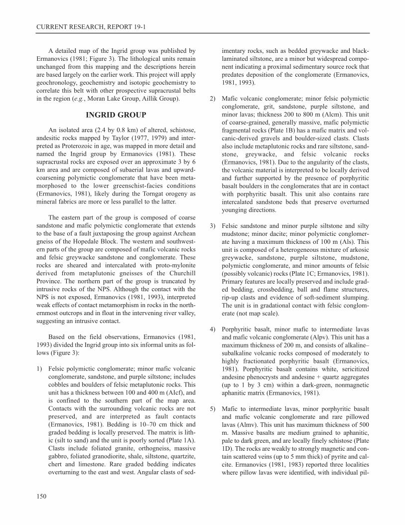
1) Felsic polymictic conglomerate; minor mafic volcanicconglomerate, sandstone, and purple siltstone; includescobbles and boulders of felsic metaplutonic rocks. Thisunit has a thickness between 100 and 400 m (AIcf), andis confined to the southern part of the map area.Contacts with the surrounding volcanic rocks are notpreserved, and are interpreted as fault contacts(Ermanovics, 1981). Bedding is 10–70 cm thick andgraded bedding is locally preserved. The matrix is lith-ic (silt to sand) and the unit is poorly sorted (Plate 1A).Clasts include foliated granite, orthogneiss, massivegabbro, foliated granodiorite, shale, siltstone, quartzite,chert and limestone. Rare graded bedding indicatesoverturning to the east and west. Angular clasts of sed-
imentary rocks, such as bedded greywacke and black-laminated siltstone, are a minor but widespread compo-nent indicating a proximal sedimentary source rock thatpredates deposition of the conglomerate (Ermanovics,1981, 1993).
2) Mafic volcanic conglomerate; minor felsic polymicticconglomerate, grit, sandstone, purple siltstone, andminor lavas; thickness 200 to 800 m (Alcm). This unitof coarse-grained, generally massive, mafic polymicticfragmental rocks (Plate 1B) has a mafic matrix and vol-canic-derived gravels and boulder-sized clasts. Clastsalso include metaplutonic rocks and rare siltstone, sand-stone, greywacke, and felsic volcanic rocks(Ermanovics, 1981). Due to the angularity of the clasts,the volcanic material is interpreted to be locally derivedand further supported by the presence of porphyriticbasalt boulders in the conglomerates that are in contactwith porphyritic basalt. This unit also contains rareintercalated sandstone beds that preserve overturnedyounging directions.
3) Felsic sandstone and minor purple siltstone and siltymudstone; minor dacite; minor polymictic conglomer-ate having a maximum thickness of 100 m (Als). Thisunit is composed of a heterogeneous mixture of arkosicgreywacke, sandstone, purple siltstone, mudstone,polymictic conglomerate, and minor amounts of felsic(possibly volcanic) rocks (Plate 1C; Ermanovics, 1981).Primary features are locally preserved and include grad-ed bedding, crossbedding, ball and flame structures,rip-up clasts and evidence of soft-sediment slumping.The unit is in gradational contact with felsic conglom-erate (not map scale).
4) Porphyritic basalt, minor mafic to intermediate lavasand mafic volcanic conglomerate (Alpv). This unit has amaximum thickness of 200 m, and consists of alkaline‒subalkaline volcanic rocks composed of moderately tohighly fractionated porphyritic basalt (Ermanovics,1981). Porphyritic basalt contains white, sericitizedandesine phenocrysts and andesine + quartz aggregates(up to 1 by 3 cm) within a dark-green, nonmagneticaphanitic matrix (Ermanovics, 1981).
5) Mafic to intermediate lavas, minor porphyritic basaltand mafic volcanic conglomerate and rare pillowedlavas (Almv). This unit has maximum thickness of 500m. Massive basalts are medium grained to aphanitic,pale to dark green, and are locally finely schistose (Plate1D). The rocks are weakly to strongly magnetic and con-tain scattered veins (up to 5 mm thick) of pyrite and cal-cite. Ermanovics (1981, 1983) reported three localitieswhere pillow lavas were identified, with individual pil-
150

A. HINCHEY AND D. CORRIGAN
151
Figure 3. Detailed geological map of the Ingrid group (after Ermanovics, 1993).
+
+
+
+
+
++
++
++
++
++
++
+
+
+
+
+
+
+
+
++
+
+
+
++
+
+
+
+
+
++
++
++
++
++
+
++
+
+
+
+
+
+
++
+
++
++
+
+
+
++
++
+
+
++
+
+
+
+
+
+
++
++
+
+
+
++
+
+
+
+
++
+
+
++
++
+
+
+
+
++
++
+
+
++
+
I
)
))
))
)
)
)
)
)
)
)
))
))
))
))
))
))
))
))
))
))
)
)
)
)
)
)
)
)
)
)
))
)
)
)
)
)
)
)
)
)
)
)
)
)
)
)
)
)
))
))
)
)
))
))
�
Ï
�
��
Ï
Ï Ï
Ï
Ï
ÏÏÏ
Ï
Ï
Ï
ÏÏ
ÏÏ
ÏÏ
Ï
Ï
ÏÏÏÏ
Ï Ï
Ù
Ù
Ù
ÏÏ
Ï
Ï
�
�
Ï
Ï
Ï
Ï
Ï Ï
Ï
Ï
Ù
���
Ù
�Ï
#
#
�
Ù
Ï �
�� Ï
�
�
�
Ù
Ù
$
$$
$#
$$
$#
#Ù
$
%
%
%Þ
Þ
Ù
$
$
Ù
$
Ï
Ù
Ï
�
�
�
��
��
�
�
�
��
��
Ù�
�
� �
��
��
�
�Ï
Ù
Ù
ÙÙ
Ù
Ù
ÙÙ
Ù
Ù
Ï
Û
ÛÛ
Û
Þ
Þ
Þ
Þ
ÙÙ
Û
Û
Û
Û
Û
Ù
$
Þ Þ
Þ
Þ
Û
ÛÛ Û
Û
ÛÛ
ÏÛ
ÛÛ Û
Û
Þ
Þ
Þ
#
#
55 23’ No
0’wab
9ls
9ls9ls
9lcm
9k
9ls
9ls
0’wab
9lcf
0’wab
0’wab
Diabase0’wab
9k
Diabase
9k
9k
9lcf
9k
9kdg
9mg
0’wab
9mgm
9lpv
9lcm
9lcm
9lpv
9lmv
9k
*Nqm
9lcm
9k
0gm
9mgand
0gm
0 0gm + ’wab
and l or k9 9
9l?
9l or 0’wab or 9k
9l or 9k
9mgm
9mgm
9mgm
9mg
9mg
9lmv
9lcf
9lcf
9lmv
9lpv
9lpv
9lcm
9lcm
9lcm
9lcm
9lcf
9lcf
9lcf
9ls
0gm
0gm
0gm
0gm
0gm
9mg
9mg
9lcm
*Nqm
65 68
68
71
70
74
70
58 72
68
80
80
74
70
65
70
70
6870
76
70
7172
72
65
74
7875
5452
72
70
72
75
80
80 78
68
65
70 73
68
68
7173
73
69
63
80
55
48
66
75
63
48
48
80
80
70-85
75
78-80
50-80
70
77
45
78
75
48
49
70
78
79
57
79
74
50
7069
65
80
65
70
80 80
83
80
70
75
82
78
72
74
8170
80
67
65
80
74
73
79
80
69
78
80
80
7570
70
INGRID
LAKE
300 0 300 600 900
Metres
61
33’W
o
55 23’ No
61
30’W
o
61
33’W
o
55 19’ No
55 19’ No
61
30’W
o
1
L E G E N D
CHURCHILL PROVINCE
NAIN PROVINCE
Bedding (top known, overturned, top unknown) . . . ���70 70 70
Gneissosity (vertical, inclined, dip unknown) . . . . .
% $ #70
Foliation (vertical, inclined, dip unknown) . . . . . ..
Ò Ï Ù
70
Mylonitic foliation (vertical, inclined) . . . . . . . .. . .
Þ Û
70
Fault (inferred) . . . . . . . . . . . . . . . . . . . . . . . . . . . .
+ +Thrust fault (assumed) . . . . . . . . . . . . . . . .. . . . . .
Anticline overturned (inferred) . . . . . . . . . . .. . . . .
I
Geological boundary(defined, approximate, assumed) . . . . . . . . . .
Area of outcrop (observed) . . . . . . . . . . . . . ..
MESOPROTEROZOIC
NAIN PLUTONIC SUITE
INGRID GROUP
CHURCHILL PROVINCE GNEISSES
PALEOPROTEROZOIC
Quartz monzonite*Nqm
9mg
Felsic plutonic gneisses and amphibolites (?Archean rocks); minor late synkinematicgranitoids
9mgm
Mylonitized and tectonically intercalated felsic
plutonic gneisses (9mg) and rocks of Ingrid
group
9lMetabasalt mafic lavas, and polymiticconglomerate
9lcf
Conglomerate, felsic and polymitic; minormafic volcanic conglomerate, sandstone andpurple siltstone; thickness 100-400 m
9lcm
Conglomerate, mafic volcanic; minor felsicpolymitic conglomerate, grit, sandstone,purple siltstone; thickness 200-800 m
9ls
Grit, sandstone and minor purple siltstone andsilty mudstone; minor polymicticconglomerate; rare dacitic rocks; maximumthickness 100 m
9lpv
Basalt; porphyritic; minor mafic to intermediatelavas and mafic volcanic conglomerate;
maximum thickness 200 m
9lmv
Lavas, mafic to intermediate; minor porphyriticbasalt and mafic volcanic conglomerate; rarepillowed lavas; maximum thickness 500 m
ARCHEAN/PROTEROZOIC
KIKKERTAVAK METADIABASE - METAGABBRO
Metadiabase9k
Metadiorite and metagabbro9kdg
0gm
Middle and late Archean, felsic plutonic
gneisses, layered gneiss and amphibolite
(0’wab)
))
Mineral isograd (Aphebian); position approximate:hornblende in mafic rocks . . . . . . . .. . . . .
))))
actinolite accompanied by schistosity
in dykes k and kdg . . . . . . . . . . . . . . . .9 9

CURRENT RESEARCH, REPORT 19-1
lows ranging from 10 by 30 cm wide and up to 1 m long.Porphyritic basalt (Alpv) is also locally observed.
6) Mafic outliers are mapped as a separate unit (Al) as therelationship with the rest of the sequence is ambiguous.Several outliers of fine-grained, laminated amphiboliteand layered orthogneiss occur within sheared quart-zofeldspathic orthogneiss west of the Ingrid group(Figure 3). In addition, a thin veneer of maficgreywacke outcrops within the Archean rocks immedi-
ately east of the Ingrid group (Figure 3; Ermanovics,1981, 1993). The contact between the eastern grey-wacke is not exposed.
METAMORPHISM
Ermanovics (1993) reported metamorphic assemblagespreserved in the Ingrid group as representative of lowergreenschist-facies conditions. Metamorphic assemblagesare best preserved in mafic units and in fine-grained sedi-
152
Plate 1. A) Poorly sorted, metaconglomerate with sub-rounded to angular clasts of felsic and mafic volcanicrocks and minor clasts of foliated granodiorite. The foliat-ed granodiorite was sampled for geochronological study;B) Mafic conglomerate; C) Cherty, pink to mauve sand-stone. Bedding is 2 to 10 cm thick; D) Weakly, foliated,fine-grained, greenschist-facies metabasalt. Foliation inthe metabasalt is north‒south and steeply dipping.
A. HINCHEY AND D. CORRIGAN
mentary rocks. Metamorphism is accompanied by the devel-opment of a weak foliation. The western contact of theIngrid group contains clasts that are stretched and deformedin parallelism with mylonitized Churchill Province gneisses.This metamorphism and deformation is interpreted as result-ing from the Torngat orogeny (Ermanovics, 1981).
TECTONIC EVOLUTION
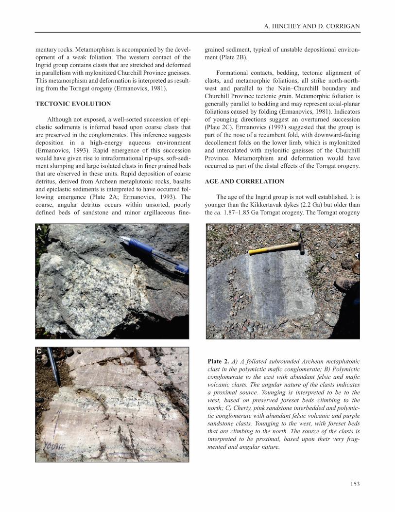
Although not exposed, a well-sorted succession of epi-clastic sediments is inferred based upon coarse clasts thatare preserved in the conglomerates. This inference suggestsdeposition in a high-energy aqueous environment(Ermanovics, 1993). Rapid emergence of this successionwould have given rise to intraformational rip-ups, soft-sedi-ment slumping and large isolated clasts in finer grained bedsthat are observed in these units. Rapid deposition of coarsedetritus, derived from Archean metaplutonic rocks, basaltsand epiclastic sediments is interpreted to have occurred fol-lowing emergence (Plate 2A; Ermanovics, 1993). Thecoarse, angular detritus occurs within unsorted, poorlydefined beds of sandstone and minor argillaceous fine-
grained sediment, typical of unstable depositional environ-ment (Plate 2B).
Formational contacts, bedding, tectonic alignment ofclasts, and metamorphic foliations, all strike north-north-west and parallel to the Nain‒Churchill boundary andChurchill Province tectonic grain. Metamorphic foliation isgenerally parallel to bedding and may represent axial-planarfoliations caused by folding (Ermanovics, 1981). Indicatorsof younging directions suggest an overturned succession(Plate 2C). Ermanovics (1993) suggested that the group ispart of the nose of a recumbent fold, with downward-facingdecollement folds on the lower limb, which is mylonitizedand intercalated with mylonitic gneisses of the ChurchillProvince. Metamorphism and deformation would haveoccurred as part of the distal effects of the Torngat orogeny.
AGE AND CORRELATION
The age of the Ingrid group is not well established. It isyounger than the Kikkertavak dykes (2.2 Ga) but older thanthe ca. 1.87–1.85 Ga Torngat orogeny. The Torngat orogeny
153
Plate 2. A) A foliated subrounded Archean metaplutonicclast in the polymictic mafic conglomerate; B) Polymicticconglomerate to the east with abundant felsic and maficvolcanic clasts. The angular nature of the clasts indicatesa proximal source. Younging is interpreted to be to thewest, based on preserved foreset beds climbing to thenorth; C) Cherty, pink sandstone interbedded and polymic-tic conglomerate with abundant felsic volcanic and purplesandstone clasts. Younging to the west, with foreset bedsthat are climbing to the north. The source of the clasts isinterpreted to be proximal, based upon their very frag-mented and angular nature.

CURRENT RESEARCH, REPORT 19-1
is a zone of intense transpression and high-grade metamor-phism that separates the Core Zone and the North AtlanticCraton (Figure 1). This orogenic event would have beenresponsible for the deformation and metamorphism pre-served in the Ingrid group. The metamorphic grade increas-es to the west from the greenschist Ingrid group through tothe Tasiuyak and Lac Lomier complex where upper gran-ulite facies conditions are preserved. Basement rocksbeneath and surrounding the Ingrid group do not appear tohave acquired the same greenschist-facies metamorphicoverprint, suggesting that the Ingrid group was emplaced asa nappe in thin-skin tectonic event.
POTENTIAL CORRELATIVES
There are several Paleoproterozoic supracrustalsequences preserved in the study area. The Moran Lake andPost Hill (not shown on Figure 2 map) groups are comprisedof siliciclastic sedimentary and mafic volcanic rocks, andare correlated on the basis of their similar stratigraphy androck types (Marten, 1977; Wardle and Bailey, 1981). ThePost Hill group contains a mafic metavolcanic unit in itslower tectonostratigraphy that was deposited ca. 2178 Ma,but units higher in the sequence were deposited after ca.2013 Ma (Ketchum et al., 2002). The Moran Lake Groupremains undated, but is unconformably overlain by ca. 1850Ma siliciclastic sedimentary rocks (Sparkes et al., 2016),and is in thrust contact with the Nain Craton.
Younger supracrustal sequences are dominated by shal-low-water to terrestrial sedimentary rocks and subaerial fel-sic volcanic rocks of the Aillik Group dated between 1883and 1856 Ma (Schärer et al., 1988; Hinchey and Rayner,2008). The Bruce River Group sits unconformably upon theMoran Lake Group. The highest exposed stratigraphy with-in the Bruce River Group contains a felsic volcanic tuff thatwas dated ca. 1650 Ma (Schärer et al., 1988; Sparkes et al.,2016). However, a felsic tuff layer within the basal units ofthe sequence of the Bruce River Group produced an age ofca. 1850 Ma (Sparkes et al., 2016), indicating the occur-rence of an unrecognized fault or unconformity.
The Post Hill group, Aillik Group, the Bruce RiverGroup, and Moran Lake Group are associated with econom-ic mineral occurrences, generally consisting of uraniummineralization. The Aillik, Bruce River and Post Hill groupscontain several uranium deposits (e.g., Kitts, Michelin,Jacques Lake, Moran Lake Lower C deposits). In addition touranium occurrences (e.g., Armstrong deposits), the MoranLake Group also contains an iron-rich breccia that has ele-vated values of gold and copper (Moran Lake Upper C Zonedeposit; Sparkes et al., 2016).
Establishing the age, as well as the geochemical andisotopic signature of the Ingrid group will allow for a robustcomparison and potential correlation with thePaleoproterozoic supracrustal sequences preserved in theregion. In turn, this will allow for potential mineralizingenvironments to be targeted based on the similaritiesbetween the belts.
CONCLUSIONS
The Ingrid group is an isolated package of supracrustalrocks that include volcanic and coarse-grained detritalrocks. The group is exposed as a faulted block preservedbetween the Churchill Province to the west and the ArcheanNain Province to the east. The group is composed of sub-aerial lavas and upward-coarsening polymictic conglomer-ate, and has been metamorphosed to the lower greenschistfacies. The age of the Ingrid group is not well known. It isyounger than the Kikkertavak dykes (2.2 Ga) but older thanthe ca. 1.87–1.85 Ga Torngat orogeny. The Torngat orogenya zone of intense transpression and high-grade metamor-phism that affected the Ingrid group. Future studies willexplore the formation and mineral potential of the Ingridgroup based on more abundant and precise U–Pb zircon andmonazite ages, as well as new ground observations support-ed by high-resolution aeromagnetic data.
ACKNOWLEDGMENTS
Heather Campbell, Deanne Van Rooyen, NicoleRayner, Hamish Sandeman and Étienne Girard are warmlythanked for their contribution in the field, and to an overallunderstanding of the geological history. Neil Stapleton isthanked for cartographic support. Wayne Tuttle helpedimmensely with logistics and safety. Universal HelicopterServices provided excellent rotary-wing support. The manu-script was improved by the helpful review by John Hinchey.
REFERENCES
Cadman, A.C., Heaman, L., Tarney, J., Wardle, R. andKrogh, T.E.
1993: U-Pb geochronology and geochemical variationwithin two Proterozoic mafic dyke swarms, Labrador.Canadian Journal of Earth Sciences, Volume 30, pages1490-1504.
Connelly, J.N. and Ryan, B.1996: Late Archean evolution of the Nain Province,Nain, Labrador: imprint of a collision. CanadianJournal of Earth Sciences, Volume 33, pages 1325-1342.
154

A. HINCHEY AND D. CORRIGAN
Corrigan, D., Wodicka, N., McFarlane, C., Lafrance, I., vanRooyen, D., Bandyayera, D. and Bilodeau, C.,
2018: Lithotectonic framework of the Core Zone,southeastern Churchill Province, Canada. GeoscienceCanada, Volume 45, pages 1-24.
Emslie, R.F.1978: Elsonian magmatism in Labrador: Age, charac-teristics and tectonic setting. Canadian Journal of EarthSciences, Volume 15, pages 438-453.
1980: Geology and petrology of the Harp LakeComplex, central Labrador: an example of Elsonianmagmatism. Geological Survey of Canada, Bulletin293.
Ermanovics, I.F.1981: Geology, Ingrid Lake, Labrador, maps and notes.Geological Survey of Canada, Open File 755, 1 sheet.
1993: Geology of the Hopedale Block, southern NainProvince, and the adjacent Proterozoic terranes,Labrador, Newfoundland. Geological Survey ofCanada, Memoir 431.
Hill, J.D.1982: Geology of the Flowers River–NatakwanonRiver area, Labrador. Government of Newfoundlandand Labrador, Department of Mines and Energy,Mineral Development Division, Report 82-6, 140pages.
Hinchey, A.M. and Rayner, N.2008: Timing constraints on the Paleoproterozoic,bimodal metavolcanic rocks of the Aillik Group, Aillikdomain, Makkovik Province, Labrador. GeolocialAssociation of Canada ‒ Mineralogical Association ofCanada, Abstract Volume 33.
James, D.T., Kamo, S. and Krogh, T.2002: Evolution of 3.0 and 3.1 Ga volcanic belts and anew thermotectonic model for the Hopedale Block,North Atlantic craton (Canada). Canadian Journal ofEarth Sciences, Volume 39, pages 687-710.
James, D.T., Nunn, G.A.G., Kamo, S. and Kwok, K.2003: The southeastern Churchill Province revisited:U–Pb geochronology, regional correlations, and theenigmatic Orma Domain. In Current Research.Government of Newfoundland and Labrador,Department of Mines and Energy, Geological Survey,Report 03-1, pages 35-45.
Ketchum, J.W.F., Culshaw, N.G. and Barr, S.2002: Anatomy and orogenic history of aPaleoproterozoic accretionary belt: the MakkovikProvince, Labrador, Canada. Canadian Journal of EarthSciences, Volume 39, pages 711-730.
Marten, B.E.1977: The relationship between the Aillik Group andthe Hopedale gneiss, Kaipokok Bay, Labrador.Unpublished Ph.D. thesis, Memorial University, St.John’s, 389 pages.
Ryan, B. (Compiler), Krogh, T.E., Heaman, L., Schärer, U.,Philippe, S. and Oliver, G.
1991: On recent geochronological studies in the NainProvince and Nain Plutonic Suite, north-centralLabrador. In Current Research. Government ofNewfoundland and Labrador, Department of Mines andEnergy, Geological Survey Branch, Report 91-1, pages257-261.
Schärer, U., Krogh, T.E., Wardle, R.J., Ryan, B. and Gandhi,S.S.
1988: U–Pb ages of early to middle Proterozoic volcan-ism and metamorphism in the Makkovik Orogen,Labrador. Canadian Journal of Earth Sciences, Volume25, pages 1098-1107.
Sparkes, G.W., Dunning, G.R., Fonkew, M. and Langille, A.2016: Age constraints on the formation of iron oxide-rich hydrothermal breccias of the Moran Lake area: evi-dence for potential IOCG-style mineralization withinthe Central Mineral Belt of Labrador. In CurrentResearch. Government of Newfoundland and Labrador,Department of Natural Resources, Geological Survey,Report 16-1, pages 71-90.
Stockwell, C.H.1963: Third report on structural provinces, orogenies,and time-classification of the Canadian Shield.Geological Survey of Canada, Paper 63-17.
Taylor, F.C. (compiler)1977: Geology, Hopedale, Newfoundland. Map 1443A.Scale: 1:250 000. Geological Survey of Canada. Colourmap, GS# 013N/0009.
1979. Reconnaissance geology of part of thePrecambrian Shield, northeastern Québec, northernLabrador and Northwest Territories. Geological Surveyof Canada, Memoir 393, 99 pages and 19 maps.
155

CURRENT RESEARCH, REPORT 19-1
Thomas, A. and Morrison, R.S.1991: Geological map of the central part of theUgjoktok River (NTS 13N/5 and parts of 13M/8 and13N/6), Labrador (with accompanying notes).Government of Newfoundland and Labrador,Department of Mines and Energy, Geological SurveyBranch, Map 91-160.
Wardle, R.J. and Bailey, D.G.1981: Early Proterozoic sequences in Labrador. InProterozoic Basins of Canada. Geological Survey ofCanada, Paper 81-10, pages 331-359.
Wardle, R.J., James, D.T., Scott, D.J. and Hall, J.2002: The southeastern Churchill Province: synthesis ofa Paleoproterozoic transpressional orogen. CanadianJournal of Earth Sciences, Volume 39, pages 639-663.
Wasteneys, H., Wardle, R., Krogh, T. and Ermanovics, I.1996: U–Pb geochronological constraints on the depo-sition of the Ingrid group and implications for theSaglek–Hopedale and Nain craton – Torngat orogenyboundaries. In Eastern Canadian Shield Onshore-Offshore Transect (ECSOOT). Compiled by R.J.Wardle and J. Hall. The University of British Columbia,Lithoprobe Secretariat, Report 57, pages 212-228.
156


