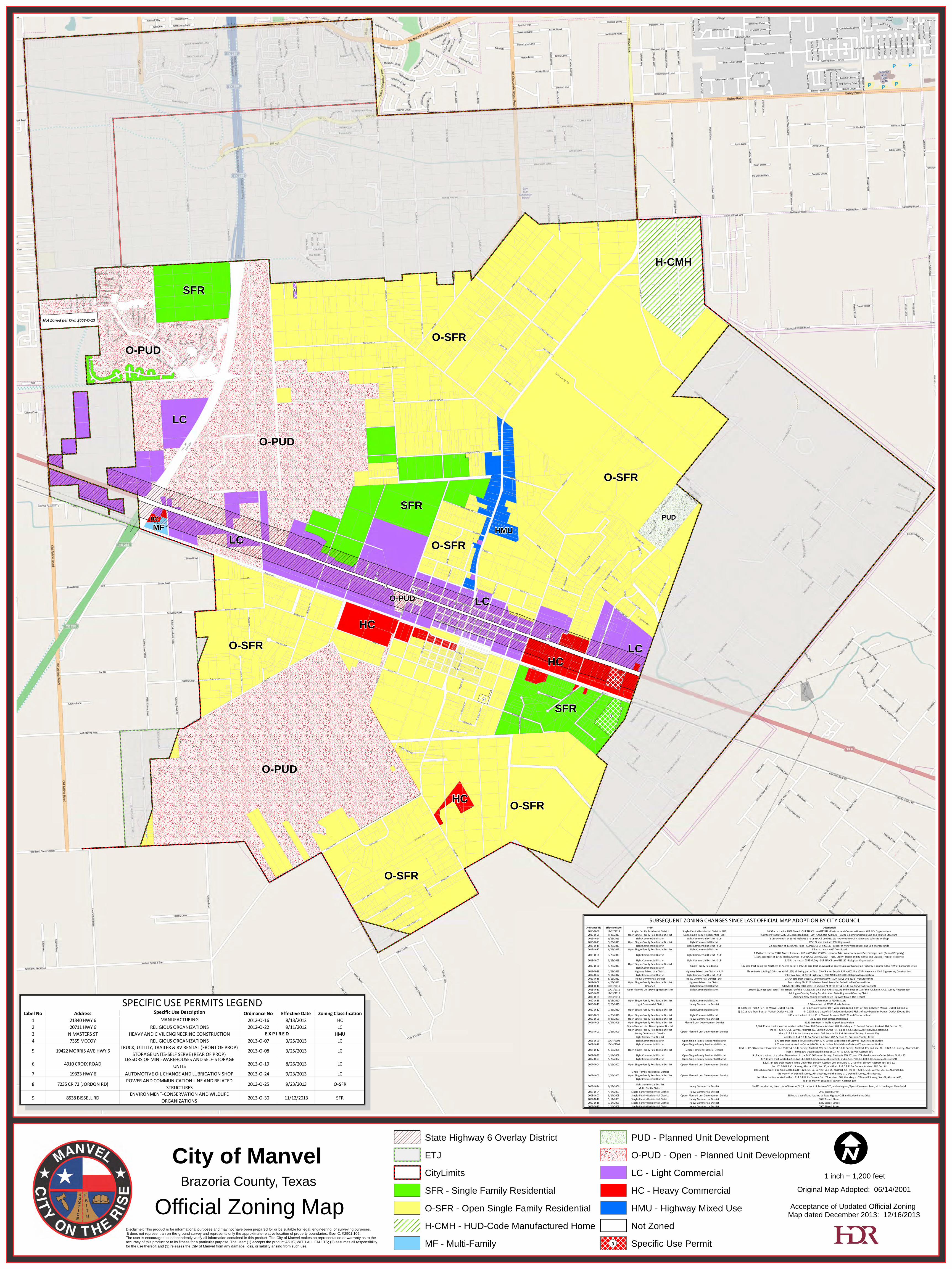
City of ManvelOfficial Zoning Map
Brazoria County, Texas Original Map Adopted: 06/14/2001Acceptance of Updated Official Zoning
Map dated December 2013: 12/16/2013
1 inch = 1,200 feet
¬«5¬«4
¬«1
¬«2
¬«6
¬«8
¬«7
¬«9
SFR
HCLC
HC
H-CMH
MF
O-PUD
O-SFR
O-SFR
O-SFR
HC
HC
O-PUD
O-PUD
O-PUD
O-SFR
SFR
O-SFR
LC
O-SFR
HMU
LC
LC
PUD
SFR
HWY 6
FM 11
28
Iowa LN
HWY 2
88
Masters RD
Clark RD
Belcher RD
Del Bello RD
CR 99
Lewis LN
Jordan RD
King ST
Oilfield RDRode
o DR Pat
terson
RD
Mcco
y RD
E Jordan RD
Del Bello LN
Ceme
tery R
D
Uzzell RD
Pine S
T
FloraFur
nace R
D
Mississ
ippi
Scott AVE
Rodeo Palms PKWY
CR 67
Bissell
Dogwood AVE
Rogers RD
Cindy
Frey R
D
Bissell RD
Louisia
na ST
Wilso
n DR
Palmero WAY
Alleluia TRL
Kirch
ner R
D
Charlotte
Pollard DR
Acorn DR
Chocolate Bayou RD
Del Bello SPUR
CR 69
Large AVE
Oak Hill
Kings DR
Lira RD
Georgia
Hal Mccl
ain RD
San Simeon DR
Cook
RD
Peter
s RD
Stevens RD
CR 57
Valusek RD
Pinehurst DR
Shaw RD
Kreuzer
Scho
ol DR
Crestrid
ge DR
Reed LN
Tankersley RD
Amanda LN
Lovers LN
CR 90
Kelly
Briarcre
st ST
Gates LP
Atascad
ero DR
Del Bello BLVD
Colony LP
Live Oak CT
Jane ST
Mustang RD
Sprag
ue ST
Oakcrest DR
Creek DR
Quail
Ridge
DR
CR 81
Mason RD
Dalmolin
Burnett RD
Rodeo Palms BLVD
CR 100
Supiro DR
Alaba
ma
Texas County RD
Russe
ll ST
Tammy DR
Terra Bella DR
Palm
etto S
T
Crossfield RD
Magn
olia ST
E She
rri CIR
2nd ST
Mira
Loma
DR
W Sh
erri C
IR
Petry
Ln
Twin Oaks DR
Cannan
CR 48
Carpenter RD
Taylor ST
1st ST
Palmdal
e LN
Garden Grove DR
Sherri CIR
Morro Bay DR
Indian Palms DR
Booth Place RD
Airpark RD
Royal Rose DR
Horse Shoe DR
Cedar
Signal Hill DR
Lum RD
Creek
Spilla
ne ST
Palm Desert DR
Palm
etto R
D
Stardu
ster
Corpo
rate D
R
Old P
residi
o DR
Allen RD
Elm ST
Hunti
ngton
Bend
DR
Coconut Palms CT
Taxi Way Three
Palom
ar DR
Wolfe LN
Kemp ST
Carmel Chase CT
Blisten Spring DR
Gilbough RD
Calistog
a CIR
Puritan WAY
Spears RD
Desert Willow CT
Supiro CT
Garden Springs CT
Garden Ridge CT
Kings CIR S
Desert Spring LN
CR 190
Uzzell RD
CR 99
Patterson RD
Magn
olia ST
Elm ST
Shaw RD
HWY 2
88
CR 48
Bissell RD
Pollard DR
Russe
ll ST
© OpenStreetMap (and) contributors, CC-BY-SA
IState Highway 6 Overlay DistrictETJCityLimitsSFR - Single Family ResidentialO-SFR - Open Single Family ResidentialH-CMH - HUD-Code Manufactured HomeMF - Multi-Family
PUD - Planned Unit DevelopmentO-PUD - Open - Planned Unit DevelopmentLC - Light CommercialHC - Heavy CommercialHMU - Highway Mixed UseNot ZonedSpecific Use Permit3
Not Zoned per Ord. 2008-O-13
Disclaimer: This product is for informational purposes and may not have been prepared for or be suitable for legal, engineering, or surveying purposes. It does not represent an on-the-ground survey and represents only the approximate relative location of property boundaries. Gov. C. §2501.102. The user is encouraged to independently verify all information contained in this product. The City of Manvel makes no representation or warranty as to the accuracy of this product or to its fitness for a particular purpose. The user: (1) accepts the product AS IS, WITH ALL FAULTS; (2) assumes all responsibility for the use thereof; and (3) releases the City of Manvel from any damage, loss, or liability arising from such use.
Ordinance No Effective Date From To Description2013-O-30 11/12/2013 Single-Family Residential District Single-Family Residential District - SUP 26.52 acre tract at 8538 Bissell - SUP NAICS Use #813312 - Environment-Conservation and Wildlife Organizations2013-O-25 9/23/2013 Open Single-Family Residential District Open Single-Family Residential - SUP 4.199 acre tract at 7235 CR 73 (Jordan Road) - SUP NAICS Use #237130 - Power & Communication Line and Related Structure2013-O-24 9/23/2013 Light Commercial District Light Commercial District - SUP 1.085 acre tract at 19333 Highway 6 - SUP NAICS Use #811191 - Automotive Oil Change and Lubrication Shop2013-O-23 9/23/2013 Open Single-Family Residential District Light Commercial District 115.127 acre tract at 19601 Highway 62013-O-19 8/26/2013 Light Commercial District Light Commercial District - SUP 2.5 acre tract at 4910 Croix Road - SUP NAICS Use #53113 - Lessor of Mini Warehouses and Self-Storage Units2013-O-17 8/26/2013 Open Single-Family Residential District Light Commercial District 2.5 acre tract at 4910 Croix Road2013-O-08 3/25/2013 Light Commercial District Light Commercial District - SUP 1.1941 acre tract at 19422 Morris Avenue - SUP NAICS Use #53113 - Lessor of Mini Warehouses and Self-Storage Units (Rear of Property)
1.1941 acre tract at 19422 Morris Avenue - SUP NAICS Use #532120 - Truck, Utility, Trailer and RV Rental and Leasing (Front of Property)2013-O-07 3/25/2013 Light Commercial District Light Commercial District - SUP 1.455 acre tract at 7355 McCoy - SUP NAICS Use #813110 - Religious Organization2012-O-30 1/28/2013 Open Single-Family Residential District
Light Commercial District Single Family Residential 117 acre tract being the Northern 117 acres out of a 146.138 acre tract know as Blue Water Lakes of Manvel on Highway 6 approx 1,850-ft W of Corporate Drive2012-O-29 1/28/2013 Highway Mixed Use District Highway Mixed Use District - SUP Three tracts totaling 5.20 acres at FM 1128, all being part of Tract 25 of Parker Subd - SUP NAICS Use #237 - Heavy and Civil Engineering Construction2012-O-22 9/11/2012 Light Commercial District Light Commercial District - SUP 1.957 acre tract at 20711 Highway 6 - SUP NAICS #813110 - Religious Organization2012-O-16 8/13/2012 Heavy Commercial District Heavy Commercial District - SUP 13.304 acre tract tract at 21340 Highway 6 - SUP NAICS Use #332 - Manufacturing2012-O-08 4/23/2012 Open Single-Family Residential District Highway Mixed Use District Tracts along FM 1128 (Masters Road) From Del Bello Road to Cannan Drive2011-O-14 10/11/2011 Unzoned Light Commercial District 5 tracts (131.082 total acres) in Section 71 of the H.T.& B.R.R. Co. Survey Abstract 2912011-O-13 10/11/2011 Open Planned Unit Development District Light Commercial District 2 tracts (129.418 total acres) in Section 71 of the H.T.&B.R.R. Co. Survey Abstract 291 and in Section 72 of the H.T.& B.R.R. Co. Survey Abstract 4602010-O-32 12/13/2010 Adding an Overlay Zoning District called State Highway 6 Overlay District2010-O-31 12/13/2010 Adding a New Zoning District called Highway Mixed-Use District2010-O-18 9/13/2010 Open Single-Family Residential District Light Commercial District 1.17 Acre tract at 7104 Masters2010-O-13 7/26/2010 Light Commercial Distict Heavy Commercial District 1.66 acre tract at 21523 Morris Avenue2010-O-12 7/26/2010 Open Single-Family Residential District Light Commercial District 1) 1.80 acre Tract 2 (S ½) of Manvel Outlot No. 100 3) 0.9091 acre tract of 60-ft wide abandoned Right-of-Way between Manvel Outlot 100 and 93
2) 0.21± acre Tract 3 out of Manvel Outlot No. 101 4) 0.1085 acre tract of 80-ft wide aandonded Right-of-Way between Manvel Outlot 100 and 1012010-O-07 4/26/2010 Open Single-Family Residential District Light Commercial District 1.00 acre tract out of Lot 21 of Manvel Acres on FM 1128 and Charlotte Road2009-O-20 9/28/2009 Open Single-Family Residential District Heavy Commercial District 22.80 acre tract at 9315 Uzell Road2009-O-08 4/27/2009 Open Single-Family Residential District Planned Unit Development District 86.13 acre tract in Wolfe Airpark Subdivision
2009-O-03 2/23/2009Open-Planned Unit Development District
Open Single-Family Residential DistrictHeavy Commercial DistrictLight Commercial District
Open - Planned Unit Development District1,663.30 acre tract known as located in the Oliver Hall Survey, Abstract 203, the Mary V. O' Donnell Survey, Abstract 484, Section 62,
the H.T. & B.R.R. Co. Survey, Abstract 483, Section 64, the H.T. & B.R.R. Co. Survey, Abstract 283, Section 63, the H.T. & B.R.R. Co. Survey, Abstract 286, Section 55, J.M. O'Donnell Survey, Abstract 470,
and the H.T. & B.R.R. Co. Survey, Abstract 282, Section 61, Brazoria County, Texas2008-O-20 10/14/2008 Light Commercial District Open Single-Family Residential District 1.77 acre tract located in Outlot 96 of Dr. A. A. Luther Subdivision of Manvel Townsite and Outlots2008-O-19 10/14/2008 Light Commercial District Open Single-Family Residential District 1.00 acre tract located in Outlot 96 of Dr. A. A. Luther Subdivision of Manvel Townsite and Outlots2008-O-12 5/12/2008 Open-Single Family Residential District Single-Family Residential District Tract I - 301.30 acre tract located in Sec. 63 H.T.& B.R.R. Survey, Abstract 283, Sec. 64 H.T.& B.R.R. Survey, Abstract 483, and Sec. 74 H.T.& B.R.R. Survey, Abstract 493
Tract II - 50.01 acre tract located in Section 73, H.T.& B.R.R. Survey Abstract 3012007-O-32 1/14/2008 Light Commercial District Open Single-Family Residential District 9.14 acre tract out of a called 20 acre tract in the M.V. O'Donnell Survey, Abstracts 470, 471 and 479, also known as Outlot 96 and Outlot 952007-O-23 5/29/2007 Light Commercial District Open Single-Family Residential District 137.38 acre tract located in Sec. 65 H.T.& B.R.R. Co. Survey, Abstract 285 and in Sec. 71 H.T.& B.R.R. Co. Survey, Abstract 2912007-O-04 3/12/2007 Open Single-Family Residential District Open - Planned Unit Development District 1,328.724 acre tract located in the Oliver Hall Survey, Abstract 203, the Mary V. O' Donnell Survey, Abstract 484, Sec. 62,
the H.T. & B.R.R. Co. Survey, Abstract 286, Sec. 55, and the H.T. & B.R.R. Co. Survey, Abstract 282, Sec. 61
2007-O-05 2/26/2007Single-Family Residential District
Open Single-Family Residential DistrictLight Commercial District
Open - Planned Unit Development District608.616 acre tract, a portion located in H.T. & B.R.R. Co. Survey, Sec. 65, Abstract 285, the H.T. & B.R.R. Co. Survey, Sec. 73, Abstract 301,
the Mary V. O' Donnell Survey, Abstract 483, and the Mary V. O'Donnell Survey, Abstract 469,the other portion located in the H.T. & B.R.R. Co. Survey, Sec. 73, Abstract 301, the Mary V. O'Donnell Survey, Sec. 64, Abstract 483,
and the Mary V. O'Donnell Survey, Abstract 1692006-O-24 9/25/2006 Light Commercial District
Multi-Family District Heavy Commercial District 5.4532 total acres, 1 tract out of Reserve "C", 1 tract out of Reserve "D", and an Ingress/Egress Easement Tract, all in the Bayou Place Subd2003-O-04 4/14/2003 Single-Family Residential District Heavy Commercial District 7910 Bissell Street2003-O-07 3/27/2003 Single-Family Residential District Open - Planned Unit Development District 585 Acre tract of land located at State Highway 288 and Rodeo Palms Drive2002-O-17 1/14/2003 Single-Family Residential District Heavy Commercial District 8406 Bissell Street2002-O-16 1/14/2003 Single-Family Residential District Heavy Commercial District 8320 Bissell Street2002-O-15 1/14/2003 Single-Family Residential District Heavy Commercial District 7900 Bissell Street
SUBSEQUENT ZONING CHANGES SINCE LAST OFFICIAL MAP ADOPTION BY CITY COUNCIL
Label No Address Specific Use Description Ordinance No Effective Date Zoning Classification1 21340 HWY 6 MANUFACTURING 2012-O-16 8/13/2012 HC2 20711 HWY 6 RELIGIOUS ORGANIZATIONS 2012-O-22 9/11/2012 LC3 N MASTERS ST HEAVY AND CIVIL ENGINEERING CONSTRUCTION HMU4 7355 MCCOY RELIGIOUS ORGANIZATIONS 2013-O-07 3/25/2013 LC5 19422 MORRIS AVE HWY 6 TRUCK, UTILITY, TRAILER & RV RENTAL (FRONT OF PROP)
STORAGE UNITS-SELF SERVE (REAR OF PROP) 2013-O-08 3/25/2013 LC6 4910 CROIX ROAD LESSORS OF MINI-WAREHOUSES AND SELF-STORAGE
UNITS 2013-O-19 8/26/2013 LC7 19333 HWY 6 AUTOMOTIVE OIL CHANGE AND LUBRICATION SHOP 2013-O-24 9/23/2013 LC8 7235 CR 73 (JORDON RD) POWER AND COMMUNICATION LINE AND RELATED
STRUCTURES 2013-O-25 9/23/2013 O-SFR
9 8538 BISSELL RD ENVIRONMENT-CONSERVATION AND WILDLIFE ORGANIZATIONS 2013-O-30 11/12/2013 SFR
SPECIFIC USE PERMITS LEGEND
E X P I R E D


