TENURE SECURITY FACILITY SOUTHERN AFRICA PROJECT
Incrementally securing tenure in informal settlements / slum upgrading in Southern Africa
Advisory Support Services – Technical Report
Incrementally securing tenure in urban Huambo, Angola
June 2013
Tenure advisory support services undertaken for Urban LandMark and Cities Alliance by: DEVELOPMENT WORKSHOP, ANGOLA

2
About Urban LandMark
Established in 2006 with funding from the UK’s Department for International Development (DFID), Urban
LandMark works to find remedies to the problems that have made urban land markets dysfunctional and
habitable land unaffordable.
Our initiatives aim to shift policies and practice to improve access to well-located urban land by making
markets as well as land planning and management systems work better for poorer people, and giving
meaning to the right to land.
Urban LandMark plays a catalytic role by using research to inform policy, and by promoting dialogue
between key stakeholders – government, the private sector and civil society – to find effective solutions to
prevailing obstacles in accessing urban land markets.
About the Tenure Security Facility Southern Africa Project
Urban LandMark established the Tenure Security Facility Southern Africa project in 2012 to provide specialist
technical assistance and advisory services on tenure security within slum upgrading initiatives in Southern
Africa, and share lessons learnt with others in the region. The work aims to contribute to improved access to
land for poorer people, which in turn contributes to improved livelihoods, active citizenship and asset
creation.
The Tenure Security Facility extends and expands on work Urban LandMark has undertaken since 2006. This
work has made a significant contribution to recognising the need for incremental tenure in the slum
upgrading process and thinking about how this should occur.
The Tenure Security Facility partnered with Development Workshop for the work in Angola.
Lauren Royston managed the advisory support services which were provided by Development
Workshop in Angola. This Technical Report was written by Allan Cain. The legal study was carried out by
Pedro Ramao with Moise Festo in collaboration with the Municipal Administration of Huambo and the
Huambo Provincial Government.
About Development Workshop
Development Workshop has been working in Angola on human settlements issues for more than three
decades and is a long-time partner of Urban LandMark. Development Workshop has engaged the
Government on land tenure policy reform and is building municipal capacity in local land management and
titling.
3
Acknowledgements The Tenure Security Facility Southern Africa project is financially supported through the Catalytic Fund of Cities Alliance and co‐funding from UKaid (Department for International Development).
The Angola project draws extensively on Development Workshop's land tenure work in Huambo that is
supported by the Municipal Administration of Huambo, the European Union and the CLIFF Fund of Homeless
International, UKaid and SIDA.

4
Improving Land Tenure Security in Huambo,
Angola
Table of Contents
Contents
1. Background............................................................................................................................................ 8
2. The Huambo case .................................................................................................................................. 8
2.1. Legal and institutional context for land management ..................................................................... 8
2.1.1. Post-independence and civil war period ................................................................................. 8
2.1.2. Post-conflict period (2002) to the present .............................................................................. 9
2.2. Development Workshop’s engagement in land management in Huambo ..................................... 11
3. Preliminary hypotheses ....................................................................................................................... 12
4. Methodology ....................................................................................................................................... 13
5. Components of the research ................................................................................................................ 13
5.1. Legal study ................................................................................................................................... 13
5.2. Household land acquisition survey ............................................................................................... 14
6. Findings: legal research ........................................................................................................................ 16
6.1. Legal basis for the recognition of land tenure rights in Angola ...................................................... 16
6.1.1. Rules related to land rights set out in the Constitution of the Republic of Angola.................. 16
6.1.2. Land legislation under the Angolan Civil Code and the Land Law of 2005 .............................. 16
6.1.3. Rules relating to the regulation of licensing of operations for the subdivision of land, urban
infrastructural works and building construction (Decree 80/06) ........................................................... 17
6.1.4. Legal Instruments used to Define Tenure Rights ................................................................... 18
6.1.5. Land Management and Registration of Tenure Rights ........................................................... 19
6.2. Legal and administrative procedures related to land rights as practiced in Huambo ..................... 20
6.2.1. Summary of Interviews ......................................................................................................... 20
6.2.2. How is the land/plot/lot acquired? ....................................................................................... 20
6.2.3. Is the transfer of plot(s) managed? ....................................................................................... 21
6.2.4. What is the process for regularization of a lot? ..................................................................... 21
6.2.5. Regularization of a lot with previously unauthorized construction ........................................ 21
6.2.6. Summary Analysis of the Interviews ..................................................................................... 22
7. Findings: Huambo household survey on land and housing ................................................................... 23
6
7.1. Population Density (indicator of overcrowding) ............................................................................ 24
7.2. Average number of persons occupying each room ....................................................................... 25
7.3. Quality of Construction ................................................................................................................ 26
7.4. Road Access to Housing ................................................................................................................ 28
7.5. Acquiring the occupation of a house or plot of land ...................................................................... 30
7.6. Documents and safeguarding of rights ......................................................................................... 35
7.7. Proof of right of occupation.......................................................................................................... 35
7.8. Overall reasons for believing they have security of tenure ............................................................ 40
7.9. Land Conflicts ............................................................................................................................... 42
7.10. Land prices ............................................................................................................................... 43
7.11. Market turnover ....................................................................................................................... 47
7.12. Summary of Findings on Land Acquisition from the Huambo Household Study: .................... 47
7.12.1. Occupant obtained an empty plot or a plot with a house? .................................................... 47
7.12.2. Type of documentation and proof of access.......................................................................... 47
7.12.3. Why people think that their occupation is valid? .................................................................. 48
7.12.4. Who would call on if required assistance with issues about validity of occupation. ............... 48
7.12.5. Cost of occupation ................................................................................................................ 49
7.12.6. Type of road surface ............................................................................................................. 49
7.12.7. State of roads after rains ...................................................................................................... 49
7.12.8. Perceived value of the zones ................................................................................................ 49
7.12.9. General comments ............................................................................................................... 49
8. Conclusions on Land Tenure in Huambo............................................................................................... 50
9. Recommendations ............................................................................................................................... 50
10. Potential for Securing Tenure Rights through Incremental Approaches in Huambo .......................... 54
Land pooling case study: land pooling and participatory planning in Huambo .............................................. 82
Key Informant Questionnaire....................................................................................................................... 86
1. Control da entrevista: .......................................................................................................................... 88
7
2. Nome do Inquiridor: ............................................................................................................................ 88
2.1.1. Verificado por: ...................................................................................................................... 88
2.1.1. ................................................................................................................................................... 88
2.1.2. ................................................................................................................................................... 88
2.1.3. ................................................................................................................................................... 88
2.1.4. Tipologia do Local de Entrevista: _____________________________________ ................... 88

1. Background
With support from the Cities Alliance and co-funding from UKaid, the Tenure Security Facility Southern
Africa project provides small-scale, targeted advisory services on incrementally securing tenure in slum
upgrading initiatives in the region. The project aims to contribute to improved access to land for poorer
people that, in turn, contributes to improved livelihoods, active citizenship and asset creation. The Tenure
Security Facility extends and expands on the work done by Urban LandMark over the past six years. This
work is making a significant impact on highlighting the need for incremental tenure in the slum upgrading
process and on the thinking around how this should occur.
The advisory work investigates appropriate mechanisms to incrementally increase tenure security for
households living in slums/ informal settlements by providing advisory services in five sites in Southern
Africa where the Tenure Security Facility project has developed partnerships. All five sites address some
element of official recognition of tenure along the continuum from insecure to more secure tenure.
Development Workshop has been working in Angola on human settlements issues for more than three
decades and is a long-time partner of Urban LandMark. Development Workshop has engaged the
Government on land tenure policy reform and is building municipal capacity in local land management and
titling. Development Workshop was invited by the Huambo Provincial Government to assist them with land
and settlement management issues after the end of the civil conflict in 2002. This involved piloting two
demonstration land readjustment (pooling) projects between 2005 and 2008 and assisting the
Administration of Huambo construct Angola’s first comprehensive municipal cadastre. Development
Workshop is keen on deepening its knowledge in this area to inform and guide its work on advocacy, training
of civil servants, land management and urban and housing development. It operates a social housing project
and understanding the legal and institutional issues is important for the success of this project.
2. The Huambo case
Angola was affected by a protracted conflict: the struggle for independence in from 1961 to 1975 and post-
independence civil conflict from 1975 until 2002. During this period, much of the population fled from the
insecure rural areas to cities like Huambo where the conflict was most intense. Since peace in 2002,
significant numbers have returned to Huambo from coastal areas that were relatively safer during the war.
By comparison, the return to rural areas has been slow.
2.1. Legal and institutional context for land management
The Portuguese primarily created the colonial land management system in Angola to legalize the
appropriation of African peasant lands for settler-farmers’ use. When the colonial period ended in 1974, the
colonial land cadastre project had been implemented in most urban areas and in the western half of the
country where populations and Portuguese settlements were more concentrated.
2.1.1. Post-independence and civil war period
After independence l in 1975, the new Angolan government affirmed the constitutional role of the state as
the owner of all land. The Confiscation Law of 1976 permitted the state to confiscate land and real estate
that had been abandoned for more than 45 days by the departing colonialists. The state thus became the
single largest owner of land and housing stock in the country. However, independence and the flight of
many Portuguese civil servants also meant that management of the formal colonial land cadastre ceased.
The colonial technicians who had mapped out and administered the cadastre left and, in some cases,
destroyed or took maps and registry information with them.
Following independence, peri-urban, informal housing settlements grew rapidly as the civil war continued
but legal and administrative procedures for managing these areas were not developed. The existing land

9
management institutions were weakened by the lack of technical staff and the low priority given to these
settlements during the conflict. A major constraint to urban land management in Angola was the absence of
up-to-date municipal land cadastres and a registry of housing and real estate. The lack of adequate
documentation on land is among the principal factors that inhibit access to credit for housing and the
development of a mortgage market.
In the Land Law of 1991, the state restored the framework for offering concessions to state-owned land and
property, principally in the rural areas and in a few specifically designated urban areas. A framework was
also set up to allow occupants of state-owned rental housing to purchase their houses and flats.1 However,
the revenues collected by the state from rents and from the sale of its housing patrimony were so low that
little income was generated to invest in upgrading or maintaining the infrastructure. At the same time, the
civil war resulted in increased population migration to the cities, lack of new formal urban construction,
planning and maintenance, and growing” informalization” of the land and housing market. The conditions of
buildings, urban infrastructure and services became severely deteriorated during this period.
The end of the war in 2002 increased demand for housing. A private real estate market emerged, aptly
responding to the increased demand from foreign companies and expatriate workers. This demand turned
these same buildings, as well as land, into very valuable assets and important sources of rent-seeking in an
increasingly informalized rental and real estate market.
2.1.2. Post-conflict period (2002) to the present
In the post-2002 period the government turned its attention to the addressing social issues, such as housing,
and the rebuilding of institutions for land management. Since 2004, a growing number of laws and
regulations related to land, housing and urban development have been adopted with a particular focus on
Luanda. While these legislations articulate the principles for citizens to exercise their right to information
and participation in land access and management, these are not regulated or reflected in practice. An
established tradition to facilitate public consultation processes before the adoption of these laws does not
exist yet. When consultation does occur, there is no guarantee that contributions will be taken into account.
Upon approval of the laws, there is often a lack of information dissemination and of a timely and systematic
follow up. As a result, not all necessary by-laws are in place to facilitate the implementation of the new
legislation. The lack of technical and financial capacity of state administrations, especially at the local level,
further limits implementation of new legislation. While many laws have been published, overall, the
government still lacks the capacity to deliver and follow through on implementation.
In 2004, a new Land Law (Law 9/04) and a Territorial Planning Law (Law 3/04) were adopted. Under the land
law, informally-occupied land needs to be regularized within three years (Article 7, Law 9/04). Land may only
be expropriated by the state for specific public use, the purpose of this use must be declared and just
compensation provided (Article 12, Law 9/04 and Article 20, Law 3/04). The territorial planning law provides
for the restoration or rehabilitation of degraded urban or illegally-occupied areas (Article 4(d), Law 3/04).
The process of elaboration, execution and revision of urban plans should contain mechanisms for citizens to
exercise their right to information and participation (Article 21, Law 3/04). Municipal and provincial
territorial plans are subject to central government approval, which, by law should be assisted by an Inter-
ministerial Commission for Territorial Planning (Article 45-46, Law 3/04).
1 Law for the Sale of State Patrimony 1992
10
Article 34 of the Land Law stipulates that the state can grant: (a) private property rights to urban land; (b)
useful customary domain to rural communities; (c) useful civic domain; (d) surface rights; and (e) precarious
(temporary) occupation rights.
The concession of urban land of up to 1,000 m² may be authorized by the Municipal Administration, while
land between 1,000 m² and 20,000 m² need the approval of the Provincial Governor. Urban land in suburban
areas of up to 1,000 m² may also be authorized by the Municipal Administration, while the approval of the
Provincial Governor is needed for land with areas of up to 50,000 m². Concession of areas greater than
50,000 m² may only be authorized by the Minister of Urbanism and Construction.
In 2010, the government estimated the formal housing deficit to be 1.9 million units. As much as 90.9
percent of the urban population lives in inappropriate conditions according to the National Statistics
Institute.2 An official Housing Policy was approved in 2006 (Resolution 60/06) with a view to guaranteeing
the universal right to housing. The subsequently adopted Framework Law for Housing (Law 03/07) seeks to
promote public and private housing policies through the:
definition of new criteria of human settlement and the construction of new bairros (neighbourhoods)
and cities,
regulation of a system of fiscal incentives,
regulation of a system of credit for housing
promotion of raising public or private funds for housing
promotion of public or private partnerships in the field of housing
the guarantee of urban security, access and infrastructures
consolidation of the urban and rural identity of the country
In 2007, the President decreed the creation of state reserves for the construction of ‘new cities’ within the
capital metropolitan region. In 2008, state land reserves were identified in the provinces of Cunene, Uíge,
Zaire, Namibe, Bié, Luanda, Benguela, Cabinda, Kuando Kubango, Huíla, Lunda Norte, Lunda Sul, Kuanza Sul,
Kuanza Norte and Huambo (Decrees 80-112/08). Some of these reserves were allocated to the respective
Provincial Governments, others to the GRN (Gabinete de Reconstrução Nacional or Office for National
Reconstruction).
Following legislative elections of September 2008, the governing political party MPLA (Movimento Popular
de Libertação de Angola or Popular Movement for the Liberation of Angola) announced a plan to build one
million houses throughout the country by 2012. The National Urbanism and Housing Programme was
officially approved in 2009 through Resolution 20/09. The Programme aims to benefit an estimated 6 million
people across the country ( based on an average of six people per household).
To date there is no legislation to regulate the Angolan rental and real estate markets. However, four laws are
currently under review by the National Assembly with a view to addressing nonexistent or outdated
legislation on real estate mediation, urban rental, construction and housing cooperatives, and social
housing. The government has announced the opening of a one-stop shop (Guiché Único) for registration of
2 IBEP (2010)
11
properties similar to the already existing Guiché for registration of companies. This would locate diverse
services within one entity and facilitate the rapid acquisition of title deeds with a view to simplifying
procedures and reducing the transaction costs for users. It was announced that in early 2011, the National
Assembly would vote on the necessary changes to the country’s Civil Code, the Land Registry Code and the
Notary Code in order to enable the creation of this Guiché. At the end of 2010, it was unclear to what extent
the revised legislation anticipates any actions to strengthen the financial, technical and human capacity of
the relevant state entities, which are the main constraints to efficient land management.
The stated policy of the State (and in particular of Municipal administrations) is to rebuild institutions so as
to decrease the risk of conflict and to create a source of tax revenues. The latter is part of the policy of local
revenue generation and diversification from oil revenues and top-down financing of state expenditure that is
the currently the main source of income. This can only happen when secure land titles are issued. The stated
policy is to incrementally upgrade sub-standard housing areas and tenure security.
As the population of the city grows, residential areas are becoming more densely populated and the
distance between housing, economic activities and social services become greater. Housing is expanding
onto areas of environmental risk. It appears that many processes continue to run informally, ignoring the
law, and that building the necessary institutions is occurring only slowly. This appears to apply even to areas
that are considered to be formal housing areas in which, nominally, the correct procedures have always
applied. As the competition for suitable, accessible land increases but appropriate procedures are only
partially applied, the potential for conflict is high.
After more than a decade of peace in which attempts have been made to build institutions and to provide
intermediate forms of ‘recognition’ of land rights and official acceptance of informal settlements in general,
Development Workshop is seeking up-to-date information about the existing local land management
arrangements. It is also seeking insights into the process of official institution building and any potential
constraints and barriers that may be hindering the development of viable land management institutions.
2.2. Development Workshop’s engagement in land management in
Huambo
Development Workshop (DW) is a human settlement NGO that has worked in partnership with the Angolan
Government and poor rural and urban communities for more than three decades. On the completion of a
series of land tenure and market studies3 in Luanda, Huambo and several of Angola’s urban centres, DW
made a number of policy recommendations to Government4 and proposed a series of pilot projects in order
to demonstrate them in practice and test their viability.
In Huambo most urban growth is taking place at the periphery without any formal planning. The Huambo
municipal administration had made provision for the distribution of land for self-help housing. However,
3 Development Workshop and Centre for Environment and Human Settlements (2005). “Terra—Urban Land Reform in Post-War Angola: Research, Advocacy & Policy Development,” Luanda Development Workshop, Occasional Paper
No.5.
4 Development Workshop (2012), “Angolan Urban Land Policies, Strengthening Citizenship through Upgrading
Informal Settlements,” World Bank Land Conference, April 26–28, 2012, Washington, D.C.
http://www.landandpoverty.com/agenda/pdfs/ppt/cain_powerpoint.pdf
12
landowners who lost their agricultural plots in the urbanization process were not compensated, nor were
the housing areas provided with basic infrastructure, and nor were the norms of urban planning respected.
Conscious of these challenges, the local government administration invited Development Workshop (DW) to
coordinate the implementation of the two pilot-demonstration projects in Huambo. The projects were
implemented at a time when important decentralisation reforms were underway through the creation of
municipal administrations that were assigned new powers for managing land. The first case study was
completed before the reforms, at a time when provincial urban planning officers could be engaged in the
pilot projects and the weight of Government could legitimise the land transactions. The second pilot project
was implemented after the publication of the “decentralisation reform law”. Municipal administrators had
been given the responsibility of managing land for housing but were inexperienced and did not have the
authority to take over the financial aspects of the programme.
The projects5 demonstrated how a land readjustment model could reduce land-conflicts and by regularising
tenure status (see Annex ??). It showed how market mechanisms created land value that benefited former
occupants, new owner-builders, financial intermediaries and the State. The projects demonstrated an
opportunity to mobilise the land market to “create value” for urban infrastructure investment. Through the
progressive regularisation of land tenure Municipalities showed the possibility to generate their own
financial resources through transaction fees and taxes. It was argued that income from the regularisation of
land tenure could be one of the ways that municipalities will be able to sustain themselves in the future.
3. Preliminary hypotheses
The study’s preliminary hypotheses that were used as entry points to investigate current land management
practices and the progress of institution-building in this area are the following:
that management practices in the city of Huambo were weakened by the lack of technical staff and
the low priority given to this area during the years of conflict (1975 – 2002) as well as the lack of
institutions and procedures for managing informal, peri-urban areas in the colonial period;
that local administrations (such as municipalities) have an interest in developing proper procedures
as this would be the basis for eventually generating local tax revenue but that progress has been
uneven in the last 11 years since peace was achieved;
that as yet the level of knowledge of, and application of, the correct procedures is low and that this
leads to confusion of institutional roles and competencies and a reversion to former informal
processes;
that support from central government (through periodic supervision and appropriate, incremental
introduction of procedures) for building the necessary local institutions has been inadequate.
5 Cain, Weber & Festo (2012) “Participatory & Inclusive Land Readjustment the case of Huambo, Angola”, presented to
the Urban Research and Knowledge Symposium - Cities of Tomorrow, 9th October, 2012, World Bank, Barcelona,
Spain.
13
4. Methodology
The project has two components: a legal study and a household survey on domestic land acquisition. The
main methods in the legal study included interviews with front-line actors in the land management
institutions in Huambo city along with those who supervise them and those who have developed the
procedures that front-line actors should implement. This was accompanied by research on legislation,
regulations and by-laws that should be used to guide the work of the relevant land management institutions.
The analysis identified the discrepancies between the procedures as actually practiced, those perceived by
higher levels of management and those stipulated by law. Further analysis identified the reasons why there
are these discrepancies, whether written procedures should be adapted so that they can in practice be
implemented or whether further support is required to front-line land administrators to implement
procedures.
The household survey on domestic land acquisition utilized a questionnaire on existing land access
mechanisms and practices in the city of Huambo. The survey, carried out in 2012, includes questions on
how land was acquired and tenure secured. Issues were addressed on how which types of documentation
were employed and the how security is perceived depending on housing type and length of occupation (ie
whether recent institution-building has had an impact on procedures and tenure security). This analysis was
carried out using the knowledge of the context held by the Development Workshop researchers and by a
national legal consultant.
5. Components of the research
Development Workshop has implemented two main research activities. The first is a legal study that was
carried out by an Angolan lawyer who is an expert in the area of land rights in Angola. The second is an
analysis of existing land access mechanisms and practices in the city of Huambo based on household
questionnaire research carried out in 2012 by DW’s research team; the analysis was lead by one of
Development Workshop’s senior consultants supported by DW’s geographic information system unit and
Urban LandMark’s statistician.
5.1. Legal study
The study involved the following:
1. Examination and description of the existing legislation in this area
2. Analysis of the way legislation is implemented in practice in the city of Huambo, through interviews with
staff of the Municipal Administration of Huambo city. It examined and described the current practices of
the Municipal Administration and analysed why and how the legislation was implemented. It analysed
why the Municipal Administration does not follow the processes stipulated in legislation and why it does
not issue the documents that the law provides for.
3. Interviews with higher authorities who supervise the work of Municipal Administrations focusing on the
instructions that these higher authorities give to Municipal Administrations. The analysis examined and
described the differences between the processes set out in the law and why Municipal Administrations
do not follow the correct procedures or have difficulty in doing so.
4. Interviews with the Municipal Administration and the higher authorities who supervise the work of
Municipal Administrations, and a description of the institutional framework for the work of Municipal
Administrations in this area. This description particularly focused on overlaps or gaps in the
14
responsibilities in the institutional framework, noting any differences between the institutional
framework set out in legislation and the institutional framework in practice. It also noted any differences
between the city of Huambo and other administrative districts if these were apparent.
5. Evaluation of whether the laws, practices and processes might change in the next two years and how
they might change based on views expressed in the interviews with Municipal Administration and higher
authorities.
6. Evaluation of the support to Municipal Administrations that might be necessary for them to carry out
the procedures as provided for in the law.
7. Evaluation of the role that Development Workshop might play in supporting the various authorities in
implementing clear processes and practices that are consistent with the law and that provide improved
security of tenure for poorer people in peri-urban areas of Huambo.
5.2. Household land acquisition survey
The analysis of existing land access mechanisms and practices in the city of Huambo were based on a
household survey conducted in September 2012 by Development Workshop’s research team. The
questionnaire was about land access mechanisms and security of tenure. The sample size was 200
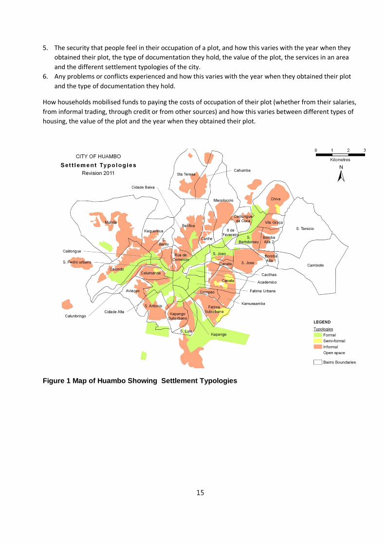
households. A sampling frame was developed based on a GIS-based settlement typology analysis, which
identified three geographically distinct housing types:
Formal areas including the old colonial city and some new condominium-type developments;
Semi-Formal areas where housing has been built informally but aligned for future infrastructure;
Informal settlements or musseques where urban infrastructure has not been planned.
Development Workshop’s research team had carried out similar household surveys in Huambo in 2004 and
2010 and is able to do a comparative data analysis.
The analysis of the survey results focused on getting a better understanding of what documentation
households have for their plots and houses and their perception of security of tenure. It looked in particular
at whether those who obtained plots recently have obtained the documentation stipulated by current
legislation and whether this provides more security of tenure. The specific aspects investigated included:
1. The delineation of houses and neighbourhoods where they are located into specific settlement
typologies, classified as “urbanised,” “informal settlements” and “intermediate (upgradeable)
settlements” and the production of a map of these areas
2. Type of documentation households possess for their plot, how this varies between different settlement
typologies (i.e., urbanised areas, informal settlements, and newer intermediate housing types), how
documentation varies with the year when households obtained their plot, with the value of the plot,
and with the services that are available in different areas.
3. The costs of occupying a housing plot, and how this varies with the year when households obtained their
plot, the value of the plot, the services in an area and the different settlement typologies of the city.
4. Length of time it tool to obtain a plot and how this varies with the year when they obtained their plot,
the type of documentation obtained, the value of the plot, the services in an area and the different
settlement typologies of the city.
15
5. The security that people feel in their occupation of a plot, and how this varies with the year when they
obtained their plot, the type of documentation they hold, the value of the plot, the services in an area
and the different settlement typologies of the city.
6. Any problems or conflicts experienced and how this varies with the year when they obtained their plot
and the type of documentation they hold.
How households mobilised funds to paying the costs of occupation of their plot (whether from their salaries,
from informal trading, through credit or from other sources) and how this varies between different types of
housing, the value of the plot and the year when they obtained their plot.
Figure 1 Map of Huambo Showing Settlement Typologies

16
6. Findings: legal research
6.1. Legal basis for the recognition of land tenure rights in Angola
The existing land tenure legislation stipulates the following:
6.1.1. Rules related to land rights set out in the Constitution of the Republic of
Angola
1. Land. Article 15 of the Constitution states that land ownership is derived from the State and can be
transmitted to natural or legal persons, with a view to their rational and effective use, in accordance
with the Constitution and the law. The Constitution recognizes local communities’ access and use of the
land, in accordance with the law but this does not preclude the possibility of expropriation in the public
interest, subject to fair compensation, in accordance with the law.
2. Right of ownership, Requisition and Expropriation. Article 37 of the Constitution guarantees the right to
private property and its transmission, in accordance with the Constitution and the Law. The State
respects and protects the ownership and other real [property] rights of natural persons, legal entities
and local communities, only being allowed to request temporary civil and expropriation in the public
interest, subject to fair and prompt compensation, in accordance with the Constitution and the Law. The
payment of compensation referred to in the preceding paragraph and condition of effectiveness of
expropriation.
3. Right to Housing. Article 85 of the Constitution states that every citizen has the right to housing and the
quality of life.
4. Tenure. Article 85 of the Constitution states that the land and property originating in State and
integrated in its private domain, with a view to granting and protection of land rights to natural or legal
persons and the rural communities, in accordance with the Constitution and the law. The State
recognizes and guarantees the right to private property of land, defined in the law. The award by the
State of private land ownership and its transfer is only allowed to Angolan nationals.
6.1.2. Land legislation under the Angolan Civil Code and the Land Law of 2005
1. National Land Policy. Angola does not have a comprehensive, written statement of its national land
policy and accordingly has no clear, overarching principles to guide land-related legislation and
regulations, or to prioritize plans for economic growth and development with issues relating to land
access, tenure security, land use, and land administration.
2. Civil Code. The Angolan Civil Code is based on the Portuguese Civil Code and is the fundamental source
of civil law in the country. The Civil Code contains sections on private obligations and contract rights,
commercial law, debtor-creditor relations, property rights, and succession. The Civil Code continues to
govern many land issues – either because they fall outside the ambit of the Land Law or because the
Land Law and Proposed Regulations specifically defer to the Civil Code as the governing law.6 However,
6 ARD & DW pg 9
17
while the Civil Code used to provide for some protection for those occupying land informally for long
periods, the 2004 Land Law removed those provisions, thus subjecting those with informal rights to
eviction if they fail to apply for a legal concession within three years provisioned by law.
3. Angola’s 2004 Land Law.7 Article 4 states that the Angolan Government owns and exercises ultimate
authority over all land and natural resources, and has an irreversible right to expropriate land. The law
expresses the government’s desire to adopt a territory organization policy with objectives of well-being,
economic and social development, and preservation of areas in which traditional ways of using the land
are protected.
4. Surface Rights. Under Article 55 of the Land Law the state can grant surface rights to rural and urban
land to individuals and legal entities for the purpose of construction of buildings or for agricultural use.
Surface rights can be mortgaged and purchased without public auction. Surface rights are granted for
70-year periods, subject to renewal. Regulations require surface rights initially to be granted
provisionally, for a period of no more than five years. The right will be extended only after proof that the
holder of the right has met the obligation of effective use and the land is demarcated.
6.1.3. Rules relating to the regulation of licensing of operations for the
subdivision of land, urban infrastructural works and building construction
(Decree 80/06)
1. Principle of Licensing. Article 4 of the Decree 80/06 provides provisions for the licensing of
allotment (sub-division) operations of land suitable for private urban property development, or the
granting of surface domain rights to private persons. However land to be licensed must fall within
the perimeters defined as “urban” as contained in approved urban master plans. The operations of
construction of buildings in these same land or lots, but must respect the rules of the General
Regulations on urban and rural territories on planning.
2. Principle of successive development. Article 6 of the Decree 80/06 requires that for the licensing of
a given for an urban development (construction) it is necessary to have previously or simultaneously
licensed operations that must precede in the logical sequence of the urbanization process.
3. Urban operations and works subject to planning permission. The Decree 80/06 states that private
initiatives require permits to carry out the following urban operations: allotment or sub-division;
construction or building in general. The operations of allotment or sub-division can only be licensed
when focusing on areas of land classified as urban or “brownfield” developments or contained
within in urban perimeters already defined or covered by new urban centers under urban
development plans.
4. Definition of allotment. Article 9 of the Decree 80/06 states that allotment (or subdivision) is the
operation of restructuring urban land that involves the division, simultaneous or subsequent, of one
or more plots of land situated within urban perimeters, into standalone units or lots intended for the
construction of buildings and other urban related use, with the corresponding change in the rights of
use. Allotment must be made in accordance with the directives of urban development plans, or in
the absence of a plan, with the directives issued by the competent municipal administrations.
7 Ibid pg 11
18
5. Title. Article 52 of the Decree 80/06 states that a Título represents planning permission that is
guaranteed by license. The guarantee of the title permit and of validity of the license depends on the
payment to the planning authority of the fees due by the applicant.
6. Property Registry. Article 52 of the Decree 80/06 also states that the title constitutes proof of
authorization of the allotment for the purpose of construction, and must be recorded in the
Property Registry Registo Predia.
6.1.4. Legal Instruments used to Define Tenure Rights
1. The legal framework and the relationship between Land Surface Rights and the Registry of Property.
Article 98 of the Angolan Constitution enshrines, ipis verbis, the right to private ownership of the
land along with other land rights, including customary use of land, surface use rights and the civil
right under Article 34 to precarious or temporary occupancy of land. Although not clearly
articulated, the regulation of surface rights appears to contradict and does not fully incorporate
other property rights that are enshrined in law.
2. The State’s almost exclusive use of the Law of Surface Rights. The current practice and the preferred
option of the Angolan State has been – and continues to be almost exclusively – to use the
constitutional provision of granting surface rights. The choice of this option is understandable
because it gives the State the sole responsibility for developing a strategic vision, policy
management of urban planning and land management that protects the private domain of the State.
However by restricting the recognition of land rights to this single application, the wider framework
of rights guaranteed under the Constitution are excluded.
3. Surface rights have legitimacy through the Civil Code. In addition to the constitutional justification
under Article 89, the provision of Surface Rights is also enshrined in the Civil Code, in Articles 1524
and 1527. The Civil Code states that "surface rights may be conferred by the State to individual and
public legal persons in the form of private domain rights subject to special legislation (the Land Law).
4. Obligation to construct a building. On the basis of Article 1524 of the Civil Code, the true right to
surface is defined as the "faculty to build, either permanently or temporarily a work on the land." It
is understood, therefore, in the social interest, beyond the law, the right to surface, serves to
encourage the construction of buildings on land occupied by a person in order to maintain their
rights to that land even if that person does not want to or cannot afford to build.
5. Surface rights as a tool for urban management. The granting of surface rights is a legal instrument
that can be used by cities and other urban centres to facilitate the construction of buildings for
housing, industrial or commercial uses by individuals and the private sector. Income for local
authorities can be derived from the granting and transfer of surface rights by subjecting the issue of
titles to lump sum or periodic payments.8
6. Local Authorities ability to grant Surface Rights. Article 39 of the Land Law accords local municipal
authorities the responsibility to grant surface rights for rural and urban land to individuals or to
national or foreign legal entities.
8 Mendes, Armindo Ribeiro, (1967) O Direito de Superfície.

19
6.1.5. Land Management and Registration of Tenure Rights
1. Licensing real estate.9 Real estate represents property that by law should be documented with a public deed.10 However a public deed is not enough, given that it represents real property, it should also be the subject of a land register11 open and available to public scrutiny. In the past, there was no publicly available land registry in Huambo.
2. Surface Rights and the right to build. Surface rights as defined by Article 1524 of the Civil Code and
Article 39 of the Land Law do not automatically confer the right to build. The right to build does not
derive directly from the surface right. It is, rather, a power that must be additionally granted to the
holder, according to the terms and conditions defined by (i) legal urban standards and (ii) by plans of the
proposed construction. However, it is the State that is responsible for assessing and deciding (granting a
license), prior to construction, if the conditions in which the person wishes to do so conform to the legal
standards and the urban plans.
3. The Land Register and Surface Rights. In order to secure full legal tenure the "title to surface rights"
must be duly registered with the Land Registry. The Registry must also show that the holder has an
approved your project, whose technical construction aspects should take into account the "General
Regulation of Urban Buildings", the "General Regulation of Territorial Planning and an "Environmental
9 Real estate rights can be defined as the direct and immediate power over a thing that the legal order
assigns a person to satisfy the interests legal-private in accordance with the terms and limits specified therein.
It is a domain or of sovereignty that the holder exercises directly and immediately on a sure thing and
determined without the interference of any person, the person who corresponds to the obligation of non an
injunction Beside the expression real, and used the expression "law of things". The latin word real means
something, hence real rights, right of things generalize the same branch of law. Inherence is not legally
possible to transmit the same real right of one thing for another.
10 Public deed is intended to give legal effect to a given document, and is carried out and supervised by
competent notary public entity. After this act (contract) should immediately proceed with final registration in
Land Registry. Act, by which transmits the well from one owner to another through a written document and
signed by both parties before a notary or his representative.
11 Land register is intended primarily to give publicity to the legal situation of the buildings, with a view to the safety of
real estate legal trade. Through the information provided by the registry (with interest in particular to those who will
buy a house) one can get to know the composition of a given building, to whom it belongs and what type of charges
(mortgages, liens, etc) related to it.
20
Impact Assessment." The approval should result in the issuance of an allotment license, a construction
license, and an approval of the environmental impact assessment.
4. The License for Construction. The construction permit, once issued, gives the citizen the legal certainty
that the work is authorized as to technical aspects and is in compliance with the urban development
plans, the rules of hygiene and safety, the urban aesthetics, the technical conditions of the foundations
of the structure of the walls, the sanitary facilities and sewage, the layout of the interior spaces and free,
the respect for minimum areas of set-backs and the rules relating to the building standards for floors
and roofs, etc. It is on the basis of the construction permit that, once the work has been completed, it
may be surveyed before the approval of a license of habitability. Therefore, non-compliance with the
conditions dictated in the construction license can result in the non-issuance of the Title to Surface
Rights, the crucial document representing the public property deed, and can lead to own whole or
partial demolition of the building that was built.
5. The License for Allotment (sub-division). The allotment license approves the division, simultaneous or
subsequent, of one or more land situated in urban perimeters, to stand-alone units or lots intended for
the construction of buildings. The issuance of an allotment license corresponds to the amendment of
rights in accordance with the directives of urban development plans, or in their absence, with the
directives issued by the competent local authorities. Based on the allotment license, the plot of land on
which a particular or real estate developer had only the "right of surface", will be divided "legally" in
batches for urban uses, with the consequent amendment of rights attributed to each plot allowing them
to be incorporated as individual plots in the Land Registry. In accordance with the law (Article 9 of the
Decree 80/06), the allotment license constitutes proof of authorization for land sub-division for
construction purposes. The allotment licenses for each of the sub-divided plots provide the legal
guarantee for those who are buying a property for construction purposes.
6.2. Legal and administrative procedures related to land rights as
practiced in Huambo
This section summarizes and reflects on the finding s from the in-depth interviews with key informants who
are key management authorities involved in the administration of land in the Province of Huambo.
Interviewees included senior persons from the Municipal Administrations of Huambo and Caala
Municipalities and from the Provincial Government of Huambo who have specific responsibilities in land
administration.
6.2.1. Summary of Interviews
Informal occupation is a common occurring pattern in Huambo Municipality. Many citizens already have a
plot of land that they occupy. The plot of land is acquired by various means, normally not official. After the
occupation or purchase of a plot of land, the citizen builds his/her house and only later investigates the
options for legalizing their possession. A question that arises is that before the occupation is
regularized/legalized, what is the occupant’s tenure status and what guarantees does the citizen have to
safeguard their occupation?
6.2.2. How is the land/plot/lot acquired?
The acquisition process occurs in various ways, namely:
21
The citizen acquires / purchases, own resources, through third parties (sometimes people connected
to the Municipal Administration) a lot;
The citizen has possession by simply, "occupying" a lot or a portion,
The citizen claims to be an heir of aging parents, grandparents, or of land claims being offered by
relatives, in which case the Administration requires a document showing this information. This
document must be reviewed by the Soba and the Commission of the District;
The citizen acquires land through a process initiated in Municipal Administration itself (this process
is described in section below).
6.2.3. Is the transfer of plot(s) managed?
As a rule, the transfer of plot(s) is usually initiated by the Municipal Administration itself sometimes as
partnership initiatives with other institutions, as is the case with Development Workshop. The process starts
with identification of areas where plots are available or have pending claims for acquisition. Typically, there
are numerous requests "pending", i.e., people, claiming a lot, but was not granted because it was not
available. A claim is made in order of seniority, as there are areas with available plots allotted.
To this end, the citizen files an application to request a lot to the Municipal Administration. Then, a
confirmation is made in the database, to monitor that same citizen is not already a beneficiary of lot granted
by the Administration. When confirmed that the citizen petitioner was not previously a beneficiary or
holder, then he/she is considered "eligible" to benefit a lot. However, the fact be considered "eligible" does
not mean that automatic benefits. The citizen must make another request with the Division of Planning and
Urbanism of Municipal Administration, that he/she intended this a lot as soon there is available area
6.2.4. What is the process for regularization of a lot?
The regularization process is a lot different depending on whether it is a lot acquired "ab initio" from the administration, or acquired by other means and on it has been previously constructed.
When the batch has been granted by the Administration, the "culmination" of the Administration process results in the emission of licenses by the Administration itself.
Ie the citizen submits the applications and joins copy of Identity. Having available batch are issued guides for citizens pay the fees due, and the fees once paid are issued licenses for auction, fencing and construction. Note here that, most citizen just with these licenses, although we are not here, strictly speaking, the culmination of the process of legalizing a lot, since legal certainty is not yet solid.
The second part of the question c) brings us to the next question below.
6.2.5. Regularization of a lot with previously unauthorized construction
The regularization of a lot on which there was previously "illegal" construction, ie, unauthorized, the runs the same way in which it handles the situations in which citizens already holds a lot (not yet built), with a variant, which we will explain:

22
The first variant is when the citizen gets Administration with a lot - who claims to be his - but where not built yet. In this case, they submit the (i) Application with (ii) Copy of Identity Card (iii) Declaration of Soba - traditional chief (iv) Request for Subdivision of Lot and (v) Location map.
Then the Administration will assess whether it is an urban area with infrastructure and allotted (if this is the case, follow the route described above, when it comes to areas allotted and issued by the Directors).
If, on the contrary, based on visits of technicians Rotua and concrete assessment, concluding that it is not possible, then the licenses are not issued.
The reasons may be the cause of a negative opinion and thus are not issuing licenses in the first place, building or lot to be in risk areas (ravines, for example) or do not meet the required clearances to the law requires (rivers, streams, etc..) or building completion not obeyed the requirements of building works and urbanism, which makes it impossible to fix that infrastructure estrutruras be incorporated in the future.
It follows that one determines "illegal" construction can be "legalized", while not respecting certain criteria referred to above, provided that you can make adjustments.
Moreover, if the house built "illegally" being a plot "legalizável" before being issued the licenses to regularize urban acts committed, citizens must pay the fines. The fines have been reduced, often more than half, so as not to discourage citizens from seeking municipal services in order to regularize their situation.
6.2.6. Summary Analysis of the Interviews
Interviews with the key political and administrative actors at the Provincial and Municipal levels in Huambo
demonstrate that in-spite of weak, unclear and unenforceable national legislation on land tenure that local
solutions have been developed to respond, in practice, to the urgent territorial settlement issues that
Huambo confronted at the end of the armed conflict. These administrative procedures have gained
widespread legitimacy in practice in Huambo and have been increasingly been employed by the Municipal
Administration who have the responsibility for domestic-scale12 land management. While the 2004 Land Law
provides the provision for granting titles to surface rights, the regulations of how these titles can be applied
in peri-urban areas has not yet been approved. In most Angolan cities, the vast majority of families live in
informal settlements where land titles cannot yet be issued. In Huambo 80% of the population, live in
settlements that have not yet been formally planned, and lack roads and infrastructure. The Huambo
provincial and Municipal authorities have therefore developed administrative procedures to manage land
12 Law 07/02 governing decentralisation gives municipalities the responsibility to manage land parcels under
1000 square meters.

23
and owner-initiated housing that is based on the principals of verifiable evidence-of-occupation and the
logical distribution of new urban land through seniority and waiting lists.
Huambo’s provincial and municipal authorities have welcomed the collaboration with Development
Workshop over the last several years in piloting demonstration projects in participatory inclusive land
readjustment. These projects have contributed to the development of the set of administrative tools by the
Municipal Administration that have allowed them to tackle the challenges of land management without
resorting to large-scale forced removals that have attracted unfavorable media attention and accusations of
human-rights violations in many other provinces in Angola. The Municipal Administrator of Huambo, when
interviewed for this current study, stated that; “So far, we haven't demolished any house that was already
built“.
However in the same interview the Administrator admitted that; “There is a huge confusion between what is
administrative, what is judicial, and I have had several problems because of that”. Thanks to open-minded
and innovative local leadership, urban land conflicts remain rather rare in Huambo to date. There have been
few disputes that have been taken to the courts. Because legal land-documents in the form of Surface Rights
Titles are almost never issued and the procedural regulations for dealing with the vast informal settlements
have not been published by the executive branch of Government, the current strategy of employing local
administrative tools seems to be appropriate. However it remains to be explored, how these tried-and-
tested administrative procedures, which incorporate many of the good-practice principals of incremental
land tenure, can be progressively legalized?
The possibility of employing the authority of the Provincial Government to pass and publish their own “by-
laws” in the form of posturas or Governorial Decrees for application within the Huambo’s geographic
jurisdiction remains to be explored. After municipal elections are held in 2015, it is anticipated that the
elected councils “autarquias” will have the authority to create local by-lays and create legal regulations
within the constitutional division of powers between different levels of governance. Domestic-scale land-
management for housing is within the realm of municipal authority,
7. Findings: Huambo household survey on land and housing
The objectives of this household survey are to understand the dynamics of urban land markets in Huambo
city. Land is an active ingredient in the economic strategies of poor people. All urban dwellers need secure
access to land on which to live and be productive. For poor families, housing, and the land they occupy, can
represent their accumulated savings and assets. Thus there is a need to look at how urban land markets in
Huambo function and meet the needs of different groups, and in particular how poor people access, trade,
and hold urban land. This involves understanding better the volume of transactions, prices, the informality
of land and housing markets, and the roles of brokers, intermediaries and agents, and government. A sound
information base of urban land access through formal and informal land markets will is needed to facilitate
the development of urban policy and land use management practice in the urban and peri-urban areas of
Angola. The need to understand the formal and informal land markets in Luanda is an essential step in
developing urban land management systems which would promote social and economic inclusion.
24
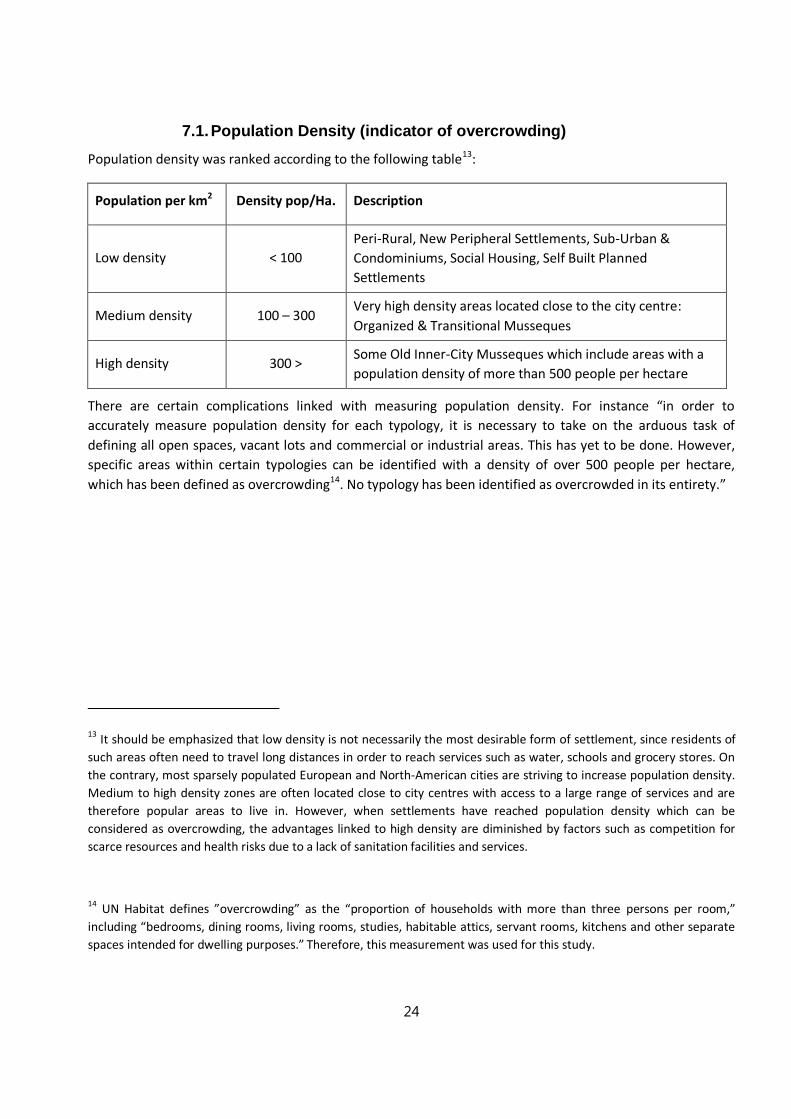
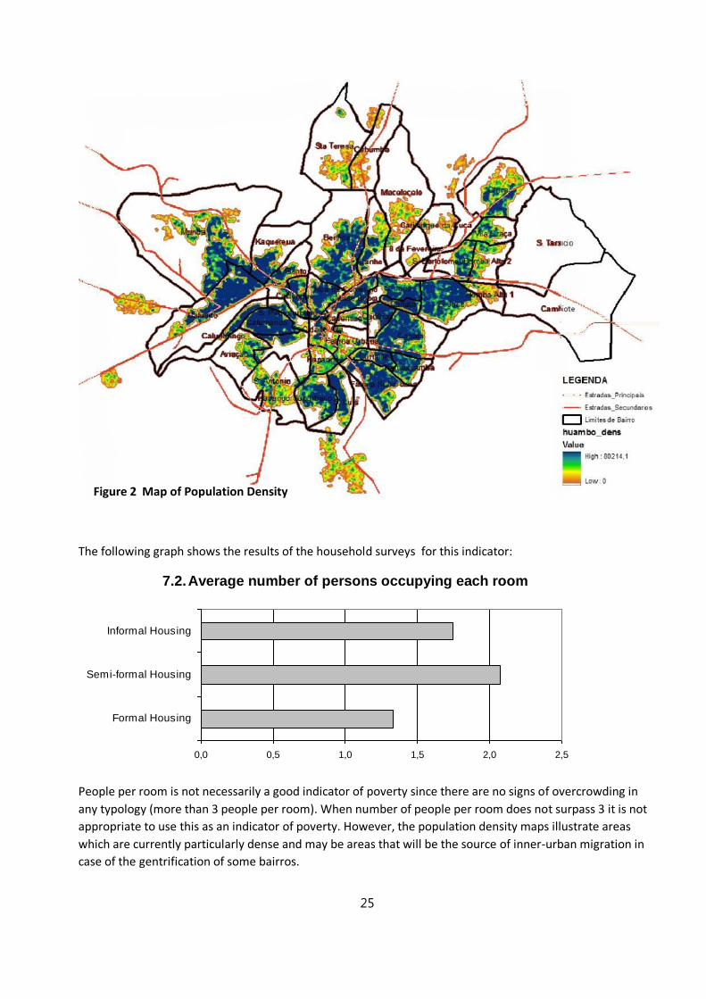
7.1. Population Density (indicator of overcrowding)
Population density was ranked according to the following table13:
Population per km2 Density pop/Ha. Description
Low density < 100
Peri-Rural, New Peripheral Settlements, Sub-Urban &
Condominiums, Social Housing, Self Built Planned
Settlements
Medium density 100 – 300 Very high density areas located close to the city centre:
Organized & Transitional Musseques
High density 300 > Some Old Inner-City Musseques which include areas with a
population density of more than 500 people per hectare
There are certain complications linked with measuring population density. For instance “in order to
accurately measure population density for each typology, it is necessary to take on the arduous task of
defining all open spaces, vacant lots and commercial or industrial areas. This has yet to be done. However,
specific areas within certain typologies can be identified with a density of over 500 people per hectare,
which has been defined as overcrowding14. No typology has been identified as overcrowded in its entirety.”
13 It should be emphasized that low density is not necessarily the most desirable form of settlement, since residents of
such areas often need to travel long distances in order to reach services such as water, schools and grocery stores. On
the contrary, most sparsely populated European and North-American cities are striving to increase population density.
Medium to high density zones are often located close to city centres with access to a large range of services and are
therefore popular areas to live in. However, when settlements have reached population density which can be
considered as overcrowding, the advantages linked to high density are diminished by factors such as competition for
scarce resources and health risks due to a lack of sanitation facilities and services.
14 UN Habitat defines ”overcrowding” as the “proportion of households with more than three persons per room,”
including “bedrooms, dining rooms, living rooms, studies, habitable attics, servant rooms, kitchens and other separate
spaces intended for dwelling purposes.” Therefore, this measurement was used for this study.
25
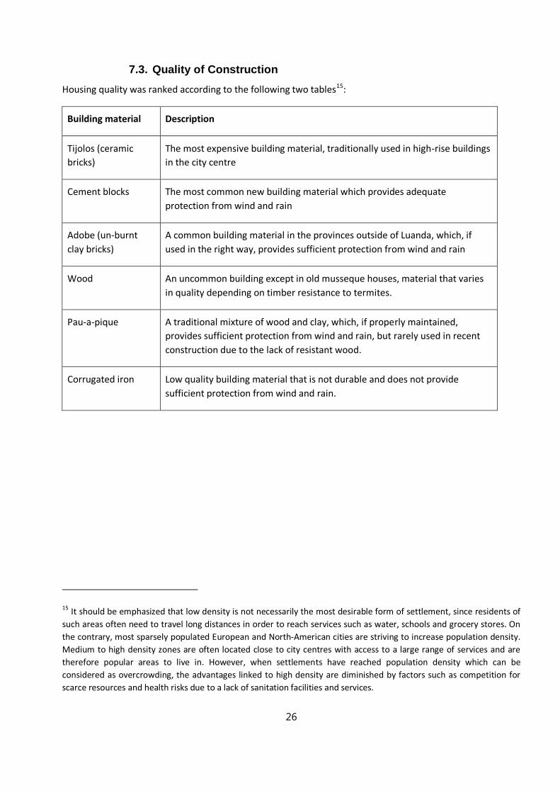
The following graph shows the results of the household surveys for this indicator:
7.2. Average number of persons occupying each room Número de pessoas por divisão na cada tipologia
0,0 0,5 1,0 1,5 2,0 2,5
Formal Housing
Semi-formal Housing
Informal Housing
People per room is not necessarily a good indicator of poverty since there are no signs of overcrowding in
any typology (more than 3 people per room). When number of people per room does not surpass 3 it is not
appropriate to use this as an indicator of poverty. However, the population density maps illustrate areas
which are currently particularly dense and may be areas that will be the source of inner-urban migration in
case of the gentrification of some bairros.
Figure 2 Map of Population Density
26
7.3. Quality of Construction
Housing quality was ranked according to the following two tables15:
Building material Description
Tijolos (ceramic
bricks)
The most expensive building material, traditionally used in high-rise buildings
in the city centre
Cement blocks The most common new building material which provides adequate
protection from wind and rain
Adobe (un-burnt
clay bricks)
A common building material in the provinces outside of Luanda, which, if
used in the right way, provides sufficient protection from wind and rain
Wood An uncommon building except in old musseque houses, material that varies
in quality depending on timber resistance to termites.
Pau-a-pique A traditional mixture of wood and clay, which, if properly maintained,
provides sufficient protection from wind and rain, but rarely used in recent
construction due to the lack of resistant wood.
Corrugated iron Low quality building material that is not durable and does not provide
sufficient protection from wind and rain.
15 It should be emphasized that low density is not necessarily the most desirable form of settlement, since residents of
such areas often need to travel long distances in order to reach services such as water, schools and grocery stores. On
the contrary, most sparsely populated European and North-American cities are striving to increase population density.
Medium to high density zones are often located close to city centres with access to a large range of services and are
therefore popular areas to live in. However, when settlements have reached population density which can be
considered as overcrowding, the advantages linked to high density are diminished by factors such as competition for
scarce resources and health risks due to a lack of sanitation facilities and services.
27
Roof material Description
Ceramic tiles (telhas) The most expensive roof material, traditionally used in high-rise buildings in
the city centre
Corruagated iron
(chapas de zinco ou
de lausalite)
The most common roof material in Luanda, which, if well maintained,
provides moderate protection from wind and rain. Asbestos cement sheets
are known to be a health risk.
Thatch roofs (capim) Low quality roof material that is not durable and does not provide sufficient
protection from wind and rain unless it is maintained very regularly. Thatch
roofs are a clear indicator of limited financial means and are rarely used in
Luanda
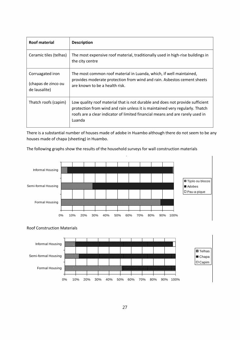
There is a substantial number of houses made of adobe in Huambo although there do not seem to be any
houses made of chapa (sheeting) in Huambo.
The following graphs show the results of the household surveys for wall construction materials O material de construção da casa é?
0% 10% 20% 30% 40% 50% 60% 70% 80% 90% 100%
Formal Housing
Semi-formal Housing
Informal Housing
Tijolo ou blocos
Adobes
Pau-a-pique
Roof Construction Materials O tecto da habitação é de ……. ?
0% 10% 20% 30% 40% 50% 60% 70% 80% 90% 100%
Formal Housing
Semi-formal Housing
Informal Housing
Telhas
Chapa
Capim
28
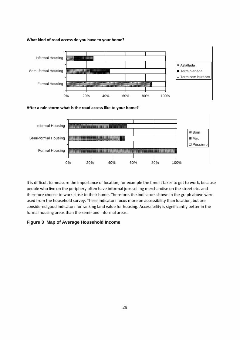
7.4. Road Access to Housing
It is difficult to measure the importance of location, for example the time it takes to get to work, because
people who live on the periphery often have informal jobs selling merchandise on the street etc. and
therefore choose to work close to their home. Therefore, the indicators shown in the graph above were
used from the household survey. These indicators focus more on accessibility than location, but are
considered good indicators for ranking land value for housing.
Accessibility is significantly better in the formal housing areas than the semi- and informal areas. The
following ranking tables were prepared for this indicator:
Road conditions Description
Good Most of the streets in the city centre are made of asphalt and have proper
drainage systems which keep the streets accessible even after heavy
rainfalls..
Bad The dirt roads do not have a drainage system, but some of them are graded
and are still passable after a regular rainy season rainfall.
Inacceptable Most of the bumpy dirt roads in the musseques become impassable each
time it rains.
Type of road Description
Asphalt Most roads in urban areas and the main access roads to the musseques are
made of asphalt.
Improved dirt road Some major roads in the musseques are improved dirt roads
Bumpy dirt road Most of the streets inside the musseques are bumpy dirt roads. Some of the
access roads are made of old and worn asphalt with large holes in it.
29
What kind of road access do you have to your home? Como é a estrada de acesso a casa?
0% 20% 40% 60% 80% 100%
Formal Housing
Semi-formal Housing
Informal Housing
Asfaltada
Terra planada
Terra com buracos
After a rain storm what is the road access like to your home? Depois da chuva como é o estado das ruas do bairro?
0% 20% 40% 60% 80% 100%
Formal Housing
Semi-formal Housing
Informal Housing
Bom
Mau
Péssimo
It is difficult to measure the importance of location, for example the time it takes to get to work, because
people who live on the periphery often have informal jobs selling merchandise on the street etc. and
therefore choose to work close to their home. Therefore, the indicators shown in the graph above were
used from the household survey. These indicators focus more on accessibility than location, but are
considered good indicators for ranking land value for housing. Accessibility is significantly better in the
formal housing areas than the semi- and informal areas.
Figure 3 Map of Average Household Income

30
7.5. Acquiring the occupation of a house or plot of land
Formal Informal Semi Formal
0
10
20
30
40
50
60
70
How did you acquire this house or plot of land?
Huambo
By occupying an empty plot
By occupying an empty house
By buying a house
By buying a plot
Received from the state
Inheritance and other
31
In the surveys, respondents were asked how they gained access to their house or a plot of land. Generally, “occupying an empty plot of land” does not feature very strongly as a means of land access and is only mentioned by people in informal areas who occupied land several years ago. Occupying empty houses is similarly rarely mentioned: where it occurs, in formal housing areas, it refers to occupation of a house in the 1970s or 1980s. It is therefore important to note that contrary to the common notion that many people are squatters, the findings of this study show that most people are not occupying or “squatting” on land and houses that they have not paid for.
In formal housing areas of Huambo, the most frequently mentioned means of access to land or a house is
reception of a house from the State - “cedência do estado”. This refers to the process by which the State
divested itself of its housing stock in the 1980s and 1990s to those who at the time were its tenants.
Inheritance is the next most important way in which respondents had gained access to property in formal
housing areas. Buying a house (or a plot) only accounts for about a total of 20% of cases though these have
become more important in recent years.
In informal housing areas the most frequently mentioned ways of acquiring land or a house are through
purchase of a plot of land on which a house has been built by the owner subsequently, and through
inheritance. Purchase of a house is quite rare.
In semi-formal housing areas the most frequently mentioned means of access to land or a house is reception
of a plot of land from the State - “cedência do estado”. Semi-formal housing areas in Huambo now include
new areas that have been divided into plots in the past 5 years and on which people usually have to build
their own houses, as well as the old semi-formal areas from the colonial era. For example in Santa Iria about
600 plots of 15 x 25 metres (375 square metres) have been provided by the Provincial Directorate of
Urbanism since 2006. Those who were subscribed to receive a plot, and were accepted, had to pay 100
kwanzas per square metre for a licenca de arrematacao, (licence to fence off a plot) and then pay 60,000
Kwanzas for a planta tipo (a standard plan of the type of house that should be constructed). In theory it is
necessary to also have a licenca de construcao (construction licence) but in practice no-one has one and this
has not been enforced. The licenca de arrematacao would have cost about 37500 kwanzas, which was about
450 Dollars at the time. Many people consider that they have bought the land from the State, and it is
reported that some of those who have received lots have been able to sell them for about 30 US Dollars per
square metre as there are signs that road access to the area is to be improved and electricity is to be
provided (see later).
There is no specific stipulation that a plot-holder has to stay for a certain period of time, because in theory
all selling of land is illegal. The responsibility for this type of land distribution activity has passed to the
Municipal Administration from Provincial Directorate of Urbanism, and there are now similar processes
going on at Sassonde, Cambiota and Chiva. There is strong demand as building on such a plot as seen as a
good investment: there is a risk that services may not be provided later leaving the plot-holder with lower
value land and poorer living conditions but in current conditions the belief is that these areas will benefit
from services within a year or two.
Thus a market in land does exist, though it is most visible in informal areas: in other areas obtaining land
from the State is more important, though the market has become more important in recent years. In formal

32
housing areas, most purchases or occupation is of a house that has already been constructed. In informal
and semi-formal areas most residents have obtained a plot and built their own house on this.
Only in informal
housing areas are there residents who have been occupying the same house since before independence in
1975 (about a third of residents of those areas). Another third of residents have been living there only for
the last five years, meaning that informal housing areas are a mix of long-term and relatively new residents.
In formal housing areas, 80% of residents moved there between 1975 and 1999. In semi-formal areas, most
residents moved to their present location since 2006, when the State began to make available plots for
building in some areas of Huambo city.
Eighty per cent of residents of formal and semi-formal areas had paid something to occupy their present
house or plot of land, while only 48% of residents of informal areas had paid. In formal housing areas the
payment was made to a government department (reflecting the fact that houses were acquired when the
State divested itself of its housing stock. In informal housing areas payments were made to the previous
proprietor. Few payments are made to intermediaries, even though contacts for sales are made through
intermediaries. Intermediaries act as agents to find properties but do not get involved in payments. Few real
estate agents involve themselves in the actual transfer of property. Their activities are mostly limited to
Formal Informal Semi-formal
0
10
20
30
40
50
60
70
80
90
When did you start to occupy this house or plot of land?
Huambo
Before 1975
1975-89
1990-99
2000-06
2006-09
y-A
xis
Title
Formal Informal Semi Formal
0
10
20
30
40
50
60
70
80
90
100
Did you occupy (or buy) a house or an empty plot of land?
Huambo
Occupied an empty plot
Occupied a house
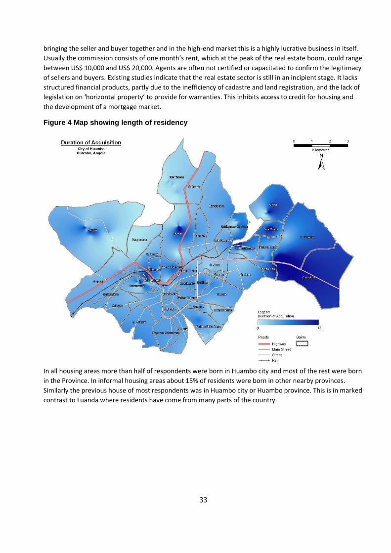
33
bringing the seller and buyer together and in the high-end market this is a highly lucrative business in itself.
Usually the commission consists of one month’s rent, which at the peak of the real estate boom, could range
between US$ 10,000 and US$ 20,000. Agents are often not certified or capacitated to confirm the legitimacy
of sellers and buyers. Existing studies indicate that the real estate sector is still in an incipient stage. It lacks
structured financial products, partly due to the inefficiency of cadastre and land registration, and the lack of
legislation on ‘horizontal property’ to provide for warranties. This inhibits access to credit for housing and
the development of a mortgage market.
Figure 4 Map showing length of residency
In all housing areas more than half of respondents were born in Huambo city and most of the rest were born
in the Province. In informal housing areas about 15% of residents were born in other nearby provinces.
Similarly the previous house of most respondents was in Huambo city or Huambo province. This is in marked
contrast to Luanda where residents have come from many parts of the country.
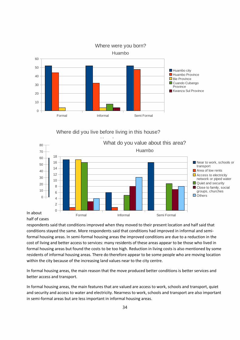
34
In about
half of cases
respondents said that conditions improved when they moved to their present location and half said that
conditions stayed the same. More respondents said that conditions had improved in informal and semi-
formal housing areas. In semi-formal housing areas the improved conditions are due to a reduction in the
cost of living and better access to services: many residents of these areas appear to be those who lived in
formal housing areas but found the costs to be too high. Reduction in living costs is also mentioned by some
residents of informal housing areas. There do therefore appear to be some people who are moving location
within the city because of the increasing land values near to the city centre.
In formal housing areas, the main reason that the move produced better conditions is better services and
better access and transport.
In formal housing areas, the main features that are valued are access to work, schools and transport, quiet
and security and access to water and electricity. Nearness to work, schools and transport are also important
in semi-formal areas but are less important in informal housing areas.
Formal Informal Semi Formal
0
10
20
30
40
50
60
Where were you born?
Huambo
Huambo city
Huambo Province
Bie Province
Cuando Cubango Province
Kwanza Sul Province
Formal Informal Semi-formal
0
10
20
30
40
50
60
70
80
Where did you live before living in this house?
Huambo
Huambo
Huambo Province
Bie Province
Kuando Kubango Province
Kwanza Norte Province
Formal Informal Semi Formal
0
2
4
6
8
10
12
14
16
18
What do you value about this area?
Huambo
Near to work, schools or transport
Area of low rents
Access to electricity network or piped water
Quiet and security
Close to family, social groups, churches
Others
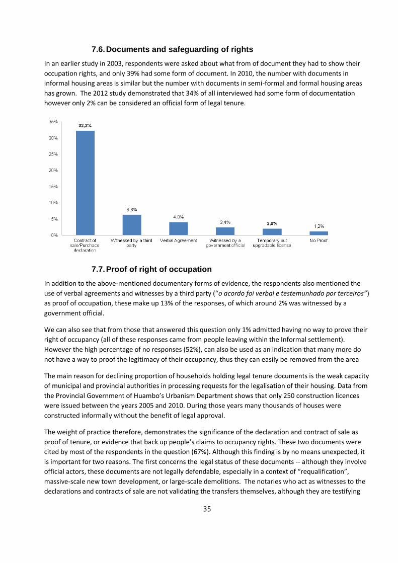
35
7.6. Documents and safeguarding of rights
In an earlier study in 2003, respondents were asked about what from of document they had to show their
occupation rights, and only 39% had some form of document. In 2010, the number with documents in
informal housing areas is similar but the number with documents in semi-formal and formal housing areas
has grown. The 2012 study demonstrated that 34% of all interviewed had some form of documentation
however only 2% can be considered an official form of legal tenure.
7.7. Proof of right of occupation
In addition to the above-mentioned documentary forms of evidence, the respondents also mentioned the
use of verbal agreements and witnesses by a third party (“o acordo foi verbal e testemunhado por terceiros”)
as proof of occupation, these make up 13% of the responses, of which around 2% was witnessed by a
government official.
We can also see that from those that answered this question only 1% admitted having no way to prove their
right of occupancy (all of these responses came from people leaving within the Informal settlement).
However the high percentage of no responses (52%), can also be used as an indication that many more do
not have a way to proof the legitimacy of their occupancy, thus they can easily be removed from the area
The main reason for declining proportion of households holding legal tenure documents is the weak capacity
of municipal and provincial authorities in processing requests for the legalisation of their housing. Data from
the Provincial Government of Huambo’s Urbanism Department shows that only 250 construction licences
were issued between the years 2005 and 2010. During those years many thousands of houses were
constructed informally without the benefit of legal approval.
The weight of practice therefore, demonstrates the significance of the declaration and contract of sale as
proof of tenure, or evidence that back up people’s claims to occupancy rights. These two documents were
cited by most of the respondents in the question (67%). Although this finding is by no means unexpected, it
is important for two reasons. The first concerns the legal status of these documents -- although they involve
official actors, these documents are not legally defendable, especially in a context of “requalification”,
massive-scale new town development, or large-scale demolitions. The notaries who act as witnesses to the
declarations and contracts of sale are not validating the transfers themselves, although they are testifying
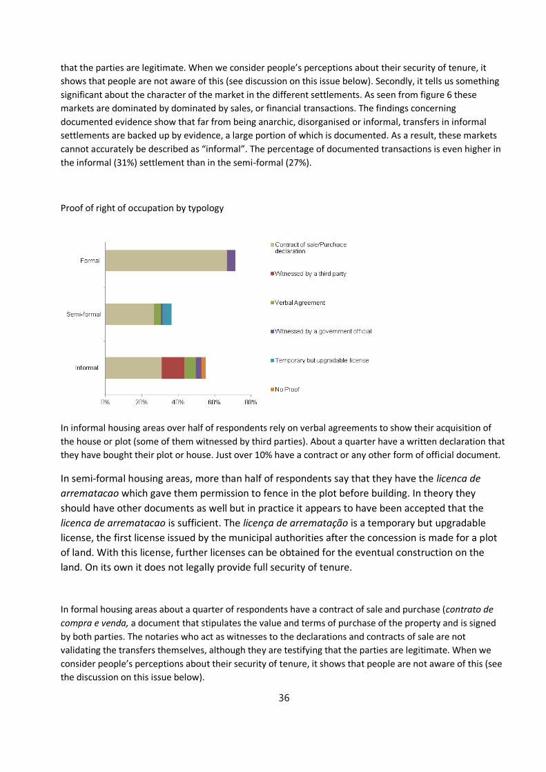
36
that the parties are legitimate. When we consider people’s perceptions about their security of tenure, it
shows that people are not aware of this (see discussion on this issue below). Secondly, it tells us something
significant about the character of the market in the different settlements. As seen from figure 6 these
markets are dominated by dominated by sales, or financial transactions. The findings concerning
documented evidence show that far from being anarchic, disorganised or informal, transfers in informal
settlements are backed up by evidence, a large portion of which is documented. As a result, these markets
cannot accurately be described as “informal”. The percentage of documented transactions is even higher in
the informal (31%) settlement than in the semi-formal (27%).
Proof of right of occupation by typology
In informal housing areas over half of respondents rely on verbal agreements to show their acquisition of
the house or plot (some of them witnessed by third parties). About a quarter have a written declaration that
they have bought their plot or house. Just over 10% have a contract or any other form of official document.
In semi-formal housing areas, more than half of respondents say that they have the licenca de
arrematacao which gave them permission to fence in the plot before building. In theory they
should have other documents as well but in practice it appears to have been accepted that the
licenca de arrematacao is sufficient. The licença de arrematação is a temporary but upgradable
license, the first license issued by the municipal authorities after the concession is made for a plot
of land. With this license, further licenses can be obtained for the eventual construction on the
land. On its own it does not legally provide full security of tenure.
In formal housing areas about a quarter of respondents have a contract of sale and purchase (contrato de
compra e venda, a document that stipulates the value and terms of purchase of the property and is signed
by both parties. The notaries who act as witnesses to the declarations and contracts of sale are not
validating the transfers themselves, although they are testifying that the parties are legitimate. When we
consider people’s perceptions about their security of tenure, it shows that people are not aware of this (see
the discussion on this issue below).
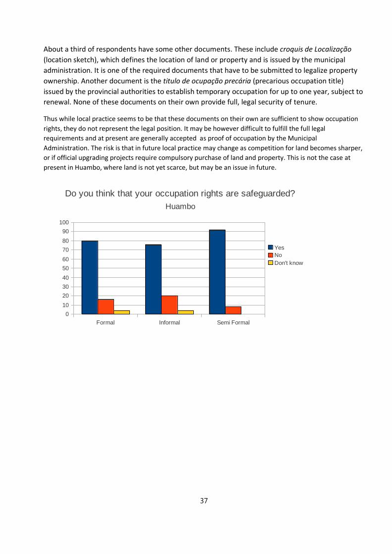
37
About a third of respondents have some other documents. These include croquis de Localização
(location sketch), which defines the location of land or property and is issued by the municipal
administration. It is one of the required documents that have to be submitted to legalize property
ownership. Another document is the titulo de ocupação precária (precarious occupation title)
issued by the provincial authorities to establish temporary occupation for up to one year, subject to
renewal. None of these documents on their own provide full, legal security of tenure.
Thus while local practice seems to be that these documents on their own are sufficient to show occupation
rights, they do not represent the legal position. It may be however difficult to fulfill the full legal
requirements and at present are generally accepted as proof of occupation by the Municipal
Administration. The risk is that in future local practice may change as competition for land becomes sharper,
or if official upgrading projects require compulsory purchase of land and property. This is not the case at
present in Huambo, where land is not yet scarce, but may be an issue in future.
Formal Informal Semi Formal
0
10
20
30
40
50
60
70
80
90
100
Do you think that your occupation rights are safeguarded?
Huambo
Yes
No
Don't know
38
Despite not having the full set of documents legally required, respondents overwhelmingly felt that their
occupation rights are safeguarded. Those who are least confident about their occupation rights are those
with a verbal agreement or one witnessed by other parties.
In formal housing areas, the main reason for feeling confident about occupation rights is the possession of
some sort of document or documents (even if the documents held are not the full documents legally
required). The fact that the house was paid for and that verbal permission was received from a government
department or a bairro coordinator are additional reasons cited for faith in the occupation rights. In informal
areas the main reason for feeling confident about occupation rights is that neighbours can testify that the
house or plot of land belongs to the occupier. The numbering of the house by the bairro coordinator and the
fact that the house or land was paid for are additional reasons cited for faith in the occupation rights. In
semi-formal housing areas, the possession of documents, the fact that a payment was made and permission
from the local administration are given as reasons for feeling confident about occupation rights.
In formal and semi-formal housing areas, the main reason for not feeling confident about occupation rights
is doubt about the documents that are held. In informal housing areas the main reason for not feeling
confident about occupation rights is the awareness that people are being forcibly removed in some areas of
the country.
In Huambo Province the official forms of documentation that provide security of tenure are:
1) - Surface right (Direito de Superfície):- this title is granted by the provincial authorities. It
constitutes a concession, usually for 60 years, attributing rights and obligations to own and
build on land. This land may only be used to construct one’s own house or to carry out basic
economic activities. When the purpose of the use of the land is defined, information on the
land must be requested from the municipal or provincial authorities with regard to the
ownership of the land and viability of the project.
2) Land/property registry (Registo Predial): - this document refers to a declaration issued by the
Conservatory (local Ministry of Justice office) as proof of property registration
3) Precarious occupation title (Título de ocupação precária):- this title is issued by the provincial
authorities to establish precarious (temporary) occupation for up to one year, and is subject to
renewal16
16 The right to precarious occupation is stipulated in Article 40 of the Land Law. The state can grant temporary
occupation rights to rural and urban land for up to one year in duration (subject to renewal) to individuals
and entities for purposes of construction, mining, scientific investigation, and other activities permitted by
the relevant regulations. Leases can be terminated by either party with a 60-day notice. Rights regarding
installations and improvements by lessees are subject to applicable provisions of the Civil Code. Where
possible, concessions shall be granted by public auction (with exemptions noted).Under the proposed
regulations, leaseholds may not exceed one hectare for quarries and one-half a hectare for other uses.
Annual lease rates are calculated based on Ministry tables, subject to annual revision. Disputes regarding
lease rates are subject to mandatory arbitration. See ARD DW (2007), p. 17.

39
4) Temporary but upgradable license (Licença de arrematação): - this Occupation License is the
first license issued by the municipal authorities after the concession is made for a plot of land.
With this license, further licenses can be obtained for the eventual construction on the land.
The first three forms of legal land tenure documentation are embedded in the Land Law and/or the Civil
Code. The fourth Occupation Licence is an administrative procedure that allows the occupant three years in
order to obtain legal title documents. In practice however Occupation Licenses are issued by both Municipal
and Provincial Government authorities. In fact they are effectively the only land-tenure documents issued in
the Province of Huambo and have gained the weight of a full legal title in practice.
When considering the weight attached to different forms of evidence there are two perspectives that are
brought to bear. The first concerns local practice, and the other concerns the official government position.
The results of this study show that local practice has more weight, as shown by the graphs (Figure 5 and
Figure.7) Although only 48% of all respondents answered this question, here we can see the disparity
between the legally acceptable documents with the documents that in reality give people a sense of
security.Below is a list of documents cited by respondents of this study:
1) Declaração de compra e venda (purchase and sales declaration)
- this is a declaration signed by both parties to prove transfer of real estate ownership; this declaration can
be signed by witnesses as well, and/or legalized by a notary
2) Contrato de compra e venda (contract of sale) - this document stipulates the value and terms of purchase
of the property and is signed by both parties
3) Licença de arrematação (temporary but upgradable occuption license)
- this license is the first license issued by the municipal authorities after the concession is made for a plot of
land. With this license, further licenses can be obtained for the eventual construction on the land.
The second perspective on the weight of evidence question, over and above the weight of current practice
reported until now, concerns the official status of different forms of evidence. The official forms of evidence
obviously carry the most legal weight, but their use in practice is negligible. One of the critical issues that
emerge from these findings is about how the process of acquiring the status of official tenure should
incorporate the validation of declarations, contracts of sale and other widely used proofs of property
transfer made in good faith. While currently not formally defensible in law, government policy makers
should reconsider how this evidence can be accommodated in the future. In fact, the provincial government
of Luanda has, in practice, used the abovementioned proofs as evidence of legitimate occupation in recent
cadastre processes.17
17 Contributions from Provincial Government representatives at the Roundtable discussion held at the World
Bank Luanda office, 28 January 2011.
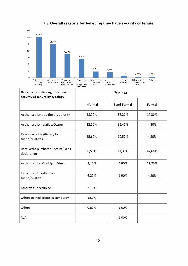
40
7.8. Overall reasons for believing they have security of tenure
Reasons for believing they have
security of tenure by typology
Typology
Informal Semi-Formal Formal
Authorised by traditional authority 28,70% 36,20% 14,30%
Authorised by relative/Owner 22,50% 32,40% 4,80%
Reassured of legitimacy by
friend/relatives 25,60% 10,50% 4,80%
Received a purchased receipt/Sales
declaration 8,50% 14,30% 47,60%
Authorised by Municipal Admin. 3,10% 2,90% 23,80%
Introduced to seller by a
friend/relative 6,20% 1,90% 4,80%
Land was unoccupied 3,10%
Others gained access in same way 1,60%
Others 0,80% 1,00%
N/A 1,00%
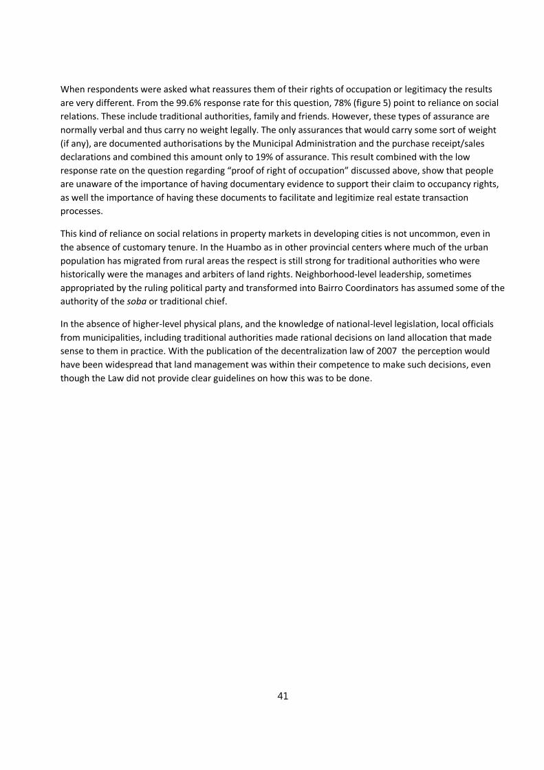
41
When respondents were asked what reassures them of their rights of occupation or legitimacy the results
are very different. From the 99.6% response rate for this question, 78% (figure 5) point to reliance on social
relations. These include traditional authorities, family and friends. However, these types of assurance are
normally verbal and thus carry no weight legally. The only assurances that would carry some sort of weight
(if any), are documented authorisations by the Municipal Administration and the purchase receipt/sales
declarations and combined this amount only to 19% of assurance. This result combined with the low
response rate on the question regarding “proof of right of occupation” discussed above, show that people
are unaware of the importance of having documentary evidence to support their claim to occupancy rights,
as well the importance of having these documents to facilitate and legitimize real estate transaction
processes.
This kind of reliance on social relations in property markets in developing cities is not uncommon, even in
the absence of customary tenure. In the Huambo as in other provincial centers where much of the urban
population has migrated from rural areas the respect is still strong for traditional authorities who were
historically were the manages and arbiters of land rights. Neighborhood-level leadership, sometimes
appropriated by the ruling political party and transformed into Bairro Coordinators has assumed some of the
authority of the soba or traditional chief.
In the absence of higher-level physical plans, and the knowledge of national-level legislation, local officials
from municipalities, including traditional authorities made rational decisions on land allocation that made
sense to them in practice. With the publication of the decentralization law of 2007 the perception would
have been widespread that land management was within their competence to make such decisions, even
though the Law did not provide clear guidelines on how this was to be done.
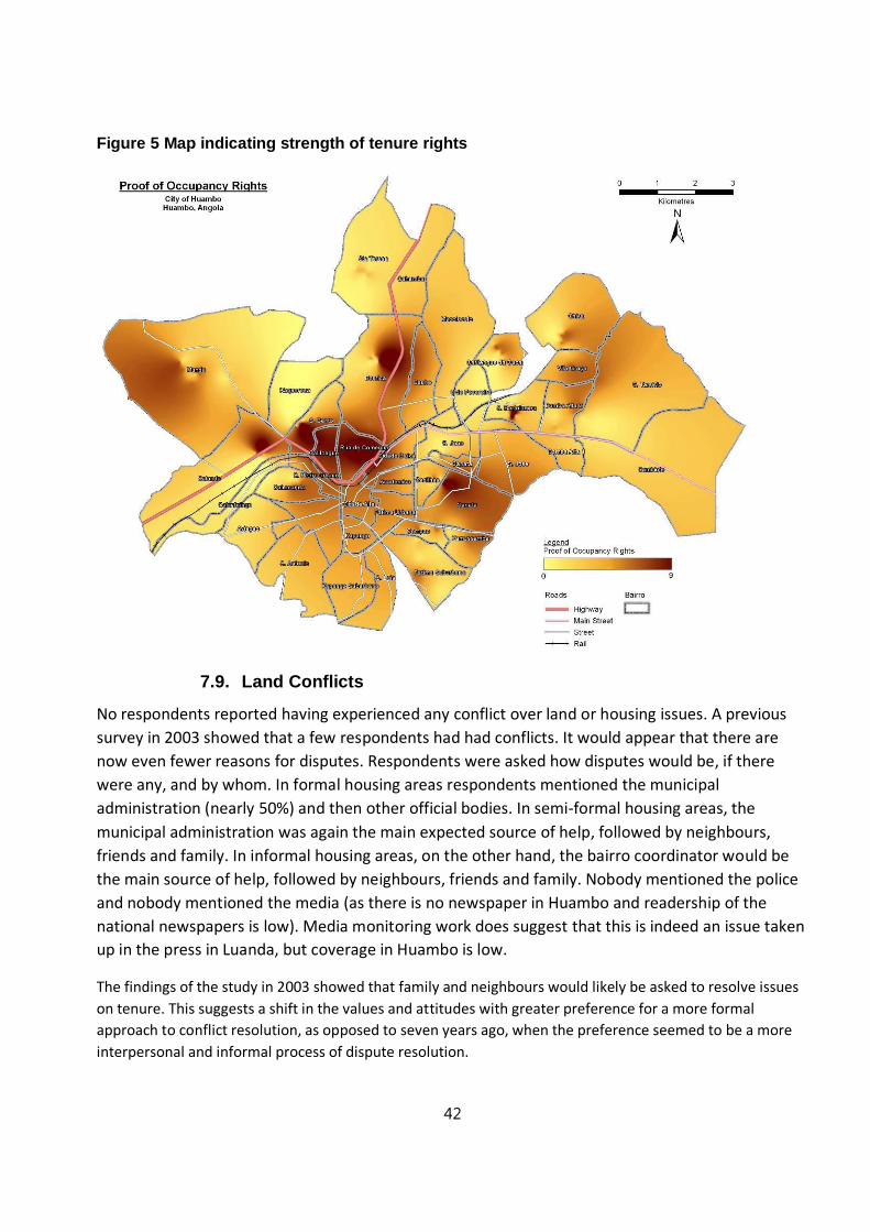
42
Figure 5 Map indicating strength of tenure rights
7.9. Land Conflicts
No respondents reported having experienced any conflict over land or housing issues. A previous
survey in 2003 showed that a few respondents had had conflicts. It would appear that there are
now even fewer reasons for disputes. Respondents were asked how disputes would be, if there
were any, and by whom. In formal housing areas respondents mentioned the municipal
administration (nearly 50%) and then other official bodies. In semi-formal housing areas, the
municipal administration was again the main expected source of help, followed by neighbours,
friends and family. In informal housing areas, on the other hand, the bairro coordinator would be
the main source of help, followed by neighbours, friends and family. Nobody mentioned the police
and nobody mentioned the media (as there is no newspaper in Huambo and readership of the
national newspapers is low). Media monitoring work does suggest that this is indeed an issue taken
up in the press in Luanda, but coverage in Huambo is low.
The findings of the study in 2003 showed that family and neighbours would likely be asked to resolve issues
on tenure. This suggests a shift in the values and attitudes with greater preference for a more formal
approach to conflict resolution, as opposed to seven years ago, when the preference seemed to be a more
interpersonal and informal process of dispute resolution.
43
7.10. Land prices
There has been little previous research on land prices in Angola18. Research on land prices was carried out in
a number of ways: through survey questions, by visiting land and houses that were for sale and through
group discussions with NGO staff involved in land tenure upgrading projects.
The surveys included a question about how much had been paid for the property that the respondent was
living in. This was found not to be useful, because respondents had moved into their present property in
different years in the past and land prices have varied considerably: the number of respondents who had
moved in in the last few years did not provide enough cases for analysis.
The surveys also included a question asking how much a plot of land in that area would cost now. This was
found to provide useful information: almost all respondents were able to reply to the question without
difficulty. (Respondents were also asked how much a house in their area would cost to buy but this provided
less useful information because of the difficulty of analysing the variation due to the differences in type of
house. Given the availability of consistent information about land values from respondents, because in most
areas empty plots are still available and the usual cost is widely known, information about house prices was
not used.)
The cost of land in formal areas of the city of Huambo is just under 70 US Dollars per square metre. In the
areas of Cidade Alta and Kapango, with high quality houses close to the city centre and with a high level of
service provision, the average price of land is 110 US Dollars per square metre (with a range from 75 to 150
US Dollars per square metre). In other formal areas of the city (with smaller houses and a perception of a
lower level of service provision) the average price of land is 32 US Dollars per square metre.
In semi-formal areas of the city of Huambo, the average price of land is 20 US Dollars per square metre. In
the newly-designated sites-and-services areas of Cacilhas and Santa Iria the price of land is between 20 and
35 US Dollars per square metre) than in the older semi-formal area of Calomanda (where the price of land is
18 Development Workshop carried out Angola’s first Land Market Study in Luanda in 2011 with support from
the World Bank.
Formal Informal Semi Formal
0
10
20
30
40
50
60
If there were a dispute, who would you seek help from?
Huambo
Neighbour, friends and family
Bairro coordinator
Municipal administration
Other official bodies
The media
Other

44
less than 10 US Dollars per square metre). This is despite the newly designated sites and services areas being
further from the city centre and having poor road conditions. The difference in price appears to be due to a
perception that the newly-designated sites-and-services areas of Cacilhas and Santa Iria are received
attention from the State and that their roads will be upgraded in the future along with water supply and
electricity supply, while the perception is that older semi-formal areas will not receive attention from the
State.
The average price of land in informal areas is between 2 and 3 US Dollars per square metre. This reflects the
fact that these areas have a much lower level of service provision and are further from the city centre. Along
the main tarred roads leading into the city centre the price of land in informal areas is about 10 US Dollars
per square metre while it is less than 2 US Dollars per square metre away from main roads. Higher prices
along the main roads reflects the easier access to employment and to services along main roads, while road
conditions inside the bairros are uniformly poor, especially after rain. Property along main roads can also be
put to some commercial use, such as selling to passers-by or those waiting for public transport.
Formal Informal Semi Formal
0
10
20
30
40
50
60
70
80
Average land value USD per square metre
Huambo
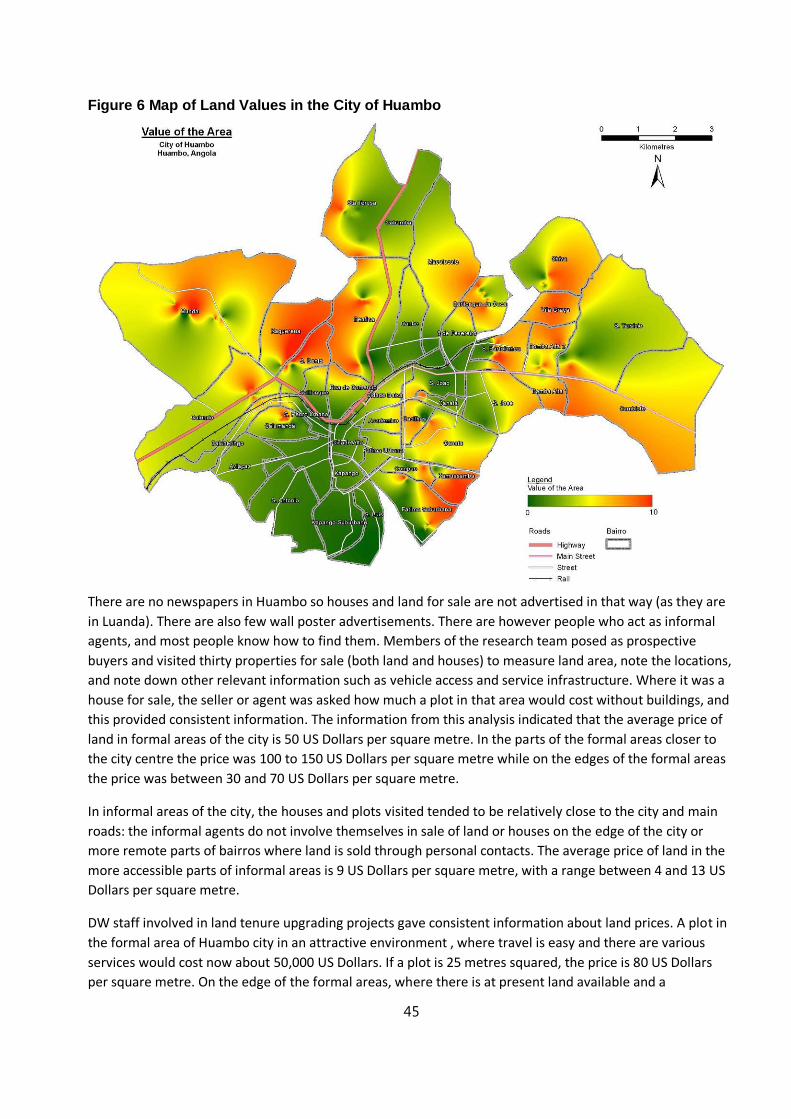
45
Figure 6 Map of Land Values in the City of Huambo
There are no newspapers in Huambo so houses and land for sale are not advertised in that way (as they are
in Luanda). There are also few wall poster advertisements. There are however people who act as informal
agents, and most people know how to find them. Members of the research team posed as prospective
buyers and visited thirty properties for sale (both land and houses) to measure land area, note the locations,
and note down other relevant information such as vehicle access and service infrastructure. Where it was a
house for sale, the seller or agent was asked how much a plot in that area would cost without buildings, and
this provided consistent information. The information from this analysis indicated that the average price of
land in formal areas of the city is 50 US Dollars per square metre. In the parts of the formal areas closer to
the city centre the price was 100 to 150 US Dollars per square metre while on the edges of the formal areas
the price was between 30 and 70 US Dollars per square metre.
In informal areas of the city, the houses and plots visited tended to be relatively close to the city and main
roads: the informal agents do not involve themselves in sale of land or houses on the edge of the city or
more remote parts of bairros where land is sold through personal contacts. The average price of land in the
more accessible parts of informal areas is 9 US Dollars per square metre, with a range between 4 and 13 US
Dollars per square metre.
DW staff involved in land tenure upgrading projects gave consistent information about land prices. A plot in
the formal area of Huambo city in an attractive environment , where travel is easy and there are various
services would cost now about 50,000 US Dollars. If a plot is 25 metres squared, the price is 80 US Dollars
per square metre. On the edge of the formal areas, where there is at present land available and a

46
considerable volume of transactions taking place, a plot probably costs 30,000 US Dollars, or about 48 US
Dollars per square metre.
A reasonable peri-urban plot (with good access) probably costs 3000 to 5000 US Dollars: this comes to about
10 US Dollars per square metre (4000 US Dollars for a plot of 20 x 20 metres). A peri-urban plot in a poor
location probably costs 500 to 1500 US Dollars: this comes to about 2.50 US Dollars per square metre (1000
US Dollars for a plot of 20 x 20 metres).
The various methods for researching land prices in Huambo city give similar results. In the parts of formal
areas with a high quality environment, land prices are 80 US Dollars per square metre or above (up to 150
US Dollars per square metre). In more peripheral formal areas they are between 40 and 70 US Dollars per
square metre. In better located informal areas (such as along main roads) the price of land is about 10 US
Dollars per square metre while it is less than 5 Dollars per square metre. In semi-formal areas the price of
land is linked to the expectation of what level of access and services might be available in the future. Where
there is an expectation that road access and services might improve because the State is giving attention to
those areas, the price of land is 20 to 40 US Dollars per square metre, while in areas which consider
themselves forgotten the price of land is about 10 US Dollars per square metre (similar to that in better-
located informal housing areas).
All informants for this research agreed that house and land prices are increasing rapidly in Huambo at
present, and some informants spoke about land prices increasing by a factor of three in three years.
Huambo city did have unoccupied plots (and houses) but these are being occupied and land and housing in
the better locations is becoming scarce. In the last 10 years, roads have been repaired and water and electric
supply have become more regular: there is a perception that these services will extend to previously
unserved areas in future. Economic activity is increasing, particularly as high schools and university
departments are re-opened and Huambo is seen as a city in which it is possible to study without the high
costs associated with living in Huambo.
Land prices are closely related to access to a good road. This access means access to economic activities, to
informal markets, to taxis, to motorcycle taxis, and to rubbish collection. At present electricity access is
closely related to access to a good road.
Access declines rapidly away from a good road. After rain, conditions are very difficult away from a good
road. In Huambo, travel is relatively easy once you are on a good road; there is no traffic congestion and
there is a good supply of transport (mainly by motorcycle taxi) so travel between different parts of the city
that have good roads is a minor constraint. The price of a plot depends very strongly on these factors.
Water supply is not a strong constraint because of access to water through shallow wells in most parts of the
city. Richer people may desire piped water at home which is mainly available in the formal housing area and
this is one of the factors that pushes up land prices in the formal housing area. However not all households
in this area have paid to be connected to the piped water system. The fact that water is only available in the
northern part of Huambo through boreholes (and a few standposts) may be one of the factors that makes
this part of the city less attractive.
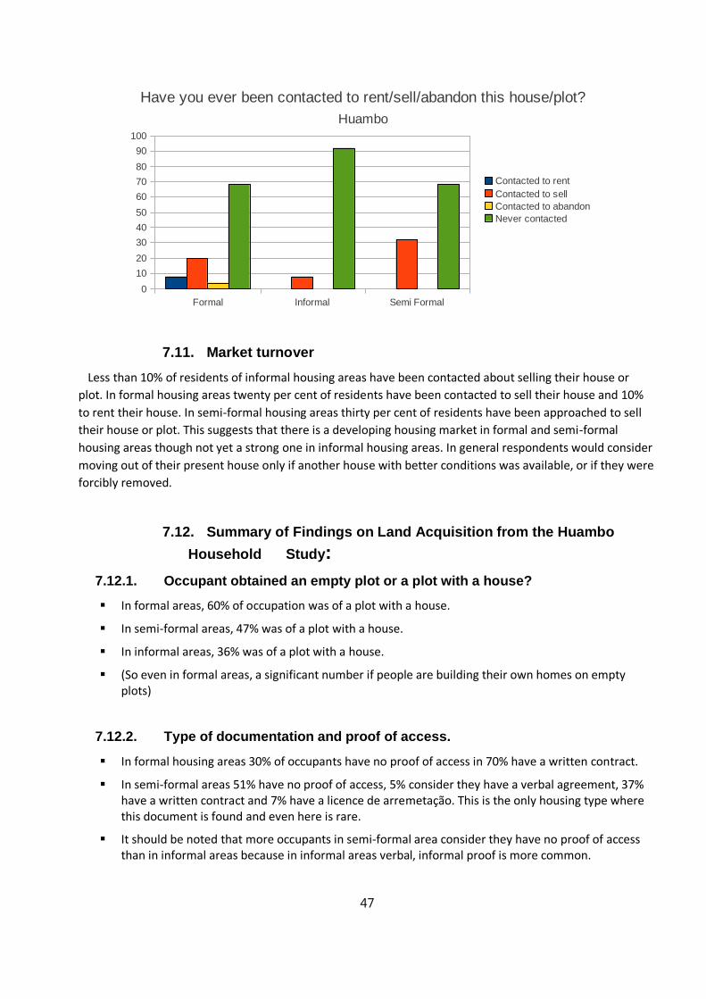
47
7.11. Market turnover
Less than 10% of residents of informal housing areas have been contacted about selling their house or
plot. In formal housing areas twenty per cent of residents have been contacted to sell their house and 10%
to rent their house. In semi-formal housing areas thirty per cent of residents have been approached to sell
their house or plot. This suggests that there is a developing housing market in formal and semi-formal
housing areas though not yet a strong one in informal housing areas. In general respondents would consider
moving out of their present house only if another house with better conditions was available, or if they were
forcibly removed.
7.12. Summary of Findings on Land Acquisition from the Huambo
Household Study:
7.12.1. Occupant obtained an empty plot or a plot with a house?
In formal areas, 60% of occupation was of a plot with a house.
In semi-formal areas, 47% was of a plot with a house.
In informal areas, 36% was of a plot with a house.
(So even in formal areas, a significant number if people are building their own homes on empty plots)
7.12.2. Type of documentation and proof of access.
In formal housing areas 30% of occupants have no proof of access in 70% have a written contract.
In semi-formal areas 51% have no proof of access, 5% consider they have a verbal agreement, 37% have a written contract and 7% have a licence de arremetação. This is the only housing type where this document is found and even here is rare.
It should be noted that more occupants in semi-formal area consider they have no proof of access than in informal areas because in informal areas verbal, informal proof is more common.
Formal Informal Semi Formal
0
10
20
30
40
50
60
70
80
90
100
Have you ever been contacted to rent/sell/abandon this house/plot?
Huambo
Contacted to rent
Contacted to sell
Contacted to abandon
Never contacted

48
In informal housing areas, 45% have no proof of access, 7% have a verbal agreement, 13% have a verbal agreement with witnesses, 3% have a verbal agreement witnessed by officials and 31% have a written contract.
7.12.3. Why people think that their occupation is valid?
The most common reason (29% of cases overall) is that the Soba or bairro coordinator gave permission. (ie a very low level official) This applies across all housing types.: 30% of formal housing occupants, 25% of semi-formal housing occupants, 31% of informal housing occupants. This is not a reason that just applies to informal housing areas).
Only 5% of respondents say that they felt their occupation is valid because of permission from the Municipal Government or a Municipal Government official). This is mainly in formal housing areas (40% of cases in formal housing areas: in other housing types there are few who feel this.)
There are few occupants who say that their occupation is valid because the land was empty or other people were occupying the land at the same time. They are all in informal housing areas and amount to 5% of cases in informal housing areas.
Only 13% of all cases feel their occupation is valid in because they have a document. This is a much less common reason in informal housing areas (95) than in other areas (20%).
21% of occupants in informal housing areas feel their occupation is valid because the owner gave them permission to stay. 35% of occupants in semi-formal housing areas feel their occupation is valid because the owner gave them permission to stay. There are no cases of this in formal housing areas.
24% of occupants in informal housing areas feel their occupation is valid because they received an assurance that it was valid from a friend or family member. 14% of occupants in semi-formal housing areas feel their occupation is valid because they received an assurance that it was valid. from a friend or family member. Even 10% of occupants in formal housing areas feel their occupation is valid because they received an assurance that it was valid from a friend or family member.
7.12.4. Who would call on if required assistance with issues about validity of
occupation.
In formal housing areas, half of occupants would call on the soba or bairro coordinator about such issues (ie a very low level official). The other half would call on the Municipal Government.
In informal housing areas 39% would call on their family, 35% would call on their bairro coordinator, 9% on the soba, 8% on the municipal government, and 5% of neighbours.
In semi-formal housing areas, 59% of occupants would call on their family, 22% on the coordinator of the bairro, 7% on the soba, and 5% on neighbours.
Overall only 1 person mentioned tribunals, and overall only 5% mentioned the Municipal Government.
The most commonly mentioned institution was the bairro coordinator, mentioned in all housing types.
49
7.12.5. Cost of occupation
Mean in semi-formal areas lower than in informal areas, possibly because of subsidised access in semi-formal areas while there has always been a market in formal areas.
There is some free access in informal and semi-formal areas but there is (and has always been) a cost in formal areas.
The range of costs within each housing type is high, partly depending on when access occurred.
7.12.6. Type of road surface
All formal housing has asphalted roads.
31% of semi-formal housing has asphalted roads, 15% has maintained earth roads and 53% has unmaintained earth roads
7% of informal housing has asphalted roads, 13% has maintained earth roads and 80% has unmaintained earth roads.
7.12.7. State of roads after rains
All roads in formal housing areas are in good condition after rains, 31% in semi-formal areas and 8% in informal areas.
All asphalted roads are in god condition after rains.
All earth roads, whether maintained or not, are in bad condition after rains. .
7.12.8. Perceived value of the zones
There are not large differences between informal, semi-formal and formal housing areas in the perceived value of the zones. The only notable difference is that only 3% of residents of semi-fromal housing areas consider that they are convenient for public transport compared to 8% in informasl areas and 10% in formal areas.
Recent laid-out housing plots may not be in places convenient for public transport.
7.12.9. General comments
There does not seem to be a great difference between the typologies on any of the indicators, especially
between semi-formal and informal housing
50
8. Conclusions on Land Tenure in Huambo
There is a market in land and plots of land in Huambo city and the scale of this appears to be increasing.
Many of the transactions go unrecorded in informal housing areas though in other areas they are usually
recorded with sales and purchase documents. The transactions are perceived as secure by an overwhelming
majority of actors, but in fact are based on rights which are legally uncertain as few transfers can be backed
up by legally-defensible documents to secure people’s tenure. Even where the State has been involved in
land and house distribution, it is arguable whether the documentation is complete and legally defensible.
Many of the middle class and elite not have full legal titles to the land and housing they occupy.
Land prices in the centre of Huambo have been rising rapidly in the last five years. The area of formal
housing in Huambo was defined, when the city was constituted almost 100 years ago, as covering a large
area which was never completely built up in the colonial period. This means that there is still some land to
meet demand adjacent to the urban core. However there is some evidence that some residents of the
formal housing areas have moved out because of rising costs. They have mainly been able to acquire land in
areas where the State has made land available for self-build housing. This has led to longer travel times to
work and to poorer access to basic services, though there appears to be an expectation that better roads
and services will be eventually provided to these areas.
There are few cases of spontaneous occupations or attempts to legitimize the “squatting” of vacant
land: spontaneous occupation happened in the past (conflict period) but has now been overtaken
by sales of land and plots. In future, uncertainty regarding property rights might create constraints
from a market perspective as eventually transfers will need to be backed up by claims that can be
legally defended. If it is proving too cumbersome to operate the system as defined under the law,
acceptable procedures to verify occupancy, based on what does function, need to be formalised.
9. Recommendations
Recommendation 1: Recognize the right of occupation in ‘good faith’
There will need to be recognition of the de facto rights of occupation of urban land, with appropriate simple
procedures to adjudicate this. Otherwise, the majority of urban residents who, in good faith, purchased or
acquired their land through some other legitimate mechanism will be excluded, and the law will be largely
seen as illegitimate. The legal basis, regulation and administrative application of this, however, need to also
be the basis for avoidance of continuing speculation in land occupation (whether by “formal” or “informal”
means). Recognition of the right of occupation in good faith will need to address the question of a cut off
date for eligibility. Typically fear in government is fairly widespread that recognizing the right of occupation
may send a signal that encourages more rural to urban migration. Both of these issues will need to be
addressed in taking this recommendation into more practical application.
The most common forms of proofs of ownership that families currently use need to be incorporated into
new legal practice. The most common documentation held by occupants are deeds of sale and declarations
of transfer of property. Documents witnessed by local administrations and recognised traditional authorities
51
also are commonly considered to be legitimate proofs of occupation. The process of granting legal tenure
should also be linked with the building of a land information system or cadastre which involves the
geographic mapping of occupations together with recording and archiving of the legal documentary proofs.
The current land legislation will need to be revised in order to accommodate the principal of occupation in good faith. Bye-laws and regulations of the law will need to define the above mentioned proofs that can be used to validate this occupation and the procedures that will be used to register these claims. Once these rights of occupation are defined legally, mechanisms will also need to be established to adjudicate conflicting claims. The strengthening of municipal courts in order for them to deal with local land-claims will also be essential.
Recommendation 2: Introduce the principle of incremental tenure into current regulations and
practice
By removing long-term occupation as a basis for tenure, recent land legislation has reduced the
opportunities for individuals to acquire legal titles. An intermediate solution needs to be found to provide
tenure security for those who are likely to wait for a considerable period of time before they can receive a
full title. An incremental approach should permit the distinction between land rights and land titles, with the
gradual progression from rights to titles, using intermediate forms of land management mechanisms. This
gradual approach should also permit the provision of improved urban services and general urban upgrading.
In Angola the Lei de Terras does not recognise scalable or incremental tenure rights as a policy, but the law
does not prohibit it either. The range of existing land tenure options permitted by the Land Law can be
adapted to an incremental approach. Article 34 stipulates that the state can grant:
(a) precarious (temporary) occupation rights
(b) surface rights
(c) useful customary domain to rural communities
(d) useful civic domain, and
(e) private property rights to urban land
The law does not, however, articulate a relationship between these rights and does not specify the
conditions by which one can transform one form of tenure into another. A specific addenda or regulation of
the existing law that maps out the principles and scaling mechanisms for incremental rights needs to be
developed.
The essential aspects of a regulation on incremental land rights are that they are:
Intermediate between full land rights such as freehold or surface rights to land on one hand, and on the
other, legally unrecognized rights or the basic property rights enshrined in the Civil Code
Evolutive in that they permit the possibility – given certain circumstances – to evolve through
manifestations of these rights to the full rights;
Defined to permit the clarification of what these rights entail, as opposed to the generality of full rights or
basic property rights – with respect to such issues as transferability, compensation and limitations
52
Recommendation 3: Incorporate the right to information into effective practice
Under existing legislation19 the obligation exists for the government and its partners to publicly disclose
their plans, interventions, land concessions and urban upgrading programs. However, these policies are not
regulated under the law and are therefore not widely practiced. There needs to be a responsibility for
information dissemination, information sharing and public forums.
The Housing Policy (2006) identifies the need to clarify the roles and responsibilities of central and local
governments. Capacity building is required for the preceding recommendations to be applied and to
implement the land and housing laws. There is evidence of issues related to land that are specific to certain
settlement types, which suggests that there is a need for appropriate urban policy and system of
management that allows for a differential approach to these settlement types. This requires better
knowledge of such specific issues, as well as adequate institutional capacity to address these at the local
level.
Recommendation 4: Advocate learning by doing through pilot projects
An important aspect of the incremental approach is learning from experience. Of particular importance is
learning from new practice, and the refinement of new approaches and actions. This process of “learning by
doing” is recommended in establishing urban land rights and in urban land titling. Pilot projects on
establishing urban land rights should be focussed on refining the nature of occupation rights and the limits
to these, including the widespread mobilisation against continued informal occupation without adequate
process. These should also establish the mechanisms for gradual evolution of these rights to titles. The pilot
projects should be established in peri-urban and peripheral urban situations: the former being generally
currently dominated by informal market activity with limited local administrative capacity.
Recommendation 5: Build municipal land information systems (cadastres)
Municipal authorities have been given the responsibility for managing domestic and commercial-scale land
allocation (up to 1,000 m2)20. The efficient functioning of land management requires efficient and updated
land registration and information systems which clearly record legal ownership and occupation of land. The
market attaches great importance to legal titles to land. This is evident from the fact that land without legal
titles, with disputed titles, or land in informal settlements are priced much lower than that of land with
titles. Land registration is also important to the government for the purpose of collecting property taxes.
Without knowing who owns the land and what that land is being used for, governments cannot levy
property taxes21.
An efficient land registration system (juridical cadastre) consists of two parts: The first is a written record or
register with information on each land parcel, such as the name of the owner and the rights of the land,
while the second part includes a detailed description of the land parcel in the form of a map or survey
measurements. The second part is normally cross-referenced with the first. When the records and
19 The preambles to the Planning and Land Laws contain a reference to the right to information and public
consultation.
20 Law No. 06/2
21 UNESCAP (2011). Urban Land Policies for the Uninitiated, http://www.unescap.org/hueset/land_policies/
53
descriptions are combined, then the land registration system provides considerable benefits. Some of the
major benefits are:
a) Security of ownership and tenure rights: This is the most important impact. It reduces the amount of land
disputes which is currently a major issue in developing countries. The security of ownership also stimulates
land development.
b) More efficient land transfers: The costs of delays in obtaining permits is a serious constraint in most
developing countries; an efficient registration system makes transfers easier, less expensive and more
secure.
c) Security for loans: The land title can be used as collateral for loans. This security has a positive impact on
the productivity of the land since it enables the release of major financial resources for investment in the
land.
d) Support for the land taxation system: The expenses for improving the cadastral system would, in actual
fact, quickly be covered by increased property tax revenues. The issue of local resource mobilisation through
the application of taxes and registration fees warrants further investigation. While the decentralisation
reforms22 allow municipal authorities to generate local financing through these mechanisms and by the
application of utility fees, a recent modification of legislation23 announced in January 2011, reverses some
key aspects of the 2006 law and obliges all locally generated financial resources to be deposited in the
central state treasury. The new regulation removes any incentive for municipalities to introduce these local
income generation measures because they are not permitted to retain the income. A reversal of this fiscal
centralisation policy is recommended.
e) Improved land use and management: It can directly provide better information on land ownership and
rights for physical planning as well as facilitate the development of other planning tools such as information
banks covering land use, land values, population, etc. It can also provide a tool to restrict certain land uses
with a negative environmental impact.
Land information systems are time consuming to develop and may encounter problems where some
information and data may be non-existent or conflicting. Systems should be developed incrementally in
order to train staff to utilize it to its maximum capacity. Local municipal administrations should develop
progressive land information systems. This means that when a new cadastral/land registration system is
introduced, or an old one improved, its design should be such that, although technically simple, it can be
upgraded easily and is readily adaptable. Data from different sources need to be collected to build a
cadastre where each land parcel has a unique identifier. With the advances in information technology, it is
becoming increasingly cheaper to develop and maintain land information systems.
22 Law No. 06/2
23 Presidential Decree N° 307/10 on receipts form community service fees

54
Recommendation 6: Secure the land rights of women
This study provides new evidence concerning the proportion of women-headed households (40%). With this
in mind, we recommend that women’s land rights be reinforced and for legislation to be made compatible
with the Family Code (1989).
There is a need to eliminate sources of legal discrimination against women, ethnic and religious minorities,
and other disadvantaged groups in economic matters. This includes de facto, as well as, de jure
discrimination; this includes efforts to ensure equal rights for women in key economic areas such as land
ownership and inheritance. The following issues identified in the succeeding paragraphs need to be
addressed.
It must be kept in mind that the equal rights of men and women to assets and resources, as supported by
the Constitution of the Republic of Angola and the Family Code of Angola, extend to rights of land access and
land tenure security (the Family Code, 1989).
Marriage is defined in the Family Code and includes registered unions and de facto unions as set forth in
Titles III-IV of the Family Code. Pursuant to the principles contained in the Constitution and Family Code,
spouses in a marriage, whether a registered or in a de facto union, are presumed to have equal rights to the
land and any buildings that they occupy, and the burden is on the spouse claiming otherwise to provide
evidence of the claim.
Where the property rights adversely impacted are held by a married couple, whether in a registered or de
facto union, payment of cash compensation shall be made jointly to the wife and husband. If the couple
elects in-kind compensation, the title to the property transferred shall be in the names of both spouses.
Recommendations to improve women’s land rights in Angola include: implementing legislative and policy
reform to remove legal constraints on women’s rights to land, promoting public information and awareness
on women’s constraints and opportunities to land access, ensuring the participation of women in the land
rights formalization and adjudication processes, and putting in place monitoring and enforcement systems
to ensure that land rights formalization efforts successfully recognize and document women’s land rights, as
well as enforce those rights.
10. Potential for Securing Tenure Rights through Incremental
Approaches in Huambo
The current Municipal Administration in Huambo has demonstrated a willingness to innovate in the practice
of land management and use their administrative authority to deal with some of the shortcomings of
Angola’s land legislation. The creation of the flexible administrative tool Licença de Arrematação (temporary
but upgradeable occupation license) to fill the gaps left in the Angolan Land Law illustrates this clearly.
Huambo remains one of the few Municipalities in the country where the new powers of the Municipality to
manage land has been put into practice.
The Municipal Administration and the Huambo Provincial Government has collaborated fully with this
current study and are open to consider the recommendations that the study produces. The Municipality has
welcomed Development Workshop’s partnership in confronting the backlog of decades of accumulated land
55
management problems. Having been the principal hot-spot during Angola’s decades of conflict, the
leadership is sensitive to the need to mitigate against potential conflicts related to land tenure. The
Municipality has engaged DW to help set up the first comprehensive Cadastre which aims to map and record
land occupation and tenure claims of all of the municipality’s residents. DW is training local administrations
in Huambo and neighbouring provinces in using Open Title an open-source public access land tenure
mapping and recording tool built on the Social Tenure Domain Model24.
The current study will make an important contribution to the process of incrementally improving land
management practice and securing tenure rights for the significant majority of residents who are excluded
today.
24 The STDM describes relationships between people and land in that it tackles land administration needs in
hitherto neglected communities such as people in informal settlements and customary areas. It supports
development and maintenance of records in areas where regular or formal registration of land rights is not the
rule. It focuses on land and property rights, which are neither registered nor registerable, as well as
overlapping claims, that may have to be adjudicated both in terms of the ‘who’, the ‘where’ and the ‘what’
right.

56
Annex A:
Key Informant Interviews (English transcriptions from Portuguese originals)
Interview Moises Festo & colleagues - Development Workshop
09 May 2013 - Duration: 1h-22min:23sec
Person 1 (P1) : Pedro Ramao
Person 2 (P2) : Moises Festo, Carlos Figueiredo, Allan Cain
P2 : Generally in order to get a plot of land the candidates need to write an application letter to the municipal administrator. This document is turned in the secretary of the administration and once the municipal administrator gets it he registers the name of the applicant in a database that he has created.
After consulting the database, if the administrator notices that the applicant has already received a plot from the municipal administration then he rejects the application, otherwise he accepts and sends the process to the repartition of territory planning of the municipal administration, called ROTUA. Once the documentation is there, and if they have an available allotted plot then they concede it to the applicant; if there isn’t available allotted plot then the candidate must wait.
P1 : Is it legal to confine one’s application into only one plot? Is there a law that establishes that one person must only have one allotted plot?
P2 : Yes it is legal. We are supported by the law in the principle of opportunity of the access to the land. Notice that a citizen may have more than one plot in the same administration but they must be for different purposes. For example, an person can have an allotted plot for commerce, another for industry, for housing and so on. In this case it is acceptable because we recognize that they are being used for different purposes.
P1 : What if one want to have two buildings, or hotels, for example?
P2 : Well, here we are dealing with commercial purposes. In these cases everyone is free to acquire as much land as they want by buying from other one and so on. However, as an administration, the law allows us to provide only one house to one family. And, by conceding a plot for housing we are fulfilling the right of habitation which is a fundamental right that the constitution guarantees for every citizen, but of course it should be exactly one per family, not more.
P1 : Okay, thanks for the explanation. Now, after the ROTUA gives the approval and the allotted plot to the applicant, what are the next steps?
P2 : After the plot is given the owner now is advised to start with the process of legalization. They must write another letter of application to the municipal administration asking for the land Occupation. This letter should be accompanied by the “croquis”25 or geographic sketches of the plot as well as a copy of the owner’s ID. We highly recommend the owner to get their “croquis” elsewhere (not here in the administration) because otherwise they may think that the “croquis” is a legal documentation of the land since it is passed
57
by someone who works in the administration, so to avoid it we are trying to ban our workers to be involved in this practices.
After all this process, the administration gives the license which often is the longest step due to the lack of personnel compared with the high demand we face daily. Notice that if all the previous steps were followed the process involving the municipal administration “ends” after the license is given. However, if the person already has a plot and wants to legalize it then if verified that that plot was not owned by anyone else then the administrator sends the application directly to ROTUA who analyzes the plot by sending personnel to the field in order to evaluate that the plot is well located and is not in a risky area. Sometimes, it is possible to make correction if there are minor irregularities.
An important aspect to point out is that we also have presence cases of people who come to legalize their plot or house even though they are in non-urban areas or even in suburbs. In this cases, we look a long term process of development of the area and if it is located in good place then we do it.
P1 : After the ROTUA approves a given plot, why can’t the administration automatically process the license without having to ask the candidate to again having to write a new application letter, for the license?
P2 : I understand your point. The problem however is that, in the first case we needed to certify that the candidate hasn’t actually be given a plot for the same purpose. Then the ROTUA needs to know the availability of the space. Sometimes, even though the person by the governor, the ROTUA may not have allotted plot for the candidate and so it may take some time until they do which makes it difficult for the administration to keep track of all these process. Thus, we find it convenient that the candidate, after being given the plot by the ROTUA, to write another letter of application for the license so thatwe know he now has been given and thus, we do not accept him twice if he applies again. What I think is abnormal is that even after the license of Occupation is given, the candidate still have to apply for a license of construction. Perhaps it would be ideal to have just one single process for construction and for Occupationing.
Now, the scenario is obviously different on those cases where a person already has a plot or house but acquired them illegally and now wants to legalize them. In either case we legalize them, but we treat each one differently. A common feature in both, however, is that they are both fined for not following the normal procedure. Nonetheless, here, in Huambo, the fines we charge are lower than that established in the constitution.
P1 – not a question - : Our first aim is really to know within the actual legal procedures what can one do in order to benefit from their own right of having a plot through the process of Open-Title. Secondly we would like to find a simplified way to obtain plot, so that we save money and time.
P1 : When the administration notices a given candidate applies to acquire an allotted plot for housing, for example, why can’t they also accept that in case there is available land they can start building their houses without having to return back twice for the letter of Occupationing and then again for the license of construction.
P2 : Actually, according to the law the candidate should only write one letter to the administration (the very first one before the ROTUA gives them the plot) and this letter should be approved, analyzed and passed through the different authorities internally. We were the ones who opt to have the candidate applying twice, however we should look into that in order to understand why this has happened and perhaps making this process simpler but still efficient. We think with the Open-Title this bureaucracy will be greatly reduced because with the approval of the administrator we could immediately place the name of the candidate into the available allotted plot and so with only one step those three requirements would be met.
58
P1 : Now, between the License of Occupation and that of construction is there another license?
P2 : Yes there is. It is the License of Fencing the plot. This license is not compulsory if the candidate used the allotted plot within three years of approval of their License of Occupation. So, unlike the License for Construction which is compulsory because the administration needs to analyze what type of house is being built according with the location and dimensions of the plot, the administration does not oblige the candidate to fence the plot within the first three years. However, they are required to delimitate it with no more than 2 meters fence if they do not want to get the License of Fencing.
P1 : One of the question we would like to talk about is the procedure of dividing legally allotted plots. For example, a person who has a large allotted plot can share or divide as they wish or is there some observances that need to be met?
P2 : Yes there are some rules about that; and, I am happy you asked this because the municipal administration learned a lot from our experience especially in cases such as the following: for example there are communities that occupy huge extensions of unclaimed land and ask the local administration to allot them. Normally what happens is that the municipal administration negotiates with them and let them know that there are many candidates awaiting for a plot and so they share the space, allotting them but also keeping some for those in the administration’s list – the famous process of Mandume26.
P1 : Can a private person do the same without the local administration monitoring it?
P2 : In this case we submit the project to the Direction of the Administration and Territorial Planning.
This is similar to a very common phenomenon that is happening in Luanda. For example, a real estate company buys 10 000 hectares for building a condominium for habitation, then what they must to is to make a project of allotment, respecting the law requires that establishes the minimum area for green spaces, streets, public spaces for an area of such dimensions as well as allotting plots for housing. They should submit the documents about the project such as the plan of allotment and the descriptive memory, a document in which one describes with details the limitations of each allotment, as well the right of superficies that must be registered. All these documents must be signed by the provincial governor and, after this process, it must go to the juridical bureau where it gets the necessary visas and from then the owner must go ahead and the register each fraction of allotted plot so that when each plot is sold then they get all the documents of the house.
P1 : Has it been done? I know, for example that most people in the Project Nova Vida and in Kilamba do not have a document of their allotted plot and that is one of the main reason they cannot borrow money from the banks, for example.
P2 : Well, in theory they should. If they don’t it is because of their luck on interest because I have benn legalizing several allotments in several places in Luanda such as in Maianga, Caala

59
Interview Huambo Municipal Administrator
10 May 2013 - Duration: 1h-22min:23sec
Person 1 (P1) : Interviewer consultant lawyer
Person 2 (P2) : Huambo Municipal Administrator Eng. Jose Marcelino
P1: First of all, I'd like to thank you, Mr. Administrator, for your time and for this opportunity. After the law of acquisition of land, the allotment law and all the other remaining land laws were approved, the administration of the government at the provincial, municipal and communal level have tried to adjust their practices and procedures according to this new law. Now, with the implementation of new public urban projects, there are more concerns about the improvements of the new constructions that are being built in urban areas. However, an area to which the administration has paid less attention is, in our opinion, that of the illegal occupation of land for housing, anarchic construction and informal markets. Hence, our study aims to make a diagnosis of the legal framework of how the central government and its branches at provincial and municipal level have dealt with such issues; to identify the procedures into action, analyze their effectiveness and, based on these analysis, recommend how they can be strengthened, simplified or modified in order to become even more effective. Another aim of our project is to structure software that can speed up the procedure of land acquisition and/or construction of houses to avoid errors involving the double allocation of the same land to different families, for example, and allow a clearer gauge of the land already allocated and that yet to be allocated. Finally, we would like to help the citizens by providing them with necessary information regarding the process of land allocation and construction, so that they know what documents they need to get a plot of land, how to legalize a house, where to obtain such documents, etc.
(First question from P1): Mr. Administrator, from your personal experience, could you tell us how the process of getting a plot of land. And land, for those who have acquired illegally, has the administration been legalizing their land and/or houses?
P2: Our main job is to deal with the legal part of this process. We legalize the land of the citizens before they build anything on it. For those who have built without a license, we apply fines establish by the constitution. However, we do take into consideration the income of each person, so that the fine is proportional to their income and not a fixed amount so that it becomes fair for everyone.
P1: Hence, there has been legalization of lands that were acquired illegally?
P2: Yes, we have legalized them but only for those that we can.
P1: Why don't you legalize all of them? What are the criteria you use to know which of the houses acquired illegally can be legalized and which ones cannot?
P2: We look into a series of factors such as, whether the land or house is intercepting a road, if it is not in a risky area, etc. Sometimes it happens that half of the land or house is too near to the road or intercepting a road. In those cases we ask the owner to be confined on the safe zone only and, if they accept, we legalize their houses. For those in risky areas, if they are in an eminent risk zone, then we cannot do anything, but if there is no eminent risk then we give them a Provisional License. That is, to avoid them becoming homeless, we give them a Provisional License stating that in case we need to remove them from that area then we will reimburse them. We do that so that they can be more aware of their situation and more responsible about
60
future plans with the land and avoid, for example that they carry out further or more intense construction in that land.
P1: The Provisional License does not entitles them to get a definitive license?
P2: No, it doesn't because a Provisional License indicates that they will not have a definitive license in that land. The Provisional License is not a pass to definitive license, because those areas are areas near to ravines, railways or of a course of water, etc.
One big problem we face here is the fact that we are increasingly having less and less free land in our city. Most of the remaining free land belongs to the company that controls the railways, which is a state company. This land should not belong to the company as they are not being used. I have proposed to the minister and the governor but this is a political decision and I can only wait. Theoretically, the buildings are supposed to be at least 150 meters from the railways. However, in urban areas, there are building, hotels, for example, that are 10 meters from the railway and, if we look at colonial constructions, it was perfectly okay since the law then allowed the buildings to be 10 to 15 meters away from the railway. Hence, since there are no urban plans, we allow this to happen and follow what is already done because these things are not yet well defined- the master plan is still being made.
A well-known Portuguese architect is developing the master plan and most of it I approve most of it. However, one of the points that I do not support is the plan of vertical construction, which is based on occupying free space with huge buildings, and there are a few examples of this already. I have fought against this project but nobody has supported me. I think this plan is flawed because the city of Huambo does not have domestic sewers. We cannot build huge towers without an appropriate sewer drainage system. Personally, I think, if there are no technical limitations, then a way to fix some of the drainage problems of existing huge building is to deviate the domestic sewer into storm-water sewer and implementing a siphon system in the sink so that at the end of the storm-water sewer so that we can carry out the necessary treatment of the waste.
P1: What is response that the administration gives to the people who built their houses but unable to legalize them even though they tried?
P2: So far, we haven't demolished any house that was already built. I tried to impose an embargo on a house of a resident and I went to jail because he was a judge. So, the houses we have embargoed were at the very early stage of construction. And whenever we want to develop an area we send there some personnel with relevant justification so that they can negotiate with the residents and make a survey of the number of residents and the houses affected in order to avoid free riders who often come to get free land or house, whenever these events occur.
P1: Which documents are required for those who have already built their houses and still want to legalize the houses?
P2: Generally we ask for an authorization of the traditional authority (soba) and another from the administration of the village or bairro residents’ commission as well as their personal documents such as ID. Then they have to write the application letter and then we issue a binding document which is the License of Occupation signed by the municipal administrator or by the provincial direction of urbanism, which now is signed only with our authorization and only when the land is vast (over 1000 meters square).
P1: What happens if the citizen acquired the land from a third part or inherited it?
61
P2: If the new owner brings the necessary documentation such as a license of sale then it is okay. In case of traditional succession, theoretically it is impossible for people to inherit land here because this land was empty due to the war and so, almost everyone here arrived recently and thus they need to have the documentation.
P1: What is the reason the administration never ends with the process of legalization, i.e., the emission of the Title of Surface Right in the limits that they can concede? That is of 1000 meters square.
P2: We have conceded some, for those who qualify legally, but they don't always come to get them. If a person has the License of Occupation then it is almost like the definite title. From there they can get the authorization and move on with their desired project with the land. However, this is only for the land, because before we approve their License of Construction we require them to send us the project design drawings either for construction or for repairs in the building, as we have had experience with people who required repairs but ended up building a small canteen and so on.
P1: What are the documents needed in order to get a certificate of residence
P2: Copies of the ID or another document of identification are needed.
P1: Is the Certificate of Residence necessary for the legalization of the land.
P2: No, it isn't necessary at all. Especially because more than 50% of Certificate of Residence are false, so it is more important and safer to have an identification card or a testimony of a person confirming the identity of the candidate than the certificate of residence.
P1: Amidst all this process for acquired the necessary documentation to legally own a land or house, and based on your extensive experience dealing with it, do you see any areas that should be improved and any positive aspect that should be emphasized?
P2: I have participated in several encounters and personally, I think in terms of the concession of land we should do the same as we did with our “kingilas” (the ladies who informally exchange dollars into kwanza and vice-verse). If we stop persecuting those who acquire land illegally and try to formalize the informal market, then we will actually be able to contain the problem of musseques. I think it is better to stop all the bureaucracy and perhaps create the figure of a mediator who can facilitate the liberation of the housing market. With more supply and freedom I think there will be less bureaucracy and eventually the existing gap between the demand and supply will cease to exist.
P1*: What is the power of the administration in establishing fines and deliberation? Do you have any freedom of choice or legal support in determining what fines or penalties to apply?
P2: Yes we do because I have a certain support of the governor. The governor was absent for eight months and if we depended only on him for the amount of work we have, nothing would be done. In addition, there is a huge confusion between what is administrative and what is judicial and I have had several problems because of that. An example of that is the fact that I was condemned for two years of suspended sentence because I embargoed the house of a resident who happened to be a lawyer.
62
Interview Chief of the Planning Division of Huambo Municipality
11 May 2013 -
Person 1 (P1) : Pedro Ramao & Moise Festo
Person 2 (P2) : Chefe de Repartição do Rotua do Município do Huambo
P1: The aim of this inquiry is to collaborate both with the government of Huambo and with that of the national level in order to understand their policies. We want to understand how the government managed the illegal occupation of the land; what are the plans of the provincial and/or municipal government for those people and whether there is an intention of incorporating them into the legal system so that the local government can raise revenue through urban property taxes, which would become a vital source of revenue inflow when the financial independence of local authorities is implemented. To start, we first want to understand the mechanism used by the provincial authorities; second we want to analyze with you how can we maximize this aim of the government and finally we intend to produce a document with recommendation and training to standardize this process nationally.
So, what are the steps that a citizen (who does not have land) ought to follow in order to acquire a lot for housing? What about a company wanting a large plot of land to develop for housing?
P2: A company came and asked the governor for allotted plot of land for forty houses and we gave them. However, after they came with a well-designed plan we realized they didn't want allotted plot of land but instead a parcel of land for forty houses. Unfortunately at that time there wasn't enough left and so we decided to change the zone in which to concede their house, this zone was in Caala. In Caala, they could do the project in the way they want, however they needed to present a plan of urbanization that agrees with the area given and bring someone with better knowledge in the issue.
P2: He first ought to submit a letter of intention (a requirement in the administration he would like to have the land) and specify the purpose he wants to give to such a land.
P1: What are the titles that have been conceded by the provincial government of Huambo and what are those given by the municipal administrations?
P2: The highest title given is the Title of Surface Rights 27 that is acquired often by big entities, those that acquire large quantity of land.
P1: Have you, in the Municipal Administration, ever issued the Title of Surface Rights within the dimensions established by the law of land, such as 1000 meter square for the municipal administration, 1000 ha for the provincial administration and 10.000 the central government?
P2: Yes, we have. However, often those who go until the limits are those who have big investments.
P1: Are there cases in which people start building their houses without the emission of the Title of Surface Rights?
27 Portuguese: Direito de Superficie

63
P2: Yes there have been a lot of cases like that.
P1: The excess of bureaucracy and lack of information from the citizens has significantly increased the delay in acquiring land or constructing legally. Would the provincial government be willing to train its workers in order to adequate the practices and procedure and avoid these problems?
P2: Absolutely! Together with the point already mentioned of the Open Title Software, we would definitely be willing to do it.
64
Interview with Chief Architect of Caala Municipality – Huambo – 12 May 2013
Person 1 (P1) : Pedro Ramao & Moise Festo
Person 2 (P2) : Chief architect of the Municipality of Caála
P2: We have the list of the 4 000 houses and everyone wants to buy these houses since they are in better condition, however it depends on how much people are willing to pay.
P1 : Okay, just to clarify, are you talking about the new centrality?
P2 : Yes, I am talking about the 4 000 houses in there. There are three models: the apartments and houses with one and two floors respectively. We recommend people buy these houses soon so that they can give us some time and we can manage the situation better.
P1 : How much do the houses cost?
P2: They will start up a process of fixing new definite prices soon. So far the price of any house of any model is 55.000 USD. I do not think this price is fair because if a person who lives in an apartment and that who lives in a house pay the same amount, they obviously will not have the same comfort in their houses despite the fact that the houses have the same dimension (of 100 square meters each). Hence, I do not think it is right for the three models to be priced the same. There is an order that will come from Luanda to change the prices (it comes from Luanda because the headquarters of the company that built the centrality is situated there). SONIP, the group Cora and some banks interested in the centrality are scheduling a meeting to fix it because in other provinces things are more advanced. Hence, this meeting is to prevent the same thing that happened in Kilamba (centrality of Kilamba, in Luanda) from occurring again. In this phase that we have almost 2500 houses ready, it is important that we open up the prices so that people can consult the banks and be ready. The process so far is very slow; we are still dependent on the authorization from Luanda. Someone mentioned (without authorization from a responsible entity) that in June they would start giving away houses, but without water and electricity I do not think it will be possible to do that.
P1: if people want to borrow from the banks to buy the houses, they will need documentation of the houses. Has the process of legalization of the houses taken place?
P2: No, the process is very slow. We are very far behind. Even the land in which the project is done has not been legalized. And, because of the dimension of the project, the provincial administration is in charge of its legalization, but it is very slow. Now, for those who are interested in the plots and want to legalize it, we are making their application as smooth and as fast as possible. We simply need a letter of application, a copy of ID and their phone number. If the person is interested in a plot (the plot we sell here are those of 20 X 30 meters square or of 20 X 25 meter square) then it is even simpler. They apply and the documents stay with us until we have an allotted plot available because we only concede plots when they are already allotted.
We are doing this process as fast as we can and attending to the demand and preferences of the applicants, i.e., in terms of where they would like to be allocated. Nonetheless, we still have here some applications that were submitted in 2008, but those are applications that I found when I started to work here and we are still considering and working on them. There are several requests and the area where most people wanted to go is becoming less popular and so they are requesting other areas. Because of that we are trying to even it up by allocating 20 X 30 meter squares to the less competitive areas and 20 X 25 to the most competitive ones.
65
Now, for those who want to legalize a plot where they have already built a house, the process is different because generally they construct in areas where there is no urban plan, however, it still differs from case to case. If, despite the auto-construction, their construction obeys the rules, such as allowing space for roads, streets and so on, we legalize it. Otherwise we can either reject the application or suggest they make the necessary adjustments.
P1: In the application process, what are you responsible for?
P2: When the application is turned in, it is verified by the head of the section (“chefe de seccao”), who analyzes two main issues: housing and environment. The application is submitted internally to me and then we see the process and we go to the land and see how it is. When we are dealing with land that is in the process of re-qualification, my presence on the field (to observe it) is necessary.
P1: Does the municipal administration concede the title of surface rights?
P2: No, this is responsibility of the provincial government. The last document that we emit is the occupation license28 (in portuguse, quitacao). After that, they go to the notary for another document or validation and then they go to the provincial administration for the title of surface rights. There has been a bad interpretation of what the occupation license is. Some think occupation license is the same as the title of surface rights. They apply for that and once they receive it, they think that nobody can take away the land from them if they do not build anything on it within three years. However, according to the land law, even with the occupation license, if they do not build anything on the land within that period then they still can lose the land unless they have the title of surface rights.
What we do here is try to remove a lot of the bureaucracy. Often when people have to wait for six months or more to get a plot, they complain.
28 Portuguese term in brackets.
66
Interview with the Provincial Vice-Governor for Technical Issues for Huambo
Person 1 (P1) :
Person 2 (P2) : Vice Gov Tecnica
P1: The aim of this inquiry is to collaborate both with the government of Huambo and with that of Luanda in order to understand their policies. We want to understand how the government managed the illegal occupation of the land; what are the plans of the provincial and/or municipal government for those people and whether there is an intention of incorporating them into the legal system so that the local government can raise revenue through urban property taxes, which would become a vital source of revenue inflow when the financial independence of local authorities is implemented. To start, we first want to understand the mechanism used by the provincial authorities; second we want to analyze with you how we can best achieve this aim of the government and finally we intend to produce a document with recommendation and training to standardize this process nationally.
So, what are the steps that a citizen (who does not have land) ought to follow in order to acquire a lot for housing?
P2: They came and asked the governor for an allotted plot of land for forty houses and we gave it to them. However, after they came with a well-designed plan we realized they didn't want an allotted plot of land but instead a parcel of land for forty houses instead. Unfortunately, at that time, there wasn't enough left and so we decided to change the zone in which to concede their house. This zone was in Caala. In Caala, they could do the project the way they wanted, however they needed to present a plan of urbanization that agrees with the area given and to bring someone with better knowledge of the issue.
P2: One ought to submit a letter of intention first (an application letter submitted to the administration responsible for the plot one intends to acquire) and specify the purpose he wants to give to such a land.
P1: What are the titles that have been conceded by the provincial government of Huambo and what are those given by the municipal administrations?
P1: The highest title given is the right of superficies29 which is often acquired by big entities, those that acquire large quantities of land.
P1: Do you, in the administration, always emit the right of superficies within the dimensions established by the law of land, such as 1000 meter square for the municipal administration, 1000 he for the provincial administration and 10.000 for the central government?
P2: Yes, we have. However, often those who go until the limits are those who have big investments.
P1: Are there cases in which people start building their houses without the having of the right of superficies?
P2: Yes there have been a lot of cases like that.
29 Literally: direito de superficie, I am not sure if it makes much sense in English as I have not heard of
an equivalent type of right in English, but I will keep using this term.

67
P1: The excess of bureaucracy and lack of information from citizens have significantly increased the delay in acquiring land or constructing legally. Would the provincial government be willing to train its workers in order to adequate the practices and procedure and avoid these problems?
P2: Absolutely! Together with the point about the Software mentioned previously, we will definitely be willing to do it.
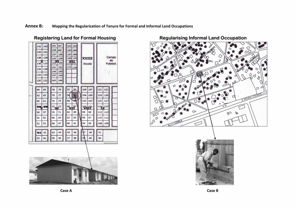
Annex B: Mapping the Regularization of Tenure for Formal and Informal Land Occupations Land Regularisation DiariesRegistering Land for Formal Housing Regularising Informal Land Occupation
Case A
Case B

69
Mapping the Bureaucracy of Formal Land
18 May 201120 June 2011
+ 33 days
$ 370
Total 33 days
to begin
construction
Mapping Case A of Regularization of Tenure for Formal Land Occupation
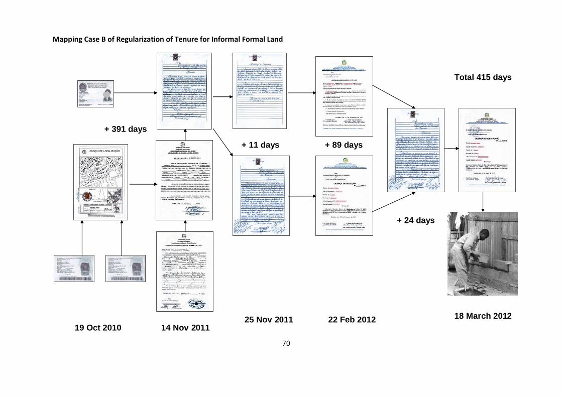
70
19 Oct 2010 14 Nov 201125 Nov 2011 22 Feb 2012 18 March 2012
+ 11 days
+ 391 days
+ 89 days
+ 24 days
Total 415 days
Mapping Case B of Regularization of Tenure for Informal Formal Land Occupation
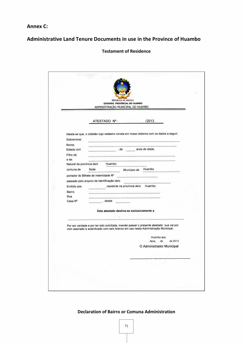
71
Annex C:
Administrative Land Tenure Documents in use in the Province of Huambo
Testament of Residence
Declaration of Bairro or Comuna Administration
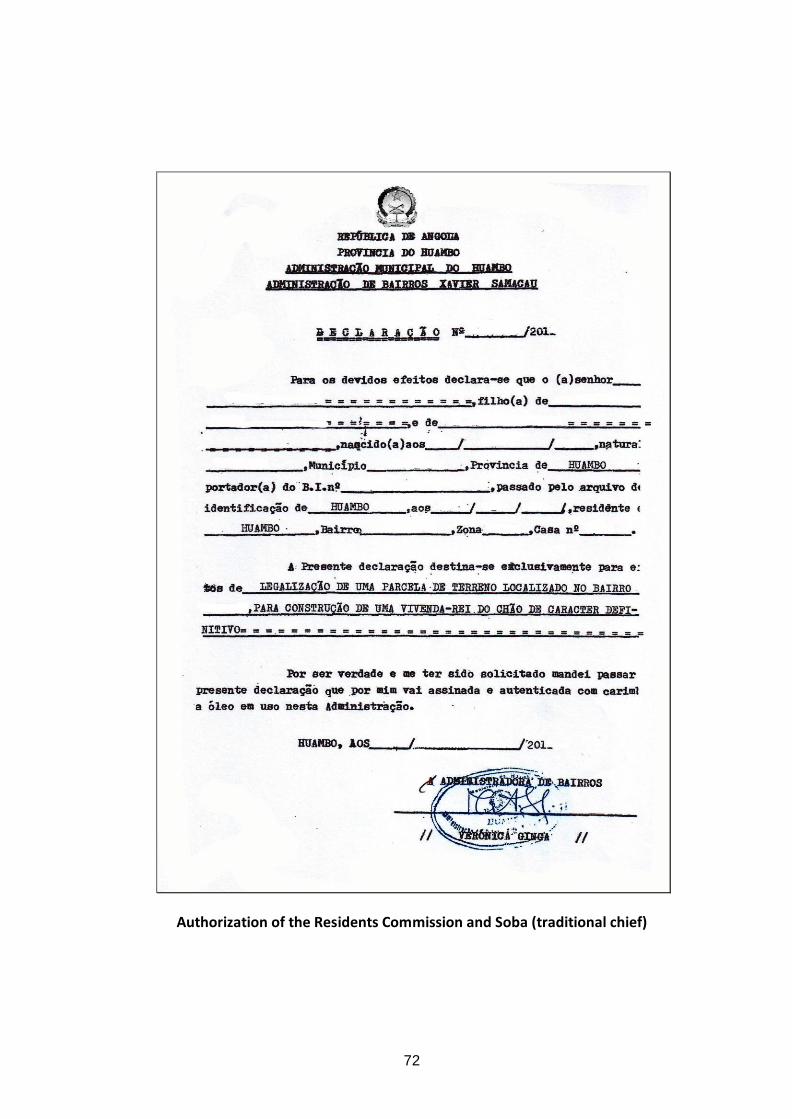
72
Authorization of the Residents Commission and Soba (traditional chief)
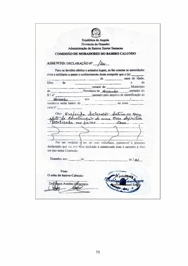
73
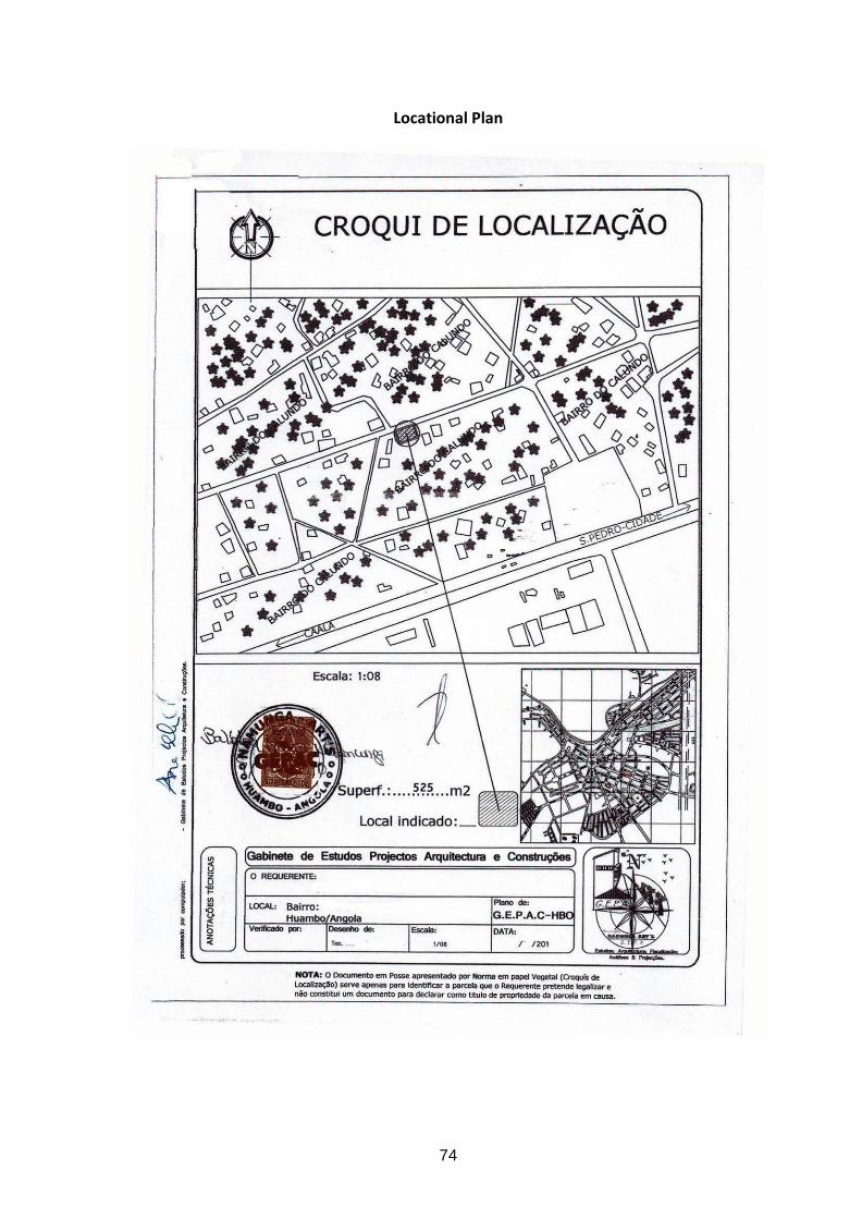
74
Locational Plan
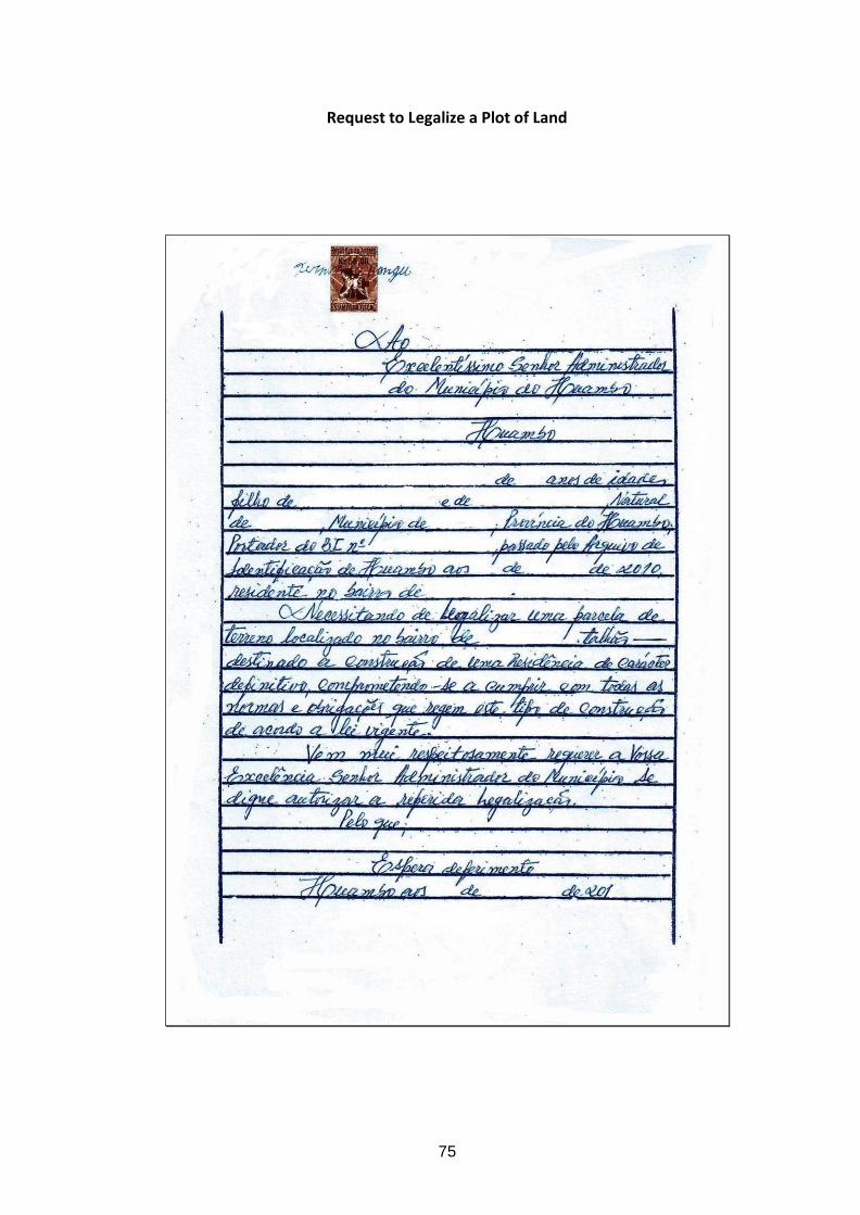
75
Request to Legalize a Plot of Land

76
Occupation License
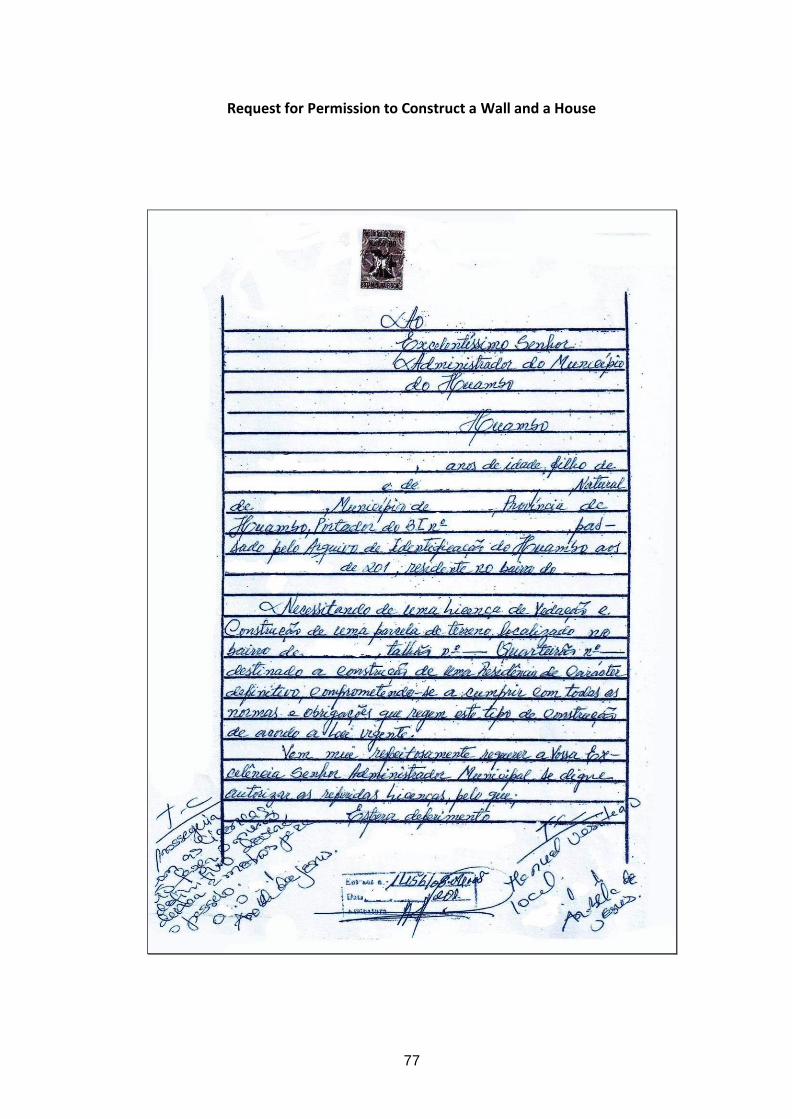
77
Request for Permission to Construct a Wall and a House

78
Promise to Respect Urban & Construction Regulations

79
License to Fence Property
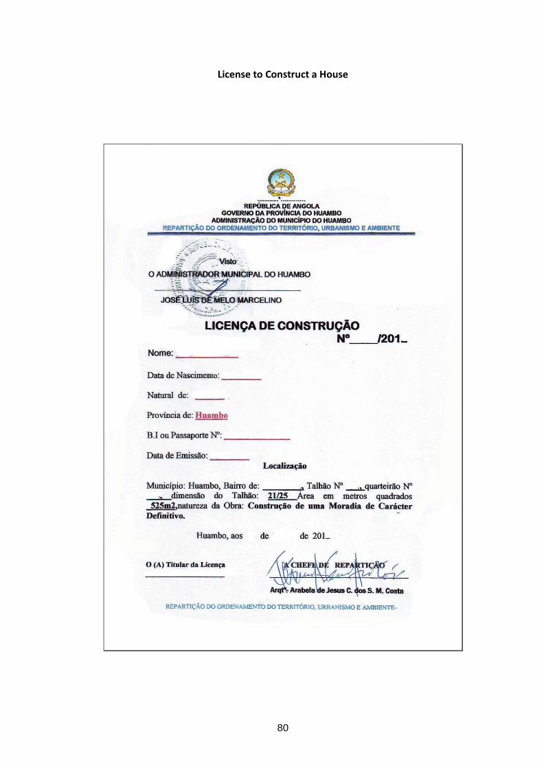
80
License to Construct a House

81
Annex D:
Municipal Cadastre building in Huambo using Open Title Software
The components of the caadastre are; mapping, deliniation
of parcel, registering, licencing & archiving.
A. Mapping
a) Satelite images
b) Topográfical maps
B. Deliniating parcels
C. Registering
D. Licencing
E. Arquiving
Cadastre Building with OpenTitle
Geographical Information Systems
Digital Cadastre with GIS

82
Annex E:
Land pooling case study: land pooling and partic ipator y planning in Huambo
From 2005 Development Workshop has partnered with the Huambo Provincial Government, local administration and the community to develop a series of participatory planning projects in the periphery of Huambo city. The preparation process of the project started in 2004, when several staff of DW and the provincial government of Huambo participated in a training course in Luanda, on participatory planning. In the course of the training, the participants developed a proposal to implement, or put into practice, what had been learned during the training (i.e., land pooling and other participatory land management techniques). A pilot project was initiated in Bairro Fatima, located south of Huambo city. The Provincial Direction of Urbanism in Huambo (DPUA) and the Institute for Territorial Planning and Urban Development (INOTU) were actively involved in this project. Two staff members from DW and the directors of DPUA and INOTU met regularly during the implementation phase of the project, making all major decisions together.
The concept of land pooling or land readjustment has been used in various countries for at least 200 years.30 It has been most successfully used in a number of Southeast Asian countries in recent years. It is an appropriate solution to the problem of land distribution in areas located on the margins of existing urban areas, and where there is scattered settlement, and where large tracts of land are unavailable for private sector subdivision-type land development. Since many of peripheral settlement plots are not for sale, it is often difficult to find a sufficient number of plots next to each other to develop a rational building development plan. It is also appropriate in older urban settlement areas that need to be reorganized in order to provide access to infrastructure and services.
The concept of land readjustment is to assemble small peri-urban or peri-rural land parcels into a large land parcel, provide it with infrastructure in a planned manner, and return a portion of the reconstituted land to the owners, after deducting the cost of the provision of infrastructure and public spaces from the sale of some of the now-serviced land. In Angola, where small landholders on the urban periphery rarely have title documents and are often considered as informal occupiers, the ‘model’ that was developed recognizes their occupation in ‘good-faith’ and employs the land pooling process as a way to help formalize occupation and provide them with tenure security.
Land pooling provides an opportunity for a planned development of land and infrastructure installation where plots in the urban fringe are small, irregularly shaped, and lack access to public roads. Land pooling is an attractive alternative to ‘forced’ acquisition of land which is becoming increasingly difficult to obtain public support for. The method has proven to be attractive to land-occupiers or claimant-owners since they can gain some considerable advantages and even profit by participating in land-pooling projects. Contrary to the obvious alternative methods for city development, land reserves and expropriation, it also avoids the costly and unpopular government procedure of forcibly acquiring land. Unlike expropriation, land pooling will return a significant part of the land to the original occupants. Ideally, a partnership for development should be formed between the public sector and the previous occupants and claimants. It is therefore very important that close links are established during the project through a process of community consultation and participatory planning.
A land pooling scheme is typically initiated when a municipality or government department designates an area as one which is about to be converted from agricultural to urban land use. A subdivision plan is developed as a unified plan for the area. Provision of infrastructure and services is financed through the sale of some of the plots within the area, with the plots being sold having been designated for commercial
30 UN-ESCAP (1998). Urban Land Policies for the Uninitiated

83
activities. The original landowners are provided with plots of land within the redimensioned area which, although smaller in size, now have provisions for infrastructure and services, but most importantly, now have formal and legal documents that provide tenure security.
The costs of basic infrastructure and services are recovered by selling surplus plots created through the land redistribution plan. Creation of these new plots provides an opportunity for distributing land more equitably and at the same time providing access to land for low-income housing. Land pooling requires that the land ownership situation be clarified and an accurate land cadastre registration system implemented. In registering land, gender issues can more easily be addressed, bringing women’s rights to co-ownership of family property into the legal domain.
In Huambo, the project team’s first step in December 2005 was to create a mobilization team that mounted an information campaign in Bairro Fátima, to explain the objectives of the project to the community leaders and the population. This information campaign proved to be very important because land was a very sensitive issue. People were aware of forced removals in other parts of the country and many were afraid of losing their land and homes. After the public awareness campaign, the project team then registered all households (more than 1,300) in the project area, and facilitated the issuance of provisional land tenure documents. Those who received these documents gained confidence in, and soon became advocates of the project.
At the same time, the project team also initiated discussions about the planning of an as yet unoccupied area to the south of Bairro Fátima. This land was used for agriculture by different families who had established user-claims by virtue of their occupation of the respective farms over several years. These peasant occupiers would stand to lose the use of the land they were currently occupying if a new bairro was to be created. While these peasants had no documents nor registered claims on the lands they used, it was considered necessary and just to compensate them. For this purpose, all agricultural land were mapped using the GPS and were registered under the name of the users. After the physical plan for the new bairro was created, these previous users/claimants also received land parcels in proportion to the land they contributed to the pool. Those who had previously occupied larger areas of agricultural land received more parcels; those with smaller agricultural plots received only one or two. In the beginning, not all owners were happy with this form and system of compensation, but once they received their parcels of land in the new bairro, along with legal tenure documents, they realized that they could sell the title to a small urbanized parcel of land for a higher price compared to the value of the original, larger piece of unregistered land.
Maria, a woman living in the
southern part of Bairro Fatima
for example explained that:
“Never before have I had a
document for my land and
house. With the document I
have received I feel more
secure and should ever
anybody attempt to take my
land, I will have the right to
proper compensation.”

84
A first draft of an urbanization plan was discussed with the local community in Bairro Fátima. The plan for the new bairro was developed in collaboration with DPUA, INOTU and the local administration. Through this broad participation of important government stakeholders and through the process of community consultation, the project team was able to ensure that the plan was accepted by all main stakeholders and that there would be no objections at a later stage of the process. Professional help was needed for the efficient planning of a rational infrastructure layout. However, it became clear that such physical planning could be implemented without sophisticated materials and software, but by merely using very basic planning techniques, the use of inexpensive hand-held GPS units, and satellite imagery.
By January 2007, the project had issued the first 150 land tenure documents to existing occupants and created the new bairro consisting of 230 land parcels. Ninety of these parcels (i.e., about 40%) were redistributed as compensation to the former occupants of the lands, and the remaining 140 were sold by the project to create a fund to be invested into basic infrastructures such as roads and community collective water points. Some of the money was set aside to fund an expansion of the project in the adjacent area.
Moises Festo, the Development Workshop project coordinator explained that “the government became very interested in this kind of project because it avoids land conflicts and takes a lot of pressure from them. There are so many people looking for land but so little titled land for people to buy or receive officially.”
For all partners involved in this planning process, it was an eye-opening learning experience. It showed a simple and effective way to issue land tenure documents and to prevent the creation of new slums and informal settlements. Much of the success of the project was due to the close partnership with the relevant government institutions and the participation of, and consultation with the population of Bairro Fatima.
Following the successful completion of the Bairro Fatima pilot project, DW implemented three other demonstration projects using the same principles. After the launch of the National Land Reserve program in 2009, DW was requested to assist with the implementation of the first social housing reserve in Huambo province -- a 300 hectare area that DW had surveyed and parceled in early 2010. The principles of land pooling were also employed, engaging existing occupants and local land claimants in a scheme of in-kind compensation (i.e., titled, urbanised plots of land). To date, the social housing reserve program in Huambo has been implemented without encountering the serious land conflicts and forced removals that have
The project received positive feedback
from those being compensated. For
example João, who received three
parcels as compensation, explained
that:“With the money I made by selling
my parcels I managed to buy a
motorbike and I’m now working as a
motorbike taxi driver in the city. With
this new job, my life and that of my
family improved a lot, I’m earning
enough now to sustain our household.”
85
captured media attention in several other provinces. Land pooling pilot and demonstration projects have given credibility to the principles of participatory planning and community consultation at the local, provincial and national government levels.
The application of the land pooling technique is based on private-public cooperation and negotiation; it requires a significant investment in human resources and training of local administrators and technicians. In particular, skilled negotiators and valuers must be trained.
While land pooling provides an opportunity for both formal and informal land owners and occupiers to develop their land that are located on the urban periphery, the system is not necessarily conducive for large-scale master plans that impose strategic visions for the development of large land tracts or legislatively-designated changes in land use. It is common for large-scale formal or informal landowners/occupiers to use their land as a savings and investment instrument, and this has contributed to increases in land values and land speculation. There is therefore little incentive for large-scale landowners to participate in land pooling schemes. They have no incentives to maintain low prices of land and support the provision of inexpensive social housing.
The land pool model and accompanying methodologies of participatory planning are appropriate today for many peri-urban and urban-perimeter situations around Angola’s cities. In these city-margin situations, the growth of informal musseque settlements is the dominant pattern. The conversion of peasant agricultural plots into scattered owner-built homesteads is common. Land pooling provides a market-framework for regularizing these informal settlements, and providing sustainable and affordable infrastructure and services while enhancing the land tenure rights and protecting the property assets of the poor.
86
Annex F
Key Informant Questionnaire
1. What is normative legal framework that has been based on the issuance of land titles in the
province of law / administration? Sets, one by one, the laws that have been the basis for the action taken by the Municipal Administration?
2. Describe the procedure, ie the administrative steps that citizens must follow to acquire a plot of
land for housing. 3. What aspects judge positive or negative in those "administrative steps"? 4. Are there procedures practiced that do not fit precisely to existing law? 5. What documents must the citizens gather to begin the process of acquiring a lot? 6. When a citizen wants to build, you can go to the Municipal Administration and requires a lot /
plot unknown, without the prior has in his possession? 7. When a citizen has (already) seen in a lot / plot, ie, (now) is in possession of "fact" that
procedures must be observed to legalize? 8. Once granted a lot, legally, by the Municipal Administration, which are the "steps" that the
citizen must follow in order to see the work licensed / authorized and which documents should be together?
9. What happens to citizens who have already built their dwellings on lots that have never been
"legalized", they can apply for legalization? This legalization focuses only on the lot or includes improvements (ie, the residence located on the lot)? What are the steps and documents that must be observed?
10. The "regularization" of homes already built depends on the same incorporarm is a
redevelopment project, or is it independent? 11. Practices and procedures that result follows Municipal Administration directive, instructions
and procedures established by the Provincial Government or the Executive? If yes, what is the basis of these instructions?
12. What are the titles that have been granted by the Provincial Government of Huambo and the
Municipal Administrations? 13. Do the procedures and the titles that have been granted are the result of an orientation of the
Central Government, Provincial Government or both? 14. What is the difficulty that the City Administration did not issue the bonds of surface rights
within the limits defined by the Land Law and its Regulations?
87
15. Already someday Municipal Administration issued a title right to the surface? 16. Once granted a title of the surface rights, the citizen can transmit to third parties for
consideration (ie, sell, for example)? 17. Or can the citizen be burden on the consignment (ie, provide guarantees to a bank, for example,
to receive funding)? 18. The Municipal Administration will open and interest in processes of formation and training in
order to adjust their procedures to the best practices implemented by the Provincial Government by the Directors of other provinces?
19. Whose depend ultimately approve the change / adjustment procedures in order to put them in
accordance with the rules and regulations?
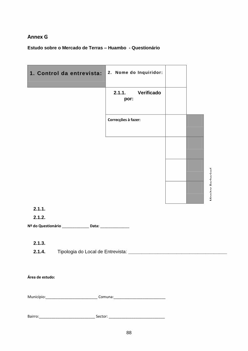
88
Annex G
Estudo sobre o Mercado de Terras – Huambo - Questionário
1. Control da entrevista: 2. Nome do Inquiridor:
Mo
nit
or R
eche
cked
2.1.1. Verificado
por:
Correcções à fazer:
2.1.1.
2.1.2.
Nº do Questionário _____________ Data: ______________
2.1.3.
2.1.4. Tipologia do Local de Entrevista: _____________________________________
Área de estudo:
Município:_________________________ Comuna:_________________________
Bairro:___________________________ Sector: ___________________________
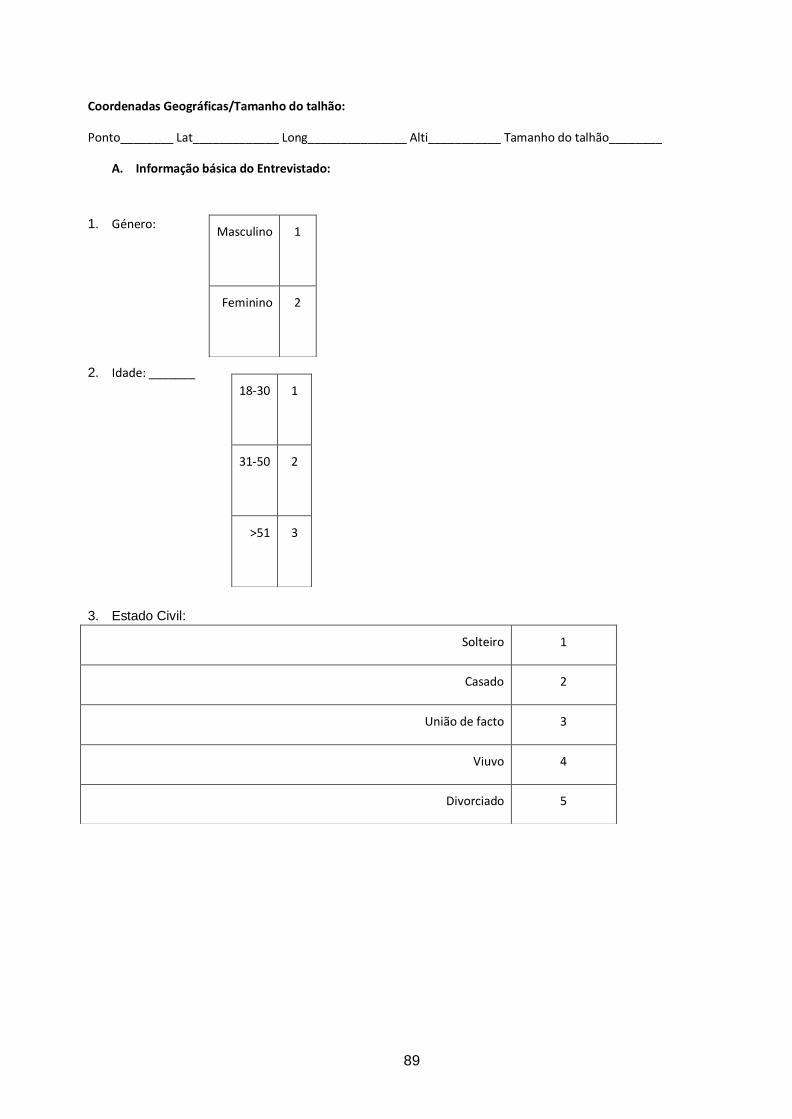
89
Coordenadas Geográficas/Tamanho do talhão:
Ponto________ Lat_____________ Long_______________ Alti___________ Tamanho do talhão________
A. Informação básica do Entrevistado:
1. Género:
2. Idade: _______ 3. Estado Civil:
Masculino 1
Feminino 2
18-30
1
31-50
2
>51
3
Solteiro 1
Casado 2
União de facto 3
Viuvo 4
Divorciado 5
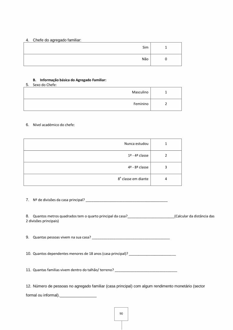
90
4. Chefe do agregado familiar:
Sim 1
Não 0
B. Informação básica do Agregado Familiar: 5. Sexo do Chefe:
Masculino 1
Feminino 2
6. Nível académico do chefe:
Nunca estudou 1
1ª - 4ª classe 2
4ª - 8ª classe 3
8a classe em diante 4
7. Nº de divisões da casa principal? __________________________________________
8. Quantos metros quadrados tem o quarto principal da casa?________________________(Calcular da distância das 2 divisões principais)
9. Quantas pessoas vivem na sua casa? ________________________________________
10. Quantos dependentes menores de 18 anos (casa principal)? ________________________
11. Quantas familias vivem dentro do talhão/ terreno? ________________________________
12. Número de pessoas no agregado familiar (casa principal) com algum rendimento monetário (sector
formal ou informal)._________________
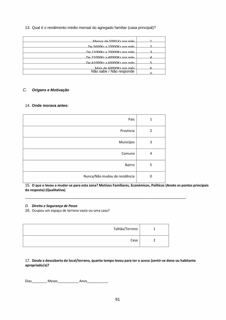
91
13. Qual é o rendimento médio mensal do agregado familiar (casa principal)?
Menos de 5000 Kz por mês 1
De 5600Kz a 10000Kz por mês 2
De 11000kz a 20000Kz por mês 3
De 21000Kz a 40000Kz por mês 4
De 41000Kz a 60000Kz por mês 5
Mais de 60000Kz por mês 6 Não sabe / Não responde
0
C. Origens e Motivação
14. Onde morava antes:
País 1
Província 2
Município 3
Comuna 4
Bairro 5
Nunca/Não mudou de residência 0
15. O que o levou a mudar-se para esta zona? Motivos Familiares, Económicos, Políticos (Anote os pontos principais da resposta) (Qualitativa)
____________________________________________________________________________.
D. Direito e Segurança de Posse 16. Ocupou um espaço de terreno vazio ou uma casa?
Talhão/Terreno 1
Casa 2
17. Desde a descoberta do local/terreno, quanto tempo levou para ter o aceso (sentir-se dono ou habitante apropriado/a)?
Dias________ Meses___________ Anos___________
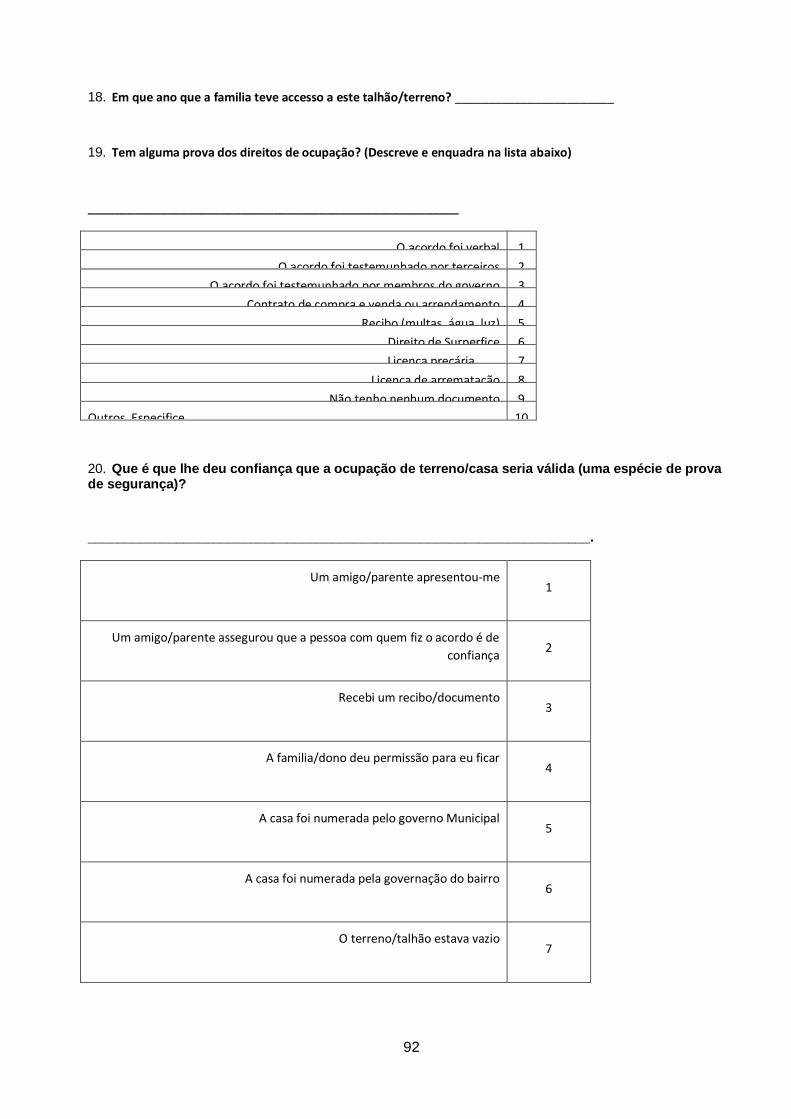
92
18. Em que ano que a familia teve accesso a este talhão/terreno? ________________________
19. Tem alguma prova dos direitos de ocupação? (Descreve e enquadra na lista abaixo)
________________________________________________________
O acordo foi verbal 1
O acordo foi testemunhado por terceiros 2
O acordo foi testemunhado por membros do governo 3
Contrato de compra e venda ou arrendamento 4
Recibo (multas, água, luz) 5
Direito de Surperfice 6
Licença precária 7
Licença de arrematação 8
Não tenho nenhum documento 9
Outros, Especifice… 10
20. Que é que lhe deu confiança que a ocupação de terreno/casa seria válida (uma espécie de prova de segurança)?
____________________________________________________________________.
Um amigo/parente apresentou-me 1
Um amigo/parente assegurou que a pessoa com quem fiz o acordo é de
confiança 2
Recebi um recibo/documento 3
A familia/dono deu permissão para eu ficar 4
A casa foi numerada pelo governo Municipal 5
A casa foi numerada pela governação do bairro 6
O terreno/talhão estava vazio 7

93
Outros estavam a fazer o mesmo 8
O governo Municipal permitiu 9
Submeti o meu bilhete 10
O soba/coordenador do bairro disse que eu podia 11
Um oficial do governo Municipal disse que eu podia 12
Eu tive de assinar papéis oficiais 13
Eu recebi papéis oficiais 14
Adicionar/modificar 15
Outros, Especifique
21. A que pessoa ou instituição recorreria em caso de conflíto (explicar o conceito conflito)?
Vizinhos 1
Amigos 2
Família 3
Coordenador / Coordenação do Bairro 4
Governo Municipal 5
Governo Provincial 6
Polícia 7
Tribunais 8
Mídia 9
ONGs 10
Soba/autoridade tradicional 11
Outros, Especificar… 12
E. Valor e Custo
22. Como é a estrada de acesso a casa?
Asfaltada 1
Terra planada/batida 2
Terra com buracos 3
Não tem estrada de acesso a casa 4
23. Depois da chuva como é o estado das ruas do bairro em geral?
Bom 1
Mau 2
Péssimo 3
24. O que você valoriza nesta zona? (Qualitativa)
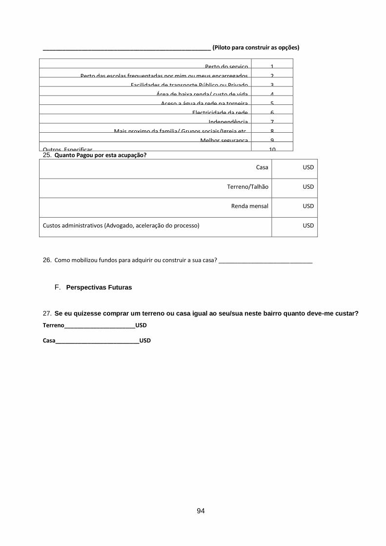
94
____________________________________________________ (Piloto para construir as opções)
Perto do serviço 1
Perto das escolas frequentadas por mim ou meus encarregados 2
Facilidades de transporte Público ou Privado 3
Área de baixa renda/ custo de vida 4
Aceso a água da rede na torneira 5
Electricidade da rede 6
Independência 7
Mais proximo da familia/ Grupos sociais/Igreja etc. 8
Melhor seguranca
9
Outros, Especificar... 10
25. Quanto Pagou por esta acupação?
Casa USD
Terreno/Talhão USD
Renda mensal USD
Custos administrativos (Advogado, aceleração do processo) USD
26. Como mobilizou fundos para adquirir ou construir a sua casa? _____________________________
F. Perspectivas Futuras
27. Se eu quizesse comprar um terreno ou casa igual ao seu/sua neste bairro quanto deve-me custar?
Terreno______________________USD
Casa__________________________USD
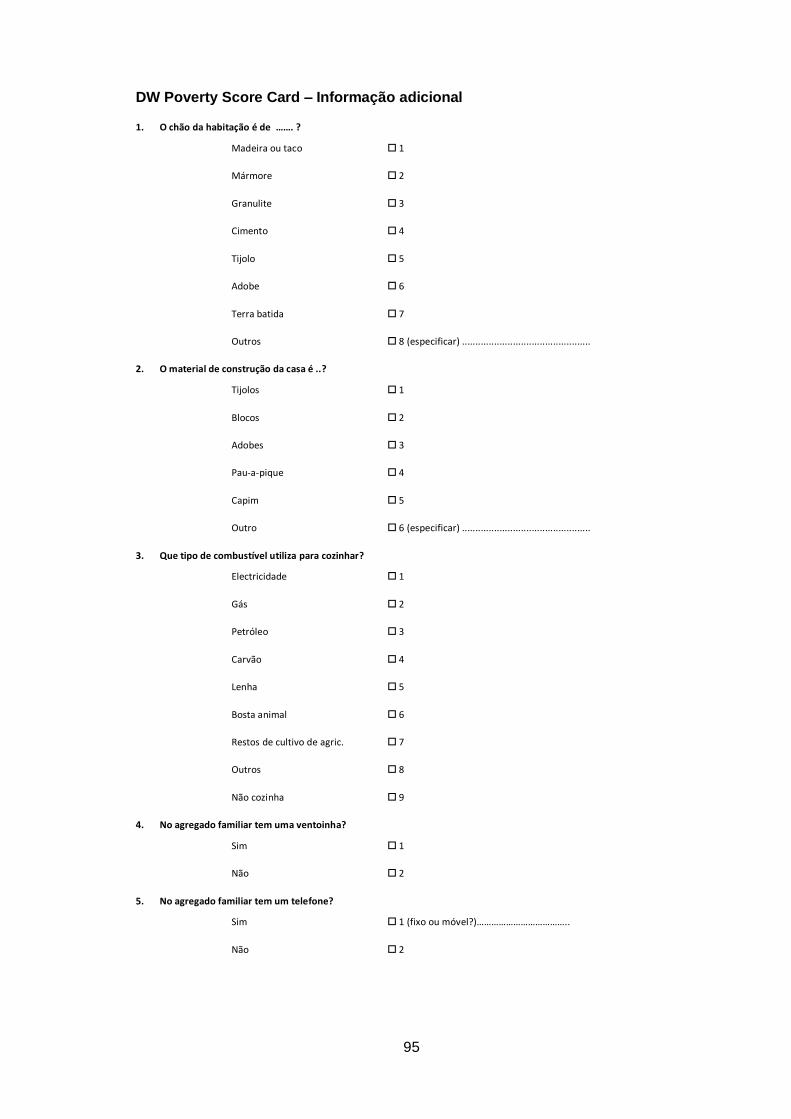
95
DW Poverty Score Card – Informação adicional
1. O chão da habitação é de ……. ?
Madeira ou taco 1
Mármore 2
Granulite 3
Cimento 4
Tijolo 5
Adobe 6
Terra batida 7
Outros 8 (especificar) ................................................
2. O material de construção da casa é ..?
Tijolos 1
Blocos 2
Adobes 3
Pau-a-pique 4
Capim 5
Outro 6 (especificar) ................................................
3. Que tipo de combustível utiliza para cozinhar?
Electricidade 1
Gás 2
Petróleo 3
Carvão 4
Lenha 5
Bosta animal 6
Restos de cultivo de agric. 7
Outros 8
Não cozinha 9
4. No agregado familiar tem uma ventoinha?
Sim 1
Não 2
5. No agregado familiar tem um telefone?
Sim 1 (fixo ou móvel?)………………………………..
Não 2
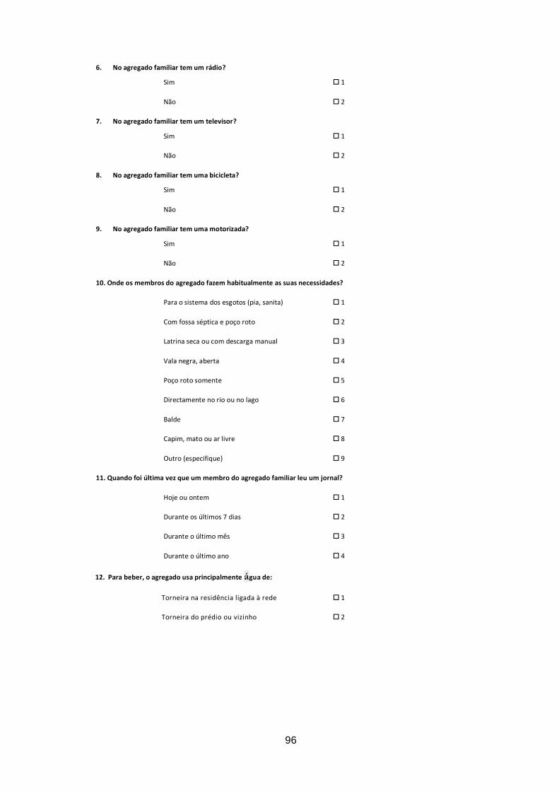
96
6. No agregado familiar tem um rádio?
Sim 1
Não 2
7. No agregado familiar tem um televisor?
Sim 1
Não 2
8. No agregado familiar tem uma bicicleta?
Sim 1
Não 2
9. No agregado familiar tem uma motorizada?
Sim 1
Não 2
10. Onde os membros do agregado fazem habitualmente as suas necessidades?
Para o sistema dos esgotos (pia, sanita) 1
Com fossa séptica e poço roto 2
Latrina seca ou com descarga manual 3
Vala negra, aberta 4
Poço roto somente 5
Directamente no rio ou no lago 6
Balde 7
Capim, mato ou ar livre 8
Outro (especifique) 9
11. Quando foi última vez que um membro do agregado familiar leu um jornal?
Hoje ou ontem 1
Durante os últimos 7 dias 2
Durante o último mês 3
Durante o último ano 4
12. Para beber, o agregado usa principalmente água de:
Torneira na residência ligada à rede 1
Torneira do prédio ou vizinho 2

97
Tanque do vizinho 3
Chafariz público 4
Furo com bomba 5
Cacimba protegida 6
Cacimba desprotegida 7
Nascente protegida 8
Nascente desprotegida 9
Água da chuva; chimpacas 10
Charco; rio; riacho 11
Camião de água 12
Água mineral em garafa 13
Outro (especifique) 14
28. Acesso a serviços sociais e económicos na zona (Inq. faça a sua avaliação)31
Grupo focal
Escola (primária, secundária) 1
Centro Médico 1
Creche 1
Esquadra de polícia
Serviços bombeiros
Centro de acolhimento de idosos
Recolha e tratamento de lixo 1
Padaria
Cantina
Praça/Mercado
Banco
Note: The data set only shows the existence of the 4 basic social services (value 1), so that their absence is
indicated by the value 0
31 Muito bom = ter acesso a escola secundária e hospital perto; muito pobre, significa não ter escolas,
postos de saúde ou igual perto.


