
September 7, 2010 Lecture D2L4b Introduction to SAR remote sensing Thuy Le Toan 1
Introduction to SAR remote sensing
Thuy Le ToanCentre d’Etudes Spatiales de la Biosphère (CESBIO)
Toulouse, [email protected]

September 7, 2010 Lecture D2L4b Introduction to SAR remote sensing Thuy Le Toan 2
• Introduction to radar remote sensing
• The Synthetic Aperture Radar
• Physical content of SAR data
Contents
September 7, 2010 Lecture D2L4b Introduction to SAR remote sensing Thuy Le Toan 3
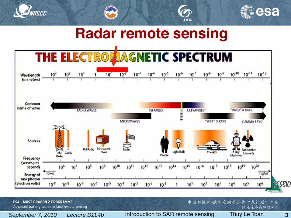
Radar remote sensing

September 7, 2010 Lecture D2L4b Introduction to SAR remote sensing Thuy Le Toan 4
ACTIVE MICROWAVE SENSORS
Detect reflected responses from objects irradiated by artificially-generated energy sources.
Non-Imaging( ex: microwave scatterometer, microwave altimeter)Imaging (Real Aperture Radar,Synthetic Aperture Radar)
RADAR: Radio Detection and Ranging
SLAR: Side Looking Airborne Radar, developed during the World War II, for all weather and day and night aircraft operations over land and sea,
SAR: Synthetic Aperture Radar, airborne systems developed in 1950’s
RADAR: Active microwave imaging system

September 7, 2010 Lecture D2L4b Introduction to SAR remote sensing Thuy Le Toan 5
Frequency bandKaK
KuXCSLP
Wavelength (cm)0.8-1.11.1-1.71.7-2.42.4-3.83.8-7.57.5-1515 -30
30 -100
Frequency (GHz)40 -26.526.5 -1818 -12.5
12.5 -88 -44 -22 -11 -0.3
Radar frequency
f (in Hertz)=C/λ C=3.108 mλ =wavelength in m

September 7, 2010 Lecture D2L4b Introduction to SAR remote sensing Thuy Le Toan 6
Spaceborne SARsSatellite Years Agency Frequency -
Polarisation Resolution -
Swath Special
ERS-1 1991-2000 ESA C - VV
25 m 100 km
Interferometry (with ERS-2)
JERS 1992-1998 NASDA L-HH 25 m 100 km
Region. mosaic available
ERS-2 1995 ESA
C - VV
25 m 100 km
Interferometry (with ERS-1)
RADARSAT-1 1995 CSA C - HH 10 -100 m 45 - 500 km
Multi-incidence
ENVISAT - ASAR
2002 ESA C - HH/VV/HV 25 - 1000 m 50 - 500 km
Multi-incidence
ALOS - PALSAR
2006 JAXA L Polarimetric
10 - 100 m 100 - 350 km
Multi-incidence
TerraSAR-X CosmoSkymed
2007 DLR Italy
X Polarimetric
1 m
Interferometry (1 day)
RADARSAT 2 2007 CSA C - Polarimetric
< 10 m Multi-incidence

September 7, 2010 Lecture D2L4b Introduction to SAR remote sensing Thuy Le Toan 7
Characteristicsof radar remote sensing
all weather capability (small sensitivity to clouds, light rain)
day and night operation (independence of sun illumination)
sensitivity to dielectric properties (water content , biomass, ice)
sensitivity to surface roughness ( ocean wind speed)
accurate measurements of distance (interferometry)
sensitivity to target structure (use of polarimetry)
subsurface and volume penetration

September 7, 2010 Lecture D2L4b Introduction to SAR remote sensing Thuy Le Toan 8
All-weather system
ERS-1 SAR, 11.25 a.m. LANDSAT TM, 9.45 a.m.Ireland, 09/08/1991
An ‘all-weather’imaging systemA microwaves system: cloud penetrating capabilities

September 7, 2010 Lecture D2L4b Introduction to SAR remote sensing Thuy Le Toan 9
Marginal atmospheric effects

September 7, 2010 Lecture D2L4b Introduction to SAR remote sensing Thuy Le Toan 12
Sensitivity to surface roughnessOil Spill detection
ESA: This Envisat
radar image captures the oil that is spilling into the Gulf of Mexico after a drilling rig exploded and sank off the coasts of Louisianaand Mississippi, USA, on 22 April 2010. The oil spill is visible as a dark grey whirl in the bottom right. Envisat acquired this image from its Advanced Synthetic Aperture Radar on 26 April at 15:58 UTC.
Gulf of Mexico, 26 April 2010ENVISAT ASAR

September 7, 2010 Lecture D2L4b Introduction to SAR remote sensing Thuy Le Toan 15
Varzea Dry Season Varzea Wet Season
SAR image SAR image
Sub-canopy penetration
Document S.Saatchi, JPL

September 7, 2010 Lecture D2L4b Introduction to SAR remote sensing Thuy Le Toan 17
Relief Terrain displacement
iso-displacement curvesiso-altitude curves
Etna Landers
i
B
Digital elevation models Cartography of terrain displacements
Accurate range measurementRadar Interferometry

September 7, 2010 Lecture D2L4b Introduction to SAR remote sensing Thuy Le Toan 18
• Introduction to radar remote sensing
• The Synthetic Aperture Radar
• Physical content of SAR data
Contents

September 7, 2010 Lecture D2L4b Introduction to SAR remote sensing Thuy Le Toan 19
Active system: day and night operations
Principle of imaging radar
September 7, 2010 Lecture D2L4b Introduction to SAR remote sensing Thuy Le Toan 21
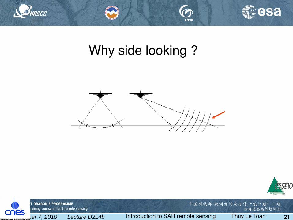
Why side looking ?

September 7, 2010 Lecture D2L4b Introduction to SAR remote sensing Thuy Le Toan 22
L
θ
The larger the antenna, the narrower the aperture (fner resolution)
'L
Radiation into space from an antenna
Numerical example:
L ≈ 10m, R ≈ 1000 km (spaceborne radar), λ ≈ 5 cm (C band) resolution ≈ 5 km
Angular aperture(horizontal plane)
L
λθ =
Antenna length (horizontal direction)
Wavelength
Ra=λ R
L

September 7, 2010 Lecture D2L4b Introduction to SAR remote sensing Thuy Le Toan 23
Synthetic aperture techniqueAn array of antennas is equivalent to a single antenna moving along the fight line LS if the received signals are coherently recorded and added, and the target assumed to be static during the period
XnX2X1
P
LS
The echoes from X1, X2, ..Xn (amplitude and
phase) are recorded coherently as a functionof time
Ra=λ R
R
Azimuth resolution
Finest resolution: Ra=L
2
LS
LS

September 7, 2010 Lecture D2L4b Introduction to SAR remote sensing Thuy Le Toan 24
v1/PRF
IMAGE FORMATION : Azimuth1 pulse 1 echo = 1 image linePRF : Pulse RepetitionFrequency

September 7, 2010 Lecture D2L4b Introduction to SAR remote sensing Thuy Le Toan 25
Improvement of the range resolution :based on the frequency modulation of the transmitted pulse
5 km 10 m (for B=15 MHz)
τ Modulation bandwidth : B compτ compτ= 1/B
cτ
2
c
2BRange resolution

September 7, 2010 Lecture D2L4b Introduction to SAR remote sensing Thuy Le Toan 26
The SAR image
Ground range
Azimuth
Look angleOff nadir

September 7, 2010 Lecture D2L4b Introduction to SAR remote sensing Thuy Le Toan 27
Azi
mu
th
Raw echoesAzimuth res= 5 kmRange res= 5 km
After range processing and SAR synthesisAzimuth res= 5 mRange res= 20 m
After range processingAzimuth res= 5 kmRange res= 20 m

September 7, 2010 Lecture D2L4b Introduction to SAR remote sensing Thuy Le Toan 28
• Introduction to radar remote sensing
• The Synthetic Aperture Radar
• Physical content of SAR data
Contents

September 7, 2010 Lecture D2L4b Introduction to SAR remote sensing Thuy Le Toan 29
What is a SAR image?
The image is seen as a picture.
Pixels are numbers.
Image is affected by specklenoise
Example of an intensity imageAPP HH image 400 x 400 pixels (of 12.5m)Gaoyou, Jiangsu province, China, 2004 05 24

September 7, 2010 Lecture D2L4b Introduction to SAR remote sensing Thuy Le Toan 30
Same image, after speckle fltering

September 7, 2010 Lecture D2L4b Introduction to SAR remote sensing Thuy Le Toan 31
What is a SAR image?
The image represents physical processes.
Pixels are measurements.
Image is interpretable based on understanding of the physical processes
Intensity image, after speckle reduction

September 7, 2010 Lecture D2L4b Introduction to SAR remote sensing Thuy Le Toan 32
SAR measurementsThe basic measurement made by a SAR is the scattering matrix S (amplitude and phase). Main types of images:
Ais the amplitude image.I = A2 is the intensity image.
Measurements derived from a single SAR imageIntensity at single or multiple polarisation Polarimetric measurements (if the SAR is polarimetric)
Measurements derived from multiple SAR imagesTemporal variation of intensity (and polarimetry)Interferometric coherenceInterferometric phase

September 7, 2010 Lecture D2L4b Introduction to SAR remote sensing Thuy Le Toan 33
The radar scatteringIncident electric feld
Ei
Backscattered electric feld Es
i
ikr
s SEr
eE =
iji
ijij eSSφ=
=
ih
iv
hhhv
vhvvikr
sh
sv
E
E
SS
SS
r
e
E
E
the amplitude, phase and polarisation of Es are modifiedwith respect to Ei
The scattering matrix S contains information on the nature and characteristics of the observed media

September 7, 2010 Lecture D2L4b Introduction to SAR remote sensing Thuy Le Toan 34
PolarisationMagnetic feld
Electric feld Trajectory of the electric feld
Propagation direction
Transverse plane

September 7, 2010 Lecture D2L4b Introduction to SAR remote sensing Thuy Le Toan 35
Transverse plane
Projection of the trajectory
of the electric feld
Ellipticity angle
Orientation angle
In projection on the transverse plane,the tip of the electric feld describes an ellipse called polarisation ellipse
τ= 1 : circular polarisationsτ =0 : linear polarisations

September 7, 2010 Lecture D2L4b Introduction to SAR remote sensing Thuy Le Toan 36
Plane orthogonal to the propagation direction
Propagation direction
Electric feld
Horizontal polarisation Vertical polarisation
Linear polarisations

September 7, 2010 Lecture D2L4b Introduction to SAR remote sensing Thuy Le Toan 37
Scattering mechanisms
Surface scattering
Volume scattering if penetration
Surface scatteringwater
Volume scattering
Surface scattering
snow
soil, rock
Surface scattering
Volume scattering
Volume-surface
scattering
vegetation

September 7, 2010 Lecture D2L4b Introduction to SAR remote sensing Thuy Le Toan 38
Scattering mechanismsThe backscattered signal results from:
-surfacescattering-volumescattering-multiplevolume-surface scattering
The relative importance of these contributions depend on-surface roughness-dielectric propertiesof the medium
All of these factors depend on the- radar frequency- polarisation- incidence angle

September 7, 2010 Lecture D2L4b Introduction to SAR remote sensing Thuy Le Toan 40
P –HH HV VV L –HH HV VV
ESAR, Remningstorp forest, Sweden

September 7, 2010 Lecture D2L4b Introduction to SAR remote sensing Thuy Le Toan 41
Surface scattering
The roughness of the surface (wrt to the wavelength) governs the scattering pattern
εr2
Smooth surface Rough surface
The dielectric constant (moisture content) of the medium governs the strength of the backscatter
εr1
εr1
εr2
εr2 > ε
r1 medium 2 is wetter than medium 1
Wetter media
September 7, 2010 Lecture D2L4b Introduction to SAR remote sensing Thuy Le Toan 42
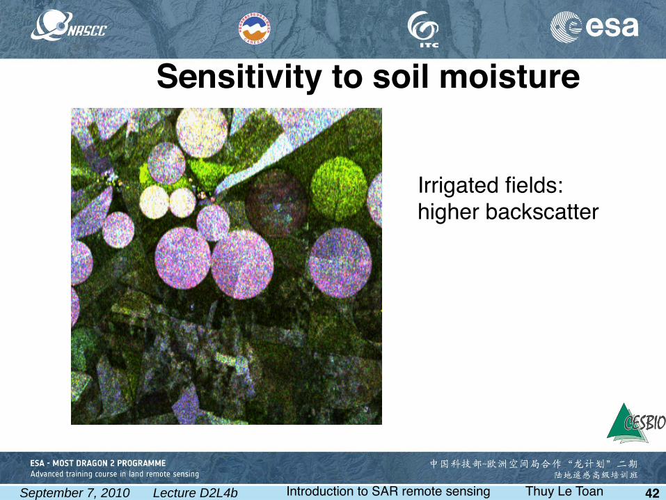
Irrigated felds: higher backscatter
Sensitivity to soil moisture

September 7, 2010 Lecture D2L4b Introduction to SAR remote sensing Thuy Le Toan 43
(adapted from Le Toan, T. , 1982, "Active microwave signatures of soil and crops: Signifcant results of three years
of experiments", In Proceedings of International Geoscience and Remote Sensing Symposium (IGARSS 82)
Sensitivity to soil moisture
Experimental results using a ground based scatterometer

September 7, 2010 Lecture D2L4b Introduction to SAR remote sensing Thuy Le Toan 45
hv
k
scatterers size,shapescatterers orientation
scatterers density
scatterers water content
soil roughness
soil moisture
Dielectric properties
Geometric, structural properties
Vegetation scattering

September 7, 2010 Lecture D2L4b Introduction to SAR remote sensing Thuy Le Toan 46
Scattering on leaves, ears
Attenuated ground scattering
Stem-ground interaction
Main scattering mechanisms from a cereal canopy
Dominant at X-band
Dominant at L-band
Dominant for fooded felds

September 7, 2010 Lecture D2L4b Introduction to SAR remote sensing Thuy Le Toan 47
Water
Scattering from a rice canopyAt C band, HH and VV: the dominant scattering mechanism is thedouble bounce vegetation-waterHH>VV because of the stronger attenuation of VV by verticalstems (and Fresnel refection RH > RV )
HH and VV increases with the
plant biomass.The increase is very important (up to 10 dB during the growth season) (Le Toan et al., 1997).

September 7, 2010 Lecture D2L4b Introduction to SAR remote sensing Thuy Le Toan 54
Biomass from Intensity
0 - 1010 - 2020 - 3030 - 4040 - 7070 - 9090 -120
120 -160160 -200200 -260> 260
0 - 1010 - 2020 - 3030 - 4040 - 7070 - 9090 -120
120 -160160 -200200 -260> 260
0 - 1010 - 2020 - 3030 - 4040 - 7070 - 9090 -120
120 -160160 -200200 -260> 260
Biomass
(ton/ha)
40
30
20
10
0m
Pol-InSAR height
Height (m)
Intensity + Pol-InSAR
RMSE= 35.56 t ha -1 RMSE= 16.26 t ha -1

September 7, 2010 Lecture D2L4b Introduction to SAR remote sensing Thuy Le Toan 55
ρ : complex degree of coherence
| ρ | degree of coherence (or coherence
∆ϕ phase difference
ρ= Ess
Es Es
( *)
( ²) ( ²)1 2
1 2s1, s2
= −ρ φe j∆j∆ϕ
B ⊥
H
r0
h
B
B //
i
s1
s2
R1
R2
Interferometric Coherence
decreases with scatterers movement
decreases with increasing biomass

September 7, 2010 Lecture D2L4b Introduction to SAR remote sensing Thuy Le Toan 57
Phase in SAR images iji
ijij eSSφ=
The phase difference between scatterersof the incident wavestravelling from the radar to a scatterer and back to the radar changes as:
∆r is the difference in the travel distance
Since the SAR resolution cell contains a large number of scatterers, the phaseof pixels seems randomly distributed
∆φ= 2π∆rλ
_____
The phase of a single SAR image is of no utility
The SAR measurement contains an amplitude and a phase

September 7, 2010 Lecture D2L4b Introduction to SAR remote sensing Thuy Le Toan 58
Phase in SAR images
If the scene is observed in 2 images, in which the scatterers remain unchanged in the resolution cell, the phase difference between pixels of the 2 images can be exploited
Polarimetry: the radar measures at the same time HH, VV, HV, VH and their phase difference
Interferometry: 2 radars observe the scene with a small shift in the look angle; or the same radar at different dates from lightly shifted orbit
Lectures on Polarimetry and interferometry

September 7, 2010 Lecture D2L4b Introduction to SAR remote sensing Thuy Le Toan 59
Summary
An introduction to SAR remote sensing has been given
Specifc characteristics of SAR data (e.g. vs optical data) have been illustrated by SAR images leading to applications
Knowledge of the physical content of SAR images is essential before their use in many land applications


