
Estuarine Mangrove Squeeze in the Mekong Delta, Vietnam
Son Hong Truong†‡, Qinghua Ye†§, and Marcel J.F. Stive†*
†Faculty of Civil Engineering andGeosciences
Delft University of TechnologyDelft 2628 CN, The Netherlands
‡Faculty of Civil EngineeringWater Resources UniversityHanoi, Vietnam
§DeltaresDelft 2629 HV, The Netherlands
ABSTRACT
Truong, S.H.; Ye, Q., and Stive, M.J.F., 2017. Estuarine mangrove squeeze in the Mekong Delta, Vietnam. Journal ofCoastal Research, 33(4), 747–763. Coconut Creek (Florida), ISSN 0749-0208.
Although the protective role of mangroves for coasts has been increasingly recognized, that of estuarine mangroves isless well acknowledged. The complex root, stem, and canopy system of healthy estuarine mangroves efficiently reducesthe impact of a strong, along-bank flow during high tides and high river discharge, protecting the riverbank fromeroding. If a sediment source is available, a healthy mangrove forest also offers a higher potential for sedimentation tocompensate for sea-level rise. Unfortunately, along the Mekong, Vietnam, estuaries, mangroves have been rapidlydestroyed. In many regions, estuarine mangroves have degraded into narrow strips of ,50 m. Riverbanks at thoselocations are eroding at a rate of 2–4 m y�1. The main reason for this ‘‘estuarine mangrove squeeze’’ phenomenon is dueto the increasing demand to create more space for local fish farming. Hence, squeeze is used in a broader sense than in thecontext of sea-level rise impact alone. The hypothesis is that there is a critical minimum width for an estuarine mangroveforest strip to maintain its ability to survive. The analysis of available data, both from literature and from satelliteobservations, supports the hypothesis: An average critical width for Mekong estuaries was found to be approximately 80m. To obtain insight into the efficiency of a mangrove forest in reducing the impacts of alongshore flow, the state-of-the-art Delft3D model was applied to the data. The model showed that the penetration-length scale of the shear layer into amangrove forest requires a certain minimum space to develop fully. It is hypothesized that the minimum width of amangrove forest, which equals this maximum penetration-length scale, has a crucial role for the health of a mangrovesystem.
ADDITIONAL INDEX WORDS: Riverbank erosion, fish farm, critical width, flow penetration.
INTRODUCTIONThe Mekong Deltaic River System in Vietnam, located in the
southern part of the country, covers an area of 39,000 km2.
Near its outlet to the sea, but still in Cambodia, as part of the
Mekong Delta plain, the Mekong River divides into two
branches, the Mekong (Tien River) and the Bassac (Hau
River). Before reaching the sea, the Tien River and the Hau
River then divide again into nine branches, which flow into
nine estuaries, of which, presently, only eight estuaries are left
(Tri, 2012). These estuaries, with complex multichannel
systems, reach the South China Sea at the eastern zone of
the Mekong Delta coast from the Tien Giang province to the Soc
Trang province. This estuarine environment was the study
area (Figure 1).
The Mekong Delta region in Vietnam is a tropical monsoon
region. The dry season is from November to April, and the wet
season is from May to October. The total mean river discharge
of the Mekong is about 15,000 m3 s�1 (Lu and Siew, 2006). The
mean high discharge during the flood season is 25,000 m3 s�1,
and the mean low discharge during the dry season is 5000 m3
s�1.
According to the report of the Road and Hydraulic Engineer-
ing Institute (DWW, 2004), the local population suggests that
erosion problems have increased since the 1990s in the Mekong
Delta, in general, and in the Mekong Estuarine System (MES),
in particular. There are several possible explanations for the
accelerated erosion problems: (1) increasing sea level (Alongi,
2008; Webb et al., 2013), (2) increasingly reduced sediment
influx because of the construction of dams upstream of the
Mekong River and sand mining, (3) increasing human-induced
subsidence and groundwater extraction (International Union
for Conservation of Nature, 2011), (4) the clearance of
mangrove forests in the 1990s (Gebhardt, Dao Nguyen, and
Kuenzer, 2012), and (5) the ‘‘squeeze’’ of the coastal mangrove
forests. These are the reasons given for accelerated erosion
along the coastal region (Phan, van Thiel de Vries, and Stive,
2014), and estuarine mangroves probably suffer from the same
causes. Together with the accelerated erosion, in many regions
along the MES, mangroves have degraded into a narrow strip
of ,50 m. Riverbanks at those locations are usually observed to
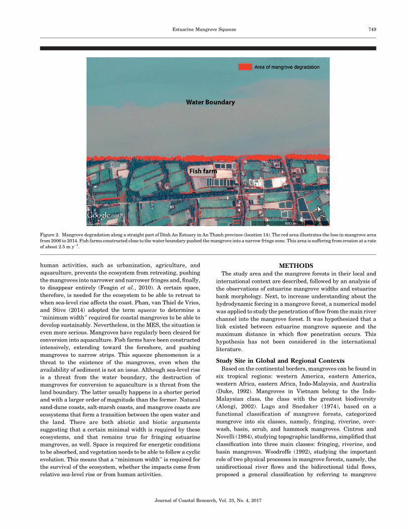
be suffering from erosion at a rate of 2–4 m y�1 (Figure 2).
During floods, the Mekong Delta carries a large sediment
load. The total annual sediment discharge of the entire Mekong
Delta River was estimated to be about 160 million ton y�1 in
1995 (Milliman et al., 1995) and about 110 million ton y�1 in
2011 (Milliman and Farnsworth, 2011). However, the amount
of sediment that finally reaches the South China Sea is less
than the total sediment carried by the Mekong River (Kummu
and Varis, 2007). Only about 60% of the total sediment load
enters the lower Mekong regions (Manh et al., 2014). This
means that the annual amount of sediment entering the lower
Mekong basin is about 96 and 66 million ton y�1 in 1995 and
2011, respectively. An alternative estimation is based on the
DOI: 10.2112/JCOASTRES-D-16-00087.1 received 16 May 2016;accepted in revision 9 November 2016; corrected proofs received5 January 2017; published pre-print online 20 March 2017.*Corresponding author: [email protected]�Coastal Education and Research Foundation, Inc. 2017
Journal of Coastal Research 33 4 747–763 Coconut Creek, Florida July 2017
average suspended sediment concentrations (SSC), reaching
approximately 50 mg L�1 and 80 mg L�1 from 1993 to 2000 at
Can Tho and My Thuan stations, respectively (Lu and Siew,
2006). From the total mean discharge and the SSC, the total
annual suspended sediment in the Mekong River can be
estimated at about 38 million tons. For a sand-bed river, the
bed-load fraction may be assumed to be around 30–50%
(Turowski, Rickenmann, and Dadson, 2010). The total sedi-
ment available for the lower Mekong regions, therefore, can
range from 54 to 76 million ton. This is almost in line with the
estimation of Lu, Kummu, and Oeurng (2014), which is about
50 million ton y�1.
Although only part of the above estimated total load of
sediment is available for the mangrove forest, it still seems to
be enough for the estuarine mangroves. To keep up with the
subsidence rate of about 2 cm y�1 in the MES (Anthony et al.,
2015), the amount of sediment needed for the 16,000 ha of
estuarine mangrove (100 m width, 200 km length, eight
branches) is estimated at only around 8.5 million tons (about
10% of the total, available sediment load). In fact, that amount
is probably smaller because the width of mangrove tends to
reduce upstream, and some branches merge around 30–100
km. Hence, the deficiency of sediment sources is not considered
a primary reason for the degradation of the estuarine
mangrove forest. This study, therefore, focused on the
degradation of the estuarine mangrove due to the ‘‘squeeze’’
issue, i.e. a limited mangrove width because of the extension of
fish farms.
The term squeeze was introduced by Doody (2004) in
recognition of the threat to the existence of coastal mangroves
or tidal wetland habitats caused by the compound impacts of
sea-level rise and human activities. The term has been widely
used since (Gilman, Ellison, and Coleman, 2007; Torio and
Chmura, 2013). Gilman, Ellison, and Coleman (2007) noted
that, when relative sea level is rising, mangrove forests tend to
retreat landward. However, the spatial blocking induced by
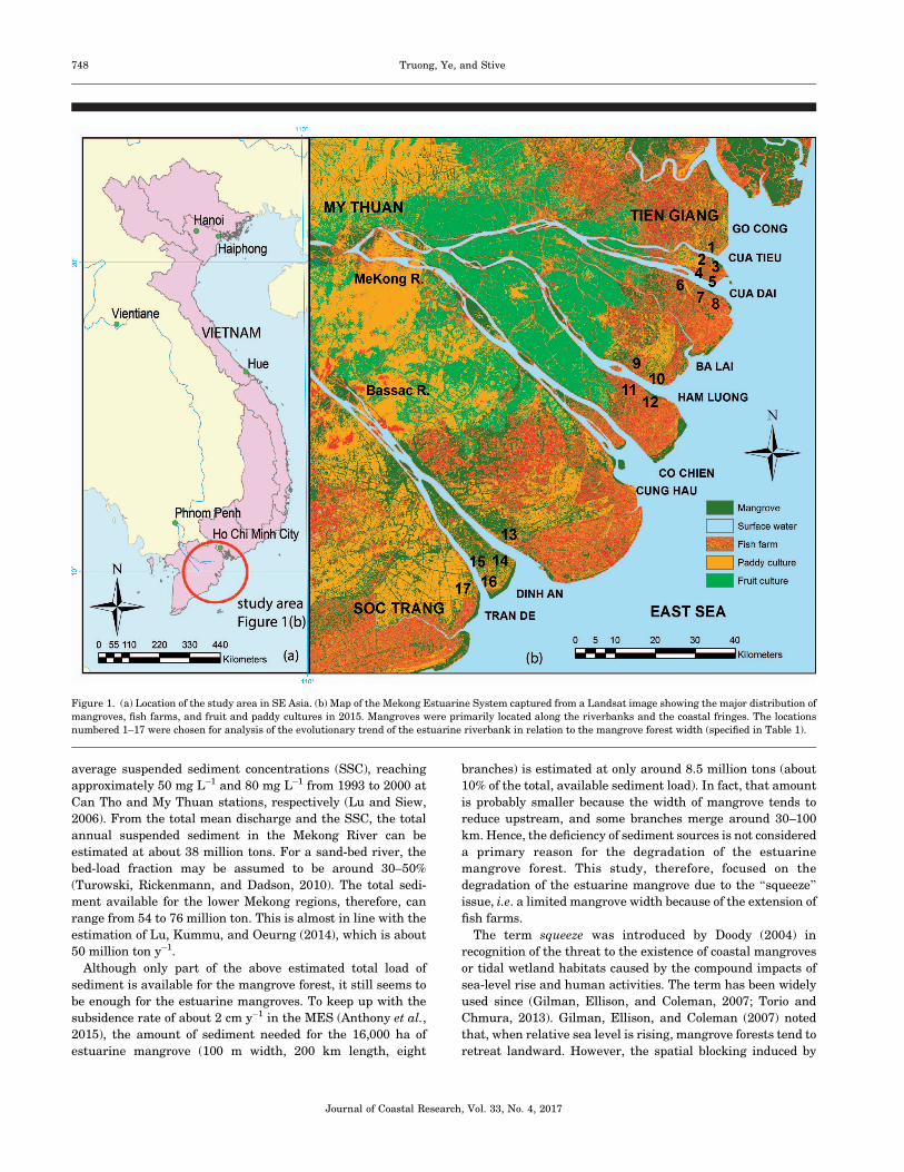
Figure 1. (a) Location of the study area in SE Asia. (b) Map of the Mekong Estuarine System captured from a Landsat image showing the major distribution of
mangroves, fish farms, and fruit and paddy cultures in 2015. Mangroves were primarily located along the riverbanks and the coastal fringes. The locations
numbered 1–17 were chosen for analysis of the evolutionary trend of the estuarine riverbank in relation to the mangrove forest width (specified in Table 1).
Journal of Coastal Research, Vol. 33, No. 4, 2017
748 Truong, Ye, and Stive
human activities, such as urbanization, agriculture, and
aquaculture, prevents the ecosystem from retreating, pushing
the mangroves into narrower and narrower fringes and, finally,
to disappear entirely (Feagin et al., 2010). A certain space,
therefore, is needed for the ecosystem to be able to retreat to
when sea-level rise affects the coast. Phan, van Thiel de Vries,
and Stive (2014) adopted the term squeeze to determine a
‘‘minimum width’’ required for coastal mangroves to be able to
develop sustainably. Nevertheless, in the MES, the situation is
even more serious. Mangroves have regularly been cleared for
conversion into aquaculture. Fish farms have been constructed
intensively, extending toward the foreshore, and pushing
mangroves to narrow strips. This squeeze phenomenon is a
threat to the existence of the mangroves, even when the
availability of sediment is not an issue. Although sea-level rise
is a threat from the water boundary, the destruction of
mangroves for conversion to aquaculture is a threat from the
land boundary. The latter usually happens in a shorter period
and with a larger order of magnitude than the former. Natural
sand-dune coasts, salt-marsh coasts, and mangrove coasts are
ecosystems that form a transition between the open water and
the land. There are both abiotic and biotic arguments
suggesting that a certain minimal width is required by these
ecosystems, and that remains true for fringing estuarine
mangroves, as well. Space is required for energetic conditions
to be absorbed, and vegetation needs to be able to follow a cyclic
evolution. This means that a ‘‘minimum width’’ is required for
the survival of the ecosystem, whether the impacts come from
relative sea-level rise or from human activities.
METHODSThe study area and the mangrove forests in their local and
international context are described, followed by an analysis of
the observations of estuarine mangrove widths and estuarine
bank morphology. Next, to increase understanding about the
hydrodynamic forcing in a mangrove forest, a numerical model
was applied to study the penetration of flow from the main river
channel into the mangrove forest. It was hypothesized that a
link existed between estuarine mangrove squeeze and the
maximum distance in which flow penetration occurs. This
hypothesis has not been considered in the international
literature.
Study Site in Global and Regional ContextsBased on the continental borders, mangroves can be found in
six tropical regions: western America, eastern America,
western Africa, eastern Africa, Indo-Malaysia, and Australia
(Duke, 1992). Mangroves in Vietnam belong to the Indo-
Malaysian class, the class with the greatest biodiversity
(Alongi, 2002). Lugo and Snedaker (1974), based on a
functional classification of mangrove forests, categorized
mangrove into six classes, namely, fringing, riverine, over-
wash, basin, scrub, and hammock mangroves. Cintron and
Novelli (1984), studying topographic landforms, simplified that
classification into three main classes: fringing, riverine, and
basin mangroves. Woodroffe (1992), studying the important
role of two physical processes in mangrove forests, namely, the
unidirectional river flows and the bidirectional tidal flows,
proposed a general classification by referring to mangrove
Figure 2. Mangrove degradation along a straight part of Dinh An Estuary in An Thanh province (location 14). The red area illustrates the loss in mangrove area
from 2006 to 2014. Fish farms constructed close to the water boundary pushed the mangrove into a narrow fringe zone. This area is suffering from erosion at a rate
of about 2.5 m y�1.
Journal of Coastal Research, Vol. 33, No. 4, 2017
Estuarine Mangrove Squeeze 749
habitats as occupying a broad continuum between tide-
dominated mangroves, river-dominated mangroves, and those
mangrove forests that are isolated from either of those
processes, as interior mangrove. Ewel, Twilley, and Ong
(1998) proposed a hybrid of these systems, combining the
classification system of Lugo and Snedaker (1974) with the
general system of Woodroffe (1992). Their simplified classifi-
cation system refers to tide-dominated mangroves as fringe
mangroves, river-dominated mangroves as riverine mangroves,
and interior mangrove as basin mangroves. Riverine man-
groves or river-dominated mangroves are flooded by river
water as well as by tides. They usually dominate in the river-
dominated deltas and are mostly exposed to unidirectional
water flows during flood tides. Fringing or tide-dominated
mangroves usually dominate low-gradient, intertidal areas of a
sheltered coastline. They are usually inundated by daily tides
and exposed to strong bidirectional tidal flow. Fringing
mangroves facing the open sea (coastal mangrove) can also be
exposed to waves. Interior mangroves usually dominate in
inland depressions, where they are least exposed to waves and
tidal motions (Ewel, Twilley, and Ong, 1998; Lugo and
Snedaker, 1974; Woodroffe, 1992).
All the above state-of-the-art classification systems consider
only tides and river flows as the major hydrodynamic
indicators, and wave actions were not considered. Although
the role of mangroves in dissipating wave energy and
protecting coastal regions has been well recognized, little
attention has been given to the reverse effects of waves on
mangroves. Waves have a role in the resuspension of bottom
sediments (Wolanski, 1994). There is also a difference in the
impact of short waves and long waves on mangroves (Phan, van
Thiel de Vries, and Stive, 2014).
Neglecting the wave factor makes it more difficult to
understand the differences in the setting of coastal mangroves
and estuarine mangroves, which is particularly true for the
MES. The Mekong Delta is classified as both a wave-influenced
and a tide-dominated delta, according to the ternary diagram of
Galloway (1975) (Ta, Nguyen, and Tateishi, 2002). The tide in
the region has a semidiurnal character. The mean tidal range is
2.6 m (Gagliano and McIntire, 1968), whereas the maximum
tidal range is 3.2–3.8 m (Nguyen, Ta, and Tateishi, 2000;
Wolanski et al., 1996). The average depth of the estuarine
branches is typically 5–10 m in the regions between the river
mouth and up to 140 km upstream (Wolanski et al., 1996).
Because of the relative low elevation and gentle slope of the
delta, tides and salt water can intrude deeply into the
floodplain through the estuaries of the Mekong and the Bassac
River (Tri, 2012). In the dry season, tidal variation can be
observed as far as Tan Chau and Chau Doc, 228 km upstream
from the river mouth (Wolanski et al., 1996). Because of these
specific features, mangrove forests in the Mekong Delta
dominate a wide range of areas from the coastal to estuary
and further upstream. Those differences in the regions where
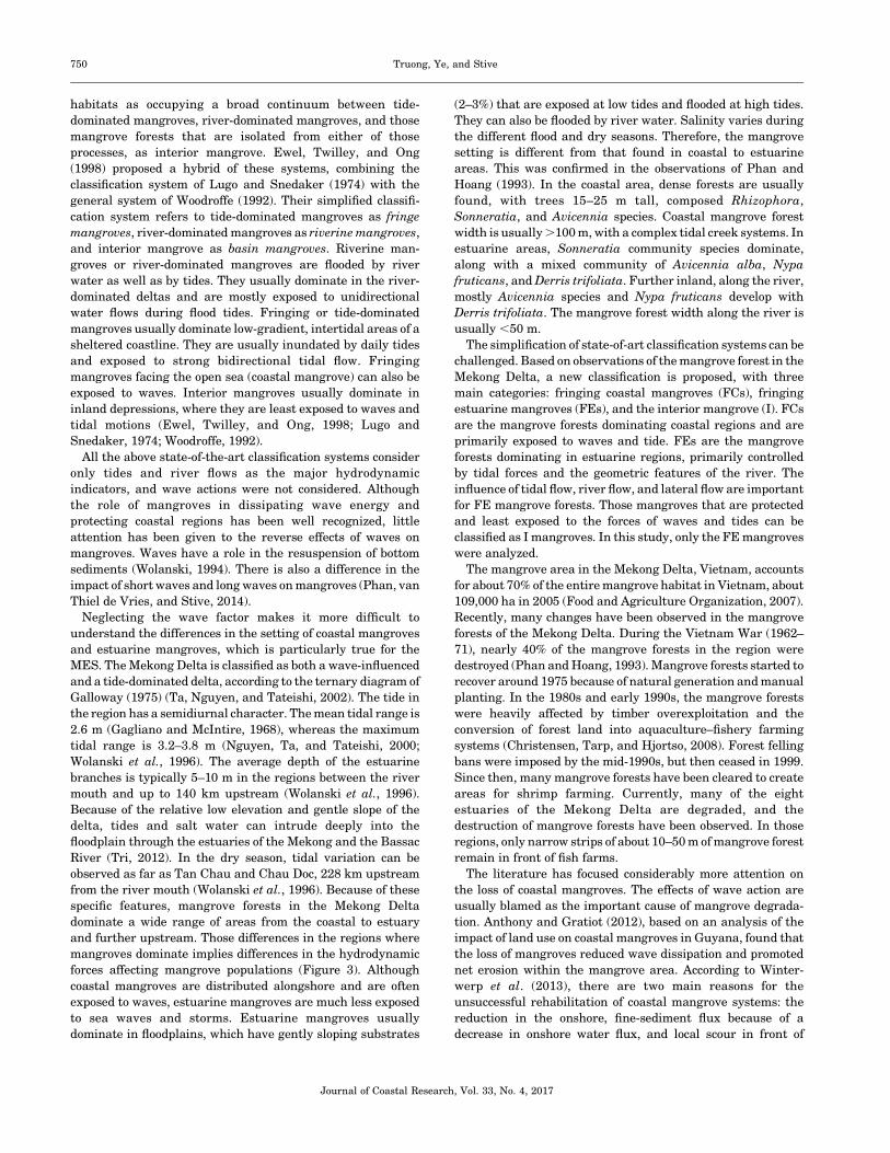
mangroves dominate implies differences in the hydrodynamic
forces affecting mangrove populations (Figure 3). Although
coastal mangroves are distributed alongshore and are often
exposed to waves, estuarine mangroves are much less exposed
to sea waves and storms. Estuarine mangroves usually
dominate in floodplains, which have gently sloping substrates
(2–3%) that are exposed at low tides and flooded at high tides.
They can also be flooded by river water. Salinity varies during
the different flood and dry seasons. Therefore, the mangrove
setting is different from that found in coastal to estuarine
areas. This was confirmed in the observations of Phan and
Hoang (1993). In the coastal area, dense forests are usually
found, with trees 15–25 m tall, composed Rhizophora,
Sonneratia, and Avicennia species. Coastal mangrove forest
width is usually .100 m, with a complex tidal creek systems. In
estuarine areas, Sonneratia community species dominate,
along with a mixed community of Avicennia alba, Nypa
fruticans, and Derris trifoliata. Further inland, along the river,
mostly Avicennia species and Nypa fruticans develop with
Derris trifoliata. The mangrove forest width along the river is
usually ,50 m.
The simplification of state-of-art classification systems can be
challenged. Based on observations of the mangrove forest in the
Mekong Delta, a new classification is proposed, with three
main categories: fringing coastal mangroves (FCs), fringing
estuarine mangroves (FEs), and the interior mangrove (I). FCs
are the mangrove forests dominating coastal regions and are
primarily exposed to waves and tide. FEs are the mangrove
forests dominating in estuarine regions, primarily controlled
by tidal forces and the geometric features of the river. The
influence of tidal flow, river flow, and lateral flow are important
for FE mangrove forests. Those mangroves that are protected
and least exposed to the forces of waves and tides can be
classified as I mangroves. In this study, only the FE mangroves
were analyzed.
The mangrove area in the Mekong Delta, Vietnam, accounts
for about 70% of the entire mangrove habitat in Vietnam, about
109,000 ha in 2005 (Food and Agriculture Organization, 2007).
Recently, many changes have been observed in the mangrove
forests of the Mekong Delta. During the Vietnam War (1962–
71), nearly 40% of the mangrove forests in the region were
destroyed (Phan and Hoang, 1993). Mangrove forests started to
recover around 1975 because of natural generation and manual
planting. In the 1980s and early 1990s, the mangrove forests
were heavily affected by timber overexploitation and the
conversion of forest land into aquaculture–fishery farming
systems (Christensen, Tarp, and Hjortso, 2008). Forest felling
bans were imposed by the mid-1990s, but then ceased in 1999.
Since then, many mangrove forests have been cleared to create
areas for shrimp farming. Currently, many of the eight
estuaries of the Mekong Delta are degraded, and the
destruction of mangrove forests have been observed. In those
regions, only narrow strips of about 10–50 m of mangrove forest
remain in front of fish farms.
The literature has focused considerably more attention on
the loss of coastal mangroves. The effects of wave action are
usually blamed as the important cause of mangrove degrada-
tion. Anthony and Gratiot (2012), based on an analysis of the
impact of land use on coastal mangroves in Guyana, found that
the loss of mangroves reduced wave dissipation and promoted
net erosion within the mangrove area. According to Winter-
werp et al. (2013), there are two main reasons for the
unsuccessful rehabilitation of coastal mangrove systems: the
reduction in the onshore, fine-sediment flux because of a
decrease in onshore water flux, and local scour in front of
Journal of Coastal Research, Vol. 33, No. 4, 2017
750 Truong, Ye, and Stive
structures because of a local increase in wave height due to
reflection caused by the implementation of structures within
the mangrove forests. In observations of the coastal area of the
Mekong Delta, Phan, van Thiel de Vries, and Stive (2014)
proposed a relationship between coastal evolution and man-
grove width and suggested the important role of long-wave
penetration in the sustainability of mangroves.
However, as mentioned, coastal mangroves and estuarine
mangroves have different hydrodynamic forces. Whereas
coastal mangroves are controlled by wave attenuation, estua-
rine mangroves are controlled by lateral flow, at least on the
bank close to the river. The effects of waves are small in
estuarine mangroves. Furthermore, in estuarine regions,
several other hydrodynamic factors can lead to the erosion of
riverbanks, such as meandering effects and circulation flow.
Therefore, the squeeze relationship between mangrove forest
width and evolution rate developed for coastal areas cannot
readily be applied to mangroves in estuarine regions.
This study focused on the straight part of the estuaries to
eliminate the meandering effect. The fundamental hypothesis
was that there must be a critical minimum width for an
estuarine mangrove forest fringe to exist sustainably exist or,
once surpassing the minimum width, to favor sedimentation.
The flow penetration into the mangrove forest needs a certain
distance to reach an equilibrium-damping value. If the width of
the forest is larger than that distance, there will be enough
space to absorb the parallel flow energy and to promote
sediment deposition, offering a successful environment for
both propagules and sedimentation. If the width of the forest is
smaller than that distance, the flow energy inside the forest
will not have decreased to a reasonable level. Seeds and
propagules cannot survive, and sediment cannot be accumu-
lated. A mangrove forest in such a state will degrade, and the
riverbank will suffer from more erosion.
Observations of Mangrove Width and RiverbankEvolution
The estuarine squeeze hypothesis, i.e. whenever fish farms
or dikes are constructed too close to the nonvegetated
foreshore, suggests that erosion trends will dominate and,
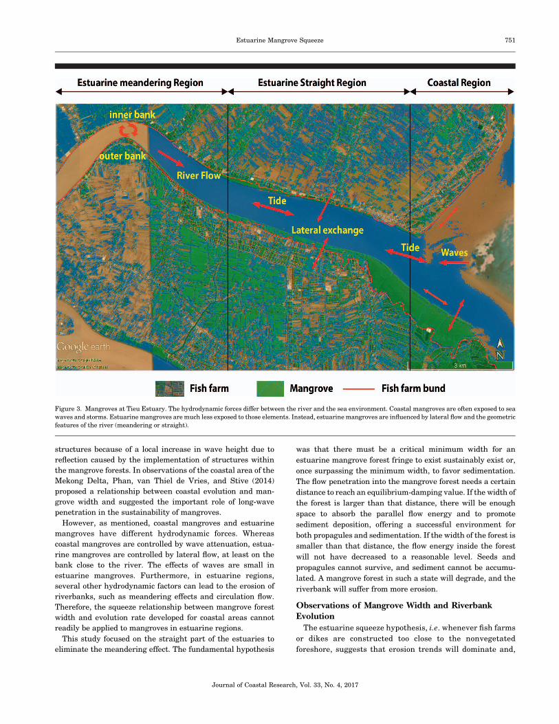
Figure 3. Mangroves at Tieu Estuary. The hydrodynamic forces differ between the river and the sea environment. Coastal mangroves are often exposed to sea
waves and storms. Estuarine mangroves are much less exposed to those elements. Instead, estuarine mangroves are influenced by lateral flow and the geometric
features of the river (meandering or straight).
Journal of Coastal Research, Vol. 33, No. 4, 2017
Estuarine Mangrove Squeeze 751
consequently, the health of the mangrove forest will be
threatened.
Optical satellite observations confirm that human inter-
vention, especially the construction of fish farms, has
disturbed mangrove forests in all branches of the MES.
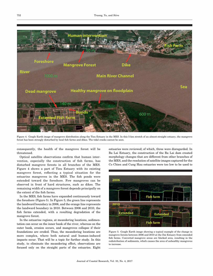
Figure 4 shows a part of Tieu Estuary with its existing
mangrove forest, reflecting a typical situation for the
estuarine mangroves in the MES. The fish ponds were
extended toward the foreshore. Few mangroves can be
observed in front of hard structures, such as dikes. The
remaining width of a mangrove forest depends principally on
the extent of the fish farms.
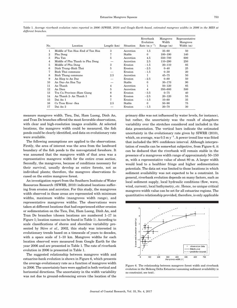
In the MES, fish farms have expanded continuously toward
the foreshore (Figure 5). In Figure 5, the green line represents
the landward boundary in 2006, and the orange line represents
the landward boundary in 2010. Between 2006 and 2010, the
fish farms extended, with a resulting degradation of the
mangrove forest.
In the estuarine regions, at meandering locations, sedimen-
tation can occur on the inner bank of the river, whereas on the
outer bank, erosion occurs, and mangroves collapse if their
foundations are eroded. Thus, the meandering locations are
more complex, where both natural and human-induced
impacts occur. That will be a topic for further study. In this
study, to eliminate the meandering effect, observations are
focused only on the straight parts of the estuaries. Eight
estuaries were reviewed; of which, three were disregarded. In
Ba Lai Estuary, the construction of the Ba Lai dam created
morphology changes that are different from other branches of
the MES, and the resolution of satellite images captured for the
Co Chien and Cung Hau estuaries were too low to be used to
Figure 4. Google Earth image of mangrove distribution along the Tieu Estuary in the MES. In this 5-km stretch of an almost-straight estuary, the mangrove
forest has been strongly disturbed by local fish farms and dikes. The tidal creeks cannot be seen.
Figure 5. Google Earth image showing a typical example of the change in
mangrove forests between 2006 and 2010 at the Dai Estuary from extended
fish farms. Converted mangrove areas are blocked area, resulting in the
redistribution of sediments, which causes the area of unhealthy mangroves
to increase.
Journal of Coastal Research, Vol. 33, No. 4, 2017
752 Truong, Ye, and Stive
measure mangrove width. Tieu, Dai, Ham Luong, Dinh An,
and Tran De branches offered the most favorable observations,
with clear and high-resolution images available. At selected
locations, the mangrove width could be measured, the fish
ponds could be clearly identified, and data on evolutionary rate
were available.
The following assumptions are applied to the observations.
Firstly, the area of interest was the area from the landward
boundary of the fish ponds to the nonvegetated foreshore. It
was assumed that the mangrove width of that area was a
representative mangrove width for the entire cross section.
Secondly, the mangroves, because of conditions necessary for
their survival, usually develop as entire forests, not as
individual plants; therefore, the mangrove observations fo-
cused on the entire mangrove forest.
An investigation report from the Southern Institute of Water
Resources Research (SIWRR, 2010) indicated locations suffer-
ing from erosion and accretion. For this study, the mangroves
width observed in those areas are represented with minimum
widths, maximum widths (mangroves width range), and
representative mangroves widths. The observations were
taken at different locations that had experienced either erosion
or sedimentation on the Tieu, Dai, Ham Luong, Dinh An, and
Tran De branches (chosen locations are numbered 1–17 in
Figure 1; location names can be found in Table 1). According to
scale classifications of shores and shoreline variability pre-
sented by Stive et al., 2002, this study was interested in
evolutionary trends based on a timescale of years to decades,
with a space scale of 1–10 km. Mangrove widths for each
location observed were measured from Google Earth for the
year 2006 and are presented in Table 1. The rate of riverbank
evolution in 2006 is presented in Table 1.
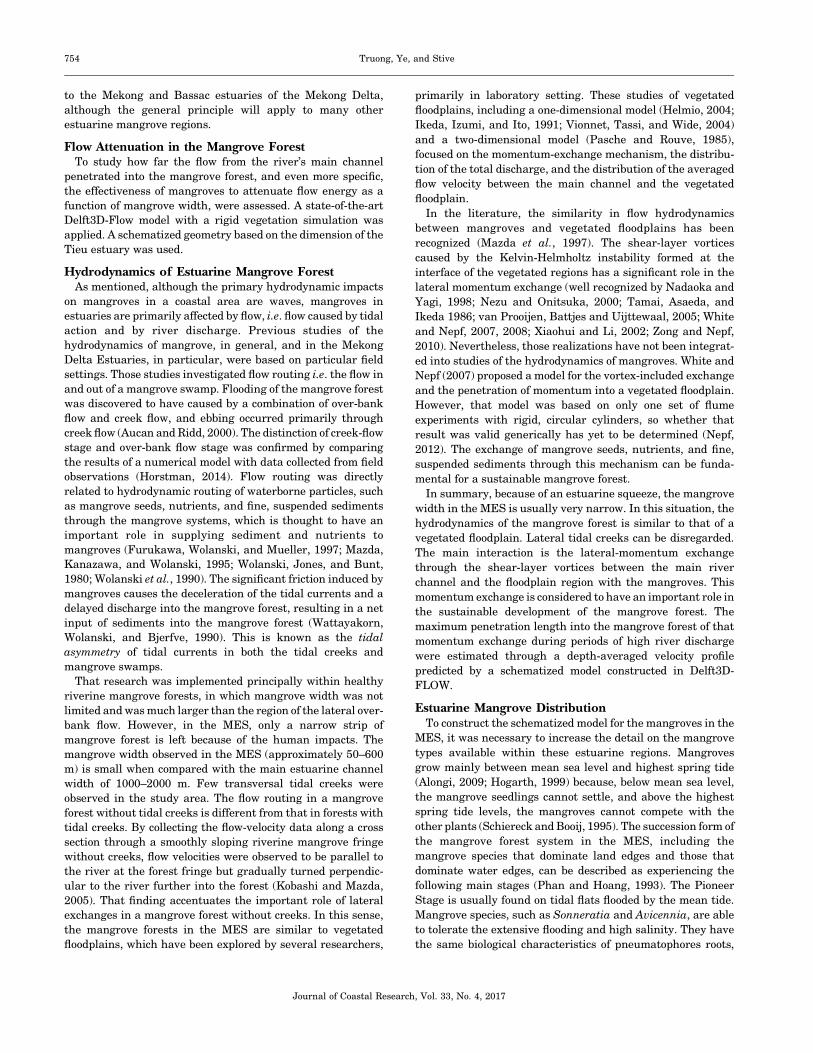
The suggested relationship between mangrove width and
estuarine-bank evolution is shown in Figure 6, which presents
the average evolutionary rate as a function of mangrove width
in 2006. The uncertainty bars were applied in both vertical and
horizontal directions. The uncertainty in the width variability
was not due to ground-referencing errors (the location of the
primary dike was not influenced by water levels, for instance),
but rather, the uncertainty was the result of alongshore
variability over the stretches considered and included in the
data presentation. The vertical bars indicate the estimated
uncertainty in the evolutionary rate given by SIWRR (2010),
which, on average, was 0.5 m y�1. A power trend line was fitted
that included the 90% confidence interval. Although interpre-
tation of results can be somewhat subjective, from Figure 6, it
can be deduced that the riverbank will remain stable in the
presence of a mangroves width range of approximately 50–150
m, with a representative value of about 80 m. A larger width
would lead to a healthier fringe and higher sedimentation
potentials. The data set was limited to those locations in which
sediment availability was not expected to be a constraint. In
general, riverbank evolution depends on many factors, such as
local sediment supply, local hydraulic conditions (flow, wave,
wind, current), local bathymetry, etc. Hence, no unique critical
mangrove-width value can be set for all estuarine regions. The
quantitative relationship provided, therefore, is only applicable
Table 1. Average riverbank evolution rates reported in 2006 (SIWRR, 2010) and Google-Earth–based, estimated mangrove widths in 2006 in the MES at
different branches.
No. Location Length (km) Situation
Riverbank
Evolution
Rate (m y�1)
Mangrove
Width
Range (m)
Representative
Mangrove
Width (m)
1 Middle of Tan Hoa–End of Tan Hoa 3 Accretion 1.5 35–60 50
2 Phu Dong 7 Stable 0 100–190 140
3 Phu Tan 5 Accretion 4.5 550–700 600
4 Middle of Phu Thanh to Phu Dong — Accretion 2.5 110–290 250
5 Middle of Phu Dong 3 Erosion �1.5 20–110 85
6 Dinh Trung–Binh Thoi 5 Erosion �2.5 0–40 25
7 Binh Thoi commune — Erosion �1.5 0–30 20
8 Binh Thang commune 2.5 Accretion 1 45–75 50
9 An Hiep to An Duc — Erosion �2.5 0–60 50
10 An Duc–An Hoa Tay — Stable 0 30–170 90
11 An Thanh 4 Accretion 1 50–120 85
12 An Dien 5 Accretion 4 350–600 500
13 Tra Cu Province–Ham Giang 8 Erosion �3.5 0–75 40
14 An Thanh 2- An Thanh 3 8 Erosion �2.5 20–120 55
15 Dai An 1 7 Erosion �1.5 10–60 35
16 Co Tron River -Sea 2.5 Stable 0 50–90 75
17 Dai An 2 — Erosion �1.5 20–70 30
Figure 6. The relationship between mangrove forest width and riverbank
evolution in the Mekong Delta Estuaries (assuming sediment availability is
no constraint; see text).
Journal of Coastal Research, Vol. 33, No. 4, 2017
Estuarine Mangrove Squeeze 753
to the Mekong and Bassac estuaries of the Mekong Delta,
although the general principle will apply to many other
estuarine mangrove regions.
Flow Attenuation in the Mangrove ForestTo study how far the flow from the river’s main channel
penetrated into the mangrove forest, and even more specific,
the effectiveness of mangroves to attenuate flow energy as a
function of mangrove width, were assessed. A state-of-the-art
Delft3D-Flow model with a rigid vegetation simulation was
applied. A schematized geometry based on the dimension of the
Tieu estuary was used.
Hydrodynamics of Estuarine Mangrove ForestAs mentioned, although the primary hydrodynamic impacts
on mangroves in a coastal area are waves, mangroves in
estuaries are primarily affected by flow, i.e. flow caused by tidal
action and by river discharge. Previous studies of the
hydrodynamics of mangrove, in general, and in the Mekong
Delta Estuaries, in particular, were based on particular field
settings. Those studies investigated flow routing i.e. the flow in
and out of a mangrove swamp. Flooding of the mangrove forest
was discovered to have caused by a combination of over-bank
flow and creek flow, and ebbing occurred primarily through
creek flow (Aucan and Ridd, 2000). The distinction of creek-flow
stage and over-bank flow stage was confirmed by comparing
the results of a numerical model with data collected from field
observations (Horstman, 2014). Flow routing was directly
related to hydrodynamic routing of waterborne particles, such
as mangrove seeds, nutrients, and fine, suspended sediments
through the mangrove systems, which is thought to have an
important role in supplying sediment and nutrients to
mangroves (Furukawa, Wolanski, and Mueller, 1997; Mazda,
Kanazawa, and Wolanski, 1995; Wolanski, Jones, and Bunt,
1980; Wolanski et al., 1990). The significant friction induced by
mangroves causes the deceleration of the tidal currents and a
delayed discharge into the mangrove forest, resulting in a net
input of sediments into the mangrove forest (Wattayakorn,
Wolanski, and Bjerfve, 1990). This is known as the tidal
asymmetry of tidal currents in both the tidal creeks and
mangrove swamps.
That research was implemented principally within healthy
riverine mangrove forests, in which mangrove width was not
limited and was much larger than the region of the lateral over-
bank flow. However, in the MES, only a narrow strip of
mangrove forest is left because of the human impacts. The
mangrove width observed in the MES (approximately 50–600
m) is small when compared with the main estuarine channel
width of 1000–2000 m. Few transversal tidal creeks were
observed in the study area. The flow routing in a mangrove
forest without tidal creeks is different from that in forests with
tidal creeks. By collecting the flow-velocity data along a cross
section through a smoothly sloping riverine mangrove fringe
without creeks, flow velocities were observed to be parallel to
the river at the forest fringe but gradually turned perpendic-
ular to the river further into the forest (Kobashi and Mazda,
2005). That finding accentuates the important role of lateral
exchanges in a mangrove forest without creeks. In this sense,
the mangrove forests in the MES are similar to vegetated
floodplains, which have been explored by several researchers,
primarily in laboratory setting. These studies of vegetated
floodplains, including a one-dimensional model (Helmio, 2004;
Ikeda, Izumi, and Ito, 1991; Vionnet, Tassi, and Wide, 2004)
and a two-dimensional model (Pasche and Rouve, 1985),
focused on the momentum-exchange mechanism, the distribu-
tion of the total discharge, and the distribution of the averaged
flow velocity between the main channel and the vegetated
floodplain.
In the literature, the similarity in flow hydrodynamics
between mangroves and vegetated floodplains has been
recognized (Mazda et al., 1997). The shear-layer vortices
caused by the Kelvin-Helmholtz instability formed at the
interface of the vegetated regions has a significant role in the
lateral momentum exchange (well recognized by Nadaoka and
Yagi, 1998; Nezu and Onitsuka, 2000; Tamai, Asaeda, and
Ikeda 1986; van Prooijen, Battjes and Uijttewaal, 2005; White
and Nepf, 2007, 2008; Xiaohui and Li, 2002; Zong and Nepf,
2010). Nevertheless, those realizations have not been integrat-
ed into studies of the hydrodynamics of mangroves. White and
Nepf (2007) proposed a model for the vortex-included exchange
and the penetration of momentum into a vegetated floodplain.
However, that model was based on only one set of flume
experiments with rigid, circular cylinders, so whether that
result was valid generically has yet to be determined (Nepf,
2012). The exchange of mangrove seeds, nutrients, and fine,
suspended sediments through this mechanism can be funda-
mental for a sustainable mangrove forest.
In summary, because of an estuarine squeeze, the mangrove
width in the MES is usually very narrow. In this situation, the
hydrodynamics of the mangrove forest is similar to that of a
vegetated floodplain. Lateral tidal creeks can be disregarded.
The main interaction is the lateral-momentum exchange
through the shear-layer vortices between the main river
channel and the floodplain region with the mangroves. This
momentum exchange is considered to have an important role in
the sustainable development of the mangrove forest. The
maximum penetration length into the mangrove forest of that
momentum exchange during periods of high river discharge
were estimated through a depth-averaged velocity profile
predicted by a schematized model constructed in Delft3D-
FLOW.
Estuarine Mangrove DistributionTo construct the schematized model for the mangroves in the
MES, it was necessary to increase the detail on the mangrove
types available within these estuarine regions. Mangroves
grow mainly between mean sea level and highest spring tide
(Alongi, 2009; Hogarth, 1999) because, below mean sea level,
the mangrove seedlings cannot settle, and above the highest
spring tide levels, the mangroves cannot compete with the
other plants (Schiereck and Booij, 1995). The succession form of
the mangrove forest system in the MES, including the
mangrove species that dominate land edges and those that
dominate water edges, can be described as experiencing the
following main stages (Phan and Hoang, 1993). The Pioneer
Stage is usually found on tidal flats flooded by the mean tide.
Mangrove species, such as Sonneratia and Avicennia, are able
to tolerate the extensive flooding and high salinity. They have
the same biological characteristics of pneumatophores roots,
Journal of Coastal Research, Vol. 33, No. 4, 2017
754 Truong, Ye, and Stive
which can rapidly establish themselves in the substrate. The
Transition Stage is a stage in which the pneumatophore system
of Sonneratia and Avicennia species trap and hold soil and
alluvium. After a short time, the mudflats are elevated, i.e.
when sediment is available as a source. Seedlings of other land-
edge species, such as Nypa fruticans, Cryptocoryne ciliata, and
Acanthus ilicifolius are carried to the flats by tidal water and
trapped by the pneumatophore system. The final stage is a
Multispecies Community. Because the land is continuously
elevated by alluvial deposition, it is usually only flooded at high
tide and more land-edge mangrove species, such as Derris
trifoliate, Wedelia biflora, and Acanthus, ilicifolius are able to
develop.
In contrast to coastal mangroves, estuarine mangroves
consist of a variety of mixed types that are able to adapt to a
wide range of salinities, such as Sonneratia Alba, Avicennia
alba, and Acanthus ilicifolius, Nypa fruticans, Cryptocoryne
ciliata, etc. In the Mekong Delta Estuaries, the presence of
Rhizophora is not often observed, except in the Ba Lai Estuary
(Phan and Hoang, 1993). In the schematized model, the
estuarine mangrove forest was considered to consist only of
Sonneratia species. This type of mangrove is known by its
pneumatophores, which are erect, lateral branches of horizon-
tal cable roots that grow underground (De Vos, 2004).
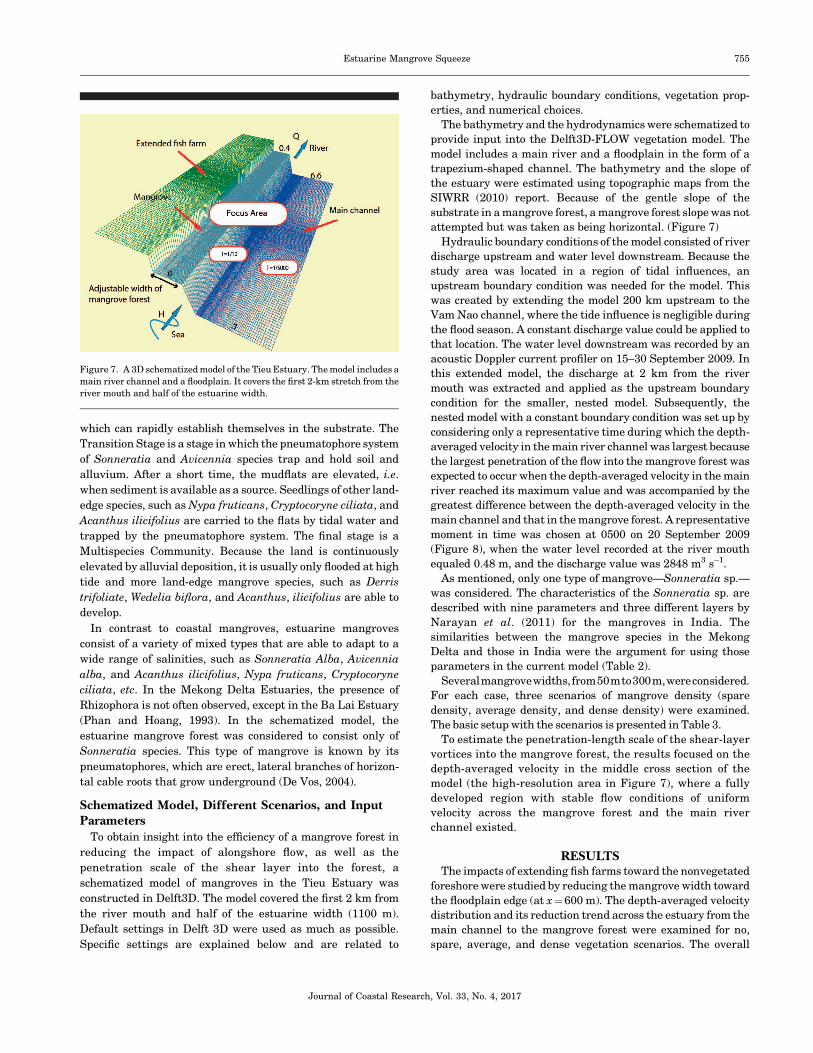
Schematized Model, Different Scenarios, and InputParameters
To obtain insight into the efficiency of a mangrove forest in
reducing the impact of alongshore flow, as well as the
penetration scale of the shear layer into the forest, a
schematized model of mangroves in the Tieu Estuary was
constructed in Delft3D. The model covered the first 2 km from
the river mouth and half of the estuarine width (1100 m).
Default settings in Delft 3D were used as much as possible.
Specific settings are explained below and are related to
bathymetry, hydraulic boundary conditions, vegetation prop-
erties, and numerical choices.
The bathymetry and the hydrodynamics were schematized to
provide input into the Delft3D-FLOW vegetation model. The
model includes a main river and a floodplain in the form of a
trapezium-shaped channel. The bathymetry and the slope of
the estuary were estimated using topographic maps from the
SIWRR (2010) report. Because of the gentle slope of the
substrate in a mangrove forest, a mangrove forest slope was not
attempted but was taken as being horizontal. (Figure 7)
Hydraulic boundary conditions of the model consisted of river
discharge upstream and water level downstream. Because the
study area was located in a region of tidal influences, an
upstream boundary condition was needed for the model. This
was created by extending the model 200 km upstream to the
Vam Nao channel, where the tide influence is negligible during
the flood season. A constant discharge value could be applied to
that location. The water level downstream was recorded by an
acoustic Doppler current profiler on 15–30 September 2009. In
this extended model, the discharge at 2 km from the river
mouth was extracted and applied as the upstream boundary
condition for the smaller, nested model. Subsequently, the
nested model with a constant boundary condition was set up by
considering only a representative time during which the depth-
averaged velocity in the main river channel was largest because
the largest penetration of the flow into the mangrove forest was
expected to occur when the depth-averaged velocity in the main
river reached its maximum value and was accompanied by the
greatest difference between the depth-averaged velocity in the
main channel and that in the mangrove forest. A representative
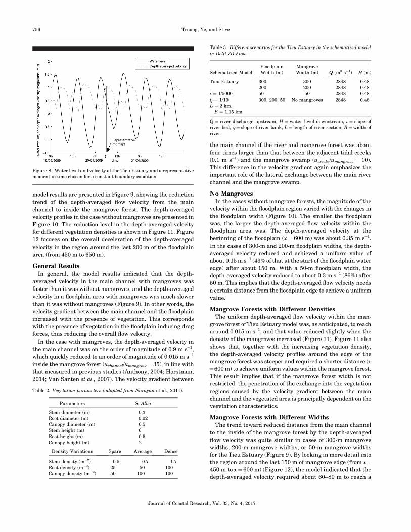
moment in time was chosen at 0500 on 20 September 2009
(Figure 8), when the water level recorded at the river mouth
equaled 0.48 m, and the discharge value was 2848 m3 s�1.
As mentioned, only one type of mangrove—Sonneratia sp.—
was considered. The characteristics of the Sonneratia sp. are
described with nine parameters and three different layers by
Narayan et al. (2011) for the mangroves in India. The
similarities between the mangrove species in the Mekong
Delta and those in India were the argument for using those
parameters in the current model (Table 2).
Severalmangrovewidths,from50mto300m,wereconsidered.
For each case, three scenarios of mangrove density (spare
density, average density, and dense density) were examined.
The basic setup with the scenarios is presented in Table 3.
To estimate the penetration-length scale of the shear-layer
vortices into the mangrove forest, the results focused on the
depth-averaged velocity in the middle cross section of the
model (the high-resolution area in Figure 7), where a fully
developed region with stable flow conditions of uniform
velocity across the mangrove forest and the main river
channel existed.
RESULTSThe impacts of extending fish farms toward the nonvegetated
foreshore were studied by reducing the mangrove width toward
the floodplain edge (at x¼600 m). The depth-averaged velocity
distribution and its reduction trend across the estuary from the
main channel to the mangrove forest were examined for no,
spare, average, and dense vegetation scenarios. The overall
Figure 7. A 3D schematized model of the Tieu Estuary. The model includes a
main river channel and a floodplain. It covers the first 2-km stretch from the
river mouth and half of the estuarine width.
Journal of Coastal Research, Vol. 33, No. 4, 2017
Estuarine Mangrove Squeeze 755
model results are presented in Figure 9, showing the reduction
trend of the depth-averaged flow velocity from the main
channel to inside the mangrove forest. The depth-averaged
velocity profiles in the case without mangroves are presented in
Figure 10. The reduction level in the depth-averaged velocity
for different vegetation densities is shown in Figure 11. Figure
12 focuses on the overall deceleration of the depth-averaged
velocity in the region around the last 200 m of the floodplain
area (from 450 m to 650 m).
General ResultsIn general, the model results indicated that the depth-
averaged velocity in the main channel with mangroves was
faster than it was without mangroves, and the depth-averaged
velocity in a floodplain area with mangroves was much slower
than it was without mangroves (Figure 9). In other words, the
velocity gradient between the main channel and the floodplain
increased with the presence of vegetation. This corresponds
with the presence of vegetation in the floodplain inducing drag
forces, thus reducing the overall flow velocity.
In the case with mangroves, the depth-averaged velocity in
the main channel was on the order of magnitude of 0.9 m s�1,
which quickly reduced to an order of magnitude of 0.015 m s�1
inside the mangrove forest (uchannel/umangrove¼35), in line with
that measured in previous studies (Anthony, 2004; Horstman,
2014; Van Santen et al., 2007). The velocity gradient between
the main channel if the river and mangrove forest was about
four times larger than that between the adjacent tidal creeks
(0.1 m s�1) and the mangrove swamp (ucreeks/umangrove ¼ 10).
This difference in the velocity gradient again emphasizes the
important role of the lateral exchange between the main river
channel and the mangrove swamp.
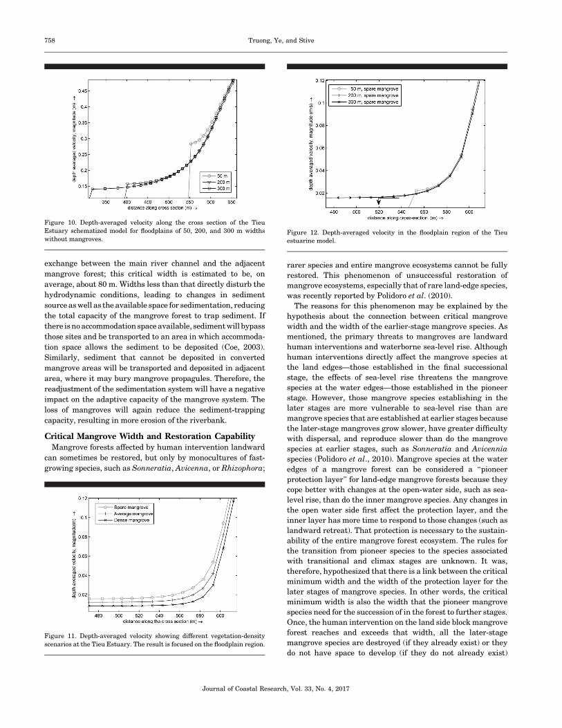
No MangrovesIn the cases without mangrove forests, the magnitude of the
velocity within the floodplain region varied with the changes in
the floodplain width (Figure 10). The smaller the floodplain
was, the larger the depth-averaged flow velocity within the
floodplain area was. The depth-averaged velocity at the
beginning of the floodplain (x¼ 600 m) was about 0.35 m s�1.
In the cases of 300-m and 200-m floodplain widths, the depth-
averaged velocity reduced and achieved a uniform value of
about 0.15 m s�1 (43% of that at the start of the floodplain water
edge) after about 150 m. With a 50-m floodplain width, the
depth-averaged velocity reduced to about 0.3 m s�1 (86%) after
50 m. This implies that the depth-averaged flow velocity needs
a certain distance from the floodplain edge to achieve a uniform
value.
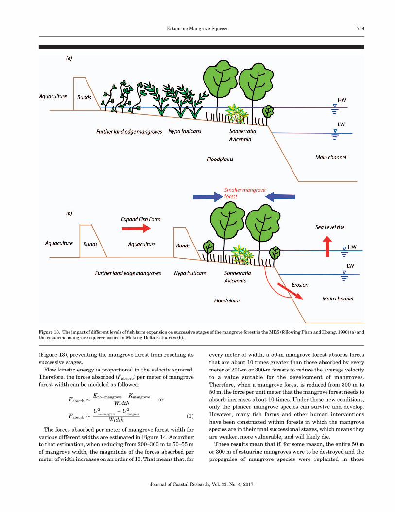
Mangrove Forests with Different DensitiesThe uniform depth-averaged flow velocity within the man-
grove forest of Tieu Estuary model was, as anticipated, to reach
around 0.015 m s�1, and that value reduced slightly when the
density of the mangroves increased (Figure 11). Figure 11 also
shows that, together with the increasing vegetation density,
the depth-averaged velocity profiles around the edge of the
mangrove forest was steeper and required a shorter distance (x
¼600 m) to achieve uniform values within the mangrove forest.
This result implies that if the mangrove forest width is not
restricted, the penetration of the exchange into the vegetation
regions caused by the velocity gradient between the main
channel and the vegetated area is principally dependent on the
vegetation characteristics.
Mangrove Forests with Different WidthsThe trend toward reduced distance from the main channel
to the inside of the mangrove forest by the depth-averaged
flow velocity was quite similar in cases of 300-m mangrove
widths, 200-m mangrove widths, or 50-m mangrove widths
for the Tieu Estuary (Figure 9). By looking in more detail into
the region around the last 150 m of mangrove edge (from x¼450 m to x¼600 m) (Figure 12), the model indicated that the
depth-averaged velocity required about 60–80 m to reach a
Table 2. Vegetation parameters (adapted from Narayan et al., 2011).
Parameters S. Alba
Stem diameter (m) 0.3
Root diameter (m) 0.02
Canopy diameter (m) 0.5
Stem height (m) 6
Root height (m) 0.5
Canopy height (m) 2
Density Variations Spare Average Dense
Stem density (m�2) 0.5 0.7 1.7
Root density (m�2) 25 50 100
Canopy density (m�2) 50 100 100
Table 3. Different scenarios for the Tieu Estuary in the schematized model
in Delft 3D-Flow.
Schematized Model
Floodplain
Width (m)
Mangrove
Width (m) Q (m3 s�1) H (m)
Tieu Estuary 300 300 2848 0.48
200 200 2848 0.48
i ¼ 1/5000 50 50 2848 0.48
if ¼ 1/10 300, 200, 50 No mangroves 2848 0.48
L ¼ 2 km,
B ¼ 1.15 km
Q ¼ river discharge upstream, H ¼ water level downstream, i ¼ slope of
river bed, if¼ slope of river bank, L¼ length of river section, B¼width of
river.
Figure 8. Water level and velocity at the Tieu Estuary and a representative
moment in time chosen for a constant boundary condition.
Journal of Coastal Research, Vol. 33, No. 4, 2017
756 Truong, Ye, and Stive

fully uniform value within the mangrove forest (about 0.015
m s�1). That depth-averaged velocity was about 20% of that at
the start of the forest (0.08 m s�1). This implies that the
length scale of the penetrating shear layer into the mangrove
forest was 60–80 m. In other words, the minimum distance
from the mangrove edge at which the velocity in the
mangrove forest reached a uniform value of about 0.015 m
s�1 was about 60–80 m. Therefore, when floodplain widths
were less than 60–80 m, the depth-averaged velocity profile
in the mangrove forest would not reach a uniform value
because the penetration length of the mixing layer was larger
than the width of the mangrove forest.
In conclusion, these results show that, as long as the
riverine mangrove forest width in the MES is larger than
approximately 60–80 m, the uniform depth-averaged flow
velocity within the mangrove forest is dependent on man-
grove characteristics, rather than on the characteristics of
bathymetry and hydraulic conditions in the adjacent main
river channel. However, when the riverine mangrove forest
width is less than 60–80 m, the uniform depth-averaged
velocity within the mangrove forest is affected by the flow in
the main river channel. This is in agreement with the
observations that confirm the hypothesis of the existence of a
link between critical mangrove width in the estuarine
mangrove forest and the maximum penetration of the flow
into the forest. An averaged value of 80 m is the minimum
width at which the mangrove forest can be maintained, and
at that width the forest is sustainable if the construction of
fish farms does not reduce that width.
DISCUSSIONThe physical meaning of a critical mangrove width can be
discussed within the context of sedimentation and forest-
restoration capacity.
Critical Mangrove Width and SedimentationThe requirements for a sustainable mangrove forest are very
strict. Significant changes in the sediment dynamics within a
mangrove forest can do damage to the entire system. Too much
sedimentation may bury the mangrove propagules, leading to
the death of the aerial mangrove root system of the pioneer
species, such as Sonneratia and Avicenna. However, too little
sedimentation may lead to the destabilization of the mangrove
trees. The mangrove propagules have a length of 25–30 cm, so a
sediment thickness of around 30 cm is necessary to provide a
suitable environment for mangrove aerial roots (Phan, 2012).
Nevertheless, only 10 cm of root burial can make Avicennia trees
die (Ellison, 1998), and 8 cm of sediment burial can reduce
growth and increase mortality of Rhizophora seedlings (Terra-
dos et al., 1997). In addition, because mangrove roots anchor in
only about 0.5 m of the soil, a few decimeters of erosion is
sufficient to destabilize a mangrove tree (Winterwerp et al.,
2013).
Once fish ponds are constructed too far into the mangrove
forest, insufficient mangrove width remains for a proper lateral
Figure 9. Depth-averaged velocity along the cross section of the Tieu Estuary schematized model (a) and the corresponding profile with 300-m, 200-m, and 50-m
floodplain widths (b) (from the equilibrium profiles).
Journal of Coastal Research, Vol. 33, No. 4, 2017
Estuarine Mangrove Squeeze 757
exchange between the main river channel and the adjacent
mangrove forest; this critical width is estimated to be, on
average, about 80 m. Widths less than that directly disturb the
hydrodynamic conditions, leading to changes in sediment
source as well as the available space for sedimentation, reducing
the total capacity of the mangrove forest to trap sediment. If
there isno accommodationspace available, sediment will bypass
those sites and be transported to an area in which accommoda-
tion space allows the sediment to be deposited (Coe, 2003).
Similarly, sediment that cannot be deposited in converted
mangrove areas will be transported and deposited in adjacent
area, where it may bury mangrove propagules. Therefore, the
readjustment of the sedimentation system will have a negative
impact on the adaptive capacity of the mangrove system. The
loss of mangroves will again reduce the sediment-trapping
capacity, resulting in more erosion of the riverbank.
Critical Mangrove Width and Restoration CapabilityMangrove forests affected by human intervention landward
can sometimes be restored, but only by monocultures of fast-
growing species, such as Sonneratia, Avicenna, or Rhizophora;
rarer species and entire mangrove ecosystems cannot be fully
restored. This phenomenon of unsuccessful restoration of
mangrove ecosystems, especially that of rare land-edge species,
was recently reported by Polidoro et al. (2010).
The reasons for this phenomenon may be explained by the
hypothesis about the connection between critical mangrove
width and the width of the earlier-stage mangrove species. As
mentioned, the primary threats to mangroves are landward
human interventions and waterborne sea-level rise. Although
human interventions directly affect the mangrove species at
the land edges—those established in the final successional
stage, the effects of sea-level rise threatens the mangrove
species at the water edges—those established in the pioneer
stage. However, those mangrove species establishing in the
later stages are more vulnerable to sea-level rise than are
mangrove species that are established at earlier stages because
the later-stage mangroves grow slower, have greater difficulty
with dispersal, and reproduce slower than do the mangrove
species at earlier stages, such as Sonneratia and Avicennia
species (Polidoro et al., 2010). Mangrove species at the water
edges of a mangrove forest can be considered a ‘‘pioneer
protection layer’’ for land-edge mangrove forests because they
cope better with changes at the open-water side, such as sea-
level rise, than do the inner mangrove species. Any changes in
the open water side first affect the protection layer, and the
inner layer has more time to respond to those changes (such as
landward retreat). That protection is necessary to the sustain-
ability of the entire mangrove forest ecosystem. The rules for
the transition from pioneer species to the species associated
with transitional and climax stages are unknown. It was,
therefore, hypothesized that there is a link between the critical
minimum width and the width of the protection layer for the
later stages of mangrove species. In other words, the critical
minimum width is also the width that the pioneer mangrove
species need for the succession of in the forest to further stages.
Once, the human intervention on the land side block mangrove
forest reaches and exceeds that width, all the later-stage
mangrove species are destroyed (if they already exist) or they
do not have space to develop (if they do not already exist)
Figure 10. Depth-averaged velocity along the cross section of the Tieu
Estuary schematized model for floodplains of 50, 200, and 300 m widths
without mangroves.
Figure 11. Depth-averaged velocity showing different vegetation-density
scenarios at the Tieu Estuary. The result is focused on the floodplain region.
Figure 12. Depth-averaged velocity in the floodplain region of the Tieu
estuarine model.
Journal of Coastal Research, Vol. 33, No. 4, 2017
758 Truong, Ye, and Stive
(Figure 13), preventing the mangrove forest from reaching its
successive stages.
Flow kinetic energy is proportional to the velocity squared.
Therefore, the forces absorbed (Fabsorb) per meter of mangrove
forest width can be modeled as followed:
Fabsorb ~Kno�mangrove �Kmangrove
Widthor
Fabsorb ~U2
no�mangrove�U2
mangrove
Widthð1Þ
The forces absorbed per meter of mangrove forest width for
various different widths are estimated in Figure 14. According
to that estimation, when reducing from 200–300 m to 50–55 m
of mangrove width, the magnitude of the forces absorbed per
meter of width increases on an order of 10. That means that, for
every meter of width, a 50-m mangrove forest absorbs forces
that are about 10 times greater than those absorbed by every
meter of 200-m or 300-m forests to reduce the average velocity
to a value suitable for the development of mangroves.
Therefore, when a mangrove forest is reduced from 300 m to
50 m, the force per unit meter that the mangrove forest needs to
absorb increases about 10 times. Under those new conditions,
only the pioneer mangrove species can survive and develop.
However, many fish farms and other human interventions
have been constructed within forests in which the mangrove
species are in their final successional stages, which means they
are weaker, more vulnerable, and will likely die.
These results mean that if, for some reason, the entire 50 m
or 300 m of estuarine mangroves were to be destroyed and the
propagules of mangrove species were replanted in those
Figure 13. The impact of different levels of fish farm expansion on successive stages of the mangrove forest in the MES (following Phan and Hoang, 1990) (a) and
the estuarine mangrove squeeze issues in Mekong Delta Estuaries (b).
Journal of Coastal Research, Vol. 33, No. 4, 2017
Estuarine Mangrove Squeeze 759

regions, the force the forest would need to absorb would be 10
times greater for the 50-m forest. This implies that the larger
the width of a mangrove forest, the easier it is for that forest to
recover, especially for the land-edge mangrove species.
CONCLUSIONSIn this study, mangrove forest degradation and the trends in
riverbank evolution affected by the extent of fish farms in the
MES were analyzed by adopting a broader definition of the
term estuarine squeeze. In that context, a minimum width was
derived that the estuarine mangrove ecosystem needs for
healthy, cyclic evolution. If mangrove forest widths are less
than 80 m in the MES, the riverbank will be less stable and the
estuarine mangroves will be more vulnerable. The results were
estimated based on an empirical relationship between man-
grove forest width and riverbank evolution. Based on the
similarity between the hydrodynamics of a narrow mangrove
forest and that of a vegetated floodplain channel, the exchange
mechanism between the main river channel and the vegetated
floodplain could be identified. That mechanism controls such
fundamental factors as the transport and deposition of
sediment, the supply of nutrients, and the significance of
organic outwelling from a mangrove forest. This occurs because
of the penetration of shear-layer vortices caused by the velocity
gradient and the presence of mangroves on the floodplain.
Results from the Delft3D-flow vegetation model for the Tieu
Estuary showed the penetration length scale of the shear layer
into the mangrove forest. The depth-averaged flow velocity
from the main channel was reduced to a uniform value on an
order of magnitude of 0.015 m s�1 within 60–80 m inside the
mangrove forest. The agreement between field observations
and the schematized model confirmed the existence of and
estuarine mangrove squeeze and the hypothesis of a critical
width linked to the maximum penetration of the flow into the
mangrove forest.
Unsuccessful mangrove restoration attempts at the land
edge of the forest, which usually contains more rare and
vulnerable species compared with pioneerspecies, can be
explained by assuming a link between the critical minimum
width and the minimum width of the mangroves at a pioneer
stage. The difficulty in the recovering mangrove species in their
final stages (the land edge of the mangrove forest) can also be
understood from an energetic standpoint.
Future work will concentrate on further validation of the
model results by both field work and laboratory experiments in
terms of both hydrodynamics and sedimentation.
ACKNOWLEDGMENTSThis study was supported by the Ministry of Education and
a training scholarship (MOET), Vietnam; the Technical
University Delft, The Netherlands; The Water Resources
University of Hanoi, Vietnam; and the Southern Institute of
Water Resources Research of Vietnam.
LITERATURE CITEDAlongi, D.M., 2002. Present state and future of the world’s mangrove
forest. Environmental Conservation, 29(3), 331–349.
Alongi, D.M., 2008. Mangrove forests: Resilience, protection from
tsunamis, and responses to global climate change. Estuarine,
Coastal and Shelf Science, 76, 1–13.
Alongi, D.M., 2009. The Energetics of Mangrove Forests. Queensland,
Australia: Springer, 216p.
Anthony, E.J., 2004. Sediment dynamics and morphological stability
of estuarine mangrove swamps in Sherbro Bay, West Africa.
Marine Geology, 208(2–4), 207–224.
Anthony, E.J.; Brunier, G.; Besset, M.; Goichot, M.; Dussouillez, P.,
and Nguyen, V.L., 2015. Linking rapid erosion of the Mekong River
Delta to human activities. Science Report, 5, 14745. doi: 10.1038/
srep14745
Anthony, E.J. and Gratiot, N., 2012. Coastal engineering and large-
scale mangrove destruction in Guyana, South America: Averting
an environmental catastrophe in the making. Ecological Engineer-
ing, 47, 268–273.
Aucan, J. and Ridd, P.V., 2000. Tidal asymmetry in creeks
surrounded by saltflats and mangrove with small swamp slopes.
Wetlands Ecology and Management, 8(4), 223–232
Baptist, M.J., 2005. Modelling Floodplain Biogeomorphology. Delft,
The Netherlands: Delft University Technology, Ph.D. dissertation,
274p.
Bouma, T.J.; Van Duren, L.A.; Temmerman, S.; Claverie, T.; Blanco-
Garcia, A., and Ysebaert., 2007. Tidal flow and sedimentation
patterns within patches of epibenthic structures: Combining field,
flume and modelling experiments. Continental Shelf Research,
27(8), 1020–1045.
Christensen, S.M.; Tarp, P., and Hjorts, C.N., 2008. Mangrove forest
management planning in coastal buffer and conservation zones,
Vietnam: A multi methodological approach incorporating multiple
stakeholders. Ocean and Coastal Management, 51(10), 712–726.
Cintron, G. and Schaeffer-Novelli, Y.S., 1984. Methods for studying
mangrove structure. In: Snedaker, S.C. (ed.), The Mangrove
Ecosystem: Research Methods. Paris: UNESCO, pp. 91–113.
Coe, A.L. (ed.), 2003. The Sedimentary Record of Sea-Level Change.
Cambridge, U.K.: Cambridge University Press, 294p. http://catdir.
loc.gov/catdir/toc/cam041/2004296450.html.
De Vos, W.J., 2004. Wave Attenuation in Mangrove Wetlands: Red
River Delta, Vietnam. Delft, The Netherlands: Delft University of
Technology, Master’s thesis, 107p. http://repository.tudelft.nl/view/
ir/uuid%3A4d8f93b5-8efa-4663-a29a-448a50c45525/.
Deltares, 2014. Delft3D-FLOW User Manual: 3D/2D Modelling Suite
for Integral Water Solutions—Hydro-Morphodynamics. Deltares,
Delft: Deltares Systems, 684p.
Figure 14. Force level the mangrove forest is required to absorb per meter of
width with different mangrove forest widths shown (Tieu Estuary model).
Journal of Coastal Research, Vol. 33, No. 4, 2017
760 Truong, Ye, and Stive

Doody, J.P., 2004. ‘Coastal squeeze’—An historical perspective.
Journal of Coastal Conservation, 10(1), 129–138.
Duke, N.C., 1992. Mangrove floristics and biogeography. In: Rob-
ertson, A.I. and Alongi, D.M. (eds.), Tropical Mangrove Ecosystems.
Washington D.C.: American Geophysical Union, pp. 63–100.
DWW (Hydraulic Engineering Department), 2004. Bank Erosion in
Mekong Delta and along Red River in Vietnam: Report Mission 23
November–6 December 2003. Delft, The Netherlands: Road and
Hydraulic Engineering Division, Rijkswaterstaat, 172p.
Ellison, J.C., 1998. Impacts of sediment burial on mangroves. Marine
Pollution Bulletin, 37(8–12), 420–426.
Ewel, K.C.; Twilley, R.R., and Ong, J.E., 1998. Different kinds of
mangrove forest provide different good and services. Global
Ecology and Biogeography Letters, 7(1), 83–94.
FAO (Food and Agriculture Organization), 2007. The World’s
Mangroves 1980–2005. Rome: FAO, Forestry Paper 153, 77p.
Feagin, R.A.; Martinez, M.L.; Mendoza-Gonzalez, G., and Costanza,
R., 2010. Salt marsh zonal migration and ecosystem service change
in response to global sea level rise: A case study from an urban
region. Ecology and Society, 15(4), 1–14.
Furukawa, K.; Wolanski, E., and Mueller, H., 1997. Current and
sediment transport in mangrove forests. Estuarine, Coastal and
Shelf Science, 44(3), 301–310.
Gagliano, S.M. and McIntire, W.G., 1968. Reports on the Mekong
River Delta. Baton Rouge, LA: Coastal Studies Institute, Louisiana
State University Technical Report 57, 144p.
Galloway, W.E., 1975. Process framework for describing the morpho-
logic and stratigraphic evolution of deltaic depositional systems. In:
Broussard, M.L. (ed.), Deltas: Models for Exploration. Houston:
Houston Geological Society, pp. 87–98.
Gebhardt, S.; Lam, D.N., and Kuenzer, C., 2012. Mangrove ecosys-
tems in the Mekong Delta—Overcoming uncertainties in inventory
mapping using satellite remote sensing data. In: Renaud, F.G. and
Kuenzer, C. (eds.), The Mekong Delta System: Interdisciplinary
Analyses of a River Delta. Heidelberg, Germany: Springer, pp. 315–
330.
Gilman, E.; Ellison, J., and Coleman, R., 2007. Assessment of
mangrove response to projected relative sea-level rise and recent
historical reconstruction of shoreline position. Environmental
Monitoring and Assessment, 124(1–3), 105–130.
Helmio, T., 2004. Flow resistance due to lateral momentum transfer
in partially vegetated rivers, Water Resources Research, 40(5), 1–
10.
Hogarth, P.J., 1999. The Biology of Mangroves. Oxford: Oxford
University Press, 228p.
Horstman, E.M., 2014. The Mangrove Tangle: Short-Term Bio-
Physical Interactions in Coastal Mangroves. Twente, The Nether-
lands: University of Twente, Ph.D. dissertation, 141p.
Hu, K.; Ding, P.; Wang, Z., and Yang, S., 2009. A 2D/3D
hydrodynamic and sediment transport model for the Yangtze
Estuary, China. Journal of Marine Systems, 77(1–2), 114–136.
Ikeda, S.; Izumi, N., and Ito, R., 1991. Effects of pile dikes on flow
retardation and sediment transport. Journal of Hydraulic Engi-
neering, 117(11), 1459–1478.
International Union for Conservation of Nature, 2011. Why Healthy
Ecosystems Matter: TheCaseofMangroves in theMekongDelta. http://
iucn.org/about/union/secretariat/offices/asia/regional_activities/
building_coastal_resilience/?8865/Why-healthy-ecosystems-matter-
the-case-of-mangroves-in-the-Mekong-delta.
Kobashi, D. and Mazda, Y., 2005. Tidal flow in riverine-type
mangrove. Wetlands Ecology and Management, 13(6), 615–619.
Kummu, M. and Varis, O., 2007. Sediment-related impacts due to
upstream reservoir trapping, the Lower Mekong River. Geomor-
phology, 85(3–4), 275–293.
Lu, X.X.; Kummu, M., and Oeurng, C., 2014. Reappraisal of sediment
dynamics in the Lower Mekong River, Cambodia. Earth Surface
Processes and Landform, 39(14), 1855–1865.
Lu, X.X. and Siew, R.Y., 2006. Water discharge and sediment flux
changes over the past decades in the Lower Mekong River: Possible
impact of the Chinese dams. Hydrology and Earth System Sciences,
10(2), 181–195.
Lugo, A.E. and Snedaker, S.C., 1974. The ecology of mangroves.
Annual Review of Ecology and Systematics, 5(1), 39–64.
Manh, N.V.; Dung, N.V.; Hung, N.N.; Merz, B., and Apel, H., 2014.
Large-scale suspended sediment transport and sediment deposition
in the Mekong Delta. Hydrology and Earth System Science, 18,
3033–3053.
Mazda, Y.; Kanazawa, N., and Wolanski, E., 1995. Tidal asymmetry
in mangrove creeks. Hydrobiologia, 295(1), 51–58.
Mazda, Y.; Wokanski, E.; King, B.; Sase, A.; Ohtsuka, D., and Magi,
M., 1997. Drag force due to vegetation on mangrove swamps.
Mangrove and Salt Marshes, 1(3), 193–199.
Milliman, J.D. and Farnsworth, K.L., 2011. River Discharge to the
Coastal Ocean: A Global Synthesis. New York: Cambridge
University Press, 384p.
Milliman, J.D. and Ren, M.E., 1995. River flux to the sea: Impact of
human intervention on river systems and adjacent coastal areas.
In: Eisma, D. (ed.), Climate Change: Impact on Coastal Habitation.
Boca Raton, Florida: Lewis, pp. 57–83.
Nadaoka, K. and Yagi, H., 1998. Shallow-water turbulence modeling
and horizontal large-eddy computation of river flow. Journal of
Coastal Engineering, 124(5), 493–500.
Narayan, S.; Suzuki, T.; Stive, M.J.; Verhagen, H.; Ursem, W.; and
Ranasinghe, R., 2011. On the effectiveness of mangrove in
attenuating cyclone-induced waves. Proceedings of the Internation-
al Conference on Coastal Engineering, 32: 1–12.
Nepf, H.M., 2012. Hydrodynamics of vegetated channels. Journal of
Hydraulic Research, 50(3), 262–279.
Nezu, I. and Onitsuka, K., 2000. Turbulent structures in partly
vegetated open-channel flows with lda and piv measurements.
Journal of Hydraulic Research, 39(6), 629–642.
Nguyen, V.L.; Ta, T.K.O., and Tateishi, M., 2000. Late Holocene
depositional environments and coastal evolution of the Mekong
River Delta, Southern Vietnam. Journal of Asian Earth Science,
18(4), 427–439.
Pasche, E. and Rouve, G., 1985. Overbank flow with vegetative
roughened floodplains. Journal of Coastal Engineering, 111(9),
1262–1278.
Phan, K.L., 2012. The Mekong Deltaic Coast: Past, Present and
Future Morphology. Delft, The Netherlands: Delft University of
Technology, Master’s thesis, 121p.
Phan, K.L.; van Thiel de Vries, J.S.M., and Stive, M.J.F., 2014.
Coastal mangrove squeeze in the Mekong Delta. Journal of Coastal
Research, 31(2), 233–243.
Phan, N.H. and Hoang, T.S., 1993. Mangroves of Vietnam. Bangkok:
IUCN, 173p.
Polidoro, B.A.; Carpenter, K.E.; Collins, L.; Duke, N.C.; Ellison, A.M.;
Farnsworth, E.J.; Fernando, E.S.; Kathiresan, K.; Koedam, N.E.;
Livingstone, S.R.; Miyagi, T.; Moore, G.E.; Ngoc Nam, V.; Ong,
J.E.; Primavera, J.H.; Salmo, S.G., III; Sanciangco, J.C.; Sukardjo,
S.; Wang, Y., and Yong, J.W.H., 2010. The loss of species:
Mangrove extinction risk and geographic areas of global concern.
PLoS One 5(4), e10095. doi:10.1371/journal.pone.0010095
Schiereck, G.J. and Booij, N., 1995. Wave transmission in Mangrove
Forest. Proceedings of the International Conference in Coastal and
Port Engineering in Developing Countries (Rio de Janeiro, Brazil,
PIANC), pp. 1969–1983.
SIWRR (Southern Institute of Water Resources Research), 2010. Tien
Estuary Investigation Report. Ho Chi Minh, Vietnam: Ministry of
Journal of Coastal Research, Vol. 33, No. 4, 2017
Estuarine Mangrove Squeeze 761
Agriculture and Rural Development of Vietnam, 180p (in Viet-
namese).
Stive, M.J.F.; Aarninkhof, S.G.; Hamm, L.; Hanson, H.; Larson, M.,
and Wijnberg, K.M., 2002. Variability of shore and shoreline
evolution. Coastal Engineering, 47(2), 211–235.
Ta, T.K.O.; Nguyen, V.L.; Tateishi, M.; Kobayashi, I.; Saito, Y., and
Nakamura, T., 2002. Sediment facies and Late Holocene progra-
dation of the Mekong River Delta in Ben Tre Province, southern
Vietnam: An example of evolution from a tide-dominated to a tide-
and wave-dominated delta. Sedimentary Geology, 152(3–4), 313–
325.
Tamai, N.; Asaeda, T., and Ikeda, H., 1986. Study on generation of
periodical large surface eddies in a composite channel flow. Water
Resources Research, 22(7), 1129–1138.
Temmerman, S.; Bouma, T.J.; Govers, G.; Wang, Z.B.; De Vries, M.B.,
and Herman, P.M.J., 2005. Impact of vegetation on flow routing
and sedimentation patterns: Three-dimensional modelling for a
tidal marsh. Journal of Geophysical Research, 110(F4), 2156–2202.
Terrados, J.; Thampanya, U.; Srichai, N.; Kheowvongsri, P.; Geertz-
Hansen, O.; Boromthanarath, S.; Panapitukkul, N., and Duarte,
C.M., 1997. The effect of increased sediment accretion on the
survival and growth of Rhizophora apiculata seedlings. Estuarine,
Coastal and Shelf Science, 45(5), 697–701.
Torio, D.D. and Chmura, G.L., 2013. Assessing coastal squeeze of
tidal wetlands. Journal of Coastal Research, 29(5), 1049–1061.
Tri, V.K., 2012. Hydrology and hydraulic infrastructure systems in
the Mekong Delta, Vietnam. In: Renaud, F.G. and Kuenzer, C.
(eds.), The Mekong Delta System: Interdisciplinary Analyses of a
River Delta. Heidelberg, Germany: Springer, pp. 49–81.
Turowski, J.M.; Rickenmann, D., and Dadson, S., 2007. The
partitioning of the total sediment load of a river into suspended
load and bedload: A review of empirical data. Sedimentology, 57(4),
1126–1146.
Uittenbogaard, R.E., 2003. Modelling turbulence in vegetated aquatic
flows. Proceedings of the International Workshop on Riparian
Forest Vegetated Channels: Hydraulic, Morphological and Ecolog-
ical Aspects (Trento, Italy). pp. 1–17.
van Leeuwen, B.; Augustijn, D.C.M.; van Wesenbeeck, B.K.; Hul-
scher, S.J.M.H., and de Vries, M.B., 2010. Modeling the influence of
a young mussel bed on fine sediment dynamics on an intertidal flat
in the Wadden Sea. Ecological Engineering, 36(2), 145–153.
van Prooijen, B.; Battjes, J., and Uijttewaal, W., 2005. Momentum
exchange in straight uniform compound channel flow. Journal of
Hydraulic Engineering, 131(3), 177–185.
Van Santen, P.; Augustinus, P.G.E.F.; Janssen-Stelder, B.M.;
Quartel, S., and Tri, N.H., 2007. Sedimentation in an estuarine
mangrove system. Journal of Asian Earth Sciences, 29(4), 566–575.
Vionnet, C.; Tassi, P., and Wide, J.M., 2004. Estimates of flow
resistance and eddy viscosity coefficients for 2D modelling on
vegetated flood-plains. Hydrological Processes, 18(15), 2907–2926.
Wattayakorn, G.; Wolanski, E., and Kjerfve, B., 1990. Mixing,
trapping and outwelling in the Klong Ngao mangrove swamp,
Thailand. Estuarine, Coastal and Shelf Science, 31(5), 667–688.
Webb, E.L.; Friess, D.A.; Krauss, K.W.; Cahoon, D.R.; Guntensper-
gen, G.R., and Phelps, J., 2013. A global standard for monitoring
coastal wetland vulnerability to accelerated sea-level rise. Nature
Climate Change, 3(5), 458–465.
White, B.L. and Nepf, H.M., 2007. Shear instability and coherent
structures in shallow flow adjacent to a porous layer. Journal of
Fluid Mechanics, 593, 1–32.
White, B.L. and Nepf, H.M., 2008. A vortex-based model of velocity
and shear stress in a partially vegetated shallow channel. Water
Resources Research, 44(1), W01412. doi:10.1029/2006WR005651
Winterwerp, J.C.; Erftemeijer, P.L.A.; Suryadiputra, N.; van Eijk, P.,
and Zhang, L., 2013. Defining eco-morphodynamic requirements
for rehabilitating eroding mangrove–mud coasts. Wetlands, 33(3),
515–526.
Wolanski, E., 1994. Physical Oceanography Processes of the Great
Barrier Reef. Boca Raton, Florida: CRC, 194p.
Wolanski, E.; Jones, M., and Bunt, J.S., 1980. Hydrodynamics of a
tidal creek-mangrove swamp system. Marine and Freshwater
Research, 31(4), 431–450.
Wolanski, E.; Mazda, Y.; King, B., and Gay, S., 1990. Dynamics,
flushing and trapping in Hinchinbrook channel, a giant mangrove
swamp, Australia. Estuarine, Coastal and Shelf Science, 31(5),
555–579.
Wolanski, E.; Nguyen, H.N.; Le, T.D.; Nguyen, H.N., and Nguyen,
N.T., 1996. Fine-sediment dynamics in the Mekong River Estuary,
Vietnam. Estuarine, Coastal and Shelf Science, 43(5), 565–582.
Woodroffe, C.D., 1992. Mangrove sediments and geomorphology. In:
Robertson, A.I. and Alongi, D.M. (eds.), Tropical Mangrove
Ecosystems. Washington, D.C.: American Geophysical Union, pp.
7–41.
Xiaohui, S. and Li, C.W., 2002. Large eddy simulation of free surface
turbulent flow in partly vegetated open channels. International
Journal for Numerical Methods in Fluids, 39(10), 919–937.
Zong, L. and Nepf, H., 2010. Flow and deposition in and around a
finite patch of vegetation. Geomorphology, 116(3–4), 363–372.
APPENDIX
Delft3D-FLOW has been widely applied to simulate flow
hydrodynamics in vegetated, shallow-water environments
(Horstman, 2014; Hu et al., 2009; Temmerman et al., 2005;
van Leeuwen et al., 2010). The process-based Delft3D-FLOW
model solves the three-dimensional (3D) or two-dimensional,
depth-averaged, unsteady, shallow-water equations. The hy-
drodynamic model applies horizontal momentum equations,
hydrostatic pressure relations, the continuity equation, the
advection-diffusion equation, and a turbulence closure model
(Deltares, 2014). To acquire more knowledge about the effects
of vegetation on the shallow-water environment, a vegetation
module has been developed in Delft3D. Initially developed as a
one-dimensional, vertical, momentum equation with turbu-
lence closures accounted for in the presence of the vegetation,
(Baptist, 2005; Uittenbogaard, 2003) assumed a collection of
rigid, vertical cylinders. This was implemented in Delft3D
through the directional point model (DPM), which has been
validated successfully (Uittenbogaard, 2003). Then, the imple-
mentation of DPM in three dimensions was calibrated and
validated successfully for salt-marsh vegetation (Bouma et al.,
2007; Temmerman et al., 2005) and mangrove forests (Horst-
man, 2014). In the 3D application of the DPM, a depth-
independent, vegetation-induced friction force, F(z) in N m�3,
determined from the flow drag around the vegetation
elements, was added to the momentum equation:
FðzÞ ¼ 1
2qwCDnðzÞDðzÞjuðzÞjuðzÞ ðA:1Þ
where, qw is the water density (in kg m�3); CD represents the
cylindrical drag coefficient (�); n(z) is the depth distribution of
the number of cylindrical elements per unit area (in m�2),
with depth diameter D(z) (m); and u(z) is the horizontal
velocity (in m s�1) at elevation z (in m).
Momentum exchange is limited by the porosity of the
vegetation, 1�Ap(z), where Ap(z) is the cross-sectional area of
the vegetation, per unit area Ap(z) (�):
Journal of Coastal Research, Vol. 33, No. 4, 2017
762 Truong, Ye, and Stive
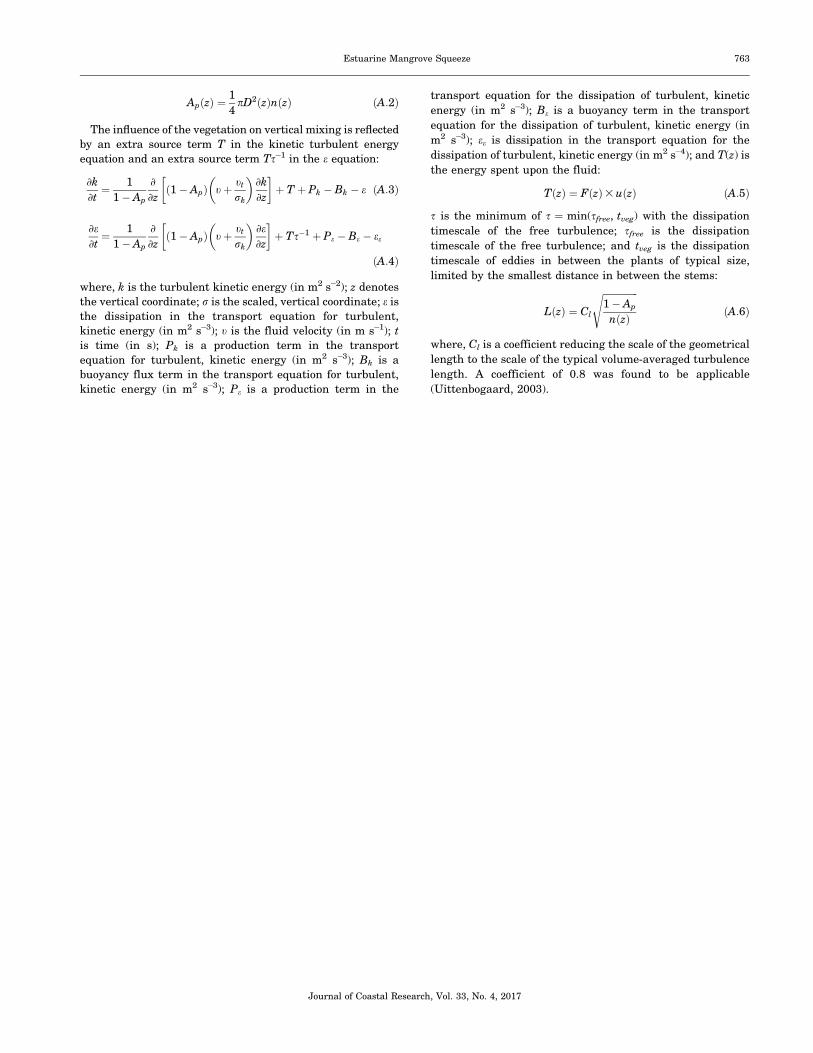
ApðzÞ ¼1
4pD2ðzÞnðzÞ ðA:2Þ
The influence of the vegetation on vertical mixing is reflected
by an extra source term T in the kinetic turbulent energy
equation and an extra source term Ts�1 in the e equation:
]k
]t¼ 1
1� Ap
]
]zð1� ApÞ tþ tt
rk
� �]k
]z
� �þ T þ Pk � Bk � e ðA:3Þ
]e]t¼ 1
1� Ap
]
]zð1� ApÞ tþ tt
rk
� �]e]z
� �þ Ts�1 þ Pe � Be � ee
ðA:4Þ
where, k is the turbulent kinetic energy (in m2 s�2); z denotes
the vertical coordinate; r is the scaled, vertical coordinate; e is
the dissipation in the transport equation for turbulent,
kinetic energy (in m2 s�3); t is the fluid velocity (in m s�1); t
is time (in s); Pk is a production term in the transport
equation for turbulent, kinetic energy (in m2 s�3); Bk is a
buoyancy flux term in the transport equation for turbulent,
kinetic energy (in m2 s�3); Pe is a production term in the
transport equation for the dissipation of turbulent, kinetic
energy (in m2 s�3); Be is a buoyancy term in the transport
equation for the dissipation of turbulent, kinetic energy (in
m2 s�3); ee is dissipation in the transport equation for the
dissipation of turbulent, kinetic energy (in m2 s�4); and T(z) is
the energy spent upon the fluid:
TðzÞ ¼ FðzÞ3 uðzÞ ðA:5Þ
s is the minimum of s ¼ min(sfree, tveg) with the dissipation
timescale of the free turbulence; sfree is the dissipation
timescale of the free turbulence; and tveg is the dissipation
timescale of eddies in between the plants of typical size,
limited by the smallest distance in between the stems:
LðzÞ ¼ Cl
ffiffiffiffiffiffiffiffiffiffiffiffiffiffiffi1� Ap
nðzÞ
sðA:6Þ
where, Cl is a coefficient reducing the scale of the geometrical
length to the scale of the typical volume-averaged turbulence
length. A coefficient of 0.8 was found to be applicable
(Uittenbogaard, 2003).
Journal of Coastal Research, Vol. 33, No. 4, 2017
Estuarine Mangrove Squeeze 763


