
Larimer Vision PlanNovember 2010

Real estate stRategies, inc.
This market-based land-use vision was developed by:Strada Architecture, LLC; Michael Stern, principal, Claudia Saladin, intern landscape architect Rachel Stadelmeier, graphic designer925 Liberty Avenue, Pittsburgh, PA 15232
In collaboration with:Real Estate Strategies; Meg Sowell, principalMichael Baker Corporation; Jerome Dettore, vice-presidentCTAC; Karen Brean, executive director & Marjorie Howard, Director of Community Initiatives
Project funding provided by:Community Design Center of PittsburghUrban Redevelopment Authority of PittsburghHousing Authority of the City of Pittsburgh Pittsburgh Partnership for Neighborhood Development

Table of Contents
Executive Summary 1.
Introduction 2.
The Land-Use Planning Process 3.
The Land-Use Vision 4. A. Physical Analysis B. Market Analysis Summary C. Plan Development Implications & Strategies
The Land-Use Vision Plan: Framework for Community Development 5. A. Neighborhood-wide Land-use Strategy B. Larimer Avenue Corridor Land-use Plan
The Sustainable Kit of Parts 6. A. Urban Sustainability Strategies B. LEED for Neighborhood Development C. Checkerboard Green and the Neighborhood Core D. New Buildings—Green Accessibility E. Park Edge Development F. Urban Farming and Community Wellness G. Green Infrastructure H. Deconstruction and Decommissioning
Implementation 7. A. Leadership B. Priorities and Development Phasing C. Housing Authority Property D. Next Steps for Implementing the Vision
Appendix: Market Analysis Report List of Interviews Historic MapsLEED Neighborhood Development Checklist
1
3
7
12122629
323234
363638394041424447
4848535154

Acknowledgements The Larimer Land Use Vision Plan grows out of decades of work by members of the community, in particular the work of East Liberty Concerned Citizens Corporation, led by Ms. Ora Lee Carroll.
This Plan was prepared for the Larimer Consensus Group, a diverse group of self-selected stakeholders convened by State Senator Jim Ferlo. It includes representatives from Representative Joseph Preston Jr.’s office, East Liberty Concerned Citizens Corporation of Larimer (ELCCC), the Kingsley Association, East Liberty Development, Inc., the business community, and faith organizations in Larimer, with the Urban Redevelopment Authority of Pittsburgh, The Housing Authority of the City of Pittsburgh, elected officials, Community Design Center of Pittsburgh and other public partners participating as well.
The work of the Larimer Consensus Group builds on the work and historic commitment of East Liberty Concerned Citizens Corporation over the last 27 years to achieve this planning and revitalization effort for the neighborhood and the work of the citizens of Larimer. Special thanks to the more than 100 community members and stakeholders who participated in the Community Design Workshop. The following people participated in the Larimer Consensus Group’s meetings and discussions relating to the development of this plan:
Ms. Thomasina Askew, Fairfield ApartmentsMr. Malik Bankston, Kingsley Association Ms. Doris Budd, CelebrateHon. Rev. Ricky Burgess, Pittsburgh City
CouncilMs. Katherine Camp, East Liberty
Development, Inc.Ms. Ora Lee Carroll, East Liberty Concerned
Citizens CorporationMr. Keith Clark, Omega Psi Phi FraternityMr. Roland Criswell, Coston’s Funeral HomeMs. Rebecca Davidson-Wagner, Urban
Redevelopment Authority of PittsburghMr. Brandon Davis, One Voice, Office
of Representative Joseph Preston Jr. Ms. Tishawn DentHon. Jim Ferlo, Pennsylvania SenateMr. Robert Germany, Faith communities rep.,
Green TeamMs. Judith K. Ginyard, East Liberty
Concerned Citizens CorporationMr. Steven Hawkins
Ms. Donna Jackson, Work & Wellness, Green Team
Ms. Deborah JonesMs. Sandra KnapperMs. Andrea Lavin Kossis, Community Design
Center of PittsburghMs. Shelly Martz, City PlanningMs. Deborah Miller, Redd Up, Green TeamMs. Maelene J. Myers, East Liberty
Development, Inc.Ms. Carolyn Peeks, Green TeamHon. Joseph Preston Jr., Pennsylvania House
of RepresentativesMr. Karriem Sami, Green Team, USED/
GETLarimerMr. Paul Svoboda, Office of Senator Jim
FerloMs. Quianna Wasler, Fairfield ApartmentsMr. David Weber, Housing Authority of the
City of PittsburghMr. Kevin B. Wells, Redd Up, Green TeamMr. Nathan Wildfire, East Liberty
Development, Inc.

A Vision for Larimer
LARIMER VISION PLAN • PAGE 1
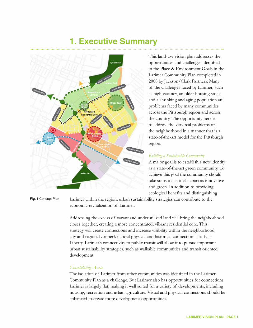
1. Executive SummaryThis land-use vision plan addresses the opportunities and challenges identified in the Place & Environment Goals in the Larimer Community Plan completed in 2008 by Jackson/Clark Partners. Many of the challenges faced by Larimer, such as high vacancy, an older housing stock and a shrinking and aging population are problems faced by many communities across the Pittsburgh region and across the country. The opportunity here is to address the very real problems of the neighborhood in a manner that is a state-of-the-art model for the Pittsburgh region.
Building a Sustainable CommunityA major goal is to establish a new identity as a state-of-the-art green community. To achieve this goal the community should take steps to set itself apart as innovative and green. In addition to providing ecological benefits and distinguishing
Larimer within the region, urban sustainability strategies can contribute to the economic revitalization of Larimer.
Addressing the excess of vacant and underutilized land will bring the neighborhood closer together, creating a more concentrated, vibrant residential core. This strategy will create connections and increase visibility within the neighborhood, city and region. Larimer’s natural physical and historical connection is to East Liberty. Larimer’s connectivity to public transit will allow it to pursue important urban sustainability strategies, such as walkable communities and transit oriented development.
Consolidating AssetsThe isolation of Larimer from other communities was identified in the Larimer Community Plan as a challenge. But Larimer also has opportunities for connections. Larimer is largely flat, making it well suited for a variety of developments, including housing, recreation and urban agriculture. Visual and physical connections should be enhanced to create more development opportunities.
Fig. 1 Concept Plan
Penn Avenue
Larimer Avenue
Negley Run Blvd.
Colli
ns A
venu
e
Lincoln AvenuePaulso
n Avenue
Meadow
Street
E. Liberty Blvd.
Frankstown Avenue
Hamilton Avenue
Highland Park
Larimer Park
Urban Farm
Recreational Complex
Village Green
Green Light Industrial
Neighborhood RetailBus
Station
Green
Stre
et
Mellon Park
Washington Blvd.

LARIMER VISION PLAN • PAGE 2
The excess of vacant land and structures creates an opportunity and a need to aggregate land in order to consolidate existing community assets and build new ones. However, to successfully revitalize, Larimer must retain its existing residents and we must respect their tenacity in the face of historic hardships. “A house for a house” is the motto of this plan, meaning no one should be forced to leave their homes and those who choose to leave a home, but stay in the neighborhood, should receive a home in return. By consolidating new residential development in the core of the community and on the edges of the new park, the plan strengthens and revitalizes a smaller, stronger neighborhood.
Turning Challenges into OpportunitiesA major component of this plan is to transition the parcels northwest of Larimer Avenue to parkland, with a major component of active recreation, that would form a new Larimer Park, connected to the rest of Pittsburgh’s park system by Highland Park and to Mellon Park via an enhanced East Liberty Boulevard.
Larimer Avenue will be defined in the future by the expanded Larimer Park with a recreational fields complex on the north side and a strong residential edge on the south side. This residential edge should include the acquisition and redevelopment of East Liberty Gardens, new residential development on the site of the current East Liberty Park ballfield and the better integration of the new residential development and Enright Court into the neighborhood street system.
The underutilized Hamilton and Frankstown Avenue light industrial corridor currently serves a range of light manufacturing, distribution, service and craft-related businesses, providing jobs and economic activity to Larimer. The goal here is for light industrial development – with a focus on new, green industries and jobs – to continue to occur in this area and over the long-term to move light industrial uses incompatible in other parts of the neighborhood to this area.

LARIMER VISION PLAN • PAGE 3
2. Introduction “A safe, clean, strong, diverse, vibrant, healthy & attractive community, with a renewed sense of pride that is a model for inner city revitalization.” Community Vision from the Larimer Community Plan (2008) Beginning in the fall of 2007, residents, business owners and community organizations in Larimer began the process of creating an updated Larimer Community Plan. That plan articulated the community vision. To achieve this vision, the community laid out goals around three main themes:
Place & Environment +Community & Organization +Human Needs +
One of the Place and Environment Goals was the preparation of “a detailed, equitable land-use plan for future housing, business development and green space allocation: fix what we can, tear down what we can’t, & identify best areas for growth.” Building on the work done in the Larimer Community Plan, this Larimer Vision Plan seeks to give physical form to the community’s vision.
A land use vision plan helps a community achieve its goals by providing a roadmap for future development. It lays out the types and locations of land uses the community wishes to pursue as well as helping the community establish priorities. Finally, a plan serves as a tool for accessing resources and for negotiating with other interests, such as government officials, developers and landowners.
A Land Use Vision Plan is:
A + long-range vision: an expression of the community’s vision for the future over 20 years
A + road map for future development What types of land-use do we want in the community? • Where should different land-uses occur? • Where do we start? •
A + tool For accessing resources • For negotiation (with the city, county, developers, landowners)•

LARIMER VISION PLAN • PAGE 4
This land-use vision plan addresses the opportunities and challenges identified by the community in the Larimer Community Plan. Many of the challenges and constraints faced by Larimer, such as high vacancy, an older housing stock and a shrinking and aging population are problems faced by many communities across the Pittsburgh region and across the country. Pittsburgh, like many former industrial cities, has seen a dramatic decline in population since the 1950s. Larimer cannot overcome all of these problems on its own, but what Larimer can do is find new, innovative and sustainable ways of addressing those challenges, turning them into opportunities and consolidating assets.
0
200,000
400,000
600,000
800,000
1,000,000
914,808
676,806
580,132
503,998
168,330
478,403
334,563292,648
331,285
82,026Cleveland Pittsburgh Buffalo Cincinnati Youngstown
1950 2000
Fig. 2Shrinking Population: a Regional Challenge
1950
2000

LARIMER VISION PLAN • PAGE 5
Challenges/Constraints identified in the Larimer Community Plan:
High vacancy +(regional problem)
Older housing stock +(regional problem)
Poor image: +History of crime • Lack of “curb appeal” – many • buildings, roads and sidewalks in poor repair
Physical isolation and poor visibility +(no one knows Larimer is there)
Shrinking population +(regional problem)
Assets/Opportunities identified in the Larimer Community Plan:
Proximity to East End development +
Flat, developable land +
Proximity to major transportation +corridors and hubs
Committed political partners +(city, county, state)
Vacancy is also an opportunity +to rethink land use in the neighborhood

LARIMER VISION PLAN • PAGE 6
The Study AreaThe study area includes both the defined neighborhood of Larimer, as well as the section of East Liberty along Larimer Avenue between East Liberty Boulevard, Collins Avenue and Broad Street. This reflects the understanding—from the outset—by the community of the importance of Larimer Avenue as the principal connection to the center of East Liberty.
This definition of the study area reflects the acknowledgement of the historic connection of Larimer to the heart of
East Liberty, which is defined by topography as much as anything else. The steep slopes along both sides of Negley Run and Washington Boulevard have always served to separate the heart of the Larimer neighborhood from Highland Park and Lincoln-Lemington and foster the historic connections to East Liberty. The historic prominence of Larimer Avenue as the primary connection to the East Liberty business district was increased by the urban renewal moves that severed most other connections between the two.
All of this—in combination with the surrounding redevelopment initiatives at the Kingsley Center, Fairfield apartments and Target—has served to place increased importance on the Larimer Avenue corridor. Unfortunately, this has become, as will be documented in this report, one of the areas of greatest vacancy, disinvestment and blight, particularly on the Larimer side of East Liberty Boulevard.
In order to develop a specific land-use vision for the Larimer Avenue corridor it was first necessary to understand the market-based opportunities within the area, as well as how Larimer Avenue’s revitalization will fit into a larger neighborhood context. Thus, there were two principal charges for this planning effort:
This Vision Plan has the overall goal of establishing a market-based land use 1. vision for the entire study area of Larimer and East Liberty and,To develop a more detailed land-use plan focused on the Larimer Avenue 2. corridor between Broad Street and the Larimer Avenue Bridge.
Fig. 3The Study Area

LARIMER VISION PLAN • PAGE 7
3. The Land-Use Planning Process This vision plan is a continuation of several planning efforts in both Larimer and East Liberty over the last 10 years that have reflected the dedication and efforts of many community activists. Specifically, these efforts have been guided by The Larimer Community Plan (1998) and A Vision for East Liberty (1999).
The Community Builders and Steven G. Hawkins/Architects completed the first professional, neighborhood-wide plan and study for Larimer in 1998 for East Liberty Concerned Citizens Corporation. It served for many years as the neighborhood’s official planning document. Addenda to the Larimer Community Plan followed, including “Building a Healthy Future For Larimer” (ELCCC, 2001); “The Larimer Community Plan Update- Community Analysis and Mapping” (ELCCC, with the assistance of East End Neighborhood Forum and consultant Tika Gurung, 2002); and the “Winslow Street Master Plan,” a plan for new housing adjacent to the Larimer School (prepared for ELCCC by Steven G. Hawkins/Architects, JAXON Development, and Karen Brean Associates, 2003). In 2005, the
Federal Home Loan Bank of Pittsburgh designated Larimer as a “Blueprint Community,” enabling a community team to receive training and guidance in doing development projects.
The next update to the Larimer Community Plan began in the fall, 2007. Led by ELCCC, the 11-month process was supported by ELCCC, the Kingsley Association and State Senator Jim Ferlo, and it was facilitated by Jackson/Clark Partners. This work (completed in 2008) updated the “state of the neighborhood,” widened participation in the neighborhood planning process, restated and created a vision and goals, and established strategies for implementation, including the five Action Teams. During this work, the Larimer Consensus Group was formed as an entity representing the various neighborhood stakeholders, with the intention of its being the implementing group of Larimer’s rebirth.
Fig. 4January 7th 2010 LCG Meeting
Fig. 5February 4th 2010 Community Meeting
Images courtesy ofLarry Rippel Photography
LARIMER VISION PLAN • PAGE 8
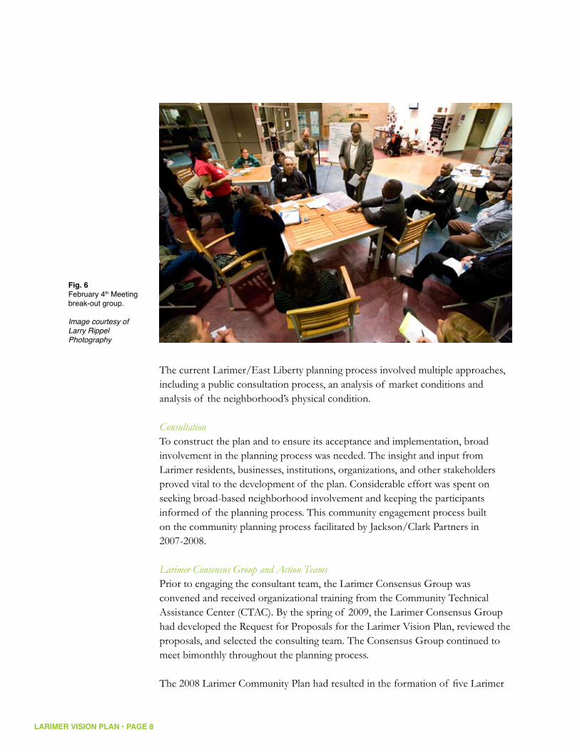
The current Larimer/East Liberty planning process involved multiple approaches, including a public consultation process, an analysis of market conditions and analysis of the neighborhood’s physical condition.
ConsultationTo construct the plan and to ensure its acceptance and implementation, broad involvement in the planning process was needed. The insight and input from Larimer residents, businesses, institutions, organizations, and other stakeholders proved vital to the development of the plan. Considerable effort was spent on seeking broad-based neighborhood involvement and keeping the participants informed of the planning process. This community engagement process built on the community planning process facilitated by Jackson/Clark Partners in 2007-2008.
Larimer Consensus Group and Action TeamsPrior to engaging the consultant team, the Larimer Consensus Group was convened and received organizational training from the Community Technical Assistance Center (CTAC). By the spring of 2009, the Larimer Consensus Group had developed the Request for Proposals for the Larimer Vision Plan, reviewed the proposals, and selected the consulting team. The Consensus Group continued to meet bimonthly throughout the planning process.
The 2008 Larimer Community Plan had resulted in the formation of five Larimer
Fig. 6February 4th Meetingbreak-out group.
Image courtesy ofLarry Rippel Photography

LARIMER VISION PLAN • PAGE 9
community action teams: One Voice; Redd Up; Green Up; Celebrate; and Work and Wellness. At the outset of the Vision Plan process, it became apparent that the Green Up action team was especially active and involved. During the Vision process, the Strada team provided opportunities for the Larimer Consensus Group to invigorate and repopulate the other action teams. Larimer Action Teams:
Redd-Up + – clean up & fix upGreen-Up + – greening & beautificationWork and Wellness + – healthy prosperous residents, families & community One Voice + – unity, partnerships, clarity, awareness & communicationCelebrate + – pride in Larimer, community building events
Interviews with Stakeholders and ExpertsRecognizing that considerable planning work had been undertaken prior to the launching of the Vision Plan, the Strada team reviewed existing planning
documents to ensure that prior and on-going planning issues and initiatives would inform current thinking. The Strada team also reviewed the results of the interviews with neighborhood and other stakeholders conducted during the 2007-2008 community planning process. This analysis was presented to the Consensus Group for review and discussion. The Strada team rounded out the information by interviewing additional key stakeholders, including public agency representatives, realtors, developers, institutions, and business owners.
Community MeetingsTwo community-wide meetings were convened during the planning process. Larimer residents, business owners, institutional representatives, and other stakeholders were invited to these facilitated discussions. The first community meeting was convened on October 22, 2009. Participants heard a presentation on an analysis of existing
Fig. 7 & 8February 4th Meeting, the children present their ideas and drawings for the neighborhood’s future.
Images courtesy ofLarry Rippel Photography

LARIMER VISION PLAN • PAGE 10
conditions, a summary of the market analysis and a discussion of what it means to be a sustainable community.
The second meeting, the community design workshop, was convened on February 4, 2010. Participants heard a presentation of the Vision Plan and then broke up into small groups to discuss their reactions to the Vision Plan. While the adults participated in the community design workshop, a children’s town hall meeting was convened on site. Through drawing maps of their neighborhood, children were asked to explore their visions for Larimer. They were asked a series of questions to help them develop the maps, such as identifying their special and favorite places. They presented their maps and ideas to the adults at the end of the community design workshop.
Throughout the vision planning, the Strada team continued to provide opportunities to build the capacity of the Consensus Group and to encourage residents and stakeholders to work with the Consensus Group. The Strada team reviewed the community meeting agendas and presentations with the Consensus Group prior to the meetings. The Consensus Group convened the community meetings and took ownership of them, from introducing the evening’s events, to co-facilitating discussion groups and outlining the next steps for the community in implementing the Vision Plan.
Fig. 9February 4th Meetingbreak-out group reports back to the meeting.
Image courtesy ofLarry Rippel Photography

LARIMER VISION PLAN • PAGE 11
Fig. 10Participants map:Although the majority of the participants in the public process came from the study area, the project attracted input from throughout the city.

LARIMER VISION PLAN • PAGE 12
4. Land-Use Vision
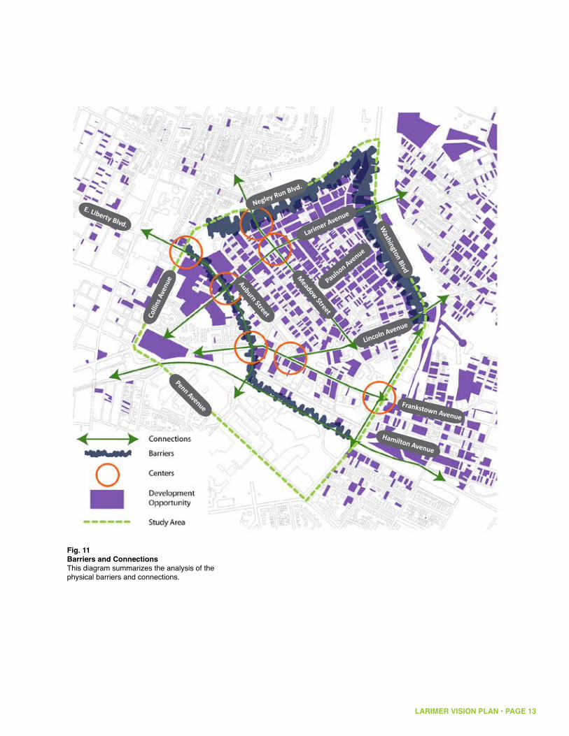
A. Physical AnalysisLand Use AnalysisThe isolation of Larimer from other communities was identified in the Community Plan as a challenge. While it is true that the neighborhood is physically cut off from the north by Negley Run Boulevard and from the east by Washington Boulevard, Larimer also has opportunities for connections.
Larimer is largely flat, making it well suited for a variety of developments, including accessible housing, recreation and urban agriculture. The natural landform provides for great connectivity between Larimer and East Liberty, while the steep slopes to the north (Negley Run Boulevard) and east (Washington Boulevard) contribute to Larimer’s isolation (see figures 13 & 14). Historically, the Larimer neighborhood had many more street connections to East Liberty, but the building of East Liberty Boulevard and Penn Circle severed many of those historic street connections, further contributing to the isolation of Larimer (see figure 12). This puts that much more importance on the redevelopment of Larimer Avenue and East Liberty Boulevard as the key connections to the growth center of East Liberty.
Larimer is also well situated with respect to public transit (see figure 15). The entire study area is within one mile of the East Liberty Busway Station. The neighborhood is also relatively well served by bus routes. Larimer’s connectivity to public transit allows it to pursue important urban sustainability strategies, such as walkable communities and transit oriented development. The proximity of Larimer to the Busway can attract households because of the ease of travel to downtown and other employment centers, thus helping to create a market for housing in the neighborhood (this is discussed in more detail in the market analysis section).
Because of Larimer’s physical location, it is unlikely that many people pass through the residential core of Larimer on the way to other destinations, which contributes to the neighborhood’s lack of visibility. In order to enhance the visibility of Larimer, the community needs to create a presence for Larimer in the city and region and enhance its visibility at key points, especially along East Liberty Boulevard, and create destinations within the neighborhood that will give people from outside Larimer a reason to visit and invest in Larimer (see figure 11).
The maps on the following pages highlight some of the existing physical characteristics of the neighborhood.
LARIMER VISION PLAN • PAGE 13
Penn Avenue
Larimer Avenue
Negley Run Blvd.
Colli
ns A
venu
e
Lincoln Avenue
Meadow Street
Washington Blvd
Auburn Street
E. Liberty Blvd.
Paulson Avenue
Frankstown Avenue
Hamilton Avenue
Fig. 11Barriers and ConnectionsThis diagram summarizes the analysis of the physical barriers and connections.

LARIMER VISION PLAN • PAGE 14
historic streets, no longer existing
historic steps
current streets
Penn Avenue
Larimer Avenue
Negley Run Blvd.Co
llins
Ave
nue
Lincoln Avenue
Meadow Street
Auburn Street
E. Liberty Blvd.
Frankstown Avenue
Hamilton Avenue
Fig. 12Historic ConnectionsThis map shows the current street grid of Larimer in black. In red are historic streets, based on maps from 1939, showing the historically greater connection between Larimer and East Liberty. One goal of the plan is to re-establish a more integrated street grid in key places.
Washington Blvd
Paulson Avenue
LARIMER VISION PLAN • PAGE 15
Penn Avenue
Larimer Avenue
Negley Run Blvd.Co
llins
Ave
nue
Lincoln Avenue
Meadow Street
Auburn Street
E. Liberty Blvd.
Frankstown Avenue
Hamilton Avenue
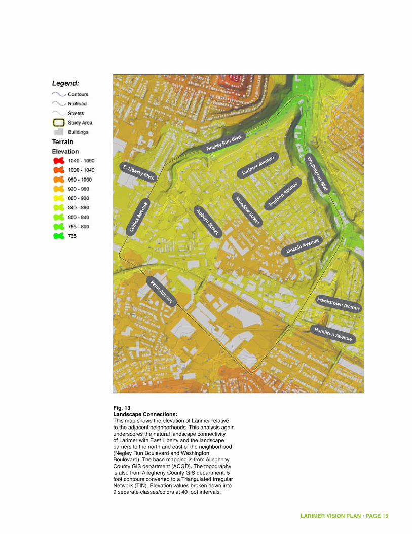
Fig. 13Landscape Connections:This map shows the elevation of Larimer relative to the adjacent neighborhoods. This analysis again underscores the natural landscape connectivity of Larimer with East Liberty and the landscape barriers to the north and east of the neighborhood (Negley Run Boulevard and Washington Boulevard). The base mapping is from Allegheny County GIS department (ACGD). The topography is also from Allegheny County GIS department. 5 foot contours converted to a Triangulated Irregular Network (TIN). Elevation values broken down into 9 separate classes/colors at 40 foot intervals.
Washington Blvd
Paulson Avenue
LARIMER VISION PLAN • PAGE 16
830
825
820
810
890
875
895
925
880
835
885
815
930
855
915
870
845
900865
840
850
860
945
920
905
910
975
980
965
970
790
955
795805
960
995
800
950
940
935
785
1000
1005
985990
1015
1035
1020
1030
1040
1025
1060
1010
1045
1050
780
1080
1070
1055
1065
1075
1085
910
905
1070
925
1085
935
920
1035
925
965
925
915
925
970
965
945
920
895
845
920
890
1050
945
1035
920
935
1050
1025
1060
925
1005
980
885
930
880
915
905
935
1015
930
960
940
950
835
910
905
925
940
1020
920
900
945
930
915
930
920
915
910
960
930
905
1045
905
915
945
900
910
1040
895
925
910
900
900
920
910
940
930
940
920
960
915
920
945
1005
910
1040
900
940
955
910
940
950
930
995
910
950
920
965
1020
900
950
970
905
970
885
890
980
935925
915
910
885
930
985
920
915
930
915
925
965
905
1025
965
905
985
895
895
910
930
890
910
910
930
915
905
1065
975
925
910
930
990
995 995
935
895
890
930
920
905
910
910
980
890
910
975
960
920
925
945
975
935
1040
890
910
960
905
925
945
940
920
950
970
955
910
885
925
1080
1010
970
980
1025
910
985
940
905
925
960
915
920
955
950
910
920
930
920
995
945
955
975
940
975
920
905
910
925
930
925
940
1000
925
910
1035
930
905
935
1000
1030
910
925
1075
875
920
1015
920
915
920
930
925
920
900
985
925
910
925
935
925
930
910
1050
955
905
1055
905
990
915
980
965
935
915
930
890
1005
930
985
990
930
945
965
925
925
920
905
890
945
920
925
925
915
945
910
910
940
930
915
910
945
920
995
925
940
1030
Penn
Fifth
High
land
East Busway
Stanton
Hamilton
Lang
Larimer
Negle
y
Beatt
y
Broad
Eucli
d
East Liberty
Walnut
Washington
Hays
Howe
Shady
Negley Run
Frankstown
Carver
Sheri
dan
Shetland
St C
lair
Lowell
Deary
Dalla
s
Saxon
Dean
Jackson
Alder
Ellsworth
Collin
s
Lenora
Emer
son
Baum
College
Polk
Winslow
Mayflower
Rowan
Mello
n
Dix
Felix
Meadow
Apple
Lehig
h
Murtla
nd
Elwood
Spah
r
Lyric
St Marie
Clifford
Thomas
Lamo
nt
Dodge
Fleury
Victor
Xenia
Odessa
Black
Kentucky
Arbor
Olivant
Mc Pherson
Livery
Linde
n
Indiana
Turrett
Rippey
Lincoln
Whit
field
Harvard
Rural
Montez
uma
Forest
Allemannia
Rapidan
Formosa
Ryoli
te
Paulson
Kelly
Finley
Aurelia
Winfield
June
Kirkwood
Gree
nbria
r
Ashley
Maryland
Simonton
Renfrew
Carro
n
Pointview
Lynn
Elmer
Inwoo
d
Denniston
Tennis
Hebe
rton
Penn
Circ
le W
est
Gerrit
t
Tripod
Upland
Felicia
Violin
Album
Sharp
Bower
Marchand
Centre
Mt Vernon
Chaucer
Maxwell
Orph
an
Swop
e
Columbo
Idlewild
Regis
Stoebner
Transit
Penn Circle South
Bennett
Penn Circle North
Swee
ney
Fielding
Holden
Tay
Ansley
Farra
gut
Yard
ley
Fletcher
Monticello
Hermitage
Tenner
Relic
Laxto
n
Bellman
Yarmouth
Atwell
Auto
Sama
ntha
Nadir
Mathews
Auburn
Kedron
Samoan
Carmine
Juliu
s
Dunmore
Mc C
ombs
Ladson
Commerce
Glenview
Starling
Rosary
Dahlem
Portla
nd
Thisb
e
Vanilla
Hedge
Larimer Ave
Claws
on
Mane
tto
Tyler
Bosey
Conover
Chislett
Zodia
c
Dent
Eva
Social
Emans
Armstrong
Navarro
Kaufman
Roane
Park Lane
Silver Lake
Torre
ns
Nelson
La S
chall
Eider
Sellers
Brainard
Selm
a
Britli
ff
Eucla
ir
Roml
ey
Home
wood
Houston
Spin
Beec
her
Amity
Supre
me
Zenit
h
Putna
m
Grapevi
ne
Lincoln Ave
Whittier
Trade
Pace
Penn
Circ
le Ea
st
Borla
nd
Akron
Etud
e
Chinn
Baywood
Susquehanna
Hauser
Renn
ig
Flavel
Tangent
Enright
Thompson
Missouri
Stratton
Joseph
Pierce
Margaretta
Mc Donald
Hyatt
Tamello
Elysian
Reimer
Ogleb
y
Macru
m
Moga
Freeman
Hastings
Robley
Sentinel
Snively
Vernoun
Topaz
Enter
prise
Weldin
Callery
Antler
Orange
Omega
Hooker
Frazee
Shuttle
Puritan
Dick
Aldino
Rodman
Melm
ore
Friendship
Janero
Lamb
Braden
Farlson
Nove
lty
Owasso
Beggs
Llewellyn
Belmar
Evers
Stam
air
Beckett
Casa
nova
Station
Sinnet
Huntress
Orse
nius
Roslyn
Meade
Well
esley
Gordo
n
Conti
nenta
l
Lemington
Mc C
une
Annan
Unna
med1
24M1
73EJ
Ambe
r
Television Hill
Beechwood
Arab
ia
Unnamed84P
Woof
Hailm
an
Easton
Oldsmar
Meadow Street
Sago
Reo
Unnamed124M
Cassina
Race
Tioga
Warpole
Mignonette
Point B
reeze
Festi
val
Summerlea
Unnamed124H
Shakespeare
Unnam
ed12
4S
Unnam
ed12
4CG
Olivant
Borla
nd
Snively
Lincoln
Murtla
nd
Denniston
Larim
er
Houston
Susquehanna
Montezuma
Alder
Rippey
Idlewild
Arbor
Tay
Mane
tto
Carro
n
Joseph
Susquehanna
Saxon
Rippey
Tenner
Sheri
dan
Unnamed124H
Meadow
Auburn
Montezuma
Sheri
dan
Baum
Euclid
Fielding
Formosa
St C
lair
Social
Meadow
Apple
Melm
ore
Missouri
Black
Braden
Paulson
Olivant
Beatty
Eva
Broad
Tyler
Unnamed124M173EJ
St C
lair
Lang
Arbor
Indiana
Commerce
Beatt
y
Legend:Contours
Railroad
Streets
Buildings
Study Area
TerrainSlope
Flat
0.1 - 7.9%
8% - 14.9%
15% - 24.9%
> 25%
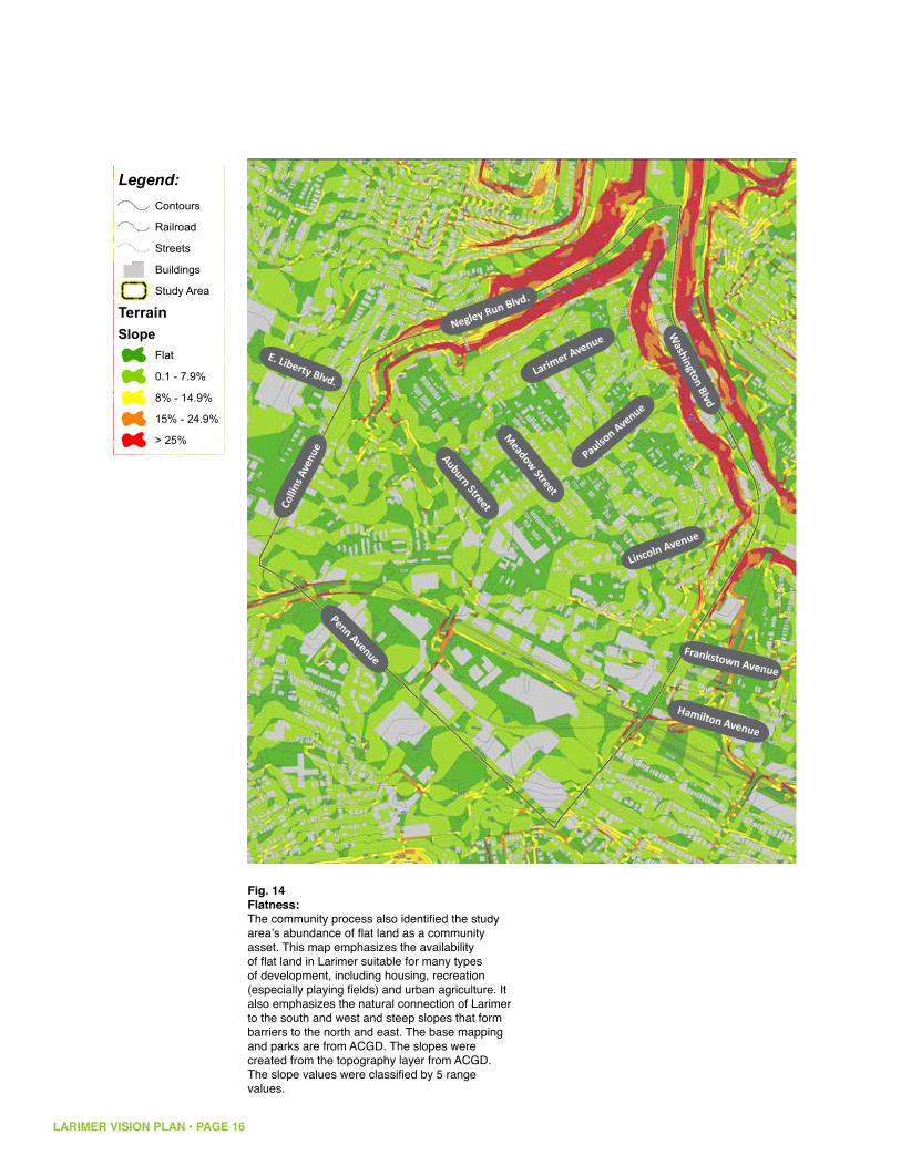
Fig. 14Flatness:The community process also identified the study area’s abundance of flat land as a community asset. This map emphasizes the availability of flat land in Larimer suitable for many types of development, including housing, recreation (especially playing fields) and urban agriculture. It also emphasizes the natural connection of Larimer to the south and west and steep slopes that form barriers to the north and east. The base mapping and parks are from ACGD. The slopes were created from the topography layer from ACGD. The slope values were classified by 5 range values.
Penn Avenue
Larimer Avenue
Negley Run Blvd.Co
llins
Ave
nue
Lincoln Avenue
Meadow Street
Auburn Street
E. Liberty Blvd.
Frankstown Avenue
Hamilton Avenue
Washington Blvd
Paulson Avenue
LARIMER VISION PLAN • PAGE 17
D17|
A47|
A49|
B68|A68|
C49|
C49|A47|
NVA|VA|A87|
C17|
A46|
BD|D
|NVA
|VA|
A39|
A87|
A98|
A98|C1
7|
B49|C49|
B18|A46|
E87|B77|
E87|B77|A77|
A49|D77|
A77|A98|B68|A68|
005|B47|
A47|C17|
D77|B47|A47|
B49|
A98|
C49|
A98|
W|T|GP|P|PL|PH|CG|G|SBE|BD|D|NVA|VA|A39|B38|E87|A87|U77|J86|G86|F86|D86|B86|A86|B36|A36|
A98|D17|
PL|B38|B18|
C87|C77|
B49|G77|F77|D77|A17|
E87|B77|A77|D17|
B18|C17|
D|A49|C17|
B18|
C49|A39|A98|
D|005|A49|A39|B47|A47|B49|B68|A68|B77|A77|
NVA|VA|A39|A87|
005|
B47|
A47|
D17|A46|
B18|A77|
D|005|A39|D77|
C87|C77|C17|
005|C49|B47|A47|C17|
005|A49|A98|B47|A46|
B18|A77|A46|
D|005|C49|A49|A98|B47|A47|
BD|
NVA|VA|A39|
A87|
C49|
A49|
A98|
C87|
C77|
005|B47|
A47|C17|
A46|
BD|D|NVA|VA|A39|A98|A87|D17|
BD|D|NVA|VA|A39|A98|A87|
PL|B49|C4
9|A49|
A98|B68|
A68|B3
8|B1
8|E87|
C87|C77|
B77|A7
7|C17|
D|NVA|VA|A49|A39|A87|C17|
D|NVA|VA|A39|A87|C17|B49|C49|A49|A98|B68|A68|B18|B77|A77|
PL|A98|B68|A68|B38|B18|
B49|A98|G77|F77|D77|A17|
PL|
D|NV
A|VA
|A3
9|B3
8|E8
7|
PL|B49|C49|A49|A98|B68|A68|B38|B18|E87|B77|A77|
B49|B68|A68|B18|B77|A77|A46|
PL|
B49|
C49|
A49|
A98|
B68|
A68|
B38|
B18|
005|C49|B47|A47|C17|A46|
PL|B38|B18|A47|
D17|
B49|G77|F77|D77|A17|
A46|
C17|
A47|
A98|
E87|B77|A77|
A47|
C49|
A47|
PL|B38|B18|
C87|C77|
nneP
htfiF
dnalhgiH
yawsuB tsaE
notnatS
notlimaH
gnaL
remiraL
yelgeN
yttaeB
daorB
dilcuE
ytrebi
L tsa
E
tunlaW
notgni
hsaW
syaH
ewoH
ydah
S
nuR yelgeN
nwotsknarF
revra
C
nadirehS
dnalte
hS
rialC tS
llewoL
yraeD
sallaD
noxaS
naeD
noskcaJ
redlA
htrowsllE
snilloC
aroneL
nosremE
muaB
egell
oC
kloP
wolsni
W
rewolf
yaM
nawoR
nolleM
xiD
xileF
woda
eM
elppA
hgiheL
dnaltruM
doowlE
rhapS
ciryL
eiraM tS
droffilC
samohT
tnomaL
egdo
D
yruelF
rotciV
aineX
assedO
kcalB
ykcutneK
robrA
tnavi
lO
nosrehP cM
yreviL
nedniL
anaidnI
tterruT
yeppiR
nlocniL
dleiftihW
dravraH
laruR
amuzetnoM
tseroF
ainnamellA
nadip
aR
asomroF
etiloyR
nosluaP
ylleK
yelniF
aileruA
dleifniW
enuJ
doowkriK
rairbneerG
yelhsA
dnaly
raM
notnomiS
werfn
eR
norraCweivtnioP
nnyL
remlE
doownI
notsin
neD
sinneT
notrebeH
tseW elcriC nneP
ttirreG
dopirT
dnalpU
aicileF
niloiV
mublA
prahS
rewoB
dnahcraM
ertneC
nonreV tM
recuahC
llewxa
M
nahprO
epowS
obmuloC
dliweldI
sigeR
renb
eotS
tisnarT
htuoS elcriC nneP
ttenneB
htroN elcriC nneP
yeneewS
gnidleiF
nedloH
yaT
yelsnA
tugarraF
yeldraY
rehctelFollecitnoM
egatimreH
renneT
cileR
notxaL
namlleB
htuomraY
llewtA
otuA
ahtnamaS
ridaN
swehtaM
nrubu
A
nordeK
naomaS
enimraC
suiluJ
eromn
uD
sbmoC cM
nosd
aL
ecremmoC
weivnelG
gnilratS
yras
oR
melha
D
dnaltroP
ebsihT
allinaV
egdeH
evA remiraL
noswalC
ottenaM
relyT
yesoB
revonoC
ttels
ihC
caidoZ
tneD
avE
laicoS
snamE
gnort
smrA
orrav
aN
namfuaK
enaoR
enaL kraP
ekaL re
vliS
snerroT
nosleN
llahcS aL
rediE
srelleS
draniarB
amleS
ffiltirB
rialcuE
yelmoR
doowemoH
notsuoH
nipS
rehceeB
ytimA
emerpuS
htineZ
mantuP
eniveparG
evA nlocniL
reittihW
edarT
ecaP
tsaE elcriC nneP
dnalroB
norkA
edutE
nnihC
doowyaB
annaheuqsuS
resuaH
ginneR
leval
F
tnegnaT
thgirnE
nospmohT
iruossiM
nottar
tS
hpeso
J
ecreiP
atteragraM
dlanoD cM
ttayH
ollemaT
naisyl
E
remieR
ybelgO
murcaM
agoM
nameerF
sgnit
saH
yelboR
lenitneS
ylevinS
nuonreV
zapoT
esirpretnE
nidleW
yrellaC
reltnA
egnar
O
agemO
reko
oH
eezarF
elttuhSnat
iruP
kciD
onidlA
namdoR
eromleM
pihsdneirF
orenaJ
bmaL
nedarB
noslraF
ytlevoN
ossawO
sggeB
nyllewel
L
ramleB
srevE
riamatS
ttekceB
avonasaC
noitatS
tenni
S
ssertnuH
suinesrO
nylsoR
edaeM
yelselleW
nodroG
latnenitnoC
notgni
meL
enuC cM
nannA
JE371M421demannU
rebmA
lliH n
oisivel
eT
doow
hcee
B
aibarA
P48d
eman
nU
fooW
namliaH
notsaE
rams
dlO
teert
S wo
daeM
ogaS
oeR
M421demannU
anissaC
demannU
ecaR
agoiT
elopra
W
ettenongiM
ezeerB tnioP
lavitseF
aelre
mmuS
H421demannU
S421demannU
noxaS
JE371M421demannU
yttaeB
renneT
dliweldI
robrA
tnavilO
nadirehS
yttae
B
nrubu
A
daorB
yaT
ottenaM
gnidleiF
rialC tS
tnavilO
rialC tS
yeppiR
ecremmoC
dnalroB
muaB
iruossiM
norraC
H421
dema
nnU
avE
annaheuqsuS
notsinneD
notsuoH
hpes
oJ
remiraL
nlocniL
nedarB
ylevinS
dnaltruM
kcalB
eromleM
anaidnI
redlA
relyT
elppA
woda
eM
gnaL
asomroF
laicoS
yeppiR
amuzetnoM
annaheuqsuS
dilcu
E
nadirehS
woda
eM
robrA
nosluaP
amuzetnoM
Mellon Park
Highland Park
Westinghouse Park
Paulson Playground
Garland Parklet
Enright Parklet
Homewood Playground
Larimer Playground
Dallas Parklet
Upland Lot
Rogers School Parklet
Legend:PAT Bus Stops
Streets
Railroad
Trails
Bike Existing
Bike Proposed
PAT Bus Routes
Study Area
Buildings
Park
East Liberty Bus Station
1/4 Mile
1/2 Mile
1 Mile
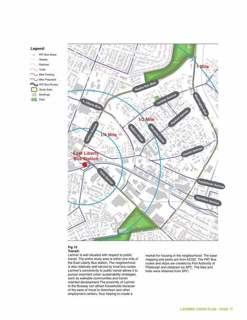
Fig 15Transit:Larimer is well situated with respect to public transit. The entire study area is within one mile of the East Liberty Bus station. The neighborhood is also relatively well served by local bus routes. Larimer’s connectivity to public transit allows it to pursue important urban sustainability strategies, such as walkable communities and transit oriented development.The proximity of Larimer to the Busway can attract households because of the ease of travel to downtown and other employment centers, thus helping to create a
market for housing in the neighborhood. The base mapping and parks are from ACGD. The PAT Bus routes and stops are created by Port Authority of Pittsburgh and obtained via SPC. The bike and trails were obtained from SPC.
Penn Avenue
Larimer Avenue
Negley Run Blvd.Co
llins
Ave
nue
Lincoln Avenue
Meadow Street
Auburn StreetE. Liberty Blvd.
Frankstown Avenue
Hamilton Avenue
Washington Blvd
Paulson Avenue

LARIMER VISION PLAN • PAGE 18
Housing Stock, Vacancy and Ownership
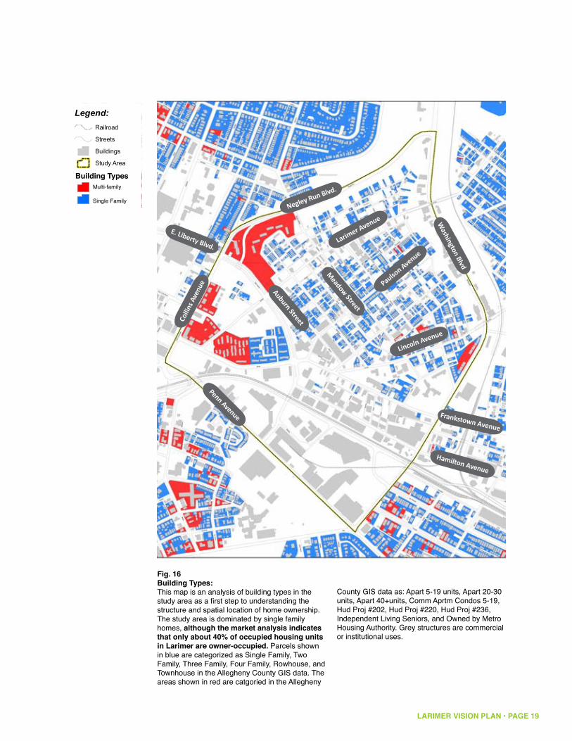
The study area and particularly the Larimer neighborhood are dominated by single family homes (see figure 16), although the market analysis indicates that only 40% of occupied housing units in Larimer are owner occupied. Larimer is also characterized by a large level of public ownership of land (see figure 17). In some cases this is land owned by government agencies, such as the Housing Authority, the Port Authority, and the Postal Service, but in many cases it is land owned by the city or the Urban Redevelopment Authority as a consequence of vacancy. There are also a significant number of tax delinquent properties, which could come into public ownership.
The neighborhood also has many structures in deteriorating condition (see figure 19). In some cases these deteriorating properties may be vacant (see figure 18). Vacancy and deteriorating building condition were two areas raised by the community as concerns. The Larimer Community Plan also identified vacancy as a potential opportunity to rethink land uses within the neighborhood. The project team mapped building condition (see figure 19), and vacant parcels and structures (see figure 18). This data was combined into a map of total development opportunity (see figure 20). The total development opportunity map indicated the scale and location of property potential for redevelopment. This map also indicated that Larimer needs to find large scale land uses. Given the quantity of unoccupied land, this analysis indicates that the area needed for residential use is smaller than in the past and is likely to remain so for some time to come.
LARIMER VISION PLAN • PAGE 19
Penn
Fifth
High
land
East Busway
Stanton
Hamilton
Lang
Larimer
Negle
y
Beatt
y
Broad
Eucli
d
East Liberty
Walnut
Washington
Hays
Howe
Shady
Negley Run
Frankstown
Carver
Sheri
dan
Shetland
St C
lair
Lowell
Deary
Dalla
s
Saxon
Dean
Jackson
Alder
Ellsworth
Collin
s
Lenora
Emer
son
Baum
College
Polk
Winslow
Mayflower
Rowan
Mello
n
Dix
Felix
Meadow
Apple
Lehig
h
Murtla
nd
Elwood
Spah
r
Lyric
St Marie
Clifford
Thomas
Lamo
nt
Dodge
Fleury
Victor
Xenia
Odessa
Black
Kentucky
Arbor
Olivant
Mc Pherson
Livery
Linde
n
Indiana
Turrett
Rippey
Lincoln
Whit
field
Harvard
Rural
Montez
uma
Forest
Allemannia
Rapidan
Formosa
Ryoli
te
Paulson
Kelly
Finley
Aurelia
Winfield
June
Kirkwood
Gree
nbria
r
Ashley
Maryland
Simonton
Renfrew
Carro
n
Pointview
Lynn
Elmer
Inwoo
d
Denniston
Tennis
Hebe
rton
Penn
Circ
le W
est
Gerrit
t
Tripod
Upland
Felicia
Violin
Album
Sharp
Bower
Marchand
Centre
Mt Vernon
Chaucer
Maxwell
Orph
an
Swop
e
Columbo
Idlewild
Regis
Stoebner
Transit
Penn Circle South
Bennett
Penn Circle North
Swee
ney
Fielding
Holden
Tay
Ansley
Farra
gut
Yard
ley
FletcherMonticello
Hermitage
Tenner
Relic
Laxto
n
Bellman
Yarmouth
Atwell
Auto
Sama
ntha
Nadir
Mathews
Auburn
Kedron
Samoan
Carmine
Juliu
s
Dunmore
Mc C
ombs
Ladson
Commerce
Glenview
Starling
Rosary
Dahlem
Portla
nd
Thisb
e
Vanilla
Hedge
Larimer Ave
Claws
on
Mane
tto
Tyler
Bosey
Conover
Chislett
Zodia
c
Dent
Eva
Social
Emans
Armstrong
Navarro
Kaufman
Roane
Park Lane
Silver Lake
Torre
ns
Nelson
La S
chall
Eider
Sellers
Brainard
Selm
a
Britli
ff
Eucla
ir
Roml
ey
Home
wood
Houston
Spin
Beec
her
Amity
Supre
me
Zenit
h
Putna
m
Grapevi
ne
Lincoln Ave
Whittier
Trade
Pace
Penn
Circ
le Ea
st
Borla
nd
Akron
Etud
e
Chinn
Baywood
Susquehanna
Hauser
Renn
ig
Flavel
Tangent
Enright
Thompson
Missouri
Stratton
Joseph
Pierce
Margaretta
Mc Donald
Hyatt
Tamello
Elysian
Reimer
Ogleb
y
Macru
m
Moga
Freeman
Hastings
Robley
Sentinel
Snively
Vernoun
Topaz
Enter
prise
Weldin
Callery
Antler
Orange
Omega
Hooker
Frazee
Shuttle
Puritan
Dick
Aldino
Rodman
Melm
ore
Friendship
Janero
Lamb
Braden
Farlson
Nove
lty
Owasso
Beggs
Llewellyn
Belmar
Evers
Stam
air
Beckett
Casa
nova
Station
Sinnet
Huntress
Orse
nius
Roslyn
Meade
Well
esley
Gordo
n
Conti
nenta
l
LemingtonMc C
une
Annan
Unna
med1
24M1
73EJ
Ambe
r
Television Hill
Beechwood
Arab
ia
Unnamed84P
Woof
Hailm
an
Easton
Oldsmar
Meadow Street
Sago
Reo
Unnamed124M
Cassina
Unnamed
Race
Tioga
Warpole
Mignonette
Point B
reeze
Festi
val
Summerlea
Unnamed124H
Shakespeare
Unnam
ed12
4S
Tenner
Mane
tto
Arbor
Meadow
Commerce
Susquehanna
Meadow
St C
lair
Braden
Social
Larim
er
Beatty
Unnamed124M173EJ
Lang
Euclid
Unnamed124H
Susquehanna
Snively
Paulson
Tyler
Sheri
dan
Missouri
Baum
Auburn
Lincoln
Formosa
Denniston
Montezuma
Sheri
dan
Olivant
Rippey
Rippey
Fielding
Alder
Beatt
y
Carro
n
Saxon
Joseph
Apple
Murtla
nd
Indiana
Broad
Tay
Idlewild
Borla
nd
Black
Arbor
Olivant
Montezuma
Eva
St C
lair
Houston
Melm
ore
Legend:Railroad
Streets
Buildings
Study Area
Residential TypeRent
Ownership
Fig. 16Building Types:This map is an analysis of building types in the study area as a first step to understanding the structure and spatial location of home ownership. The study area is dominated by single family homes, although the market analysis indicates that only about 40% of occupied housing units in Larimer are owner-occupied. Parcels shown in blue are categorized as Single Family, Two Family, Three Family, Four Family, Rowhouse, and Townhouse in the Allegheny County GIS data. The areas shown in red are catgoried in the Allegheny
County GIS data as: Apart 5-19 units, Apart 20-30 units, Apart 40+units, Comm Aprtm Condos 5-19, Hud Proj #202, Hud Proj #220, Hud Proj #236, Independent Living Seniors, and Owned by Metro Housing Authority. Grey structures are commercial or institutional uses.
Penn Avenue
Larimer Avenue
Negley Run Blvd.Co
llins
Ave
nue
Lincoln Avenue
Meadow Street
Auburn Street
E. Liberty Blvd.
Frankstown Avenue
Hamilton Avenue
Washington Blvd
Building TypesMulti-family
Single Family
Paulson Avenue
LARIMER VISION PLAN • PAGE 20
Penn
Fifth
High
land
East Busway
Stanton
Hamilton
Lang
Larimer
Negle
y
Beatt
y
Broad
Eucli
d
East Liberty
Walnut
Washington
Hays
Howe
ShadyNegley Run
Frankstown
Carver
Sheri
dan
Shetland
St C
lair
Lowell
Deary
Dalla
s
Saxon
Dean
Jackson
Alder
Ellsworth
Collin
s
Lenora
Emer
son
Baum
College
Polk
Winslow
Mayflower
Rowan
Mello
n
Dix
Felix
Meadow
Apple
Lehig
h
Murtla
nd
Elwood
Spah
r
Lyric
St Marie
Clifford
Thomas
Lamo
nt
Dodge
Fleury
Victor
Xenia
Odessa
Black
Kentucky
Arbor
Olivant
Mc Pherson
Livery
Linde
n
Indiana
Turrett
Rippey
Lincoln
Whit
field
Harvard
Rural
Montez
uma
Forest
Allemannia
Rapidan
Formosa
Ryoli
te
Paulson
Kelly
Finley
Aurelia
Winfield
June
Kirkwood
Gree
nbria
r
Ashley
Maryland
Simonton
Renfrew
Carro
n
Pointview
Lynn
Elmer
Inwoo
d
Denniston
Tennis
Hebe
rton
Penn
Circ
le W
est
Gerrit
t
Tripod
Upland
Felicia
Violin
Album
Sharp
Bower
Marchand
Centre
Mt Vernon
Chaucer
Maxwell
Orph
an
Swop
e
Columbo
Idlewild
Regis
Stoebner
Transit
Penn Circle South
Bennett
Penn Circle North
Swee
ney
Fielding
Holden
Tay
Ansley
Farra
gut
Yard
ley
FletcherMonticello
Hermitage
Tenner
Relic
Laxto
n
Bellman
Yarmouth
Atwell
Auto
Sama
ntha
Nadir
Mathews
Auburn
Kedron
Samoan
Carmine
Juliu
s
Dunmore
Mc C
ombs
Ladson
Commerce
Glenview
Starling
Rosary
Dahlem
Portla
nd
Thisb
e
Vanilla
Hedge
Larimer Ave
Claws
on
Mane
tto
Tyler
Bosey
Conover
Chislett
Zodia
c
Dent
Eva
Social
Emans
Armstrong
Navarro
Kaufman
Roane
Park Lane
Silver Lake
Torre
ns
Nelson
La S
chall
Eider
Sellers
Brainard
Selm
a
Britli
ff
Eucla
ir
Roml
ey
Home
wood
Houston
Spin
Beec
her
Amity
Supre
me
Zenit
h
Putna
m
Grapevi
ne
Lincoln Ave
Whittier
Trade
Pace
Penn
Circ
le Ea
st
Borla
nd
Akron
Etud
e
Chinn
Baywood
Susquehanna
Hauser
Renn
ig
Flavel
Tangent
Enright
Thompson
Missouri
Stratton
Joseph
Pierce
Margaretta
Mc Donald
Hyatt
Tamello
Elysian
Reimer
Ogleb
y
Macru
m
Moga
Freeman
Hastings
Robley
Sentinel
Snively
Vernoun
Topaz
Enter
prise
Weldin
Callery
Antler
Orange
Omega
Hooker
Frazee
Shuttle
Puritan
Dick
Aldino
Rodman
Melm
ore
Friendship
Janero
Lamb
Braden
Farlson
Nove
lty
Owasso
Beggs
Llewellyn
Belmar
Evers
Stam
air
Beckett
Casa
nova
Station
Sinnet
Huntress
Orse
nius
Roslyn
Meade
Well
esley
Gordo
n
Conti
nenta
l
LemingtonMc C
une
Annan
Unna
med1
24M1
73EJ
Ambe
r
Television Hill
Beechwood
Arab
ia
Unnamed84P
Woof
Hailm
an
Easton
Oldsmar
Meadow Street
Sago
Reo
Unnamed124M
Cassina
Unnamed
Race
Tioga
Warpole
Mignonette
Point B
reeze
Festi
val
Summerlea
Unnamed124H
Shakespeare
Unnam
ed12
4S
Tenner
Mane
tto
Arbor
Meadow
Commerce
Susquehanna
Meadow
St C
lair
Braden
Social
Larim
er
Beatty
Unnamed124M173EJ
Lang
Euclid
Unnamed124H
Susquehanna
Snively
Paulson
Tyler
Sheri
dan
Missouri
Baum
Auburn
Lincoln
Formosa
Denniston
Montezuma
Sheri
dan
Olivant
Rippey
Rippey
Fielding
Alder
Beatt
y
Carro
n
Saxon
Joseph
Apple
Murtla
nd
Indiana
Broad
Tay
Idlewild
Borla
nd
Black
Arbor
Olivant
Montezuma
Eva
St C
lair
Houston
Melm
ore
Legend:Study Area
Railroad
Streets
Buildings
Parcel Ownership
Private
Public
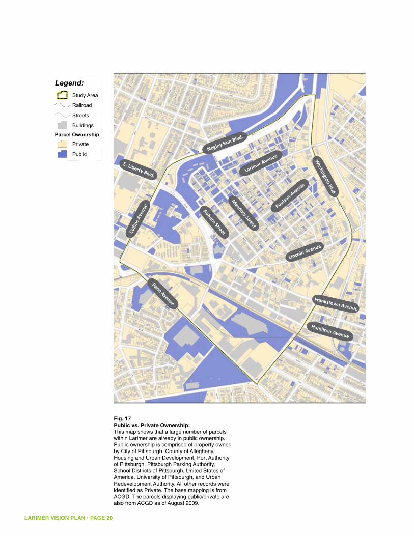
Fig. 17Public vs. Private Ownership:This map shows that a large number of parcels within Larimer are already in public ownership. Public ownership is comprised of property owned by City of Pittsburgh, County of Allegheny, Housing and Urban Development, Port Authority of Pittsburgh, Pittsburgh Parking Authority, School Districts of Pittsburgh, United States of America, University of Pittsburgh, and Urban Redevelopment Authority. All other records were identified as Private. The base mapping is from ACGD. The parcels displaying public/private are also from ACGD as of August 2009.
Penn Avenue
Larimer Avenue
Negley Run Blvd.Co
llins
Ave
nue
Lincoln Avenue
Meadow Street
Auburn Street
E. Liberty Blvd.
Frankstown Avenue
Hamilton Avenue
Washington Blvd
Paulson Avenue
LARIMER VISION PLAN • PAGE 21
Penn
Fifth
High
land
East Busway
Stanton
Hamilton
Lang
Larimer
Negle
y
Beatt
y
Broad
Eucli
d
East Liberty
Walnut
Washington
Hays
Howe
Shady
Negley Run
Frankstown
Carver
Sheri
dan
Shetland
St C
lair
Lowell
Deary
Dalla
s
Saxon
Dean
Jackson
Alder
Ellsworth
Collin
s
Lenora
Emer
son
Baum
College
Polk
Winslow
Mayflower
Rowan
Mello
n
Dix
Felix
Meadow
Apple
Lehig
h
Murtla
nd
Elwood
Spah
r
Lyric
St Marie
Clifford
Thomas
Lamo
nt
Dodge
Fleury
Victor
Xenia
Odessa
Black
Kentucky
Arbor
Olivant
Mc Pherson
Livery
Linde
n
Indiana
Turrett
Rippey
Lincoln
Whit
field
Harvard
Rural
Montez
uma
Forest
Allemannia
Rapidan
Formosa
Ryoli
te
Paulson
Kelly
Finley
Aurelia
Winfield
June
Kirkwood
Gree
nbria
r
Ashley
Maryland
Simonton
Renfrew
Carro
nPointvie
w
Lynn
Elmer
Inwoo
d
Denniston
Tennis
Hebe
rton
Penn
Circ
le W
est
Gerrit
t
Tripod
Upland
Felicia
Violin
Album
Sharp
Bower
Marchand
Centre
Mt Vernon
Chaucer
Maxwell
Orph
an
Swop
e
Columbo
Idlewild
Regis
Stoebner
Transit
Penn Circle South
Bennett
Penn Circle North
Swee
ney
Fielding
Holden
Tay
Ansley
Farra
gut
Yard
ley
FletcherMonticello
Hermitage
Tenner
Relic
Laxto
n
Bellman
Yarmouth
Atwell
Auto
Sama
ntha
Nadir
Mathews
Auburn
Kedron
Samoan
Carmine
Juliu
s
Dunmore
Mc C
ombs
Ladson
Commerce
Glenview
Starling
Rosary
Dahlem
Portla
nd
Thisb
e
Vanilla
Hedge
Larimer Ave
Claws
on
Mane
tto
Tyler
Bosey
Conover
Chislett
Zodia
c
Dent
Eva
Social
Emans
Armstrong
Navarro
Kaufman
Roane
Park Lane
Silver Lake
Torre
ns
Nelson
La S
chall
Eider
Sellers
Brainard
Selm
a
Britli
ff
Eucla
ir
Roml
ey
Home
wood
Houston
Spin
Beec
her
Amity
Supre
me
Zenit
h
Putna
m
Grapevi
ne
Lincoln Ave
Whittier
Trade
Pace
Penn
Circ
le Ea
st
Borla
nd
Akron
Etud
e
Chinn
Baywood
Susquehanna
Hauser
Renn
ig
Flavel
Tangent
Enright
Thompson
Missouri
Stratton
Joseph
Pierce
Margaretta
Mc Donald
Hyatt
Tamello
Elysian
Reimer
Ogleb
y
Macru
m
Moga
Freeman
Hastings
Robley
Sentinel
Snively
Vernoun
Topaz
Enter
prise
Weldin
Callery
Antler
Orange
Omega
Hooker
Frazee
Shuttle
Puritan
Dick
Aldino
Rodman
Melm
ore
Friendship
Janero
Lamb
Braden
Farlson
Nove
lty
Owasso
Beggs
Llewellyn
Belmar
Evers
Stam
air
Beckett
Casa
nova
Station
Sinnet
Huntress
Orse
nius
Roslyn
Meade
Well
esley
Gordo
n
Conti
nenta
l
LemingtonMc C
une
Annan
Unna
med1
24M1
73EJ
Ambe
r
Television Hill
Beechwood
Arab
ia
Unnamed84P
Woof
Hailm
an
Easton
Oldsmar
Meadow Street
Sago
Reo
Unnamed124M
Cassina
Unnamed
Race
Tioga
Warpole
Mignonette
Point B
reeze
Festi
val
Summerlea
Unnamed124H
Shakespeare
Unnam
ed12
4S
Tenner
Mane
tto
Arbor
Meadow
Commerce
Susquehanna
Meadow
St C
lair
Braden
Social
Larim
er
Beatty
Unnamed124M173EJ
Lang
Euclid
Unnamed124H
Susquehanna
Snively
Paulson
Tyler
Sheri
dan
Missouri
Baum
Auburn
Lincoln
Formosa
Denniston
Montezuma
Sheri
dan
Olivant
Rippey
Rippey
Fielding
Alder
Beatt
y
Carro
n
Saxon
Joseph
Apple
Murtla
nd
Indiana
Broad
Tay
Idlewild
Borla
nd
Black
Arbor
Olivant
Montezuma
Eva
St C
lair
Houston
Melm
ore
Legend:Railroad
Streets
Study Area
Buildings
Parcel Status
Condemned
Vacant Land
Foreclosure
No Water Service
Parcels
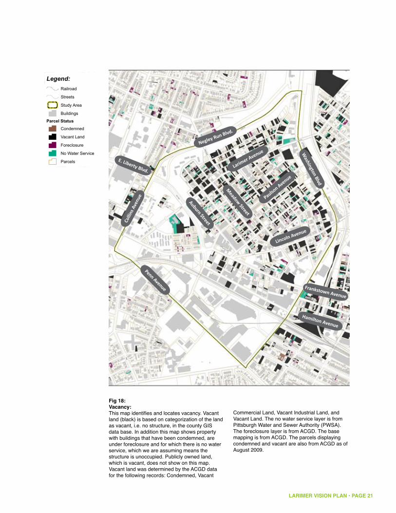
Fig 18:Vacancy:This map identifies and locates vacancy. Vacant land (black) is based on categorization of the land as vacant, i.e. no structure, in the county GIS data base. In addition this map shows property with buildings that have been condemned, are under foreclosure and for which there is no water service, which we are assuming means the structure is unoccupied. Publicly owned land, which is vacant, does not show on this map. Vacant land was determined by the ACGD data for the following records: Condemned, Vacant
Commercial Land, Vacant Industrial Land, and Vacant Land. The no water service layer is from Pittsburgh Water and Sewer Authority (PWSA). The foreclosure layer is from ACGD. The base mapping is from ACGD. The parcels displaying condemned and vacant are also from ACGD as of August 2009.
Penn Avenue
Larimer Avenue
Negley Run Blvd.Co
llins
Ave
nue
Lincoln Avenue
Meadow Street
Auburn Street
E. Liberty Blvd.
Frankstown Avenue
Hamilton Avenue
Washington Blvd
Paulson Avenue
LARIMER VISION PLAN • PAGE 22
Penn
Fifth
High
land
East Busway
Stanton
Hamilton
Lang
Larimer
Negle
y
Beatt
y
Broad
Eucli
d
East Liberty
Walnut
Washington
Hays
Howe
ShadyNegley Run
Frankstown
Carver
Sheri
dan
Shetland
St C
lair
Lowell
Deary
Dalla
s
Saxon
Dean
Jackson
Alder
Ellsworth
Collin
s
Lenora
Emer
son
Baum
College
Polk
Winslow
Mayflower
Rowan
Mello
n
Dix
Felix
Meadow
Apple
Lehig
h
Murtla
nd
Elwood
Spah
r
Lyric
St Marie
Clifford
Thomas
Lamo
nt
Dodge
Fleury
Victor
Xenia
Odessa
Black
Kentucky
Arbor
Olivant
Mc Pherson
Livery
Linde
n
Indiana
Turrett
Rippey
Lincoln
Whit
field
Harvard
Rural
Montez
uma
Forest
Allemannia
Rapidan
Formosa
Ryoli
te
Paulson
Kelly
Finley
Aurelia
Winfield
June
Kirkwood
Gree
nbria
r
Ashley
Maryland
Simonton
Renfrew
Carro
n
Pointview
Lynn
Elmer
Inwoo
d
Denniston
Tennis
Hebe
rton
Penn
Circ
le W
est
Gerrit
t
Tripod
Upland
Felicia
Violin
Album
Sharp
Bower
Marchand
Centre
Mt Vernon
Chaucer
Maxwell
Orph
an
Swop
e
Columbo
Idlewild
Regis
Stoebner
Transit
Penn Circle South
Bennett
Penn Circle North
Swee
ney
Fielding
Holden
Tay
Ansley
Farra
gut
Yard
ley
FletcherMonticello
Hermitage
Tenner
Relic
Laxto
n
Bellman
Yarmouth
Atwell
Auto
Sama
ntha
Nadir
Mathews
Auburn
Kedron
Samoan
Carmine
Juliu
s
Dunmore
Mc C
ombs
Ladson
Commerce
Glenview
Starling
Rosary
Dahlem
Portla
nd
Thisb
e
Vanilla
Hedge
Larimer Ave
Claws
on
Mane
tto
Tyler
Bosey
Conover
Chislett
Zodia
c
Dent
Eva
Social
Emans
Armstrong
Navarro
Kaufman
Roane
Park Lane
Silver Lake
Torre
ns
Nelson
La S
chall
Eider
Sellers
Brainard
Selm
a
Britli
ff
Eucla
ir
Roml
ey
Home
wood
Houston
Spin
Beec
her
Amity
Supre
me
Zenit
h
Putna
m
Grapevi
ne
Lincoln Ave
Whittier
Trade
Pace
Penn
Circ
le Ea
st
Borla
nd
Akron
Etud
e
Chinn
Baywood
Susquehanna
Hauser
Renn
ig
Flavel
Tangent
Enright
Thompson
Missouri
Stratton
Joseph
Pierce
Margaretta
Mc Donald
Hyatt
Tamello
Elysian
Reimer
Ogleb
y
Macru
m
Moga
Freeman
Hastings
Robley
Sentinel
Snively
Vernoun
Topaz
Enter
prise
Weldin
Callery
Antler
Orange
Omega
Hooker
Frazee
Shuttle
Puritan
Dick
Aldino
Rodman
Melm
ore
Friendship
Janero
Lamb
Braden
Farlson
Nove
lty
Owasso
Beggs
Llewellyn
Belmar
Evers
Stam
air
Beckett
Casa
nova
Station
Sinnet
Huntress
Orse
nius
Roslyn
Meade
Well
esley
Gordo
n
Conti
nenta
l
LemingtonMc C
une
Annan
Unna
med1
24M1
73EJ
Ambe
r
Television Hill
Beechwood
Arab
ia
Unnamed84P
Woof
Hailm
an
Easton
Oldsmar
Meadow Street
Sago
Reo
Unnamed124M
Cassina
Unnamed
Race
Tioga
Warpole
Mignonette
Point B
reeze
Festi
val
Summerlea
Unnamed124H
Shakespeare
Unnam
ed12
4S
Tenner
Mane
tto
Arbor
Meadow
Commerce
Susquehanna
Meadow
St C
lair
Braden
Social
Larim
er
Beatty
Unnamed124M173EJ
Lang
Euclid
Unnamed124H
Susquehanna
Snively
Paulson
Tyler
Sheri
dan
Missouri
Baum
Auburn
Lincoln
Formosa
Denniston
Montezuma
Sheri
dan
Olivant
Rippey
Rippey
Fielding
Alder
Beatt
y
Carro
n
Saxon
Joseph
Apple
Murtla
nd
Indiana
Broad
Tay
Idlewild
Borla
nd
Black
Arbor
Olivant
Montezuma
Eva
St C
lair
Houston
Melm
ore
Legend:Railroad
Streets
Buildings
Study Area
ParcelsBuilding Quality
Good
Poor
No Data
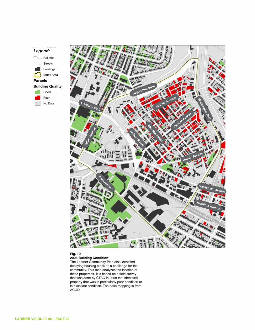
Fig. 192008 Building Condition:The Larimer Community Plan also identified decaying housing stock as a challenge for the community. This map analyzes the location of these properties. It is based on a field survey that was done by CTAC in 2008 that identified property that was in particularly poor condition or in excellent condition. The base mapping is from ACGD.
Penn Avenue
Larimer Avenue
Negley Run Blvd.Co
llins
Ave
nue
Lincoln Avenue
Meadow Street
Auburn Street
E. Liberty Blvd.
Frankstown Avenue
Hamilton Avenue
Washington Blvd
Paulson Avenue
LARIMER VISION PLAN • PAGE 23
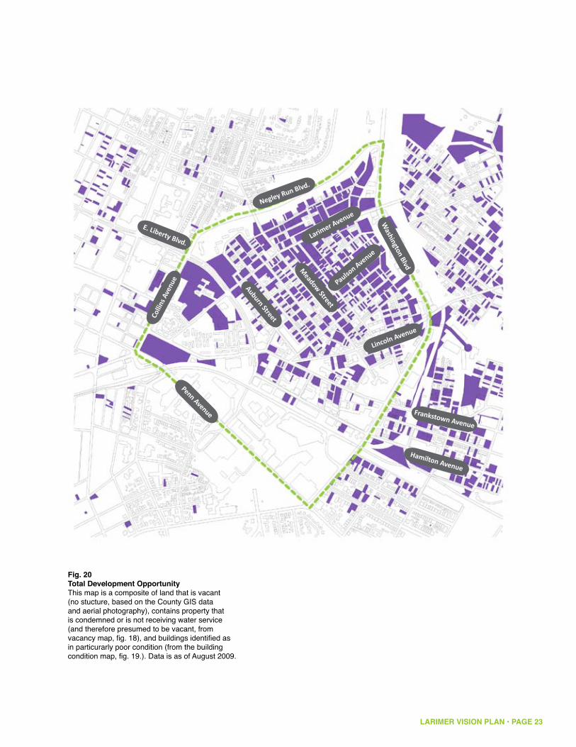
Fig. 20Total Development OpportunityThis map is a composite of land that is vacant (no stucture, based on the County GIS data and aerial photography), contains property that is condemned or is not receiving water service (and therefore presumed to be vacant, from vacancy map, fig. 18), and buildings identified as in particurarly poor condition (from the building condition map, fig. 19.). Data is as of August 2009.
Penn Avenue
Larimer Avenue
Negley Run Blvd.
Colli
ns A
venu
e
Lincoln Avenue
Meadow Street
Auburn Street
E. Liberty Blvd.
Frankstown Avenue
Hamilton Avenue
Washington Blvd
Paulson Avenue
LARIMER VISION PLAN • PAGE 24
Seeds of Growth
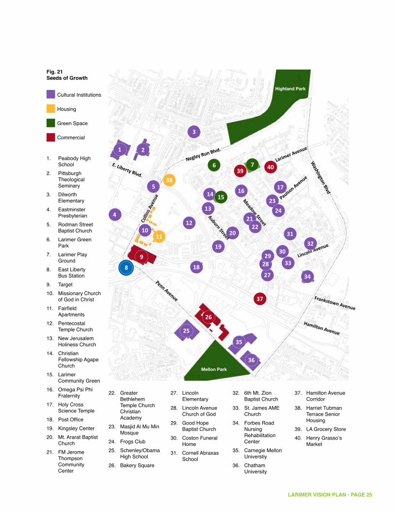
Larimer has many existing institutions and businesses that may potentially serve as attractors to the neighborhood and seeds around which revitalization can start. In addition, Larimer is adjacent to much of the new East End redevelopment (Target, Bakery Square). Larimer can take advantage of these initiatives to increase visibility, to create a new identity, and to attract new visitors and residents to the neighborhood. This new development has the potential to bring new jobs to the neighborhood. The Hamilton Avenue corridor has become a center of creative and craft related businesses. The relatively intact industrial stock means it is ideally suited for both craft related business and green light industrial development. The proximity to the busway means there is easy access from Larimer to key regional employment centers such as Downtown and Oakland. Building on existing community institutions and businesses promotes redevelopment activities with direct benefits to residents.
Meadow Street
Paulson Avenue
Lincoln Avenue
Colli
ns A
venu
e
LARIMER VISION PLAN • PAGE 25
Mellon Park
Highland Park
Fig. 21Seeds of Growth
Peabody High 1. SchoolPittsburgh 2. Theological SeminaryDilworth 3. ElementaryEastminster 4. PresbyterianRodman Street 5. Baptist ChurchLarimer Green 6. ParkLarimer Play 7. GroundEast Liberty 8. Bus StationTarget9. Missionary Church 10. of God in ChristFairfield 11. ApartmentsPentecostal 12. Temple ChurchNew Jerusalem 13. Holiness ChurchChristian 14. Fellowship Agape ChurchLarimer 15. Community GreenOmega Psi Phi 16. FraternityHoly Cross 17. Science TemplePost Office18. Kingsley Center19. Mt. Ararat Baptist 20. ChurchFM Jerome 21. Thompson Community Center
1 2
3
4
5
6 7
10
8 9
11
38
12
13
14 15 16 17
18
19
20
21 22
23 24
25
26
37
39 40
27 28 29
30
31 32
33
34
35
36
Greater 22. Bethlehem Temple Church Christian AcademyMasjid Al Mu Min 23. MosqueFrogs Club24. Schenley/Obama 25. High SchoolBakery Square26.
Lincoln 27. ElementaryLincoln Avenue 28. Church of GodGood Hope 29. Baptist ChurchCoston Funeral 30. HomeCornell Abraxas 31. School
6th Mt. Zion 32. Baptist ChurchSt. James AME 33. ChurchForbes Road 34. Nursing Rehabilitation CenterCarnegie Mellon 35. UniverstiyChatham 36. University
Cultural Institutions
Housing
Green Space
Commercial
Penn Avenue
Larimer Avenue
Negley Run Blvd.
Auburn StreetE. Liberty Blvd.
Frankstown Avenue
Hamilton Avenue
Washington Blvd
Hamilton Avenue 37. CorridorHarriet Tubman 38. Terrace Senior HousingLA Grocery Store39. Henry Grasso’s 40. Market
LARIMER VISION PLAN • PAGE 26
B. Market Analysis SummaryA market analysis by Real Estate Strategies, Inc. identified potential land uses. A full market analysis is attached as an appendix to this report. Below is a summary of conclusions and recommendations.
Residential Development New housing development can tap demand from households living in the following postal zip codes: 15201, Lawrenceville/Stanton Heights; 15206, East Liberty/Larimer/Highland Park; 15208, Homewood/Point Breeze; 15213, Oakland; and 15224, Bloomfield/Garfield.
There is evidence of market support for the following types of housing over a time frame of five to ten years:
New for-sale housing + : 50 to 60 single-family, for-sale homes with “green” features, creating a new neighborhood identified as green. New development could include up to 10 carriage homes for seniors constructed to Uniform Federal Accessibility Standards and having first-floor master bedrooms. These homes would be an alternative for older homeowners now living in Larimer, as well as a relocation resource for seniors wanting to remain in the neighborhood. Development of for-sale townhouses around a park or greenway might be tested after initial phases of sales housing have been developed. Infill housing on scattered sites should not be pursued until there are very clear signs that Larimer has become a stable neighborhood.
Mixed-Income Rental Housing + : One or more new mixed-income rental projects with about 400 units will offer new housing opportunities for low-income residents of Larimer while also broadening the appeal of the neighborhood to households with higher incomes. These new units should be developed in phases during a time frame of five to seven years. Some of the units should replace the existing 129-unit East Liberty Gardens project in one or more new mixed-income properties. Redevelopment of the existing Hamilton-Larimer public housing units at a more appropriate location in Larimer is also recommended. Because they are a stakeholder in Larimer and can help assist extremely low-income households, involvement by the Housing Authority of the City of Pittsburgh in mixed-income rental development is recommended.
Residential Phasing + : A phasing plan should give priority to the development of new residential units that can be occupied by residents now living in the neighborhood. With the large amount of vacant land that is available, it should be possible to offer replacement housing units for owner-occupants and renters. Since many households in the neighborhood have very low incomes, the challenge will be to ensure that new housing is affordable to households wanting to remain in the new neighborhood.
Commercial Development PotentialA greenhouse/garden center might be developed to support Larimer’s new +positioning as a green neighborhood. A community-oriented urban farm market could market products raised in the neighborhood; there would be synergies between a farm market and a greenhouse/garden center.
Development of Industrial/Flex SpaceAreas along Hamilton Avenue, Frankstown Avenue, and Washington Boulevard +are good locations for manufacturing, distribution, service, and craft-related businesses. Improved lighting and streetscape enhancements would improve their competitiveness and marketability. Frankstown Avenue in Larimer can be redeveloped and repositioned as a location for new industrial/flex/showroom space to accommodate small businesses including green businesses, start-ups from nearby universities, and artists. This area can be Larimer’s business gateway for green industries; facilities can complement those proposed in the Hill District by Pittsburgh Green Innovators, Inc.
Open Space and Green Initiatives There is unmet demand for additional active recreation facilities in Pittsburgh +including playing fields for baseball, softball, football, and soccer. Other facilities for active youth and adult sports are also needed; existing facilities are fully used and even over-used.
Establishing an identity for Larimer as a green neighborhood should +enhance its redevelopment potential. Green initiatives to help “jump-start” neighborhood revitalization can include:
Developing new structures to green standards; • Preserving and expanding green spaces in the neighborhood; • Positioning new housing around green spaces to add “eyes on the space;”• Creating open spaces as centers for community gathering; and • Establishing an Urban Garden District in the neighborhood to specify and • control permitted uses.
LARIMER VISION PLAN • PAGE 27

LARIMER VISION PLAN • PAGE 28
Fig. 22Concept Diagram
Penn Avenue
Larimer Avenue
Negley Run Blvd.
Colli
ns A
venu
e
Lincoln Avenue
Meadow
Street
E. Liberty Blvd.
Frankstown Avenue
Hamilton Avenue
Highland Park
Larimer Park
Urban Farm
Recreational Complex
Village Green
Green Light Industrial
Neighborhood RetailBus
Station
Green
Stre
et
Mellon Park
GreenSpace
Retail/Commercial Residential Light
Industrial Institutional Existing Parks
Washington Blvd
Paulson Avenue

LARIMER VISION PLAN • PAGE 29
C. Plan Development Implications & StrategiesThe preceding analysis indicates that to stabilize and reverse the loss of population and households, the neighborhood must change. The analysis also suggests key strategies to ensure that Larimer can successfully revitalize, addressing in an innovative way the regional challenges of vacancy and a declining and aging population and planning strategically for a smaller neighborhood. Larimer needs a flexible plan that allows the community to be nimble in responding to market and development opportunities and one that allows Larimer to regrow successfully and strategically.
Larimer must establish a new identity and reputation in the city and the region. This will enable Larimer to attract newer residents, including those with higher incomes, while retaining existing residents. To both attract new residents and retain existing residents, Larimer needs to become a safe, secure and vibrant neighborhood. Larimer’s abundant vacant land is a challenge, because it contributes to the image of Larimer as neglected and unsafe—a perception that must change for Larimer to successfully revitalize. However, that same vacant land provides an opportunity for Larimer to pursue large-scale land uses that radically change the character of the neighborhood. Strategies:
Bring the neighborhood closer together: create a more concentrated, vibrant residential core1. Larimer needs to address the negative aspects of vacancy—the “missing tooth” look of the neighborhood with vacant lots and abandoned buildings. To plan strategically and successfully, Larimer needs to concentrate existing residents and target new housing developments in a smaller residential core that will bring residents closer together and create a more vibrant, active neighborhood. This concentrated residential cluster should focus around existing community institutions and assets and around existing intact housing. A number of neighborhood institutions, such as the East Liberty Concerned Citizens Corporation and Omega Psi Phi Fraternity, already have plans for doing precisely this. These and other community based institutions should be incorporated into the neighborhood plan. Dilapidated and unsafe structures should be cleared through deconstruction and sound structures stabilized and rehabilitated. Vacant lots within the residential core should either be used for new housing, deeded as side yards to adjoining homeowners, or reclaimed as open space for community use. Creating a “critical mass” of housing and increasing curb appeal in the core of the neighborhood in conjunction with new destinations will contribute to creating a new identity for the neighborhood.

LARIMER VISION PLAN • PAGE 30
Establish a new identity as a state of the art green community. 2. To achieve the goal of establishing Larimer as a state-of-the-art green community, Larimer should take steps to set itself apart as innovative and green. A menu of sustainability strategies is discussed in more detail in Section 6. The neighborhood should strongly encourage all new construction in the area to be green buildings. The neighborhood should explore the use of the LEED ND neighborhood development certification program as a way to foster comprehensively planned sustainable development, and set Larimer apart from other city neighborhoods. New infrastructure should be green infrastructure. An emphasis should be placed on green, innovative practices and projects, such as the Kingsley Center’s Imagine Larimer and the urban garden/farm on Larimer Avenue.
Fig. 23Consolidating Assets
Create Strengthened
Residential Core
Strengthen Light-Industrial
Core

LARIMER VISION PLAN • PAGE 31
Create connections and increase visibility3. Larimer’s natural physical and historical connection is to East Liberty. Given the scale of re-development currently occurring in East Liberty, it makes sense for Larimer to enhance its connections to East Liberty. East Liberty Boulevard has historically contributed to Larimer’s isolation. However, with increasing developments in East Liberty and at Bakery Square, traffic on East Liberty Boulevard is likely to increase. As Larimer’s most accessible and most visible boundary, it is important to create gateways at key points along East Liberty Boulevard and to enhance the Larimer Avenue connection (see figure 11). Creating more street connections for vehicular, bicycle, and pedestrian traffic between Larimer and East Liberty, particularly in the East Liberty Gardens and Enright Court Areas, is also important in creating greater connectivity for Larimer.
Retain existing residents: “a house for a house” 4. To successfully revitalize, Larimer must retain its existing residents. The principle established over the course of the planning process was “a house for a house.” No one should be forced to leave their homes and those who chose to leave a home —but stay in the neighborhood—should receive a house in return. This can be accomplished in several ways. First, the phasing of redevelopment should provide for enough new housing to be constructed so that people only move once. Many of Larimer’s residents are older, and new, possibly single-story construction (patio or carriage homes) may be more convenient and marketable and allow older residents to stay independent and in their own homes longer. Mechanisms like life estates can also be used to transfer property to public uses after residents pass on, if they elect that option.
Create destinations that change the reputation of Larimer5. Larimer needs to find large scale land uses for its vacant land. Opportunities exist for active recreation, urban farming and park uses. The market analysis report suggests an active recreation complex, including rectangular fields, and a fieldhouse or other indoor facilities will create a city-wide and regional destination that could be self-sustaining. Likewise, some of Pittsburgh’s most successful neighborhoods—Squirrel Hill, Point Breeze, Regent Square, Highland Park—have developed adjacent to the city’s parks. A park will enhance the visibility and reputation of Larimer and enhance the property values on its edges, creating a destination within the neighborhood that will bring people from the region into the new Larimer and one that will help foster a new green regional identity.

LARIMER VISION PLAN • PAGE 32
Perhaps the single biggest challenge facing Larimer is the large amount of vacant land and structures. Historically a thriving and bustling neighborhood, it has been depopulated to the point that there are now few residents, and even fewer businesses along Larimer Avenue. But this plan is predicated on the notion that this liability can be turned to an opportunity to reconstitute a smaller, but stronger residential neighborhood core. To achieve this, the plan uses the following principles:
Identify large-scale land uses for vacant land• Focus on a stronger, smaller core• Identify key connections and local nodes for development•
A. Neighborhood wide land-use strategy The goal of the land-use strategy is to establish Larimer as a state-of-the-art green community to revitalize the neighborhood. A major component of this plan is to transition the parcels northwest of Larimer Avenue to park land that would form the new Larimer Park, and connect to Highland Park and the rest of Pittsburgh’s park system. This new park would include a complex of rectangular fields and a field house, as well as passive recreation, urban woodlands and passive stormwater management. This would create an amenity for Larimer residents as well as a year-round destination for the city and region. The region needs rectangular fields and Larimer is one of the few places where a large amount of flat land is available for development in a central location.
The park would also continue along the slope above Washington Boulevard between Larimer Avenue and Lincoln Avenue. This edge of the neighborhood also has a high level of vacancy and could be incorporated into the park. The flatter areas could also be used for urban farms and community gardens.
Although the proposed park is one of the areas of greatest vacancy, creating the park may require the phased and patient relocation of some residents. This need not be accomplished all at once, but the goal would be to reconcentrate the residential core of the neighborhood between Larimer Avenue and Lincoln Avenue and Broad Street. The purpose here is to concentrate the neighborhood into a smaller residential core and reduce the rate of vacancy. Within the new residential core, vacant lots should either be developed as new housing, disposed to adjacent homeowners who are willing to maintain them, or dedicated to community green space or green infrastructure.
5. The Land-Use Vision Plan: A Framework for Community Development
LARIMER VISION PLAN • PAGE 33
The Study Area has numerous impressive historic structures, such as the former Catholic churches on Larimer and Meadow and the old Larimer School. Many of these structures are in disrepair and in some cases dangerous or near collapse; rehabilitation will be costly and complex. Where creative reuse of historic structures is feasible it should be pursued right away, but where it is not, they should be taken down and the building materials and contents reused and recycled (deconstructed). The community needs to be strategic about what to save and what to deconstruct.
The Hamilton and Frankstown Avenue light industrial corridor currently serve a range of light manufacturing, distribution, service and craft-related businesses, providing jobs and economic activity to Larimer. The goal is for light industrial development to continue to occur in this area and over the long term to move light industrial uses incompatible with the plan in other parts of the neighborhood into this area. The existing building stock in this area is generally good. The potential of this area to contribute to the economic growth of Larimer can be enhanced by capitalizing on the existing craft activities that are already happening along Hamilton Avenue as well as targeting this area for development of new green jobs. This area is also a possible location for a business incubation facility, as identified in the market analysis.

Checkerboard Green14. —Activities within the residential core should focus on the clearance of dilapidated structures, the rehabilitation of sound structures, the disposition of vacant lots and side yards to adjoining homeowners and the reclamation of open spaces for community gardens, green infrastructure and farming.
The Forbes Health Facility15. at the corner of Frankstown Avenue and Washington Boulevard presents a long range opportunity.
The area bounded by Frankstown, Lincoln, 16. Mayflower and Paulson is a mix of retail, light industrial and residential. Opportunity for neighborhood scale retail such as ALDI or others, focused on Frankstown.
The Hamilton Avenue Corridor17. serves a range of manufacturing, distribution, service and craft related businesses, providing jobs and economic activity in Larimer. Enhance as a center for green jobs/light industrial development. Adaptive reuse of existing buildings.
The Housing Authority owns part of the 18. property designated as green space by this plan. The Housing Authority has goals for building and managing new housing in the Larimer Avenue corridor that must be addressed before they agree to their current site being green space. Sites for this housing, both scattered and assembled at larger scale need to be identified.
Stormwater collection and treatment9. is both a green sustainability strategy and a park amenity utilizing natural terrains and drainage systems and reducing sewer demand.
Field house: a year round regional 10. destination. An alternative to a single field house is to have several smaller facilities dispersed through out the park. A feasibility study for the park and available financing opportunities will drive the preferred alternative.
Urban Farm: 11. provides opportunities for urban agriculture, associated with new green space.
Provide smaller, more concentrated 12. residential clusters to strengthen the neighborhood. A number of community organizations have plans for new development within the residential core which can form the basis of these clusters.
The eastern extents of the park are flexible.13. The border may change depending on vacancy and needs for development.
Expand and Connect to Highland Park.1. Create a complex with rectangular fields and a field house for an active, year round destination. Rectangular fields are in short supply in the region and will draw people to Larimer.
East Liberty Boulevard as green boulevard2. —connecting the new Larimer Park and Mellon Park with green infrastructure, bike and pedestrian amenities.
East Liberty Boulevard and Negley Run 3. Boulevard will be a key gateway to Larimer Park and the new Larimer.
The new Environment and Energy 4. Community Outreach Center on East Liberty Boulevard is a new development likely to be a destination in Larimer and should be highlighted as a key gateway. This will also be gateway to the new Larimer Park.
Create Park Edge5. with new housing fronting the newly created Park.
Create opportunities for development and 6. neighborhood connection with a new land-use plan for East Liberty Gardens, the ball feild, Enright Court, and St. Peter and Paul Church
Kingsley Center7. on East Liberty Boulevard should be highlighted as a key gateway and face of the neighborhood.
East Liberty Boulevard and Penn Avenue is a 8. key location for a Larimer gateway, especially given its proximity to the new Bakery Square Development.
RE-IMAGINING A More Sustainable Cleveland 19
FIG 18-19 Design concepts for vacant land in headwaters areas
GreenSpace
Retail/Commercial Residential Light
Industrial Institutional Existing Parks
Highland Park
Mellon Park
Port
Authority Garage
East Liberty Bus Stop
Larimer Avenue
Meadow Street
Frankstown Avenue
Hamilton Avenue
Auburn Street
Washington Blvd.
E. Liberty Blvd.
Penn Avenue
Paulson Avenue
Lincoln Avenue
Negley Run Blvd.
Colli
ns A
venu
e
10
9
1
11
14
13
1516
17
18
12
2
3
4
7
8
5
5
6
Calvin College
Environment and Energy Community Outreach CenterExterior Perspective 1
19 January 2010Fukui Architects
november 2010 2 0 y e a r l a r i m e r v i s i o n p l a n pittsburgh, paneighborhood
land use vision plan
Image courtesy ofCleveland Urban Design Collaborative & Neighborhood Progress, Inc.
Proposed NewStreet Connection

november 2010 l a r i m e r a v e n u e c o r r i d o r v i s i o n p l a n pittsburgh, palarimer avenue corridor
land use plan
Larimer Park will include the establishment of a recreation complex for organized sports.
Field house for a year round regional destination.
Create additional street connections along Larimer Avenue into existing and proposed housing, especially Enright Court.
Redevelop East Liberty Gardens and integrate into the neighborhood.
New Village Green: new housing, neighborhood gatherings, and market activities at the site of the current Larimer Garden will form a new civic core of the neighborhood.
Capitalize on the enhanced land values across from the new park to develop a new residential edge.
Build out of Fairfield Phase II
Create a new residential development on ball field site
Create a rain garden system above Negley Run as part of a sustainable storm water strategy and as park amenity.
Walking trails and picnic pavilions along top of slopes.
Future integration of Mike’s Auto Body into the park with building re-purposed as a field house.
CoLLIns AvEnuEEAsT LIBErTy BLvd.
sTAT
Ion
sTr
EET
BroAd sTrEET
BuswAy
nEgLEy run BLvd.
wA
sHIn
gTo
n B
Lvd
.
MEAdow sTrEET
LArIMEr AvEnuE
LARIMER VISION PLAN • PAGE 34
Larimer Avenue will be defined in the future by the establishment of Larimer Park with a recreational field complex on the north side and a strong residential edge on the south side. This residential edge should include the acquisition and redevelopment of East Liberty Gardens, and the creation of new residential development on the site of the current East Liberty Park ball field adjacent to East Liberty Gardens and Enright Court. The parcels that include Omega Place, which had formerly been slated as Phase 3 of Fairfield, should be incorporated into the park expansion because of the difficulties —including contaminated soils and high development costs—in developing the site as housing. The current community garden on Larimer Avenue between Mayflower and Carver streets should become a new Village Green that will include the garden, new housing and market activities surrounded by new and rehabilitated infill housing and perhaps some small neighborhood-scaled retail such as a coffeeshop. This area has already begun to serve as the new civic core of the neighborhood and this role should be strengthened in the plan.
The new Larimer Park should include the establishment of a recreation complex for organized sports, including a field house. A field house will create a year-round destination for people throughout the region, enhancing the visibility of Larimer. One possibility is to re-purpose the current Mike’s Autobody as a field house in the future. The plan shows the field house as a single structure, however an alternative is to have several smaller facilities dispersed throughout the park. A feasibility study for the park (see section 7) and available financing opportunities will drive the preferred alternatives.
B. Larimer Avenue corridor land use plan
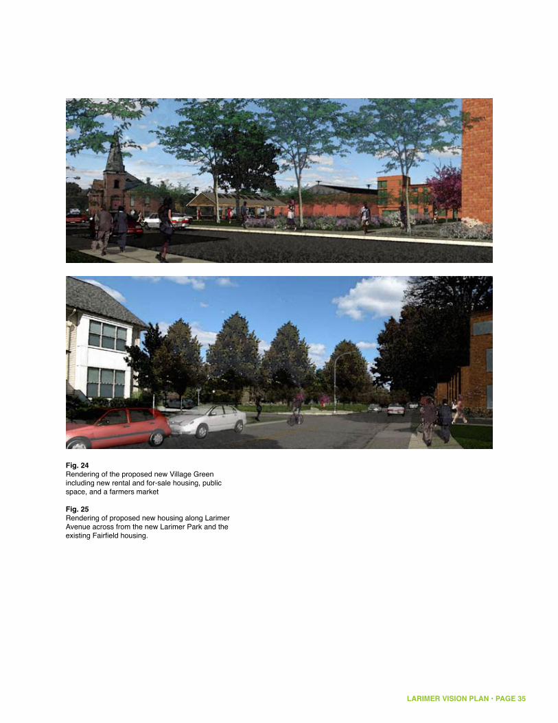
LARIMER VISION PLAN • PAGE 35
Fig. 24Rendering of the proposed new Village Green including new rental and for-sale housing, public space, and a farmers market
Fig. 25Rendering of proposed new housing along Larimer Avenue across from the new Larimer Park and the existing Fairfield housing.

LARIMER VISION PLAN • PAGE 36
6. The Sustainable Kit of Parts
A. Urban Sustainability StrategiesIn addition to providing ecological benefits and distinguishing Larimer within the region, urban sustainability strategies can also contribute to the economic revitalization of Larimer. Research done at the Wharton School at the University of Pennsylvania on the impacts of vacancy and green strategies on property values in Philadelphia indicates that stabilizing a vacant lot (mowing, trash removal, etc.) led to an average increase of 17% in the value of adjacent homes. Improvements in streetscapes led to a 28% positive impact on adjacent property values.
Larimer has the opportunity to incorporate many of these sustainability strategies into the fabric of the neighborhood as redevelopment occurs. Steps to implement some of these strategies, such as stabilizing and greening of vacant lots and creating the community garden, are already being taken by the Larimer Green Team and others, and this work should continue and expand. Other strategies, such as creation of new park land, urban farming, green infrastructure, streetscape improvements, and incorporation of green building practices should be implemented as the redevelopment process moves forward. Sustainability strategies will help to create a new character and identity for the neighborhood.
Green development practices will also be important economic development tools that can contribute to attracting new grants, investment and residents to the neighborhood, and creating employment and job training opportunities. More and more, public and private funding opportunities are dependent on the incorporation of green practices into the development approach and new initiatives—such as the joint HUD/DOT/EPA Interagency Partnership for Sustainable Communities—are targeting funding around projects that advance this agenda.
References: http://www.epa.gov/smartgrowth/partnership/index.html
Pennsylvania Horticultural Society, Reclaiming Vacant Lots: A Philadelphia Green Guide http://www.pennsylvaniahorticulturalsociety.org/garden/vacantmanual.html
Growing Greener Cities : Urban Sustainability in the Twenty-First Century, Eugenie L. Birch and Susan M. Wachter, Editors (2008), http://www.upenn.edu/pennpress/book/14506.html Susan M. Wachter, Kevin C. Gillen, and Carolyn R. Brown, University of Pennsylvania, A Positive Force in Cities: Green Investment Strategies (2008)
Susan M. Wachter and Kevin C. Gillen, The Wharton School University of Pennsylvania, Public Investment Strategies: How They Matter for Neighborhoods in Philadelphia

LARIMER VISION PLAN • PAGE 37
Scale
Strategy Neighborhood Street Lot
Energy Efficiency/ Independence
Food Security
Green Jobs
Healthy Communities
Walkable Communities
Green Infrastructure
Wind powerSolar CellsGeothermalBiofuelsEECO
Community GardenUrban FarmSchoolyard Gardens
“Our own Construction Junction”Business IncubatorImagine Larimer
Recreation facilities
Enhanced pedestrian connections to key transit hubs: • Bus way• Penn Avenue• East Liberty BoulevardEnhanced pedestrian connection to neighborhood services, East End retail
GreenwaysParksConnecting to existing Parks
Green BuildingsEnergy efficient housesLEED certified housesNet zero houses
Sidelot/home gardens
Deconstruction/salvaging of building materialsFarmingEnergy/BiofuelsWeatherization
Pocket park (basketball, playgrounds)
Rain gardensRain barrels/down spout disconnectionRain water recycling
Streetscape improvements
Streetscape and lighting improvementsADA accessibility
Green streetsRain gardensBoulevards
Implementing Urban Sustainability Strategies in the Neighborhood
LARIMER VISION PLAN • PAGE 38
B. LEED for Neighborhood Development The LEED-ND certification program is one that Larimer might wish to consider as it moves forward with implementing its state-of-the-art green community.LEED-ND is a green building rating system that encourages communities to develop according to Smart Growth and urban sustainability principles, which include:
take advantage of existing transportation linkages, avoid sprawl and preserve +sensitive landsestablish a neighborhood design that is equitable, walkable, healthy and mixed +usedesign and construct buildings and infrastructure that reduce energy and water +use and promote a more sustainable use of materials
The certification program is a complex and sophisticated system that evaluates all of the aspects of a neighborhood development against a set of defined criteria in a point-based ranking system. Even if projects are not carried all the way through the certification process, the LEED-ND system will be an important guide that sets out clear parameters for the neighborhood’s development. (LEED-ND checklist is attached as an appendix to the report)
References:LEED-ND http://www.usgbc.org/DisplayPage.aspx?CMSPageID=148
Greensburg GreenTown http://www.greensburggreentown.org/
Germany Imagines Suburbs Without Cars http://www.nytimes.com/2009/05/12/science/earth/12subur
Vauban District, Freiburg http://www.vauban.de/info/abstract.html
Residents of Vauban, Community - Heroes of the Environment 2009 http://www.time.com/time/specials/packages/article/0,28804,1924149_1924154_1924430,00.html
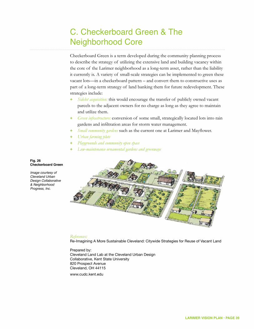
LARIMER VISION PLAN • PAGE 39
C. Checkerboard Green & The Neighborhood Core Checkerboard Green is a term developed during the community planning process to describe the strategy of utilizing the extensive land and building vacancy within the core of the Larimer neighborhood as a long-term asset, rather than the liability it currently is. A variety of small-scale strategies can be implemented to green these vacant lots—in a checkerboard pattern – and convert them to constructive uses as part of a long-term strategy of land banking them for future redevelopment. These strategies include:
Sidelot acquisition: + this would encourage the transfer of publicly owned vacant parcels to the adjacent owners for no charge as long as they agree to maintain and utilize them.Green infrastructure: + conversion of some small, strategically located lots into rain gardens and infiltration areas for storm water management.Small community gardens + such as the current one at Larimer and Mayflower.Urban farming plots +Playgrounds and community open space +Low-maintenance ornamental gardens and greenways +
References:Re-Imagining A More Sustainable Cleveland: Citywide Strategies for Reuse of Vacant Land Prepared by:Cleveland Land Lab at the Cleveland Urban DesignCollaborative, Kent State University820 Prospect AvenueCleveland, OH 44115
www.cudc.kent.edu
RE-IMAGINING A More Sustainable Cleveland 19
FIG 18-19 Design concepts for vacant land in headwaters areas
Fig. 26Checkerboard Green Image courtesy ofCleveland Urban Design Collaborative & Neighborhood Progress, Inc.
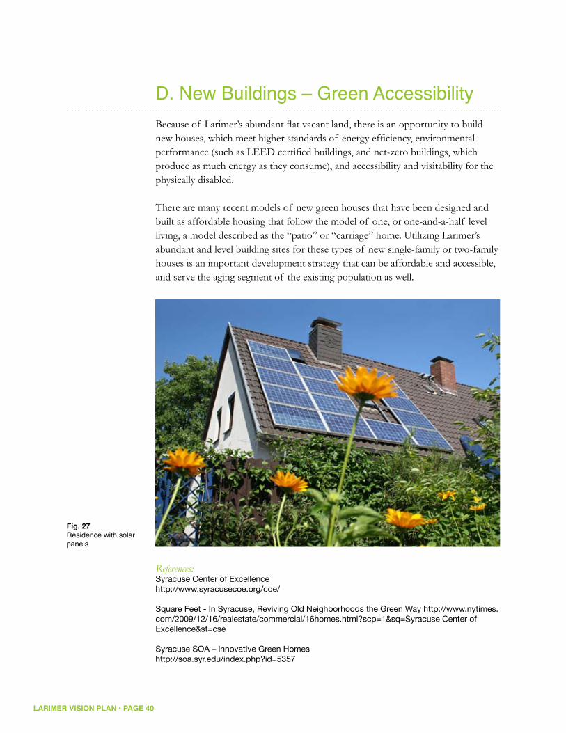
LARIMER VISION PLAN • PAGE 40
D. New Buildings – Green AccessibilityBecause of Larimer’s abundant flat vacant land, there is an opportunity to build new houses, which meet higher standards of energy efficiency, environmental performance (such as LEED certified buildings, and net-zero buildings, which produce as much energy as they consume), and accessibility and visitability for the physically disabled.
There are many recent models of new green houses that have been designed and built as affordable housing that follow the model of one, or one-and-a-half level living, a model described as the “patio” or “carriage” home. Utilizing Larimer’s abundant and level building sites for these types of new single-family or two-family houses is an important development strategy that can be affordable and accessible, and serve the aging segment of the existing population as well.
References:Syracuse Center of Excellence http://www.syracusecoe.org/coe/
Square Feet - In Syracuse, Reviving Old Neighborhoods the Green Way http://www.nytimes.com/2009/12/16/realestate/commercial/16homes.html?scp=1&sq=Syracuse Center of Excellence&st=cse Syracuse SOA – innovative Green Homes http://soa.syr.edu/index.php?id=5357
Fig. 27Residence with solar panels

LARIMER VISION PLAN • PAGE 41
E. Park Edge DevelopmentA key concept of the Larimer Vision Plan is the notion of re-concentrating the neighborhood around a new park amenity for both the surrounding neighborhood and the City of Pittsburgh. An important part of this redevelopment opportunity lies in capitalizing on the real estate advantages of proximity to parks and open space and the increased values that result. There are many local and national examples of the long-term economic value that accrues to property along the edges of successful and well-maintained parks. For these reasons, the plan recommends a focus on these edges of the new Larimer Park for the new housing initiatives, which will provide important visibility and place-making opportunities for the new developments. An important implementation piece for the plan will be feasibility studies and site-specific master planning for these new development sites. Useful resources in planning these park-related development opportunities exist at the Trust for Public Land and the Urban Land Institute. A joint planning workshop with these two entities may be a useful first step in implementing this piece of the plan.
References:Parks and Property Values in Greenville, South Carolina, Molly Espey, Kwame Owusu-Edusei Department of Agricultural and Applied Economics Clemson University January 2001
John L. Crompton, The Impact Of Parks And Open Space On Property ValuesAnd The Property Tax Base (2004)
The Trust for Public Land, Measuring the Economic Value of a City Park System (2009)
Urban Land Institute E. Baltimore Development (land assembly model) http://www.ebdi.org/thestory.html
Annie E Casey Foundation, Neighborhood Development Program http://www.aecf.org/
Fig. 28Rendering of Larimer Avenue Park Edge at Station Street
Fig. 29 Frick Park and residential edge along South Braddock Avenue

LARIMER VISION PLAN • PAGE 42
F. Urban Farming & Community WellnessThe design of communities can contribute to the health and wellness of the community and its residents. A neighborhood that includes recreation opportunities for residents in the form of parks and community centers contributes to residents’ well being. Utilizing vacant land and open space to produce food through urban farms, individual garden plots, and community gardens will also contribute to the productivity, economy and wellness of the neighborhood. Many distressed urban neighborhoods have used urban farming as a redevelopment tool that can provide healthy food at the same time that it creates economic and job opportunities and community empowerment. The community garden at the corner of Larimer and Mayflower, sponsored by the Larimer Green Team and Grow Pittsburgh is an important early step in the development.
Again, one of Larimer’s key opportunities is the abundance of level land that could be readily converted to this use. In addition, the neighborhood is ideally located very close to many desirable markets for these agricultural products, including the burgeoning East End restaurant scene that is increasingly focused on the use of local foods. Numerous local and national groups are focused on developing this revived form of urbanism, including Grow Pittsburgh, GTECH, Slow Food Pittsburgh and many of the organizations cited below.
References:Street Farmerhttp://www.nytimes.com/2009/07/05/magazine/05allen-t.html?_r=1&em=&pagewanted=all
Growing Power http://www.growingpower.org/
No Red Barn, but That’s a Farm in Red Hook; Two Acres, No Mule, but an Agricultural Education for Urban Teenagershttp://www.nytimes.com/2003/08/20/nyregion/no-red-barn-but-that-s-farm-red-hook-two-acres-no-mule-but-agricultural.html?sec=&spon=&pagewanted=all
Turning Detroit Into Urban Farms: The Best Solution for Everyone? http://www.good.is/post/turning-detroit-into-urban-farms-the-best-solution-for-everyone/
Fig. 30Site of current Larimer Farm
Fig. 31Sunflowers planted by GTECH

LARIMER VISION PLAN • PAGE 43
Can the Way We Eat Change Metropolitan Agriculture? The Portland Example http://www.terrain.org/articles/17/works_harvey.htm
About Us | Edible Schoolyard http://www.edibleschoolyard.org/about-us
Resource Center: City Farm http://www.resourcecenterchicago.org/70thfarm.html The Cleveland Model http://www.thenation.com/doc/20100301/alperowitz_et_al/single
Aquaponics, a Gardening System Using Fish and Circulating Water http://www.nytimes.com/2010/02/18/garden/18aqua.html
Center for Disease Control (CDC) Healthy Places: http://www.cdc.gov/healthyplaces/
LARIMER VISION PLAN • PAGE 44
G. Green InfrastructureGreen infrastructure is a set of strategies for bringing greater ecological function into urban environments and rethinking the existing infrastructure of cities in new, more sustainable ways. It can be in the form of simple urban forestry initiatives that reduce urban heat island effect, provide for sustainable storm water management, and provide an amenity for the neighborhood, such as street trees and preservation and management of woodlands. Green infrastructure can also include parks for active and passive recreation, which can contribute to increased property values.
More intensively, it involves redesigning urban infrastructure—particularly stormwater and drainage systems —to more closely resemble natural drainage patterns that encourage groundwater infiltration, evapotranspiration and water quality improvement through filtration. Many different techniques have been developed for creating artificial wetlands, rain gardens, and other interventions into the conventional, street/gutter/drain/pipe system of urban stormwater management. Many of the references below describe these techniques in great detail.
An additional strategy for Larimer is to tie the implementation of these new systems with the strategic removal of streets and other infrastructure in favor of more natural and softer green solutions as the neighborhood is redeveloped. This has the potential long-term benefit of reducing hard infrastructure maintenance requirements such as street repaving. Figure 32 shows how green infrastructure could be incorporated into the Larimer Plan. Figure 33 shows the historic drainages of Larimer, that can form the basis for a Larimer green infrastructure plan.
References:Green Infrastructure: Linking Landscapes and Communities by Mark A. Benedict and Edward T. McMahon; 2006, Island Press Artful Rainwater Design http://www.artfulrainwaterdesign.net/
Low Impact Development Center http://www.lowimpactdevelopment.org/
EPA Green Infrastructure website: http://cfpub.epa.gov/npdes/home.cfm?program_id=298
Pennsylvania Stormwater Best Management Practices Manual, DEPARTMENT OF ENVIRONMENTAL PROTECTION, Bureau of Watershed Management
Samso Journal - From Turbines and Straw, Danish Self-Sufficiency http://www.nytimes.com/2009/09/30/world/europe/30samso.html?scp=1&sq=denmark island&st=cse
East Liberty Green Vision Plan
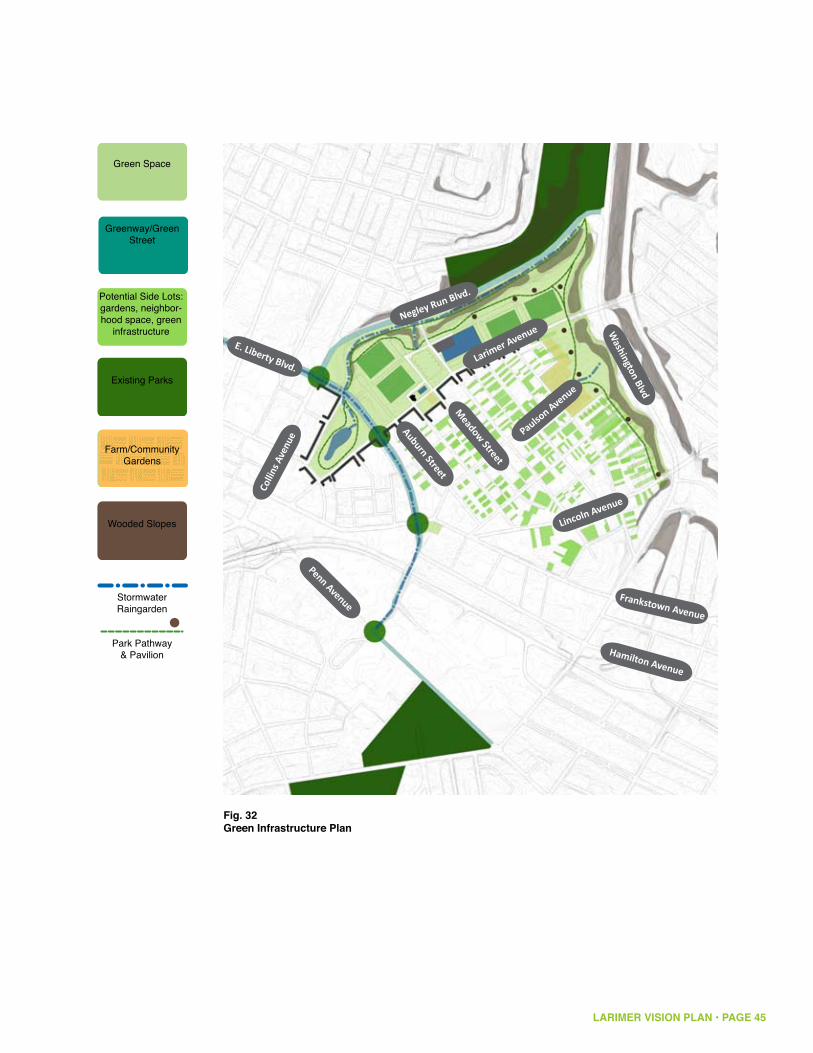
Fig. 32 Green Infrastructure Plan
LARIMER VISION PLAN • PAGE 45
Penn Avenue
Larimer Avenue
Negley Run Blvd.
Colli
ns A
venu
e
Lincoln Avenue
Meadow Street
Auburn Street
Paulson Avenue
E. Liberty Blvd.
Frankstown Avenue
Hamilton Avenue
Washington Blvd
Green Space
Greenway/Green
Street
Potential Side Lots:
gardens, neighbor-
hood space, green
infrastructure
Existing Parks
Wooded Slopes
Stormwater
Raingarden
Park Pathway
& Pavilion
Green Space Key
Farm/Community
Gardens

LARIMER VISION PLAN • PAGE 46
Fig. 33 Historic Drainage This map shows the historic waterways in the Larimer neighborhood. These are no longer present as surface water ways, but suggest where historic drainages could be recreated as part of a green infrastructure system.
Penn Avenue
Larimer Avenue
Negley Run Blvd.
Colli
ns A
venu
e
Lincoln Avenue
Meadow Street
Auburn Street
Frankstown Avenue
Hamilton Avenue
Washington Blvd
Paulson Avenue

LARIMER VISION PLAN • PAGE 47
H. Deconstruction & DecommissioningLarimer should also view its vacant buildings as natural resources to be harvested and reused through a process called deconstruction. Deconstruction is the process of dis-assembling buildings so that their materials can be repurposed or recycled. While sometimes more expensive than demolition, deconstruction is a more sustainable process, allowing valuable materials to be reused rather than sent to a landfill. It also creates green jobs, including skilled jobs in hazardous materials handling and construction techniques, while actively supporting the reuse of neighborhood resources in the rebuilding of the neighborhood.
References:The Evolution of Deconstructionhttp://www.jgpress.com/archives/_free/001884.html
Deconstruction - Construction Junction http://www.constructionjunction.org/pages/deconstruction
Baltimore’s Safe and Sound Campaign (deconstruction) http://safeandsound.org/
LARIMER VISION PLAN • PAGE 48
7. Implementation
A. LeadershipThe Larimer Consensus Group has made great strides in moving the community forward. With the completion of this market-based land use plan, the LCG is poised to shift its emphasis from planning to implementation.
Implementation will require patience, persistence, political support, public financial assistance, and most importantly an energized implementation organization focused on Larimer. The LCG, working with local elected leadership, must identify an effective organizational structure for implementation—including a continuing role for the LCG—and make it operational. This activity is absolutely primary and should be an immediate priority.
Additionally, the LCG should establish and nurture strategic partnerships to contribute to the revitalization effort. Chatham University is a presence in the community and can offer landscape and horticultural advice. The Green Building Alliance offers expertise in environmentally and energy sound construction. These organizations as well as other businesses in the community can make significant contributions to the effort.
Throughout this process of neighborhood-building, the LCG and the implementing organization should work closely with the Urban Redevelopment Authority of Pittsburgh and the City to identify and seek funding for infrastructure and park improvements and to coordinate those improvements with development efforts.
B. Priorities & Development PhasingThe general development strategy is to develop the new housing edge and Larimer Park in tandem, since the two elements are so interrelated. Beginning at the west end of Larimer Avenue, at Broad Street is logical since this would build on the significant investments that have already been made in this area, as well as address some of the issues related to East Liberty Gardens and Enright Court. The following are specific implementation tasks that should be part of a coordinated redevelopment strategy:
Expedite the completion and opening of the Energy and Environment +Community Outreach Center; this will serve as a gateway into this section of Larimer Avenue and establish the identity of a green community. Creating a park and neighborhood gateway at East Liberty Boulevard and Larimer Avenue
LARIMER VISION PLAN • PAGE 49
should also be the beginning of turning East Liberty Boulevard into a true green street and the start of the rectangular field complex.
Advance the continued development of the Fairfield project but incorporate +it into the new park strategy defined in this plan. This initiative must include development of a plan and timetable for the acquisition and redevelopment of East Liberty Gardens, the redevelopment of the East Liberty Park ballfield, and the integration of Enright Court into the neighborhood street system. Achieving the proper income mix in this new neighborhood is very critical. To that end, it may be necessary to identify additional mixed income residential development sites in other areas of East Liberty to accommodate many of the families and individuals currently living in East Liberty Gardens so as to avoid “temporary relocation” of these residents.
The introduction of new for-sale residential product along Larimer Avenue +east of the East Liberty Boulevard intersection is an important component of stabilizing Larimer, but success will depend upon the creation of a new sector of eco-friendly urban housing of various types (patio homes, family homes, lofts) with its own character and amenities to attract buyers. This effort should be centered around the Village Green identified in the plan. Market studies suggest that up to 60 new units could comprise this part of the neighborhood, which is best located and organized along the southern side of Larimer Avenue, across from the park. Developer interest for the new homeowners community should be solicited and in the meantime property acquisitions to assemble park and new development sites east of East Liberty Boulevard should be initiated.
Activities within the historic residential core should focus on the clearance of +dilapidated structures, the rehabilitation of sound structures, the disposition of vacant lots and side yards to adjoining homeowners and the reclamation of open spaces for community gardens and farming. Experience in other neighborhoods suggests that to be successfully marketed, new residential construction needs to be part of a “planned community” with an image and amenities; for this reason, new infill residential construction in the core should not be a significant part of the initial redevelopment strategy.
The Larimer Green Team should continue its progress in reclaiming land +for gardens and should form strategic partnerships with local agricultural leadership and farmers to establish farming operations and related job production in the community, including the marketing of the locally grown produce to both residents and commercial operations such as restaurants.

LARIMER VISION PLAN • PAGE 50
Larimer AvenueNegley Run Blvd.
E. Liberty Blvd.
The establishment of a recreation complex for organized sports in Larimer +Park will serve to support the Larimer community in a number of ways. First, it will satisfy a regional market demand for ball fields, which will draw people into the neighborhood. These visitors may eventually constitute a market for food and other commercial needs along Larimer Avenue. Secondly, it will provide park amenities to residents of Larimer and East Liberty and serve to anchor the construction of a new urban community of homeowners. As property acquisition is advanced to create larger opportunity areas, a feasibility study of the recreation complex should be undertaken to better understand the market demand and economics of such a facility (see follow-up studies section).
The Hamilton Avenue Corridor serves a range of manufacturing, distribution, +service and craft related businesses, providing jobs and economic activity in Larimer. The strength and business vitality of this area should be nurtured by the strategic acquisition of vacant or underutilized properties to allow for the expansion of existing businesses or to attract new businesses. These key acquisitions should include the Frankstown Avenue corridor for light industrial and flex space development as well. Use of local and state Economic Development Financing programs will also be key to the strengthening of this business zone.
Colli
ns A
venu
e
Lincoln Avenue
Meadow Street
Auburn Street
Paulson Avenue
Washington Blvd
Fig. 34Conceptual Phasing Plan

LARIMER VISION PLAN • PAGE 51
The intersection of Frankstown and Lincoln is good for the preservation and +addition of small-scale neighborhood serving retail on the Frankstown and Lincoln Avenue frontages. Efforts should be made to relocate the industrial and commercial (non-retail) uses in this area to the Hamilton Avenue corridor. As part of such a reorganization of land uses, Paulson Avenue should be reclaimed as a residential street and a pedestrian/residential character established in the connection to Frankstown Avenue and the Kingsley Center.
The Forbes Health Facility at the corner of Frankstown Avenue and +Washington Boulevard presents a long-range opportunity for the improvement of Larimer. Recognizing the magnitude and visibility of this property, its use and condition should be monitored over time and actions taken at the appropriate time to ensure any reuse of the property will contribute to the strength and vitality of Larimer.
C. Housing Authority Property As a major landowner in the Larimer Avenue study area, The Housing Authority of the City of Pittsburgh is clearly a major stakeholder in this planning process. Their large landholdings, expertise, and resources will be an important part of enabling Larimer’s development. The Housing Authority owns a large assemblage of land within the Larimer Avenue corridor, located at the northwest corner of the East Liberty Boulevard/Larimer Avenue intersection. Previously, this location was the site of Auburn Towers, a large 275 unit senior-housing property which was demolished in 2008. Today, that site is cleared. At the western end of Auburn Street, 28 HACP-owned units remain with their backs to the Negley Run ravine (See figure 34). Two of these properties were recently converted to accessible units, and one additional unit is used as space for an after school program. These properties, while older and in various states of decay, do provide a rare amenity in the East End —publicly subsidized 3, 4, and 5 bedroom units for large families.
The Housing Authority property sits within a possible green zone in the corridor, due to its adjacency to the Negley Run ravine and its position across East Liberty Boulevard from the Omega Place properties and former watercourse of Negley Run. (The Omega Place assemblage of land, south of East Liberty Boulevard, is contaminated with various heavy metals, making for-sale residential development there nearly impossible without expensive and total remediation of the soil.) The Housing Authority property is also adjacent to the most vacant blocks within Larimer, where in some cases the vacancy rate is more than 80%. If a new green
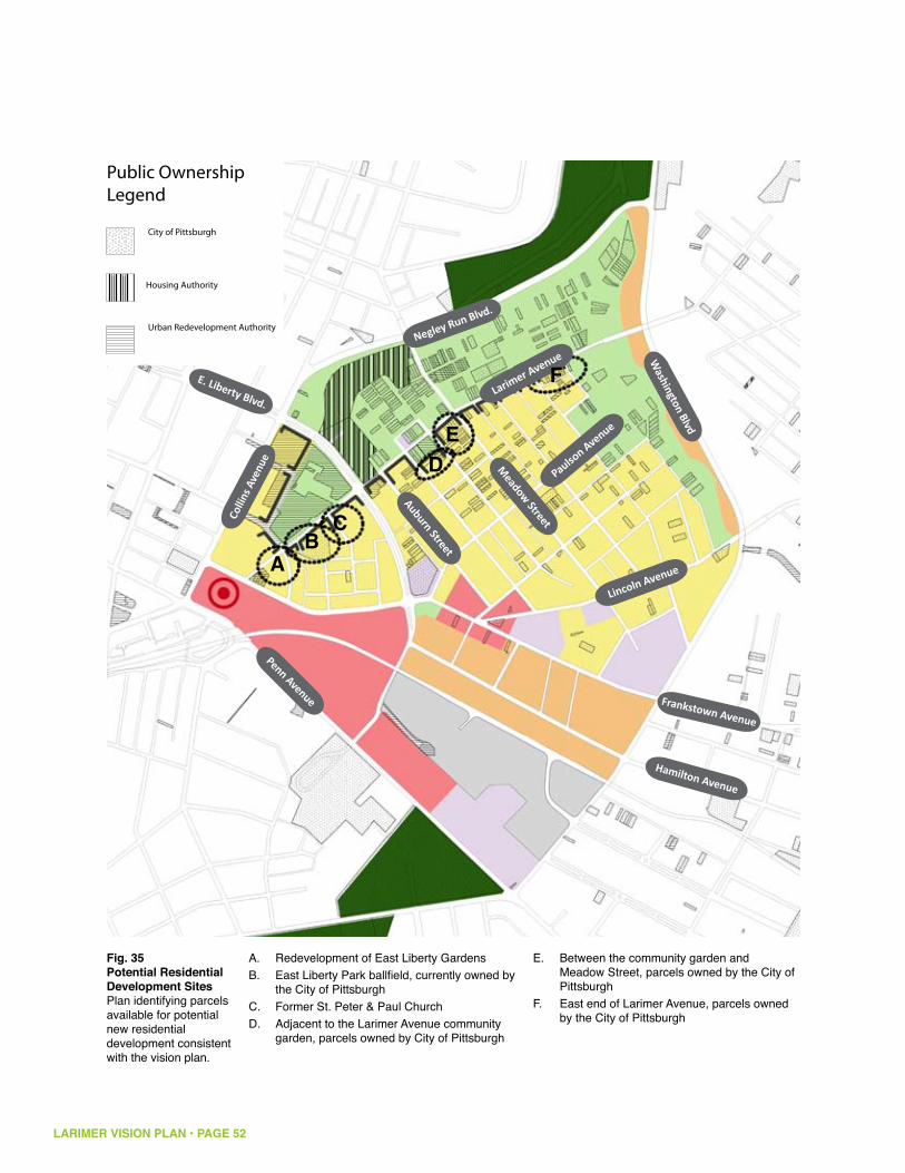
LARIMER VISION PLAN • PAGE 52
Fig. 35Potential Residential Development Sites Plan identifying parcels available for potential new residential development consistent with the vision plan.
Penn Avenue
Larimer Avenue
Negley Run Blvd.
Colli
ns A
venu
e
Lincoln Avenue
Meadow Street
Auburn Street
E. Liberty Blvd.
Frankstown Avenue
Hamilton Avenue
Washington Blvd
Paulson Avenue
Redevelopment of East Liberty GardensA. East Liberty Park ballfield, currently owned by B. the City of PittsburghFormer St. Peter & Paul ChurchC. Adjacent to the Larimer Avenue community D. garden, parcels owned by City of Pittsburgh
Between the community garden and E. Meadow Street, parcels owned by the City of PittsburghEast end of Larimer Avenue, parcels owned F. by the City of Pittsburgh
AB
C
DE
F

LARIMER VISION PLAN • PAGE 53
space began north of the Fairfield Apartments, centered on the former Negley Run watercourse, it might make sense to continue that green space along the Negley Run ravine north through the current Housing Authority site, since it is adjacent to the highest level of vacancy and existing green space.
The Housing Authority has goals for building and managing new housing in the Larimer Avenue corridor that must be addressed before they agree to their current site being green space. First, the Housing Authority would like to develop, possibly in partnership with other entities, 200 new units of mixed income housing, with the distribution of tax-credit, affordable, and market rate units to be determined based on market demand and available financing, but with at least 25% market rate. Sites for this housing, both scattered and assembled at larger scale would have to be identified (figure 34 suggests possible locations). If the Housing Authority agreed to a green space development plan on their current site, they would have to have appropriate, low cost replacement sites for their housing program that also work for their current management practices. Presumably, they would also identify development partners to assemble land suitable for their goals and to collaborate in developing a variety of product types.
Several additional planning exercises must be completed, however, before a permanent boundary for green space is determined. First, the neighborhood must determine a few key things about needs: what is the appropriate density of housing units? What is the appropriate mix between different levels of affordable and market rate? What are neighborhood principles for scattered site housing versus single-site, and what are the ratios of each for an ideal neighborhood? Second, the neighborhood should undergo a green space master-planning exercise that identifies regional need and neighborhood preferences for green space amenities, while also identifying funding mechanisms to build and maintain new green space. Third, a land-use plan for the entire corridor must be developed in concert with the above two activities to ensure that parcels like the Housing Authority’s are put to the best and highest use for the neighborhood and the stakeholders that own its land.
Ultimately, the Housing Authority is a critical partner in the Larimer neighborhood, not just in determining the land use of the land they hold now, but also in developing and managing new housing within the neighborhood. Several key questions must be answered before plans for a green space that runs through or around their current site are finalized.
LARIMER VISION PLAN • PAGE 54
D. Next Steps for Implementing the VisionQuestions to be answered:
What are the locations of strength and stability in the residential areas +and in adjacent neighborhoods that we can use as foundations for future development?
What is the optimal density of the residential area of the neighborhood? +
What is the optimal mix of people of different income levels in the +neighborhood?
How does this translate to different housing types that the neighborhood +should offer? What is the best unit mix for a successful neighborhood? (How many single family homes vs. apartments vs. ownership vs. rental vs. different subsidized and social services based housing units?)
How will land-use transitions happen in each zone? +
What is the best phasing strategy for short term, medium term, and long term +development? What needs to happen first so that other things can follow?
What are the region’s recreational needs versus the neighborhood’s needs? +How is new recreation space paid for and maintained?
Translating our Vision into action:Map the spatial organization of land uses, corridors, enclaves, and +neighborhood groups.
Quantify the vision plan in measurable development objectives/long-range +targets, including population, density, household income distribution, tenure, types and areas of open space, and economically sustainable non-residential uses.
Identify specific projects or initiatives that are catalytic, and stakeholder driven +whenever possible.
Prioritize projects or initiatives based on long-range targets and market +momentum.
Create a phasing plan and develop a two-year action plan to begin +implementation.

LARIMER VISION PLAN • PAGE 55
Establish Larimer Community Green Principles: the community needs to +define for itself what it means to be a state-of-the-art green community that will guide implementation. This could lead to the establishment of a set of design and development guidelines based on the East Liberty Green Vision or other relevant standards such as LEED-ND.
Conduct a Park Development Master Plan: In order to facilitate the +development of Larimer Park a comprehensive master plan needs to be undertaken that addresses the following issues:
An economic feasibility study that analyzes the market opportunities and • capital and operating costs for an active recreation complex, including indoor facilities, as well as the other proposed park functions. The feasibility study should include financial projections and budgets for the capital and operating costs of the park’s development scenarios as well as stewardship and management models for the eventual operation of the park.A phased design and development plan that addresses needs articulated • through the market research and a community process that creates a detailed site plan that can be implemented over time.A green infrastructure plan that utilizes state-of-the-art sustainability • practices in all aspects of both the capital development and on-going operations of the park. Park design and infrastructure development should be integrated into the adjacent land development so that the park functions as an operational piece of the total storm water management plan for the neighborhood.A property acquisition plan for the park that identifies strategies to acquire • the land along the northwest side of Larimer Avenue for inclusion in the new Larimer Park. Whatever strategies are considered, they should all adhere to the general principles of “a house for a house.” Strategies to explore include:
direct purchase• construction of replacement homes• life estate• condemnation •
Develop a Decommissioning and Deconstruction Plan: for both vacant +structures and historic infrastructure that can be converted to green infrastructure. This plan should develop strategies for using the existing vacant structures as a community resource of harvestable building materials, as well as decommissioning of public infrastructure as both an environmental and economic strategy that can reduce the total operating cost of the neighborhood. These cost savings in maintenance of infrastructure could then be translated to funds for redevelopment efforts.


