
Longwalls 900W and 910 Rehabilitation Management Plan
Angus Place Colliery
November 2013

Longwalls 900W and 910 Rehabilitation Management Plan
This page has been intentionally left blank.

Longwalls 900W and 910 Rehabilitation Management Plan
ii
This page has been intentionally left blank.
Longwalls 900W and 910 Rehabilitation Management Plan
iii
TABLE OF CONTENTS 1. INTRODUCTION .............................................................................................................................. 1 2. PURPOSE ........................................................................................................................................ 1 3. SCOPE ............................................................................................................................................. 1 4. REGULATORY REQUIREMENTS .................................................................................................. 4
4.1. Project Approval and Statement of Commitments ................................................................... 4 4.2. Mining Leases .......................................................................................................................... 5 4.3. Other Guidelines ...................................................................................................................... 5
5. RELEVANT FEATURE(S) AND PREDICTED IMPACTS ............................................................... 5 5.1. Relevant Feature(s) ................................................................................................................. 5 5.2. Predicted Impacts .................................................................................................................... 6
5.2.1. Surface Cracking .............................................................................................................. 6 5.2.2. Erosion and Sedimentation .............................................................................................. 6 5.2.3. Ponding ............................................................................................................................ 6 5.2.4. Subsidence Assessment Review ..................................................................................... 7
6. IDENTIFIED RISKS ......................................................................................................................... 7 7. PERFORMANCE MEASURES AND INDICATORS ....................................................................... 9
7.1. Performance Measures ............................................................................................................ 9 7.2. Performance Indicators ............................................................................................................ 9
8. REHABILITATION MANAGEMENT MEASURES .......................................................................... 9 8.1. Management of Minor Subsidence Related Impacts ............................................................. 10
8.1.1. Surface Cracking ............................................................................................................ 12 8.1.2. Erosion and Sedimentation ............................................................................................ 12 8.1.3. Ponding .......................................................................................................................... 13
8.2. Rehabilitation Objectives ........................................................................................................ 13 8.3. Rehabilitation Success Criteria .............................................................................................. 13 8.4. Final Landuse ......................................................................................................................... 17 8.5. Landform Establishment ........................................................................................................ 17 8.6. Topsoil Management .............................................................................................................. 18
8.6.1. Topsoil Stripping and Handling ...................................................................................... 18 8.6.2. Topsoil Re-spreading and Seedbed Preparation ........................................................... 18
8.7. Revegetation .......................................................................................................................... 19 8.8. Rehabilitation Maintenance .................................................................................................... 20
8.8.1. Weed Management ........................................................................................................ 20 8.8.2. Feral Animal Control ...................................................................................................... 21
9. MONITORING PROGRAM ............................................................................................................ 22 9.1. Baseline Monitoring ................................................................................................................ 22 9.2. Monitoring Subsidence Impacts ............................................................................................. 22 9.3. Monitoring Environmental Consequences ............................................................................. 23 9.4. Success of Remediation Measures........................................................................................ 23
9.4.1. Rehabilitation Monitoring ................................................................................................ 23 10. CONSULTATION ........................................................................................................................... 25

Longwalls 900W and 910 Rehabilitation Management Plan
iv
11. ADAPTIVE MANAGEMENT .......................................................................................................... 26 12. CONTINGENCY PLAN .................................................................................................................. 26 13. ROLES AND RESPONSIBILITIES ............................................................................................... 31 14. REPORTING .................................................................................................................................. 31 15. REVIEW ......................................................................................................................................... 32 16. REFERENCES ............................................................................................................................... 33
Tables Table 1. Relevant Project Approval Conditions ........................................................................... 4
Table 2. Relevant Statement of Commitments ............................................................................. 4
Table 3. Relevant Mining Lease Conditions.................................................................................. 5
Table 4. Risk to Rehabilitation ....................................................................................................... 8
Table 5. Preliminary Rehabilitation Success Criteria ................................................................ 14
Table 6. Subsidence Monitoring Program ................................................................................... 22
Table 7. Rehabilitation Monitoring Program ............................................................................... 23
Table 8. Trigger Action Response Plan for Rehabilitation ........................................................ 27
Table 9. Key Personnel and Accountabilities ............................................................................. 31
Figures Figure 1 Regional Locality............................................................................................................... 2
Figure 2 Locality Plan ...................................................................................................................... 3
Figure 3 Rehabilitation Management Process Flowchart .......................................................... 11
Plates Plate 1. Warning Sign at Angus Place .............................................................................................. 12
Appendices Appendix 1 Trigger Action Response Plan for Land Management
Appendix 2 MOP Rehabilitation Table
Appendix 3 Flora Species List
Appendix 4 Stakeholder Consultation
Longwalls 900W and 910 Rehabilitation Management Plan
v
Abbreviations AEMR Annual Environmental Management Report (now known as Annual Review)
CCL Consolidated Coal Lease
DgS Ditton Geotechnical Services Pty Ltd
DP&I NSW Department of Planning and Infrastructure
DTIRIS NSW Department of Trade and Investment, Regional Infrastructure and Services – Division of Resources and Energy
EA Environmental Assessment
EEC Endangered Ecological Community
EPL Environment Protection Licence
ESP Exchange Sodium Percentage
FCNSW Forestry Corporation of NSW
GNSS Global Navigation Satellite Systems
LDP Licenced Discharge Point
ML Mining Lease
MOP Mining Operations Plan
Mtpa Million tonnes per annum
NOW NSW Office of Water
OEH NSW Office of Environment and Heritage
ROM Run of mine
SCA Sydney Catchment Authority
SMP Subsidence Management Plan
TARP Trigger Action Response Plan
Longwalls 900W and 910 Rehabilitation Management Plan
1
1. INTRODUCTION
Angus Place Colliery (Angus Place) is an underground coal mining operation located approximately five kilometres north of the village of Lidsdale, eight kilometres northeast of the township of Wallerawang and approximately 15 kilometres northwest of the city of Lithgow in the Blue Mountains region of NSW. It is bordered by Springvale Colliery to the south, Ivanhoe Colliery to the northwest and Wolgan Valley and Newnes Plateau to the north and east, respectively. The regional locality of Angus Place is shown on Figure 1.
Angus Place has been in operation since 1979 and is operated by Centennial Angus Place Pty Ltd, a joint venture company owned in equal share between the Centennial Coal Company Ltd and SK Kores of Korea. Secondary extraction of coal is currently undertaken at Angus Place utilising the longwall method of mining within Mining Lease (ML) 1424 and Consolidated Coal Lease (CCL) 704.
Project Approval (PA 06_0021) was granted by the then Department of Planning (now Department of Planning and Infrastructure (DP&I)) on 13 September 2006. This approval allowed for an extension of underground longwall mining operations (Longwalls 920 – 980) and an increase in run of mine (ROM) coal production to 3.5 million tonnes per annum (Mtpa). PA 06_0021 has been modified on two occasions. Modification 1 (Mod 1) was approved on 29 August 2011 and allowed for the development and extraction of two additional longwall panels (Longwall 900W and 910) as well as an increase in production limit to 4 Mtpa. Modification 2 (Mod 2) was approved in April 2013 and allowed for the development of underground roadways and the construction and operation of a Ventilation Facility (APC-VS2) and supporting infrastructure.
This Longwalls 900W and 910 Rehabilitation Management Plan (Rehabilitation Management Plan) has been developed in accordance with Schedule 3, Conditions 3C(g) and 37 of PA 06_0021 (as modified) and the Draft Guidelines for the Preparation of Extraction Plans (DP&I, 2012). Regulatory requirements applicable to the development of this Plan are outlined in Section 4.
2. PURPOSE
The purpose of this Rehabilitation Management Plan is to outline the measures to be implemented to rehabilitate potential subsidence related impacts to land resulting specifically from the secondary extraction of Angus Place Longwalls 900W and 910. There is no planned vegetation clearing or direct surface disturbance within the Longwall 900W and 910 area (herein referred to as the Project Area). Subsequently, this Rehabilitation Management Plan is focussed on the remediation of potential subsidence induced surface impacts such as surface cracking, ponding, and erosion and sedimentation. Required actions and responsibilities are defined to ensure detection and remediation of any mining induced subsidence-related impacts.
3. SCOPE
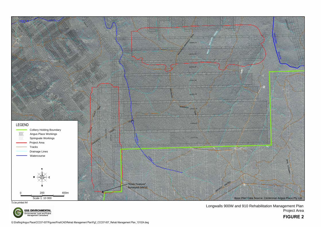
This Rehabilitation Management Plan applies to the rehabilitation of land located within the Project Area. In accordance with the requirements of the Guidelines for Applications for Subsidence Management Approvals (2003), published by the NSW Department of Mineral Resources (now the NSW Department of Trade and Investment, Regional Infrastructure and Services – Division of Resources and Energy (DTIRIS)), this Project Area has been calculated by combining the areas bound by the following limits (see Figure 2):
• A 26.5° angle of draw line from the limit of proposed extraction; and • The predicted limit of vertical subsidence, taken as the 20mm subsidence contour resulting
from the extraction of the Longwalls 900W and 910.

Capertree
Ben Bullen
Lithgow
Marrangaroo
Wallerawang
Rydal
Mount Lambie
Meadow Flat
Blackmans Flat
Cullen Bullen
Great
Western
Highway
CastlereaghHighway
Lidsdale
Springvale
BellsLine
Road
Of
Portland
Wolgan River
Turon River
Fish R.
CoxsRiver
ML1424
ML1326
CCL704
MountVictoria
FIGURE 1
Longwalls 900W and 910 Rehabilitation Management Plan
Regional Locality
To be printed A4
G:\Drafting\Angus Place\CCC07-007\Figures\Final\CAD\Rehab Management Plan\Fg1_CCC07-007_Locality_130918.dwg
V:\GSSE Drawing Templates\logo for title block.jpg
LEGEND
0 8.0 km4.0
Scale 1: 200 000
Colliery Holding Boundary
Mining Lease Boundary
Project Area
Major Roads
Major Waterways
Railway
Built-up areas
NewcastleSydney
Canberra
DubboTamworth
MuswellbrookSingleton
Angus Place
DIST
RICT
MAI
N NO
RTH
1
5
5
1
0
"
A
"
"
B
"
"
C
"
"
D
"
"
E
"
"
F
"
"
A
"
"
B
"
35
34
36
37
38
LONGWALL 950
LONGWALL 960
LONGWALL 970
DISTRICT 100
DISTRICT
100D
DISTRICT 303
DIST
RICT
900
LONGWALL 920
LONGWALL 930
LONGWALL 940
LONGWALL 1LONGWALL 2
ShaftUpcast
LONGWALL 910
LONG
WAL
L 900
WES
T
LONGWALL 980LO
NGW
ALL N
o.1
LONG
WAL
L 40
1
LONG
WAL
L 40
2
LONG
WAL
L 40
3
LONG
WAL
L 40
4
LONG
WAL
L 40
5
LONG
WAL
L 40
6
LONG
WAL
L 40
7
LONG
WAL
L 40
8
LONG
WAL
L 40
9
LONG
WAL
L 41
0
LONG
WAL
L 41
1
LONG
WAL
L 41
2
"Rock Feature"
Surveyed 3/8/12
KANGAROO
CR
EE
K
W
O
L
G
A
N
R
IV
E
R
K
A
N
G
A
R
O
O
C
R
E
E
K
CAMP
BELL
S
ROAD
BEECROFT FIRETRAIL
B
E
E
C
R
O
F
T
F
I
R
E
T
R
A
I
L
K
A
N
G
A
R
O
O
C
R
E
E
K
R
O
A
D
A
N
G
U
S
T
R
A
I
L
P
L
A
C
E
M
A
Y
IN
Y
G
U
M
AR
RA
GU
T
R
A
I
L
M
A
Y
I
N
Y
G
U
M
A
R
R
A
G
U
T
R
A
I
L
C
R
E
E
K
W
O
L
G
A
N
W
E
S
T
Base Plan Data Source: Centennial Angus Place Pty Ltd
FIGURE 2
Longwalls 900W and 910 Rehabilitation Management Plan
Project Area
To be printed A4
G:\Drafting\Angus Place\CCC07-007\Figures\Final\CAD\Rehab Management Plan\Fg2_CCC07-007_Rehab Management Plan_131024.dwg
0 400m200
Scale 1: 10 000
LEGENDColliery Holding Boundary
Angus Place Workings
Project Area
Springvale Workings
Tracks
Drainage Lines
Watercourse
Longwalls 900W and 910 Rehabilitation Management Plan
4
4. REGULATORY REQUIREMENTS
4.1. Project Approval and Statement of Commitments
Project Approval PA 06_0021 (as modified) includes a number of conditions relevant to the preparation and implementation of a Rehabilitation Management Plan for the Project Area. Conditions relating specifically to the preparation of this Plan have been summarised in Table 1. This table also outlines the sections where these conditions have been addressed within this document.
Table 1. Relevant Project Approval Conditions
Condition Condition Requirement Section Addressed
Schedule 3, Condition 3C
The Proponent shall prepare and implement Extraction Plan/s for the second workings in Longwalls 910 and 900W to the satisfaction of the Director-General. Each Extraction Plan must: g) include the following to the satisfaction of the
Executive Director Mineral Resources:
• appropriate revisions to the Rehabilitation Management Plan required under condition 37;
This document
Schedule 3, Condition 37
The Proponent shall prepare and implement a Rehabilitation Management Plan for the project, to the satisfaction of the Director-General and Executive Director Mineral Resources. This plan must be: a) submitted to the Director-General for approval prior to
the commencement of secondary extraction in either of longwalls 900W or 910;
This document
b) prepared in consultation with DRE, Forests NSW, OEH, NOW, SCA and Council; and Section 10
c) prepared in accordance with the relevant DRE guideline. Section 4.3
Table 2 provides the details of the relevant commitment made by Angus Place in the Mod 1 Statement of Commitments, which is appended to PA 06_0021 (as modified). In accordance with Schedule 2, Condition 3 of PA 06_0021 (as modified), if there is any inconsistency between the Mod 1 Statement of Commitments and the conditions of the Project Approval, the conditions of the approval shall prevail to the extent of any inconsistency. Subsequently, Angus Place has submitted this Rehabilitation Management Plan to satisfy the Commitment 1 of the Mod 1 Statement of Commitments.
Table 2. Relevant Statement of Commitments Commitment Statement of Commitment Section Addressed
1
A Rehabilitation Strategy as set out in Appendix 7.6 and revised in relation to the measures identified for the rehabilitation of areas of construction for the dewatering bore at Longwall 910 and its associated infrastructure that have been withdrawn from the proposals of the EA will be developed for approval by the Director-General I&I NSW prior to commencement of Longwalls 910 and 900 west and within 12 months of the date of approval.
This document

Longwalls 900W and 910 Rehabilitation Management Plan
5
Please note that the Mod 2 Statement of Commitments, also appended to PA 06_0021 (as modified) specifically relates to the Ventilation Facility Project. On this basis, these commitments have not been addressed within this Rehabilitation Management Plan for Longwalls 900W and 910.
4.2. Mining Leases
The Project Area is associated with three mining tenements; ML 1326, ML 1424 and CCL 704. Conditions relevant to the preparation of this Rehabilitation Management Plan have been provided in Table 3.
Table 3. Relevant Mining Lease Conditions
Mining Lease Requirement Section Addressed
CCL 704, Condition 7 Disturbed land must be rehabilitated to a sustainable/agreed end land use to the satisfaction of the Director General.
Section 8.2
ML 1326 Condition 29 and ML 1424 Condition
32
The lease holder shall: j) complete work in relation to rehabilitation within the
Warragamba Outer Catchment Area before termination of the authority to the satisfaction of the Authority.
Section 8.2
4.3. Other Guidelines
This report has generally been prepared in accordance with the requirements of the following relevant strategic land use planning and resource management plans and policies relating to mine rehabilitation and mine closure:
• EDG 03 Guidelines to the Mining, Rehabilitation and Environmental Management Process (DTIRIS, 2012)
• The Strategic Framework for Mine Closure (ANZMEC and Minerals Council of Australia, 2000);
• Best Practice Environmental Management in Mining: Landform Design for Rehabilitation (Department of Environment, 1998);
• Mine Rehabilitation – Leading Practice Sustainable Development Program for the Mining Industry (Commonwealth of Australia, 2006);
• Mine Closure and Completion - Leading Practice Sustainable Development Program for the Mining Industry (Federal Department of Industry, Tourism and Resources, 2002); and
• The approved Mining Operations Plan (MOP) (GSS Environmental, 2013).
5. RELEVANT FEATURE(S) AND PREDICTED IMPACTS
5.1. Relevant Feature(s)
All land overlying the Project Area is within the Newnes State Forest, managed by the Forestry Corporation of NSW (FCNSW) as part of a forestry enterprise. The predominant land uses within the State Forest include native hardwood harvesting and recreational activities such as bushwalking, motor cycling and four wheel drive pursuits. A number of publicly-accessible forest tracks are located within the Project Area including Kangaroos Creek Road, Beecroft Fire Trail, Mayinygu Marragu Trail and Angus Place Trail (see Figure 2).
As outlined in the Surface Water Assessment (GHD, 2010), which was prepared as part of the Mod 1 Environmental Assessment (EA) titled Angus Place Colliery, NSW Modification of Project Approval 06_0021 under Section 75W, Part 3A (RPS, 2010), there is one ephemeral drainage line located

Longwalls 900W and 910 Rehabilitation Management Plan
6
above Longwall 910, known as West Wolgan Creek. There are two first order tributaries of Kangaroo Creek located above Longwall 900W. The locations of drainage lines associated with the Project Area are shown on Figure 2.
5.2. Predicted Impacts
5.2.1. Surface Cracking
As a component of the Mod 1 EA titled Angus Place Colliery, NSW Modification of Project Approval 06_0021 under Section 75W, Part 3A (RPS, 2010), Ditton Geotechnical Services Pty Ltd (DgS) prepared a Subsidence Prediction and Impact Assessment (DgS, 2010) which outlined the predicted subsidence related impacts associated with the proposed development and secondary extraction of Longwalls 900W and 910. In this report, DgS (2010) states surface cracking widths of between 1mm - 20mm may occur within the limits of extraction and up to 90mm where competent rock is exposed near strain peaks. It is however considered unlikely by DgS (2010) that the cracks will occur as a single crack where deep soil or weathered surface rock exists, instead presenting as several smaller width cracks. With regard to cracking of forest access tracks within the Project Area, DgS (2010) predicts that the worst case crack width is estimated to range between 20mm – 90mm. It is expected that approximately 30m – 50m long sections of the tracks above each of the longwalls may require repairs to tensile cracking or compressive shear failures through the road after each panel is completed.
Minor transient surface cracking with widths <20mm may develop behind the retreating secondary extraction face and along and across creek beds or watercourses that are undermined (DgS, 2010). Cracks that occur within the drainage gullies or creek beds may result in sub-surface re-routing of surface flows during storm periods and particularly those areas that have bedrock exposed. However, the impacts in most cases should be self-healing, due to sediment bed load that is likely to accumulate in the cracks after several storm events occur.
5.2.2. Erosion and Sedimentation
Minor surface cracking and deformation is anticipated to occur within the tributaries of Kangaroo Creek as a result of mining (DgS, 2010). However, the long term geomorphologic impacts as a result of changes to longitudinal gradients and surface cracking are expected to be negligible and therefore no consequences are expected (GHD, 2010).
There is only one ephemeral drainage line located in the Project Area, referred to as West Wolgan Creek. Based on pre and post mining terrain change analysis, the Subsidence Prediction and Impact Assessment (DgS, 2010) estimates that the section of West Wolgan Creek that overlies Longwall 910 would be subject to grade changes of +0.1% to -0.6%. Predictions also include additional subsidence of between 0.15m – 0.25m over Longwalls 920 and 930 as a result of the secondary extraction within Longwall 910 (DgS, 2010). The existing grade of this section of creek is relatively steep (approximately 3%) and these grade change estimates would not have a significant impact on existing erosion rates and therefore no consequences are expected (GHD, 2010).
5.2.3. Ponding
DgS (2010) predicted that some minor ponding to a depth of 0.1m may occur towards the downstream extent of the section of West Wolgan Creek overlying Longwall 910. This would potentially result in an increase from the existing depth of 0.67m to 0.72m. The estimated volume of predicted ponding based on this depth is 0.05 megalitres and the impact on flow transfers downstream is considered to be negligible (GHD, 2010).
It is also expected that the impact of increased ponding along the creek beds is likely to be contained ‘in-channel’ and therefore the effects upon existing flora and fauna is likely to be minimal (DgS, 2010).

Longwalls 900W and 910 Rehabilitation Management Plan
7
5.2.4. Subsidence Assessment Review
As a component of the Longwalls 900W and 910 Integrated SMP/Extraction Plan, DgS completed a review of the Subsidence Prediction and Impact Assessment (DgS, 2010). This review was completed to satisfy the requirement of Schedule 3, Condition 3C(e) of PA 06_0021 (as modified), which requires the proponent to:
“Provide revised predictions of the potential subsidence effects, subsidence impacts and environmental consequences of the proposed second workings, incorporating any relevant information obtained since this approval.”
The report titled Subsidence Assessment Review for the Longwalls 900W and 910 Integrated SMP/Extraction Plan, Centennial Angus Place Colliery (DgS, 2013), incorporated relevant information obtained by Angus Place since the approval of PA 06_0021 (Mod 1) in August 2011, including subsidence monitoring data and observed subsidence effects following the completion of secondary extraction in Longwalls 960 and 970, and a change to the mining height within Longwalls 900W and 910.
The Subsidence Prediction and Impact Assessment (DgS, 2010) assessed potential subsidence effects based upon a mining height of 3.25 m. Angus Place will now mine Longwalls 900W and 910 at an extraction height up to 3.425 m. This change has been assessed by DgS (2013) which concluded that “the observed and predicted subsidence impacts and environmental consequences for LWs 960 and 970 have also been consistent with predictions for LWs 900W and 910, and as such, the predicted ‘negligible’ environmental consequences for LWs 900W and 910 are not expected to change from the previous assessment due to the 5% increase in mining height.”
“It is therefore considered that the impact management strategies for the environment and site developments (e.g. access roads and Endeavour Energy 66kV power line) that were outlined in DgS, 2010 are still valid and do not require amendment” (DgS, 2013). The management measures as outlined in Section 8 are consistent with the impact management strategies outlined in the Subsidence Prediction and Impact Assessment (DgS, 2010).
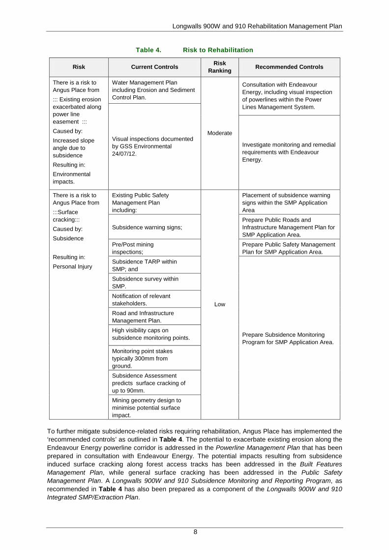
6. IDENTIFIED RISKS
On 25th July 2012 a Subsidence Management Plan (SMP) Risk Assessment was conducted to identify subsidence-related hazards that may affect the environment and community as a result of the extraction of Angus Place Longwalls 900W and 910. This risk assessment was completed in accordance with the requirements of the Guideline for Applications for Subsidence Management Approvals (Department of Mineral Resources, 2003) and the Centennial Coal Risk Management Standard - Management Standard 004 (Centennial Coal, 2008).
Risks were identified and assessed through the review of known surface and sub-surface features within the Project Area. A risk ranking (low, moderate, significant, high or extreme) was assigned to each risk/hazard. There were two potential risks that related to rehabilitation identified during the SMP Risk Assessment which related to: potential for subsidence to exacerbate existing erosion along the power line corridor (moderate risk); and subsidence induced surface cracking (low risk). Although the maximum consequence for subsidence related erosion was ranked as insignificant, the moderate risk ranking was assigned due to the likelihood of this occurring (ranked as probable) as a result of subsidence along the Endeavour Energy powerline corridor. These risks and the recommended controls have been presented in Table 4.
Longwalls 900W and 910 Rehabilitation Management Plan
8
Table 4. Risk to Rehabilitation
Risk Current Controls Risk Ranking Recommended Controls
There is a risk to Angus Place from ::: Existing erosion exacerbated along power line easement ::: Caused by: Increased slope angle due to subsidence Resulting in: Environmental impacts.
Water Management Plan including Erosion and Sediment Control Plan.
Moderate
Consultation with Endeavour Energy, including visual inspection of powerlines within the Power Lines Management System.
Visual inspections documented by GSS Environmental 24/07/12.
Investigate monitoring and remedial requirements with Endeavour Energy.
There is a risk to Angus Place from :::Surface cracking::: Caused by: Subsidence Resulting in: Personal Injury
Existing Public Safety Management Plan including:
Low
Placement of subsidence warning signs within the SMP Application Area
Subsidence warning signs;
Prepare Public Roads and Infrastructure Management Plan for SMP Application Area.
Pre/Post mining inspections;
Prepare Public Safety Management Plan for SMP Application Area.
Subsidence TARP within SMP; and
Prepare Subsidence Monitoring Program for SMP Application Area.
Subsidence survey within SMP.
Notification of relevant stakeholders.
Road and Infrastructure Management Plan.
High visibility caps on subsidence monitoring points.
Monitoring point stakes typically 300mm from ground.
Subsidence Assessment predicts surface cracking of up to 90mm.
Mining geometry design to minimise potential surface impact.
To further mitigate subsidence-related risks requiring rehabilitation, Angus Place has implemented the ‘recommended controls’ as outlined in Table 4. The potential to exacerbate existing erosion along the Endeavour Energy powerline corridor is addressed in the Powerline Management Plan that has been prepared in consultation with Endeavour Energy. The potential impacts resulting from subsidence induced surface cracking along forest access tracks has been addressed in the Built Features Management Plan, while general surface cracking has been addressed in the Public Safety Management Plan. A Longwalls 900W and 910 Subsidence Monitoring and Reporting Program, as recommended in Table 4 has also been prepared as a component of the Longwalls 900W and 910 Integrated SMP/Extraction Plan.

Longwalls 900W and 910 Rehabilitation Management Plan
9
Additional detail regarding the rehabilitation of subsidence related cracking, ponding and erosion within the Project Area has been detailed in Section 8. Monitoring of any rehabilitation within the Project Area has been outlined in Section 9.4.1.
7. PERFORMANCE MEASURES AND INDICATORS
7.1. Performance Measures
Subsidence impact performance measures are specified in Schedule 3, Condition 3 of PA 06_0021 (as modified). The performance measure specifically relating to rehabilitation is:
• Damage to built features (forest access roads and tracks) must be fully repaired or replaced, or else fully compensated.
7.2. Performance Indicators
As outlined in Section 5.2, there is a low likelihood that there will be a requirement for Angus Place to undertake rehabilitation of subsidence induced ponding or erosion and sedimentation within the Project Area. DgS (2010) predicted that approximately 30m – 50m long sections of the tracks above each of the longwalls may require repairs to tensile cracking or compressive shear failures through the road after each panel is completed. It is expected, based upon site experience, that such remediation works will be minor in nature and will not generally require revegetation works. Accordingly, Angus Place will undertake the management/repair of all minor subsidence impacts as per the methodology outlined in Section 8.1. For the purpose of this Rehabilitation Management Plan, minor subsidence impacts are defined as being consistent with the predictions of the Subsidence Prediction and Impact Assessment (DgS, 2010) (see Section 5.2).
In the event that subsidence induced cracking, ponding or erosion and sedimentation within the Project Area is beyond the extent of impacts predicted by DgS (2010) and significant rehabilitation is required, Angus Place will undertake appropriate rehabilitation works (see Section 8) and implement the rehabilitation monitoring program outlined in Section 9.4.1. This monitoring program will be used to establish compliance with the performance measures outlined in Section 7.1 and to assess the environmental performance of rehabilitation against the following performance indicators:
• Adequate condition of slopes, drainage and erosion on rehabilitation areas; • Water management structures are safe, stable and non-polluting; • Soil parameters adequate to sustain ecosystems; • Vegetation communities and structure development consistent with analogue communities;
and • Water quality within the parameters of Angus Place Environmental Protection Licence (EPL)
467 and PA 06_0021.
8. REHABILITATION MANAGEMENT MEASURES
There is no planned vegetation clearing or direct surface disturbance within the Project Area, subsequently rehabilitation is expected to be limited to minor repairs of subsidence induced surface cracking, ponding, and erosion and sedimentation. The management and repair of minor subsidence related impacts within the Project Area will be undertaken as per the methodology outlined in Section 8.1.
In the event that subsidence induced cracking, ponding or erosion and sedimentation within the Project Area is beyond the extent of impacts predicted by DgS (2010) and significant rehabilitation is required, Angus Place will implement rehabilitation activities in accordance with the rehabilitation

Longwalls 900W and 910 Rehabilitation Management Plan
10
management process flowchart shown in Figure 3. Additional detail regarding the rehabilitation management measures that will be implemented by Angus Place within the Project Area (if required) have been provided in Sections 8.2 – 8.8. Monitoring of rehabilitation is outlined in Section 9.4.1.
8.1. Management of Minor Subsidence Related Impacts
As per the recommendations of the Subsidence Prediction and Impact Assessment (DgS, 2010), the management measures specified in Sections 8.1.1 – 8.1.3 will be implemented by Angus Place during the secondary extraction of Longwalls 900W and 910 to monitor and manage minor subsidence induced surface cracking, ponding and erosion within the Project Area.
The management of mining induced surface cracking, ponding and erosion and sedimentation within the Project Area will be undertaken in accordance with a Trigger Action Response Plan (TARP) for Land Management. A copy of this TARP from the Longwalls 900W and 910 Land Management Plan (Land Management Plan) has been provided in Appendix 1.

Longwalls 900W and 910 Rehabilitation Management Plan
11
Figure 3 Rehabilitation Management Process Flowchart
Longwalls 900W and 910 Rehabilitation Management Plan
12
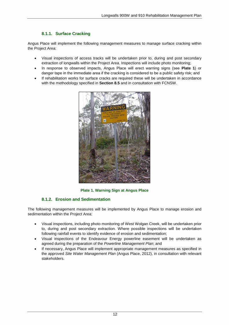
8.1.1. Surface Cracking
Angus Place will implement the following management measures to manage surface cracking within the Project Area:
• Visual inspections of access tracks will be undertaken prior to, during and post secondary extraction of longwalls within the Project Area. Inspections will include photo monitoring;
• In response to observed impacts, Angus Place will erect warning signs (see Plate 1) or danger tape in the immediate area if the cracking is considered to be a public safety risk; and
• If rehabilitation works for surface cracks are required these will be undertaken in accordance with the methodology specified in Section 8.5 and in consultation with FCNSW.
Plate 1. Warning Sign at Angus Place
8.1.2. Erosion and Sedimentation
The following management measures will be implemented by Angus Place to manage erosion and sedimentation within the Project Area:
• Visual inspections, including photo monitoring of West Wolgan Creek, will be undertaken prior to, during and post secondary extraction. Where possible inspections will be undertaken following rainfall events to identify evidence of erosion and sedimentation;
• Visual inspections of the Endeavour Energy powerline easement will be undertaken as agreed during the preparation of the Powerline Management Plan; and
• If necessary, Angus Place will implement appropriate management measures as specified in the approved Site Water Management Plan (Angus Place, 2012), in consultation with relevant stakeholders.
Longwalls 900W and 910 Rehabilitation Management Plan
13
8.1.3. Ponding
Angus Place will undertake the following measures in accordance with the approved Site Water Management Plan (Angus Place, 2012) and the recommendations of the Subsidence Prediction and Impact Assessment (DgS, 2010) to monitor and manage potential ponding within the Project Area:
• Visual inspections, including photo monitoring of West Wolgan Creek, will be undertaken prior to, during and post secondary extraction. Where possible inspections will be undertaken following rainfall events to identify evidence of temporary/permanent ponding;
• If visual inspections along West Wolgan Creek identify that there is evidence of temporary/permanent ponding within the Project Area, Angus Place will undertake a review and appraisal of changes to drainage paths and surface vegetation; and
• If necessary, Angus Place will develop an appropriate management strategy in consultation with relevant NSW Government Agencies (including FCNSW).
8.2. Rehabilitation Objectives
The approved Angus Place MOP (GSS Environmental, 2013) and PA 06_0021 (as modified), set out specific rehabilitation objectives. These objectives are:
• Rehabilitation and the outcomes will be consistent with the Mod 1 EA (RPS, 2010); • Rehabilitation will be based on mine closure criteria and outcomes developed through
stakeholder consultation; • Compliance with the relevant regulatory requirements and that regulatory consensus is
attained on the successful closure and rehabilitation of the site; • Rehabilitation of native vegetation will be integrated with undisturbed native vegetation to
provide consolidated areas and wildlife corridors where possible; • The rehabilitation area will be rehabilitated to an agreed final land use compatible with the
surrounding land fabric and land use requirements; • The rehabilitation process will address limitations of land capability that may arise as a
consequence of mining; • The rehabilitation will be sustainable in terms of selected final land use; • The rehabilitated site will be stable with permanent landforms with soils, hydrology and
ecosystems having maintenance needs no greater than those of the surrounding land; • Waste substances that have the potential to affect land use or result in pollution will be
secured and safely contained until they can be removed from site by licenced waste contractors;
• The rehabilitated site will not present a hazard to persons, stock or native fauna; • The site will be clean and tidy and any remaining structures will be left in a condition that
provides for the safety of the public; and • Mine closure works are completed as quickly and cost effective as possible whilst providing
that the above objectives are achieved.
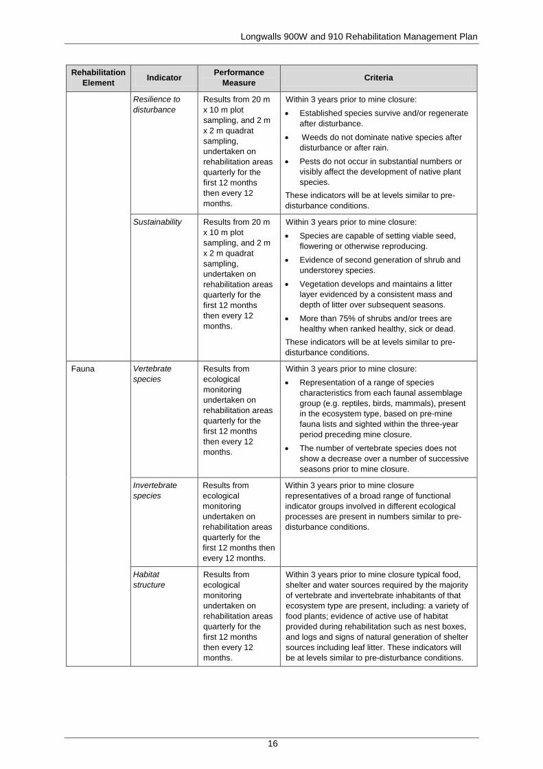
8.3. Rehabilitation Success Criteria
Preliminary success criteria (or closure criteria) for rehabilitation areas are presented in Table 5. The success criteria are performance objectives or standards against which rehabilitation success in achieving a sustainable system for the proposed post-mine land use is demonstrated. Satisfaction and maintenance of the success criteria (as indicated by monitoring results) will demonstrate that the rehabilitated landscape is ready to be relinquished from the mine’s financial assurance and could be handed back to stakeholders in a productive and sustainable condition.
The success criteria will be reviewed every three to five years with stakeholder participation to ensure the nominated success criteria remain realistic and achievable. Angus Place has an existing

Longwalls 900W and 910 Rehabilitation Management Plan
14
relationship with FCNSW and therefore it is expected that the open communications will continue to facilitate agreements on rehabilitation and closure criteria.
The rehabilitation success criteria comprise indicators for landform stability, and safety on a landform-type basis that reflects the nominated post-mine land use of a mosaic of native woodland and forests. For each element, standards that define rehabilitation success at mine closure are provided. Based on the generic indicators in Table 5, each criterion will be further developed to be specific, measurable, achievable, realistic and outcome based, and to reflect the principle of sustainable development. This will be based on results of further research and ongoing monitoring of the progressive rehabilitation areas. Further detail regarding rehabilitation success criteria is included in the approved MOP rehabilitation table, which has been provided as Appendix 2.
Table 5. Preliminary Rehabilitation Success Criteria
Rehabilitation Element Indicator Performance
Measure Criteria
Landform stability
Slope gradient Annual geotechnical stability inspection
Within 12-months of undertaking rehabilitation, no less than 75% of the area has slopes <10°. Where the slopes are steeper, additional water management structures will be utilised (as required). Where reject layers are present and exposed, the landform is capped with a minimum of 1.5m of inert material and be free-draining.
Erosion control Results from erosion monitoring (50m transect) undertaken 1 year after establishment then every 2 years.
Within 12 months of undertaking rehabilitation:
• Erosion control structures are installed at intervals commensurate with the slope of the landform.
• Average soil loss per annum is <40 tonnes/ha/yr (sheet erosion).
• Dimensions and frequency of occurrence of erosion rills and gullies are generally no greater than that in reference sites that exhibit similar landform characteristics.
Surface Water Drainage
Results from erosion monitoring (50m transect) undertaken 1 year after establishment then every 2 years. Annual geotechnical stability inspection
Within 12 months of undertaking rehabilitation:
• Use of contour banks and diversion drains to direct water into stable areas or sediment control basins.
• All landforms will be free draining except where specific structures (i.e. LDP003) have been constructed for the storage of water as required for sediment and erosion control or some post mining landuse.
Water quality EC, pH, TSS and oil and grease
Quarterly water quality monitoring (or following rainfall) in accordance with the Site Water Management Plan
Ensure receiving waters affected by surface water runoff have contaminant limits of the EPL at all times.

Longwalls 900W and 910 Rehabilitation Management Plan
15
Rehabilitation Element Indicator Performance
Measure Criteria
Topsoil Salinity (electrical conductivity)
Analyses of soil samples from 20 m x 10 m plot sampling undertaken quarterly for the first 12 months then every 12 months
Soil salinity content is <0.6 dS/m within 12 months of rehabilitation.
pH Soil pH is between 5.5 and 8.5 within 12 months of rehabilitation.
Sodium content Soil Exchange Sodium Percentage (ESP) is <15% within 12 months of rehabilitation.
Nutrient cycling Within 12 months of rehabilitation, nutrient accumulation and recycling processes are occurring as evidenced by the presence of a litter layer, mycorrhizae and/or other microsymbionts. Adequate macro and micro-nutrients are present.
Vegetation Land use Results from 20 m x 10 m plot sampling, and 2 m x 2 m quadrat sampling, undertaken on rehabilitation areas quarterly for the first 12 months then every 12 months.
Area accomplishes and remains as a healthy native woodland within 3 years prior to mine closure.
Surface cover Results from 20 m x 10 m plot sampling, and 2 m x 2 m quadrat sampling, undertaken on rehabilitation areas quarterly for the first 12 months then every 12 months. Photographic records
Within 3 years prior to mine closure:
• Minimum of 70% vegetative cover is present (or 50% if rocks, logs or other features of cover are present).
• No bare surfaces >20 m2 in area or >10 m in length down slope.
Species composition
Results from 20 m x 10 m plot sampling, and 2 m x 2 m quadrat sampling, undertaken on rehabilitation areas quarterly for the first 12 months then every 12 months.
Within 3 years prior to mine closure, subject to proposed land use, comprise a mixture of native trees, shrubs and grasses representative of regionally occurring woodland.
Longwalls 900W and 910 Rehabilitation Management Plan
16
Rehabilitation Element Indicator Performance
Measure Criteria
Resilience to disturbance
Results from 20 m x 10 m plot sampling, and 2 m x 2 m quadrat sampling, undertaken on rehabilitation areas quarterly for the first 12 months then every 12 months.
Within 3 years prior to mine closure:
• Established species survive and/or regenerate after disturbance.
• Weeds do not dominate native species after disturbance or after rain.
• Pests do not occur in substantial numbers or visibly affect the development of native plant species.
These indicators will be at levels similar to pre-disturbance conditions.
Sustainability Results from 20 m x 10 m plot sampling, and 2 m x 2 m quadrat sampling, undertaken on rehabilitation areas quarterly for the first 12 months then every 12 months.
Within 3 years prior to mine closure:
• Species are capable of setting viable seed, flowering or otherwise reproducing.
• Evidence of second generation of shrub and understorey species.
• Vegetation develops and maintains a litter layer evidenced by a consistent mass and depth of litter over subsequent seasons.
• More than 75% of shrubs and/or trees are healthy when ranked healthy, sick or dead.
These indicators will be at levels similar to pre-disturbance conditions.
Fauna Vertebrate species
Results from ecological monitoring undertaken on rehabilitation areas quarterly for the first 12 months then every 12 months.
Within 3 years prior to mine closure:
• Representation of a range of species characteristics from each faunal assemblage group (e.g. reptiles, birds, mammals), present in the ecosystem type, based on pre-mine fauna lists and sighted within the three-year period preceding mine closure.
• The number of vertebrate species does not show a decrease over a number of successive seasons prior to mine closure.
Invertebrate species
Results from ecological monitoring undertaken on rehabilitation areas quarterly for the first 12 months then every 12 months.
Within 3 years prior to mine closure representatives of a broad range of functional indicator groups involved in different ecological processes are present in numbers similar to pre-disturbance conditions.
Habitat structure
Results from ecological monitoring undertaken on rehabilitation areas quarterly for the first 12 months then every 12 months.
Within 3 years prior to mine closure typical food, shelter and water sources required by the majority of vertebrate and invertebrate inhabitants of that ecosystem type are present, including: a variety of food plants; evidence of active use of habitat provided during rehabilitation such as nest boxes, and logs and signs of natural generation of shelter sources including leaf litter. These indicators will be at levels similar to pre-disturbance conditions.

Longwalls 900W and 910 Rehabilitation Management Plan
17
Rehabilitation Element Indicator Performance
Measure Criteria
Safety Risk assessment
Risk assessment results.
Any future risk assessments to be undertaken in accordance with relevant guidelines and Australian Standards and risks reduced to levels agreed with the stakeholders.
8.4. Final Landuse
The proposed post mining land use for the Project Area is State Forest. The final landuse and biodiversity/habitat values for this site will be consistent with surrounding vegetation communities. The appropriate rehabilitation and management techniques, as outlined in this report, when implemented post mining, will ensure land capability and forestry values are re-instated. The final landform will only consist of minor changes in topography of that which already exists on site (i.e. prior to undermining), caused by the minor subsidence levels/impacts predicted by DgS (2010) (see Section 5.2).
Provided that environmental controls (particularly subsidence management and erosion and sediment controls) are in place there should be no adverse effects to the Project Area or surrounding land.
8.5. Landform Establishment
The predicted maximum final subsidence from Longwalls 900W and 910 is expected to range from 0.69m - 1.47m as described in the Subsidence Prediction and Impact Assessment (DgS, 2010). DgS has predicted that surface cracking widths of between 1mm - 20mm may occur within the limits of extraction and up to 90mm where competent rock is exposed near strain peaks. It was however considered unlikely that the cracks would occur as a single crack, instead presenting as several smaller width cracks. DgS (2010) considered that surface crack repair works would be unlikely to be needed across the panels after mining, unless cracking develops across public access roads.
Nevertheless, should subsidence impacts occur to surface features, rehabilitation will be undertaken in accordance with the relevant management plans prepared as components of the Longwalls 900W and 910 Integrated SMP/Extraction Plan.
Whilst the majority of subsidence impacts should be adequately repaired naturally through sedimentation and infilling of vegetation and surface debris, rehabilitation methods for surface features may include such actions as repairing surface cracks in roads and general disturbed areas where the land surface has been cleared, or surface cracking in the natural environment, and will be undertaken as per Best Practice for Landform Design in Rehabilitation (Department of Environment, 1998) and Mine Rehabilitation – Leading Practice Sustainable Development Program for the Mining Industry (Commonwealth of Australia, 2006).
Should cracking occur in roads or general disturbed areas, the surface will be graded and the cracks filled with sand, or other suitable material, prior to the surface being re-graded and compacted. If the area is no longer utilised, it will be deep ripped, topsoiled and appropriately revegetated, as detailed in Section 8.7.
Subsidence cracking on the Newnes Plateau may also occur in densely vegetated areas away from established tracks. In such instances where access by equipment is an issue, the most natural way to rehabilitate surface cracking is to place locally occurring vegetative matter above or within the cracks, hastening the natural processes that occur over a prolonged period. Appropriate materials placed in or above the cracks will be determined by the size of the cracks and the intended depth to which these materials would be used in the rehabilitation. Logs, sticks, leaf litter and local soil (ensuring a localised seed bank) could all be placed within and/or above the cracks. This form of rehabilitation would result in a natural looking rehabilitated crack that would continue to accumulate additional

Longwalls 900W and 910 Rehabilitation Management Plan
18
natural leaf litter and debris over time. Using this method of rehabilitation would avoid additional access requirements and significant disturbance to existing natural vegetation.
8.6. Topsoil Management
Angus Place recognises the importance of appropriate soil identification, stripping, and management practices for successful rehabilitation and the achievement of the desired post-closure land use. Soil resources will be utilised to rehabilitate areas of direct surface disturbance. In the event that subsidence related impacts within the Project Area exceed the predictions outlined in the Subsidence Prediction and Impact Assessment (DgS, 2010) and the management of topsoil is required, it will be undertaken as outlined in Sections 8.6.1 and 8.6.2.
8.6.1. Topsoil Stripping and Handling
Where topsoil stripping and transportation is required, the following proposed topsoil handling techniques, as detailed in the approved MOP (GSS Environmental; 2013), would be adopted to prevent excessive soil deterioration:
• Topsoil will be maintained in a slightly moist condition during stripping; material should not be stripped in either an excessively dry or wet condition;
• Soil will be graded or pushed into windrows with excavators, graders or dozers for loading into rear dump trucks by front-end loaders. This is the preferred method because it minimises compression effects of the heavy equipment that is often necessary for economical transport of soil material;
• Scrapers will not be used to form soil stockpiles, and only loose truck dumping will be undertaken;
• The surface of soil stockpiles will be left in a coarsely textured condition in order to promote infiltration and minimise erosion until vegetation is established;
• Topsoil stockpile heights will be designed to prevent biological and structural degradation. Where appropriate clayey soils will be stored in lower stockpiles for shorter periods of time compared to soils that have a coarser texture;
• Free-draining stockpiles will be created to minimise the formation of anaerobic zones; • Stockpiles will be formed in a “chevron” profile with batters graded to achieve slopes
approaching 18°; • Where long-term stockpiling is planned (i.e. greater than 12 months), stockpiles will be
seeded and fertilised. An annual cover crop species that produce sterile florets or seeds will be sown. The annual pasture species will not persist in the rehabilitation areas but will provide sufficient competition for emerging weed species and enhance the desirable microorganism activity in the soil;
• Prior to respreading stockpiled topsoil onto disturbed areas (particularly onto designated tree seeding areas), an assessment of weed infestation on stockpiles will be undertaken to determine if individual stockpiles require herbicide application and/or “scalping” of weed species prior to topsoil spreading, and
• Specific respreading depths for different landforms will be optimised during rehabilitation activities.
8.6.2. Topsoil Re-spreading and Seedbed Preparation
Where possible, topsoil will be re-spread directly onto cleared/reshaped landforms. Where topsoil resources allow, topsoil will be spread to a nominal minimum depth range of 0.1m to 0.3m on all areas to be rehabilitated.
Thorough seedbed preparation will be undertaken to optimise establishment and growth of vegetation. All topsoiled areas will be lightly contour-ripped (after topsoil spreading) to create a “key” between the topsoil and the subsoil. Ripping will be undertaken on the contour and the tynes lifted for

Longwalls 900W and 910 Rehabilitation Management Plan
19
approximately 2 m every 200 m to reduce the potential for channelised erosion on slopes greater than 10°. Ripping will be undertaken when soil is moist and immediately prior to sowing for best results. The respread topsoil surface will be scarified prior to or during seeding to reduce runoff and increase infiltration.
For areas requiring long duration topsoil stockpiling opportunities will be investigated for the application of additional ameliorants (e.g. biosolids) to assist with the regeneration of the desirable microorganism activity in the soil.
8.7. Revegetation
Endemic species mixes should be utilised where possible for revegetation, based on the species list provided in the Flora and Fauna Assessment (RPS, 2010a). A copy of the Flora Species List from this assessment has been provided as Appendix 3. Fertiliser will be applied with mixes where appropriate to increase the likelihood of initial revegetation success, however prior to application approval will be required from the land owner (that being FCNSW). The type, application rate, and concentration of the fertiliser used will be confirmed by a rehabilitation consultant before it is applied. Slow release fertilisers that have been designed for native species will be used preferentially, and sourced from licenced suppliers.
All revegetation operations are best undertaken immediately after ripping so that the ripped surface has minimal time to crust prior to seed application. The most effective way of controlling erosion will be to establish and/or maintain a healthy vegetation cover. Vegetation will provide effective surface protection against raindrop impact, bind the underlying soil to resist detachment by surface flows, and improve and maintain the soil’s infiltration capacity thereby decreasing the velocity and volume of runoff. Vegetation will also improve the aesthetic appearance of each area and the operational efficiency of structural sediment and erosion control measures employed. The main revegetation steps will therefore include:
• Species selection; • Sowing rates and species proportions; • Seed pre-treatment; • Equipment selection; • Soil amelioration and fertiliser; and • Timing.
Should natural revegetation require acceleration, the following rehabilitation methods and techniques will be implemented depending on the requirements. These include:
• Use of mulch for soil protection; • Use of brush matting to import seed into cleared areas; • Use of open weave jute mesh pegged in with steel pegs; • Brush harvesting from nearby areas; and • Ripping of compacted wheel tracks.
The overall prescribed sowing rate is 7.5 kilograms per hectare (kg/ha) of mixed seed, with seed pre-treated where appropriate. Fertiliser (Granulock 15) will be mixed with seed at 100 kg/ha. Where possible the seed will be sourced or collected from plants within the Blue Mountains area. To improve the success of rehabilitation, fast growing pasture species will be sown to obtain initial ground coverage.
As stated in the approved Site Water Management Plan (Angus Place, 2012), a rapid growing and healthy annual pasture sward would provide sufficient competition to minimise the emergence of undesirable weed species. The annual pasture species would not persist in the rehabilitation areas

Longwalls 900W and 910 Rehabilitation Management Plan
20
but will provide sufficient competition for emerging weed species and enhance the desirable micro-organism activity in the soil.
8.8. Rehabilitation Maintenance
Areas of completed rehabilitation will be regularly inspected and assessed against rehabilitation objectives in consultation with FCNSW. Typically, rehabilitation monitoring will occur quarterly for the first 12 months after establishment and then every 12 months thereafter. The rehabilitation monitoring schedule is presented in Section 9.4.1. Rehabilitation monitoring will assess the following key aspects:
• Evidence of any erosion or sedimentation; • Species composition; • Vegetation cover and health; • Soil quality; • Availability and variety of habitat; • Surface and groundwater quality; • Success of initial establishment of crop or grass cover and tree and shrub seeding/plantings; • Natural regeneration of native species; • Weed infestation (primarily noxious weeds, but also where rehabilitation areas are dominated
by other weeds); and • Integrity of graded banks, diversion drains, waterways and sediment control structures; and • General stability of the rehabilitation areas.
In accordance with Schedule 3, Condition 39(c) of PA 06_0021 (as modified), specific criteria used to monitor and assess rehabilitation have been included in Section 8.3. Where rehabilitation success appears limited, maintenance works will be undertaken. This may include the following:
• Re-seeding and, where necessary, re-topsoiling and/or the application of specialised treatments such as composted mulch or biosolids to areas with poor vegetation establishment;
• Installation of tree guards around planted seedlings or construction of temporary fencing suitable for excluding native and feral fauna species should grazing by animals be excessive;
• Replacement of drainage controls if they are found to be inadequate for their intended purpose, or compromised by vegetation or wildlife;
• De-silting or repair of sediment control structures; and/or • Where monitoring indicates the presence of excessive weeds or the potential for noxious
weed infestation, necessary precautions to prevent the development of weeds within the rehabilitated areas will be undertaken, such as undertaking hand removal and weed spraying programs, as detailed in Section 8.8.1.
Monitoring results, along with any required maintenance activities and refinements of rehabilitation techniques will be reported in the site’s Annual Environmental Management Report (AEMR)/Annual Review.
8.8.1. Weed Management
The presence of weed species has the potential to have a major impact on revegetation and regeneration outcomes. Additionally, any presence of weed species within the surrounding land has the potential to significantly impact on the biodiversity value of the rehabilitated areas. Weed management will be a critical component of rehabilitation activities. Flora monitoring data for species present on the Newnes Plateau (including weed species) has been collected by Angus Place since 2004. This data can be used as baseline data to establish pre-disturbance conditions for subsidence cracking areas. Results from the 2012 flora monitoring found that weed species were generally rare in
Longwalls 900W and 910 Rehabilitation Management Plan
21
the Newnes Plateau Endangered Ecological Communities (EECs), with Hypochaeris radicata being the most often encountered. Other weed species recorded were Cirsium vulgare, Holcus lanatus and Sonchus spp. Species identified in the Flora and Fauna Assessment (RPS, 2010) prepared as part of the Mod 1 EA included Hypochaeris glabra, Hypochaeris radicata, and Centaurium erythraea.
Weeds will be managed at Angus Place through a series of control measures, including:
• Hosing down equipment in an approved wash down area before entry to site; • Herbicide spraying (in consultation with FCNSW) or scalping weeds from topsoil stockpiles
prior to re-spreading topsoil; • Inspections to identify potential weed infestations; and • Identifying and spraying existing weed populations on-site together with ongoing weed
spraying over the life of the mine.
The spread of declared noxious weeds will be prevented by using the measures above. The monitoring and control of weed populations using herbicides within the site will significantly reduce weed infestations. Weed control, if required, will be undertaken in a manner that will minimise soil disturbance. Any use of herbicides will be carried out in accordance with the regulatory requirements. Records will be maintained of weed infestations and control programs will be implemented according to best management practice for the weed species concerned.
Monitoring of weeds in rehabilitation areas will be undertaken quarterly during the first two years and biennially after that. Inspections will be opportunistic after significant rainfall events, and will monitor species identity, the approximate numbers/level of infestation, and the observations of any impacts to rehabilitation.
8.8.2. Feral Animal Control
Fauna monitoring at Angus Place is undertaken by an experienced ecology consultant in accordance with the approved Flora and Fauna Management Plan. Current fauna monitoring methodologies utilised on the Newnes Plateau (including pest species) include hair tubes, spotlighting, nocturnal call playback, remote cameras, diurnal bird censuses, bat echolocation recording, heptofauna searches, camera traps, secondary indications and incidental observations. A combination of these methods will continue to be used by Angus Place on the Newnes Plateau, where appropriate, following rehabilitation. Inspections will be opportunistic and will monitor species identity, the approximate numbers/level of species abundance, and the observations of any impacts of pest species to rehabilitation. Feral animal control measures will be undertaken in accordance with the Pest Management Plan.
Currently at Angus Place, pest management is not considered a significant environmental risk, and no pest management activities are deemed necessary. Notwithstanding, a Pest Management Strategy exists for the site and outlines the management of feral animals on site. Pest management methodologies that may be implemented as required to prevent detrimental impacts on rehabilitation on the Newnes Plateau include ground baiting, trapping, shooting, and strategic aerial control programs. Goats, foxes, cats, rabbits, pigs and dogs will be controlled in accordance with Livestock Health and Pest Authority procedures.
In order to assess success with the above described rehabilitation management program, Angus Place has prepared a Rehabilitation Monitoring Program (see Section 9.4.1) and rehabilitation success criteria (see Section 8.3).

Longwalls 900W and 910 Rehabilitation Management Plan
22
9. MONITORING PROGRAM
9.1. Baseline Monitoring
Baseline monitoring of the Project Area will be undertaken prior to the commencement of secondary extraction within Longwalls 900W and 910 respectively. Baseline data will be obtained by Angus Place through:
• A visual inspection program undertaken by Angus Place that includes the use of photo monitoring points prior to the commencement of secondary extraction in Longwalls 900W and 910 to establish the pre-mining condition of significant features within and in close proximity to the Project Area (e.g. forest tracks and West Wolgan Creek).
No rehabilitation monitoring or subsequent data analysis is currently required to be undertaken at Angus Place due to the minor nature of subsidence impacts and ongoing utilisation of pit top facilities.
9.2. Monitoring Subsidence Impacts
Significant features within and in close proximity to the Project Area such as forest tracks and West Wolgan Creek will be monitored pre and post mining for evidence of any subsidence related impacts such as surface cracking, ponding or erosion and sedimentation. Table 6 provides a summary of the subsidence monitoring program that will be undertaken to manage these features. Additional detail pertaining to subsidence monitoring methodology relevant to the Project Area can be found in the Longwalls 900W and 910 Subsidence Monitoring and Reporting Program.
Table 6. Subsidence Monitoring Program
Monitoring Method Parameter Frequency
Subsidence survey lines Subsidence, tilt, strain and angle of draw
Prior and post secondary extraction within Longwalls 900W and 910
Global Navigation Satellite Systems (GNSS) stations Subsidence and angle of draw Prior and post secondary extraction
in Longwall 910
Visual inspections (including photo monitoring) of access tracks Presence or absence of damage
Monthly during secondary extraction within 500m of Longwalls 900W and 910. Inspections will continue for four consecutive months following the completion of secondary extraction within Longwalls 900W and 910. A final inspection will be undertaken 12 months after the completion of secondary extraction within Longwall 900W and 910
Visual inspections (including photo monitoring) of West Wolgan Creek
Presence or absence of temporary/permanent ponding and/or erosion
Monthly during secondary extraction within 500m of Longwalls 900W and 910. Inspections will continue for four consecutive months following the completion of secondary extraction within Longwalls 900W and 910. A final inspection will be undertaken 12 months after the completion of secondary extraction within Longwall 900W and 910
Longwalls 900W and 910 Rehabilitation Management Plan
23
9.3. Monitoring Environmental Consequences
Angus Place will implement the monitoring program as specified in Table 6 to monitor the development of predicted subsidence related environmental impacts (see Section 5.2). A TARP has been developed as a component of the Land Management Plan to outline management measures that will be implemented in the event that predicted environmental consequences are exceeded (see Appendix 1).
In the event that significant rehabilitation of subsidence induced surface cracking, ponding or erosion and sedimentation within the Project Area is required, rehabilitation will be managed in accordance with the Rehabilitation TARP provided in Section 12.
9.4. Success of Remediation Measures
In the event that remediation of minor subsidence induced cracking, ponding or erosion and sedimentation is required, Angus Place will undertake rehabilitation in consultation with relevant NSW Government Agencies (including the FCNSW). During consultation and prior to implementation of any remedial measures, Angus Place will determine the ongoing monitoring requirements.
In the event that significant rehabilitation of subsidence induced surface cracking, ponding or erosion and sedimentation is required within the Project Area (for subsidence impacts beyond the predictions of the Subsidence Prediction and Impact Assessment (DgS, 2010)), rehabilitation monitoring will be undertaken as outlined in Section 9.4.1.
9.4.1. Rehabilitation Monitoring
In the event that significant rehabilitation is required within the Project Area, regular monitoring will be required during the initial vegetation establishment period and beyond to demonstrate whether the objectives of the rehabilitation strategy are being achieved and whether a sustainable, stable landform has been provided. Table 7 presents the recommended monitoring program, as provided in the approved MOP, including the specific aspects and elements to be monitored and monitoring frequencies for those various aspects.
Landform stability and drainage will be monitored through geotechnical stability inspections to assess slope gradients and ensure all landforms are free-draining (except where specific structures have been constructed for the storage of water as required for sediment and erosion control or post mining landuse).
Rehabilitation methods will be improved as additional knowledge develops from monitoring data collected through these programs. More specifically, monitoring of the elements in the rehabilitation monitoring program will be undertaken to determine the level of achievement of success criteria. Monitoring for each element in Table 7 will continue at the specified frequency until the success criteria in Table 5 have been reached.
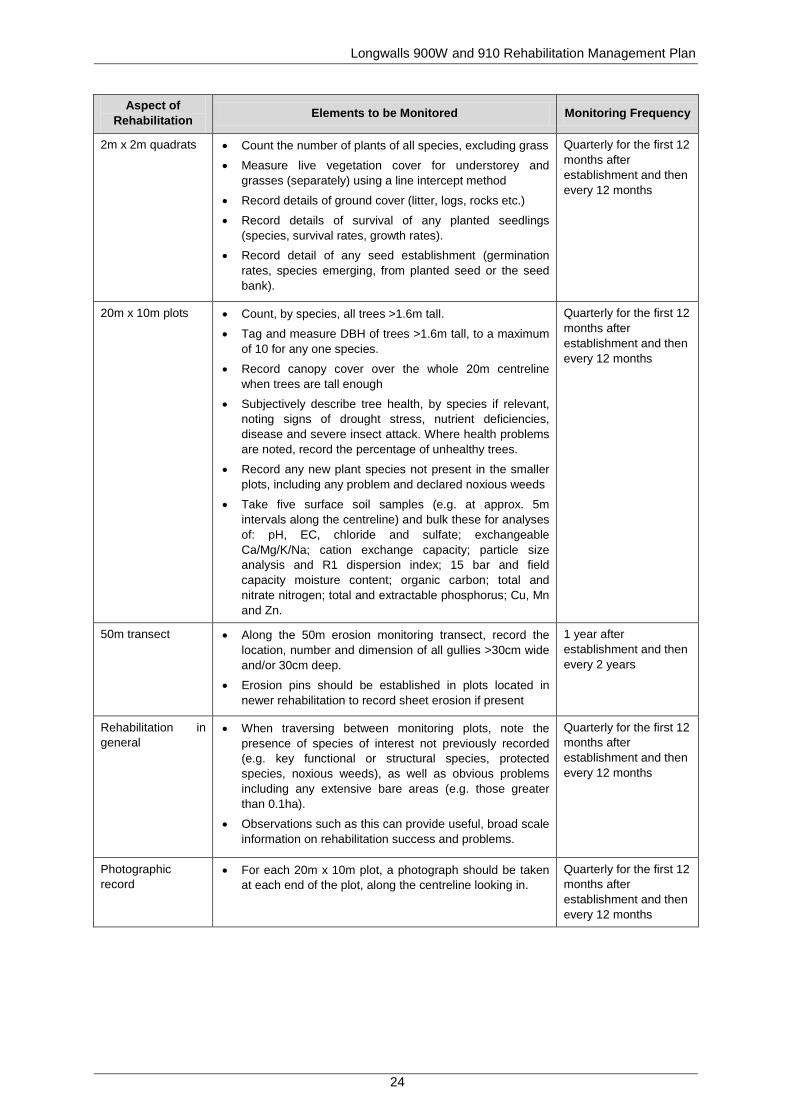
Table 7. Rehabilitation Monitoring Program
Aspect of Rehabilitation Elements to be Monitored Monitoring Frequency
Ecosystem Establishment
General Description
• Describe the vegetation in general terms, e.g. mixed eucalypt woodland with grass understorey and scattered shrubs, dense Acacia scrub, etc.
Quarterly for the first 12 months after establishment and then every 12 months
Longwalls 900W and 910 Rehabilitation Management Plan
24
Aspect of Rehabilitation Elements to be Monitored Monitoring Frequency
2m x 2m quadrats • Count the number of plants of all species, excluding grass
• Measure live vegetation cover for understorey and grasses (separately) using a line intercept method
• Record details of ground cover (litter, logs, rocks etc.)
• Record details of survival of any planted seedlings (species, survival rates, growth rates).
• Record detail of any seed establishment (germination rates, species emerging, from planted seed or the seed bank).
Quarterly for the first 12 months after establishment and then every 12 months
20m x 10m plots • Count, by species, all trees >1.6m tall.
• Tag and measure DBH of trees >1.6m tall, to a maximum of 10 for any one species.
• Record canopy cover over the whole 20m centreline when trees are tall enough
• Subjectively describe tree health, by species if relevant, noting signs of drought stress, nutrient deficiencies, disease and severe insect attack. Where health problems are noted, record the percentage of unhealthy trees.
• Record any new plant species not present in the smaller plots, including any problem and declared noxious weeds
• Take five surface soil samples (e.g. at approx. 5m intervals along the centreline) and bulk these for analyses of: pH, EC, chloride and sulfate; exchangeable Ca/Mg/K/Na; cation exchange capacity; particle size analysis and R1 dispersion index; 15 bar and field capacity moisture content; organic carbon; total and nitrate nitrogen; total and extractable phosphorus; Cu, Mn and Zn.
Quarterly for the first 12 months after establishment and then every 12 months
50m transect • Along the 50m erosion monitoring transect, record the location, number and dimension of all gullies >30cm wide and/or 30cm deep.
• Erosion pins should be established in plots located in newer rehabilitation to record sheet erosion if present
1 year after establishment and then every 2 years
Rehabilitation in general
• When traversing between monitoring plots, note the presence of species of interest not previously recorded (e.g. key functional or structural species, protected species, noxious weeds), as well as obvious problems including any extensive bare areas (e.g. those greater than 0.1ha).
• Observations such as this can provide useful, broad scale information on rehabilitation success and problems.
Quarterly for the first 12 months after establishment and then every 12 months
Photographic record
• For each 20m x 10m plot, a photograph should be taken at each end of the plot, along the centreline looking in.
Quarterly for the first 12 months after establishment and then every 12 months
Longwalls 900W and 910 Rehabilitation Management Plan
25
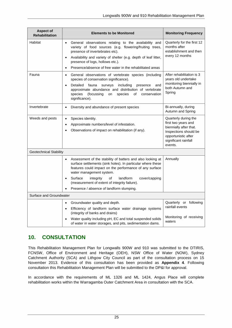
Aspect of Rehabilitation Elements to be Monitored Monitoring Frequency
Habitat • General observations relating to the availability and variety of food sources (e.g. flowering/fruiting trees, presence of invertebrates etc).
• Availability and variety of shelter (e.g. depth of leaf litter, presence of logs, hollows etc.).
• Presence/absence of free water in the rehabilitated areas
Quarterly for the first 12 months after establishment and then every 12 months
Fauna • General observations of vertebrate species (including species of conservation significance).
• Detailed fauna surveys including presence and approximate abundance and distribution of vertebrate species (focussing on species of conservation significance).
After rehabilitation is 3 years old undertake monitoring biennially in both Autumn and Spring
Invertebrate • Diversity and abundance of present species Bi-annually, during Autumn and Spring
Weeds and pests • Species identity.
• Approximate numbers/level of infestation.
• Observations of impact on rehabilitation (if any).
Quarterly during the first two years and biennially after that. Inspections should be opportunistic after significant rainfall events.
Geotechnical Stability
• Assessment of the stability of batters and also looking at surface settlements (sink holes). In particular where these features could impact on the performance of any surface water management system.
• Surface integrity of landform cover/capping (measurement of extent of integrity failure).
• Presence / absence of landform slumping.
Annually
Surface and Groundwater
• Groundwater quality and depth.
• Efficiency of landform surface water drainage systems (integrity of banks and drains)
• Water quality including pH, EC and total suspended solids of water in water storages, and pits, sedimentation dams.
Quarterly or following rainfall events Monitoring of receiving waters
10. CONSULTATION
This Rehabilitation Management Plan for Longwalls 900W and 910 was submitted to the DTIRIS, FCNSW, Office of Environment and Heritage (OEH), NSW Office of Water (NOW), Sydney Catchment Authority (SCA) and Lithgow City Council as part of the consultation process on 15 November 2013. Evidence of this consultation has been provided as Appendix 4. Following consultation this Rehabilitation Management Plan will be submitted to the DP&I for approval.
In accordance with the requirements of ML 1326 and ML 1424, Angus Place will complete rehabilitation works within the Warragamba Outer Catchment Area in consultation with the SCA.

Longwalls 900W and 910 Rehabilitation Management Plan
26
11. ADAPTIVE MANAGEMENT
Angus Place has developed an adaptive management approach that is designed to avoid repetition of any poor rehabilitation outcomes. This approach will include the monitoring and periodic evaluation of environmental consequences against the performance indicators defined in Section 7.2; the implementation of the contingency plan (see Section 12) in the event that a performance indicators are exceeded; and the review of this Rehabilitation Management Plan as necessary (see Section 15).
12. CONTINGENCY PLAN
A TARP for rehabilitation has been developed to identify required management actions in the event of impacts specifically to rehabilitation areas, or where rehabilitation outcomes are not achieved in an acceptable timeframe. Where necessary, rehabilitation procedures will be amended accordingly with the aim of continually improving rehabilitation standards.
The TARP is provided as Table 8, and will be reviewed and revised (as required) as conditions at Angus Place change or new risks to rehabilitation are identified.

Longwalls 900W and 910 Rehabilitation Management Plan
27
Table 8. Trigger Action Response Plan for Rehabilitation
Aspect/ Category
Key Element Trigger
Response Condition Green Condition Amber Condition Red
Landform stability
Slope gradient
Trigger At least 75% of the rehabilitation area to have slopes <10°. <65% of the rehabilitation area has slopes <10°. <55% of the rehabilitation area has slopes <10°.
Response No response required. Continue monitoring program. Undertake regrading and revegetation of the area.
Undertake a review of the landform design, including survey if required. Undertake regrading and revegetation of the area. Notify DTIRIS and relevant stakeholders.
Erosion control
Trigger Average soil loss per annum is <40 tonnes/ha/yr (sheet erosion).
Average soil loss per annum is >40 tonnes/ha/yr (sheet erosion).
Average soil loss per annum is >50 tonnes/ha/yr (sheet erosion).
Response No response required. Continue monitoring program.
An inspection of the site will be undertaken by a suitably trained person. Investigate opportunities to install water management infrastructure to address soil loss. Remediate as appropriate.
Engage a consultant to assist with the management of erosion and sedimentation at the site and provide recommendations to appropriately remediate the soil loss. Remediate as soon as practicable. Notify DTIRIS and relevant stakeholders.
Trigger Dimensions and frequency of occurrence of erosion rills and gullies are no greater than that in reference sites that exhibit similar landform characteristics.
Dimensions and frequency of occurrence of erosion rills and gullies are <20% greater than that in reference sites that exhibit similar landform characteristics.
Dimensions and frequency of occurrence of erosion rills and gullies are >20% greater than that in reference sites that exhibit similar landform characteristics.
Response No response required. Continue monitoring program.
An inspection of the site will be undertaken by a suitably trained person. Investigate opportunities to install water management infrastructure to address soil loss. Remediate as appropriate.
Engage a consultant to assist with the management of erosion and sedimentation at the site and provide recommendations to appropriately remediate the soil loss. Remediate as soon as practicable. Notify DTIRIS and relevant stakeholders.
Surface water drainage
Trigger
All landforms will be free draining (except where specific structures have been constructed for the storage of water as required for sediment and erosion control or post mining landuse).
Landforms exhibiting minor drainage issues. Landforms exhibiting significant drainage issues.
Response No response required. Continue monitoring program.
An inspection of the site will be undertaken by a suitably trained person. Investigate opportunities to install water management infrastructure to address soil loss from rehabilitation areas. Remediate as appropriate.
Engage a consultant to assist with the management of erosion and sedimentation at the site and provide recommendations to appropriately remediate the soil loss. Remediate as soon as practicable. Notify DTIRIS and relevant stakeholders.

Longwalls 900W and 910 Rehabilitation Management Plan
28
Aspect/ Category
Key Element Trigger
Response Condition Green Condition Amber Condition Red
Vegetation
Land use
Trigger Rehabilitation area accomplishes and remains as a healthy native woodland/grassland.
Six months following revegetation works, less than 80% of the rehabilitation area accomplishes and remains as a healthy native woodland/grassland.
Less than 50% of the rehabilitation area accomplishes and remains as a healthy native woodland/grassland.
Response No response required. Continue monitoring program. Investigate use of appropriate management options to remediate.
An inspection of the site will be undertaken by a suitably trained person. Investigate use of appropriate management options to remediate. Remediate as appropriate. Notify DTIRIS and relevant stakeholders.
Surface cover
Trigger
Six months following revegetation works, a minimum of 70% vegetative cover is present within rehabilitation areas (or 50% if rocks, logs or other features of cover are present).
Minimum of 60% vegetative cover is present within rehabilitation areas.
Minimum of 50% vegetative cover is present within rehabilitation areas.
Response No response required. Continue monitoring program. Review procedures where required to increase vegetation cover.
An inspection of the site will be undertaken by a suitably trained person. Investigate use of appropriate management options to remediate. Remediate as appropriate. Notify DTIRIS and relevant stakeholders.
Trigger Six months following revegetation works, no bare surfaces >20 m2 in area or >10 m in length down slope within rehabilitation areas.
Bare surfaces >20 m2 in area or >10 m in length down slope within rehabilitation areas.
Bare surfaces >30 m2 in area or >20 m in length down slope within rehabilitation areas.
Response No response required. Continue monitoring program. Review procedures where required to increase vegetation cover.
An inspection of the site will be undertaken by a suitably trained person. Investigate use of appropriate management options to remediate. Remediate as appropriate. Notify DTIRIS and relevant stakeholders.

Longwalls 900W and 910 Rehabilitation Management Plan
29
Aspect/ Category
Key Element Trigger
Response Condition Green Condition Amber Condition Red
Species composition
Trigger Species composition to comprise a mixture of native trees, shrubs and grasses representative of regionally occurring woodland.
Six months following revegetation works, species composition shows less than 75% of species are native trees, shrubs and grasses representative of regionally occurring woodland.
Species composition shows less than 50% of species are native trees, shrubs and grasses representative of regionally occurring woodland.
Response No response required. Continue monitoring program. Engage weed management contractor to remove introduced species from the site.
Engage weed management contractor to remove introduced species from the site as soon as practicable. Investigate management measures to assist native plant establishment including use of ameliorants and implement as appropriate. Notify DTIRIS and relevant stakeholders.
Resilience to disturbance
Trigger Established species survive and/or regenerate after disturbance.
Minor occurrences of established species do not survive and/or regenerate after disturbance.
Significant numbers of established species do not survive and/or regenerate after disturbance.
Response No response required. Continue monitoring program. Review procedures where required to increase resilience to disturbance.
An inspection of the site will be undertaken by a suitably trained person. Investigate use of appropriate management options to remediate. Undertake management measures and revegetation as soon as practicable. Notify DTIRIS and relevant stakeholders.
Trigger Weeds do not dominate native species after disturbance or after rain.
Weeds dominate native species (>30%) after disturbance or after rain.
Weeds dominate native species (>50%) after disturbance or after rain.
Response No response required. Continue monitoring program. Engage weed management contractor to remove introduced species from the site.
Engage weed management contractor to remove introduced species from the site as soon as practicable. Investigate management measures to assist native plant establishment including use of ameliorants and implement as appropriate. Notify DTIRIS and relevant stakeholders.
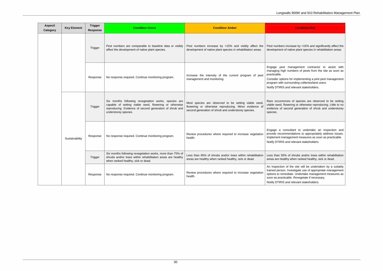
Longwalls 900W and 910 Rehabilitation Management Plan
30
Aspect/ Category
Key Element Trigger
Response Condition Green Condition Amber Condition Red
Trigger Pest numbers are comparable to baseline data or visibly affect the development of native plant species.
Pest numbers increase by <15% and visibly affect the development of native plant species in rehabilitation areas.
Pest numbers increase by >15% and significantly affect the development of native plant species in rehabilitation areas.
Response No response required. Continue monitoring program. Increase the intensity of the current program of pest management and monitoring.
Engage pest management contractor to assist with managing high numbers of pests from the site as soon as practicable. Consider options for implementing a joint pest management program with surrounding collieries/land users. Notify DTIRIS and relevant stakeholders.
Sustainability
Trigger
Six months following revegetation works, species are capable of setting viable seed, flowering or otherwise reproducing. Evidence of second generation of shrub and understorey species.
Most species are observed to be setting viable seed, flowering or otherwise reproducing. Minor evidence of second generation of shrub and understorey species.
Rare occurrences of species are observed to be setting viable seed, flowering or otherwise reproducing. Little to no evidence of second generation of shrub and understorey species.
Response No response required. Continue monitoring program. Review procedures where required to increase vegetation health.
Engage a consultant to undertake an inspection and provide recommendations to appropriately address issues. Implement management measures as soon as practicable. Notify DTIRIS and relevant stakeholders.
Trigger Six months following revegetation works, more than 75% of shrubs and/or trees within rehabilitation areas are healthy when ranked healthy, sick or dead.
Less than 65% of shrubs and/or trees within rehabilitation areas are healthy when ranked healthy, sick or dead.
Less than 55% of shrubs and/or trees within rehabilitation areas are healthy when ranked healthy, sick or dead.
Response No response required. Continue monitoring program. Review procedures where required to increase vegetation health.
An inspection of the site will be undertaken by a suitably trained person. Investigate use of appropriate management options to remediate. Undertake management measures as soon as practicable. Revegetate if necessary. Notify DTIRIS and relevant stakeholders.

Longwalls 900W and 910 Rehabilitation Management Plan
31
13. ROLES AND RESPONSIBILITIES
The responsibility for implementation, monitoring and review of the Rehabilitation Management Plan lies with the Angus Place Environment and Community Coordinator. The ultimate responsibility for the implementation of the Rehabilitation Management Plan lies with the Mine Manager, who shall make appropriate resources available. The roles and responsibilities for this Rehabilitation Management Plan are outlined in Table 9.
Table 9. Key Personnel and Accountabilities Position Responsibility
Mine Manager • Ensuring that sufficient resources are available to implement and execute the
requirements of this Plan; and • Reporting triggers/non-conformances to external stakeholders.
Environment and Community Coordinator
Implementation, monitoring and review of this plan, including: • The carrying out of inspections;
• The installation and maintenance of signage;
• Reporting triggers/non-conformances internally to the Mine Manager as appropriate;
• Consulting with stakeholders on any issues arising from subsidence;
• Consultation during the review process with relevant stakeholders and distributing this Rehabilitation Management Plan;
• Coordinating any remediation work as required;
• Inspecting areas susceptible to tensile and compressive strains and potential cracking;
• Co-ordinating the generation and submission of formal reporting requirements outlined in this plan (e.g. End of Panel Reports and the AEMR/Annual Review); and
• Reviewing this Rehabilitation Management Plan.
14. REPORTING
In accordance with the requirements of the Draft Guidelines for the Preparation of Extraction Plans (DP&I 2012), Angus Place will submit the following reports to the DP&I and DTIRIS during the secondary extraction of Longwalls 900W and 910:
• Bi-monthly Subsidence Impact Reports - These reports will be submitted following the regular monthly inspections if any new subsidence impacts are identified; and
• Six-monthly Environmental Monitoring Report - This report will include:
− a comprehensive summary of all impacts, including a revised characterisation according to the relevant TARP and any proposed actions resulting from the relevant TARP (see Section 12);
− an assessment of compliance with relevant performance indicators (see Section 7.2); and
− a comprehensive summary of all quantitative and qualitative environmental monitoring results.

Longwalls 900W and 910 Rehabilitation Management Plan
32
The Annual Environmental Management Report (AEMR)/Annual Review will be made available on the Centennial Coal website and will include subsidence monitoring results, performance against subsidence predictions and identification of any subsidence related environmental impacts identified during the reporting period.
In accordance with the requirements of Schedule 5, Condition 6 of PA 06_0021 (as modified), Angus Place will notify the Director-General of DP&I, FCNSW and any other relevant agencies of any land management related incident, resulting from the extraction of Longwalls 900W and 910 as soon as practicable after becoming aware of the incident. Within seven days of the incident, the Proponent shall provide the Director-General of DP&I and any relevant agencies with a detailed report on the incident.
Angus Place will also prepare an End of Panel Report to encompass all environmental and subsidence monitoring, including a comparison of actual impacts with predicted subsidence impacts. This report will be submitted to DTIRIS within three months of secondary extraction being completed in each longwall panel.
15. REVIEW
This Rehabilitation Management Plan will be reviewed every three years, or in the event that the following occur:
• Stakeholders raise issues that necessitate a review; • There are changes to the management requirements (e.g. if there are changes to related
approvals); • Where unpredicted impacts or consequences have required implementation of contingency
actions under this plan; or • Monitoring, incident, or audit processes demonstrate that a review is warranted.
Any amendments to the Rehabilitation Management Plan will be undertaken in consultation with relevant stakeholders, and a copy of the amended Rehabilitation Management Plan will be forwarded to the Director-General of the DP&I for approval.
Longwalls 900W and 910 Rehabilitation Management Plan
33
16. REFERENCES
Angus Place (2012) Angus Place Site Water Management Plan.
ANZMEC and Minerals Council of Australia (2000) The Strategic Framework for Mine Closure.
Centennial Coal (2008). Centennial Coal Risk Management Standard (Management Standard – 004).
Commonwealth of Australia (2006) Mine Rehabilitation – Leading Practice Sustainable Development Program for the Mining Industry.
DgS (2010) Subsidence Prediction and Impact Assessment for the Proposed Longwall Panels 910 and 900 West at Angus Place Colliery, Lidsdale. DgS Report No. ANP-002/1.
DgS (2013) Subsidence Assessment Review for the Longwalls 900W and 910 Integrated SMP/Extraction Plan, Centennial Angus Place Colliery.
Department of Environment (1998) Best Practice Environmental Management in Mining: Landform Design for Rehabilitation.
Department of Mineral Resources (2003). Guideline for Applications for Subsidence Management Approvals.
DP&I (2012) Draft Guidelines for the Preparation of Extraction Plans.
Federal Department of Industry, Tourism and Resources (2002) Leading Practice Sustainable Development Program for the Mining Industry – Mine Closure and Completion.
GHD (2010) Angus Place Colliery 75W Modification Surface Water Assessment.
GSS Environmental (2013) Angus Place Colliery Mining Operation Plan.
DTIRIS (2012) EDG03 Guidelines to the Mining, Rehabilitation & Environmental Management Process.
RPS (2010) Angus Place Colliery, NSW Modification of Project Approval 06_0021 under Section 75W, Part 3A.
RPS (2010a) Flora and Fauna Assessment Proposed Longwalls 910 and 900W, Angus Place Colliery.

Longwalls 900W and 910 Rehabilitation Management Plan
This page has been intentionally left blank.

APPENDIX 1: Trigger Action Response
Plan for Land Managem
ent
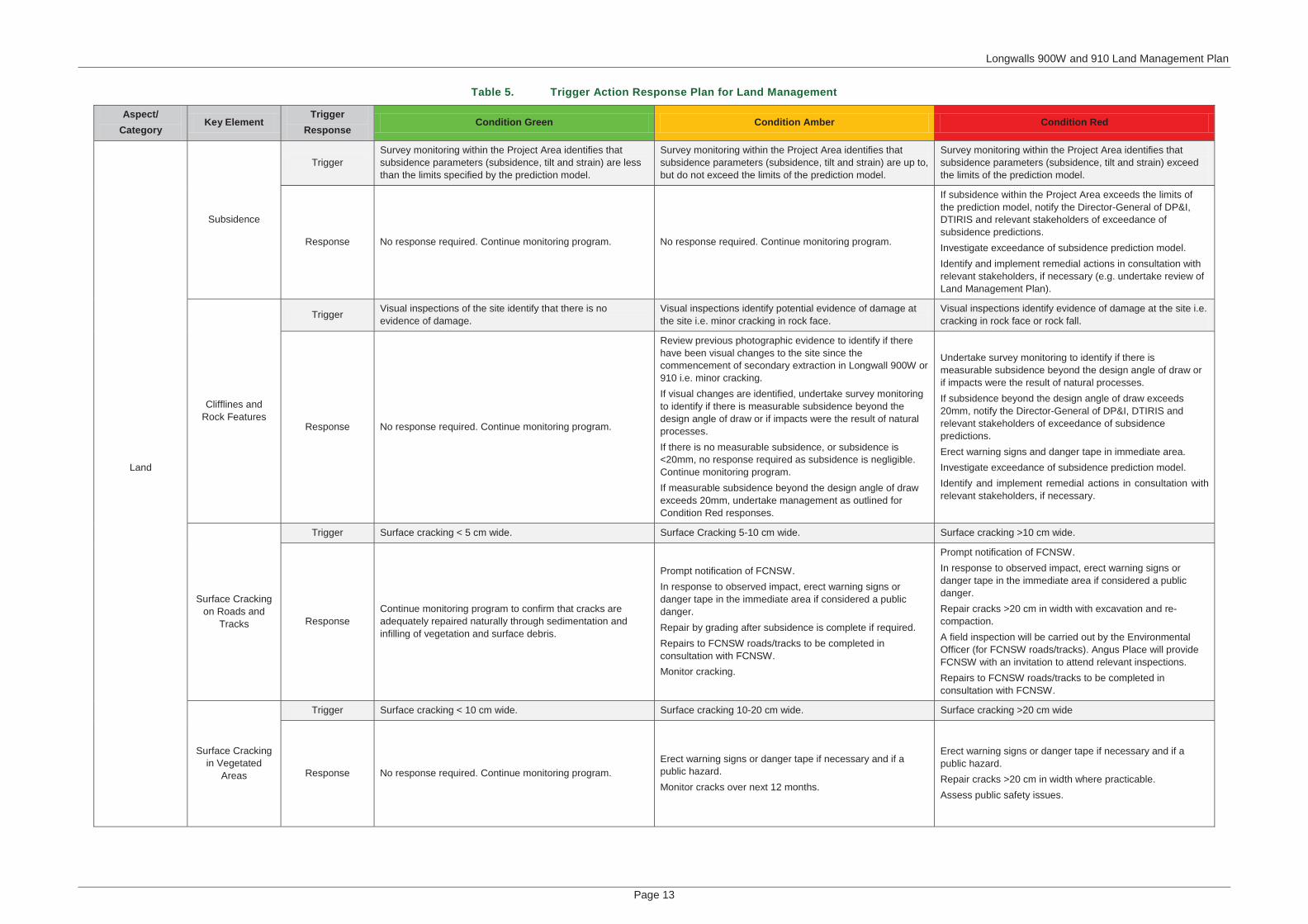
Longwalls 900W and 910 Land Management Plan
Page 13
Table 5. Trigger Action Response Plan for Land Management
Aspect/Category
Key ElementTrigger
ResponseCondition Green Condition Amber Condition Red
Land
Subsidence
TriggerSurvey monitoring within the Project Area identifies that subsidence parameters (subsidence, tilt and strain) are less than the limits specified by the prediction model.
Survey monitoring within the Project Area identifies that subsidence parameters (subsidence, tilt and strain) are up to, but do not exceed the limits of the prediction model.
Survey monitoring within the Project Area identifies that subsidence parameters (subsidence, tilt and strain) exceedthe limits of the prediction model.
Response No response required. Continue monitoring program. No response required. Continue monitoring program.
If subsidence within the Project Area exceeds the limits of the prediction model, notify the Director-General of DP&I, DTIRIS and relevant stakeholders of exceedance of subsidence predictions.Investigate exceedance of subsidence prediction model. Identify and implement remedial actions in consultation with relevant stakeholders, if necessary (e.g. undertake review of Land Management Plan).
Clifflines and Rock Features
Trigger Visual inspections of the site identify that there is no evidence of damage.
Visual inspections identify potential evidence of damage at the site i.e. minor cracking in rock face.
Visual inspections identify evidence of damage at the site i.e. cracking in rock face or rock fall.
Response No response required. Continue monitoring program.
Review previous photographic evidence to identify if there have been visual changes to the site since the commencement of secondary extraction in Longwall 900W or 910 i.e. minor cracking. If visual changes are identified, undertake survey monitoring to identify if there is measurable subsidence beyond the design angle of draw or if impacts were the result of natural processes.If there is no measurable subsidence, or subsidence is<20mm, no response required as subsidence is negligible. Continue monitoring program.If measurable subsidence beyond the design angle of draw exceeds 20mm, undertake management as outlined for Condition Red responses.
Undertake survey monitoring to identify if there is measurable subsidence beyond the design angle of draw or if impacts were the result of natural processes.If subsidence beyond the design angle of draw exceeds 20mm, notify the Director-General of DP&I, DTIRIS and relevant stakeholders of exceedance of subsidence predictions.Erect warning signs and danger tape in immediate area.Investigate exceedance of subsidence prediction model. Identify and implement remedial actions in consultation with relevant stakeholders, if necessary.
Surface Cracking on Roads and
Tracks
Trigger Surface cracking < 5 cm wide. Surface Cracking 5-10 cm wide. Surface cracking >10 cm wide.
ResponseContinue monitoring program to confirm that cracks are adequately repaired naturally through sedimentation and infilling of vegetation and surface debris.
Prompt notification of FCNSW.In response to observed impact, erect warning signs or danger tape in the immediate area if considered a public danger.Repair by grading after subsidence is complete if required. Repairs to FCNSW roads/tracks to be completed in consultation with FCNSW.Monitor cracking.
Prompt notification of FCNSW.In response to observed impact, erect warning signs or danger tape in the immediate area if considered a public danger.Repair cracks >20 cm in width with excavation and re-compaction. A field inspection will be carried out by the EnvironmentalOfficer (for FCNSW roads/tracks). Angus Place will provide FCNSW with an invitation to attend relevant inspections.Repairs to FCNSW roads/tracks to be completed in consultation with FCNSW.
Surface Cracking in Vegetated
Areas
Trigger Surface cracking < 10 cm wide. Surface cracking 10-20 cm wide. Surface cracking >20 cm wide
Response No response required. Continue monitoring program.Erect warning signs or danger tape if necessary and if a public hazard. Monitor cracks over next 12 months.
Erect warning signs or danger tape if necessary and if a public hazard. Repair cracks >20 cm in width where practicable.Assess public safety issues.
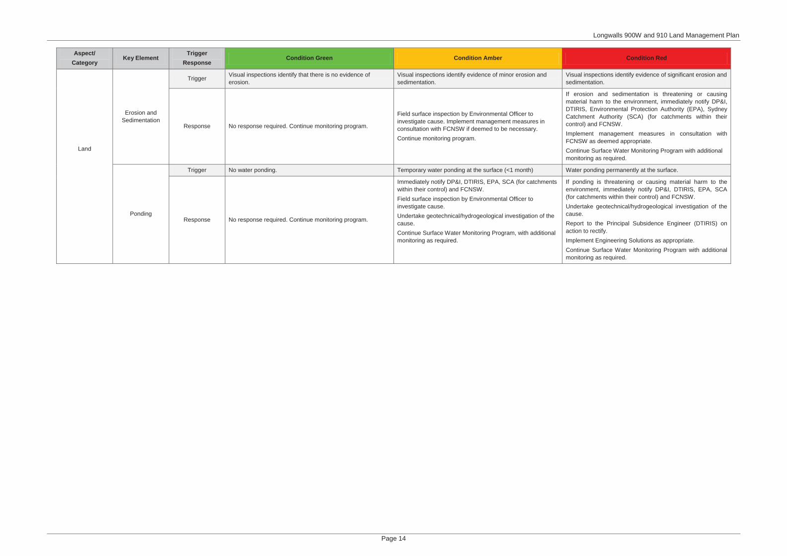
Longwalls 900W and 910 Land Management Plan
Page 14
Aspect/Category
Key ElementTrigger
ResponseCondition Green Condition Amber Condition Red
Land
Erosion and Sedimentation
Trigger Visual inspections identify that there is no evidence of erosion.
Visual inspections identify evidence of minor erosion and sedimentation.
Visual inspections identify evidence of significant erosion and sedimentation.
Response No response required. Continue monitoring program.
Field surface inspection by Environmental Officer to investigate cause. Implement management measures in consultation with FCNSW if deemed to be necessary.Continue monitoring program.
If erosion and sedimentation is threatening or causing material harm to the environment, immediately notify DP&I, DTIRIS, Environmental Protection Authority (EPA), Sydney Catchment Authority (SCA) (for catchments within their control) and FCNSW.Implement management measures in consultation with FCNSW as deemed appropriate.Continue Surface Water Monitoring Program with additional monitoring as required.
Ponding
Trigger No water ponding. Temporary water ponding at the surface (<1 month) Water ponding permanently at the surface.
Response No response required. Continue monitoring program.
Immediately notify DP&I, DTIRIS, EPA, SCA (for catchments within their control) and FCNSW.Field surface inspection by Environmental Officer to investigate cause.Undertake geotechnical/hydrogeological investigation of the cause.Continue Surface Water Monitoring Program, with additional monitoring as required.
If ponding is threatening or causing material harm to the environment, immediately notify DP&I, DTIRIS, EPA, SCA (for catchments within their control) and FCNSW.Undertake geotechnical/hydrogeological investigation of the cause.Report to the Principal Subsidence Engineer (DTIRIS) on action to rectify.Implement Engineering Solutions as appropriate.Continue Surface Water Monitoring Program with additional monitoring as required.

APPEN
DIX 2: MO
P Rehabilitation Table

Rehabilitation Objective Indicator Performance Measure Completion Criteria Justification/Source Complete
(Yes/No)
Progress at
start of MOP
Phase – Decommissioning
Domain 1 – Infrastructure
All infrastructure removed
Services removed Quarterly Rehabilitation
Inspection report Services removed
Mod 1 Rehabilitation
Strategy Section
3.3.2.(GSS, 2010a)
No Not commenced
Offices removed Quarterly Rehabilitation
Inspection report
Offices and
foundations removed
Mod 1 Rehabilitation
Strategy Section
3.3.2.(GSS, 2010a)
No Not commenced
Workshops removed Quarterly Rehabilitation
Inspection report
Workshops, floors,
footings etc. removed
Mod 1 Rehabilitation
Strategy Section
3.3.2.(GSS, 2010a)
No Not commenced
Fuel and chemical tanks
and drums removed
Quarterly Rehabilitation
Inspection report
Tanks, drums,
compounds, footings
and bunds removed
Mod 1 Rehabilitation
Strategy Section
3.3.2.(GSS, 2010a)
No Not commenced
Roads and tracks removed Quarterly Rehabilitation
Inspection report
Bitumen and gravel
roads removed
Mod 1 Rehabilitation
Strategy Section
3.3.2.(GSS, 2010a)
No Not commenced
Water pumps and pipe
lines removed
Quarterly Rehabilitation
Inspection report
Pumps and pipelines
removed
Mod 1 Rehabilitation
Strategy Section
3.3.2.(GSS, 2010a)
No Not commenced
All hazardous materials
and contaminated
materials appropriately
removed/remediated
Hazardous materials
audits undertaken and
contamination at
acceptable levels
Contamination audit
report(s) completed by
specialist at mine closure
Hydrocarbons less
than assessment
criteria
NSW EPA (1994)
NSW EPA (1998) No Not commenced

Rehabilitation Objective Indicator Performance Measure Completion Criteria Justification/Source Complete
(Yes/No)
Progress at
start of MOP
Contamination audit
report(s) completed by
specialist at mine closure
Heavy metals less
than assessment
criteria
NSW EPA (1998) No Not commenced
Groundwater piezometers
sealed
Groundwater piezometers
and bores removed
Quarterly Rehabilitation
Inspection report
Backfill and remove
seal
Bore licence 10BL601829
Condition 11. No Not commenced
Management of European
heritage site
Removal of concrete
footings, foundations and
associated cement
structures
Quarterly Rehabilitation
Inspection report
Removal of concrete
footings, foundations
and associated
cement structures
Historic Heritage and
Significance Assessment
for the Vale of Clwydd
No.2 Colliery (RPS, 2011)
No Not commenced
VOC#2 drift entry way and
the building above it
retained with its foundation
stone inscription left intact
Quarterly Rehabilitation
Inspection report
Drift entry, building
and inscription
retained
Historic Heritage and
Significance Assessment
for the Vale of Clwydd
No.2 Colliery (RPS, 2011)
No Not commenced
Assessment of structural
integrity by a structural
engineer
Structural assessment
completed by specialist
Assessment report
received from
structural engineer
Historic Heritage and
Significance Assessment
for the Vale of Clwydd
No.2 Colliery (RPS, 2011)
No Not commenced
Domain 2 – Subsidence Management Area
All underground mining
infrastructure removed
Subsidence survey
monitoring lines removed
following completion of
subsidence
Quarterly Rehabilitation
Inspection report Survey pegs removed
Mod 1 Rehabilitation
Strategy Section
3.3.2.(GSS, 2010a)
No Not commenced
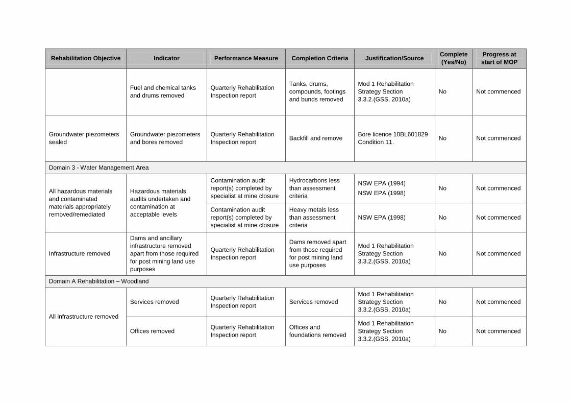
Rehabilitation Objective Indicator Performance Measure Completion Criteria Justification/Source Complete
(Yes/No)
Progress at
start of MOP
Fuel and chemical tanks
and drums removed
Quarterly Rehabilitation
Inspection report
Tanks, drums,
compounds, footings
and bunds removed
Mod 1 Rehabilitation
Strategy Section
3.3.2.(GSS, 2010a)
No Not commenced
Groundwater piezometers
sealed
Groundwater piezometers
and bores removed
Quarterly Rehabilitation
Inspection report Backfill and remove
Bore licence 10BL601829
Condition 11. No Not commenced
Domain 3 - Water Management Area
All hazardous materials
and contaminated
materials appropriately
removed/remediated
Hazardous materials
audits undertaken and
contamination at
acceptable levels
Contamination audit
report(s) completed by
specialist at mine closure
Hydrocarbons less
than assessment
criteria
NSW EPA (1994)
NSW EPA (1998) No Not commenced
Contamination audit
report(s) completed by
specialist at mine closure
Heavy metals less
than assessment
criteria
NSW EPA (1998) No Not commenced
Infrastructure removed
Dams and ancillary
infrastructure removed
apart from those required
for post mining land use
purposes
Quarterly Rehabilitation
Inspection report
Dams removed apart
from those required
for post mining land
use purposes
Mod 1 Rehabilitation
Strategy Section
3.3.2.(GSS, 2010a)
No Not commenced
Domain A Rehabilitation – Woodland
All infrastructure removed
Services removed Quarterly Rehabilitation
Inspection report Services removed
Mod 1 Rehabilitation
Strategy Section
3.3.2.(GSS, 2010a)
No Not commenced
Offices removed Quarterly Rehabilitation
Inspection report
Offices and
foundations removed
Mod 1 Rehabilitation
Strategy Section
3.3.2.(GSS, 2010a)
No Not commenced
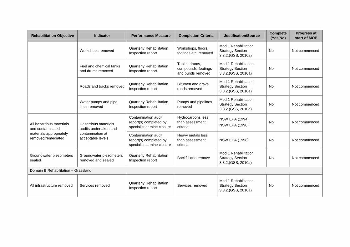
Rehabilitation Objective Indicator Performance Measure Completion Criteria Justification/Source Complete
(Yes/No)
Progress at
start of MOP
Workshops removed Quarterly Rehabilitation
Inspection report
Workshops, floors,
footings etc. removed
Mod 1 Rehabilitation
Strategy Section
3.3.2.(GSS, 2010a)
No Not commenced
Fuel and chemical tanks
and drums removed
Quarterly Rehabilitation
Inspection report
Tanks, drums,
compounds, footings
and bunds removed
Mod 1 Rehabilitation
Strategy Section
3.3.2.(GSS, 2010a)
No Not commenced
Roads and tracks removed Quarterly Rehabilitation
Inspection report
Bitumen and gravel
roads removed
Mod 1 Rehabilitation
Strategy Section
3.3.2.(GSS, 2010a)
No Not commenced
Water pumps and pipe
lines removed
Quarterly Rehabilitation
Inspection report
Pumps and pipelines
removed
Mod 1 Rehabilitation
Strategy Section
3.3.2.(GSS, 2010a)
No Not commenced
All hazardous materials
and contaminated
materials appropriately
removed/remediated
Hazardous materials
audits undertaken and
contamination at
acceptable levels
Contamination audit
report(s) completed by
specialist at mine closure
Hydrocarbons less
than assessment
criteria
NSW EPA (1994)
NSW EPA (1998) No Not commenced
Contamination audit
report(s) completed by
specialist at mine closure
Heavy metals less
than assessment
criteria
NSW EPA (1998) No Not commenced
Groundwater piezometers
sealed
Groundwater piezometers
removed and sealed
Quarterly Rehabilitation
Inspection report Backfill and remove
Mod 1 Rehabilitation
Strategy Section
3.3.2.(GSS, 2010a)
No Not commenced
Domain B Rehabilitation – Grassland
All infrastructure removed Services removed Quarterly Rehabilitation
Inspection report Services removed
Mod 1 Rehabilitation
Strategy Section
3.3.2.(GSS, 2010a)
No Not commenced

Rehabilitation Objective Indicator Performance Measure Completion Criteria Justification/Source Complete
(Yes/No)
Progress at
start of MOP
Offices removed Quarterly Rehabilitation
Inspection report
Offices and
foundations removed
Mod 1 Rehabilitation
Strategy Section
3.3.2.(GSS, 2010a)
No Not commenced
Workshops removed Quarterly Rehabilitation
Inspection report
Workshops, floors,
footings etc. removed
Mod 1 Rehabilitation
Strategy Section
3.3.2.(GSSE, 2010a)
No Not commenced
Fuel and chemical tanks
and drums removed
Quarterly Rehabilitation
Inspection report
Tanks, drums,
compounds, footings
and bunds removed
Mod 1 Rehabilitation
Strategy Section
3.3.2.(GSSE, 2010a)
No Not commenced
Mine owned roads and
tracks removed
Quarterly Rehabilitation
Inspection report
Bitumen and gravel
roads removed
Mod 1 Rehabilitation
Strategy Section
3.3.2.(GSSE, 2010a)
No Not commenced
Water pumps and pipe
lines removed
Quarterly Rehabilitation
Inspection report
Pumps and pipelines
removed
Mod 1 Rehabilitation
Strategy Section
3.3.2.(GSSE, 2010a)
No Not commenced
All hazardous materials
and contaminated
materials appropriately
removed/remediated
Hazardous materials
audits undertaken and
contamination at
acceptable levels
Contamination audit
report(s) completed by
specialist at mine closure
Hydrocarbons less
than assessment
criteria
NSW EPA (1994)
NSW EPA (1998) No Not commenced
Contamination audit
report(s) completed by
specialist at mine closure
Heavy metals less
than assessment
criteria
NSW EPA (1998) No Not commenced

Rehabilitation Objective Indicator Performance Measure Completion Criteria Justification/Source Complete
(Yes/No)
Progress at
start of MOP
Domain C - Water Management Area
All hazardous materials
and contaminated
materials appropriately
removed/remediated
Hazardous materials
audits undertaken and
contamination at
acceptable levels
Contamination audit
report(s) completed by
specialist at mine closure
Hydrocarbons less
than assessment
criteria
NSW EPA (1994)
NSW EPA (1998) No Not commenced
Contamination audit
report(s) completed by
specialist at mine closure
Heavy metals less
than assessment
criteria
NSW EPA (1998) No Not commenced
Infrastructure removed
Dams and ancillary
infrastructure removed
apart from those required
for post mining land use
purposes
Quarterly Rehabilitation
Inspection report
Dams and ancillary
infrastructure removed
apart from those
required for post
mining land use
purposes
Mod 1 Rehabilitation
Strategy Section
3.3.2.(GSSE, 2010a)
No Not commenced
Phase – Landform Establishment
Domain 1 – Infrastructure
Slope Gradient Annual geotechnical
stability inspection
No less than 75% of
rehabilitation area has
slopes <10°
Mod 1 Rehabilitation
Strategy Section 5.(GSSE,
2010a)
No Not commenced
Minimal active erosion
Results from erosion
monitoring (50m transect)
undertaken 1 year after
establishment then every
2 years.
Erosion control
structures are
installed at intervals
commensurate with
the slope of the
landform
Mod 1 Rehabilitation
Strategy Section 5.(GSSE,
2010a)
No Not commenced
Rehabilitation Objective Indicator Performance Measure Completion Criteria Justification/Source Complete
(Yes/No)
Progress at
start of MOP
Landform generally blends
in with surrounding
landscape and is stable
Landform generally blends
in with surrounding
landscape and is stable
Results from erosion
monitoring (50m transect)
undertaken 1 year after
establishment then every
2 years.
Average soil loss per
annum is <40
tonnes/ha/yr (sheet
erosion)
Mod 1 Rehabilitation
Strategy Section 5.(GSSE,
2010a)
No Not commenced
Results from erosion
monitoring (50m transect)
undertaken 1 year after
establishment then every
2 years.
Dimensions and
frequency of
occurrence of erosion
rills and gullies are
generally no greater
than that in reference
sites that exhibit
similar landform
characteristics
Mod 1 Rehabilitation
Strategy Section 5.(GSSE,
2010a)
No Not commenced
Drainage condition
Drainage condition
Results from erosion
monitoring (50m transect)
undertaken 1 year after
establishment then every
2 years.
Construction of
contour banks and
diversion drains to
direct water into stable
areas or sediment
control basins
Mod 1 Rehabilitation
Strategy Section 5.(GSSE,
2010a)
No Not commenced
Annual geotechnical
stability inspection
All landforms free
draining except where
specific structures
have been
constructed for the
storage of water as
required for sediment
and erosion control or
post mining landuse
Mod 1 Rehabilitation
Strategy Section 5.(GSSE,
2010a)
No Not commenced
Water quality non-polluting
and appropriate for end
land use
Water quality
Quarterly water quality
monitoring (or following
rainfall) in accordance
with the Site Water
Management Plan
Complies with water
quality criteria
established in the Site
Water Management
Plan
Angus Place Site Water
Management Plan,
Section 8.2 (2012)
No Not commenced
Rehabilitation Objective Indicator Performance Measure Completion Criteria Justification/Source Complete
(Yes/No)
Progress at
start of MOP
Domain 2 - Subsidence Management Area
Landform generally blends
in with surrounding
landscape and is stable
Landform generally blends
in with surrounding
landscape and is stable
Minimal active erosion
Minimal active erosion
Results from erosion
monitoring (50m transect)
undertaken 1 year after
establishment then every
2 years.
Erosion control
structures are
installed at intervals
commensurate with
the slope of the
landform
Mod 1 Rehabilitation
Strategy Section 5.(GSSE,
2010a)
No Not commenced
Results from erosion
monitoring (50m transect)
undertaken 1 year after
establishment then every
2 years.
Average soil loss per
annum is <40
tonnes/ha/yr (sheet
erosion)
Mod 1 Rehabilitation
Strategy Section 5.(GSSE,
2010a)
No Not commenced
Results from erosion
monitoring (50m transect)
undertaken 1 year after
establishment then every
2 years.
Dimensions and
frequency of
occurrence of erosion
rills and gullies are
generally no greater
than that in reference
sites that exhibit
similar landform
characteristics
Mod 1 Rehabilitation
Strategy Section 5.(GSSE,
2010a)
No Not commenced
Drainage condition Annual geotechnical
stability inspection
Construction of
contour banks and
diversion drains to
direct water into stable
areas or sediment
control basins
Mod 1 Rehabilitation
Strategy Section 5.(GSSE,
2010a)
No Not commenced
Water quality non-polluting
and appropriate for end
land use
Water quality
Quarterly water quality
monitoring (or following
rainfall) in accordance
with the Site Water
Management Plan
Complies with water
quality criteria
established in the Site
Water Management
Plan
Angus Place Site Water
Management Plan,
Section 8.2 (2012)
No Not commenced
Domain 3 - Water Management Area

Rehabilitation Objective Indicator Performance Measure Completion Criteria Justification/Source Complete
(Yes/No)
Progress at
start of MOP
Landform generally blends
in with surrounding
landscape and is stable
Landform generally blends
in with surrounding
landscape and is stable
Drainage condition
Drainage condition
Annual geotechnical
stability inspection
Construction of
contour banks and
diversion drains to
direct water into stable
areas or sediment
control basins
Mod 1 Rehabilitation
Strategy Section 5.(GSSE,
2010a)
No Not commenced
Annual geotechnical
stability inspection
All landforms free
draining except where
specific structures
have been
constructed for the
storage of water as
required for sediment
and erosion control or
post mining landuse
Mod 1 Rehabilitation
Strategy Section 5.(GSSE,
2010a)
No Not commenced
Water quality non-polluting
and appropriate for end
land use
Water quality
Quarterly water quality
monitoring (or following
rainfall) in accordance
with the Site Water
Management Plan
Complies with water
quality criteria
established in the Site
Water Management
Plan
Angus Place Site Water
Management Plan,
Section 8.2 (2012)
No Not commenced
Domain A Rehabilitation – Woodland
Slope Gradient
Annual geotechnical
stability inspection
No less than 75% of
the rehabilitation area
has slopes <10°
Mod 1 Rehabilitation
Strategy Section 5.(GSSE,
2010a)
No Not commenced
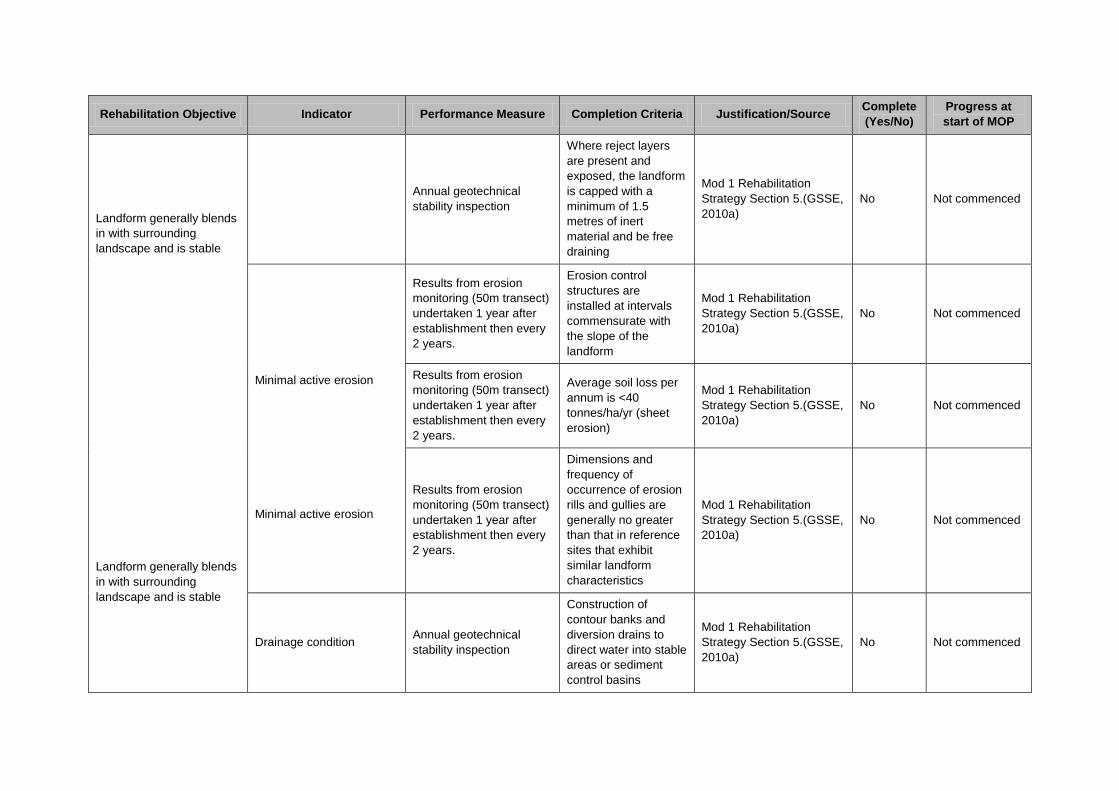
Rehabilitation Objective Indicator Performance Measure Completion Criteria Justification/Source Complete
(Yes/No)
Progress at
start of MOP
Landform generally blends
in with surrounding
landscape and is stable
Landform generally blends
in with surrounding
landscape and is stable
Annual geotechnical
stability inspection
Where reject layers
are present and
exposed, the landform
is capped with a
minimum of 1.5
metres of inert
material and be free
draining
Mod 1 Rehabilitation
Strategy Section 5.(GSSE,
2010a)
No Not commenced
Minimal active erosion
Minimal active erosion
Results from erosion
monitoring (50m transect)
undertaken 1 year after
establishment then every
2 years.
Erosion control
structures are
installed at intervals
commensurate with
the slope of the
landform
Mod 1 Rehabilitation
Strategy Section 5.(GSSE,
2010a)
No Not commenced
Results from erosion
monitoring (50m transect)
undertaken 1 year after
establishment then every
2 years.
Average soil loss per
annum is <40
tonnes/ha/yr (sheet
erosion)
Mod 1 Rehabilitation
Strategy Section 5.(GSSE,
2010a)
No Not commenced
Results from erosion
monitoring (50m transect)
undertaken 1 year after
establishment then every
2 years.
Dimensions and
frequency of
occurrence of erosion
rills and gullies are
generally no greater
than that in reference
sites that exhibit
similar landform
characteristics
Mod 1 Rehabilitation
Strategy Section 5.(GSSE,
2010a)
No Not commenced
Drainage condition Annual geotechnical
stability inspection
Construction of
contour banks and
diversion drains to
direct water into stable
areas or sediment
control basins
Mod 1 Rehabilitation
Strategy Section 5.(GSSE,
2010a)
No Not commenced
Rehabilitation Objective Indicator Performance Measure Completion Criteria Justification/Source Complete
(Yes/No)
Progress at
start of MOP
Annual geotechnical
stability inspection
All landforms free
draining except where
specific structures
have been
constructed for the
storage of water as
required for sediment
and erosion control or
post mining landuse
Mod 1 Rehabilitation
Strategy Section 5.(GSSE,
2010a)
No Not commenced
Water quality non-polluting
and appropriate for end
land use
Water quality
Quarterly water quality
monitoring (or following
rainfall) in accordance
with the Site Water
Management Plan
Complies with water
quality criteria
established in the Site
Water Management
Plan
Angus Place Site Water
Management Plan,
Section 8.2 (2012)
No Not commenced
Domain B Rehabilitation – Grassland
Landform generally blends
in with surrounding
landscape and is stable
Slope Gradient
Annual geotechnical
stability inspection
No less than 75% of
the rehabilitation area
has slopes <10°
Mod 1 Rehabilitation
Strategy Section 5.(GSSE,
2010a)
No Not commenced
Annual geotechnical
stability inspection
Where reject layers
are present and
exposed, the landform
is capped with a
minimum of 1.5
metres of inert
material and be free
draining
Mod 1 Rehabilitation
Strategy Section 5.(GSSE,
2010a)
No Not commenced
Results from erosion
monitoring (50m transect)
undertaken 1 year after
establishment then every
2 years.
Erosion control
structures are
installed at intervals
commensurate with
the slope of the
landform
Mod 1 Rehabilitation
Strategy Section 5.(GSSE,
2010a)
No Not commenced
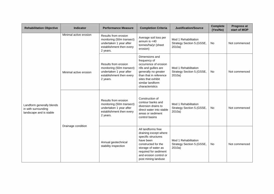
Rehabilitation Objective Indicator Performance Measure Completion Criteria Justification/Source Complete
(Yes/No)
Progress at
start of MOP
Landform generally blends
in with surrounding
landscape and is stable
Minimal active erosion
Minimal active erosion
Results from erosion
monitoring (50m transect)
undertaken 1 year after
establishment then every
2 years.
Average soil loss per
annum is <40
tonnes/ha/yr (sheet
erosion)
Mod 1 Rehabilitation
Strategy Section 5.(GSSE,
2010a)
No Not commenced
Results from erosion
monitoring (50m transect)
undertaken 1 year after
establishment then every
2 years.
Dimensions and
frequency of
occurrence of erosion
rills and gullies are
generally no greater
than that in reference
sites that exhibit
similar landform
characteristics
Mod 1 Rehabilitation
Strategy Section 5.(GSSE,
2010a)
No Not commenced
Drainage condition
Results from erosion
monitoring (50m transect)
undertaken 1 year after
establishment then every
2 years.
Construction of
contour banks and
diversion drains to
direct water into stable
areas or sediment
control basins
Mod 1 Rehabilitation
Strategy Section 5.(GSSE,
2010a)
No Not commenced
Annual geotechnical
stability inspection
All landforms free
draining except where
specific structures
have been
constructed for the
storage of water as
required for sediment
and erosion control or
post mining landuse
Mod 1 Rehabilitation
Strategy Section 5.(GSSE,
2010a)
No Not commenced
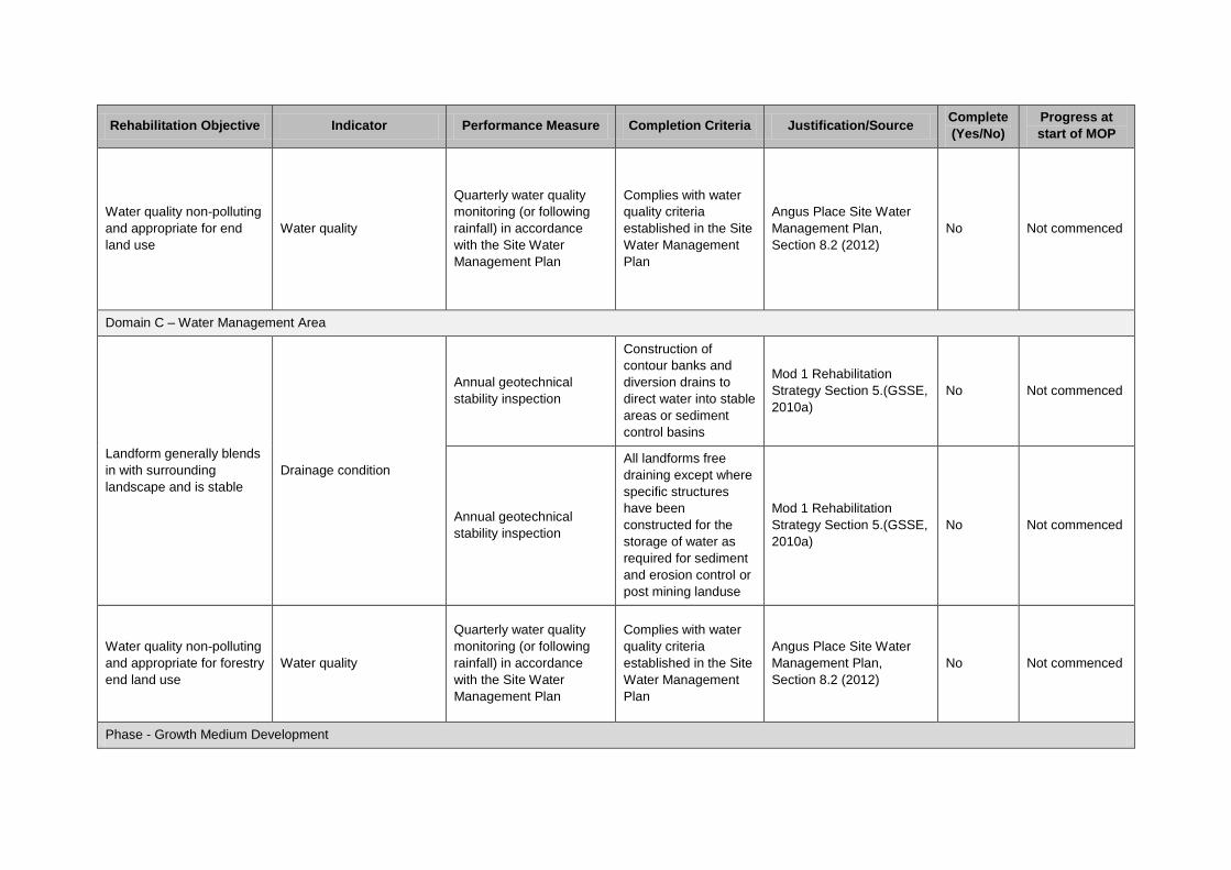
Rehabilitation Objective Indicator Performance Measure Completion Criteria Justification/Source Complete
(Yes/No)
Progress at
start of MOP
Water quality non-polluting
and appropriate for end
land use
Water quality
Quarterly water quality
monitoring (or following
rainfall) in accordance
with the Site Water
Management Plan
Complies with water
quality criteria
established in the Site
Water Management
Plan
Angus Place Site Water
Management Plan,
Section 8.2 (2012)
No Not commenced
Domain C – Water Management Area
Landform generally blends
in with surrounding
landscape and is stable
Drainage condition
Annual geotechnical
stability inspection
Construction of
contour banks and
diversion drains to
direct water into stable
areas or sediment
control basins
Mod 1 Rehabilitation
Strategy Section 5.(GSSE,
2010a)
No Not commenced
Annual geotechnical
stability inspection
All landforms free
draining except where
specific structures
have been
constructed for the
storage of water as
required for sediment
and erosion control or
post mining landuse
Mod 1 Rehabilitation
Strategy Section 5.(GSSE,
2010a)
No Not commenced
Water quality non-polluting
and appropriate for forestry
end land use
Water quality
Quarterly water quality
monitoring (or following
rainfall) in accordance
with the Site Water
Management Plan
Complies with water
quality criteria
established in the Site
Water Management
Plan
Angus Place Site Water
Management Plan,
Section 8.2 (2012)
No Not commenced
Phase - Growth Medium Development

Rehabilitation Objective Indicator Performance Measure Completion Criteria Justification/Source Complete
(Yes/No)
Progress at
start of MOP
Domain 1 – Infrastructure
Class VIII – Timber
Soil in shaped areas to be
ameliorated to sustain
forestry ecosystems
Analyses of soil samples
from 20 m x 10 m plot
sampling undertaken
quarterly for the first 12
months then every 12
months
ESP <15%
Mod 1 Rehabilitation
Strategy Section 5.(GSSE,
2010a)
No Not commenced
Analyses of soil samples
from 20 m x 10 m plot
sampling undertaken
quarterly for the first 12
months then every 12
months
pH >5.5 and <8.5
Mod 1 Rehabilitation
Strategy Section 5.(GSSE,
2010a)
No Not commenced
Analyses of soil samples
from 20 m x 10 m plot
sampling undertaken
quarterly for the first 12
months then every 12
months
EC <0.6ds/m
Mod 1 Rehabilitation
Strategy Section 5.(GSSE,
2010a)
No Not commenced
Analyses of soil samples
from 20 m x 10 m plot
sampling undertaken
quarterly for the first 12
months then every 12
months
Photographic records
Nutrient accumulation
and recycling
processes are
occurring as
evidenced by the
presence of a litter
layer, mycorrhizae
and/or other
microsymbionts
Mod 1 Rehabilitation
Strategy Section 5.(GSSE,
2010a)
No Not commenced
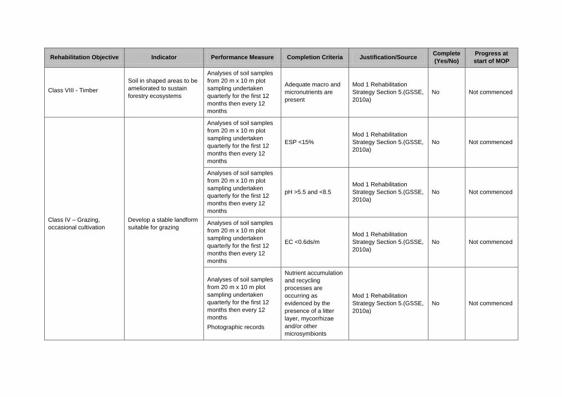
Rehabilitation Objective Indicator Performance Measure Completion Criteria Justification/Source Complete
(Yes/No)
Progress at
start of MOP
Class VIII - Timber
Soil in shaped areas to be
ameliorated to sustain
forestry ecosystems
Analyses of soil samples
from 20 m x 10 m plot
sampling undertaken
quarterly for the first 12
months then every 12
months
Adequate macro and
micronutrients are
present
Mod 1 Rehabilitation
Strategy Section 5.(GSSE,
2010a)
No Not commenced
Class IV – Grazing,
occasional cultivation
Develop a stable landform
suitable for grazing
Analyses of soil samples
from 20 m x 10 m plot
sampling undertaken
quarterly for the first 12
months then every 12
months
ESP <15%
Mod 1 Rehabilitation
Strategy Section 5.(GSSE,
2010a)
No Not commenced
Analyses of soil samples
from 20 m x 10 m plot
sampling undertaken
quarterly for the first 12
months then every 12
months
pH >5.5 and <8.5
Mod 1 Rehabilitation
Strategy Section 5.(GSSE,
2010a)
No Not commenced
Analyses of soil samples
from 20 m x 10 m plot
sampling undertaken
quarterly for the first 12
months then every 12
months
EC <0.6ds/m
Mod 1 Rehabilitation
Strategy Section 5.(GSSE,
2010a)
No Not commenced
Analyses of soil samples
from 20 m x 10 m plot
sampling undertaken
quarterly for the first 12
months then every 12
months
Photographic records
Nutrient accumulation
and recycling
processes are
occurring as
evidenced by the
presence of a litter
layer, mycorrhizae
and/or other
microsymbionts
Mod 1 Rehabilitation
Strategy Section 5.(GSSE,
2010a)
No Not commenced

Rehabilitation Objective Indicator Performance Measure Completion Criteria Justification/Source Complete
(Yes/No)
Progress at
start of MOP
Class IV – Grazing,
occasional cultivation
Develop a stable landform
suitable for grazing
Analyses of soil samples
from 20 m x 10 m plot
sampling undertaken
quarterly for the first 12
months then every 12
months
Adequate macro and
micronutrients are
present
Mod 1 Rehabilitation
Strategy Section 5.(GSSE,
2010a)
No Not commenced
Domain 2 - Subsidence Management Area
Class VIII – Timber
Soils ameliorated to
sustain native ecosystems
as required
Analyses of soil samples
from 20 m x 10 m plot
sampling undertaken
quarterly for the first 12
months then every 12
months
ESP <15%
Mod 1 Rehabilitation
Strategy Section 5.(GSSE,
2010a)
No Not commenced
Analyses of soil samples
from 20 m x 10 m plot
sampling undertaken
quarterly for the first 12
months then every 12
months
pH >5.5 and <8.5
Mod 1 Rehabilitation
Strategy Section 5.(GSSE,
2010a)
No Not commenced
Analyses of soil samples
from 20 m x 10 m plot
sampling undertaken
quarterly for the first 12
months then every 12
months
EC <0.6ds/m
Mod 1 Rehabilitation
Strategy Section 5.(GSSE,
2010a)
No Not commenced
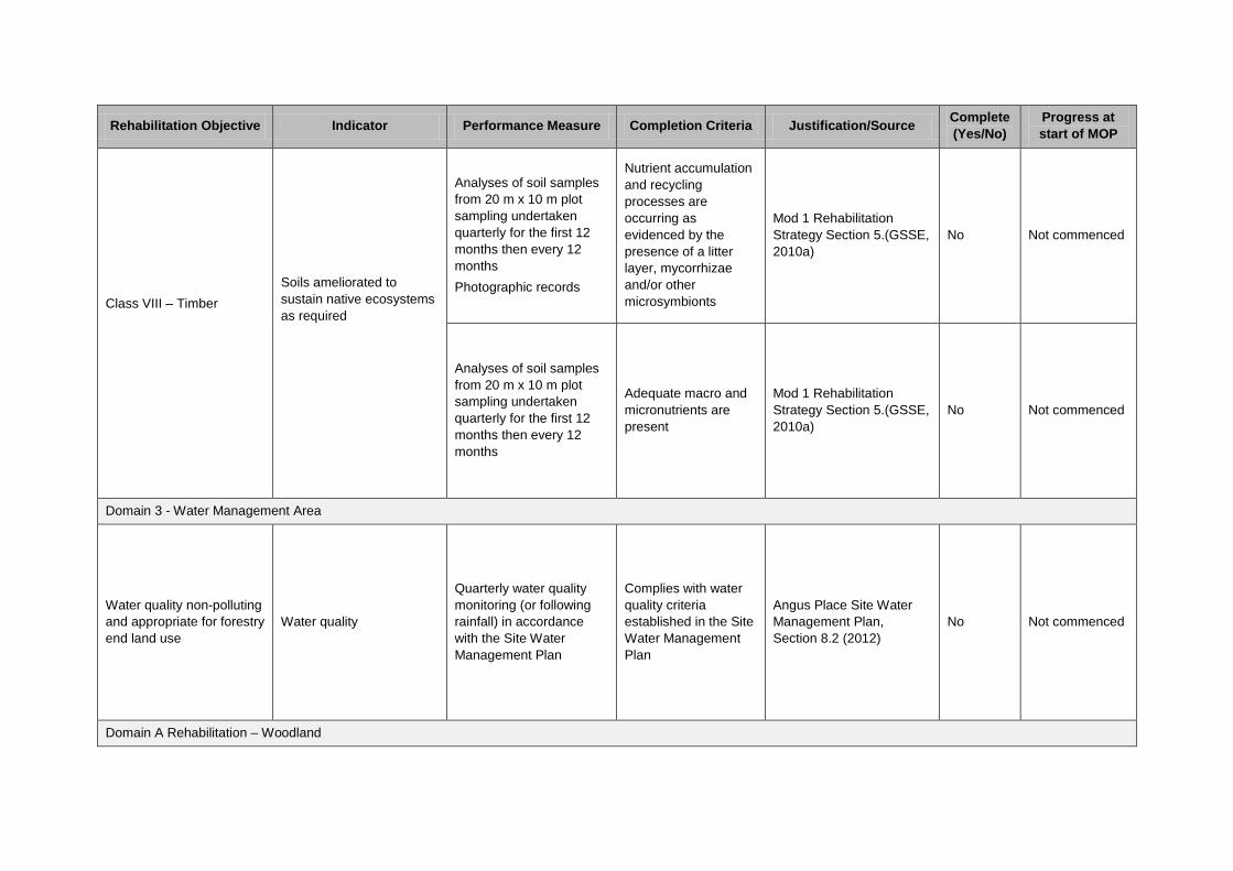
Rehabilitation Objective Indicator Performance Measure Completion Criteria Justification/Source Complete
(Yes/No)
Progress at
start of MOP
Class VIII – Timber
Soils ameliorated to
sustain native ecosystems
as required
Analyses of soil samples
from 20 m x 10 m plot
sampling undertaken
quarterly for the first 12
months then every 12
months
Photographic records
Nutrient accumulation
and recycling
processes are
occurring as
evidenced by the
presence of a litter
layer, mycorrhizae
and/or other
microsymbionts
Mod 1 Rehabilitation
Strategy Section 5.(GSSE,
2010a)
No Not commenced
Analyses of soil samples
from 20 m x 10 m plot
sampling undertaken
quarterly for the first 12
months then every 12
months
Adequate macro and
micronutrients are
present
Mod 1 Rehabilitation
Strategy Section 5.(GSSE,
2010a)
No Not commenced
Domain 3 - Water Management Area
Water quality non-polluting
and appropriate for forestry
end land use
Water quality
Quarterly water quality
monitoring (or following
rainfall) in accordance
with the Site Water
Management Plan
Complies with water
quality criteria
established in the Site
Water Management
Plan
Angus Place Site Water
Management Plan,
Section 8.2 (2012)
No Not commenced
Domain A Rehabilitation – Woodland
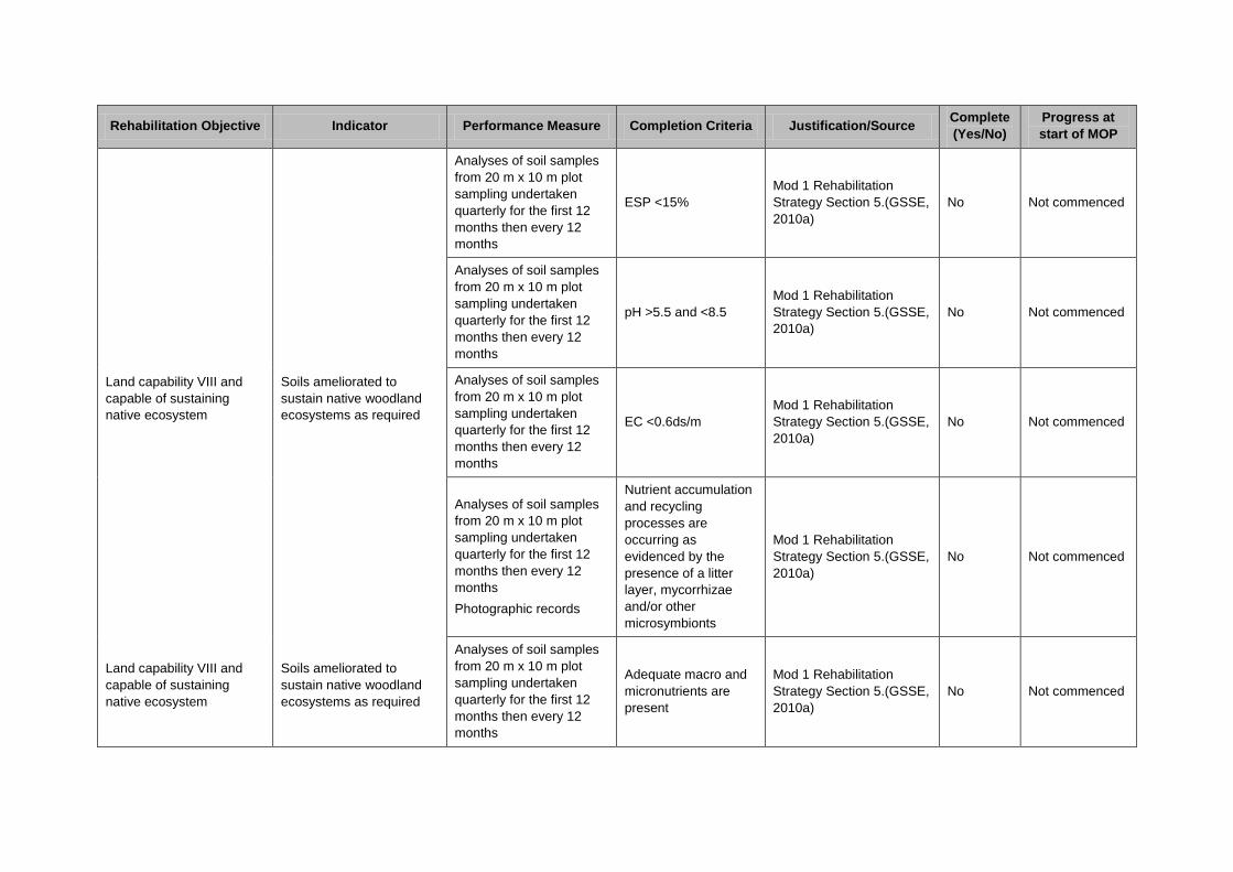
Rehabilitation Objective Indicator Performance Measure Completion Criteria Justification/Source Complete
(Yes/No)
Progress at
start of MOP
Land capability VIII and
capable of sustaining
native ecosystem
Land capability VIII and
capable of sustaining
native ecosystem
Soils ameliorated to
sustain native woodland
ecosystems as required
Soils ameliorated to
sustain native woodland
ecosystems as required
Analyses of soil samples
from 20 m x 10 m plot
sampling undertaken
quarterly for the first 12
months then every 12
months
ESP <15%
Mod 1 Rehabilitation
Strategy Section 5.(GSSE,
2010a)
No Not commenced
Analyses of soil samples
from 20 m x 10 m plot
sampling undertaken
quarterly for the first 12
months then every 12
months
pH >5.5 and <8.5
Mod 1 Rehabilitation
Strategy Section 5.(GSSE,
2010a)
No Not commenced
Analyses of soil samples
from 20 m x 10 m plot
sampling undertaken
quarterly for the first 12
months then every 12
months
EC <0.6ds/m
Mod 1 Rehabilitation
Strategy Section 5.(GSSE,
2010a)
No Not commenced
Analyses of soil samples
from 20 m x 10 m plot
sampling undertaken
quarterly for the first 12
months then every 12
months
Photographic records
Nutrient accumulation
and recycling
processes are
occurring as
evidenced by the
presence of a litter
layer, mycorrhizae
and/or other
microsymbionts
Mod 1 Rehabilitation
Strategy Section 5.(GSSE,
2010a)
No Not commenced
Analyses of soil samples
from 20 m x 10 m plot
sampling undertaken
quarterly for the first 12
months then every 12
months
Adequate macro and
micronutrients are
present
Mod 1 Rehabilitation
Strategy Section 5.(GSSE,
2010a)
No Not commenced

Rehabilitation Objective Indicator Performance Measure Completion Criteria Justification/Source Complete
(Yes/No)
Progress at
start of MOP
Domain B Rehabilitation – Grassland
Land capability IV and
capable of sustaining
grasslands
Land capability IV and
capable of sustaining
grasslands
Soils ameliorated to
sustain grasslands
Soils ameliorated to
sustain grasslands
Analyses of soil samples
from 20 m x 10 m plot
sampling undertaken
quarterly for the first 12
months then every 12
months
ESP <15%
Mod 1 Rehabilitation
Strategy Section 5.(GSSE,
2010a)
No Not commenced
Analyses of soil samples
from 20 m x 10 m plot
sampling undertaken
quarterly for the first 12
months then every 12
months
pH >5.5 and <8.5
Mod 1 Rehabilitation
Strategy Section 5.(GSSE,
2010a)
No Not commenced
Analyses of soil samples
from 20 m x 10 m plot
sampling undertaken
quarterly for the first 12
months then every 12
months
EC <0.6ds/m
Mod 1 Rehabilitation
Strategy Section 5.(GSSE,
2010a)
No Not commenced
Analyses of soil samples
from 20 m x 10 m plot
sampling undertaken
quarterly for the first 12
months then every 12
months
Nutrient accumulation
and recycling
processes are
deemed to be
occurring
Mod 1 Rehabilitation
Strategy Section 5.(GSSE,
2010a)
No Not commenced
Analyses of soil samples
from 20 m x 10 m plot
sampling undertaken
quarterly for the first 12
months then every 12
months
Adequate macro and
micronutrients are
present
Mod 1 Rehabilitation
Strategy Section 5.(GSSE,
2010a)
No Not commenced
Domain C – Water Management Area
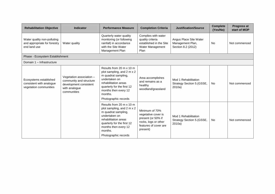
Rehabilitation Objective Indicator Performance Measure Completion Criteria Justification/Source Complete
(Yes/No)
Progress at
start of MOP
Water quality non-polluting
and appropriate for forestry
end land use
Water quality
Quarterly water quality
monitoring (or following
rainfall) in accordance
with the Site Water
Management Plan
Complies with water
quality criteria
established in the Site
Water Management
Plan
Angus Place Site Water
Management Plan,
Section 8.2 (2012)
No Not commenced
Phase - Ecosystem Establishment
Domain 1 – Infrastructure
Ecosystems established
consistent with analogue
vegetation communities
Vegetation association –
community and structure
development consistent
with analogue
communities
Results from 20 m x 10 m
plot sampling, and 2 m x 2
m quadrat sampling,
undertaken on
rehabilitation areas
quarterly for the first 12
months then every 12
months.
Photographic records
Area accomplishes
and remains as a
healthy
woodland/grassland
Mod 1 Rehabilitation
Strategy Section 5.(GSSE,
2010a)
No Not commenced
Results from 20 m x 10 m
plot sampling, and 2 m x 2
m quadrat sampling,
undertaken on
rehabilitation areas
quarterly for the first 12
months then every 12
months.
Photographic records
Minimum of 70%
vegetative cover is
present (or 50% if
rocks, logs or other
features of cover are
present)
Mod 1 Rehabilitation
Strategy Section 5.(GSSE,
2010a)
No Not commenced
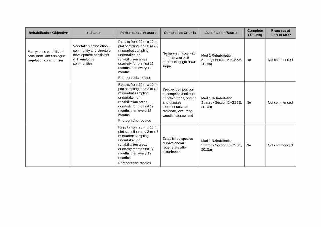
Rehabilitation Objective Indicator Performance Measure Completion Criteria Justification/Source Complete
(Yes/No)
Progress at
start of MOP
Ecosystems established
consistent with analogue
vegetation communities
Vegetation association –
community and structure
development consistent
with analogue
communities
Results from 20 m x 10 m
plot sampling, and 2 m x 2
m quadrat sampling,
undertaken on
rehabilitation areas
quarterly for the first 12
months then every 12
months.
Photographic records
No bare surfaces >20
m2 in area or >10
metres in length down
slope
Mod 1 Rehabilitation
Strategy Section 5.(GSSE,
2010a)
No Not commenced
Results from 20 m x 10 m
plot sampling, and 2 m x 2
m quadrat sampling,
undertaken on
rehabilitation areas
quarterly for the first 12
months then every 12
months.
Photographic records
Species composition
to comprise a mixture
of native trees, shrubs
and grasses
representative of
regionally occurring
woodland/grassland
Mod 1 Rehabilitation
Strategy Section 5.(GSSE,
2010a)
No Not commenced
Results from 20 m x 10 m
plot sampling, and 2 m x 2
m quadrat sampling,
undertaken on
rehabilitation areas
quarterly for the first 12
months then every 12
months.
Photographic records
Established species
survive and/or
regenerate after
disturbance
Mod 1 Rehabilitation
Strategy Section 5.(GSSE,
2010a)
No Not commenced

Rehabilitation Objective Indicator Performance Measure Completion Criteria Justification/Source Complete
(Yes/No)
Progress at
start of MOP
Ecosystems established
consistent with analogue
vegetation communities
Ecosystems established
Vegetation association –
community and structure
development consistent
with analogue
communities
Vegetation association –
Quarterly rehabilitation
inspections during the first
two years then biennially.
Opportunistic inspections
after significant rainfall
events.
Photographic records
Weeds do not
dominate native
species after
disturbance or after
rain
Mod 1 Rehabilitation
Strategy Section 5.(GSSE,
2010a)
No Not commenced
Quarterly rehabilitation
inspections during the first
two years then biennially.
Pests do not occur in
substantial numbers
or visibly affect the
development of native
plant species
Mod 1 Rehabilitation
Strategy Section 5.(GSSE,
2010a)
No Not commenced
Photographic records
Species are capable
of setting viable seed,
flowering or otherwise
reproducing
Mod 1 Rehabilitation
Strategy Section 5.(GSSE,
2010a)
No Not commenced
Quarterly rehabilitation
inspections during the first
two years then biennially.
Photographic records
Evidence of second
generation of shrub
and understorey
species in woodland
areas (not applicable
to grassland areas)
Mod 1 Rehabilitation
Strategy Section 5.(GSSE,
2010a)
No Not commenced
Results from 20 m x 10 m
plot sampling, and 2 m x 2
m quadrat sampling,
undertaken on
rehabilitation areas
quarterly for the first 12
months then every 12
months.
Photographic records
Vegetation in
woodland areas
develops and
maintains a litter layer
evidenced by a
consistent mass and
depth of litter over
subsequent seasons
(not applicable to
grassland areas)
Mod 1 Rehabilitation
Strategy Section 5.(GSSE,
2010a)
No Not commenced
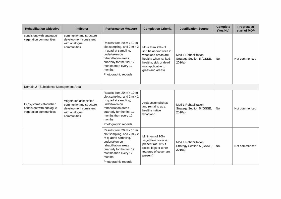
Rehabilitation Objective Indicator Performance Measure Completion Criteria Justification/Source Complete
(Yes/No)
Progress at
start of MOP
consistent with analogue
vegetation communities
community and structure
development consistent
with analogue
communities
Results from 20 m x 10 m
plot sampling, and 2 m x 2
m quadrat sampling,
undertaken on
rehabilitation areas
quarterly for the first 12
months then every 12
months.
Photographic records
More than 75% of
shrubs and/or trees in
woodland areas are
healthy when ranked
healthy, sick or dead
(not applicable to
grassland areas)
Mod 1 Rehabilitation
Strategy Section 5.(GSSE,
2010a)
No Not commenced
Domain 2 - Subsidence Management Area
Ecosystems established
consistent with analogue
vegetation communities
Vegetation association –
community and structure
development consistent
with analogue
communities
Results from 20 m x 10 m
plot sampling, and 2 m x 2
m quadrat sampling,
undertaken on
rehabilitation areas
quarterly for the first 12
months then every 12
months.
Photographic records
Area accomplishes
and remains as a
healthy native
woodland
Mod 1 Rehabilitation
Strategy Section 5.(GSSE,
2010a)
No Not commenced
Results from 20 m x 10 m
plot sampling, and 2 m x 2
m quadrat sampling,
undertaken on
rehabilitation areas
quarterly for the first 12
months then every 12
months.
Photographic records
Minimum of 70%
vegetative cover is
present (or 50% if
rocks, logs or other
features of cover are
present)
Mod 1 Rehabilitation
Strategy Section 5.(GSSE,
2010a)
No Not commenced

Rehabilitation Objective Indicator Performance Measure Completion Criteria Justification/Source Complete
(Yes/No)
Progress at
start of MOP
Ecosystems established
consistent with analogue
vegetation communities
Vegetation association –
community and structure
development consistent
with analogue
communities
Results from 20 m x 10 m
plot sampling, and 2 m x 2
m quadrat sampling,
undertaken on
rehabilitation areas
quarterly for the first 12
months then every 12
months.
Photographic records
No bare surfaces >20
m2 in area or >10
metres in length down
slope
Mod 1 Rehabilitation
Strategy Section 5.(GSSE,
2010a)
No Not commenced
Results from 20 m x 10 m
plot sampling, and 2 m x 2
m quadrat sampling,
undertaken on
rehabilitation areas
quarterly for the first 12
months then every 12
months.
Photographic records
Species composition
to comprise a mixture
of native trees, shrubs
and grasses
representative of
regionally occurring
woodland
Mod 1 Rehabilitation
Strategy Section 5.(GSSE,
2010a)
No Not commenced
Results from 20 m x 10 m
plot sampling, and 2 m x 2
m quadrat sampling,
undertaken on
rehabilitation areas
quarterly for the first 12
months then every 12
months.
Photographic records
Established species
survive and/or
regenerate after
disturbance
Mod 1 Rehabilitation
Strategy Section 5.(GSSE,
2010a)
No Not commenced
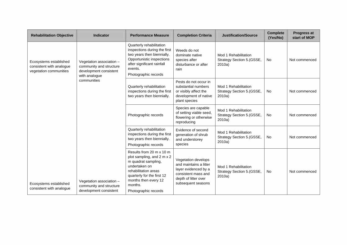
Rehabilitation Objective Indicator Performance Measure Completion Criteria Justification/Source Complete
(Yes/No)
Progress at
start of MOP
Ecosystems established
consistent with analogue
vegetation communities
Ecosystems established
consistent with analogue
Vegetation association –
community and structure
development consistent
with analogue
communities
Vegetation association –
community and structure
development consistent
Quarterly rehabilitation
inspections during the first
two years then biennially.
Opportunistic inspections
after significant rainfall
events.
Photographic records
Weeds do not
dominate native
species after
disturbance or after
rain
Mod 1 Rehabilitation
Strategy Section 5.(GSSE,
2010a)
No Not commenced
Quarterly rehabilitation
inspections during the first
two years then biennially.
Pests do not occur in
substantial numbers
or visibly affect the
development of native
plant species
Mod 1 Rehabilitation
Strategy Section 5.(GSSE,
2010a)
No Not commenced
Photographic records
Species are capable
of setting viable seed,
flowering or otherwise
reproducing
Mod 1 Rehabilitation
Strategy Section 5.(GSSE,
2010a)
No Not commenced
Quarterly rehabilitation
inspections during the first
two years then biennially.
Photographic records
Evidence of second
generation of shrub
and understorey
species
Mod 1 Rehabilitation
Strategy Section 5.(GSSE,
2010a)
No Not commenced
Results from 20 m x 10 m
plot sampling, and 2 m x 2
m quadrat sampling,
undertaken on
rehabilitation areas
quarterly for the first 12
months then every 12
months.
Photographic records
Vegetation develops
and maintains a litter
layer evidenced by a
consistent mass and
depth of litter over
subsequent seasons
Mod 1 Rehabilitation
Strategy Section 5.(GSSE,
2010a)
No Not commenced
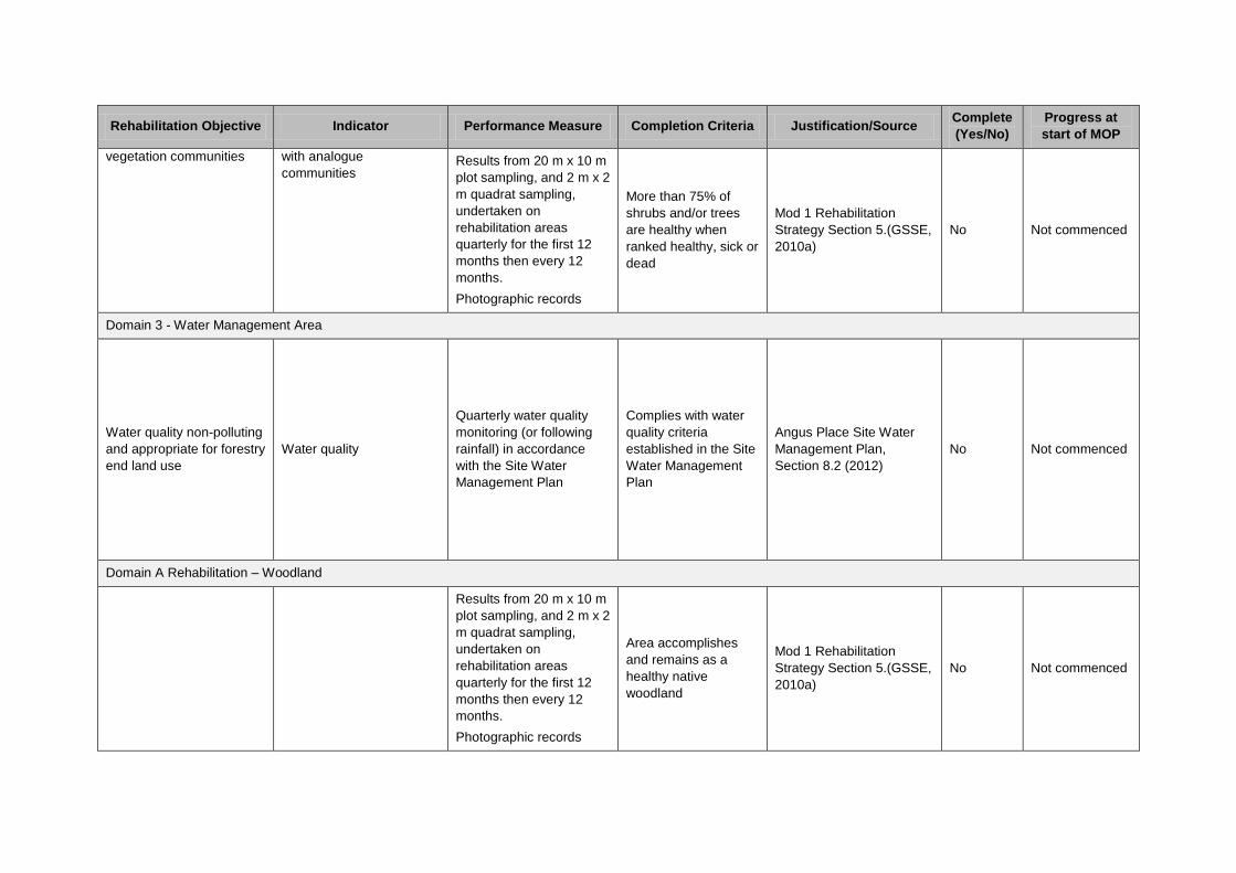
Rehabilitation Objective Indicator Performance Measure Completion Criteria Justification/Source Complete
(Yes/No)
Progress at
start of MOP
vegetation communities
with analogue
communities
Results from 20 m x 10 m
plot sampling, and 2 m x 2
m quadrat sampling,
undertaken on
rehabilitation areas
quarterly for the first 12
months then every 12
months.
Photographic records
More than 75% of
shrubs and/or trees
are healthy when
ranked healthy, sick or
dead
Mod 1 Rehabilitation
Strategy Section 5.(GSSE,
2010a)
No Not commenced
Domain 3 - Water Management Area
Water quality non-polluting
and appropriate for forestry
end land use
Water quality
Quarterly water quality
monitoring (or following
rainfall) in accordance
with the Site Water
Management Plan
Complies with water
quality criteria
established in the Site
Water Management
Plan
Angus Place Site Water
Management Plan,
Section 8.2 (2012)
No Not commenced
Domain A Rehabilitation – Woodland
Results from 20 m x 10 m
plot sampling, and 2 m x 2
m quadrat sampling,
undertaken on
rehabilitation areas
quarterly for the first 12
months then every 12
months.
Photographic records
Area accomplishes
and remains as a
healthy native
woodland
Mod 1 Rehabilitation
Strategy Section 5.(GSSE,
2010a)
No Not commenced

Rehabilitation Objective Indicator Performance Measure Completion Criteria Justification/Source Complete
(Yes/No)
Progress at
start of MOP
Ecosystems established
consistent with analogue
vegetation communities
Vegetation association –
community and structure
development consistent
with analogue
communities
Results from 20 m x 10 m
plot sampling, and 2 m x 2
m quadrat sampling,
undertaken on
rehabilitation areas
quarterly for the first 12
months then every 12
months.
Photographic records
Minimum of 70%
vegetative cover is
present (or 50% if
rocks, logs or other
features of cover are
present)
Mod 1 Rehabilitation
Strategy Section 5.(GSSE,
2010a)
No Not commenced
Results from 20 m x 10 m
plot sampling, and 2 m x 2
m quadrat sampling,
undertaken on
rehabilitation areas
quarterly for the first 12
months then every 12
months.
Photographic records
No bare surfaces >20
m2 in area or >10
metres in length down
slope
Mod 1 Rehabilitation
Strategy Section 5.(GSSE,
2010a)
No Not commenced
Results from 20 m x 10 m
plot sampling, and 2 m x 2
m quadrat sampling,
undertaken on
rehabilitation areas
quarterly for the first 12
months then every 12
months.
Photographic records
Species composition
to comprise a mixture
of native trees, shrubs
and grasses
representative of
regionally occurring
woodland
Mod 1 Rehabilitation
Strategy Section 5.(GSSE,
2010a)
No Not commenced

Rehabilitation Objective Indicator Performance Measure Completion Criteria Justification/Source Complete
(Yes/No)
Progress at
start of MOP
Ecosystems established
consistent with analogue
vegetation communities
Vegetation association –
community and structure
development consistent
with analogue
communities
Results from 20 m x 10 m
plot sampling, and 2 m x 2
m quadrat sampling,
undertaken on
rehabilitation areas
quarterly for the first 12
months then every 12
months.
Photographic records
Established species
survive and/or
regenerate after
disturbance
Mod 1 Rehabilitation
Strategy Section 5.(GSSE,
2010a)
No Not commenced
Quarterly rehabilitation
inspections during the first
two years then biennially.
Opportunistic inspections
after significant rainfall
events.
Photographic records
Weeds do not
dominate native
species after
disturbance or after
rain
Mod 1 Rehabilitation
Strategy Section 5.(GSSE,
2010a)
No Not commenced
Quarterly rehabilitation
inspections during the first
two years then biennially.
Pests do not occur in
substantial numbers
or visibly affect the
development of native
plant species
Mod 1 Rehabilitation
Strategy Section 5.(GSSE,
2010a)
No Not commenced
Photographic records
Species are capable
of setting viable seed,
flowering or otherwise
reproducing
Mod 1 Rehabilitation
Strategy Section 5.(GSSE,
2010a)
No Not commenced

Rehabilitation Objective Indicator Performance Measure Completion Criteria Justification/Source Complete
(Yes/No)
Progress at
start of MOP
Ecosystems established
consistent with analogue
vegetation communities
Vegetation association –
community and structure
development consistent
with analogue
communities
Quarterly rehabilitation
inspections during the first
two years then biennially.
Photographic records
Evidence of second
generation of shrub
and understorey
species
Mod 1 Rehabilitation
Strategy Section 5.(GSSE,
2010a)
No Not commenced
Results from 20 m x 10 m
plot sampling, and 2 m x 2
m quadrat sampling,
undertaken on
rehabilitation areas
quarterly for the first 12
months then every 12
months.
Photographic records
Vegetation develops
and maintains a litter
layer evidenced by a
consistent mass and
depth of litter over
subsequent seasons
Mod 1 Rehabilitation
Strategy Section 5.(GSSE,
2010a)
No Not commenced
Results from 20 m x 10 m
plot sampling, and 2 m x 2
m quadrat sampling,
undertaken on
rehabilitation areas
quarterly for the first 12
months then every 12
months.
Photographic records
More than 75% of
shrubs and/or trees
are healthy when
ranked healthy, sick or
dead
Mod 1 Rehabilitation
Strategy Section 5.(GSSE,
2010a)
No Not commenced
Domain B Rehabilitation – Grassland
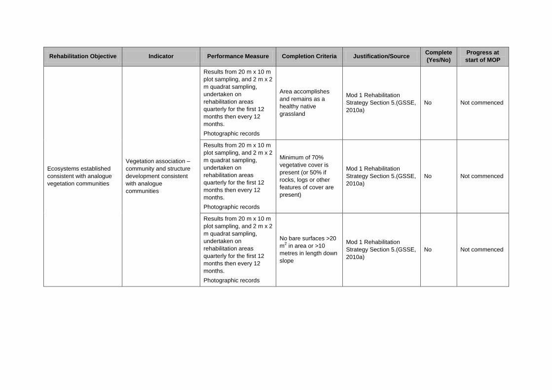
Rehabilitation Objective Indicator Performance Measure Completion Criteria Justification/Source Complete
(Yes/No)
Progress at
start of MOP
Ecosystems established
consistent with analogue
vegetation communities
Vegetation association –
community and structure
development consistent
with analogue
communities
Results from 20 m x 10 m
plot sampling, and 2 m x 2
m quadrat sampling,
undertaken on
rehabilitation areas
quarterly for the first 12
months then every 12
months.
Photographic records
Area accomplishes
and remains as a
healthy native
grassland
Mod 1 Rehabilitation
Strategy Section 5.(GSSE,
2010a)
No Not commenced
Results from 20 m x 10 m
plot sampling, and 2 m x 2
m quadrat sampling,
undertaken on
rehabilitation areas
quarterly for the first 12
months then every 12
months.
Photographic records
Minimum of 70%
vegetative cover is
present (or 50% if
rocks, logs or other
features of cover are
present)
Mod 1 Rehabilitation
Strategy Section 5.(GSSE,
2010a)
No Not commenced
Results from 20 m x 10 m
plot sampling, and 2 m x 2
m quadrat sampling,
undertaken on
rehabilitation areas
quarterly for the first 12
months then every 12
months.
Photographic records
No bare surfaces >20
m2 in area or >10
metres in length down
slope
Mod 1 Rehabilitation
Strategy Section 5.(GSSE,
2010a)
No Not commenced
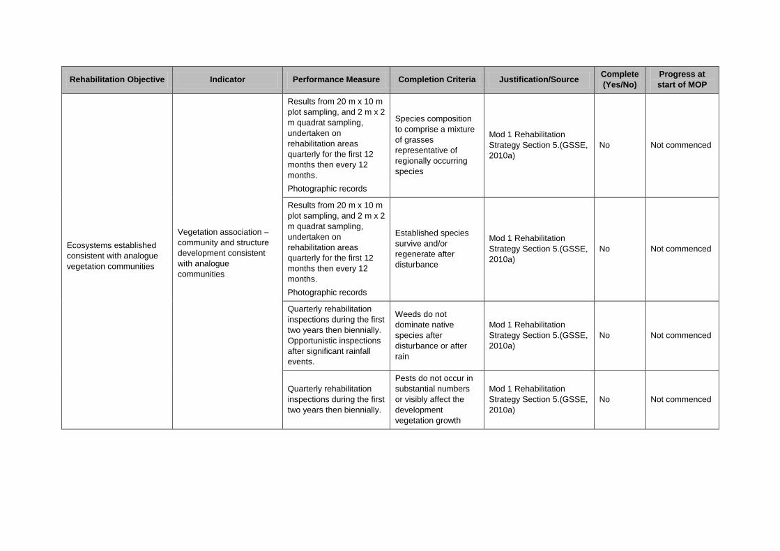
Rehabilitation Objective Indicator Performance Measure Completion Criteria Justification/Source Complete
(Yes/No)
Progress at
start of MOP
Ecosystems established
consistent with analogue
vegetation communities
Vegetation association –
community and structure
development consistent
with analogue
communities
Results from 20 m x 10 m
plot sampling, and 2 m x 2
m quadrat sampling,
undertaken on
rehabilitation areas
quarterly for the first 12
months then every 12
months.
Photographic records
Species composition
to comprise a mixture
of grasses
representative of
regionally occurring
species
Mod 1 Rehabilitation
Strategy Section 5.(GSSE,
2010a)
No Not commenced
Results from 20 m x 10 m
plot sampling, and 2 m x 2
m quadrat sampling,
undertaken on
rehabilitation areas
quarterly for the first 12
months then every 12
months.
Photographic records
Established species
survive and/or
regenerate after
disturbance
Mod 1 Rehabilitation
Strategy Section 5.(GSSE,
2010a)
No Not commenced
Quarterly rehabilitation
inspections during the first
two years then biennially.
Opportunistic inspections
after significant rainfall
events.
Weeds do not
dominate native
species after
disturbance or after
rain
Mod 1 Rehabilitation
Strategy Section 5.(GSSE,
2010a)
No Not commenced
Quarterly rehabilitation
inspections during the first
two years then biennially.
Pests do not occur in
substantial numbers
or visibly affect the
development
vegetation growth
Mod 1 Rehabilitation
Strategy Section 5.(GSSE,
2010a)
No Not commenced
Rehabilitation Objective Indicator Performance Measure Completion Criteria Justification/Source Complete
(Yes/No)
Progress at
start of MOP
Ecosystems established
consistent with analogue
vegetation communities
Vegetation association –
community and structure
development consistent
with analogue
communities
Photographic records
Species are capable
of setting viable seed,
flowering or otherwise
reproducing
Mod 1 Rehabilitation
Strategy Section 5.(GSSE,
2010a)
No Not commenced
Domain C – Water Management Area
Water quality non-polluting
and appropriate for forestry
end land use
Water quality
Quarterly water quality
monitoring (or following
rainfall) in accordance
with the Site Water
Management Plan
Complies with water
quality criteria
established in the Site
Water Management
Plan
Angus Place Site Water
Management Plan,
Section 8.2 (2012)
No Not commenced
Phase - Ecosystem Development
Domain 1 – Infrastructure
Ecosystems established
consistent with analogue
vegetation communities
Vegetation association –
community and structure
development consistent
with analogue
communities
Results from 20 m x 10 m
plot sampling, and 2 m x 2
m quadrat sampling,
undertaken on
rehabilitation areas
quarterly for the first 12
months then every 12
months.
Area remains as a
healthy native
woodland/grassland
Mod 1 Rehabilitation
Strategy Section 5.(GSSE,
2010a)
No Not commenced
Results from 20 m x 10 m
plot sampling, and 2 m x 2
m quadrat sampling,
undertaken on
rehabilitation areas
quarterly for the first 12
months then every 12
months.
Photographic records
Minimum of 70%
vegetative cover is
present (or 50% if
rocks, logs or other
features of cover are
present)
Mod 1 Rehabilitation
Strategy Section 5.(GSSE,
2010a)
No Not commenced
Rehabilitation Objective Indicator Performance Measure Completion Criteria Justification/Source Complete
(Yes/No)
Progress at
start of MOP
Ecosystems established
consistent with analogue
vegetation communities
Ecosystems established
consistent with analogue
Vegetation association –
community and structure
development consistent
with analogue
communities
Vegetation association –
community and structure
Results from 20 m x 10 m
plot sampling, and 2 m x 2
m quadrat sampling,
undertaken on
rehabilitation areas
quarterly for the first 12
months then every 12
months.
Photographic records
No bare surfaces >20
m2 in area or >10
metres in length down
slope
Mod 1 Rehabilitation
Strategy Section 5.(GSSE,
2010a)
No Not commenced
Results from 20 m x 10 m
plot sampling, and 2 m x 2
m quadrat sampling,
undertaken on
rehabilitation areas
quarterly for the first 12
months then every 12
months.
Photographic records
Species composition
to comprise a mixture
of native trees, shrubs
and grasses
representative of
regionally occurring
woodland/grassland
Mod 1 Rehabilitation
Strategy Section 5.(GSSE,
2010a)
No Not commenced
Results from 20 m x 10 m
plot sampling, and 2 m x 2
m quadrat sampling,
undertaken on
rehabilitation areas
quarterly for the first 12
months then every 12
months.
Photographic records
Established species
survive and/or
regenerate after
disturbance
Mod 1 Rehabilitation
Strategy Section 5.(GSSE,
2010a)
No Not commenced
Quarterly rehabilitation
inspections during the first
two years then biennially.
Opportunistic inspections
after significant rainfall
events.
Weeds do not
dominate native
species after
disturbance or after
rain
Mod 1 Rehabilitation
Strategy Section 5.(GSSE,
2010a)
No Not commenced

Rehabilitation Objective Indicator Performance Measure Completion Criteria Justification/Source Complete
(Yes/No)
Progress at
start of MOP
vegetation communities
Ecosystems established
development consistent
with analogue
communities
Vegetation association –
community and structure
Quarterly rehabilitation
inspections during the first
two years then biennially.
Pests do not occur in
substantial numbers
or visibly affect the
development of native
plant species
Mod 1 Rehabilitation
Strategy Section 5.(GSSE,
2010a)
No Not commenced
Photographic records
Species are capable
of setting viable seed,
flowering or otherwise
reproducing
Mod 1 Rehabilitation
Strategy Section 5.(GSSE,
2010a)
No Not commenced
Quarterly rehabilitation
inspections during the first
two years then biennially.
Photographic records
Evidence of second
generation of shrub
and understorey
species in woodland
areas (not applicable
to grassland)
Mod 1 Rehabilitation
Strategy Section 5.(GSSE,
2010a)
No Not commenced
Results from 20 m x 10 m
plot sampling, and 2 m x 2
m quadrat sampling,
undertaken on
rehabilitation areas
quarterly for the first 12
months then every 12
months.
Photographic records
Woodland vegetation
maintains a litter layer
evidenced by a
consistent mass and
depth of litter over
subsequent seasons
(not applicable to
grassland)
Mod 1 Rehabilitation
Strategy Section 5.(GSSE,
2010a)
No Not commenced

Rehabilitation Objective Indicator Performance Measure Completion Criteria Justification/Source Complete
(Yes/No)
Progress at
start of MOP
consistent with analogue
vegetation communities
development consistent
with analogue
communities
Results from 20 m x 10 m
plot sampling, and 2 m x 2
m quadrat sampling,
undertaken on
rehabilitation areas
quarterly for the first 12
months then every 12
months.
Photographic records
More than 75% of
woodland shrubs
and/or trees are
healthy when ranked
healthy, sick or dead
(not applicable to
grassland)
Mod 1 Rehabilitation
Strategy Section 5.(GSSE,
2010a)
No Not commenced
Domain 2 - Subsidence Management Area
Ecosystems established
consistent with analogue
vegetation communities
Vegetation association –
community and structure
development consistent
with analogue
communities
Results from 20 m x 10 m
plot sampling, and 2 m x 2
m quadrat sampling,
undertaken on
rehabilitation areas
quarterly for the first 12
months then every 12
months.
Photographic records
Area remains as a
healthy native
woodland
Mod 1 Rehabilitation
Strategy Section 5.(GSSE,
2010a)
No Not commenced
Results from 20 m x 10 m
plot sampling, and 2 m x 2
m quadrat sampling,
undertaken on
rehabilitation areas
quarterly for the first 12
months then every 12
months.
Photographic records
Minimum of 70%
vegetative cover is
present (or 50% if
rocks, logs or other
features of cover are
present)
Mod 1 Rehabilitation
Strategy Section 5.(GSSE,
2010a)
No Not commenced

Rehabilitation Objective Indicator Performance Measure Completion Criteria Justification/Source Complete
(Yes/No)
Progress at
start of MOP
Ecosystems established
consistent with analogue
vegetation communities
Ecosystems established
consistent with analogue
vegetation communities
Vegetation association –
community and structure
development consistent
with analogue
communities
Vegetation association –
community and structure
development consistent
with analogue
Results from 20 m x 10 m
plot sampling, and 2 m x 2
m quadrat sampling,
undertaken on
rehabilitation areas
quarterly for the first 12
months then every 12
months.
Photographic records
No bare surfaces >20
m2 in area or >10
metres in length down
slope
Mod 1 Rehabilitation
Strategy Section 5.(GSSE,
2010a)
No Not commenced
Results from 20 m x 10 m
plot sampling, and 2 m x 2
m quadrat sampling,
undertaken on
rehabilitation areas
quarterly for the first 12
months then every 12
months.
Photographic records
Species composition
to comprise a mixture
of native trees, shrubs
and grasses
representative of
regionally occurring
woodland
Mod 1 Rehabilitation
Strategy Section 5.(GSSE,
2010a)
No Not commenced
Results from 20 m x 10 m
plot sampling, and 2 m x 2
m quadrat sampling,
undertaken on
rehabilitation areas
quarterly for the first 12
months then every 12
months.
Photographic records
Established species
survive and/or
regenerate after
disturbance
Mod 1 Rehabilitation
Strategy Section 5.(GSSE,
2010a)
No Not commenced
Quarterly rehabilitation
inspections during the first
two years then biennially.
Opportunistic inspections
after significant rainfall
events.
Weeds do not
dominate native
species after
disturbance or after
rain
Mod 1 Rehabilitation
Strategy Section 5.(GSSE,
2010a)
No Not commenced

Rehabilitation Objective Indicator Performance Measure Completion Criteria Justification/Source Complete
(Yes/No)
Progress at
start of MOP
Ecosystems established
consistent with analogue
vegetation communities
communities
Vegetation association –
community and structure
development consistent
with analogue
communities
Quarterly rehabilitation
inspections during the first
two years then biennially.
Pests do not occur in
substantial numbers
or visibly affect the
development of native
plant species
Mod 1 Rehabilitation
Strategy Section 5.(GSSE,
2010a)
No Not commenced
Photographic records
Species are capable
of setting viable seed,
flowering or otherwise
reproducing
Mod 1 Rehabilitation
Strategy Section 5.(GSSE,
2010a)
No Not commenced
Quarterly rehabilitation
inspections during the first
two years then biennially.
Photographic records
Evidence of second
generation of shrub
and understorey
species
Mod 1 Rehabilitation
Strategy Section 5.(GSSE,
2010a)
No Not commenced
Results from 20 m x 10 m
plot sampling, and 2 m x 2
m quadrat sampling,
undertaken on
rehabilitation areas
quarterly for the first 12
months then every 12
months.
Photographic records
Vegetation maintains
a litter layer evidenced
by a consistent mass
and depth of litter over
subsequent seasons
Mod 1 Rehabilitation
Strategy Section 5.(GSSE,
2010a)
No Not commenced
Results from 20 m x 10 m
plot sampling, and 2 m x 2
m quadrat sampling,
undertaken on
rehabilitation areas
quarterly for the first 12
months then every 12
months.
Photographic records
More than 75% of
shrubs and/or trees
are healthy when
ranked healthy, sick or
dead
Mod 1 Rehabilitation
Strategy Section 5.(GSSE,
2010a)
No Not commenced
Domain 3 - Water Management Area
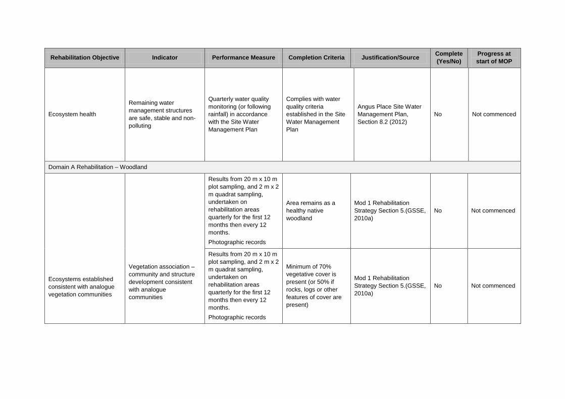
Rehabilitation Objective Indicator Performance Measure Completion Criteria Justification/Source Complete
(Yes/No)
Progress at
start of MOP
Ecosystem health
Remaining water
management structures
are safe, stable and non-
polluting
Quarterly water quality
monitoring (or following
rainfall) in accordance
with the Site Water
Management Plan
Complies with water
quality criteria
established in the Site
Water Management
Plan
Angus Place Site Water
Management Plan,
Section 8.2 (2012)
No Not commenced
Domain A Rehabilitation – Woodland
Ecosystems established
consistent with analogue
vegetation communities
Vegetation association –
community and structure
development consistent
with analogue
communities
Results from 20 m x 10 m
plot sampling, and 2 m x 2
m quadrat sampling,
undertaken on
rehabilitation areas
quarterly for the first 12
months then every 12
months.
Photographic records
Area remains as a
healthy native
woodland
Mod 1 Rehabilitation
Strategy Section 5.(GSSE,
2010a)
No Not commenced
Results from 20 m x 10 m
plot sampling, and 2 m x 2
m quadrat sampling,
undertaken on
rehabilitation areas
quarterly for the first 12
months then every 12
months.
Photographic records
Minimum of 70%
vegetative cover is
present (or 50% if
rocks, logs or other
features of cover are
present)
Mod 1 Rehabilitation
Strategy Section 5.(GSSE,
2010a)
No Not commenced

Rehabilitation Objective Indicator Performance Measure Completion Criteria Justification/Source Complete
(Yes/No)
Progress at
start of MOP
Ecosystems established
consistent with analogue
vegetation communities
Vegetation association –
community and structure
development consistent
with analogue
communities
Results from 20 m x 10 m
plot sampling, and 2 m x 2
m quadrat sampling,
undertaken on
rehabilitation areas
quarterly for the first 12
months then every 12
months.
Photographic records
No bare surfaces >20
m2 in area or >10
metres in length down
slope
Mod 1 Rehabilitation
Strategy Section 5.(GSSE,
2010a)
No Not commenced
Results from 20 m x 10 m
plot sampling, and 2 m x 2
m quadrat sampling,
undertaken on
rehabilitation areas
quarterly for the first 12
months then every 12
months.
Photographic records
Species composition
to comprise a mixture
of native trees, shrubs
and grasses
representative of
regionally occurring
woodland
Mod 1 Rehabilitation
Strategy Section 5.(GSSE,
2010a)
No Not commenced
Results from 20 m x 10 m
plot sampling, and 2 m x 2
m quadrat sampling,
undertaken on
rehabilitation areas
quarterly for the first 12
months then every 12
months.
Photographic records
Established species
survive and/or
regenerate after
disturbance
Mod 1 Rehabilitation
Strategy Section 5.(GSSE,
2010a)
No Not commenced
Quarterly rehabilitation
inspections during the first
two years then biennially.
Opportunistic inspections
after significant rainfall
events.
Weeds do not
dominate native
species after
disturbance or after
rain
Mod 1 Rehabilitation
Strategy Section 5.(GSSE,
2010a)
No Not commenced

Rehabilitation Objective Indicator Performance Measure Completion Criteria Justification/Source Complete
(Yes/No)
Progress at
start of MOP
Ecosystems established
consistent with analogue
vegetation communities
Vegetation association –
community and structure
development consistent
with analogue
communities
Quarterly rehabilitation
inspections during the first
two years then biennially.
Pests do not occur in
substantial numbers
or visibly affect the
development of native
plant species
Mod 1 Rehabilitation
Strategy Section 5.(GSSE,
2010a)
No Not commenced
Photographic records
Species are capable
of setting viable seed,
flowering or otherwise
reproducing
Mod 1 Rehabilitation
Strategy Section 5.(GSSE,
2010a)
No Not commenced
Quarterly rehabilitation
inspections during the first
two years then biennially.
Photographic records
Evidence of second
generation of shrub
and understorey
species
Mod 1 Rehabilitation
Strategy Section 5.(GSSE,
2010a)
No Not commenced
Results from 20 m x 10 m
plot sampling, and 2 m x 2
m quadrat sampling,
undertaken on
rehabilitation areas
quarterly for the first 12
months then every 12
months.
Photographic records
Vegetation maintains
a litter layer evidenced
by a consistent mass
and depth of litter over
subsequent seasons
Mod 1 Rehabilitation
Strategy Section 5.(GSSE,
2010a)
No Not commenced

Rehabilitation Objective Indicator Performance Measure Completion Criteria Justification/Source Complete
(Yes/No)
Progress at
start of MOP
Results from 20 m x 10 m
plot sampling, and 2 m x 2
m quadrat sampling,
undertaken on
rehabilitation areas
quarterly for the first 12
months then every 12
months.
Photographic records
More than 75% of
shrubs and/or trees
are healthy when
ranked healthy, sick or
dead
Mod 1 Rehabilitation
Strategy Section 5.(GSSE,
2010a)
No Not commenced
Domain B Rehabilitation – Grassland
Ecosystems established
consistent with analogue
vegetation communities
Vegetation association –
community and structure
development consistent
with analogue
communities
Results from 20 m x 10 m
plot sampling, and 2 m x 2
m quadrat sampling,
undertaken on
rehabilitation areas
quarterly for the first 12
months then every 12
months.
Photographic records
Area remains as a
healthy native
grassland
Mod 1 Rehabilitation
Strategy Section 5.(GSSE,
2010a)
No Not commenced
Results from 20 m x 10 m
plot sampling, and 2 m x 2
m quadrat sampling,
undertaken on
rehabilitation areas
quarterly for the first 12
months then every 12
months.
Photographic records
Minimum of 70%
vegetative cover is
present (or 50% if
rocks, logs or other
features of cover are
present)
Mod 1 Rehabilitation
Strategy Section 5.(GSSE,
2010a)
No Not commenced
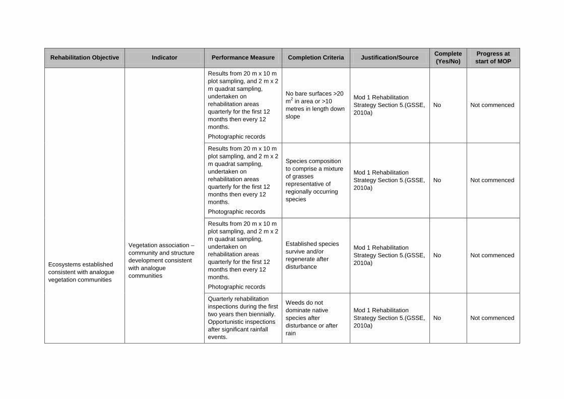
Rehabilitation Objective Indicator Performance Measure Completion Criteria Justification/Source Complete
(Yes/No)
Progress at
start of MOP
Ecosystems established
consistent with analogue
vegetation communities
Vegetation association –
community and structure
development consistent
with analogue
communities
Results from 20 m x 10 m
plot sampling, and 2 m x 2
m quadrat sampling,
undertaken on
rehabilitation areas
quarterly for the first 12
months then every 12
months.
Photographic records
No bare surfaces >20
m2 in area or >10
metres in length down
slope
Mod 1 Rehabilitation
Strategy Section 5.(GSSE,
2010a)
No Not commenced
Results from 20 m x 10 m
plot sampling, and 2 m x 2
m quadrat sampling,
undertaken on
rehabilitation areas
quarterly for the first 12
months then every 12
months.
Photographic records
Species composition
to comprise a mixture
of grasses
representative of
regionally occurring
species
Mod 1 Rehabilitation
Strategy Section 5.(GSSE,
2010a)
No Not commenced
Results from 20 m x 10 m
plot sampling, and 2 m x 2
m quadrat sampling,
undertaken on
rehabilitation areas
quarterly for the first 12
months then every 12
months.
Photographic records
Established species
survive and/or
regenerate after
disturbance
Mod 1 Rehabilitation
Strategy Section 5.(GSSE,
2010a)
No Not commenced
Quarterly rehabilitation
inspections during the first
two years then biennially.
Opportunistic inspections
after significant rainfall
events.
Weeds do not
dominate native
species after
disturbance or after
rain
Mod 1 Rehabilitation
Strategy Section 5.(GSSE,
2010a)
No Not commenced
Rehabilitation Objective Indicator Performance Measure Completion Criteria Justification/Source Complete
(Yes/No)
Progress at
start of MOP
Ecosystems established
consistent with analogue
vegetation communities
Vegetation association –
community and structure
development consistent
with analogue
communities
Quarterly rehabilitation
inspections during the first
two years then biennially.
Pests do not occur in
substantial numbers
or visibly affect the
development of
vegetation
Mod 1 Rehabilitation
Strategy Section 5.(GSSE,
2010a)
No Not commenced
Photographic records
Species are capable
of setting viable seed,
flowering or otherwise
reproducing
Mod 1 Rehabilitation
Strategy Section 5.(GSSE,
2010a)
No Not commenced
Domain C – Water Management Area
Ecosystem health
Remaining water
management structures
are safe, stable and non-
polluting
Quarterly water quality
monitoring (or following
rainfall) in accordance
with the Site Water
Management Plan
Complies with water
quality criteria
established in the Site
Water Management
Plan
Angus Place Site Water
Management Plan,
Section 8.2 (2012)
No Not commenced

APPEN
DIX 3: Flora Species List

Family Scientific Name Common NameTREESCasuarinaceae Allocasuarina nana Dwarf She-oakCupressaceae Callitris rhomboidea Port Jackson CypressMyrtaceae Eucalyptus blaxlandii Blaxland's StringybarkMyrtaceae Eucalyptus dalrympleana Mountain GumMyrtaceae Eucalyptus dives Broad-leaved PeppermintMyrtaceae Eucalyptus fastigata Brown BarrelMyrtaceae Eucalyptus oreades Blue Mountains AshMyrtaceae Eucalyptus pauciflora Snow GumMyrtaceae Eucalyptus radiata Narrow-leaved PeppermintMyrtaceae Eucalyptus sclerophylla Scribbly GumMyrtaceae Eucalyptus sieberi Silvertop Ash
SHRUBSApiaceae Platysace linearifolia Narrow-leafed PlatysaceAraliaceae Polyscias sambucifolia Elderberry PanaxAsteraceae Cassinia arcuata Sifton BushAsteraceae Cassinia cunninghamii Cunningham's EverlastingAsteraceae Olearia erubescens Silky Daisy BushCasuarinaceae Allocasuarina distyla -Epacridaceae Brachyloma daphnoides Daphne HeathEpacridaceae Epacris microphylla Coral HeathEpacridaceae Epacris pulchella Wallum HeathEpacridaceae Leucopogon lanceolatus Lance-leaf Beard-heathEpacridaceae Monotoca elliptica Tree Broom-heathEpacridaceae Monotoca scoparia Prickly Broom-heathEuphorbiaceae Amperea xiphoclada var. xiphoclada Broom SpurgeFabaceae/faboideaDaviesia latifolia -Fabaceae/faboideaDaviesia squarrosa -Fabaceae/faboideaGompholobium huegelii Pale Wedge PeaFabaceae/faboideaMirbelia platylobioides -Fabaceae/faboideaPhyllota squarrosa Dense PhyllotaFabaceae/faboideaAcacia buxifolia Box-leaf WattleFabaceae/faboideaAcacia rubida Red-stemmed WattleFabaceae/faboideaAcacia terminalis Sunshine WattleMyrtaceae Baeckea linifolia Weeping BaeckeaMyrtaceae Leptospermum arachnoides -Myrtaceae Leptospermum continentale Tea-treeMyrtaceae Leptospermum grandifolium Woolly Tea-treeMyrtaceae Leptospermum obovatum -Myrtaceae Leptospermum polygalifolium subsp. polygaTantoonMyrtaceae Leptospermum trinervium Slender Tea-treeProteaceae Banksia cunninghamii subsp. cunninghamii -Proteaceae Banksia ericifolia var. ericifolia Heath-leaved BanksiaProteaceae Grevillea acanthifolia subsp. acanthifolia -Proteaceae Grevillea laurifolia Laurel-leaf GrevilleaProteaceae Hakea dactyloides Broad-leaved HakeaProteaceae Hakea sericea NeedlebushProteaceae Isopogon anemonifolius Flat-leaved DrumsticksProteaceae Lomatia myricoides River LomatiaProteaceae Lomatia silaifolia Crinkle BushProteaceae Persoonia chamaepitys Mountain Geebung

Proteaceae Persoonia hindii -Proteaceae Persoonia myrtilloides subsp. myrtilloides -Proteaceae Persoonia oblongata -Proteaceae Persoonia recedens -Proteaceae Petrophile pulchella ConesticksProteaceae Petrophile sessilis ConesticksRhamnaceae Pomaderris andromedifolia -Rutaceae Boronia microphylla Small-leaved BoroniaSantalaceae Leptomeria acida Native CurrantSantalaceae Omphacomeria acerba -Scrophularaceae Derwentia blakelyi -
GROUNDCOVERSAsteraceae Arrhenechthites mixta Purple FireweedAsteraceae Helichrysum rutidolepis Pale EverlastingAsteraceae Hypochaeris glabra* Smooth CatsearAsteraceae Hypochaeris radicata* FlatweedAsteraceae Lagenophora stipitata -Asteraceae Senecio linearifolius FireweedClusiaceae Hypericum gramineum Small St Johns WortCyperaceae Gahnia aspera Saw SedgeCyperaceae Gahnia microstachya -Cyperaceae Gahnia sieberiana Red-fruited Saw-sedgeCyperaceae Lepidosperma laterale Variable Sword-sedgeCyperaceae Lepidosperma limicola -Dennstaedtiaceae Pteridium esculentum BrackenDilleniaceae Hibbertia (monogyna ?) -Dilleniaceae Hibbertia obtusifolia Grey Guinea FlowerDroseraceae Drosera peltata SundewDroseraceae Drosera spathulata Common SundewEuphorbiaceae Poranthera microphylla -Gentianaceae Centaurium erythraea* Common CentauryGleicheniaceae Gleichenia dicarpa Pouched Coral FernGoodeniaceae Dampiera stricta Blue DampieraGoodeniaceae Goodenia bellidifolia Daisy-leaved GoodeniaGoodeniaceae Goodenia hederacea subsp. hederacea Ivy-leaved GoodeniaHaloragaceae Gonocarpus tetragynus Poverty RaspwortHaloragaceae Gonocarpus teucroides RaspwortIridaceae Patersonia glabrata Leafy Purple-flagIridaceae Patersonia sericea Wild IrisLomandraceae Lomandra filiformis subsp. coriacea Wattle Mat-rushLomandraceae Lomandra filiformis subsp. filiformis Wattle Mat-rushLomandraceae Lomandra glauca Pale Mat-rushLomandraceae Lomandra longifolia Spiky-headed Mat-rushLomandraceae Lomandra multiflora Many-flowered Mat-rushOrchidaceae Dipodium punctatum Hyacinth OrchidOxalidaceae Oxalis perrenans Yellow-flowered Wood SorrelPhormiaceae Dianella caerulea var. producta Blue Fla1 LilyPhormiaceae Dianella revoluta var. revoluta Spreading Fla1 LilyPoaceae Austrodanthonia racemosa var. racemosa Wallaby GrassPoaceae Austrostipa pubescens Tall SpeargrassPoaceae Joycea pallida Silvertop Wallaby GrassPoaceae Microlaena stipoides var. stipoides Weeping Rice Grass

Poaceae Poa seiberiana var. cyanophylla -Restionaceae Baloskion australe -Restionaceae Empodisma minus -Stylidiaceae Stylidium graminifolium Grass Trigger PlantStylidiaceae Stylidium lineare Narrow-leaved Trigger PlantThymelaeaceae Pimelea linifolia subsp. linifolia Slender Rice FlowerTremandraceae Tetratheca rupicola Black-eyed SusanViolaceae Hybanthus monopetalus Slender VioletViolaceae Hybanthus vernonii subsp. vernonii -Violaceae Viola betonicifolia Native VioletViolaceae Viola hederacea Ivy-leaved VioletXanthorrhoaceae Xanthorrhoea resinosa -
CLIMBERSPittosporaceae Billardiera scandens Hairy Appleberry

APPEN
DIX 4: Stakeholder Consultation


Angus Place Colliery
PO Box 42
Wallerawang NSW 2845


