Cornwall Minerals Safeguarding DPD Evidence Report: Mineral Site Profiles November 2016
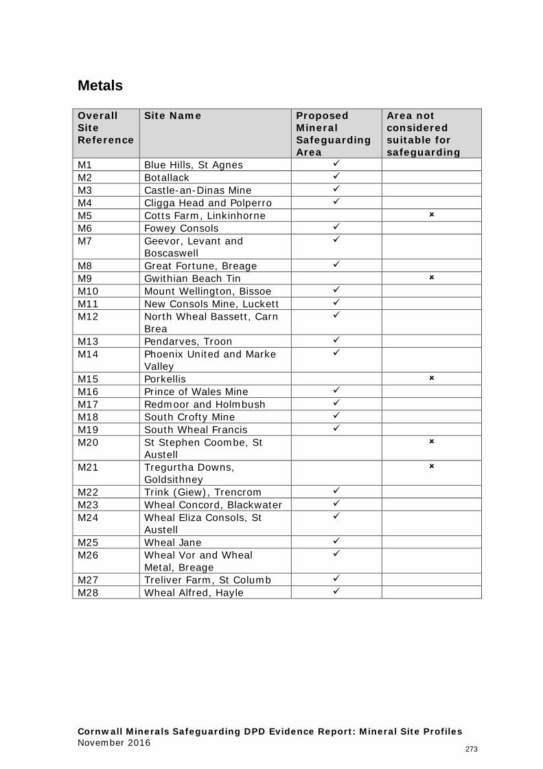
Metals Overall Site Reference
Site Name Proposed Mineral Safeguarding Area
Area not considered suitable for safeguarding
M1 Blue Hills, St Agnes M2 Botallack M3 Castle-an-Dinas Mine M4 Cligga Head and Polperro M5 Cotts Farm, Linkinhorne M6 Fowey Consols M7 Geevor, Levant and
Boscaswell
M8 Great Fortune, Breage M9 Gwithian Beach Tin M10 Mount Wellington, Bissoe M11 New Consols Mine, Luckett M12 North Wheal Bassett, Carn
Brea
M13 Pendarves, Troon M14 Phoenix United and Marke
Valley
M15 Porkellis M16 Prince of Wales Mine M17 Redmoor and Holmbush M18 South Crofty Mine M19 South Wheal Francis M20 St Stephen Coombe, St
Austell
M21 Tregurtha Downs, Goldsithney
M22 Trink (Giew), Trencrom M23 Wheal Concord, Blackwater M24 Wheal Eliza Consols, St
Austell
M25 Wheal Jane M26 Wheal Vor and Wheal
Metal, Breage
M27 Treliver Farm, St Columb M28 Wheal Alfred, Hayle
273

274
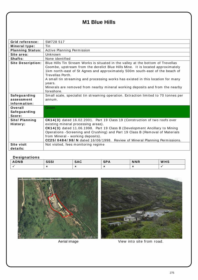
M1 Blue Hills
Grid reference: SW728 517 Mineral type: Tin Planning Status: Active Planning Permission Site area: Unknown Shafts: None identified Site Description: Blue Hills Tin Stream Works is situated in the valley at the bottom of Trevellas
Coombe, upstream from the derelict Blue Hills Mine. It is located approximately 1km north-east of St Agnes and approximately 500m south-east of the beach of Trevellas Porth. A small tin streaming and processing works has existed in this location for many years. Minerals are removed from nearby mineral working deposits and from the nearby foreshore.
Safeguarding assessment information:
Small scale, specialist tin streaming operation. Extraction limited to 70 tonnes per annum.
Overall Safeguarding Score:
Green
Site/Planning History:
CK14(3) dated 16.02.2001. Part 19 Class 19 (Construction of two roofs over existing mineral processing areas). CK14(3) dated 11.06.1998. Part 19 Class B (Development Ancillary to Mining Operations -Screening and Crushing) and Part 19 Class B (Removal of Materials from Mineral - working deposits). CC25/0484/98/N dated 16/06/1998. Review of Mineral Planning Permissions.
Site visit details:
Not visited, fees monitoring regime
Designations AONB SSSI SAC SPA NNR WHS
Aerial image View into site from road.
275
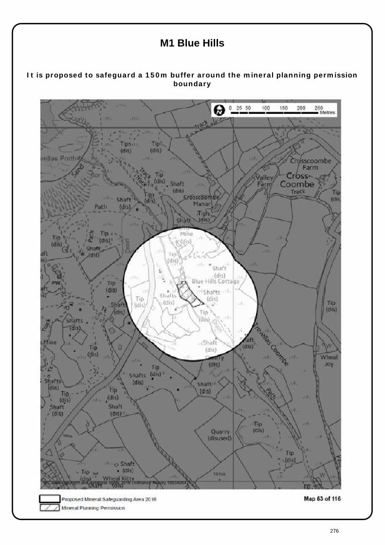
M1 Blue Hills
It is proposed to safeguard a 150m buffer around the mineral planning permission
boundary
276
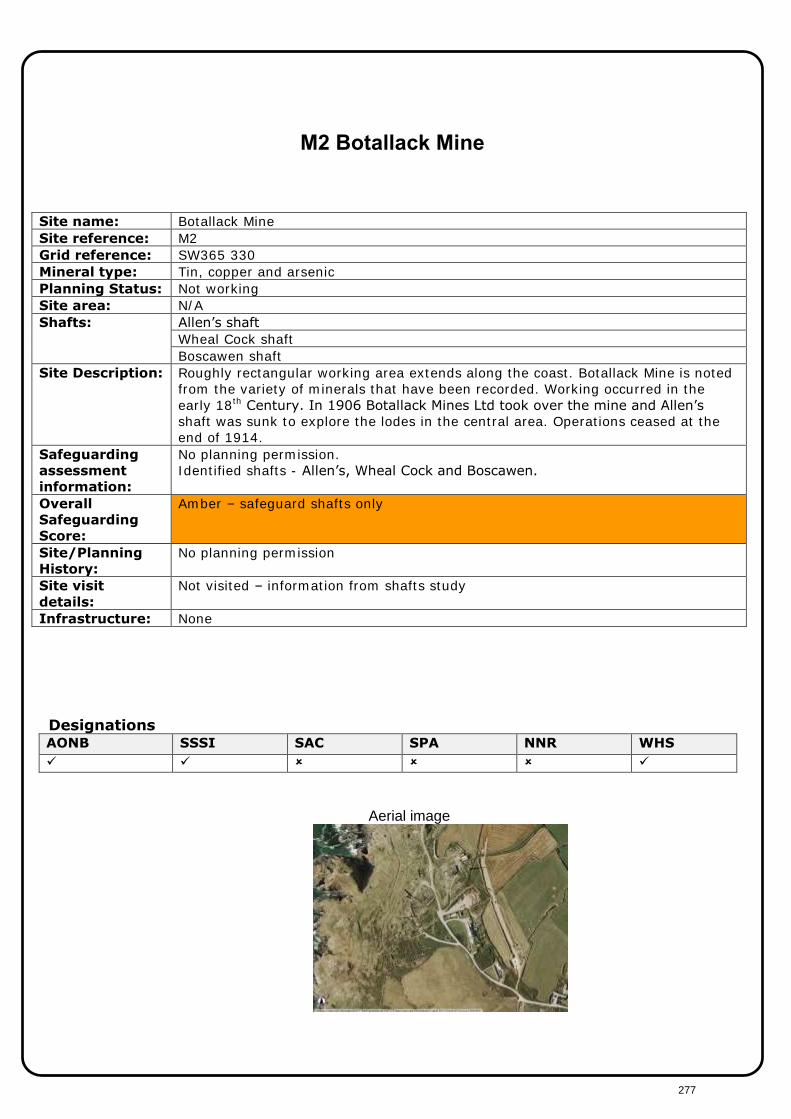
M2 Botallack Mine Site name: Botallack Mine Site reference: M2 Grid reference: SW365 330 Mineral type: Tin, copper and arsenic Planning Status: Not working Site area: N/A Shafts: Allen’s shaft
Wheal Cock shaft Boscawen shaft
Site Description: Roughly rectangular working area extends along the coast. Botallack Mine is noted from the variety of minerals that have been recorded. Working occurred in the early 18th Century. In 1906 Botallack Mines Ltd took over the mine and Allen’s
shaft was sunk to explore the lodes in the central area. Operations ceased at the end of 1914.
Safeguarding
assessment
information:
No planning permission. Identified shafts - Allen’s, Wheal Cock and Boscawen.
Overall
Safeguarding
Score:
Amber – safeguard shafts only
Site/Planning
History:
No planning permission
Site visit
details:
Not visited – information from shafts study
Infrastructure: None
Designations AONB SSSI SAC SPA NNR WHS
Aerial image
277

M2 Botallack
It is proposed to safeguard a 150m buffer around Allen’s Shaft and 50m buffers
around Wheal Cock Shaft and Boscawen Shaft
278

M3 Castle-an-Dinas Mine Site name: Castle-an-Dinas Mine Site reference: M3 Grid reference: SW946 624 Mineral type: Tungsten
Tin Arsenic
Planning Status: No planning permission Site area: 7.7ha Shafts: New Shaft Site Description: Dines “Castle-an-Dinas wolfram lode was not known before 1915. A trial shaft sunk
on the northern slops of the hill in 1916 proved good values at a depth of 30ft and development commenced. In 1935 North Shaft was sunk. Since 1934 production was steady. New Shaft was sunk in 1945. The mine is the only one in Cornwall with a steady output of wolfram as its main product.”
Safeguarding
assessment
information:
Dormant planning permission.
Overall
Safeguarding
Score:
Amber
Site/Planning
History:
No planning history
Site visit
details:
Visited October
Designations AONB SSSI SAC SPA NNR WHS
Aerial image
279
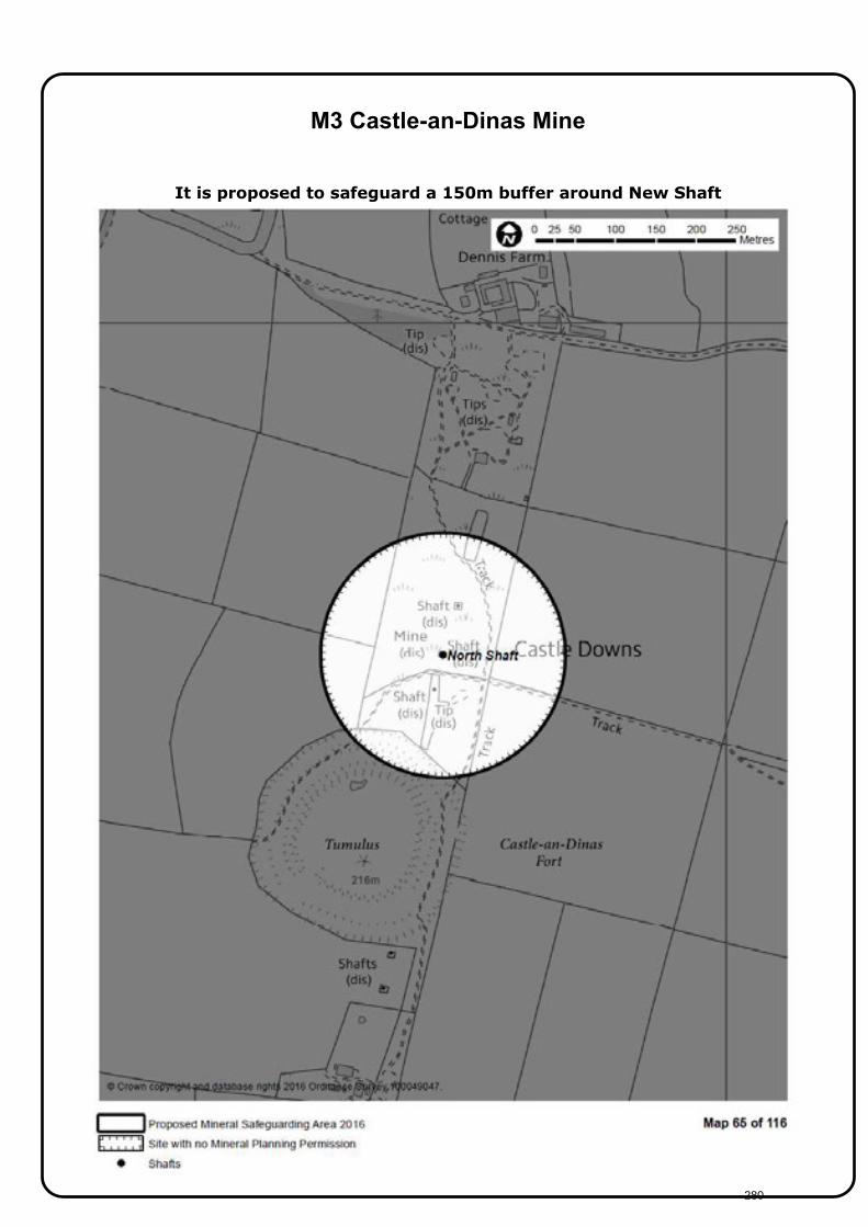
M3 Castle-an-Dinas Mine
It is proposed to safeguard a 150m buffer around New Shaft
280

M4 a) Cligga Head and b) Polperro Consols
Grid reference: SW739 536 Mineral type: Tin, copper, tungsten and sulphur (Metals) Planning Status: No planning permission Site area: N/A Shafts Contact shaft (a)
Turnavore Shaft (b) Site Description: Dines “The deposit resembles a stockwork but is not rich enough to permit working
of the whole mass by opencast methods. In 1938 mining was resumed in a small way. An old shaft, named Contact Shaft, was reopened and 8 tons of concentrate was recovered. The mine continued to operate until 1945. From 1940 – 1944 about 300 tons of wolfram concentrates and 200 tons of black tin were produced.” South West of Perranporth. Wolfram present in the killas cliffs.
Safeguarding assessment information:
No planning permission
Overall Safeguarding Score:
Amber
Site/Planning History:
No planning history
Site visit details:
Not visited, information from shafts study
AONB SSSI SAC SPA NNR WHS
Aerial view of site.
281
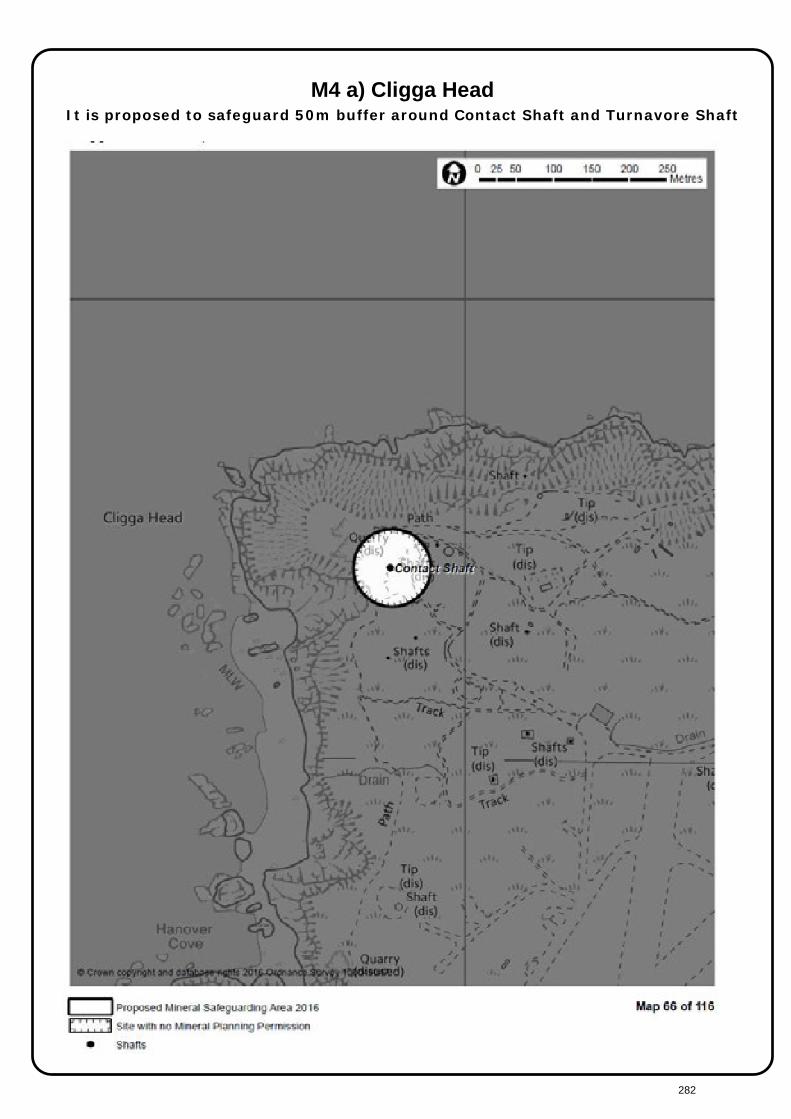
M4 a) Cligga Head
It is proposed to safeguard 50m buffer around Contact Shaft and Turnavore Shaft
282

M4 (b) Polperro Consols It is proposed to safeguard 50m buffer around Contact Shaft and Turnavore Shaft
283

284
M5 Cotts Farm Site name: Cotts Farm Site reference: M5 Grid reference: SX266 727 Mineral type: Metal Planning Status: Dormant Site area: N/A Shafts: None identified Site Description: Dines entry on Stanbear Cott. “Many shode stones of wolfram in the soil east of
Higher Stanbear led to prospecting in 1943. Work was soon abandoned owing to erratic distribution of the ore.”
Safeguarding
assessment
information:
Dormant planning permission. No shafts
Overall
Safeguarding
Score:
Red
Site/Planning
History:
Dormant
Site visit
details:
Not visited
Infrastructure: None
Designations AONB SSSI SAC SPA NNR WHS
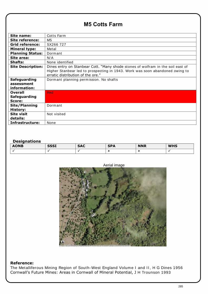
Aerial image
Reference: The Metalliferous Mining Region of South-West England Volume I and II, H G Dines 1956 Cornwall’s Future Mines: Areas in Cornwall of Mineral Potential, J H Trounson 1993
285

M5 Cotts Farm
It is not proposed to safeguard this site
286

M6 Fowey Consols
Grid reference: SX082 561 Mineral type: Copper, tin, sulphur, zinc Planning Status: Not working Site area: N/A Shafts: Austen’s Whim Shaft Site Description: Dines “Many lodes in this once important copper mine. Fowey Consols provided
large dividends during its early periods of activity and continued until about 1870 when values fell off; it seems probable that practically the full depth of the copper zone was developed.”
Safeguarding
assessment
information:
No planning permission. Austen Whim's shaft - 50m
Overall
Safeguarding
Score:
Amber – shafts only
Site/Planning
History:
No planning permission
Site visit
details:
Not visited, information from shafts study
Designations AONB SSSI SAC SPA NNR WHS
Aerial image
Reference: The Metalliferous Mining Region of South-West England Volume I and II, H G Dines 1956 Cornwall’s Future Mines: Areas in Cornwall of Mineral Potential, J H Trounson 1993
287

M6 Fowey Consols It is proposed to safeguard a 50m buffer around Austen Whim’s Shaft
288

M7 Geevor, Levant and Boscaswell
Site name: Geevor, Levant and Boscaswell Site reference: M7 Grid reference: SW375 345 Mineral type: Tin
Copper Arsenic
Planning Status: Planning permission lapsed Aug 1998 Site area: N/A Shafts: Victory Shaft
Engine/Skip Shaft Treweeks Shaft Geevor Adit Wethered Shaft
Site Description: Coastal mine which is now operating as a visitor attraction. Tin and copper have been mined from the general area of Geevor since the late 18th century. Wethered Shaft began in 1909, by 1919 work moved west towards the coast and Victory Shaft was sunk. Operations were suspended in 1921 and again in 1930 due to falling tin prices. In 1944 Victory Shaft continued to be used. During the 1960s there was much underground exploration including the undersea workings of Levant mine (which closed in 1930). The mine closed in 1990 and the mine was left to flood from 1991.
Safeguarding assessment information:
Planning permission lapsed Aug 1998. Victory shaft - 150m; Engine/Skip - 50m; Treweeks shaft - 50m; Geevor Adit - 50m; Wethered Shaft - 50m
Overall Safeguarding Score:
Amber - Shafts only
Site/Planning History:
Planning permission lapsed August 1998
Site visit details:
Not visited, information from shafts study
Designations AONB SSSI SAC SPA NNR WHS Adjacent
Aerial image
Reference: The Metalliferous Mining Region of South-West England Volume I and II, H G Dines 1956 Cornwall’s Future Mines: Areas in Cornwall of Mineral Potential, J H Trounson 1993
289
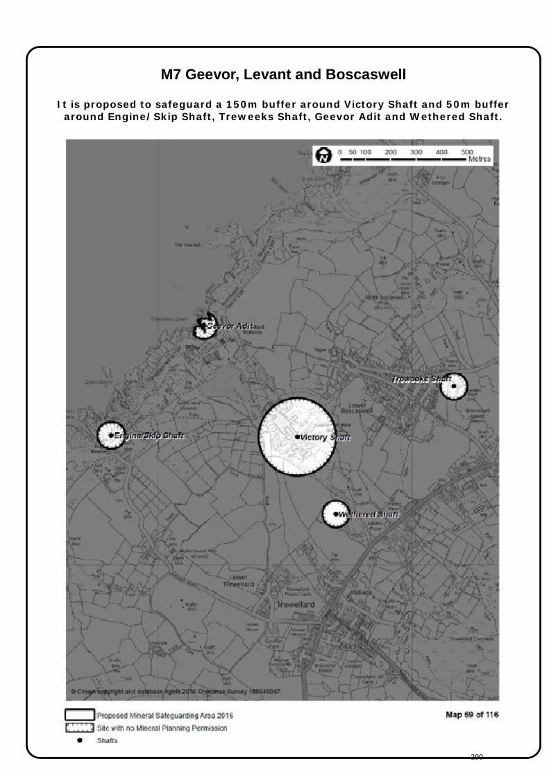
M7 Geevor, Levant and Boscaswell
It is proposed to safeguard a 150m buffer around Victory Shaft and 50m buffer around Engine/Skip Shaft, Treweeks Shaft, Geevor Adit and Wethered Shaft.
290
M8 Great Wheal Fortune Site name: Great Wheal Fortune Site reference: M8 Grid reference: SW626 289 Mineral type: Tin
Copper Arsenic Tungsten
Planning Status: No planning status Site area: N/A Shafts: Harveys Engine Shaft
Wheal Vor Adit Site Description: Located three-quarters of a mile northeast of Breage. The mine produced zinc
between 1860 and 1876, copper between 1855 and 1884, tin between 1855 and 1906. Part of the disused mine was designated as a Site of Special Scientific Interest (SSSI) for its geological interest in 1991. Example of open-cast tin mining survives at Great Wheal Fortune. Developed on a network of tin bearing veinlets (‘stockwork’) known as the Conqueror Branches, its
two ‘quarries’ retain considerable geological and mineralogical significance. They
are also valuable conservation sites. Safeguarding
assessment
information:
No planning permission. Harveys Engine Shaft – 50m, Wheal Vor Adit – 50m
Overall
Safeguarding
Score:
Amber – shafts only
Site/Planning
History:
No planning history
Site visit
details:
No visited, information from shafts study
Designations AONB SSSI SAC SPA NNR WHS
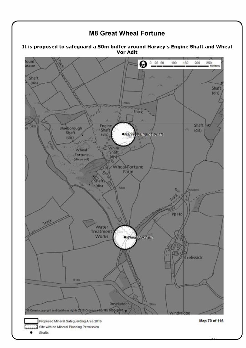
Aerial image
Reference: The Metalliferous Mining Region of South-West England Volume I and II, H G Dines 1956 Cornwall’s Future Mines: Areas in Cornwall of Mineral Potential, J H Trounson 1993
291
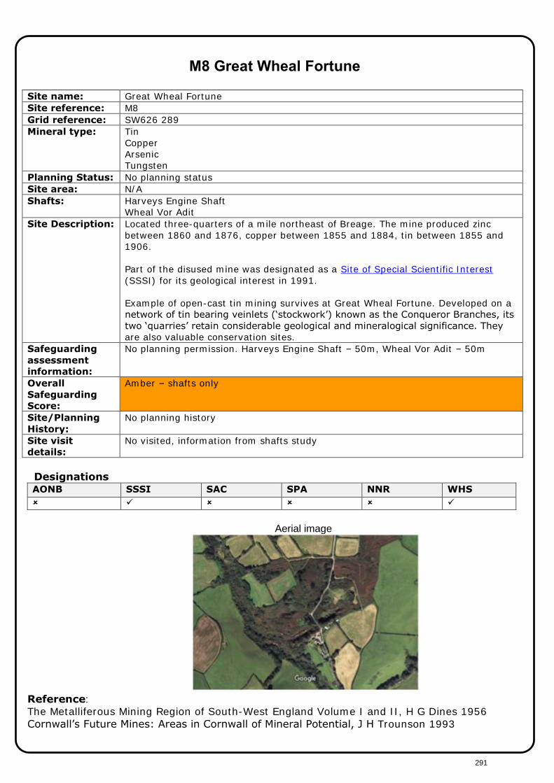
M8 Great Wheal Fortune
It is proposed to safeguard a 50m buffer around Harvey's Engine Shaft and Wheal Vor Adit
292

M9 Gwithian Beach Tin
Site name: Gwithian Beach Tin Site reference: M9 Grid reference: SW574 410 Mineral type: Alluvial Tin Planning Status: Dormant Site area: 62ha Site Description: Dormant planning permission on Gwithian Beach for tin from beach deposits. Safeguarding assessment information:
Dormant planning permission for tin extraction from sand. No shafts
Overall Safeguarding Score:
Red
Site/Planning History:
W1/51/P/02738 Extraction of sand from the foreshore
Site visit details:
Not visited
Designations AONB SSSI SAC SPA NNR WHS
Aerial image
Reference: The Metalliferous Mining Region of South-West England Volume I and II, H G Dines 1956 Cornwall’s Future Mines: Areas in Cornwall of Mineral Potential, J H Trounson 1993
293

M9 Gwithian Beach Tin
It is not proposed to safeguard this site
294
M10 Mount Wellington
Grid reference: SW760 417 Mineral type: Metal Planning Status: Planning permission lapsed Site area: N/A Site Description: Located East of St Day, the mine began in the 1920s but after several changes of
owners closed in the 1970s due to the price of tin. The mine reopened in the 1980s as part of a consolidated mine with Wheal Jane and South Crofty. Wheal Jane and Mount Wellington finally closed in 1991.
Shafts: Wellington Shaft; Taylors Shaft; Hawkes Shaft; Garlands Shaft; Taylors/Whim Shaft; Daveys Whim Shaft; Woolf’s Shaft; Morcom’s Shaft; Francis Engine Shaft; Frederick Shaft; Wheal Maid Shaft; Great County Adit.
Safeguarding
assessment
information:
Planning permission lapsed June 1999. Wellington shaft - 150m; Wheal Maid shaft - 150m; Taylors shaft - 50m; Hawkes shaft - 50m; Garlands shaft - 50m; Taylors/Whim shaft - 50m; Daveys Whim shaft - 50m ; Woolf's shaft - 50m; Morcom's shaft - 50m; Francis Engine shaft - 50m; Frederick shaft - 50m;; Great County adit - 50m.
Overall
Safeguarding
Score:
Amber
Site/Planning
History:
PA13/00913/PREAPP - Pre application advice for the proposed development of Mount Wellington Mine Renewable energy park to create further incubation space for start-up businesses C1/CC12/0701/98/S - Change use to dev site as center for recycling waste, re-clamation of used bldg materials and install plant/machinery W2/83/00118/F - Underground winning of minerals NR/71/00005/MIN - Winning and working of minerals and the disposal of mining waste
Site visit
details:
Not visited, shafts study information
Designations AONB SSSI SAC SPA NNR WHS
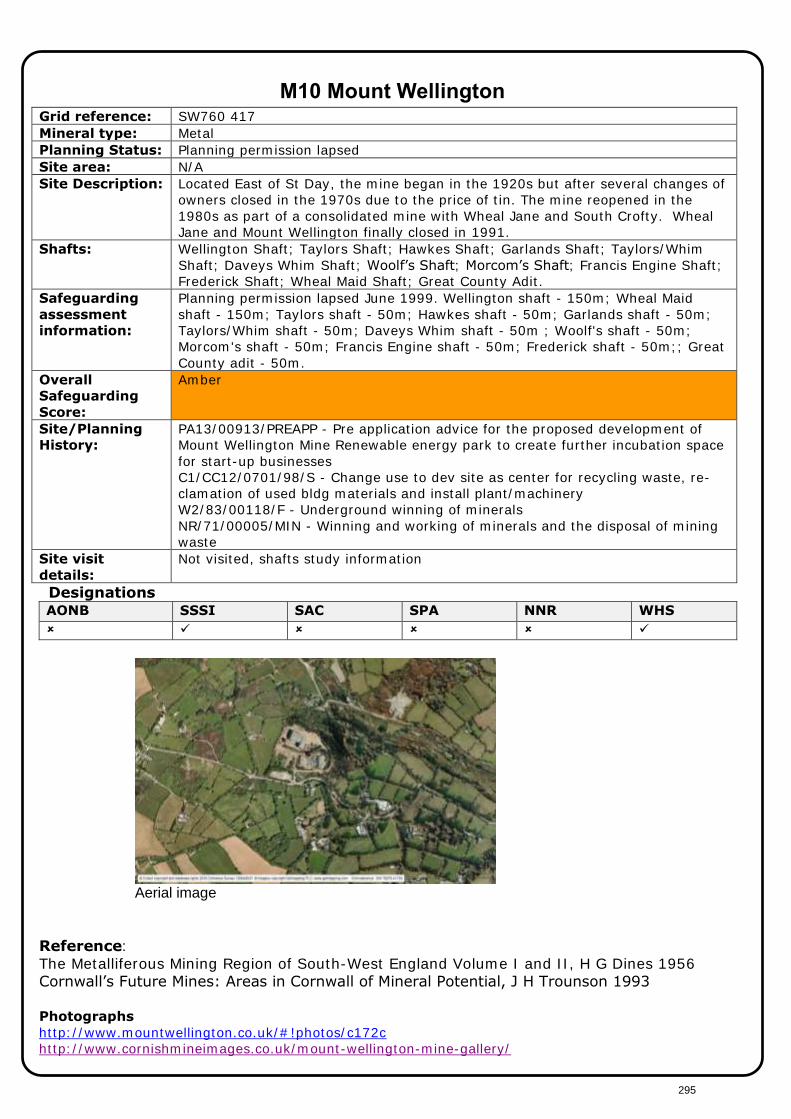
Aerial image
Reference: The Metalliferous Mining Region of South-West England Volume I and II, H G Dines 1956 Cornwall’s Future Mines: Areas in Cornwall of Mineral Potential, J H Trounson 1993 Photographs
http://www.mountwellington.co.uk/#!photos/c172c http://www.cornishmineimages.co.uk/mount-wellington-mine-gallery/
295
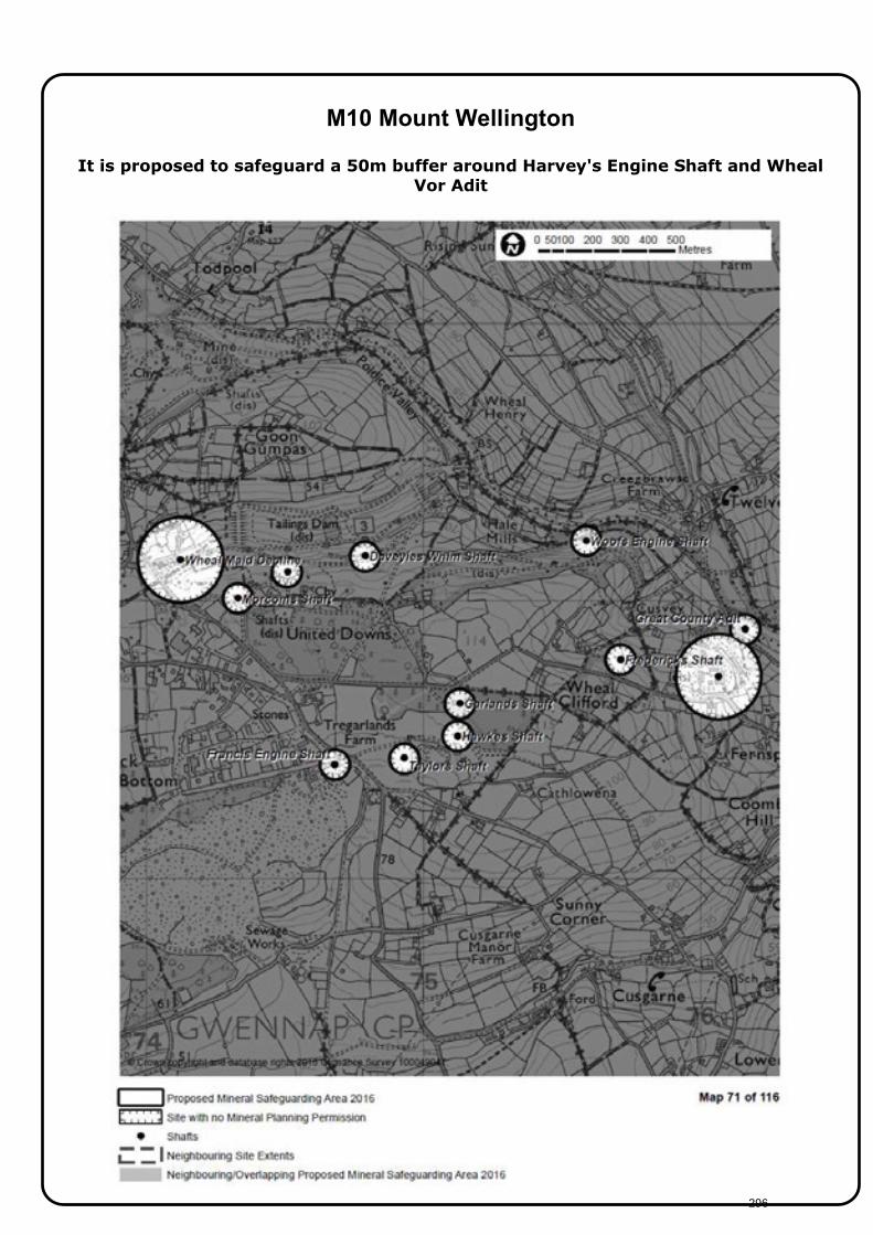
M10 Mount Wellington
It is proposed to safeguard a 50m buffer around Harvey's Engine Shaft and Wheal
Vor Adit
296

M11 New Consols Mine Grid reference: SX386 736 Mineral type: Copper
Tin Arsenic
Planning Status: Dormant Site area: N/A Shafts Engine Shaft Site Description: Dines: New Great Consols. Engine Shaft, vertical. In 1946 the mine was re-
opened and by 1949 a mill was installed. The mine was abandoned in December 1952 having produced 170 tons of black tin and 2 tons of wolfram. The mine has had various names including Great Wheal Martha, New Wheal Martha and New Consols. The copper ores produced by the mine were complex in nature and contained arsenic, sulphur, iron, blende, tin, silver and even ho installed traces of gold.
Safeguarding
assessment
information:
Dormant planning permission. Appears to be underground tin mining plus alluvial tin working. Engine shaft - 150m
Overall
Safeguarding
Score:
Amber
Site/Planning
History:
No planning history
Site visit
details:
Not visited, information from shafts study
Infrastructure: None Designations AONB SSSI SAC SPA NNR WHS
Aerial image
Reference: The Metalliferous Mining Region of South-West England Volume I and II, H G Dines 1956 Cornwall’s Future Mines: Areas in Cornwall of Mineral Potential, J H Trounson 1993
Photographs
See http://www.aditnow.co.uk/Album/Historic-Photographs-Of-New-Consols_10930/
297

M11 New Consols Mine It is proposed to safeguard a 150m buffer around Engine Shaft
298

M12 North Wheal Bassett, Wheal Uny, Wheal Buller and Tresavean Grid reference: SW688 400 Mineral type: Copper
Tin Planning Status: No planning status Site area: N/A Shafts Lyles Shaft
Engine Shaft Hinds Engine Shaft Kistles Shaft Harveys Shaft Bassets Shaft
Site Description: Dines: Amalgamated with Wheal Basset. The mines in this group lie in the valley between Carnmenellis and Carn Brea. North Wheal Basset was originally a copper mine, it produced over 30,000 tons of copper ore between 1846 and 1869. In 1854 a large ore deposit of copper was discovered and development and shaft deepening took place to access it. It was discovered in 1857 that the potential ore reserves had been seriously overestimated. North Wheal Basset mine was comparatively short-lived. Wheal Uny mine was opened at the end of the 19th century, but was only operational for a short period. It closed in 1893. Wheal Buller was one of the greatest copper mines in Cornwall. Wheal Buller produced some 242,000 tons of copper in its working life.A new shaft was sunk in summer 1856 known as Kistler's (or Kistle's) Shaft but production continued to fall. The mine struggled on into the 1870's but the position of the mine was unsustainable and the mine equipment was sold off in 1875. Tresavean Mine was active in the middle of the 18th Century and was reopened in the early 19th Century. It became an important copper producer in 1829; it was worked until 1870. Mining recommenced in 1910 but the mine closed in 1928 due to the fall in tin values. Trounson: The Great Flat Lode was virtually exhausted in the Basset group with the exception of a short ore-shoot near Lyle’s Shaft. Wheal Uny is worthy of
further investigation. Safeguarding
assessment
information:
No planning permission. Lyles shaft - 150m; Engine shaft - 50m; Hinds Engine shaft - 50m; Kistles shaft - 50m; Harveys shaft - 50m; Bassets shaft - 50m.
Overall
Safeguarding
Score:
Amber – shafts only
Site/Planning
History:
No planning history
Site visit
details:
Not visited, information from shafts study
Infrastructure: None Designations AONB SSSI SAC SPA NNR WHS
Photographs
http://www.aditnow.co.uk/Album/Historic-Photographs-Of-North-Wheal-Basset_6775/ http://whealbullerproject.co.uk/ Reference: The Metalliferous Mining Region of South-West England Volume I and II, H G Dines 1956 Cornwall’s Future Mines: Areas in Cornwall of Mineral Potential, J H Trounson 1993
Photographs
See http://www.aditnow.co.uk/Album/Historic-Photographs-Of-New-Consols_10930/
299

M12 North Wheal Bassett, Wheal Uny, Wheal Buller and Tresavean
It is proposed to safeguard a 150m buffer around Lyles and 50m buffer around
Engine Shaft, Hinds Engine Shaft, Kistles Shaft, Harveys Shaft and Bassets Shaft.
300

M13 Pendarves
Grid reference: SW647 383 Mineral type: Copper, Tin, Arsenic, Sulphur Planning Status: Planning permission lapsed 1998 Site area: N/A Shafts: Simms Shaft
Goolds Shaft Fortescues
Site Description: Dines: Pendarves dates back to 1854, as a group of mines including Wheal Nelson, West Condurrow, Tryphena, Tolcarne and South Tolcarne. Worked in the 1840's, again producing a small amount of copper ore. The mine extracted ore from one chief lode known unsurprisingly as Main Lode. It worked from seven shafts: Plantation, Bennetts', Pendarves, Newton, Vivian's, Tolcarne and Roaring Water Shafts. In 1967/68, Simms shaft was sunk to a depth of 260m. Some limited mining was carried out until 1973, when the mine was purchased by a subsidiary of South Crofty Ltd. Production was scaled up to 40,000 tons of ore per year until 1981. The output declined and in 1984 the mine had run out of developed ore reserves and had to close.
Safeguarding assessment information:
Planning permission lapsed March 1998. Simms shaft - 150m; Goolds - 50m; Fortescues - 50m.
Overall Safeguarding Score:
Amber – shafts only
Site/Planning History:
Planning permission lapsed 1998 W2/62/15338/O Winning and working of minerals and erection of buildings. W2/71/30826/SA Erection of primary crushing and storage plant for tin ore.
Site visit details:
Not visited, information from shafts study
Infrastructure: None Designations AONB SSSI SAC SPA NNR WHS
Reference: The Metalliferous Mining Region of South-West England Volume I and II, H G Dines 1956 Cornwall’s Future Mines: Areas in Cornwall of Mineral Potential, J H Trounson 1993
301

M13 Pendarves It is proposed to safeguard a 150m buffer around Simms Shaft and 50m Goolds Shaft
and Fortescues Shaft
302

M14 Phoenix United and Marke Valley Grid reference: SX266 719 Mineral type: Tin, Copper Planning Status: Planning permission lapsed May 2000 Site area: N/A Shafts: Prince of Wales Shaft
Salisbury Shaft Seccombe Shaft Marke Valley Adit
Site Description: Dines: Main tin mine was Phoenix United and main copper mine was Marke Valley. Phoenix United - In 1843 the mine re-opened until 1860 when it ceased to produce important quantities of copper. Between 1877 and 1897 the amount of tin ore raised annually ranged from 34,000 tons to 22,000 tons at the end of that period. Re-started in 1907 the Prince of Wales Shaft was sunk. Marke Valley – Salisbury Shaft is vertical. The mine was first worked in 1828 and re-opened in 1840; output between 1844 and 1890 was 393 tons of black tin and 128,500 tons of copper ore.
Safeguarding
assessment
information:
Planning permission lapsed May 2000. Prince of Wales - 150m; Salisbury shaft - 50m; Seccombe shaft - 50m; Marke Valley adit - 50m.
Overall
Safeguarding
Score:
Amber – Shafts only
Site/Planning
History:
Planning permission lapsed May 2000
Site visit
details:
Not visited, information from shafts study
Designations AONB SSSI SAC SPA NNR WHS
Photographs http://www.aditnow.co.uk/Mines/Marke-Valley-Mixed-Mine_6252/ Reference: The Metalliferous Mining Region of South-West England Volume I and II, H G Dines 1956. Cornwall’s Future Mines: Areas in Cornwall of Mineral Potential, J H Trounson 1993
303

M14 Phoenix United and Marke Valley
It is proposed to safeguard a 150m buffer around Prince of Wales Shaft and a 50m
buffer around Salisbury Shaft, Seccombe Shaft and Marke Valley Adit
304
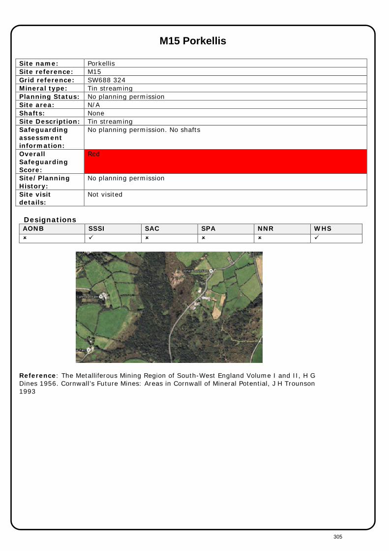
M15 Porkellis
Site name: Porkellis Site reference: M15 Grid reference: SW688 324 Mineral type: Tin streaming Planning Status: No planning permission Site area: N/A Shafts: None Site Description: Tin streaming Safeguarding assessment information:
No planning permission. No shafts
Overall Safeguarding Score:
Red
Site/Planning History:
No planning permission
Site visit details:
Not visited
Designations AONB SSSI SAC SPA NNR WHS
Reference: The Metalliferous Mining Region of South-West England Volume I and II, H G Dines 1956. Cornwall’s Future Mines: Areas in Cornwall of Mineral Potential, J H Trounson 1993
305

M15 Porkellis
It is not proposed to safeguard this site
306

M16 Prince of Wales Mine
Site name: Prince of Wales Mine Site reference: M16 Grid reference: SX401 705 Mineral type: Tin, Copper, Arsenic, Sulphur, Silver. Planning Status: No planning permission Site area: N/A Shafts: Watson Shaft
Baileys Shaft Site Description: Dines: Large producer of tin. Watson Shaft sunk a short distance north of the
outcrop is vertical. Prince of Wales operated between 1865 and 1912 and produced 1,102 tons for black tin and 10,845 tons of copper ore. Prince of Wales mine closed in 1914.
Safeguarding assessment information:
Dormant planning permission. Watsons shaft - 150m
Overall Safeguarding Score:
Amber - shafts only
Site/Planning History:
Dormant planning permission
Site visit details:
Not visited, information from shafts study
Infrastructure: None Designations AONB SSSI SAC SPA NNR WHS
Photographs http://www.aditnow.co.uk/Photos/Mine/Prince-Of-Wales-Copper-Mine_6684/ http://www.mindat.org/gallery.php?loc=883
307
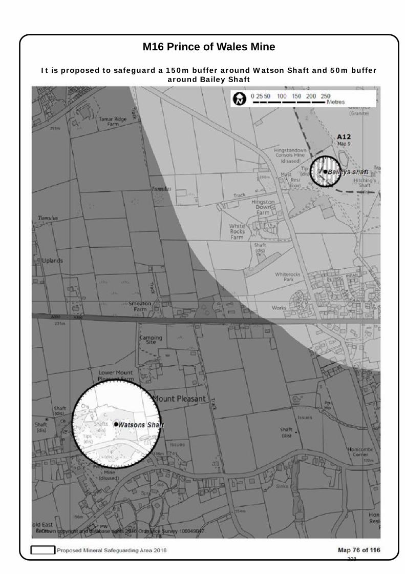
M16 Prince of Wales Mine
It is proposed to safeguard a 150m buffer around Watson Shaft and 50m buffer
around Bailey Shaft
308

M17 Redmoor and Holmbush
Grid reference: SX355 710 Mineral type: Copper, Tin, Lead, Silver, Arsenic, Tungsten. Planning Status: No planning permission Site area: N/A Shafts: Johnsons Shaft
Hitchen’s Engine Shaft Site Description: Dines: Group of mines known as Callington United. Holmbush Mine – main shaft is
Hitchen’s Engine Shaft sunk vertically. Redmoor Mine – chief shaft is Johnson’s, sunk vertically. Johnson’s Lode carries arsenic, tin and some wolfram and is intersected by the shaft. In 1943 the new Counthouse Shaft (located 350m North by East of Johnson’s Shaft) was opened and some exploratory work carried out around Johnson’s Shaft. Redmoor re-opened briefly between 1907 and 1914 and in 1934 and 1943. Redmoor mine area was prospected in the early 1980's, and was near to being brought into production, but the price of tin collapsed in 1985. Recent press releases from NAE indicate good tin and tungsten resources (March 2016).
Safeguarding assessment information:
Johnsons Shaft, Hitchens Engine Shaft
Overall Safeguarding Score:
Site/Planning History:
E2/04/00179/OUT Redevelopment of former mine site as tourist attraction involving: mining heritage display, remediation of site contamination by natural methods; construction of visitor centre and ancillary buildings; alteration of access/egress. E2/86/00957/F Use of land for the winning and working of metalliferous minerals by underground methods.
Site visit details:
Not visited, information from shafts study
Designations AONB SSSI SAC SPA NNR WHS
http://nae.net.au/wp-content/uploads/2015/12/Redmoor-Inferred-Mineral-Resource.pdf
Reference: The Metalliferous Mining Region of South-West England Volume I and II, H G Dines 1956. Cornwall’s Future Mines: Areas in Cornwall of Mineral Potential, J H Trounson 1993
309

M17 Redmoor and Holmbush
It is proposed to safeguard a 150m buffer around Johnson’s Shaft and 50m buffer
around Hitchen’s Engine Shaft
310

M18 South Crofty Grid reference: SW664 410 Mineral type: Tin, copper Planning Status: Active (not currently working) Site Description: Large, active underground tin mine covering much of Pool, although not currently producing
metals. Several shafts and associated infrastructure within the mineral planning permission area. Extant planning permission for processing plant, yet to be implemented. South Crofty Mine is located in Pool, mid-way between Camborne and Redruth in west Cornwall. Mining in this area is thought to date back to the late 1590s, only becoming known as South Wheal Crofty in 1854. Typical of early mines in the area, working commenced as a shallow tin and copper prospects, turning to the deep tin zone from the 1860s onwards. After the 1890s, the mine acquired other setts as the surrounding mines closed, including New Cook's Kitchen Mine, Tincroft, Carn Brea, North Roskear, South Roskear and Dolcoath Mines. The mine effectively ceased to operate in 1998. In June 2001, Baseresult Holdings Ltd (BHL) acquired South Crofty and the associated mine plant and developed a tunnel from the Tuckingmill Decline to connect to New Cooks Kitchen Shaft and Old Engine Shaft. The former to be used as a service shaft and the latter for secondary egress. In November 2007, Western United Mines (WUM) was launched following a joint venture between BHL and Cassiterite LP. In December 2010, WUM became a wholly owned subsidiary of Cornish Minerals Limited (CML). In 2013 WUM announced that they had entered into administration and that the mine was placed under ‘care and maintenance’
Shafts New Cook’s Shaft, Taylors Shaft, Robinsons Shaft, New Roskear Shaft, Williams Shaft, New Tolgus Shaft, Tuckingmill Decline, Dolcoath Deep Adit Additional shafts identified in planning permission PA10/04564
Safeguarding assessment information:
Planning permission consolidated 2011. New Cooks shaft - 150m; Taylors shaft - 50m; Robinsons shaft - 50m; New Roskear shaft - 50m; Williams shaft - 50m; New Tolgus shaft - 50m; Tuckingmill decline - 50m; Dolcoath deep adit - 50m.
Overall Safeguarding Score:
Site/Planning History: PA10/05145 Further Information/Clarification/Explanation under Regulation 19 of the Town and Country Planning Environmental Impact Assessment (England and Wales) Regulations 1999 - Proposed consolidation and extension of planning permissions for underground winning and working of minerals. PA10/04564 The proposed modernisation of South Crofty Mine to allow continuation of winning and working of minerals by relocation to land surrounding the Tuckingmill Decline and by erection of buildings, plant and works for ore processing, ancillary processes, associated operations and deliveries, comprising:- Main Processing Plant Building also containing associated engineering works for additional accesses to underground mine, HSE Stores, Aggregate Store, Electricity Substation, Fuel Storage, Tailings Treatment, Emergency Tailings Store, Ancillary Buildings (high density thickeners, security, pumped minewater storage, loading ramp, chemical silo's, bottled gas compound, offices, changing rooms, stores, archive, vehicle and plant maintenance, storage containers), Earth Works, Mine shaft ventilation caps, Surface water management, Water Treatment Plant, Access Roads, Car park areas, weighbridge and wheel washes, aggregate screening and stockpiling area. NR/07/00103/SCREEN Proposed extension to underground mining permissions at the South Crofty Mine, Pool, Redruth, by Baseresult Holdings Ltd. (SCREENING OPINION). NR/07/00104/SCOPE Proposed modernisation to South Crofty Mine by redevelopment of Tuckingmill Decline area including installation of concentrator, storage silos, thickener tanks, mine offices, workshop, fuel store, garage, electrical substation and engineering earthworks; at South Crofty Mine, Pool, Redruth, by Baseresult Holdings Ltd (SCOPING OPINION) W2/PA06/01298/CCC Review of mineral conditions. NR/03/00107/ROMPS Application to determine new conditions. W2/84/01204/F Construction of Decline Adit Portal and construction of an access road and temporary accommodation. W2/70/32487/F Erection of plant and ancillary equipment for the storing, batching and processing of aggregates and the production of ready mixed concrete. W2/69/29168/F Erection of winder house and head gear for tin mine. W2/64/19315/F Underground winning of tin. W2/61/12244/F Underground winning of tin. W2/53/04310/F Winning of tin, wolfram, arsenic etc. W2/51/02754/F Surface and underground tin mining Site visit details:
Not visited – fees monitoring regime
Designations AONB SSSI SAC SPA NNR WHS Partially/adjacent
New Roskear Shaft, 200 Tuckingmill Decline, 2009
311
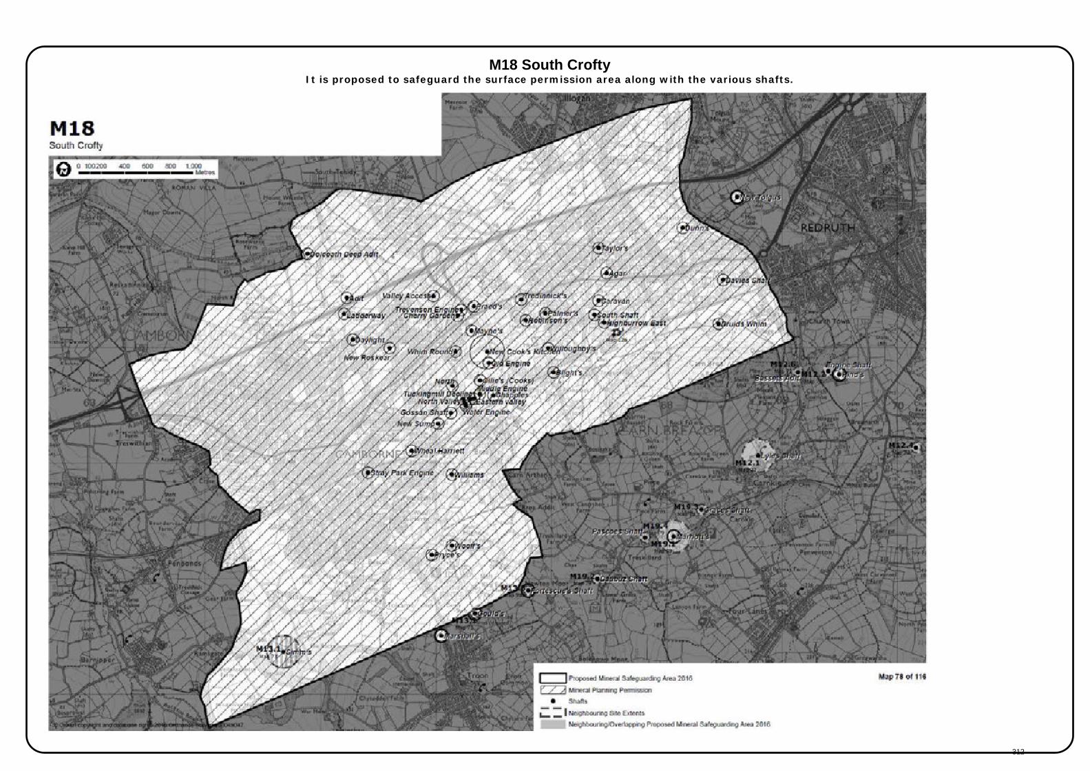
M18 South Crofty It is proposed to safeguard the surface permission area along with the various shafts.
312
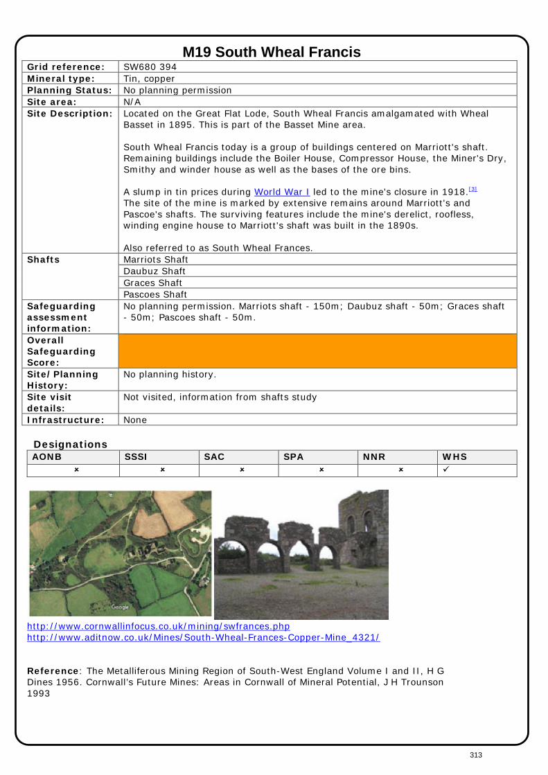
M19 South Wheal Francis Grid reference: SW680 394 Mineral type: Tin, copper Planning Status: No planning permission Site area: N/A Site Description: Located on the Great Flat Lode, South Wheal Francis amalgamated with Wheal
Basset in 1895. This is part of the Basset Mine area. South Wheal Francis today is a group of buildings centered on Marriott's shaft. Remaining buildings include the Boiler House, Compressor House, the Miner's Dry, Smithy and winder house as well as the bases of the ore bins. A slump in tin prices during World War I led to the mine's closure in 1918.[3]
The site of the mine is marked by extensive remains around Marriott's and Pascoe's shafts. The surviving features include the mine's derelict, roofless, winding engine house to Marriott's shaft was built in the 1890s. Also referred to as South Wheal Frances.
Shafts Marriots Shaft Daubuz Shaft Graces Shaft Pascoes Shaft
Safeguarding assessment information:
No planning permission. Marriots shaft - 150m; Daubuz shaft - 50m; Graces shaft - 50m; Pascoes shaft - 50m.
Overall Safeguarding Score:
Site/Planning History:
No planning history.
Site visit details:
Not visited, information from shafts study
Infrastructure: None Designations AONB SSSI SAC SPA NNR WHS
http://www.cornwallinfocus.co.uk/mining/swfrances.php http://www.aditnow.co.uk/Mines/South-Wheal-Frances-Copper-Mine_4321/
Reference: The Metalliferous Mining Region of South-West England Volume I and II, H G Dines 1956. Cornwall’s Future Mines: Areas in Cornwall of Mineral Potential, J H Trounson 1993
313
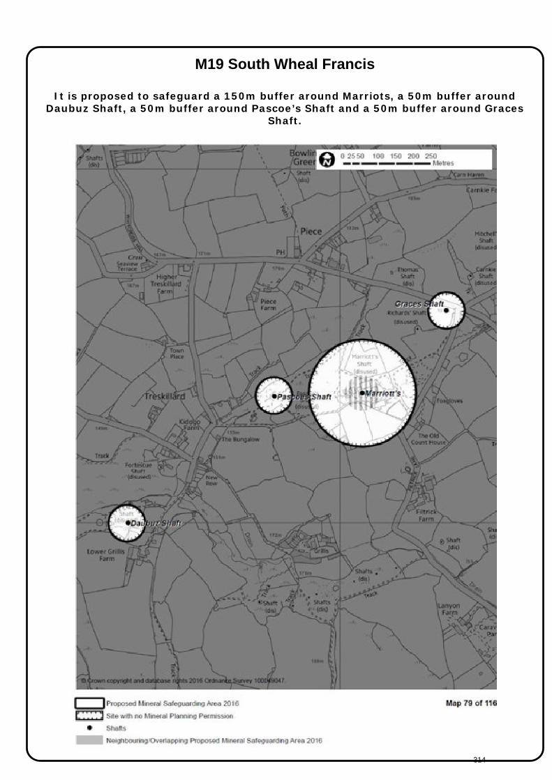
M19 South Wheal Francis
It is proposed to safeguard a 150m buffer around Marriots, a 50m buffer around Daubuz Shaft, a 50m buffer around Pascoe’s Shaft and a 50m buffer around Graces
Shaft.
314

M20 St Stephen Coombe
Site name: St Stephen Coombe Site reference: M20 Grid reference: SW949 514 Mineral type: Tin streaming Planning Status: No planning history Site area: N/A Site Description: Former tin streaming area, 3.5 miles West of St Austell. Wooded area. Shafts: None Safeguarding assessment information:
No planning permission.
Overall Safeguarding Score:
Site/Planning History:
No planning history
Site visit details:
Not visited
Designations AONB SSSI SAC SPA NNR WHS
Aerial image Reference: The Metalliferous Mining Region of South-West England Volume I and II, H G Dines 1956. Cornwall’s Future Mines: Areas in Cornwall of Mineral Potential, J H Trounson 1993
315
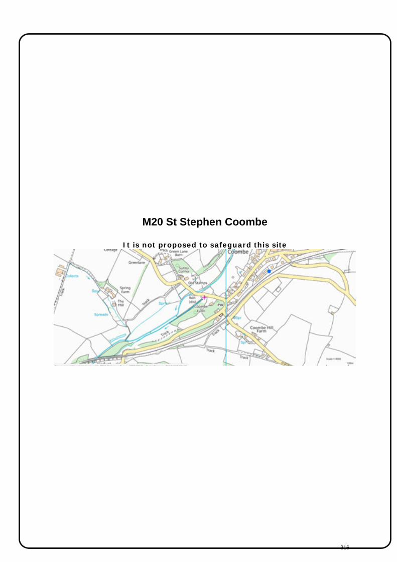
M20 St Stephen Coombe
It is not proposed to safeguard this site
316
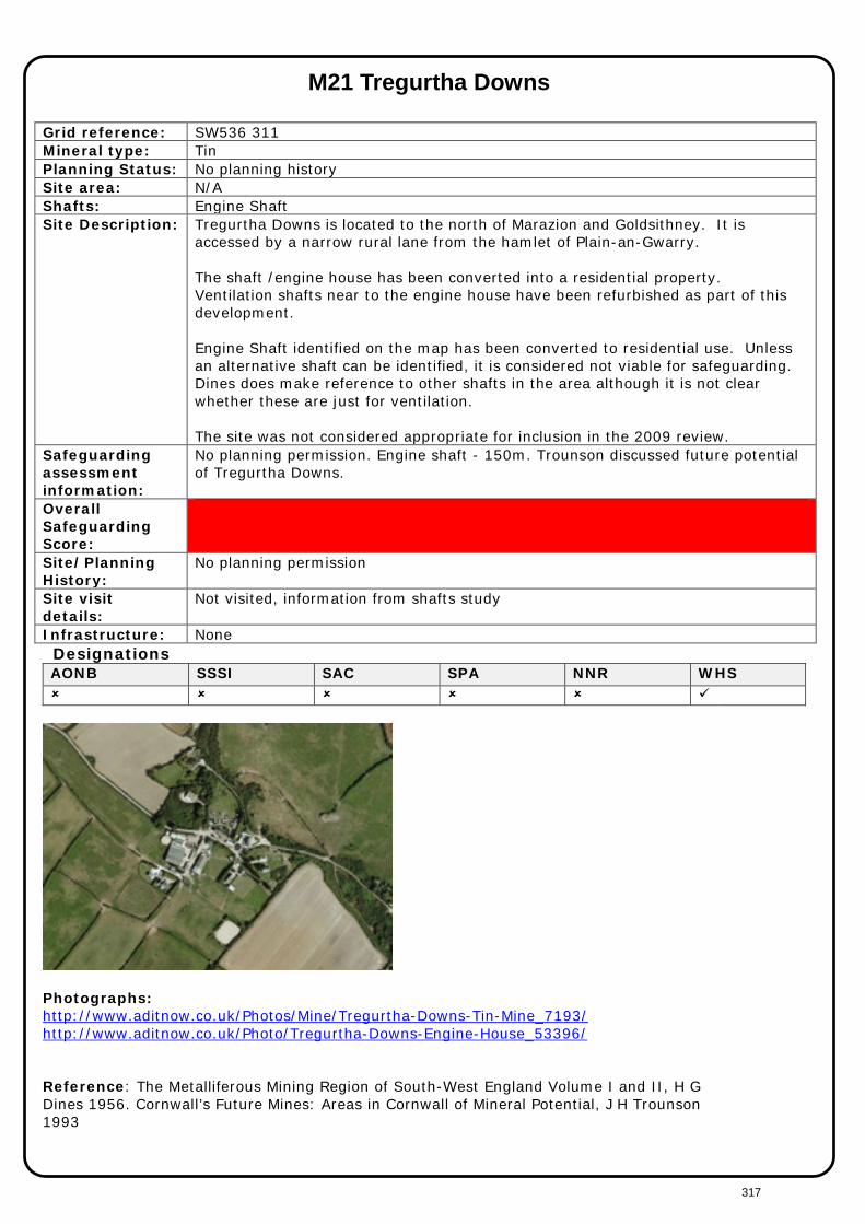
M21 Tregurtha Downs
Grid reference: SW536 311 Mineral type: Tin Planning Status: No planning history Site area: N/A Shafts: Engine Shaft Site Description: Tregurtha Downs is located to the north of Marazion and Goldsithney. It is
accessed by a narrow rural lane from the hamlet of Plain-an-Gwarry. The shaft /engine house has been converted into a residential property. Ventilation shafts near to the engine house have been refurbished as part of this development. Engine Shaft identified on the map has been converted to residential use. Unless an alternative shaft can be identified, it is considered not viable for safeguarding. Dines does make reference to other shafts in the area although it is not clear whether these are just for ventilation. The site was not considered appropriate for inclusion in the 2009 review.
Safeguarding assessment information:
No planning permission. Engine shaft - 150m. Trounson discussed future potential of Tregurtha Downs.
Overall Safeguarding Score:
Site/Planning History:
No planning permission
Site visit details:
Not visited, information from shafts study
Infrastructure: None Designations AONB SSSI SAC SPA NNR WHS
Photographs: http://www.aditnow.co.uk/Photos/Mine/Tregurtha-Downs-Tin-Mine_7193/ http://www.aditnow.co.uk/Photo/Tregurtha-Downs-Engine-House_53396/ Reference: The Metalliferous Mining Region of South-West England Volume I and II, H G Dines 1956. Cornwall’s Future Mines: Areas in Cornwall of Mineral Potential, J H Trounson 1993
317
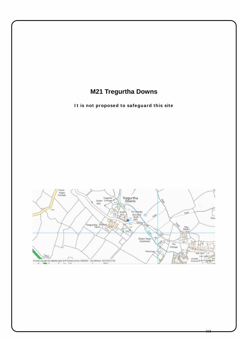
M21 Tregurtha Downs
It is not proposed to safeguard this site
318

M22 Trink (known as Giew Mine)
Grid reference: SW500 371 Mineral type: Tin Planning Status: No planning permission Site area: N/A Shafts: Franks Shaft
Trencrom Adit Site Description: In its time Giew has been known as Gew, Reeth Consols, Trink and St. Ives
Consols. The remaining buildings centered around Frank's Shaft are only the easternmost of a number of shafts all working the area. The engine house dates from 1874. This was part of the re-working of Giew Mine started in 1869 by Thomas Treweeke. Other shafts, running from east to west include Blackburn's, Robinsons Engine, Martins, Ladock Shaft and Giew Engine Shaft where it joined Billia Consols Mine. It produced tin up until 1922, the mine closed with the tin slump in the early 1920's ceasing work in 1923. Trounson: There are very considerable possibilities in the area around Giew and Wheal Reeth.
Safeguarding assessment information:
No planning permission. Franks shaft - 150m; Trencrom adit - 50m. Tin produced until 1922.
Overall Safeguarding Score:
Shafts only
Site/Planning History:
No planning history
Site visit details:
Not visited, information from shafts study
Designations AONB SSSI SAC SPA NNR WHS
Photographs http://www.aditnow.co.uk/Photos/Mine/Giew-Mixed-Mine_5767/ http://www.mindat.org/gallery.php?loc=189722 Reference: The Metalliferous Mining Region of South-West England Volume I and II, H G Dines 1956 Cornwall’s Future Mines: Areas in Cornwall of Mineral Potential, J H Trounson 1993
319

M22 Trink (known as Giew Mine)
It is proposed to safeguard 150m buffer around Frank’s Engine Shaft and a 50m buffer around Trencom Adit.
320
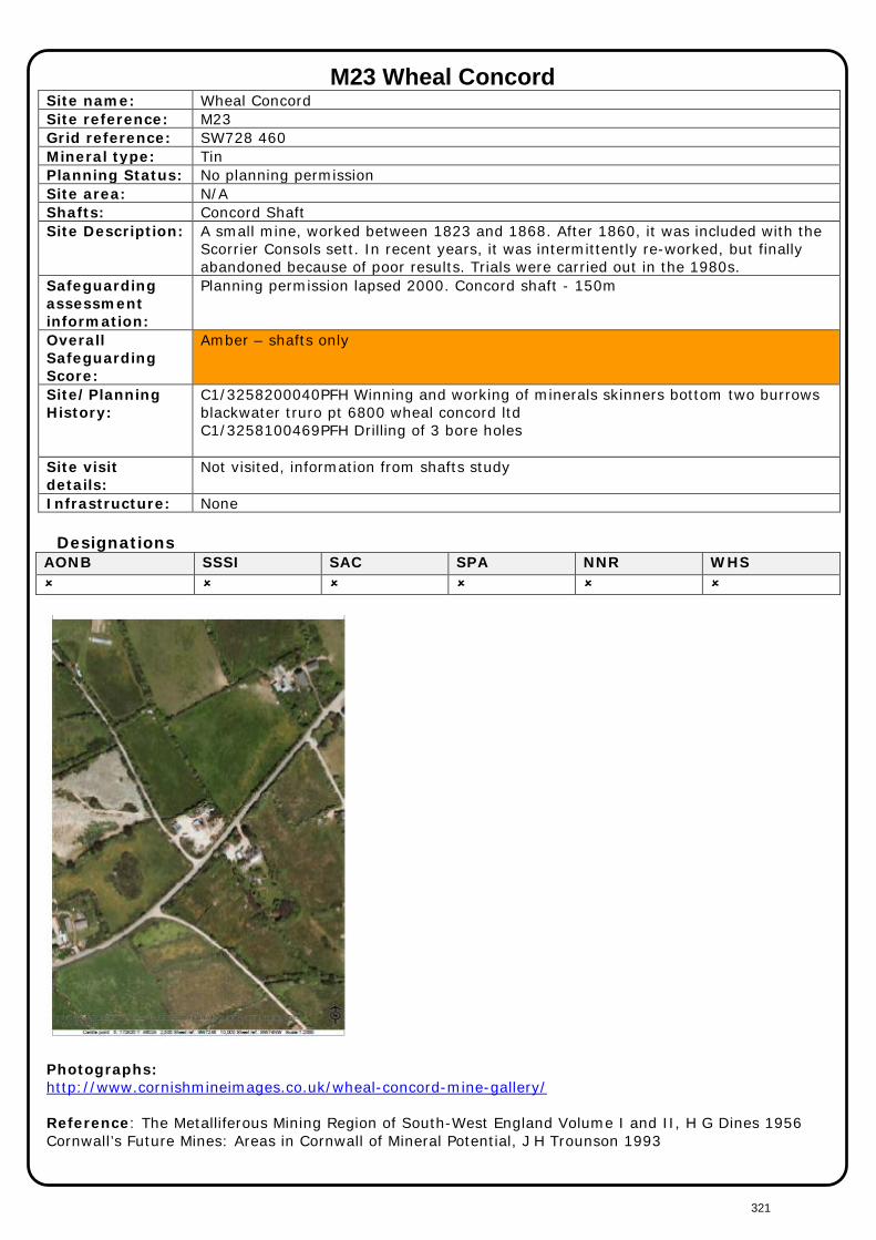
M23 Wheal Concord Site name: Wheal Concord Site reference: M23 Grid reference: SW728 460 Mineral type: Tin Planning Status: No planning permission Site area: N/A Shafts: Concord Shaft Site Description: A small mine, worked between 1823 and 1868. After 1860, it was included with the
Scorrier Consols sett. In recent years, it was intermittently re-worked, but finally abandoned because of poor results. Trials were carried out in the 1980s.
Safeguarding assessment information:
Planning permission lapsed 2000. Concord shaft - 150m
Overall Safeguarding Score:
Amber – shafts only
Site/Planning History:
C1/3258200040PFH Winning and working of minerals skinners bottom two burrows blackwater truro pt 6800 wheal concord ltd C1/3258100469PFH Drilling of 3 bore holes
Site visit details:
Not visited, information from shafts study
Infrastructure: None Designations
AONB SSSI SAC SPA NNR WHS
Photographs: http://www.cornishmineimages.co.uk/wheal-concord-mine-gallery/ Reference: The Metalliferous Mining Region of South-West England Volume I and II, H G Dines 1956 Cornwall’s Future Mines: Areas in Cornwall of Mineral Potential, J H Trounson 1993
321
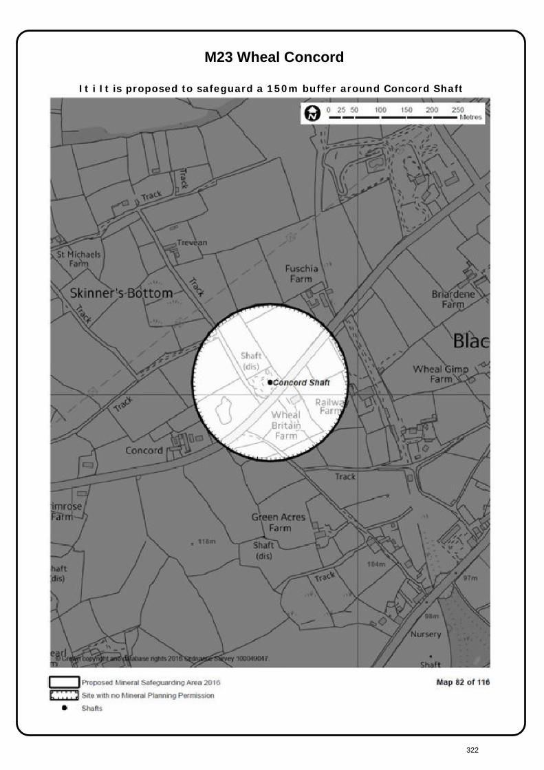
M23 Wheal Concord
It i It is proposed to safeguard a 150m buffer around Concord Shaft
322

M24 Wheal Eliza Consols
Site name: Wheal Eliza Consols Site reference: M24 Grid reference: SW045 532 Mineral type: Tin
Copper Planning Status: No planning permission Site area: 5.25ha Shafts: Engine Shaft Site Description: Wooded former metal mine on the edge of St Austell. A partially derelict engine
house and stack remain on site. The site is securely fenced. Site is owned by Boscundle Manor. http://www.boscundlemanor.co.uk/land-for-sale/ Engine Shaft – sunk in 19th Century. 215m deep and rectangular. The shaft is vertical and not lined. Dines: Engine shaft on the main lode. Although the Wheal Eliza group of mines was opened and prospected between 1908 and 1913, there was then practically no production.
Safeguarding assessment information:
No planning permission. Engine shaft - 150m. Dines - Engine shaft on the main lode. Although the Wheal Eliza group of mines was opened and prospected between 1908 and 1913, there was then practically no production.
Overall Safeguarding Score:
Shafts only
Site/Planning History:
No planning history
Site visit details:
Visited, August 2015
Designations AONB SSSI SAC SPA NNR WHS
Reference: The Metalliferous Mining Region of South-West England Volume I and II, H G Dines 1956 Cornwall’s Future Mines: Areas in Cornwall of Mineral Potential, J H Trounson 1993
323

M24 Wheal Eliza Consols
It is proposed to safeguard a 150m buffer around Engine Shaft
324

M25 Wheal Jane
Grid reference: SW772 427 Mineral type: Metal Planning Status: Active (not operating) Site area: N/A Shafts: Clemows Shaft
No. 2 Shaft Site Description:
Wheal Jane is sited near Baldhu, approximately 5km south west of Truro and 8km north east of Penryn. Tin was formerly extracted and processed at Wheal Jane, until its closure in 1991, when the pumping of the mine water ceased and the mine flooded. PA12/04692 dated 01.11.2012 identifies a final restoration scheme.
Safeguarding assessment information:
Active planning permission, site not currently operational. Treatment and restoration operations only. Clemows shaft - 150m; No 2 shaft - 50m
Overall Safeguarding Score:
Shafts only
Site/Planning History:
PA16/03502 Variation of conditions 2, 5, 6, 14, 17, 18, 20, 22, 23, 27, 29 and 30 in respect of decision PA12/04692 to facilitate the long term operation and reclamation together with minor ancillary changes in respect of the Wheal Jane site PA14/01591 dated 16.04.2014. Prior approval under Part 19 Class B for a temporary siting of a heat recovery system at Clemo’s Shaft. Not implemented. PA13/0095/99/N dated 11.07.2002. Mine offices (retention and use of redundant mining buildings for general office purposes. PA13/0093/99/N dated 29.03.2002. Mine Office (retain vacant mine workshops for general industrial purposes and change of use of mine changing rooms to provide industrial accommodation. PA12/04692 variation of conditions to facilitate the long term operation and reclamation together with minor ancillary changes in respect of the Wheal Jane site. The Wheal Jane Development Framework (WJDF) – a Masterplan for the Wheal Jane site was adopted on 09.11.2011 as a document to which the Council has regard in the determination of planning applications.
Site visit details:
No, fees monitoring regime
Infrastructure: Hazardous waste treatment facility Sludge treatment facility
Designations AONB SSSI SAC SPA NNR WHS adjacent
Photographs
Hazardous Waste Facility Site entrance Reference: The Metalliferous Mining Region of South-West England Volume I and II, H G Dines 1956 Cornwall’s Future Mines: Areas in Cornwall of Mineral Potential, J H Trounson 1993
325
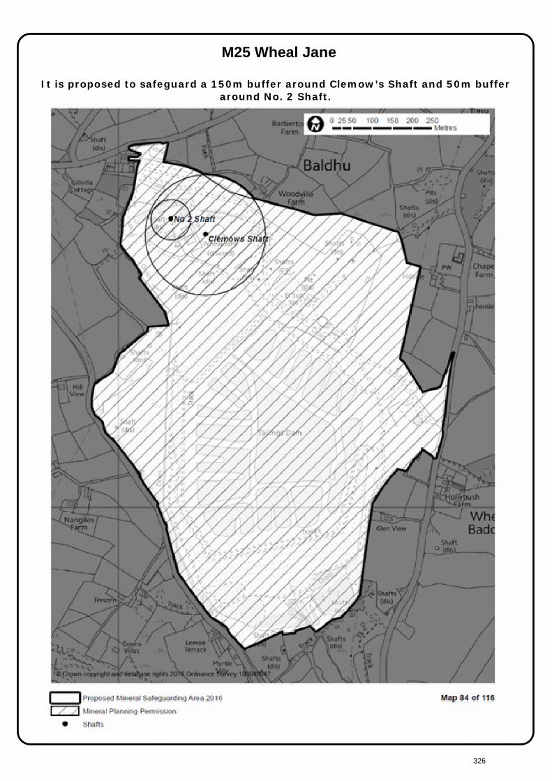
M25 Wheal Jane
It is proposed to safeguard a 150m buffer around Clemow’s Shaft and 50m buffer around No. 2 Shaft.
326
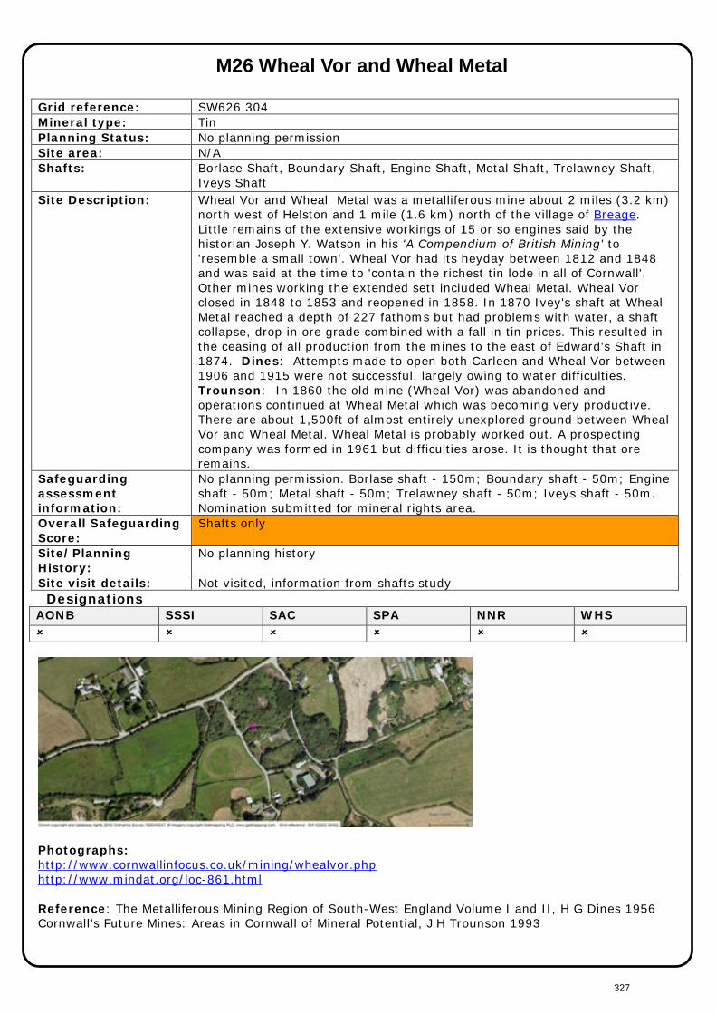
M26 Wheal Vor and Wheal Metal
Grid reference: SW626 304 Mineral type: Tin Planning Status: No planning permission Site area: N/A Shafts: Borlase Shaft, Boundary Shaft, Engine Shaft, Metal Shaft, Trelawney Shaft,
Iveys Shaft Site Description: Wheal Vor and Wheal Metal was a metalliferous mine about 2 miles (3.2 km)
north west of Helston and 1 mile (1.6 km) north of the village of Breage. Little remains of the extensive workings of 15 or so engines said by the historian Joseph Y. Watson in his 'A Compendium of British Mining' to 'resemble a small town'. Wheal Vor had its heyday between 1812 and 1848 and was said at the time to 'contain the richest tin lode in all of Cornwall'. Other mines working the extended sett included Wheal Metal. Wheal Vor closed in 1848 to 1853 and reopened in 1858. In 1870 Ivey's shaft at Wheal Metal reached a depth of 227 fathoms but had problems with water, a shaft collapse, drop in ore grade combined with a fall in tin prices. This resulted in the ceasing of all production from the mines to the east of Edward's Shaft in 1874. Dines: Attempts made to open both Carleen and Wheal Vor between 1906 and 1915 were not successful, largely owing to water difficulties. Trounson: In 1860 the old mine (Wheal Vor) was abandoned and operations continued at Wheal Metal which was becoming very productive. There are about 1,500ft of almost entirely unexplored ground between Wheal Vor and Wheal Metal. Wheal Metal is probably worked out. A prospecting company was formed in 1961 but difficulties arose. It is thought that ore remains.
Safeguarding assessment information:
No planning permission. Borlase shaft - 150m; Boundary shaft - 50m; Engine shaft - 50m; Metal shaft - 50m; Trelawney shaft - 50m; Iveys shaft - 50m. Nomination submitted for mineral rights area.
Overall Safeguarding Score:
Shafts only
Site/Planning History:
No planning history
Site visit details: Not visited, information from shafts study Designations
AONB SSSI SAC SPA NNR WHS
Photographs: http://www.cornwallinfocus.co.uk/mining/whealvor.php http://www.mindat.org/loc-861.html Reference: The Metalliferous Mining Region of South-West England Volume I and II, H G Dines 1956 Cornwall’s Future Mines: Areas in Cornwall of Mineral Potential, J H Trounson 1993
327

M26 Wheal Vor and Wheal Metal
It is proposed to safeguard a 150m buffer around Borlase Shaft and a 50m buffer around Boundary Shaft, Engine Shaft, Metal Shaft, Trelawney Shaft and Iveys Shaft.
328
M27 Treliver
Grid reference: SW917 605 Mineral type: Tin
Tungsten Planning Status: No planning permission Site area: 21.425ha Shafts: None Site Description: The Treliver site lies approximately 2km north of Indian Queens and 2km to the
south of St Columb Major. The site is bordered to the south by the St Austell – Newquay branchline. The A30 lies approximately 1.2km to the south-east of the site and the A39 likes approximately 1km to the south-west. A public footpath crosses the site from east-west and the Springfield’s Fun Park and Pony Centre likes immediately to the north. The Treliver site consists of a number of fields currently used primarily for cattle grazing. The fields slope gradually in a northerly direction and are predominantly closed Cornish hedges. Dines: Ruthvoes including Treliver Iron Mine was worked for iron ore in 1754.
Safeguarding assessment information:
Treliver lies approximately 2km north of Indian Queens and 2km to the south of St Columb Major.
Overall Safeguarding Score:
Site/Planning History:
PA14/00345 Screening opinion relating to drilling of 10 exploratory boreholes PA13/07790 Prior approval for a programme of exploratory borehole drilling. PA13/03228 EIA screening request for the drilling of exploratory boreholes. PA12/03659/PREAPP Pre application advice for Treliver Minerals Ltd ("TML") holds a lease over the mineral rights to a number of packages of land at Treliver Farm and surrounding land. TML intends to start diamond core drilling in January 2013 at Treliver Farm as part of an exploration program for Tin. C2/82/00584 MINERAL PROSPECTING, MAINLY BY DRILLING
Site visit details:
Visited, October 2015
Designations
AONB SSSI SAC SPA NNR WHS
Reference: The Metalliferous Mining Region of South-West England Volume I and II, H G Dines 1956 Cornwall’s Future Mines: Areas in Cornwall of Mineral Potential, J H Trounson 1993
329

M27 Treliver
It is proposed to safeguard 500m buffer around the boundary of the prior approval for boreholes.
330
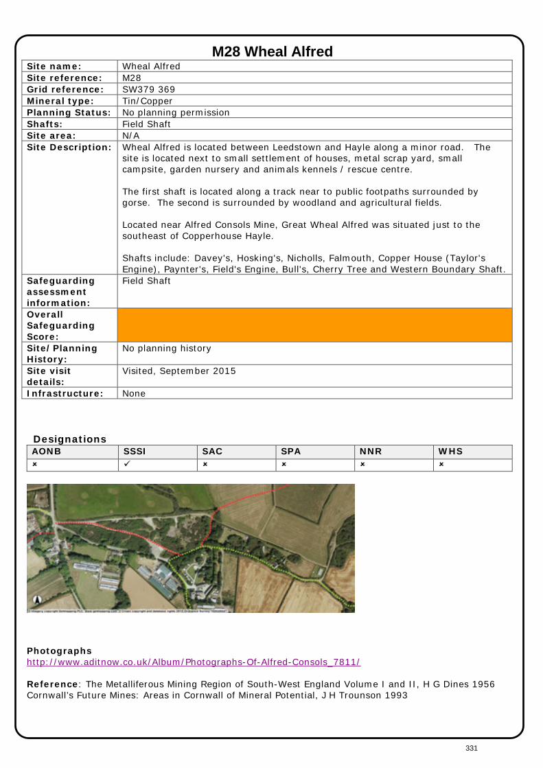
M28 Wheal Alfred Site name: Wheal Alfred Site reference: M28 Grid reference: SW379 369 Mineral type: Tin/Copper Planning Status: No planning permission Shafts: Field Shaft Site area: N/A Site Description: Wheal Alfred is located between Leedstown and Hayle along a minor road. The
site is located next to small settlement of houses, metal scrap yard, small campsite, garden nursery and animals kennels / rescue centre. The first shaft is located along a track near to public footpaths surrounded by gorse. The second is surrounded by woodland and agricultural fields. Located near Alfred Consols Mine, Great Wheal Alfred was situated just to the southeast of Copperhouse Hayle. Shafts include: Davey's, Hosking's, Nicholls, Falmouth, Copper House (Taylor's Engine), Paynter's, Field's Engine, Bull's, Cherry Tree and Western Boundary Shaft.
Safeguarding assessment information:
Field Shaft
Overall Safeguarding Score:
Site/Planning History:
No planning history
Site visit details:
Visited, September 2015
Infrastructure: None
Designations AONB SSSI SAC SPA NNR WHS
Photographs http://www.aditnow.co.uk/Album/Photographs-Of-Alfred-Consols_7811/ Reference: The Metalliferous Mining Region of South-West England Volume I and II, H G Dines 1956 Cornwall’s Future Mines: Areas in Cornwall of Mineral Potential, J H Trounson 1993
331
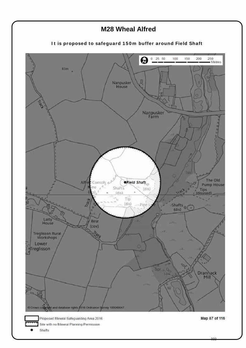
M28 Wheal Alfred
It is proposed to safeguard 150m buffer around Field Shaft
332


