
1
Methods for identifying recording and analyzing Palaeolithic surface scatterssites
Dr Julie Scott-Jackson Institute of Archaeology University of Oxford 36 Beaumont
Street Oxford OX1 2PG Director of the PADMAC Unit
juliescott-jacksonarchoxacuk 00447785 110910
Dr William Scott-Jackson Institute of Archaeology University of Oxford PADMAC Unit
williamscott-jacksonarchoxacuk
Abstract
The application of distinct methodologies and techniques developed by the PADMAC
Unit for the investigation of Palaeolithic surface-scatters of lithic artefacts has the
potential to rapidly advance archaeological ability to construct models of hominin
dispersal patterns Palaeolithic habitat preferences (including the provision of resources)
and the use of the landscape as a whole Here we present evidence that an iterative process
of inductive analogous reasoning utilising a varied and evolving suite of techniques and
analytical procedures for the investigation of surface-scatters can be a powerful tool This
concept is described and applied to the desk-based assessment field investigations off-site
analyses of field investigation data and techno-typological analyses of artefacts These
evolving analyses produce significant results including suggestions of inter-site
relationships location criteria and hominin dispersal especially considering the scarcity of
alternative comprehensive approaches
Keywords Palaeolithic Surface-scatter Techno-typology lithic scatter Arabia UAE site
2
1 Introduction
Well dated excavated Palaeolithic sites from around the world have produced site-specific
data of international importance However data derived from excavated sites are unlikely
to provide information on the Palaeolithic peoplesrsquo use of landscape as a whole
Conversely Palaeolithic surface-scatters (PS-Ss) are often the only evidence of a
Palaeolithic presence in a locale It is important therefore to fully utilise all the data that
PS-Ss can provide In principle the interactive approach described here can be applied to
any area irrespective of size in a variety of environments to identify a Palaeolithic
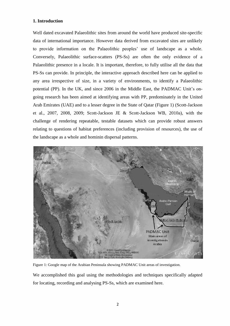
potential (PP) In the UK and since 2006 in the Middle East the PADMAC Unitrsquos on-
going research has been aimed at identifying areas with PP predominately in the United
Arab Emirates (UAE) and to a lesser degree in the State of Qatar (Figure 1) (Scott-Jackson
et al 2007 2008 2009 Scott-Jackson JE amp Scott-Jackson WB 2010a) with the
challenge of rendering repeatable testable datasets which can provide robust answers
relating to questions of habitat preferences (including provision of resources) the use of
the landscape as a whole and hominin dispersal patterns
Figure 1 Google map of the Arabian Peninsula showing PADMAC Unit areas of investigation
We accomplished this goal using the methodologies and techniques specifically adapted
for locating recording and analysing PS-Ss which are examined here
3
Rationale and methods
The presence of multiple components inherent in the preservation or loss of PS-Ss sites
several which are driven by the mechanisms of reactive chemical and mechanical
weathering processes over geological time on both the terrain and Palaeolithic artefacts
results in complex geo-archaeological research Here we present evidence that an iterative
process of inductive analogous reasoning utilising a varied and evolving suite of
techniques and analytical procedures for the investigation of PS-Ss can be a powerful tool
The desk-based assessment prior to fieldwork (Section 31) is considered first followed
by the field-investigation stage (Section 32) the off-site analyses (Section 33) the off-
site techno-typological artefact analysis (Section 34)
31 The desk-based assessment the aims methodologies and techniques for locating
PS-Ss prior to fieldwork
Understanding Palaeolithic hominin dispersal patterns and hominin behavioural
organization which includes habitat habitat preferences and provision of resources across
the whole landscape naturally depends on locating PS-Ss The questions particularly
associated with Palaeolithic habitat range and location include for example Where did
these hunters-gathers go in a specific area and why did they choose these areas Other
questions relating to the provision of resources across the whole landscape are What
resource (or resources) in any one place was the focus of their choice What were their
concerns in making those choices For example what type of raw material did they
generally use in that area to make stone-tools
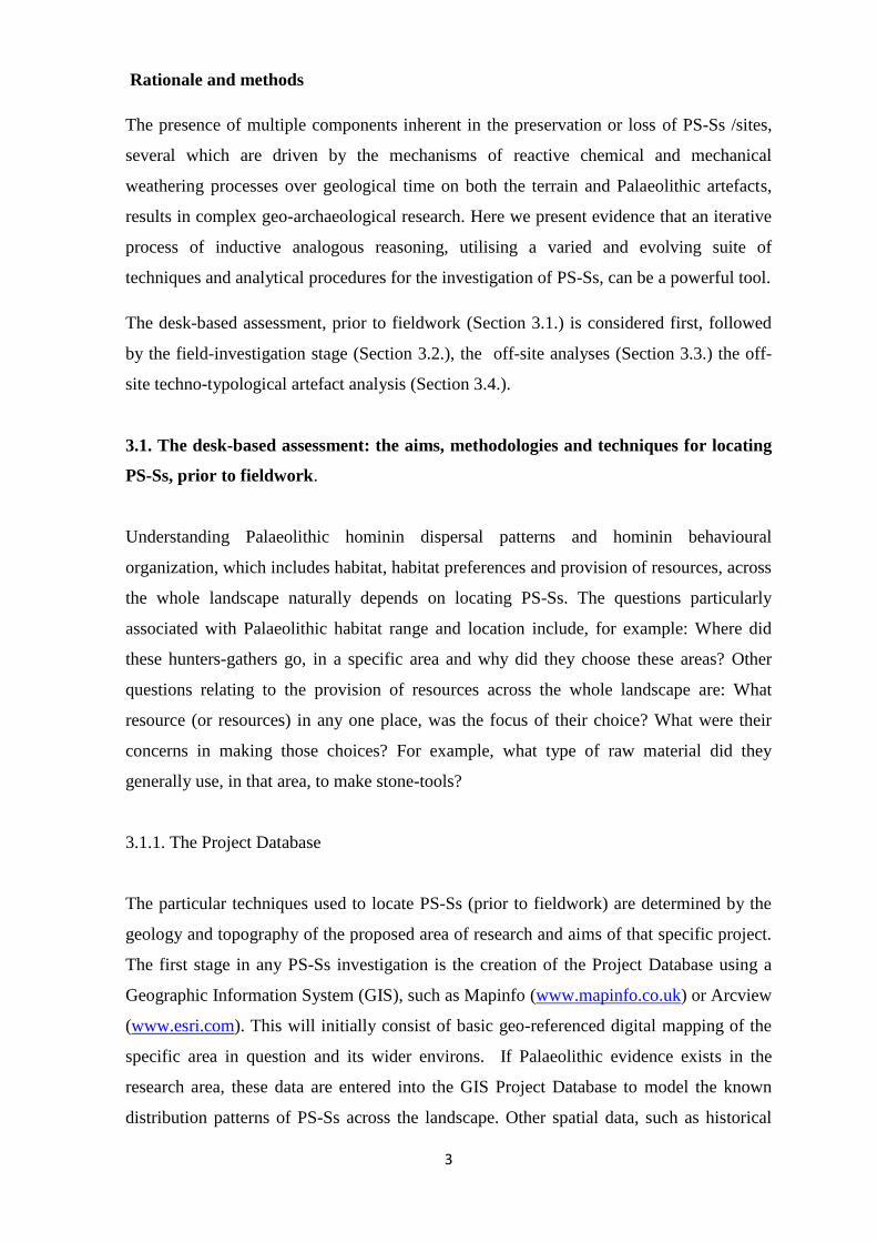
311 The Project Database
The particular techniques used to locate PS-Ss (prior to fieldwork) are determined by the
geology and topography of the proposed area of research and aims of that specific project
The first stage in any PS-Ss investigation is the creation of the Project Database using a
Geographic Information System (GIS) such as Mapinfo (wwwmapinfocouk) or Arcview
(wwwesricom) This will initially consist of basic geo-referenced digital mapping of the
specific area in question and its wider environs If Palaeolithic evidence exists in the
research area these data are entered into the GIS Project Database to model the known
distribution patterns of PS-Ss across the landscape Other spatial data such as historical
4
mapping is also added as is geological geomorphological and soil mapping data (Figure
2) which is needed to identify areas with a PP
Figure 2 Layers from GIS based Project database for PADMAC Unit site of Dickettrsquos Field UK
Data entered into the GIS Project Database can then be exported to a web-based remote
sensing satellite mapping system such as Google Earth (Figure 3)
Figure 3 Google mapping (vertical and 3d) of PADMAC Unit site of Dickettrsquos Field UK showing geo-
referenced satellite images and artefact locations
5
312 Remote Sensing Techniques
Remote sensing techniques access data from satellites aircraft or other flight platforms
The analysis of these data is desk-based as the information is available via computer
systems and media but should also if at all possible be confirmed through field
investigation (lsquoground-truthingrsquo) The techniques cited here are not definitive nor indeed
are the uses Satellite mapping including 3D visualization (Figure 4) is used for example
to explore both landscape features and surface geology to search for areas of PP and to
study relationships between known PS-Ss in a variety of contexts such as plateau edges
interfluves and drainage systems (eg river terraces and river valleys)
Figure 4 3d visualization of the region of PADMAC Unit site of Dickettrsquos Field UK showing landform and
draped geology mapping
With this remote sensing technique it is also possible to identify evidence of later
archaeology more recent structures and settlements and routes for field investigations
(eg Scott-Jackson JE amp Scott-Jackson WB 2010a) Digital Terrain Modeling (DTM)
based on calculated heights (from eg SRTM90 satellite data) also helps indicate locations
with a PP (Figure 5) when combined with the geological and geomorphological data For
example mountain ridges edges of plateaux with views down into valleys overlooking
possible animal migration routes wadis and river systems
6
DTM data also enables the modeling of slope profiles cross-sections and relative distances
which can be calculated in relation to provision of resources (eg raw materials andor
water)
Figure 5 Digital Terrain Map showing PADAMC Unit sites in UAE (up to 2011)
In addition aerial photography (Figure 6) may show areas of PP and for example the
proximity to known PS-Ss andor sites later archaeology access to these areas and
anthropomorphic modification of landscape More specialized methods include multi-
spectral (eg IRS-P4 OCM) satellite imaging which has a use in PS-Ss prospecting as it
can identify for example non-visible diagnostic geologicalgeomorphological features
such as palaeochannels beneath dune systems (Rajani and Rajawat 2011) and remote
sensing geophysical aerial techniques (eg magnetometry) which are also able to detect
sub-surface features over wide areas (Lasaponara et al 2011)
Figure 6 PADMAC Unit site of Dickettrsquos Field UK Geo-referenced aerial photograph showing Iron Age
Hill-fort in relation to locations of Palaeolithic surface finds
7
32 Field-investigations the aims methodologies and techniques for locating and
recording PS-Ss
PS-Ss should be treated as integral components of the erosionaldepositional surface-
deposits on which they are found as an artefact is no more than a natural clast (stone) until
recognized as such Detailed recording of the context in which PS-Ss are recovered
including the topographical geological geomorphological and sedimentological processes
that have acted upon that specific area is essential to establish the integrity of this valuable
archaeological resource
321 Palaeolithic Survey Grid
The desk-based geo-archaeological assessment data previously entered into the Mapinfo
GIS Project Database is incorporated into a high-resolution GIS Palaeolithic Survey Grid
(PSG) which uses coordinates that comply with (if at all possible) an existing grid system
for that region or country Each specific grid square in the PSG has a unique identifier
which allows repeatable testable fieldwork data sets to be produced The use of this
method facilitates the co-ordination of Palaeolithic field investigations a comprehensive
record of both the presence and absence of Palaeolithic evidence and the retention and
access to all the information generated Ideally it would also lead to the development of a
local andor regional Palaeolithic Research Agenda to provide a geo-archaeological
framework for identifying recording preserving and investigating Palaeolithic
archaeology such as the Palaeolithic Research Agenda for Qatar (Scott-Jackson JE amp
Scott-Jackson WB 2010a)
322 On-site methodologies and techniques
Various categories of techniques are employed during fieldwork those for locating and
recording the presence or absence of PS-Ss and geophysical and sedimentological
techniques to investigate the context and deposits associated with the scatters Global
Positioning System (GPS) is the essential tool in all field surveys GPS tracking (Figure 7)
and waypoints are used to record the presence and absence of Palaeolithic evidence across
the landscape (Scott-Jackson JE amp Scott-Jackson WB 2010a)
8
Figure 7 PADMAC Unit Field investigations in Qatar using GPS tracking (MotionX software)
High resolution differential GPS equipment (eg httpwwwleica-geosystemscouk) can
also be used within the area of the PS-Sssite to record the extent of the archaeology and to
provide details of the site terrain to produce off-site detailed DTM (Figure 8) to an
appropriate level of accuracy for the specific project (Scott-Jackson et al 2009)
Figure 8 Detailed DTM of PADMAC Unit sites near Fili Sharjah Emirate UAE
9
Where access to an area is difficult or restricted the use of close range aerial photography
by balloon kite or powered platform (eg AR Drone quadricopter
wwwardroneparrotcom ) is an option (Verhoeven et al 2009) (Figure 9)
Figure 9 Close Range Aerial Photography using dirigible PADMAC Unit Palaeolithic surface-scatter
ESF06A (United Arab Emirates)
323 Determining the integrity of PS-Ss
Site-specific investigations are required to understand the particular context in which a PS-
S is found When analyzing desert landforms for example it is noteworthy that many
features seen today may have been formed in earlier wetter climates Surface weathering
of the bedrockdeposits by fluvial and aeolian processes which include erosion transport
and deposition of material by the wind can effectively incorporate a PS-S into the
deposits Later the same artefacts may be re-exposed by the erosional process of
deflation whereby fine-grained material is removed from an area by wind and water To
understand better the context in which a particular PS-S was found an analysis of the
associated deposits is necessary as soils and sediments exhibit properties that can be used
to understand the site formation processes (Marder et al 2011)
324 Photogrammetry
One particular technique which has proved invaluable in determining the in-situ or
otherwise status of a PS-S is photogrammetry (using for example i-witness
(wwwiwitnessphotocom) This relatively easy method of recording (even in difficult
10
field situations) produces 3D models for orientation slope process analyses of the PS-Ss
(See Figure 10 for photogrammetry of the case study site ESF06A) the only proviso is
that the artefacts should be easily visible Otherwise a high resolution differential GPS a
laser or total station survey is required (Scott-Jackson JE amp Scott-Jackson WB 2009
Lerma et al 2010)
Figure 10 3d diagram of photogrammetry analysis of artefact distribution at EFS06A showing angles of dip
orientation and angle of a-axis
325 Geophysical survey
The integrity of PS-Ss on high-level ridges and hilltops can be somewhat different to the
scatters found at low-levels as in situ high-level scatterssites are invariably retained in
deposits held in depressions and fissures in the underlying rock (the same situation may in
certain circumstances apply to low-level scatters) Retaining features such as those
described are produced by geomorphological processes both chemical and mechanical
operating on the sub-surface over geological time A variety of ground-based non-intrusive
geophysical survey techniques are available for the detection of sub-surface features
(Gaffney 2008) but success depends on selecting the appropriate method Each method
has both advantages and disadvantages depending on for example the geology
geomorphology topography soil moisture content of the deposits and the ultimate aim of
the specific project (see Milsom 2011) A Deep Resistivity Survey (Figure 11) using for
example a Campus Tigre 128 System (Wenner Array) is the preferred means of
geophysical exploration in non-arid karst environments where the need is to identify sub-
11
surface dissolution features such as basin-like hollows pipes and caves The caveat to this
method is that to be successful it requires a high soil moisture content (Scott-Jackson JE amp
Scott-Jackson WB 2010b)
Figure 11 Resistivity Survey diagram of sub-surface PADMAC Unit site at Dickettrsquos Field UK
Ground Penetrating Radar (GPR) can also identify sub-surface voids or differentiated
deposits but the effectiveness of this technique is hindered by clay and moist rich soils
(Goacutemez-Ortiz 2010) Two other geophysical techniques (Figure 12) that have application
are magnetometry to locate sub-surface features such as evidence of previous ditches or
banks which during their construction could have been implicated in exposure or
movement of PS-Sssites (Milsom 2011) and magnetic susceptibility to reveal areas of
differential usage across a landscape and identify land uses that may have disturbed
Palaeolithic archaeology (see httpwwwarchaeotechnicscoukmaghtml)
Figure 12 Geophysical Investigations of Palaeolithic Surface-Scatters (DFY03 UK)
12
33 Off-site analyses the aims methodologies and techniques for analyzing PS-Ss
The rapid and on-going development of computer-based techniques and new
methodologies is both advancing the research of geo-archaeology in general and giving a
new dimension to the study of PS-Ss in particular However inherent in this progress are
accelerated opportunities for the misinterpretation of these collected data and of data
distortions The need for careful attention to scale and accuracy is paramount (Goodchild
2011) For example DTM data produced to an accuracy of 10 metres cannot be used for
analyses requiring an accuracy of 1 metre Information derived from the desk-based
assessment and the field investigations forms the basis for the off-site analyses which is
focused on the inter-scatter relationships the intra-scatter relationships and the techno-
typological analysis of the Palaeolithic artefacts The results of the off-site analyses are
subsequently entered into the Project Database
331 Inter-scatter Analyses
The off-site analysis begins by accessing the landscape scale DTM from the GIS Project
Database This is used to analyse the inter-scatter relationships (that is relationships
between the recorded PS-Ss andor sites) and to further identify locations with PP ie the
integrity of a specific PS-S and the identification of other PS-Ss and areas that have
Palaeolithic in-situ potential and may warrant detailed excavation (Figure 13)
Figure 13 Inter-Scatter analysis of relationships between Palaeolithic surface-scatters in the locality of
DFY03 UK
13
Included in this analysis of inter-scatter relationships is evidence of geomorphological
processes of erosion and deposition in the area and the results from detailed analyses of the
soil andor sediment samples Other applications for the DTM data are the techniques of
viewshed and proximity analysis (Alexakis et al 2011) which from a specified point in
the landscape can be used to compare locations and explore location criteria (eg the
position of knapping scatters relative to views over game routes views of associated
scatter locations and proximity to raw material and water) The credibility of the resultant
data is governed by both the need for a conservative interpretation and the appropriateness
of the available data which should take into account changes to the topography over
geological time Other data held within the GIS Project Database such as historical
mapping is also accessed to identify post-Palaeolithic anthropomorphic modification of
the landscape (eg later prehistoric structures and changes in agricultural practices in more
recent history) For the case study sites viewshed analysis was utilised with caution to
explore possible location criteria and historical mapping was used to identify land use
changes (in recent history)
332 Intra-scatter Analyses
For the intra-scatter analyses (ie the relationship of the artefacts one to another within
the PS-S and also that of a scatter within individual spits in an excavated site) a three-
dimensional model of the artefacts and clasts their orientations and patterns of distribution
is produced using photogrammetry (employing i-witness software for example) or data
derived from a laser scan or total station survey (Lerma et al 2010) The resulting
orientation of both the natural clasts and the artefacts can now be statistically analysed
using software such as Oriana (httpwwwkovcompcouk) which calculates means
variances and other statistical relationships from circular data (Figure 10) such as direction
in degrees (where for example the values of 0 and 360 are identical) These data are then
used to identify the geomorphological processes ranging from soil-creep to mass flow
which have operated in the immediate area of the scatter in order to determine the
integrity of the PS-S (ie in situ or dervived) Photogrammetry can also be used to create
ortho-rectified composite artefact distribution photographs showing accurate spatial
layouts of a complete scatter the artefacts and other features (Ayoub et al 2009)
14
34 Off-site techno-typological artefact analysis
The off-site techno-typological analysis of the Palaeolithic artefacts (including debitage) is
in two linked parts the first is the intra-scattersite analysis and the second the inter-
scattersite analysis
341 Intra-scattersite techno-typological analysis of the Palaeolithic artefacts
The intra-scatter (andor site) techno-typological analysis begins by compiling a list of
attributes (ie the observable characteristics) of each artefact (Andrefsky 2005 Hovers
2009) For each attribute there are a number of possible variables associated with the
observed characteristics Every artefact is defined by the assigned attributes from the list
Typically any attribute of an individual artefact is assigned a single attribute status An
individual artefact can then be described by the relationship among its attributes or by
technological typological and stylistic attributes In addition to the role of determining
shared attribution within the assemblage an intra-sitescatter comparison may isolate any
significant techno-typological differences within the assemblage which might suggest that
it is a palimpsest The presence of refitting artefacts in a PS-S assemblage may be
indicative of the integrity of that assemblage Where refits occur it may be possible to
construct a reduction sequence
342 Inter-scattersite techno-typological analysis of the Palaeolithic artefacts
The inter-sitescatter techno-typological comparison of the PS-S assemblages and (dated
sites) is made using data derived from the intra-sitescatter techno-typological analysis
Comparing and contrasting the techno-typology of individual PS-S assemblages (in a
specific area) can produce data that has the potential to reveal the location choices of
Palaeolithic hunter-gathers across the wider landscape (Figure 14)
15
Figure 14 Inter-site techno-typological analysis of Palaeolithic surface-scatters ESF067 (United Arab
Emirates) (Scott-Jackson et al 2009) and the excavated assemblage at Jebel Faya (United Arab Emirates)
(Armitage et al 2011)
This may be achieved with particular reference to the topography of the studied area the
proximity of the PS-Ss to previously identified sources of knappable raw material (eg
chert flint) sources of water (eg wadi systems) (Raczek in press) and as far as the data
allows (see Sections 312and 331) possible game routes (eg where viewshed analysis
has allowed a tentative suggestion of migration routes of prey species (Scott-Jackson JE amp
Scott-Jackson WB 2008) or more frequent tracks to feeding grounds or water sources)
Where high resolution data is generated it may be feasible with due caution to extrapolate
from these findings suggested hominin dispersal patterns (eg distribution patterns of
artefact types which may suggest the types of activities being carried out) For example a
comprehensive study of PS-Ss has added significantly to the general understanding of
Palaeolithic hominin dispersal patterns within the Arabian Peninsula
16
References
Andrefsky W 2005 Lithics Macroscopic Approaches to Analysis Second Edition
Cambridge University Press Cambridge UK
Alexakis A Sarris A Astaras T Albnakis K 2011 Integrated GIS remote sensing
and geomorphologic approaches for the reconstruction of the landscape habitation of
Thessaly during the neolithic period Journal of Archaeological Science 38 (1) 89-100
Armitage S J Jasim S A Marks A E Parker A G et al 2011 The southern route lsquoOut
of Africarsquo evidence for an early expansion of modern humans into Arabia Science 331
453ndash456
Gaffney C 2008 Detecting Trends in the prediction of the buried past A review of
geophysical techniques in archaeology Archaeometry 50 313ndash336
Goacutemez-Ortiz D Martiacuten-Crespo T Martiacuten-Velaacutezquez S Martiacutenez-Pagaacuten P Higueras
H Manzano M 2010 Application of ground penetrating radar (GPR) to delineate clay
layers in wetlands A case study in the Soto Grande and Soto Chico watercourses Dontildeana
(SW Spain) Journal of Applied Geophysics 72 (2) 107ndash113
Goodchild MF 2011 Scale in GIS An overview Geomorphology 130 (1-2) 5-9
Grun R Stringer C McDermott F Nathan R Porat N Robertson S Taylor L
McCulloch M 2005 U-series and ESR analyses of bones and teeth relating to the human
burials from Skhul Journal of Human Evolution 49 (3) 316-334
Hovers E 2009 The lithic assemblages of Qafzeh Cave Oxford University Press
Oxford pp 43-154
Inizan ML 1980 Premiers reacutesultats des fouilles preacutehistoriques de la reacutegion de Khor In
Tixier J editor Mission Archeacuteologique Franccedilaise agrave Qatar Doha Dar al-Uloom p 51ndash97
Jagher R 2009 The Central Oman Paleolithic Survey Recent Research in Southern
Arabia and Reflection on the Prehistoric Evidence In Petraglia M Rose J (Eds) The
Evolution of Human Populations in Arabia Springer Netherlands 139-150
Jelinek AJ 1990 The Amudian in the context of the Mugharan tradition at the Tabun
Cave (Mt Carmel) Israel In Mellars P (Ed) The emergence of modern humans
Edinburgh University Press Edinburgh pp 81-90
Jelinek AJ 1992 Problems in chronology in the Middle Paleolithic and the first
appearance of modern humans in Western Eurasia In Akazawa T Aoki K Kimura T
(Eds) The evolution and dispersal of modern humans in Asia Hokusen-sha Press Tokyo
pp 253-276
Kapel H 1967 Atlas of the Stone-Age Cultures of Qatar Aarhus University Press
Denmark
Lahr M Foley R 1994 Multiple dispersals and modern human origins Evolutionary
Anthropology 3 48-60
17
Lahr M amp Foley R 1998 Towards a theory of modern human origins geography
demography and diversity in recent human evolution Yearbook of Physical Anthropology
41 137ndash176
Lasaponara R Masini N Rizzo E Orefici G 2011 New discoveries in the Piramide
Naranjada in Cahuachi (Peru) using satellite Ground Probing Radar and magnetic
investigations Journal of Archaeological Science 38 2031-2039
Leakey M Tobias PV Martyn JE Leakey R 1969 An Acheulian industry with
prepared core technique and the discovery of a contemporary hominin mandible at Lake
Baringo Kenya Proceedings of the Prehistoric Society 3 48ndash76
Lerma JL Navarro S Cabrelles M Villaverde V 2010 Terrestrial laser scanning and
close range photogrammetry for 3D archaeological documentation the Upper Palaeolithic
Cave of Parpalloacute as a case study Journal of Archaeological Science 37 (3) pp 499-507
Marder O Malinsky-Buller A Shahack-Gross R Ackermann O Ayalon A Bar-
Matthews M Goldsmith Y Hovers E 2011 Archaeological horizons and fluvial
processes at the Lower Paleolithic open-air site of Revadim (Israel) Journal of Human
Evolution 60 (4) pp 508-522
McDougall I Brown FH Fleagle JG 2005 Stratigraphic placement and age of
modern humans from Kibish Ethiopia Nature 433 733-736
Milsom J Eriksen A 2011 Field Geophysics Blackwell Oxford
Monigal K 2002 The Levantine Leptolithic Blade Technology from the Lower
Paleolithic to the Dawn of the Upper Paleolithic PhD Dissertation Southern Methodist
University Dallas
Oppenheimer S 2011 A single southern exit of modern humans from Africa Before or
after Toba Quaternary International httpdxdoi101016jquaint201107049
Petraglia MD Alsharekh A 2003 The Middle Paleolithic of Arabia implications for
modern human behaviour and dispersals Antiquity77 (298) 671ndash84
Pleurdeau D 2005 Human technical behavior in the African Middle Stone Age the lithic
assemblage from Porc-Epic Dave (Dire Dawa Ethiopia) African Archaeological Review
22 (4) 177-197
Raczek TT (in press) Hominin migration in South Asia and raw material sources in the
Banas-Berach basin Quaternary International Available online 9 August 2011
httpdxdoiorg101016jquaint201107037
Rafani MB Rajawat AS 2011 Potential of satellite based sensors for studying
distribution of archaeological sites along palaeo channels Harappan sites a case study
Journal of Archaeological Science 38 2010-2016
Reich D Green RE Kircher M Krause J Patterson N Durand EY Viola B
Briggs AW Stenzel U Johnson PLF et al 2010 Genetic history of an archaic
hominin group from Denisova Cave in Siberia Nature 468 1053-1060
18
Richter D 2007 Advantages and limitations of thermoluminescence dating of heated
flint from Paleolithic sites Geoarchaeology 22 671ndash683
Rhodes EJ 2011 Optically Stimulated Luminescence dating of sediments over the past
200000 Years Annual Review of Earth and Planetary Sciences 39 461 -488
Rohling E J K Grant M Bolshaw A P Roberts M Siddall Ch Hemleben and M
Kucera 2009 Antarctic Temperature and Global Sea Level Closely Coupled over the Past
Five Glacial Cycles Nature Geosci advanced online publication (June 21)
doi101038ngeo557 httpdxdoiorg101038ngeo557
Rose JI 2004 The question of Upper Pleistocene connections between East Africa and
South Arabia Current Anthropology 45 (4) 551ndash5
Rose JI 2006 Among Arabian Sands Defining the Paleolithic of Southern Arabia
PhD dissertation Southern Methodist University
Rose JI 2007 The Arabian Corridor Migration Model archaeological evidence for
hominin dispersal into Oman during the Middle and Upper Pleistocene Proceedings of the
Seminar for Arabian Studies 37 pp 219-237
Rose JI 2010 New Light on Human Prehistory in the Arabo-Persian Gulf Oasis Current
Anthropology 51 (6) 849-883
Rose JL Petraglia MD 2009 Tracking the Origin and Evolution of Human Populations
in Arabia In Petraglia M Rose J (Eds) The Evolution of Human Populations in
Arabia Springer Netherlands pp1-14
Rose JI Usik VI 2009 The ldquoUpper Paleolithicrdquo of South Arabia In Petraglia M
Rose J (Eds) The Evolution of Human Populations in Arabia Springer Netherlands
pp169-185
Scott-Jackson JE 2000 Lower and Middle Palaeolithic artefacts from deposit mapped
as Clay-with-flints ndash a new synthesis with significant implications for the earliest
occupation of Britain Oxbow Books Oxford pp76-140
Scott-Jackson JE 2005 The Palaeolithic of the Marlborough Downs and Avebury Area
In Brown G Field D McOmish D (Eds) The Avebury Landscape aspects of the field
archaeology of the Marlborough Downs Oxbow Books (for English Heritage) Oxford
pp66-76
Scott-Jackson JE Scott-Jackson WB 2008 Alternative location modelling of a
LowerMiddle Palaeolithic site on deposits mapped as Clay-with-flints in southern
England UK PADMAC Unit Working Paper University of Oxford UK
httpusersoxacuk~padmacrschinfohtm
Scott-Jackson JE Scott-Jackson WB 2009 The use of photogrammetry in
investigations of Palaeolithic sites surface scatters and excavations PADMAC Unit
Working Paper httpusersoxacuk~padmacrschinfohtm
19
Scott-Jackson JE Scott-Jackson WB 2010a A Palaeolithic research agenda for the
State of Qatar PADMAC Unit Working Paper University of Oxford UK
httpusersoxacuk~padmacrschinfohtm
Scott-Jackson JE Scott-Jackson WB 2010b Geo-archaeological investigations at
Arrewig Lane near Chesham Buckinghamshire PADMAC Unit Working Paper
University of Oxford UK httpusersoxacuk~padmacrschinfohtm
Scott-Jackson JE Scott-Jackson WB Jasim S 2007 Middle Paleolithic-or what
New sites in Sharjah UAE Proceedings of the Seminar for Arabian Studies 37 277-279
Scott-Jackson JE Scott-Jackson WB Rose JI 2009 Palaeolithic Stone Tool
Assemblages from Sharjah and Ras al Khaimah in the United Arab Emirates In Petraglia
M Rose J (Eds) The Evolution of Human Populations in Arabia Springer Netherlands
pp125-138
Scott-Jackson JE Scott-Jackson WB Rose JI Jasim S 2008 Upper Pleistocene
stone-tools from Sharjah UAE Initial investigations interim report Proceedings of the
Seminar for Arabian Studies 38 43-54
Serreze M Francis J 2006 The Arctic Amplification Debate Climatic Change 76 (3)
241-264
Smith GH 1997New prehistoric sites in Oman Journal of Oman Studies 3 71ndash81
Solecki RS Solecki RL 1993 The Pointed Tools from the Mousterian Occupations of
Shanidar Cave Northern Iraq In Olszewski D Dibble HL (Eds) The Paleolithic
Prehistory of the Zagros-Taurus University of Pennsylvania Press Pennsylvania 120-130
Stewart JR amp Stringer C 2012 Human Evolution Out of Africa The Role of Refugia
and Climate Change Science 335 1317-1321
Stringer C 2000 Coasting out of Africa Nature 405 24ndash27
Tchernov E1992 Eurasian-African biotic exchanges through the Levantine corridor
during the Neogene and Quaternary Courier Forsch-Inst Senckenberg 153 103ndash123
Trinkaus E 1983 The Shanidar Neanderthals Academic Press New York
Trinkaus E Biglari F 2006 Middle Paleolithic Human Remains from Bisitun Cave
Iran Paleacuteorient 32 (2) 105-111
Verhoeven G J J Loenders J Vermeulen F Docter R 2009 Helikite aerial
photography ndash a versatile means of unmanned radio controlled low-altitude aerial
archaeology Archaeological Prospection 16 125ndash138
Wahida G Al-TikritiWL Beech M J Meqbali AA 2009 A Middle Palaeolithic
Assemblage from Jebel Barakah Coastal Abu Dhabi Emirate In Petraglia M Rose J
(Eds) The Evolution of Human Populations in Arabia Springer Netherlands 117-124
20
Whalen NM Siraj-Ali JS Davis W 1984 Excavation of Acheulean sites near
Saffaqah Saudi Arabia Atlal 89ndash24
Whalen NM Siraj-Ali JS Sindi HO Pease DW Badein MA 1988 A complex
of sites in the Jeddah-Wadi Fatimah area Atlal 11 77-85
Wendorf F Schild R 1974 A Middle Stone Age Sequence from the Central Rift
Valley Ethiopia Polska Akademia Nauk Warsaw
Zarins J 2001 The land of incense ndash Archaeological work in the Governorate of Dhofar
Sultanate of Oman 1990ndash1995 Sultan Qaboos University Publications Muscat
21
FIGURES
Figure 1 Google Map of Arabian Peninsula showing main areas of PADMAC Unit
investigations
Figure 2 Digital Terrain Map showing Palaeolithic surface-scatterssites investigated by
the PADMAC Unit in Sharjah and Ras Al Khaimah Emirates (UAE)
Figure 3 Google map showing Palaeolithic assemblages discussed in the techno-
typological case study (Section 4)
Figure 4 Photogrammetry results from ESF06A showing spatial distribution and
orientations of artefacts
Figure 5 Group A1 representative artefacts
Figure 6 Group A2 representative artefacts
Figure 7 Group A3 representative artefacts ndash large biface and centripetal Levallois core
Figure 8 Group B1 representative artefacts
Table 1 Techno-typological Indicators after Scott-Jackson et al 2009
2
1 Introduction
Well dated excavated Palaeolithic sites from around the world have produced site-specific
data of international importance However data derived from excavated sites are unlikely
to provide information on the Palaeolithic peoplesrsquo use of landscape as a whole
Conversely Palaeolithic surface-scatters (PS-Ss) are often the only evidence of a
Palaeolithic presence in a locale It is important therefore to fully utilise all the data that
PS-Ss can provide In principle the interactive approach described here can be applied to
any area irrespective of size in a variety of environments to identify a Palaeolithic
potential (PP) In the UK and since 2006 in the Middle East the PADMAC Unitrsquos on-
going research has been aimed at identifying areas with PP predominately in the United
Arab Emirates (UAE) and to a lesser degree in the State of Qatar (Figure 1) (Scott-Jackson
et al 2007 2008 2009 Scott-Jackson JE amp Scott-Jackson WB 2010a) with the
challenge of rendering repeatable testable datasets which can provide robust answers
relating to questions of habitat preferences (including provision of resources) the use of
the landscape as a whole and hominin dispersal patterns
Figure 1 Google map of the Arabian Peninsula showing PADMAC Unit areas of investigation
We accomplished this goal using the methodologies and techniques specifically adapted
for locating recording and analysing PS-Ss which are examined here
3
Rationale and methods
The presence of multiple components inherent in the preservation or loss of PS-Ss sites
several which are driven by the mechanisms of reactive chemical and mechanical
weathering processes over geological time on both the terrain and Palaeolithic artefacts
results in complex geo-archaeological research Here we present evidence that an iterative
process of inductive analogous reasoning utilising a varied and evolving suite of
techniques and analytical procedures for the investigation of PS-Ss can be a powerful tool
The desk-based assessment prior to fieldwork (Section 31) is considered first followed
by the field-investigation stage (Section 32) the off-site analyses (Section 33) the off-
site techno-typological artefact analysis (Section 34)
31 The desk-based assessment the aims methodologies and techniques for locating
PS-Ss prior to fieldwork
Understanding Palaeolithic hominin dispersal patterns and hominin behavioural
organization which includes habitat habitat preferences and provision of resources across
the whole landscape naturally depends on locating PS-Ss The questions particularly
associated with Palaeolithic habitat range and location include for example Where did
these hunters-gathers go in a specific area and why did they choose these areas Other
questions relating to the provision of resources across the whole landscape are What
resource (or resources) in any one place was the focus of their choice What were their
concerns in making those choices For example what type of raw material did they
generally use in that area to make stone-tools
311 The Project Database
The particular techniques used to locate PS-Ss (prior to fieldwork) are determined by the
geology and topography of the proposed area of research and aims of that specific project
The first stage in any PS-Ss investigation is the creation of the Project Database using a
Geographic Information System (GIS) such as Mapinfo (wwwmapinfocouk) or Arcview
(wwwesricom) This will initially consist of basic geo-referenced digital mapping of the
specific area in question and its wider environs If Palaeolithic evidence exists in the
research area these data are entered into the GIS Project Database to model the known
distribution patterns of PS-Ss across the landscape Other spatial data such as historical
4
mapping is also added as is geological geomorphological and soil mapping data (Figure
2) which is needed to identify areas with a PP
Figure 2 Layers from GIS based Project database for PADMAC Unit site of Dickettrsquos Field UK
Data entered into the GIS Project Database can then be exported to a web-based remote
sensing satellite mapping system such as Google Earth (Figure 3)
Figure 3 Google mapping (vertical and 3d) of PADMAC Unit site of Dickettrsquos Field UK showing geo-
referenced satellite images and artefact locations
5
312 Remote Sensing Techniques
Remote sensing techniques access data from satellites aircraft or other flight platforms
The analysis of these data is desk-based as the information is available via computer
systems and media but should also if at all possible be confirmed through field
investigation (lsquoground-truthingrsquo) The techniques cited here are not definitive nor indeed
are the uses Satellite mapping including 3D visualization (Figure 4) is used for example
to explore both landscape features and surface geology to search for areas of PP and to
study relationships between known PS-Ss in a variety of contexts such as plateau edges
interfluves and drainage systems (eg river terraces and river valleys)
Figure 4 3d visualization of the region of PADMAC Unit site of Dickettrsquos Field UK showing landform and
draped geology mapping
With this remote sensing technique it is also possible to identify evidence of later
archaeology more recent structures and settlements and routes for field investigations
(eg Scott-Jackson JE amp Scott-Jackson WB 2010a) Digital Terrain Modeling (DTM)
based on calculated heights (from eg SRTM90 satellite data) also helps indicate locations
with a PP (Figure 5) when combined with the geological and geomorphological data For
example mountain ridges edges of plateaux with views down into valleys overlooking
possible animal migration routes wadis and river systems
6
DTM data also enables the modeling of slope profiles cross-sections and relative distances
which can be calculated in relation to provision of resources (eg raw materials andor
water)
Figure 5 Digital Terrain Map showing PADAMC Unit sites in UAE (up to 2011)
In addition aerial photography (Figure 6) may show areas of PP and for example the
proximity to known PS-Ss andor sites later archaeology access to these areas and
anthropomorphic modification of landscape More specialized methods include multi-
spectral (eg IRS-P4 OCM) satellite imaging which has a use in PS-Ss prospecting as it
can identify for example non-visible diagnostic geologicalgeomorphological features
such as palaeochannels beneath dune systems (Rajani and Rajawat 2011) and remote
sensing geophysical aerial techniques (eg magnetometry) which are also able to detect
sub-surface features over wide areas (Lasaponara et al 2011)
Figure 6 PADMAC Unit site of Dickettrsquos Field UK Geo-referenced aerial photograph showing Iron Age
Hill-fort in relation to locations of Palaeolithic surface finds
7
32 Field-investigations the aims methodologies and techniques for locating and
recording PS-Ss
PS-Ss should be treated as integral components of the erosionaldepositional surface-
deposits on which they are found as an artefact is no more than a natural clast (stone) until
recognized as such Detailed recording of the context in which PS-Ss are recovered
including the topographical geological geomorphological and sedimentological processes
that have acted upon that specific area is essential to establish the integrity of this valuable
archaeological resource
321 Palaeolithic Survey Grid
The desk-based geo-archaeological assessment data previously entered into the Mapinfo
GIS Project Database is incorporated into a high-resolution GIS Palaeolithic Survey Grid
(PSG) which uses coordinates that comply with (if at all possible) an existing grid system
for that region or country Each specific grid square in the PSG has a unique identifier
which allows repeatable testable fieldwork data sets to be produced The use of this
method facilitates the co-ordination of Palaeolithic field investigations a comprehensive
record of both the presence and absence of Palaeolithic evidence and the retention and
access to all the information generated Ideally it would also lead to the development of a
local andor regional Palaeolithic Research Agenda to provide a geo-archaeological
framework for identifying recording preserving and investigating Palaeolithic
archaeology such as the Palaeolithic Research Agenda for Qatar (Scott-Jackson JE amp
Scott-Jackson WB 2010a)
322 On-site methodologies and techniques
Various categories of techniques are employed during fieldwork those for locating and
recording the presence or absence of PS-Ss and geophysical and sedimentological
techniques to investigate the context and deposits associated with the scatters Global
Positioning System (GPS) is the essential tool in all field surveys GPS tracking (Figure 7)
and waypoints are used to record the presence and absence of Palaeolithic evidence across
the landscape (Scott-Jackson JE amp Scott-Jackson WB 2010a)
8
Figure 7 PADMAC Unit Field investigations in Qatar using GPS tracking (MotionX software)
High resolution differential GPS equipment (eg httpwwwleica-geosystemscouk) can
also be used within the area of the PS-Sssite to record the extent of the archaeology and to
provide details of the site terrain to produce off-site detailed DTM (Figure 8) to an
appropriate level of accuracy for the specific project (Scott-Jackson et al 2009)
Figure 8 Detailed DTM of PADMAC Unit sites near Fili Sharjah Emirate UAE
9
Where access to an area is difficult or restricted the use of close range aerial photography
by balloon kite or powered platform (eg AR Drone quadricopter
wwwardroneparrotcom ) is an option (Verhoeven et al 2009) (Figure 9)
Figure 9 Close Range Aerial Photography using dirigible PADMAC Unit Palaeolithic surface-scatter
ESF06A (United Arab Emirates)
323 Determining the integrity of PS-Ss
Site-specific investigations are required to understand the particular context in which a PS-
S is found When analyzing desert landforms for example it is noteworthy that many
features seen today may have been formed in earlier wetter climates Surface weathering
of the bedrockdeposits by fluvial and aeolian processes which include erosion transport
and deposition of material by the wind can effectively incorporate a PS-S into the
deposits Later the same artefacts may be re-exposed by the erosional process of
deflation whereby fine-grained material is removed from an area by wind and water To
understand better the context in which a particular PS-S was found an analysis of the
associated deposits is necessary as soils and sediments exhibit properties that can be used
to understand the site formation processes (Marder et al 2011)
324 Photogrammetry
One particular technique which has proved invaluable in determining the in-situ or
otherwise status of a PS-S is photogrammetry (using for example i-witness
(wwwiwitnessphotocom) This relatively easy method of recording (even in difficult
10
field situations) produces 3D models for orientation slope process analyses of the PS-Ss
(See Figure 10 for photogrammetry of the case study site ESF06A) the only proviso is
that the artefacts should be easily visible Otherwise a high resolution differential GPS a
laser or total station survey is required (Scott-Jackson JE amp Scott-Jackson WB 2009
Lerma et al 2010)
Figure 10 3d diagram of photogrammetry analysis of artefact distribution at EFS06A showing angles of dip
orientation and angle of a-axis
325 Geophysical survey
The integrity of PS-Ss on high-level ridges and hilltops can be somewhat different to the
scatters found at low-levels as in situ high-level scatterssites are invariably retained in
deposits held in depressions and fissures in the underlying rock (the same situation may in
certain circumstances apply to low-level scatters) Retaining features such as those
described are produced by geomorphological processes both chemical and mechanical
operating on the sub-surface over geological time A variety of ground-based non-intrusive
geophysical survey techniques are available for the detection of sub-surface features
(Gaffney 2008) but success depends on selecting the appropriate method Each method
has both advantages and disadvantages depending on for example the geology
geomorphology topography soil moisture content of the deposits and the ultimate aim of
the specific project (see Milsom 2011) A Deep Resistivity Survey (Figure 11) using for
example a Campus Tigre 128 System (Wenner Array) is the preferred means of
geophysical exploration in non-arid karst environments where the need is to identify sub-
11
surface dissolution features such as basin-like hollows pipes and caves The caveat to this
method is that to be successful it requires a high soil moisture content (Scott-Jackson JE amp
Scott-Jackson WB 2010b)
Figure 11 Resistivity Survey diagram of sub-surface PADMAC Unit site at Dickettrsquos Field UK
Ground Penetrating Radar (GPR) can also identify sub-surface voids or differentiated
deposits but the effectiveness of this technique is hindered by clay and moist rich soils
(Goacutemez-Ortiz 2010) Two other geophysical techniques (Figure 12) that have application
are magnetometry to locate sub-surface features such as evidence of previous ditches or
banks which during their construction could have been implicated in exposure or
movement of PS-Sssites (Milsom 2011) and magnetic susceptibility to reveal areas of
differential usage across a landscape and identify land uses that may have disturbed
Palaeolithic archaeology (see httpwwwarchaeotechnicscoukmaghtml)
Figure 12 Geophysical Investigations of Palaeolithic Surface-Scatters (DFY03 UK)
12
33 Off-site analyses the aims methodologies and techniques for analyzing PS-Ss
The rapid and on-going development of computer-based techniques and new
methodologies is both advancing the research of geo-archaeology in general and giving a
new dimension to the study of PS-Ss in particular However inherent in this progress are
accelerated opportunities for the misinterpretation of these collected data and of data
distortions The need for careful attention to scale and accuracy is paramount (Goodchild
2011) For example DTM data produced to an accuracy of 10 metres cannot be used for
analyses requiring an accuracy of 1 metre Information derived from the desk-based
assessment and the field investigations forms the basis for the off-site analyses which is
focused on the inter-scatter relationships the intra-scatter relationships and the techno-
typological analysis of the Palaeolithic artefacts The results of the off-site analyses are
subsequently entered into the Project Database
331 Inter-scatter Analyses
The off-site analysis begins by accessing the landscape scale DTM from the GIS Project
Database This is used to analyse the inter-scatter relationships (that is relationships
between the recorded PS-Ss andor sites) and to further identify locations with PP ie the
integrity of a specific PS-S and the identification of other PS-Ss and areas that have
Palaeolithic in-situ potential and may warrant detailed excavation (Figure 13)
Figure 13 Inter-Scatter analysis of relationships between Palaeolithic surface-scatters in the locality of
DFY03 UK
13
Included in this analysis of inter-scatter relationships is evidence of geomorphological
processes of erosion and deposition in the area and the results from detailed analyses of the
soil andor sediment samples Other applications for the DTM data are the techniques of
viewshed and proximity analysis (Alexakis et al 2011) which from a specified point in
the landscape can be used to compare locations and explore location criteria (eg the
position of knapping scatters relative to views over game routes views of associated
scatter locations and proximity to raw material and water) The credibility of the resultant
data is governed by both the need for a conservative interpretation and the appropriateness
of the available data which should take into account changes to the topography over
geological time Other data held within the GIS Project Database such as historical
mapping is also accessed to identify post-Palaeolithic anthropomorphic modification of
the landscape (eg later prehistoric structures and changes in agricultural practices in more
recent history) For the case study sites viewshed analysis was utilised with caution to
explore possible location criteria and historical mapping was used to identify land use
changes (in recent history)
332 Intra-scatter Analyses
For the intra-scatter analyses (ie the relationship of the artefacts one to another within
the PS-S and also that of a scatter within individual spits in an excavated site) a three-
dimensional model of the artefacts and clasts their orientations and patterns of distribution
is produced using photogrammetry (employing i-witness software for example) or data
derived from a laser scan or total station survey (Lerma et al 2010) The resulting
orientation of both the natural clasts and the artefacts can now be statistically analysed
using software such as Oriana (httpwwwkovcompcouk) which calculates means
variances and other statistical relationships from circular data (Figure 10) such as direction
in degrees (where for example the values of 0 and 360 are identical) These data are then
used to identify the geomorphological processes ranging from soil-creep to mass flow
which have operated in the immediate area of the scatter in order to determine the
integrity of the PS-S (ie in situ or dervived) Photogrammetry can also be used to create
ortho-rectified composite artefact distribution photographs showing accurate spatial
layouts of a complete scatter the artefacts and other features (Ayoub et al 2009)
14
34 Off-site techno-typological artefact analysis
The off-site techno-typological analysis of the Palaeolithic artefacts (including debitage) is
in two linked parts the first is the intra-scattersite analysis and the second the inter-
scattersite analysis
341 Intra-scattersite techno-typological analysis of the Palaeolithic artefacts
The intra-scatter (andor site) techno-typological analysis begins by compiling a list of
attributes (ie the observable characteristics) of each artefact (Andrefsky 2005 Hovers
2009) For each attribute there are a number of possible variables associated with the
observed characteristics Every artefact is defined by the assigned attributes from the list
Typically any attribute of an individual artefact is assigned a single attribute status An
individual artefact can then be described by the relationship among its attributes or by
technological typological and stylistic attributes In addition to the role of determining
shared attribution within the assemblage an intra-sitescatter comparison may isolate any
significant techno-typological differences within the assemblage which might suggest that
it is a palimpsest The presence of refitting artefacts in a PS-S assemblage may be
indicative of the integrity of that assemblage Where refits occur it may be possible to
construct a reduction sequence
342 Inter-scattersite techno-typological analysis of the Palaeolithic artefacts
The inter-sitescatter techno-typological comparison of the PS-S assemblages and (dated
sites) is made using data derived from the intra-sitescatter techno-typological analysis
Comparing and contrasting the techno-typology of individual PS-S assemblages (in a
specific area) can produce data that has the potential to reveal the location choices of
Palaeolithic hunter-gathers across the wider landscape (Figure 14)
15
Figure 14 Inter-site techno-typological analysis of Palaeolithic surface-scatters ESF067 (United Arab
Emirates) (Scott-Jackson et al 2009) and the excavated assemblage at Jebel Faya (United Arab Emirates)
(Armitage et al 2011)
This may be achieved with particular reference to the topography of the studied area the
proximity of the PS-Ss to previously identified sources of knappable raw material (eg
chert flint) sources of water (eg wadi systems) (Raczek in press) and as far as the data
allows (see Sections 312and 331) possible game routes (eg where viewshed analysis
has allowed a tentative suggestion of migration routes of prey species (Scott-Jackson JE amp
Scott-Jackson WB 2008) or more frequent tracks to feeding grounds or water sources)
Where high resolution data is generated it may be feasible with due caution to extrapolate
from these findings suggested hominin dispersal patterns (eg distribution patterns of
artefact types which may suggest the types of activities being carried out) For example a
comprehensive study of PS-Ss has added significantly to the general understanding of
Palaeolithic hominin dispersal patterns within the Arabian Peninsula
16
References
Andrefsky W 2005 Lithics Macroscopic Approaches to Analysis Second Edition
Cambridge University Press Cambridge UK
Alexakis A Sarris A Astaras T Albnakis K 2011 Integrated GIS remote sensing
and geomorphologic approaches for the reconstruction of the landscape habitation of
Thessaly during the neolithic period Journal of Archaeological Science 38 (1) 89-100
Armitage S J Jasim S A Marks A E Parker A G et al 2011 The southern route lsquoOut
of Africarsquo evidence for an early expansion of modern humans into Arabia Science 331
453ndash456
Gaffney C 2008 Detecting Trends in the prediction of the buried past A review of
geophysical techniques in archaeology Archaeometry 50 313ndash336
Goacutemez-Ortiz D Martiacuten-Crespo T Martiacuten-Velaacutezquez S Martiacutenez-Pagaacuten P Higueras
H Manzano M 2010 Application of ground penetrating radar (GPR) to delineate clay
layers in wetlands A case study in the Soto Grande and Soto Chico watercourses Dontildeana
(SW Spain) Journal of Applied Geophysics 72 (2) 107ndash113
Goodchild MF 2011 Scale in GIS An overview Geomorphology 130 (1-2) 5-9
Grun R Stringer C McDermott F Nathan R Porat N Robertson S Taylor L
McCulloch M 2005 U-series and ESR analyses of bones and teeth relating to the human
burials from Skhul Journal of Human Evolution 49 (3) 316-334
Hovers E 2009 The lithic assemblages of Qafzeh Cave Oxford University Press
Oxford pp 43-154
Inizan ML 1980 Premiers reacutesultats des fouilles preacutehistoriques de la reacutegion de Khor In
Tixier J editor Mission Archeacuteologique Franccedilaise agrave Qatar Doha Dar al-Uloom p 51ndash97
Jagher R 2009 The Central Oman Paleolithic Survey Recent Research in Southern
Arabia and Reflection on the Prehistoric Evidence In Petraglia M Rose J (Eds) The
Evolution of Human Populations in Arabia Springer Netherlands 139-150
Jelinek AJ 1990 The Amudian in the context of the Mugharan tradition at the Tabun
Cave (Mt Carmel) Israel In Mellars P (Ed) The emergence of modern humans
Edinburgh University Press Edinburgh pp 81-90
Jelinek AJ 1992 Problems in chronology in the Middle Paleolithic and the first
appearance of modern humans in Western Eurasia In Akazawa T Aoki K Kimura T
(Eds) The evolution and dispersal of modern humans in Asia Hokusen-sha Press Tokyo
pp 253-276
Kapel H 1967 Atlas of the Stone-Age Cultures of Qatar Aarhus University Press
Denmark
Lahr M Foley R 1994 Multiple dispersals and modern human origins Evolutionary
Anthropology 3 48-60
17
Lahr M amp Foley R 1998 Towards a theory of modern human origins geography
demography and diversity in recent human evolution Yearbook of Physical Anthropology
41 137ndash176
Lasaponara R Masini N Rizzo E Orefici G 2011 New discoveries in the Piramide
Naranjada in Cahuachi (Peru) using satellite Ground Probing Radar and magnetic
investigations Journal of Archaeological Science 38 2031-2039
Leakey M Tobias PV Martyn JE Leakey R 1969 An Acheulian industry with
prepared core technique and the discovery of a contemporary hominin mandible at Lake
Baringo Kenya Proceedings of the Prehistoric Society 3 48ndash76
Lerma JL Navarro S Cabrelles M Villaverde V 2010 Terrestrial laser scanning and
close range photogrammetry for 3D archaeological documentation the Upper Palaeolithic
Cave of Parpalloacute as a case study Journal of Archaeological Science 37 (3) pp 499-507
Marder O Malinsky-Buller A Shahack-Gross R Ackermann O Ayalon A Bar-
Matthews M Goldsmith Y Hovers E 2011 Archaeological horizons and fluvial
processes at the Lower Paleolithic open-air site of Revadim (Israel) Journal of Human
Evolution 60 (4) pp 508-522
McDougall I Brown FH Fleagle JG 2005 Stratigraphic placement and age of
modern humans from Kibish Ethiopia Nature 433 733-736
Milsom J Eriksen A 2011 Field Geophysics Blackwell Oxford
Monigal K 2002 The Levantine Leptolithic Blade Technology from the Lower
Paleolithic to the Dawn of the Upper Paleolithic PhD Dissertation Southern Methodist
University Dallas
Oppenheimer S 2011 A single southern exit of modern humans from Africa Before or
after Toba Quaternary International httpdxdoi101016jquaint201107049
Petraglia MD Alsharekh A 2003 The Middle Paleolithic of Arabia implications for
modern human behaviour and dispersals Antiquity77 (298) 671ndash84
Pleurdeau D 2005 Human technical behavior in the African Middle Stone Age the lithic
assemblage from Porc-Epic Dave (Dire Dawa Ethiopia) African Archaeological Review
22 (4) 177-197
Raczek TT (in press) Hominin migration in South Asia and raw material sources in the
Banas-Berach basin Quaternary International Available online 9 August 2011
httpdxdoiorg101016jquaint201107037
Rafani MB Rajawat AS 2011 Potential of satellite based sensors for studying
distribution of archaeological sites along palaeo channels Harappan sites a case study
Journal of Archaeological Science 38 2010-2016
Reich D Green RE Kircher M Krause J Patterson N Durand EY Viola B
Briggs AW Stenzel U Johnson PLF et al 2010 Genetic history of an archaic
hominin group from Denisova Cave in Siberia Nature 468 1053-1060
18
Richter D 2007 Advantages and limitations of thermoluminescence dating of heated
flint from Paleolithic sites Geoarchaeology 22 671ndash683
Rhodes EJ 2011 Optically Stimulated Luminescence dating of sediments over the past
200000 Years Annual Review of Earth and Planetary Sciences 39 461 -488
Rohling E J K Grant M Bolshaw A P Roberts M Siddall Ch Hemleben and M
Kucera 2009 Antarctic Temperature and Global Sea Level Closely Coupled over the Past
Five Glacial Cycles Nature Geosci advanced online publication (June 21)
doi101038ngeo557 httpdxdoiorg101038ngeo557
Rose JI 2004 The question of Upper Pleistocene connections between East Africa and
South Arabia Current Anthropology 45 (4) 551ndash5
Rose JI 2006 Among Arabian Sands Defining the Paleolithic of Southern Arabia
PhD dissertation Southern Methodist University
Rose JI 2007 The Arabian Corridor Migration Model archaeological evidence for
hominin dispersal into Oman during the Middle and Upper Pleistocene Proceedings of the
Seminar for Arabian Studies 37 pp 219-237
Rose JI 2010 New Light on Human Prehistory in the Arabo-Persian Gulf Oasis Current
Anthropology 51 (6) 849-883
Rose JL Petraglia MD 2009 Tracking the Origin and Evolution of Human Populations
in Arabia In Petraglia M Rose J (Eds) The Evolution of Human Populations in
Arabia Springer Netherlands pp1-14
Rose JI Usik VI 2009 The ldquoUpper Paleolithicrdquo of South Arabia In Petraglia M
Rose J (Eds) The Evolution of Human Populations in Arabia Springer Netherlands
pp169-185
Scott-Jackson JE 2000 Lower and Middle Palaeolithic artefacts from deposit mapped
as Clay-with-flints ndash a new synthesis with significant implications for the earliest
occupation of Britain Oxbow Books Oxford pp76-140
Scott-Jackson JE 2005 The Palaeolithic of the Marlborough Downs and Avebury Area
In Brown G Field D McOmish D (Eds) The Avebury Landscape aspects of the field
archaeology of the Marlborough Downs Oxbow Books (for English Heritage) Oxford
pp66-76
Scott-Jackson JE Scott-Jackson WB 2008 Alternative location modelling of a
LowerMiddle Palaeolithic site on deposits mapped as Clay-with-flints in southern
England UK PADMAC Unit Working Paper University of Oxford UK
httpusersoxacuk~padmacrschinfohtm
Scott-Jackson JE Scott-Jackson WB 2009 The use of photogrammetry in
investigations of Palaeolithic sites surface scatters and excavations PADMAC Unit
Working Paper httpusersoxacuk~padmacrschinfohtm
19
Scott-Jackson JE Scott-Jackson WB 2010a A Palaeolithic research agenda for the
State of Qatar PADMAC Unit Working Paper University of Oxford UK
httpusersoxacuk~padmacrschinfohtm
Scott-Jackson JE Scott-Jackson WB 2010b Geo-archaeological investigations at
Arrewig Lane near Chesham Buckinghamshire PADMAC Unit Working Paper
University of Oxford UK httpusersoxacuk~padmacrschinfohtm
Scott-Jackson JE Scott-Jackson WB Jasim S 2007 Middle Paleolithic-or what
New sites in Sharjah UAE Proceedings of the Seminar for Arabian Studies 37 277-279
Scott-Jackson JE Scott-Jackson WB Rose JI 2009 Palaeolithic Stone Tool
Assemblages from Sharjah and Ras al Khaimah in the United Arab Emirates In Petraglia
M Rose J (Eds) The Evolution of Human Populations in Arabia Springer Netherlands
pp125-138
Scott-Jackson JE Scott-Jackson WB Rose JI Jasim S 2008 Upper Pleistocene
stone-tools from Sharjah UAE Initial investigations interim report Proceedings of the
Seminar for Arabian Studies 38 43-54
Serreze M Francis J 2006 The Arctic Amplification Debate Climatic Change 76 (3)
241-264
Smith GH 1997New prehistoric sites in Oman Journal of Oman Studies 3 71ndash81
Solecki RS Solecki RL 1993 The Pointed Tools from the Mousterian Occupations of
Shanidar Cave Northern Iraq In Olszewski D Dibble HL (Eds) The Paleolithic
Prehistory of the Zagros-Taurus University of Pennsylvania Press Pennsylvania 120-130
Stewart JR amp Stringer C 2012 Human Evolution Out of Africa The Role of Refugia
and Climate Change Science 335 1317-1321
Stringer C 2000 Coasting out of Africa Nature 405 24ndash27
Tchernov E1992 Eurasian-African biotic exchanges through the Levantine corridor
during the Neogene and Quaternary Courier Forsch-Inst Senckenberg 153 103ndash123
Trinkaus E 1983 The Shanidar Neanderthals Academic Press New York
Trinkaus E Biglari F 2006 Middle Paleolithic Human Remains from Bisitun Cave
Iran Paleacuteorient 32 (2) 105-111
Verhoeven G J J Loenders J Vermeulen F Docter R 2009 Helikite aerial
photography ndash a versatile means of unmanned radio controlled low-altitude aerial
archaeology Archaeological Prospection 16 125ndash138
Wahida G Al-TikritiWL Beech M J Meqbali AA 2009 A Middle Palaeolithic
Assemblage from Jebel Barakah Coastal Abu Dhabi Emirate In Petraglia M Rose J
(Eds) The Evolution of Human Populations in Arabia Springer Netherlands 117-124
20
Whalen NM Siraj-Ali JS Davis W 1984 Excavation of Acheulean sites near
Saffaqah Saudi Arabia Atlal 89ndash24
Whalen NM Siraj-Ali JS Sindi HO Pease DW Badein MA 1988 A complex
of sites in the Jeddah-Wadi Fatimah area Atlal 11 77-85
Wendorf F Schild R 1974 A Middle Stone Age Sequence from the Central Rift
Valley Ethiopia Polska Akademia Nauk Warsaw
Zarins J 2001 The land of incense ndash Archaeological work in the Governorate of Dhofar
Sultanate of Oman 1990ndash1995 Sultan Qaboos University Publications Muscat
21
FIGURES
Figure 1 Google Map of Arabian Peninsula showing main areas of PADMAC Unit
investigations
Figure 2 Digital Terrain Map showing Palaeolithic surface-scatterssites investigated by
the PADMAC Unit in Sharjah and Ras Al Khaimah Emirates (UAE)
Figure 3 Google map showing Palaeolithic assemblages discussed in the techno-
typological case study (Section 4)
Figure 4 Photogrammetry results from ESF06A showing spatial distribution and
orientations of artefacts
Figure 5 Group A1 representative artefacts
Figure 6 Group A2 representative artefacts
Figure 7 Group A3 representative artefacts ndash large biface and centripetal Levallois core
Figure 8 Group B1 representative artefacts
Table 1 Techno-typological Indicators after Scott-Jackson et al 2009
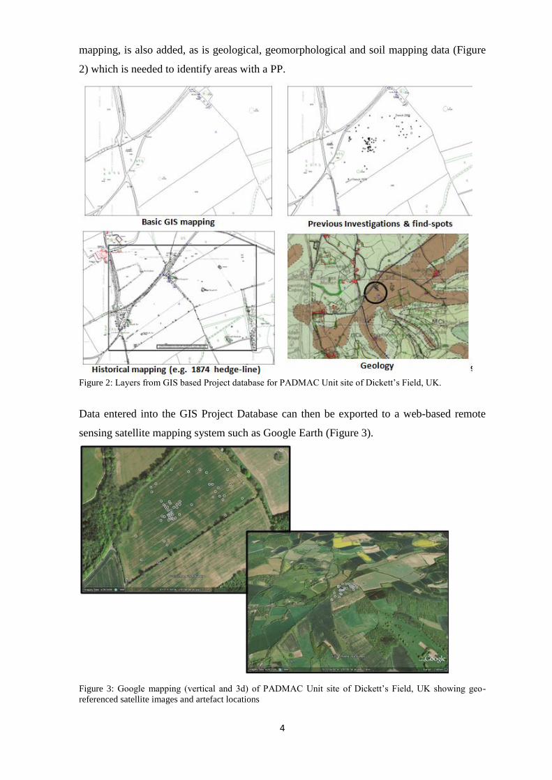
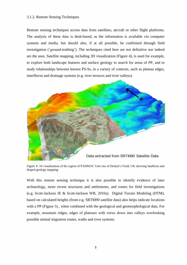
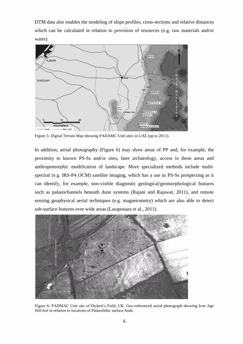
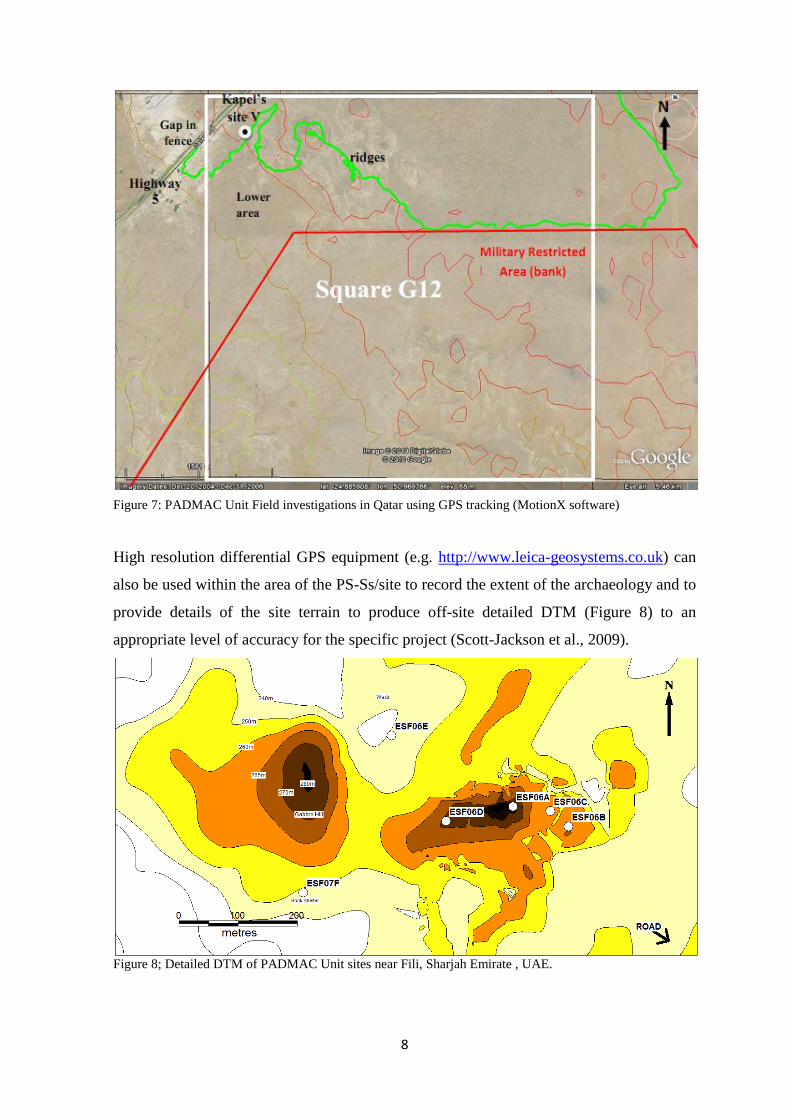
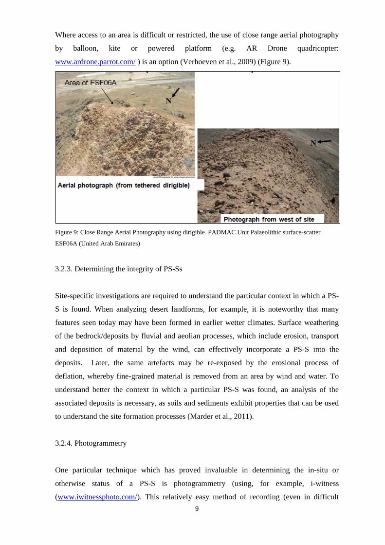
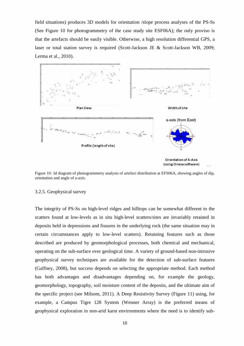
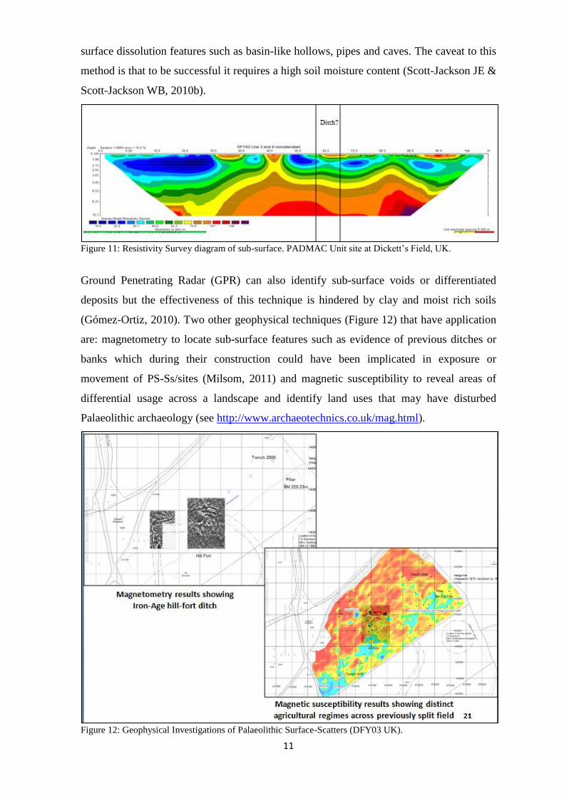
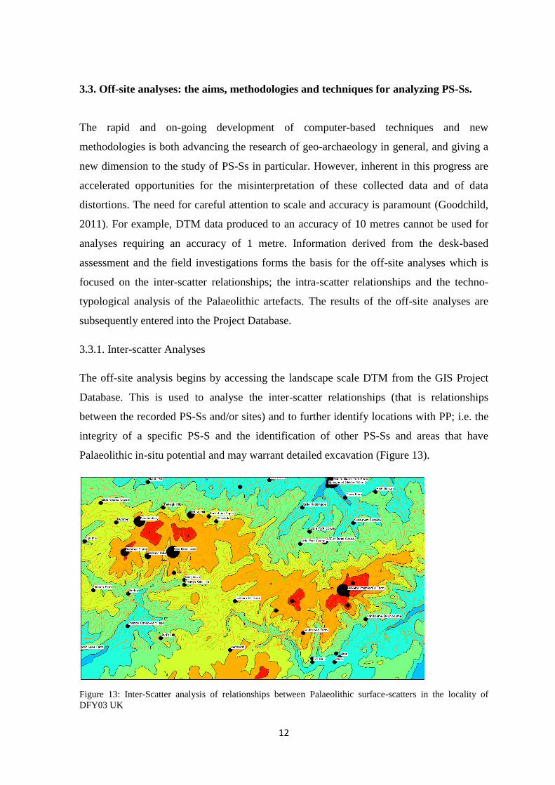
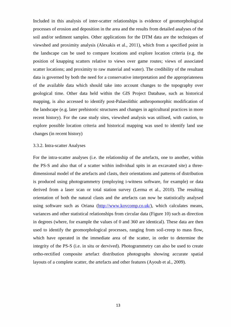


