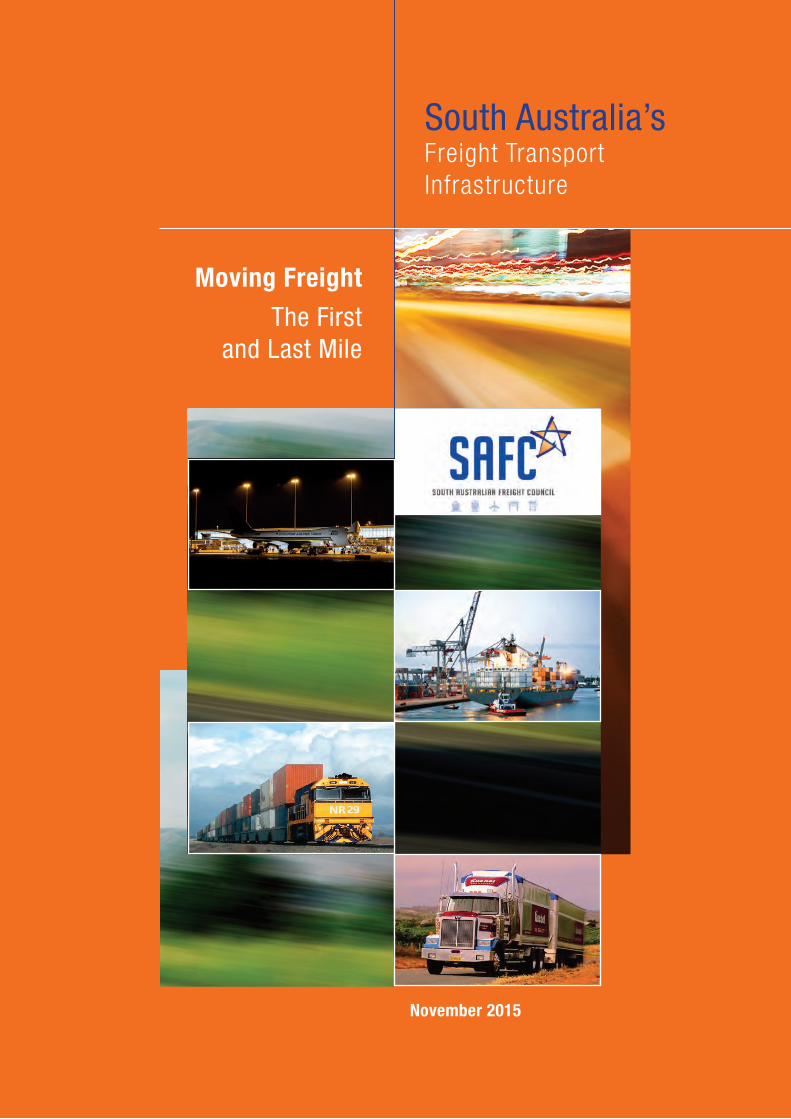
Moving Freight
The First and Last Mile
South Australia’sFreight Transport Infrastructure
November 2015
South Australian Freight Council Inc
Level 1, 296 St Vincent Street
Port Adelaide SA 5015
Tel.: (08) 8447 0688
Email: [email protected]
www.safreightcouncil.com.au
The South Australian Freight Council Inc is the State’s peak multi-modal freight and logistics industry group that advises both State and Federal Governments on industry related issues.SAFC represents road, rail, sea and air freight modes and operations, Freight service users (customers) and assists the industry on issues relating to freight and logistics across all modes.
Disclaimer: While the South Australian Freight Council has used its best endeavours to ensure the accuracy of the information contained in this report, much of the information provided has been sourced from third parties. Accordingly, SAFC accepts no liability resulting from the accuracy, interpretation, analysis or use of information provided in this report. In particular, maps of permitted restricted access vehicle routes regularly change, and those contained in this document are for illustrative purposes only and should not be relied upon for route planning.
1
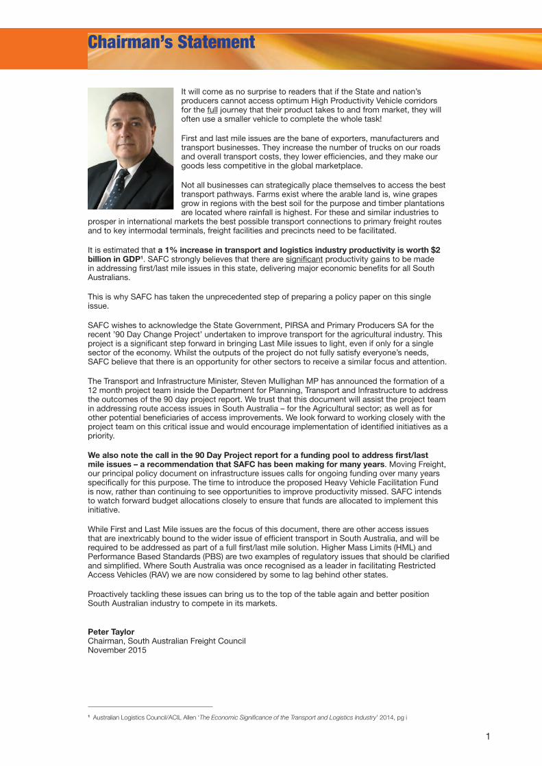
Peter Taylor Chairman, South Australian Freight Council November 2015
Chairman’s Statement
It will come as no surprise to readers that if the State and nation’s producers cannot access optimum High Productivity Vehicle corridors for the full journey that their product takes to and from market, they will often use a smaller vehicle to complete the whole task!
First and last mile issues are the bane of exporters, manufacturers and transport businesses. They increase the number of trucks on our roads and overall transport costs, they lower efficiencies, and they make our goods less competitive in the global marketplace.
Not all businesses can strategically place themselves to access the best transport pathways. Farms exist where the arable land is, wine grapes grow in regions with the best soil for the purpose and timber plantations are located where rainfall is highest. For these and similar industries to
prosper in international markets the best possible transport connections to primary freight routes and to key intermodal terminals, freight facilities and precincts need to be facilitated.
It is estimated that a 1% increase in transport and logistics industry productivity is worth $2 billion in GDP1. SAFC strongly believes that there are significant productivity gains to be made in addressing first/last mile issues in this state, delivering major economic benefits for all South Australians.
This is why SAFC has taken the unprecedented step of preparing a policy paper on this single issue.
SAFC wishes to acknowledge the State Government, PIRSA and Primary Producers SA for the recent ’90 Day Change Project’ undertaken to improve transport for the agricultural industry. This project is a significant step forward in bringing Last Mile issues to light, even if only for a single sector of the economy. Whilst the outputs of the project do not fully satisfy everyone’s needs, SAFC believe that there is an opportunity for other sectors to receive a similar focus and attention.
The Transport and Infrastructure Minister, Steven Mullighan MP has announced the formation of a 12 month project team inside the Department for Planning, Transport and Infrastructure to address the outcomes of the 90 day project report. We trust that this document will assist the project team in addressing route access issues in South Australia – for the Agricultural sector; as well as for other potential beneficiaries of access improvements. We look forward to working closely with the project team on this critical issue and would encourage implementation of identified initiatives as a priority.
We also note the call in the 90 Day Project report for a funding pool to address first/last mile issues – a recommendation that SAFC has been making for many years. Moving Freight, our principal policy document on infrastructure issues calls for ongoing funding over many years specifically for this purpose. The time to introduce the proposed Heavy Vehicle Facilitation Fund is now, rather than continuing to see opportunities to improve productivity missed. SAFC intends to watch forward budget allocations closely to ensure that funds are allocated to implement this initiative.
While First and Last Mile issues are the focus of this document, there are other access issues that are inextricably bound to the wider issue of efficient transport in South Australia, and will be required to be addressed as part of a full first/last mile solution. Higher Mass Limits (HML) and Performance Based Standards (PBS) are two examples of regulatory issues that should be clarified and simplified. Where South Australia was once recognised as a leader in facilitating Restricted Access Vehicles (RAV) we are now considered by some to lag behind other states.
Proactively tackling these issues can bring us to the top of the table again and better position South Australian industry to compete in its markets.
1 Australian Logistics Council/ACIL Allen ‘The Economic Significance of the Transport and Logistics Industry’ 2014, pg i
2
Executive Summary
Addressing First and Last Mile issues has the potential to increase road transport productivity by up to 50% for some businesses.
This significant productivity increase will in turn increase profitability and enhance the potential for agricultural, mining and manufacturing businesses (to name just a few) to expand their operations, delivering jobs and economic growth for all South Australians.
Eliminating First and Last Mile issues also promises to deliver associated congestion reduction, safety, export competitiveness and environmental benefits to the broader economy and the community in general.
The recently completed (March 2015) ‘90 Day’ agricultural transport improvement project is a step in the right direction, providing a unique focus on First and Last Mile issues. Nonetheless, the project outcomes require further clarification and transparency to confirm their validity and enhance their value as well as a solid implementation plan. The tables in the Appendix to this document include the issues SAFC raised with the 90 Day Project team, the (sometimes contradictory) possible timelines for completion of related issues in the project report, and SAFC’s comments on those issues.
Throughout this document SAFC makes a number of recommendations. While these are best read in context throughout the document, the key recommendations are:
90 Day Project• A number of projects SAFC raised with high benefits and little to no cost have been relegated
to long timeframes, which runs counter to the methodology outlined in the document. Government must transparently clarify why these projects have been relegated to the ‘too hard’ basket, despite relatively little apparent cost and high productivity gain. All rankings and cost/benefit analysis undertaken should be made public.
• One of the first tasks of the 12 month Implementation Team must be to re-issue the tables in a clearer and logical manner so that the implementation timeline for each access improvement can be more easily assessed and identified.
Funding• SAFC’s principal public policy document, Moving Freight (last published in November 2012)
advocated at the highest level of urgency and importance for the creation of a state-based funding pool aimed at improving high productivity vehicle access over a 20 year period. The 90 Day Project Report also recommends “a funding program be developed for consideration by the State and Commonwealth Governments to address ‘last mile’ and access issues where infrastructure needs to be improved”.
SAFC urges the early establishment of this pool of funding so as the benefits of improved heavy vehicle access can be achieved swiftly.
Gazettal below design capacity• SAFC urges the State Government to immediately gazette the Northern Expressway and the
duplicated section of the Sturt Highway to the PBS3 network (accommodating vehicles up to Double Road Train and B-Triple Higher Mass Limit categorisation). SAFC believes that specific facility access issues adjacent to these routes will then emerge.
• It is critical that the full value of new infrastructure spending is realised by gazetting new roads at their design level going forward.
Performance Based Standards (PBS) and Higher Mass Limits (HML)• All network access permissions should be gazetted at a PBS level, not the level of an
individual configuration, and SAFC calls upon the South Australian Government to implement this change.
• Governments (State and Local) must ensure that there is no difference in the HML and standard mass limit networks, unless there is a demonstrable infrastructure weight limit (i.e. a bridge) that renders this necessary. Government instituted HML rules ensure that access is safe and will not damage road pavements beyond normal trucking impacts.
• All Commodity Networks should be gazetted at HML – providing access for those with the appropriate vehicles and accreditations.
• SAFC supports the consolidation of a sufficiently resourced one stop shop for route and vehicle approvals inside the NHVR and, critically, avoidance of any subsequent unilateral right of state and local governments to veto applications and NHVR decisions.
3
Introduction
Imagine the Government could increase a significant element of your business productivity by 33 – 50% with little more than ‘the stroke of a pen2’. Then imagine that improvement replicated across a large portion of South Australia’s exporting businesses, and the significant gains to the entire South Australian economy and community. That’s the potential inherent in addressing first and last mile transport access issues in South Australia, and across the nation.
Of course it’s not always that simple and often there are some costs in terms of relatively minor infrastructure improvements that require completion, or issues regarding other road users that need to be considered. However there is huge economic potential to be unlocked by addressing first and last mile issues in South Australia.
A recent study by the Australian Logistics Council indicated a 1% increase in transport and logistics industry productivity is worth $2 billion in GDP3 to Australia. This suggests that a similar transport and logistics productivity increase in South Australia would deliver an additional $150 million in Gross State Product (GSP).
A 2010 Economic Impact Assessment and Strategic Analysis of the SA Transport and Logistics Industry commissioned by SAFC and conducted by Hudson Howells found that ‘a 10% efficiency improvement could increase Gross State Product annually by $810m and result in the order of 8500 new jobs’4.
Related issues regarding gazettal below design capacity, and access to higher mass limits can also improve freight productivity and increase GSP.
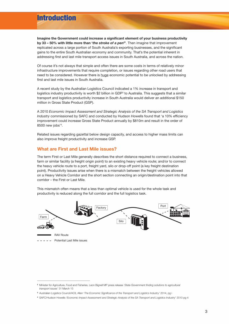
What are First and Last Mile issues?
The term First or Last Mile generally describes the short distance required to connect a business, farm or similar facility (a freight origin point) to an existing heavy vehicle route; and/or to connect the heavy vehicle route to a port, freight yard, silo or drop-off point (a key freight destination point). Productivity issues arise when there is a mismatch between the freight vehicles allowed on a Heavy Vehicle Corridor and the short section connecting an origin/destination point into that corridor – the First or Last Mile.
This mismatch often means that a less than optimal vehicle is used for the whole task and productivity is reduced along the full corridor and the full logistics task.
2 Minister for Agriculture, Food and Fisheries, Leon Bignell MP press release ‘State Government finding solutions to agricultural transport issues’ 31 March 15
3 Australian Logistics Council/ACIL Allen ‘The Economic Significance of the Transport and Logistics Industry’ 2014, pg i4 SAFC/Hudson Howells ‘Economic Impact Assessment and Strategic Analysis of the SA Transport and Logistics Industry’ 2010 pg 4
Farm
RAV Route
Potential Last Mile issues
Silo
Factory Port
4
Introduction Continued
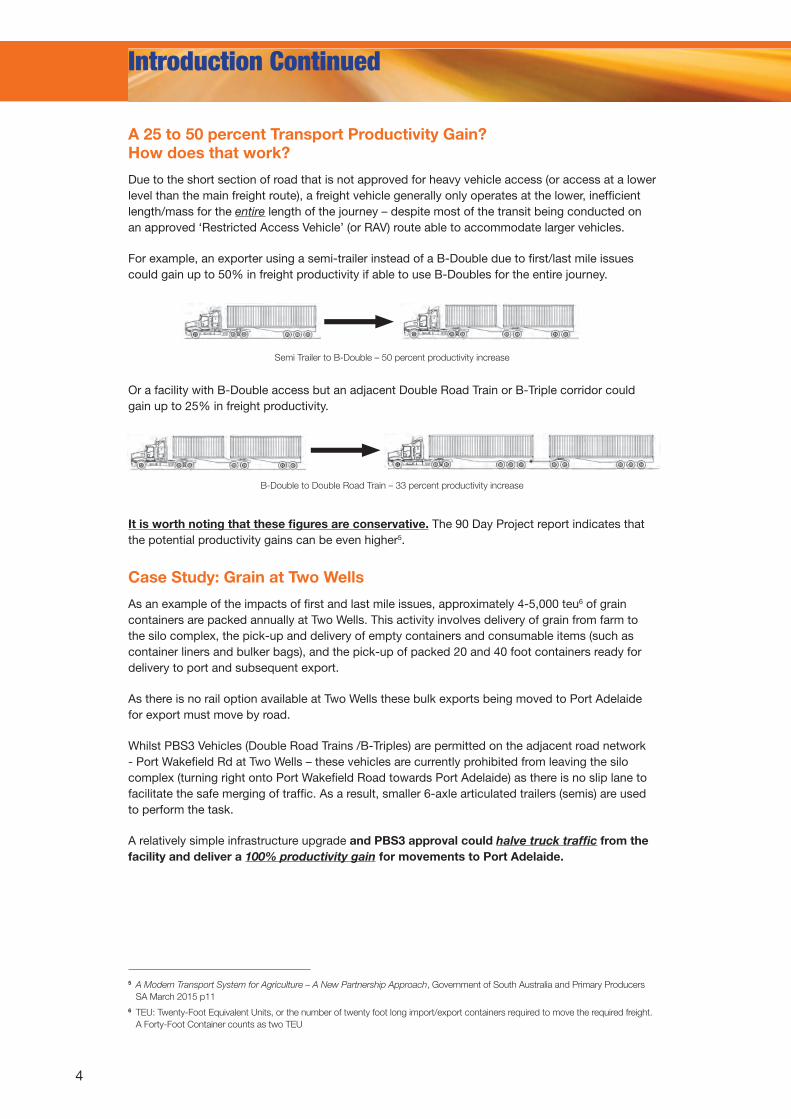
A 25 to 50 percent Transport Productivity Gain? How does that work?
Due to the short section of road that is not approved for heavy vehicle access (or access at a lower level than the main freight route), a freight vehicle generally only operates at the lower, inefficient length/mass for the entire length of the journey – despite most of the transit being conducted on an approved ‘Restricted Access Vehicle’ (or RAV) route able to accommodate larger vehicles.
For example, an exporter using a semi-trailer instead of a B-Double due to first/last mile issues could gain up to 50% in freight productivity if able to use B-Doubles for the entire journey.
It is worth noting that these figures are conservative. The 90 Day Project report indicates that the potential productivity gains can be even higher5.
Case Study: Grain at Two Wells
As an example of the impacts of first and last mile issues, approximately 4-5,000 teu6 of grain containers are packed annually at Two Wells. This activity involves delivery of grain from farm to the silo complex, the pick-up and delivery of empty containers and consumable items (such as container liners and bulker bags), and the pick-up of packed 20 and 40 foot containers ready for delivery to port and subsequent export.
As there is no rail option available at Two Wells these bulk exports being moved to Port Adelaide for export must move by road.
Whilst PBS3 Vehicles (Double Road Trains /B-Triples) are permitted on the adjacent road network - Port Wakefield Rd at Two Wells – these vehicles are currently prohibited from leaving the silo complex (turning right onto Port Wakefield Road towards Port Adelaide) as there is no slip lane to facilitate the safe merging of traffic. As a result, smaller 6-axle articulated trailers (semis) are used to perform the task.
A relatively simple infrastructure upgrade and PBS3 approval could halve truck traffic from the facility and deliver a 100% productivity gain for movements to Port Adelaide.
Or a facility with B-Double access but an adjacent Double Road Train or B-Triple corridor could gain up to 25% in freight productivity.
Semi Trailer to B-Double – 50 percent productivity increase
B-Double to Double Road Train – 33 percent productivity increase
5 A Modern Transport System for Agriculture – A New Partnership Approach, Government of South Australia and Primary Producers SA March 2015 p11
6 TEU: Twenty-Foot Equivalent Units, or the number of twenty foot long import/export containers required to move the required freight. A Forty-Foot Container counts as two TEU
5
More benefits than just productivity
The benefits of addressing First and Last Mile issues go far beyond just productivity gains for industry, particularly where there is not a competitive rail option available:
• Safety & Congestion
By increasing freight productivity we reduce overall truck numbers, lowering congestion and the possibility of heavy vehicle/car accidents. A semi can carry only one or two export containers, while a B-Double can carry up to three. A Double Road Train can carry twice the load of a Semi and a Triple Road Train can carry three times as much.
The safety systems aboard multiple trailer combinations are strictly regulated through registration requirements and Australian Design Rules thereby ensuring bigger trucks adhere to higher safety standards than smaller trucks. MC Drivers are also better trained with more experience.
• Export Competitiveness
The geographical nature of Australia with its open spaces and long transport distances, combined with its relative isolation from key export markets and sources of imports to the production process means that we must have the most efficient transport system possible to be able to compete on an international stage. Lowering transport costs by using higher productivity vehicles is the key to international competitiveness – by reducing total landed costs in current markets, and possibly opening up new markets entirely.
• Environmental Benefits
There are also significant environmental benefits, particularly in greenhouse gas emission reductions.
In 2012 Stuart St Clair, Then Chief Executive of the Australian Trucking Association stated “If we take the example of moving a thousand tonnes of freight…by using 20 B-Triples you would emit 32% less carbon dioxide than the 42 Semitrailers you would otherwise need”7
For more information on the environmental benefits of using high productivity vehicles, see the SAFC publication Green Freight, available on the SAFC website
www.safreightcouncil.com.au/safcresourcesreportsandsubmissions_safcreports.html
• Improved Safety
• Less Congestion
• Better for the Environment
• Improved Competitiveness
7 ATA Media Release, ‘Land Freight Strategy to boost Productivity, Safety’ September 2012
6
Governments are aware that first and last mile problems are an issue for industry and the community, and take steps to fix some of these issues when they can. It is important to note that governments do not always know that a particular first/last mile access issue exists – and therefore can’t be expected to address it. This paper seeks to inform governments of these issues, in order that they can be addressed.
The ’90 Day Agricultural Transport Project’
The South Australian Government (through Primary Industries and Regions SA) has recently undertaken a ’90 Day Project’ aimed at improving road transport for the agricultural industry and eliminating many of the network access and connectivity issues affecting it. SAFC provided a submission to this project and the final report was released in late March 2015. SAFC looks forward to seeing the issues raised being addressed by the government and notes that the 90 Day Project had a strong (but not exclusive) grain focus and many other industry sectors (such as South Australia’s iconic wine industry) could benefit from a similar determined focus on eliminating first and last mile issues.
The project report – entitled A Modern Transport System for Agriculture: A New Partnership Approach – outlines a number of ‘quick wins’ such as HML access for some Viterra Grain sites and approval for BAB quad and ABB quad road trains to the A Triple (or Triple Road Train) network in the far north of the state. These are welcome additions to the network.
However SAFC also forsees a number of issues with the report, including a lack of transparency in how projects were rated and how cost benefit/time assessments have been made. A number of projects SAFC raised with seemingly high benefits and little to no cost have been relegated to long timeframes, which runs counter to the methodology outlined in the document.
Government must transparently clarify why these projects have been relegated to the ‘too hard’ basket, despite relatively little apparent cost and high productivity gain. All rankings and cost/benefit analysis undertaken should be made public.
Although the document claims to have consolidated issues, some – such as the addition of the Northern Expressway to the Double Road Train network – are included many times in the tables, sometimes with minor variations or route additions, and with varying implementation/consideration timelines. An example is access to the Two Wells silos – Double Road Train access is to be addressed in the ‘short’ term, however shorter and lighter B-Doubles are to be addressed in the ‘medium’ term. This is confusing, and means that SAFC and affected sectors cannot determine when a project that they raised will be addressed by government. While SAFC considers that the tight 90 day timeline for the project has probably caused some confusion, the current report is not capable of being meaningfully analysed.
One of the first tasks of the 12 month Implementation Team for the 90 Day Project must be to re-issue the tables in a clearer and logical manner so that the implementation timeline for each access improvement can be more easily assessed and identified.
What Governments are doing, and what can be improved
7
Funding for First/Last Mile issues
The Commonwealth’s National Stronger Regions Fund (NRSF) of $1 billion over 5 years is a new, (relatively) small program that offers matching grants of between $20,000 and $10m for capital projects which involve the construction of new infrastructure, or the upgrade, extension or enhancement of existing infrastructure. This program is open to local governments and not-for-profit organisations to apply, and is required to deliver an economic benefit to the region beyond the period of construction. These elements appear to make it an ideal fund to be utilised for addressing first and last mile issues, and SAFC strongly encourages Councils and Regional Development Australia Committees to apply to undertake works to open up restricted vehicle access, for the benefit of local industry.
SAFC’s principal public policy document, Moving Freight (last published in November 2012) advocated at the highest level of urgency and importance for the creation of a state-based funding pool for 20 years to be targeted towards fixing first/last mile issues which have the potential to deliver significant productivity gains. This program should be available for matching funding from the NRSF, and could be designed to follow the success of the Black Spots funding program (delivering road safety benefits), by replicating the targeted small investment model around productivity gains and cost-benefit analysis.
The 90 Day Project Report also recommends “a funding program be developed for consideration by the State and Commonwealth Governments to address ‘last mile’ and access issues where infrastructure needs to be improved”8.
This appears to match the request made by SAFC (above) and adds weight to the repeated calls by industry for such a funding pool to be instituted immediately.
In the majority of cases the funding required to fix first/last mile issues is
relatively small, with potentially massive benefits. These benefits accrue firstly
to the industry affected and its customers through reduced unit prices; and
then through the tax system to all South Australians as a result of improved
competitiveness leading to orders, re-orders and an overall increase in
economic activity, potentially paying back the investment many times over.
In the majority of cases the transport industry does not benefit directly,
especially if less transport units are needed to undertake the same task. In
most instances it is our industry’s customers that capture the productivity
benefit through reduced freight rates and improved competitiveness.
Nevertheless SAFC, as an advocate ‘for freight’ is a strong supporter of a
funding pool to address first/last mile issues – a small state such as South
Australia cannot allow potential productivity and GSP gains to pass by
if we intend to achieve our goals of sustained economic growth.
We need this now.
8 A Modern Transport System for Agriculture – A New Partnership Approach, Government of South Australia and Primary Producers SA March 2015 Pg 14
What Governments are doing, and what can be improved Continued
8
‘Gazettal’ below Design Capacity
SAFC is concerned that in some instances the full value of new infrastructure spending is not being realised due to a failure on the part of state/territory governments to provide regulatory access for RAVs (through the Government Gazette) at the maximum design level for new roads.
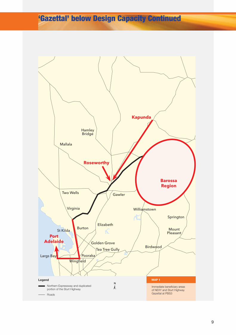
For example, the Commonwealth and South Australian Governments have recently spent $723m on building the Northern Expressway (NEXY) and duplicating the Sturt Highway from NEXY to Nuriootpa. These are great investments that benefit all users of the network, however SAFC understands that for all intents and purposes these roads are capable of handling Performance Based Standards (PBS) Level 3 vehicles – Double Road Trains and B-Triples – but inexplicably they have to date only been gazetted at the lower PBS2 (B-Double) level.
SAFC urges the State Government to immediately gazette NEXY and the duplicated portion of the Sturt Highway to the PBS3 network (accommodating vehicles up to Double Road Train and B-Triple Higher Mass Limit categorisation). Required first and last mile connections to key facilities on this corridor will then reveal themselves through a natural process of permit applications, and ultimately gazettal of commonly used links to key facilities and freight generating precincts.
With these additional First/Last Mile access enhancements, benefits would be expected in the first instance to flow to the grain sector (Roseworthy Grain Complex), the wine and cement manufacturing sectors (Barossa Valley) and the export hay sector (Kapunda processing facilities).
In a financially constrained economy it is acknowledged that South Australia cannot afford all the new road transport infrastructure that it desperately needs. Therefore it is critical that the full value of new infrastructure spending is realised by gazetting new roads at their maximum design capacity. Failure to do so is akin to buying an Ultra High Definition television, and proceeding to hook it up to an old VHS video recorder – wasted capacity, wasted opportunities and wasted money.
This represents a 25% lowering of possible freight productivity and
hundreds of additional trucks on the roads each year, with resultant
financial, environmental and safety impacts.
Moreover, these impacts are felt within, across and beyond the region
as larger vehicles are prevented from accessing this relatively small
element of the national highway network.
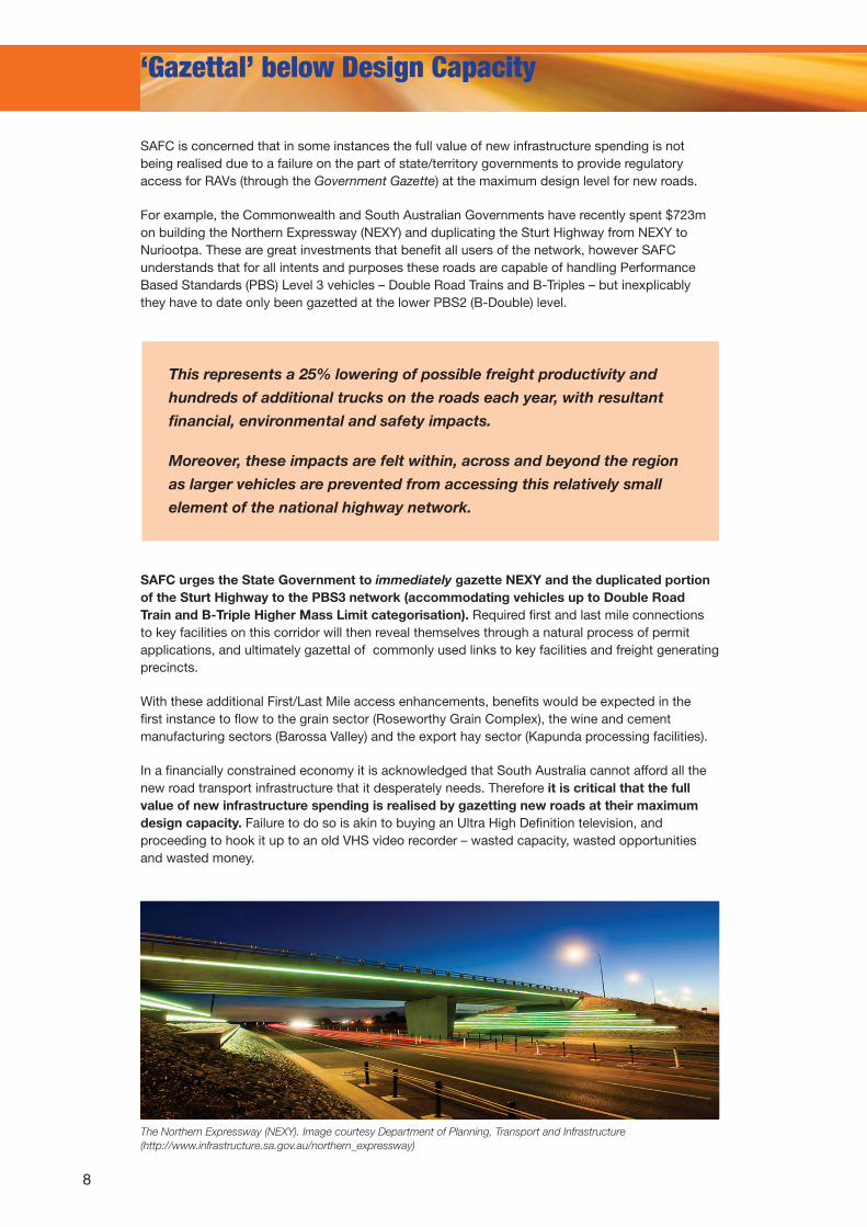
The Northern Expressway (NEXY). Image courtesy Department of Planning, Transport and Infrastructure (http://www.infrastructure.sa.gov.au/northern_expressway)
9
NLegend
Roads
Northern Expressway and duplicated portion of the Sturt Highway
Immediate beneficiary areas of NEXY and Sturt Highway Gazettal at PBS3
MAP 1
Nuriootpa
HamleyBridge
Mallala
Tanunda
LyndochGawler
Elizabeth
St KildaBurton
Virginia
Birdwood
Williamstown
Golden Grove
Tea Tree Gully
Pooraka
WingfieldLargs Bay
Two Wells
Angaston
Springton
Mount Pleasant
Roseworthy
Kapunda
PortAdelaide
‘Gazettal’ below Design Capacity Continued
BarossaRegion
10
Performance Based Standards and Higher Mass Limits
Performance based Standards (PBS) and Higher Mass Limits (HML) are two innovations that offer increased freight productivity to the business community and SAFC (and the broader industry) generally supports their introduction.
However, the transport and logistics industry is reporting that these innovations are more difficult to access than they should be, or that these innovations are not being applied to an entire route (especially the first/last mile). SA is considered by some to be lagging behind other states, where once we were widely regarded as innovators in heavy vehicle access.
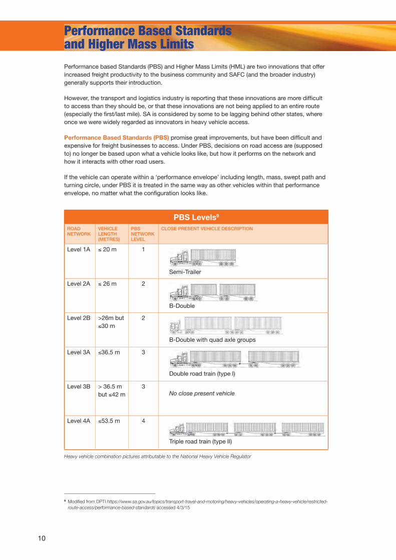
Performance Based Standards (PBS) promise great improvements, but have been difficult and expensive for freight businesses to access. Under PBS, decisions on road access are (supposed to) no longer be based upon what a vehicle looks like, but how it performs on the network and how it interacts with other road users.
If the vehicle can operate within a ‘performance envelope’ including length, mass, swept path and turning circle, under PBS it is treated in the same way as other vehicles within that performance envelope, no matter what the configuration looks like.
9 Modified from DPTI https://www.sa.gov.au/topics/transport-travel-and-motoring/heavy-vehicles/operating-a-heavy-vehicle/restricted-route-access/performance-based-standards accessed 4/3/15
PBS Levels9
ROAD NETWORK
VEHICLE LENGTH (METRES)
PBS NETWORK LEVEL
CLOSE PRESENT VEHICLE DESCRIPTION
Level 1A ≤ 20 m 1
Level 2A ≤ 26 m 2
Level 2B >26m but ≤30 m
2
Level 3A ≤36.5 m 3
Level 3B > 36.5 m but ≤42 m
3
Level 4A ≤53.5 m 4
Semi-Trailer
B-Double
B-Double with quad axle groups
Double road train (type I)
No close present vehicle
Triple road train (type II)
Heavy vehicle combination pictures attributable to the National Heavy Vehicle Regulator
11
Performance Based Standards and Higher Mass Limits Continued
For example, both Double Road Trains and B-Triples fit inside the PBS level 3 ‘envelope’. However there are separate networks approved for each of these configurations. The shorter B-Triple, which for most intents and purposes performs as well (or better) than a Double Road Train on the network, faces greater restrictions in where it can travel and cannot access Higher Mass Limit (HML) concessions. Ultimately, the B-Triple has a lower level of access to the network.
SAFC believes that all network access permissions should be gazetted at a PBS level, not the level of an individual configuration, and calls upon the South Australian Government to implement this change.
In addition, the current process for having a vehicle combination classified to a PBS level is complex, costly, and arbitrary. This means that the value of the system – one that promised to deliver great advances in heavy vehicle access in Australia is significantly diminished.
SAFC understands that the National Heavy Vehicle regulator (NHVR) recognises that AB triples are comparable vehicles to A-Double road trains with regard to road geometry and operation on approved Type 1 road train routes.
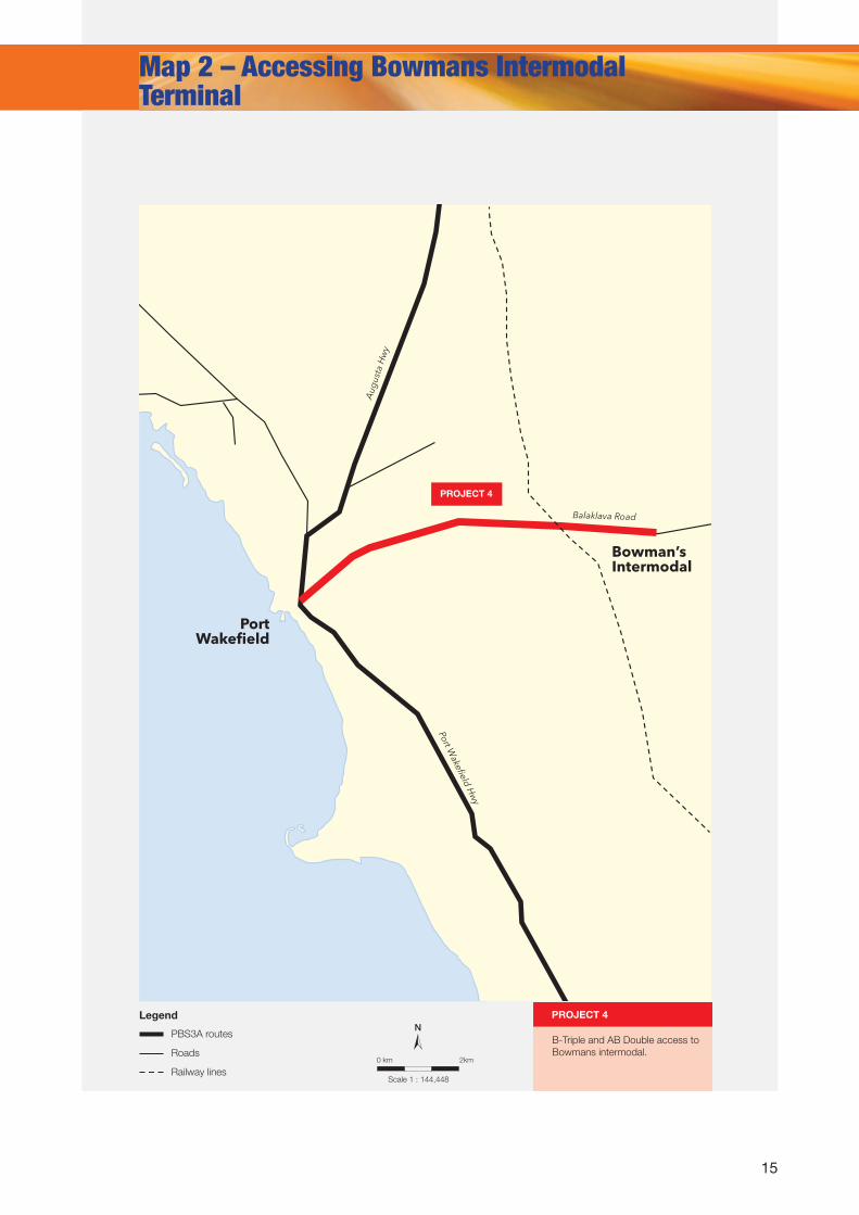
However, the SA Government, through the Department of Planning, Transport and Infrastructure (the Road Manager) has denied access for an AB-Triple at HML to the network already available to Double Road Trains at HML, and requires a PBS approval for each and every vehicle.
As a result of this denial of access on a relatively short element of the corridor (approx. 11km from Bowmans intermodal terminal to Port Wakefield), a smaller and less efficient vehicle is being utilised for the full journey (approximately 560km from Bowmans to Port Lincoln).
South Australia is the only state requiring PBS approval for this vehicle. The ‘Yes, but we are different’ mantra remains firmly in place.
Higher Mass Limits (HML) is another scheme that is being underutilised, but promises significant economic benefits. For example, the 90 Day Project report indicated that upgrading a B-Double from GML (General Mass Limits) to HML offers a 14% productivity gain10.
To be eligible to utilise the HML network, vehicles must be fitted
with certified road friendly suspension systems, and be accredited
under the Mass Management Module of the National Heavy Vehicle
Accreditation Scheme (NHVAS). This ensures that these vehicles do no
more damage to road pavements over time than vehicles of the same
type operating at standard mass limits.
Thus the only reason a HML combination should be denied access to a
road is if there is a specific weight limitation on the infrastructure (such
as a bridge mass limit)11.
10 A Modern Transport System for Agriculture – A New Partnership Approach, Government of South Australia and Primary Producers SA March 2015 p11
11 Ceteris Paribus
12
Performance Based Standards and Higher Mass Limits Continued
Unfortunately, individual road managers (including state governments and local councils) currently maintain a right to unilaterally determine road access issues, including HML applications. This means that there are gaps in network connectivity and the networks for HML and standard mass limits for all vehicle combination types are significantly different – and thus many of the First and Last Mile issues identified in this paper (and the 90 Day Project report) relate to HML access.
SAFC contends that there should be no difference in the HML and standard mass limit networks, unless there is a demonstrable infrastructure weight limit (i.e. a bridge or culvert) that renders this necessary.
This includes ‘commodity networks’ – access provisions that operate for certain commodities (such as grain) for only a few weeks each year (such as around harvest periods). All Commodity Networks are gazetted at General Mass Limits only – which is a major restriction for heavy commodities (such as grain, grapes and timber) which may result in trucks being only partially laden – unreasonably lowering productivity. As with all other networks, SAFC believes that in the absence of demonstrable infrastructure constraints that Commodity Networks should be gazetted at HML – providing access for those with the appropriate vehicles and accreditations.
Also, with the introduction of the National Heavy Vehicle Regulator (NHVR) and the National Heavy Vehicle Law (NHVL), all HML applications are now processed by the NHVR. However the NHVR has no power to make an HML determination without the assent of the ‘Road Manager’ (in SA’s case the Department of Planning, Transport and Infrastructure or a Local Council).
There is an appeals system, but it can be a long and drawn out process, and requires only an internal review. Whilst the same individual that makes the decision to deny a RAV access application cannot undertake a review, it seems unusual that the review is undertaken by someone from within the same organisation.
Conversely, a decision made by the NHVR is subject to external review by a tribunal or court – and seems to provide a more just system for the future12.
Thus under the current system the NHVR is simply providing an additional layer of cost and complexity without adding value to the system. This was not the intention when the NHVR was first mooted.
SAFC supports the consolidation of a sufficiently resourced one stop shop for route and vehicle approvals inside the NHVR and, critically, avoidance of any subsequent unilateral right of state and local governments to veto applications and NHVR decisions. For due process and administrative justice reasons, the review process must be taken away from the organisation that made the original decision.
12 Approved Guidelines for Granting Access, NHVR, Feb 2014 pg 13
The Access and Appeals Process
1. An application is made to the NHVR
2. NHVR seeks approval from the Road Manager
3. Application is either approved (process ends) or is rejected with reasons outlined
4. Applicant accepts decision (process ends) or appeals to the NHVR
5. NHVR passes appeal on to the Road Manager, who conducts an internal
review
6. Application is either approved on appeal, or rejected for a second time
(process ends)
13
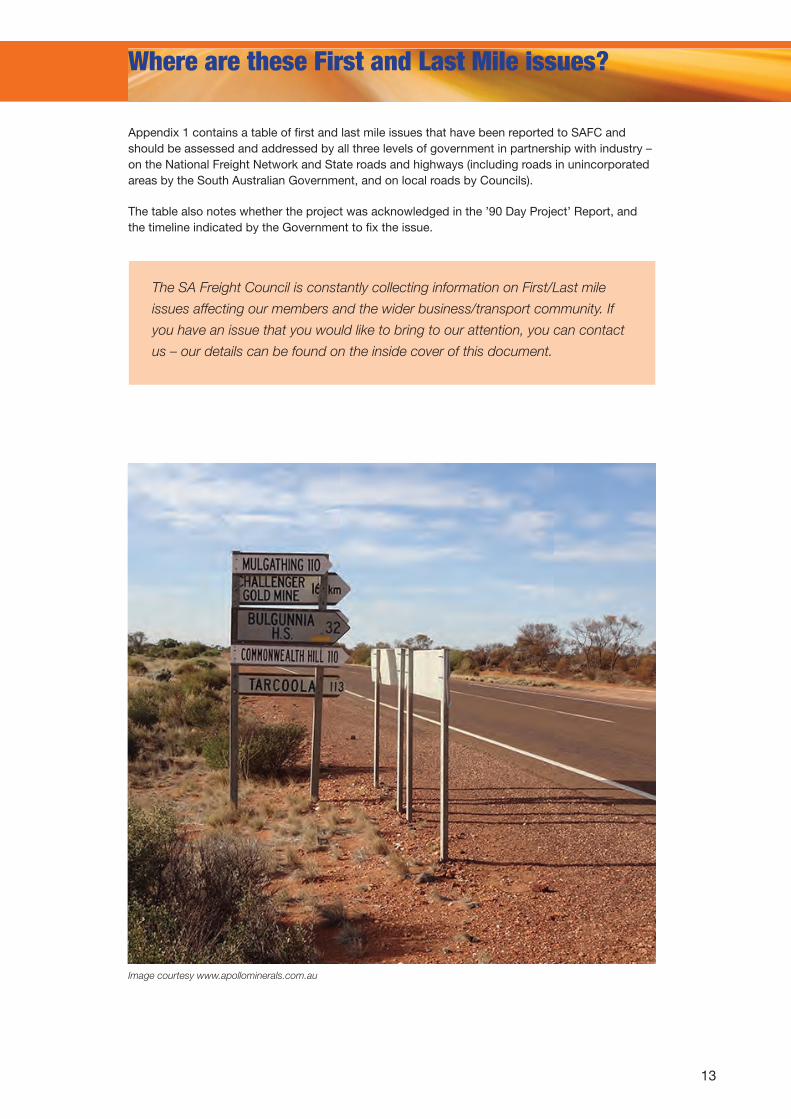
Where are these First and Last Mile issues?
Appendix 1 contains a table of first and last mile issues that have been reported to SAFC and should be assessed and addressed by all three levels of government in partnership with industry – on the National Freight Network and State roads and highways (including roads in unincorporated areas by the South Australian Government, and on local roads by Councils).
The table also notes whether the project was acknowledged in the ’90 Day Project’ Report, and the timeline indicated by the Government to fix the issue.
The SA Freight Council is constantly collecting information on First/Last mile
issues affecting our members and the wider business/transport community. If
you have an issue that you would like to bring to our attention, you can contact
us – our details can be found on the inside cover of this document.
Image courtesy www.apollominerals.com.au
14
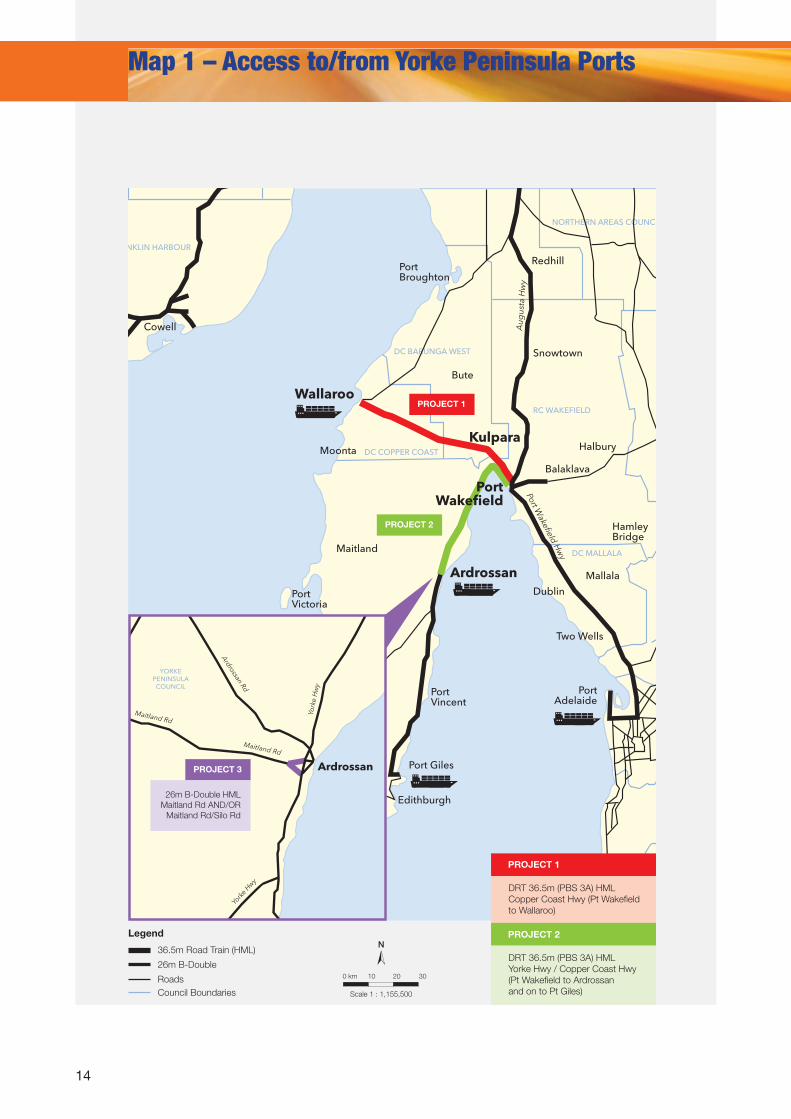
Map 1 – Access to/from Yorke Peninsula Ports
N
Scale 1 : 1,155,500
0 km
Legend
10 20 30
36.5m Road Train (HML)
26m B-Double
RoadsCouncil Boundaries
DC COPPER COAST
DC BARUNGA WEST
DC FRANKLIN HARBOUR
YORKE PENINSULA
COUNCIL
NORTHERN AREAS COUNCIL
RC WAKEFIELD
DC MALLALA
ALEXANDRINA COUNCIL
YORKE PENINSULA COUNCIL
ADELAIDE HILLS COUNCIL
DC MOUNT BARKER
Port Broughton
Bute
Clevel
Duke
Moonta
Cowell
Maitland
Maitland
Minlaton
Edithburgh
Yorketown
Dublin
Two Wells
Mallala
Williamstown
Kersbrook
Woodside
Mt Barker
Mt Compass
Strathalbyn
Sturt Hwy
Port Wakefield H
wy
Aug
usta
Hw
y
Lyndoch
Auburn
KapundaHamley Bridge
Snowtown
Balaklava
Halbury
Redhill
Bura
Wallaroo
Ardrossan
Ardrossan
Kulpara
PortWakefield
Port Victoria
Stenhouse Bay
Port Neil
Port Vincent
Port Adelaide
Port Giles
Maitland Rd
Maitland Rd
York
e H
wy
York
e Hwy
Spen
cer
Hw
y
Spen
cer
Hw
y
Art
hurt
on
Rd
Upper Yorke
Rd
St V
ince
nt H
wy
Ardrossan Rd
Port Victoria
Rd
PROJECT 1
PROJECT 2
DC COPPER COAST
DC BARUNGA WEST
DC FRANKLIN HARBOUR
YORKE PENINSULA COUNCIL
NORTHERN AREAS COUNCIL
RC WAKEFIELD
DC MALLALA
ALEXANDRINA COUNCIL
YORKE PENINSULA COUNCIL
ADELAIDE HILLS COUNCIL
DC MOUNT BARKER
Port Broughton
Bute
Clevel
Duke
Moonta
Cowell
Maitland
Maitland
Minlaton
Edithburgh
Yorketown
Dublin
Two Wells
Mallala
Williamstown
Kersbrook
Woodside
Mt Barker
Mt Compass
Strathalbyn
Sturt Hwy
Port Wakefield H
wy
Aug
usta
Hw
y
Lyndoch
Auburn
KapundaHamley Bridge
Snowtown
Balaklava
Halbury
Redhill
Bura
Wallaroo
Ardrossan
Ardrossan
Kulpara
PortWakefield
Port Victoria
Stenhouse Bay
Port Neil
Port Vincent
Port Adelaide
Port Giles
Maitland Rd
Maitland Rd
York
e H
wy
York
e Hwy
Spen
cer H
wy
Spen
cer H
wy
Art
hurt
on R
d
Upper Yorke
Rd
St V
ince
nt H
wy
Ardrossan Rd
Port Victoria
Rd
PROJECT 3
26m B-Double HMLMaitland Rd AND/OR
Maitland Rd/Silo Rd
DRT 36.5m (PBS 3A) HMLYorke Hwy / Copper Coast Hwy (Pt Wakefield to Ardrossan and on to Pt Giles)
DRT 36.5m (PBS 3A) HMLCopper Coast Hwy (Pt Wakefield to Wallaroo)
PROJECT 1
PROJECT 2
15
NLegend
Roads
PBS3A routesB-Triple and AB Double access to Bowmans intermodal.
PROJECT 4
Aug
usta
Hw
y
PortWakefield
Bowman’s Intermodal
Balaklava Road
Port Wakefield H
wy
Map 2 – Accessing Bowmans Intermodal Terminal
Scale 1 : 144,448
0 km 2km
PROJECT 4
Railway lines
16
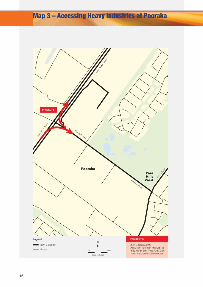
Map 3 – Accessing Heavy Industries at Pooraka
N
Scale 1 : 9,028
0 m
Legend
200m
26m B-Double
Roads
Bridge
Road
Mai
n N
orth
Roa
d
Mai
n N
orth
Roa
d
PoorakaPara Hills
West
Maxwell Road
Maxwell Road
26m B-Double HMLAllow right turn from Maxwell Rd onto Main North Road AND Main North Road onto Maxwell Road
PROJECT 5
PROJECT 5
17
NLegend
Roads
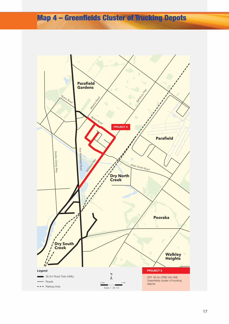
36.5m Road Train (HML) DRT 36.5m (PBS 3A) HMLGreenfields cluster of trucking depots
PROJECT 6
Parafield
Pooraka
ParafieldGardens
Dry North Creek
Dry South Creek
WalkleyHeights
Elder Smith Road
Ryans Road
Mar
tins R
oad
Salis
bury
Hw
y
Salis
bury
Hw
yRyans Road
Go
lden D
erby W
ay
Port W
akefield Ro
ad
Map 4 – Greenfields Cluster of Trucking Depots
Scale 1 : 36,112
0 km 1 km
PROJECT 6
Railway lines
18
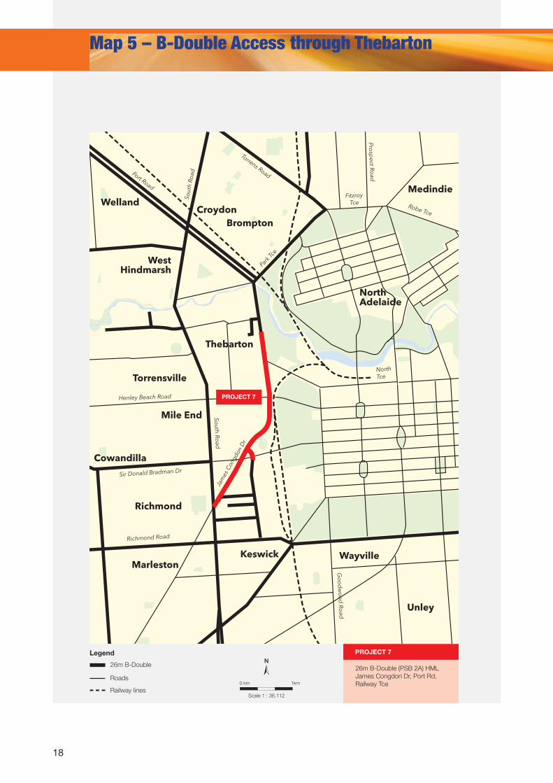
Map 5 – B-Double Access through Thebarton
N
Scale 1 : 36,112
0 km
Legend
1km
26m B-Double
Roads
Medindie
North Adelaide
Welland
BromptonCroydon
Thebarton
Torrensville
Cowandilla
Mile End
Richmond
MarlestonWayvilleKeswick
Unley
West Hindmarsh
Port Road
Torrens Road
Robe TceJa
mes
Con
gdon
Dr
Fitzroy Tce
Sir Donald Bradman Dr
Henley Beach Road
Richmond Road
Go
od
wo
od
Road
Prosp
ect Road
South Ro
ad
Sout
h Ro
ad
Park
Tce
North Tce
26m B-Double (PSB 2A) HMLJames Congdon Dr, Port Rd, Railway Tce
PROJECT 7
PROJECT 7
Railway lines
19
Legend
Roads
36.5m Road Train/B-Triple (PBS 3A)
RC WAKEFIELD
DC MALLALA
LIGHT REGIONAL COUNCIL
CC PLAYFORD
BAROSSA COUNCIL
ADELAIDE HILLS COUNCIL
Dublin
Two Wells
Mallala
Nuriootpa
Mount PleasantKersbrook
Woodside
Palmer
Sturt Hwy
Port Wakefield Hwy
Lyndoch
Auburn
KapundaHamley Bridge
Balaklava
Halbury
Port Adelaide
Map 6 – Opening Opportunities through NEXY
BurtonWaterloo Corner
Port Wakefield
Road
Northern Express
Way
Rang
er R
d
Hea
slip
Rd
Penfield Rd
Lovey Rd
Pellew Rd
Huxtable Rd
Edinburgh Rd
Mill Road
Diment Rd
Jarm
yn R
d
BarossaRegion
PROJECT 9
36.5m Road Train/B-Triple (PBS 3A) HML
Access to SCT Intermodal Terminal at Penfield, Ranger/
Jarmyn Rd (from Penfield Rd) to facility
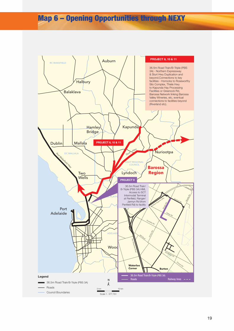
PROJECT 8, 10 & 11
36.5m Road Train/B-Triple (PBS 3A) - Northern Expressway & Sturt Hwy Duplication and beyond.Connections to key facilities - Horrocks to Roseworthy Silo Complex, Thiele Hwy to Kapunda Hay Processing Facilities or Greenock Rd, Barossa Network linking Barossa Valley Wineries, etc, eventual connections to facilities beyond (Riverland etc).
N
Scale 1 : 577,791
0 km 10 km
Council Boundaries
PROJECT 8, 10 & 11
Railway linesRoads36.5m Road Train/B-Triple (PBS 3A)
20
Map 7 – Linking DRT’s and B-Triples to the Barossa and Beyond
N
Scale 1 : 72,224
0 km
Legend
1km
DRT 36.5m (HML)
26m B-Double (HML)
Roads
Sturt Hwy
Sturt Hwy
Stoc
kwel
l Roa
d
Stoc
kwel
l Roa
d
Sam
uel
Roa
d
Baro
ssa
Val
ley
Way
Burings Rd
Seppeltsfield RdSiegersdorf Rd
Basedow Rd
Greenock Rd
Pipeline Rd
Carrara Hill Rd
Kalimna Rd
Penrice RdRailway Tce
Tolley Rd
Angaston Rd
Nuriootpa
Tanunda
Angaston
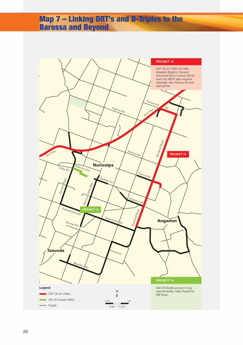
26m B-Double access to key sawmill facility, Tolley Road/Old Mill Road.
DRT 36.5m (PBS 3A) HMLAdelaide Brighton Cement, Stockwell Rd to Carrara Hill Rd and onto NEXY (also requires Gazettal). Also Penrice Rd and Samuel Rd.
PROJECT 12
PROJECT 14
PROJECT 12
PROJECT 14
21
NLegend
Roads
26m B-Double (HML)
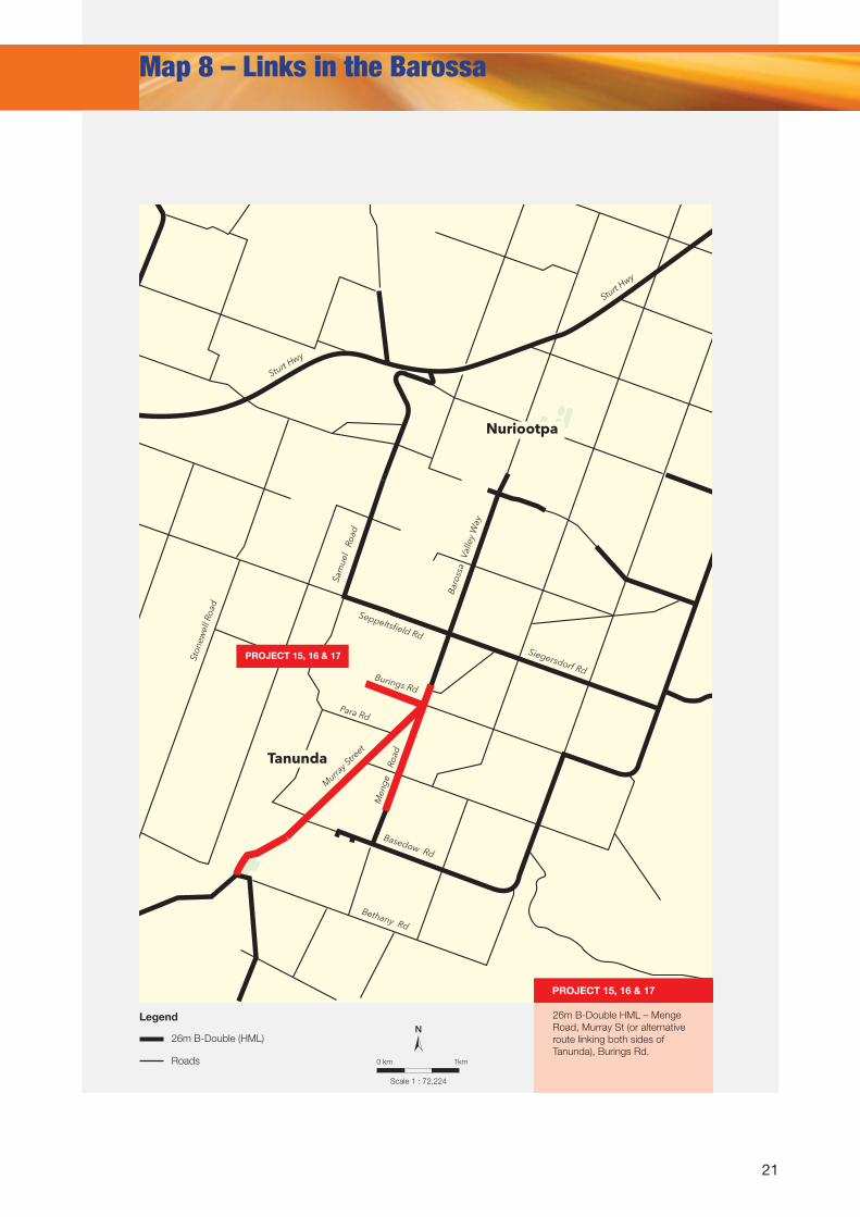
26m B-Double HML – Menge Road, Murray St (or alternative route linking both sides of Tanunda), Burings Rd.
Seppeltsfield Rd
Siegersdorf RdBurings Rd
Para Rd
Basedow Rd
Bethany Rd
Sturt Hwy
Sturt Hwy
Sam
uel
Roa
d
Men
ge
Roa
d
Nuriootpa
Tanunda
Baro
ssa
Val
ley
Way
Ston
ewel
l Roa
d
Murra
y Stre
et
Map 8 – Links in the Barossa
Scale 1 : 72,224
0 km 1km
PROJECT 15, 16 & 17
PROJECT 15, 16 & 17
22
Map 9 – Links through and around Eudunda
N
Scale 1 : 18,056
0 m
Legend
500m
26m B-Double
Roads
Eudunda
Salevards Road
Pine Ave
Three Chain Road
Heron Rd
Rosella Rd
South Tce
Peep Hill Road
Bunker Rd
Industry Rd
Bru
ce S
t
Railw
ay P
de
Thiele Hwy
World
’s End H
wy
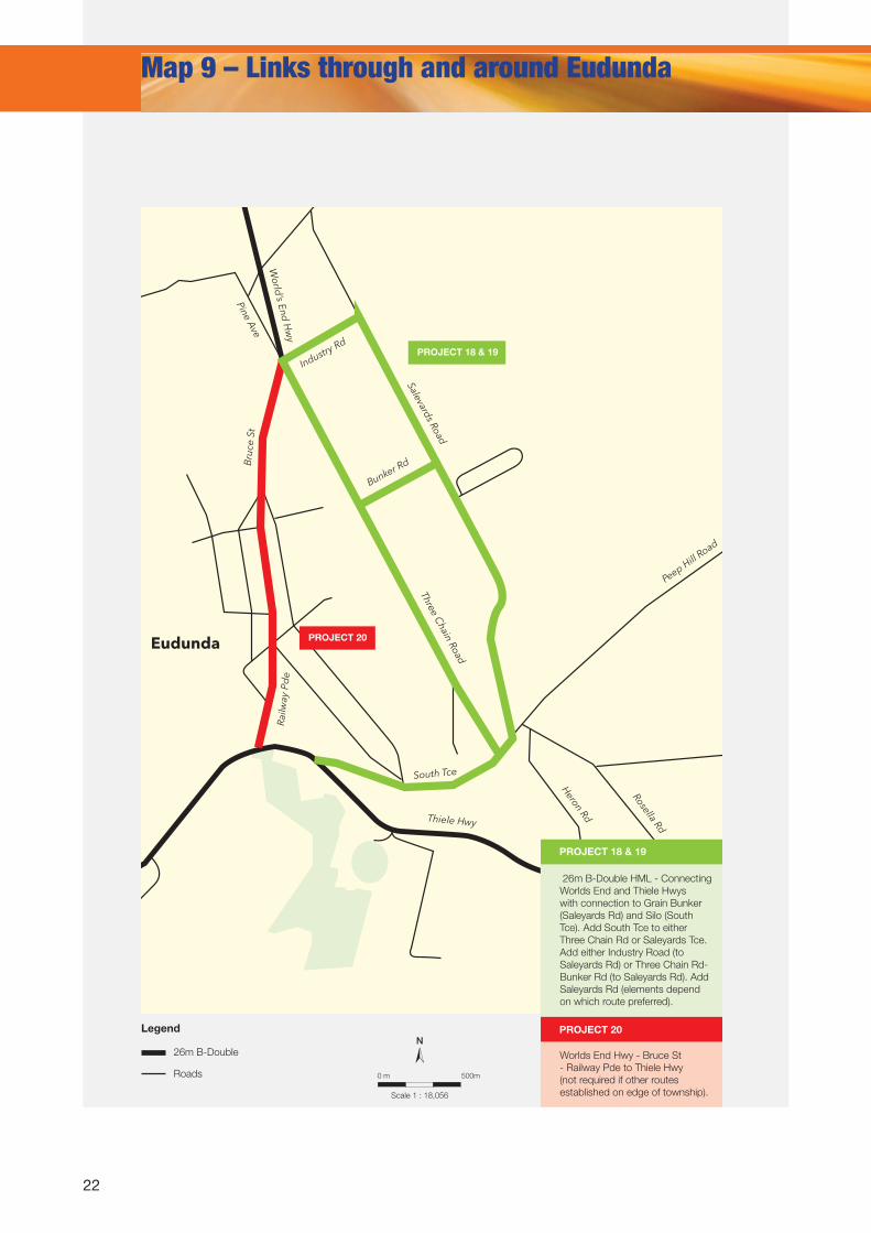
Worlds End Hwy - Bruce St - Railway Pde to Thiele Hwy (not required if other routes established on edge of township).
26m B-Double HML - Connecting Worlds End and Thiele Hwys with connection to Grain Bunker (Saleyards Rd) and Silo (South Tce). Add South Tce to either Three Chain Rd or Saleyards Tce.Add either Industry Road (to Saleyards Rd) or Three Chain Rd-Bunker Rd (to Saleyards Rd). Add Saleyards Rd (elements depend on which route preferred).
PROJECT 18 & 19
PROJECT 20
PROJECT 20
PROJECT 18 & 19
23
NLegend
Mal
lala
Ro
ad
Mallala
Two Wells
Port Gawler Road
Gawler Road
Dublin Road
Sharpe Rd
Old Port W
akefield Road
Port Wakefield Hwy
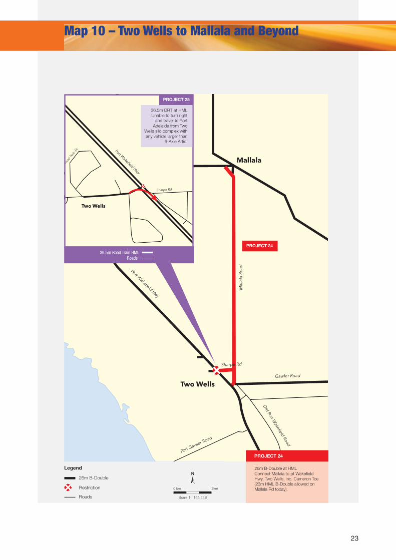
Map 10 – Two Wells to Mallala and Beyond
Scale 1 : 144,448
0 km 2km
26m B-Double
Roads
Road Tr
ain
Dr
Two Wells
Port Wakefield Hwy
Sharpe Rd
PROJECT 24
PROJECT 25
36.5m DRT at HMLUnable to turn right
and travel to Port Adelaide from Two
Wells silo complex with any vehicle larger than
6-Axle Artic.
Restriction
26m B-Double at HMLConnect Mallala to pt Wakefield Hwy, Two Wells, inc. Cameron Tce (23m HML B-Double allowed on Mallala Rd today).
PROJECT 24
36.5m Road Train HMLRoads
24
Appendix 1: Known First/Last Mile Issues
MapNo.
Project No.
Affected Road(s)
Industry/ Sector/
Business
Current PBS Level
Required Truck
Type/PBS Level
Stretch and length of Roads
InvolvedFreight Transport Issue
1 1Yorke Hwy,
Copper Coast Hwy
Grain, Livestock,
Mining, General Freight
2A
DRT – 36.5m
(PBS 3A) HML
Copper Coast Hwy from A1 (Port Wakefield Road) to Yorke Hwy; Yorke Hwy to Ardrossan Silos – approx 48 km
The DRT network on the Yorke Peninsula (Ardrossan - Pt Giles) is isolated and merely connects 1 silo complex to a single port. A link from Ardrossan silos to the A1 just north of Pt Wakefield is required to provide a high capacity link from the lower Yorke Peninsula network to the rest of the state network, facilitating grain movements too and from key silo complexes, Pt Giles and Pt Adelaide as well as Bowmans Intermodal complex, future mining supply movements and general cargos. Some preliminary work has been undertaken (jointly funded by industry and government) but current status is unknown.
1 2 Copper Coast Hwy Grain 2A
DRT – 36.5m
(PBS 3A) HML
Route to follow existing B-Double route from Pt Wakefield to Wallaroo (port/silo complex)
This route is needed to move grain from Mid North silos and Bowman’s Intermodal to port at Wallaroo for export. Current movements utilising B-Doubles only is inefficient and increases the total number of trucks on roads and environmental impacts. There is a link between this project and Project 1 (Ardrossan - Pt Wakefield).
1 3 Maitland RdGrain, local
primary producers
23m B-Double only on
Maitland Rd. No
access on Silo Rd.
26m B-Doubles (Full PBS 2A) HML
Maitland Road from the termination point (Old Pump Rd/Airstrip Rd) of the 26m B-Double network to Coast Road (Yorke Hwy) OR along Silo road from Maitland Rd network termination point to Coast Road
The Maitland Rd 26m b-double network stops abruptly just prior to the Silo Rd turn off, requiring grain transport to use inefficient vehicles.
2 4 Balaklava Rd
Transport (Bowmans
Intermodal), Primary
Producers (Seafood,
Grain, Hay), General Freight. Future mining
potential.
3A
B-Triple (3A) HML
AND AB Double
HML
Balaklava Rd from A1 at Port Wakefield to Bowmans Intermodal, matching the current 36.5m HML Road Train route
HML Double Road Trains at 36.5m currently use this route - access by shorter B-Triples (35m) at HML should be allowed. Both are PBS level 3A vehicles and should be treated similarly.
3 5Maxwell Rd, Main North
RdVarious 2A 26m
B-DoubleIntersection - right turn prohibited
The Maxwell Rd/Main North Road intersection is left turn in-left turn out only, creating issues for traffic wishing to turn north on main north rd. from Maxwell Rd; and east from Main North Rd into Maxwell Rd. Turns are controlled by traffic signal in all directions at this intersection.
4 6
Ryans Rd, George St, Berlfree Dr, Greenfields
Dr, Elder Smith Rd, Salisbury
Hwy,
Road Transport Depots
(eg: Dennis Transport,
Whiteline Tsp, Territory Freight
et al)
Level 3A for parts of Ryans Rd
only
DRT - 36.5m
(PBS 3A) @ HML
Ryans Rd from network termination point to Salisbury Hwy, Salisbury Hwy from Ryans Rd to Greenfields Dr, George St (all), Elder Smith Rd, Belfree Dr
Greenfields has emerged as a significant new road transport hub, adjacent to the interstate road corridor (A1) nearby. The area requires expansion of the 36.5m HML network to facilitate growth and efficient combination use to link to the 36.5m HML interstate corridor nearby. Essentially, the area’s status should be recognised as a road transport hub similar to Regency Park, with similar access provided.
25
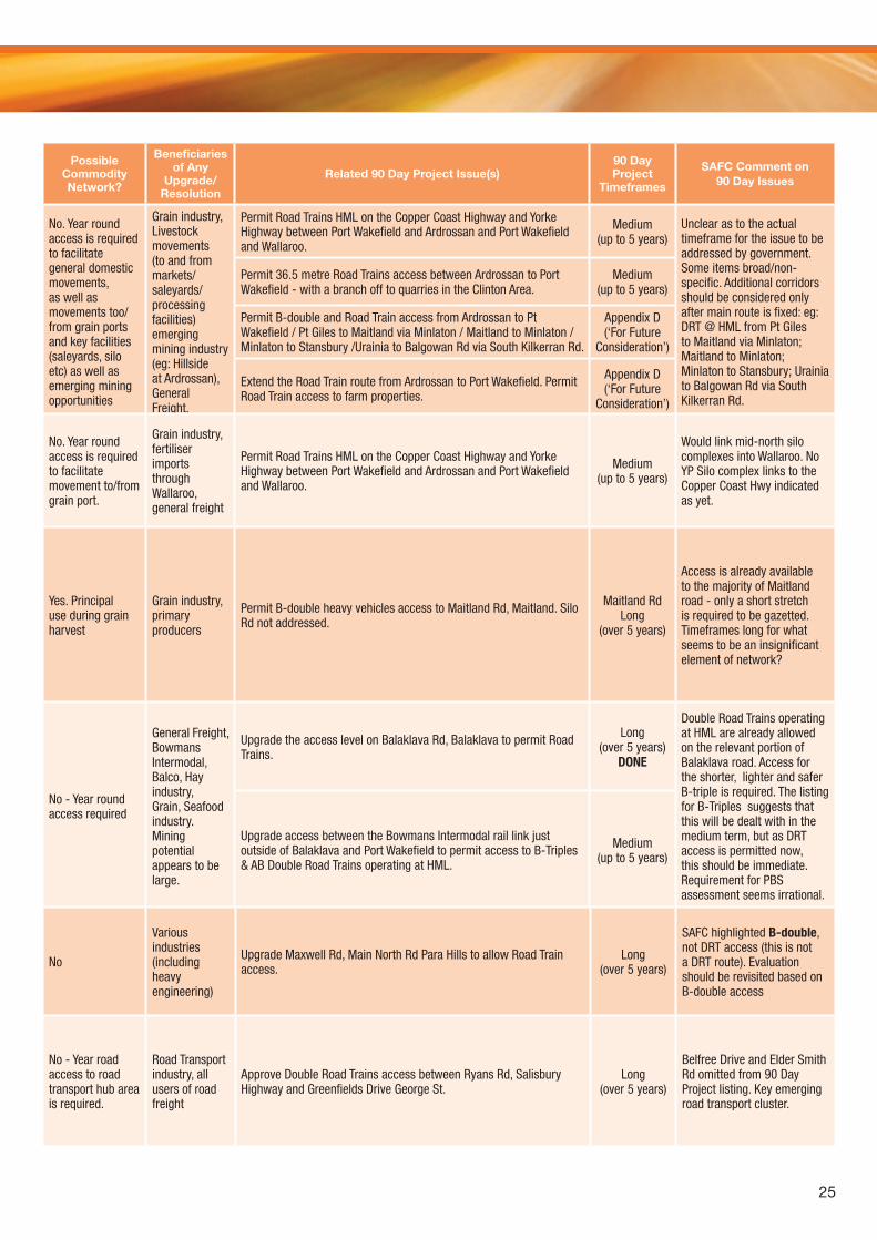
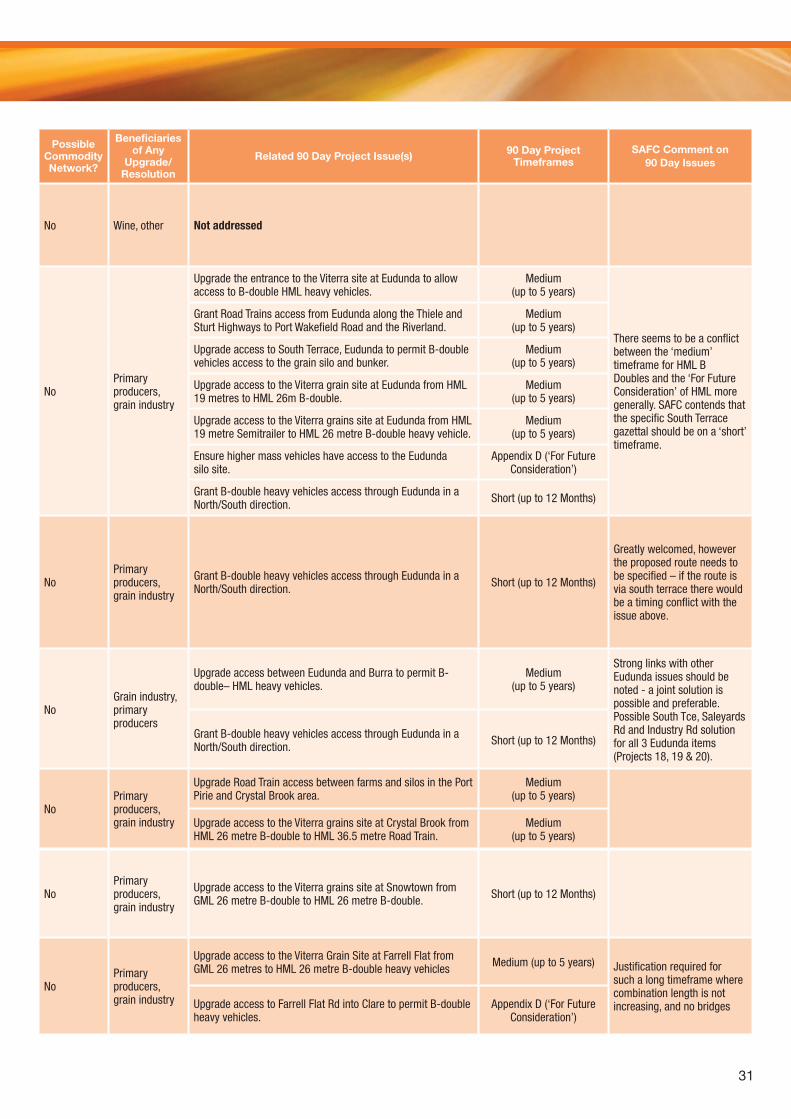
Possible Commodity Network?
Beneficiaries of Any
Upgrade/Resolution
Related 90 Day Project Issue(s)90 Day Project
Timeframes
SAFC Comment on 90 Day Issues
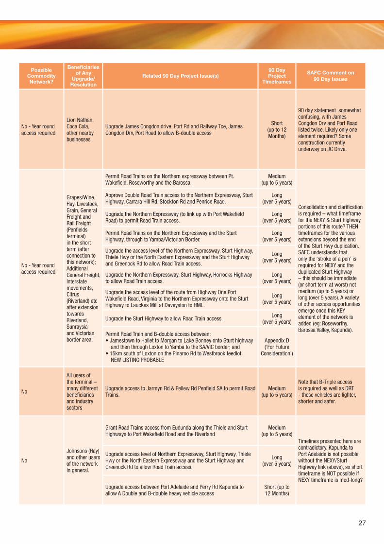
No. Year round access is required to facilitate general domestic movements, as well as movements too/from grain ports and key facilities (saleyards, silo etc) as well as emerging mining opportunities
Grain industry, Livestock movements (to and from markets/saleyards/processing facilities) emerging mining industry (eg: Hillside at Ardrossan), General Freight.
Permit Road Trains HML on the Copper Coast Highway and Yorke Highway between Port Wakefield and Ardrossan and Port Wakefield and Wallaroo.
Medium (up to 5 years)
Unclear as to the actual timeframe for the issue to be addressed by government. Some items broad/non-specific. Additional corridors should be considered only after main route is fixed: eg: DRT @ HML from Pt Giles to Maitland via Minlaton; Maitland to Minlaton; Minlaton to Stansbury; Urainia to Balgowan Rd via South Kilkerran Rd.
Permit 36.5 metre Road Trains access between Ardrossan to Port Wakefield - with a branch off to quarries in the Clinton Area.
Medium (up to 5 years)
Permit B-double and Road Train access from Ardrossan to Pt Wakefield / Pt Giles to Maitland via Minlaton / Maitland to Minlaton /Minlaton to Stansbury /Urainia to Balgowan Rd via South Kilkerran Rd.
Appendix D (‘For Future
Consideration’)
Extend the Road Train route from Ardrossan to Port Wakefield. Permit Road Train access to farm properties.
Appendix D (‘For Future
Consideration’)
No. Year round access is required to facilitate movement to/from grain port.
Grain industry, fertiliser imports through Wallaroo, general freight
Permit Road Trains HML on the Copper Coast Highway and Yorke Highway between Port Wakefield and Ardrossan and Port Wakefield and Wallaroo.
Medium (up to 5 years)
Would link mid-north silo complexes into Wallaroo. No YP Silo complex links to the Copper Coast Hwy indicated as yet.
Yes. Principal use during grain harvest
Grain industry, primary producers
Permit B-double heavy vehicles access to Maitland Rd, Maitland. Silo Rd not addressed.
Maitland Rd Long
(over 5 years)
Access is already available to the majority of Maitland road - only a short stretch is required to be gazetted. Timeframes long for what seems to be an insignificant element of network?
No - Year round access required
General Freight, Bowmans Intermodal, Balco, Hay industry, Grain, Seafood industry. Mining potential appears to be large.
Upgrade the access level on Balaklava Rd, Balaklava to permit Road Trains.
Long (over 5 years)
DONE
Double Road Trains operating at HML are already allowed on the relevant portion of Balaklava road. Access for the shorter, lighter and safer B-triple is required. The listing for B-Triples suggests that this will be dealt with in the medium term, but as DRT access is permitted now, this should be immediate. Requirement for PBS assessment seems irrational.
Upgrade access between the Bowmans Intermodal rail link just outside of Balaklava and Port Wakefield to permit access to B-Triples & AB Double Road Trains operating at HML.
Medium (up to 5 years)
No
Various industries (including heavy engineering)
Upgrade Maxwell Rd, Main North Rd Para Hills to allow Road Train access.
Long (over 5 years)
SAFC highlighted B-double, not DRT access (this is not a DRT route). Evaluation should be revisited based on B-double access
No - Year road access to road transport hub area is required.
Road Transport industry, all users of road freight
Approve Double Road Trains access between Ryans Rd, Salisbury Highway and Greenfields Drive George St.
Long (over 5 years)
Belfree Drive and Elder Smith Rd omitted from 90 Day Project listing. Key emerging road transport cluster.
26
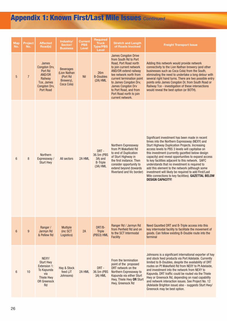
Appendix 1: Known First/Last Mile Issues Continued
MapNo.
Project No.
Affected Road(s)
Industry/ Sector/
Business
Current PBS Level
Required Truck
Type/PBS Level
Stretch and Length of Roads Involved Freight Transport Issue
5 7
James Congdon Drv,
Port Rd AND/ORRailway
Tce, James Congdon Drv,
Port Road
Beverages (Lion Nathan
(Port Rd Brewery), Coca Cola)
Nil26m
B-Doubles (2A) HML
James Congdon Drive from South Rd to Port Road, Port Road north to join current network AND/OR extend railway tee network north from current termination point to James Congdon Drv, James Congdon Drv to Port Road, and from Port Road north to join current network.
Adding this network would provide network connectivity to the Lion Nathan brewery (and other businesses such as Coca Cola) from the South, eliminating the need to undertake a long detour with several right hand turns. There are two possible entry points onto James Congdon Dr, from South Road or Railway Tce - investigation of these intersections would reveal the best option (or BOTH).
6 8Northern
Expressway / Sturt Hwy
All sectors 2A HML
DRT - 36.5m (PBS
3A) and B-Triple
(3A) HML
Northern Expressway from Pt Wakefield Rd to end of Duplication of Sturt Highway in the first instance. Then consider opportunity to extend beyond (towards Riverland and Vic border)
Significant investment has been made in recent times into the Northern Expressway (NEXY) and Sturt Highway Duplication Projects. Increasing access levels to PBS 3 levels will capitalise on this investment (currently gazetted below design capacity) and reveal opportunities to expand access to key facilities adjacent to this network. SAFC understands that no investment is required to add this element to the network (although some investment will likely be required to add First/Last Mile connections to key facilities). GAZETTAL BELOW DESIGN CAPACITY!
6 9Ranger /
Jarmyn Rd & Pellew Rd
Multiple (inc SCT Logistics)
2ADRT/B-Triple
(PBS3) HML
Ranger Rd / Jarmyn Rd from Penfield Rd and on to the SCT Intermodal Facility
Need Gazetted DRT and B-Triple access into this key intermodal facility to facilitate the movement of goods. Can follow existing B-Double route into the terminal
6 10
NEXY/Sturt Hwy
Extension 1: To Kapunda
via Thiele Hwy
OR Greenock Rd
Hay & Stock feed (JT
Johnsons)2A HML
DRT - 36.5m (PBS
3A) HML
From the termination point of the proposed DRT network on the Northern Expressway to Kapunda via either Sturt Hwy, Thiele Hwy OR Sturt Hwy, Greenock Rd
Johnsons is a significant international exporter of hay and stock feed products via Port Adelaide. Currently limited to B-Doubles, despite the availability of DRT routes on Pt Wakefield Rd from NEXY to Pt Adelaide, and investment into the network from NEXY to Kapunda. DRT traffic could be routed via the Thiele Hwy or Greenock Rd, depending on road capability and network interaction issues. See Project No. 12 (Adelaide Brighton issue) also - suggests Sturt Hwy/Greenock may be best option.
27
Possible Commodity Network?
Beneficiaries of Any
Upgrade/Resolution
Related 90 Day Project Issue(s)90 Day Project
Timeframes
SAFC Comment on 90 Day Issues
No - Year round access required
Lion Nathan, Coca Cola, other nearby businesses
Upgrade James Congdon drive, Port Rd and Railway Tce, James Congdon Drv, Port Road to allow B-double access
Short (up to 12 Months)
90 day statement somewhat confusing, with James Congdon Drv and Port Road listed twice. Likely only one element required? Some construction currently underway on JC Drive.
No - Year round access required
Grapes/Wine, Hay, Livestock, Grain, General Freight and Rail Freight (Penfields terminal) in the short term (after connection to this network); Additional General Freight, Interstate movements, Citrus (Riverland) etc after extension towards Riverland, Sunraysia and Victorian border area.
Permit Road Trains on the Northern expressway between Pt. Wakefield, Roseworthy and the Barossa.
Medium (up to 5 years)
Consolidation and clarification is required – what timeframe for the NEXY & Sturt highway portions of this route? THEN timeframes for the various extensions beyond the end of the Sturt Hwy duplication. SAFC understands that only the ‘stroke of a pen’ is required for NEXY and the duplicated Sturt Highway – this should be immediate (or short term at worst) not medium (up to 5 years) or long (over 5 years). A variety of other access opportunities emerge once this KEY element of the network is added (eg: Roseworthy, Barossa Valley, Kapunda).
Approve Double Road Train access to the Northern Expressway, Sturt Highway, Carrara Hill Rd, Stockton Rd and Penrice Road.
Long (over 5 years)
Upgrade the Northern Expressway (to link up with Port Wakefield Road) to permit Road Train access.
Long (over 5 years)
Permit Road Trains on the Northern Expressway and the Sturt Highway, through to Yamba/Victorian Border.
Long (over 5 years)
Upgrade the access level of the Northern Expressway, Sturt Highway, Thiele Hwy or the North Eastern Expressway and the Sturt Highway and Greenock Rd to allow Road Train access.
Long (over 5 years)
Upgrade the Northern Expressway, Sturt Highway, Horrocks Highway to allow Road Train access.
Long (over 5 years)
Upgrade the access level of the route from Highway One Port Wakefield Road, Virginia to the Northern Expressway onto the Sturt Highway to Lauckes Mill at Daveyston to HML.
Long (over 5 years)
Upgrade the Sturt Highway to allow Road Train access. Long (over 5 years)
Permit Road Train and B-double access between:• Jamestown to Hallet to Morgan to Lake Bonney onto Sturt highway
and then through Loxton to Yamba to the SA/VIC border; and• 15km south of Loxton on the Pinaroo Rd to Westbrook feedlot.
NEW LISTING PROBABLE
Appendix D (‘For Future
Consideration’)
No
All users of the terminal – many different beneficiaries and industry sectors
Upgrade access to Jarmyn Rd & Pellew Rd Penfield SA to permit Road Trains.
Medium (up to 5 years)
Note that B-Triple access is required as well as DRT - these vehicles are lighter, shorter and safer.
No
Johnsons (Hay) and other users of the network in general.
Grant Road Trains access from Eudunda along the Thiele and Sturt Highways to Port Wakefield Road and the Riverland
Medium (up to 5 years)
Timelines presented here are contradictory. Kapunda to Port Adelaide is not possible without the NEXY/Sturt Highway link (above), so short timeframe is NOT possible if NEXY timeframe is med-long?
Upgrade access level of Northern Expressway, Sturt Highway, Thiele Hwy or the North Eastern Expressway and the Sturt Highway and Greenock Rd to allow Road Train access.
Long (over 5 years)
Upgrade access between Port Adelaide and Perry Rd Kapunda to allow A Double and B-double heavy vehicle access
Short (up to 12 Months)
28
Appendix 1: Known First/Last Mile Issues Continued
MapNo.
Project No.
Affected Road(s)
Industry/ Sector/
Business
Current PBS Level
Required Truck
Type/PBS Level
Stretch and Length of Roads Involved Freight Transport Issue
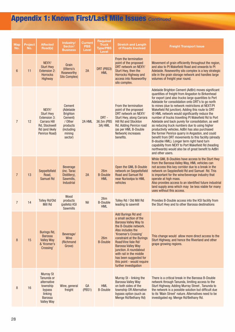
6 11
NEXY/Sturt Hwy
Extension 2:Horrocks Highway
Grain (Viterra’s
Roseworthy Silo Complex)
2A DRT (PBS3) HML
From the termination point of the proposed DRT network on NEXY/ Sturt Hwy, then the Horrocks Highway and access into Roseworthy silo complex.
Movement of grain efficiently throughout the region, and also to Pt Wakefield Road and onwards to Pt Adelaide. Roseworthy silo complex is a key strategic site in the grain storage network and handles large volumes of freight year round.
7 12
NEXY/Sturt Hwy
Extension 3:Carrara Hill
Rd, Stockwell Rd (and likely Penrice Road)
Cement (Adelaide Brighton Cement) / Other
products (including
mining sector)
2A HMLDRT -
36.5m (PBS 3A) HML
From the termination point of the proposed DRT network on NEXY/Sturt Hwy, along Carrara Hill Rd and Stockton Rd. Adding Penrice road (as per HML B-Double Network) increases benefits.
Adelaide Brighton Cement (AdBri) moves significant quantities of freight from Angaston to Birkenhead for export (and also trucks large quantities to Port Adelaide for consolidation onto DRT’s to go north to mines (due to network restrictions at NEXT/Pt Wakefield Rd junction). Adding this route to DRT @ HML network would significantly reduce the number of trucks travelling Pt Wakefield Rd to Port Adelaide and back purely for consolidation, as well as reducing truck numbers due to using higher productivity vehicles. AdBri has also purchased the former Penrice quarry in Angaston, and could benefit from DRT movements to this facility (already B-double HML). Longer term right hand turn capability from NEXY to Port Wakefield Rd (heading northwards) would also be of great benefit to AdBri and other users.
7 13Seppeltsfield
Road, Samuel Rd
Beverage (inc. Tarac Distillery), Sawmills, Industrial
2A26m
B-Double HML
Open the GML B-Double network on Seppeltsfield Road and Samuel Rd near Nuriootpa to HML vehicles
While GML B-Doubles have access to the Sturt Hwy from the Barossa Valley Way, HML vehicles can not access this key corridor due to a break in the network on Sepplesfield Rd and Samuel Rd. This is important for the wine/beverage industry that operate at high mass.Also provides access to an identified future industrial land supply area which may be less viable for many uses without this access.
7 14 Tolley Rd/Old Mill Rd
Wood products
(pallets) KSI Sawmills
Nil26m
B-Double HML
Tolley Rd / Old Mill Rd leading to sawmill
Provides B-Double access into the KSI facility from the Sturt Hwy and to other Barossa destinations
8 15
Burings Rd, Barossa
Valley Way & ‘Kromer’s Crossing’
Beverage/Wine
(Richmond Grove)
26m B-Double
Add Burings Rd and a small section of the Barossa Valley Way to the B-Double network. Also includes the ‘Kroemer’s Crossing’ constraint at the Burings Road/Vine Vale Rd/Barossa Valley Way junction. A roundabout with rail in the middle has been suggested for this point - would require further investigation
This change would allow more direct access to the Sturt Highway, and hence the Riverland and other grape growing regions.
8 16
Murray St Tanunda or alternative township bypass linking
Barossa Valley Way
Wine, general freight
GA (PBS1)
HML B-Double
Murray St - linking the Barossa Valley Way on both sides of the township OR Alternative bypass option (such as Menge Rd/Bethany Rd)
There is a critical break in the Barossa B-Double network through Tanunda, limiting access to the Sturt Highway. Adding Murray Street , Tanunda to the network is a possible solution but difficult due to its ‘Main Street’ nature. Alternatives need to be investigated eg: Menge Rd/Bethany Rd.
29
Possible Commodity Network?
Beneficiaries of Any Upgrade/Resolution Related 90 Day Project Issue(s)
90 Day Project
Timeframes
SAFC Comment on 90 Day Issues
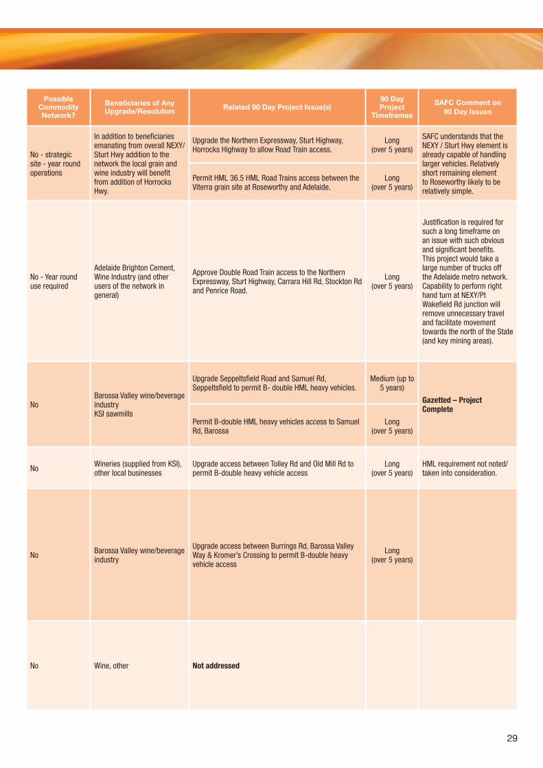
No - strategic site - year round operations
In addition to beneficiaries emanating from overall NEXY/Sturt Hwy addition to the network the local grain and wine industry will benefit from addition of Horrocks Hwy.
Upgrade the Northern Expressway, Sturt Highway, Horrocks Highway to allow Road Train access.
Long (over 5 years)
SAFC understands that the NEXY / Sturt Hwy element is already capable of handling larger vehicles. Relatively short remaining element to Roseworthy likely to be relatively simple.
Permit HML 36.5 HML Road Trains access between the Viterra grain site at Roseworthy and Adelaide.
Long (over 5 years)
No - Year round use required
Adelaide Brighton Cement, Wine Industry (and other users of the network in general)
Approve Double Road Train access to the Northern Expressway, Sturt Highway, Carrara Hill Rd, Stockton Rd and Penrice Road.
Long (over 5 years)
Justification is required for such a long timeframe on an issue with such obvious and significant benefits. This project would take a large number of trucks off the Adelaide metro network. Capability to perform right hand turn at NEXY/Pt Wakefield Rd junction will remove unnecessary travel and facilitate movement towards the north of the State (and key mining areas).
No Barossa Valley wine/beverage industryKSI sawmills
Upgrade Seppeltsfield Road and Samuel Rd, Seppeltsfield to permit B- double HML heavy vehicles.
Medium (up to 5 years)
Gazetted – Project Complete
Permit B-double HML heavy vehicles access to Samuel Rd, Barossa
Long (over 5 years)
No Wineries (supplied from KSI), other local businesses
Upgrade access between Tolley Rd and Old Mill Rd to permit B-double heavy vehicle access
Long (over 5 years)
HML requirement not noted/taken into consideration.
No Barossa Valley wine/beverage industry
Upgrade access between Burrings Rd, Barossa Valley Way & Kromer’s Crossing to permit B-double heavy vehicle access
Long (over 5 years)
No Wine, other Not addressed
30
Appendix 1: Known First/Last Mile Issues Continued
MapNo.
Project No.
Affected Road(s)
Industry/ Sector/
Business
Current PBS Level
Required Truck
Type/PBS Level
Stretch and Length of Roads Involved Freight Transport Issue
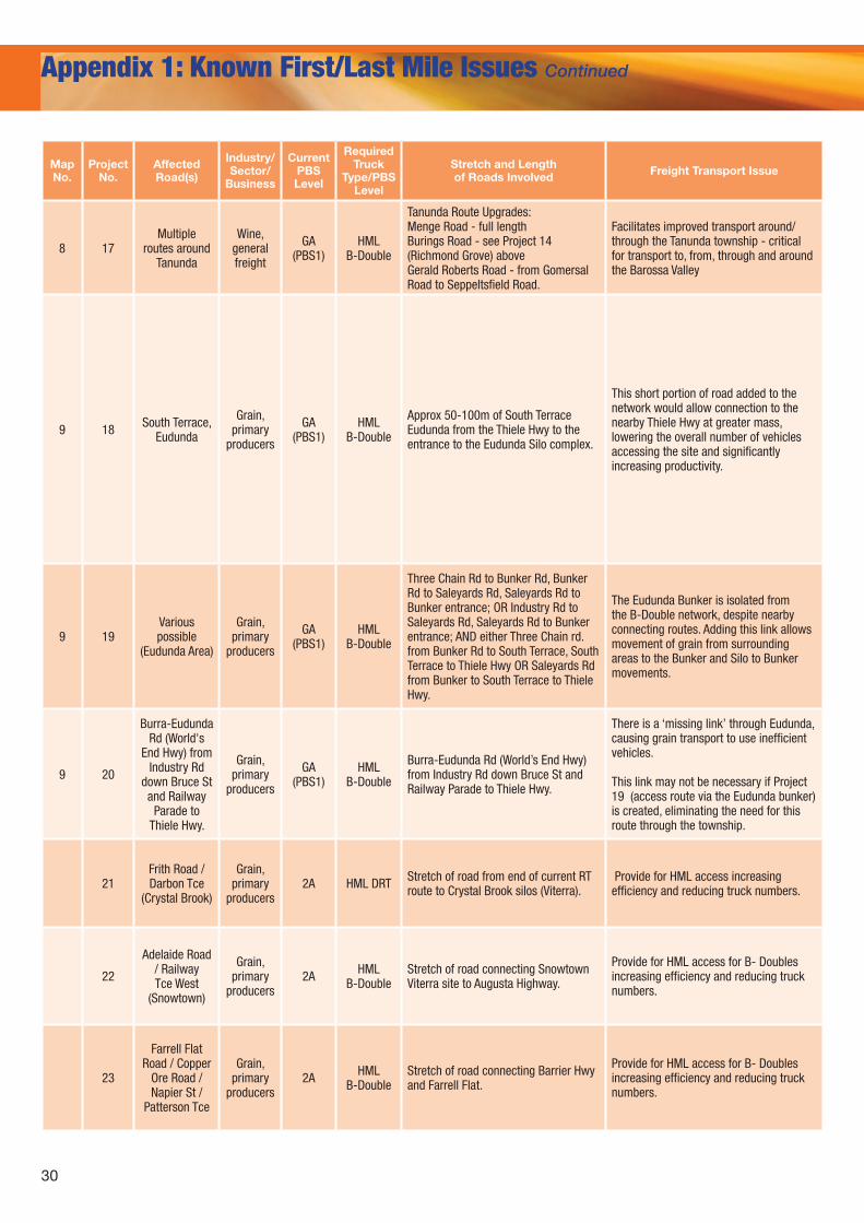
8 17Multiple
routes around Tanunda
Wine, general freight
GA (PBS1)
HML B-Double
Tanunda Route Upgrades:Menge Road - full lengthBurings Road - see Project 14 (Richmond Grove) aboveGerald Roberts Road - from Gomersal Road to Seppeltsfield Road.
Facilitates improved transport around/through the Tanunda township - critical for transport to, from, through and around the Barossa Valley
9 18 South Terrace, Eudunda
Grain, primary
producers
GA (PBS1)
HML B-Double
Approx 50-100m of South Terrace Eudunda from the Thiele Hwy to the entrance to the Eudunda Silo complex.
This short portion of road added to the network would allow connection to the nearby Thiele Hwy at greater mass, lowering the overall number of vehicles accessing the site and significantly increasing productivity.
9 19Various possible
(Eudunda Area)
Grain, primary
producers
GA (PBS1)
HML B-Double
Three Chain Rd to Bunker Rd, Bunker Rd to Saleyards Rd, Saleyards Rd to Bunker entrance; OR Industry Rd to Saleyards Rd, Saleyards Rd to Bunker entrance; AND either Three Chain rd. from Bunker Rd to South Terrace, South Terrace to Thiele Hwy OR Saleyards Rd from Bunker to South Terrace to Thiele Hwy.
The Eudunda Bunker is isolated from the B-Double network, despite nearby connecting routes. Adding this link allows movement of grain from surrounding areas to the Bunker and Silo to Bunker movements.
9 20
Burra-Eudunda Rd (World's
End Hwy) from Industry Rd
down Bruce St and Railway
Parade to Thiele Hwy.
Grain, primary
producers
GA (PBS1)
HML B-Double
Burra-Eudunda Rd (World’s End Hwy) from Industry Rd down Bruce St and Railway Parade to Thiele Hwy.
There is a ‘missing link’ through Eudunda, causing grain transport to use inefficient vehicles.
This link may not be necessary if Project 19 (access route via the Eudunda bunker) is created, eliminating the need for this route through the township.
21Frith Road / Darbon Tce
(Crystal Brook)
Grain, primary
producers2A HML DRT Stretch of road from end of current RT
route to Crystal Brook silos (Viterra). Provide for HML access increasing efficiency and reducing truck numbers.
22
Adelaide Road / Railway Tce West
(Snowtown)
Grain, primary
producers2A HML
B-DoubleStretch of road connecting Snowtown Viterra site to Augusta Highway.
Provide for HML access for B- Doubles increasing efficiency and reducing truck numbers.
23
Farrell Flat Road / Copper
Ore Road / Napier St /
Patterson Tce
Grain, primary
producers2A HML
B-DoubleStretch of road connecting Barrier Hwy and Farrell Flat.
Provide for HML access for B- Doubles increasing efficiency and reducing truck numbers.
31
Possible Commodity Network?
Beneficiaries of Any
Upgrade/Resolution
Related 90 Day Project Issue(s) 90 Day Project Timeframes
SAFC Comment on 90 Day Issues
No Wine, other Not addressed
NoPrimary producers, grain industry
Upgrade the entrance to the Viterra site at Eudunda to allow access to B-double HML heavy vehicles.
Medium (up to 5 years)
There seems to be a conflict between the ‘medium’ timeframe for HML B Doubles and the ‘For Future Consideration’ of HML more generally. SAFC contends that the specific South Terrace gazettal should be on a ‘short’ timeframe.
Grant Road Trains access from Eudunda along the Thiele and Sturt Highways to Port Wakefield Road and the Riverland.
Medium (up to 5 years)
Upgrade access to South Terrace, Eudunda to permit B-double vehicles access to the grain silo and bunker.
Medium (up to 5 years)
Upgrade access to the Viterra grain site at Eudunda from HML 19 metres to HML 26m B-double.
Medium (up to 5 years)
Upgrade access to the Viterra grains site at Eudunda from HML 19 metre Semitrailer to HML 26 metre B-double heavy vehicle.
Medium (up to 5 years)
Ensure higher mass vehicles have access to the Eudunda silo site.
Appendix D (‘For Future Consideration’)
Grant B-double heavy vehicles access through Eudunda in a North/South direction. Short (up to 12 Months)
NoPrimary producers, grain industry
Grant B-double heavy vehicles access through Eudunda in a North/South direction. Short (up to 12 Months)
Greatly welcomed, however the proposed route needs to be specified – if the route is via south terrace there would be a timing conflict with the issue above.
NoGrain industry, primary producers
Upgrade access between Eudunda and Burra to permit B- double– HML heavy vehicles.
Medium (up to 5 years)
Strong links with other Eudunda issues should be noted - a joint solution is possible and preferable. Possible South Tce, Saleyards Rd and Industry Rd solution for all 3 Eudunda items (Projects 18, 19 & 20).
Grant B-double heavy vehicles access through Eudunda in a North/South direction. Short (up to 12 Months)
NoPrimary producers, grain industry
Upgrade Road Train access between farms and silos in the Port Pirie and Crystal Brook area.
Medium (up to 5 years)
Upgrade access to the Viterra grains site at Crystal Brook from HML 26 metre B-double to HML 36.5 metre Road Train.
Medium (up to 5 years)
NoPrimary producers, grain industry
Upgrade access to the Viterra grains site at Snowtown from GML 26 metre B-double to HML 26 metre B-double. Short (up to 12 Months)
NoPrimary producers, grain industry
Upgrade access to the Viterra Grain Site at Farrell Flat from GML 26 metres to HML 26 metre B-double heavy vehicles Medium (up to 5 years) Justification required for
such a long timeframe where combination length is not increasing, and no bridgesUpgrade access to Farrell Flat Rd into Clare to permit B-double
heavy vehicles.Appendix D (‘For Future
Consideration’)
32
Appendix 1: Known First/Last Mile Issues Continued
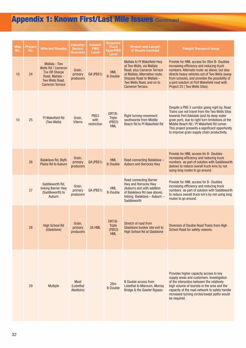
MapNo.
Project No. Affected Road(s)
Industry/ Sector/
Business
Current PBS Level
Required Truck
Type/PBS Level
Stretch and Length of Roads Involved Freight Transport Issue
10 24
Mallala - Two Wells Rd / Cameron
Tce OR Sharpe Road, Mallala - Two Wells Road, Cameron Terrace
Grain, primary
producersGA (PBS1) HML
B-Double
Mallala to Pt Wakefield Hwy at Two Wells, via Mallala Road; plus Cameron Terrace at Mallala. Alternative route: Sharpes Road to Mallala - Two Wells Road, and on to Cameron Terrace.
Provide for HML access for 26m B- Doubles increasing efficiency and reducing truck numbers. Alternate route: as above, but also directs heavy vehicles out of Two Wells (away from schools), and provides the possibility of a joint solution at Port Wakefield road with Project 25 ( Two Wells Silos).
10 25 Pt Wakefield Rd (Two Wells)
Grain, Viterra
PBS3 with
restriction
DRT/B-Triple
(PBS3) HML
Right turning movement southwards from Middle Beach Rd to Pt Wakefield Rd
Despite a PBS 3 corridor going right by, Road Trains can not travel from the Two Wells Silos towards Port Adelaide (and its deep water grain port), due to right turn limitations at the Middle Beach Rd / Pt Wakefield Rd corner. This project presents a significant opportunity to improve grain supply chain productivity.
26 Balaklava Rd, Blyth Plains Rd to Auburn
Grain, primary
producersGA (PBS1) HML
B-DoubleRoad connecting Balaklava – Auburn and Horrocks Hwy
Provide for HML access for B- Doubles increasing efficiency and reducing truck numbers as part of solution with Saddleworth (below) to reduce overall truck kms by not using long routes to go around.
27
Saddleworth Rd, linking Barrier Hwy
(Saddleworth) to Auburn
Grain, primary
producersGA (PBS1) HML
B-Double
Road connecting Barrier Hwy and Horrocks Hwy (Auburn) and with addition of Balaklava Rd (see above), linking Balaklava – Auburn – Saddleworth
Provide for HML access for B- Doubles increasing efficiency and reducing truck numbers as part of solution with Saddleworth to reduce overall truck km’s by not using long routes to go around.
28 High School Rd (Gladstone)
Grain, primary
producers2A HML
DRT/B-Triple
(PBS3) HML
Stretch of road from Gladstone bunker site exit to High School Rd at Gladstone
Diversion of Double Road Trains from High School Road for safety reasons.
29 MultipleMeat
(Lobethal Abattoirs)
26m B-Double
B Double access from Lobethal to Mannum, Murray Bridge & the Gawler Bypass
Provides higher capacity access to key supply areas and customers. Investigation of the interaction between the relatively high volume of tourists in the area and the capacity of the road network to safely handle increased turning circles/swept paths would be required.
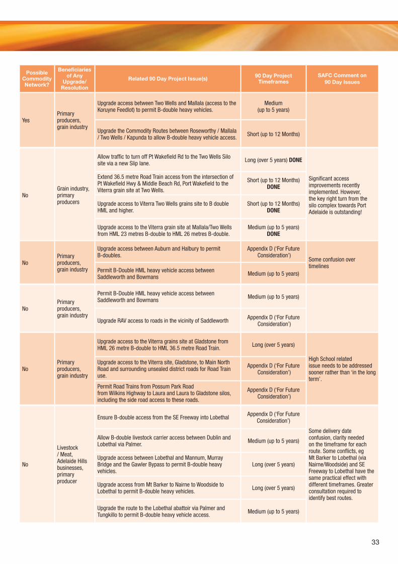
33
Possible Commodity Network?
Beneficiaries of Any
Upgrade/Resolution
Related 90 Day Project Issue(s) 90 Day Project Timeframes
SAFC Comment on 90 Day Issues
YesPrimary producers, grain industry
Upgrade access between Two Wells and Mallala (access to the Koruyne Feedlot) to permit B-double heavy vehicles.
Medium (up to 5 years)
Upgrade the Commodity Routes between Roseworthy / Mallala / Two Wells / Kapunda to allow B-double heavy vehicle access. Short (up to 12 Months)
NoGrain industry, primary producers
Allow traffic to turn off Pt Wakefield Rd to the Two Wells Silo site via a new Slip lane. Long (over 5 years) DONE
Significant access improvements recently implemented. However, the key right turn from the silo complex towards Port Adelaide is outstanding!
Extend 36.5 metre Road Train access from the intersection of Pt Wakefield Hwy & Middle Beach Rd, Port Wakefield to the Viterra grain site at Two Wells.
Short (up to 12 Months) DONE
Upgrade access to Viterra Two Wells grains site to B double HML and higher.
Short (up to 12 Months) DONE
Upgrade access to the Viterra grain site at Mallala/Two Wells from HML 23 metres B-double to HML 26 metres B-double.
Medium (up to 5 years) DONE
No
Livestock / Meat, Adelaide Hills businesses, primary producer
Ensure B-double access from the SE Freeway into Lobethal Appendix D (‘For Future Consideration’)
Some delivery date confusion, clarity needed on the timeframe for each route. Some conflicts, eg Mt Barker to Lobethal (via Nairne/Woodside) and SE Freeway to Lobethal have the same practical effect with different timeframes. Greater consultation required to identify best routes.
Allow B-double livestock carrier access between Dublin and Lobethal via Palmer. Medium (up to 5 years)
Upgrade access between Lobethal and Mannum, Murray Bridge and the Gawler Bypass to permit B-double heavy vehicles.
Long (over 5 years)
Upgrade access from Mt Barker to Nairne to Woodside to Lobethal to permit B-double heavy vehicles. Long (over 5 years)
Upgrade the route to the Lobethal abattoir via Palmer and Tungkillo to permit B-double heavy vehicle access. Medium (up to 5 years)
NoPrimary producers, grain industry
Permit B-Double HML heavy vehicle access between Saddleworth and Bowmans Medium (up to 5 years)
Upgrade RAV access to roads in the vicinity of Saddleworth Appendix D (‘For Future Consideration’)
NoPrimary producers, grain industry
Upgrade access between Auburn and Halbury to permit B-doubles.
Appendix D (‘For Future Consideration’)
Some confusion over timelines
Permit B-Double HML heavy vehicle access between Saddleworth and Bowmans Medium (up to 5 years)
NoPrimary producers, grain industry
Upgrade access to the Viterra grains site at Gladstone from HML 26 metre B-double to HML 36.5 metre Road Train. Long (over 5 years)
High School related issue needs to be addressed sooner rather than ‘in the long term’.
Upgrade access to the Viterra site, Gladstone, to Main North Road and surrounding unsealed district roads for Road Train use.
Appendix D (‘For Future Consideration’)
Permit Road Trains from Possum Park Road from Wilkins Highway to Laura and Laura to Gladstone silos, including the side road access to these roads.
Appendix D (‘For Future Consideration’)
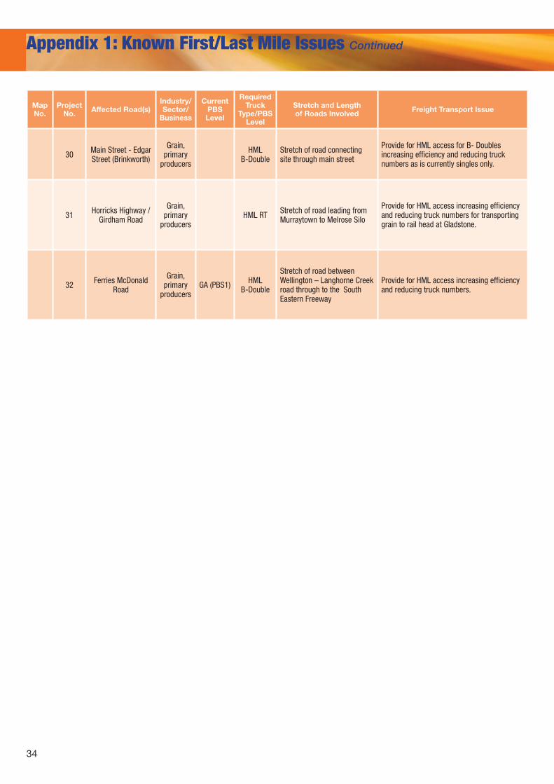
34
Appendix 1: Known First/Last Mile Issues Continued
MapNo.
Project No. Affected Road(s)
Industry/ Sector/
Business
Current PBS Level
Required Truck
Type/PBS Level
Stretch and Length of Roads Involved Freight Transport Issue
30 Main Street - Edgar Street (Brinkworth)
Grain, primary
producers
HML B-Double
Stretch of road connecting site through main street
Provide for HML access for B- Doubles increasing efficiency and reducing truck numbers as is currently singles only.
31 Horricks Highway / Girdham Road
Grain, primary
producersHML RT Stretch of road leading from
Murraytown to Melrose Silo
Provide for HML access increasing efficiency and reducing truck numbers for transporting grain to rail head at Gladstone.
32 Ferries McDonald Road
Grain, primary
producersGA (PBS1) HML
B-Double
Stretch of road between Wellington – Langhorne Creek road through to the South Eastern Freeway
Provide for HML access increasing efficiency and reducing truck numbers.
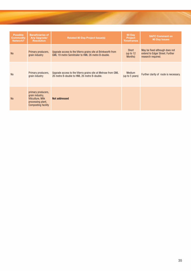
35
Possible Commodity Network?
Beneficiaries of Any Upgrade/
ResolutionRelated 90 Day Project Issue(s)
90 Day Project
Timeframes
SAFC Comment on 90 Day Issues
No Primary producers, grain industry
Upgrade access to the Viterra grains site at Brinkworth from GML 19 metre Semitrailer to HML 26 metre B-double.
Short (up to 12 Months)
May be fixed although does not extend to Edgar Street. Further research required.
No Primary producers, grain industry
Upgrade access to the Viterra grains site at Melrose from GML 26 metre B-double to HML 26 metre B-double.
Medium (up to 5 years) Further clarity of route is necessary.
No
primary producers, grain industry, Viticulture, Milk processing plant, Composting facility
Not addressed


For further information, contact the South Australian Freight Council
on [email protected] or www.safreightcouncil.com.au


