
National Hurricane Center Products
Jack BevenNational Hurricane Center
Florida Governor’s Hurricane Conference11 May 2014
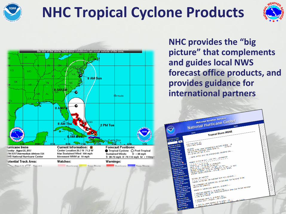
NHC Tropical Cyclone Products
NHC provides the “big picture” that complements and guides local NWS forecast office products, and provides guidance for international partners
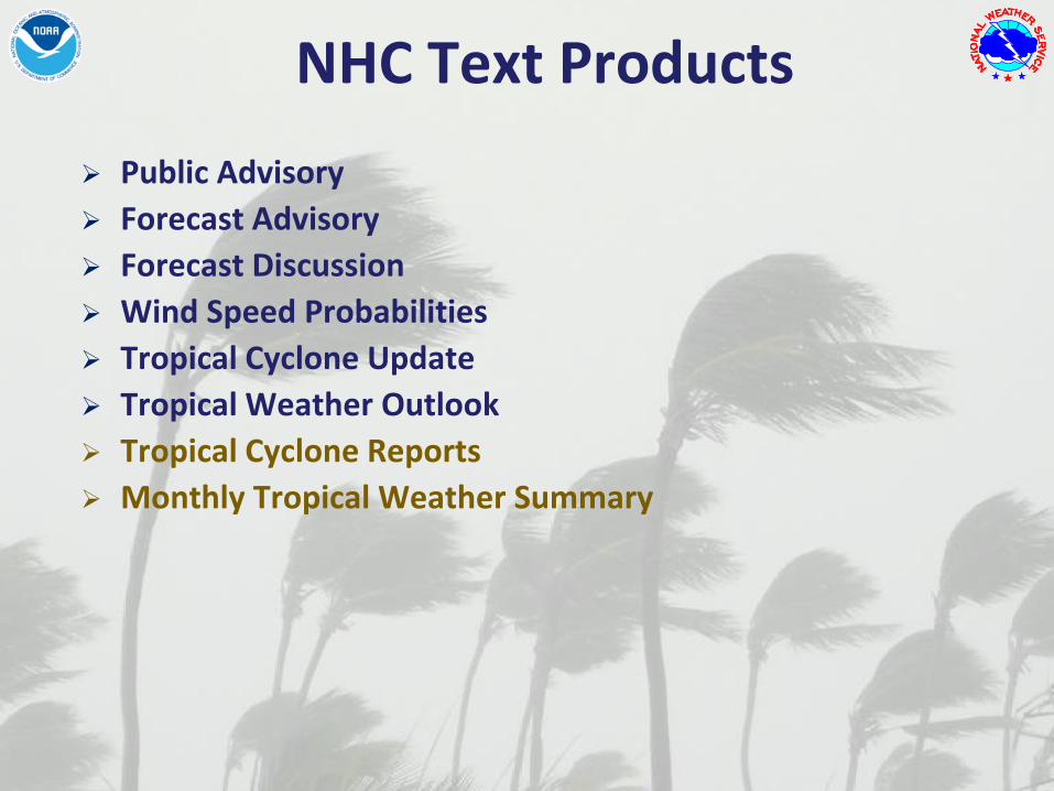
NHC Text Products
Public Advisory
Forecast Advisory
Forecast Discussion
Wind Speed Probabilities
Tropical Cyclone Update
Tropical Weather Outlook
Tropical Cyclone Reports
Monthly Tropical Weather Summary

NHC Graphical Products
Track Forecast Cone
Surface Wind Field
Surface Wind Speed Probabilities
Cumulative Wind History
Graphical Tropical Weather Outlook
Storm Surge Probabilities
Potential Storm Surge Flooding Map (Experimental)
Podcasts (Audio)
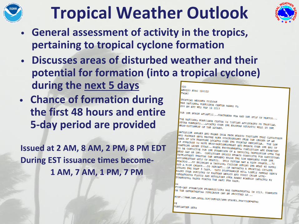
Tropical Weather Outlook• General assessment of activity in the tropics,
pertaining to tropical cyclone formation
• Discusses areas of disturbed weather and their potential for formation (into a tropical cyclone) during the next 5 days
Issued at 2 AM, 8 AM, 2 PM, 8 PM EDT
During EST issuance times become-
1 AM, 7 AM, 1 PM, 7 PM
• Chance of formation during the first 48 hours and entire 5-day period are provided
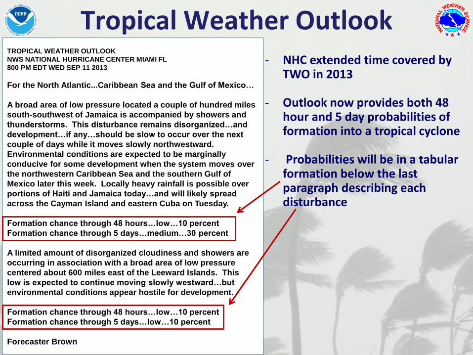
TROPICAL WEATHER OUTLOOK
NWS NATIONAL HURRICANE CENTER MIAMI FL
800 PM EDT WED SEP 11 2013
For the North Atlantic...Caribbean Sea and the Gulf of Mexico…
A broad area of low pressure located a couple of hundred miles
south-southwest of Jamaica is accompanied by showers and
thunderstorms. This disturbance remains disorganized…and
development…if any…should be slow to occur over the next
couple of days while it moves slowly northwestward.
Environmental conditions are expected to be marginally
conducive for some development when the system moves over
the northwestern Caribbean Sea and the southern Gulf of
Mexico later this week. Locally heavy rainfall is possible over
portions of Haiti and Jamaica today…and will likely spread
across the Cayman Island and eastern Cuba on Tuesday.
Formation chance through 48 hours…low…10 percent
Formation chance through 5 days…medium…30 percent
A limited amount of disorganized cloudiness and showers are
occurring in association with a broad area of low pressure
centered about 600 miles east of the Leeward Islands. This
low is expected to continue moving slowly westward…but
environmental conditions appear hostile for development.
Formation chance through 48 hours…low…10 percent
Formation chance through 5 days…low…10 percent
Forecaster Brown
- NHC extended time covered by TWO in 2013
- Outlook now provides both 48 hour and 5 day probabilities of formation into a tropical cyclone
- Probabilities will be in a tabular formation below the last paragraph describing each disturbance
Tropical Weather Outlook
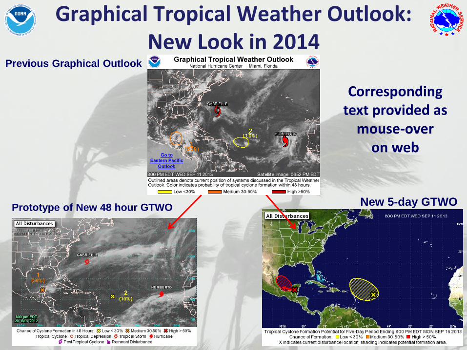
Graphical Tropical Weather Outlook: New Look in 2014
Prototype of New 48 hour GTWONew 5-day GTWO
Previous Graphical Outlook
Corresponding text provided as
mouse-over on web
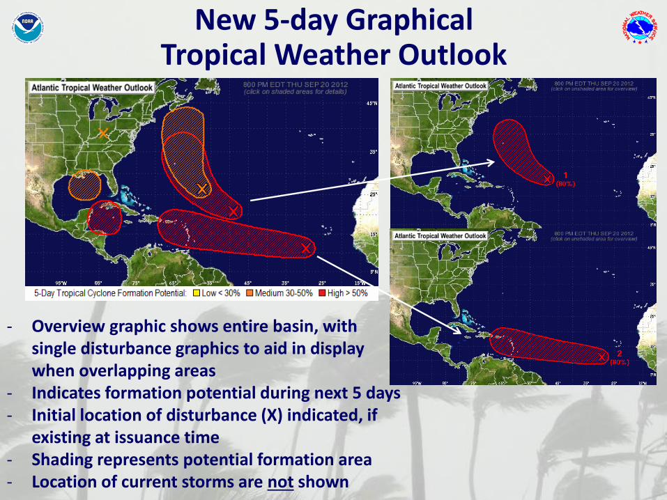
- Overview graphic shows entire basin, with single disturbance graphics to aid in display when overlapping areas
- Indicates formation potential during next 5 days- Initial location of disturbance (X) indicated, if
existing at issuance time- Shading represents potential formation area- Location of current storms are not shown
New 5-day Graphical Tropical Weather Outlook
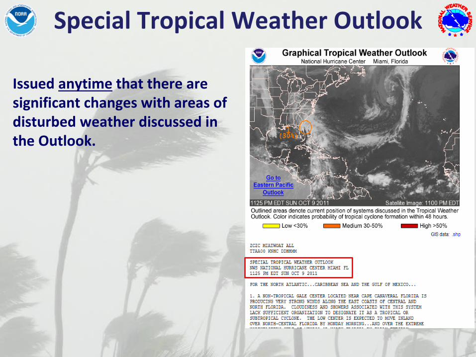
Issued anytime that there are significant changes with areas of disturbed weather discussed in the Outlook.
Special Tropical Weather Outlook

NHC Tropical Cyclone Advisory Products
Plain-language text product originally intended for “rip and read”.
Public Advisory
• Headline or lead statement• Watches and warnings• Center location, motion,
forecast• Wind speed and forecast• Storm surge, rainfall,
tornadoes, and generalized timing of wind arrival
• Tornadoes• Recommended actions

NHC Tropical Cyclone Advisory Products
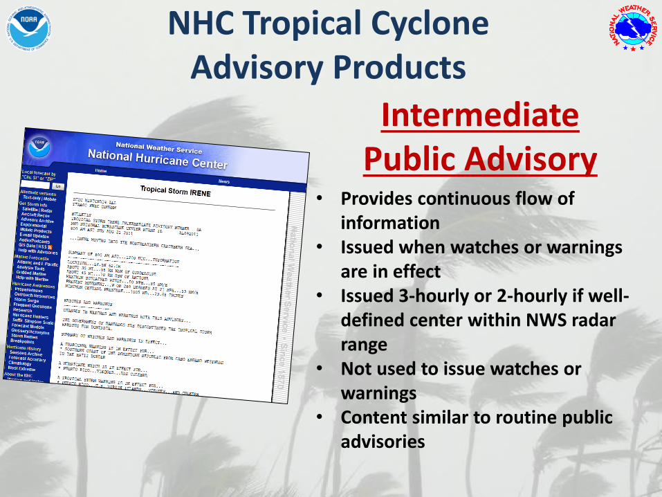
NHC Tropical Cyclone Advisory Products
• Provides continuous flow of information
• Issued when watches or warnings are in effect
• Issued 3-hourly or 2-hourly if well-defined center within NWS radar range
• Not used to issue watches or warnings
• Content similar to routine public advisories
Intermediate Public Advisory
NHC Tropical Cyclone Advisory Products
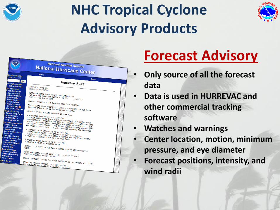
• Only source of all the forecast data
• Data is used in HURREVAC and other commercial tracking software
• Watches and warnings• Center location, motion, minimum
pressure, and eye diameter• Forecast positions, intensity, and
wind radii
Forecast Advisory

NHC Tropical Cyclone Advisory Products
• Depicts location-specific probabilities of tropical-storm-force, 58 mph, and hurricane-force winds.
• Contains cumulative and individual time period onset probabilities for a fixed set of locations
• More of this product from Dr. Brennan next
Wind Speed Probabilities

NHC Tropical Cyclone Advisory Products
• Free-form text product• Provides the reasoning behind
forecasts and warnings• Discussion of relevant
observations, model guidance, and the forecast uncertainties
• Includes table of track and intensity forecasts
• Will be in mixed case startingthis year
Forecast Discussion
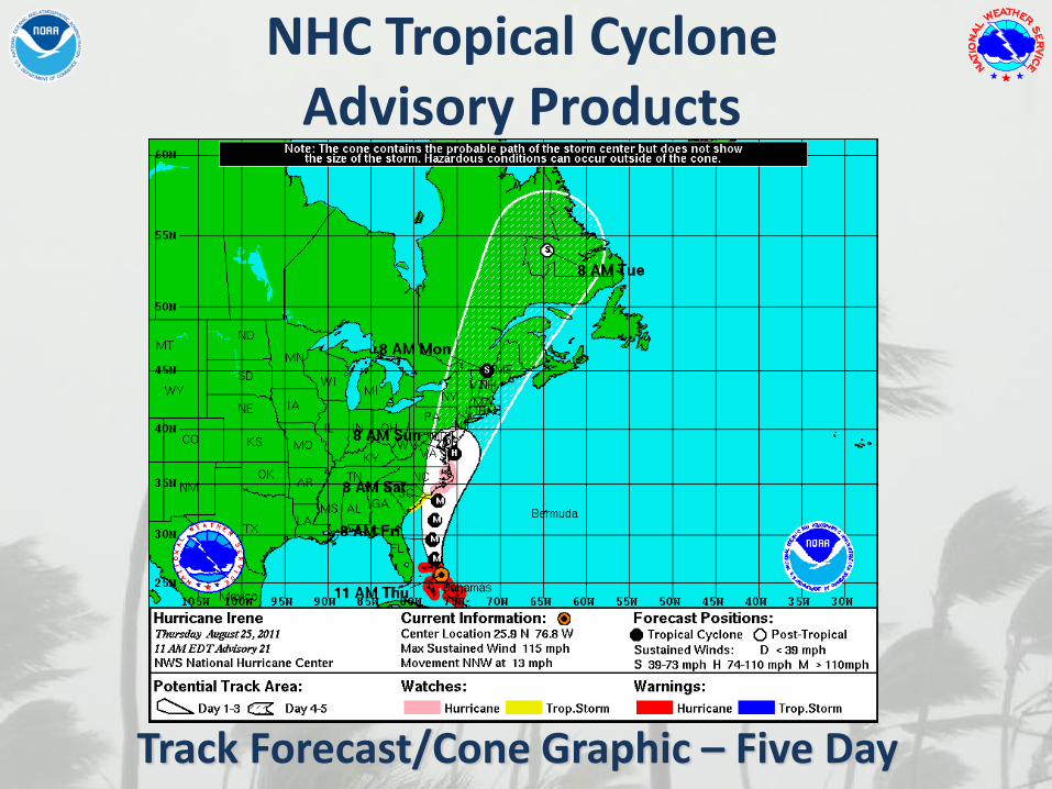
Track Forecast/Cone Graphic – Five Day
NHC Tropical Cyclone Advisory Products
NHC Tropical Cyclone Advisory Products
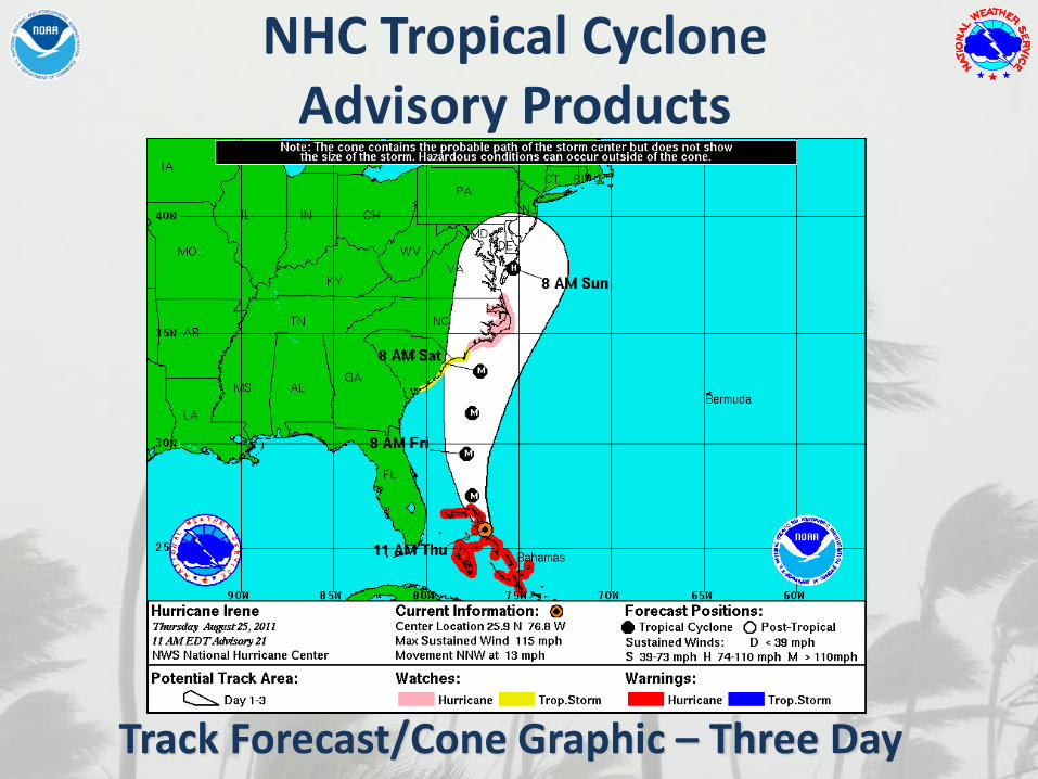
Track Forecast/Cone Graphic – Three Day

NHC Tropical Cyclone Advisory Products
Shows:
• Wind field
• Past track
• Current watches & warnings
Surface Wind Field
NHC Tropical Cyclone Advisory Products
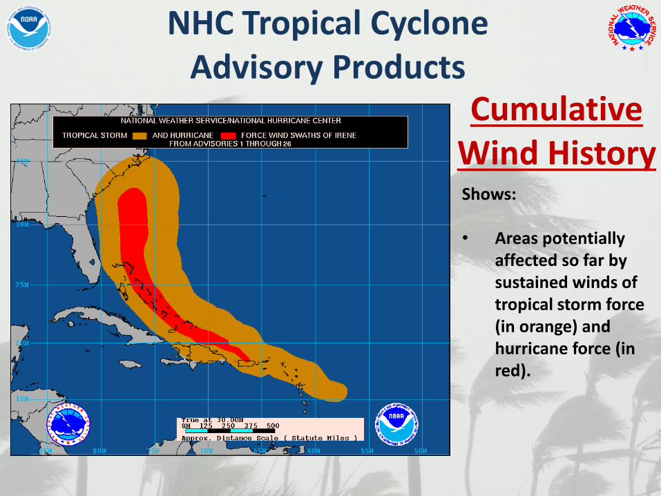
Cumulative Wind HistoryShows:
• Areas potentially affected so far by sustained winds of tropical storm force (in orange) and hurricane force (in red).
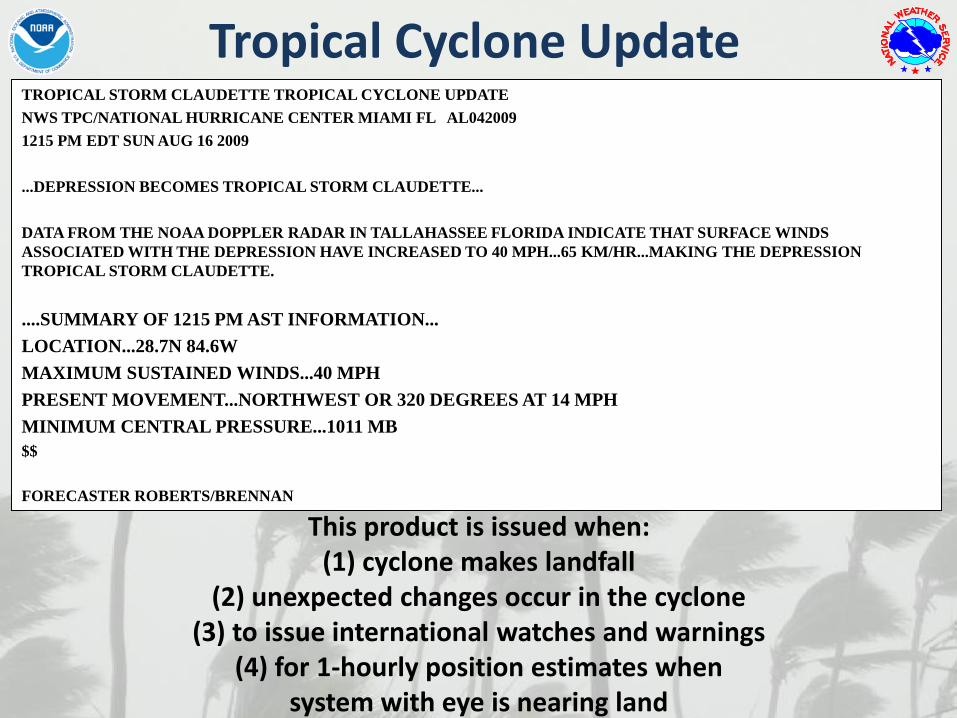
Tropical Cyclone UpdateTROPICAL STORM CLAUDETTE TROPICAL CYCLONE UPDATE
NWS TPC/NATIONAL HURRICANE CENTER MIAMI FL AL042009
1215 PM EDT SUN AUG 16 2009
...DEPRESSION BECOMES TROPICAL STORM CLAUDETTE...
DATA FROM THE NOAA DOPPLER RADAR IN TALLAHASSEE FLORIDA INDICATE THAT SURFACE WINDS
ASSOCIATED WITH THE DEPRESSION HAVE INCREASED TO 40 MPH...65 KM/HR...MAKING THE DEPRESSION
TROPICAL STORM CLAUDETTE.
....SUMMARY OF 1215 PM AST INFORMATION...
LOCATION...28.7N 84.6W
MAXIMUM SUSTAINED WINDS...40 MPH
PRESENT MOVEMENT...NORTHWEST OR 320 DEGREES AT 14 MPH
MINIMUM CENTRAL PRESSURE...1011 MB
$$
FORECASTER ROBERTS/BRENNAN
This product is issued when:(1) cyclone makes landfall
(2) unexpected changes occur in the cyclone (3) to issue international watches and warnings
(4) for 1-hourly position estimates when system with eye is nearing land
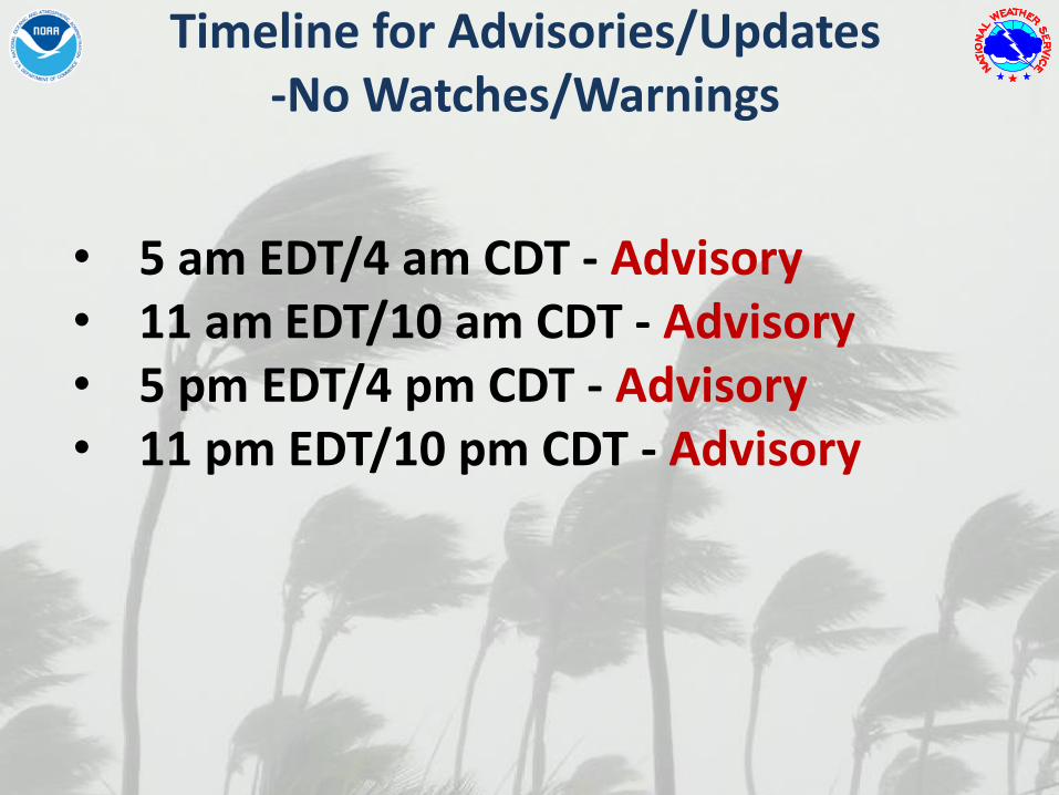
Timeline for Advisories/Updates-No Watches/Warnings
• 5 am EDT/4 am CDT - Advisory• 11 am EDT/10 am CDT - Advisory• 5 pm EDT/4 pm CDT - Advisory• 11 pm EDT/10 pm CDT - Advisory
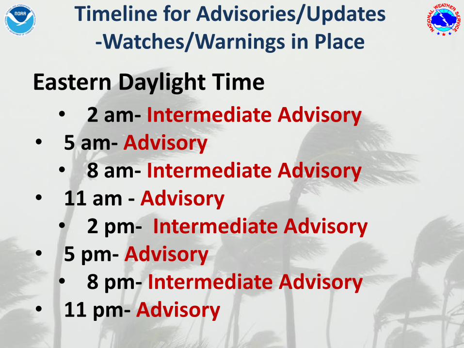
• 2 am- Intermediate Advisory• 5 am- Advisory• 8 am- Intermediate Advisory
• 11 am - Advisory• 2 pm- Intermediate Advisory
• 5 pm- Advisory• 8 pm- Intermediate Advisory
• 11 pm- Advisory
Eastern Daylight Time
Timeline for Advisories/Updates-Watches/Warnings in Place

• 11 am - Advisory• 12 pm- Tropical Cyclone Update• 1 pm- Intermediate Advisory• 2 pm- Tropical Cyclone Update• 3 pm- Intermediate Advisory• 4 pm- Tropical Cyclone Update
• 5 pm- Repeat…
Eastern Daylight Time
Timeline for Advisories/Updates-Watches/Warnings in place and center can be tracked by Radar

GIS Products
• Forecast Cone/Track/Points/Watches and Warnings
• Surface Wind Field
• Working Best Track Wind Swath
• Forecast Wind Radii
• Breakpoints
• Wind Speed Probability
• Probabilistic Storm Surge
www.nhc.noaa.gov/gis/

Other NHC Tropical Cyclone Related Products
Tropical Weather Summary
ABNT30 KNHC 011156
TWSAT
MONTHLY TROPICAL WEATHER SUMMARY
NWS TPC/NATIONAL HURRICANE CENTER MIAMI FL
800 AM EDT FRI OCT 01 2010
FOR THE NORTH ATLANTIC...CARIBBEAN SEA AND THE GULF OF MEXICO...
EIGHT TROPICAL STORMS FORMED IN THE ATLANTIC BASIN DURING THE MONTH
OF SEPTEMBER. THREE OF THESE STORMS...IGOR...JULIA...AND KARL...
BECAME MAJOR HURRICANES...AND LISA REACHED HURRICANE STATUS. THESE
NUMBERS ARE WELL ABOVE THE LONG-TERM (1944-2009) AVERAGES OF 4
TROPICAL STORMS...2 HURRICANES...AND ABOUT 1 MAJOR HURRICANE FOR THE
MONTH OF SEPTEMBER. ALSO...THE FORMATION OF EIGHT NAMED STORMS
TIES 2002 FOR THE RECORD NUMBER OF NAMED STORMS FORMING IN THE
MONTH OF SEPTEMBER. IN TERMS OF ACCUMULATED CYCLONE ENERGY...
ACE...WHICH MEASURES THE COMBINED STRENGTH AND DURATION OF TROPICAL
STORMS AND HURRICANES...TROPICAL CYCLONE ACTIVITY IN SEPTEMBER WAS
ABOUT 78 PERCENT ABOVE AVERAGE.
SO FAR THIS SEASON...OVERALL TROPICAL CYCLONE ACTIVITY TO DATE IS
ABOUT 53 PERCENT ABOVE THE LONG-TERM MEDIAN.
REPORTS ON INDIVIDUAL CYCLONES...WHEN COMPLETED...ARE AT THE WEB
SITE OF THE NATIONAL HURRICANE CENTER...USE LOWER-CASE
LETTERS...HTTP://WWW.NHC.NOAA.GOV/2010ATLAN.SHTML
SUMMARY TABLE
NAME DATES MAX WIND (MPH)
----------------------------------------------------
H ALEX 25 JUN-2 JUL 105
TD TWO 7-8 JUL 35
TS BONNIE 22-24 JUL 40
TS COLIN 2-8 AUG 60
TD FIVE 10-11 AUG 35
MH DANIELLE 21-31 AUG 135
MH EARL 25 AUG-5 SEP 145
TS FIONA 30 AUG-4 SEP 60
TS GASTON 1-2 SEP 40
TS HERMINE 6-8 SEP 65
MH IGOR 8-21 SEP 155
MH JULIA 12-20 SEP 135
MH KARL 14-18 SEP 120
H LISA 21-26 SEP 80
TS MATTHEW 23-26 SEP 60
• Issued on the first of each month from July-Dec
• Summarizes tropical cyclones that occurred during the previous month
• Provides preliminary statistics of the season thus far

Preliminary Track Maps
Other NHC Tropical Cyclone Related Products
• Posted to NHC website around the 1st of each month
• Provides preliminary tracks of the season’s tropical cyclones to date
• Operational track & intensities shown until final “best-track” issued

Other NHC Tropical Cyclone Related Products
Tropical CycloneReports
• Reports are completed weeks to a couple of months after each storm
• Posted to NHC website• Provide final track,
intensity, and size information
• Discusses damage and casualties, and provides forecast critique

Questions/Comments?


