1
Newell RoadSan Francisquito Creek Bridge
Replacement Project
Community Meeting
February 27th, 2014
2
• Welcome and IntroductionsJim Keene, Palo Alto City ManagerKamal Fallaha, East Palo Alto City Engineer
• Bridge Alternatives and Screening CriteriaBrad Eggleston, Palo Alto Assistant Public Works Director
• Alternatives Screening and Traffic AnalysisBrad Eggleston, Palo Alto Assistant Public Works Director
• Questions and Comments
Meeting Agenda
3
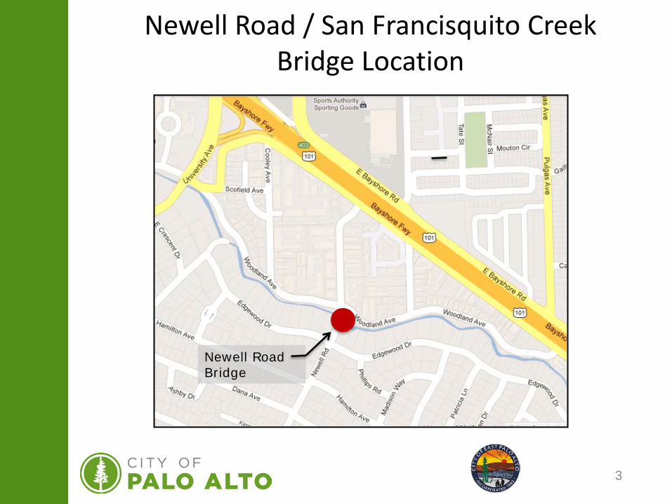
Newell Road / San Francisquito CreekBridge Location
Newell Road Bridge
4
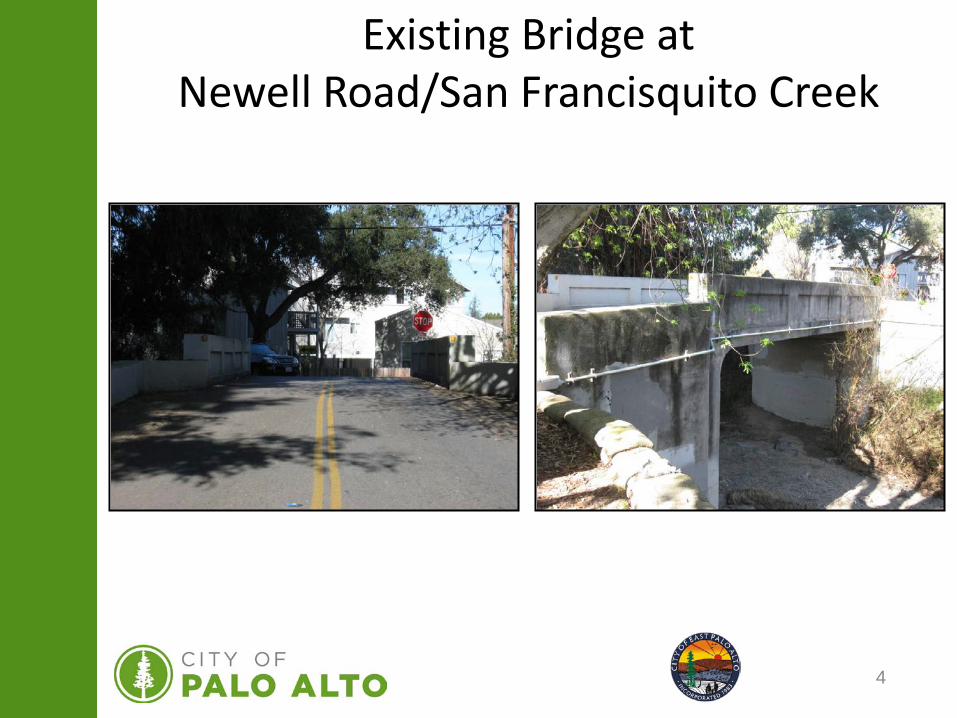
Existing Bridge atNewell Road/San Francisquito Creek
5
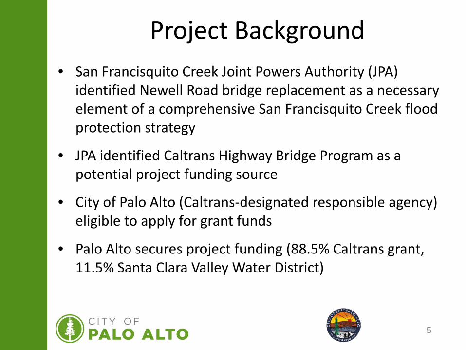
Project Background• San Francisquito Creek Joint Powers Authority (JPA)
identified Newell Road bridge replacement as a necessary element of a comprehensive San Francisquito Creek flood protection strategy
• JPA identified Caltrans Highway Bridge Program as a potential project funding source
• City of Palo Alto (Caltrans-designated responsible agency) eligible to apply for grant funds
• Palo Alto secures project funding (88.5% Caltrans grant, 11.5% Santa Clara Valley Water District)
6
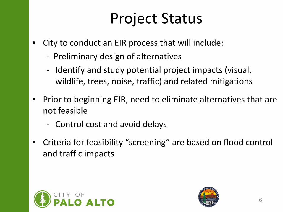
• City to conduct an EIR process that will include:- Preliminary design of alternatives- Identify and study potential project impacts (visual,
wildlife, trees, noise, traffic) and related mitigations
• Prior to beginning EIR, need to eliminate alternatives that are not feasible- Control cost and avoid delays
• Criteria for feasibility “screening” are based on flood control and traffic impacts
Project Status
7
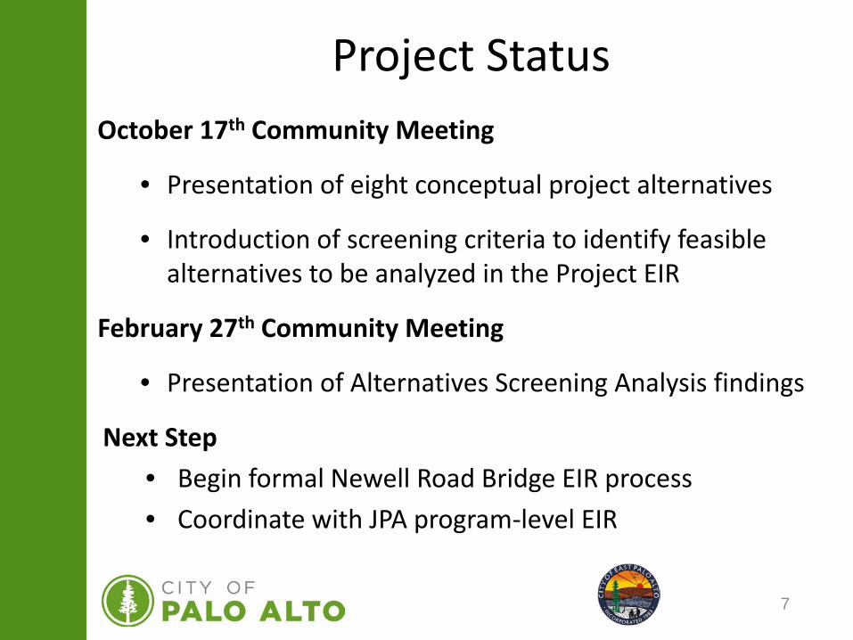
October 17th Community Meeting
• Presentation of eight conceptual project alternatives
• Introduction of screening criteria to identify feasible alternatives to be analyzed in the Project EIR
February 27th Community Meeting
• Presentation of Alternatives Screening Analysis findings
Next Step• Begin formal Newell Road Bridge EIR process• Coordinate with JPA program-level EIR
Project Status
8
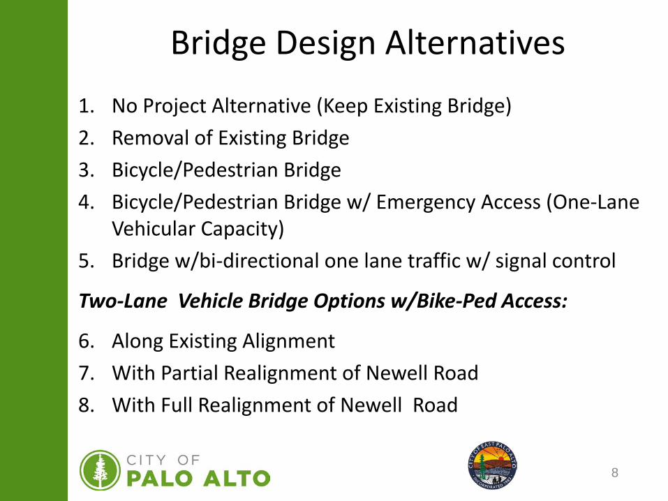
Bridge Design Alternatives1. No Project Alternative (Keep Existing Bridge)2. Removal of Existing Bridge3. Bicycle/Pedestrian Bridge4. Bicycle/Pedestrian Bridge w/ Emergency Access (One-Lane
Vehicular Capacity)5. Bridge w/bi-directional one lane traffic w/ signal control
Two-Lane Vehicle Bridge Options w/Bike-Ped Access:
6. Along Existing Alignment7. With Partial Realignment of Newell Road8. With Full Realignment of Newell Road
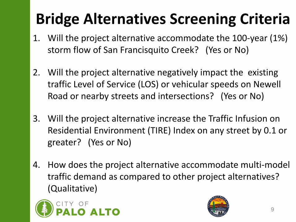
9
Bridge Alternatives Screening Criteria1. Will the project alternative accommodate the 100-year (1%)
storm flow of San Francisquito Creek? (Yes or No)
2. Will the project alternative negatively impact the existing traffic Level of Service (LOS) or vehicular speeds on Newell Road or nearby streets and intersections? (Yes or No)
3. Will the project alternative increase the Traffic Infusion on Residential Environment (TIRE) Index on any street by 0.1 or greater? (Yes or No)
4. How does the project alternative accommodate multi-model traffic demand as compared to other project alternatives? (Qualitative)
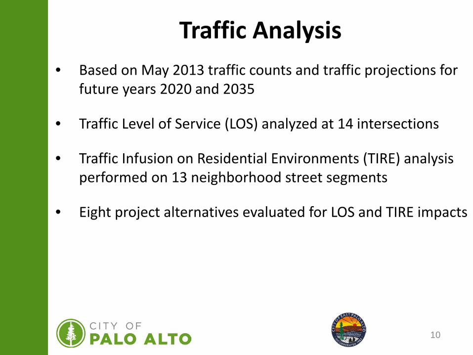
10
Traffic Analysis• Based on May 2013 traffic counts and traffic projections for
future years 2020 and 2035
• Traffic Level of Service (LOS) analyzed at 14 intersections
• Traffic Infusion on Residential Environments (TIRE) analysis performed on 13 neighborhood street segments
• Eight project alternatives evaluated for LOS and TIRE impacts
11
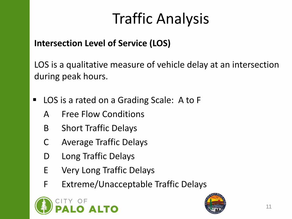
Traffic AnalysisIntersection Level of Service (LOS)
LOS is a qualitative measure of vehicle delay at an intersection during peak hours.
LOS is a rated on a Grading Scale: A to FA Free Flow ConditionsB Short Traffic DelaysC Average Traffic DelaysD Long Traffic DelaysE Very Long Traffic DelaysF Extreme/Unacceptable Traffic Delays
12
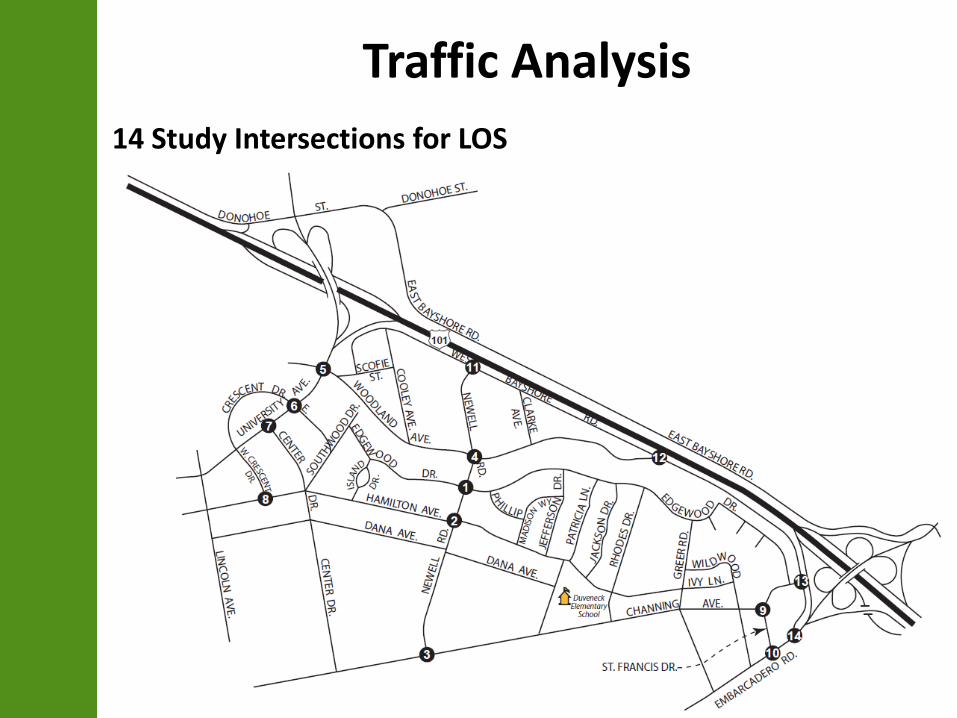
Traffic Analysis14 Study Intersections for LOS
13
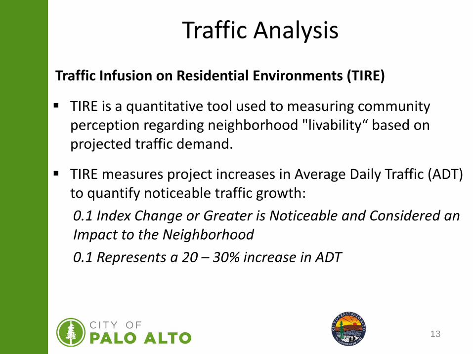
Traffic Analysis
Traffic Infusion on Residential Environments (TIRE)
TIRE is a quantitative tool used to measuring community perception regarding neighborhood "livability“ based on projected traffic demand.
TIRE measures project increases in Average Daily Traffic (ADT) to quantify noticeable traffic growth:0.1 Index Change or Greater is Noticeable and Considered an Impact to the Neighborhood0.1 Represents a 20 – 30% increase in ADT
14
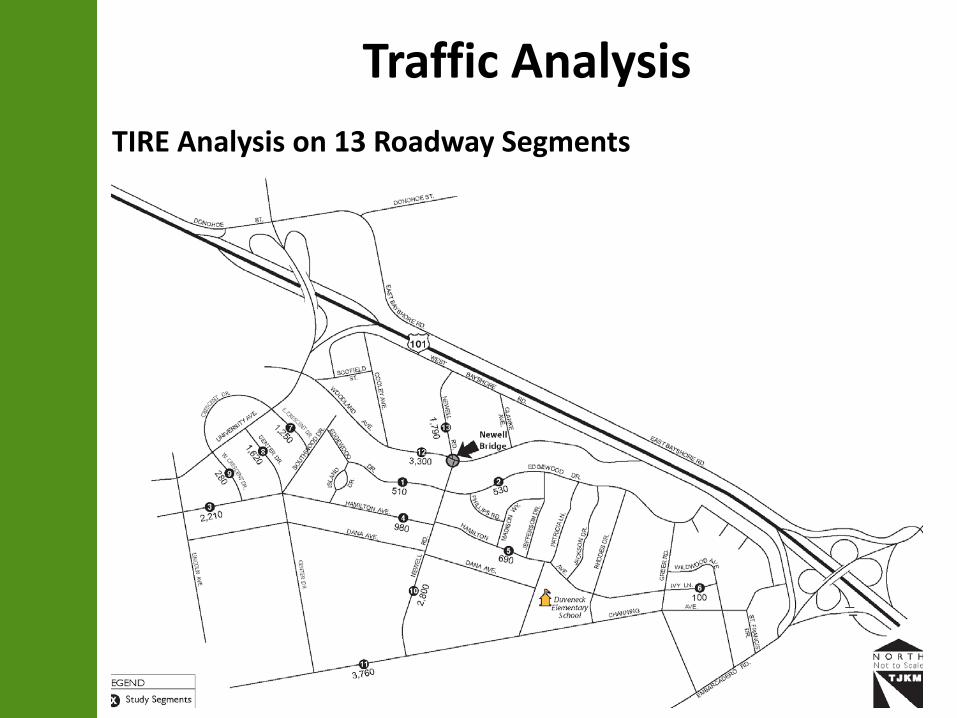
Traffic AnalysisTIRE Analysis on 13 Roadway Segments

15
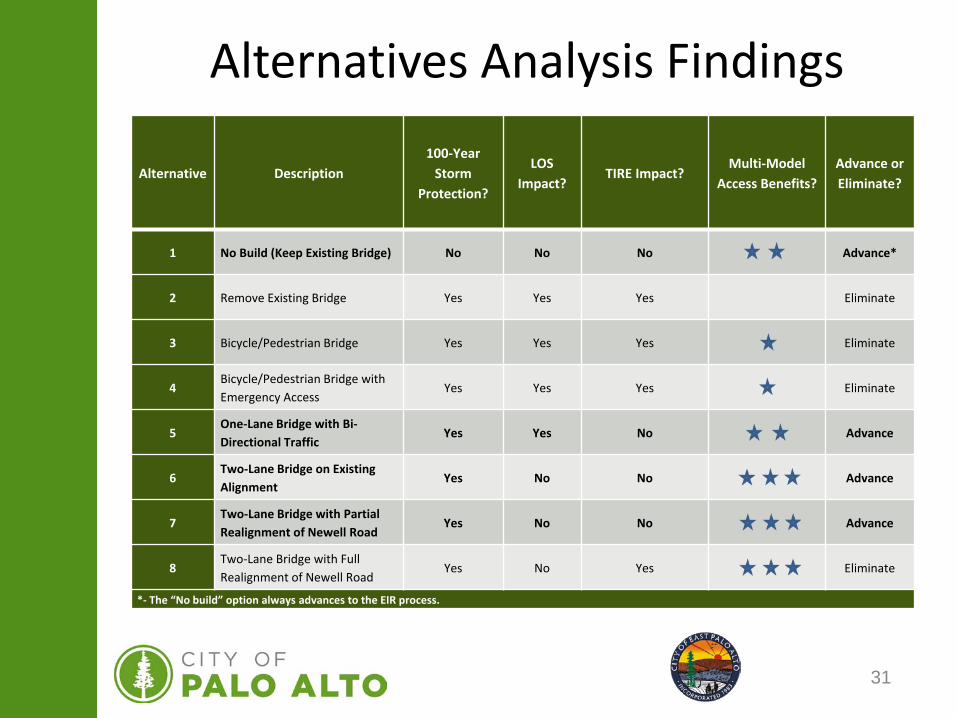
Alternatives Analysis Findings
Alternative Description100-Year
Storm Protection?
LOSImpact?
TIRE Impact?Multi-Model
Access Benefits?Advance or Eliminate?
1 No Build (Keep Existing Bridge) No No No Advance*
2 Remove Existing Bridge Yes Yes Yes Eliminate
3 Bicycle/Pedestrian Bridge Yes Yes Yes Eliminate
4Bicycle/Pedestrian Bridge with Emergency Access
Yes Yes Yes Eliminate
5One-Lane Bridge with Bi-Directional Traffic
Yes Yes No Advance
6Two-Lane Bridge on Existing Alignment
Yes No No Advance
7Two-Lane Bridge with Partial Realignment of Newell Road
Yes No No Advance
8Two-Lane Bridge with Full Realignment of Newell Road
Yes No Yes Eliminate
*- The “No build” option always advances to the EIR process.
16
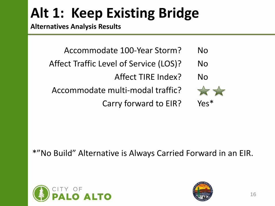
Alt 1: Keep Existing BridgeAlternatives Analysis Results
Accommodate 100-Year Storm?Affect Traffic Level of Service (LOS)?
Affect TIRE Index?Accommodate multi-modal traffic?
Carry forward to EIR?
NoNoNo
Yes*
*”No Build” Alternative is Always Carried Forward in an EIR.
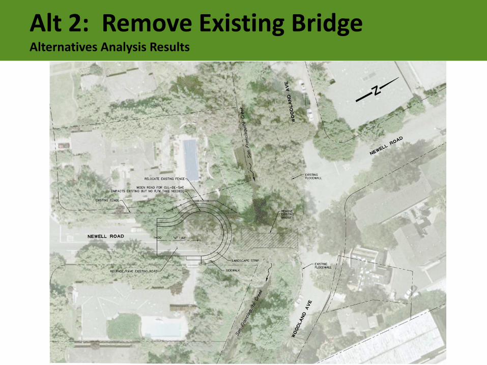
Alt 2: Remove Existing BridgeAlternatives Analysis Results
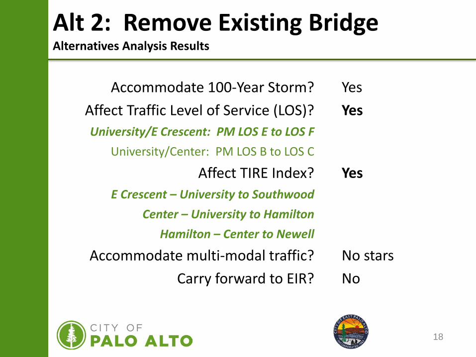
18
YesYes
Yes
No starsNo
Alt 2: Remove Existing BridgeAlternatives Analysis Results
Accommodate 100-Year Storm?Affect Traffic Level of Service (LOS)?University/E Crescent: PM LOS E to LOS F
University/Center: PM LOS B to LOS C
Affect TIRE Index?E Crescent – University to Southwood
Center – University to HamiltonHamilton – Center to Newell
Accommodate multi-modal traffic?Carry forward to EIR?
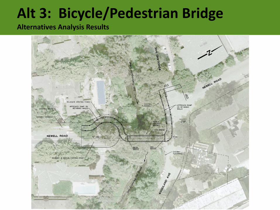
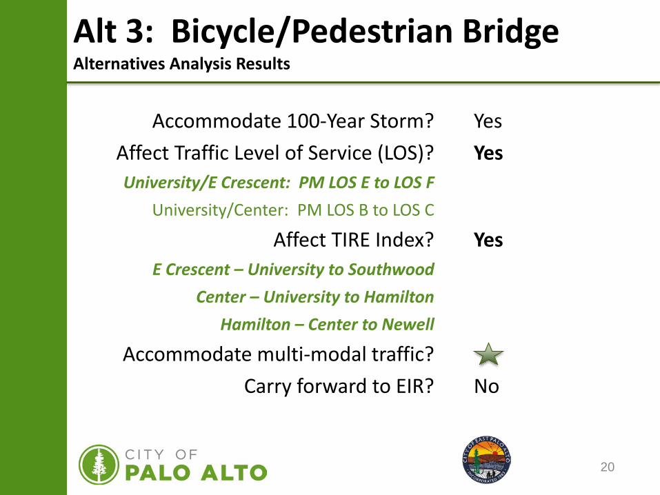
Alt 3: Bicycle/Pedestrian BridgeAlternatives Analysis Results
20
Alt 3: Bicycle/Pedestrian BridgeAlternatives Analysis Results
Accommodate 100-Year Storm?Affect Traffic Level of Service (LOS)?University/E Crescent: PM LOS E to LOS F
University/Center: PM LOS B to LOS C
Affect TIRE Index?E Crescent – University to Southwood
Center – University to HamiltonHamilton – Center to Newell
Accommodate multi-modal traffic?Carry forward to EIR?
YesYes
Yes
No
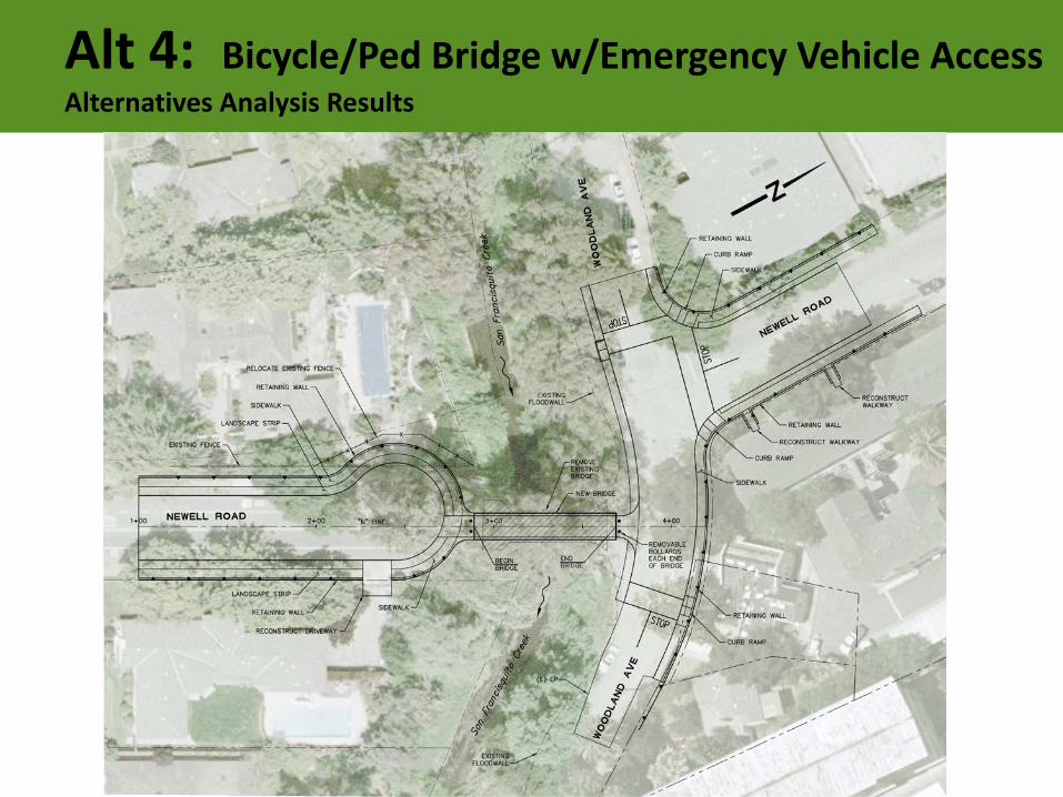
Alt 4: Bicycle/Ped Bridge w/Emergency Vehicle AccessAlternatives Analysis Results
22
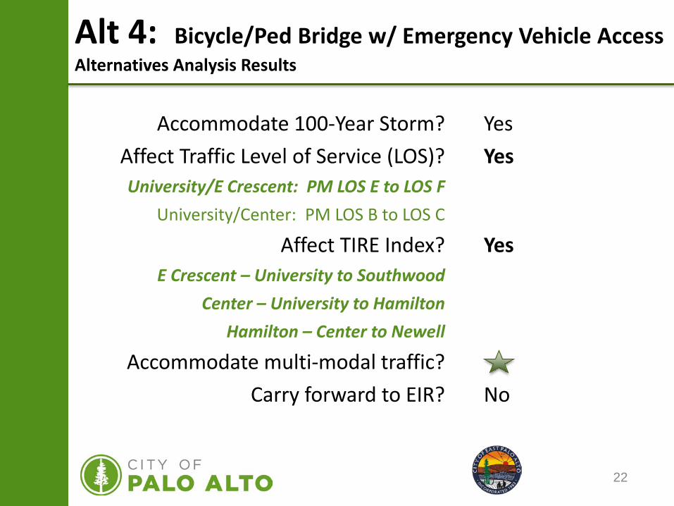
Alt 4: Bicycle/Ped Bridge w/ Emergency Vehicle AccessAlternatives Analysis Results
Accommodate 100-Year Storm?Affect Traffic Level of Service (LOS)?University/E Crescent: PM LOS E to LOS F
University/Center: PM LOS B to LOS C
Affect TIRE Index?E Crescent – University to Southwood
Center – University to HamiltonHamilton – Center to Newell
Accommodate multi-modal traffic?Carry forward to EIR?
YesYes
Yes
No
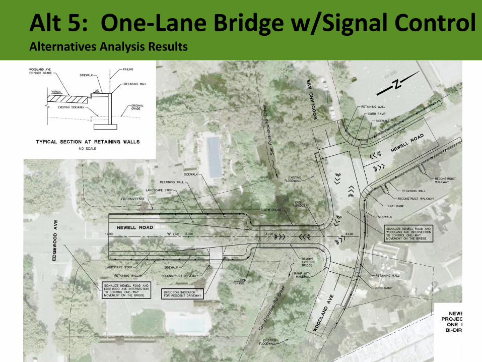
Alt 5: One-Lane Bridge w/Signal ControlAlternatives Analysis Results
24
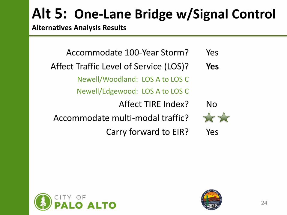
Alt 5: One-Lane Bridge w/Signal ControlAlternatives Analysis Results
Accommodate 100-Year Storm?Affect Traffic Level of Service (LOS)?
Newell/Woodland: LOS A to LOS CNewell/Edgewood: LOS A to LOS C
Affect TIRE Index?Accommodate multi-modal traffic?
Carry forward to EIR?
YesYes
No
Yes
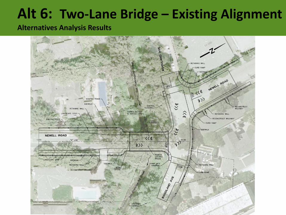
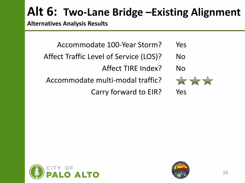
Alt 6: Two-Lane Bridge – Existing AlignmentAlternatives Analysis Results
26
Alt 6: Two-Lane Bridge –Existing AlignmentAlternatives Analysis Results
Accommodate 100-Year Storm?Affect Traffic Level of Service (LOS)?
Affect TIRE Index?Accommodate multi-modal traffic?
Carry forward to EIR?
YesNoNo
Yes
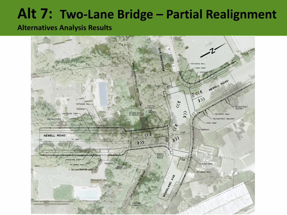
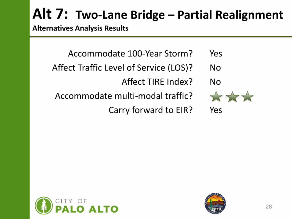
Alt 7: Two-Lane Bridge – Partial RealignmentAlternatives Analysis Results
28
Alt 7: Two-Lane Bridge – Partial RealignmentAlternatives Analysis Results
Accommodate 100-Year Storm?Affect Traffic Level of Service (LOS)?
Affect TIRE Index?Accommodate multi-modal traffic?
Carry forward to EIR?
YesNoNo
Yes
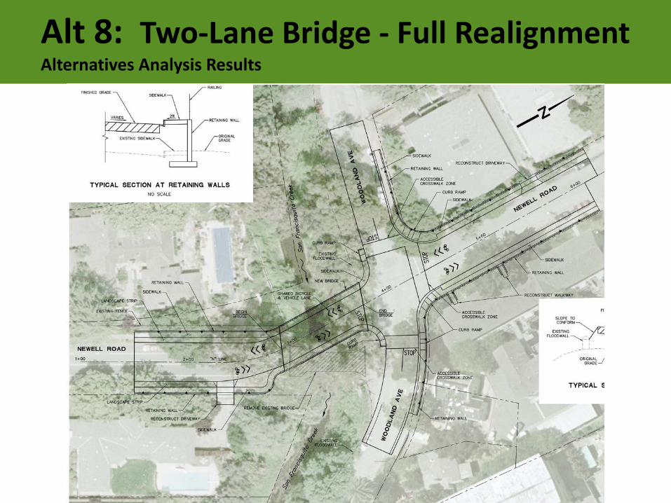
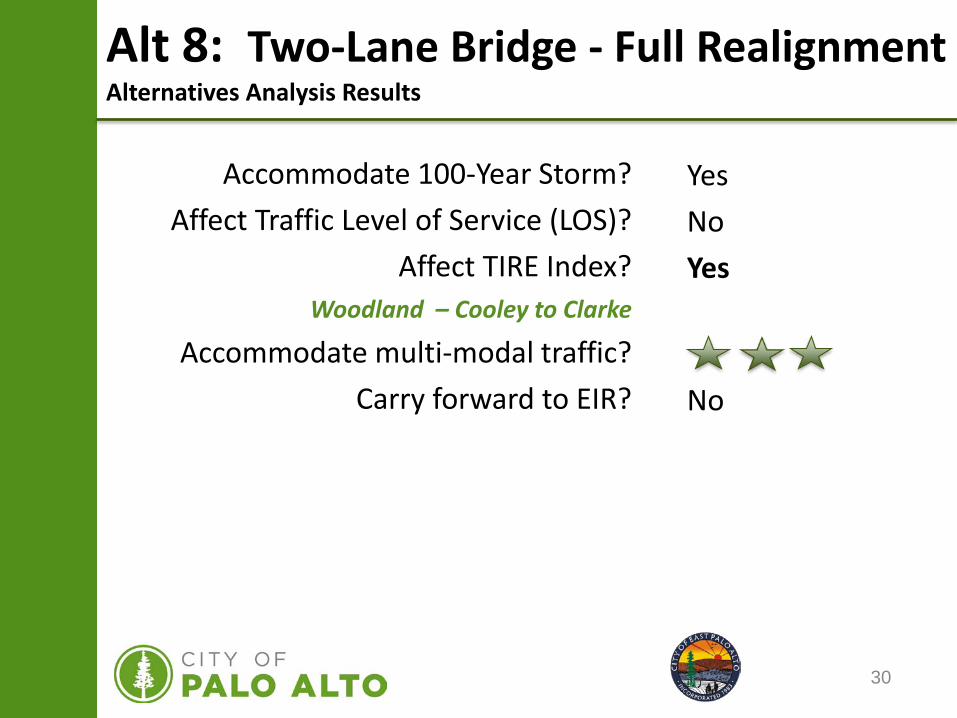
Alt 8: Two-Lane Bridge - Full RealignmentAlternatives Analysis Results
30
Alt 8: Two-Lane Bridge - Full RealignmentAlternatives Analysis Results
Accommodate 100-Year Storm?Affect Traffic Level of Service (LOS)?
Affect TIRE Index?Woodland – Cooley to Clarke
Accommodate multi-modal traffic?Carry forward to EIR?
YesNoYes
No
31
Alternatives Analysis Findings
Alternative Description100-Year
Storm Protection?
LOSImpact?
TIRE Impact?Multi-Model
Access Benefits?Advance or Eliminate?
1 No Build (Keep Existing Bridge) No No No Advance*
2 Remove Existing Bridge Yes Yes Yes Eliminate
3 Bicycle/Pedestrian Bridge Yes Yes Yes Eliminate
4Bicycle/Pedestrian Bridge with Emergency Access
Yes Yes Yes Eliminate
5One-Lane Bridge with Bi-Directional Traffic
Yes Yes No Advance
6Two-Lane Bridge on Existing Alignment
Yes No No Advance
7Two-Lane Bridge with Partial Realignment of Newell Road
Yes No No Advance
8Two-Lane Bridge with Full Realignment of Newell Road
Yes No Yes Eliminate
*- The “No build” option always advances to the EIR process.
32
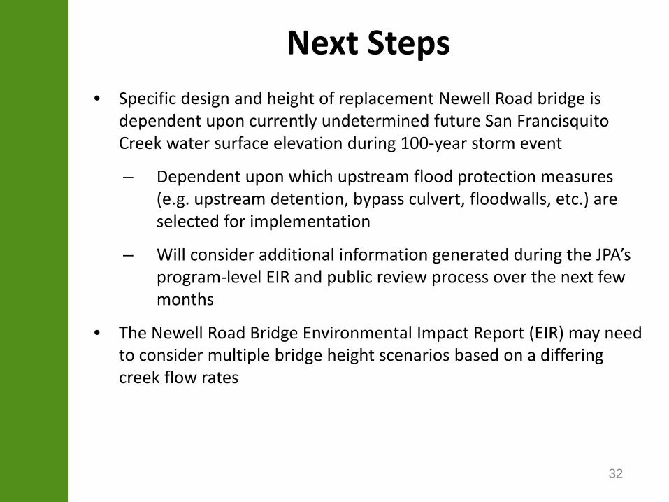
Next Steps• Specific design and height of replacement Newell Road bridge is
dependent upon currently undetermined future San FrancisquitoCreek water surface elevation during 100-year storm event
– Dependent upon which upstream flood protection measures (e.g. upstream detention, bypass culvert, floodwalls, etc.) are selected for implementation
– Will consider additional information generated during the JPA’s program-level EIR and public review process over the next few months
• The Newell Road Bridge Environmental Impact Report (EIR) may need to consider multiple bridge height scenarios based on a differing creek flow rates
33
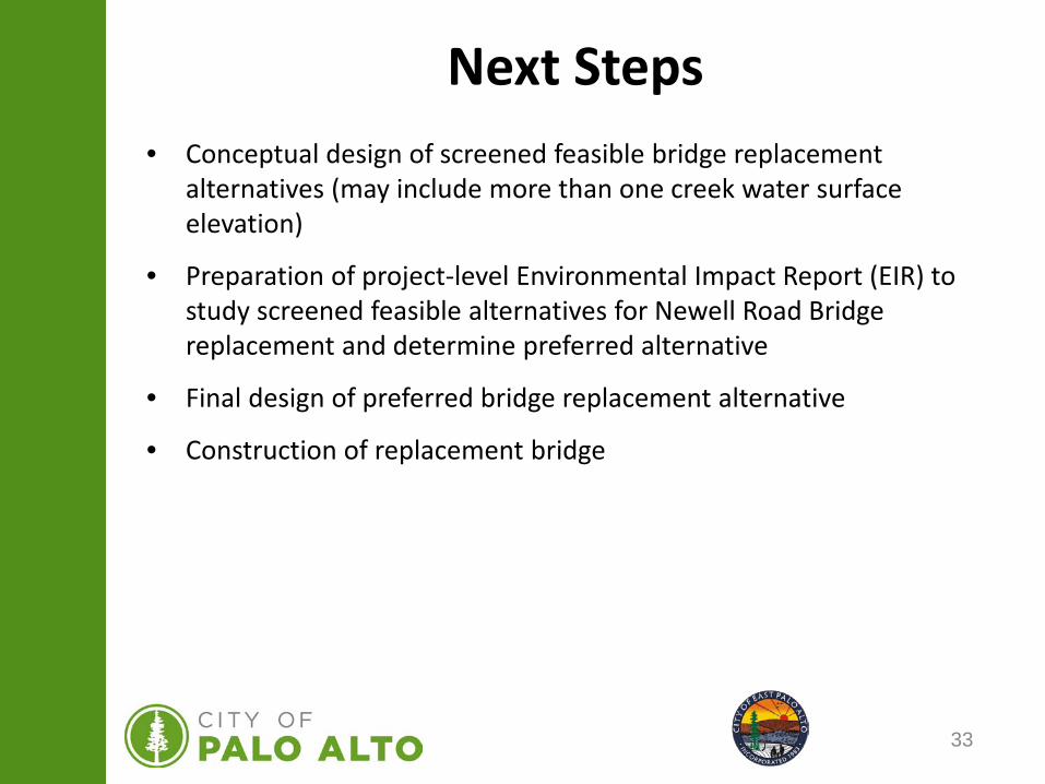
• Conceptual design of screened feasible bridge replacement alternatives (may include more than one creek water surface elevation)
• Preparation of project-level Environmental Impact Report (EIR) to study screened feasible alternatives for Newell Road Bridge replacement and determine preferred alternative
• Final design of preferred bridge replacement alternative
• Construction of replacement bridge
Next Steps
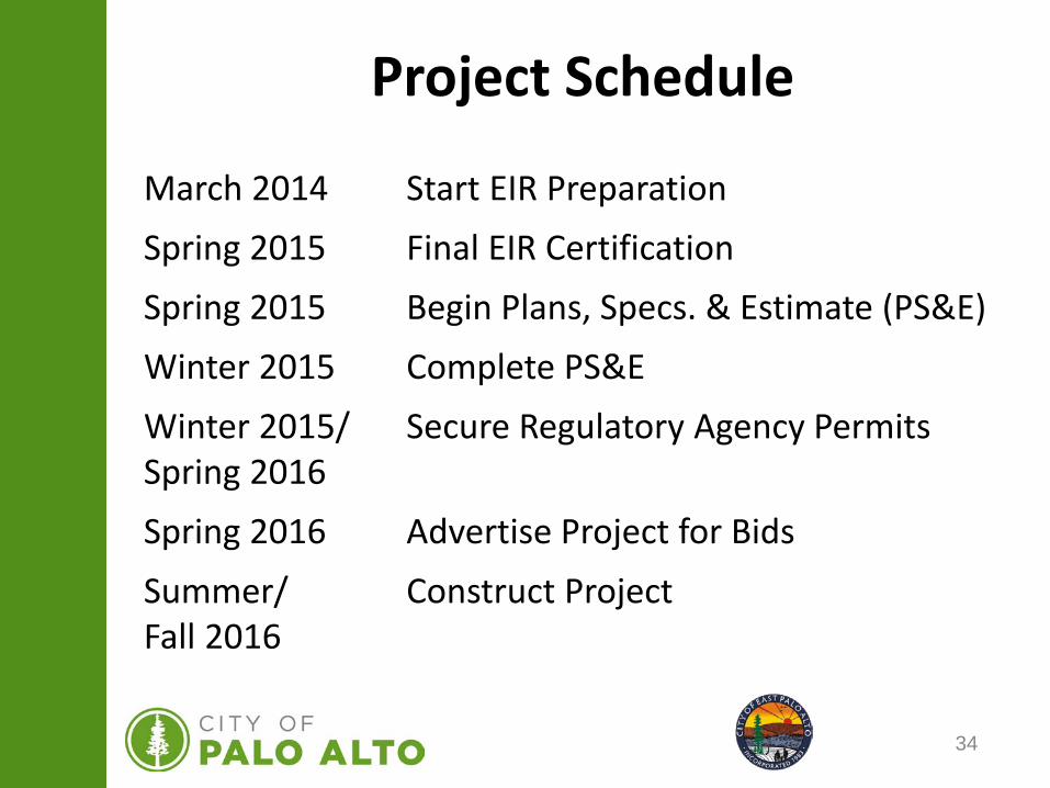
34
Project Schedule
March 2014 Start EIR PreparationSpring 2015 Final EIR CertificationSpring 2015 Begin Plans, Specs. & Estimate (PS&E)Winter 2015 Complete PS&EWinter 2015/ Secure Regulatory Agency PermitsSpring 2016Spring 2016 Advertise Project for BidsSummer/ Construct ProjectFall 2016
35
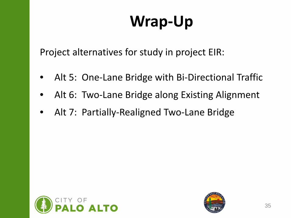
Wrap-Up
Project alternatives for study in project EIR:
• Alt 5: One-Lane Bridge with Bi-Directional Traffic
• Alt 6: Two-Lane Bridge along Existing Alignment
• Alt 7: Partially-Realigned Two-Lane Bridge
36
Community
Questions
and
Comments


