KMA report current and future satellite systems

2
Develop Earth observation KOMPSAT satellites, standard·export purpose next generation medium
satellites, and space science·research purpose next generation small satellites
Develop MEO and GEO satellites for meteorology, ocean, environmental, communications, early
warning·augmented navigation, navigation applications
National Space Development Plan of Korea
2019
3
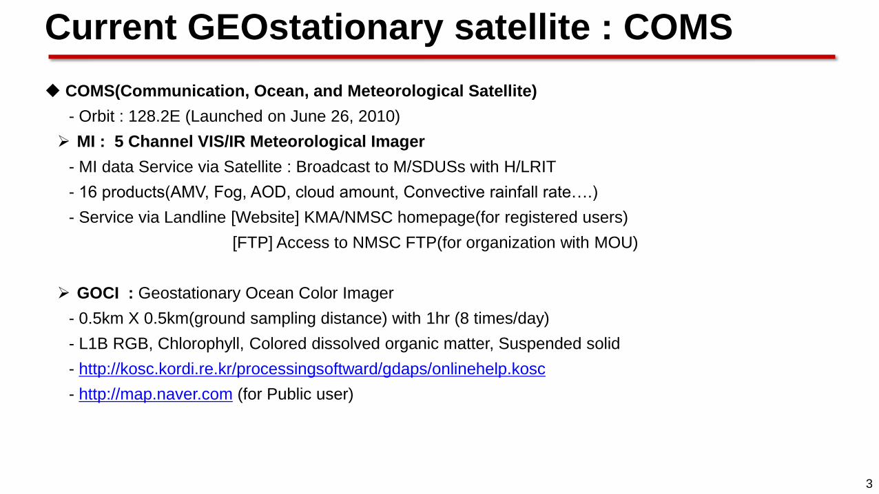
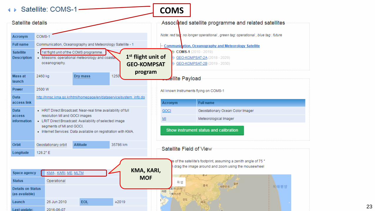
COMS(Communication, Ocean, and Meteorological Satellite)
- Orbit : 128.2E (Launched on June 26, 2010)
MI : 5 Channel VIS/IR Meteorological Imager
- MI data Service via Satellite : Broadcast to M/SDUSs with H/LRIT
- 16 products(AMV, Fog, AOD, cloud amount, Convective rainfall rate….)
- Service via Landline [Website] KMA/NMSC homepage(for registered users)
[FTP] Access to NMSC FTP(for organization with MOU)
GOCI : Geostationary Ocean Color Imager
- 0.5km X 0.5km(ground sampling distance) with 1hr (8 times/day)
- L1B RGB, Chlorophyll, Colored dissolved organic matter, Suspended solid
- http://kosc.kordi.re.kr/processingsoftward/gdaps/onlinehelp.kosc
- http://map.naver.com (for Public user)
Current GEOstationary satellite : COMS
4
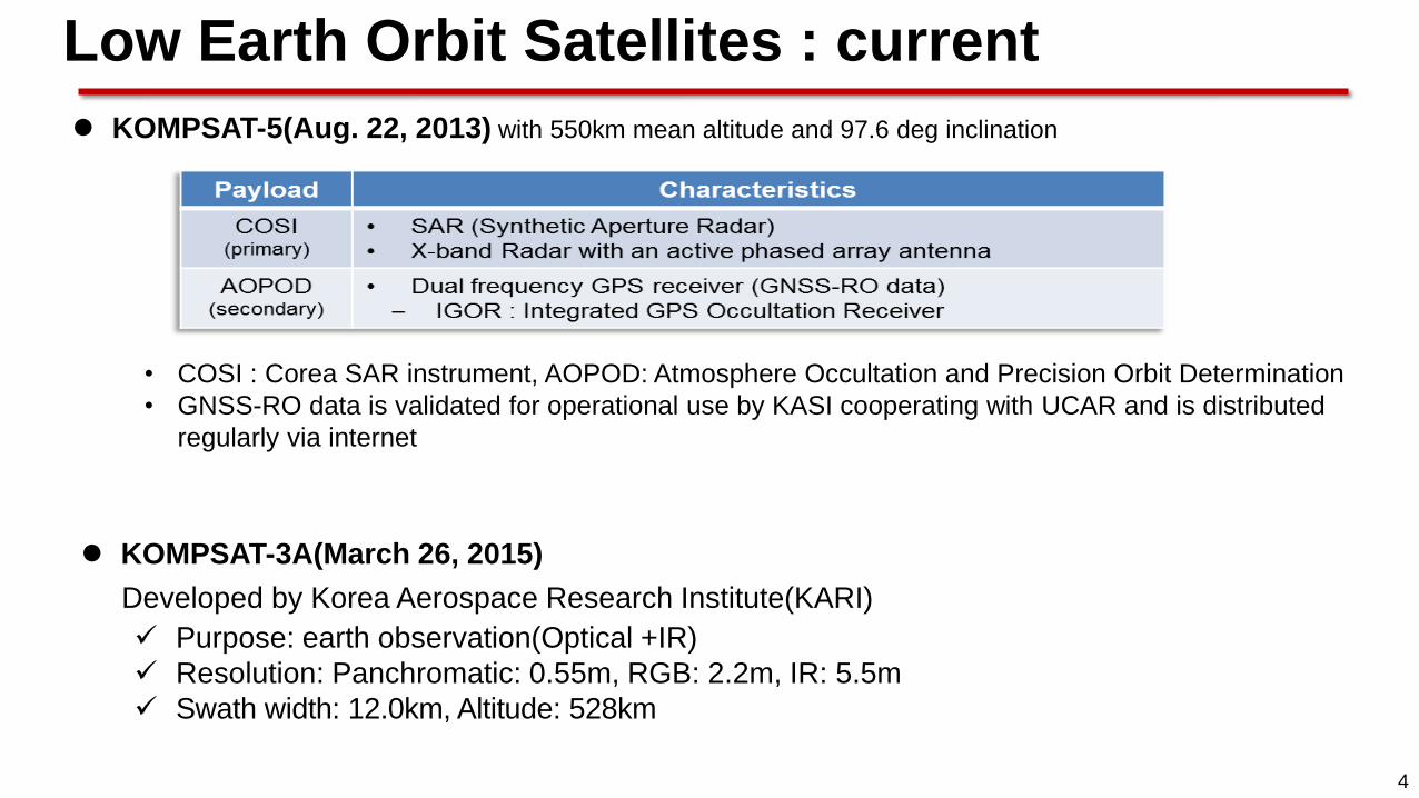
KOMPSAT-5(Aug. 22, 2013) with 550km mean altitude and 97.6 deg inclination
• COSI : Corea SAR instrument, AOPOD: Atmosphere Occultation and Precision Orbit Determination
• GNSS-RO data is validated for operational use by KASI cooperating with UCAR and is distributed
regularly via internet
KOMPSAT-3A(March 26, 2015)
Developed by Korea Aerospace Research Institute(KARI)
Purpose: earth observation(Optical +IR)
Resolution: Panchromatic: 0.55m, RGB: 2.2m, IR: 5.5m
Swath width: 12.0km, Altitude: 528km
Low Earth Orbit Satellites : current
5
Sector Satellite in Orbit Operator Location Launch date Environmental payload and status
West
Pacific
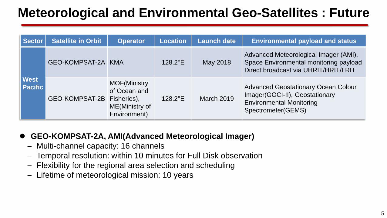
GEO-KOMPSAT-2A KMA 128.2°E May 2018
Advanced Meteorological Imager (AMI),
Space Environmental monitoring payload
Direct broadcast via UHRIT/HRIT/LRIT
GEO-KOMPSAT-2B
MOF(Ministry
of Ocean and
Fisheries),
ME(Ministry of
Environment)
128.2°E March 2019
Advanced Geostationary Ocean Colour
Imager(GOCI-II), Geostationary
Environmental Monitoring
Spectrometer(GEMS)
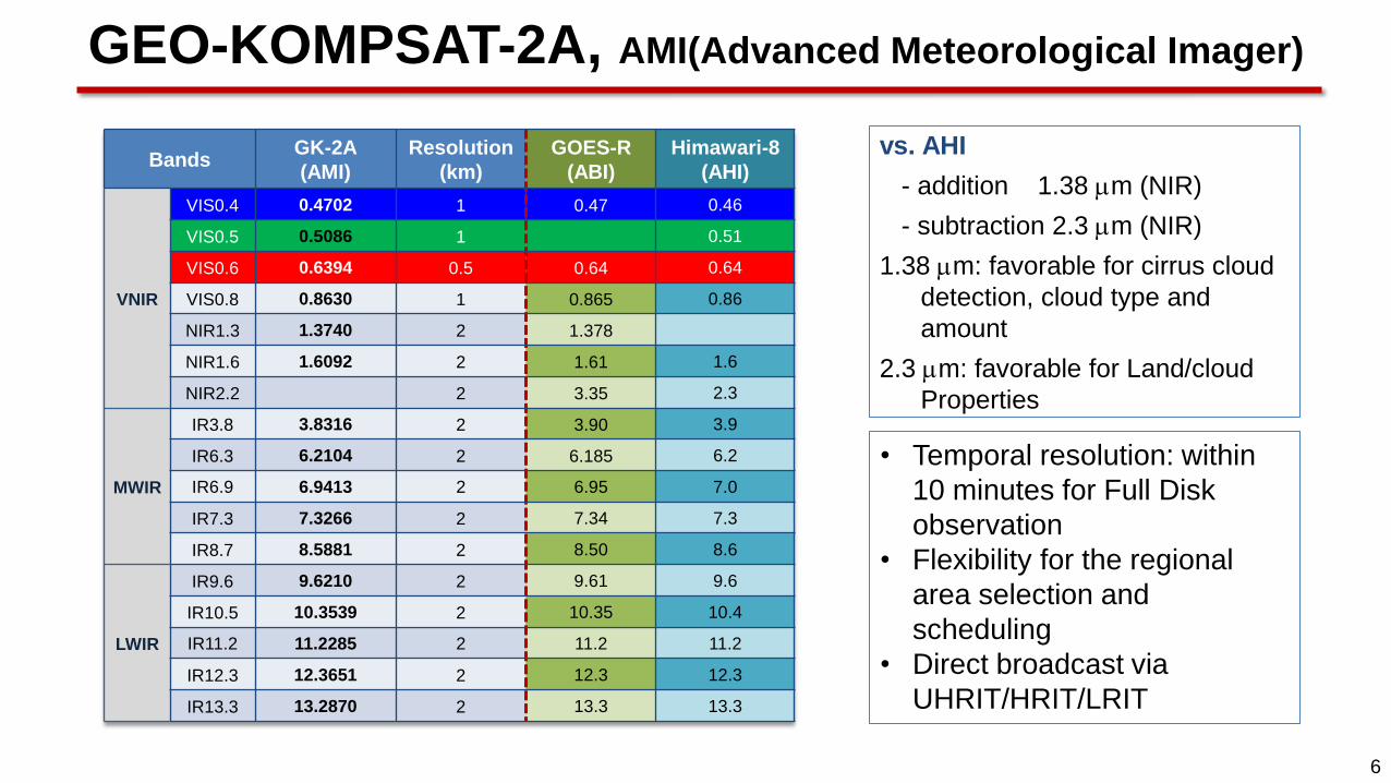
GEO-KOMPSAT-2A, AMI(Advanced Meteorological Imager)
– Multi-channel capacity: 16 channels
– Temporal resolution: within 10 minutes for Full Disk observation
– Flexibility for the regional area selection and scheduling
– Lifetime of meteorological mission: 10 years
Meteorological and Environmental Geo-Satellites : Future
6
vs. AHI
- addition 1.38 m (NIR)
- subtraction 2.3 m (NIR)
1.38 m: favorable for cirrus cloud
detection, cloud type and
amount
2.3 m: favorable for Land/cloud
Properties
• Temporal resolution: within
10 minutes for Full Disk
observation
• Flexibility for the regional
area selection and
scheduling
• Direct broadcast via
UHRIT/HRIT/LRIT
Bands GK-2A
(AMI)
Resolution
(km)
GOES-R
(ABI)
Himawari-8
(AHI)
VNIR
VIS0.4 0.4702 1 0.47 0.46
VIS0.5 0.5086 1 0.51
VIS0.6 0.6394 0.5 0.64 0.64
VIS0.8 0.8630 1 0.865 0.86
NIR1.3 1.3740 2 1.378
NIR1.6 1.6092 2 1.61 1.6
NIR2.2 2 3.35 2.3
MWIR
IR3.8 3.8316 2 3.90 3.9
IR6.3 6.2104 2 6.185 6.2
IR6.9 6.9413 2 6.95 7.0
IR7.3 7.3266 2 7.34 7.3
IR8.7 8.5881 2 8.50 8.6
LWIR
IR9.6 9.6210 2 9.61 9.6
IR10.5 10.3539 2 10.35 10.4
IR11.2 11.2285 2 11.2 11.2
IR12.3 12.3651 2 12.3 12.3
IR13.3 13.2870 2 13.3 13.3
GEO-KOMPSAT-2A, AMI(Advanced Meteorological Imager)

7
GK-2A 10-minute timeline
Full Disk
Every 10 min
ELA
Every 2 min
(3800 X 2400 km)
10 min.
Timeline
1 FD(Full Disk) + 5 ELA(Extended Local Area) + 5 LA(Local Area)
LA
Every 2 min
(1000 X 1000 km)
8
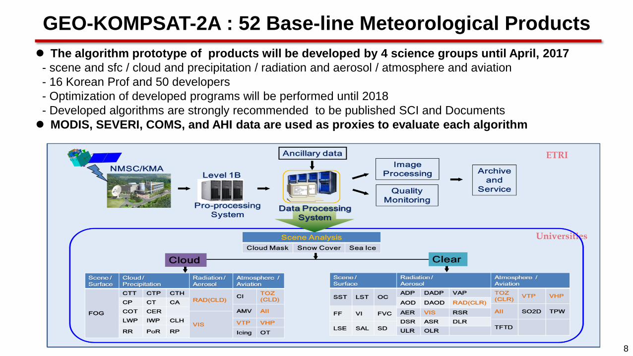
The algorithm prototype of products will be developed by 4 science groups until April, 2017
- scene and sfc / cloud and precipitation / radiation and aerosol / atmosphere and aviation
- 16 Korean Prof and 50 developers
- Optimization of developed programs will be performed until 2018
- Developed algorithms are strongly recommended to be published SCI and Documents
MODIS, SEVERI, COMS, and AHI data are used as proxies to evaluate each algorithm
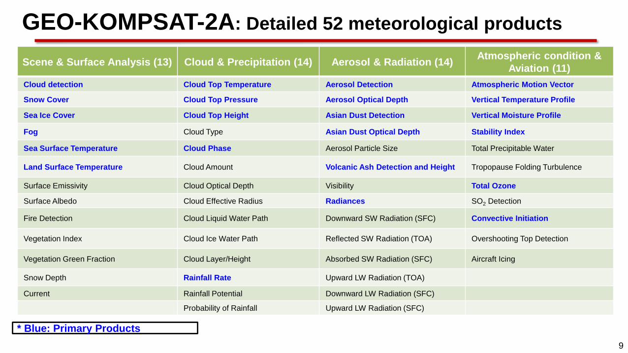
GEO-KOMPSAT-2A : 52 Base-line Meteorological Products
ETRI
Universities
9
GEO-KOMPSAT-2A: Detailed 52 meteorological products
Scene & Surface Analysis (13) Cloud & Precipitation (14) Aerosol & Radiation (14) Atmospheric condition &
Aviation (11)
Cloud detection Cloud Top Temperature Aerosol Detection Atmospheric Motion Vector
Snow Cover Cloud Top Pressure Aerosol Optical Depth Vertical Temperature Profile
Sea Ice Cover Cloud Top Height Asian Dust Detection Vertical Moisture Profile
Fog Cloud Type Asian Dust Optical Depth Stability Index
Sea Surface Temperature Cloud Phase Aerosol Particle Size Total Precipitable Water
Land Surface Temperature Cloud Amount Volcanic Ash Detection and Height Tropopause Folding Turbulence
Surface Emissivity Cloud Optical Depth Visibility Total Ozone
Surface Albedo Cloud Effective Radius Radiances SO2 Detection
Fire Detection Cloud Liquid Water Path Downward SW Radiation (SFC) Convective Initiation
Vegetation Index Cloud Ice Water Path Reflected SW Radiation (TOA) Overshooting Top Detection
Vegetation Green Fraction Cloud Layer/Height Absorbed SW Radiation (SFC) Aircraft Icing
Snow Depth Rainfall Rate Upward LW Radiation (TOA)
Current Rainfall Potential Downward LW Radiation (SFC)
Probability of Rainfall Upward LW Radiation (SFC)
* Blue: Primary Products
10
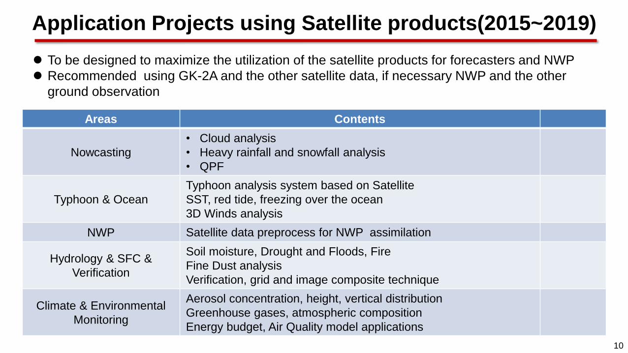
Application Projects using Satellite products(2015~2019)
To be designed to maximize the utilization of the satellite products for forecasters and NWP
Recommended using GK-2A and the other satellite data, if necessary NWP and the other
ground observation
Areas Contents
Nowcasting
• Cloud analysis
• Heavy rainfall and snowfall analysis
• QPF
Typhoon & Ocean
Typhoon analysis system based on Satellite
SST, red tide, freezing over the ocean
3D Winds analysis
NWP Satellite data preprocess for NWP assimilation
Hydrology & SFC &
Verification
Soil moisture, Drought and Floods, Fire
Fine Dust analysis
Verification, grid and image composite technique
Climate & Environmental
Monitoring
Aerosol concentration, height, vertical distribution
Greenhouse gases, atmospheric composition
Energy budget, Air Quality model applications

11
[Via GK-2A broadcast] • Broadcast all 16 channels data (UHRIT) of meteorological observations
• Maintain L/HRIT broadcast corresponding to COMS five channels
Categories UHRIT
COMS-like H/LRIT
HRIT LRIT Service
Data Rate < 31 Mbps 3 Mbps ~512 Kbps
Frequencies Uplink : S-band
Downlink : X-band
Uplink : S-band , Downlink : L-band
* Same Frequencies band with COMS
Data Type
AMI Image(16 Ch.)
Alphanumeric text
Encryption Key Message
* Additional info could be added in the future
AMI Image(14 Ch.)
Alphanumeric text
Encryption Key Message
GOCI-II products(TBD)
AMI Image (5 Ch.)
Alphanumeric text
Encryption Key Message
Lv2 products
GOCI-II image file
Mode FD FD FD
Station LDUS MDUS SDUS
Data Service Plan : Geo-KOMPSAT-2A
[Via Landline] • Cloud service similar to HimawariCloud is under development (completed in 2018)
• Renovated web-based service system is under development (completed in 2018)
• GK-2A data also will be available in DCPC-NMSC (http://dcpc.nmsc.kma.go.kr)
12
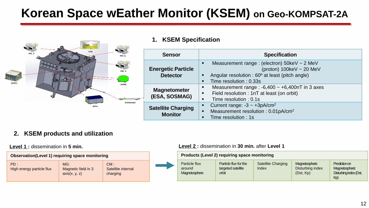
1. KSEM Specification
Sensor Specification
Energetic Particle
Detector
Measurement range : (electron) 50keV ~ 2 MeV
(proton) 100keV ~ 20 MeV
Angular resolution : 60º at least (pitch angle)
Time resolution : 0.33s
Magnetometer
(ESA, SOSMAG)
Measurement range : -6,400 ~ +6,400nT in 3 axes
Field resolution : 1nT at least (on orbit)
Time resolution : 0.1s
Satellite Charging
Monitor
Current range: -3 ~ +3pA/cm2
Measurement resolution : 0.01pA/cm2
Time resolution : 1s
2. KSEM products and utilization
Observation(Level 1) requiring space monitoring
PD :
High energy particle flux
MG:
Magnetic field in 3
axis(x, y, z)
CM :
Satellite internal
charging
Level 1 : dissemination in 5 min.
Products (Level 2) requiring space monitoring
Particle flux
around
Magnetosphere
Particle flux for the
targeted satellite
orbit
Satellite Charging
Index
Magnetospheric
Disturbing index
(Dst, Kp)
Prediction on
Magnetospheric
Disturbing index (Dst,
Kp)
Level 2 : dissemination in 30 min. after Level 1
Korean Space wEather Monitor (KSEM) on Geo-KOMPSAT-2A
13
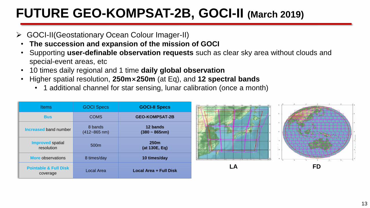
GOCI-II(Geostationary Ocean Colour Imager-II) • The succession and expansion of the mission of GOCI
• Supporting user-definable observation requests such as clear sky area without clouds and
special-event areas, etc
• 10 times daily regional and 1 time daily global observation
• Higher spatial resolution, 250m×250m (at Eq), and 12 spectral bands
• 1 additional channel for star sensing, lunar calibration (once a month)
Items GOCI Specs GOCI-II Specs
Bus COMS GEO-KOMPSAT-2B
Increased band number 8 bands
(412~865 nm)
12 bands
(380 ~ 865nm)
Improved spatial
resolution 500m
250m
(at 130E, Eq)
More observations 8 times/day 10 times/day
Pointable & Full Disk
coverage Local Area Local Area + Full Disk
LA FD
FUTURE GEO-KOMPSAT-2B, GOCI-II (March 2019)

14
G2GS(GOCI-II Ground Segment system) • New ground segment for GOCI-II
• To satisfy the needs of users like more and faster data processing
- 24 times bigger data size than GOCI (Lv0~Lv2 all products)
- 2 times faster processing timeliness than GOCI
• Current developing status is the detailed design of ground segment systems
FUTURE GEO-KOMPSAT-2B, GOCI-II (March 2019)

15
GEMS(Geostationary Environmental Monitoring Spectrometer) • Contributing to Atmospheric Composition Constellation under the Committee on Earth Observation
Satellites (CEOS)
– understanding of the globalization of pollution events, source/sink identification, and long-range
transport of pollutants and short-lived climate forcers (SLCFs)
– baseline : Korea (GEMS), Europe (Sentinel-4), and the US (TEMPO)
Bus GEO-KOMPSAT-2B
Payload Scanning UV-Visible(300-500 nm)
Spectrometer
Measurement O3, NO2, SO2, HCHO, Aerosols
Duty cycle/Imaging
time
8 images during daytime
(30 min imaging + 30 min rest)
× 8 times/day
Field of regard
> 5,000 km(N/S) × 5,000 km(E/W) N/S:
45°N~5°S, E/W: Selectable between
75°E~145°E
FUTURE GEO-KOMPSAT-2B, GEMS (March 2019)
16
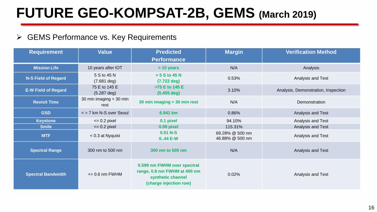
GEMS Performance vs. Key Requirements
Requirement
Value
Predicted
Performance
Margin
Verification Method
Mission Life 10 years after IOT > 10 years N/A Analysis
N-S Field of Regard 5 S to 45 N
(7.681 deg)
> 5 S to 45 N
(7.722 deg) 0.53% Analysis and Test
E-W Field of Regard 75 E to 145 E
(5.287 deg)
>75 E to 145 E
(5.455 deg) 3.10% Analysis, Demonstration, Inspection
Revisit Time 30 min imaging + 30 min
rest 30 min imaging + 30 min rest N/A Demonstration
GSD < = 7 km N-S over Seoul 6.941 km 0.86% Analysis and Test
Keystone <= 0.2 pixel 0.1 pixel 94.10% Analysis and Test
Smile <= 0.2 pixel 0.09 pixel 115.31% Analysis and Test
MTF < 0.3 at Nyquist 0.51 N-S
0..44 E-W
69.28% @ 500 nm
46.88% @ 500 nm Analysis and Test
Spectral Range 300 nm to 500 nm 300 nm to 500 nm N/A Analysis and Test
Spectral Bandwidth <= 0.6 nm FWHM
0.599 nm FWHM over spectral
range, 0.8 nm FWHM at 400 nm
synthetic channel
(charge injection row)
0.02% Analysis and Test
FUTURE GEO-KOMPSAT-2B, GEMS (March 2019)

17
Products : Trace gas (SO2, O3, NO2, HCHO), Aerosol Properties • (Column Density) NO2, SO2, HCHO, O3 (possibly CHOCHO, BrO)
• (O3) column density @ troposphere and stratosphere, entire quantity, profile
• (Aerosol) Optical depth, Index, Single scattering albedo, height
• (Cloud) effective cloud cover, pressure
• Surface reflectance, UV index
SO2
NO2
AOD
Cloud
FUTURE GEO-KOMPSAT-2B, GEMS (March 2019)
18
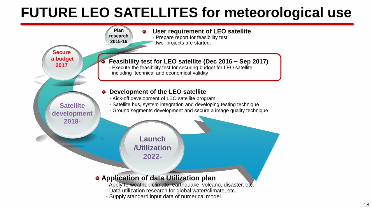
Plan
research
2015-16
Secure
a budget
2017
Satellite
development
2018-
Launch
/Utilization
2022-
Feasibility test for LEO satellite (Dec 2016 ~ Sep 2017) - Execute the feasibility test for securing budget for LEO satellite including technical and economical validity
Application of data Utilization plan - Apply to weather, climate, earthquake, volcano, disaster, etc. - Data utilization research for global water/climate, etc. - Supply standard input data of numerical model
User requirement of LEO satellite - Prepare report for feasibility test - two projects are started.
Development of the LEO satellite - Kick-off development of LEO satellite program
- Satellite bus, system integration and developing testing technique
- Ground segments development and secure a image quality technique
FUTURE LEO SATELLITES for meteorological use
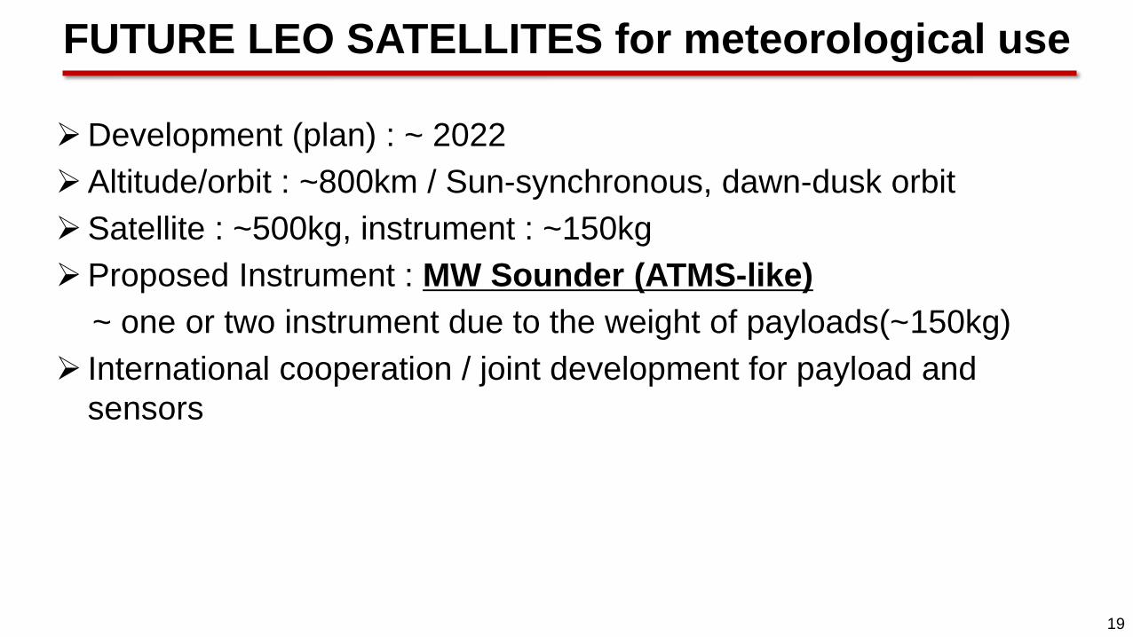
19
Development (plan) : ~ 2022
Altitude/orbit : ~800km / Sun-synchronous, dawn-dusk orbit
Satellite : ~500kg, instrument : ~150kg
Proposed Instrument : MW Sounder (ATMS-like)
~ one or two instrument due to the weight of payloads(~150kg)
International cooperation / joint development for payload and
sensors
FUTURE LEO SATELLITES for meteorological use

20
Plan of satellite utilization system of Korea

21
Develop Earth observation KOMPSAT satellites, standard medium satellites, and space
science·research purpose next generation small satellites
Develop MEO and GEO satellites for meteorology, ocean, environmental, communications
LEO (~500kg) - MW (3), hyperspectral (3), SAR (8) during `21~`30
- MW (16), hyperspectral (4), SAR(12) during `31~`40
GEO - Met (1), Ocean & Env (1) during `21~`30
- Met (1), Ocean & Env (1) during `31~`40
based on “Mid to Long Term Space Development Plan” ('14~‘40)
(Revision of the 2nd Basic Plan to Promote Space Development, ‘13.11)
Will be updated in late 2017
Future plan of Korea’s satellite program

22
Action ET-SAT 8.08: Each ET-SAT member to check the information in OSCAR regarding the missions under responsibility of his/her respective agency : new missions, change of status (approval, launch, cancellation, termination), schedule, payload content, etc.
Will report to WMO for updates
Action ET-SAT 8.08 OSCAR review
23
COMS
1st flight unit of GEO-KOMPSAT
program
KMA, KARI, MOF
24
2nd flight unit of GEO-KOMPSAT
program
COMS
Geostationary Korea Multi-Purpose Satellite
KMA, KARI KSEM/PD KSEM/MG KSEM/CM
Korea Space wEather Monitor

25
Thank you


