Download - OneMap Myanmar Project and Updates - UMD
OneMap Myanmar Project and Updates
Myat Su MonForest Department, Myanmar
International Meeting on Land Use and Emission in South/Southeast AsiaHo Chi Minh City, Vietnam, 17th-19th October 2016
Presentation outlines
• Introduction
• National Land Use Policy 2016
• OneMap Myanmar Project
• Land use and emissions
• Conclusion

Introduction
3
51 millions (2014 census) Population and over 100 national races-Different culture, custom and traditions related to natural resource uses.
Green economy approach : to meet social and economic needs whilesustainably managing its natural capital; to ensure that nature cancontinue to provide benefits for next generations
Need to understand: where and how nature supports people and theirlivelihoods, and highlight different economic sectors and also climatechange effects
Land related issues are critical.
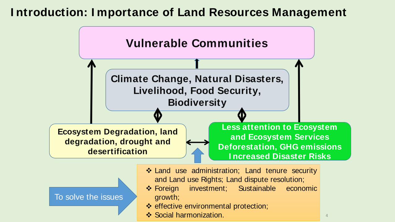
Introduction: Importance of Land Resources Management
4
Less attention to Ecosystem and Ecosystem Services
Deforestation, GHG emissionsIncreased Disaster Risks
Vulnerable Communities
Climate Change, Natural Disasters, Livelihood, Food Security,
Biodiversity
Ecosystem Degradation, land degradation, drought and
desertification
Land use administration; Land tenure securityand Land use Rights; Land dispute resolution;
Foreign investment; Sustainable economicgrowth;
effective environmental protection; Social harmonization.
To solve the issues

5
Myanmar National Land Use Policy 2016
1. Introduction2. Objectives and Principles3. Land Use Administration4. Planning and Changing Land Use5. Grants and Leases of Land at the Disposal of Government6. Procedures related to Land Acquisition, Relocation,
Compensation, Rehabilitation and Restitution7. Land Dispute Resolution and Appeal8. Assessment and Collection of Land Tax, Land Transfer Fee
and Stamp Duties9. Land Use Rights of the Ethnic Nationalities10. Equal Rights of Men and Women11. Harmonization of Laws and Enacting New Law12. Monitoring and Evaluation13. Research and Development14. Miscellaneous
• composed of 14 Parts covering wide range of land related topics;

OneMap Myanmar: Open Access Spatial Data Platform

OneMap is closely linked to the The National Land Use Policy
Parts II and III of the National Land Use Policy (2016): • A single, centralized land data management system must be developed,
to help systemically maintain correct and accurate land cover maps, land records and other land information
• Maps must be converted in digital format to facilitate sharing, coordination and use by government departments and the public
• Coordination between respective government agencies and local representatives must be improved in the drawing of maps
• All individuals, communities and organizations must have equal rights to access accurate and complete information
• Land tenure rights recognized by the communities must be integrated• Consultation and participation must be integrated of land use mapping
methods

Why is OneMap so important for the management of land and natural resources?
• Myanmar is facing very critical issues related to land• Managing land and natural resources is complex. Transparent access to
good information and data is critical for decision makers and citizens• But access to key data is still very limited because of different reasons. For
example, some data :• Do not exist yet• Are outdated • Are inaccessible• Are inaccurate• Are still in paper format, etc.
• OneMap project helps to develop a central online database, where all data relevant to land, are accessible to users (government and citizens).

OneMap Myanmar - Project fact sheet
Total duration: 8 Years through 4 phases
Start date: August 2015
Funding: Swiss Agency for Development and Cooperation (SDC)
Implementing agencies:Government partners: 25 line agencies – 11 Ministries and 3 City CouncilsMain implementers: CDE, University of Bern (Switzerland), Land Core GroupAdditional partnerships: MIMU; SERVIR Mekong.

Project Goal and ObjectivesThe overarching goal of the project is:
to contribute to the democratization of data related to land that enables
government, citizens and the private sector to jointly make sustainable resource
management decisions
The specific project objective is:
An open-access spatial data platform on land-related information
functions as an effective basis for transparent analysis of accurate data and
accountable land governance and development planning by government
and citizens.

Multiple Phases of OneMap
Phase Start date End date achievements
Inception phase 06.2015 11.2015 Review approach/Set PrioritiesSet-up partnerships
Main phase I(Establishment)
12.2015 06.2017 Piloting. Establish foundations.
Main phase II(Expansion)
06.2017 06.2021 Expansion of approach to additional geographic areas, levels of government, and/or thematic scope
Phase III(Consolidation)
06.2021 06.2023 Consolidation and implementation of exit strategy

OneMap Project Technical Steering Committee
OneMap Technical Working Group
OneMap Technical Unit
State/Region OneMap
OneMap has already established coordination mechanisms at central level between agencies working on land related matters
MinistriesMinistry of Agriculture, Irrigation, Livestock and Fishery
Ministry of Natural Resources and Environmental Conservation-MONREC
Ministry of National Planning and Economic Development
Ministry of Immigration and Population
Ministry of Construction
Ministry of Education
Ministry of Home Affairs
Ministry of Transport and Communications
Ministry of Electricity and Energy
Ministry of Defense
Ministry of Social Welfare, Relief and Resettlement
City Development Councils FD, MONREC-Focal Department for Implementation

During the inception phase, thematic andgeographic priorities were establishedthrough intensive consultation with keystakeholders
• Thematic:• Land tenure/ownership/right• Land cover and Land Use• Large scale investments in land• Base maps (roads, rivers, locations, etc)• Population and socioeconomic data
• Geographic:• Bago (Taungoo)• Mon• Tanintharyi
OneMap – Pilot areas

How do regional government benefit from OneMap?
• Technical Assistance• Trainings, equipment for data collection and analysis• Development of regional of data management system or/and online
platform to centralize regional data and information• Institutional support
• Support to the establishment of a OneMap regional working unit • Enhancing data
• Support to the collection or enhancement of key datasets, as prioritized by local stakeholders
• Conduct participatory mapping for land use planning or natural resources management

a workshop on 8th
October with multi-stakeholders
OneMap Pilot in Tanintharyi Region, Myanmar
The assessment will examine how much land is owned by palm oil companies,how much of that is currently being used for actual production and how theland is farmed.
OneMap Myanmar Project is supporting the assessment.

OneMap Pilot in Tanintharyi Region, Myanmar
WebDemo
Land use and Emissions

National Greenhouse Gases inventory
GHG emissions and removals by sectors in Myanmar for the year 2000

SNC – Myanmar Project Information
• Project Title Preparation of the Second National Communication
under UN Framework Convention on Climate Change
(UNFCCC)
• Project GFL/5070-2724-4C89-2207, PMS: GF/3010-12-07
• Implementing Organization
Environmental Conservation Department, MoNREC
• Duration 36 months (To complete in November 2018)
• Budget - GEF/UNEP and Government

What we are doing in Forestry Sector????

Three Working Groups for REDD+
consisting of multi stakeholders as;• Drivers and Strategies TWG to review existing information on drivers of
deforestation and forest degradation in Myanmar and their underlying causesand to identify potential strategies to address them
• National Forest Monitoring System (NFMS) and Forest ReferenceEmission Levels/ Reference Levels (RELs/RLs) TWG to access nationaltechnical capacities and institutional arrangements for Myanmar’s NFMS forREDD+ activities, to consider and identify strategies to develop Myanmar’sRELs/RLs/ for REDD+
• Stakeholder Consultation and Safeguards to review processes forstakeholder engagement and social and environmental safeguards in relation toforest management in Myanmar.
22

Component 1: Management of REDD+ Readiness Component 2: Stakeholder Consultation and Participation Component 3: Development and selection of REDD+
StrategiesComponent 4: Implementation framework and
safeguardsComponent 5: National Forest Reference Emission Level
and/or Forest Reference Level (FREL/FRL) Component 6: National Forest Monitoring System
• The Roadmap sets out how Myanmar will implement its REDD+ Readiness activities.
• It is divided into the following six components:
Myanmar REDD+ Readiness Roadmap 2013
UNREDD Programme in Myanmar – FAO Component
• Capacity building and development of national action plans on NFM and FREL/FRLs
• Development of a land monitoring system based on satellite images, and a web based GIS portal
• Design of a multipurpose national forest inventory• REDD+ strategy analysis (contributions to analysis of drivers of DD)
24

Reviewing on Forest Cover Data (Activity Data)
• 1989
• 2000 (Source: 1998-2000 Landsat TM)
• FRA 2010 (Source: 2005-2007 Landsat 7, 5)
• FRA 2015 (Source: 2010 IRS Liss III)
• 2015 (FAO TCP based on 2015 Landsat 8)

26
57.97%51.54% 49.25% 46.96%
42.92%
0
5,000
10,000
15,000
20,000
25,000
30,000
35,000
40,000
45,000
1990 2000 2005 2010 2015
Are
a (0
00 h
a)
Year
Closed forest
Open forest
Forest total
Forest Cover Changes in Myanmar (FAO FRA)

FRA 2015 Source Data FRA 2010 Source Data
Reviewing on National Forest Cover Data
Notes: Not exactly 2005

Real time Forest Cover Assessment (2015)
Combined to FRA categories
Harmonizing with IPCC categories

Definition
Deforestation − loss of forest cover by the conversion of forest to
another land cover, i.e. below 10% of canopy cover. (conversion of closed
+ open forest to non-forest)
Forest Degradation − changes within the forest which negatively affect
the structure or function of the stand, provided above 10% of canopy
cover (FAO, 2000 and 2005) (conversion of closed to open forest)

Forest Cover Assessment
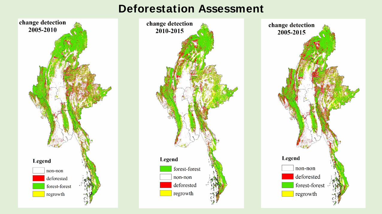
Deforestation Assessment
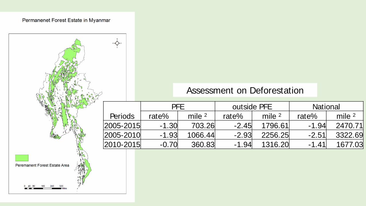
Assessment on Deforestation
PeriodsPFE outside PFE National
rate% mile 2 rate% mile 2 rate% mile 22005-2015 -1.30 703.26 -2.45 1796.61 -1.94 2470.712005-2010 -1.93 1066.44 -2.93 2256.25 -2.51 3322.692010-2015 -0.70 360.83 -1.94 1316.20 -1.41 1677.03

Challenges
• Standardization
(methodology for image classification, satellite datasets: sensors, acquisition time, forest definition, effects of interpreters etc….)
. Although definition is clear, thresholds for closed forest (>=40% FCD), open forest (<40% and >=10% FCD), and other wooded land (<10% and >=5% FCD), are very difficult in image interpretation.
. need more practices and field measurements for the above three categories
• Ongoing• Analyzing inventory data for different areas based on
available data• Calculating on the statistical parameters of each data
set such as estimated mean, lower limit, upper limit, % coefficient of variation, % margin of error, % standard error, variance and estimated variance at 95% or 90% Confidence for target parameters
• carbon stock estimation by default equations
Forest Inventory Data (Emission Factors)
Next Steps
• Checking uncertainty and discrepancy of the forest cover maps and inventory data
• Collection of field data and verification of forest cover
• Standardization of the forest cover maps of three periods
• Checking the deforestation hot spots
• Checking forest degradation hot spots
• Using real time data for national reporting
• Conducting forest types Mapping
• Development of Multipurpose National Forest Inventory
Conclusion: Link between MRV and OneMap Myanmar
OneMap Myanmar: Follow up activity for National land use policy• OneMap initiative is going to implement by pilot study (Taungoo
Pilot: demonstration of Government Data, Tanintharyi Pilot: demonstration of coordination among NGOs, INGOs, CSOs, Private sectors, etc….)
• Land information management (District to State and Regions to National) and to produce knowledge products
• Data Collection, validation, enhancement and harmonization by OneMap
Working together and sharing information between MRV and OneMap Myanmar in order to strengthen spatial database and to produce more effective and accurate information

Thank you very much!!!


