
OR 8: Oak/Baseline/10th Avenue Corridor Study (K18004)Technical Advisory Committee (TAC) Meeting

TAC Meeting Agenda
Introductions
Project Background
Technical Advisory Committee (TAC) Purpose
Developing the Corridor Vision
Blueprint for Urban Design
Group Discussion
Next Steps
Summary of Action Items

Introductions
Name
Representing agency/organization
Role
Connection to corridor (Oak/Baseline/10th)

Project Background

Study Area

Project Schedule
WE ARE HERE

TAC PurposeRoles, responsibilities, protocols
Attend and be present at TAC meetings
Review and comment on project deliverables in advance of
TAC meetings
Advise the project team’s technical work at project milestones
Involvement with Blueprint for Urban Design process
Developing the Corridor Vision
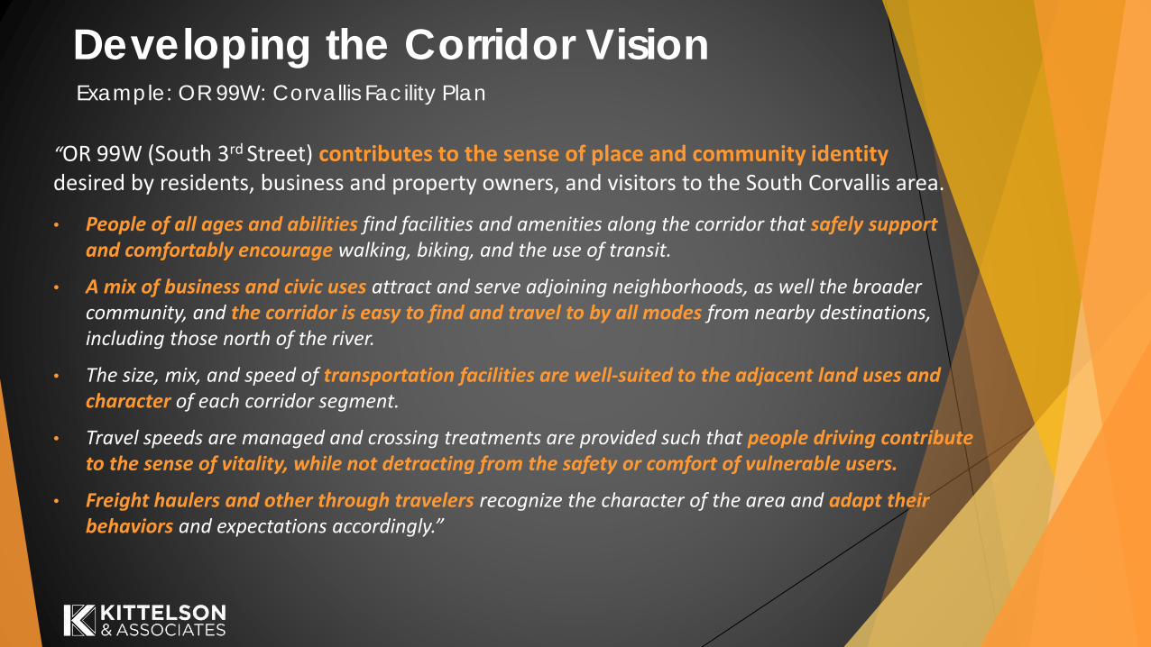
“OR 99W (South 3rd Street) contributes to the sense of place and community identity desired by residents, business and property owners, and visitors to the South Corvallis area.
• People of all ages and abilities find facilities and amenities along the corridor that safely support and comfortably encourage walking, biking, and the use of transit.
• A mix of business and civic uses attract and serve adjoining neighborhoods, as well the broader community, and the corridor is easy to find and travel to by all modes from nearby destinations, including those north of the river.
• The size, mix, and speed of transportation facilities are well-suited to the adjacent land uses and character of each corridor segment.
• Travel speeds are managed and crossing treatments are provided such that people driving contribute to the sense of vitality, while not detracting from the safety or comfort of vulnerable users.
• Freight haulers and other through travelers recognize the character of the area and adapt their behaviors and expectations accordingly.”
Example: OR 99W: Corvallis Facility Plan

Developing the Corridor Vision
Pedestrian, Bicycle and Transit Travel is Safe and Well-Connected (Goal C)
▪ Action #6: Enhance the safety of street crossings that provide access to transit stations, schools and parks, with special attention to north-south movements across Baseline and Oak and east-west movements across 10th Avenue
Major Streets are More Inviting with Enhanced Streetscapes and Safe
Pedestrian/Bike Crossings (Goal D)
▪ Policy 1: Improve the quality of the entries and main thoroughfares within the Downtown community for both visitors and residents, and to enhance future development and redevelopment potential.
▪ Action #1: Improve the gateways to the Downtown community through the addition of landscaping or architectural features at the following locations: …, 10th Avenue from Shute Park northward... and Baseline and Oak entry points.
Example: City of Hillsboro Downtown Framework Plan

Developing the Corridor Vision
▪ Action #5: Improve the character and appearance of the Baseline/Oak/10th Avenue corridor through added street trees, public art, landscaping, and new streetlights.
Policy 2: Respect the need to address both intra- and inter-city traffic
movements as part of regional freight and passenger movements.
▪ Action #2: Improve the safety and number of east-west pedestrian/bicycle crossings of 10th Avenue and north-south crossings of Oak/Baseline....
Example: City of Hillsboro Downtown Framework Plan

Developing the Corridor VisionExample: City of Hillsboro 2035 Community Plan
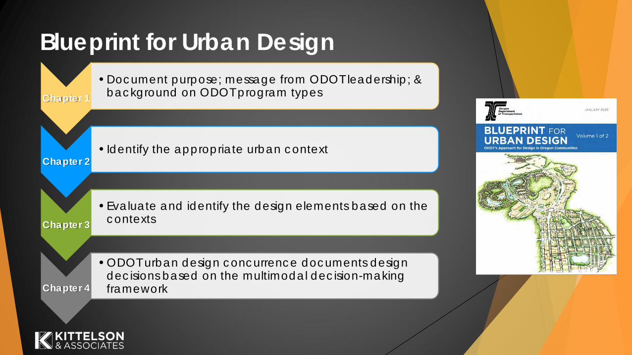
Blueprint for Urban Design
Chapter 1
• Document purpose; message from ODOT leadership; & background on ODOT program types
Chapter 2 • Identify the appropriate urban context
Chapter 3
• Evaluate and identify the design elements based on the contexts
Chapter 4
• ODOT urban design concurrence documents design decisions based on the multimodal decision-making framework

Establish Corridor Vision,
Context, & Desired
Outcomes
Evaluate Performance
of Alternatives
Select and Develop Concept
Plan
Develop Preliminary
& Final Design
Construct Project
Monitor, Operate,
and Maintain
Performance-Based Design Decision Framework
Documentation is a key component throughout each step of the framework
KAI Scope Later Steps

Identifying
the Urban
Context
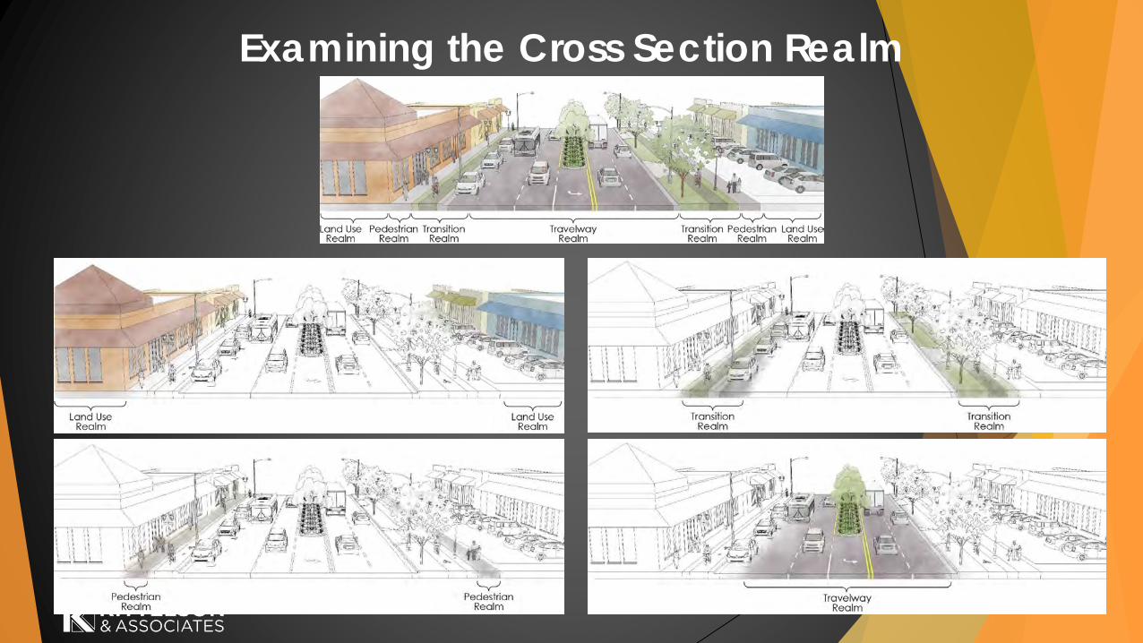
Examining the Cross Section Realm

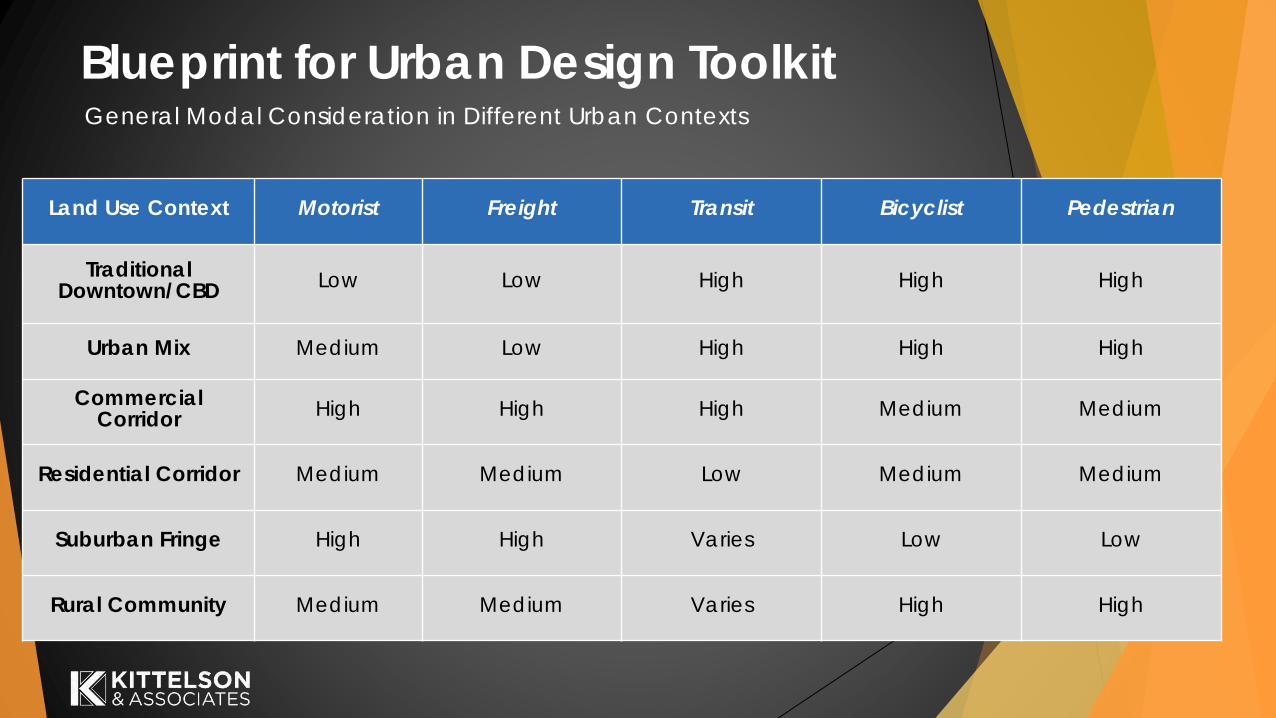
Blueprint for Urban Design Toolkit
Land Use Context
Setbacks
Distance from the
building to the
property line
Building Orientation
Buildings with front
doors that can be
accessed from the
sidewalks along a
pedestrian path
Land Use
Existing or future mix
of land uses
Building Coverage
Percent of area adjacent
to right-of-way with
buildings, as opposed to
parking, landscape or
other uses
Parking
Location of parking in
relation to the building
along the right-of-way
Block Size
Average size of blocks
adjacent to the right-
of-way
Traditional
Downtown/CBDShallow/None Yes
Mixed (residential
Commercial,
Park/Recreation)
HighOn-street/
garage/shared in back
Small, consistent block
structure
Urban Mix Shallow Some
Commercial
fronting, residential
behind or above
Medium
Mostly off-street/Single
row in front/In back/ On
side
Small to medium
blocks
Commercial
CorridorMedium to Large Sparse
Commercial,
Institutional,
Industrial
Low Off-street/In frontLarge blocks, not well
defined
Residential Corridor Shallow Some Residential Medium VariesSmall to medium
blocks
Suburban Fringe Varies VariesVaried, interspersed
developmentLow Varies
Large blocks, not well
defined
Rural Community Shallow/None Some
Mixed (Residential,
Commercial,
Institutional,
Park/Recreation)
MediumSingle row in front/In
back/ On side
Small to medium
blocks
ODOT Urban Context Matrix
Blueprint for Urban Design Toolkit
Land Use Context Motorist Freight Transit Bicyclist Pedestrian
Traditional Downtown/CBD
Low Low High High High
Urban Mix Medium Low High High High
Commercial Corridor
High High High Medium Medium
Residential Corridor Medium Medium Low Medium Medium
Suburban Fringe High High Varies Low Low
Rural Community Medium Medium Varies High High
General Modal Consideration in Different Urban Contexts

Baseline near 8th
Baseline near 2nd Oak near 2nd
Oak near 8th
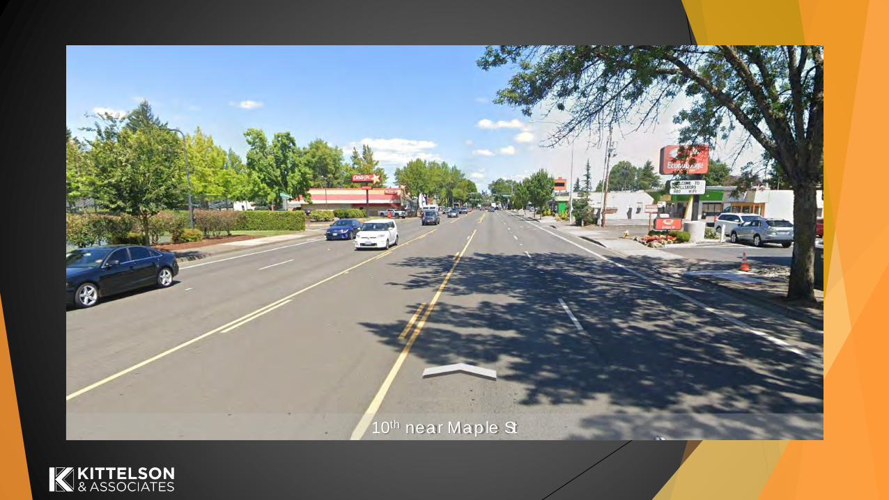
10th near Maple St

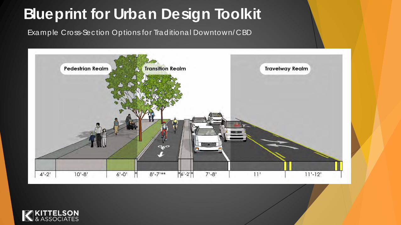
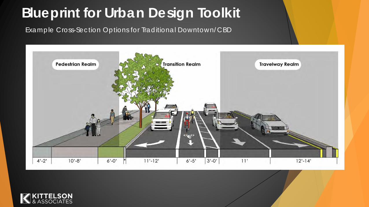
Blueprint for Urban Design ToolkitExample Cross-Section Options for Traditional Downtown/CBD
Blueprint for Urban Design ToolkitExample Cross-Section Options for Traditional Downtown/CBD

Blueprint for Urban Design ToolkitExample Cross-Section Options for Traditional Downtown/CBD

Blueprint for Urban Design ToolkitExample Cross-Section Options for Traditional Downtown/CBD
Blueprint for Urban Design ToolkitExample Cross-Section Options for Traditional Downtown/CBD

Blueprint for Urban Design ToolkitExample Cross-Section Options for Traditional Downtown/CBD

Group Discussion
How do you experience the corridor today?
What are the user needs within the corridor?
What challenges are you familiar with for different users?
What urban contexts feel most appropriate based on
your knowledge of the area?
Next Steps
Next TAC meeting: Tuesday, June 22, 2021
▪ Draft Corridor Vision Statement
▪ Draft TM#1: Land Use and Urban Design Assessment
▪ Draft TM#2: Transportation Existing Conditions and Future No-Build
▪ Public Involvement Plan
▪ Stakeholder interview summaries
Round table discussion

Questions/Comments?
OR8: SW Adams Ave. SE 10th Ave and SE Baseline – SE Maple St.
(OR8: Oak/Baseline/10th Avenue Corridor Study [K18004])
Karla Antonini
City of Hillsboro
Project Manager
Matt Novak
Oregon Department of Transportation
Agency Project Manager
Nick Gross
Kittelson and Associates, Inc.
Senior Planner

Adjourn


