
Prairie Creek, Mud Creek, West Mud Creek, and the Neches River Above Lake Palestine Recreational Use Attainability Analysis
Overview Texas Institute for Applied Environmental Research
Stephenville, Texas
February 20, 2014 1

Project Partners
• Texas State Soil and Water Conservation Board (TSSWCB)
• Texas Institute for Applied Environmental Research (TIAER)
2

TSSWCB
• Provide state oversight • Management and coordination of project
activities – Project partners – Texas Commission on Environmental Quality
(TCEQ)
• Provide project funding
3

TIAER
• Project administration • Develop & maintain stakeholder relations • Perform RUAA survey activities • GIS inventory • Facilitate meetings • Develop final technical reports
4

Importance of Being a Stakeholder
• Stakeholders: – Make and implement decisions – Are affected by the decisions made – Participate in the implementation planning
process
5

Who is a Stakeholder?
• Landowners • Citizens • Citizen Groups • Local Representatives • Local Governmental entities
– Cites – Counties – Soil and Water Conservation Districts
• Non-Governmental Organizations
6

Why we are here
• Texas 303 (d) List of Impaired Water bodies – Developed by TCEQ to summarize the
condition of the state’s surface waters, including concerns for public health, fitness for use by aquatic species and other wildlife, and specific pollutants and their possible sources.
7

Bacteria Impairment • Prairie Creek, Mud Creek, West Mud Creek
and the Neches River above Lake Palestine are not meeting the water quality standard for primary contact recreation
• Due to elevated levels of bacteria, E. coli. • requires action to meet the standards that are set by
the State of Texas and EPA. – Geometric mean should not exceed 126 cfu/ 100ml
8

Impaired Stream Segments • Prairie Creek, Mud Creek, West Mud Creek, and
The Neches River Above Lake Palestine are listed as impaired for primary contact recreation
• Prairie Creek (0606A) – 2002 Texas Water Quality 303(d) List
• Bacteria » Current Geometric mean = 165 cfu/ 100mL (0606A_01) » Current Geometric mean = 138 cfu/ 100 mL (0606A_03)
• Mud Creek (0611C) – 2002 Texas Water Quality 303(d) List
• Bacteria » Current Geometric mean = 184 cfu/ 100mL (0611C_01) » Current Geometric mean = 151 cfu/ 100mL (0611C_02)
9

Impaired Stream Segments
• West Mud Creek (0611D)
– 2010 Texas Water Quality 303(d) List • Bacteria
» Current Geometric mean = 187 cfu/ 100mL (0611D_01) » Current Geometric mean = 258 cfu/ 100mL (0606A_02)
• The Neches River Above Lake Palestine (0606)
– 2008 Texas Water Quality 303(d) List • Bacteria
» Current Geometric mean = 229 cfu/100mL
10

Water Quality Monitoring Locations for Prairie Creek
11

Water Quality Monitoring Locations for Prairie Creek
Site Description
Prairie Creek at road crossing on State Hwy 64 – TCEQ 10518 Prairie Creek at road crossing on FM 724 – TCEQ 10519 Prairie Creek at road crossing on 1150 – TCEQ 10520 Prairie Creek at road crossing on State Hwy 110 – TCEQ 18301
12

Water Quality Monitoring Locations for Mud Creek
13

Water Quality Monitoring Locations Mud Creek
14
Site Description Mud Creek at road crossing on Old Tyler/CR 2138 – TCEQ 10537 Mud Creek at road crossing on State Hwy 110 – TCEQ 16586 Mud Creek at road crossing on FM 2064 – TCEQ 10536 Mud Creek at road crossing on State Hwy 135 – TCEQ 17103 Mud Creek at road crossing on US Hwy 79 – TCEQ 14477 Mud Creek at road crossing on US Hwy 84 – TCEQ 10532 Mud Creek at road crossing on County Hwy 4223 – TCEQ 10535

Water Quality Monitoring Locations for West Mud Creek
15

Site Description
West Mud Creek at road crossing on FM 346 – TCEQ 10540
West Mud Creek at road crossing on US Hwy 69 – TCEQ 18302
West Mud Creek at road crossing on FM 3052 – TCEQ 10538
West Mud Creek at road crossing on FM 344 – TCEQ 10539
West Mud Creek at road crossing on FM 2813 – TCEQ 10541
16
Water Quality Monitoring Locations for West Mud Creek

Water Quality Monitoring Locations for the Neches River Above Lake Palestine
17
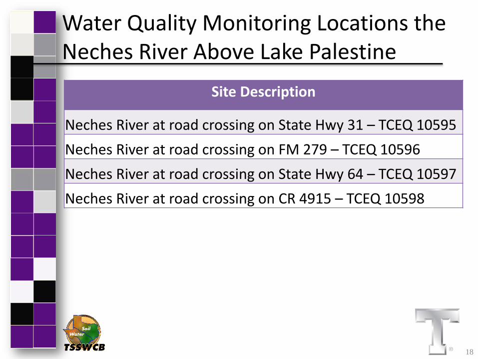
Site Description
Neches River at road crossing on State Hwy 31 – TCEQ 10595 Neches River at road crossing on FM 279 – TCEQ 10596 Neches River at road crossing on State Hwy 64 – TCEQ 10597 Neches River at road crossing on CR 4915 – TCEQ 10598
18
Water Quality Monitoring Locations the Neches River Above Lake Palestine

RUAA
• One method for removing Prairie Creek, Mud Creek, West Mud Creek, and the Neches River Above Lake Palestine from the impaired list for bacteria – Assess if the recreational standard is
appropriate • Recreational use attainability analysis (RUAA)
19

Purpose of RUAA
• To determine if primary contact recreation is the correct use or if another recreational use category may be more appropriate.
20

RUAA Use Categories
21
• Primary Contact Recreation – 126 cfu/ 100 mL – Activities that are presumed to involve a significant
risk of ingestion of water • (e.g. wading by children, swimming, water skiing, diving,
tubing, surfing, and the following white water activities: kayaking, canoeing, and rafting).
• Secondary Contact Recreation 1 – 630 cfu/ 100 mL – Activities that commonly occur but have limited
body contact incidental to shoreline activity • Wading by adults, fishing, canoeing • Activities are presumed to pose a less significant risk of
water ingestion than primary contact recreation but more than secondary contact recreation 2.

RUAA Use Categories
22
• Secondary Contact Recreation 2 – 1030 cfu/ 100 mL
– These activities occur less frequently than secondary contact recreation 1 due to physical characteristics of the water body or limited public access.
• Noncontact Recreation – 2060 cfu 100/ mL
– Activities that do not involve a significant risk of water ingestion, such as those with limited body contact incidental to shoreline activity, including birding, hiking, and biking.
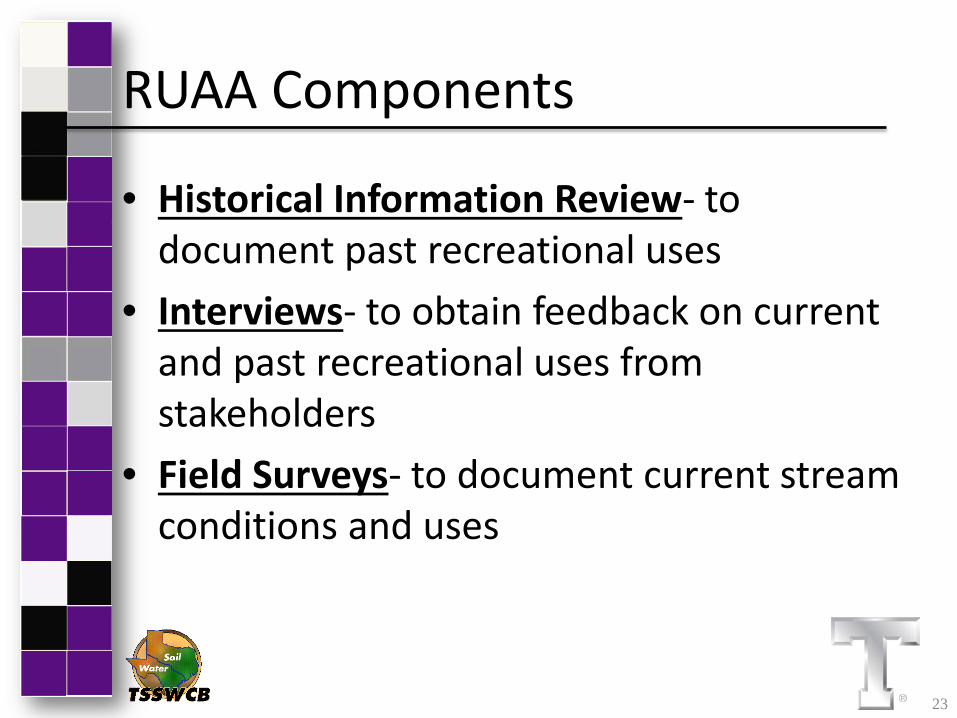
RUAA Components
• Historical Information Review- to document past recreational uses
• Interviews- to obtain feedback on current and past recreational uses from stakeholders
• Field Surveys- to document current stream conditions and uses
23

RUAA Components
Historical Information Review • November 28, 1975 – Present
– Any documentation of recreational use of Prairie Creek, Mud Creek, West Mud Creek, and the Neches River Above Lake Palestine
• Newspaper clippings or other publications • Historical or Museum Records • Personal pictures or letters
24

RUAA Components Stakeholder Interviews • Document use of the creeks from
individuals – Conducted during field surveys (if individuals
are encountered) – Streamside landowners – Local residents – Other users
• Interviews can be anonymous and conducted by phone, USPS mail, or email.
25

RUAA Components
Field Surveys • Goal: 3 sites for every 5 miles
– At each site: • 300 meter reach traversed
– Document • Stream characteristics that may promote or
hinder recreational use • Observations of direct use or signs of recreational
use • Interviews with individuals
26

RUAA Field Surveys
• 2 Field Surveys Conducted – Base Flow Conditions
1. Sustained typical dry warm-weather flow 2. Between rainfall events
– Periods of Likely Use (May-Sept) Air Temperature > 70°F
1. Spring Break 2. Weekends 3. Holidays 4. Summer
27

RUAA Field Surveys
• Field Data Sheet Includes: – Stream characteristics – Current weather conditions & daily conditions
for the previous month – Riparian zone, ease of bank access, dominant
substrate – Document recreation observed (if any) – Stream and pool measurements
28

RUAA Field Surveys
• Field Photographic Records – Each Survey Site
• Upstream • Left • Right Bank • Downstream
– At 30, 150, 300 M
29

Site Selection for RUAA • Currently proposed sites represent public
road crossings, many of which are fenced
• Seeking Landowner permission to access points above and below road crossing and additional points on the creek
• Need stakeholder input on site selection
and additional sites
30

Proposed Survey Sites for Prairie Creek
31

Proposed Survey Sites for Prairie Creek Site Description
Prairie Creek at road crossing on State Hwy 64 – TCEQ 10518
Prairie Creek at road crossing on FM 724 – TCEQ 10519
Prairie Creek at road crossing on 1150 – TCEQ 10520
Prairie Creek at road crossing on CR 474
Prairie Creek at road crossing on CR 472
Prairie Creek at road crossing on CR 471
Prairie Creek at road crossing on State Hwy 110 – TCEQ 18301
32

Proposed Survey Sites for Mud Creek
33

Proposed Survey Sites for Mud Creek
Site Description Mud Creek at road crossing on State Hwy 204 Mud Creek at road crossing on Old Tyler/CR 2138 – TCEQ 10537 Mud Creek at road crossing on CR 1301 Mud Creek at road crossing on State Hwy 110 – TCEQ 16586 Mud Creek at road crossing on FM 2064 – TCEQ 10536 Mud Creek at road crossing on State Hwy 135 – TCEQ 17103 Mud Creek at road crossing on US Hwy 79 – TCEQ 14477 Mud Creek at road crossing on State Hwy 110 Mud Creek at road crossing on US Hwy 84 – TCEQ 10532 Mud Creek at road crossing on County Hwy 4223 – TCEQ 10535 Mud Creek at road crossing on CR 4905
34

Proposed Survey Sites for West Mud Creek
35

Proposed Survey Sites for West Mud Creek
Site Description
West Mud Creek at road crossing on FM 346 – TCEQ 10540
West Mud Creek at road crossing on US Hwy 69 – TCEQ 18302
West Mud Creek at road crossing on CR 129
West Mud Creek at road crossing on FM 3052 – TCEQ 10538
West Mud Creek at road crossing on FM 344 – TCEQ 10539
West Mud Creek at road crossing on FM 2813 – TCEQ 10541
West Mud Creek at road crossing on US Hwy 69
West Mud Creek at road crossing on CR 113
West Mud Creek at road crossing on County Line Road
West Mud Creek at road crossing on Private Property at end of CR 118 36

Proposed Survey Sites for the Neches River Above Lake Palestine
37

Proposed Survey Sites for the Neches River Above Lake Palestine
Site Description
Neches River at road crossing on State Hwy 31 – TCEQ 10595
Neches River at road crossing on FM 279 – TCEQ 10596
Neches River at road crossing on State Hwy 64 – TCEQ 10597
Neches River at road crossing on CR 4915 – TCEQ 10598
Neches River at road crossing on CR 4511
Neches River at bridge crossing on FM 314
Neches River at road crossing on CR 3790
Neches River at road crossing on CR 426
Neches River at road crossing on CR 421
Neches River at road crossing on State Hwy 31 38

RUAA Site Selection Guidelines
• Identify areas where the water body is – Accessible to the public – Has a high potential for recreational use
• Road crossings • Public lands • Parks • Populated areas
• Characterize the full river reach
39

RUAA Site Selection Guidelines • Goal for RUAA Survey
– 3 sites for every 5 miles of stream • Prairie Creek is about 12 river miles long
– Goal: 7 sites • Mud Creek is about 56 river miles long
– Goal: 34 sites • West Mud Creek is about 23 river miles long
– Goal: 13 sites • The Neches River Above Lake Palestine is about
33 river miles long – Goal: 20 sites
40
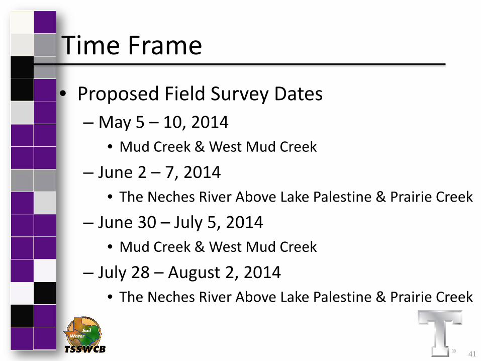
Time Frame • Proposed Field Survey Dates
– May 5 – 10, 2014 • Mud Creek & West Mud Creek
– June 2 – 7, 2014 • The Neches River Above Lake Palestine & Prairie Creek
– June 30 – July 5, 2014 • Mud Creek & West Mud Creek
– July 28 – August 2, 2014 • The Neches River Above Lake Palestine & Prairie Creek
41

Questions on RUAA Overview?
Project Websites: http://tiaer.tarleton.edu/ruaa/prairie-creek.html http://tiaer.tarleton.edu/ruaa/mud-creek1.html
http://tiaer.tarleton.edu/ruaa/west-mud-creek.html http://tiaer.tarleton.edu/ruaa/neches-river-above-lake-palestine.html
Leah Taylor Texas Institute for Applied Environmental Research
[email protected] (254) 968-0513
42
Funding Provided through a State General Revenue Nonpoint Source grant from Texas State Soil and Water Conservation Board.


