A Worton Rectory Park
Oxford OX29 4SX
United KingdomT +44 (0) 1865 887050F +44 (0) 1865 887055W www.lda-design.co.uk
LDA Design Consulting Ltd
Registered No: 09312403
17 Minster Precincts, Peterborough PE1 1XX
Purfleet Thames Terminal – Roundabout and Entry/Exit
Facilities
Non Technical Summary
Environmental Statement: Non Technical Summary
November 2016

November 2016
Purfleet
Contents
1.0 Introduction ................................................................................................................................................... 1
2.0 EIA Assessment Methodology ............................................................................................................... 3
3.0 Alternative Sites and Design Iterations ............................................................................................. 9
4.0 Project Description ................................................................................................................................... 11
5.0 Traffic and Transport .............................................................................................................................. 14
6.0 Air Quality .................................................................................................................................................... 15
7.0 Noise and Vibration ................................................................................................................................. 16
8.0 Water resources ......................................................................................................................................... 17
9.0 Ground Conditions .................................................................................................................................. 19
10.0 Other Environmental Considerations ............................................................................................. 20
11.0 Cumulative Assessment ........................................................................................................................ 23
Purfleet
Non Technical Summary (NTS)
Version: 1.0
Version date: 07 October 2016
Comment For Contractual Review
This document has been prepared and checked in accordance with ISO 9001:2008

Purfleet
iv
This page has been left intentionally blank
Purfleet
1
1.0 Introduction
1.1.1. An Environmental Statement (ES) has been prepared and submitted on behalf of the
Applicant and supports a Full Planning Application for access works at the Purfleet
Thames Terminal (the Terminal) within the borough of Thurrock in Essex.
1.1.2. The Proposed Development comprises the demolition of existing structures and
construction of a new roundabout and highway works at Stonehouse
Corner/London Road, a new secure site entrance and exit facilities, along with
landscaping, drainage and associated works.
1.1.3. The ES sets out the assessment of the likely environmental effects which may arise
as a result of the Proposed Development.
1.2. The Site
1.2.1. The Application Site (the Site) comprises of 5.13ha of land located within Purfleet
Terminal which is situated on the north bank of the River Thames, immediately to
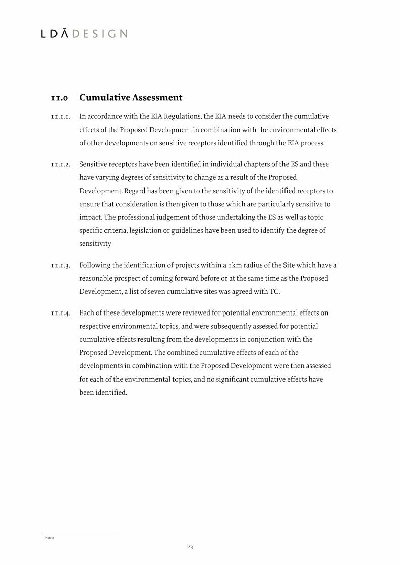
the west of the Dartford Crossing. The Site location is shown on Figure 1.1.
(presented at the end of the NTS).
1.2.2. The Terminal has been owned by the Applicant, Purfleet Real Estate, and operated
by C.RO Ports London Ltd since 1992 as a roll-on roll-off freight terminal for the
handling, storage and on-carriage of trailers, containers, vehicles and general cargo.
1.2.3. The Site is industrial in character and covers an area of land predominantly in port
use for surface car storage. It also includes a short section of London Road; part of
Jurgens Road (private road); an existing landscape bund to the south of Jarrah
Cottages; a small part of the Tilbury Loop railway line; and a small area of scrub land
within the area known as Purfleet Farm.
1.2.4. The Site is bounded to the south by the Unilever Foods and Aggregate Industries
facilities; to the north by Jarrah Cottages and London Road; to the west by
operational land within the Terminal; and to the east by an area of scrub land within
Purfleet Farm.
Purfleet
2
1.3. The Proposed Development
1.3.1. An overview of the key aspects of the Proposed Development is as follows:
A new four arm roundabout and associated highways works connecting to
Stonehouse Corner and London Road to provide a new primary access to the
Purfleet Thames Terminal and neighbouring businesses;
New secure entrance and exit facilities to the Purfleet Thames Terminal
(including security gates);
Demolition of any existing structures; and
Associated roads, drainage and landscaping works.
Purfleet
3
2.0 EIA Assessment Methodology
2.1.1. The Town and Country Planning (Environmental Impact Assessment) Regulations
2011 (as amended 2015) (‘EIA Regulations’) identify two types of development
projects: Schedule 1, for which the requirement to prepare an EIA is mandatory, and
Schedule 2, for which an EIA may be required depending on the size, nature and
location of the development and whether it is likely to have any significant effects
on the environment.
2.1.2. The Proposed Development is considered to fall within Schedule 2 of the EIA
Regulations. Paragraph 10 (f) of Schedule 2 deals with ‘Construction of roads’ and
states that an EIA may be required if the area of the development exceeds 1 hectare
(ha).
2.1.3. The Applicant considers that the Proposed Development is a project for which an
EIA is required. It was agreed that an EIA Screening Opinion would not be sought
and that a Voluntary ES would be submitted as part of the planning application
suite of documents.
2.1.4. The ES outlines the assessment of the likely environmental effects of the Proposed
Development against a range of environmental receptors located within the Site and
surrounding area.
2.1.5. The following topics have been included in the EIA:
Traffic and Transport;
Air Quality;
Noise and Vibration;
Water Resources; and
Ground Conditions.
2.1.6. In addition to the environmental assessments listed above, landscape, visual and
terrestrial ecology have also been considered.
Purfleet
4
2.1.7. The existing Terminal has an extensive planning history. Many of the consents are
for individual buildings, but others cover a much larger geographic area within the
Terminal (mainly associated with parking and storage).
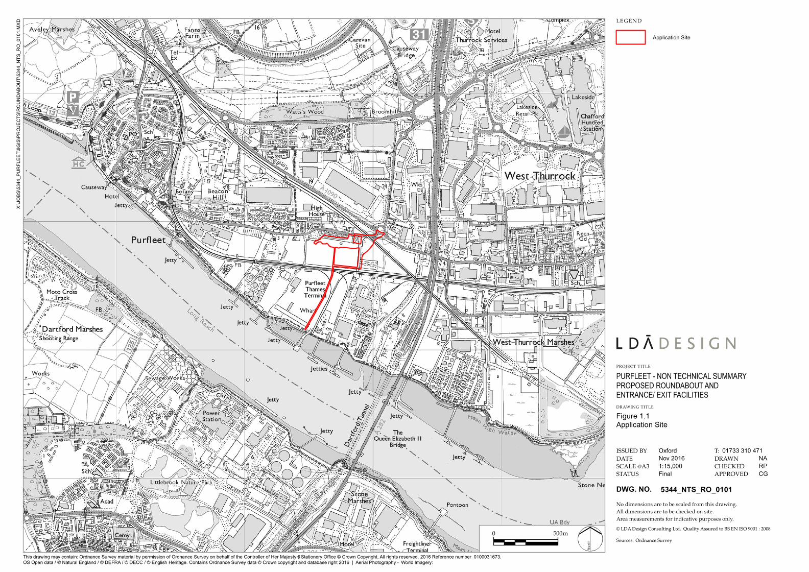
2.1.8. Most of the planning applications have been granted planning consent. Table 2.1
sets out the details of these planning permissions. The extents of the extant planning
applications within the Site are shown on Figure 2.1.
Table 2.1: Extant Planning Applications within the Port
No. Application
Reference
Description Decision
(Date)
1 15/00268/FUL Former Paper Mills Site
Use of land for vehicular storage, formation of hard standing
and associated infrastructure works including erection of
lighting and CCTV columns, erection of fencing, and
drainage infrastructure on land at the former Paper Mills site,
London Road, Purfleet.
Permitted
(27/05/16)
2 14/01387/FUL Exxon Site
Use of part of the land for vehicular storage for use in
association with Purfleet Thames Terminal, formation of
hard standing, associated infrastructure works including
erection of lighting and CCTV columns, erection of fencing,
drainage infrastructure on land at the former Exxon Mobil
Lubricants site, London Road, Purfleet.
Permitted
(26/05/16)
3 14/01392/FUL Purfleet Farm
Use of part of land for vehicular storage for use in association
with Purfleet Thames Terminal, formation of hard standing,
associated landscaping and infrastructure works including
erection of a gatehouse building, lighthouse columns,
erection of fencing, drainage infrastructure including a
surface water balancing pond, infill and alteration to levels,
alterations to vehicular access to London Road.
Resolution
to grant,
S106
unsigned
4 07/01217/TTG
OUT
11/50431/TTG
ETL
Purfleet Farm
Mixed use development of B2 (general industry)
and B8 (storage and distribution).
Extension of time limit - Original application
07/01217/TTGOUT
Permitted
(30/04/09)
Permitted
(25/05/13)
Purfleet
5
2.1.9. These developments are subject to planning approvals and within the control of the
Applicant. Consequently, these four permissions along with the ports current
operational infrastructure comprise the future baseline against which the impacts of
the Proposed Development have been assessed.
2.1.10. With regards to the Transport, Air Quality, Noise and Vibration assessments, a
quantitative assessment has been undertaken, whereby a model has been run to take
account of committed developments within 1km of the Site (as agreed with TC).
This approach has been taken to ensure that the assessment models take account of
future traffic growth within close proximity of the Site. The committed
developments along with those in Table 2.1 form the future baseline for the
transport, air quality and noise assessments.
2.1.11. The assessment process for each environmental topic was undertaken in line with
topic specific legislation, planning policy, and guidance documents as outlined in
each chapter of the ES. The significance of likely environmental effects and any
proposed mitigation has been identified.
2.1.12. Consultation has been undertaken with a range of prescribed and non-prescribed
consultees. Each chapter in the ES refers to the specific consultation undertaken.
2.1.13. A cumulative assessment has been undertaken as required by the EIA Regulations.
The cumulative assessment considers the cumulative effect of the Proposed
Development being carried out alongside any other reasonably foreseeable
developments in the locality. The list of cumulative developments has been agreed
with TC and are set out in Table 2.1.
2.1.14. In addition, each of the environmental assessments interact to some degree, and the
ES includes a description of the ‘inter-relationship’ between various factors, setting
out how the particular topic area has been influenced, or has been informed by,
other environmental assessments.
Purfleet
6
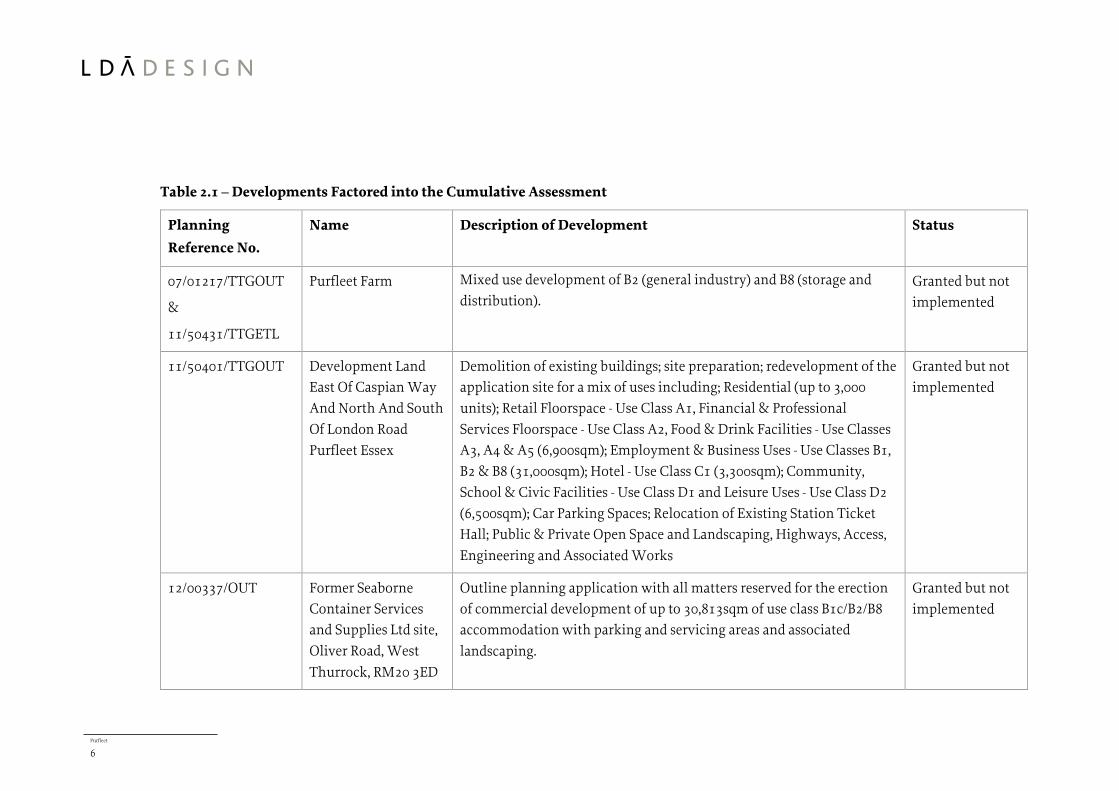
Table 2.1 – Developments Factored into the Cumulative Assessment
Planning
Reference No.
Name Description of Development Status
07/01217/TTGOUT
&
11/50431/TTGETL
Purfleet Farm Mixed use development of B2 (general industry) and B8 (storage and
distribution).
Granted but not
implemented
11/50401/TTGOUT Development Land
East Of Caspian Way
And North And South
Of London Road
Purfleet Essex
Demolition of existing buildings; site preparation; redevelopment of the
application site for a mix of uses including; Residential (up to 3,000
units); Retail Floorspace - Use Class A1, Financial & Professional
Services Floorspace - Use Class A2, Food & Drink Facilities - Use Classes
A3, A4 & A5 (6,900sqm); Employment & Business Uses - Use Classes B1,
B2 & B8 (31,000sqm); Hotel - Use Class C1 (3,300sqm); Community,
School & Civic Facilities - Use Class D1 and Leisure Uses - Use Class D2
(6,500sqm); Car Parking Spaces; Relocation of Existing Station Ticket
Hall; Public & Private Open Space and Landscaping, Highways, Access,
Engineering and Associated Works
Granted but not
implemented
12/00337/OUT Former Seaborne
Container Services
and Supplies Ltd site,
Oliver Road, West
Thurrock, RM20 3ED
Outline planning application with all matters reserved for the erection
of commercial development of up to 30,813sqm of use class B1c/B2/B8
accommodation with parking and servicing areas and associated
landscaping.
Granted but not
implemented
Purfleet
7
Planning
Reference No.
Name Description of Development Status
13/01231/FUL Land To East Of
Euclid Way And
South Of West
Thurrock Way West
Thurrock Essex
Demolition of existing buildings and redevelopment to provide: in
detail: a superstore extending 6,694 sqm (GIA) (Use Class A1) and petrol
filling station; restaurants extending 704 sqm (GIA) (Use Class A3); a
drive-through restaurant extending 246 sqm (GIA) (Use Class A3/5);
community space extending 1,026 sqm (GIA) (Use Class D1/2); and
associated car parking, landscaping and highways improvements; in
outline (all matters reserved except access): up to 320 residential units
(Use Class C3) and associated highways improvements. Hybrid
application.
Granted but not
implemented
14/01387/FUL Exxon Site Use of part of the land for vehicular storage for use in association with
Purfleet Thames Terminal, formation of hard standing, associated
infrastructure works including erection of lighting and CCTV columns,
erection of fencing, drainage infrastructure on land at the former Exxon
Mobil Lubricants site, London Road, Purfleet.
Granted but not
implemented
14/01392/FUL Purfleet Farm Use of part of land for vehicular storage for use in association with
Purfleet Thames Terminal, formation of hard standing, associated
landscaping and infrastructure works including erection of a gatehouse
building, lighthouse columns, erection of fencing, drainage
infrastructure including a surface water balancing pond, infill and
alteration to levels, alterations to vehicular access to London Road.
Resolution to
grant, S106
unsigned
Purfleet
8
Planning
Reference No.
Name Description of Development Status
15/00268/FUL Former Paper Mills
Site
Use of land for vehicular storage, formation of hard standing and
associated infrastructure works including erection of lighting and
CCTV columns, erection of fencing, and drainage infrastructure on land
at the former Paper Mills site, London Road, Purfleet.
Granted but not
implemented
Purfleet
9
3.0 Alternative Sites and Design Iterations
3.1. Introduction
3.1.1. This chapter describes the alternative sites that have been considered during the
design and assessment process.
3.2. Alternative Sites
3.2.1. Alternative sites have not been considered for the roundabout as its function is to
create a new access to the operational areas of the Terminal.
3.3. Design Evolution
3.3.1. An alternative design arrangement was considered during the preliminary stages of
the Proposed Development which looked at the potential to create a fifth arm to the
Stonehouse Corner roundabout. The reasons for discounting this option were:
A fifth arm could not be accommodated on the existing roundabout due to the
proximity of the new and existing London Road arms, therefore the roundabout
would need to be enlarged;
The constraints imposed by the current land use and existing highway
alignment meant that an enlarged roundabout could only be accommodated by
elongating the roundabout to the south;
Stonehouse Corner roundabout is on a steep grade, 6% measured across the
central island between inside channel lines. The enlarged roundabout would
match this grade, creating a hazard for vehicles picking up speed along the
extended eastern downhill arm, and turning sharply to the right in order to
remain on the roundabout;
There is a significant level drop beyond the current southern arm of Stonehouse
roundabout, approximately 3.5m over 40m which would need to be filled in
order for the roundabout to be enlarged;
Diversion/protection work to the existing gas main would be required; and

Purfleet
10
Build ability and traffic management issues would be difficult to enlarge the
roundabout whilst keeping existing routes open.
3.3.2. The proposed ‘dumbbell’ solution creating a new roundabout was considered to be a
better solution and involved a number of key benefits including:
Being a largely offline solution located on the Applicants land, therefore
avoiding unnecessary delays to road users that would otherwise have been
necessary for the enlargement of the Stonehouse Corner Roundabout; and
Pedestrian desire lines to and from Purfleet are maintained, and there is no net
increase to the overall length of the pedestrian routes.
Purfleet
11
4.0 Project Description
4.1.1. The overall vision for the Terminal is simply to improve safety and increase
efficiency. A review of the existing access and internal circulation routes of the
existing Terminal has been key to making this possible.
4.1.2. The vision will be achieved by applying two basic principles:
1) Improving the site access and internal circulation routes which will reduce HGV
traffic on London Road; and
2) Reducing the reliance upon the level crossings within the Terminal.
4.1.3. The individual elements of the project are described in detail below.
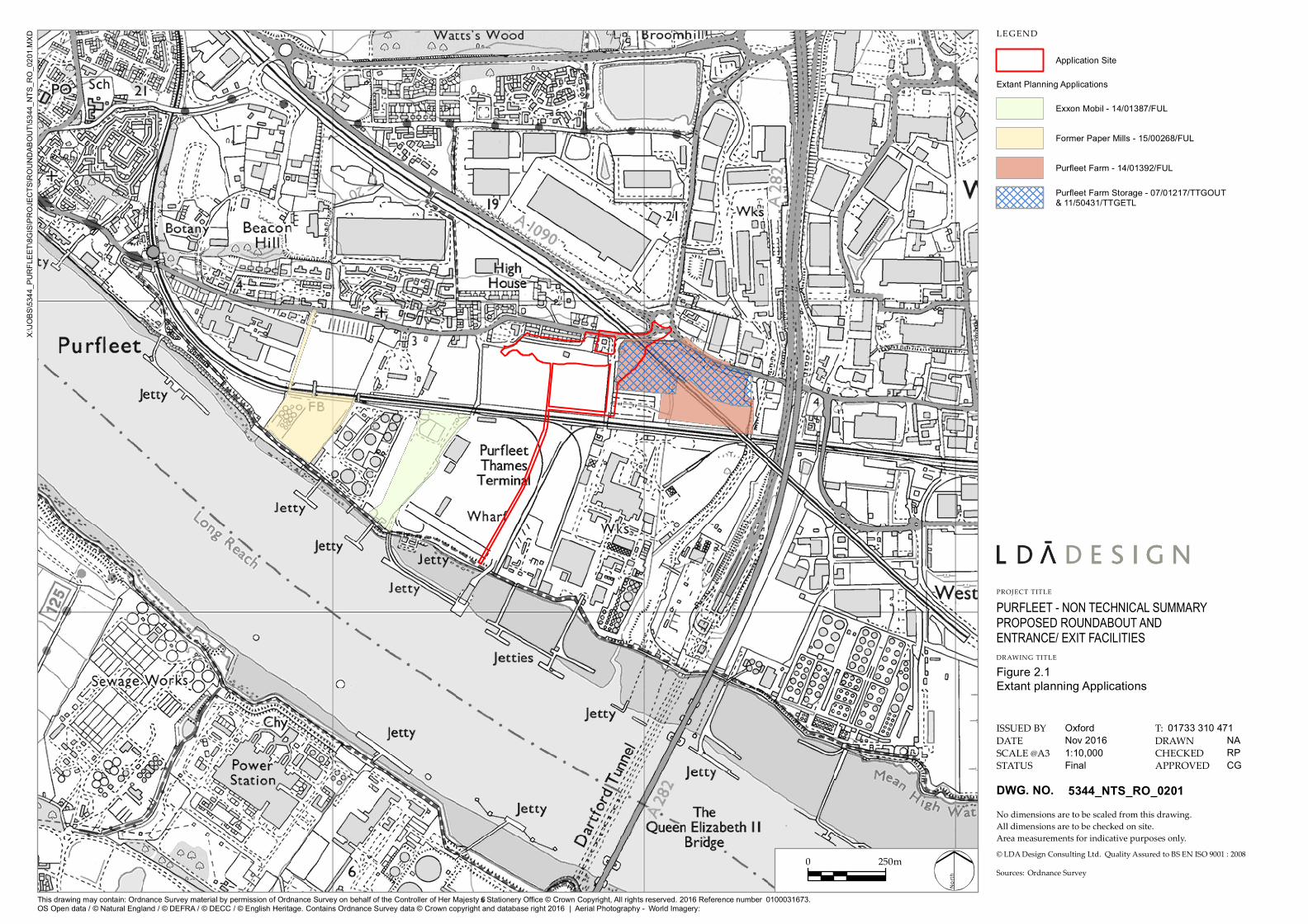
4.2. A new primary Site access in the form of a new roundabout at the
London Road/Jurgens Road Junction
4.2.1. A new primary site access will be constructed in the form of a new roundabout at
the London/Jurgens Road Junction. The new roundabout will have four arms and
will replace the existing London Road/Jurgens Road Junction.
4.2.2. The new roundabout arrangement will remove all HGV traffic associated with the
internal operation of the Terminal from London Road, with the exception of the car
transporters accessing the former Paper Mills Site (as per the consented planning
application - 15/00268/FUL).
4.3. Security Gate Complex
4.3.1. A Security Gate Complex (SGC) will be constructed to the rear of Jarrah Cottages.
Access to the SGC will be gained from the western arm of the new roundabout and it
will process all of the HGV traffic entering and exiting the Terminal (with the
exception of the Paper Mills Land, as explained above).
4.3.2. All vehicles will be required to pass a porter lodge on entry and exit. The porter
lodges will check freight in and out of the Terminal and inform drivers on where
their cargo should be located. The porter lodges will be located on a central island
(2.8m wide) between the lanes.

Purfleet
12
4.4. Landscape Treatments
4.4.1. The landscape strategy for the Site seeks to enhance the existing landscape areas
which are located along the edges of the proposed London Road roundabout. The
proposed strategy will seek to retain as much of the existing vegetation as possible.
Key areas for retention of vegetation are along the Site’s boundary with London
Road and the existing tree lined earth bund to the rear of Jarrah Cottages to ensure
that adequate tree cover is retained through a scheme of appropriate planting and
maintenance.
4.4.2. New areas of soft landscaping including trees, shrubs and areas of grass will be
created between the arms of the roundabout.
4.5. Lighting Strategy
4.5.1. All lighting comprises of LED luminaires for longevity and efficiency. Lighting has
been designed based on 16m high columns within the security gate complex, 10m
high columns for the carriageway lighting in order to match the height of the
existing columns, and 5m high columns for the pedestrian-only route to the north of
the proposed roundabout.
4.6. Signage
4.6.1. All traffic signs and road markings have been designed in accordance with the
Traffic Signs Manual and the Traffic Signs Regulations and General Directions
(TSRGD) 2016, supplemented where appropriate by Local Transport Note 1/94.
Regulatory and warning signs, and road markings advise of speed limits, weight
restrictions, pedestrian crossing points, the combined foot and cycleway and the
proposed London Road roundabout. Further detail is contained in the Design and
Access Statement.
4.7. Surface Water Drainage Strategy
4.7.1. New drainage system comprising a network of drains, and surface water collection
systems consisting of channels, gullies and kerb drains that connect directly into the
Purfleet
13
carrier drains. Surface water attenuation, where required, shall utilise oversized
pipes for storage.
4.8. Ecological Mitigation
4.8.1. An area of Open Mosaic Habitat will be created on the length of former London Road
which is no longer in use.
4.8.2. The embankments on the southern edge of the new London Road roundabout will
be planted with trees and shrubs and managed for ecological enhancement.
4.9. Construction Programme and Phasing
4.9.1. Subject to planning approvals, the construction of the Proposed Development will
be phased over 8 months and is anticipated to commence by the end of 2017 with an
anticipated completion date in 2018.
4.9.2. A Site Management Plan will be implemented to ensure health and safety,
environmental protection and quality are carefully managed and monitored during
the construction phase.
4.9.3. A Construction Traffic Management Plan shall be implemented during the
construction phase to minimise the effects of construction traffic upon local
receptors during the construction phase.
Purfleet
14
5.0 Traffic and Transport
5.1.1. The transport assessment considers the construction and operational effects of the
Proposed Development on the local transport network which comprises of the
highway network, pedestrian movement, cycling and public transport.
5.1.2. Consented developments have been included within the future baseline traffic
scenario which forms the basis of the transport assessment.
5.1.3. The IEMA Guidelines for the Environmental Assessment of Road Traffic (1993)
suggest a range of factors to be considered when determining the level of the
environmental impacts of development. The factors considered within the
Transport Chapter include: severance, driver and pedestrian delay, pedestrian
amenity, fear and intimidation and accidents and safety.
5.1.4. Although the construction works will generate a temporary increase in traffic
movements on the highway network in the vicinity of the Site, it is judged that the
Proposed Development would have a negligible effect on receptors during
construction with regard to all of the above factors.
5.1.5. The Proposed Development will not in itself generate any additional traffic and the
provision of a new access at the roundabout will result in redistributed traffic flows.
It is judged that all effects of the Proposed Development on receptors will be
negligible, and there will be no Significant effects on traffic or transport.
5.1.6. Although the effects are judged to be negligible, mitigation measures have been
suggested. These include the production of a Construction Logistics Plan which
would include details of haul roads and how pedestrian and cyclist safety would be
prioritised during construction.
5.1.7. Overall, there will be no Significant effects on traffic or transport as a result of the
Proposed Development.

Purfleet
15
6.0 Air Quality
6.1.1. An air quality assessment has been carried out to assess both construction and
operational effects of the Proposed Development.
6.1.2. An assessment of the potential effects during the construction phase concluded that
releases of dust and particulate matter is likely to occur during construction
activities. However, through good site practice and the implementation of suitable
mitigation measures, the impacts will be effectively mitigated.
6.1.3. It is also anticipated that there will be a temporary increase in vehicle movement
during the construction phase, but this would not result in any Significant impacts.
6.1.4. There is not anticipated to be any increase in vehicle movements associated with the
operational phase of the roundabout.
6.1.5. There would be a potential benefit in air quality to locally sensitive receptors along
London Road as a result of the Proposed Development. The proposed roundabout
would remove the majority of heavy duty vehicles from London Road by redirecting
them into the Site. The impact of operational phase road traffic emissions is
therefore considered to be not Significant and beneficial.
Purfleet
16
7.0 Noise and Vibration
7.1.1. The noise and vibration assessment considers the likely effects of the Proposed
Development with respect to noise and vibration. These include the effects of
existing noise and vibration conditions at the Site and the effects of noise and
vibration generated by the Proposed Development on surrounding properties,
during both construction and operational phases.
7.1.2. The assessment has been based on a series of environmental noise measurements
undertaken at the Site which have been used to generate noise predictions.
7.1.3. The impact of noise and vibration during construction of the Proposed Development
has been predicted and assessed in accordance with BS 5228. Mitigation measures
are recommended which, when implemented, are capable of ensuring that the
impact of noise and vibration during the construction of the Proposed Development
is adequately controlled. These measures will be implemented through a
construction environmental plan.
7.1.4. For the operational phase, an assessment has been carried out in accordance with
the adopted criteria (BS:4142:2014) to determine the level of impact on sensitive
receptors in the vicinity of the Site.
7.1.5. The assessment determined that an acoustic fence barrier is also considered
appropriate to protect the private amenity spaces of Jarrah Cottages from the noise
egress associated with the security gate complex. The acoustic fence shall replace the
existing fence which is located on the landscaped bund to the north of the security
gate complex. There will be no impact with respect to vibration associated with
operational phase activities.

Purfleet
17
8.0 Water resources
8.1.1. This chapter of the ES assesses the potential effects on flood risk impacts and water
resources receptors, including: groundwater quality and quantity; surface water
quality, hydrology and geomorphology (rivers, ditches, lakes, ponds and estuarine
waters); and, Water Framework Directive (WFD) compliance, which is considered at
the water body scale.
8.1.2. To assess the impacts of the Proposed Development on these receptors a set of
threshold criteria have been defined to establish the sensitivity, magnitude and
significance of the impacts identified. Baseline information for the local area was
gathered from Thurrock’s Strategic Flood Risk Assessments (FRA) and from relevant
assessments included in previous planning applications within the vicinity of the
Site.
8.1.3. The Site is located predominantly within Flood Zone 3, which is at ‘high’ risk of tidal
flooding from the Thames Estuary. A few small areas of high ground are within
Flood Zone 2, which is at ‘medium’ risk of flooding. However, the whole Site is
protected by tidal flood defences managed by the Environment Agency.
8.1.4. The Proposed Development could have a potential effect on flood risk and water
resources. Whilst some potential impacts on the water environment have been
identified as a result of the Proposed Development, it is considered that following
improvements to the Site drainage system (which will provide sufficient capacity
over the lifetime of the Proposed Development), that the Proposed Development
would not increase the risk of flooding to on- or off-site receptors, and in the long
term effects would be beneficial.
8.1.5. The risks identified to water quality can be managed through a combination of
tertiary mitigation such as good practice during construction; and mitigation which
would comprise of ground investigation and risk assessment, followed up with
appropriate measures (such as ground remediation) as necessary.

Purfleet
18
8.1.6. Following the implementation of all suggested mitigation measures, it is judged that
there are no Significant effects on water quality. The Proposed Development is
therefore judged to be compliant with the Water Framework Directive.
Purfleet
19
9.0 Ground Conditions
9.1.1. The ground conditions assessment presents the approach and findings of the
assessment of potential effects of the Proposed Development on human health, soil,
groundwater and surface water with respect to the ground conditions at, and in the
vicinity of, the Site.
9.1.2. To assess the impacts of the Proposed Development a set of threshold criteria have
been defined to establish the sensitivity, magnitude and significance of the impacts
identified.
9.1.3. Due to its industrial use the Site has a long history of potentially contaminative
land-use, and ground investigations have demonstrated the presence of ground
contamination within the vicinity of the Site.
9.1.4. A number of potentially Significant effects have been identified relating to exposure
to ground gas and contamination of construction workers, site operatives and local
residents, and pollution of the deep aquifer and identified groundwater abstractions
due to contamination leaching or migration.
9.1.5. However, suitable mitigation measures have been proposed which include the use
of PPE and good practice during construction, further ground investigations and risk
assessments followed up with any appropriate measures as necessary.
9.1.6. Implementation of these mitigation measures would result in no Significant
residual effects of the Proposed Development on ground conditions and
contamination.

Purfleet
20
10.0 Other Environmental Considerations
10.1. Landscape and Visual
10.1.1. A full landscape and visual impact assessment has not been undertaken as it is
judged that due to the nature of the Proposed Development, the industrial character
of the receiving environment, and limited nature of visual receptors likely to be
affected, that Significant landscape and visual effects are unlikely to arise.
10.1.2. In relation to landscape character, the Site lies within landscape character area
(LCA) E3 – West Thurrock and Purfleet Urban Area which extends from Purfleet
town centre to West Thurrock. The Thurrock Landscape Capacity Study (March
2005) notes that the area is dominated by a range of large commercial buildings and
warehouses. Overall, the Site and its immediate surrounds has an industrial
character, although there are areas of residential development to the north and west
of the Site along London Road.
10.1.3. Site work has confirmed that the Site is well screened and all potential landscape
and visual receptors are contained to a short section of London Road between
Vellcaott Close and Stonehouse Corner roundabout. Where views of the Site are
available, they are currently characterised by existing port activity which includes
the movement of vehicles (cars and HGV lorries), cranes, ships, and associated
infrastructure such as lighting columns, surface level car parks and container stacks.
10.1.4. Landscape mitigation has been embedded into the design and includes the retention
of existing trees and vegetation where possible. Further native and ornamental tree
and shrub planting has been also proposed around the roundabout to filter views of
the surrounding industrial context and provide an attractive entrance to the
Terminal.
10.1.5. Effects on landscape character resulting from the Proposed Development would
generally be confined to the Site itself, and would result in the loss of a small section
of scrub along Jurgens Road. However, overall, there will be a net gain in tree and
shrub planting on the Site and the effect on landscape character would be negligible.

Purfleet
21
10.1.6. In relation to visual receptors, effects are likewise very constrained and localised
with potential receptors including residents and users of London Road (including
Jarrah Cottages), Vellacott Close and High House Production Park. It is judged that
there will be no Significant effects on these receptors from the Proposed
Development.
10.2. Ecology
10.2.1. The majority of the Site comprises of areas of hardstanding related to port activities
including surface level storage for cars and shipping containers. These areas do not
support vegetation and are assessed to be of negligible ecological value. There are no
statutory or non-statutory designated wildlife or nature sites within or adjacent to
the Site.
10.2.2. The Site also includes a 0.93ha section of Purfleet Farm which is an area of vegetated
land to the south of London Road and east of Jurgens Road. This section of Purfleet
Farm comprises of patchy scrub and a vegetated ditch along the western boundary, a
small area of scrub to the northern boundary, an area of species-poor neutral
grassland in the north-west corner and a small area of sparsely vegetated hard-
standing/grassland below the Channel Tunnel Rail Link.
10.2.3. It is judged that Purfleet Farm, when considered as a whole, meets the definition for
open mosaic habitat (OMH) on previously developed land, which is a habitat of
principal importance for the purposes of conserving biodiversity. One of the main
reasons for the habitat being a priority is its importance for invertebrates.
10.2.4. An extended Phase 1 habitat survey was carried out in June 2016 and desk based
studies were also undertaken to assess the effects of the Proposed Development on
habitats and species within and adjacent to the Site.
10.2.5. The principle ecological impact of the Proposed Development on habitats would be
the loss of a small area of scrub and tall herbaceous vegetation along the boundary of
Purfleet Farm which is of low ecological value. There would be no additional
ecological impact over and above the future baseline situation on species-poor
neutral grassland.

Purfleet
22
10.2.6. There will be a minor reduction in the OMH within Purfleet Farm (approximately
10%), and the principle of loss of OMH within the northern half of Purfleet Farm has
been previous agreed in a consented planning consent (Ref: 07/01217TTGOUT and
11/50431/TTGETL).
10.2.7. To mitigate against the small loss of OMH arising from the Proposed Development
the southern section of Purfleet Farm will be managed to enhance biodiversity, and
additional landscaping for the new roundabout will incorporate proposed areas of
vegetation.
10.2.8. This vegetation will include two areas of successional vegetation/open flower rich
grassland to incorporate suitable habitats for invertebrates and compensate for the
loss of OHM. Native tree and scrub planting along the south-east Site boundary will
also provide a replacement for tree/scrub loss along the Purfleet Farm boundary.
These measures will adequately address the minor habitat loss associated with the
Proposed Development.
10.2.9. A small proportion of the area of habitat suitable for nesting birds and reptiles
within Purfleet Farm will be affected by the Proposed Development (approximately
10%). Precautionary mitigation will involve removing vegetation outside of the bird
nesting season, and the removal of ground vegetation by hand under an ecological
watching brief to encourage any reptiles present to move away from the working
area before any machinery is used.
10.2.10. Provided that the mitigation is carried out as suggested, it is judged that there will be
no Significant effects on reptiles or birds as a result of the Proposed Development.
Purfleet
23
11.0 Cumulative Assessment
11.1.1. In accordance with the EIA Regulations, the EIA needs to consider the cumulative
effects of the Proposed Development in combination with the environmental effects
of other developments on sensitive receptors identified through the EIA process.
11.1.2. Sensitive receptors have been identified in individual chapters of the ES and these
have varying degrees of sensitivity to change as a result of the Proposed
Development. Regard has been given to the sensitivity of the identified receptors to
ensure that consideration is then given to those which are particularly sensitive to
impact. The professional judgement of those undertaking the ES as well as topic
specific criteria, legislation or guidelines have been used to identify the degree of
sensitivity
11.1.3. Following the identification of projects within a 1km radius of the Site which have a
reasonable prospect of coming forward before or at the same time as the Proposed
Development, a list of seven cumulative sites was agreed with TC.
11.1.4. Each of these developments were reviewed for potential environmental effects on
respective environmental topics, and were subsequently assessed for potential
cumulative effects resulting from the developments in conjunction with the
Proposed Development. The combined cumulative effects of each of the
developments in combination with the Proposed Development were then assessed
for each of the environmental topics, and no significant cumulative effects have
been identified.
0 500m
X:\JOBS\5344_PURFLEET\8GIS\PROJECTS\ROUNDABOUT\5344_NTS_RO_0101.MXD
PURFLEET - NON TECHNICAL SUMMARYPROPOSED ROUNDABOUT AND ENTRANCE/ EXIT FACILITIES
Figure 1.1Application S ite
NARPCG
Nov 2016
Final1:15,000
5344_NTS_RO_0101
Ordn an ce Survey
North
01733 310 471Oxford
DWG. NO.
LEGEND
PROJECT TITLE
DRAW ING TITLE
ISSUED BYDATESCALE @A3STATUS
DRAW NCHECKEDAPPROVED
T:
No dimen sion s are to be scaled from this drawin g.All dimen sion s are to be checked on site.Area measuremen ts for in dicative purposes on ly.© LDA Design Con sultin g Ltd. Quality Assured to BS EN ISO 9001 : 2008Sources:
Th is drawing m ay contain: Ordnance S urv ey m aterial by perm ission of Ordnance S urvey on beh alf of th e Controller of Her Majesty’s S tationery Office © Crown Copyrig h t, All rig h ts reserv ed. 2016 Reference num ber OS Open data / © Natural Eng land / © DEFRA / © DECC / © Eng lish Heritage. Contains Ordnance S urv ey data © Crown copyrig h t and database rig h t 2016 | Aerial Ph otog raph y - World Im ag ery:
0100031673.
Application S ite
0 250m
X:\JOBS\5344_PURFLEET\8GIS\PROJECTS\ROUNDABOUT\5344_NTS_RO_0201.MXD
Fig ure 2.1Extant planning Applications
NARPCG
Nov 2016
Final1:10,000
5344_NTS_RO_0201
Ordn an ce Survey
North
01733 310 471Oxford
DWG. NO.
LEGEND
PROJECT TITLE
DRAW ING TITLE
ISSUED BYDATESCALE @A3STATUS
DRAW NCHECKEDAPPROVED
T:
No dimen sion s are to be scaled from this drawin g.All dimen sion s are to be checked on site.Area measuremen ts for in dicative purposes on ly.© LDA Design Con sultin g Ltd. Quality Assured to BS EN ISO 9001 : 2008Sources:
Application Site
Extant P lanning Applications
Exxon Mobil - 14/01387/FUL
Form e r P ape r Mills - 15/00268/FUL
P urfle e t Farm - 14/01392/FUL
P urfle e t Farm Storag e - 07/01217/TTGOUT& 11/50431/TTGETL
This d rawing m ay contain: Ord nance Survey m ate rial by pe rm ission of Ord nance Surve y on be half of the Controlle r of He r Maje sty’s Statione ry Office © Crown Copyrig ht, All rig hts re se rve d . 2016 Re fe re nce num be r OS Ope n d ata / © Natural Eng land / © DEFRA / © DECC / © Eng lish He ritag e . Contains Ord nance Survey d ata © Crown copyrig ht and d atabase rig ht 2016 | Ae rial P hotog raphy - World Im ag e ry:
0100031673.
PURFLEET - NON TECHNICAL SUMMARYPROPOSED ROUNDABOUT AND ENTRANCE/ EXIT FACILITIES
Jarrah cottages
Tilb
ury L
oop R
ailw
ay
Unilever Site
L
o
n
d
o
n
R
o
a
d
H
S
1
V
i
a
d
u
c
t
North Park
Stonehouse Corner
Roundabout
South Park
Purfleet Farm
Proposed
London Road
Roundabout
Proposed
Security Gate
Complex
River Thames
020 7467 1470London T:
Sketch
No
rth
0 100m
1:2,000
LE GEN D
ISSUED BY
DWG. NO
DATE
SCALE@A2
STATUS
DRAWN
CHECKED
APPROVED
No dimensions are to be scaled from this drawing.
All dimensions are to be checked on site.
Area measurements for indicative purposes only.
© LDA Design Consulting Ltd. Quality Assured to BS EN ISO 9001 : 2008
Sources
X:\JO
BS
\5394_P
UR
FLE
ET
T
HA
ME
S T
ER
MIN
AL\7C
AD
\D
RA
WIN
GS
\5394_024_P
RO
PO
SE
D D
EV
ELO
PM
EN
T.D
WG
PROJECT TITLE
REV. DESCRIPTION APP. DATE
DRAWING TITLE
This drawing may contain: Ordnance Survey material by permission of Ordnance Survey on behalf of the Controller of Her Majesty's Stationery Office © Crown Copyright 2015. All rights reserved. Reference number
OS Open data / © Natural England / © DEFRA / © DECC / © English Heritage. Contains Ordnance Survey data © Crown copyright and database right 2015 | Aerial Photography -
PURFLEET - ENVIRONMENTAL STATEMENTPROPOSED ROUNDABOUT AND ENTRANCE/EXIT FACILITIES
Drawing Title
Figure 4.1
Proposed Development
October 2016 MA
RP
RP
5394_SK024
Ordnance Survey
0100031673.
ESRI, DigitalGlobe, GEOEye, i-cubed, USDA FSA,USGD, AEX, Getmapping, Aerogrid, IGN,IGP,swisstopo, the GIS User Community
Application site
Surface water drain


![Thames Region Land Drainage - gov.uk · Thames Water Authority LAND DRAINAGE BYELAWS 1981 [as amended by the Thames Region FLOOD DEFENCE BYELAWS 1991] The Thames Water Authority,](https://cdn.vdocument.in/doc/165x107/5ead899913c7690cc165ecc9/thames-region-land-drainage-govuk-thames-water-authority-land-drainage-byelaws.jpg)