
Quandale, Rousay:
The biography of a landscape
An interpretive landscape survey
Daniel Lee
M.A. Archaeological Practice Orkney College
2008

Declaration:
This dissertation represents my own work except where otherwise acknowledged
using the Harvard referencing system.
Abstract:
The landscape of Quandale, Rousay, Orkney, is a remarkable area of ruined crofts, dykes, run rig and prehistoric mounds. It was subject to clearance in the mid 19th century and offers a rare opportunity to investigate an unimproved area of the Orcadian landscape. This thesis, facilitated by a reflexive walkover survey, aims to provide an interpretative account of Quandale; a biography of the landscape. A review of recent theoretical approaches to landscape and previous field surveys suggests that ‘landscape’ has been a neglected area of study in Orkney. The notion of a ‘top down’ and ‘bottom up’ approach to landscape is introduced. The former is discussed in relation to the interplay of Lairds, the Ordnance Survey, antiquarians and archaeologists, and the latter embodies the lived-through inhabitation of the landscape. The same approach is taken with the earlier and later landscapes that are both discussed with themes of materiality, place and temporality in an attempt to breakdown period-based constructs. The earlier landscape is explored through the Bronze Age burnt mounds and barrows that form significant monuments that endure to take on new meaning. Current accounts of burnt mounds are unsatisfactory, and both they and barrows monumentalise a range of spatial and temporal activities. The ‘event’-like characteristics of barrows can be compared to the ‘becoming’ of burnt mounds where the processes of varied, and perhaps seasonal, activities are embodied within the mound. The process of construction and the resulting mound may have symbolised wealth, consumption and display. The later landscape is discussed in terms of the task-orientated patterns of life, including the construction of dykes and aspects of tenure, that played out the concerns of the crofters as well as subtly appropriating the past. Social stratification may have been negotiated through the structures of everyday life and gender in crofting communities. In conclusion, it is suggested that Quandale does not represent a relict landscape of the past, but a dynamic landscape with a future.
i

Contents:
Abstract i
Contents ii
List of figures iv
List of tables v
1. Introduction 1
2. Landscape archaeology and field survey 4
Recent approaches to landscape 4
Landscape approaches in Orkney 6
Walkover and field surveys 9
3. The Quandale survey 13
Fieldwork, methodology and reflection 13
4. Notions of the Quandale landscape 18
The Ordnance Survey 18
Estate maps 22
Antiquarian pursuits 25
Romanticism 28
5. The materiality of the earlier landscape 30
Burnt mounds 31
Burnt mounds and barrows in the landscape 33
Temporality of construction: burnt mounds 36
Temporality of construction: barrows 38
6. Living among the mounds 41
Patterns of life 41
Inhabiting the past 48
7. Landscapes of politics and power 54
Territoriality, commemoration and display 54
Tenure, gender and religion 57
Earldom, estate and community 60
The contemporary landscape 61
ii

8. Conclusions 63
Future work 65
Acknowledgements 66
Cartographic sources 67
Air photograph 67
Bibliography 68
Appendix I 79
Appendix II 85
Appendix III 86
iii

List of Figures:
1. Location map of Quandale, Rousay 2
2. Archive: Inset location map (Appendix I) 80
3. Archive: Site location, southern area (Appendix I) 81
4. Archive: Site location, central area (Appendix I) 82
5. Archive: Site location, northern area (Appendix I) 83
6. The island of Eynhallow between Rousay and Mainland Orkney 8
7. Fieldwork list 14
8. Field survey 17
9. Location map of Rousay 19
10. Extract from 1st edition Ordnance Survey map 21
11. Extract from 2nd edition Ordnance Survey map (Appendix I) 84
12. Estate map (1841-5) 23
13. Estate map (1851) 24
14. Sea gust across Quoynalonga Ness 25
15. Grant and Callander: ‘the broch boys’ 26
16. Cist typology of excavated Quandale barrows 27
17. Sites of the earlier landscape of Quandale 31
18. Knowe of Dale burnt mound (59) 33
19. Sites of the earlier landscape of Quandale, southern area 34
20. Dyke (6A) and burnt mound (5) 35
21. Tafts barrow (117) 36
22. Tafts house (112) 42
23. Run rig (18) 43
24. Detail of feelie dyke stonework (65B, 123C) 44
25. Hill dyke (2) 45
26. Mackenzie’s map of Rousay (1750) showing hill dykes 46
27. Pens and plantiecrues (28, 57, 126, 127) 47
28. Sites of the later landscape of Quandale, southern area 49
29. Air photograph of the Tafts enclosure (112, 115) 51
30. Approach to the Tafts enclosure (59, 112, 117) 52
31. Double ditch and bank boundary (33) 55
32. Quoynalonga Ness burnt mound (24); a statement in the landscape? 57
33. Breck croft (89A) 59
iv

List of Tables:
1. Variation of place names between estate maps and Ordnance Survey 20
v
1
1) Introduction Nested between the hills and the sea on the north-west coast of Rousay, Orkney (Fig.
1) is the area known as Quandale. It is a remarkable landscape of ruined crofts,
weathered dykes, run-rig and prehistoric mounds. The survival of this ‘relict’
landscape sits well within the archaeological richness of Orkney. However, this is a
contested landscape of eviction and most of its monuments are unintentional. This
area of Rousay was the only part of Orkney subjected to clearance during the 19th
century and was turned into a sheep run. The landscape of Quandale therefore offers a
rare opportunity to investigate an area of the Orcadian landscape that was framed by
improvement and that is threaded with many interweaving narratives of past, present
and future.
Landscape archaeology has generally been a neglected area of study in Orkney.
Approaches to landscape and field surveys are reviewed in Chapter 2 and set against a
summary of more recent theoretical arguments. Research-led surveys have been rare,
with regional examples tending to be environmentally deterministic, description laden
and without recent approaches to landscape. The lack of attention may be bound up in
the difficulty of classifying the landscape of the archipelago, and for some it appears
as if Orkney has no landscape. The intention with this thesis is to move away from
this paradigm. Central to this was undertaking a walkover survey of Quandale and the
adoption of a reflexive methodology to provide a basis for ideas and discussion. In
Chapter 3 it is argued that such surveys provide an essential engagement with the
archaeological features and landscape from the bottom up, and also create situated
observation, interpretation and knowledge. This thesis represents the selective
discussion of sites and narratives, with the full survey archive summarised in
Appendices I-III (Figs 2-5).
A ‘bottom up’ and ‘top down’ approach to landscape is contrasted and the latter is
discussed in Chapter 4, showing how the interplay of Lairds, the Ordnance Survey
(OS), antiquarians and archaeologists shapes our understanding and perception of
Quandale today. In Chapters 5 and 6 the interlinking themes of materiality, place and
temporality are introduced as part of a consistent approach that blurs the misleading


3
boundary between prehistory and history. The Bronze Age burnt mounds and barrows
form the focus of discussion in Chapter 5 because they are significant monuments in
the landscape in the earlier and later phases. Certainly, burnt mounds are rarely
considered in the archaeological literature and there discussion tends to be functional
and descriptive. The focus on these monuments and themes leads into a consideration
of the later landscape in Chapter 6, where it is argued that the earlier monuments
endure and take on new meaning through the task-orientated patterns of life. The
theme of materiality is continued with reference to tenure and the construction of
dykes, and how these created a certain engagement with the earlier landscape. The
mounds, and to a different extent the boundaries, were appropriated in subtle and
varied ways bound up in notions of a mythical past and superstition. The final chapter
focuses on broader themes of politics and power, highlighting the conflict between
estate and community in the post-medieval period, culminating in the 19th century
clearance and the eviction of Quandale. The idea that the area represents a ‘relict’
landscape is rejected as it provides a sense of identity for Rousay and Orkney, and is a
landscape with a future.

4
2) Landscape archaeology & field survey Recent approaches to landscape Recent approaches to landscape have sought to combine the multiplicity of experience
through time and space as part of a process of change, appropriation and contention
(Bender 1993, 1998). For Bender, ‘landscapes are about the way in which people, any
time, anywhere, engage with their physical and imaginary worlds’ (2000, 23). They
are a dialectic between intimate and familiar, and distant and unfamiliar places. The
multi-vocality of landscape means that there are many perceptions and voices, but
also that with knowledge and power determine which ones are heard (ibid. 24, Bender
1998). The materiality of the landscape is enmeshed with historically situated
experience, social relations and cultural perceptions which cannot be separated. This
‘contextualizing’ of the landscape, according to Bender (1993, 2), depends upon
people’s perception and understanding within a specific time and place, and under
certain historical conditions. In this way the landscape provides multiple narratives
(Bender 1998).
Space is not therefore an abstract container for people and landscape, but is socially
constructed and ‘meaningfully constituted in relation to human agency and activity’
(Tilley 1994, 10). A phenomenological perspective, adopted principally by Tilley
(1994; 1999; 2004) and Thomas (1993; 1996), allows narratives to be focused through
the experience of the human body in relation to material culture and the landscape.
Following Heidegger, these approaches introduced ideas of being-in-the-world and
the concept of dwelling to archaeological discourse (also see Ingold 2000), although
Tilley uses it as ‘a methodology as well as a philosophy’ (Brück 2005, 48). The use of
phenomenology, however, has been criticised for its lack of methodological rigour
and the problem of verification in the field (Fleming 2006) and for its own Romantic
tendencies (Thomas 1996; Bender 1998), but mostly due to the problems inherent in
directly translating contemporary experiences onto the past (Brück 1998, 2005).
These criticisms aside, the significant contribution of phenomenological approaches
to landscape archaeology has been in facilitating the breakdown of dualistic post-
enlightenment thinking and reassessing dichotomies, such as subject/object and

5
culture/nature, allowing archaeologists to engage with the social significance of
landscape and personhood (ibid. 65).
Phenomenological ideas of dwelling and movement have led Ingold (1993, 2000) to
assert that people, place and identity are embedded in the landscape through routine
practice. He has conceptualised this temporality of landscape with the term
‘taskscape’ (ibid.). This theoretical stance has been criticised for applying universal
themes of labour-based engagement with space and place (Bender 2000, 25); it is also
countered that knowledgeable engagement cannot solely be gained through a series of
performed tasks (Barrett 1999a, 24). Tilley has suggested that ‘a landscape is a series
of named locales, a set of relational places linked by paths, movements and narratives’
(1994, 34). Several authors have explored ideas of ritual and routine practice within
everyday life with a focus on the more transient spaces between settlements and
ceremonial monuments (Bender et al. 1997, 2007; Edmonds 1999). Rather than being
static definable entities that can be read like a stratigraphic book (Tilley 1994; Barrett
1999a) landscapes are ‘untidy’ and subjected to constant re-working and re-
constitution (Chadwick 2004, 5). The metaphor of tapestries or fabrics has been used
for landscape, thus describing the ‘complex, intertwined relationships that change
over time and from place to place, and into which our own experiences and memories
are woven’ (ibid.).
Recent archaeological discourse has concerned itself with the concept of human
agency whereby knowledgeable individuals continually constitute and re-constitute
their world through practice (Dobres and Robb 2000). Barrett, however, suggests that
‘the practices by which that agency both gained and used its knowledge are rarely
discussed’ (1997, 122). He has argued for an archaeology of inhabitation (1997,
2000, 2001), following Bourdieu’s (1977) notion of habitus, where social practice and
structure is created out of the routines of daily life, and Giddens’ (1984) duality of
structure where social conditions are created and recreated in an unintentional,
ongoing and recursive manner. Crucial to this concept is that contemporary
archaeological interpretation and the past both represent an ‘inhabitation of material
culture’ (Barrett 1997, 124). Landscapes are thus embodied inhabitation of multiple
temporal and spatial narratives formed by practice and experience (ibid. 125-6).
Hodder (2000), however, suggests that this approach to agency denies individual

6
intentionality. He believes that it focuses on the large scale narrative dictated by
resources, at the expense of investigation at the human micro-scale through which
experience is understood. Nevertheless, this appears to deny the range of scales of
analysis (see Thomas 1996, 95-8), from the micro to landscape and beyond, and how
understanding their interplay is essential to make sense of the past.
These approaches to landscape, however, have generally been applied to prehistory.
Johnson (2007) has recently argued that such theories of agency and practice, now
common in prehistoric discourse, should also be applied to historic landscapes (see
also Symonds 2000; Dalglish 2003). The landscape is the result of human agency over
many thousands of years, and the prehistoric, historic and archaeological ‘records’ are
both products and mediators of social action (Johnson 2007, 147-52).
Landscape approaches in Orkney Surprisingly, landscape has been a neglected area of study in Orkney. Investigations
have focused on sites and classes of sites, often failing to break down period
boundaries. This may reflect the wealth and quality of archaeological remains, the
study of which perhaps still suffers from the legacy of antiquarian investigation.
Renfrew (1973, 1984), for example, did consider the setting and intervisibility of
Neolithic tombs on Rousay, but followed a systemic method with no consideration of
what came before or afterwards. The Neolithic landscape was reduced to a static
series of imposed Thiessen Polygons which were used to delineate territories based on
environmental criteria. More recent studies have considered the experience of
landscape in relation to monuments and materiality (Richards 1996a, 1996b) and the
relationship between monuments, land and sea (Phillips 2003), but these
investigations have remained focused on the Neolithic and have not considered the
multi-period landscape.
Certain recent projects have focused on Neolithic settlement (Richards 2003, 2005;
Card 2006) in an attempt to place ceremonial monuments in a wider context, and a
recent study of Bronze Age funerary practice, specifically cremation, has focused on
the practice of burial including a consideration of the constitution of barrows in the
landscape (Downes 2005). Iron Age studies have recently attempted to move away

7
from broch-centric approaches (see Hedges 1985; Armit 2003) towards more
interpretative studies that consider the wider landscape (Carruthers pers. comm.;
Moore forthcoming). Medieval and post-medieval studies in Orkney are still very
much entrenched within their own agenda, and have yet to venture ‘out of the box’ in
terms of recent approaches to landscape. This is exemplified by the debate
surrounding the ‘integration’ of the Vikings and Picts (Grieve and Gibson 2005),
where diffusionist ideals assume that the Vikings inherited a blank canvas.
Recent challenges such as developer funded archaeology are at the moment on a
relatively small scale in Orkney, and coastally eroding sites (Wilson 2003) continue to
be approached in an isolated and reactionary manner. Focus on the contemporary
Orcadian landscape has tended to be for classification purposes (RCAHMS 2007;
Land Use Consultants 1998) and aspects of setting (Tyldesley 2001).
This lack of attention is perhaps linked to the difficulty of classifying the Orcadian
landscape, especially in relation to Scotland. Perceptions of landscape in mainland
Scotland have traditionally centred on the Romantic ideal of the Highlands, a pattern
reflected in archaeological enquiry (Barclay 2000, 2004). Until recently, the uplands
approach to landscape has been applied whether appropriate or not (Barclay 2004).
The Orcadian landscape has therefore been difficult to classify; it is neither classic
upland nor lowland, but somewhere in between in terms of land use and archaeology.
Indeed, the ‘upland’ areas of Orkney (the hills of Hoy, West Mainland and Rousay)
have received the least attention. Even Barclay seems confused in classifying the
archipelago as ‘highland’ (2000, 278). It appears that this problem of definition has
led to a lack of clarity in considering the wider landscape. This is also, perhaps, bound
up with a common failure to consider the sea as anything but a neutral boundary (cf.
Noble 2006; Phillips 2003; Rainbird 2007). The Orcadian landscape has been
famously described in terms of the sea as ‘the backs of whales in the ocean of time’
(George Mackay Brown; Fig. 6). For some, therefore, it seems as if Orkney has no
landscape.

8
Fig. 6. The sea, land and sky: the island of Eynhallow between Mainland Orkney and Rousay.
The Heart of Neolithic Orkney World Heritage Site (HNOWHS) research agenda
(Downes et al. 2005) has been important in pushing forward the landscape approach.
Whilst the designated WHS zones are small and confined to pre-existing scheduled
and environmental areas, the recognition that the Neolithic sites form a dynamic part
of a multi-period landscape (Cowley et al. 2005) has been significant. The
consideration of landscape has been firmly placed at the heart of the agenda, and set a
bench mark for future research. This approach has been centred on recent theoretical
approaches to landscape, but also reflects, perhaps, a growing trend of archaeologists
undertaking work from within the county, drawing on more locally situated
knowledge and experience rather than solely the traditional summer visits from
southern universities. Recent work in the WHS has, however, tended to be technique
led, for example with the extensive geophysical surveys (Card et al. 2007) and
enhanced landscape survey (Robertson 2005) of the inner buffer zones. Richards
(1985, 2005) was the first to apply systematic fieldwalking at a research level in
Orkney and unsurprisingly found it highly successful in locating previously
unrecorded sites, helping to broaden the agenda to consider Neolithic settlement
rather than ceremonial monuments alone. Whilst highly productive, research has so

9
far not considered the landscape at different social and temporal scales nor, apart from
mapping, attempted to cross period boundaries.
Walkover and field surveys There have been few research-led landscape surveys in Orkney. The first attempts to
characterise the wealth of archaeological remains on the islands was undertaken by
John Corrie of the Royal Commission in the early 20th century (RCAHMS 1946;
Reynolds 1984) and later by Raymond Lamb in the 1980s (e.g. Lamb 1980, 1982).
Corrie identified and recorded numerous new sites but his methodology was dictated
by the pattern of remains previously identified by the OS in the late 19th century. The
surveys by Lamb were more detailed and broke away from merely verifying the OS,
making significant discoveries for example the major later prehistoric land boundaries
known as treb dykes (1980, 1983). Both Corrie’s and Lamb’s surveys, however, were
conducted and compiled in order to produce inventories, and features and monuments
were characterised on a site basis without consideration of the wider landscape. Very
much a product of their time, they have nonetheless formed a vital resource for the
establishment of the county SMR and NMR, and a basis for future research. Other
projects in the 1980s followed this inventorisation objective, and surveys of the
islands Muckle Skerry (Hunter and Dockrill 1982), Fara (Hunter et al. 1982), Cava,
Rysa Little and Switha (Hunter et al. 1984) and Deerness in East Mainland (Steedman
1980) where undertaken. These reports are based on description and gazetteers, at the
expense of wider interpretation and consideration of the landscape.
The Rousay, Egilsay and Wyre Community Council Local History Project
(REWCCLHP, 1983) took a slightly different approach, placing an emphasis on
transposing air photos and collating archive resources with some fieldwork as a means
of investigating the islands. The resulting plans and primary archive form a detailed
record of the multi-period landscape (including Quandale) and a valuable local
resource, however the project was a highly empirical exercise of data collection, and
unfortunately, no funding was in place for dissemination.
It is interesting to consider why it has taken over 20 years for more research led
walkover surveys to be conducted in Orkney. This may be due to the association of

10
field surveys with more methodological approaches and the diminishing trend of
inventory production. As noted above, the WHS has so far been investigated with
technique-led approaches, rather than the characterisation and examination of multi-
period features on the ground. No recent research led walkover surveys have been
conducted on mainland Orkney, with the only examples on the islands of Wyre and
Eynhallow (Thomas 2006; Moore and Thomas in prep). Systematic characterisation
of the archaeology of these islands has been carried out including additional survey,
fieldwalking and geophysical survey. A comprehensive approach to the fieldwork was
adopted, although the reporting follows a traditional Data Structure Report format
(DSR, Historic Scotland 1996; IFA 2001) with sites discussed by type and not
considering the nuances of landscape (Thomas 2006). A similar structure has also
been used by Bradley (2004) reporting on a recent landscape survey of Foula,
Shetland, although the results are discussed by area.
A limited number of surveys have been undertaken in Orkney within the paradigm of
developer funded archaeology (e.g. Card 2002; Robertson and Sharman 2006), and
extensive coastal surveys have been carried out in response to erosion (Wilson 2003).
These have been important in building locally based knowledge and experience, but
such reports follow the DSR format with the objective of assessing the
‘archaeological resource’ within a certain area. This reduces reports to a formulaic
written archive or gazetteer created from a brief, engaging little with recent
approaches to landscape. Whilst ‘fit for purpose’ and designed to satisfy standard
procedure, the argument as to whether these should adopt more innovative approaches
to fieldwork practice and reporting is beyond the remit of this thesis (see Tilley 1989;
Barrett 1995, 2000; Chadwick 2004; Bradley 2006). The DSR format is certainly
problematic, however, as it often represents the end point with no further publication,
interpretation or theoretical input.
Elsewhere in Atlantic Scotland several landscape surveys of varying scales and
approaches have been undertaken and provide a useful comparison. Surveys of note in
Shetland include Fair Isle (Hunter 1996) and Kebister (Owen and Lowe 1999) which
provide detailed accounts of those multi-period landscapes combining survey,
excavation and building recording. They are, however, environmentally deterministic,
and in the case of Fair Isle, reinforce the notion of marginality and remoteness (Coles

11
and Mills 1996) without acknowledging the agency of the land and maritime
communities, a position Hunter has made clear elsewhere (1994). The Kebister report
is a highly traditional monograph with the survey element aimed at ‘landscape
reconstruction’, adopting a technique-and methodology-laden approach. Data
production seemed paramount, and ‘the intensive topographical and specialist surveys
[soil, vegetation, peat, pollen, marine seismic reflection and tephrochronology]
produced a wealth of data which is not easy to assimilate’ (Owen and Lowe 1999, 75).
The people of the past, whose fate was apparently determined solely by climate and
soil, are swapped for data and description. These reports are a product of their time
(fieldwork in mid 1980s) but they lack more recent theoretical angles and approaches
to landscape and inhabitation.
In his recent book on St. Kilda, Fleming (2005) rejects the notion of marginal
existence and environmental determinism so often placed on island communities. He
argues that these approaches minimise the significance of changing historical
conditions and treat communities as ‘culture bearers rather than active participants in
their own history’ (2005, 12). The project has been published in an accessible and
readable book and claims to have adopted a more anthropological approach (ibid. 13),
but the people of the narrative only appear with the historical and documentary
evidence. The opportunity to explore the temporality and inhabitation of the
prehistoric landscape, especially in regards to the dolerite quarries and the re-working
of earlier monuments in later history, is omitted (although this has been reported to
some extent elsewhere with input from Mark Edmonds, see Fleming and Edmonds
1999).
It is easy to be critical of previous landscape surveys, and it must be stressed that the
examples mentioned above provide important assessments of otherwise neglected
areas. There are, however, other ways of telling a landscape narrative. Recent
approaches to landscape have rarely been applied in Orkney and Atlantic Scotland,
and investigations have tended to be technique based. Previous walkover surveys,
especially in the 1980s, have been objective, methodological and description laden,
and in some cases environmentally-deterministic, often reinforcing perceived ideas of
marginality. More recent reports have been bound by the concept of the DSR or
lacked consideration of place, temporality and inhabitation for both prehistoric and

12
historical archaeology, themes which have become central to recent approaches to
landscape.

13
3) The Quandale survey A walkover survey was considered to be the logical starting point for the investigation
of the landscape of Quandale. This allows a ‘bottom up’ approach to the features and
monuments, rather than a ‘top down’ approach relying on previous investigations,
existing documents and maps that are themselves methodologically and temporally
situated, creating their own notion of ‘landscapes’ (see Chapter 4). Walkover surveys
are an important way to engage with landscape features, not only in a physical sense,
but also as a means of situated observation, interpretation and knowledge. The success
of this approach depends how the survey is approached (not just a perceived need to
get your boots muddy) and how the research is presented. As mentioned in Chapter 2,
past surveys have tended to be descriptive, and only interpretative when this is
inherently bound up in description (Hodder 1999). The experience of the survey itself
and perhaps the attraction of small uninhabited islands (e.g. Hunter et al. 1982, 1984)
is often denied. It is interesting that, empowered by new approaches to landscape and
reflexive archaeological practice, archaeologists are now returning to field survey
(e.g. Bender et al. 1997, 2000, 2007) as a means of explicitly engaging with the
contemporary (and therefore the past) landscape.
Fieldwork, methodology and reflection In any survey, a study area boundary is a false imposition on the landscape, so the
most controversial boundary of all was adopted: the large sheep dyke constructed to
enclose Quandale after the clearance of the crofts and improvement of the
surrounding area in the mid 19th century (Fig. 1). This encompasses an area of c.275
hectares within which a rapid walkover was undertaken between the 25th October and
13th November 2007, with 13 of those days spent in the field (Fig. 7).
Cartographic resources, including historical OS maps which show many of the main
post-medieval boundaries, OS Landline map data (acquired from OS/EDINA service),
and maps produced by the Rousay, Egilsay and Wyre Community Council Local
History Project (REWCCHP, 1983) which transposed local aerial photographic and
historical map data, were used as references in the field. The area was not split into
separate compartments per se, but investigated in blocks defined by enclosure
Dead rabbit HY37540/31818

14
boundaries and landscape features to ensure systematic and full coverage. Each block
was walked including along the full length of each boundary dyke and intersections.
Where large open areas were encountered, regular traverses were made (c.50m wide
max.) to examine the area as consistently as possible. The distance between traverses
was only estimated and some variation did occur, with some areas examined in more
detail if the potential for archaeological remains was considered to be high. Other
areas, such as those comprising thick peat, were examined systematically but less
intensively due to time pressures in the field.
Fig. 7. Fieldwork check list.
The primacy of the map when conducting a field survey is significant. As Johnson
points out, traditional landscape archaeology often denies the archaeological elements
of the landscape as they are already predetermined by the historical and documentary
sources (2007, 58-9). The survey of Quandale had the advantage of the REWCCHP
maps which vastly limited the amount of survey that had to be undertaken in short
time, but inversely meant that the survey was bound to check and verify the
authenticity of predetermined features. Whilst constraining, this process was
undertaken reflectively and knowledgeably with careful consideration of whether
these features represented a true pattern, or existed at all and also required the
investigation of the ‘blank’ areas in between.
Plastic barrel HY37254/32064

15
Each site was assigned a unique identifier number in the field and its location
recorded using a leisure grade handheld GPS receiver (accurate to +/- 4-7m). A ‘site’
represents a small isolated discrete feature, a group of related features of similar form
and character, or a number of associated features that form a coherent group. The
decision as to what formed a site was taken in the field, and sites which comprised a
number of features, such as a croft and head dyke, were subdivided (e.g. 100A, B, C
etc.) for ease of description and discussion. Sites are referenced in bold in the
following chapters, e.g. (12) for Site 12, with the site archive in Appendices I to III.
Site locations can be found in Figures 3-5 (Appendix I) unless stated otherwise.
The characteristics of each site were recorded on pre-printed pro forma record sheets
or drafting film, depending on conditions. The type of site was noted and the central
NGR was recorded using the GPS receiver. Dimensions and orientation were recorded
using pacing, hand tapes and a compass. Land use, observable physical relationships,
associated sites, erosion, condition, visibility and significance were recorded where
appropriate. Weather conditions were also noted. A detailed description and
interpretation was compiled for each site including location, visibility, preservation,
physical characteristics, construction and materials, and accompanied by a detailed,
annotated, sketch plan. Digital photographs were taken of each site when weather
conditions allowed.
The fieldwork methodology was primarily visual, following traditional methods in
landscape archaeology (Thomas 1993, 25; Johnson 2007, 85-9) with the use of maps
as a guide. However, other experiential elements, such as touch or feeling as you walk
over features or probe them, and sound and smell, all inform interpretation and must
be acknowledged. The influence of the latter may be minimal, but the importance of
touch when assessing land use, the form of features and breaks of slope, stone content
and regularity is highly significant. Just as excavators often claim they can ‘feel’
different deposits when trowelling, so walking and moving around features is
important in their discovery, characterisation and interpretation.
A diary was completed on a daily basis during the process of the fieldwork. The
reflexive element to the survey methodology included detailing alternative
interpretations, and less ‘decipherable’ sites and areas were revisited in different
Red mushroom HY37211/32112

16
weather and light conditions. It was unfortunately not possible to engage the local
community in the fieldwork due to unfavourable weather conditions (gale force winds
and rain) and the tight time scale before the weather turned for winter. The
interpretations are therefore those of the author after a sustained period in the field
under certain conditions. The next phase in the project will involve revisiting sites for
more detailed survey and community involvement, and conducting a guided walk for
interested public and peers when the weather improves.
Two side projects were completed during the process of the fieldwork to convey the
experience of the survey and the contemporary landscape. The first was a simple
three-part record of the weather conditions combined with photographic
representations of the sky gained from the photographic archive (Fig. 8). The second
was a record of ‘Archaeological Half Sites’ that were encountered. These are the
objects, be they ‘natural’ or ‘cultural’; a plastic bottle, sheep skull, or buoy, that were
noticed during walking. They are not archaeological in a true sense, but are part of the
way to entering the ‘archaeological record’. They are ephemeral contemporary
scatters of artefacts that form a frequently noticed but never recorded part of the
landscape. Encountered only when walking and looking, they represent pauses and
temporary places. These were recorded as if ‘archaeological’ in the traditional sense
with a brief description and grid reference. A selection of these are shown on each
page header to convey the experience of the walkover survey.
The results of the walkover survey are presented as a series of archive maps and
descriptive tables (Appendix I-III, Figs 2-5). The remainder of this dissertation is
concerned with a number of central themes that emerged out of the fieldwork process.
Ingold has noted that ‘the practice of archaeology is itself a form of dwelling’ (2000,
189). This survey is thus the latest chapter in the ongoing inhabitation of the Quandale
landscape and has almost at once been superseded. The reflective narratives of this
brief inhabitation are the concern of this thesis.
Sheep skulls HY37014/32045

17
Fig. 8. Field survey

18
4) Notions of the Quandale landscape
This chapter examines some of the different phases of engagement with, and
investigation of, the Quandale landscape that shape our understanding and perception
of it today. OS mapping and estate control give the appearance that the contemporary
landscape is the result of clearance. The 20th century saw the first real engagement
with Rousay’s archaeology and a Romanticisation of the landscape. The interplay of
Lairds, the Ordnance Survey, antiquarians and archaeologists form a ‘top down’
approach to the landscape. This contrasts with the inhabited and lived through
landscape, experienced and manipulated by those who constructed the mounds, dykes
and crofts. This ‘bottom up’ approach to landscape, which the walkover survey has
enabled, will be discussed in Chapters 5 and 6. A location map of Rousay is shown in
Figure 9 for reference.
The Ordnance Survey More often than not, our first encounter with a place is guided by the use of an OS
map, simply to find out where to go and what is there. The map, however, only
provides one way of looking at the landscape; it is a set of symbols that are
themselves historically and socially constituted. This bird’s eye view illustrates the
choices of what should be surveyed and named at specific points in time. It is now
well attested that the OS programme of mapping during the 18th and 19th centuries
represented the legacy of colonial ambition (Johnson 2007, 87; Withers 2000, 533)
and a desire to control knowledge, resources and nature (Bender 1998, 108); a process
of ‘authorising’ the landscape (Withers 2000, 532).
Plastic bottle HY36784/32347

19
Fig. 9. Map of Rousay showing places mentioned in the text (based on OS map data).
The creation of the first OS edition in Scotland in the mid 19th century comprised
survey first, followed up with name and antiquity research into what was worth of
recording; information which was generally sought from the upper levels of society
(Davidson, 1986, 11-12). The accuracy of this was dependent on the enthusiasm and
thoroughness of ‘Sappers’ of the Royal Engineers who conducted the name survey, to
whom they spoke, and the reliability of their accounts (ibid. 13-14). The resultant
‘name books’ often contained erroneous information, eccentricities and incorrect, or
even controversial Anglicised spelling (ibid.; Table 1). The surveys were a lengthy,
piecemeal and complicated process (Withers 2000).
Polystyrene slab HY36724/32424

20
Estate map c.1841-5 OS 1st edition pub. 1882 Type Stirling Starling Croft Tofts Tafts Croft/house Meadow Burn - Burn Burn of Dale - Burn - Dale Croft - Mid Quandale Croft Cruly Croolea Croft Burn of Cruly - Burn Hammers of Cruly - Rock face Hammers of Drussifer - Rock face - Claypots Enclosure - Cairn Croft - Lower Breek Croft - Hestivall Croft Green Hill Brae of Moan Hill Singens of Cutlaws Sinians of Cutlaws Coastal cave Waesgoe - Coastal Ebbalongie - Coastal Marbar - Coastal Queenalonganess, (also Quinalonganess 1851)
Quoynalonga Ness Coastal
- Swinge Geo Coastal - Water Geo Coastal Singens Kiln of Dusty Coastal cave - Hellia Spur Coastal - Murren Coastal - North Dale Land
Table 1: Variation of place names in Quandale between the Estate map c.1841-5 and the first edition Ordnance Survey map surveyed 1878, published 1882 (where different). The estate map names are derived from an ‘official’ source rather than residents, but highlight the variation in what was named between an inhabited and uninhabited area. Some of the crofts are absent from the estate map as they were amalgamated with other crofts by that time. The landscape encountered at Quandale by the survey team in 1878 may have still
retained a familiar human scale following the clearances in 1845-8 by the laird
George Traill and the remaining croft houses and fields were probably well preserved.
Some dwellings had been demolished to form sheep shelters and walls (Grant 1936),
and the 45 miles of linear drainage ditches excavated in 1837 (Thomson 1981, 48)
may have still seemed fresh. Any sense of abandonment would have been heightened
by the lack of people. Whilst some crofters found work with the enlarged farm of
Westness that assimilated the cleared areas, most were displaced elsewhere on the
island or left (ibid.). The local knowledge of the Quandale area was largely lost with
them.
Sheep skull HY36416/32193

21
Fig. 10. Extract from Ordnance Survey first edition map (1882, not to scale).
The Ordnance Survey team would have experienced the relative prosperity and
improvement of the island characteristic of the period 1870-83 under the new laird,
Fredrick Traill Burroughs, but the bitter resentment of the clearances remained. It is
unlikely that the Sappers engaged much with the local population, especially in
regards to Quandale, and the names and antiquities recorded are likely to have
originated from the laird or factor. Whilst the detail of the survey is admirable
considering the landscape was essentially ‘abandoned’, only three unnamed ‘Tumuli’
and ‘The Knowe of Dale’ (15, 21, 24, 59) are depicted, demonstrating a lack of
inhabited local knowledge regarding antiquities, and omitting some of the more
prominent Bronze Age mounds (e.g. 103, 117; Fig. 10). This pattern is faithfully
repeated in the second edition published in 1903 (Fig. 11, Appendix I). The mapping
of Quandale may have hints of Romanticism recording a lost way of life because the
Limpet shell HY36372/32216

22
old boundaries and crofts were depicted in detail. The surveys were historically
constituted and the product of a particular time and experience. The standardised
maps give the impression of consistency and rigour, but behind each sheet is a story
of local encounters, knowledge and control.
Estate maps The presentation of the landscape by the Ordnance Survey differs quite drastically
from that of Traill’s estate maps from around the time of the clearance of Quandale. It
was his vision driven by his ruthless factor Scarth, which created the present
landscape where the past improvement is highly visible with its connotations of
contest and abandonment. The earlier ‘Plan of the Township of Quendale’ is likely to
date from when Traill first purchased the area in 1841 (copy undated c.1841-5) and
depicts the crofts and ‘old boundaries’ with tenants and their rents marked (Fig. 12).
The straight lines of the ‘roads without fences’ and ‘proposed fences’ are more likely
to represent intention rather than reality, and suggest some consideration of a future
for the community. This is also hinted at by the improvements made in 1842 to certain
crofts, including a new corn drier and barn for Tafts (112; ibid. 45).
The purchase of Westness in 1845 changed the fate of Quandale but rather than
improving the crofters’ holdings, the area was incorporated into Westness and turned
over to sheep (ibid. 45-6). Following the clearance in 1845 the township was
essentially erased from the estate. Whilst the rest of the Orcadian lairds, gentry and
their associates at this time were amusing themselves with antiquarian pursuits (Card
2005a), Traill was focused on his estate, especially Westness and Quandale, in terms
of economics and resources. He died suddenly in 1847, but the inheritor, Burroughs,
was resident in India; the farm was let with Scarth remaining as the factor (Thomson
1981). The 1851 plan of the Farm of Westness (as proposed to be let) shows the area
bounded by a large wall incorporating the land to the north-east of Scabra Head, and
named ‘Quandale Park’ with no detail of the township (Fig. 13). It was the OS who
drew this area back into focus depicting the abandoned crofts and boundaries,
including those who were amalgamated with other crofts prior to the clearance.
Buoy HY36255/32324

23
Fig. 12. Extract from Estate map (c.1841-5, not to scale, REWCCLHP).
In contrast to Traill, Burroughs was absent in India and showed little interest in the
Rousay estate until his arrival in 1870 (ibid.). Following a short period of residence at
Westness House in sight of the contested cleared areas, Burroughs soon constructed
the grand Trumland House on the southern side of the island (Fig. 9). This seemed to
distance his centre of power from Westness and Quandale. After a period of relative
prosperity Burroughs started rack-renting tenants to cover his own financial problems.
Combined with poor harvests, crofters were massively in arrears and became
desperate. They founded the Crofters Movement and a bitter battle between
community and laird ensued and was investigated by the Napier Commission in 1883-
4. This advised new land reform and security of tenure to all crofters within the
‘Crofters Act’ of 1886 (ibid.). The mid to late 19th century saw bitter disputes and
Buoy HY36336/32371

24
battles on Rousay and clearly focused the inhabitants in opposition to traditional life,
improvements and capital.
Fig. 13. Extract from ‘Plan of the Farm of Westness’ showing Quandale Park (1851, not to scale, REWCCLHP).
The perceptions of living in Quandale are significant. In the late 19th century this was
recorded in official records, however the Napier Commission highlighted that even
the crofters often complained of the frequent ‘sea gust’ which damaged crops with salt
(ibid. 42; Fig. 14). The perception from outside the community was one of
astonishment that the community could inhabit such a bleak and windswept place
(ibid. 45). Even Thomson partly succumbs to this notion of the landscape when he
describes Quandale as ‘a broad and bare semi-circular depression facing the open sea’
(1981, 42). This perception appears to legitimise the clearances as a means of saving
Drinks can HY36476/32391

25
the community from poverty and the environment, but misses the point that these
were conditions that were known and worked through on a yearly basis, even if they
were adverse at times. Were the conditions on the coast at Quandale really any
different to other west facing coastal settlements in Orkney or Atlantic Scotland?
Fig. 14. Sea gust across Quoynalonga Ness, looking south-west.
Antiquarian pursuits Antiquarian pursuits in late 19th century Rousay were low in priority compared to the
rest of Orkney (Card 2005a), and few excavations were carried out on the estate. One
exception was Taversoe Tuick chambered tomb, adjacent to Trumland House, partly
excavated by General and Lady Burroughs in 1898 after the mound was disturbed
during the construction of a proposed garden seat (Turner 1903; Grant 1939; see also
McCrie 1881). Lady Burroughs’ diary describes how the excavation captured her
imagination, perhaps more so than her husband’s, but she notes that ‘the inhabitants
don’t much like finding these burials’ (Reynolds 1985, 119). This lack of engagement
and interest with the wealth of archaeological remains on Rousay characterises
Burroughs’ perception of the landscape as an economic resource. Perhaps the conflict
with the crofters meant that he could not show interest in such remains, as they were
Goose egg HY36498/32378

26
somehow connected with the traditional and mythical past he was trying so hard to
remove.
Following General Burroughs’ death in 1905 and Lady Burroughs’ shortly after in
1908, a new more enlightened laird, Walter Grant was to run the estate. Freed from
the previous family legacy of the clearances and rent extortion, Grant looked at the
landscape of Rousay with new eyes. Inspired by Gordon Childe’s excavations at
Skara Brae which started in 1927, and the visit of John Corrie in 1928 to compile the
first archaeological inventory, Grant and his team, including the director of the
National Museum Graham Callander, a draftsman and local men, excavated 11 sites
between 1930-37 (Reynolds and Ritchie 1985). Whereas Burroughs actively avoided
archaeological remains unless they were literally on his doorstep, Grant and Callander
investigated numerous mounds and became known as ‘the broch boys’ (Fig. 15).
Grant was the first to engage with the archaeology in Quandale, apart from Corrie’s
survey (1928). He certainly recognised a Bronze Age ‘landscape’ of sorts, but this
was focused on the funerary monuments, even though the burnt mounds were also
partly excavated (Grant 1936; RCAHMS 1946, 225-6). Burnt mounds were not
understood in the early 20th century and not assigned to the Bronze Age; an ambiguity
that is reflected in limited publication. It was left to the RCAHMS (1946) inventory to
describe them briefly from Grant’s notes despite Corrie’s general efforts to record
them in detail.
Fig. 15. The ‘broch boys’ Walter Grant (left) and Graham Callander (Orkney SMR).
Rabbit skeleton HY36772/32226

27
Fig. 16. Cist typology from the excavated barrows within the study area (after Grant 1936, Plate IV).
The excavation methods employed by Grant tell us something of the attitudes to
monuments at the time. Only the central cists were targeted for excavation and no
cross sections of the eleven mounds were recorded. The resulting cist ‘typology’ is
illustrated as a single figure (Fig 16). Little attempt was made to backfill or reinstate
the excavated barrows and central depressions are common (15A, 32, 36). In some
cases the central cist is visible (9, 117), and large ‘wedges’ were excavated from some
burnt mounds (21, 24, 59). They were clearly not considered to represent enduring
monuments in a landscape, and their life seems to have ended with excavation. The
monuments were viewed as isolated expendable ‘objects’. This is exemplified by the
housing of nearby Mid Howe chambered tomb in Westness within a roofed building
Dead gull HY36733/32329

28
by the Ministry of Works after excavation (Callander and Grant 1934). The
monument is presented like an object in a gallery and totally isolated from the
landscape.
The excavation of the barrows appears selective, as several previously unrecorded and
unexcavated examples have been identified ([39], 80, 81, 98, 122, 124). Two
previously unrecorded examples do not appear on Grants plan, but have the
characteristic central depression indicating previous investigation (96A, 114). These
are likely to represent excavation prior to Grant, as it seems likely he would have
reported them given his usual thoroughness. His investigations focused on the
southern area of Quandale, and it appears his team may not have fully explored the
area north of the Knowe of Dale (59). This is perhaps due to the nine-hole golf course
that was laid to the south-east of Scabra Head at that time (Lamb pers comm.). Mark
Twain famously said ‘golf is a good walk spoiled’, but this activity would have
brought its own unique engagement with the landscape. Perhaps Grant’s intention to
build a course raised his awareness of the archaeological remains, and conducted a
form of extended ‘rescue’ excavation on the barrows?
Romanticism The early 20th century in Orkney saw a growing interest in vernacular architecture and
included a description of Tafts (112) in Quandale (Clouston 1922, 1923a, 1923b).
This trend was perhaps influenced by the Arts and Crafts movement which held
Romantic ideals of nature, lost traditions and in particular a fascination with everyday
buildings (Garnham 1993; Cumming 2006). The connection was made stronger
following the short residence of Thomas Middlemore at Westness House (Lamb pers.
comm.), who purchased the Romanticised island of Eynhallow in 1894 and
commissioned the refurbishment of Melsetter House on Hoy in 1898 according to that
style (Mooney 1923; Garnham 1993; Butler 2004). The Romantic interest in
vernacular architecture is summarised by Birsay who remarks that ‘there is an almost
inexpressible charm in such studies’ (1924, 77). This period, along with Grant’s
excavations, signifies a change in perception of the more recent past, and a certain
Romanticisation of the landscape. More recent building recording has continued the
Plastic tray HY36783/32529

29
focus upon the vernacular, but with an objective and methodological interest in
architecture and local history (RARG 1980; Newman and Newman 1993).
The recent history of Quandale has been one of a contested landscape. The clearances
of the mid 19th century framed the landscape that is visible today in a physical sense,
as well as in memory for the community of Rousay. The landscape was ‘authorised’
by the Ordnance Survey who replotted the abandoned crofts and boundaries erased
from the estate plans. The archaeological monuments of Rousay gained little attention
from Burroughs, who rarely engaged with antiquarian pursuits, perhaps because they
had connotations of the traditional mythical past he deplored. The early 20th century
saw a new, more enlightened laird fully engage with the prehistory of the island,
including the Bronze Age barrows in Quandale. The landscape was then romanticised
from the early 20th century, perhaps as the memory of the clearances faded, and the
croft houses weathered sufficiently. These shifts in the notion of landscape form the
basis of our perception of Quandale today, and represent a ‘top down’ approach to
landscape. Let us now turn to the inhabited landscape, and take the discussion from
the bottom up.
Feather HY36949/32299

30
5) The materiality of the earlier landscape
The materiality of the landscape will be explored by focusing on a selection of the
monuments, features and boundaries of the earlier landscape of Quandale (Fig. 17).
The emphasis is on the tangible aspects of their basic materiality, such as earth, turf,
peat and stone, and how this physicality is bound up in practice and landscape. The
scale of analysis has thus moved from broad notions of landscape as discussed
previously, to how places were created through practice. Materiality is defined here as
the basic elemental components of monuments and features (see Bender 1998, 46-55;
Tilley 2004;) and the temporality and social significance of these in the landscape
(Tilley 2007, 18; cf. Ingold 2007), rather than the traditional focus on the materiality
and temporality of artefacts and objects (see Thomas 1996, Ch 3; Meskell 2005;
Hurcombe 2007). The theme of materiality will be brought through into the discussion
of the later phases of the landscape in Chapter 6, along with a consideration of how
the earlier landscape was lived through.
This discussion will focus primarily on the burnt mounds and barrows, as these are
prominent monuments in the Quandale landscape and the former are rarely considered
in archaeological discourse or landscape studies. These will be contextualized with a
consideration of a selection of earlier boundaries and features. It is argued that burnt
mounds and barrows operate at different temporal scales during their construction and
use. Burnt mounds are distinctive as a process of becoming, creating a certain sense of
place through ongoing monumentalization; this contrasts with the funerary
monuments which can be characterised as an event, commemorating the dead in terms
of more discrete episodes of construction bound up in mortuary practice. But, as we
shall see, this distinction is often blurred and burnt mounds can be associated with
funerary monuments. These monuments and their location in the landscape formed
part of the dynamic and ongoing strategies of the community in the creation and
continuation of their world (Barrett 1990). The materiality of these monuments is
significant during their construction and use, but also in shaping their life history in
the landscape.
Dead bird HY36998/32480

31
Fig. 17. Monuments and potential prehistoric features of the earlier landscape.
Burnt Mounds Traditionally, the study of burnt mounds has been focused on form, function and
distribution (Buckley 1990) with little consideration of recent theoretical approaches
to landscape. These characteristic mounds are typically crescent-shaped, comprising
middens of burnt stone and fuel ash often surrounding a central trough or pit (Russell-
White 1990, 88). The general consensus is that stones were heated, typically by
burning peat fuel, to produce hot water (ibid. 87). Radiocarbon and
thermoluminescence dates suggest a range from the early Neolithic to the Middle
Ages (Anthony 2003, 331; Card 2005b). Some burnt mounds are associated with
external structures (Moore and Wilson 1999; Armit and Brady 2002); they are
generally located adjacent to a water course (Buckley 1990). The theme common to
most examples is the accumulated mass of burnt material.
Dead sheep HY37470/32143

32
Wide ranging debate has interpreted burnt mounds as cooking facilities (Hedges 1975;
Hunter 1996, 57), sweat lodges (Barfield and Hodder 1987), for boiling water
(Russell-White 1990; Moore and Wilson 1999), used in the process of fulling
(Downes pers comm.), or a combination of these. In broader terms, they have been
suggested to be indicators of settlement (Hunter 1996), thus ‘filling in a gap in the
settlement record’ (Cowie and Shepherd 2003, 159). Recently the individual
variability and specialist function of burnt mounds has been highlighted (Moore and
Wilson 1999; Armit and Brady 2002). It is not necessary to further rehearse these
arguments here, but a few basic points can be made:
Firstly, the variability in date, form and possible function, implies that our
classifications are too simplistic. This variability is underplayed and it seems
problematic to group mounds with only one common material theme. Variability may
also be demonstrated by considering their location in the landscape and association
with other monuments. Secondly, the mounds are never really considered in their own
right and are always viewed as a by-product of the associated activities. They are
usually sample excavated and perceived as mundane and lacking artefacts (Hedges
1975, 51). The construction of a mound of burnt material through the repeated
deposition of stones and ash, however, may appear mundane, but could be as
significant, if not more so, than the activities inside. The mounds both monumentalise
themselves and the range of activities associated with them. These include the various
tasks involved in constructing the mound, the activities of stone and fuel collection,
heating stones, repeated use, and eventual abandonment. It is probable that certain
activities were undertaken at burnt mounds on a seasonal basis, perhaps explaining the
variation often found upon excavation. Thus the construction process creates a sense
of place which operates at various scales and temporalities in the landscape. The
monumentalisation of burnt mounds is a process of becoming, bound up in the
temporality of practices that are embodied in its construction. This sense of place then
endures in various ways in landscape and memory. The discussion will now consider
these points in relation to the burnt mounds in Quandale.
Fish box HY37596/31912

33
Burnt mounds and barrows in the landscape
Four burnt mounds have previously been identified in Quandale (21, 24, 59, 103) and
these represent the largest examples located in the valley bases. The Knowe of Dale
(59) is truly monumental in scale (c.21m by 18m by 2.3m), and is visible from much
of the surrounding area (Fig. 18). Unfortunately, little is known about their structure
from Grant’s partial excavations in the 1930s, other than that they comprised burnt
material and some structural elements (RCHAMS 1946, 225). These mounds form
significant foci in the landscape and are visible when moving along the valleys or
viewed from above. The exception is Site 103 which is more subtly located in a small
valley and only visible when encountered locally. This mound may have been
associated with Tafts barrow (117) and a large dyke (111), but the authenticity of the
latter is unclear. According to the survey, these examples appear to be isolated
monuments, although associated structures may have been removed through
clearance. They form a loose ‘group’ of prominent mounds located in valley bases,
and are not generally associated with funerary monuments.
Fig. 18. The Knowe of Dale burnt mound (59), looking north-west towards Tafts barrow (117).
Leg bone HY37364/32122

34
Fig. 19. Barrow cemetery and burnt mounds in the southern area of Quandale.
A cluster of three smaller burnt mounds was identified during the walkover survey in
the south of the area (4, 5, 13, Fig. 19). These are located at a much higher elevation
(c.75m OD) on a north-west facing slope and are associated with a barrow cemetery
(7, 9, 15). The burnt mounds are similar in size (7-13m in length and 1-1.3m high)
and form. The authenticity and date of these monuments remains uncertain without
geophysical survey or excavation. However, Sites 4 and 5 are bisected by a large
curvilinear dyke (6A) of treb-like proportions which may be later Bronze Age in date
(Lamb 1983; Fig. 20). The dyke could have formed part of the same monument as the
burnt mounds, or perhaps was constructed to partition the area after the mounds were
no longer used. The dyke certainly blocks the former stream channels associated with
the mounds, suggesting a later date. The burnt mounds could also postdate the
cemetery, and so represent a change in the association of place from that of the
ancestors to one of feasting and life. This may have been a deliberate strategy in the
appropriation of the cemetery for changing political needs. However, the burnt
mounds perhaps played a part in the mortuary rituals associated with the barrows,
Drinks can HY37576/31819

35
such as feasting, cleansing or embalming, bound up in association with death and the
ancestors.
Fig. 20. Dyke 6A appears to respect the small burnt mound (5), looking south-west towards barrow (7).
A parallel to this arrangement of monuments can be found at Five Hillocks, East
Mainland Orkney, where an unexcavated series of eight mounds are enclosed by a
substantial earth dyke (RCHAMS 1946, 105). It is plausible that these represent both
burnt mounds and ceremonial monuments. Similarly at Holland, St. Ola, at least one
burnt mound (D) is associated with a barrow cemetery, which the excavator suggests
is contemporary (Neil 1981). On a more basic level, the variability of burnt mounds as
a class of monument has been demonstrated by considering their landscape location
and association with other monuments.
Sheep scapula HY37498/32294

36
Fig. 21. Tafts barrow (117) situated on the summit of a natural hillock, looking south-west.
Other barrows in Quandale show a different landscape distribution (Fig. 17). The
survey identified a line of five mounds orientated east to west on the edge of a series
of glacial terraces above the eastern valley (80, 81, 82, 83, 98). Three (80, 81, 98) are
more substantial (3.25-5.5m diameter) and probably represent authentic barrows. All
these mounds are within an area of peat which may have formed around the
monuments obscuring part of them. The smaller mounds could represent clearance
cairns. A sub-peat dyke (79) is located to the west, and could be Bronze Age or earlier
in date as peat formation occurred towards the end of that period (Davidson and Jones
1990, 32-5). The line of barrows continues around the south-west facing slope (114,
96A, 122), and may even continue to the north (124, 130). Apart from Tafts barrow
(117), where a natural hillock was used to accentuate its size (Fig. 21), and Site 39,
which appears isolated within an area of peat, the barrows and mounds are located on
the south to south-west slope and are not associated with burnt mounds in the north of
the study area.
Temporality of construction: burnt mounds It may be worth considering the formation of the burnt mounds as construction rather
than in terms of simple cause and effect. The construction process, or the becoming of
burnt mounds, may provide insights into their temporality in the landscape. In general,
Dead gull HY37724/32160

37
burnt mounds consist of varied deposits suggesting episodic and prolonged use over
time. The frequency of use has been equated in functionalist terms with the quantities
of stone required in experimental boilings (Russell-White 1990, 88). Excavation has
revealed distinct layers, dumps and lenses of burnt material within the mounds
interpreted as successive episodes of use separated by a short time span (Hedges
1975, 41-2; Lehane 1990, 81). Stratigraphy is sometimes not discernable within the
mass of burnt material (see Lehane 1990, 78), but this is likely to indicate repeated
construction rather than a single phase. The complexity in structure of the mounds,
combined with a general trend of regular form, suggest that it is over simplistic to
state that ‘the crescent shape might be interpreted as the discard pattern of spent
material’ (Hunter 1996, 57).
The deposits indicate a complex temporality of place where certain tasks were
undertaken over a certain timescale. Rather than one fixed function (which
archaeologists tend to prefer) there could have been a range of activities undertaken
on a seasonal basis. This may be hinted at by discrete but significant artefact
assemblages, such as shells, pottery, flint and stone objects, in certain layers (Hedges
1975, 67; Lehane 1990, 81; Moore and Wilson 1999, 218; cf. Barber 1990). Burnt
mounds may have also been used in the production of salt from sea water (Balfour
2000). The duration of use may range from a few years or a generation for the smaller
examples (5), to several generations for the larger mounds (59).
The gathering of the stone itself involved a specific set of tasks. Hard sandstone was
preferred and there is evidence to suggest the deliberate selection of material,
especially for harder rock (Russell-White 1990, 87). The local thinly banded Rousay
Flags sandstone (Mykura 1976) may disintegrate rapidly when heated, and certainly if
newly quarried. The collection of stone is likely to have involved beachcombing to
find suitable cobbles. Excavations have suggested that stone was acquired from
nearby storm beaches or field clearance (Hedges 1975, 41; Moore and Wilson 1999,
211). Was stone gathered for prolonged periods by a select few and stored, or was
there a more community based effort to gather larger quantities of stone in immediate
preparation? Carrying the stone from its source to the mound could have been an
arduous task over a distance of several kilometres. Was this a familiar regular
occurrence, or did the others have to explain what was to be done to complete an
Glass bottle HY37699/31905

38
unfamiliar task? Was there seasonality to these tasks with certain activities at the
mounds requiring stone at various times in the year? A similar temporality of tasks
could be suggested for the collection of peat fuel. The undertaking of these tasks, and
the subsequent heating of the stones, gave the burnt mound an identity in the
landscape. This may have shifted with different phases of use evidenced in the
excavated examples (e.g. Moore and Wilson 1999). It is the resultant mound which
endures in the landscape when the heating activity has finished, and continues to mark
and identify that place, which may then take on new meaning.
Temporality of construction: barrows Recent excavations in Orkney have highlighted the complex materiality of barrows
where various deposits were often carefully placed around a central cist. Clay appears
to be particularly important and is often used to pack around the cist and abutting
external kerbing (Ritchie and Ritchie 1974), and is sometimes used as capping for the
covering cist slab (Ashmore 1974). Small clay knobs were used at Quoyscottie to
support the cist sides (Hedges 1977, 35) and at Corquoy, Rousay, the cist was
‘cemented with tempered red clay’ (McCrie 1881, 71). Orkney barrows are typically
constructed from earth and clay, however variation does occur (Barber et al. 1996).
The excavation of a kerbed barrow at Mousland, Stromness, revealed that ‘different
coloured clays and organic material were laid in concentric circles, producing striking
contrasts across the surface of the mound’ (Downes 1994, 147). Unfortunately, the
excavation of the Quandale barrows targeted only the central cists and the mounds
were ignored (Grant 1936). It was noted, however, that the cist base of Mound 10
consisted of carefully compacted clay, rather than the usual stone slab (ibid. 80). A
mound, it seems, is not just a mound; many embody a deliberate and considered use
of materials with a range different colours and textures.
Typically excavators suggest that these materials are acquired within a short distance
of the mound (e.g. Downes 1994, 147), perhaps bound up in the other mortuary
practices and sequence of events surrounding the funeral. However, this range of
specific materials may have been obtained from elsewhere and brought to the chosen
barrow location. This enters a temporality to the construction of the mounds which
may, as has been argued for burnt mounds, involve a series of tasks across the
Large feather HY37901/32238

39
landscape. The significance of using materials from elsewhere is perhaps suggested
by the placement of a flattened unfired clay object below the basal cist slab of Knowe
1, Quoyscottie (Hedges 1977, 131), and a steatite urn filled with clay, ashes and
fragments of bone at Corquoy (McCrie 1881, 71-2). The clay within this urn was
apparently local (ibid. 72), but could equally have been imported from further afield
considering the portable nature of its container. The use of clay within the structure of
barrow mounds, especially around the cist, seems to represent structured deposition.
Significantly, several barrows have considerable quantities of burnt material
incorporated within their structure. In the majority of cases this appears to be derived
from pyre material which has either been brought to the barrow site en masse (e.g.
Mousland, Downes 1994), or that the pyre site later formed the location for the
barrow (Downes 2005, Linga Fold Mound 7). There are several barrows, however,
which contain significant quantities of burnt material that the excavators suggest were
not derived from a pyre. For example, burnt material was found below the basal cist
slabs at Queenjafold (Ritchie and Ritchie 1974), Bu Farm (Barber 1996) and Mounds
5 and 6 at Linga Fold (Downes 2005). Significant quantities of burnt material,
including stones, was found around and below the cist at Quoyscottie (Hedges 1977,
131). At Holland, St. Ola, the primary barrow mound consisted of burnt mound
material, leading the excavator to describe it as a ‘re-deposited burnt mound’ (Neil
1981, 33). If we accept that the material within barrows was structurally deposited,
and that this material may have a spatial association with the landscape, it is not
inconceivable that burnt mound material was deliberately deposited in barrows during
their construction, perhaps as part of funerary practices. The activities bound up in the
burnt mound with its possible association with funerary practice may have been
embodied within the barrow. The blurring of what is perceived as a barrow is also
highlighted by at least one example in Orkney lacking a primary burial (Hedges 1977;
see also Barber 1996).
If burnt mound material was often deliberately incorporated into some barrows
elsewhere in Orkney, it is not inconceivable that the burnt mounds and barrows in the
southern area of Quandale are contemporary with one another. Grant (1936) makes no
reference to burnt material, but the barrow mounds were not fully investigated or the
cists removed. He distinguishes between mounds of ‘heaps of yellowish clay with its
Dead sheep HY37891/32201

40
natural admixture of small stones’ (9, 15A) and those formed of ‘earth and stones’ (7,
15B, 12; ibid. 74).
In summary, the association of burnt mounds and barrows in the southern area may
indicate that these monuments were woven into in funerary practice; a ceremonial
area which was later divided with a large dyke, perhaps in the later Bronze Age. In
contrast, the large burnt mounds in the valleys (21, 24, 59, 103) appear isolated, and
may have been involved in a whole range of other activities, perhaps on a seasonal
basis. These tasks become embodied in the monumentalisation of these places over
time; a becoming in the landscape. This contrasts with the event-like nature of the
barrows, bound up in funerary practice, where artificial mounds consisting of highly
structured material, perhaps obtained from other places in the landscape, were
constructed to house the dead at specific locations. Smaller burnt mounds could have
been associated with this practice, but they would have served to monumentalise the
funeral activities of the mourners rather than the dead, whilst still forming part of a
ceremonial landscape. The complexity of this relationship is highlighted when burnt
mound material has been ‘embodied’ within barrows. Let us now consider how these
monuments and boundaries were lived through in the later phase of the landscape.
Foam sheeting HY37887/32329

41
6) Living among the mounds
‘In those days superstition prevailed among the people to a great extent. But when the home brewn ale was less used, their superstition died away’ (Marwick undated, b.1801, Rousay).
The intention here is not to present a linear description of time, from the earliest
monuments to the most recent. As demonstrated in Chapter 5, there are several local
histories that are enmeshed in materiality, temporality and landscape. The earlier
monuments and boundaries endure and take on new meaning as they continue to form
an active part of the later landscape. The activities of later communities, such as
tending rig, building turf dykes and cutting peat, created a set of conditions through
which the earlier landscape was encountered and referenced in subtle but real ways.
These may be intangible, suffuse with memory, stories and suspicion, but the resulting
narratives leave physical references in the landscape. This chapter will firstly discuss
the practices and materiality through which this past was encountered and worked
through; practices that formed part of the seasonal routine of farming and fishing
dictated by a rhythmical task-orientated pattern of time (Symonds 2000, 205). The
ways in which the later field dykes and crofts reference the earlier landscape will then
be considered. It is argued that the materiality of the earlier features was known, but
that this may have been part of a more mythical understanding of them (Gosden and
Lock 1998). This is not to suggest some romantic continuity of life where all actions
were symbolic, but that a series of deliberate and considered acts of construction that
chose to reference what was already there in a certain way as a means of subtle
appropriation.
Patterns of life It is necessary to briefly consider the history of the later landscape and a selection of
the activities that formed the patterns of life. The house of Tafts (112), situated in the
centre of Quandale, serves as the most ‘dateable’ unintentional monument for the later
history of the landscape. Clouston (1923b) suggests it represents the oldest two-storey
house in Orkney and dates it to the early 15th century, although Lamb (1982, 12)
suggests a slightly later date. The name Tafts, or thopt in Old Norse, commonly
applies to houses found at the centre of a township or community (Thompson 1981,
44; Fig 22). Certainly, Tafts and its infield dyke (112, 115) form the centre of the later
Plastic container HY37721/32375

42
landscape, with later crofts situated around and beyond the old hill dyke to the north.
The more recent perception of Quandale as an exposed marginal area facing the sea
(Chapter 4) may actually serve to illustrate Norse or perhaps earlier origins. Recent
studies in Scandinavia have highlighted the importance of the outfield, or utmark, in
Iron Age and Medieval settlement (Arge 2005; Bertelsen 2005; Diinhoff 2005). In
Norway, the utmark encompasses the resources of the sea, and some settlements are
situated facing the sea with little infield (innmark) and evidence of a large reliance on
marine resources (Bertelsen 2005). Many of the place names in Quandale have Norse
roots (Marwick 1947), and the origins of the township may relate to varied
relationships with the infield and outfield in the later prehistoric and historic period.
Fig. 22. Tafts house (112) the heart of the later landscape, looking north.
The fragmentation of the infield landscape was common due to udal laws of tenure
(Norse law), with rites of inheritance and kinship often sub-divided holdings (Fenton
1997, 22; Jones 1996, 189). Run rig, or rig and rendal, was increasingly divided
between members of the township during the medieval and post-medieval periods,
creating a ‘maze-like landscape’ (Fenton 1997, 41; Thomson 2001, 315; Fig. 23).
After 1468 when the Scottish feudal system of land tenure was introduced, udal law
continued in part, but more as a ‘mental landscape’ of past tenure and identity with
Dead sheep HY37744/32156

43
reduced legal standing (Jones, 2001, 4). Udal law formed a fragmentary pattern of
tenure and working of the land, creating certain cycles of movement and practice that
formed knowledge and engagement with the township as a whole. This pattern would
change with inheritance and kinship to create a landscape in constant flux and change
within the space of a generation. Set beside this sense of change were the more
routine tasks of hill dyke maintenance and the rights to common grazing and fishing
in the outfield including rights to the shore. The landscape may have been understood
by this pattern of tenure and kinship.
Fig. 23. Run rig (18), later known as ‘planking’, formed the basis of cultivation and ordering of the landscape, looking south.
The construction and maintenance of dykes would have formed a routine but
significant activity every year. The piecemeal growth of enclosures to the north and
east of Tafts (112) represents encroachment into common hill grazing (89D, 97E,
118), a practice that had been common since the Middle Ages (Fenton 1997, 55). The
enclosures represent complex narratives of dyke construction, reclamation, animal
control and expansion of the infield due to changing concerns and requirements. Some
are grouped around possible earlier boundaries or enclosures (72) and cultivation
terraces (90, 92), whilst others tell a story of years of toil to manure the peat to make
the land profitable ((89D, 118); Lee 2007). These boundaries stand as monuments to
Plastic bottle HY37627/32334

44
the hard work and aspirations of the farmers; for them, the exposed hillside did have a
future, but it was one that had to be worked for.
Feelie dykes vary locally in size and preservation, but all follow a similar tradition of
materiality; earth, turf and stone, and were often railed with sticks sloping outwards to
deter animals (Fenton 1997, 89). The varied preservation of dykes in Quandale is to
some extent caused by differential weathering and erosion, but also hints at a
segmented pattern of maintenance. Some sections, for example, are well-defined and
survive up to one metre high with steep or vertical sides of turf, and the outer face
reveted with large vertical slabs or lengths of neatly coursed stones (e.g. 65B, 66, 78,
87B, 89C, 101D, 123C; Fig. 24). Other sections in the same dyke are low and
denuded (e.g. 37A, 100C, 115) or entirely replaced with roughly coursed low walls
(e.g. 62, 70). The weathered stone would have been obtained from clearance or the
beach, and seems to replace turf as the preferred material for later repairs. This
variability suggests a piecemeal approach to maintenance and re-construction, perhaps
over several years.
Fig. 24. Stone orthostat revetting (65B) and neat coursing (123C) used in the construction of feelie dykes. Stone was often used as a base for turf that has now weathered away.
Dead rabbit HY37508/32313

45
The yearly maintenance of hill dykes, in contrast, occurred every spring and was a
duty that was upheld by law (Birsay 1924, 79; Leith 1927; Fenton, 1997, 89;
Thomson 2001, 322). This seasonal work was communal and brought people together
for a period of two weeks or more (Birsay 1924, 79). There is evidence that the
township of Quandale had more than one external boundary (2, 6), perhaps in use
simultaneously, or representing a change in concerns (Fig. 25 and 26). It was often
easier to build a new turf dyke than to repair a heavily weathered one (Fenton 1997).
The hill and feelie dykes demanded a large quantity of turf that was sourced from the
communal outfield rather than valuable infield land (Fenton 1997, 91; Thomson 2001,
323). Turf dykes may have been a source of pride among the community, and
annoyance if poor maintenance resulted in loose animals. A parallel could be drawn
with peat cutting in terms of temporality and cooperation. Peat was cut for fuel from
the higher ground after the hill dykes were restored and the crops seeded (Fenton
1997).
Fig. 25. The hill dyke (2) constructed from turf is now weathered, but once would have stood to the required six feet high, looking north-east.
Plastic container HY37529/32397

46
Fig. 26. Mackenzie’s map of Rousay (1750) showing the various hill dykes on the island. Quandale’s dyke (2) extended to the south to encompass Westness and Frotoft.
The variety of small enclosures, pens, plantiecrues and kailyards scattered across the
landscape indicate a complex history of animal and plant husbandry during the post-
medieval period (e.g. 26, 28, 57, 58, 73, 125; Fig. 27). Plantiecrues are small
enclosures with turf or stone dykes, often only a few metres in diameter, where kail
plants were raised to be transplanted into kailyards in the spring (ibid. 101-5).
Plantiecrues could be freely located on the common land, resulting in concentrations
near the shore to avoid frost or on the hill, but this distinction may have been blurred
later on (e.g. 49, 84, 126). Kailyards tended to be adjacent to the crofts (e.g. 101B,
129, 108). The range of associated tasks, such as manuring with ash, seaweed or turf,
planting, tending and replanting, varied temporally throughout the season and also
spatially across the landscape.
Fish box HY38147/32353

47
Fig. 27. Small pens or plantiecrues (A= (28), B= (57), C= (126), D= (127)).
This discussion has highlighted how the landscape was ordered and understood
through the pattern of seasonal activities. The routine nature of these tasks was set
against the change created by the fragmentation of tenure by udal law. The identity
drawn from udal tenure endured even though it was watered down by the feudal
system during the post-medieval period. The pattern of life remained consistent even
if the landscape was subtly restructured from above. At the same time, the nature of
the fragmented landscape produced a ‘sharing principle’ within the community often
out of necessity rather than simply goodwill (Thomson 2001, 329). The seasonal
round created a cycle of movement and engagement with the landscape where certain
places were visited at certain times. The more distant communal work of peat cutting
contrasts with the repair of a small section of infield dyke. At whatever scale, these
activities created and reinforced the knowledge and understanding of places, such as
the sourcing of raw materials from well known locations or the creation of a new
enclosure on the hill. It was a landscape that was understood and deeply familiar, with
these patterns of life embodying the construction and maintenance of local allegiances
and ties within the community, creating and reinforcing a sense of landscape, place
and identity.
Wooden pole HY38085/32355

48
Inhabiting the past These patterns of life were, however, not undertaken upon a blank canvas. The earlier
landscape still formed an active and dynamic part of the concerns and strategies of the
later communities. The past revealed itself in many ways: the mounds, dykes, and
features were present not only in a physical sense, but also as a mythical landscape
imbued with suspicion, tales and understanding. This past may have been familiar,
such as the discovery of recognisable boundaries below the peat during cutting ((79);
also see Nayling 1983), but were clearly constructed from different ideas of how
things should be done; or less familiar with the common interpretation of flint
arrowheads as elf arrows (Robertson 1924, 39). Perhaps mounds, such as the
monumental Knowe of Dale, evoked a more cautious approach. As Barrett (1999b,
263) suggests, this is a process of individuals interpreting and rediscovering the past
through the practices of their own lives, with the transformation of the landscape lying
not so much in its physical modification as in its interpretation (ibid. 256). The later
landscape of Quandale was thus an inhabitation of the earlier landscape, where the
past and the present co-existed and earlier monuments become later monuments (ibid.
261). But as Bradley points out, ‘people take what they need from the past, and every
reading is selective’ (1993, 97).
There appears to be a different treatment of older boundaries compared to mounds in
the later landscape. Earlier boundaries tend to be incorporated into later enclosure
schemes, such as the extension of Site 6A to the north-east and west (6B&C) to form
a possible infield boundary. This is also seen with the expansion of the crofts up onto
the hill to the north-east of Tafts where the hill dyke is breached. The unique double-
ditch and bank boundary (33) and later addition to the south-west (31) appear more
ancient, and the former is superseded by the hill dyke (2) to the south-east. This
suggests a familiarity with boundaries and a willingness to incorporate them or
replace them. Their materiality of earth, turf and stone would have been familiar to
the ongoing concerns of dyke construction and maintenance. In contrast, mounds were
treated in various ways including association, avoidance or used as markers. The
materiality of the mounds was probably familiar, with a distinction between mounds
of burnt stone or earth. Generally, burnt mounds were treated differently than
barrows; the former were avoided and not tampered with (although this may in part be
Sheep skull HY38053/32387

49
due to their frequent location in boggy ground), and the latter were sometimes
associated with but at a slight distance. On Fair Isle, Hunter suggests that the survival
of burnt mounds within the improved areas in the south of the island is due to the high
effort of removing a mound of ‘valueless’ stone (1996, 58-60). This functionalist
explanation suggests on one hand that the materiality of burnt mounds was known, but
ignores the possibility that mounds were retained for any other reasons. The burnt
mounds in Quandale, it seems, were only invaded by archaeologists.
Fig. 28. Detail of the southern area of Quandale showing the association of crofts and barrows in the later landscape.
The crofts of Knapknowes, Upper Quandale and Mid Quandale (10, 29, 34) are
located close to the barrow cemetery in the south of the study area (Fig. 28). It could
be argued that this is more than coincidence. Knapknowes (10), as the name suggests,
is located just to the west of three small but significant barrows (9), and the most
prominent barrow in the area when viewed from the north (7). The barrows were
Rabbit skeleton HY37779/32614

50
respected until the estate wall was built across them in the late 19th century (1). Upper
Quandale and Mid Quandale are also both situated close to distinctive barrows (32,
36), which blend into the surrounding topography when viewed from any distance,
but are prominent locally when moving around the crofts. In each case, there is an
association with the barrows, but a space or ‘liminal’ area has been left around them.
There are several crofts in the area, however, that do not appear to be located next to
barrows (22, 41, 51, 52; although there is an amorphous mound (42) at Lower
Quandale). This is not to propose a universal law that states ‘all crofts are located next
to barrows’. It is to suggest that in some cases this mythical past seems to have been
subtly appropriated for certain reasons, concerns or suspicions. The variability in
these concerns is demonstrated by a possible barrow (122) which has been apparently
deliberately avoided during the construction of the infield boundary for Hestivall croft
(121C). A conscious decision appears to have been made to exclude the mound from
the enclosure, a mound which may have been known for years, but only encountered
in this way during the construction of the feelie dyke.
The Tafts enclosure (115) and the Knowe of Dale (59) provide another case study.
The enclosure, assuming that it represents a single phase of construction, has
enveloped three monuments. A small barrow (114) lies to the east of the house
complex, and the substantial Tafts barrow (117) is situated on a natural hillock to the
west. To the south, a large double peaked burnt mound (103) is located in a small
localised valley next to the Burn of Tafts (Fig. 29). The choice was apparently to
include these mounds within the enclosure, but there is no discernable reference to
them within this, apart from the barrow being highly visible from the house. Merely
because something is visible, however, does not lend it inherent significance. The
most prominent mound in the area, the Knowe of Dale, lies to the south. In this
direction the Tafts enclosure essentially consists of the burn along the southern
section. The Knowe of Dale was not only excluded from the Tafts enclosure, but it is
surrounded by an area of uncultivated peat, and apparently avoided by all the crofts
and boundaries by at least 100m around. This liminal area is situated within the
cultivated land which fringes the township, and it seems more than coincidence that
this area was left to the mound. The area, however, would have to be crossed to reach
the main entrance to the Tafts enclosure located on the south-east side. Anyone
approaching from this direction would have to pass the mound (Fig. 30). Upon
Sheep scapula HY37735/32898

51
entering the enclosure, the Tafts barrow is highly visible on a natural hillock to the
north-west, silhouetted against the sea with the house located to the north. Whether
intentional or not, this experience may have originally played a part in the location of
the centre of the township, and may represent a subtle appropriation of the earlier
landscape.
Fig. 29. Air photo showing the Tafts enclosure (115) and house (112) with a possible ‘liminal area’ around the Knowe of Dale and the approach to the enclosure entrance (Scottish Natural Heritage, used with permission)
Rabbit bones HY37692/32969

52
Fig. 30. Approach to the Tafts enclosure (115) passing the Knowe of Dale (59). The Tafts barrow (117) is visible against the sea to the left of the house and becomes more prominent as you enter the enclosure, looking north-west.
There is a folk tale relating specifically to the Knowe of Dale: ‘Jock in the Knowe’
(Robertson 1924; Muir and Wilson 1998, 28-29; Muir pers comm.). In short, two
Rousay men on hearing noises inside the knowe investigated and found a door
through which they entered. Inside were fairies dancing and singing. They told Jock to
leave, who did so as he had a knife. The other man without steel was not so lucky. A
year later, Jock passed the knowe and heard music. He rushed home to get two knives
and returned and entered the door. They both escaped and the man thought he had
only been trapped for a few minutes. Whilst this story could apply to any mound and
is a recurring tale, it suggests a sense of danger associated with such a large mound.
There is also a temporality to that danger, where it is only unstable at certain times.
The influence of Norse mythology was significant and superstitions were common in
Orkney, even in the early 20th century (Marwick 2000). Troll communities were
thought to be common inhabitants of mounds, and had to be dealt with in certain
ways. Most mounds in Orkney were thought to contain a ‘mound dweller’ (Old Norse
hang-búi) embodying the spirits of dead family members. The mounds were
consequently treated with respect and not crossed or tampered with, and often
presented with offerings at certain times. The mound dweller would protect the
property in return, but there would be consequences if these obligations were not met
Plastic container HY37561/32761

53
(ibid. 39-40). It is obviously problematic to apply these analogies directly to the
mounds of Quandale, but they hint at the strong supernatural associations and
temporalities such places may have had in the landscape. A choice to associate with or
exclude such features may not have been taken lightly.
The seasonal task-related routines, including the cultivation of rig, maintenance and
construction of dykes, and turf and peat cutting, created a certain engagement with the
landscape to address the requirements of the individual and community. This was not,
however, undertaken within an empty space. The landscape was already rich in
monuments and features of an earlier time. Just as when interpretation during the
walkover survey had to opt for a vague ‘prehistoric to post-medieval’ date for
features, the monuments in the past may have been categorised in a similar blurred
way. We cannot know, without intervention, how old things really are; does it actually
matter? The monuments of the earlier landscape would have been encountered and
dealt with during the pattern of life of the later communities. The way this was
managed has been shown to be variable and could relate to a known materiality.
Boundaries may have been more familiar, and incorporated into new schemes.
Mounds were apparently treated in different ways, ranging from appropriation to
avoidance. The monumental Knowe of Dale appears to have been left within a liminal
area, but the superstitions embodied in the mound may have been more subtly
appropriated for the approach to the Tafts enclosure. Some crofts were associated with
barrows, but others were not. As we have seen, the later landscape was an
inhabitation of the earlier landscape, but this was by no means straightforward.
Water bottle HY37425/32629

54
7) Landscapes of politics and power
This chapter develops some of the previous arguments further. The earlier landscape
is discussed in terms of broader themes of territoriality and societal change with a
focus on the Bronze Age introduced in Chapter 5. The funerary context of some burnt
mounds and their relationship to commemorating the dead and the living is
highlighted. The larger burnt mounds are suggested to represent monuments to
consumption and wealth, which may have acted as symbols of display to other
communities at a time of apparent increased territoriality. Both these spheres played
an important role in negotiating power. At a more subtle level, the later landscape is
firstly discussed in terms of tenure, tasks and gender, extending the arguments posited
in Chapter 6. The role of the infield and outfield is considered with reference to recent
work in Scandinavia (Bertelsen 2005; Svensson 2005). This suggests that organisation
and social stratification were negotiated through the structures of everyday life with
various areas of the landscape and settlement forming important roles. Wider ideas of
mythology and religion may also have been significant. The discussion of these
patterns of life culminates with a comparison of estate and community. A contrast is
drawn between the top down approach of the estate and the bottom up inhabitation of
the crofting communities of Quandale.
Territoriality, commemoration and display
Quandale seems to have formed a focus for activity in the Bronze Age. The general
pattern of monuments demonstrates a desire to situate funerary architecture and burnt
mounds away from Neolithic activity. This shift was not absolute, however, as early
Bronze Age Beaker pottery has been found in a number of excavated Neolithic tombs,
including the Knowe of Yarso in Rousay (Card 2005b, 56). The manipulation of the
Neolithic landscape would have partly created the conditions for the Bronze Age in
Rousay (Barrett 1990). The lower fringe of the island may have remained important
for settlement and agriculture, with an increasing trend of expansion into the upland
areas during the second millennium BC which is often linked to population pressure
or increased territoriality (Cowie and Shepherd 1997). The subsequent abandonment
of upland areas in the early first millennium BC was due to a number of causes, which
are likely to have varied regionally, but generally rest on environmental deterioration
Yellow plastic HY37612/32852

55
stimulating peat formation, and perhaps even greater territoriality (Davidson and
Jones 1990; Cowie and Shepherd 1997). It is beyond the remit of this thesis to discuss
whether this represents a true pattern of settlement or is the result of environmental
determinism. Suffice to say, two possible prehistoric settlement sites were identified
during the survey (25, 132) in ‘lowland’ and ‘upland’ locations in Quandale,
highlighting this variability.
Lamb (1983, 179) has argued that treb dykes represent the remains of a land allotment
system which broke down in the later Bronze Age. Treb dykes are substantial linear
earthworks up to c.11m wide and 1.8m high with broad regular profiles, which form
extensive land divisions across whole islands, for example North Ronaldsay and
Sanday, or are associated with steep terrain or peninsulas as in Rousay (ibid. 176-8).
The wide and broad dykes identified in Quandale (6A, 31, 111) and the unique double
ditch and bank (33) may be associated with similar concerns of land division in a
more ‘lowland’ area (Fig. 31). Site 6A is similar in character to known treb dykes and
likely to be contemporary, but as argued in Chapter 5 it appears to provide a more
specialised role dividing the burnt mound and barrow cemetery (4, 5, 7, 9, 15). These
boundaries can only be dated at this stage by inference, but indicate some level of
concern for land division and perhaps territoriality in the Bronze Age.
Fig. 31. Unique double ditch and bank (33) that is overlain by the hill dyke (2) to the south-east, looking south-east.
Bird pellet HY37238/32789
56
It was demonstrated in Chapter 5 that burnt mounds can be connected with a range of
practices. The association of burnt mounds with barrows indicates that these
monuments may have been contemporary, and the mounds of burnt stone appear to
have formed part of funerary practices. This role may have been in the preparation of
a corpse for cremation, such as cleaning or embalming, or a focus for feasting or other
activities associated with the mourners. Whereas the barrows served to commemorate
the dead in the landscape, the burnt mounds may have monumentalised the activities
of the living during the funerary process. The event-like construction of the barrows
can be contrasted with the repeated use of the burnt mounds which formed part of the
same complex; a process of becoming in the landscape. These roles indicate a
complex history of place created through the playing out of political concerns of the
living. In this case, this complex of monuments appears to have culminated with the
division of the burnt mounds with a large dyke (6A).
The larger burnt mounds in the valleys of Quandale were monumentalised by repeated
use, perhaps over several generations, and do not appear to have been concerned with
funerary practice and the commemoration of the dead. Nor do they appear to represent
settlement. The construction of these mounds embodied the range of activities which
were varied and perhaps undertaken on a seasonal basis. This range of tasks may have
been ‘mundane’, such as salt production, bathing, food preparation, or the fulling of
wool. The product of these activities, however, may have been highly significant to
the communities bound up in systems of trade and kinship. In monumentalising these
activities, burnt mounds may also have embodied these wider spheres at specific
places within the landscape.
In a broad sense, it could be argued that burnt mounds represented wealth,
consumption and display. Their construction may have been deliberately repeated at
various places within the area, or mounds could have been in use at the same time.
Large mounds, such as the Knowe of Dale, may have acted as a symbol of
consumption and wealth, a reminder of the success and power of the community and
intention for the future. In this way they acted as a display to other communities
signifying success; a statement in the landscape (Fig. 32). That burnt mounds were
used for a wide range of tasks throughout the year would have been known to other
Blue foam HY37325/32892

57
communities who were also involved in such activities, and their becoming in the
landscape, perhaps at several locations, may have been a conspicuous act. This
process was undoubtedly open to intra- and inter-community manipulation and
negotiations of power. These places are displayed in the landscape for the community
and beyond and became places which endure. At a time of increased territoriality and
societal change (Champion 1999; Parker Pearson 1999), burnt mounds may have
played a significant role in power relations during the Bronze Age. As recent dating
evidence suggests (Anthony 2003) these concerns may have continued well into the
Iron Age.
Fig. 32. A statement of conspicuous display in the landscape? The Quoynalonga Ness burnt mound (24), looking south-east.
Tenure, gender and religion
The fragmentation of land tenure under the udal system and the varied patterns of
movement and working the land were discussed in Chapter 6. Recent work in
Scandinavia has highlighted the importance of the infield and outfield within these
agricultural and settlement regimes, and is an area of study which has introduced
concepts of gender, agency and practice, unlike in Britain. Diinhoff (2005) argues that
the outfield cannot be understood without the infield, and the two are inextricably
linked as a cultural rather than geographical concept. The development of complex
Rubber ball HY37366/32781

58
social structures from the later Bronze Age to medieval period is commonly linked to
the importance of the outfield (utmark) which consists of cultural and natural
resources of the mountains and sea (Bertelsen 2005; Diinhoff 2005). Studies of early
modern agrarian society suggest that this ordering of the landscape provided the basis
for social structure. As Svensson suggests, gender patterns, household organisation
and social stratification were formed and negotiated through the structures of
everyday life’ (2005, 158). A fisher-farmer, for example, was in fact two people, with
a division of labour between men and the sea (house, shore, sea), and women and the
farm (house, infield, outfield; Bertelsen 2005, 26).
Svensson, (2005, 158) argues that ‘work’ and ‘production’ were not purely functional,
and that gendered labour divisions were significant principles which structured daily
routine behaviour. From the spatial distribution of artefacts she has suggested that
women’s tasks were more varied but repetitive and generally restricted to the home
and farmstead. The public space of the house, especially the kitchen, situated women
at the heart of the arena for decision making and planning (Fig. 33). Women
undertook a greater variety of tasks at a greater distance into the outfield. Male tasks
were more commercially orientated, and focused upon cattle breeding and the
outhouses (ibid. 160-4). Whilst we cannot transpose the organisation of these
Scandinavian forest dwellers onto the households of Quandale, it does indicate the
potential social stratification and areas of the landscape that may have been created
out of gender roles relating to everyday routines.
Fenton’s (1997) remarkable book, ‘The Northern Isles: Orkney and Shetland’ has
long been recognised as ‘the bible’ for ethnology and provides a major resource for
post-medieval archaeology in the islands. It describes in great detail the buildings,
dykes, resources, techniques and animals of the period; a task orientated account that
‘is not about work, but about people’ (ibid. 623). Whilst clearly ahead of its time
(originally published in 1978), the relation of tasks to gender is not considered, apart
from documentary sources or photographs which generally depict men. This is clearly
an area that requires more detailed study, but the examples from Scandinavia may hint
at important gendered tasks and areas of the landscape which may have been central
to the social organisation of crofting communities during the historic period.
Curlew skull HY38024/32348

59
Fig. 33. The remains of Breck croft (89A)- the central place of the infield and at the heart of planning, negotiation and social stratification at the level of the household. Many features that were central to everyday routines, such as corn driers, byres, and goose nests, as well as highly personal spaces such as bed neuks and shelves survive, looking south-west.
Christianity has been suggested by Steinsland (2005) to have nullified the traditional
perception of the infield and its relationship to Viking mythology, which describes the
cosmos as a sort of infield (home/farm of the gods: Midgard) and outfield (dangerous
place of giants and spirits: Utgard). The Christian church demonised and then
euhemerised the gods which were perceived as the greater threat, and the giants and
land spirits of the outfield survived (ibid. 144). This pattern is reflected in Norwegian
and Orcadian folk traditions where the outfield is considered dangerous (Marwick
2000; Steinsland 2005). Unlike the periphery in the Christian cosmology, the Utgard
and the outfield were not emptied of holiness, but ‘loaded with power and energy’
(Steinsland 2005, 145). Perceptions of the infield and outfield of Quandale may have
followed similar lines, but the complexity of this relationship is highlighted by the
treatment of the earlier mounds of the infield in the post-medieval period. There was
apparently never a church in the Quandale township, although services may have been
held outside (Downes pers. comm.) and to visit a church the inhabitants of Quandale
would have to make the journey to Wasbister or Westness (Marwick 1947). But as we
have seen, this commitment to the Christian church was interwoven with local
traditions and superstitions which together structured the pattern of life.
Skinned rabbit HY37449/32271

60
Earldom, Estate and community
Conflicts of power and politics are most vividly played out through the relationship
between estate and community. This relationship culminated in the total displacement
of people from Quandale when the area was cleared in the mid 19th century. In the
Norse period, it was likely that all or part of Quandale fell within Sigurd of Westness’
12th-century estate, and udal farmers could claim outright ownership of their land by
paying skat: rent to the earl not the crown as in the feudal system (Thomson 1981,
21). Thomson suggests that the acquisition of udal land by Earl William (1434-71)
was due to economic decline resulting in the confiscation of land following the non-
payment of skat (ibid. 24). Most of these so called conquest lands were acquired in
small scattered units, but Quandale was rare and was acquired as a whole district. The
ownership of land in Rousay in the 15th and 16th centuries was a complex mosaic of
earldom and bishopric estates and udal land that survived in some areas into the 19th
century (ibid. 25). Quandale was owned by successive proprietors until it was
purchased by George William Traill in 1841. The inhabitants would have experienced
this change in estate ownership over the generations, but as Thomson points out the
later lairds, even though they were responsible for eviction and rent extortion, may not
have been as systematically ruthless as their predecessors (ibid. 17). The drive for
improvement in the 19th century and the need for capital gain essentially ended the
traditional crofting way of life on the island.
Within this history of change, the traditional ways may have endured. Perhaps the
perception of an udal landscape with roots in a distant past was just as significant as
the actual rights themselves. The essence of udal land holding lay in kinship, where
land was held in trust for the family (Jones 2001, 8). The division of land between
eligible heirs (including females) and the resulting fragmentation of holdings may
have been perceived by the proprietors of the feudal system as a problem of udal law
and traditional tenure. For the udallers, however, the landscape represented a history
of kinship and allegiances. Fragmented holdings across the landscape may have
signified a rooted sense of kinship to place and the past. This history may have
endured as a ‘mental landscape’ (ibid. 4) for the crofters of the later estates, especially
if other parts of the island were still under udal tenure. Udal Law came to symbolise
the freedoms which were under threat by the Scottish legal system and its pressure to
Dead sheep HY37278/32660

61
rent rather than ‘own’ land in the 17th century (Thomson 2001). The udal landscape
was modified rather than replaced in the early improvements of the 18th century and
run-rig was converted into ‘planking’ convenient to each house (ibid. 333-4). This
retained the pattern of the landscape but not the pattern of working the land and
kinship.
The dichotomy of the estate as capitalism, and the community as tradition, is best
documented in the clearance of Quandale by Traill and the later rent extortion by
Burroughs. The financial problems of the estate were essentially passed on to the
community in the 19th century with increased rent. The traditional system of run-rig
was incomprehensible to improvements, and the way of life bound up in the various
tasks and temporalities of traditional farming were perceived as idle (Thomson 1981,
2001). The contested landscapes of Rousay borne out of the conflicts between estate
and community in the later 19th century would be remembered in the physical remains
of that past, and in the memory of the community.
The contemporary landscape Most people’s encounter with Quandale today is a brief glimpse from the car window
when driving around Rousay’s circular road (Fig. 9). The road symbolises the division
between lowland cultivation and inhabitation, and the central dead ‘hill’ area (see Lee
2007). The road dominates how the island is experienced by travel: journeys are part
of a circle, but do you go round by the west or east? The road was constructed as part
of the improvements in the 1840s, by-passing Quandale; to venture in you have to get
over the gate and walk.
The remains of the crofts and boundaries, the ‘unintentional monuments’ to the
clearance (Basu 2000), are set beside a more distant past. However, we should not
define Quandale as a ‘relict’ landscape following the tradition in archaeology, because
this implies the area is dead and static, and assigned to the past. Importantly, the
unintentional monuments provide a sense of identity to the island within an Orcadian
context and beyond. The eviction of a whole landscape was unprecedented in the
county, and the reminders are there to see. These are encountered when residents and
visitors use Quandale for walking, photography, archaeological interests, bird
Sheep skull HY37391/32919

62
watching, beach combing, and quad or trial biking. The landscape of Quandale is
dynamic and changing, albeit in subtle ways. The slow encroachment of heather and
peat from the hill into the reclaimed fields, the waterlogging of the valleys as the 19th-
century drains become blocked, and the accumulation of wind blown jetsam represent
gradual change. The main inhabitants of the area today are sheep, with cattle to
accompany them during the summer months with their own patterns of movement and
fluctuating paths. Quandale was recently under the Rural Stewardship Scheme as
coastal heath, and the discovery of the rare primula scotica that is endemic to the far
north of Scotland highlights the potential for agri-environment schemes. The future of
the landscape lies in its identity, agricultural grants and archaeology.
Motorbike tyre HY37212/33074

63
8) Conclusions
This thesis has attempted to give an interpretative account of the landscape of
Quandale, Rousay, using the results of a walkover survey as the basis for discussion.
Considering the wealth of archaeology in Orkney it is surprising how little attention
the landscape has received. The recent interpretative agenda in archaeology has set
landscape at the heart of investigation (Barrett 1997; Tilley 1994). However, the
Orcadian landscape is difficult to classify, operating as complex blend of sea, land and
sky, and for some it seems as if Orkney has no landscape. This is reflected in
archaeological field surveys which have yet to acknowledge more recent approaches
to landscape, and have tended to be objective, methodological and description laden,
and in some cases environmentally deterministic reinforcing ideas of marginality.
This thesis has moved away from this paradigm by investigating a remarkable area of
Rousay using a reflexive walkover survey as the central means of engaging with the
landscape. The ‘experience’ of the walkover forms situated observation, interpretation
and knowledge.
The different phases of engagement and investigation in Quandale have been
discussed using a ‘top down’ approach to landscape which demonstrates the formation
of our understanding and perception of the area. The contested landscape of Quandale
was framed by the mid 19th-century clearance and conflicts on the estate. The history
of cartography between estate and the Ordnance Survey demonstrates how the cleared
area was excluded and then authorised. The conflict between estate and community
also shaped the history of antiquarian and archaeological interest; Quandale was
contested, inventoried, excavated and then Romanticised.
The ‘bottom up’ approach to landscape facilitated by the walkover survey has been
central to this account. This has allowed the interpretative discussion of selected sites
at a range of different scales. Themes of materiality, place and temporality have been
used to consider both the prehistoric and historic landscape. The focus for the earlier
landscape has been the barrows and burnt mounds as these form significant
monuments in the landscape, which endure and take on new meaning and reference in
the later landscape. It is suggested that the current functional and descriptive accounts
Sheep spine HY37424/33862

64
of burnt mounds are unsatisfactory. The materiality of the barrows and burnt mounds
has been considered and shown to have been bound up in a range of spatial and
temporal tasks during construction, including a careful selection of materials. Several
burnt mounds in the south of the study area are associated with a ceremonial
landscape, and may have served to monumentalise the activities of the living during
funerary practice. The event-like characteristics of barrows can be compared to the
becoming of burnt mounds where the processes of varied, and perhaps seasonal,
activities are embodied within the mound. The process of construction and the
resulting mound may have symbolised wealth, consumption and display.
The themes of materiality, place and temporality are also significant in the later
landscape where the patterns of life such as constructing dykes, cutting peat and turf,
created a certain engagement with the past. At the same time, traditional forms of
tenure such as udal law, created their own cycles of practice and identity. Udal law,
through rights of inheritance, divided land holdings and created a fragmented pattern
of tenure. It is argued that this created a perception of the landscape based on kinship,
which may have endured following the introduction of the Scottish feudal system.
Social stratification and organisation within these traditional patterns of agriculture
were negotiated through gender relations bound up in routine tasks in the landscape
(Bertelsen 2005; Svensson 2005). The mythical legacy of the Norse may in some
ways explain the treatment of earlier landscape features which were encountered and
dealt with through these patterns. The varied and subtle appropriation or avoidance of
earlier mounds suggests a landscape still imbued with meaning and superstition in the
post-medieval period. The later landscape was certainly an inhabitation of the earlier
landscape. The evictions in the 19th century ended the traditional way of life and
framed the landscape of Quandale within a sheep dyke. The landscape, however, is by
no means static; it still forms a sense of interest and identity to the island today.
Quandale is not a relict landscape of the past, but a landscape with a future.
Rabbit skull HY37614/33955

65
Future Work The walkover survey is intended to form the first stage in an ongoing project. In terms
of survey, it would be beneficial to investigate the areas to the north and south of the
study area to characterize the archaeological remains over a wider area of unimproved
land. Measured survey and targeted geophysics would be useful around some of the
sites, such as the Knowe of Dale to investigate the surrounding ‘liminal’ area. The hill
land to the east, that would have formed part of the outfield for the township, could
also be investigated with a broad walkover to redress the balance of investigation
between lowland/infield and upland/outfield. Local involvement and awareness will
be key to future work in order to engage and empower the local community with their
past.
Plastic container HY37404/33149

66
Acknowledgements: Many thanks to the landowners Russell and Kathy Marwick for allowing me to conduct the survey. Paul Sharman for putting me up in San Tropez during the fieldwork and Nick Card for lending me the equipment. Jackie Marwick for her advice and local knowledge, and also for allowing me to access the REWCCHP project archive and use the maps. The Firth family for allowing me to reproduce the estate maps. Jane Downes my supervisor for discussions, advice and encouragement. Julie Gibson for helpful contacts and discussions in the SMR. Tom Muir for discussions on Orcadian folklore. Mike Jones and Margaret Flaws for information about udal law. The staff at Orkney Archives for help and photocopying during my frequent visits. Scottish Natural Heritage Kirkwall office for access to their air photos and permission to reproduce them. Antonia for introducing me to Orkney and Rousay, and for her support, patience and conversations.

67
Cartographic sources: Mackenzie, M. 1750. Orcades or a Geographic and Hydrographic Survey of the
Orkney and Lewis Islands in Eight Maps. Map 5: The North West Coast of Orkney (Orkney Archives).
Plan of the Township Quendale in the Island of Rousay, the property of George W.
Traill Esquire of Veira. (18??- c.1841-5) Drawn by G. Robson Rousay. 4 chains to one inch. Redrawn by S. Harris, Rousay, REWCCLHP 1983.
Plan Farm Westness in the Island of Rousay as now proposed to let (1851), scale of
imperial chains. Redrawn by REWCCLHP 1983. Ordnance Survey 1st edition map, surveyed 1878, published 1882, Sheet LXXXIV, 6
inches to 1mile (National Library of Scotland). Ordnance Survey 2nd edition map, surveyed 1895, published 1903, Sheet LXXXIV, 6
inches to 1mile (Orkney Archives). Digital map data is based on Ordnance Survey material with the permission of
Ordnance Survey on Behalf of the Controller of Her Majesty’s Stationary Office © Crown Copyright/database right 2008. Supplied by an Ordnance Survey/EDINA service.
Air photo: Scottish Natural Heritage, air photos: Rousay Box HY4030, sortie CUCAP in 2004
(1:10,000), Frame 82. Used with permission.

68
Bibliography: Anthony, I.M.C. 2003. Luminescence Dating of Scottish Burnt Mounds: New
Investigations in Orkney and Shetland’. University of Glasgow, unpublished PhD thesis.
Arge, S.V. 2005. ‘Uttangarð s’. In Holm, I. et al. (eds) 2005, 67-81. Armit, I. 2003. Towers in the North: the Brochs of Scotland. Stroud: Tempus Armit, I. and Brady. A. 2002. ‘Excavation of a burnt mound and associated structures
at Ceann nan Clachan, North Uist’. Proc Soc Antiq Scot 132, 229-258. Ashmore, P.J. 1974. ‘Excavation at Summersdale, Orkney, by F.G. Wainwright in
July 1960’. Proc Soc Antiq Scot 105 (1972-4), 41-42. Atkinson, J.A, Banks, I. & MacGregor, G. (eds) 2000. Townships to Farmsteads.
Rural Settlement Studies in Scotland, England and Wales. BAR British Series 293.
Balfour, T. 2000. Letter to J. Gibson, Orkney County Archaeologist, on the subject of
burnt mounds regarding accounts of his father. Dated 06/04/00. Orkney SMR. Barber, J. 1990. ‘Scottish burnt mounds: variations on a theme’. In V. Buckley (ed.)
1990, 98-101. Barber, J., Duffy, A. and O’Sullivan, J. 1996. ‘The excavation of two Bronze Age
burial cairns at Bu Farm, Westray, Orkney’. Proc Soc Antiq Scot 126, 103-120.
Barclay, G.J. 2000. ‘Between Orkney and Wessex: the Search for the Regional
Neolithics of Britain’, In A. Ritchie (ed.) Neolithic Orkney in its European Context, pp 275-285. Cambridge: McDonald Institute Monograph.
Barclay, G.J. 2004. ‘…Scotland cannot have been an inviting country for agricultural
settlement’: a history of Neolithic Scotland. In I.A.G. Shepherd and G.J. Barclay (eds) Scotland in Ancient Europe: Neolithic and Early Bronze Age of Scotland in Their European Context. pp31-44. Edinburgh: Society of Antiquaries of Scotland.
Barfield, L. and Hodder, M. 1987. ‘Burnt mounds and saunas and the prehistory of
bathing’. Antiquity 61, 370-9. Barrett, J.C. 1990. ‘The monumentality of death: the character of Early Bronze Age
mortuary mounds in southern Britain’. World Archaeology 22(2), 179-189. Barrett, J.C. 1995. Some Challenges in Contemporary Archaeology. Archaeology in
Britain Conference, Lecture 2. Oxford: Oxbow

69
Barrett, J.C. 1997. ‘Stone age ideologies’. Analecta Praehistorica Leidensia 29, 121-129.
Barrett, J.C. 1999a. ‘Chronologies of landscape’. In P.J. Ucko and R. Layton (eds)
The Archaeology and Anthropology of Landscape: Shaping Your Landscape. pp 21-30. London: Routledge.
Barrett, J.C. 1999b. ‘The mythical landscapes of the British Iron Age’. In W.
Ashmore and A.B.Knapp (eds) Archaeologies of Landscape: Contemporary Perspectives. pp 253-265. Oxford: Blackwell.
Barrett, J.C. 2000. ‘A Thesis on Agency’. In M-A. Dobres & J.E. Robb (eds) Agency
in Archaeology, pp 61-8. London: Routledge Barrett, J.C. 2001. ‘Agency, the Duality of Structure, and the Problem of the
Archaeological Record’, In I. Hodder (ed.) Archaeological Theory Today, pp141-164. Cambridge: Polity Press
Basu, P. 2000. ‘Sites of memory-sources of identity: landscape-narratives of the
Sutherland clearances’. In A. Atkinson, et al. (eds), 225-236. Bender, B. 1993. ‘Introduction: landscape- meaning and action’. In B. Bender (ed.)
Landscape Politics and Perspectives, pp. 1-17. Oxford: Berg. Bender, B. 1998. Stonehenge: Making Space. Oxford: Berg Bender, B. 2000. ‘Investigating landscape and identity in the Neolithic’. In A. Ritchie
(ed) Neolithic Orkney in its European Context, pp. 23-30. Cambridge: McDonald Institute Monograph.
Bender, B., Hamilton, S. and Tilley, C. 1997. ‘Leskernick: stone worlds; alternative
narratives; nested landscapes’. Proceedings of the Prehistoric Society 63, 147-78
Bender, B., Hamilton, S. and Tilley, C. 2000. ‘Art and the re-presentation of the past’.
Leskernick Project website: http://www.ucl.ac.uk/leskernick/articles/art/text/art01.htm visited 18/09/07
Bender, B., Hamilton, S. and Tilley, C. 2007. Stone Worlds: Narrative and Reflexivity
in Landscape Archaeology. Walnut Creek, California: Left Coast Press. Bertelsen, R. 2005. ‘The sea as ‘innmark’ or ‘utmark’. In Holm, I. et al. (eds) 2005,
21-29. Birsay, J.S. 1924. ‘Life and work in moorland Orcadia in days of old’. Proceedings of
the Orkney Antiquarian Society 2 (1923-4), 77-82. Bourdieu, P. 1977. Outline of a Theory of Practice. Cambridge: Cambridge
University Press

70
Bradley, H. 2004. The Archaeology of Foula, Shetland: A Landscape Survey. Volume I. University of Sheffield: unpublished MA dissertation.
Bradley, R. 1993. Altering the Earth: The Origins of Monuments in Britain and
Continental Europe. Edinburgh: Society of Antiquaries of Scotland Monograph Series Number 8.
Bradley, R. 2006. ‘Bridging the Two Cultures: Commercial Archaeology and the
Study of British Prehistory’. Antiquaries Journal 86. Paper given to Soc. Ant. London on 12/01/06. Accessed online: www.sal.org.uk. Visited 14/02/07
Brück, J. 1998. ‘In the footsteps of the ancestors: a review of Christopher Tilley’s A
Phenomenology of Landscape: places Paths and Monuments’. Archaeological Review from Cambridge 15(1), 23-36.
Brück, J. 2005. ‘Experiencing the past? The development of a phenomological
archaeology in British prehistory’. Archaeological Dialogues 12(1), 45-72 Buckley, V. (ed.) 1990. Burnt Offerings: International Contributions to Burnt Mound
Archaeology. Dublin: Wordwell. Butler, M. 2004. The Landscapes of Eynhallow. University of Bristol: Unpublished
MA dissertation Callander, J.G. & Grant, W.G. 1934. ‘A Long Stalled Chambered Cairn or
Mausoleum (Rousay Type) near Midhowe, Rousay, Orkney’, Proc Soc Antiq Scot 68 (1933-34), 320-50
Card, N. 2002. Linga Holm, Stronsay, Orkney. An Archaeological Survey.
Unpublished Orkney Archaeological Trust Report. Card, N. 2005a. History of Prehistoric Research. In Downes et al. 2005, 40-46. Card, N. 2005b. Assessment of the prehistoric periods. In Downes et al. 2005, 46-65. Card, N. 2006. Ness of Brodgar Excavations 2006, Data Structure Report.
Unpublished report for Historic Scotland. Card, N., Cluett, J., Downes, J., Gater, J. and Ovenden, S. 2007. ‘The Heart of
Neolithic Orkney World Heritage Site: building a landscape’. In M. Larsson and M. Parker Pearson (eds) From Stonehenge to the Baltic: Living with Cultural Diversity in the Third Millennium BC, pp 221-229. BAR International Series 1692.
Chadwick, A.M. 2004. ‘Geographies of sentience’, an introduction to space, place and
time’. In A.M. Chadwick (ed.) Stories from the Landscape. Archaeologies of Inhabitation, pp 1-31. BAR International Series 1238.
Champion, T. 1999. ‘The later Bronze Age’. In Hunter J. and Ralston I. (eds) 1999,
95-112.

71
Clouston, J.S. 1922. ‘Old Orkney Houses I’. Proceedings of the Orkney Antiquarian
Society 1 (1922-3), 11-19. Clouston, J.S. 1923a. ‘Old Orkney Houses II’. Proceedings of the Orkney Antiquarian
Society 1 (1922-3), 39-47. Clouston, J.S. 1923b. ‘Old Orkney Houses III’. Proceedings of the Orkney
Antiquarian Society 2 (1923-4), 7-14. Coles, G. and Mills, C.M. 1996. ‘Clinging on for a grim life; an introduction to
marginality as an archaeological issue.’ In Mills, G. & C.M Coles, (eds.) Life on the Edge: Human settlement and marginality, pp 7-12. Oxford: Oxbow.
Corrie, J.M. 1928. Orkney Islands, Note Book 1. Field notebook of the RCAHMS
inventory survey. Orkney SMR Cowie, T.G. and Shepherd, I.A.G. 1997. ‘The Bronze Age’. In K.J. Edwards and
I.B.M. Ralston (eds) Scotland After the Ice Age: Environment, Archaeology and History, 8000BC-AD1000. Edinburgh: Edinburgh University Press.
Cowley, D., Downes, J., Edmonds, M. and Landscape Group, 2005. Researching the
landscape. In Downes et al. 2005, 35-37 Cumming, E. 2006. Hand, Heart and Soul: The Arts and Crafts Movement in
Scotland. Edinburgh: Birlinn Dalglish, C. 2003. Rural Society in the Age f Reason: An Archeology of the
Emergence of Modern Life in the Southern Scottish Highlands. New York: Kluwer Academic/Plenum Publishers.
Davidson, J.L. 1986. ‘The collection of antiquarian information for the Ordnance
Survey maps of Scotland’, Proc Soc Antiq Scot 116, 11-16. Davidson, DA & Jones, RL 1990. ‘The Environment of Orkney’. In C. Renfrew (ed)
The Prehistory of Orkney. Edinburgh: Edinburgh University Press. pp10-35. Diinhoff, S. 2005. ‘The issue of infield and outfield’. In Holm, I. et al. (eds) 2005,
109-118. Dobres, M-A. and Robb, J.E. 2000. ‘Agency in archaeology: Paradigm or platitude?’.
In M-A. Dobres and J.E. Robb (eds) Agency in Archaeology, pp3-17. London: Routledge.
Downes, J. 1994. ‘Excavation of a Bronze Age burial at Mousland, Stromness,
Orkney’. Proc Soc Antiq Scot 124, 141-154. Downes, J. 2005. Cremation Practice in Bronze Age Orkney. University of Sheffield:
unpublished PhD Thesis.

72
Downes, J., Foster, S.M. and Wickham Jones C.R. 2005. The Heart of Neolithic Orkney World Heritage Site, Research Agenda. Edinburgh: Historic Scotland
Edmonds, M. 1999. Ancestral Geographies of the Neolithic: Landscape Monuments
and Memory. London: Routledge. Fenton, A. 1997. The Northern Isles: Orkney and Shetland. (Reprint of 1978 edition).
Phantassie, East Lothian: Tuckwell Press Fleming, A. 2005. St Kilda and the Wider World: Tales from an Iconic Island.
Macclesfield: Windgather Press. Fleming, A. 2006. ‘Post-processual landscape archaeology: a critique’. Cambridge
Archaeological Journal 16(3), 267-280 Fleming, A and Edmonds, M. 1999. ‘St Kilda: Quarries, fields and prehistoric
agriculture’. Proc Soc Antiq Scot 129, 119-159. Garnham, T. 1993. Melsetter House: William Richard Lethaby. Architecture in detail.
London: Phaildon. Giddens, A. 1984. The Constitution of Society. Cambridge: Polity Press Gosden, C. and Lock, G. 1998. ‘Prehistoric histories’. World Archaeology 30(1), 2-12 Grant W.G. 1936. ‘Excavation of Bronze Age Burial Mounds at Quandale, Rousay,
Orkney’. Proc Soc Antiq Scot 71 (1936-7), 72-84 Grant W.G. 1939. ‘Excavations on behalf of H.M. Office of Works at Taiverso Tuick,
Rousay’. Proc Soc Antiq Scot 73 (1938-9), 155-166. Grieve, S.J. and Gibson, J. 2005. ‘Assessment of the historic period’. In J. Downes et
al. 2005, 66-79. Hedges, J.W. 1975. ‘Excavation of two Orcadian burnt mounds at Liddle and
Beaquoy’. Proc Soc Antiq Scot 106 (1974-5), 39-98. Hedges, J.W. 1985. ‘The broch period’. In C. Renfrew (ed.) The Prehistory of Orkney,
150-175. Edinburgh: Edinburgh University Press. Hedges, M.E. 1977. ‘The excavation of the Knowes of Quoyscottie, Orkney: a
cemetery of the first millennium BC’. Proc Soc Antiq Scot 108 (1976-7), 130-55.
Historic Scotland 1996. Project Design, Implementation and Archiving. Historic
Scotland Archaeological Procedure Paper 2. Edinburgh: Historic Scotland. Hodder, I. 1999. The Archaeological Process: An Introduction. Oxford: Blackwell.
73
Hodder, I. 2000. ‘Agency and individuals in long-term processes’. In M-A. Dobres and J.E. Robb (eds) Agency in Archaeology, pp 21-33. London: Routledge
Holm, I., Innselset, S. and Øye, I. (eds) 2005. ‘Utmark’: The Outfield as Industry and
Ideology in the Iron Age and the Middle Ages’. University of Bergen Archaeological Series 1.
Hunter, J.R. 1994. ‘Maritime Culture’: notes from the land’. The International
Journal of Nautical Archaeology 23, 261-264. Hunter, J.R. 1996. Fair Isle. The Archaeology of an Island Community. National Trust
for Scotland. Edinburgh: HMSO Hunter, J.R. and Dockrill, S.J. 1982. ‘The island of Muckle Skerry, Orkney’, Proc Soc
Antiq Scot 112, 518-523. Hunter, J.R., Dockrill, S.J. and McKinley, J.I. 1982. The Sites and Monuments of
Fara, Orkney. Bradford University Schools of Archaeological Sciences and Physics, Occasional Paper 2.
Hunter, J.R., Dockrill, S.J. and McKinley, J.I. 1984. The Sites and Monuments of
Cava, Rysa little and Switha, Orkney. Bradford University Schools of Archaeological Sciences and Physics, Occasional Paper 4.
Hunter J. and Ralston I. (eds) 1999. The Archaeology of Britain: An Introduction from
the Upper Paleolithic to the Industrial Revolution. London: Routledge, Hurcombe, L. 2007. ‘A sense of materials and sensory perception in concepts of
materiality’. World Archaeology 39(4), 532-545. Ingold, T. 1993. ‘The temporality of landscape’. World Archaeology 25, 152-74. Ingold, T. 2000. The Perception of the Environment: Essays in livelihood, Dwelling
and Skill. London: Routledge. Ingold, T. 2007. ‘Materials against materiality’. Archaeological Dialogues 14(1), 1-
16. IFA 2001. Standard and Guidance for Archaeological Field Evaluation. The Institute
of Field Archaeologists. Accessed online: http://www.archaeologists.net/modules/icontent/inPages/ docs/codes/fldeval 2001.pdf. Visited 23/12/07.
Johnson, M. 2007. Ideas of Landscape. Oxford: Blackwell. Jones, M.R.H. 1996. ‘Perceptions of udal law in Orkney and Shetland’. In D.J. Waugh
(ed.) Shetland’s Northern Links: Language and History. Edinburgh: Scottish Society for Northern Studies, 186-204.

74
Jones, M.R.H. 2001. ‘Scots and norse in the landscape of Orkney and Shetland: visible landscape and mental landscape’. In F.H.A. Aalen and M. Hennessy (eds) Proceedings of the Permanent European Conference for the Study of the Rural Landscape. Dublin: Department of Geography, University of Dublin, 4-10.
Lamb, R. 1980. The Archaeological Sites of Sanday and North Ronaldsay, Orkney.
Archaeological Sites and Monuments of Scotland Series, No. 11. Edinburgh: RCAHMS.
Lamb, R. 1982. The Archaeological Sites of Rousay, Egilsay and Wyre, Orkney.
Archaeological Sites and Monuments of Scotland Series No. 16. Edinburgh: RCAHMS.
Lamb, R. 1983. ‘The Orkney Trebs’. In J.C. Chapman & H.C. Mytum (eds)
Settlement in North Britain 1000 BC- AD 1000. BAR British Series 118, 175-184.
Land Use Consultants 1998. Orkney Landscape Character Assessment. Scottish
Natural Heritage Review No. 100. Lee, J. 2007. ‘Experiencing landscape: Orkney hill land and farming’. Journal of
Rural Studies 23, 88-100. Lehane, D. 1990. ‘Gill Pier burnt mound, Westray, Orkney’. In V. Buckley (ed.)
1990, 80-81. Leith, P. 1927. ‘Hill Dike Agreement, 1761’. Proceedings of the Orkney Antiquarian
Society 4 (1926-7), 59-60. Marwick, E.W. 2000. The Folklore of Orkney and Shetland. (Reprinted from 1975
edition). Edinburgh: Birlinn. Marwick, H. 1947. The Place Names of Rousay. Kirkwall: Macintosh. Marwick, M. undated. ‘Recollections of Mr. M. Marwick of Corse, Rousay’ (b.1801).
Transcribed c.1850. Orkney Archives ref. D8/1/22. McCrie, G. 1881. ‘Notice of the discovery of an urn of steatite in one of five tumuli
excavated at Corquoy, on the island of Rousay, Orkney’. Proc Soc Antiq Scot 15 (1880-1), 71-3.
Meskell, L. (ed.) 2005. Archaeologies of Materiality. Oxford: Blackwell. Mooney, J. 1923. Eynhallow: The Holy Island of the Orkneys. Kirkwall: Mackintosh. Moore, J. forthcoming. Landscape and Society in Iron Age Orkney. University of
Aberdeen PhD Thesis.

75
Moore, J. and Thomas, A. in prep. Eynhallow, Orkney: Survey 2007. Data Structure Report.
Moore, H. and Wilson, G. 1999. ‘Food for thought: A survey of burnt mounds of
Shetland and excavations at Tangwick’. Proc Soc Antiq Scot 129, 203-237. Muir, T. and Wilson B. 1998. The Mermaid Bride and Other Orkney Tales. Kirkwall:
Orcadian Mykura, W. 1976. British Regional Geology: Orkney and Shetland. Edinburgh:
HMSO Nayling, N. 1983. Sub-peat dykes on Eday, Orkney Unpublished BA dissertation,
Durham University. Neil, N.R.J. 1981. ‘A Bronze Age burial mound at Holland, St. Ola, Orkney’.
Glasgow Archaeological Journal 8(1981), 32-45. Newman, P. & Newman, A. 1993. ‘Quandal: The buildings in a pre-improvement
agricultural community on Rousay, Orkney. Vernacular Building 17, 23-35 Noble, G. 2006. ‘Harnessing the waves: Monuments and ceremonial complexes in
Orkney and beyond’. Journal of Maritime Archaeology 2006: 1, 100-117. Olwyn, O. and Lowe, C. 1999. Kebister: The Four-Thousand-Year-Old Story of One
Shetland Township. Edinburgh: Society of Antiquaries of Scotland Monograph 14.
Parker Pearson, M. 1999. ‘The Earlier Bronze Age’. In Hunter J. and Ralston I. (eds)
1999, 77-94. Phillips, T. 2003. ‘Landscape and seascapes in Orkney and Northern Scotland’. World
Archaeology 35(3), 371-84. Rainbird, P. 2007. The Archaeology of Islands. Cambridge: Cambridge University
Press. RARG 1980. A Survey of the Farms of Tofts and Breck, Quendal, Rousay. Rousay,
Orkney: Rousay Archaeological Rescue Group RCAHMS 1946. Twelfth Report and Inventory of the Ancient Monuments of Orkney
and Shetland. (Volume II: Orkney). Edinburgh: HMSO RCAHMS 2007. HLAMAP. RCAHMS website: http://jura.rcahms.gov.uk/HLA/map,
Visited 28/12/07 Renfrew, C. 1973. Before Civilization: The Radiocarbon Revolution and Prehistoric
Europe. London: Jonathan Cape

76
Renfrew, C. 1984. Approaches to Social Archaeology. Edinburgh: Edinburgh University Press
Reynolds, D.M. 1984. ‘J.M. Corrie, Archaeologist’. Transactions of the Dumfrieshire
and Galloway Natural History and Antiquarian Society 59, 94-107. Reynolds, D.M. 1985. ‘How we found a Tumulus, a story of the Orkney Islands- the
journal of Lady Burroughs’. Proc Soc Antiq Scot 115, 115-124. Reynolds D.M. and Ritchie J.N.G. 1985. ‘Walter Gordon Grant: an archaeological
appreciation’. Proc Soc Antiq Scot 115, 67-73. Richards, C. 1985. Orkney Survey Project: Interim Report 1984. Department of
Archaeology, University of Glasgow: unpublished report. Richards, C. 1996a. ‘Monuments as landscape: creating the centre of the world in
Late Neolithic Orkney’. World Archaeology 28(2), 190-208. Richards, C. 1996b. ‘Henges and water: towards an elemental understanding of
monumentality and landscape in Late Neolithic Britain’. Journal of Material Culture 1(3), 313-36.
Richards, C. 2003. Excavation of the Early Neolithic Settlement at Wideford Hill,
Mainland, Orkney. University of Manchester: Unpublished report for Historic Scotland.
Richards, C. (ed.) 2005. Dwelling Among the Monuments. Cambridge: McDonald
Institute Monographs Ritchie, G. and Ritchie, A. 1974. ‘Excavation of a barrow at Queenfjold, Twatt,
Orkney. Proc Soc Antiq Scot 105 (1972-4), 33-40. Robertson, D.J. 1924. ‘Orkney folk-lore’. Proceedings of the Orkney Antiquarian
Society 2 (1923-4), 37-46. Robertson, J. 2005. The Bronze Age Dwelling at Wasbister, Orkney WHS: An
Enhanced Landscape Interpretation. Orkney College UHI: unpublished MA dissertation.
Robertson, J. and Sharman, P. 2006. The Bu Sands, Burray, Orkney. Archaeological
Assessment and Evaluation. Unpublished Orkney Archaeological Trust Report.
Russell-White C.J. 1990. ‘Excavation and sampling of burnt mounds in Scotland:
Synthesis’. In V. Buckley (ed.) 1990, 87-91. Steedman, K.A. 1980. The Archaeology of the Deerness Peninsula, Orkney.
University of Durham: unpublished undergraduate dissertation.

77
Steinsland, G. 2005. ‘The late Iron Age worldview and the concept of ‘utmark’’. In Holm, I. et al. (eds) 2005, 137-146.
Svensson, I. 2005. ‘Gender and spatial patterns in the Scandinavian farmstead and
outland’. In Holm, I. et al. (eds) 2005, 157-170. Symonds, J. 2000. ‘The dark island revisited: an approach to the historical
archaeology of Milton, South Uist’. In J.A. Atkinson, I. Banks and G. MacGregor (eds) 1999, 197-210.
Thomas, A. 2006. Wyre, Orkney: Survey 2006. Data Structure Report. Unpublished
report. Thomas, J. 1993. ‘The politics of vision and the archaeologies of landscape’. In B.
Bender (ed.) Landscape Politics and Perspectives, pp. 19-48. Oxford: Berg. Thomas, J. 1996. Time Culture and Identity: An Interpretative Archaeology. London:
Routledge. Thomson, W.P.L. 1981. The Little General and the Rousay Crofters. Crisis and
Conflict on an Orkney Crofting Estate. Edinburgh: John Donald Thomson, W.P.L. 2001. The New History of Orkney. Edinburgh: Mercat Press. Tilley, C. 1989. ‘Excavation as theatre’. Antiquity 63, 275-80. Tilley, C. 1994. A Phenomenology of Landscape. Oxford: Berg. Tilley, C. 1999. Metaphor and Material Culture. Oxford: Blackwell. Tilley, C. 2004. The Materiality of Stone: Explorations in Landscape Phenomenology.
Oxford: Berg. Tilley, C. 2007. ‘Materiality in materials’. Archaeological Dialogues 14(1), 16-20. Turner, W. 1903. ‘An account of a chambered cairn and cremation cists, at Taversoe
Tuick, near Trumland House, in the island of Rousay, Orkney, excavated by Lieut. General Traill Burroughs, C.B., of Rousay, in 1898’. Proc Soc Antiq Scot 37 (1902-3), 73-82.
Tyldesley, D. 2001. Landscape Capacity Study of the Setting of the Heart of Neolithic
Orkney World Heritage Site and a Comparison of Landscape character Assessment and Historic Landuse Assessment in the Area. Unpublished report for Scottish Natural Heritage and Historic Scotland.
Wilson, G. 2003. ‘Assessment Survey: Orkney’, In T. Dawson (ed.) Coastal
Archaeology and Erosion in Scotland, 45-53, Edinburgh: Historic Scotland

78
Withers, C.W.J. 2000. ‘Authorizing landscape: ‘authority’, naming and the Ordnance Survey’s mapping of the Scottish Highlands in the nineteenth century’. Journal of Historical Geography 26 (4), 532-554.

79
Appendix I: Archive figures Fig. 2. Archive: Inset location for Figures 3-5.
Fig. 3. Archive: Site location, southern area
Fig. 4. Archive: Site location, central area
Fig. 5. Archive: Site location, northern area
Fig. 11. Archive: Extract from Ordnance Survey second edition map (1903)


Fig. 11. Extract from the Ordnance Survey second edition map (1903), not to scale.

Appendix II: Archive- Site summary
85
Type Site No’s No. Description Date Barrow
7, 9, 15 (A&B), 32, 36, 39, 117 (known) 80, 81, 96A, 98, 114, 122, (new)
13 Previously recorded barrows, with several new potential examples located mainly on the NE side of the study area.
BA
Burnt mound
4, 5, 13 (new) 21, 24, 59, 103 (known)
7 Previously recorded burnt mounds with 3 new potential examples located on the SE slope adjacent to small stream channels associated with barrows
BA-IA
Mound
30, 35, 40, 42, 45, 49, 61, 82, 83, 85, 124, 130
12 Possible barrows, burnt mounds, cairns or natural features. Mostly previously unrecorded/noted
Preh- PM/Nat
Ancient dykes?
2 (hill dyke), 6A (treb-like), 6B&C, 31 (bank & mound), 33 (double ditch & bank), 111
5 Potential earlier major boundary dykes, especially 6A & 33 as they are quite distinctive in form.
Preh- med?
Sub-peat dykes
72 ( rectilinear enclosure?), 79, 88, 133
4 Prehistoric sub-peat dykes representing earlier landscape divisions. 133 is associated with other features (Site 132)
Neo- BA?
Settlement
132 1 Series of mounds, hollows & enclosure which appear to have structural remains internally. Possible settlement site. Associated with Site 133.
Neo-IA?
Platform/ terrace
60, 90, 92, 120 4 Cultivation terraces (possible lynchets?) or platforms, often aligned parallel to slope, some of which may represent earlier activity.
Preh- PM
Stone
77, 134 2 Possible standing/marker stone stumps
Preh- PM
Croft
10 (Knap Knowes), 22 (Cutlaw), 29 (Upper Quandale), 34 (Mid Quandale), 41 (Lower Quandale), 51 (Starling), 52 (Dale), 76 (Croolea), 87 (Cairn), 89 (Breck), 97 (Breek [S]), 100 (Breek), 101 (Lower Breek), 112 (Tafts), 121 (Hestivall), 123 (North House)
16 Croft houses, infield enclosures & associated features.
PM
Dyke
1, 20, 27, 37, 38, 43, 44, 47, 63, 65, 66, 68, 69, 71, 74, 78, 107, 115
18 Site 1 is the main stone sheep dyke enclosing the study area. Others are typically feelie dykes of earth & stone.
Med- PM
Ditch
53, 54, 138 3 Ditches were often flanked dykes & were recorded with them. Most singular ditches were for drainage in the mid 19th C
PM
Enclosure
25, 26, 46, 56, 62, 64, 70, 73, 108, 118, 129
11 Various sized enclosures with stone or earth dykes. Cultivation or stock management. Possible Kail yards?
PM
Plantie-crue/ Kail yard/ pen
28, 50, 55, 57, 58, 75, 84, 94, 95, 99, 104, 109, 110, 119, 125, 126, 127
17 Small rectangular structures with stone, or occasionally earth dykes, sometimes with internal division. Plantiecrues, Kail yards or animal pens.
PM
Quarry
3, 8, 11, 12, 14, 16, 86, 136, 137 9 Small sandstone quarries, mostly excavated for construction of Site 1.
PM
Structure
17, 23, 48, 67, 93, 102, 105, 116, 131, 135
10 Remains of possible structures, including two circular. Unclear function
Preh- PM
Rig & furrow
18 1 Large area of rig & furrow recorded separately as a site.
PM
Clearance cairn
19, 106 2 Two clearance cairns recorded separately. Others recorded as part of larger composite sites.
Preh- PM
Hollow
91, 113, 128 3 Uniform circular or oval cut hollows with possible structural elements & entranceways. Underground store or ‘tattie-hoose’. Possible well?
PM

Appendix III: Archive- Site Inventory
86
SITE NO.
TYPE NGR (HY)
DESCRIPTION / INTERPRETATION* DATE INV.
1 Wall 38169/ 32329
Main stone boundary wall constructed from quarried stone (sheep-dyke) of ‘Quandale Park’ (delimits study area). SE and N flank constructed first (depicted on OS 1st edition map of 1882, Fig. 10), S flank a later addition (depicted on OS 2nd edition map 1903, Fig. 11).
Mid 19th C
-
2 Dyke 37374/ 31407
Hill dyke. Substantial weathered earth bank (3.25x1m) running along south-east area adjacent to road. Well defined in sections with steeper side to NW. In turn to NW at entrance to Quandale, still used today with modern gate. May have superseded Site 6 as hill dyke?
Med- PM
-
3 Quarry 37405/ 31489
Small sandstone quarry cut into natural steep slope with spoil to west. Possible cut for Site 1?
?PM -
4 Burnt Mound
37388/ 31525
Possible burnt mound. Circular (10x1.3m) with two distinct peaks. Adjacent to dry stream channel. Associated with Site 5.
?BA ?
5 Burnt Mound
37345/ 31552
Possible burnt mound. Regular crescent shaped mound (7x5x1m) adjacent to a dry stream channel. Respected by Site 6A and associated with Site 4.
?BA ?
6 Dyke 37252/ 31525
A) Very large curvilinear earth bank (>10mx1m) with some stone protruding. Treb-like in proportions. Turns around Site 5. Possibly prehistoric? B) Substantial earth bank (1.5x0.5m) which clearly overlays (A) to the NE. C) Substantial earth bank (2x0.5m) which turns NW from (A), (relationship unclear) with ditch to S (3x1m) in part. Major boundary from east slopes down to Sinians of Cutlaw cave. Truncated by Site 22. Possible former hill dyke, earlier than Site 2?
BA – PM?
-
7 Barrow 37259/ 31498
Large highly visible barrow (9x8x1m) located on promontory. Visible on the skyline from most areas to the N & NE. Excavated (Grant 1936). Associated with Site 9.
BA SMR 624 NMR ?
8 Quarry 37264/ 31453
Small sandstone quarry (11x8x2.5m) adjacent to Site 1, and probably excavated for its construction
Mid 19th C
-
9 Barrow group
37247/ 31435
Group of 3 small barrows (max 7x0.75m), with a 4th small mound to the SE. N barrow is traversed by Site 1. Excavated (Grant 1936). Associated with Site 7.
BA SMR 625 NMR -HY33SE21 BP 133-5
10 Croft- Knap-knowes
37233/ 31447
Former croft (Knapknowes) surviving as a series of low feelie dykes and terrace. A shallow rectangular stone revetted cut feature (A) in north of main enclosure. Traversed by Site 1.
PM -
11 Quarry 37255/ 31514
Small sandstone quarry (6.5x4.5x1m) cut into ditch of Site 6. Probably excavated for Site 1. Secondary rectangular ?sheep clamp built into side.
Mid 19th C
-
12 Quarry 37164/ 31533
Small sandstone quarry (14x8x1.25m) cut into ditch of Site 6. Probably excavated for Site 1.
Mid 19th C
-
13 Burnt Mound
37088/ 31571
Possible burnt mound. Regular sub-oval mound (13x10x1m) with two distinctive peaks. Adjacent to dry stream channel.
?BA -
14 Quarry 37031/ 31577
Small sandstone quarry (13x6x1.5m) cut into ditch of Site 6. Probably excavated for Site 1.
Mid 19th C
-
15 Barrow group
37315/ 31626
A) Small circular barrow (3.5x0.4m) with central hollow from excavation (Grant 1936). B) Disturbed barrow. Central cist orthostats exposed and spoil cast to sides (15x12m). Destroyed by excavation before Grant.
BA SMR 626 NMR – HY33SE26
16 Quarry 37287/ 31656
Weathered rectangular sandstone quarry (16x6x2m) cut into steep natural slope.
PM -
17 Structure 37176/ 31726
Pile of stones (7.5x5x0.3m). Remains of possible plantiecrue/pen reduced to rubble.
PM -
18 Rig & Furrow
37100/ 31760
Area of well preserved rig & furrow (3.5-4.5m wide, 0.2m high) to the SW of Mid Quandale (Site 34)
Med - PM
-
19 Cairn 37005/ 31620
Probable clearance cairn. Small oval stony mound (4x2.5x0.3m). Possible collapsed structure.
BA - PM
-

Appendix III: Archive- Site Inventory
87
SITE NO.
TYPE NGR (HY)
DESCRIPTION / INTERPRETATION* DATE INV.
20 Dyke 36873/ 31660
Low weathered curvilinear earth bank (3x0.4m) which may define the edge of Site 18 to the SW, or represent an earlier boundary.
Preh – PM?
-
21 Burnt Mound
36830/ 31900
Lower Quandale Burnt Mound. Large crescentic mound (15x1m) with rectangular central setting with coursed stonework exposed, opening to the SW. Waterlogged central area (trough?) with stream to SW. Associated small mound (9x4.5x0.5m) 20m to SW. Excavated by Grant but not fully published (RCHAMS 1946, 226).
BA SMR 465 NMR – HY33SE7 SAM
22 Croft- Cutlaw
36720/ 31660
Cutlaw croft (out of area) and infield enclosure of earth banks surrounding rig. Later than Site 6C (possible former hill dyke). May represent expansion of township outside of first hill dyke.
PM -
23 Structure 36467/ 31965
Sheep dip. Narrowing stone walled channel (15x4x1.25m) with flagged and cobbled floor to direct sheep into a pond to the SE created by a stone and earth dam (now breached) across a burn. Dam cuts Site 24.
Late 19th C
-
24 Burnt Mound
36475/ 31985
Quoynalonga Ness Burnt Mound. Large burnt mound (16x11x1.75m) located adjacent to a stream and the sea. Sub-circular in shape with two peaks. Cut by Site 23 to S. Very visible within local valley, especially from SE. Sky-lined against sea from lower levels.
BA SMR 464 NMR – HY33SE5 SAM
25 Enclosure 36315/ 32185
Two possible low weathered banks (>4x0.3m) with orthostats protruding, running up from the beach cliff to low mounds (>8x0.35m). Inconclusive line of stones visible between the mounds. Function unclear. May represent settlement activity.
Preh? -
26 Enclosure 36257/ 32327
Small rectangular animal enclosure (25x12x1.10m) with stone walls (>0.8m wide) of large quarried (beach?) & weathered stones. 3 entrances. Sheep pen.
PM -
27 Dyke 36545/ 32016
Curvilinear feelie dyke of earth construction (>2x0.3m) which runs from the Lower Quandale enclosure (Site 37A), crossing a burn several times before running around Site 24 to the shore.
?PM -
28 Structures 37090/ 31936
A) Remains of rectangular structure (5x3.75x0.3m) with a spread of stones and an orthostat visible B) Small pile of stones (2x0.3m) (HY37123/31932) which may represent a collapsed structure.
?PM -
29 Crofts- Upper Quandale
37380/ 31779
A) Remains of croft house with corn drier & rectangular earth feelie dyke enclosure to S. B) Sub-rectangular walled enclosure forming terrace to N. C) Remains of croft house and rectangular walled enclosure to east
PM NMR – HY33SE64
30 Mound 37513/ 31694
Small low mound (4x0.3m) on a slight plateau below a steep natural slope. Possible barrow or natural.
?BA -
31 Bank / Mound
37414/ 31754
Substantial curvilinear earth bank (>5mx0.5m) which peters out & ends at small low mound (4x3.5x0.3m) in W. Appears to turn and continue NW where joined by Site 33, but intersection is disturbed..
?Preh. - med
-
32 Barrow 37443/ 31823
Well preserved mound (8x0.6m) on a plateau adjacent to stream. Only locally visible but other monuments prominent to N & S. Central depression from excavation (Grant 1936).
BA SMR 630 NMR – HY33SE31 BP 147?
33 Dyke 37493/ 31868
Unique double ditch (2x0.5m) and central bank (2.5x0.6m) boundary. Appears to continue SE of hill dyke (Site 2), and turn to join corner of Site 31, although intersection is disturbed.
?Preh. - med
-

Appendix III: Archive- Site Inventory
88
SITE NO.
TYPE NGR (HY)
DESCRIPTION / INTERPRETATION* DATE INV.
34 Croft- Mid Quandale
37263/ 31974
A) Remains of croft house later converted to sheep shelters with walled enclosures to NW. Quarried stone with some weathered blocks. B) Walled irregular shaped enclosure to NE of (A) surviving to 0.5m high and mostly grass covered C&D) Substantial sheep dyke walls (1.6m high) maintained for sheep shelter E) Deep steep sided cutting which curves around Site 36 (5x1m). possible boundary, holloway or linear quarry.
PM NMR – HY33SE65
35 Mound 37249/ 32005
Irregular mound (10x5x0.5m), possible midden or eroded barrow. Appears disturbed. Located to N of Site 34B.
BA - PM
-
36 Barrow 37345/ 31963
Well defined circular barrow mound (4.5x0.5m) with central depression visible from excavation (Grant 1936). Only locally visible but other monuments prominent to N & S.
BA SMR 630 BP 146
37 Dyke (Lower Quandale)
37149/ 32079
A) Earth feelie dyke (>2.5x0.7m) with stone revetment on the outer face in places forming the enclosure for Site 41. Possibly later than Site 44. Joined by Sites 27 and 37B. The NE flank may have been part of an earlier boundary with Site 43. Segmented by erosion. B) Low earth feelie dyke (2.5x0.5m) forming an extension to Site 37A to E. Peters out to SE. Joined by Site 38.
PM NMR – HY33SE66
38 Dyke 37250/ 32119
Well defined but segmented earth feelie dyke (2x0.5m) joining Sites 37B & 115.
PM -
39 Mound 37162/ 32208
Possible barrow. Low well defined sub-circular mound (5x4x0.5m) within gently sloping area of peat. Apparently undisturbed. Site 59 prominent to E. Locally visible from E, & Sites 59 & 117 prominent.
?BA NMR – HY33SE32
40 Mound 37030/ 32154
Distinctive small oval earth mound (5x3.5x0.4m) incorporated within Site 37A. Possible earlier feature or variation within the bank.
?PM -
41 Croft- Lower Quandale
37021/ 32054
A) House platform reduced to lowest courses. Defined by high wall (1.8m) to NW maintained as a sheep shelter. Quarried & some weathered stone. B) Walled enclosure to NW of (A) forming a slight terrace. C) 2 tumbled structures (max 5x4x1m) one of which may represent a corn drier. D) Deep steep sided cutting (6x1.5m) defining E of area. Possible Holloway or drain. E) Main inner enclosures of collapsed walling (0.3m high). Small stone structure (6x4.5x0.65m) in S corner. F) Possible house platform or enclosure. Reduced to lower courses.
PM NMR – HY33SE66
42 Mound 37072/ 32050
Substantial oval earth mound (9x7.5x0.75m) with large off centre depression in top (2.5m diam.). Stones visible in make-up. Cutting 41B appears to respect it. Possible barrow or disturbed structure.
?Preh. -PM
-
43 Dyke 36811/ 32331
Weathered linear earth feelie dyke (>3x0.5m) which runs from Site 37 to Digger beach. Peters out in NW in boggy area. Replaced by Site 44?
PM? -
44 Dyke 36789/ 32319
Substantial steep sided earth feelie dyke (>6x0.75m) which appears to replace Site 43 as it turns to join the line of 43 near Digger. May have been part of earlier boundary system (but maintained) as there is a suggestion that it may have continued SE towards Site 41D.
PM? -
45 Mound 36725/ 32252
Small low oval mound (4.5x4x0.3m) within area of peat. Situated near top of gentle NW slope. Within undulating area and could be natural rather than prehistoric.
?BA- Nat.
-

Appendix III: Archive- Site Inventory
89
SITE NO.
TYPE NGR (HY)
DESCRIPTION / INTERPRETATION* DATE INV.
46 Enclosure 36848/ 32859
Collapsed oval stone walled enclosure (A) situated over the mouth of the Burn of Tafts. Walling of large slabs and blocks survives in places to 0.8m high with buttresses which may have formed internal structures. Low curvilinear earth bank with stone revetting runs from S of enclosure to low sea cliff (B). Structure spanning the burn to N may be the remains of a click mill. Generally all in poor condition.
PM -
47 Dyke 36906/ 32859
Remains of a stone dyke which flanks the SW side of the Burn of Tafts channel from Site 46 to 115. Some coursing survives (0.75m high) but mostly collapsed.
PM -
48 Structure 36899/ 32814
Remains of a rectangular structure (9x7x0.5) situated on a spur near the mouth of the Burn of Tafts. Survives as low grassy banks on a plateau with some orthostats visible & a small stony mound (3m diam.) to the W.
?Preh. -PM
-
49 Mound 36924/ 32776
Large irregular grassy oval mound (10x9x0.75m) on the edge of a stream channel near the mouth of the Burn of Tafts. A small stony mound (3.5m diam.) is adjacent to the NE and the remains of a small square stone structure (3x3m; plantiecrue?) have been constructed into the E side.
?Preh. -PM
-
50 Structure 37493/ 31787
Rectangular stone structure (9.5x4x0.4m) adjacent to stream channel. Reduced to lowest courses with an internal division visible. Possible dwelling, pen or double plantiecrue.
PM NMR – HY33SE59
51 Croft- Starling
37632/ 31824
Remains of small croft house (B) reduced to 0.55m high (quarried stone) , with out buildings (A & C) and walled enclosure to NE reduced to a stony bank (2x0.4m). Located between 2 stream channels.
PM - NMR – HY33SE58
52 Croft- Dale
37589/ 31983
A) Croft house with adjacent barn with possible corn drier. Stone walls survive well to 1.45m high. Quarried stone. Central hearth. B) Small enclosure to N of house of stony banks (2.5x0.4m) of weathered former wall. Orthostats used as revetment.
PM -
53 Ditch 37597/ 31907
Drainage ditch with a ‘V’ shaped profile (2x0.5m) which joins stream adjacent to Site 52A. Possible drain relating to improvement.
19th C -
54 Dyke & Ditch
37677/ 31974
Substantial steep sided ditch (2.5x0.6m) with weathered earth and stone dyke (1.5x0.3m) flanking SW side. Stone walling & orthostat revetting on NE side in places. Joins hill dyke to SE but intersection badly rutted. Terminates at entrance in Site 56 to NW.
?PM -
55 Structure 37534/ 32100
Remains of small rectangular structure (7x4x0.45m) reduced grassy stony banks with some orthostat revetment visible. Probable pen or Kail yard.
PM -
56 Enclosure (Dale)
37639/ 32091
A) Main infield enclosure dyke to N of Site 53 (Dale). Substantial but weathered banks, walling and internal & external orthostat revetment. Continues N. Joined by Site 54 at entrance. B) Substantial stone wall (0.85x0.5m) forming NW of enclosure. Few orthostats used. Rebuilt or a later phase?
PM -
57 Structure 37658/ 32009
Remains of small rectangular structure (6x4.25x0.5m) reduced to a stony bank with some coursing visible. Within Site 56. Probable pen or Kail yard.
PM -
58 Structures 37509/ 32152
Remains of two rectangular structures (max 7.5x5x0.8m) 9m apart adjacent to stream channel. SE example has a low internal central dividing bank. Walls of large blocks survive well in places to 0.8m high. Possible pens, buildings or Kail yards.
PM -
59 Burnt Mound
37419/ 32157
Knowe of Dale. Large prominent crescentic burnt mound (21x18x2.3m) located at the head of a small valley. A very prominent landscape feature. SW & Central area has been excavated and the central box is still partly exposed (RCAHMS 1946). Highly visible from all directions.
BA SMR 469 NMR HY-33SE15 SAM

Appendix III: Archive- Site Inventory
90
SITE NO.
TYPE NGR (HY)
DESCRIPTION / INTERPRETATION* DATE INV.
60 Platform 37379/ 31980
Sub-rectangular grass covered platform of earth (15x11.5x0.4m) with slight mounds at either end. Possible small enclosure or structure remains.
Preh. -PM
-
61 Mound 37522/ 31900
Small low grass covered mound (3.5x0.3m) located at the top of a natural slope. Possible clearance cairn or barrow. Could be natural.
?Preh. -PM
-
62 Enclosure 37862/ 32151
Stone section of additional enclosure S of Site 75 (Croolea). Well preserved irregularly coursed wall surviving to 0.55m high. Possible re-built section. Forms S addition to enclosure to the N with Site 66. Appears to have been constructed around SW end of Site 63. May be same phase as Site 64.
PM -
63 Dyke 37762/ 32192
Curvilinear feelie dyke (1.25x0.5m) of earth construction with steep sides & flat top in places. Large stone slabs across width of dyke in places. Forms enclosure along with Site 68 between Sites 62/65 and Site 70, and is likely to be later. May have continued SW before construction of Site 62?
PM -
64 Enclosure 37641/ 32199
Rectangular enclosure (18x15x0.6m) with walls of various sized slabs and 2 entrances. Small sub-enclosure in N corner. Animal pen to control stock from common grazing to infield. May have been a later addition to the enclosure system (with Site 62?) as the line of Site 65 seems to continue S inside, or this could be a terrace.
PM -
65 Dyke- Croolea
37666/ 32293
Series of feelie dykes which forms the infield enclosure for Site 76 (Croolea). There are suggestions of several phases of expansion or rebuilding. (A) Main outer boundary of earth and some stone (1.5x0.5m). (B & C) dividing bank (1.5x0.2m) of earth which may form part of an earlier or less maintained system with terraces Site 90. The original enclosure may have continued SW (D) as a low bank (but perhaps a furrow) and cross the burn (E) to (A). These relationships remain unclear. The enclosure croft house enclosure Site 76B (stone) certainly appears to be above bank 65B. The enclosure system appears to have expanded south and linked the Tafts enclosure (Site 115) to N (F). Generally the dykes probably represent several phases of construction and maintenance
PM -
66 Dyke 37617/ 32181
Largely stone built dyke wall (1.5x0.5m) which may have been rebuilt to accommodate extensions to the in field to the S along with Site 62. Large orthostats used as external revetment in SE. Similar in form to Site 56. The marked kink at the NW end may represent different phases in relation to Site 65E?
PM -
67 Structure 37753/ 32038
Sub-square earth bank feature (10x10x0.4m) with open side to NW (perhaps weathered) & orthostat revetment visible on the SE side. Grass covered & steep sections suggest largely turf construction. Two short curvilinear banks (16x1x0.3m) join the NE and SW corner, the SW of which is more convincing. May be prehistoric.
?Preh.
-
68 Dyke 37781/ 32305
Feelie dyke (1.25x0.5m) of earth with some stone and orthostat revetment forming part of an additional enclosure system between Site 70 (Claypots) and Site 65 (Croolea). May have first formed enclosure with Site 63 to S, but linear form suggests it probably formed the S boundary of an enclosure with Site 71 to the N.
PM -
69 Dyke 37847/ 32187
Feelie dyke (1.25x0.5m) of turf with steep well defined sides forming an additional enclosure with Site 74 to the S of Site 70 (Claypots). Traverses Site 72, but respects with a change in direction, and is later. Joins Site 73, but hints that it once continued to join Site 74.
PM -

Appendix III: Archive- Site Inventory
91
SITE NO.
TYPE NGR (HY)
DESCRIPTION / INTERPRETATION* DATE INV.
70 Enclosure -Claypots
37887/ 32329
Large sub-circular feelie dyke enclosure (Claypots) of broad low earth bank (1.35x0.4m) with some stones and orthostat revetment in places. A rectangular stone walled enclosure was seemingly added to the SE corner. Wall reduced mostly to a broad stony bank (1.5mx0.5m) but some structure survives capped with large slabs. Contains rig & furrow.
PM NMR – HY33SE56
71 Dykes 37741/ 32394
Feelie dyke (1.5x0.6m) of earth & stone construction with large slabs, blocks & orthostats used for revetment. Forms enclosure with Site 68 between Site 65 (Croolea) and Site 70 (Claypots). This is internally divided by a similar form dyke.
PM -
72 Sub-peat enclosure
37853/ 32179
Rectilinear apparently sub-peat enclosure. Low peat covered banks (max 1.75x0.3m) which are more distinctive in the SE, with a possible continuation into a marshy area to the NW. A possible internal sub-division (7x6x0.2m) is visible in the NW corner, and may represent internal features. This is perhaps disturbed by a small drain, but its authenticity appears good. Site 63 respects the SW flank in changing course when running above.
BA? -
73 Enclosure 37880/ 32186
Rectangular enclosure with rough stone walls surviving to 0.75m high, but reduced to stony banks (1.75x0.4m) in most parts suggesting varied maintenance. Remains of a small stone structure (4x3x0.65m: plantiecrue?) are built into the SE wall, and may have originally formed the junction of Site 69 & 74 before the construction of Site 73? Three gullies within internal area may represent rig.
PM -
74 Dyke 37899/ 32215
Feelie dyke (1.25x0.4m) of earth & some stone including orthostat revetment forming an enclosure with Site 69. Appears to have had Site 73 inserted into S corner and may form E boundary.
PM -
75 Structure 37700/ 32302
Remains of oval structure (14x7x0.5m) of earth and some possible collapsed walling visible as orthostats. Forms a slight raised area with the burn as N boundary. Low earth bank extends 16m to N across burn. Possible plantiecrue or pen but unclear.
PM? -
76 Croft- Croolea
37610/ 32299
A) Well preserved house with gable end still largely intact (1.95m high) with internal shelf. Two small outhouses attached to the SW side and additional structures now largely collapsed to the S. Quarried stone. Central hearth. B) Croft sub-square enclosure with collapsed boundary wall which may have been constructed onto earlier bank (Site 65B) or more recently maintained. C) Possible small feelie dyke sub-enclosure within (B) with well defined steep sided earth banks (1.5x0.3m). D) Remains of a small stone roofed structure (roof slabs visible) to N of house reduced to 0.45m high. Possible animal house.
PM NMR – HY33SE56
77 Stone 37500/ 32280
Large weathered earth-fast orthostat (1.05x0.27x0.4m) within heath area on a slight rise south of a burn at the base of the small Croolea valley. Possible standing stone stump or natural.
Neo-BA?
-
78 Dyke 37493/ 32310
Stone dyke (0.7x0.55m) largely collapsed but with large orthostats and large slabs used in construction. Appears to control movement around an entrance to Site 115 (Tafts enclosure), & may have formed a former NW boundary for Site 76 (Croolea). Is augmented by a short length of segmented earth feelie dyke (1.5x0.4m) between Site 115 forming a sub-enclosure.
PM -

Appendix III: Archive- Site Inventory
92
SITE NO.
TYPE NGR (HY)
DESCRIPTION / INTERPRETATION* DATE INV.
79 Sub-peat dyke
37671/ 32448
Curvilinear dyke (1.5x0.35m) which emerges fragmentally for a short distance from below an area of peat to the S of Site 87 (Cairn). Runs along the top of a steeper natural slope to the S. Well defined in central section with a steeper southern side and visible stones (perhaps one orthostat). Peat may be thinner in this area, perhaps due to peat cutting.
Neo- BA?
-
80 Mound 37802/ 32443
Possible barrow. Small circular low mound (4mx0.4m) situated on a glacial plateau within an area of peat. Large stones visible in the top. Visible on skyline when approached from E. Not excavated.
BA? -
81 Mound 37927/ 32451
Possible barrow. Small circular low mound (5.5mx0.5m) situated on a glacial plateau within an area of peat. Large stones visible in the top. Visible on skyline when approached from E. Not excavated.
BA? -
82 Mound 37872/ 32450
Possible barrow but less convincing than Sites 80 & 81. Small circular low mound (3.5x3x0.3m) situated on a glacial plateau within an area of peat. Large stone visible in the top. Visible only in immediate local area. Could represent a larger sub-peat feature.
BA? -
83 Mound 38008/ 32448
Possible barrow but less convincing than Sites 80 & 81. Small oval low mound (3.5x0.35m) situated on a glacial plateau within an area of peat. Large stones visible in the top. Visible only in immediate local area & from the SE. Could represent a larger sub-peat feature.
BA? -
84 Enclosure 38088/ 32322
Small sub-rectangular enclosure (7x5.5x0.3m) formed from low earth banks 1m wide. Within a marshy area and could be sub-peat. A small 2.5m wide mound is situated to the N. Likely to represent a turf constructed plantiecrue.
PM -
85 Mound 37959/ 32598
Small low sub-circular peaty mound (4x0.25m) located within an area of peat within a natural amphitheatre with views to the E. Possible sub-peat mound but likely to be natural.
Preh or nat.
-
86 Quarry 37881/ 32677
Sandstone quarry (14x6x3.5m) cut into a steep rocky natural face with spoil to the south. A second smaller quarry was noted out of the survey area beyond boundary wall to the E (c.37970/32665). Both likely to have been excavated for the construction of Site 1.
Mid 19th C
-
87 Croft -Cairn
37664/ 32498
A) Croft house and separate byre. Walls survive well to 1.05m high. Byre to the S consists of 2 rooms from different phases of construction. A short length of low wall is situated to the NE. Quarried stone. Central hearth. B) Main irregularly shaped infield enclosure perhaps of earth foundations modified with stone walling (0.6x0.55m) surviving well in sections. Mostly collapsed with large boulders visible. Entrance in N corner by (C). C) Small sub-enclosure of tumbled low grass covered walls located at an entrance in (B). Perhaps for stock management from common grazing.
PM NMR – HY33SE55
88 Dyke Sub-peat?
37580/ 32543
Short length of slightly curvilinear dyke (c.17x0.65x0.2m) which appears to be sub-peat and may continue further at each visible end. Stone slabs & blocks visible, with 3 courses in places. Probing suggests a continuation down into peat. Appears not to be associated and follows a different E-W alignment to Site 87B, but this cannot be ruled out.
Preh- PM?
-

Appendix III: Archive- Site Inventory
93
SITE NO.
TYPE NGR (HY)
DESCRIPTION / INTERPRETATION* DATE INV.
89 Croft- Breck
37582/ 32627
A) Well preserved croft house, byre, outhouses and corn drier. Walls of the corn drier survive to up to 1.9m high with a slab constructed lean-to by the side. Additional rooms were added to the barn to the SW. The house to the N survives well with orthostat divisions, a corner shelf, four wall shelves, and a side bed neuk. An additional room was added to the SW. All quarried stone. Central hearth. B) Inner enclosure consists of collapsed stone dykes with coursing surviving in places (0.6x0.4m) with a feelie dyke and ditch forming the boundary to the NE. This was apparently extended to the NW with a walled enclosure. C) Main infield enclosure well defined earth feelie dyke (1.25x0.6m) with a slight ditch adjacent on the southern flank. Extended in several phases to E by (D). D) Extension to (C) to E of main enclosure. Stone revetted feelie dykes. Suggests piecemeal extension & subdivision of enclosures. E) North enclosure feelie dyke boundary which continues NE. Appears to be joined by (C).
PM NMR – HY33SE54
90 Terraces 37575/ 32330
Series of 3 possible cultivation terraces (c. 13m, 7.5m & 3.5m wide) adjacent to Site 76 (Croolea) which are aligned parallel to the slope (instead of perpendicular as with rig). Associated with denuded banks (Site 65B) which appear to have predated the inner croft boundary. Clear edge of lower terrace to SW.
Preh- PM?
-
91 Hollow 37600/ 32761
Small oval steep sided hollow (6x4x1m) to the N of Site 89 cut into a slope with a possible spoil mound to SE and narrow entrance channel to W. Possible small quarry or more likely a formerly roofed tattie-hoose or underground store.
PM -
92 Terrace & Bank
37542/ 32738
Terrace (30x7.5x0.4m) aligned parallel to slope (& respected by Site 89D to N) flanked by linear earth bank (1x0.2m) arrangement including a central square banked feature with box-like orthostat setting (0.8x0.7x0.3m). There are hints of other possible low flanking banks & a possible ditch. The terrace could have been used for cultivation but the function of the bank(s) & setting is unclear and enigmatic.
Preh- PM?
-
93 Structure 37562/ 32759
Pile of stones (4x3x0.5m) which may represent a collapsed structure, perhaps a plantiecrue, or a clearance cairn.
PM? -
94 Structure 37419/ 32721
Rectangular structure including central division (8.5x3x0.7m) with roughly built stone walls of various sized slabs and boulders. Constructed into the side of Site 89E but unclear if contemporary. Possible dwelling house, but rough construction suggests an animal pen.
PM -
95 Structure 37401/ 32681
Rectangular structure (9x6x0.4m) which appears to abut the SW side of Site 89C. Constructed from collapsed turf and stone with a central dividing wall. Probable animal pen.
PM -
96 Mound 37368/ 32701
A) Possible barrow. Low roughly circular mound (4.5x0.5m) located to the S of a slight natural hillock. Small central depression visible from ?excavation. B) Small probable stony clearance cairn (2x1.5x0.3m) to the NW of barrow (HY 37357/32738) within area of peat.
BA? -

Appendix III: Archive- Site Inventory
94
SITE NO.
TYPE NGR (HY)
DESCRIPTION / INTERPRETATION* DATE INV.
97 Croft- Breek (S)
37530/ 32804
A) Rectangular ?dwelling structure (5.5x4.5x1.6m) with substantial supporting external wall on W side. Quarried stone. Central hearth. B) Inner enclosure with a collapsed stone dyke (0.7x0.5m) forming a terrace to the W. Area of rig to S. C) Earth feelie dyke (1x0.25m) flanking a natural channel to N. D) Feelie dyke of earth and some stone. Continuation of Site 89C after entranceway at junction with Site 89E. Continues NW to Site 101 (Lower Breek). E) Well defined W boundary of main enclosure. Earth feelie dyke (1x0.6m) with steep sides which joins boundary system to N.
PM -
98 Mound 37902/ 32454
Possible barrow (3.25x0.35m). Low mound with visible stones within an area of peat. More convincing than Site 82. Could be natural or perhaps sub-peat.
BA? -
99 Structures 37442/ 32786
A) Irregular shaped low platform (9x6x0.35m) with external slab revetment. Low earth feelie dyke continues to N & S dividing an area of rig. Possible pen or Kail yard? B) Small rectangular stone structure base (4.5x3.5x0.4m) with possible entrance to S. reduced to lower courses. Possible animal pen.
PM -
100 Croft- Breek
37506/ 32869
A) Croft house, barn & corn drier, outbuilding. Substantial well preserved house to the N with additional rooms abutting to the E & W. Off-shot neuk bed to N. Barn & corn drier in building range to S with winnowing air holes in walls. Small outbuilding to SW. Quarried stone. Central hearth. B) Main feelie dyke (1.25x0.45m) forming N boundary to infield with spurs enclosing croft house. Variable low earthwork in W including well defined vertically sided flat topped parts, and rough coursed stonework & clearance boulders in E. Area of rig to S. C) Main NE infield boundary dyke (1.5x0.6m) of weathered earth. Substantial ditch (3x1m) along N flank from junction with Hestivall (???) enclosure. Curves out to E from Hestivall boundary as if a later addition. Well defined steep sided sections (1x0.8m) to SE with external orthostat revetment. Joins dyke intersection to S. D) Uniform circular hollow (6x5.5x0.75m) to south of croft buildings. Steep regular sides with convex base and central circular rise. Possible entrance to NW. Possible underground store or tattie-hoose?
PM NMR – HY33SE53

Appendix III: Archive- Site Inventory
95
SITE NO.
TYPE NGR (HY)
DESCRIPTION / INTERPRETATION* DATE INV.
101 Croft- Lower Breek
37317/ 32805
A) Croft house with single room and small outbuilding/byre to SW. NW gable end survives to 1.9m high with an internal shelf. Central hearth. Small terraced field (0.5m high) to NW with rich dark earth and weathered feelie boundary with stone. All quarried stone. Central hearth. B) Small slightly terraced sub-rectangular of collapsed earth feelie dykes (1x0.3m) with some stone coursing visible. Inserted into main boundary dyke or as remains of Site D visible internally, or perhaps was extended to S. C) Small sub-rectangular enclosure with heavily weathered earth feelie dykes (1x0.25m). Less cohesive in NW. D) Main infield boundary of denuded earth feelie dykes (1.5x0.5m) with sections of rough stone walling (W corner), boulders, & orthostat revetment on both sides. Continues N, & E similar. Joined by Site 118. E) Small rectangular enclosure (c.17x5.5x0.6m) of denuded earth and stone dykes & internal corner earth division. Possible large plantiecrue/pen. F) Infield E boundary. Weathered feelie dyke (1x0.3m) of earth, & stone infilling/revetting in places. Joined by Site 100B. G) Internal dividing low earth feelie dyke (1x0.3m), with small ditch (0.6x0.15m) along S side. Possible drain.
PM NMR – HY33SE52
102 Structure & banks
37157/ 32855
A) Rectangular stone built structure (7.5x5.5x0.5m) with collapsed walls of large slabs, orthostats & boulders. Possible plantiecrue in slightly sheltered location or animal pen. B) Irregular grass covered mound (4.5x3.5x0.6m) to SE of A. Some stones visible. Possible clearance cairn. C) Low denuded earth banks (1x0.3x0.2m) forming a possible enclosure to SW of A&B.
PM -
103 Burnt Mound
37127/ 32483
Tafts burnt mound. Large crescentic burnt mound (20x14x1.5m) with two discrete peaks giving the impression of 2 mounds. A second small mound (7x5x0.8m) is located c.4m to the S beyond a burn. Situated in the marshy base of a local valley the mound is not highly visible until in close proximity, but is visible from Site 117 & from the ridge to the SW.
BA SMR 589 NMR – HY33SE8
104 Structure 37203/ 32467
Small rectangular structure (4x3.5x0.3m) of tumbled walls of stone & some earth. Possible plantiecrue. Small sub-circular mound (3.5x0.4m) up slope to E. Possible clearance cairn.
PM -
105 Structure 37223/ 32509
Remains of a possible former structure reduced to a pile of stones (4x2x0.25m) within a small terrace (8m long x 7m wide) cut into a steep natural slope. Possible spoil area to W. Possible pen.
PM? -
106 Mound 37265/ 32473
Small stony mound (3x0.35m). Possible structure remains or clearance cairn. Associated with Site 107.
Preh- PM?
-
107 Bank 37304/ 32462
Low weathered linear earth bank (1.5x0.2m) which is cut by a later drain to the E, and runs up to Site 106 to the W.
Preh- PM?
-
108 Enclosure 37278/ 32351
Rectangular walled enclosure (c.25x13x1m) forming a slightly raised central area. Walls (>0.7m wide) of various sized slabs & some boulders survive well. Entrance unclear. Possible cultivation enclosure (Kail yard?) due to terracing.
PM -
109 Structure 37422/ 32267
Rectangular walled enclosure (8.5x6x0.45m) with collapsed stone walls. Range of large blocks & slabs used, & orthostat revetment visible within outer face. Possible Kail yard or pen.
PM -

Appendix III: Archive- Site Inventory
96
SITE NO.
TYPE NGR (HY)
DESCRIPTION / INTERPRETATION* DATE INV.
110 Structure 37461/ 32284
Roughly square walled double enclosure (7x6.5x0.6m) with collapsed stone walls of sub-angular slabs & blocks. Orthostats used mainly in central dividing wall which forms two equal internal areas. Entrance not visible. Possible pens or Kail yards. Constructed into the S side of Site 115 (Tafts main enclosure dyke).
PM -
111 Bank 37441/ 32376
Substantial curvilinear possible bank (>7x0.75m) which runs from the S of the Tafts enclosure (Site 115), where it is cut by drains, turning NW at its most substantial & well defined part, into an area of peat margin towards Tafts house (Site 112). The NW flank forms more of a distinctive terrace which may be sub-peat. Could be associated with Site 112, but could be a much older boundary included in Site 115, the relationship to which is unclear in the S due to later drain cuts.
Preh.? -
112 House & encl.s- Tafts
37310/ 32552
A) Large well preserved 2 storey house (16th C?) with byres, corn drier, and out buildings. Previously recorded. All quarried stone. House could date to 16th century (Clouston 1923, Lamb 1982). Centre of post-medieval township. B) Inner SE sub-rectangular enclosure of low tumbled stone walls up to 0.6m high forming slight terraces to the SW. Small sub-enclosure of low earth feelie dykes (1x0.3m) in N corner. C) Small outbuilding with well constructed stone walls surviving to 1.2m high. Apparently open to the SE side. D) Inner NW enclosure of similar form to B, forming a slight terrace to SW. Large boulders & orthostats used to support face.
PM NMR – HY33SE44
113 Hollow 37336/ 32511
Oval cut hollow (5x3.5x0.75m) with regular steep sides, stones & a slab visible in the base, and a spoil heap (0.5m high) adjacent to the W. Possible entrance to north. Located to the S of Site 112. Possible small quarry (but too regular) or below ground storage structure (tattie-hoose) that may have been roofed. Possible well.
PM -
114 Barrow 37404/ 32527
Small regular circular barrow (4x0.6m) situated on a broad peninsula orientated towards the sea. Central hollow (1.5x0.2m) in top from previous excavation? Other monuments highly visible (Sites 59, 103, 117) but only visible itself in the immediate local area.
BA -
115 Dyke- enclosure
37260/ 32500
Large sub-oval infield enclosure dyke for Site 112 (Tafts). Weathered earth dyke (2.5x0.9m max) best preserved & more substantial on NE side. Appears to utilize large natural stream channels either side of N corner, although these could have been cut perhaps as a linear quarry. A weathered section reveals earth (turf) construction with few stones, & orthostats are used as revetting in places. SW side beyond the burn is considerably less substantial & segmented (1.25x0.2m in places) and may have been constructed from peat. Some sections appear to have been maintained more recently, but this could be due to differential weathering. Encloses large areas of rig & furrow (3.5-4m wide) but the SW, N & NE areas are marsh or peat.
Med-PM
NMR – HY33SE50
116 Structure 37350/ 32616
Circular stone walled structure (2.3x1.5x0.52m) located on a ridge to the N of Tafts (Site 112). Constructed from large sub-angular to sub-rounded slabs and boulders its circularity is more uniform on the outside. Appearance of a well head, but function remains unclear.
PM -
117 Barrow (Tafts)
37164/ 32585
Barrow (7x0.75m) situated on the summit of a small hillock to the side of a small natural valley. Central hollow in the top (2x0.5m) from previous excavation (Grant 1936). Very prominent from the SE (from where it is sky lined against the sea), & locally from the NE & SW. Merges into the landscape from greater distances.
BA SMR 629 NMR – HY33SE30 HY33SE76 BP 145
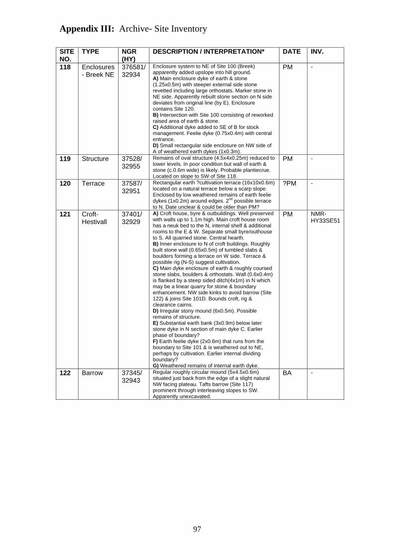
Appendix III: Archive- Site Inventory
97
SITE NO.
TYPE NGR (HY)
DESCRIPTION / INTERPRETATION* DATE INV.
118 Enclosures - Breek NE
376581/ 32934
Enclosure system to NE of Site 100 (Breek) apparently added upslope into hill ground. A) Main enclosure dyke of earth & stone (1.25x0.5m) with steeper external side stone revetted including large orthostats. Marker stone in NE side. Apparently rebuilt stone section on N side deviates from original line (by E). Enclosure contains Site 120. B) Intersection with Site 100 consisting of reworked raised area of earth & stone. C) Additional dyke added to SE of B for stock management. Feelie dyke (0.75x0.4m) with central entrance. D) Small rectangular side enclosure on NW side of A of weathered earth dykes (1x0.3m).
PM -
119 Structure 37528/ 32955
Remains of oval structure (4.5x4x0.25m) reduced to lower levels. In poor condition but wall of earth & stone (c.0.6m wide) is likely. Probable plantiecrue. Located on slope to SW of Site 118.
PM -
120 Terrace 37587/ 32951
Rectangular earth ?cultivation terrace (16x10x0.6m) located on a natural terrace below a scarp slope. Enclosed by low weathered remains of earth feelie dykes (1x0.2m) around edges. 2nd possible terrace to N. Date unclear & could be older than PM?
?PM -
121 Croft- Hestivall
37401/ 32929
A) Croft house, byre & outbuildings. Well preserved with walls up to 1.1m high. Main croft house room has a neuk bed to the N, internal shelf & additional rooms to the E & W. Separate small byre/outhouse to S. All quarried stone. Central hearth. B) Inner enclosure to N of croft buildings. Roughly built stone wall (0.65x0.5m) of tumbled slabs & boulders forming a terrace on W side. Terrace & possible rig (N-S) suggest cultivation. C) Main dyke enclosure of earth & roughly coursed stone slabs, boulders & orthostats. Wall (0.6x0.4m) is flanked by a steep sided ditch(4x1m) in N which may be a linear quarry for stone & boundary enhancement. NW side kinks to avoid barrow (Site 122) & joins Site 101D. Bounds croft, rig & clearance cairns. D) Irregular stony mound (6x0.5m). Possible remains of structure. E) Substantial earth bank (3x0.9m) below later stone dyke in N section of main dyke C. Earlier phase of boundary? F) Earth feelie dyke (2x0.6m) that runs from the boundary to Site 101 & is weathered out to NE, perhaps by cultivation. Earlier internal dividing boundary? G) Weathered remains of internal earth dyke.
PM NMR- HY33SE51
122 Barrow 37345/ 32943
Regular roughly circular mound (5x4.5x0.6m) situated just back from the edge of a slight natural NW facing plateau. Tafts barrow (Site 117) prominent through interleaving slopes to SW. Apparently unexcavated.
BA -

Appendix III: Archive- Site Inventory
98
SITE NO.
TYPE NGR (HY)
DESCRIPTION / INTERPRETATION* DATE INV.
123 Croft- North House
37340/ 33196
A) Croft house, barn, byre and outhouses. Well preserved remains with the lintel still present in main croft house in E wall, & internal shelf. Rooms abutting to E & W, with west gable end 2.15m high externally. S building range includes barn and corn drier. Byre to W with large orthostat division visible. Gable end survives to 2m high externally. All quarried stone. Central hearth. B) Inner enclosure of well preserved earth bank & external stone wall (1.5x0.5m) flanked by a small external ditch (1.5x0.4m). Appears to have been extended to N with previous course of C visible. C) Main enclosure dyke (2x0.5m max) of earth and stone. Neat & distinctive sections of roughly coursed wall revetment. Continues W to sea often as low weathered earth banks. Internal divisions low weathered earth banks. South part flanked by drainage ditch. Bounds area of rig.
PM NMR- HY33SE49
124 Mound 37105/ 33161
Small low oval mound (3.5x3x0.5m) within area of peat situated on the edge of a slight NW facing plateau. Low visibility. Possible barrow, burnt mound or could be natural.
BA? -
125 Structures 37169/ 33023
Two small sub-rectangular earth enclosures (11x5x0.4m max) with raised central areas. Enclosed by low weathered earth banks. Within Site 123. Plantiecrues or possible pens.
PM -
126 Structure 37511/ 33328
Small rectangular structure base (3.7x3x0.4m) of large squared stone blocks quarried from rock face to E forming rough walls . Possible earth terrace to S. Located on natural glacial terrace upslope to NE of Site 123. Animal pen or plantiecrue.
PM -
127 Structure 37214/ 33080
Small rectangular walled enclosure (8x3.75x0.55m) inside Site 123 with well preserved neatly constructed stones walls (> 0.75m wide) of weathered stone. Collapsed in parts. Large orthostats used as external revetment. Central area raised. Plantiecrue or Kail yard, possible pen.
PM -
128 Hollow 37404/ 33144
Oval feature (4x3.5x1m) cut into natural slope. Steep sides & flat base with spoil to W side & narrow entrance to N. Level ledge around upper SE edge which may have supported a roof. Possible underground store (tattie-hoose) or well head.
PM -
129 Enclosure 37359/ 33254
Rectangular walled enclosure (c.24x16x0.45m) to N of Site 123 within area of peat. Walls (>0.6m wide) of large slabs & external orthostat revetting survive well. Internal area raised suggesting cultivation: Kail yard?
PM -
130 Mound 37139/ 33313
Small roughly circular mound (5x4.5x0.75m) with stones protruding situated on a gentle NW facing slope c.30m S of a small burn within a small valley. Only visible in local area. Possible barrow/burnt mound.
BA? -
131 Structure 37174/ 33342
Remains of collapsed stone structure (3x2.5x0.2m) within some in-situ stonework suggesting a circular form. (similar to Site 119?). Possible pen or plantiecrue?
PM -

Appendix III: Archive- Site Inventory
99
SITE NO.
TYPE NGR (HY)
DESCRIPTION / INTERPRETATION* DATE INV.
132 Settlement 37461/ 33761
Linear arrangement (N-S) of features comprising a large mound, six hollows (possible structures?), a weathered stony mound & curvilinear bank. Situated on a slight natural NW facing terrace within a broad slope. Possible settlement/quarrying. A) Large irregular sub-oval mound (13x7x0.9m) more defined to the W. Central orthostat protruding. Joined by bank (Site 133) to S. B) Well defined steep sided oval hollow (8x5x0.5m) ?cut into side of (A) to N. Stones protruding from sides. C) Regular oval hollow (8x3.5x0.6m) within steeper sides to E. D) Series of 3 interlinking hollows (5x1m max) with possible stone lined/walled sides. E) Remains of low curvilinear bank (2x0.2m) with several orthostats visible (parallel & perpendicular) which appears to join mound (A) & (F) to form an enclosure. Possible continuation between (F) & (D). May continue to SE as Site 133. F) Small weathered possible mound (3.5x0.3m) with frequent stone blocks (one perhaps notched). G) Regular steep sided hollow (4x0.5m) with possible coursed stone in E side & orthostats by ?entrance.
Preh.? -
133 Dyke (Sub-peat?)
37601/ 33633
Curvilinear earth bank (3.5x0.5m max) which runs from area of peat to E to Site 132. Less well defined on scarp slopes & may dip below peat. Large orthostats common protruding from top. Possible prehistoric boundary associated with Site 132.
Preh.? -
134 Stone 37583/ 33572
Large tilting earth fast orthostat (1.3x0.2x0.72m) located in a prominent position at the top of a steep W facing hill slope. Top may have been broken. Possible standing stone stump.
Preh.? -
135 Structure 37556/ 33182
Remains of rectangular stone structure (0.85x0.75x0.22m). Faced coursed stone visible. Possible cairn located on break of steep SW facing hill slope. Possible animal pen or plantiecrue.
PM? -
136 Quarry 37704/ 33039
Sandstone quarry (13x6x1.25m) near summit of Brae of Moan adjacent to boundary wall (Site 1), for which the stone was probably excavated.
Mid 19th C
-
137 Quarry 37794/ 32938
Linear sandstone quarry (25x7x2m) adjacent to boundary wall (Site 1), for which the stone was probably excavated.
Mid 19th C
-
138 Ditches - Linear drainage ditch system cut to drain the lower marshy areas of Quandale during the mid 19th century. Represents the only major form of improvement within the study area.
Mid 19th C
-
*Basic description and interpretations from primary record sheets. All dimensions are maximum and in meters. When two dimensions given e.g. (1x0.5m) this relates to width (or diameter) and height, when three e.g. (7.5x5x0.5m) this relates to length, width and height. PM = post-medieval, Med = medieval, BA = Bronze Age, Preh = prehistoric, BP = Barrows Project.


