
Rapid Hotspot Detection Using Himawari-8
Riris Adriyanto, Alpon Sepriando Manurung, and Tyas Tri PujiastutiRemote Sensing Data Management DivisionAgency for Meteorology Climatology and Geophysics (BMKG)Indonesia
Remote Sensing Data Management DivisionCenter for Public Weather Services - BMKG

Remote Sensing Data Management DivisionCenter for Public Weather Services - BMKG
Current Hotspot Information provided by BMKG
• Observation from MODIS sensor onboard NASA’s Terra/Aqua satellites• Data source : LAPAN (Indonesian Agency for Space and Aeronautics)

Remote Sensing Data Management DivisionCenter for Public Weather Services - BMKG
Hotspot Occurrences for Year 2015 & 2016
2015 2016
02000400060008000
100001200014000
Kalbar Kaltim Kalteng Kalsel Riau Jambi Sumsel Papua
Jum
lah
Hot
spot
Propinsi
High confidence level (81-100%) MODIS HotspotYear 2013-2016
2013201420152016
Estimated total economic loss
due to 2015 massive
wildfires: 221 Trillion IDR (22
billion USD)(BNPB, 2016)

Remote Sensing Data Management DivisionCenter for Public Weather Services - BMKG
PM10 Concentration at Pekanbaru, Palembang (Central and South Sumatra island), and Palangkaraya (Kalimantan island) 2014-2016
PALEMBANG(South Sumatra
province)
PEKANBARU(Riau province)
PALANGKARAYA (Central
Kalimantan)
LEGEND :
DANGEROUS
VERYUNHEALTHY
GOOD
MODERATE
UNHEALTHY
SEP - OCT

Remote Sensing Data Management DivisionCenter for Public Weather Services - BMKG
Terra/Aqua
Limitation detecting hotspot by MODIS (Terra/Aqua) :
•Low frequency of observation (4 times a day) makes less possibility to detecting hotspot
•Due to its polar orbiting unobserved area sometimes caused misleading in hotspot interpretation by emergency personnels the field
Daytime : Terra/MODIS : 00:00 – 05:00 UTC (07:00 – 12:00 LST) Aqua/MODIS : 03:00 – 08:00 UTC (10:00 – 15:00 LST)
Nighttime: Terra/MODIS : 12:00 – 17:00 UTC (19:00 – 24:00 LST) Aqua/MODIS : 15:00 – 20:00 UTC (22:00 – 03:00 LST)

Remote Sensing Data Management DivisionCenter for Public Weather Services - BMKG
Himawari-8

Remote Sensing Data Management DivisionCenter for Public Weather Services - BMKG
Himawari Cloud
JMA Himawari Cloud Server
40mbps
BMKG Himawari-8 Data Processing Server
BMKG Database Center
- Download and convert HSD to SATAID format
- Product generation
- User Request- Archiving Data and Image
- BZ2 Format (90 GB/day)- SATAID Format (40 Gb/day)

Remote Sensing Data Management DivisionCenter for Public Weather Services - BMKG
AlgorithmHotspot detection using Meteosat SEVIRI (Roberts and Wooster, 2008)

Remote Sensing Data Management DivisionCenter for Public Weather Services - BMKG
Algorithm
Tbb I4 > 313K(Fire potential)
Tbb I4 > 290K(Fire potential)

Remote Sensing Data Management DivisionCenter for Public Weather Services - BMKG
ResultCase study : 12 September 2016 12.50 LST

Remote Sensing Data Management DivisionCenter for Public Weather Services - BMKG
RGB Product
Himawari-8 False Color (22 Oct 2015) smoke/haze clearly depicted in this RGB
combination
Band 03(0.64μm)
Band 04(0.86μm)
Band 06(2.3μm)
R = VS Gamma 1.8G = N1 Gamma 1B = N3 Gamma 3
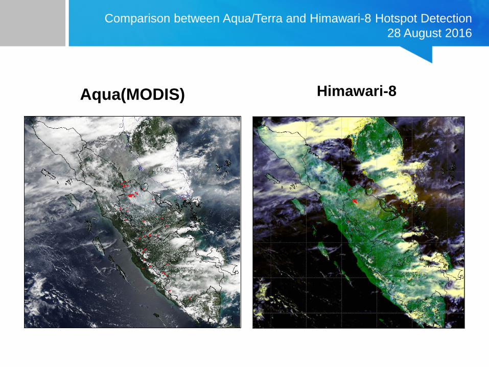
Comparison between Aqua/Terra and Himawari-8 Hotspot Detection28 August 2016
Aqua(MODIS) Himawari-8

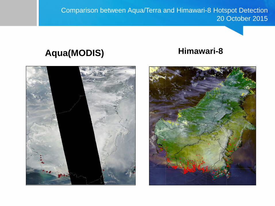
Comparison between Aqua/Terra and Himawari-8 Hotspot Detection20 October 2015
Aqua(MODIS) Himawari-8

Comparison between Aqua/Terra and Himawari-8 Hotspot Detection 20 August 2015
Aqua(MODIS) Himawari-8
Comparison between Aqua/Terra and Himawari-8 Hotspot Detection 20 October 2015
Aqua(MODIS) Himawari-8

Comparison between Aqua/Terra and Himawari-8 Hotspot Detection10 September 2016
Aqua(MODIS) Himawari-8

http://www.thejakartapost.com/seasia/2016/08/27/masks-fly-off-shop-shelves-as-smoke-shrouds-singapore.html
Terra
Aqua
Suomi NPP
26 Agt 2016 27 Agt 2016
Image True Color at daytime and Hotspot at daytime and night-time (Terra-Aqua-Suomi NPP)

Remote Sensing Data Management DivisionCenter for Public Weather Services - BMKG
HIMAWARI vs TERRA-AQUA-SUOMI NPP IMAGES (26-27 AUGUST 2016)
Terra
Aqua
26 Aug 2016 27 Aug 2016
SuomiNPP
Terra
Aqua
SuomiNPP
HIMAWARI

Remote Sensing Data Management DivisionCenter for Public Weather Services - BMKG
TrajectorySample of smoke TrajectoryRiau - 2 March 2014
produced based on cloud trajectory movement and has been used to identify tendency of smoke/haze movements.
there is still challenges in haze dispersion modeling to complement satellite-based hotspot information for various concerned stakeholders and general public

Remote Sensing Data Management DivisionCenter for Public Weather Services - BMKG
Challenges
• False alarm is still challenging in hotspot detection algorithm using Himawari-8 data in BMKG. Development of the algorithm should be improved to remove false alarm due to sun glint. River and lake boundary data could be a reference to eliminate sun reflection.
• Studying the relationship between infrared brightness from Himawari-8 bands and fire temperature on the ground as reference to make confidence level of hotspot detection.
• Haze dispersion model to improve services for relevant stakeholders is urgently needed.
• Improving computational resources is one of the solutions to shorten information dissemination time.


