.,: Re, ort-s|_ |.1 , J
: , > ~~~~~~~~~~~~~~~~~Report E0079
M " t - . .ua , g /~~~~~~~~~~~~~~~~~~~~~~~~~~~~~~~~~~~~~~~~~~~~~~~~~~~~~~~~~~~~~~~~~~~~~~~~~~~~~~~~~~~~~~~~~~~~~~~~~~
.. . . .... . ,i.. . ..
Pub
lic D
iscl
osur
e A
utho
rized
Pub
lic D
iscl
osur
e A
utho
rized
Pub
lic D
iscl
osur
e A
utho
rized
Pub
lic D
iscl
osur
e A
utho
rized

ELCTRICITY GENRATING AUTHORITY OF THAILAND
ENVIRONMENTAL IMPACT ASSESSMENT OF
LAM TA KHONG PUMPED STORAGE PROJECT
FINAL REPORTVOLUME 1-2:Summary Report
Prepared by:
KNON KARN UNIVERSITYM11rh 1992 L li -

VO)L.UME=S C>MPEFlI S I1NC; T H IS piE3..E
I-I : Summary Report (in Thai)
I-2 : Summary Report (in English)
II Environmental Impact Assessment
III-1 : Recommended Environmental Impact Mitigation Plan and
Monitoring Program (in Thai)
III-2 : Recommended Environmental Impact Mitigation Plan and
Monitoring Program (in English)
IV : Environmental Economics Analysis
V Appendices
-i i-
Our Ref.: 0504.7/ 1787
Khon Kaen UniversityKhon Kaen 40002.
March 9, 1992
General ManagerElectricity Generating Authority of ThailandNonthaburi 11000
Dear Sir:
It Is our pleasure to submit with this letter the final reportof the Environmental Impact Assessment of Lam Ta Khong PumpedStorage Project.
The report was prepared in seven volumes:
Volume I-1 : Summary Report (in Thai)Volume I-2 : Summary Report (in English)Volume rr : Environmental Impact AssessmentVolume III-1: Recommended Environmental Impact Mitigation
Plan and Monitoring Program (in Thai)Volume III-2: Recommended Environmental Impact Mitigation
Plan and Monitoring Program (in English)Volume IV : Environmental Economics Analysis (in English)Volume V : Appendices (in English)
We would like to again, express our gratitude for yourselection of Khon Kaen University to conduct this study. Wecan ascertain that our expertise In the various disciplineshad been utilized to the fullest extent in the course of thestudy. And we do hope the results of the work would besatisfactory and provide sufficient data for the continuingscheme on your part.
Yours Sincerely,
Nopadol TongsopitPresident
-iii-

Throughout the eithteen-month study period of this project
multidisciplinary data and information have been collected
from various sources, both in the project vicinity and in
Bangkok offices, by the various members of this study team.
Cooperation and hospitality rendered by all of the following
concerned offices to the study team are hereby gratefully
acknowledged.
- The Royal Irrigation Department
- Lam Ta Khong Irrigation Office
- Regional Irrigation Office 6
- Climatology Division, The Meteorological Department
- Nakhon Ratchasima Highway District
- Nakhon Ratchasima Provincial Health Office
- Si Khiu District Health Office
- Pak Chong District Health Office
We also owe deep appreciation to the EGAT's staff, without
which the study would have been Inadequate.
-ivr-

.4~ ~ ~ ~~~I a.8 d
tiumpff vir1ummuLnfluni,fnm
_..jflljdjjjll8UUAf- ~ ~ _. w. IC i. 4 . f.
El 4LId'AflfilJJfl1IU . ~... ........1 W .~................IJA .L .2f~..... ...... a...................
(ou)..............
.. _...._......._. _._...... . ..... .
-^tannnui )........ ............ ... .. .i ........... .. ....... . ............. 2 _ . . . . .. ...1 . ....1o ..X.@. .... ...
.jm'qu uy..'......
^."...22.>.Q..lnunmuntJoull..............
(nl.) _ .... ___
.... ~~~~~~~~~~~~~~- ... _ -
(s) @@s ee_e-@-w e z*@Be-z-@ * Lf*lh1- fl-fl1flfl7--flJfl---*-a*_-V --_--f-l -----i-i-1-1 s
¢>>se@e@@@|ee@@@@@@B-@e--tte@_tw-see6w@_esee9*@z@@@@@a
............ .W-- - - - - - .W6uLul LfnLn
........... - *- -* -- - -............ nuta us- 5- Ln
........... .............----- nhurn ...nnu,nnklbILUI3IUln r3 harthtljnlLn
, .............. ................... ------- G Ib1LLLnLn
LLLUkLI 1
... ..---------.................. aun qUU'RL
............ ..........- - ----..... nkt}XUn6 %utLnLn
......................... & ...... n z. - nUWR fra;XLrLLLLLL
- ergnue LLurLnL,,%i
r~~~~~~~~rl - . I s^5i
CLLUPU NuU LU U CUbLISflLt UtLLUrU
nCSZXULnn LrLL
outL-C- ra ,tAL,6-L m L. c- aSrL GcL-

r3 STAFF
rroject Management r
Vanasri Bunyaratpan, M.Eng. Project Director
Supachal Suetrong: M.Agri.Econ. Deputy Project Director
Jirasak Jindarojana, H.S.C.E. Project Manager
Suparerk Sinsupan, M Eng. Project Coordinator
Technical Core Team
Jlrasak Jindarojana, M.S.C.E. Environmental Engineer/
Task Leader
Varasri Bunyaratpan, M.Eng. Sanitary Engineer
Suparerk Sinsupan, M.Eng. Environmental Engineer
Supachai Suetrong, M.Agri.Econ. Agricultural Economist
Kitti Akamphon, M.Sc. Envlronmental Biologist
Alk Vathana, M.Sc. Ecologist (Preliminary
Stage)
Surface Water Hydrology
Wirote Chaiyadhuma, Ph.D. Water Resources
Engineer/Task Leader
Groundwater Hydrology
Chalong Buaphan, M.Sc. Scientist/Task Leader
Surface and Ground Water Quality
Vanasri Bunyaratpan, M.Eng. Sanitary Engineer/Task
Leader
Samran Ruangsri, M.Sc. Public Health Scientist
Paibool Bunyakanjana,Dip.in Sanltary Engineer
San.Eng.
Chutima Kukusamude, M.Sc. Scientist
-vii-
Meteorology
Wirote Chaiyadhuma, Ph.D. Water Resources
Engineer/Task Leader
Atmospheric Quality
Jlrasak Jindarojana, M.S.C.E. Environmental Engineer/
Task Leader
Suparerk Sinsupan, M.Eng. Environmental Engineer
Soil Fertility Erosion and Sedimentation
Charat Mongkolsawat, Dr.Eng. Soil Scientist/Task
Leader
Geology Seismology and Mineral Resources
Winit Youngme, H.Sc. Geologist/Task Leader
Aquatic Biology
Kitti Akamphon, M.Sc. Environmental Biologist/
Task Leader
Aik Vathana, M.Sc. Ecologist
Sam-ang Homchuen, M.Sc. Biologist
Fisheries
Prapast Chalorkpunrut, M.Sc. Fishery Specialist/Task
Leader
Pnrnehai Jaruratjamorn, M.Sc. Fishery Specialist
Parasitology
Smarn Tesana, N.Sc. Parasitolocist/Task
Leader
-viii-
Forest Wildlife and Rare Species
Aik Vathana, M.Sc. Ecologist/Task Leader
Kitti Akamphon, M.Sc. Environmental Blologist
Sam-ang Homchuen, M.Sc. Biologlst
Irrigation
Maitree Juangpanich, M.Sc. Water Resources
Engineer/Task Leader
Water Supply
Suparerk Sinsupan, M.Eng. Environmental Engineer/
Task Leader
Palbool Bunyakanjana, Dip.in Sanitary Engineer
San.Eng.
Samran Ruansri, M.Sc. Public Health Scientist
Water Pollution and Control
Jirasak Jindarojana, M.S.C.E. Environmental Engineer/
Task Leader
Flood Control
Wirote Chalyadhuma, Ph.D. Water Resources
Engineer/Task Leader
Water Balances
Wirote Chaiyadhuma, Ph.D. Water Resources
Engineer/Task Leader
Landuses and Dedicated Area Uses
Charat Mongkolsawat, Dr.Eng. Soil Scientist/Task
Leader
- ix-
Aquaculture
Pornchal Jaruratjamorn, M.Sc. Fishery Specialist/
Task Leader
Prapast Chalorkpunrut, M.Sc. Fishery Specialist
Reforestation
AIk Vathana, M.Sc. Ecologist/Task Leader
Agriculture
Kanha Bunpromma, M.Sc. Agronomist/Task Leader
Highway Railway and Navigation
Pongrid Klungboonkrong, M.Eng. Civil Engineer/Task
Leader
Electricity Generation and Transmission
Supawadee Swatdiponphallop, K.Sc. Electrical Engineer/
Task Leader
Phongsak Binsomprasong, M.Sc. Electrical Engineer
Recreation Development
Thada Sutthitham, M.Arch. Architect/Task Leader
Weerawan Sitisara, M.Arch. Architect
Socio-Economics and Institution
Supachai Suetrong, M.Agri. Agricultural Economist/
Econ. Task Leader
Paitoon Kachmart, M.Sc. Agricultural Economist
Juckrit Hormchan, Ph.D. Soil Scientist
Piansak Pakdee, M.Sc. Agricultural Economist
-x-
Resettlement Relocation and Compensation
Supachai Suetrong, M.Agri. Agricultural Economist/
Econ. Task Leader
Paitoon Kachmart, M.Sc. Agricultural Economist
Piansak Pakdee, M.Sc. Agricultural Economist
Public Health and Public Safety
Theera Ruttaworn, H.P.H. Public Health Specialist/
Task Leader
Thirapong Thiramanus, M.S. Public Health Specialist
Historical and Archaeological Values
Surapol Natapintu, M.Sc. Archaeologist/Task Leader
Thada Sutthitham, M.Arch. Architect
Aesthetic Values
Weerawan Sitisara, M.Arch. Architect/Task Leader
Thada Sutthitham, M.Arch. Architect
Environmental Economics
Vute Wangwacharakul, Ph.D. En';ironmental Economist/
Task Leader
Mitigation Plan Development
The Technical Core Team
Buares Prachaiyo M.S. Forestry Management
Specialist
Boonsri Prabnasak M.A. Public Relation
Specialist
-xi -

Editorial Staff
The Technical Core Team
Woralap Sangvatanachai, Dip.Higher Technical Writing
Ed. Expert/Task Leader
Sasi Jungsatitkul, M.Sc. Technical Writing Expert
Report Preparation
Sopa Sakcharoen Typist
Vallapa Phomkul Computerized Graphic
Operator
Wiriya Klumrienthong Draft Technician
-xii-
ENVIRONMENTAL IMPACT ASSESSMENT
OF
LAN TA KRONG PUMPED STORAGE PROJECT
FINAL REPORT
VOLUME 1-2: SUMMARY REPORT
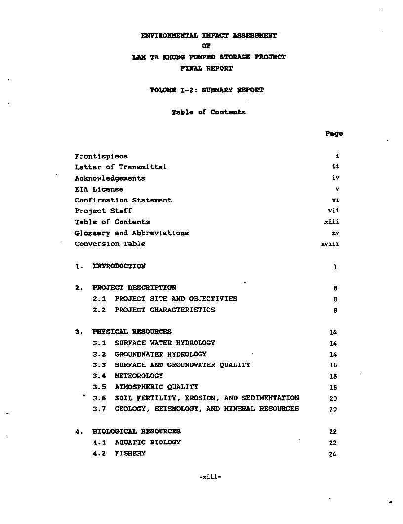
Table of Contents
Page
Frontispiece
Letter of Transmittal i£
Acknowledgements iv
EIA License v
Confirmation Statement vi
Project Staff vii
Table of Contents xiii
Glossary and Abbreviations xv
Conversion Table xviii
1. INTRODUCTION I
2. PROJECT DESCRIPTION 8
2.1 PROJECT SITE AND OBJECTIVIES 8
2.2 PROJECT CHARACTERISTICS 8
3. PHYSICAL RESOURCES 14
3.1 SURFACE WATER HYDROLOGY 14
3.2 GROUNDWATER HYDROLOGY 14
3.3 SURFACE AND GROUNDWATER QUALITY 16
3.4 METEOROLOGY 18
3.5 ATMOSPHERIC QUALITY 18
3.6 SOIL FERTILITY, EROSION, AND SEDIMENTATION 20
3.7 GEOLOGY, SEISMOLOGY, AND MINERAL RESOURCES 20
4. BIOLOGICAL RESOURCES 22
4.1 AQUATIC BIOLOGY 22
4.2 FISHERY 24
-xiii-

Table of Contents (cont'd)
Page
4.3 AQUATIC PARASITERS 24
4.4 FOREST, WILDLIFE, AND RERE SPECIES 25
5. HUMAN USE VALUES 26
5.1 IRRIGATION 26
5.2 WATER SUPPLY 26
5.3 WATER POLLUTION AND CONTROL 29
5.4 FLOOD CONTROL 32
5.5 WATER BALANCE 32
5.6 LAND USE 33
5.7 AQUACULTURE 33
5.8 REFORESTATION 35
5.9 AGRICULTURE 35
4.10 HIGHWAY, RAILWAY, AND NAVIGATION 36-
5.11 ELECTRICITY 37
5.12 RECREATION DEVELOPMENT 38
6. QUALITY OF LIFE VALUES 39
6.1 SOCIO-ECONOMICS AND INSTITUTION 39
6.2 COMPENSATION AND DEVELOPMENT 39
6.3 PUBLIC HEALTH 41
6.4 HISTORICAL AND ARCHAEOLOGICAL VALUES 41
6.5 AESTHETIC VALUES 41
7. INTEGRATED IMPACT ASSESSMENT 43
7.1 LAND 43
7.2 WATER 46
7.3 SOCIO-ECONOMICS 49
7.4 IMPACT ON THE WATERSHED AREA CLASS 1A 51
8. ENVIRONIENTAL IMPACT MITIGATION AND MONITORING 54
8-.1 ENVIRONMENTAL IMPACT MITIGATION 54
8.2 MONITORING OF THE ENVIRONMENTAL 55
9. ENVIRONMENTAL ECONOMIC ANALYSIS 60
-xiv-
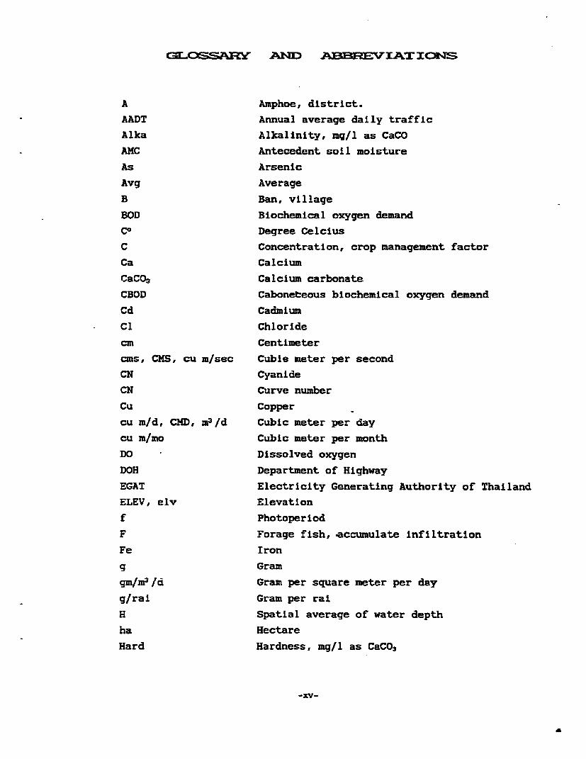
C31J ASE;Pln ANX:ND ABE3REC V IALT ION-S
A Amphoe, district.
AADT Annual average daily traffic
Alka Alkalinity, mg/l as CaCO
AMC Antecedent soil moisture
As Arsenic
Avg Average
B Ban, village
BOD Biochemical oxygen demand
Co Degree Celcius
C Concentration, crop management factor
Ca Calcium
CaCO3 Calcium carbonate
CBOD Caboneteous biochemical oxygen demand
Cd Cadmium
C1 Chloride
cm Centimeter
cms, CMS, cu m/sec Cuble meter per second
CN Cyanide
CN Curve number
Cu Copper
cu mid, CMD, ma/d Cubic meter per day
cu m/mo Cubic meter per month
DO Dissolved oxygen
DOH Department of Highway
EGAT Electricity Generating Authority of Thailand
ELEV, elv Elevation
f Photoperiod
F Forage fish, accumulate infiltration
Fe Iron
g Gram
gm/fr3fd Gram per square meter per day
g/rai Gram per rai
H Spatial average of water depth
ha Hectare
Hard Hardness, mg/l as CaCO3
-xv-

Hg Mercury
hr, HR Hour
I. Surface light intensity
Ia Initial abstraction
JICA Japan International Cooperation Agency
K Soil erodibility factor
KKU Khon Kaen University
Km Kilumeter
KV Kilovolt
kw Kilowatt
K cal/cm2 Kilo - Calorie per square centimeter
Lat Latitude
Long Longitude
LS Slope factor
n2 Square meter
no, CU.M Cubic meter
m2 /d Square meter per day
me/hr, cu m/hr Cubic meter per hour
m 3 /min Cubic meter per minute
-ax Maximum
Mcm Million cubic meter
MCM/yr Million cubic meter per year
meq Milliequivalent
mg Magnesium
mg/l Milligram per liter
min Minimum
ml Milliliter
mm Millimeter
Mn Manganese
MPN Most probable number
MPN/100 ml Most probable number/100 milliliterMSL, msl Mean sea level
MW Megawatt
in meter
m/d Meter per dayNEB The National Environment Board
NH3-N Ammonia nitrogen
Ni Nickel
-xvi-
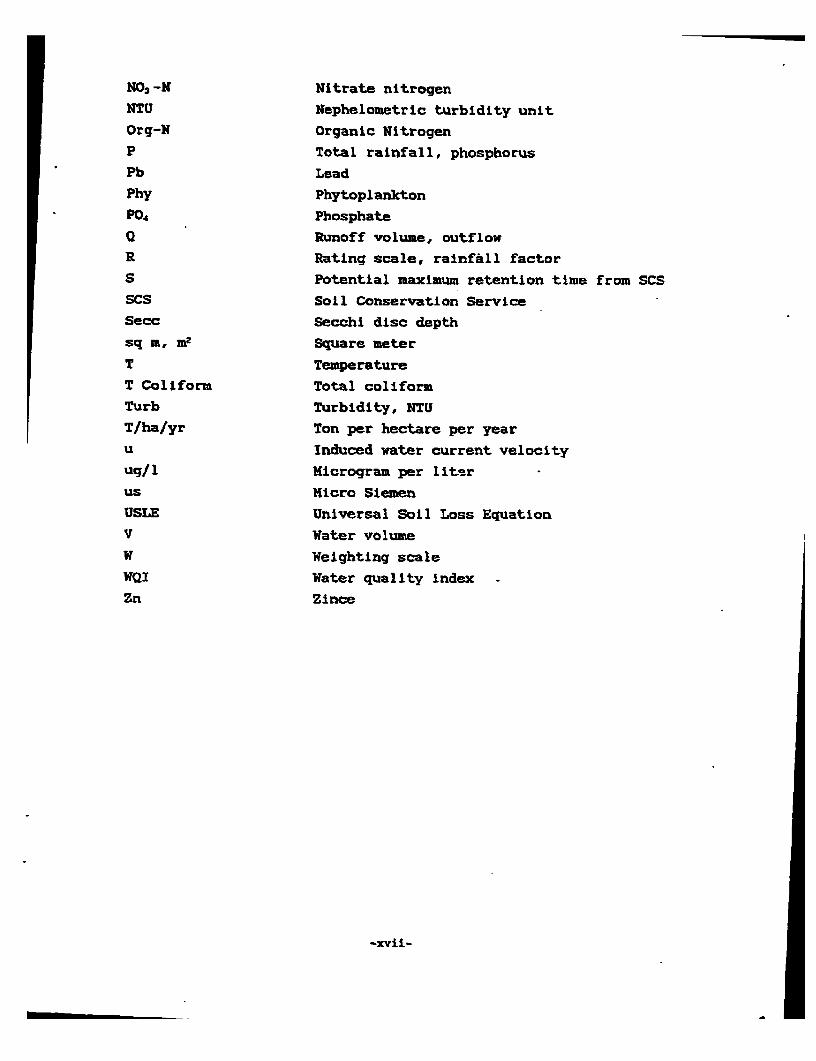
N03-N Nitrate nitrogen
NTU Nephelometric turbidity unit
Org-N Organic Nitrogen
P Total rainfall, phosphorus
Pb Lead
Phy Phytoplankton
P0 4 Phosphate
a Runoff volume, outflowR Rating scale, rainfall factorS Potential maximum retention time from SCSSCS Soil Conservation ServiceSecc Secohi disc depth
sq m, m2 Square meter
T Temperature
T Coliform Total coliform
Turb Turbidity, NTU
T/ha/yr Ton per hectare per year
u Induced water current velocity
ug/1 Hicrogram per literus Micro Siemen
USLE Universal Soil Loss Equation
V Water volume
W Weighting scale
WQI Water quality index -
Zn Zince
-xvii-

CONVSSION TASLE
1 inch 2.54 cm1 inch 25.4 mm
I uL le 1.6093 km1 km 0.6214 milesI ft 0.3048 m1 m 3.28 ft1 va 2 m1 ft 2 0.0929 l 2
r2e 10.7584 ft 2
1 hectare 6.25 rais1 acre 2.53 rais1 klm2 100 hectares1 rat = 1,600 n2
1 ngan 400 l 2
1 ft 3 0.0283 ma
1 Vs = 35.31 ft2
1 mcm = 1,000,000 m3
1 cfs 0.0283 cms1 cms 35.31 cfs1 HkWh = 1,000,000 kWh1 GWh - 1,000,000 - kWh
1 MW - 1,000 kW
= 't11000,000 W
1 kg 2.205 pounds1 ton = 1,000 kg

ENVIRONMTAIRL nMPACT ASSESSMENT
OFLAN TA KEONG PUMED STORAGE PROJECT
FINAL REPORTVOLUME 1-2: SUMARY REORT
1 . ThI]I.CTI O
BACKGROUND
The Environmental Impact Assessment of Lam Ta Khong Pumped
Storage Project represent another continual attempt of the
Electricity Generation Authority of Thailand (EGAT) in its
routine undertaking to preserve national environment and to
enhance its development project benificial to the nation
development.
The Lam Ta Khong Pumped Storage Project is a hydro-electric
power project, located at the border line between Si Khiu and
Pak Chong Districts, Nakhon Ratchasima. The major components
of the Project include an upper reservoir; an underground
power house, tunnels, a switchyard and transmission lines.
The existing Lam Ta Khong reservoir, at present under the
responsibility of the Royal Irrigation Department (RID) will
be used as the lower reservoir. An upper reservoir will be
constructed on top of a mountain so that water from the lower
reservoir can be pumped up and stored in the upper reservoir.
The stored water will be released with pressure to generate
power during the peak demanding period.
The Project will Inevitable involve certain environmental
aspects, namely the requirement of an area for the
construction site and the use of the former Lam Ta Khong
reservoir as the lower reservoir. These two points can
possibly cause impacts on the environmental resources/values.
This is particularly true with the construction site which
covers an area of three sq km being located in the area
categorized under the watershed classification 1B. A detailed
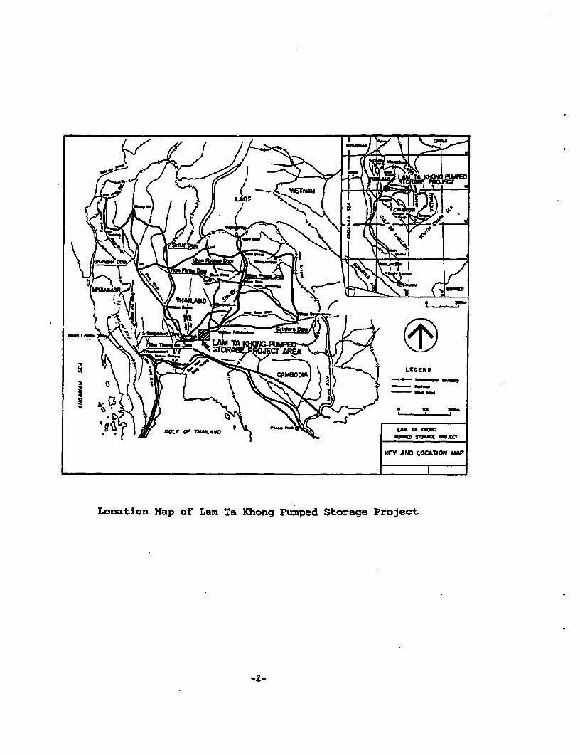
t9\1r.t.. SM2TO- -L--~~~~~~~~~~~~~~~~~~LGN
KEY AND LOCATION MAP
Location Map of Lam Ta Khong Pumped Storage Project
-2-

environmental impact study must be carried out in order that
the Project can be taken under the consideration of the
National Environment Board (NEB).
Khon Kaen University (KKU) was assigned the task to carry
out this environmental Impact study during an 18-month
period from Auguse 1990 to February 1992.
OBJECTIVES AND SCOPE OF STUDY
The ultimate purpose of the study was the preparation of the
environmental impact assessment (EIA) which was closely con-
formed with NEB guidelines and associated documents for
government approval of the Project.
Specific objectives of the study were as follows:
1) To define the study area which would be
directly and indirectly affected by the deve-
lopment of the proposed Project.
2) To describe the existing characteristics and
quality of all environmental resources and
values of the study area.
3) To characterize the physical, biological, and
socio-economic aspects that would affect the
project and/or alternate the Project design,
the Project cost and benefits.
4) To identify the principal changes of the
environment that may possibly be expected as a
result of the Project development.
5) To examine the effect, evaluate and predict the
short and long term impacts of the proposed
Project upon the environmental resources and
values, including also the degree of signifi-
cance and magnitude of the predicted impacts.
6) To recommend practical approaches and means in
developing the proposed project that would con-
form with governmental criteria regarding the
-3-

water resources and landuse management
designated for the classified watershed.
7) To recommend short and long term guidelines for
the prevention or mitigation of the adverse
effects and/or the maximization of the positive
results of the proposed project.
8) Based on the findings of the study, to recom-
mend the appropriate environmental monitoring
program with the relevant manpower estimate for
the proposed project.
scope
The study involves collectlon, analysis, and interpretation
of literature, existing data, and data collected during the
study period that allow accurate evaluation and prediction
of impacts of the Project upon the environmental resources/
values as well as for development of recommendations for
mitigation and compensation/resettlement plannings, and the
environmental monitoring programs.
SETHODOLOGY
Two aspects of study were predetermined; the first aspect to
be one of the normal EIA conforming with NEB guidelines and
the other aspect to enable appropriate selection of the upper
reservoir site.
The determination of the scope and study areas was achieved
through an ecological analysis in which the elements of the
system, land, water, and human were taken into consideration.
Thus, five areas were selected according to the relationships
between the ecological system and the Project, namely:
Area I: Lan Ta Khong reservoir tad its vicinity including
water ecological system and the living conditions of the
community around the reservoir.
-4-

/E - //x/ I - -
I Lam Ts Khong Reservoirand viclnity
II Right bank alternativesite for upper reservoirand waterway
E\ &fi//E// / / -/ \ /III Left bank alternativesite for upper reservoir
IV Downstream irrigation area-/ ' / V Nakhon Ratchasima urban
area and districts In thevicinity
Spatial Extent and SubdivisLon for EIAof Lam Ta Ihong Pumped Storage Project
I~~~~~~~~~~~~~~~~~~~~~~~~~~~~~~~~~~~~~~~~~~~~~~~~~~~~~~~~

Area I:: The proposed right bank alternative sites for upper
reservoir including three alternative sites for upper
reservoir.
Area II:I The proposed left bank alternative site for upperreservoir bearing similar characteristics as the second area
and was chosen as the comparative study area.
Area IV: Downstream lrrigation area which requires water from
the existing Lam Ta Khong reservoir for lrrigation.
Area V: Nakhon Ratchasiua urban area and districts in the
vicinity where the rate of population and industrial growths
were high, demandlng water from Lam Ta Khong reservoir.
The environmental Impact assessment study was conducted onthe four major environmental resources and values as
stipulated by NEB, namely: 1) physical resources, 2)
ecological resources, 3) human use values, and 4) quality
of life values. The study covered all of the above areas
according to their direct and Indirect environmental
relationships with the Project. In addition, environmental
economics were analyzed.
In carrying out the study, personnel from various discipllnes
were asked to participate according to their areas of
expertise. A technical core team was appointed in order that
the study was coherent and in unity.
ORDER OP PRESENTATION
This report consists of the following topics which were
concluded from the results of the study:
1. Introduction. This topic deals with the back-
ground of the Project, its scope and objectives,
methodology and order of presentation.
-6-

2. Project Description. This topic presents the
characteristics of the Project and the activities
related to the environment.
3. Physical. resources/ 4. Ecological resources/ 5.
Mumn Use values/ 6. Quality of life values.
These four topics present the conclusion of the
results of study on the present conditions,
trends, and envirornmental assessment classifled
by the environmental resources and values In that
order.
7. Integrated Impact Assessment. This topic presents
the assessment of the environmental impacts which
had been Integrated Into three parts of an ecolo-
gical system: land, water, and human. Then
necessary mitigation and environmental develop-
ment plans are identified.
S. Environmental Impact Mitigation and the Moni-
toring Program. This topic deals with the
preventive and development plans which Include
preliminary plan, plan during construction
period, long-term plan, and the environmental
monitoring during the implementation period.
9. Environmental Economic Analysis. This presents
the conclusion of the environmental economics
analysis by taklng into account the cost and
benefits of the Project, on the basis of
engineering as well as environment.
-7-

2.1 PROJECT XITE AND OBJECTIVES
Lam Ta Khong Pumped Storage Project is a hydropower project
situated on the border line between Si Khiu and Pak Chong
Districts, Nakhon Ratchasima. The distances from Muanq
District, Saraburi, and Muang District, Nakhon Ratchasima are
82 km and 70 km respectively. The Electricity Generation
Authority of Thailand was supported by Japan International
Cooperation Agency to conduct the feasibllity study of the
Project. This study was conducted on the primary
appropriateness in terms of engineering, economics, and
environmental and was completed in 1991. The operation of
the Project will comprise two phases: the first is the
installation of two 250 MW generators, totalling a capacity
of 500 MW, and the second phase is the installation of other
500 MW generators. Thus, the total capacity will be 1,000 MW.
The objectives of Lam Ta Khong Pumped Storage Project is to
generate electricity as a supplement for the generation
during peak period of demand. This will reduce the
investment cost for the increase of generation capacity
because the cost per unit of production of this system is
relatively low.
2.2 PROJECT CEARACTERISTICS
The Lam Ta Khong Pumped Storage Project consists of
constructions of a reservoir on a mountain, an underground
power house, underground tunnels, switchyard, and trans-
mission lines joining the project with the existing system.
Brief characteristics of each of the Project components are
as follows:
-8-

Reservoir. The reservolr Is of rockfill type with an asphalt
facing to prevent water from seeping out. The dam crest hight
of the reservoir is 60 m. The volume of rocks used in
constructing the basin is 6.2 mil cu m the reservoir can
store water up to the height of 660 m (MSL) and the volume
of 10.3-mul cu m, with the water surface area of 0.34 sq km.
Underground Powerhouse. The underground powerhouse Is 300 m
below the ground surface with a width of 22 m a length of 117
a and a height of 45.7 m. The generators will be installed
In two phases.
Phase 1 2 x 250 MW generators
Phase 2 2 x 250 MW generators
Penstock. The penstock joins the upper reservoir with the
underground powerhouse with an inner diameter of 5.8-2.6 m
and a length of 690 m.
Tailace Tunnel. The water tunnel joins the underground
powerhouse and Lam Ta Khong reservoir. It has an inner
diameter of 4.9-6.6 a and a length of 1,470 m.
Transmission Line. During the first phase, transmission
lines capacity of 230 KV for 4 circuits are used to connect
with the existing 230 KV lines from the Saraburi substation
2 and the Nakhon Ratchasima substation 2. The connected
distance is 15 km. As for the second phase, double-circuit
230 KV lines are used to connect with Tha Lan substation 3
for a distance of 95 km.
Uvitcbyard and Control Building. The area of the switchyard
and the control building is 40 m wide and 110 rA long. Gas
Insulated Switchgears (GIS) are used.
-_9-

7
P!I,R��ERVOIR
LOWER RESERVOIRTOCK (LAW TA RHONO RESERVOIR)
WITCHYARDPOVERHOUSE TAILRACE TUNN
ob LRACE OUT ET
STORAGE-PROJEC, "T.

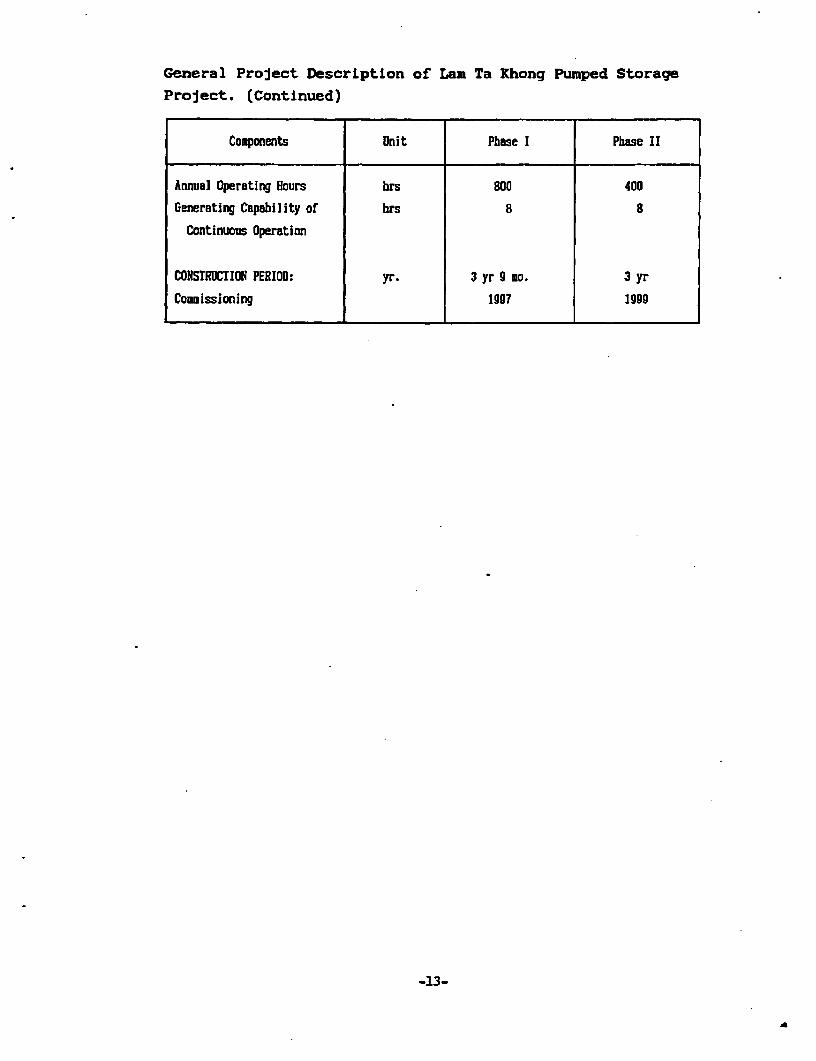
General Project Description of Lam Ta Khong Pumped Storage
Project.
Components Unit Phase I Pbase II
RESERVOIR:
Type _ Rock fill with _
Asphalt Facing
Height 60
Crest Length ..HSL 2,210 _
Voluse lol .3 6.2
Normal High Vater m.HSL 60b
Level (NHRL)
Low Water Level m.HSL 620 _
Total Storage Capacity 10° *3 10.3
Effective Storage Capacity loll 3 9.9
StrrfacL Area at NRHL km2 0.3
INTAKE:
Type Horning-glory
Inner Dianeter h 18.0-5.8
Length . 51.0
Number 2
PENSTOCK:
Type Inclined Sbaft
Embedded Steel
Inner Diameter a 5.e-2.6
Length 690
TAILRACE TUNNEL:
Type Concrete Lined
Pressure Type
Inner Diameter a 4.90-6.60
Length m 1,470
(To be continued)
-11-
. ~~~

General Project Description of Lan Ta Khong Pumped Storage
Project. (Continued)
Components Unit Phase I Phase II
POWER HOUSE:
Type _ Underground Type
Size - width n 22.0
- Length a 117.0
- Height o 45.7
TURBINE/GENERATOR:
Turbine:
Type _ Vertical Sbaft Fra is type reversible
pump-turbine
Number Unit 2 2
Hsaxiuu Gross Head o 357.0 357.0
Haximuu Poaer Discharge - u3 /sec 85 85
Rated Output MV 255 255
GENERITOR:
Type _ 3-Phase AC Synchron us Generator-Motor
Number Unit 2 2
Frequency Hz 50 50
Revolving Speed rpm 375 375
IRANSHISSION LINE:
Connection To Sarsburi-Nakhon atchasima Existing
230 KV line
Nominal Voltage KV 230 230
Number of Circuit ect 4 2
Length km 15 95
POWER GENERATION:
Max. Power Discharge m3 /sec 2x82.5 4x82.5
Normal Effective Head a 375 375Installed Capacity Nv 2x250 4x250
(lo be continued)
-12-
General Project Descrlptlon of Lam Ta Khong Pumped Storage
Project. (Continued)
Components Unit Phase I Phase II
Annual Operating Hours brs 800 400
Generating Capability of hrs 8 8
Continuous Operation
CONSTRUCTION PERIOD: yr. 3 yr 9 mo. 3 yr
Comoissioning 1997 1999
-13-

:3. PHEYE ICLAL~ I] S3CLl1
3.1 SURFACE WATER HYDROLOGY
The Lam Ta Khong Pumped Storage Project was dubious of its
relation with the surface water hydrology due to Its usage of
the Lam Ta Khong reservoir as the lower reservoir, its
construction of intake and outlet structures and its
construction of the upper reservolr on the top of a mountain
whose surface area is 0.34 sq km. Two areas will be required
for muck disposal which will be on the mountain and at the
edge of the lower reservoir. Rehabilitation will be
undertaken along with landscaping of the Project areas. The
topography of the present Project areas is mainly
deteriorated forest land, with no big trees. The upper
reservoir construction area will be small and will be located
on the highest contour line. There is no watershed area on
the upper reservoir except for the direct receiving of rain
on its surface with the capacity of 500 cu m per mm. If no
construction is carried out, half of this amount i.e., 250
cu m per mm will flow to the lower reservoir while the
other half will flow to other areas. Thus, this construction
will not interfere with the surface water hydrology.
3.2 GROUNDWATER HYDROLOGY
Due to the construction of the upper reservoir on the
mountain top, groundwater hydrology of the concerned areas
required an investigation before the Project commencement.
From the study, groundwater in the areas occurs inconsolidated sedimentary rocks of Korat Group, which consist
of sandstone, siltstone in unconfined and confined aquifer.
The depths of groundwater are from less than 10 m to nearly
50 m below the land surface. The amount of groundwater is
relatively small in these aquifers except for the fractures,
cracks, joints, bedding planes where yields are moderate.
The upper reservoir construction site has the groundwater
depths between 14 to 48 m from the ground surface. During
-14-

the heavy rain in October 1990, the grQund-water levels rose
about 5-30 m from the original levels. The Project cons-
truction will affect the groundwater hydrology by loweringabout 36 m of the underlay water level from the normal level
aSt the center of the reservoir or about 10 m under the
reservoir base.
3.3 URFACE AND GROUNDWATER QUALI
The Lam Ta Khong Pumped Storage Project pumps the water from
Lam-Ta Khong reservoir to storage in the upper reservoirduring low-demanding period. This amount of water is used to
operate the generator during peak periods. The water from
the generator will flow into the lower reservoir. Such
operation will bring about an impact on the quality of water
and so a study was required. Eight surface water sample
collection sites were determined, seven of which were
scattered in Lam Ta Khong reservoir, and the otehr in Lam Ta
Rhong river upstream. There was also a groundwater collectionsite at the groundwater well of Wat Khao Noi. Six collections
were carried out during the period from October 1990 to
August 1991. The samples were analyzed for their physical,
chemical, and biological characteristics. In addition, water
and sediment from seven sites in 1am Ta Khong were collected
and analysed for pesticides three times during the course of
study. The results of the analysis are shown hereunder:
Surfacs Water Quality
Physichl Characteristics. Water turbidity fluctuated
according to seasons, reaching the highest value in the rainy
season (1,960.NTU). When there was no rain the value was
between 2.6 and 53 NTU. Temperature also varied with the'
seasons, the highest value being 27.9 °C in the summer and
the lowest being 22.0 oC in the winter.
Chemical Characteristics. In general, the chemical charac-
teristics of the water remained more or less the same
-16-

throughout the year. In the rainy season, the quality of
water degraded slightly for a short period.
Biological Characteristics. The highest bacterial areas In
the rainy season were at the inflow points. Less bacteria
were detected in other zones. At the sampling site near
Nakhon Ratchasima water supply intake point, the highest
amount of bacteria detected was 13 MPN/100 ml, which showed
that the biological quality of water was very good.
Pesticidal Characteristics. Organochlorine pesticide was
detected In the upstream area of the reservoir in October,and in the central part of the reservoir in December, 1990.
However, the amounts recorded at the two sampling points were
very low, less than 0.1 and 0.2 ug/l respectively. No
detection of the pjesticide was reported in other areas and
very little amount could be observed in the sediment.
Groundwater Quality
Physical Characteristics. Turbidity was the evident
fluctuating physical characteristic of the groundwater.
After heavy rain turbidity was found to increase. In other
seasons there was not much diffarence in turbidity levels.
Chemical Characteristics. It was found that groundwater
contained high amounts of total dissolved solids, alkalinity,
and conductivity throughout the year.
Conclusion
The quality of surface water and groundwater in the Project
area, in terms of physical, chemical, biological, and
pesticidal characteristics, was within the fresh water
standard of ONEB.
The Project impacts on the water quality would be in terms of
its physical characteristics. Turbidlty would increase
-27-
during the construction perlod, which ls only short-term.
During the Project operation, which is a long term, turbidity
changes will be only slight and do not affect the raw water
used by Nakhon Ratchasima Waterwork. This Is because the
intake point is 4.5 km fat from the outlet point. As far as
the chemical characteristic of the water Is concerned, the
amount of dissolved oxygen will lessen slightly at the outlet
point due to the pumping up samall living organisms, e.g.
fish into the tunnel and killed and the dispersion of
sediment at the releasing point. This, however, will not
last for a long period due to the action of strong winds in
the area which result in the motion of surface water. Thus,
the amount of oxygen in water can increase rapidly. The
biological characteristic of the water will remain the same.
It can therefore be expected that this Project has no impact
on the quality of water.
3.4 METEOROLOGY
The study of meteorology in the Project area was aimed at
obtailing basic data for the analysis of environmental
impacts. The study revealed that in the area the general
amount of rainfall ranged from 7LO to 1,200 mm per year, the
highest amount was found from August to October. The lowest
average temperatures were in December and January, about
14 oC. The highest average temperatures were in April, about
34 oC. The lowest relative humidity of about 65% was recorded
in March, while the highest value of 75% was detected in
September. The average annual evaporation rates were in the
range of 1,500-1,900 mm per year. The area in general is
deteriorated forest land where villagers grow crops for
their subsistence. As the upper reservoir will cover an area
of only 0.34 sq km no impacts can be anticipated on this
basis.
3.5 ATMOSPHERIC QUALITY
The study of the atmospheric quality was conducted only at
-18-

the construction site and the surrounding area emphasizing
the adverse effects which might occur durlng the
construction.
At present, the general atmospheric condltions are normal.
Air pollution found In the area Is caused from Mittraparp
Highway along Lam Ta Khong reservoir, where traffic volumes
are high. The pollution is from noise as well as vehicle
exhausts. However, since the area is an open land area with
good ventilation, air pollution cannot be said to exist.
During the construction of the Project, the quality of air in
the area may be affected because of vehicle exhausts, dusts,
smoke, and vibration from different activities carried out on
the surface construction slte, as shown underneath:
Construction Site Activities Air Pollution/Violence VJ
Exhaust Dust Noise Smoke Vibration
Upper reservoir -Digging, hauling 1 4 2
-Concrete work - 2 2 -
-Asphalt work - 2 2 3
-Maintenance of 1 - 2 - -
machinery
-Transportation 2 2 2 - 2
Switchyard -Tunnelling - 3 4 - 4
Intake-outlet -Construction - - 2 - 2
disposal area -Rock filling 2 4 2 - 2
LJ Violence 1 - very low 2 - low 3 -moderate 4 - high
-19-

3.6 SOIL FERTILITY, EROSION, AND SEDIKENTATION
The Lam Ta Khong Pumped Storage Project environmental Impact
assessment on the basis of soil fertility, erosion, and sedi-
mentation was conducted in order to evaluate the soil
fertility level and the severity of soil erosion in the
Project site, and the level of impacts from sedimentation on
water resources particularly Lam Ta Khong reservolr.
The study showed that the soil in the construction area is
low in fertility. Soil loss from erosion has a wide range of
severity, from 0.64 tons/hectare/year to more than 800 tons/
hectare/year, depending mainly on the slope of ground
surface.
The suspended load in the reservoir was investigated from
Landsat imagery taken In November, 1990. The result shows
that the suspended load near the dam site was lower than that
of the upstream area, and the suspended load on the left side
of the reservoir was lower than that on the riqht side.
The Project construction site Is located on low fertile land,
and so no damage will occur. Nevertheless, during the
construction period soil erosion severity and sedimentation
In water resources may increase. After the completion of the
construction and when reforestation is undertaken, the
severity will be lessened.
3.7 GEOLOGY, SEISMOLOGY, AND MINERAL RESOURCES
The construction involved in the pumped storage project is a
large scale one which includes not only the reservoir
construction on the mountain but the installation of under-
ground tunnels as well as an underground powerhouse. The
Project, the first one of its kind in Thailand, therefore
required a study on geoloy, seismology and mineral resources
in order to obtain adequate information for the planning. The
study showed that the Project area is located at the
-20-
southwest margin of Khorat plateau. The bedrock consists of
sandstone, siltstone, shale, and claystone, white to reddish
brown in color. The layers of rocks are In the horizontal
north-east direction. The rocks are of the Jurassic age. No
evidence of large-scale movement was observed in the area
whlch will obstruct the construction. The site is In a stable
seismic region with the recorded earthquake intensity not
exceeding 5 in intensity of Marcalli scale (less than 4.5
Richter). The potentiality that an earthquake may happen is
very little.
The characteristics of rock layers in the area, the
measuremenat of radioactive elements, and the under water
sediment analysis do not reveal any commercially valuable
minerals.
-21-
4. BIOLOGICAL RESOJ3zE3
4.1 AQUATIC BXOLOGY
The study of the aquatic biology In Lam Ta Khong reservoir
was a general aquatic biological study aiming at collecting
basic Information on the conditions of living organisms In
the water which had an Important role In the ecology of the
water source and fi.hery resources.
This study detected six phyla and 33 species of plankton
which consisted of four phyla and 22 species of phytoplankton
and two phyla and 11 species of zooplankton. In the cold and
dry season, plankton density was relatively high whereas in
the rainy season it was rather low. Primary productivity and
chlorophyll a content were in the range of 121-2,866 mg
Clm3ld and 0.017-1.339 mg/n3, respectively. In the cold and
dry seasons these two parameters became apparently higher
than ln the rainy season. Ten famllies and 14 species of
aquatic weeds were found, most of which were submerged
species. The dominant species found were Potamogeton crispus,P. polygonlf'olIus, and Hydrille vertlcillat3. Two benthicanimal species were observed, wlth Corbicular sp. being the
dominant species. In an overall view, the production
potential was higher in the upper reach than in the lower
reach of the reservoir. The impact from the construction
will be.of a short duration and will affect only a limited
area. The impact likely to occur during the operational
perlod is the loss of plankton when the water is being pumped
through the intake tunnel. However, the pumping of water can
bring a good result, i.e., nutrients overturn will enhance
the growth of plankton. The degree of impact from the Project
operation upon the plankton population depends largely on the
percentage of water volume in the lower reservoir belng
pumped up. During the rainy season where the water level in
the lower reservoir is high, less impact will be taken place.
On the contrary, the impact increases when the water level
decreases in the dry season.
-22-

4.2 PI8HERY
Lam Ta Khong reservoir is one of the major fishery sources of
the population of Pak Chong and Si Khiu Districts. This
stud'y was aimed at investigating the fishery resources and at
anticipating the potential impacts from the Project's
activities.
The inspection of fish samples in the reservolr by seining
method and by collection from fishermen in the area from
December 1990 to August 1991 revealed 24 species of flsh.
Twenty two species were native species while the other two
were specles added from other sources. These could be
classified into 14 families and 19 genera, with Cyprinids
ranking first in number, i.e., 7 species. Then classified
according to their feeding habits, 13 species were forage
fish and eleven were carnivorous fish. Eight species were of
commercial values. Six were classified as abundant species.
During the study period, six species were found at their
ovary resting stage. The average standing crop of fish was
2.83 kg per rai and the average forage/carnivorous fish ratio
(F/C) was 1.49.
The Increasing water turbidity and the interference of their
thriving places during the construction period would bear a
small impact on the fish population. However, the
operational period is likely to bring about some effects on
the fishery resources. Fish population and their fingerlings
living and feeding at the intake point will be especially
disturbed or killed by being pumped into the hiyjh-pressure
tunnel.
4.3 AQUATIC PARASITES
Infections from a large number of parasites were spread
through mollusks. The most widespread disease found among
the North-east population Is the liver fluke disease. The
study investigated mollusk population and the annual rate of
-24-

carriers, from October 1990 to May 1991. The Investigation
by manual collection in the rainy season showed dead shells
of three species of clams, and 4 species of snails. In the
cold season and summer two species of alive clams were found
together with five species of snails. Mollusk population and
their sizes increased in the summer. No parasitic infection
was detected among the sampled mollusks.
4.4 FOREST, WILDLIFE, AND RARE SPECIES
The environmental impact assessment study of a project would
not be complete without adequate information on flora and
fauna in the Project areas of- concern. This information
would be used to appropriately determine the values of those
areas. The study emphasized the ecological conditions of
animal and plant lives so as to anticipate the potential
impacts of the Project.
The study revealed that the Project site would cover the
areas on the mountain where forest conditions have already
been deteriorated. Only seasonal weeds and few timber
species were found. Few small animals could be observed. No
big game Aammals were at all found.
Since the ecological values of the agricultural land on the
mountain where the Project site will be situated are fairly
low, the impacts will also be very little.
-25-
HUA S VALUES
5.1 IRRIGATION
The study of the amount of irrigation water was aimed at
finding the amount allocated for different crops in the
downstream areas during the dry and the rainy seasons, both
at present and in the future. The results of the study would
help improve the efficiency of the allocation of water for
other activities.
Lam Ta Khong Irrigation Project supplies water to the
irrigation areas through the eleven diversion dams. In the
rainy season, irrigated land covers an area of 127,540 rai.
During the dry season, the Project can supply water to only
some parts of the areas due to the amount left after the
rain. Usually, 1,800 rai of land near the reservoir is
irrigated for second paddy, 36,070 rai is irrigated for mung
bean growing, 360 rai for soybean, 6,565 rai for peanut, and
3,500 rai for vegetable cropping. When the Project pumps
water up to generate electricity, no impact is anticipated to
occur to the former irrigation project or to future
operation. This is because in the rainy season the amount
from the reservoir demanded by the Project is already low;
the irrigated areas turn to use rain water, or water from the
.downstream instead. In the dry season, the supply is not
affected either because the Project is circulating water.
When the water level is lower than the level to supply to the
lower reach, the Project can still operate.
5.2 WATER SUPPLY
The environmental impact study of Lam Ta Khong Pumped Storage
Project required a consideration of the amount of water
consumption in the communities downstream which depends on
raw water from Lam Ta Khong reservoir. This was in order to
assess the demand for water of these communities, and other
activities, which could affect the allocation of water at
-26-

present as well as In the future. the sample communities
were divided into six groups, namely: (1) Nakhon Ratchasima
municipality (2) districts and sub-districts located in
sanitary districts (3) governmental units, (4) vlllages with
waterworks, (5) village relying on Lam Ta Khong, and (6)
Outskirt factories.
The study disclosed the present consumptive amount of 22.597
million cu m per year gr it is equivalent to 7.8 % of the
effective storage (290 MCM), as shown hereunder:
Consumptlon Rate
Consumer groups Million cu m/year
1) Nakhon Ratchasima munlelpality 13.632
2) Amphoe and tambon located In 1.729
sanitary districts
3) Governmental units 3.035
4) Village with waterwork 0.560
5) Village relying on Lam Ta Khong 0.843
6) Outskist factories 2.798
Total 22.597
The environmental impact assessment showed that the above
figures would not cause any impacts during the constructionof the Project. Long-term impact when the Project is inoperation is also little since the amount of water required
by the power plant is only 3.41 % of the reservoir effectivestorage (290 million cu i). In addition, water can be pumped
from the dead storage zone. The maximum demand for watersupply activities evaluated from the future consumption of
ten years (1991-2000) is 57.712 million cu a, or 20% of the
effective storage of Lam Ta Khong reservoir. This amount
will not disturb the reservoir water capacity. The amount
pumped up to storage in the upper reservoir will not affect
-28-
water demand downstream either. However, as water in Lam Ta
Khong is used for many activities, problems that may arise
can be alleviated by well-planned management program.
5.3 WATER POLLUTION AND CONTROL
The study of water pollution and control was carried out in
order to evaluate the pollution conditions, and the present
and future pollution control related to the Project. The
impacts from the Project were also investigated and
controlling measures were recommended as appropriate.
The study involved two water bodies, namely Lam Ta Khong
reservoir which will be used as the lower reservoir, and the
lower reach river from Lam Ta Khong Dam passing Nakhon
Ratchasima to the Moon river, totalling a distance of 110 km.
In the study, physical and hydrological data were collected
as well as the discharge of waste from various sources.
These, together with information obtained from field surveys
were compiled in order to develop mathematical models for the
analysis and decision of means to control pollution. The
results are as follow:
Lam Ta Khong Reservoir
From the investigation of physical characteristics and the
biochemical changes of the. water, it can be concluded that
the reservoir is not very deep. Good mixing and seasonal
changes could be observed due to inflow-outflow and other
external factors which enhance the seasonal changes of the
physical, chemical, and biological characteristics.
The analysis of ecological conditions in the reservoir was
conducted by means of the mathematical models developed. The
relationships among the main components were revealed, which
included zooplankton, fish, and nutritnts. The results of the
analysis showed that in general the water conditions are
good. The biological conditions and fish products are low
because of low inflow of nutrients.
-29-
During the Project construction, slight impact could occur
due to erosion and sedimentation at the construction site in
the rainy season. Long-term impacts may arise from the
dally pumping and releasing of water which could destroy some
of the fish and plankton. The mathematical models showed
that impact on plankton is little, but could reduce fish
population to a great extent because the rate of replacement
of fish is rather low. However, if fish can be prevented
from being pumped into the tunnel, the impact will be
lessened. The severity of Impact on fish and plankton also
depends on the annual storage volume of the reservoir. The
severity will be higher in the year with low water. For
other water qualities, no impact can be anticipated from the
Project.
Lam Ta Ihang River
The survey conducted during the low-flow period, which was
the critical period of the dry season of 1990 showed that the
conditions of the river in the 90 km reach from the dam to
the area before reaching Nakhon Ratchasima municipality were
good. When the river received wastes from the city, It
became polluted all through its lower reach. This happened
for a period of about six months (Jan - Jun).
The major cause of the pollution was the dumping of sewage
and garbage from thie communities into the river. The
Municipality of Nakhon Ratchasima was in the progress of
solving this problem by installing sewers and a treatment
system which have been in operation since 1991. The
sanitation in the community has also been improved. The
analysis by mathematical models, based on a two-alternatLve
management comparison of the dry season increase of flow and
the reduction of pollution loading, was conducted. It turned
out that the possible and suitable means to approach this
problem should be an implementation toward the reduction of
pollution loading by reducing garbage and waste discharge by
Nakhon Ratchasima communities. This can be achieved through
-30-

the expansion of the service area of the sewerage system.
Garbage dumping should also be controlled. The operation of
the Project ltself does not have any impact on the pollution
in Lam Ta Khong river, whether it ls long-term or short-term.
5.4 FLOOD CONTROL
The aim of this study was to investigate how Lam Ta Khong
Pumped Storage Project would affect the flood controlling
operation of Lam Ta Khong reservoir.
The study revealed that the reservoir could control flood
problems if the water volume does not exceed 0o%. Water
could be released without causing any problem in the
downstream, no matter whether it is durlng construction or
operation period. However, If the water level is high, flood
could occur in the downstream areas. This was calculated
from the 400 year flood, and so is unlikely to happen.
5.5 WATER BALANCE
The study of water balance was aimed at analyzing the water
management and water balance in Lam Ta Khong reservoir at
present. Then the future means for water balancing in
relation with the operation of the pumped storage project
were lnvestigated.
The study of the ten-year consumption of water using the
inflow rates in 1963-1972 cart be concluded as follows:
In the period of project operation, the water level will
fluctuate between 0.811 and 0.118 meters when the level in
the lower reservoir is 261-277 a. This means an increase of
1.10-0.40t loss if the water level is 268.5-277 m. This
problem can be solved by gate operation. Due to the presence
of the upper reservoir, evaporation loss during the first
year of operation is lessened because of the initial water
volume. In the following year, the reverse will be true. In
-32-
the long run, the presence of the upper reservoir will cause
an average of 0.25% increase of evaporation loss.
In the future when water demand Increases, waterwork and
industry should lay a good plan for their water consumption
in order to be able to approach a problem that may arise.
Lam Ta Khong Pumped Storage Project will not be the only
cause of such problem as this used to happen before In the
past.
5.6 LAND USE
The study of land use covered a wide area using satellite
imagery as its basic information source. In the study,
patterns of land use and land utilization were classified so
as to evaluate the impact from the pumped storage project
more accurately.
The majority of land was used for field crops and fruit
trees. Field crops include maize and cassava, while fruit
trees Include cashew nut and jackfruit. Native species were
rarely found. Grass was found to cover the areas while no
valuable species could be detected.
The change of land use patterns from the presence of this
Project does not bear any impact on other environmental
factors.
5.7 AQOUCULTURE
The irrigated areas in Lam Ta Khong river has a high
potentiality for developing aguaculture especially fish.
This study was to survey aqaculture patterns and their
potentiality in the areas. In Lam Ta Khong reservoir and the
vicinity fish farmers could be divided into two groups. The
first group breeds fish for subsistence and so the adoptedmethod is an integrated fish-farm system where crops aregrown and animals are reared in the fish ponds. The second
-33-

is better than the first group. The farmers would rear fish
demanded by the market in Nakhon Ratchasima, e.g., Thai catfish Claries macroceppalus, African cat fish C. gariepinus,
and their hybrlds.
It Is anticipated that Lam Ta Khong Pumped Storage Project
will not have any impact on aquaculture practised in Lam Ta
Khong areas.
5.8 REFORESTATION
Big trees are rarely found in the Project area. The general
conditions are not suitable for animals to live.. It Is
therefore necessary to improve this area by planting more
trees which would enhance the scenic values and at the same
time maintain soil ercc ,n protection. From the study,
reforestation on Kao Tian - Kao Kuan Lan should include soil-
improving species for animals and birds to feed. Beautiful
flower trees and temperate garden flowers should also- beplanted to increase the bea't
As a result, the ecological conditions of the area will be
better, the soil and river sources will be improved.
5 .9 AGRICULTURE
Irrigated areas in Lam Ta Khong lower reach covers 127,540
rai. 104,735 rai can be irrigated to grow rainy season crops.
98,855 rai of this is used for paddy fields, and 5,880 rai
for vegetables. In the dry season, second paddy and
vegetables can be grown in areas not exceeding 5,000 rai
because of the lack of irrigated water. Most of the land is
paddy field with well-drained fertile sandy clay, loam, and
black paddy soil. The second crop grown by farmers is
usually mung bean.
-35-
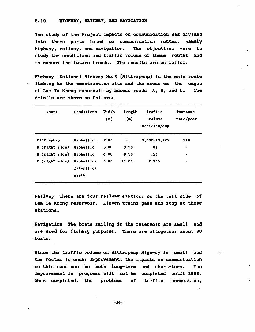
5.10 HIGHWAY, RLILWAY, AND NAVIGATEON
The study of the Project impacts on communication was divided
into three parts based on communication routes, namely
highway, railway, and navigation. The objectives were to
study the conditions and traffic volume of these routes and
to assess the future trends. The results are as follow:
Highway National Highway No.2 (Mittraphap) is the main route
linking to the constructlon slte and the areas on the edges
of Lam Ta Khong reservoir by access roads A, B, and C. The
details are shown as follows:
Route Conditions Vidth Length Traffic Increase
(D) (m) Volume rate/year
vehicles/day
MIttraphap Asphaltic . 7.00 - 9,832-13,776 llX
A (right side) Asphaltic 3.00 3.50 81
B (right side) Asphaltic p.00 9.50 156
C (right side) Asphaltic+ 6.00 11.00 2,955
lateritic+
earth
Railway There are four railway stations on the left slde of
Lam Ta Khong reservoir. Eleven trains pass and stop at these
statlons.
Navigation The boats sailing in the reservoir are small and
are used for fishery purposes. There are altogether about 30
boats.
Since the traffic volume on Mittraphap Highway is small and
the routes is under improvement, the impacts on communication
on this road can be both long-term and short-term. The
Lmprovement in progress will not be completed until 1993.
When completed, the problems of treffic congestion,
-36-
accidents, and damage of road surface will be lessened to a
great extent. Therefore, it could be said that the traffic
volume during the Project construction and the period
imediately after the construction will cause few problems to
the traffic there. Nevertheless, during periods of high
traffic volume, potential vehicles in the construction stage,
particularly heavy trucks could have some impacts on tha
traffic on this route at the turning points to the
construction site on the mountain and to the disposal area on
the edge of the reservoir. On access Road B, the traffic
will be small because this route is only leading to the
Project site. The traffic flow estimated to be created by
the construction activities during construction and early
post construction periods will not cause any congestion on
this route. However, the surface conditions of this road are
bad, and so with the anticipated traffic of heavy trucks, the
surface conditions will rapidly deteriorate and may be a
cause of accldents. Hence, it is essential that the running
surface of this road is improved.
5.11 ELECTRICITY
The future demand of electlcai power was the reason behind
the initiation of this Project. The daily peak period demand
which could not be met by the present power supply. Capacity
could be supplemented by another 1,000 KW from this new
Project through transmission lines that link to the existing
system.
To date, the Northeast Electricity Generation Authority can
generate 380.-06 MW of electricity. This amount will be
increased to 1,856.06 MM in 1996. 249 MW of this energy
output will be supplied from EGAT Project to be completed in
1994. Another 1,255 MW will be supplied from the future
projects. The present transmission lines total 4,154 km in
length, comprising lines of 230 KV, 115 KV, and 69 KV. The
transmission lines to be installed to the Project is 230 KV,
and 15 km long. This will be linked to the existing lines
-37-
from the sub-station, which links between Saraburi and Nakhon
RatchasJma. The result of the construction of this Project
will increase the power supply in the future and it will be
used In an emergency case.
5,12 RECREATION DEVELOPMENT
The study on tourism activities In Lam Ta Khong reservoir
area and the Project construction area had as its objective
to determine the tourism potential and the changing trends of
these activities when the Project is completed. Questionnaire
was used in the study. It was found that' tourists stopped for
their meals and for viewing the scenes of the reservolr
during public holidays. The majority of tourists came on
Songkran day. The scenic views of the reservoir and the
surrounding areas were the important atracting points. 92% of
the samples recommended development of tourism elements such
as landscaping, public parks, forest plantation along the
highway. In addition, suggestiors were given on the
establishment of sourvenir shops, camping grounds, and
salling in the reservoir. 25% of the samples reported that
they have seen the views from the top of mountain. 3^%
believed that this Project would enhance the aesthetic
values of the area.
The Project has no impact on the scenic values, both in the
construction period or in the long run. On the contrary, the
Project will promote tourism activities in the area.
-38-
C5. * QLIAL n orF IC rIFE VALUArEMS
6.1 SOCIO-ECONOKZCS AND INSTITUTION
The construction of the upper reservoir of the pumped storage
Project will bring about certain direct impacts on two groups
of forest communities (1,393.-75 Rais) which are situated in
the National Conserved Forest area, Kao Yal Tiang, Group 6,
Klong Pal Subdistrict, Si Khiu District, Nakhon Ratchasima,
and Kao Tlan - Kao Kuan Lan. Field crops and fruit trees are
generally grown on these areas, e.g., maize, cassava, cashew
nut, and jackfruit. The average size of subsistence land is
34.3 rai per household. On the most part, the farmers are
allocated an average of 14.5 rai per household for farming.
The crop produce is relatively low due to low-quality soil
and drought. No paddy and vegetable farming is practised? in
these areas. Commercial domestic animals include beef cattle.
The average income, expense and debts per household per year
are Bht 80,518.30, Bht 78,233.40, and Bht 12,409.40 respec-
tlvely. The major problems in occupation are low-quality
soil, drought, prlces of products being low and unstable,
whereas the costs of production elements rise continuously.
On the survey date, 81.5% of the villagers agree with the
Project construction.
6.2 COMPENSATION AND DEVELOPMEWT
The loss of assets of the population from the Project
includes agricultural land of about 223 hectares or 1,393.75
rai. About 45 households are estimated to receive
compensation payment. The total compensation cost Is Bht
27,303,231 which is the figure estimated from 1990 price
values. Compensation costs can be classified into two
categories:
1) Land compensation 22,996,875 Baht
2) Compensation for fruit 4,306,356 Baht
trees and perennia±s
-39-
Besides the above-me-itioned compensation cost, plans should
be set up to assist some of the villagers in terms of
occupation. This can be the promotion of beef cattle raising
which produces good yields as far as marketlng and rates of
return are concerned. In addition, EGAT-should take part in
the development of the ways of living of the people ln the
construction area. For instance, the existing water resource
can be improved so that water is available for every
household and livestocks for the year round.
6.3 PUBLIC HEALTH
ITe study conducted on publlc health showed that the healthand hygeine of the people In Nakhon Ratchasima are in good
conditions on the most part. In the construction area of theProject, the population still face some health problems which
are-not severe.
6.4 HISTORICAL AND ARCHAEOLOGICAL VALUES
The investigation of the archaeological and historical sites
on Kao Yai Tiang revealed that the place is on a high
elevation and so was not suitable for any permanent human
settlement. Thus, there are no traces of archaeological
objects or structures in the area. These objects are found
in the areas far from the Project slte where they have beenwell maintained and protected.
6.5 AESTEBTIC VALUES
In Lam Ta Khong reservoir area, its vicinity, and the upper
reservoir area on Kao Yai Tiang mountain, the scenery is
beautiful for the whole year with varying characteristics of
each season. The travellers on Mittraphap Highway east of
the reservoir and on the railroad west of the reservoir can
view the scenery of the reservoir which has the water as the
main element and the mountains and sky as the background.
This scenery can also be viewed from the points on the upper
reservoir area.
-41-
7-. I NrE3T IMPACT ASSESS?C'IT
The environmental impacts were summarized using the
ecological system analysis approach. The ecology was divided
into three parts--land, water, and socio-economics.
7.1 LAND
Affected Areas
The areas that were affected by the Project consist of
- Areas on Thao Tian-Khao Khuanlun for construction
reservoir, switchyard, tunnels, and vicinity
- Disposal areas consisting of the areas in theeast and south of the upper reservoir and along
the edge of the Lam Ta Khong reservoir
- Areas for road construction and vicinity
Impacts During Project Construction
Impact causing activities:
1) Construction of the upper reservoir. The cons-
truction area is in the watershed area Class 1B
2) Construction of water way. The distance where
the tunnel will be lald is set to be the
shortest and avoid the watershed area Class 1A
by excavating the tunnel deeply below the area
3) Construction of the powerhouse and switchyard.
The powerhouse is built underground while the
entrance and switchyard are built above ground
outside of the area 1A
4) Disposal of the muck. There are two areas for
soil and muck disposal--around the upper reser-
voir and along the edge of the reservoir below
-43-

-~~ '. . -- -
pht 4n *A... * . .
I ~~~~~~~~w 416
~~t, ~ _ .WL off1de
//)2,~~~~~~P )\ - -- - I~~~~~~~~~L 9EIS51 Aw.
_LEGN ITNHDOAS1Aj~U~O)UPPER RESERVOIR IT -- %..-I \ a , '-POaCMV-DCASU FATNDMY AR
* LII~RE Z.2'...-.CrAEAOLN0R
*- --- *? ')M" 'y4r1 ~'I~~ (~i'!kII/v Wtershed Classificationl In the Project Area

5) Road improvement and traffic increase. This dis-
turbs the ecology of the land in the area.
6) Transmission line installation. Transmission
lines will be installed along all of the
highways.
Environmental impacts:
1) Impacts on land use and soil erosion. The cons-
truction area was a low-yield agriculatural area
with low soil fertility. Thus, it is expected
that there will be very little Impact on land
use. However, the severity of the soil erosion
varies according to the steepness of the areas.
It is necessary that there be a good mitigation
soil conservation measurp.
2) Impacts on forest, wildlife, and rare species.
The construction area is mainly area for
agriculture. No wildlife or plants that are rare
or endangered were found. The existing plants
and animals will be affected by the construction
activities and pollution. The impact, however,
will be small because the construction covers a
small area and will be over in a short time.
Impacts During Project Operation
Impact causing activity:
Traffic increase. Increase of traffic volume due
to transportation of equipments and materials.
Environmental impacts:
Impacts on land use and soil erosion. After the
construction the severity of the impacts will
-45-
gradually decrease as a result of the reforestation
plan and suitable soil erosion protection.
Impacts on forest, wildlife, and rare species. It
is expected that an increase In traffic will
produce a small impact on tfe ecosystem of the
area. Besides, in the long run, the ecology should
be able to balance itself.
7.2 WATER
Affected Areas
Two areas will be affected by the Project:
1)'Lam Ta Thong reservoir
2) Lam Ta Khong river and irrigation system in the
lower area of the Lam Ta Xhong reservoir.
Impacts During Project Construction
Impact causing activities:
1) Earth work involving excavating and embanking
soil. These activlties cause soll erosion,
sedimentation suspension particles,and transport
into the water in the rainy period
2) Underwater work. In adjusting the bed of the
Lam Ta Khong reservoir around the pumping-
discharge point, it is necessary that a coffer
dam be built into the reservoir which will
disturb the habitat of the living things In the
reservoir.
Environmental impacts:
Impacts expected to occur during this period are:
-46-

1) The quallty of the water in the affected areas
will be lowered due to turbidity and Impurities
that flow into the water source.
2) Living organisms in the water will be disturbed
by the lowered quality water and the disturbance
to their habitat during construction.
Impacts During Projact Operation
Impact causing activities:
Daily water pumping and releasing The daily volume
of 9.9 million cubic metres that ls pumped and
released can cause a variatlon in the water levels
from 0.28 metre per day at NHWL (277 m msl) to 2.20
metres per day at LWL (261 m msl). The area that
results from the decrease in water level ranges
from 0.75 sq km at LWL to 1.55 sq km at NHWL and
LWL.
Tlurnover period. The turnover period of the water
in the Lam Ta Khong reservoir varies from 2.0 days
at LWL to 31.3 days at NHWL.
Environmental izpacts:
1) Restriction of water availability. When the
water level is near the LWL, the amount of water
that can be used will be limited to the water
need of 9.9 million cubic meters.
2) Plankton and fish destruction. The increased
pressure in the water tunnel due to the daily
pumping and discharge of water will kill
plankton and fish in the water. The severity of
the impact varies inverselly with the water
volume in the Lam Ta Khong reservoir, that is,
the impact will be severe In the year when water
is not abundant.
-48-

7.3 BOCIO-ECONOEZCES
Affected Areas
The affected areas are those on Khao Tlan-Khao Khuanlun, and
around the Lam Ta Khong reservoir.
Impacts Durlig Project Construction
Negative results:
1) Loss of 1,394 rai of agriculture land in 45
households the mojority of which will per-
manently lose their land and a annual Income of
22,232 baht from agriculture.
2) Those whose houses are near the construction
area will suffer from noise and dust.
3) There will be more incidents of accidents,
diarrhea, and hookworms due to the large amount
of people working in the area.
Positive results:
1) There will be more work for local people and
those from outside.
2) There will be more money in circulation
Improving -the overall economy of the area and
vicinity, which will eventually be beneficial to
the economy of the country as a whole.
XIpacts During Project Operation
Negative results:
1) There will be 45 households who will permanently
lose their land and income.
-49-
AS

Positive results:
1) The development of the tourist spot at the Lam
Ta Khong reservoir (the disposal area) will
increase Income for local people and those in
the vicinity
2) The road that passes Rhao Yaithiang village will
be much better than the present condition.
3) The environmental, in general, will be improved
and revived.
7.4 I3PACT ON THE WATERSHED AREA CLASW IA
From the Project feasibility study, the upper reservoir has
been located on the mountain which is the watershed area
class 1B. Tunnels for the waterway, powerhouse, transmission
lLne, and access way have been located deep underground of
the watershed area class 1A. This Is to avoid any
disturbance to the protected forest area.
This environmental assessment study, can prove that the
Project construction will not cause anly disturbance to the
1A area. Thus, the Project will certainly conform with the
resolution of the carbinet (B.E. 2531) concerning the
watershed classification (Moon-Chi basin).
The assessment can be concluded as follows:
1) The construction under the 1A area is 100-300 m
deep from ground surface. The geologic
formation of the area is so stable that the
construction will not cause any effect to the
upper environmental resources of the 1A area;
i.e., soil, forest and wildlife will not be
affected.
2) The vibration from blasting during .the Project
construction can be controlled such that the
geological condition will not be affected.
-51-

3) The tunnel excavation will slightly affect
groundwater pressure in deep zone. However this
effect will not cause any significant environ-
mental impact.
4) Noise, dust, smoke, and other air pollutants to
be emitted from the construction outside the 1A
area; e.g., upper reservoir, tunnel portals, etc
will cause some short-term impacts to the forest
and wildlife in the 1A area. However, the
Impacts are estimated to be fairly small.
-52-

8 . EKNVXIRONM14VZEXNTrAL. IXkA=CT MXI T IQ T ICN
AUNID4 MONrI T OERI NC;
8.1 ENVIRONMENTAL IMPACT MITIGATION
The aforementioned impacts necessitate measures to mitigate
the negative impacts, and to improve-revive the environment,
so that Impacts from the Project are kept to a minimum, while
at the same time, promoting as many positive impacts as
possible. These measures are:
Prolilinary Measures
1) Public relations to bring good and clear
understanding as well as creating positive
attitudes toward the project.
2) Compensatlon payment.
Measures During Project Construction
1) Measures to reduce soil erosion
2) Measures to decrease nuisances from dust, noise,
and vibrations.
3) Measures to control traffic to prevent accidents
4) Measures on health and hygiene, and safety
Long-term Measures
1) Rehabilitating and developing the Project area
after construction.
2) Conserving fishery resource in Lam Ta Khong
reservoir.
3) Managing water resource in Lam Ta Khong
reservoir in accordance with Project operation
and water needs. in other activities.
-54-
8.2 MONITORING OP TRB ENVIRONMENT
The monitoring of the environment Is carried out as a measure
to efficiently recover and develop the environment In the
Project areas. There will be a close follow-up evaluation.
In order for the operation to achieve Its goals and to be
able to solve problems as soon as they occur, there are three
monitoring plans.
1) Monitoring of the forest and the soil erosion of
the area
2) Monitoring of the environment and fishery
resource in Lam Ta Khong reservolr.
3) Monitoring of socio-economics.
-55-

Sumary of Mitigation and D.valopment
Operation Plans Operation Areas Procedure Operation Periods Budget
1. Primary plans
1.1 Pubilo relations Generation locations - Establishing PR units - Project preparation 10 mill.baht
In Nakhon Ratchasima for the project periodi,2 months (excluding salaries)
and Bangkok - Carrying out PA - Project proposal
activities periods 2 months
JI - Post-project approval
* period: 8 months
1.2 Conponsation Upper reservoir - Paying compensation 3 months after project 27.3 mill.baht
payment, living construction area for land, costs of approval
condition and on Khao Tian - Khao fruit trees and per-
occupationaL Khuanlun ennials
development

Summary of Mitigation and Development (Continued)
Operation Plans Operation Areas Procedure Operation Periods Eudget
2. Plans durfng
construct i on
2.1 Environmental Project construction - Prevention of moIl - To be determined by
mitigation areas an the mountain erosion EGAT
during construction and areas around Lam - Prevention of atr - To be determined by
Ta Khong reservoir and noise pollution, EGAT
and vibrations
- Prevention, rectifi- - To be determined by
cation, and develop- BOAT
ment of traffic
- Preparation for health - To be determined by
and hyglenne of project ECAT
employees
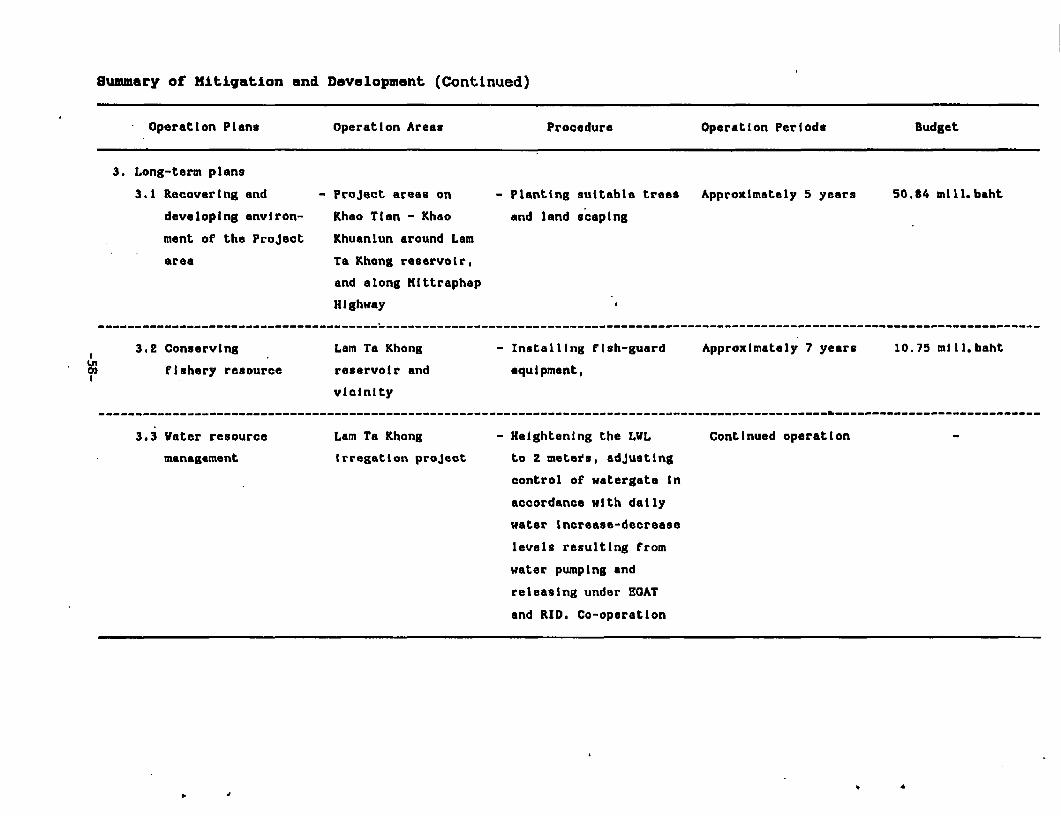
Summary of Mitigatlon and Development (Continued)
Operation Plans Operation Areas Procedure Operation Periods Budget
3. Long-term plans
3.1 Recovertng and - Project areas on - Planting suitable trees Approximately 5 years 50.84 mil1.baht
developing environ- Khao Tian - Khao and land soaping
ment of the Project Khuanlun around Lam
area Ta Khong reservoir,
and along Hittraphap
Highway
3.2 Conserving Lam Ta Khong - Installing fish-guard Approximately 7 years 10.75 mill.baht
0 Efishery resource reservoir and equipment,
vicinity
3.3 Vater resource Lam Ta Khong - Heightening the LVL Continued operation -
management Irregation project to 2 meters, adjusting
control of watergate In
accordance with daily
water increase-decrease
levels resulting from
water pumping and
releasing undor EGAT
and RID. Co-operation
, ,~~~~~~~~~~~~~~~~~~~~~~~~~~~~~~~~~~~~~~~~~~

I:,~~~~~~~~~~~~~~Wterrsore aa
I-,,.,~~~~~~~~~~~~~~~~~~~~~~~~~~~~Pbi ral
l~~~~~ C -g,\ #t;'2;ompe; nsarvtion Lp|ymentR
|l\V\t ) |' 5w515 .rlshery resource conservationtJI -rz(ANui J f.15 L >re
l~~~~~~~~~~1 finhstalltion of fish
V protck 9-*ti a T hng equm rid5 ad Dvlpment tlkfc
9 __ ~~~~~ ~~~ '7oE !tb *72 179~~~~~~~~an rehabolltatLan
9 . 3E2NWIFNMvEE3NTrAL. ]ECX:CtC)OHIC ANUAL.I
The main objective of the environmental economic analysis of
Lam Ta Khong Pumped Storage project is to incorporate the
environmental impact of the Project into the benefit cost
analysis of the Project. AlSo analysed here is the spill-
over effect of the Project in the regional economy.
The financial analysis of the Project conducted by JICA and
finalized by EGAT is used as a base for the study. Using
conversion factors, financial cost and benefit are adjusted
to economic ones. Fisheries, water and land resources are
major affected resources. In addition, construction of the
reservoir disposes of substantial soil, which necessitate
land rehabilitation. These environmental impacts of the
Project are quantified and included in the economic analysis
of the Project.
While the majority of the Project costs include construction,
operation and maintenance as well as environment, the
important benefit of the Project is electricity. In this
case, the cost saving of an alternative electricity
generator. Using project analysis criteria--NPV, B/C at
discount rates of between 8% to 16%, and IRR, the results
show that the Project is highly beneficial. TNPV of the
Project ranges from more than 450 million to as high as 4.4
billion baht. B/C of the Project is between 1.06 to 1.37 and
the IRR is 19%.
Besides a high economic yield, the Project could also induce
substantial spill-over effect to the regional economy. Using
the input-output approach, it is estimated that during the
construction period, the Project could induce an average of
more than 637 million baht of output per year, and 250
million baht of income to the people in the region. During
the operation and maintenance periods, more than 160 million
baht worth of output, and more than 86 million baht of income
-60-

could be generated. Of the total income, about one-thirdwould be in the form of wages and salaries.
.*


