
Recreational Fishing Regulations for Gulf of Mexico Federal WatersFor Species Managed by the Gulf of Mexico Fishery Management Council January 2019

This publication was prepared for general informational purposes and has no legal force or effect. Fishing
regulations are subject to change. Check for updates by visiting www.gulfcouncil.org, or the Fish Rules
regulations app.
Download the Fish Rules regulations app - available for both iPhone and Android.
A publication of the Gulf of Mexico Fishery Management Council pursuant to National Oceanic and Atmospheric Administration Award No. NA15NMF4410011.
IPhone
Android
Photo: Sea GrantPhoto: Dylan HubbardPhoto: Emily Muehlstein

1 |
Table of Contents
About Us 2
Recreational Regulations
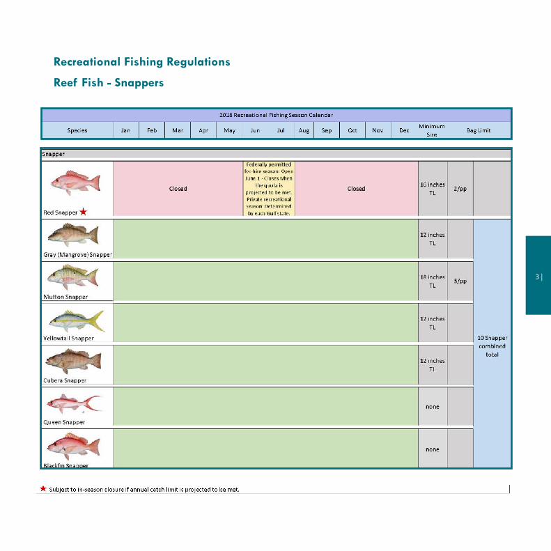
Reef Fish - Snappers 3
Reef Fish - Other 5
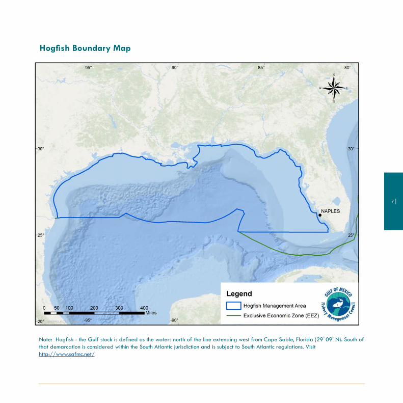
Hogfish Management Boundary Map 7
Reef Fish - Groupers 8
Shallow-water Grouper Closure Map 10
Shallow-water Grouper Closure Coordinates 11
Coastal Migratory Pelagics 12
Shellfish and Other Species 13
Coral and Other Species 13
Highly Migratory Species 14
Recreational Permit Requirements 15
Additional Rules 16
Measurement Guidelines 17
Marine Sanctuarys and Area Closures 18
Gulf of Mexico Federal Waters 34
Important Phone Numbers 35
Regulation Changes and Updates 37
Gulf of Mexico Fishery Management Council 4107 W. Spruce StreetSuite 200Tampa, Florida 33607888-833-1844/813-348-1630

| 2
About the
Gulf of Mexico Fishery Management Council
The Gulf of Mexico Fishery Management Council is one of eight regional Fishery Manage-
ment Councils established by the Fishery Conservation and Management Act of 1976. The Council prepares
fishery management plans, which are designed to manage fishery resources within the federal waters of
the Gulf of Mexico.
The Council consists of 17 voting members: the Southeast Regional Administrator of NOAA Fisheries
Southeast Regional Office, the directors of the five Gulf state marine resource management agencies, and
11 members who are nominated by the state governors and appointed by the Secretary of Commerce.
There are also four non-voting members representing the U.S. Coast Guard, U.S. Fish and Wildlife Service,
Department of State, and the Gulf States Marine Fisheries Commission.
When reviewing potential rule changes, the Council draws upon the services of knowledgeable people
from other state and federal agencies, universities, and the public to balance competing interests and
achieve the greatest overall benefit to the nation.
Scoping workshops and public hearings are held throughout the Gulf coast to collect
your input. Public comment is considered by the Council before it takes final action
on proposed rule changes. The Council also collects comments on proposed changes
through virtual meetings and online comment forms. Public testimony is heard during
each Council meeting. After the Council takes final acton, proposed rule changes are
submitted to National Marine Fisheries Service for further review and approval before
implementation by the Secretary of Commerce.
3 |
Recreational Fishing Regulations
Reef Fish - Snappers

| 4
Red SnapperPhoto: Dylan Hubbard
Mutton SnapperPhoto: Rosemary White
Red SnapperPhoto: Scott Hickman

5 |
Reef Fish - Other
Golden Tilefish Photo: NOAA
Blueline Tilefish Photo: NOAA, Teacher at Sea
Gray TriggerfishPhoto: NOAA, Teacher at Sea

| 6
NOTES:
• Pending implementation, for-hire vessel operators will have to make a trip declaration (hail out) prior to
departing. Operators will also have to submit electronic fishing reports for each trip before offloading fish.
Each vessel will need to be equipped with hardware that, at minimum, arcives GPS position.
• For-hire captains and crew are prohibited from retaining bag limits of any grouper, greater amberjack, or red
snapper while under charter.
• Federally permitted for-hire reef fish vessels must comply with the more restrictive of federal or state reef fish
regulations when fishing for reef fish in state waters.
• When fishing in state waters off Monroe County, FL, South Atlantic regulations apply.
Northern Gulf Coast Photo: NOAA
7 |
Hogfish Boundary Map
Note: Hogfish - the Gulf stock is defined as the waters north of the line extending west from Cape Sable, Florida (29° 09’ N). South of that demarcation is considered within the South Atlantic jurisdiction and is subject to South Atlantic regulations. Visit http://www.safmc.net/

| 8
Reef Fish - Groupers
ScampPhoto: NOAA

9 |
Scamp grouperPhoto: Gavin Redinger
Snowy grouperPhoto: Dylan Hubbard
Yellowedge grouperPhoto: Dylan Hubbard

| 10
Shallow-water Grouper Closure (Map of the 20-fathom break)Title 50 CFR: Wildlife and Fisheries - PART 622 FISHERIES OF THE CARIBBEAN, GULF OF MEXICO, AND SOUTH ATLANTICSubpart B – Reef Fish Resources of the Gulf of Mexico - §622.34 Seasonal and area closures designed to protect Gulf reef fish(d) Seasonal closure of the recreational sector for shallow-water grouper (SWG). The recreational sector for SWG, in or from the Gulf EEZ, is closed each year from February 1 through March 31, in the portion of the Gulf EEZ seaward of rhumb lines connecting, in order, the points in the following table. During the closure, the bag and possession limit for SWG in or from the Gulf EEZ seaward of the following rhumb lines is zero.
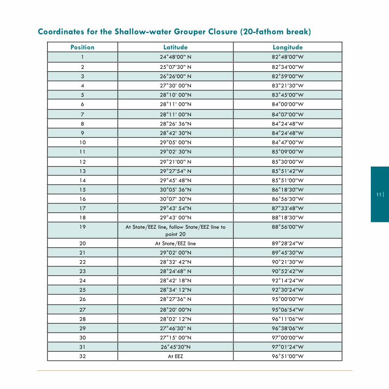
11 |
Position Latitude Longitude1 24°48’00” N 82°48’00”W
2 25°07’30” N 82°34’00”W
3 26°26’00” N 82°59’00”W
4 27°30’ 00”N 83°21’30”W
5 28°10’ 00”N 83°45’00”W
6 28°11’ 00”N 84°00’00”W
7 28°11’ 00”N 84°07’00”W
8 28°26’ 36”N 84°24’48”W
9 28°42’ 30”N 84°24’48”W
10 29°05’ 00”N 84°47’00”W
11 29°02’ 30”N 85°09’00”W
12 29°21’00” N 85°30’00”W
13 29°27’54” N 85°51’42”W
14 29°45’ 48”N 85°51’00”W
15 30°05’ 36”N 86°18’30”W
16 30°07’ 30”N 86°56’30”W
17 29°43’ 54”N 87°33’48”W
18 29°43’ 00”N 88°18’30”W
19 At State/EEZ line, follow State/EEZ line to point 20
88°56’00”W
20 At State/EEZ line 89°28’24”W
21 29°02’ 00”N 89°45’30”W
22 28°32’ 42”N 90°21’30”W
23 28°24’48” N 90°52’42”W
24 28°42’ 18”N 92°14’24”W
25 28°34’ 12”N 92°30’24”W
26 28°27’36” N 95°00’00”W
27 28°20’ 00”N 95°06’54”W
28 28°02’ 12”N 96°11’06”W
29 27°46’30” N 96°38’06”W
30 27°15’ 00”N 97°00’00”W
31 26°45’30”N 97°01’24”W
32 At EEZ 96°51’00”W
Coordinates for the Shallow-water Grouper Closure (20-fathom break)

| 12
Note: The 2-day bag limit allowance for qualified charter vessels and headboats on a trip in excess of 24 hours does not apply to cobia.
Coastal Migratory Pelagics
CobiaPhoto: Ed Walker King mackerel
Photo: Dylan Hubbard
Spanish mackerelPhoto: Carrie Simmons

13 |
Coral and Other Species
Species Notes
Live Rock Harvest and possession of live rock is prohibited, except for permitted aquaculture op-erations. Call 727-824-5763.
Other Marine Life Organisms
Marine life organisms from the EEZ harvested or possessed by Florida residents or landed in Florida are subject to Florida’s Marine Life Rule. Contact the Florida Fish and Wildlife Commission for more information at 850-487-3122.
Shellfish and Other Species
Spiny lobster and Red grouperPhoto: W.T. Pearson
Red DrumPhoto: Dylan Hubbard
Spiny LobsterPhoto: Sea Grant
| 14
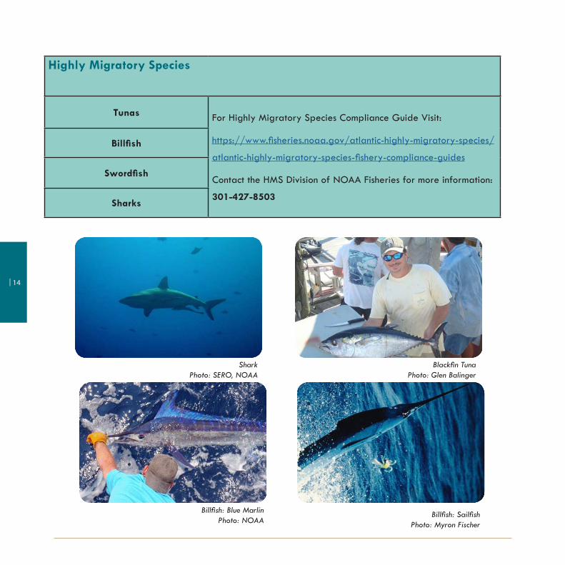
Highly Migratory Species
Tunas For Highly Migratory Species Compliance Guide Visit:
https://www.fisheries.noaa.gov/atlantic-highly-migratory-species/
atlantic-highly-migratory-species-fishery-compliance-guides
Contact the HMS Division of NOAA Fisheries for more information:
301-427-8503
Billfish
Swordfish
Sharks
SharkPhoto: SERO, NOAA
Blackfin TunaPhoto: Glen Balinger
Billfish: Blue MarlinPhoto: NOAA
Billfish: SailfishPhoto: Myron Fischer

15 |
Recreational Permit Requirements
Permit Required for:
Charter vessel/headboat coastal pelagics permit Charter vessel and headboats fishing for king mackerel, Spanish mackerel, and cobia. NOTE: Issuance of new permits is under a moratorium effective 6/16/2003.
Charter vessel/headboat reef fish permit Charter vessels and headboats fishing for snappers, groupers, amberjack, tilefish, hogfish, and gray triggerfish. NOTE: Issuance of new permits is under a moratorium effective 6/16/2003.
Highly migratory species (HMS) charter/headboat permit
All charter or headboats that fish for or possess highly migratory species.
HMS recreational angling permit Owners of vessels used to fish recreationally for Atlantic HMS - Atlantic tunas (other than blackfin), billfish, sharks, and swordfish.
Recreational Anglers No federal permit or license required. Anglers are responsible for obtaining any state fishing license required.
Photo: Emily MuehlsteinPhoto: NOAA/NMFS/William Folsom
| 16
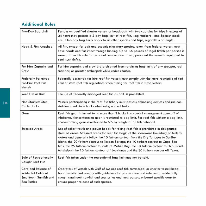
Additional RulesTwo-Day Bag Limit Persons on qualified charter vessels or headboats with two captains for trips in excess of
24 hours may possess a 2-day bag limit of reef fish, king mackerel, and Spanish mack-erel. One-day bag limits apply to all other species and trips, regardless of length.
Head & Fins Attached All fish, except for bait and oceanic migratory species, taken from federal waters must have heads and fins intact through landing. Up to 1.5 pounds of legal finfish per person is exempt from this rule for personal consumption at sea, provided the vessel is equipped to cook such finfish.
For-Hire Captains and Crew
For-hire captains and crew are prohibited from retaining bag limits of any grouper, red snapper, or greater amberjack while under charter.
Federally Permitted For-Hire Reef Fish Vessels
Federally permitted for-hire reef fish vessels must comply with the more restrictive of fed-eral or state reef fish regulations when fishing for reef fish in state waters.
Reef Fish as Bait The use of federally managed reef fish as bait is prohibited.
Non-Stainless Steel Circle Hooks
Vessels participating in the reef fish fishery must possess dehooking devices and use non-stainless steel circle hooks when using natural baits.
Gear Reef fish gear is limited to no more than 3 hooks in a special management zone off of Alabama. Nonconforming gear is restricted to bag limit. For reef fish without a bag limit, nonconforming gear is restricted to 5% by weight of all fish onboard.
Stressed Areas Use of roller trawls and power heads for taking reef fish is prohibited in designated stressed areas. Stressed areas for reef fish begin at the shoreward boundary of federal waters and generally follow the 10 fathom contour from the Dry Tortugas to Sanibel Island; the 20 fathom contour to Tarpon Springs; the 10 fathom contour to Cape San Blas; the 25 fathom contour to south of Mobile Bay; the 13 fathom contour to Ship Island, Mississippi; the 10 fathom contour off Louisiana; and the 30 fathom contour off Texas.
Sale of Recreationally Caught Reef Fish
Reef fish taken under the recreational bag limit may not be sold.
Care and Release of Incidental Catch of Smalltooth Sawfish and Sea Turtles
Operators of vessels with Gulf of Mexico reef fish commercial or charter vessel/head-boat permits must comply with guidelines for proper care and release of incidentally caught smalltooth sawfish and sea turtles and must possess onboard specific gear to ensure proper release of such species.

17 |
Measurement Guidelines
Fork length: the straight-line distance from the tip of the head (snout) to the rear center edge of the tail (caudal fin).
Total length: the straight-line distance from the tip of the snout to the tip of the tail (caudal fin), excluding any caudal filament, while the fish is lying on its side. The mouth of the fish may be closed and/or the tail may be squeezed together to give the greatest overall measurement.
Carapace length: The carapace is measured beginning at the forward edge between the rostral horns, excluding and soft tissue, and proceeding along the middle to the rear edge of the carapace.

| 18
Marine Sanctuaries and Area Closures
Detailed maps, coordinates, and regulations associated with each area can be found on pages 19-32.Note: All coordinates have been converted to degrees, minutes, seconds.
19 |
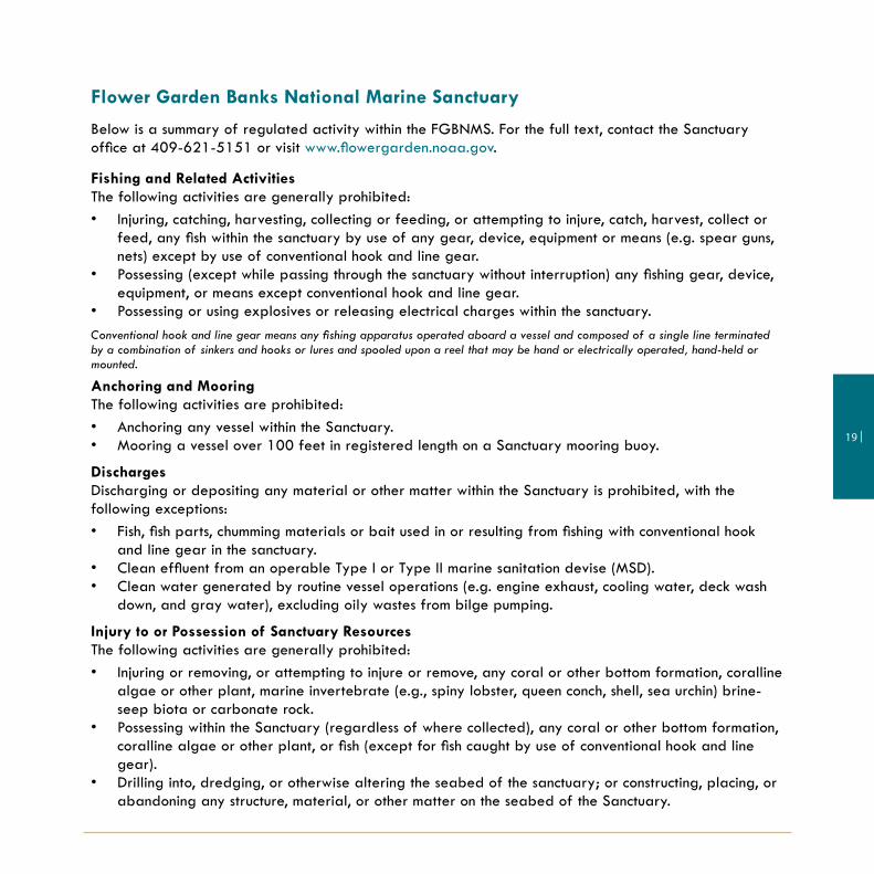
Flower Garden Banks National Marine Sanctuary
Below is a summary of regulated activity within the FGBNMS. For the full text, contact the Sanctuary office at 409-621-5151 or visit www.flowergarden.noaa.gov.
Fishing and Related ActivitiesThe following activities are generally prohibited:• Injuring, catching, harvesting, collecting or feeding, or attempting to injure, catch, harvest, collect or
feed, any fish within the sanctuary by use of any gear, device, equipment or means (e.g. spear guns, nets) except by use of conventional hook and line gear.
• Possessing (except while passing through the sanctuary without interruption) any fishing gear, device, equipment, or means except conventional hook and line gear.
• Possessing or using explosives or releasing electrical charges within the sanctuary.Conventional hook and line gear means any fishing apparatus operated aboard a vessel and composed of a single line terminated by a combination of sinkers and hooks or lures and spooled upon a reel that may be hand or electrically operated, hand-held or mounted.
Anchoring and MooringThe following activities are prohibited:• Anchoring any vessel within the Sanctuary.• Mooring a vessel over 100 feet in registered length on a Sanctuary mooring buoy.
DischargesDischarging or depositing any material or other matter within the Sanctuary is prohibited, with the following exceptions:• Fish, fish parts, chumming materials or bait used in or resulting from fishing with conventional hook
and line gear in the sanctuary.• Clean effluent from an operable Type I or Type II marine sanitation devise (MSD).• Clean water generated by routine vessel operations (e.g. engine exhaust, cooling water, deck wash
down, and gray water), excluding oily wastes from bilge pumping.
Injury to or Possession of Sanctuary ResourcesThe following activities are generally prohibited:• Injuring or removing, or attempting to injure or remove, any coral or other bottom formation, coralline
algae or other plant, marine invertebrate (e.g., spiny lobster, queen conch, shell, sea urchin) brine-seep biota or carbonate rock.
• Possessing within the Sanctuary (regardless of where collected), any coral or other bottom formation, coralline algae or other plant, or fish (except for fish caught by use of conventional hook and line gear).
• Drilling into, dredging, or otherwise altering the seabed of the sanctuary; or constructing, placing, or abandoning any structure, material, or other matter on the seabed of the Sanctuary.

| 20
Flower Garden Banks National Marine Sanctuary50 CFR: Wildlife and Fisheries - PART 622 FISHERIES OF THE CARIBBEAN, GULF OF MEXICO, AND SOUTH ATLANTIC§622.34 - Gulf EEZ seasonal and/or area closures.
(j) West and East Flower Garden Banks HAPC. Fishing with a bottom longline, bottom trawl, buoy gear, dredge, pot, or trap and bottom anchoring by fishing vessels are prohibited year-round.(s) Stetson Bank HAPC. Fishing with a bottom longline, bottom trawl, buoy gear, pot, or trap and bottom anchoring by fishing vessels are prohibited year-round.

21 |
West Flower Garden BankPosition Latitude Longitude
A 27°55’22.8” N 93°53’09.6” W
B 27°55’22.8” N 93°46’46.0” W
C 27°49’03.0” N 93°46’46.0” W
D 27°49’03.0” N 93°53’09.6” W
A 27°55’22.8” N 93°53’09.6” W
East Flower Garden Bank
Position Latitude Longitude
A 27°59’14.4” N 93°38’58.2” W
B 27°59’14.4” N 93°34’03.5” W
C 27°52’36.5” N 93°34’03.5” W
D 27°52’36.5” N 93°38’58.2” W
A 27°59’14.4” N 93°38’58.2” W
Flower Garden Banks National Marine Sanctuary
A 28°10’38.3” N 94°18’36.5” WB 28°10’38.3” N 94°17’06.3” W
C 28°09’18.6” N 94°17’06.3” W
D 28°09’18.6” N 94°18’36.5” W
A 28°10’38.3” N 94°18’36.5” W
Stetson BankPosition Latitude Longitude

| 22
McGrail Bank50 CFR: Wildlife and Fisheries - PART 622 FISHERIES OF THE CARIBBEAN, GULF OF MEXICO, AND SOUTH ATLANTIC§622.34 - Gulf EEZ seasonal and/or area closures.
(t) McGrail Bank HAPC. Fishing with a bottom longline, bottom trawl, buoy gear, pot, or trap and bottom anchoring by fishing vessels are prohibited year-round.
Texas
Louisiana

23 |
McGrail Bank
Fishing with a bottom longline, bottom trawl, buoy gear, pot, or trap and bottom anchoring by fishing vessels are prohibited year-round.
McGrail BankPosition Latitude Longitude
A 27°59’06.0”N 92°37’19.2” WB 27°59’06.0” N 92°32’17.4” WC 27°55’55.5” N 92°32’17.4”WD 27°55’55.5” N 92°37’19.2” WA 27°59’06.0” N 92°37’19.2” W
ActinoscyphiaPhoto: NOAA
Staghorn coralPhoto: Carrie Simmons
ReefPhoto: NOAA/FKNMS
Lophelia reefPhoto: NOAA

| 24
Florida Keys National Marine Sanctuary (FKNMS) Tortugas North and South Ecological Reserves

25 |
Tortugas North Ecological Reserve
Point Latitude Longitude
A 24°46’00” N 83°06’00” W
B 24°46’00” N 82°54’00” W
C 24°45’48” N 82°48’00” W
D 24°43’31.8” N 82°48’00” W
E 24°43’31.8” N 82°52’00” W
F 24°43’00” N 82°54’00” W
G 24°39’00” N 82°58’00” W
H 24°39’00” N 83°06’00” W
A 24°46’00” N 83°06’00” W
Florida Keys National Marine Sanctuary (FKNMS)
Tortugas North and Tortugas South Ecological Reserves are closed to all fishing. Anchoring of fishing vessels is also not allowed. The boundaries of the areas are as follows:
Tortugas South Ecological Reserve
Point Latitude Longitude
A 24°33’00” N 83°09’00 W
B 24°33’00” N 83°05’00” W
C 24°18’00” N 83°05’00” W
D 24°18’00” N 83°09’00” W
A 24°33’00” N 83°09’00” W

| 26
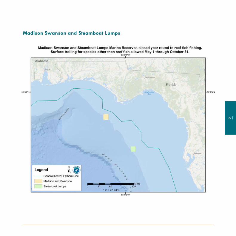
Madison Swanson, Steamboat Lumps, and the Edges
50 CFR: Wildlife and Fisheries - PART 622 FISHERIES OF THE CARIBBEAN, GULF OF MEXICO, AND SOUTH ATLANTIC§622.34 - Gulf EEZ seasonal and/or area closures.
(k) Closure provisions applicable to the Madison and Swanson sites, Steamboat Lumps, and the Edges.
(2) Within the Madison and Swanson sites and Steamboat Lumps, possession of Gulf reef fish is prohibited, except for such possession aboard a vessel in transit with fishing gear stowed as specified in paragraph (k)(4) of this section.
(3) Within the Madison and Swanson sites and Steamboat Lumps during November through April, and within the Edges during January through April, all fishing is prohibited, and possession of any fish species is prohibited, except for such possession aboard a vessel in transit with fishing gear stowed as specified in paragraph (k)(4) of this section. The provisions of this paragraph, (k)(3), do not apply to highly migratory species.
(4) For the purpose of paragraph (k) of this section, transit means non-stop progression through the area; fishing gear appropriately stowed means -
(i) A longline may be left on the drum if all gangions and hooks are disconnected and stowed below deck. Hooks cannot be baited. All buoys must be disconnected from the gear; however, buoys may remain on deck.
(ii) A trawl net may remain on deck, but trawl doors must be disconnected from the trawl gear and must be secured.
(iii) A gillnet must be left on the drum. Any additional gillnets not attached to the drum must be stowed below deck.
(iv) A rod and reel must be removed from the rod holder and stowed securely on or below deck. Terminal gear (i.e., hook, leader, sinker, flasher, or bait) must be disconnected and stowed separately from the rod and reel. Sinkers must be disconnected from the down rigger and stowed separately.
(5) Within the Madison and Swanson sites and Steamboat Lumps, during May through October, surface trolling is the only allowable fishing activity. For the purpose of this paragraph (k)(5), surface trolling is defined as fishing with lines trailing behind a vessel which is in constant motion at speeds in excess of four knots with a visible wake. Such trolling may not involve the use of down riggers, wire lines, planers, or similar devices.
(6) For the purpose of paragraph (k) of this section, fish means finfish, mollusks, crustaceans, and all other forms of marine animal and plant life other than marine mammals and birds. Highly migratory species means tuna species, marlin (Tetrapturus spp. and Makaira spp.), oceanic sharks, sailfishes (Istiophorus spp.), and swordfish (Xiphias gladius).
27 |
Madison Swanson and Steamboat Lumps
Alabama
Florida

| 28
The Edges (40 fathom contour)
Florida

29 |
Madison-Swanson Marine ReservePosition Latitude Longitude
A 29°17’ 00”N 85°50’ 00”WB 29°17’ 00”N 85°38’ 00”W
C 29°06’00” N 85°38’ 00”WD 29°06’00” N 85°50’ 00”WA 29°17’00” N 85°50’ 00”W
Steamboat Lumps Marine ReservePosition Latitude Longitude
A 28°14’00” N 84°48’ 00”WB 28°14’00” N 84°37’ 00”WC 28°03’00” N 84°37’ 00”WD 28°03’ 00”N 84°48’ 00”W
A 28°14’ 00”N 84°48’ 00”W
Madison-Swanson and Steamboat Lumps Reserves are closed to reef-fish fishing year round. Surface trolling for species other than reef fish is allowed May 1 through October 31.
The Edges
Position Latitude Longitude
A 28°51’00” N 85°16’00” W
B 28°51’00” N 85°04’00” WC 28°14’00” N 84°42’00”W
D 28°14’00” N 84°54’00” W
A 28°51’00” N 85°16’00” W
The Edges (40 fathom contour) is closed January 1 through April 30 to all fishing. The Edges is a 390 nautical square mile region northwest of Steamboat Lumps.

| 30
The Middle Grounds50 CFR: Wildlife and Fisheries - PART 622 FISHERIES OF THE CARIBBEAN, GULF OF MEXICO, AND SOUTH ATLANTIC§622.34 - Gulf EEZ seasonal and/or area closures.
(b) Florida middle grounds HAPC. Fishing with a bottom longline, bottom trawl, dredge, pot, or trap is prohibited year round.
Florida

31 |
The Middle Grounds
Fishing with a bottom longline, bottom trawl, dredge, pot, or trap is prohibited year-round.
Middle GroundsPosition Latitude Longitude
A 28°42’30”N 84°24’ 48”WB 28°42’ 30”N 84°16’ 18”WC 28°11’ 00”N 84°00’00”WD 28°11’ 00”N 84°07’ 00”WE 28°26’ 36”N 84°24’ 48”WA 28°42’ 30”N 84°24’ 48”W
Squat lobster on black coral Photo: NOAA/Okeanos Expedition 2014
Red Bream and decadactylusPhoto: NOAA
Diver at Flower Garden Banks National Marine SanctuaryPhoto: NOAA/FGBNMS/G.P. Schmahl
| 32
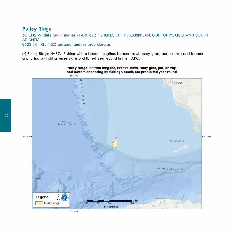
Pulley Ridge50 CFR: Wildlife and Fisheries - PART 622 FISHERIES OF THE CARIBBEAN, GULF OF MEXICO, AND SOUTH ATLANTIC§622.34 - Gulf EEZ seasonal and/or area closures.
(r) Pulley Ridge HAPC. Fishing with a bottom longline, bottom trawl, buoy gear, pot, or trap and bottom anchoring by fishing vessels are prohibited year-round in the HAPC.
Florida

33 |
Pulley RidgeFishing with a bottom longline, bottom trawl, buoy gear, pot, or trap and bottom anchoring by fishing vessels are prohibited year-round.
Pulley Ridge
Position Latitude Longitude
A 24°58’18” N 83°38’33” W
B 24°58’18” N 83°37’00” W
C 24°41’11” N 83°37’00”W
D 24°40’00” N 83°41’22” W
E 24°43’55” N 83°47’15” W
A 24°58’18” N 83°38’33” W
Red Grouper with fish at Pulley RidgePhoto: Coral Ecosystem Connectivity 2014, NOAA

| 34
Gulf of Mexico Federal Waters
The Gulf of Mexico Fishery Management Council manages fisheries in the federal waters of the Gulf of Mexico Exclusive Economic Zone. Federal waters begin where state waters end and extend to the 200-mile limit of the Gulf of Mexico.
Title 50: Wildlife and Fisheries
Part 600 - Magnuson-Stevens Act ProvisionsSubpart B - Regional Fishery Management Councils
§ 600.105 Intercouncil boundaries.
(c) South Atlantic and Gulf of Mexico Councils. The Boundary coincides with the line of demarcation between the Atlantic Ocean and the Gulf of Mexico, which begins at the intersection of the outer boundary of the EEZ, as specified in the Magnuson-Stevens Act, and 83°00’ W long., proceeds northward along that meridian to 24° 35’ N lat., (near the Dry Tortugas Islands), thence eastward along that parallel, through Rebecca Shoal and the Quicksand Shoal, to the Marquesas Keys, and then through the Florida Keys to the mainland at the eastern end of Florida Bay, the line so running that the narrow waters within the Dry Tortugas Islands, the Marquesas Keys and the Florida Keys, and between the Florida Keys and the mainland are within the Gulf of Mexico.
State Authority in Federal Waters
A state may regulate vessels that are registered in that state and fishing in federal waters for species for which there are no federal fishery management plans or applicable federal regulations, or for which the appropriate fishery management plan has delegated management of the state and the state rules are consistent with federal regulations.
NOTE: Federally permitted for-hire reef fish vessels must comply with the more restrictive of federal or state reef fish regulations when fishing for reef fish in state waters.

35 |
Important Phone Numbers
NOAA Fisheries Operations Branch- Southeast Regional Office 727-824-5301
NOAA Fisheries Permits and Regulations Branch (see below for tuna permit applications)
877-376-4877
To apply for permits online visit https://fisheriespermits.noaa.gov
NOAA Fisheries nationwide federal fishing violations hotline 800-853-1964
NOAA Fisheries 24-hour Atlantic tuna information line
NOAA Fisheries Atlantic tuna/Highly Migratory Species vessel permits
978-281-9260
888-872-8862NOAA Fisheries Highly Migratory Species Management Division 727-824-5399
NOAA Fisheries Swordfish/Billfish Recreational Reporting 800-894-5528
Flower Garden Banks National Marine Sanctuary 409-621-5151
Florida Keys National Marine Sanctuary 305-809-4700
South Atlantic Fishery Management Council 843-571-4366
Gulf States Marine Fisheries Commission 228-875-5912
U.S. Coast Guard, 7th District (Florida east of St. Marks) 305-415-6683
U.S. Coast Guard, 8th District (St. Marks, Florida to Texas) 504-671-2020
Regional NOAA Fisheries Office for Law Enforcement 727-824-5344
NMFS Enforcement Field Offices:
St. Petersburg, Florida Marathon, Florida Niceville, Florida Slidell, Louisiana Galveston, Texas Harlingen, Texas
727-824-5344305-743-3110850-729-8628985-643-6232409-770-0812956-423-3450

| 36
Important Phone Numbers continued
State Agencies
Alabama Department of Conservation & Natural Resources - Marine Resources Division
Fisheries Section - Information
24-Hour contact line to report state fishing violations
251- 861-2882
251-476-1256Florida Fish & Wildlife Conservation Commission
Marine Fisheries Management - Infomation
To report state fishing violations
850-488-4676
850-487-0554
888-404-3922Louisiana Department of Wildlife & Fisheries
To report state fishing violations
800-256-2749
800-442-2511Mississippi Department of Marine Resources
To report state fishing violations-DMR Marine Patrol
228-374-5000
844-WE-R-MDMRTexas Parks & Wildlife Department
To report state fishing violations
800-792-1112
800-792-4263
37 |
Regulation Changes and UpdatesSupplemental “update sheets” will be published periodically to reflect changes in fishing regulations implemented since this pamphlet was published. For up-to-date regulations visit www.gulfcouncil.org or download our free regulations app. Just visit the Android Market or iTunes and search for “Gulf Council”.
NOTE: The Official Electronic Code of Federal Regulations for 50 CFR 622 for Fisheries of the Caribbean, Gulf of Mexico and South Atlantic is available online.
Please visit: https://www.gpo.gov/fdsys/granule/CFR-2013-title50-vol12/CFR-2013-title50-vol12-part622.
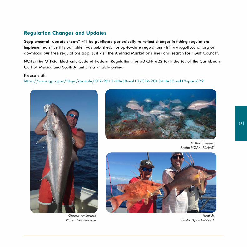
Greater AmberjackPhoto: Paul Borowski
HogfishPhoto: Dylan Hubbard
Mutton SnapperPhoto: NOAA, FKNMS

p | 813-348-1630/ 888-833-1844 e | [email protected] w | www.gulfcouncil.org


