Golder Associates Africa (Pty) Ltd Reg. No. 2002/007104/07 JOHANNESBURG PO Box 6001 Halfway House 1685 South Africa Thandanani Park, Matuka Close Halfway Gardens, Midrand Tel + (27) (0)11 254-4800 Fax + (27) (0)11 315-0317 http://www.golder.com
Directors : P Onley (Australia), FR Sutherland, AM van Niekerk, JA Wates OFFICES IN JOHANNESBURG, PIETERMARITZBURG, AUSTRALIA, INDONESIA, NEW ZEALAND, PEOPLE’S REPUBLIC OF CHINA, PHILIPPINES,
SINGAPORE OFFICES ACROSS AFRICA, ASIA, AUSTRALASIA, EUROPE, NORTH AMERICA, SOUTH AMERICA
REPORT ON
GROUNDWATER CONTAMINATION AT FINSCH MINE:
PHASE 1 SITUATION ASSESSMENT
Report No : 8334/8504/1/G
Submitted to:
Finsch Mine PO Box 7
Lime Acres 8410
DISTRIBUTION:
1 Copy - Finsch Mine 1 Copy - Golder Associates Africa (Pty) Ltd – Library October 2006 8334

October 2006 i 8334/8504/1/G
GOLDER ASSOCIATES
EXECUTIVE SUMMARY
At the request of Finsch Mine, Golder Associates Africa conducted a Phase I groundwater contamination assessment of the current status of the groundwater system in the area of, and to the north and northeast of, the Finsch Slimes Dam complex. This report documents the assessment of the current groundwater situation, and makes recommendations for expanding and augmenting the existing monitoring boreholes within the study area. The scope of work involved:
• Review of available data, including data from a hydrocensus conducted in 2003.
• A field hydrocensus of current groundwater levels and collection of samples
• Baseline groundwater quality assessment and preliminary assessment of contamination including water level and flow direction
• Gap analysis
The study area, here termed the “Slimes Dams complex” is located east and northeast of the Finsch open pit (Figure 1). The area includes Slimes Dams 1, 2 and 3, the recently-completed Infill Dam and the footprint of the Old Slimes Paddocks. In addition to the slimes dams and paddocks, the area includes Bonza Quarry which is linked to the mine process water circuit and includes the Earth Dam and Five Missions Dam.
A total of 23 boreholes were visited during the current hydrocensus. Seven boreholes were sampled and surface water was sampled from PPC Quarry 4 and Quarry 5. A walkover of the Old Slimes Paddocks indicated that overflow from the Slimes Dam 1 sump had created a pool behind the westernmost paddock wall. A borrow excavation at the pool indicated salt precipitation and the presence of sinkholes in the underlying dolomite.
The hydrogeology of the study area may be summarised as:
• The aquifer is a series of solution cavities within solid dolomite. The solution cavities could be developed on structural features and may or may not be interconnected. The observation of sinkholes confirms the indication from available geophysical data that solution features exist beneath the Old Slimes Paddocks.
• Permeable horizons within the dolomite include the near-surface weathered zone.
• The aquifer is heterogeneous and anisotropic, i.e. hydraulic properties vary over short distances in all directions.
• Groundwater elevations range from 1404 mamsl to 1449 mamsl and indicate a general eastward groundwater flow direction from the golf course towards Quarry 4.
Closer examination of the hydrocensus data suggest groupings of boreholes based on similar groundwater elevations. These groupings may represent compartments within the dolomite aquifer that are separated by differences in transmissivity or by geological structures such as dykes and faults.

October 2006 ii 8334/8504/1/G
GOLDER ASSOCIATES
The following potential compartments have been identified in the study area (Figure 13):
• Golf Course compartment – groundwater elevation ranges from 1449 mamsl to 1444 mamsl. Flow in this compartment is generally towards the east. The compartment is bounded to the west by the Golf Course dyke swarm.
• Golf Course dyke swarm – A single borehole in this compartment indicates a groundwater elevation of 1414 mamsl.
• Five Missions Compartment – One borehole in this compartment which indicates a level of 1407 mamsl. The compartment is bounded to the east by the Slimes Paddock Fault.
• PPC compartment – The three measured elevations in this compartment suggest groundwater flow towards the northeast. The compartment is bounded on the east by the Quarry 4 dyke swarm.
• Quarry 4 dyke swarm – Variable groundwater elevations from 1404 mamsl to 1406 mamsl as well as Quarry 4 itself with elevation of 1408 mamsl. Water levels in monitoring boreholes E2 and E3 are lower than Quarry 4 which suggests a southwest flow direction.
• Bonza Quarry Compartment – groundwater elevations in range of 1410 mamsl to 1415 mamsl which suggest north to northeast groundwater flow.
• Bonza Game Farm Compartment – This compartment lies south of the Slimes Paddock Fault. The two elevations in this compartment suggest an east to southeast flow direction.
The potential for groundwater flow and contaminant migration across compartment boundaries would be limited and the impact of a contamination source on groundwater quality may be limited to a particular compartment. Boreholes to delineate contamination plumes would need to be sited taking the effect of compartment boundaries into account.
Potential groundwater contamination sources in the study area include:
• Five Mission Dam
• Bonza Quarry
• Earth Dam
• Seepage from the Slimes Dams
• Seepage of Sump 1 Overflow through slimes paddock material
The samples collected during the current hydrocensus are generally within the limits of Class I drinking water as outlined in the SANS 241:2005 Drinking Water Specification except for Quarry 4, PPC16 and Bonza 01. The groundwater has been impacted by contamination sources which have elevated the concentrations of all parameters when compared to background water quality.

October 2006 iii 8334/8504/1/G
GOLDER ASSOCIATES
The geochemistry of the current samples suggests that potential sources such as the “Slimes Overflow” and “Five Missions Dam” analyses are probably not the sources of NO3 contamination in Quarry 4 and Quarry 5.
The following gaps have been identified in the existing groundwater information
• Groundwater flow direction in Quarry 4, Bonza Quarry, Five Missions, Bonza Game Farm and Golf course compartments
• Groundwater quality in the Bonza Quarry, PPC, Five Missions and Bonza Game Farm compartments
• Aquifer transmissivity in all compartments identified
• The volume of seepage from identified contamination sources
• The quality of seepage from identified contamination sources
The following preliminary conclusions are drawn from the work undertaken so far.
• The site is underlain by weathered and fractured karstic dolomite which dips gently to the west
• The aquifer consists of a series of solution cavities within solid dolomite
• Geological structures can act as barriers to groundwater flow. A dominant southwest – northeast structural trend underlies the site and structures define the boundaries of a number of groundwater compartments.
• Groundwater flow direction within these compartments is generally from southwest to northeast and parallels the structural trend. However, measured groundwater levels in the Quarry 4 dyke swarm suggest flow from the northeast to the southwest.
• Current analyses indicate elevated concentrations of major parameters relative to the background which suggests the influence of source(s) of contamination.
• The distribution of boreholes in the study area is not sufficient to identify groundwater flow directions and pollution plumes within the compartments inferred from this study
• The efficacy of the groundwater monitoring system can be improved through the upgrading of boreholes which have fallen into disuse, establishing and implementing a programme of regular groundwater level and quality monitoring and the drilling of additional monitoring boreholes in selected areas.
• Additional monitoring boreholes, especially in the Five Missions compartment and the Old Slimes Paddocks would assist in the determination of groundwater flow directions within compartments and hence the potential migration direction of contamination from potential sources located in these compartments.

October 2006 iv 8334/8504/1/G
GOLDER ASSOCIATES
• A programme of systematic monitoring of groundwater levels and quality should be implemented in the study area. The monitoring programme should be conducted under the direction of an experienced hydrogeologist and include protocols for storage of the data in a central repository to facilitate access to the data by Finsch Mine.
Based on the findings of this Phase I groundwater assessment, the following recommendations are made.
• Implement a Phase II study as described in Section 9;
• Upgrade and augment the monitoring network as discussed in Section 9;
• Implement a systematic monitoring programme as described in Section 9.

October 2006 v 8334/8504/1/G
GOLDER ASSOCIATES
TABLE OF CONTENTS
SECTION PAGE
1 INTRODUCTION.........................................................................................1 2 OBJECTIVES ..............................................................................................1 3 SCOPE OF WORK......................................................................................1 4 DESCRIPTION OF SITE.............................................................................1
4.1 Topography ......................................................................................... 3 4.2 Infrastructure ....................................................................................... 3
4.2.1 Tailings storage facility .......................................................... 3 4.2.2 Quarries ................................................................................ 3 4.2.3 Finsch Mine water circuit....................................................... 3
4.3 Geology............................................................................................... 5 5 DATA SOURCES ........................................................................................5
5.1 Discussion of hydrogeology ................................................................ 5 5.1.1 Water levels .......................................................................... 6 5.1.2 Geological structure ............................................................ 10 5.1.3 Geophysical data ................................................................ 10 5.1.4 Aquifer Anisotropy............................................................... 10
5.2 Existing monitoring programme ........................................................ 13 5.3 Field Programme............................................................................... 13
5.3.1 Hydrocensus ....................................................................... 13 5.3.2 Walkover of Slimes Paddocks............................................. 16 5.3.3 Information from PPC.......................................................... 17
5.4 Discussion......................................................................................... 17 6 HYDROGEOLOGY ...................................................................................17
6.1 Aquifer............................................................................................... 17 6.2 Piezometric conditions ...................................................................... 19 6.3 Compartmentalisation and structure ................................................. 19 6.4 Effect on groundwater flow................................................................ 22
7 GROUNDWATER QUALITY ....................................................................22 7.1 Existing and new data ....................................................................... 22 7.2 Quality of hydrocensus samples ....................................................... 23 7.3 Impact on groundwater quality .......................................................... 24 7.4 Contamination sources ..................................................................... 24 7.5 Geochemistry .................................................................................... 25
8 GAP ANALYSIS ........................................................................................27 9 PHASE II PROGRAMME..........................................................................28
9.1 Upgrading existing monitoring boreholes.......................................... 29 9.2 Position of additional monitoring boreholes ...................................... 29 9.3 Augmentation of existing monitoring network ................................... 31
10 PRELIMINARY CONCLUSIONS..............................................................31 10.1 Prevailing groundwater regime ......................................................... 31 10.2 Current groundwater quality.............................................................. 32 10.3 Groundwater pollution plumes .......................................................... 32 10.4 Information gaps ............................................................................... 32
11 RECOMMENDATIONS.............................................................................33 12 REFERENCES..........................................................................................33

October 2006 vi 8334/8504/1/G
GOLDER ASSOCIATES
LIST OF FIGURES
Figure 1: Locality plan of study area showing key features of relevance to local groundwater contamination (aerial photo from Google Earth) .................................................................................... 2
Figure 2: Schematic representation of the movement of water in the mine water circuit in the study area.......................................................................................................................................................... 4
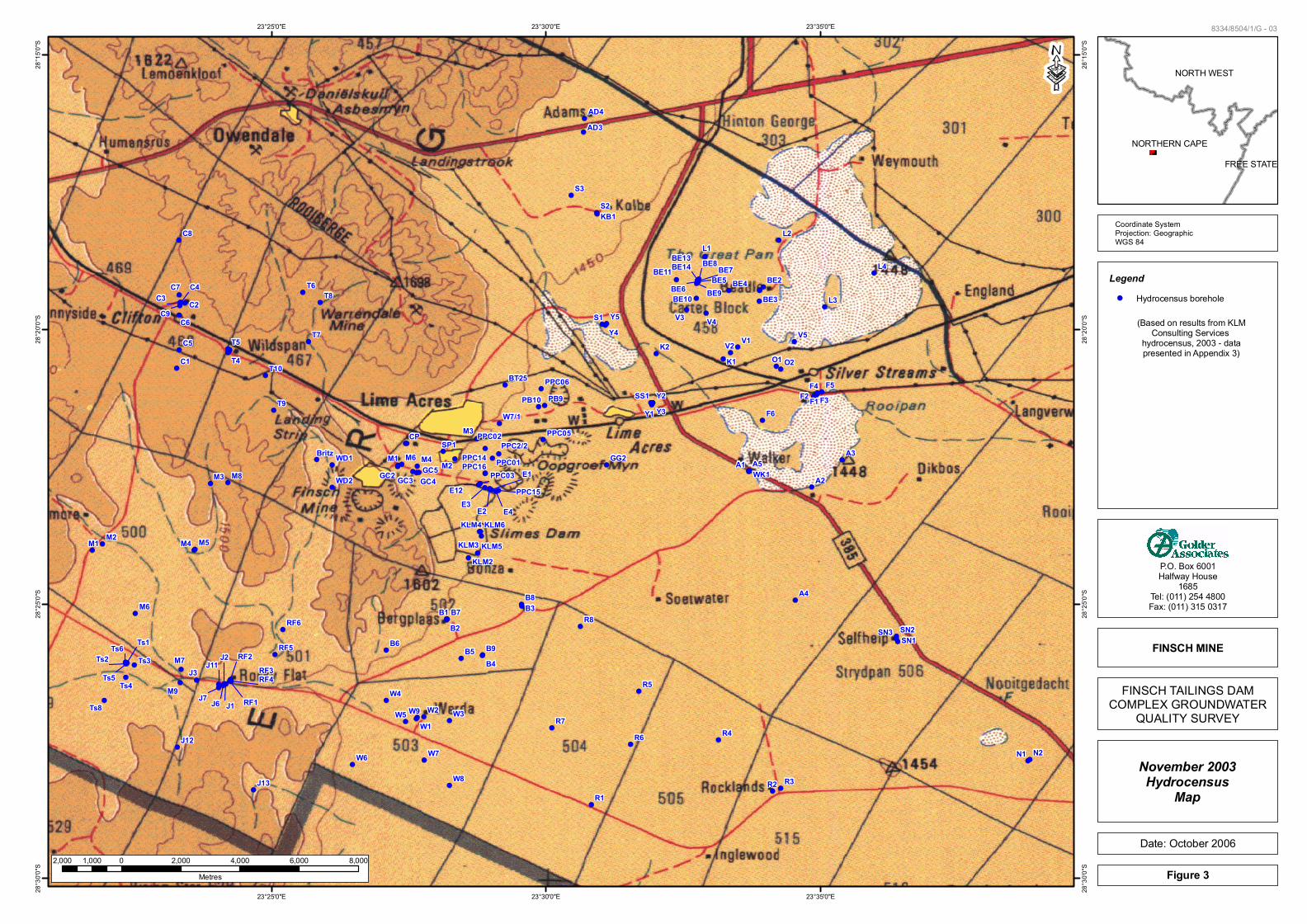
Figure 3: Map of boreholes noted during the 2003 hydrocensus conducted by KLM Consulting Services ................................................................................................................................................... 7
Figure 4: Inferred groundwater flow directions in the Finsch Mine vicinity.......................................... 8
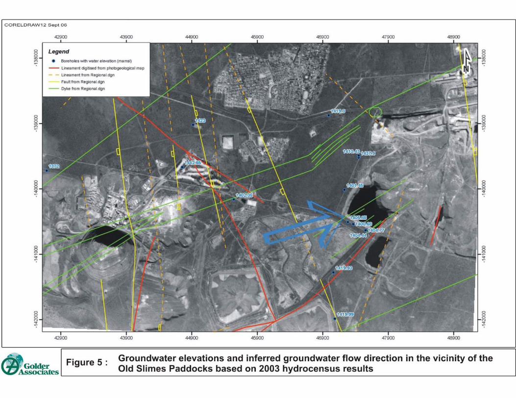
Figure 5: Groundwater elevations and inferred groundwater flow direction in the vicinity of the Old Slimes Paddocks based on 2003 hydrocensus results ............................................................................. 9
Figure 6: Geological structures crossing the area west of Finsch Mine................................................ 11
Figure 7: Gravity survey results from the Old Slimes Paddocks indicating gravity lows (blue) which are inferred to be solution cavities developed in the dolomite underlying the slimes material ............ 12
Figure 8: Map showing boreholes, surface water sampling locations and locations of interest noted during the hydrocensus ......................................................................................................................... 15
Figure 9: View looking northwest of pools developed behind the first paddock wall. The pools are formed by overflow from the Slimes Dam 1 sump............................................................................... 16
Figure 10: Sinkhole developed in a borrow excavation in the first paddock wall on the Old Slimes Paddock................................................................................................................................................. 16
Figure 11: View of the southern wall of PPC Quarry No 4 showing development of vegetation along a preferential flow horizon within the dolomite. Note the Finsch Mine Slimes Dams in the background.............................................................................................................................................................. 18
Figure 12: Groundwater elevations measured during the current hydrocensus .................................... 20
Figure 13: Water level elevations measured during this hydrocensus. Outlines group similar water level elevations which may indicate compartments in the dolomite aquifer ........................................ 21
Figure 14: Piper plot of selected water samples from the Finsch Mine Slimes Dam complex............. 26
Figure 15: Proposed general locations of additional monitoring boreholes. Final locations would be decided based on the results of geophysical data.................................................................................. 30

October 2006 vii 8334/8504/1/G
GOLDER ASSOCIATES
LIST OF TABLES
Table 1: Hydrocensus results recorded at boreholes and quarries around the site................................ 14
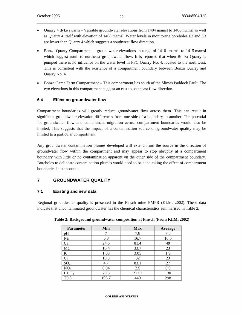
Table 2: Background groundwater composition at Finsch (From KLM, 2002) ................................... 22
Table 3: Analytical results of samples collected. Results exceeding the relevant SANS241 guideline are highlighted ...................................................................................................................................... 23
Table 4 Recommended actions to upgrade monitoring boreholes in the study area............................ 29
LIST OF APPENDICES
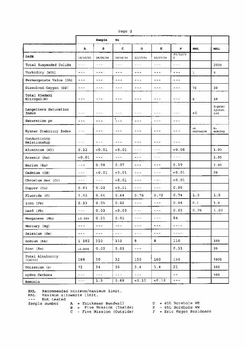
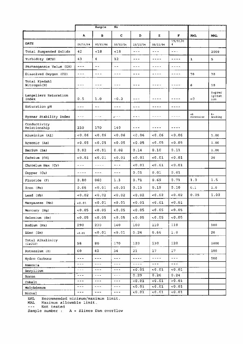
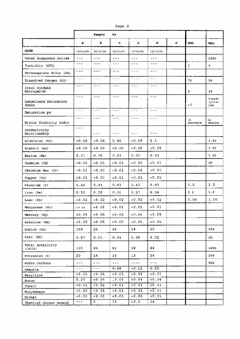
Appendix A Logs of boreholes KLM2 to KLM6 Appendix B Laboratory analyses of potential contamination sources Appendix C KLM Hydrocensus results from 2003 Appendix D Laboratory reports of current hydrocensus samples

October 2006 8334/8504/1/G
GOLDER ASSOCIATES
1
1 INTRODUCTION
At the request of Ms Sara Sparks, Environmental Manager of Finsch Mine, Golder Associates Africa (Pty) Ltd (Golder) conducted an investigation of the current status of the groundwater system in the area of, and to the north and northeast of, the Finsch Slimes Dam complex. This report documents the work conducted and the results obtained.
The outcome of this study is an assessment of the current groundwater situation, and recommendations for expanding and augmenting the existing monitoring boreholes within the study area.
2 OBJECTIVES
The specific objectives of the investigation are to:
• Characterise the prevailing groundwater regime;
• Determine the current quality of the groundwater;
• Delineate any groundwater pollution plume(s);
• Assess whether mitigation and/or remediation is required.
3 SCOPE OF WORK
The groundwater contamination assessment described in this report involved the following scope of work:
Review of available data, including earlier work undertaken by Golder Associates, previous reports dealing with the area, including logs of boreholes drilled by KLM Consulting, groundwater level and quality monitoring data for the area, and study of air photos.
• Field confirmation of current water levels and groundwater quality through the collection of samples for analysis of major cations and anions, pH, EC and conductivity;
• Preparation of a baseline water quality assessment and preliminary appraisal of contamination, including piezometric, (water level and flow direction) and water quality maps;
• Gap analysis;
• Preparation of this report and recommendations for further studies as required.
4 DESCRIPTION OF SITE
The study area, here termed the “Slimes Dams complex” is located east and northeast of the Finsch open pit (Figure 1). The area includes Slimes Dams 1, 2 and 3, the recently-completed Infill Dam and the footprint of the Old Slimes Paddocks.

October 2006 8334/8504/1/G
GOLDER ASSOCIATES
3
4.1 Topography
Finsch Mine is situated on a ridge which trends north-northwest, south-southeast. Slimes Dams 1 and 2 abut this ridge on the eastern side. From the ridge, the land is generally flat and falls with a gentle slope to the northeast.
4.2 Infrastructure
The study area includes the following mine infrastructure.
• Tailings storage facility;
• Quarries;
• Dams that form part of the Finsch mine water circuit.
4.2.1 Tailings storage facility
Active tailings storage is conducted on Slimes Dams 1, 2 and 3 and the newly-constructed Infill Dam which is located between Slimes Dam 1 and Slimes Dam 2. Each dam has a sump which captures water recovered from the tailings.
The Old Slimes Paddock consists of a series of retaining walls in a roughly triangular-shaped area northeast of Slimes Dam 1. Tailings were deposited behind (southwest of) these retaining walls to a depth of several metres.
4.2.2 Quarries
Bonza Quarry lies to the east of the Old Slimes Paddocks while PPC Quarry No. 4 lies to the northeast adjacent to the Finsch/PPC boundary (Figure 1). Lime Acre’s water supply is obtained from PPC Quarry No. 5 which lies to the north of Quarry 4. Both Quarry 4 and Quarry 5 are disused pits from which PPC formerly extracted limestone. They are now partially filled with water.
4.2.3 Finsch Mine water circuit
The mine water circuit associated with the Slimes Dams has a number of features which are relevant to groundwater contamination in the study area. A flow chart of the relationship between these features is presented in Figure 2.
Bonza Quarry receives overflow water from the Slimes Dams, Earth Dam and stormwater runoff from the slimes dams and Old Slimes Paddocks. Bonza Quarry has been partially backfilled and the area to the south and east of the existing quarry consists of backfill material.


October 2006 8334/8504/1/G
GOLDER ASSOCIATES
5
The Earth Dam is located immediately south of the Five Missions residential area. It is a concrete-lined storage dam for process water from the mine and also contains final effluent from the sewage plant.
Five Missions Dam immediately north of the Five Missions residential area contains the final treated effluent from the mine sewage plant. It is concrete-lined. Overflow water reports to the Overspill Dam which lies between the Five Missions village and the Norfin village.
4.3 Geology
Based on the EMPR (KLM, 2002) the country rocks from surface to depth at Finsch mine are:
• The Banded Ironstones of the Kuruman member of the Asbestos Hill Formation. They are banded siliceous ironstones, 45 m thick. Significant jointing and bedding planes are visible.
• The Passage Beds, a transitional sedimentary sequence made up of interbedded shales, mudstones, chert, magnetic bands and shaley dolomite. This unit is 11 m thick.
• The carbonates of the Lime Acres member of the Ghaap plateau Formation. The sequence consists of alternating layers of dolomite and interbedded limestones and thin horizons of carbonaceous shales, algae and stromatolites.
The sequence dips relatively gently to the west. Finsch mine is located on the contact between the Banded Ironstones to the west and and the Lime Acres dolomites to the east.
The area to the north and northeast of the Finsch Mine Slimes Dams is underlain by west-dipping dolomites. The dolomites have been affected by karst weathering and geological structures (dykes and faults).
5 DATA SOURCES
Previous sources of information included:
• Logs of monitoring boreholes KLM2 to KLM 6 (Appendix A);
• Previous Golder reports discussing the hydrogeology and potential contamination sources in the area;
• Laboratory analysis of potential contamination sources provided by Finsch (Appendix B);
• KLM Hydrocensus results from 2002 (Appendix C).
5.1 Discussion of hydrogeology
Based on the EMPR (KLM, 2002) the groundwater system is characterised by two aquifers:

October 2006 8334/8504/1/G
GOLDER ASSOCIATES
6
• A shallow aquifer developed in weathered dolomite which extends from the ground surface to a depth determined by the extent of dolomite weathering but is generally less than 40 m;
• A deeper aquifer along fault zones, joints, fractures, dyke margins and karst solution features developed in relatively unweathered dolomite.
Key features of the regional hydrogeology, as described in the Finsch Mine EMPR (KLM, 2002) include:
• Karst dolomite underlies the Golf Course, PPC Quarry and Bonza Game Farm areas;
• The dolomite aquifer is divided into compartments by the Danielskuil and Groot Pan dykes;
• Faults in the area can act as barriers or conduits to groundwater flow;
• The groundwater level is between 6 m and 39 m below surface;
• Regional groundwater flow is from west to east;
• Hydraulic conductivities in the dolomite vary from 0.0002 m/day to 2 m/day.
5.1.1 Water levels
Water levels were measured in 170 boreholes in the area of Finsch Mine in November 2003 (Figure 3). In general, borehole collar elevations were estimated from contours on published 1:50 000 scale topographic maps which are indicated at 20 m intervals. This suggests that groundwater level data from the survey is generally accurate to within 5 m to 10 m.
Based on the hydrocensus data groundwater flows from the higher-lying banded ironstone towards the lower lying dolomite i.e. from west-northwest to east-southeast (Golder, 2005). Fairly large differences in groundwater level elevations occur over fairly short distances and the boreholes may be grouped together on the basis of their water level elevation. Figure 4 shows the water level elevations assumed to be representative for the different areas and the groundwater flow directions inferred from the data.
From Figure 4, groundwater flow north of Finsch Mine is generally from west to east towards the slimes dam complex. East of the slimes dam complex, groundwater flow is from north to south.
The PPC quarries and the slimes paddock area were considered to have generally similar water level elevations while the golf course area had higher elevations, suggesting a different groundwater compartment (Golder, 2005).
In the vicinity of the Slimes Dam Complex, the hydrocensus data of November 2003 show that the piezometric groundwater levels were flat, varying from 1402 mamsl on the western side of the Old Slimes Paddocks to 1400 mamsl on the northeastern side. Water levels to the south of the paddocks were higher at 1419 mamsl. The hydraulic gradient inferred from these data is from southwest to northeast (Figure 5).
NORTHERN CAPE
NORTH WEST
FREE STATE
8334/8504/1/G - 03
Coordinate SystemProjection: GeographicWGS 84
P.O. Box 6001Halfway House
1685Tel: (011) 254 4800Fax: (011) 315 0317
Figure 3
Date: October 2006
FINSCH TAILINGS DAMCOMPLEX GROUNDWATER
QUALITY SURVEY
November 2003Hydrocensus
Map
FINSCH MINE
!(!(!(!(!(
!(
!(
!(
!(
!(!(
!(!(!(
!(
!(
!(
!(
!(
!(!(
!(
!(!(
!(
!(
!(
!( !(!(!(
!(!(!(
!(
!(
!( !(!(
!(
!(
!(!(
!(
!(
!(
!(!(
!(
!(
!(
!(
!(
!(!(
!(
!(!(
!(
!(
!(
!(
!(
!(
!(
!(
!(
!(!(!(!(!(
!(
!(!(
!(!(
!(!(
!(!(
!(
!(!(!(
!(!(!(
!(
!(
!(
!(
!(
!(
!(
!(
!(
!(
!(
!(
!(
!(
!(
!(
!(
!(!(
!(
!(
!(
!(
!(
!(
!(!(
!(
!(!(
!(
!(!(!( !(!(
!(
!(!(
!(
!(
!(!(!(!(!(
!(
!(
!(
!(
!(
!(!( !(
!(
!(!(
!(
!(!(!(!(
!(
!(
!(!(
!(!(!(
!(!(
!(
!(
!(!(!(!(!(
!(
!( !(!(
BE6BE5
BE7BE13BE14 BE8
F1
C3C4
Ts1
Ts5
Ts2 Ts3
J6
J11
J1 RF1
RF2
PPC02
PPC03 E1PPC15
N2N1
E4E3 E2
CP
M6 M4
M3
M2M1
L4
L3
L2L1
S3S2
S1 Y5Y4
Y3Y2
Y1
V5V4V3
V2 V1K2K1 O2O1
F6
F5F4F3F2
A5
A4
A3
A2A1
B9
B8B7
B6B5
B4
B3
B2B1 R8
R7R6
R5
R4
R3R2R1
W9
W8
W7W6
W5
W4
W3W2W1
J7
J3J2
M9
M8
M7
M6
M5M4
M3
M2M1
C9
C8
C7
C6
C5
C2
C1
T9
T8
T7
T6
T5
T4
BE9BE4
BE3
BE2
SN3 SN2SN1
RF6
RF5
RF3RF4
Ts8
Ts6
Ts4
WD2
WD1SP1
GC5GC4GC3GC2
E12
AD4AD3
KB1
SS1
WK1
PB9
GG2
J13
J12
T10
BE11
BE10
KLM6
KLM5
KLM4
KLM3KLM2
BT25
PB10W7/1
Britz PPC14PPC16
PPC06
PPC05PPC2/2
PPC01
23°25'0"E
23°25'0"E
23°30'0"E
23°30'0"E
23°35'0"E
23°35'0"E28
°30'0
"S
28°3
0'0"S
28°2
5'0"S
28°2
5'0"S
28°2
0'0"S
28°2
0'0"S
28°1
5'0"S
28°1
5'0"S
·
Legend!( Hydrocensus borehole
2,000 0 2,000 4,000 6,000 8,0001,000Metres
(Based on results from KLMConsulting Services
hydrocensus, 2003 - datapresented in Appendix 3)

October 2006 8334/8504/1/G
GOLDER ASSOCIATES
10
5.1.2 Geological structure
According to the existing information the area is traversed by several structural features (Figure 6).
• A SW – NE trending sub-vertical dyke swarm (here termed the “Golf Course dyke swarm” which crosses the Lime Acres golf course and trends directly into PPC Quarry No. 5. This dyke swarm is thought to be some 300 m wide and comprises numerous fractures infilled with kimberlite and dolerite dykes.
• A SW – NE trending sub-vertical dyke swarm (here termed the “Quarry No. 4 dyke swarm” which extends from the Old Slimes Paddocks into PPC Quarry No. 4.
• A SSE – NNW trending fracture/fault/shear zone (“Slimes Paddock Fault”) with downthrow on the western side. This trend follows the regional SSE – NNW trend in the general area. This feature cuts across the centre of the Old Slimes Paddocks.
5.1.3 Geophysical data
A gravity survey conducted by Golder over the Old Slimes Paddocks in 2003 indicated the presence of gravity lows which are interpreted as cavities and solution features in the karst dolomite underlying the slimes material (Figure 7). These features appear to be related to the presence of the Quarry 4 dyke swarm and Slimes Paddock Fault and have not yet been drilled to confirm the status of the dolomite and karst aquifer in this vicinity.
5.1.4 Aquifer Anisotropy
Documented and anecdotal evidence suggests that flow along permeable features can be rapid and extend for long distances.
• When PPC developed Quarry No. 5 the boreholes on the golf course to the SW dried up.
A Finsch Mine internal memo from the mine geotechnical engineer (May, 2003) indicates that, in late 1999 PPC extended Quarry 5 to the west and intersected a water-bearing fissure. Groundwater levels in boreholes on the Golf Course and Bonza Game Farm fell to such an extent that the holes were unusable. Over the following 6 months the water level on Bonza recovered but chemical analysis of the water indicated that it was not fit for drinking purposes due to high levels of TDS. By late 2001 water conditions had stabilised and the water was again fit for drinking.
• When PPC Quarry No. 4 was first developed, water flowed out of the SW face.
Chris Preece of the Finsch Mine Geotechnical Section indicates that a water-bearing fissure was intersected on the south side of Quarry 4 which was inferred to extend beneath the slimes paddocks. The water flow from this fissure reportedly dried up when monitoring borehole E2 was drilled.
• When the Bonza Quarry was being mined, seepage was observed on the northern (PPC) side of the pit.


October 2006 8334/8504/1/G
GOLDER ASSOCIATES
13
The dominance of the southwest – northeast trending structural pattern, combined with the anecdotal evidence, indicates there is a strong anisotropy in the dolomite with preferential groundwater flow in the southwest – northeast direction.
The implication is that seepage from the Slimes Dam Complex will tend to move to the northeast.
5.2 Existing monitoring programme
Finsch does not currently have a systematic groundwater monitoring programme. Boreholes KLM2 to KLM6 are designated monitoring boreholes and several other boreholes have been drilled in the vicinity of the Old Slimes Paddocks which could be used for monitoring.
Monitoring of groundwater levels has been conducted once to twice yearly in selected boreholes at Finsch and on farms in the area with the last measurement in November 2003. PPC monitor the groundwater levels in selected boreholes on the PPC property on a monthly basis and this data is forwarded to Finsch Mine Geotechnical Department.
No groundwater quality monitoring data is available except for results recorded in the EMPR (KLM, 2002).
5.3 Field Programme
The field programme was conducted from 11 to 14 July 2006. A hydrocensus was conducted, including measurement of water levels and groundwater sampling. In addition, information of relevance to the groundwater assessment was obtained from PPC and a site walkover of the Old Slimes Padddocks was conducted.
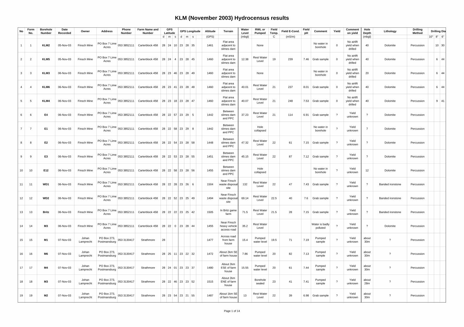
5.3.1 Hydrocensus
Based on the results of the KLM (2002) hydrocensus, a target list of 30 potential boreholes was drawn up located in the vicinity of the slimes dams, slimes paddocks and the PPC No 4 Quarry. Some boreholes were not accessible, were locked or destroyed. A total of 23 boreholes were visited during the hydrocensus. Surface water was sampled from PPC Quarry 4 and Quarry 5.
The elevation and co-ordinates at each site were recorded using a GPS receiver. Groundwater levels and the depth of the boreholes were measured using a 100 m dip meter. The water level measurements recorded are presented in Table 1 and the various monitoring locations are shown in Figure 8.
The condition and status of each borehole was noted to assist in the identification of boreholes suitable for ongoing monitoring.
Groundwater sampling
Water samples were collected at 7 sites. Of these 7 sites, 2 were surface water samples from PPC quarries 4 and 5, and 5 were boreholes. Other boreholes could not be purged or sampled as they were dry or damaged.
October 2006 8334/8504/1/G
GOLDER ASSOCIATES
14
Table 1: Hydrocensus results recorded at boreholes and quarries around the site Borehole Latitude Longitude Ground
elevation (mamsl)
Groundwater level
(mbg)
Borehole depth
(mbTOC)
Groundwater elevation (mamsl)
Borehole Status
KLM2 28.40273 23.47645 1461 DRY 40.58 Good. Equipped for monitoring. KLM3 28.39614 23.48038 1452 DRY 20.55 Good. Equipped for monitoring. KLM4 28.38827 23.47986 1446 DRY 37.4 Good. Equipped for monitoring. KLM5 28.40121 23.47926 1457 11.81 27.19 1445.19 Good. Equipped for monitoring. KLM6 28.39466 23.4801 1451 35.48 40 1415.52 Good. Equipped for monitoring. E1 28.38199 23.48341 1451 DRY 31.42 Capped but not locked. No marker pole E2 28.38172 23.48282 1448 43.72 >100 1404.28 Capped but not locked. No marker pole. Casing flush with ground level E3 28.38134 23.48201 1453 46.16 >100 1406.84 Capped but not locked. No marker pole E5 28.37823 23.4643 1460 52.73 -55.5 1407.27 No cap. No marker pole E4 28.38255 23.48481 1552 42.13 >100 1409.87 Casing bent and flush with ground level. E12 28.38029 23.4795 1448 DRY 11.3 No cap. No marker pole Bonza 01 28.3947 23.48229 1452 37.02 >100 1414.78 No cap. No marker pole Bonza 02 28.40425 23.48486 1450 PUMP >100 Bonza Game Farm water supply borehole. Pump installed - 100m Bonza 03 28.40543 23.4852 1450 27.63 1422.37 No cap. No marker pole. Abandoned borehole. Casing flush with concrete block PPC01 28.37235 23.4363 1452 21.95 62.5 1430.05 Capped but not locked. No marker pole PPC03 28.38007 23.47991 1453 13.36 54.89 1439.64 Capped but not locked. No marker pole PPC15 28.38258 23.48508 1452 39.15 44.59 1412.58 Capped but not locked. No marker pole PPC16 28.37694 23.48139 1452 23.32 >70 1428.68 Capped but not locked. No marker pole GC1 28.375 23.455 1472 PUMP Pump installed - no access GC2 28.37472 23.455 1473 PUMP Pump installed - no access GC-A 28.3768 23.46103 1468 54.07 60 1413.93 No cap. No marker pole GC-B 28.37436 23.45574 1470 20.75 23.65 1449.25 No cap. No marker pole. Casing bent PAR3 28.37389 23.45611 1410 20.85 1449.15 No cap. No marker pole. Casing bent GG2 28.37439 23.4563 1447 25.35 33.12 1444.65 M3 28.36667 23.47889 1458 LOCKED Capped. No marker pole M4 M6 28.37392 23.4563 1470 26.08 27.87 1443.92 No cap. No marker pole M8 28.36806 23.45778 1465 unknown M9 28.37333 23.47167 1448 DRY 10 Filled with stones Quarry 4 28.37721 23.48643 1408 0 SURFACE 1408 Quarry 5 28.36872 23.49098 1405 0 SURFACE 1405

NORTHERN CAPE
NORTH WEST
8334/8504/1/G-08
Figure 8
August 2006 Hydrocensus
Map
P.O. Box 6001Halfway House
1685Tel: (011) 254 4800Fax: (011) 315 0317
FINSCH TAILINGS DAM COMPLEX GROUNDWATER
QUALITY SURVEY
Date: October 2006
FINSCH MINE
!
!
!
!
!
!!
!
!
!!
!
!!
!
!
!
!
!
!
!
!
!!
!
!
!
! ")
")
!
#*
M4 M9
M8
M6
M3
E5
E4
E3
E2GG2
GC1
E12
PPC1
KLM6
KLM5
KLM4
KLM3
KLM2
GC-A
PPC16
PPC15
PPC03
Quarry 5
Quarry 4
Bonza 03Bonza 02
Pool and Sinkhole
E1
GC2
PAR3
GC-B
Bonza 01
23°26'0"E
23°26'0"E
23°27'0"E
23°27'0"E
23°28'0"E
23°28'0"E
23°29'0"E
23°29'0"E
28°2
4'0"S
28°2
4'0"S
28°2
3'0"S
28°2
3'0"S
28°2
2'0"S
28°2
2'0"S
Coordinate SystemProjection GeographicWGS 84
·
500 0 500 1,000 1,500 2,000250Metres
Legend! Borehole
#* Pool and Sinkhole
")Surface watersampling location

October 2006 8334/8504/1/G
GOLDER ASSOCIATES
16
Each sampled borehole was first purged to allow fresh water from the aquifer to fill the borehole. Purging and sampling was conducted using a submersible electric pump powered by aportable generator.
Two samples were collected from each borehole. One sample was passed through a 0.45 µm filter, to remove reactive colloidal material and preserved using Nitric Acid (HNO3) for cation and metal analysis. A second unfiltered sample was collected for major anion, pH, alkalinity and conductivity analysis. Samples were sent to the SANAS-accredited UIS Analytical Laboratories, in Centurion for analysis.
5.3.2 Walkover of Slimes Paddocks
The Slimes Dam 1 return water sump has been overflowing for an extended period, possibly years. This has resulted in a body of water extending northeast from the return water sump and pools of water along the westernmost paddock wall (Figure 9).
Part of the paddock wall has been removed as borrow material for the construction of the Infill Dam wall. Sinkholes were observed at the base of the excavation (Figure 10) and precipitated salts were observed in the residual paddock wall material. The location of the pools and sinkhole are indicated on Figure 8.
Figure 9: View looking northwest of pools developed behind the first paddock wall. The pools are formed by overflow from the Slimes Dam 1 sump
Figure 10: Sinkhole developed in a borrow excavation in the first paddock wall on the Old Slimes Paddock

October 2006 8334/8504/1/G
GOLDER ASSOCIATES
17
5.3.3 Information from PPC
PPC conducts monthly monitoring of groundwater levels in selected boreholes and kindly provided Golder with their monitoring results. PPC also provided water quality analyses from selected quarry pits. We understand that analysis of groundwater samples from the monitoring boreholes is not conducted.
The PPC geologist Banie Lubbe indicated the existence of preferential flow horizons within the dolomite sequence. One such horizon was identified in the south and east walls of Quarry 4 (Figure 11).
5.4 Discussion
Regional groundwater levels from the 2003 hydrocensus indicate flow from west to east in the area north of the mine turning to southward in the area east of the slimes dams.
Geophysical results and anecdotal evidence suggest that there are numerous structural features which may influence groundwater flow and pronounced northeast-southwest anisotropy has been identified. The available groundwater level monitoring data is not sufficient to establish whether these structures modify the southwest to northeast groundwater flow.
A hydrocensus was conducted to obtain current groundwater level and quality information, focussing on the area of the Slimes Dam Complex. Groundwater elevation data from the hydrocensus are consistent with existing data in that the highest groundwater elevations are found in the west, near the golf course. The lowest groundwater elevation in the current hydrocensus was measured at borehole E2 which is located between Quarry 4 and the Old Slimes Paddocks. Groundwater elevation increases east of E2 in the vicinity of Bonza Quarry and increases further to the south at the Bonza Game Farm and borehole KLM5.
The hydrocensus results also indicate that water levels previously recorded in borehole KLM4 may not accurately reflect groundwater levels at this location. The borehole depth measured in the current hydrocensus is about 37 m. The 2003 hydrocensus data indicate a water level of 40.7 m below ground level and the drilled depth of the borehole as 40 m. This suggests that the water measurements relate to moisture collected in the bottom of KLM4 rather than groundwater.
6 HYDROGEOLOGY
Based on the existing information and the data collected during the hydrocensus, the situation as regards hydrogeology is summarised in the following discussion.
6.1 Aquifer
The dolomite aquifer consists of:
• A series of solution cavities within solid dolomite. The solution cavities could be developed on structural features and may or may not be interconnected.

October 2006 8334/8504/1/G
GOLDER ASSOCIATES
19
A cavity was intersected during drilling of KLM2. The observation of sinkholes in the excavation of the paddock walls confirms the indication from the geophysical data that solution features exist beneath the Old Slimes Paddocks.
• Permeable horizons within the dolomite including the near-surface weathered zone.
The aquifer is heterogeneous and anisotropic, i.e. hydraulic properties vary over short distances in all directions.
6.2 Piezometric conditions
Groundwater elevations measured during the hydrocensus are indicated on the map in Figure 12.
Groundwater elevations range from 1404 mamsl to 1449 mamsl (Table 1). Higher elevations were found at the Lime Acres Golf Course and southeast of the Old Slimes Paddocks with the lowest at borehole E2 between the Old Slimes Paddocks and Quarry 4.
This is consistent with the 2003 hydrocensus and indicates a general eastward groundwater flow direction from the golf course towards Quarry 4.
6.3 Compartmentalisation and structure
Closer examination of the hydrocensus data suggest groupings of boreholes based on similar groundwater elevations. These groupings may represent compartments within the dolomite aquifer that are separated by differences in transmissivity or by geological structures such as dykes and faults.
Figure 13 shows groupings of similar measured groundwater level elevations with known geological structures superimposed. There appears to be a good agreement between areas with similar water level elevations and areas bounded by geological structures especially in the vicinity of the slimes paddocks and PPC Quarry 4 where the density of boreholes is greater. This suggests that the dolomite aquifer is compartmentalised at a relatively small scale. The following potential compartments have been identifed on Figure 13.
• Golf Course compartment – groundwater elevation ranges from 1449 mamsl to 1444 mamsl. Flow in this compartment is generally towards the east. The compartment is bounded to the west by the Golf Course dyke swarm.
• Golf Course dyke swarm – A single borehole in this compartment indicates a groundwater elevation of 1414 mamsl.
• Five Missions Compartment – One borehole in this compartment which indicates a level of 1407 mamsl. The compartment is bounded to the east by the Slimes Paddock Fault.
• PPC compartment – The three measured elevations in this compartment suggest groundwater flow towards the northeast. The compartment is bounded on the east by the Quarry 4 dyke swarm.
NORTHERN CAPE
NORTH WEST
8334/8504/1/G-12
Figure 12
Ground Water ElevationsMeasured During The
2006 Hydrocensus
P.O. Box 6001Halfway House
1685Tel: (011) 254 4800Fax: (011) 315 0317
Date: October 2006
FINSCH MINE!(
!(
!(
!(
!(
!(!(
!(
!(
!(!(
!(
!(!(
!(
!(
!(
!(
!(
!(
!(
!(
!(!(
!(
!(
!(
!( !(
!(
!(
!(
!(
!(
!(
!(
!(
!(!(
!(
!(
!(!(
!(
!(!(
!(
!(
!(
!(
!(
!(
!(
!(
!(!(
!(
!(
!(
!( ")
")
!(
#*
E21404.28
GC-B1449.25
PAR31449.15
Pools & Sinkholes
M4M9
M8 M3
E1
GC2
GC1
E12
KLM4
KLM3
KLM2
M61443.92
E51407.27
E41409.87
GG21445.65
KLM61415.52
KLM51445.19
GC-A1413.93
PPC151412.58
PPC031439.64
Bonza 031422.37
E31406.84
Bonza 02
Quarry 51405
Quarry 41408
PPC161428.68
Bonza 011414.78
PPC011430.05
23°27'0"E
23°27'0"E
23°28'0"E
23°28'0"E
23°29'0"E
23°29'0"E
28°2
4'0"S
28°2
4'0"S
28°2
3'0"S
28°2
3'0"S
28°2
2'0"S
28°2
2'0"S
Coordinate SystemProjection GeographicWGS 84
·
500 0 500 1,000 1,500 2,000250Metres
FINSCH TAILINGS DAM COMPLEX GROUNDWATER
QUALITY SURVEY
Legend
#* Pool and sinkhole")
Surface watersampling location
!(Sampled borehole withwater level elevation (mamsl)
!(Borehole with waterlevel elevation (mamsl)

NORTHERN CAPE
NORTH WEST
8334/8504/1/G-13
Figure 13
Groundwater Compartments
P.O. Box 6001Halfway House
1685Tel: (011) 254 4800Fax: (011) 315 0317
Date: October 2006
FINSCH MINE!(
!(
!(
!(
!(
!(!(
!(
!(
!(!(
!(
!(!(
!(
!(
!(
!(
!(
!(
!(
!(
!(!(
!(
!(
!(
!( ")
")
!(
#*
"
"
"
"
"
E21404.28
GC-B1449.25
PAR31449.15
Pool and Sinkhole
M4
Five Missions Compartment
Quarry 4Dyke Swarm
Bonza QuarryCompartment
Golf CourseCompartment
Golf CourseDyke Swarm
Slimes PaddockFault
Bonza Game FarmCompartment
PPC Compartment
GG21444.65
M9
M8 M3
E1
GC2
GC1
E12
KLM4
KLM3
KLM2
M61443.92
E51407.27
E41409.87
KLM61415.52
KLM51445.19
GC-A1413.93
PPC151412.58
PPC031439.64
Bonza 031422.37
E31406.84
Bonza 02
Quarry 51405
Quarry 41408
PPC161428.68
Bonza 011414.78
PPC011430.05
23°27'0"E
23°27'0"E
23°28'0"E
23°28'0"E
23°29'0"E
23°29'0"E
28°2
4'0"S
28°2
4'0"S
28°2
3'0"S
28°2
3'0"S
28°2
2'0"S
28°2
2'0"S
Coordinate SystemProjection GeographicWGS 84
·
500 0 500 1,000 1,500 2,000250Metres
FINSCH TAILINGS DAM COMPLEX GROUNDWATER
QUALITY SURVEY
Legend
#* Pool and sinkholeRegional faultRegional dykeGroupings of similarwater level elevations
!(Sampled borehole withwater level elevation (mamsl)
!(Borehole with waterlevel elevation (mamsl)
")Surface watersampling location
"Inferred groundwaterflow direction
October 2006 8334/8504/1/G
GOLDER ASSOCIATES
22
• Quarry 4 dyke swarm – Variable groundwater elevations from 1404 mamsl to 1406 mamsl as well as Quarry 4 itself with elevation of 1408 mamsl. Water levels in monitoring boreholes E2 and E3 are lower than Quarry 4 which suggests a southwest flow direction.
• Bonza Quarry Compartment – groundwater elevations in range of 1410 mamsl to 1415 mamsl which suggest north to northeast groundwater flow. It is reported that when Bonza Quarry is pumped there is no influence on the water level in PPC Quarry No. 4, located to the northwest. This is consistent with the existence of a compartment boundary between Bonza Quarry and Quarry No. 4.
• Bonza Game Farm Compartment – This compartment lies south of the Slimes Paddock Fault. The two elevations in this compartment suggest an east to southeast flow direction.
6.4 Effect on groundwater flow
Compartment boundaries will greatly reduce groundwater flow across them. This can result in significant groundwater elevation differences from one side of a boundary to another. The potential for groundwater flow and contaminant migration across compartment boundaries would also be limited. This suggests that the impact of a contamination source on groundwater quality may be limited to a particular compartment.
Any groundwater contamination plumes developed will extend from the source in the direction of groundwater flow within the compartment and may appear to stop abruptly at a compartment boundary with little or no contamination apparent on the other side of the compartment boundary. Boreholes to delineate contamination plumes would need to be sited taking the effect of compartment boundaries into account.
7 GROUNDWATER QUALITY
7.1 Existing and new data
Regional groundwater quality is presented in the Finsch mine EMPR (KLM, 2002). These data indicate that uncontaminated groundwater has the chemical characteristics summarised in Table 2.
Table 2: Background groundwater composition at Finsch (From KLM, 2002)
Parameter Min Max Average pH 7 7.8 7.3 Na 6.8 16.7 10.0 Ca 24.6 81.4 49 Mg 16.4 33.7 23 K 1.03 3.85 1.9 Cl 10.3 32 23 SO4 4.7 83.1 27 NO3 0.04 2.5 0.9 HCO3 79.3 211.2 130 TDS 193.7 440 298

October 2006 8334/8504/1/G
GOLDER ASSOCIATES
23
Field measurements of conductivity and pH collected during the November 2003 hydrocensus are available for certain of the boreholes. These show that the conductivity of the groundwater in the vicinity of the Old Slimes Paddocks vary from 61 mS/m to 248 mS/m. More specifically the conductivity of the groundwater within the Quarry 4 dyke swarm in boreholes E2, E3 and E4 is 61 mS/m, 87 mS/m and 114 mS/m respectively, whereas in the Bonza Compartment the conductivity is 237 mS/m in borehole KLM6 and 248 mS/m in KLM4. The conductivity of background groundwater is about 50 mS/m based on the TDS reported in the EMPR (KLM, 2002).
The DWAF water quality guidelines classify water with a conductivity of <70 mS/m as ideal quality, water with conductivity between 70 mS/m and 150 mS/m as good quality, and water with conductivity between 150 mS/m and 370 mS/m as marginal quality.
The laboratory results of samples collected during the current hydrocensus are tabulated and compared to drinking water guidelines in Table 3. Copies of laboratory reports are presented in Appendix D.
Table 3: Analytical results of samples collected. Results exceeding the relevant SANS241 guideline are highlighted
Analyte Unit E2 E3 PPC16 Bonza 01
Bonza 02
Quarry 4
Quarry 5
Class I recommended
limit (SANS 241)
pH 7.5 7.6 7.7 7.5 7.6 8.1 8.1 5 to 9.5 Conductivity mS/m 81.5 83.8 133.3 131.7 97.9 129 102.1 <150 TDS mg/l <1000 Calcium mg/l 93.5 97.2 131 89.3 127 111 113 <150 Magnesium mg/l 42.7 40.7 60.8 71.3 30.4 55.1 34.5 <70 Sodium mg/l 13.9 21.6 58 46.7 31.8 69.5 45.4 <200 Potassium mg/l 2.8 2.9 7.7 6.8 2.4 9.5 4.1 <50 Fluoride mg/l 0.5 0.5 0.3 0.1 0.3 0.3 0.1 <1.0 Chloride mg/l 71 59 121.6 89 88 140.1 101.7 <200 Nitrate mg/l 3.9 4.5 25.2 3.6 32.8 64.8 36 - NO3 as N mg/l 0.9 1 5.7 0.8 7.4 14.6 8.1 <10 Sulphate mg/l 51.5 71.8 421.7 4.8 112 357.4 216.3 <400 Phosphate mg/l <0.8 1.1 <0.8 4.6 <0.8 <0.8 <0.8 - Iron mg/l <0.25 <0.25 <0.25 <0.25 <0.25 <0.25 <0.25 <0.2 Chromium mg/l <0.05 <0.05 <0.05 <0.05 <0.05 <0.05 <0.05 <0.1 Manganese mg/l <0.05 <0.05 <0.05 <0.05 <0.05 <0.05 <0.05 <0.1 Copper mg/l <0.05 <0.05 0.1 0.1 <0.05 0.1 <0.05 <1.0 Nickel mg/l <0.05 <0.05 <0.05 <0.05 <0.05 <0.05 <0.05 <0.15 Zinc mg/l 0.1 <0.05 <0.05 <0.05 1.8 <0.05 <0.05 <5.0 Selenium mg/l 6.5 9.4 10.7 9.2 13.5 13 12 <20 Total alkalinity as CaCO3
mg/l 409.2 410.3 577.4 516.3 442.4 504 424.3 -
p-Alkalinity mg/l <0.6 <0.6 <0.6 <0.6 <0.6 <0.6 <0.6 - m-Alkalinity mg/l 264.5 279 113.5 471 260 57.5 144.5 -
7.2 Quality of hydrocensus samples
Conductivity values range from 13 mS/m to 108 mS/m in 7 borehole analyses reported.
October 2006 8334/8504/1/G
GOLDER ASSOCIATES
24
The samples collected during the hydrocensus are generally within the limits of Class I drinking water as outlined in the SANS 241:2005 Drinking Water Specification except for Quarry 4, PPC16 and Bonza 01.
From Table 3, water in PPC Quarry No 4 exceeds the Class I acceptable limit of 10 mg/l nitrate (as N) although it is within the limit of 10 mg/l to 20 mg/l for consumption for a limited duration (Class II drinking water).
Water from the borehole designated Bonza 01 exceeds the Class I limit for Magnesium while the sample from PPC16 exceeds the Class I limit for sulphate.
Note that PPC16 is adjacent to Quarry 4 and has a higher sulphate concentration than the analysis of Quarry 4 water. This suggests that groundwater flow between the two locations may be limited or that groundwater at PPC16 is affected by another source of contamination, possibly the Old Slimes Paddocks.
Water quality in boreholes E2 and E3 is fit for drinking although the concentrations of major ions are elevated compared to the average background. These two boreholes are located directly between the Old Slimes Paddocks, a potential contamination source, and PPC Quarry No 4 and it appears likely that groundwater quality at this location is affected by some level of interaction with both sources.
The analysis of samples from the boreholes at Bonza Game Farm indicates that the water is fit for drinking purposes. In comparison to average groundwater, the Bonza samples have a higher dissolved solids content.
7.3 Impact on groundwater quality
Existing data from the 2003 hydrocensus indicates that the water quality in the Bonza Compartment has been impacted, probably due to overflow from the slimes dams into Bonza Quarry.
No groundwater samples could be collected from boreholes in the Bonza Compartment during the current hydrocensus. The laboratory data from groundwater samples collected during the hydrocensus indicate that the groundwater in the vicinity of the Slimes Dam Complex is fit for drinking purposes. However, the groundwater has been impacted by contamination sources which have elevated the concentrations of all parameters when compared to background water quality.
7.4 Contamination sources
Potential groundwater contamination sources in the study area include:
• Five Mission Dam.
October 2006 8334/8504/1/G
GOLDER ASSOCIATES
25
• Bonza Quarry – It is reported that the water level in Bonza Dam is such that water is lost to the dolomite aquifer by seepage out of the dam into the groundwater system. The volume of the seepage is unknown, however, the poor quality of this water implies that a pollution plume may have developed from Bonza Quarry.
• Earth Dam – Based on the mine water circuit the composition of this water is likely to be a mixture of Bonza Quarry water and sewage effluent water.
• Seepage from the Slimes Dams – analysis of this water includes samples “Slimes Dam 2” and “Slimes Dam 3” presented in Golder (2004) and Appendix B.
• Seepage of Sump 1 Overflow through slimes paddock material – The presence of precipitated salts in the paddock wall material beneath the pools suggests that the Sump 1 overflow may have seeped through slimes paddock material and into the groundwater through the sinkholes for an extended period of time.
Sump 1 overflow is likely to be similar in quality to the slimes dams overflow although it may change significantly as it flows over the Old Slimes Paddock material and seeps through it into the underlying dolomite
• Laboratory analyses of these potential contamination sources were supplied by Finsch (except Earth Dam and seepage of Sump 1 overflow) and are presented in Appendix B.
7.5 Geochemistry
Figure 14 presents a Piper plot of the groundwater samples collected during this hydrocensus, background water quality and available analyses of potential contamination sources. The Piper plot summarises the major ion composition of a water analysis as a single point in the central diamond-shaped field. Each point represents the relative percentage of cations and anions. A mixture of two waters plots as a point on a straight line between the points representing the two waters.
Referring to Figure 14, the hydrocensus samples (plotted as triangles) plot on a line along the top left side suggesting a mixing trend between the “Ave Background” and “Quarry 4” points. This trend suggests that the Quarry 5 analysis is a mixture of background groundwater and Quarry 4 water.
Potential contamination sources (plotted as upside-down triangles) cluster near the right corner of the diamond-shaped field. The Bonza Quarry analysis falls on the straight line joining the sewerage and slimes overflow analyses which indicates it is a mixture of water from the two sources.
The Piper plot suggests that potential sources such as the “Slimes Overflow” and “Five Missions Dam” analyses are probably not the sources of NO3 contamination in Quarry 4 and Quarry 5 since it is unlikely that these sources can change the SO4 and NO3 proportions without also changing the relative proportions of cations.


October 2006 8334/8504/1/G
GOLDER ASSOCIATES
27
While Bonza Quarry is identified as a potential source of groundwater contamination, the analysis results indicate that it has a lower nitrate concentration than PPC Quarry 4 which suggests that Quarry 4 itself may be a source of nitrate.
The water samples collected during the hydrocensus indicate that groundwater quality generally falls within the limits of the SANS 241 drinking water quality guidelines except at borehole PPC16, Bonza 02 and Quarry 4. Water quality at the latter three locations falls within the Class II SANS 241 classification which indicates it is suitable for drinking for a limited period of time (7 years as the only source of drinking water).
Groundwater quality in the study area therefore appears to be of generally good quality. However, the number of samples that could be collected during this assessment was limited due, in large part, to the generally poor condition of the monitoring boreholes which prevented access for sampling equipment. Since the distribution of boreholes through the study area is limited, an indication of the quality of groundwater in only a very small area of the aquifer has been obtained during the current assessment.
The compartmentalised nature of the aquifers and the limited borehole distribution obscure the influence of potential groundwater contamination sources on the groundwater quality at monitoring boreholes. Based on an assessment of borehole analytical results, the following statements are made:
• Water in the Bonza Quarry is comprised of a mixture of overflow from the Slimes Dams, sewage effluent and background groundwater. This is consistent with the function of Bonza Quarry in the mine water circuit.
• Water in PPC Quarry 4 may be a mixture of background groundwater and a source of elevated NO3 and SO4. The major ion signature does not appear to match the identified contamination sources: Bonza Quarry, Five Missions Dam or Slimes Dams.
• Water in PPC Quarry 5 appears to be made up of a mixture of background groundwater and elevated NO3 water from Quarry 4.
8 GAP ANALYSIS
Regional geology and the location of existing geological structure such as dykes and faults have been well-defined. The location of structures such as sinkholes beneath the Old Slimes Paddocks and vicinity have been confirmed through direct observation and/or geophysics.
The aquifer is compartmentalised on the local scale. This has implications for the migration of contaminated groundwater from identified contamination sources within compartments.
• Earth Dam, Five Missions Dam and Overflow Dam are within the Five Missions Compartment
• The Old Slimes Paddock overlaps the Five Missions Compartment, PPC Compartment, Quarry 4 dyke swarm and Bonza Quarry Compartment
• Bonza Quarry is contained in the Bonza Quarry Compartment

October 2006 8334/8504/1/G
GOLDER ASSOCIATES
28
This suggests that contamination from these sources will largely be restricted within the compartments outlined above. Groundwater quality impacts are therefore best assessed on a compartment basis.
Much of the uncertainty is due to the limited distribution of available monitoring boreholes. The existing boreholes tend to cluster in areas such as the golf course, between Quarry 4 and the Old Slimes Paddock, and in the Bonza Game Farm with significant areas between clusters that are relatively free of boreholes.
The following gaps have been identified in the existing groundwater information
• Groundwater flow direction in the following compartments
- Quarry 4 dyke swarm
- Bonza Quarry compartment
- Five Missions compartment
- Bonza Game Farm compartment
- Golf course dyke swarm
• Groundwater quality in the following compartments
- Bonza Quarry compartment
- PPC compartment
- Five Missions compartment
- Bonza Game Farm compartment
• Aquifer transmissivity in all compartments
• The volume of seepage from identified contamination sources
• The quality of seepage from identifed contamination sources
These information gaps can be addressed by
• Upgrading the existing network of monitoring boreholes
• Siting, drilling and testing of additional monitoring boreholes
• Implementing a systematic groundwater monitoring programme.
9 PHASE II PROGRAMME
A Phase II hydrogeological assessment programme to address the identified information gaps is outlined in the following sections.

October 2006 8334/8504/1/G
GOLDER ASSOCIATES
29
9.1 Upgrading existing monitoring boreholes
Monitoring boreholes in the study area should be repaired and upgraded as required to facilitate monitoring of groundwater levels and quality. Recommended actions based on the hydrocensus results are outlined in Table 4.
Table 4 Recommended actions to upgrade monitoring boreholes in the study area Borehole Latitude Longitude Ground
elevation (mamsl)
Recommended action
KLM3 S 28.39614 E 23.48038 1452 Deepen to 80m or redrill KLM4 S 28.38827 E 23.47986 1446 Deepen to 80m or redrill E2 S 28.38172 E 23.48282 1448 Extend casing. Install lockable cap and marker pole E3 S 28.38134 E 23.48201 1453 Install lockable cap and marker pole E5 S 28.37823 E 23.46430 1460 Install lockable cap and marker pole E4 S 28.38255 E 23.48481 1552 Extend casing. Install lockable cap and marker pole Bonza 01 S 28.39470 E 23.48229 1452 Install lockable cap and marker pole Bonza 03 S 28.40543 E 23.4852 1450 Install lockable cap and marker pole GC-A S 28.37680 E 23.46103 1468 Install lockable cap and marker pole GC-B S 28.37436 E 23.45574 1470 Install lockable cap and marker pole PAR3 S 28.37389 E 23.45611 1410 Extend casing. Install lockable cap and marker pole M6 S 28.37392 E 23.4563 1470 Install lockable cap and marker pole mamsl - metres above mean sea level
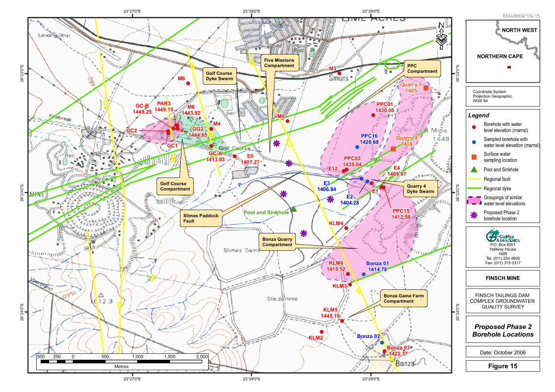
9.2 Position of additional monitoring boreholes
Siting and drilling of additional monitoring boreholes should be conducted in the following general locations (Figure 15):
• Two boreholes should be drilled to the north of the Old Slimes Paddocks between Quarry 4 and Five Missions village to assess levels and quality in the Five Missions aquifer compartment. Borehole E5 is the only monitoring location in this compartment which contains three significant contamination sources (Earth Dam, Five Missions Dam, Overflow Dam). Given the predominantly northeast groundwater flow direction, the two new boreholes should be drilled east and northeast of the contamination sources to assess potential groundwater contamination from these sources.
• Two additional monitoring boreholes should be located on the Old Slimes Paddocks to assess groundwater quality beneath this potential contamination source and provide sufficient locations to resolve groundwater flow direction in the area west of the Slimes Paddock Fault.
• One additional monitoring borehole should be located on the Old Slimes Paddocks east of the Slimes Paddock Fault and in the Quarry 4 dyke swarm. This would provide additional groundwater elevation information to confirm the flow direction in this compartment as well as an indication of groundwater quality beneath the slimes material at this point.
NORTHERN CAPE
NORTH WEST
8334/8504/1/G-15
Figure 15
Proposed Phase 2Borehole Locations
P.O. Box 6001Halfway House
1685Tel: (011) 254 4800Fax: (011) 315 0317
Date: October 2006
FINSCH MINE!(
!(
!(
!(
!(
!(!(
!(
!(
!(!(
!(
!(!(
!(
!(
!(
!(
!(
!(
!(
!(
!(!(
!(
!(
!(
!( ")
")
!(
#*
kj
kj
kjkj
kj
E21404.28
GC-B1449.25
PAR31449.15
Pool and Sinkhole
M4
Five Missions Compartment
Quarry 4Dyke Swarm
Bonza QuarryCompartment
Golf CourseCompartment
Golf CourseDyke Swarm
Slimes PaddockFault
Bonza Game FarmCompartment
PPC Compartment
M9
M8 M3
E1
GC2
GC1
E12
KLM4
KLM3
KLM2
M61443.92
E51407.27
E41409.87
GG21444.65
KLM61415.52
KLM51445.19
GC-A1413.93
PPC151412.58
PPC031439.64
Bonza 031422.37
E31406.84
Bonza 02
Quarry 51405
Quarry 41408
PPC161428.68
Bonza 011414.78
PPC011430.05
23°27'0"E
23°27'0"E
23°28'0"E
23°28'0"E
23°29'0"E
23°29'0"E
28°2
4'0"S
28°2
4'0"S
28°2
3'0"S
28°2
3'0"S
28°2
2'0"S
28°2
2'0"S
Coordinate SystemProjection GeographicWGS 84
·
500 0 500 1,000 1,500 2,000250Metres
FINSCH TAILINGS DAM COMPLEX GROUNDWATER
QUALITY SURVEY
Legend
#* Pool and SinkholeRegional faultRegional dyke
kjProposed Phase 2borehole location
Groupings of similarwater level elevations
")Surface watersampling location
!(Sampled borehole withwater level elevation (mamsl)
!(Borehole with waterlevel elevation (mamsl)

October 2006 8334/8504/1/G
GOLDER ASSOCIATES
31
• Borehole KLM4 should be deepened to at least 80 m or redrilled. This will provide a reliable location for monitoring groundwater level and quality in the Bonza Quarry compartment.
• The drilling of the additional monitoring boreholes should include:
- Geophysical surveying to locate fracture zones and dyke contacts which could provide preferential flow paths for groundwater flow
- Drilling of the monitoring boreholes
- Testing of the new and existing boreholes to provide hydraulic information for subsequent modelling
- Collection and analysis of water samples.
9.3 Augmentation of existing monitoring network
Boreholes M3, M4 and M8 could not be accessed during the current hydrocensus since they were locked and it was not clear who the borehole owners were. Access to the boreholes for monitoring should be arranged with the relevant owners and these boreholes added to the monitoring network.
The monitoring network should consist of all boreholes identified in Table 1 and Table 4.
Monitoring should consist of
• Measurement of groundwater elevation in all monitoring boreholes on a monthly basis.
• A monthly survey of the water elevation in PPC Quarry No 4 and Quarry No 5.
• Groundwater quality samples should be collected every six months from the same boreholes. The boreholes should be purged (removal of at least 3 well volumes) prior to sampling. Samples should be field filtered through a 0.45 µm filter and preserved for transport to the laboratory. The analytical suite should include: pH, TDS, EC, K, Na, Ca, Mg, NH4, Total Alkalinity, F, Cl, NO3, SO4, PO4 and ICP scan for trace metals. Finsch may wish to volunteer to collect the groundwater samples from PPC boreholes.
10 PRELIMINARY CONCLUSIONS
The following conclusions can be drawn from the work undertaken so far.
10.1 Prevailing groundwater regime
• The site is underlain by weathered and fractured karstic dolomite which dips gently to the west
• The aquifer consists of a series of solution cavities within solid dolomite
• Geological structures can act as barriers to groundwater flow. A dominant southwest – northeast structural trend underlies the site and structures define the boundaries of a number of groundwater compartments.
October 2006 8334/8504/1/G
GOLDER ASSOCIATES
32
• Groundwater flow direction within these compartments is generally from southwest to northeast and parallels the structural trend. However, measured groundwater levels in the Quarry 4 dyke swarm suggest flow from the northeast to the southwest.
10.2 Current groundwater quality
Based on the analyses conducted of samples collected during the current study, groundwater is generally within drinking water quality standards. However, all the current analyses indicate elevated concentrations of major parameters relative to the background which suggests the influence of source(s) of contamination.
Based on an assessment of the analytical results in relation to analyses of potential contamination sources provided by Finsch, a mixing trend has been identified which suggests that the analyses from this hydrocensus are a mixture of background groundwater with Quarry 4 water. The source of contamination of Quarry 4 water is not evident from this assessment. The geochemical assessment also suggests that the slimes dams complex is not a source of nitrate in Quarry 4 and Quarry 5.
10.3 Groundwater pollution plumes
It would be difficult to track groundwater contamination across compartment boundaries although it may be possible to identify pollution plumes from contamination sources within a single compartment. However, the distribution of boreholes in the study area is not sufficient to identify groundwater flow directions and pollution plumes within the compartments inferred from this study.
Groundwater contamination is suspected in:
• The PPC compartment, as indicated from the analysis of the sample from borehole PPC16;
• Nitrate contamination has been identified in the Quarry 4 dyke swarm, in Quarry 4 itself;
• The Bonza Quarry compartment from Bonza Quarry seepage.
The available information is not conclusive with regard to the extent of potential groundwater contamination. The need for mitigation or remediation of contamination may be evident once the results of the Phase II assessment are known.
10.4 Information gaps
• The efficacy of the groundwater monitoring system can be improved through the upgrading of boreholes which have fallen into disuse, establishing and implementing a programme of regular groundwater level and quality monitoring and the drilling of additional monitoring boreholes in selected areas.
• Additional monitoring boreholes, especially in the Five Missions compartment and the Old Slimes Paddocks would assist in the determination of groundwater flow directions within compartments and hence the potential migration direction of contamination from potential sources.

GOLDER ASSOCIATES
APPENDIX A
Logs of boreholes KLM2 to KLM6


GOLDER ASSOCIATES
APPENDIX B
Laboratory analyses of potential contamination sources


GOLDER ASSOCIATES
APPENDIX C
KLM Hydrocensus results from 2003
KLM (November 2003) Hydrocensus results
No Form No.
Borehole Number
Date Recorded Owner Address Phone
NumberFarm Name and
NumberGPS
Latitude GPS Longitude Altitude Terrain Water Level
RWL or Pumped
Field Temp. Field E-Cond. Field
pH Comment Yield Comment on yield
Hole Depth Lithology Drilling
Method Drilling Dia
d m s d m s (GPS) (mbgl) C (mS/m) (mbgl) 10" 8" 6"
1 1 KLM2 05-Nov-03 Finsch Mine PO Box 7 Lime Acres 053 3852111 Carterblock 458 28 24 10 23 28 35 1461
Flat area adjacent to slimes dam
None No water in borehole 0
No airlift yield when
drilled40 Dolomite Percussion 10 30
2 2 KLM5 05-Nov-03 Finsch Mine PO Box 7 Lime Acres 053 3852111 Carterblock 458 28 24 4 23 28 45 1460
Flat area adjacent to slimes dam
12.38 Rest Water Level 19 239 7.46 Grab sample 0
No airlift yield when
drilled40 Dolomite Percussion 6 44
3 3 KLM3 06-Nov-03 Finsch Mine PO Box 7 Lime Acres 053 3852111 Carterblock 458 28 23 46 23 28 49 1460
Flat area adjacent to slimes dam
None No water in borehole 0
No airlift yield when
drilled20 Dolomite Percussion 6 44
4 4 KLM6 06-Nov-03 Finsch Mine PO Box 7 Lime Acres 053 3852111 Carterblock 458 28 23 41 23 28 48 1460
Flat area adjacent to slimes dam
40.01 Rest Water Level 21 237 8.01 Grab sample 0
No airlift yield when
drilled40 Dolomite Percussion 6 44
5 5 KLM4 06-Nov-03 Finsch Mine PO Box 7 Lime Acres 053 3852111 Carterblock 458 28 23 18 23 28 47 1460
Flat area adjacent to slimes dam
40.07 Rest Water Level 21 248 7.53 Grab sample 0
No airlift yield when
drilled40 Dolomite Percussion 9 41
6 6 E4 06-Nov-03 Finsch Mine PO Box 7 Lime Acres 053 3852111 Carterblock 458 28 22 57 23 29 5 1442
Between slimes dam and PPC
37.23 Rest Water Level 21 114 6.91 Grab sample ? Yield
unknown ? Dolomite Percussion
7 7 E1 06-Nov-03 Finsch Mine PO Box 7 Lime Acres 053 3852111 Carterblock 458 28 22 58 23 29 8 1442
Between slimes dam and PPC
Hole collapsed
No water in borehole ? Yield
unknown 7 Dolomite Percussion
8 8 E2 06-Nov-03 Finsch Mine PO Box 7 Lime Acres 053 3852111 Carterblock 458 28 22 54 23 28 58 1448
Between slimes dam and PPC
47.32 Rest Water Level 22 61 7.15 Grab sample ? Yield
unknown ? Dolomite Percussion
9 9 E3 06-Nov-03 Finsch Mine PO Box 7 Lime Acres 053 3852111 Carterblock 458 28 22 53 23 28 55 1451
Between slimes dam and PPC
45.15 Rest Water Level 22 87 7.12 Grab sample ? Yield
unknown ? Dolomite Percussion
10 10 E12 06-Nov-03 Finsch Mine PO Box 7 Lime Acres 053 3852111 Carterblock 458 28 22 58 23 28 56 1455
Between slimes dam and PPC
Hole collapsed
No water in borehole ? Yield
unknown 12 Dolomite Percussion
11 11 WD1 06-Nov-03 Finsch Mine PO Box 7 Lime Acres 053 3852111 Carterblock 458 28 22 28 23 26 6 1504
Near Finsch waste disposal
site132 Rest Water
Level 22 47 7.43 Grab sample ? Yield unknown ? Banded ironstone Percussion
12 12 WD2 06-Nov-03 Finsch Mine PO Box 7 Lime Acres 053 3852111 Carterblock 458 28 22 52 23 25 49 1494
Near Finsch waste disposal
site69.14 Rest Water
Level 22.5 40 7.6 Grab sample ? Yield unknown ? Banded ironstone Percussion
13 13 Britz 06-Nov-03 Finsch Mine PO Box 7 Lime Acres 053 3852111 Carterblock 458 28 22 22 23 25 42 1505 In Britz game
farm 71.5 Rest Water Level 21.5 28 7.15 Grab sample ? Yield
unknown ? Banded ironstone Percussion
14 14 M3 06-Nov-03 Finsch Mine PO Box 7 Lime Acres 053 3852111 Carterblock 458 28 22 0 23 28 44 1455
Near Finsch heavy vehicle access road
35.2 Rest Water Level
Water is badly polluted ? Yield
unknown ? Dolomite Percussion
15 15 M1 07-Nov-03 Johan Lamprecht
PO Box 273, Postmansburg 053 3130417 Strathmore 28 1477
Across road from farm
house15.4 Pumped
water level 19.5 71 7.19 Pumped sample ? Yield
unknownabout 30m ? Percussion
16 16 M6 07-Nov-03 Johan Lamprecht
PO Box 273, Postmansburg 053 3130417 Strathmore 28 25 11 23 22 32 1472 About 2km SE
of farm house 7.86 Pumped water level 20 82 7.13 Pumped
sample ? Yield unknown
about 30m ? Percussion
17 17 M4 07-Nov-03 Johan Lamprecht
PO Box 273, Postmansburg 053 3130417 Strathmore 28 24 01 23 23 37 1480
About 2km ESE of farm
house15.55 Pumped
water level 20 61 7.44 Pumped sample ? Yield
unknownabout 30m ? Percussion
18 18 M3 07-Nov-03 Johan Lamprecht
PO Box 273, Postmansburg 053 3130417 Strathmore 28 22 46 23 23 52 1515
About 2km ENE of farm
house
Borehole sealed 23 41 7.41 Pumped
sample ? Yield unknown
about 28m ? Percussion
19 19 M2 07-Nov-03 Johan Lamprecht
PO Box 273, Postmansburg 053 3130417 Strathmore 28 23 54 23 21 55 1487 About 1km SE
of farm house 13 Rest Water Level 22 39 6.98 Grab sample ? Yield
unknownabout 30m ? Percussion
Page 1 of 14

KLM (November 2003) Hydrocensus results
No Form No.
Borehole Number
Date Recorded Owner Address Phone
NumberFarm Name and
NumberGPS
Latitude GPS Longitude Altitude Terrain Water Level
RWL or Pumped
Field Temp. Field E-Cond. Field
pH Comment Yield Comment on yield
Hole Depth Lithology Drilling
Method Drilling Dia
d m s d m s (GPS) (mbgl) C (mS/m) (mbgl) 10" 8" 6"
20 20 M7 07-Nov-03 Johan Lamprecht
PO Box 273, Postmansburg 053 3130417 Strathmore 28 23 30 23 21 23 1496 Adjacent to
farm houseNo access
to hole 22 92 7.44 Pumped sample ? Yield
unknownabout 17m ? Percussion
21 21 A2 11-Nov-03 Mr A de JagerPO Box 313, Danielskuil,
8405053 3850626 Murray 28 23 1450
About 100m North of farm
house
Borehole sealed 20.5 201 7.18 Pumped
sample ? Yield unknown
about 28m Dolomites ?
22 22 A3 11-Nov-03 Mr A de JagerPO Box 313, Danielskuil,
8405053 3850626 Murray 28 22 23 23 35 23 1450 About 1km NE
of farm house 17.18 Pumped water level 21.5 91 7.33 Pumped
sample ? Yield unknown
about 30m Dolomites ?
23 23 A4 11-Nov-03 Mr A de JagerPO Box 313, Danielskuil,
8405053 3850626 Murray 28 24 56 23 34 32 1444 About 5km SW
of farm houseBorehole sealed 22 75 7.03 Pumped
sample ? Yield unknown
about 30m Dolomites Percussion
24 24 A1 11-Nov-03 PPC Walker 28 22 34 23 33 41 1440 Adjacent to farm house 18.9 Pumped
water level 22 92 6.99 Pumped sample ? Yield
unknown ? Dolomites ?
25 25 A5 11-Nov-03 PPC Walker 28 22 34 23 33 42 1440 Adjacent to farm house 15.05 Rest Water
Level 25 95 7.14 Grab sample ? Yield unknown ? Dolomites Hand dug well
(1.5m diameter)
26 26 O1 11-Nov-03 Mr Williams Works at Finsch Mine Outpost 28 23 1443 Adjacent to
farm house 13.68 Pumped water level 24.7 166 7.43 Pumped
sample ? Yield unknown ? Dolomites ?
27 27 O2 11-Nov-03 Mr Williams Works at Finsch Mine Outpost 28 20 42 23 34 16 1437
About 100m East of farm
house
Borehole sealed 23.7 175 7.44 Pumped
sample ? Yield unknown ? Dolomites ?
28 28 L1 11-Nov-03 Mr K KoekemoerPO Box 204, Danielskuil,
8405082 4926789 Outpost 28 20 33 23 33 14 1449
About 500m SW of Beadle
farm house19.71 Rest Water
LevelHole open and water polluted ? Yield
unknown ? Dolomites Percussion
29 29(a) L2 11-Nov-03 Small Farmers Association
PO Box 35, Danielskuil,
8405083 5328690 Laufging Waters
Farm 28 18 40 23 32 53 1455 Adjacent to farm house
Borehole sealed 26 75 7.15 Pumped
sample ? Yield unknown
about 25m Dolomites Percussion
29 29(b) E5 12-Nov-03 Finsch Mine PO Box 7 Lime Acres 053 3852111 Carterblock 458 28 22 42 23 27 51 1458
Adjacent to Lime Aces golf
course55.65 Rest Water
LevelHole open and water polluted ? Yield
unknownabout 100m Dolomites Percussion 6m 6 to
100
31 30 GC1 12-Nov-03 Lime Acres Golf Club Carterblock 458 28 22 30 23 27 18 1473 On Lime Acres
GC (No.9 Tee)Bees in borehole
Bees in borehole ? Yield
unknown ? Dolomites Percussion
32 31 GC2 12-Nov-03 Lime Acres Golf Club Carterblock 458 28 22 29 23 27 18 1471 On Lime Acres
GC (No.9 Tee)Bees in borehole
Bees in borehole ? Yield
unknown ? Dolomites Percussion
33 32 M4 12-Nov-03 Finsch Mine PO Box 7 Lime Acres 053 3852111 Carterblock 458 28 23 On Lime Acres
GC 36.46 Rest Water Level
Bailer cant fit in hole ? Yield
unknown ? Dolomites Percussion
34 33 M6 12-Nov-03 Finsch Mine PO Box 7 Lime Acres 053 3852111 Carterblock 458 28 22 26 23 27 22 1470
On Lime Acres GC No. 9 fairway
27.35 Rest Water Level 23 55 7.61 Hole open,
grab sample ? Yield unknown ? Dolomites Percussion
35 34 PAR3 12-Nov-03 Finsch Mine PO Box 7 Lime Acres 053 3852111 Carterblock 458 28 22 26 23 27 22 1470
On Lime Acres GC No. 9 fairway
Hole collapsed
No water in borehole ? Yield
unknown 25 Dolomites Percussion
36 35 M8 13-Nov-03 Finsch Mine PO Box 7 Lime Acres 053 3852111 Carterblock 458 28 22 05 23 27 28 1465 Adjacent to
caravan park 42 Rest Water Level 19.8 65 7.04 Hole open,
grab sample ? Yield unknown ? Dolomites Percussion
37 36 M9 13-Nov-03 Finsch Mine PO Box 7 Lime Acres 053 3852111 Carterblock 458 28 22 24 23 28 18 1448 Close to Lime
Acres suburbHole
collapsedNo water in
borehole ? Yield unknown 3.15 Dolomites Percussion
38 37 F1 13-Nov-03 Mr de Villiers Jansen
PO Box 119, Lime Acres,
8401053 3850625 Silver Streams 28 21 14 23 34 52 1435 Adjacent to
farm house 14.55 Rest Water Level 29 101 7.23 Pumped
sample ? Yield unknown ? Dolomites Percussion
Page 2 of 14

KLM (November 2003) Hydrocensus results
No Form No.
Borehole Number
Date Recorded Owner Address Phone
NumberFarm Name and
NumberGPS
Latitude GPS Longitude Altitude Terrain Water Level
RWL or Pumped
Field Temp. Field E-Cond. Field
pH Comment Yield Comment on yield
Hole Depth Lithology Drilling
Method Drilling Dia
d m s d m s (GPS) (mbgl) C (mS/m) (mbgl) 10" 8" 6"
39 38 F2 13-Nov-03 Mr de Villiers Jansen
PO Box 119, Lime Acres,
8401053 3850625 Silver Streams 28 21 13 23 34 51 1436 Adjacent to
farm house 14.22 Rest Water Level 20.6 113 6.96 Grab sample ? Yield
unknown ? ? Jumper Rig
40 39 F6 13-Nov-03 Mr de Villiers Jansen
PO Box 119, Lime Acres,
8401053 3850625 Silver Streams Can not
locate holeCan not locate
holeCan not
locate hole
41 40 F5 13-Nov-03 Mr de Villiers Jansen
PO Box 119, Lime Acres,
8401053 3850625 Silver Streams 28 21 09 23 35 00 1440
About 1km East of farm
house
Borehole sealed
Borehole sealed ? Yield
unknown ? ? ?
42 41 F4 13-Nov-03 Mr de Villiers Jansen
PO Box 119, Lime Acres,
8401053 3850625 Silver Streams 28 21 10 23 34 56 1441
About 500m East of farm
house
Borehole sealed
Borehole sealed ? Yield
unknown ? ? ?
43 42 F3 13-Nov-03 Mr de Villiers Jansen
PO Box 119, Lime Acres,
8401053 3850625 Silver Streams 28 21 11 23 34 55 1439 Adjacent to
farm houseBorehole sealed 26 102 6.04 Pumped
sample ? Yield unknown ? ? ?
44 43 BE1 14-Nov-03 Hennie van ZylPO Box 164, Lime Acres,
8401082 8253856 Beadle 28 19 18 23 33 53 1440
About 500m north of farm
house9.78 Rest Water
Level 22 72 7.12 Grab sample 13000 Farmers pump test 100 2m - Calcrete 98m -
Dolomite Percussion 100
45 44 BE2 14-Nov-03 Hennie van ZylPO Box 164, Lime Acres,
8401082 8253856 Beadle 28 19 18 23 33 53 1442
About 500m NE of farm
house10.2 Rest Water
Level 22 84 6.93 Pumped sample 4500 Farmers
pump test 60 1m - Calcrete 5m - Weath Dol 54m - Dolomite Percussion 60
46 45 BE3 14-Nov-03 Hennie van ZylPO Box 164, Lime Acres,
8401082 8253856 Beadle 28 19 29 23 33 53 1447 Flat next to
pan 11.3 Rest Water Level 22 133 7.02 None 360 Airlift 66 4m - Calcrete 66m -
Dolomite Percussion 66
47 46 BE4 14-Nov-03 Hennie van ZylPO Box 164, Lime Acres,
8401082 8253856 Beadle 28 19 18 23 33 19 1447 Flat terrain None None Dry for 4
years ? ? Jumper Rig
48 47 BE5 14-Nov-03 Hennie van ZylPO Box 164, Lime Acres,
8401082 8253856 Beadle 28 19 08 23 32 46 1443 Flat terrain 20.4 Rest Water
Level None 1000 Pump test 30 Dolomites Percussion
49 48 BE6 14-Nov-03 Hennie van ZylPO Box 164, Lime Acres,
8401082 8253856 Beadle 28 19 08 23 32 45 1446 Flat terrain 17 Estimated 21.7 67 6.9 Pumped
sample 100 000 Pumped 25 6m Calcrete 25m Fractured Dolomite Percussion ?
50 49 BE7 14-Nov-03 Hennie van ZylPO Box 164, Lime Acres,
8401082 8253856 Beadle 28 19 06 23 32 46 1453 Flat terrain 17.2 Rest Water
Level 22 68 7.44 Grab sample 100 000 Airlift 60 12m Calcrete 60m kimberlite Percussion 60
51 50 BE8 14-Nov-03 Hennie van ZylPO Box 164, Lime Acres,
8401082 8253856 Beadle 28 19 05 23 19 47 1550 Flat terrain 16.8 RWL 22 167 6.6 Grab 60000 Airlift 42 12m Calcrete 30m
Kimberlite 42m Dolomite Percussion 42
52 51 BE9 14-Nov-03 Hennie van ZylPO Box 164, Lime Acres,
8401082 8253856 Beadle 28 19 10 23 32 45 1446 Flat terrain 17 Estimate -
no access 21.8 69 7.74 Pumping 100000 Pump Test 60 12m Calcrete 20m Coal 60m Dolomite Percussion 60
53 52 BE10 14-Nov-03 Hennie van ZylPO Box 164, Lime Acres,
8401082 8253856 Beadle 28 19 26 23 32 44 1440
Flat terrain near lands and centre pivots
16.5 RWL 21.5 66 7.45 Grab 200000 Airlift 45 6m Calcrete 45m Dolomite Percussion 45
54 53 BE11 14-Nov-03 Hennie van ZylPO Box 164, Lime Acres,
8401082 8253856 Beadle 28 19 06 23 32 22 1445 Flat terrain 14.8 RWL 23.1 76 7.27 Grab 20000 Airlift 50
9m Calcrete 14m Brown clay 17m Dolomite 22m
wad 50m dolomitePercussion 50
55 54 BE12 14-Nov-03 Hennie van ZylPO Box 164, Lime Acres,
8401082 8253856 Beadle 28 19 06 23 32 22 1446 Riser close to
pan 21 Pumping 26 368 6.93 Pumping (no sample) 1000 Pump Test 25 Dolomite Percussion
56 55 Y3 17-Nov-03 David YorkPO Box 35, Lime Acres,
8401053 3850054 Papkuil 28 19 19 23 34 04 1443 Flat 14.73 RWL No sample ~100 Percussion
57 56 Y2 17-Nov-03 David YorkPO Box 35, Lime Acres,
8401053 3850054 Papkuil 28 21 20 23 31 54 1440 Flat terrain 13.2 RWL No sample ? Dolomite? ? ?
Page 3 of 14
KLM (November 2003) Hydrocensus results
No Form No.
Borehole Number
Date Recorded Owner Address Phone
NumberFarm Name and
NumberGPS
Latitude GPS Longitude Altitude Terrain Water Level
RWL or Pumped
Field Temp. Field E-Cond. Field
pH Comment Yield Comment on yield
Hole Depth Lithology Drilling
Method Drilling Dia
d m s d m s (GPS) (mbgl) C (mS/m) (mbgl) 10" 8" 6"
58 57 Y1 17-Nov-03 David YorkPO Box 35, Lime Acres,
8401053 3850054 Papkuil 28 21 22 23 31 56 1442 Flat terrain 21.24 RWL 23 134 7.41 Grab ? Dolomite? Jumper Rig?
59 58 T3 17-Nov-03 CA SmithPO Box 70, Lime Acres,
8401082 3758677 Wiidzpan 28 20 26 23 24 13 1517 Rise close to
valley 4.1 Pumping 33 81 7.36 Pumping ? ? BIF Hand dug well
60 59 T4 17-Nov-03 CA SmithPO Box 70, Lime Acres,
8401082 3758677 Wiidzpan 28 20 26 23 24 15 1520 Slight rise 4.8 RWL No sample ? ? BIF Jumper Rig?
61 60 T2 17-Nov-03 CA SmithPO Box 70, Lime Acres,
8401082 3758677 Wiidzpan 28 20 25 23 24 14 1518 Rise close to
valley 5.45 RWL No sample BIF Jumper Rig?
62 61 T1 17-Nov-03 CA SmithPO Box 70, Lime Acres,
8401082 3758677 Wiidzpan 28 20 23 23 24 14 1520 On a rise 9.75 Pumping 27 49 7.4 Pumping ? No yield
recorded ? BIF Jumper Rig?
63 62 T5 17-Nov-03 CA SmithPO Box 70, Lime Acres,
8401082 3758677 Wiidzpan 28 20 22 23 24 12 1527 On a rise 10.55 RWL Sealed ? No yield
recorded ? BIF Jumper Rig?
64 63 T6 17-Nov-03 CA SmithPO Box 70, Lime Acres,
8401082 3758677 Wiidzpan 28 19 20 23 25 38 1560 In valley 53.72 RWL No sample ? No yield
recorded ? BIF Jumper Rig?
65 64 T7 17-Nov-03 CA SmithPO Box 70, Lime Acres,
8401082 3758677 Wiidzpan 28 20 13 23 25 41 1539 In valley ? No access No sample ? No yield
recorded ? BIF Jumper Rig?
66 65 T8 17-Nov-03 CA SmithPO Box 70, Lime Acres,
8401082 3758677 Wiidzpan 28 20 32 23 24 03 1517
Slight rise adjacent to
valley5.2 Pumping 24 234 6.76 Pumping ? No yield
recorded ? BIF ?
67 66 Ts1 18-Nov-03 Mr de Klerk PO Box 787, Postmansberg 053 3136146 Taaibosputs 28 26 04 23 22 22 1471
Flat terrain adjacent to farmhouse
5.4 RWL Sealed ? No yield recorded ? ? Percussion
68 67 Ts3 18-Nov-03 Mr de Klerk PO Box 787, Postmansberg 053 3136146 Taaibosputs 28 26 07 23 22 30 1466 Flat terrain 5.2 RWL 22 47 8.12 Grab ? No yield
recorded 33 ? Percussion
69 68 Ts4 18-Nov-03 Mr de Klerk PO Box 787, Postmansberg 053 3136146 Taaibosputs 28 26 20 23 22 21 1408 Flat terrain 7.5 Pumping 24 68 7.17 Pumped ? No yield
recorded ? ? Percussion
70 69 Ts2 18-Nov-03 Mr de Klerk PO Box 787, Postmansberg 053 3136146 Taaibosputs 28 26 05 23 22 21 1466 Slight rise ? No access 23 69 7.43 Pumped ? No yield
recorded ? ? Percussion
71 70 Ts5 18-Nov-03 Mr de Klerk PO Box 787, Postmansberg 053 3136146 Taaibosputs 28 26 06 23 22 20 1408
Flat terrain adjacent to farmhouse
4.58 RWL No access ? No yield recorded ? ? Percussion
72 71 Ts6 18-Nov-03 Mr de Klerk PO Box 787, Postmansberg 053 3136146 Taaibosputs 28 26 03 23 22 21 1469
Flat terrain adjacent to farmhouse
? No access 23 68 6.92 Pumped ? No yield recorded ? ? ?
73 72 Ts7 18-Nov-03 Mr de Klerk PO Box 787, Postmansberg 053 3136146 Taaibosputs 28 25 14 23 21 11 1482 Rise close to
hilltop ? Sealed 24 95 7.43 Pumped ? No yield recorded 30 ? ?
74 73 J1 18-Nov-03 Mr J Oosthuisen PO Box 113, Postmansberg 053 3131588 Jacobsfontein 28 26 30 23 24 09 1455 Flat terrain
within valley ? No access No access ? No yield recorded ? ? ?
75 74 J2 18-Nov-03 Mr J Oosthuisen PO Box 113, Postmansberg 053 3131588 Jacobsfontein 28 26 29 23 24 08 1461 Flat terrain
within valley 2.93 RWL 24 66 7.03 Pumped ? No yield recorded ? ? Hand dug well 1.5
m
76 75 J6 18-Nov-03 Mr J Oosthuisen PO Box 113, Postmansberg 053 3131588 Jacobsfontein 28 26 28 23 24 07 1453 Rise close to
valley ? No access No access ? No yield recorded 30 Shale chips Percussion
Page 4 of 14
KLM (November 2003) Hydrocensus results
No Form No.
Borehole Number
Date Recorded Owner Address Phone
NumberFarm Name and
NumberGPS
Latitude GPS Longitude Altitude Terrain Water Level
RWL or Pumped
Field Temp. Field E-Cond. Field
pH Comment Yield Comment on yield
Hole Depth Lithology Drilling
Method Drilling Dia
d m s d m s (GPS) (mbgl) C (mS/m) (mbgl) 10" 8" 6"
77 76 J9 18-Nov-03 Mr J Oosthuisen PO Box 113, Postmansberg 053 3131588 Jacobsfontein 28 25 18 23 25 07 1455 Flat terrain
within valley ? Sealed 25 31 6.91 Pumped ? No yield recorded ? BIF Percussion
78 77 J8 18-Nov-03 Mr J Oosthuisen PO Box 113, Postmansberg 053 3131588 Jacobsfontein 28 26 24 23 24 16 1460 Flat terrain
within valley ? No access No access ? No yield recorded 30 ? Percussion
79 78 J5 18-Nov-03 Mr J Oosthuisen PO Box 113, Postmansberg 053 3131588 Jacobsfontein 28 26 24 23 24 20 1450 Rise adjacent
to valley ? Sealed 25 58 7.42 Pumped ? No yield recorded 30 Fractured shale Percussion
80 79 J10 18-Nov-03 Mr J Oosthuisen PO Box 113, Postmansberg 053 3131588 Jacobsfontein 28 26 26 23 24 19 1450 Middle of flat
valley 0 RWL Seepage ? No yield recorded 0 ? Spring
81 80 J3 18-Nov-03 Mr J Oosthuisen PO Box 113, Postmansberg 053 3131588 Jacobsfontein 28 26 25 23 23 38 1458 In valley ? No access 21.1 60 7.44 Pumped ? No yield
recorded 30 ? ?
82 81 J7 18-Nov-03 Mr J Oosthuisen PO Box 113, Postmansberg 053 3131588 Jacobsfontein 28 26 31 23 24 02 1468 Half way up
slope 9.72 RWL No access ? No yield recorded ? ? Percussion
82 PPC2 19-Nov-03 PPC Mine PPC 28 26 31 23 24 02 1469Flat terrain adjacent to
PPC pit44.37 RWL 23.4 108 7.43 Grab sample None No yield
recorded ? Dolomite Core
83 PPC1 19-Nov-03 PPC Mine PPC 28 22 21 23 29 01 1459Flat terrain adjacent to
PPC pit21.1 RWL 21.7 99 7.43 Grab sample None No yield
recorded ? Dolomite Core
84 PPC14 19-Nov-03 PPC Mine PPC 28 22 20 23 29 01 1459Flat terrain adjacent to
PPC pit45.57 RWL 22.5 148 7.22 Grab sample None No yield
recorded ? Dolomite Percussion
85 PPC16 19-Nov-03 PPC Mine PPC 28 22 37 23 28 53 1447Flat terrain adjacent to
PPC pit45.55 RWL No sample None No yield
recorded ? Dolomite Percussion
86 PPC3 19-Nov-03 PPC Mine PPC 28 22 48 23 22 47 1442Flat terrain adjacent to
PPC pit45.28 RWL 21.6 86 7.25 Grab sample None No yield
recorded ? Dolomite Percussion
87 PPC15 19-Nov-03 PPC Mine PPC 28 22 57 23 29 06 1442Flat terrain adjacent to
PPC pit37.56 RWL 22.3 82 7.46 Grab sample None No yield
recorded ? Dolomite Percussion
88 GG2 19-Nov-03 PPC Mine PPC 28 22 27 23 31 05 1443Flat terrain adjacent to
PPC pit23.29 RWL No sample None No yield
recorded ? Dolomite Percussion
89 BT25 19-Nov-03 PPC Mine PPC 28 21 01 23 29 15 1459
Flat terrain adjacent to dolomite outcrop
39.15 RWL 29 48 7.58 Grab sample None No yield recorded ? Dolomite Core
90 RL1 19-Nov-03 PPC Mine PPC 28 19 56 23 31 05 1440
Flat terrain adjacent to dolomite outcrop
25.1 RWL No sample None No yield recorded ? Dolomite ?
91 AD3 19-Nov-03 PPC Mine PPC 28 16 24 23 30 41 1470
Flat terrain close to
Postmasburg tar road
9.71 RWL 29 84 7.43 Grab sample None No yield recorded ? Dolomite Percussion
92 C8 19-Nov-03 CJ Smith Clifton 28 18 17 23 24 38 1640 On top of hill ? Greater than 100m 23 50 7.83 Pumped 9092 1970 by
farmer 128 BIF Percussion
93 C4 19-Nov-03 CJ Smith Clifton 28 19 29 23 23 22 1474 Flat ? Sealed 25 24 7.43 Pumped 4500 No yield recorded 30 Dolomite Percussion
94A C2 19-Nov-03 CJ Smith Clifton 28 19 30 23 23 25 1544 Slope 29.9 Pumped 24 44 7.43 Pumped ? No yield recorded ? BIF Jumper Rig
Page 5 of 14
KLM (November 2003) Hydrocensus results
No Form No.
Borehole Number
Date Recorded Owner Address Phone
NumberFarm Name and
NumberGPS
Latitude GPS Longitude Altitude Terrain Water Level
RWL or Pumped
Field Temp. Field E-Cond. Field
pH Comment Yield Comment on yield
Hole Depth Lithology Drilling
Method Drilling Dia
d m s d m s (GPS) (mbgl) C (mS/m) (mbgl) 10" 8" 6"
94B C7 19-Nov-03 CJ Smith Clifton 28 19 24 23 23 23 1544 Flat 34.58 Pumped 23.7 34 7.24 Pumped ? No yield recorded 76 BIF Jumper Rig 7"
95 C6 19-Nov-03 CJ Smith Clifton 28 19 45 23 23 17 1525 Flat 23.72 Pumped 25 36 7.41 Pumped ? No yield recorded 30 ? Jumper Rig
96 C5 19-Nov-03 CJ Smith Clifton 28 20 24 23 23 17 1536 Flat Terrain 11.24 RWL No sample 20000 Airlift 55 ? Percussion 30 25
97 C1 19-Nov-03 CJ Smith Clifton 28 20 40 23 23 18 1513 Flat adjacent to pan 16.05 Pumped 25 54 7.62 Pumped No yield
recorded 20 BIF Jumper Rig
98 W2 20-Nov-03 JJ Oosthuisen PO Box 113, Postmansburg Werda 28 27 01 23 27 52 1443 Flat adjacent
to farmhouse 29.25 Pumped 22 59 7.58 Pumped ? No yield recorded ? Dolomite ?
99 W3 20-Nov-03 JJ Oosthuisen PO Box 113, Postmansburg Werda 28 27 07 23 28 15 1441 Flat Terrain 28 Pumped 20.7 62 7.43 Pumped ? No yield
recorded ? Dolomite ?
100 W6 20-Nov-03 JJ Oosthuisen PO Box 113, Postmansburg Werda 1439 Flat terrain ? No Access 22.3 78 7.1 Pumped ? No yield
recorded ? Dolomite ?
101 W1 20-Nov-03 JJ Oosthuisen PO Box 113, Postmansburg Werda 28 27 15 23 30 06 1439 Flat Terrain 32.7 Pumped 23.2 88 7.44 Pumped ? No yield
recorded ? Dolomite ?
102 W4 20-Nov-03 JJ Oosthuisen PO Box 113, Postmansburg Werda 28 26 45 23 27 06 1446 Flat terrain ? No Access 26 126 7.22 Pumped ? No yield
recorded ? Dolomite ?
103 W5 20-Nov-03 JJ Oosthuisen PO Box 113, Postmansburg Werda 28 27 08 23 27 27 1445 flat terrain 33.01 Pumped 23.8 65 7.95 Pumped ? No yield
recorded ? Dolomite ?
104 BS1 20-Nov-03 RJ Lombard Bergplaas 28 27 08 23 27 27 1447Flat Terrain (Dolomite outcrop)
20.11 RWL No sample ? No yield recorded ? Dolomite ?
105 BS2 20-Nov-03 RJ Lombard Bergplaas 1447 Flat terrain 26.52 RWL No sample ? No yield recorded ? Dolomite ?
106 BS3 20-Nov-03 RJ Lombard Bergplaas 28 25 59 23 28 29 1449 Flat Terrain ? No Access No sample ? No yield recorded ? Dolomite ?
107 BS4 20-Nov-03 RJ Lombard Bergplaas 28 25 54 23 26 54 1460 Flat Terrain ? No Access No sample ? No yield recorded ? Dolomite ?
108 BS5 20-Nov-03 RJ Lombard Bergplaas 28 25 47 23 27 07 1462 On side of hill ? Blocked at 1.7m No sample ? No yield
recorded ? BIF Percussion
109 BS6 20-Nov-03 RJ Lombard Bergplaas 28 25 17 23 28 12 1470 On slope close to farmhouse ? Sealed No sample ? No yield
recorded ? ? ?
110 BS7 20-Nov-03 RJ Lombard Bergplaas 28 25 17 23 28 12 1453 On slope close to farmhouse ? Sealed 25 91 7.33 Pumped ? No yield
recorded ? BIF ?
111 BA1 21-Nov-03 Finsch Mine PO Box 7, Lime Acres
053 385 2911 Bonza Game Farm 28 24 15 23 29 05 1450 Flat Terrain 36.9 RWL No sample ? No yield
recorded ? Dolomite Percussion
112 BA2 21-Nov-03 Finsch Mine PO Box 7, Lime Acres
053 385 2911 Bonza Game Farm 28 24 20 23 29 07 1450
Flat Terrain adjacent to
camp30.73 RWL No sample ? No yield
recorded ? Dolomite Percussion
Page 6 of 14

KLM (November 2003) Hydrocensus results
No Form No.
Borehole Number
Date Recorded Owner Address Phone
NumberFarm Name and
NumberGPS
Latitude GPS Longitude Altitude Terrain Water Level
RWL or Pumped
Field Temp. Field E-Cond. Field
pH Comment Yield Comment on yield
Hole Depth Lithology Drilling
Method Drilling Dia
d m s d m s (GPS) (mbgl) C (mS/m) (mbgl) 10" 8" 6"
113 R 9 21-Nov-03 T van der Spuy Rocklands 28 24 20 23 29 07 1450 Flat Terrain ? No Access 18.9 87 7.17 Pumped ? No yield recorded ? Dolomite ?
114 R 3 21-Nov-03 T van der Spuy Rocklands 28 28 21 23 34 16 1432 Flat Terrain ? Sealed 20.09 91 7.27 Pumped ? No yield recorded ? Dolomite ?
115 R 2 21-Nov-03 T van der Spuy Rocklands 28 28 25 23 34 08 1436Flat terrain adjacent to farmhouse
? No Access No sample ? No yield recorded ? Dolomite ?
116 R 4 21-Nov-03 T van der Spuy Rocklands 28 27 30 23 33 09 1426 Flat terrain 34.2 RWL 19.8 81 8.31 Pumped ? No yield recorded ? Dolomite ?
117 R 5 21-Nov-03 T van der Spuy Rocklands 28 27 10 23 32 33 1427 Flat terrain 18.44 RWL No sample ? No yield recorded ? Dolomite ?
118 N1 21-Nov-03 T van der Spuy Nooitgedacht 28 27 50 23 38 49 1409 Flat terrain 9.1 RWL 20.6 83 7.44 Pumped ? No yield recorded ? Dolomite ?
119 S1 21-Nov-03 Andries de Jager PO Box 313, Danielskuil 053 3850620 Brickworks 28 21 30 23 31 56 1437
Flat terrain adjacent to brickworks
41.5 RWL 20 82 7.52 Pumped ? No yield recorded ? Dolomite ?
120 S3 21-Nov-03 Andries de Jager PO Box 313, Danielskuil 053 3850620 Brickworks 28 21 29 23 31 56 1444 Flat terrain 51.81 RWL No sample ? No yield
recorded ? Dolomite ?
121 RN1 21-Nov-03 T van der Spuy Rolpan 28 26 54 23 34 50 1431 Flat terrain ? No Access 20 86 7.46 Pumped ? No yield recorded ? Dolomite ?
122 SN1 21-Nov-03 T van der Spuy Straightpan 28 25 41 23 36 24 1442 Flat terrain ? Sealed 19.2 158 7.15 Pumped ? No yield recorded ? Dolomite ?
123 SN2 21-Nov-03 T van der Spuy Straightpan 28 25 35 23 36 23 1435 Flat terrain ? No Access 17.9 253 7.44 Pumped ? No yield recorded ? Dolomite ?
124 V4 22-Nov-03 Andries Scheepers
PO Box 2160, Kimberley 082 2024133 Beadle 28 20 23 23 33 24 1440 Flat terrain 19.1 RWL No sample ? No yield
recorded 30 Dolomite Percussion 30
125 V1 22-Nov-03 Andries Scheepers
PO Box 2160, Kimberley 082 2024133 Beadle 28 20 21 23 33 28 1441 Flat terrain ? No Access 18.3 488 7.43 Pumped 1500 Farmer 30 Dolomite ?
126 V2 22-Nov-03 Andries Scheepers
PO Box 2160, Kimberley 082 2024133 Beadle 28 20 23 23 33 24 1441
Flat terrain next to
labourers housing
? Sealed No sample ? No yield recorded 30 Dolomite Jumper Rig
127 V3 22-Nov-03 Andries Scheepers
PO Box 2160, Kimberley 082 2024133 Beadle 28 19 39 23 32 32 1440 Flat terrain ? 19.8 73 7.43 Grab sample 24000 Pump test 20 Dolomite Percussion 20
Page 7 of 14

KLM (November 2003) Hydrocensus results
No Form No.
Borehole Number
1 1 KLM2
2 2 KLM5
3 3 KLM3
4 4 KLM6
5 5 KLM4
6 6 E4
7 7 E1
8 8 E2
9 9 E3
10 10 E12
11 11 WD1
12 12 WD2
13 13 Britz
14 14 M3
15 15 M1
16 16 M6
17 17 M4
18 18 M3
19 19 M2
meters Casing Details Collar height Screen Construction
CommentsPlinth
Dimensions Cap Hole status Pump Type Current Yield Water use Driller Date Drilled Comment
5" 4" 10" 8" 6" 5" 4" (cm) (m) H L B l/h
10 steel
40 steel
40 uPV
C20 28-34
uPVC Round concrete
plinth 15 90 90 Metal cap bolted Monitoring Hole None 0 Not in use EDRS Sep-03
6 steel
40 steel
40 uPV
C15 28-34
uPVC Round concrete
plinth 20 90 90 Metal cap bolted Monitoring Hole None 0 Not in use EDRS Sep-03
6 steel 33 None Round concrete
plinth 17 90 90 Metal cap bolted Monitoring Hole None 0 Not in use EDRS Sep-03
6 steel
40 steel
40 uPV
C45 28-34
uPVC Round concrete
plinth 15 90 90 Metal cap bolted Monitoring Hole None 0 Not in use EDRS Sep-03
9 steel
40 steel
41 uPV
C20 28-34
uPVC Round concrete
plinth 10 90 90 Loose metal cap Monitoring Hole None 0 Not in use EDRS Sep-03
0-? steel 5 ? Hole partially
graded over Loose metal cap Monitoring Hole None 0 Not in use ? ?
0-4 steel 10 None Hole collapsed at 7
mbgl Loose metal cap Monitoring Hole None 0 Not in use ? ?
0-? steel 0 ? No concrete plinth Loose metal cap Monitoring Hole None 0 Not in use ? ?
0-? steel 15 ? No concrete plinth Loose metal cap Monitoring Hole None 0 Not in use ? ?
0-? steel 10 ? No concrete plinth Loose metal cap Monitoring Hole None 0 Not in use ? ?
0-? steel
0-? steel 35 ? No concrete plinth Metal cap bolted Monitoring Hole None 0 Not in use ? ?
0-? steel
0-? steel 45 ? No concrete plinth Metal cap bolted Monitoring Hole None 0 Not in use ? ?
0-? steel
0-? steel 30 ? No concrete plinth Loose metal cap Monitoring Hole None 0 Not in use ? ?
0-? steel 15 ? Plinth level with
ground 0 100 100 Lockable metal cap Monitoring Hole None 0 Not in use ? ?
0 ? Plinth cast with 44 gallon drum 45 58 58 Windmill base
plateEquipped and
pumpingWindmill
Climax No. 10 420 Stock watering ? ?
0 ? Square concrete plinth 40 57 60 Windmill base
plateEquipped and
pumpingWindmill
Climax No. 8 160 Stock watering ? about 1991
0 ? Plinth cast with 44 gallon drum 30 55 55 Windmill base
plateEquipped and
pumpingWindmill
Climax No. 10 420 Stock watering ? about 1991
Plinth cast with 44 gallon drum 25 70 70 Windmill base
plateEquipped and
pumpingWindmill
Climax No. 12 650 Stock watering ? about 1991
Plinth cast with 44 gallon drum 55 58 58 Metal cap bolted Not equipped None 0 Not in use ? about 1991
Page 8 of 14

KLM (November 2003) Hydrocensus results
No Form No.
Borehole Number
20 20 M7
21 21 A2
22 22 A3
23 23 A4
24 24 A1
25 25 A5
26 26 O1
27 27 O2
28 28 L1
29 29(a) L2
29 29(b) E5
31 30 GC1
32 31 GC2
33 32 M4
34 33 M6
35 34 PAR3
36 35 M8
37 36 M9
38 37 F1
meters Casing Details Collar height Screen Construction
CommentsPlinth
Dimensions Cap Hole status Pump Type Current Yield Water use Driller Date Drilled Comment
5" 4" 10" 8" 6" 5" 4" (cm) (m) H L B l/h
Plinth cast with 44 gallon drum 29 65 65 Windmill base
plateEquipped and
pumpingWindmill
Climax No. 10 420 Household and stock water ? about 1992
0 ? Plinth cast with 44 gallon drum 33 1.8 1.8 Windmill base
plateEquipped and
pumping Sub - mersible ? Household and stock water ? ?
0 ? Plinth cast with 44 gallon drum 20 58 58 Windmill base
plateEquipped and
pumpingWindmill
Climax No. 8 160 Stock watering ? ?
0 ? Plinth cast with 44 gallon drum 8 58 58 Windmill base
plateEquipped and
pumpingWindmill
Climax No. 8 160 Stock watering ? ?
0 ? Concrete block plinth 20 154 154 Pump base plate Equipped and
pumpingMono with
Lister engine ? Stock watering ? ?
0 None Concrete block plinth 40 200 200 None Equipped and
not pumpingWindmill
Climax No. 8 0 Not in use Dug by hand ?
0 ? Concrete block plinth 27 53 80 Windmill base
plateEquipped and
pumpingWindmill
Climax No. 10 420 Household and stock water ? ?
0 ? Plinth cast with corrugated iron 19 39 39 Windmill base
plateEquipped and
pumpingWindmill
Climax No. 10 420 Irrigation and stock watering ? ?
about 18m 10 None Concrete block
plinth 15 100 100 None Not equipped None 0 Not in use ? ? Hole open to atmosphere
0 Concrete block plinth 28 100 100 Windmill base
plateEquipped and
pumping None 0 Not in use ? ?
6m 45 None No concrete plinth None Monitoring Hole None 0 Not in use ? ?According to Finsch hole dried
when PPC struck water in quarry
? 10 ? Plinth level with ground 0 100 100 Pump base plate Equipped and
pumping Sub - mersible Irrigation ? ? Beehive within hole and couldn't gain access
? 10 ? Plinth level with ground 0 100 100 Pump base plate Equipped and
pumping Sub - mersible Irrigation ? ? Beehive within hole and couldn't gain access
? 10 ? Plinth level with ground 0 100 100 Lockable metal
cap Monitoring Hole None 0 Not in use ? ? Borehole contains 50mm HDPE pipe, thus cant bail it
? 35 ? No concrete plinth None Monitoring Hole None Not in use ? ? Hole open to atmosphere
? 10 ? No concrete plinth None Monitoring Hole None 0 Not in use ? ? Hole has collapsed at about 25 mbgl
? 23 ? No concrete plinth None Monitoring Hole None 0 Not in use ? ? Hole open to atmosphere
? 21 ? No concrete plinth None Monitoring Hole None 0 Not in use ? ? Hole blocked with stones at 3.15 mbgl
0 ? Hand dug well 25 150 150 None Equipped and pumping
Windmill Climax No. 10 420 Household and
stock water ? ? Hand dug well with a diameter of about 1.5m
Page 9 of 14

KLM (November 2003) Hydrocensus results
No Form No.
Borehole Number
39 38 F2
40 39 F6
41 40 F5
42 41 F4
43 42 F3
44 43 BE1
45 44 BE2
46 45 BE3
47 46 BE4
48 47 BE5
49 48 BE6
50 49 BE7
51 50 BE8
52 51 BE9
53 52 BE10
54 53 BE11
55 54 BE12
56 55 Y3
57 56 Y2
meters Casing Details Collar height Screen Construction
CommentsPlinth
Dimensions Cap Hole status Pump Type Current Yield Water use Driller Date Drilled Comment
5" 4" 10" 8" 6" 5" 4" (cm) (m) H L B l/h
16cm 0 ? Plinth cast with 44 gallon drum 10 58 58 Metal cap bolted Not equipped None 0 Not in use ? ? Casing diameter suggests
drilled using Jumper rig
Can not locate hole Can not locate borehole on pan
Concrete block plinth 39 35 48 Windmill base
plateEquipped and not pumping
Broken Windmill 0 Not in use Windmill with missing head
gear
Plinth cast with 44 gallon drum 25 58 58 Windmill base
plateEquipped and not pumping
Broken Windmill 0 Not in use Windmill with missing head
gear
0 Concrete block plinth 28 91 44 Pump base plate Equipped and
pumpingMono with
electric motorHousehold and
stock water ? ? Equipped with Mono B8575 pump
6 44 None No concrete plinth None Not equipped None 0 Not in use Van Rensburg Oct-03 First water strike at 42 mbgl. Drill chips on site
6 30 None No concrete plinth None Equipped and pumping Sub - mersible Not in use Van Rensburg Oct-03 Will be used for both household
and stock watering
None No concrete plinth None Abandoned None Not in use Van Rensburg Oct-03 Hole open to atmosphere
? Brick plinth 104 80 None Abandoned Broken Windmill 0 Not in use ? ? Abandoned windmill - dry
? ? Concrete block plinth 41 190 90 None Pumping Sub - mersible 1000 Household and
stock water ? ? Pump not connected to electricity
Concrete block plinth 25 135 116 Mono pump
(100) 100 000 Irrigation for milk cows ? 04/01/87 Estimated RWL due to lack of
access
4 None No concrete plinth Abandoned None 0 Not in use Van Rensburg Oct-03 Chips logged by Farmer
3 30 None Plain steel used for casing None Not Equipped
Yet None 0 NIY - will be irrigation Van Rensburg Oct-03 Logged by farmer
6 None No Plinth 40 120 50 pump head Pumping Submersible 30kn 100 000 Irrigation and
dairy cows Van Rensburg Oct-03 Suction depth 35m
3 20 None No Plinth None Not Equipped Yet None 0 NIY - will be
Irrigation Van Rensburg Oct-03 Water strike at 30m
4 20 None No Plinth None Not Pumping None 0 NIY Van Rensburg Oct-03 Water strike at 24m
25 15 None Old landmark site 15 80 80 None Pumping Submersible 0.5kn 1000 House &
Garden ? ? No sample collected
42 ? Brick plinth 42 113 90 Drum Not Pumping Submersible Household ? 21/08/97 Struck by lightening
? 31 None Brick plinth 31 170 103 None Abandoned - blocked NIY ? ? Borehole blocked
Page 10 of 14

KLM (November 2003) Hydrocensus results
No Form No.
Borehole Number
58 57 Y1
59 58 T3
60 59 T4
61 60 T2
62 61 T1
63 62 T5
64 63 T6
65 64 T7
66 65 T8
67 66 Ts1
68 67 Ts3
69 68 Ts4
70 69 Ts2
71 70 Ts5
72 71 Ts6
73 72 Ts7
74 73 J1
75 74 J2
76 75 J6
meters Casing Details Collar height Screen Construction
CommentsPlinth
Dimensions Cap Hole status Pump Type Current Yield Water use Driller Date Drilled Comment
5" 4" 10" 8" 6" 5" 4" (cm) (m) H L B l/h
10 ? Brick plinth 10 200 105 None Abandoned None ? NIY ? ? Was old windmill
0 None Cross struts None Pumping Windmill (Climax8) ? Stock watering ? ? Windmill over hand dug well
18mm 0-
?0 None Circular concrete
plinth 50 60 60 Windmill base plate Abandoned None ? NIY ? ? Was windmill
18mm 0-
?0 None Circular concrete
plinth 15 58 58 Mono base plate Not Pumping Mono 84063 2hp ? Stock
watering? ? ?
18mm 0-
?0 ? Circular concrete
plinth 23 58 58 Windmill base plate Pumping Windmill
Climax No. 10 ? Household & Stockwatering ? ? Equipped with old mono pump,
driven by windmill
18mm 0-
?0 ? Concrete block
plinth 13 45 35 None Abandoned Broken windmill 0 NIY ? ? Equipped with windmill - no
rods
18mm 0-
?0 ? Circular concrete
plinth 15 58 58 Windmill base plate Abandoned Broken
windmill 0 NIY ? ? Equipped with windmill - no rods
18mm 0-
?0 ? Circular concrete
plinth 38 58 58 Windmill base plate Abandoned Broken
windmill 0 NIY ? ? Equipped but broken
0 ? Circular concrete plinth 7 58 58 Windmill base
plate Pumping Windmill Climax No. 10
Household & Stockwatering ? ?
0-? 15 ? Concrete block plinth 10 90 150 Submersible
baseplate Pumping Submersible ? Household & Stockwatering ? ?
0-? 0 ? Circular Concrete Plinth 26 58 58 Metal clamp Not pumping Submersible ? Stockwatering
& Irrigation ? Nov-93 Irrigates adjacent land
0 ? Circular Concrete Plinth 20 58 58 Windmill
baseplate Pumping Windmill Climax No. 10 ? Stockwatering ? ? Pumps to adjacent reservoir
0 ? Circular Concrete Plinth 30 40 40 Windmill
baseplate Pumping Windmill Climax No. 10 ? Stockwatering ? ?
0-? 15 ? Concrete slab 0 100 100 Mono base plate Not pumping Mono pump 3.7kw ?
Household & Stockwatering
&Irrigation? ? Mono equipped with electric
motor
0 ? Circular Concrete Plinth 30 58 58 Windmill
baseplate Pumping Windmill Climax No. 10 ? Stock watering
& household ? ?
0 ? Circular Concrete Plinth 10 40 40 Windmill
baseplate Pumping Windmill Climax No. 8 ? Stockwatering ? ? Pumps to adjacent reservoir
0 ? Concrete block plinth 15 60 60 Windmill
baseplate Pumping Windmill Climax No.10 ? Stockwatering ? ?
0 ? Circular Concrete Plinth 60 58 58 None Pumping Solar ? Stockwatering Hand dug ? Solar pump with 25mm HDPE
pipe
0 ? Circular Concrete Plinth 25 58 58 Windmill
baseplate Pumping Windmill Climax No. 10 ? Stockwatering ? ?
Page 11 of 14

KLM (November 2003) Hydrocensus results
No Form No.
Borehole Number
77 76 J9
78 77 J8
79 78 J5
80 79 J10
81 80 J3
82 81 J7
82 PPC2
83 PPC1
84 PPC14
85 PPC16
86 PPC3
87 PPC15
88 GG2
89 BT25
90 RL1
91 AD3
92 C8
93 C4
94A C2
meters Casing Details Collar height Screen Construction
CommentsPlinth
Dimensions Cap Hole status Pump Type Current Yield Water use Driller Date Drilled Comment
5" 4" 10" 8" 6" 5" 4" (cm) (m) H L B l/h
0 ? Circular Concrete Plinth 25 58 58 Windmill
baseplate Pumping Windmill Climax No. 14 ? Stockwatering ? ? Pumps to adjacent reservoir
0 ? Circular Concrete Plinth 26 58 58 Windmill
baseplate Abandoned Broken windmill 0 NIY ? ? Windmill broken, rods still in
Borehole
0 ? Circular Concrete Plinth 40 58 58 Windmill
baseplate Pumping Windmill Climax No. 14 ? Stockwatering
& Irrigation ? 1990
None ? None Spring flows during wet season
0 ? Circular Concrete Plinth 30 58 58 Windmill
baseplate Pumping Windmill Climax No. 8 ? Stockwatering ? Apr-94 Adjacent to earth dam
0-? 0 ? Concrete slab 10 150 200 None Not pumping Mono pump 0 NIY ? ? Mono pump not equipped with motor
12cm 28 None Concrete block plinth 20 60 60 None Monitoring hole None None NIY ? ? BH open to atmosphere
12cm 25 None Concrete block plinth 21 60 60 None Monitoring hole None None NIY ? ? BH open to atmosphere
0-? 13 ? Concrete block plinth 19 60 60 None Monitoring hole None None NIY ? ? BH open to atmosphere
0-? 35 ? No concrete None Monitoring hole None None NIY ? ? BH open to atmosphere
0-? 5 ? Concrete block plinth 10 60 60 None Monitoring hole None None NIY ? ? BH open to atmosphere
0-? 14 ? Concrete block plinth 14 60 60 None Monitoring hole None None NIY ? ? BH open to atmosphere
UPVC15.5mm
0-70 0 ? Concrete block plinth 12 80 80 None Monitoring hole None None NIY ? ? BH blocked by rocks (visible)
11cm 8 None No concrete None Monitoring hole None None NIY ? ? BH open to atmosphere
0 ? Cement brick plinth 31 60 60 Baseplate Not pumping Windmill No.10 NIY ? ? No sample as hole blocked by
windmill baseplate
0-? 40 ? No concrete None Monitoring hole None None NIY ? ? BH open to atmosphere
? ? Circular concrete plinth 30 58 58 Windmill
baseplate Pumping Windmill Climax No.14 7000 Stockwatering Farmer
30 30 0 ? Circular concrete plinth 20 33 33 Mono pump base Not pumping Mono 4kw ? Irrigation Farmer ?
0-24 0 ? Circular concrete plinth 28 58 58 Windmill
baseplate Pumping Windmill Climax No. 12 1130 Household Farmer 1972
Page 12 of 14

KLM (November 2003) Hydrocensus results
No Form No.
Borehole Number
94B C7
95 C6
96 C5
97 C1
98 W2
99 W3
100 W6
101 W1
102 W4
103 W5
104 BS1
105 BS2
106 BS3
107 BS4
108 BS5
109 BS6
110 BS7
111 BA1
112 BA2
meters Casing Details Collar height Screen Construction
CommentsPlinth
Dimensions Cap Hole status Pump Type Current Yield Water use Driller Date Drilled Comment
5" 4" 10" 8" 6" 5" 4" (cm) (m) H L B l/h
0 ? Circular concrete plinth 21 Windmill
baseplate Pumping Windmill 1300 ? Farmer 1972
0 ? Circular concrete plinth 10 35 35 Windmill
baseplate Pumping Windmill 1130 Garden Before 1953
30 20 ? No concrete Plate with bolt Not Equipped None ? NIY ? 1979
0 ? Circular concrete plinth 35 58 58 Windmill
baseplate Pumping Windmill Climax No.10 Stock watering ? 1957
0 ? Circular concrete plinth 25 58 58 Windmill
baseplate Pumping Windmill Climax No.10
Stock watering & Household ? 08/04/1964
0 ? Circular concrete plinth 80 58 58 Windmill
baseplate Pumping Windmill Climax No.10 Stock watering ? ?
0 ? Circular concrete plinth 26 58 58 Windmill
baseplate Pumping Windmill Climax No.10 Stock watering ? ?
0 ? Circular concrete plinth 60 75 75 Windmill
baseplate Pumping Windmill Climax No. 12
Irrigation & Stock watering ? ?
0 ? Circular concrete plinth 27 58 58 Windmill
baseplate Pumping Windmill Climax No. 10 Stock watering ? ?
0 ? Circular concrete plinth 44 58 58 Windmill
baseplate Pumping Windmill Climax No. 12 Stock watering ? ?
0 ? Concrete block plinth 36 45 76 Windmill
baseplate Not pumping Windmill Climax No. 10 NIY ? ?
0 ? Circular concrete plinth 40 58 58 Windmill
baseplate Not pumping Windmill Climax No. 10 NIY ? ? No sample as hole blocked by
windmill baseplate
0 ? Circular concrete plinth 35 50 50 Mono pump base Not pumping Mono old Stock watering ? ?
No sample as hole blocked by mono baseplate (originally equipped with Climax 14)
0 ? Circular concrete plinth 40 58 58 Windmill
baseplate Not pumping Windmill climax no. 14 NIY ? ? No sample as hole blocked by
windmill baseplate
0-? 0 ? No concrete Windmill baseplate Abandoned Windmill
climax no. 10 NIY ? ?
0 ? Circular concrete plinth 43 55 55 Windmill
baseplate Pumping Windmill climax no. 20
Household & Irrigation ? ?
0 ? Circular concrete plinth 30 55 55 Windmill
baseplate Pumping Windmill climax no. 14
Household & Irrigation ? ?
0-? 30 ? No concrete None Not pumping Mono Game ? ? Mono mounted onto metal frame
0-18 0 ? Concrete brick plinth 32 100 100 None Not Equipped None NIY ? ? Borehole polluted with organic
matter
Page 13 of 14

KLM (November 2003) Hydrocensus results
No Form No.
Borehole Number
113 R 9
114 R 3
115 R 2
116 R 4
117 R 5
118 N1
119 S1
120 S3
121 RN1
122 SN1
123 SN2
124 V4
125 V1
126 V2
127 V3
meters Casing Details Collar height Screen Construction
CommentsPlinth
Dimensions Cap Hole status Pump Type Current Yield Water use Driller Date Drilled Comment
5" 4" 10" 8" 6" 5" 4" (cm) (m) H L B l/h
0 ? Circular concrete plinth 22 52 52 Windmill
baseplate Pumping Windmill Climax 10 Stock watering ? ? Dolomite outcrop close to site
0 ? Concrete block plinth 34 58 58 Windmill
baseplate Pumping Windmill Climax No. 14
Household & Stock watering ? ?
0 ? Circular concrete plinth 25 58 58 Windmill
baseplate Not pumping Windmill Climax No. 10 NIY ? ?
0 ? Concrete block plinth 35 60 60 Windmill
baseplate Pumping Windmill Climax No. 10 Stock watering ? ?
0 ? Circular concrete plinth 11 58 58 Windmill
baseplate Not pumping Windmill climax No. 8 Stock watering ? ?
0 ? Circular concrete plinth 25 58 58 Windmill
baseplate Pumping Windmill Climax No. 8 Stock watering ? ? Farm ownership not verified
0-? 20 ? No concrete None Not pumping Submersible ? Brickmaking and household ? ?
0 ? Circular concrete plinth 5 58 58 Submersible
baseplate Not pumping Submersible ? Brickmaking and household ? ? 25mm hdpe in borehole
0 ? Circular concrete plinth 15 55 55 Windmill
baseplate Not pumping Windmill Climax No. 10 Stock watering ? ?
0 ? Circular concrete plinth 44 58 58 Windmill
baseplate Not pumping Windmill Climax No. 10 Stock watering ? ?
0 ? Circular concrete plinth 45 58 58 Windmill
baseplate Not pumping Windmill Climax No. 8
Household and Irrigation ? ?
None ? No concrete None Abandoned None NIY ? 2000 Borehole polluted with organic matter
0 ? Circular concrete plinth 45 58 58 Windmill
baseplate Pumping Windmill Climax No. 10 Stock watering ? ?
30 ? No concrete None Not pumping Windmill Climax No. 10 ? NIY ? ? Windmill broken
0-? 30 None No concrete None Not Equipped None 0 NIY ? Jun-05 Borehole open to atmosphere
Page 14 of 14

GOLDER ASSOCIATES
APPENDIX D
Laboratory reports of Current Hydrocensus Samples
14 July 2006
1362
7
21 July 2006
Terry Harck
PPC 16, QUARRY 5, E2, E3, QUARRY 4, BONZA 1, BONZA 2
21 July 2006
2LABORATORY NUMBER
CLIENT INFORMATION
Golder Associates Africa (Pty) Ltd
PO Box 6001, Halfway House, 1685
SAMPLE INFORMATION
RECEIVED
REQUIRED
COMPLETED
DETAIL/ORIGIN
SAMPLE ID's
PRIORITY
QUANTITY
REFERENCE NUMBER
ORDER NUMBER
0112544896
8334
REMARKS
LABORATORY TEST REPORT
Highveld Tecno Park
13 Esdoring Nook
NUMBER T0184
NOTEOpinions and interpretations expressed above are outside the scope of SANAS accreditation. The results only relate to the test items provided. This report may not be reproduced, except in full, without the prior written approval of the laboratory. Tests marked "Not SANAS Accredited" in this Report are not included in the SANAS Accreditation Shedule for our laboratory.
FOR ANY ENQUIRIES, PHONE : 012-665 4291
DATE PRINTED: 21 July 2006 03:57:34 PM
PAGE 1 of
Centurion
UIS Analytical Services (Pty) Ltd
ANALYST STANDARD TESTS, INSTRUMENT and SOFTWARE USEDMETHOD NUMBER
SANAS ACCR.
Johannes Mokoka Water sample filtration Gravimetric No
Johannes Mokoka pH UIS-EA-T003 YespH Meter Radiometer PHM 210 (EA 030)
Johannes Mokoka Total conductivity UIS-EA-T001 YesConductivity meter
Radiometer PHM 210 (EA 030)
Johannes Mokoka P and M alkalinity UIS-EA-T002 YesTitration Metrohm; EA011
Johannes Mokoka 6 Anions by IC F, Cl, NO2, NO3, PO4, SO4
UIS-EA-T008 YesSuppressed IC Dionex DX 120 EA 012 Peaknet
Japie Oberholzer ICP-OES Water Analysis NoICP-OES Perkin Elmer Optima 3000 - AC 001
ICP WinLAB

Water Test Results UIS Analytical Services (Pty) Ltd · Reg. No. 2000/027788/0713 Esdoring Corner · Highveld Techno Park · CenturionPO Box 8286 · Centurion · 0046Tel. +27 12 665 4291 · Fax. +27 12 665 [email protected] · www.uis-as.co.za
Reporting Units : mg/l [ppm]Sample number 1362-1 PPC 16
Difference in meq/l: -1.00
% Difference: -3.39
Total Cation meq/l: 14.28
Total Anion meq/l: 15.28
Laboratory Number 1362
Quality Control
Total Hardness by calculation (as CaCO3) 577.4
131.0
0.1
<0.25
7.7
60.8
58.0
<0.05
<0.05
Reporting Units: mg/l [ppm]
0.3
121.6
25.2
421.7
<0.8
Date Received 2006/07/14
Date Completed 2006/07/21
7Days in holdingTDS by Determination:TDS by Summation : 969TDS by Conductivity: 933
@
18.9 deg C @
25.0deg C
133.3
<0.6
7.7
Ca
Mg
Na
K
Fe
Cu
Zn
Pb
F
Cl
NO3
NO3 as N
SO4
PO4
Total dissolved solids
EC (mS/m)
p-Alkalinity
113.5m-Alkalinity
pH
<0.05Al
Cd
Mn
<0.05
<0.05
Class 0
Class 0
Class 0
Class 0
Class 0
Class 0
Class 1 5.7
Si 10.7
Class 1
Class 0
Class 2
Class 0
Class 1
Class 2<0.05Cr
0.1B
<0.05Ni<0.05Co
Authorized signatory (Waterlab): .........................................
21 July 2006Reporting date:
Instruments used: Dionex DX 120 Ion Chromatograph with Peaknet Software
Page ......of.........
WJ Havenga (Technical Manager)
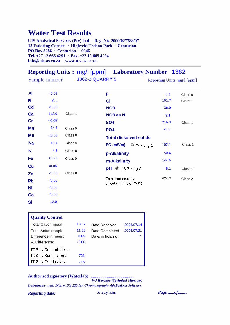
Water Test Results UIS Analytical Services (Pty) Ltd · Reg. No. 2000/027788/0713 Esdoring Corner · Highveld Techno Park · CenturionPO Box 8286 · Centurion · 0046Tel. +27 12 665 4291 · Fax. +27 12 665 [email protected] · www.uis-as.co.za
Reporting Units : mg/l [ppm]Sample number 1362-2 QUARRY 5
Difference in meq/l: -0.65
% Difference: -3.00
Total Cation meq/l: 10.57
Total Anion meq/l: 11.22
Laboratory Number 1362
Quality Control
Total Hardness by calculation (as CaCO3) 424.3
113.0
<0.05
<0.25
4.1
34.5
45.4
<0.05
<0.05
Reporting Units: mg/l [ppm]
0.1
101.7
36.0
216.3
<0.8
Date Received 2006/07/14
Date Completed 2006/07/21
7Days in holdingTDS by Determination:TDS by Summation : 728TDS by Conductivity: 715
@
18.3 deg C @
25.0deg C
102.1
<0.6
8.1
Ca
Mg
Na
K
Fe
Cu
Zn
Pb
F
Cl
NO3
NO3 as N
SO4
PO4
Total dissolved solids
EC (mS/m)
p-Alkalinity
144.5m-Alkalinity
pH
<0.05Al
Cd
Mn
<0.05
<0.05
Class 0
Class 0
Class 0
Class 0
Class 0
Class 0
Class 1 8.1
Si 12.0
Class 1
Class 0
Class 2
Class 0
Class 1
Class 1<0.05Cr
0.1B
<0.05Ni<0.05Co
Authorized signatory (Waterlab): .........................................
21 July 2006Reporting date:
Instruments used: Dionex DX 120 Ion Chromatograph with Peaknet Software
Page ......of.........
WJ Havenga (Technical Manager)

Water Test Results UIS Analytical Services (Pty) Ltd · Reg. No. 2000/027788/0713 Esdoring Corner · Highveld Techno Park · CenturionPO Box 8286 · Centurion · 0046Tel. +27 12 665 4291 · Fax. +27 12 665 [email protected] · www.uis-as.co.za
Reporting Units : mg/l [ppm]Sample number 1362-3 E2
Difference in meq/l: 0.84
% Difference: 4.95
Total Cation meq/l: 8.87
Total Anion meq/l: 8.03
Laboratory Number 1362
Quality Control
Total Hardness by calculation (as CaCO3) 409.2
93.5
<0.05
<0.25
2.8
42.7
13.9
<0.05
0.1
Reporting Units: mg/l [ppm]
0.5
71.0
3.9
51.5
<0.8
Date Received 2006/07/14
Date Completed 2006/07/21
7Days in holdingTDS by Determination:TDS by Summation : 562TDS by Conductivity: 571
@
18.5 deg C @
25.0deg C
81.5
<0.6
7.5
Ca
Mg
Na
K
Fe
Cu
Zn
Pb
F
Cl
NO3
NO3 as N
SO4
PO4
Total dissolved solids
EC (mS/m)
p-Alkalinity
264.5m-Alkalinity
pH
<0.05Al
Cd
Mn
<0.05
<0.05
Class 0
Class 0
Class 0
Class 0
Class 0
Class 0
Class 1 0.9
Si 6.5
Class 1
Class 0
Class 2
Class 0
Class 0
Class 0<0.05Cr
0.1B
<0.05Ni<0.05Co
Authorized signatory (Waterlab): .........................................
21 July 2006Reporting date:
Instruments used: Dionex DX 120 Ion Chromatograph with Peaknet Software
Page ......of.........
WJ Havenga (Technical Manager)

Water Test Results UIS Analytical Services (Pty) Ltd · Reg. No. 2000/027788/0713 Esdoring Corner · Highveld Techno Park · CenturionPO Box 8286 · Centurion · 0046Tel. +27 12 665 4291 · Fax. +27 12 665 [email protected] · www.uis-as.co.za
Reporting Units : mg/l [ppm]Sample number 1362-4 E3
Difference in meq/l: 0.61
% Difference: 3.42
Total Cation meq/l: 9.22
Total Anion meq/l: 8.61
Laboratory Number 1362
Quality Control
Total Hardness by calculation (as CaCO3) 410.3
97.2
<0.05
<0.25
2.9
40.7
21.6
<0.05
<0.05
Reporting Units: mg/l [ppm]
0.5
59.0
4.5
71.8
1.1
Date Received 2006/07/14
Date Completed 2006/07/21
7Days in holdingTDS by Determination:TDS by Summation : 604TDS by Conductivity: 587
@
18.7 deg C @
25.0deg C
83.8
<0.6
7.6
Ca
Mg
Na
K
Fe
Cu
Zn
Pb
F
Cl
NO3
NO3 as N
SO4
PO4
Total dissolved solids
EC (mS/m)
p-Alkalinity
279.0m-Alkalinity
pH
<0.05Al
Cd
Mn
<0.05
<0.05
Class 0
Class 0
Class 0
Class 0
Class 0
Class 0
Class 1 1.0
Si 9.4
Class 1
Class 0
Class 2
Class 0
Class 0
Class 0<0.05Cr
0.1B
<0.05Ni<0.05Co
Authorized signatory (Waterlab): .........................................
21 July 2006Reporting date:
Instruments used: Dionex DX 120 Ion Chromatograph with Peaknet Software
Page ......of.........
WJ Havenga (Technical Manager)

Water Test Results UIS Analytical Services (Pty) Ltd · Reg. No. 2000/027788/0713 Esdoring Corner · Highveld Techno Park · CenturionPO Box 8286 · Centurion · 0046Tel. +27 12 665 4291 · Fax. +27 12 665 [email protected] · www.uis-as.co.za
Reporting Units : mg/l [ppm]Sample number 1362-5 QUARRY 4
Difference in meq/l: -0.98
% Difference: -3.54
Total Cation meq/l: 13.36
Total Anion meq/l: 14.34
Laboratory Number 1362
Quality Control
Total Hardness by calculation (as CaCO3) 504.0
111.0
0.1
<0.25
9.5
55.1
69.5
<0.05
<0.05
Reporting Units: mg/l [ppm]
0.3
140.1
64.8
357.4
<0.8
Date Received 2006/07/14
Date Completed 2006/07/21
7Days in holdingTDS by Determination:TDS by Summation : 900TDS by Conductivity: 903
@
19.0 deg C @
25.0deg C
129.0
<0.6
8.1
Ca
Mg
Na
K
Fe
Cu
Zn
Pb
F
Cl
NO3
NO3 as N
SO4
PO4
Total dissolved solids
EC (mS/m)
p-Alkalinity
57.5m-Alkalinity
pH
<0.05Al
Cd
Mn
<0.05
<0.05
Class 0
Class 0
Class 0
Class 0
Class 0
Class 0
Class 1 14.6
Si 13.0
Class 1
Class 0
Class 2
Class 0
Class 1
Class 1<0.05Cr
0.1B
<0.05Ni<0.05Co
Authorized signatory (Waterlab): .........................................
21 July 2006Reporting date:
Instruments used: Dionex DX 120 Ion Chromatograph with Peaknet Software
Page ......of.........
WJ Havenga (Technical Manager)
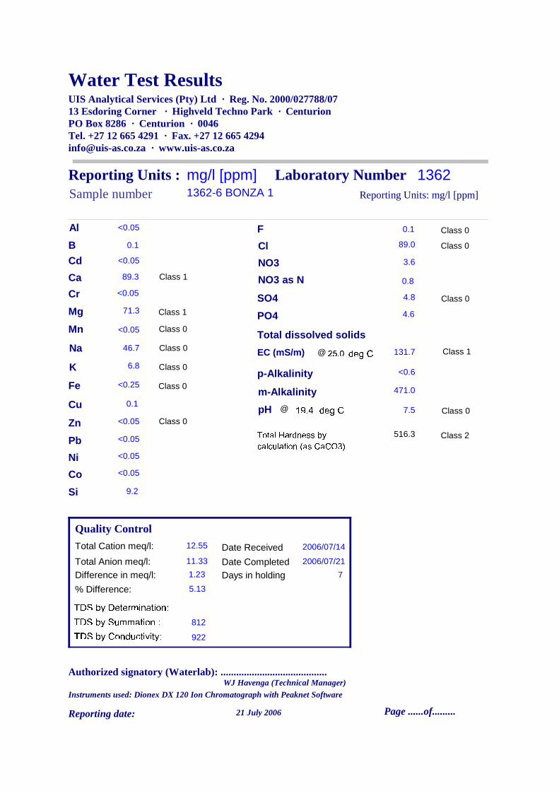
Water Test Results UIS Analytical Services (Pty) Ltd · Reg. No. 2000/027788/0713 Esdoring Corner · Highveld Techno Park · CenturionPO Box 8286 · Centurion · 0046Tel. +27 12 665 4291 · Fax. +27 12 665 [email protected] · www.uis-as.co.za
Reporting Units : mg/l [ppm]Sample number 1362-6 BONZA 1
Difference in meq/l: 1.23
% Difference: 5.13
Total Cation meq/l: 12.55
Total Anion meq/l: 11.33
Laboratory Number 1362
Quality Control
Total Hardness by calculation (as CaCO3) 516.3
89.3
0.1
<0.25
6.8
71.3
46.7
<0.05
<0.05
Reporting Units: mg/l [ppm]
0.1
89.0
3.6
4.8
4.6
Date Received 2006/07/14
Date Completed 2006/07/21
7Days in holdingTDS by Determination:TDS by Summation : 812TDS by Conductivity: 922
@
19.4 deg C @
25.0deg C
131.7
<0.6
7.5
Ca
Mg
Na
K
Fe
Cu
Zn
Pb
F
Cl
NO3
NO3 as N
SO4
PO4
Total dissolved solids
EC (mS/m)
p-Alkalinity
471.0m-Alkalinity
pH
<0.05Al
Cd
Mn
<0.05
<0.05
Class 0
Class 0
Class 0
Class 0
Class 0
Class 1
Class 1 0.8
Si 9.2
Class 1
Class 0
Class 2
Class 0
Class 0
Class 0<0.05Cr
0.1B
<0.05Ni<0.05Co
Authorized signatory (Waterlab): .........................................
21 July 2006Reporting date:
Instruments used: Dionex DX 120 Ion Chromatograph with Peaknet Software
Page ......of.........
WJ Havenga (Technical Manager)

Water Test Results UIS Analytical Services (Pty) Ltd · Reg. No. 2000/027788/0713 Esdoring Corner · Highveld Techno Park · CenturionPO Box 8286 · Centurion · 0046Tel. +27 12 665 4291 · Fax. +27 12 665 [email protected] · www.uis-as.co.za
Reporting Units : mg/l [ppm]Sample number 1362-7 BONZA 2
Difference in meq/l: -0.30
% Difference: -1.44
Total Cation meq/l: 10.35
Total Anion meq/l: 10.65
Laboratory Number 1362
Quality Control
Total Hardness by calculation (as CaCO3) 442.4
127.0
<0.05
<0.25
2.4
30.4
31.8
<0.05
1.8
Reporting Units: mg/l [ppm]
0.3
88.0
32.8
112.0
<0.8
Date Received 2006/07/14
Date Completed 2006/07/21
7Days in holdingTDS by Determination:TDS by Summation : 721TDS by Conductivity: 685
@
19.8 deg C @
25.0deg C
97.9
<0.6
7.6
Ca
Mg
Na
K
Fe
Cu
Zn
Pb
F
Cl
NO3
NO3 as N
SO4
PO4
Total dissolved solids
EC (mS/m)
p-Alkalinity
260.0m-Alkalinity
pH
<0.05Al
Cd
Mn
<0.05
<0.05
Class 0
Class 0
Class 0
Class 0
Class 0
Class 0
Class 1 7.4
Si 13.5
Class 1
Class 0
Class 2
Class 0
Class 0
Class 0<0.05Cr
0.1B
<0.05Ni<0.05Co
Authorized signatory (Waterlab): .........................................
21 July 2006Reporting date:
Instruments used: Dionex DX 120 Ion Chromatograph with Peaknet Software
Page ......of.........
WJ Havenga (Technical Manager)


