Download - Research of Vardø
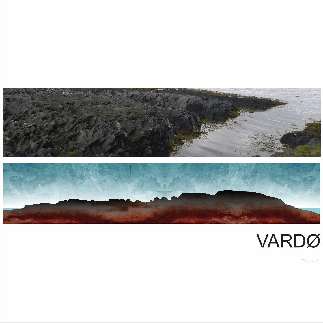
VARDØYAO ZUO

1. LOCATION
2. MY FIELD TRIP FINDINGS
- National tourist route, Architecture & Art project in Vardø
- “Biotope” and bird resources
- “KOMAFEST” street art
Conclusion 1
3. MY NEW FINGDINGS
- Land analysis
- History changing
- Climate
- Industry - Svartnes harbor
- Millitary - Globus II
Conclusion 2
CATALOG

LOCATION

LOCATION
0 10 20KM0 250 500KM
SOURCES:
- “STEDSANALYSE VARDØ”, Ragna Fagerli og Natalie Stabell Hofsli Masteroppgave, NTNU, fakultet for arkitektur og billedkunst, 2004

0 400 800M

MY FIELD TRIP FINDINGS


THE FIRST IMPRESSION OF VARDØ

NATIONAL TOURIST ROUTE - ARCHITECTURE & ART
HISTORYBIRD RESOURCESSOURCES:- Nasjonale turistveger, http://www.nasjonaleturistveger.no/en/varanger, 2013
TOURIST
0 1 5km
VARDØ
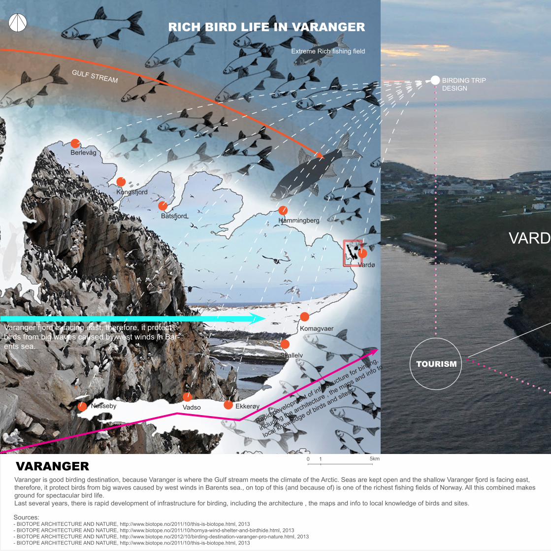
BIRDING TRIP DESIGN
TOURISM
Varanger fjord is facing east, therefore, it protect birds from big waves caused by west winds in Bar-ents sea.
Sources:- BIOTOPE ARCHITECTURE AND NATURE, http://www.biotope.no/2011/10/this-is-biotope.html, 2013- BIOTOPE ARCHITECTURE AND NATURE, http://www.biotope.no/2011/10/hornya-wind-shelter-and-birdhide.html, 2013- BIOTOPE ARCHITECTURE AND NATURE, http://www.biotope.no/2012/10/birding-destination-varanger-pro-nature.html, 2013- BIOTOPE ARCHITECTURE AND NATURE, http://www.biotope.no/2011/10/this-is-biotope.html, 2013
0 1 5km
GULF STREAM
Varanger is good birding destination, because Varanger is where the Gulf stream meets the climate of the Arctic. Seas are kept open and the shallow Varanger fjord is facing east, therefore, it protect birds from big waves caused by west winds in Barents sea., on top of this (and because of) is one of the richest fishing fields of Norway. All this combined makes ground for spectacular bird life. Last several years, there is rapid development of infrastructure for birding, including the architecture , the maps and info to local knowledge of birds and sites.
Extreme Rich fishing field
Berlevåg
Kongsfjord
BatsfjordHammingberg
Vardø
Komagvaer
Skallelv
EkkerøyVadsoNesseby
RICH BIRD LIFE IN VARANGER
VARANGER
Rapid development of infrastructure for birding,
including the architecture , the maps and info to
local knowledge of birds and sites.

VARDØ
GULLFEST - BIRD EVENT
HORNØYA
BIOTOPE
LOCAL RESIDENTS
LOCAL BUSINESS
NATIONAL TOURIST ROUTE
Biotope is architectural office with special expertise on birds and birdwatching. The office locates in Vardø. The office deal with the project about building public architecture for peo-ple birding. It create the tourism possibility from birding. They did a lot of research about Varanger birds, and provide birding information which is include map, birds knowledge.Biotope organized Gullfest (bird festival) which start from April 2012.After one birdhide build in Vardø, it became a part of National tourist route project in Varanger. Biotope is also have a good way to connect local business. The local fishing industry and accommodation facilities is also include in their birding trip introduction to visitors. The number of guest is increasing in NORDPOL KRO Hotel which is local hotel. Biotope informed and “educated” the local people about how special the Varanger peninsula is for birders. This have created a local pride for the local fauna and the locals have a greater knowledge to shear with people visiting Vardø.
Because birds is include in locals daily life, Locals have not been aware about how distinctive the local bird life is at a global scale.
Biotope informed and “educated” the local people about how special the Varanger peninsula is for birders. This have created a local pride for the local fauna and the locals have a greater knowledge to shear with people visiting Vardø.
The project from Biotope often include local businesses,such as fishing, hotel.
Biotope is architectural of-fice with special expertise on birds and birdwatching.
Gullfest is a bird festival organized by Biotope form April. 2012. They invite people form worldwide to make exhibi-tion, talk and trip for birds.
10 min by boat

VARDØ
BIRDING TRIP DESIGN
TOURISM
FISH HUNTING
HORNØYA
Sources:- “FOLKE-OG BOLIGTELLING 1. NOVEMBER 1970 2002 VARDØ”, STATISTISK SENTRALBYRÅ, OSLO, NORWAY- Nordic Centre for Spatial Development, http://www.nordregio.se/en/Metameny/About-Nordregio/Journal-of-Nordregio/2008/Journal-of-Nordregio-no-3-2008/Uncertainty-in-the-High-North/, 2013- EUROPAN 10 VARDØ_NORWAY, Europan Norway
The bird cliffs of Hornøya outside Vardø in Varanger is a fan-tastic place. This is home to 150 000 birds, of a wide variety of species. It is one of Varanger’s most popular places to visit for birders and bird photographers. Sand Eels, Capelin, and Herring constitute the main diet of nearly all the seabird species seen on the islands. Gulls and Kittiwakes also take advantage of fish waste from trawlers and the fishing port of Vardø. The manuring effect of this is evident in the lush growth of scurvy-grass and sorrel. The gull colony on the two islands is one of the largest in Europe and numbers 40-50 000pairs. Alcids are an essential part of the bird cliffs, with 5-10 000 pairs of Puffin, 3-3500 pairs of guillemosts, 500 pairs of Razorbills and 3-400 pairs of the Arctic(Brünichs) Guillemot. Numerous other species also breed or visit the islands.
NORDPOL KRO HOTEL
Increasing number of guest

VARDØ
NORDPOL KRO HOTEL
FISH HUNTING
LIGHT HOUSE ACCOMMODATION
LIGHT HOUSE ACCOMMODATION
Hornøya is visited very year by roughly 3000 birdwatchers and photographers, and this number is increasing.
HORNØYA
LOCAL BUSINESS
About 150 000 birds in Hornøya
2128 people live in Vardø
2200m
LOCAL RESIDENTS
GULLFEST - BIRD EVENT
0 10 100m
10 min by boat

MAPPING EXISTING ART PROJECT
RESOURCES
RESTORING SITE
INDUSTRY
HISTORY
HOUSE HERITAGE
RECREATION
EDUCATION
KOMAFEST-STREET ART
HIGH LIGHT ABANDONDED HOUSES TELL THE HISTORICAL STORY ABOUT CITY
RESTORE DEAD SITE SHOW CITY ATTRACTION
A street art festival curated by the Norwegian artist Pøbel. The idea behind the project is give attention to the de-population of Northern Norway, and make something worn out beautiful and interesting; to give attention to remote areas and prove to the youth that everything doesn’t have to happen in the big cities.Locals really like this project, and started to proud of their land.Mayor of Vardø :
Lasse Hauhome

NOW
FUTURE
ART
LANDSCAPE ARCHITECTURE STRATEGY ?
THE ROLE OF ART
ARCHITECTURE
STEILNESET MEMORIAL
BIRDING
artist Louise Bourgeois & architect Peter Zumthor - history of witch-hunts
TOURISM
architecture office “Biotope” - bird resources
STREET PAINTING
KOMAFEST
PRESERVATION ABANDOND BUILDING
artist Pøbel - “ mapping” ruins
QUESTION 1. To what degree can or should art be part of an overall landscape strategy for the island?
SOURCES:- KOMAFEST, http://www.komafest.com/p/komafest-2011.html, 2013- Finnmark DAGBLAD, http://www.finnmarkdagblad.no/finnmarken/lokale_nyheter/arti-cle6164378.ece, 2013

MY NEW FINDINGS


SOURCES:- EUROPAN 10 VARDØ_NORWAY, Europan Norway
1. Rescue boat
2. “Dampskipkaia”
3. Refinement of fish at Vardø upper sec school
5
1
2
3 5
4
56
55
Natural shoreline with slatestone Filled up area
Stone wall Wooden wharf
Building on poles
Concrete / Wall
Natural shoreline with sand
Shoreline4. Private harbour
5. Boathouse
6. Crabs
Land Analysis
Main route
Main roadsAccess by boat

0 100 500m
Land UsePublic buildings
Commercial use
Industry/production
Dwellings
Nature
Mixed use, dwellings and commercial use
Green SpaceSmall amount of green belt Green belt including rock and shore line
Park area/ churchyard/ playground/ sports facilities/ public building with a lawnn
Housing areas and other buildings with gardens

FORTRESS
UNPLANNED AREA
The section is two times on elevation0 100 500m
0 50 100m
QUESTION 2. How to built better connections between residential area and recreation area for leading tourists and locals to touch and use this unplanned area?
4800m
2900m
Recreation area
The west-north part of island is the recreation area. Locals use this area for barbecue in summer and ski in winter. There is also the place for dry fish. We can see some infrustractures on the ground. Huge rock caused uneven terrain around the costal line, different specises grow up there, creat special nature landscape in this area.
BERGEN

Hurtigrute - the coastal steamer docks in Vardø, 3 km from Svartnes HarbourIt departs daily from south to Bergen and east to Kirkenes.
FORTRESS BIRD HIDE
HIGH SCHOOL
URBAN AREA
01 - Leitstand (Typ Hovde/Hoö)02 - OB für 10,5 cm K 331 (f)03 - Tobruk04 - Tobruk05 - Felshohlbau (3 Ebenen)06 - gesprenger Vf Unterstand07 - 2 * OB Flak08 - HWB Garage
Vardö-Renösund
(4 *10,5 cm K331(f) guns/range 12 000 m
Formed in July 1941, blown up in late 1944)
The coastal defense was built by Germany in WWII to against Russia. It left on the west-north part of island in Vardø.
SOURCES:- http://www.atlantikwall-research-norway.de/HKB_Vard%F6_Ren%F6ysund.html, Jan.2014
KIRKENES

The
first
fortr
ess
was
ere
cted
by
Haa
kon
V M
agnu
sson
in 1
306
and
was
cal
led
Varg
høya
.
Vard
ø ha
d de
velo
ped
into
a tr
adin
g ce
ntre
an
d an
impo
rtant
par
t of t
he P
omor
trad
e ne
twor
k be
twee
n R
ussi
a an
d N
orth
ern
Nor
way
.
The
rich
fishi
ng s
tock
s in
the
surr
ound
ing
sea
are
the
mai
n re
ason
for t
he to
wn’
s ex
-is
tenc
e. T
race
s of
set
tlem
ent f
rom
6,0
00
– 7,
000
B.C
. hav
e be
en fo
und.
Vard
ø es
tabl
ishe
d as
a m
unic
ipal
ity.
6,000 – 7,000 B.C. 17001306 1838
19051700
HISTORY
Man
y bu
ildin
gs h
ad b
een
dest
roye
d du
r-in
g W
WII
, One
third
of t
he b
uild
ings
wer
e le
ft in
tact
afte
r the
bom
bing
s. F
ew b
uild
-in
gs fr
om b
efor
e S
econ
d W
orld
War
are
pr
eser
ved
in th
e re
st o
f the
cou
nty.
From
map
, we
foun
d ci
ty d
evel
oped
com
-pa
red
with
ear
lier m
ap.
19441905
1944
SOURCES:
- Forsvarsbygg, http://www.verneplaner.no/?f=vardohus&id=106871&a=3, 2013- WIKIMEDIA COMMONS, http://commons.wikimedia.org/wiki/File:Vardø_map_1905.jpg, 2013
© Grenselandmuseet

Vardø was connected to the mainland by Norway’s first underwater tunnel, more than three kilometres long. The population about half of which is of Finnish decent had risen to 2600 by the turn of the twentieth century.
1970, the number of population is one of the highest point in the Vardø history.
SOURCES:
- “FOLKE-OG BOLIGTELLING 1. NOVEMBER 1970 2002 VARDØ”, STATISTISK SENTRALBYRÅ, OSLO, NORWAY- Nordic Centre for Spatial Development, http://www.nordregio.se/en/Metameny/About-Nordregio/Journal-of-Nordregio/2008/Journal-of-Nordregio-no-3-2008/Uncertain-ty-in-the-High-North/, 2013- EUROPAN 10 VARDØ_NORWAY, Europan Norway
1970 1982 1990
Work Distribution in 1970
Population 4187
Main Jobs in 2012
Population 2122
1000
2000
3000
4000
50004187
35343008
Empty buildings
Service Industry
Transport and Communication
Retirement and social security
Other
IndustryFishing and Whaling610897
879
329 724
648
Public sectorThe municipality is the main employer in Vardø(about 50% employees). As a part of Norwegian decentralization policy, the State Compensation Office is located in Vardø.
FishingFish used to be the main industry in Vardø, but today you hardly see any larger fish boats in the harbour and there is almost no industry left. However, fish together with public sector still remain the dominant activity in the municipality.
Military and monitoringMilitary presence has continued in Vardø(60 employees), but after the cold war the amount of Norwegian military personnel has been re-duced to a minimum. Today there is no military presence at the old fortress.
State-Based Institution The city have various state based institution, like the Norwegian Coastal Administration, the Nor-wegian Armed Forces, the Norwegian Criminal Injuries Compensation Authority Service for Vic-tims of Crime and the Police Certificate Office. The Norwegian Criminal Injuries Com-pensation Authority Service for Victims of Crime and the Police Certificate Office do have about 75 employees and many of them are lawyers.
Fishing and Industry accounts for a big amount of them.

HISTORY
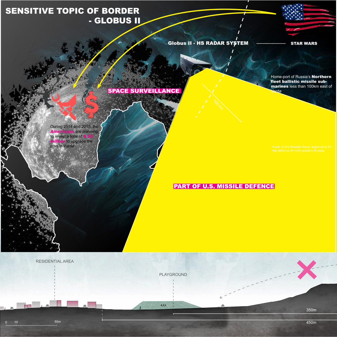
US radar system installed.Officially the US has claimed that the purpose of the radar station is to track space debris. Most peo-ple, however, see it as a spy-sys-tem focused on Russia.
“It is ironic particularly in light of the fact that there was a brand new 100 million NOK opened here in 2003, only for it to be closed 12 months later.” ----Thor Robertsen
Depopulation is over.1998 2003
21222128
2012 2013
FISHERY INDUSTRY
15 years ago Vardø had 14 fishing factories, today it only has two.
29132496
As the fishing industry disappeared, buildings were left empty or changed use.
14 2
0 50 300m
Empty buildings Decreased working placeWorking places at earlier time
Working places today

SOURCES:- EUROPAN 10 VARDØ_NORWAY, Europan Norway
CENTRAL PART OF CITY
0 10 50m
SECTION 1
SECTION 2
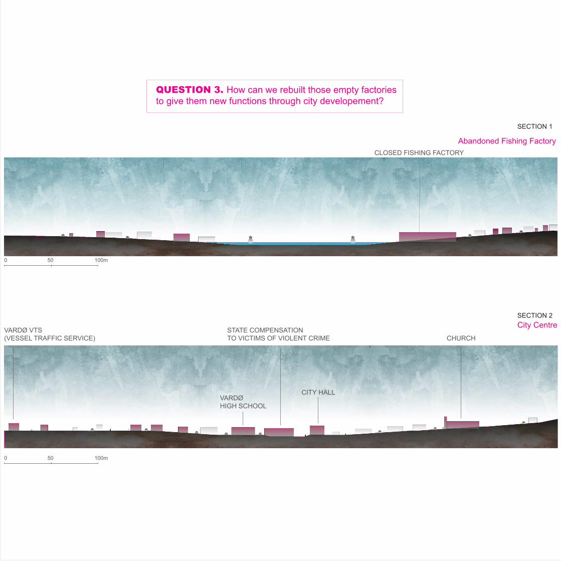
City Centre
Abandoned Fishing Factory
CHURCH
CLOSED FISHING FACTORY
CITY HALL
STATE COMPENSATION TO VICTIMS OF VIOLENT CRIME
VARDØ HIGH SCHOOL
VARDØ VTS(VESSEL TRAFFIC SERVICE)
0 50 100m
0 50 100m
QUESTION 3. How can we rebuilt those empty factories to give them new functions through city developement?
SECTION 1
SECTION 2

January February March AprilAverage Wind speed: 17 kts
May June July August SeptemberAverage Wind speed: 12 kts
October November December Average Wind speed: 16 kts
Wind Direction©windfinder.com
WINTER WINDSUMMER WIND
SUMMER WIND
Vardø is Norway’s only town in the Arctic climate zone. This means that the average temperature per month never climbs above ten degrees. Understandably this has consequences for Vardø’s vegetation and wildlife. Vardø’s only tree died some years ago.Vardø is extremely exposed to wind. Vardø has the stormiest days in Norway. The wind is especially strong on Valen and Strandgata where the streetscape works as an icy wind tunnel. Predominant wind is from the southwest in winter and northwest of the summer.A large tidal range occurs generally on the shores of continents, Vardø is a island but really close to mainland, so, the tidal range is quite large in Vardø, The highest water level at Vardø reached 3.2m.From 23 November to 21 January the sun disappears under the horizon and from 16 May to 29 July is the midnight sun present.
“In winter, sea waves can reach-es 2-3m high, punch the shore, it caused big damage for foundation of this old fishing factory.”Said by Ruamus .His job is restoring old building in Vardø
2-3m
0 400 800m
Climate in Vardø

1975 , 201220
10
0
-10
-20
Annual: 1.1°C(1975) 2.4°C(2012)
Histograms of the mean sea wave height (m) from model simulations for Barents Sea for three decades: 1990-1999, 2040-2049 and 2090-2099.
Global warming cause increasing dangerous storm events and associated wave activity. In Barents sea, the frequency of very high (more than 5 meters) waves model simulations show a growth of activity in the middle and end of 21st century.Despite very small frequency of extremely high sea waves, these waves are especially dangerous for shipping and offshore construction.
Frequency
Height
SOURCES:
- “EUROPAN 10 VARDØ_NORWAY”, Europan Norway- WINDFINDER, http://www.windfinder.com/windstats/windstatistic_vardo_lufthavn_svartnes.htm, 2013 - “The Vardø Vessel Traffic Service – For increased safety at sea”, NOR VTS, http://www.kystverket.no/Docu-ments/Om%20Kystverket/Brosjyrer/VardøVTSbrosjyre_EN_HR.pdf-“Climate change in Arctic and sea wave activity in the 21st century from model simulations” V.C.Khon, I.I. Mok-hov, F.A. Pogarsky A.M. Obukhov Institute of Atmospheric Physics RAS, Moscow, Russia
Global Warming
Unsafe shippingand offshore construction
Increasing wave activity
The Vardø Vessel Traffic Service The Vardø Vessel Traffic Service is NCA(NORWEGIAN COASTAL ADMINISTRATION)’s new maritime service for Norway.
With a 24 hour monitoring of the sea traffic from the Swedish border in the south to the Russian border. In addition to Svalbard and Jan Mayen. Swedish aviation company Saab has invested in Vardø. Saab is planning to develop Vardø into the centre for ocean security in the Barents Sea area.
Norwegian Monitoring border of sea traffic

E75Oil Spill Preparedness Deep Water Port
Bussesundet
Crew Transfer Service
TUNNEL - THE ONLY ONE CONNECTION BETWEEN INDUSTRY AREA AND LIVING AREA.
Quay
Supply Base
Pipe Storage
Local Airport, situated 800 metres from harbour
E 75, 300 metres from harbour, European route E 75 is part of the International E-road network
194m Quay
The section is 5 times on elevation
0 10 50m
SECTION
Disconnection 1. Oil and gas as most valuable nature resources in Barents sea for future Norway and Russia, more and more drill-ing happens, the Svartnes harbor became a potential oil and gas offshore supply base. Only 540km distance to Shtokman Field make Vardø became closest harbor compare with other harbors in both Norway and Russia. Vardø Barents base AS said Svartnes harbor is ideal geographic location for performing offshore activities.
But if we change the view to see this city, we can find those plans are not good connections to locals there. Firstly, the education in Vardø is not include oil, gas and marine service knowledge. So, how can people work in those new industries? Secondly, the harbor are used as Transfer Service now, when crews came to harbor, they have to walk through the tunnel which is only for car but only geologically connection with Vardø island to get recreation service ( eating and drinkings) there.
Svartnes harbor, as a potential economy part for Vardø, needs to establish better connection with island.
QUESTION 4 - 1. How to establish better connection for locals and visiting sailors?
9m6m
Svartnes Site
The Svartnes site is an industrial area with a large storage capacity. The site is situated on the mainland approx. 3 km from the centre of Vardø and is the new fishing and industri-al harbour for the municipality. Large sums of money have been invested in the develop-ment of this site.
Barents Base controls an area amounting to 7.5 acres. The total industrial area amounts to 37.5 acres. The entire area is easily ac-cessible and suitable for outdoor storage. An additional area of around 1000 acres or more is presently available but as yet undeveloped.
The quay measures 194 metres in length and has a marked approach which is 9 metres in depth. Water, electricity and a crane are available on the quay.
Coast Centre Base AS (CCB) owns 50% of the Vardø Barents Base AS. The remaining 50% is owned equally by Bjørn Dæhlie and Vivian Lorentzen.
Aarsæther Vardø AS - Stagnant fishing factory

E75
E6
E75
E75
SOURCES:
- TU Petroleum, http://www.tu.no/petroleum/2013/10/16/slik-kan-barentshavet-se-ut-i-2030, 2013- BARENTS BASE, http://www.barentsbase.as/index.php?lang=eng&id=3, 2013- BARENTS BASE, http://www.barentsbase.as/index.php?lang=eng&id=12, 2013- https://www.facebook.com/vardobarentsbase, 2013- “GEO-INVESTIGATIONS AND ADVANCED TUNNEL EXCAVATION TECHNTQUE IMPOR-TANT FOR THE VARDØ SUBSEA ROAD TUNNEL”,AriId PalmstrØm and Ingeniør A.B.BerdaI A/S, 1984
Sweden
Norway
FinlandRussia
Kirkenes
Goliat
Snøhvit
Murmansk
Teriberka
Shtokman Field
Vardø
Arkhangelsk
Shtokman field 540 km
Goliat 755 km
Snøhvit 792 km
Vardø 540 km
Teriberka 560 km
Murmansk 590km
Kirkenes 610 km
Arkhangelsk 960 km
17.3m 5m
40m
88m
Ideal Geographic location for Performing Offshore Activities
- Easternmost harbour in Norway- Closest harbour to Shtokman in both Norway and Russia- The harbour is ice-free all year
0 10 50m
350m
PLAYGROUND
RESIDENTIAL AREA
450m0 10 50m
QUESTION 4. How to use landscape to built new connection between residential area and military area?
During 2014 and 2015 the American are plan-ning to invest a total of $ 50 milli Red Banner Northern Fleet
Major Military Bases
During 2014 and 2015, the Americans are planning to invest a total of $ 50 million to upgrade the plan in Vardø.
100 km
Globus II - HS RADAR SYSTEM
SPACE SURVEILLANCE
PART OF U.S. MISSILE DEFENCE
Home-port of Russia’s Northern fleet ballistic missile sub-marines less than 100km east of Vardø
A unit of the Russian Navy responsible for the defence of north-western Russia.
STAR WARS
SENSITIVE TOPIC OF BORDER - GLOBUS II

SOURCES:- BARENTS OBSERVER, http://barentsobserver.com/en/security/2013/02/us-spends-50-million-vardo-radar-upgrade-27-02 , 2013- BARENTS OBSERVER, http://barentsobserver.com/en/security/claims-vardo-radar-can-be-used-missile-de-fence-system, 2013- A GLOBUS II / HAVE STARE SOURCEBOOK Version of 2013-09-20, http://www.fas.org/spp/military/program/track/globusII.pdf, 2013
QUESTION 4 - 2. How to establish better connection for locals and military area?
-In 1995, Norwegian and U.S. government agreed to move Radar to Vardø from Vanden-berg Air Force Base, California.
-Norwegian Government claims that the Globus II radar’s mission is track, catalogue and identify space debris. Globus II is under Norwegian control and is operated by Nor-wegians. But owned by U.S. -Russian think that radar could be integrated into the NMD(National Missile Defence) network to provide early warning of SLBM(Satellite Launched Ballistic Missile) launches from Russian ports or the Barents Sea. In 2000, a Russian general claimed that Vardø was becoming a nuclear target. Cooperation between Norway and Russia weakened by the fuss around Globus II radar in Vardø, says Ragnar Bratland, Norwegian defence attaché in Moscow.
Globus II
GLOBUS II
Disconnection 2. The conflict of Radar(Globus II) caused relationship between Russia and Norway became sensitive. This huge “white ball” stand on the top of east hill, people can see it from far distance of city, it looks like land mark of Vardø and locates only 450 meters from residential area.
The fence has been set at foot of the slope to avoid people get into Radar area. The attitude of locals to Globus II is really negative, people worried about this Radar will bring political trouble for their land. In such a small island, Radar, as an important political role of Norway, need to be established better connec-tion with locals. Because people is most important support for city development, but not benefit of country. And for those people who lives there, city is more direct and tight connecting with them.

RECREATION
RESIDENTIAL AREA
BUSINESS CENTRETRANSPORTATION CENTRE
POLICY- radar - Globus ii
PUBLIC SECTOR-marine sercurity centre
INDUSTRY AREA-oil& gas offshore supply
Too much activities and different identities around the city
The area between residential area and policy is important transition area to remit the conflict between locals and milirary in the city.
The area between industry and island need more transportation conncections for future locak work-ers.
The area between residen-tial area and recreation need more conncetions for leading tourists and locals to touch and use unplaned nature recreation area.
OVERALL ANALYSIS

QUESTION 5. How to make an island connected with itself and mainland harbor?
The city seems to be too small to handle all the different activities that goes on, and the identities that are built around them.
From historical point, almost all the Finnmark has been burned during the WW II by Germany. Vardø is one of two city that hav-en’t totally been burned (other one is vadsø). One third buildings survived and have been kept until now, it became the precious historical culture for city. Vardø was very important promo center for transporting goods between Russia and Norway in 1930s. Lots of fisherman, crews, businessman were going to and from the Vardø, it was prosperity land, the population was more than 4000 in 1970s which is highest point during history. The city had strong identity by fishing village in the old time, but fishing age has gone as time goes by, locals moved out, depopulation continued in last 8 decades, Half of people left their land, and rest of them became disappoint to their city. Vast of abandon fishing factories around harbor and empty houses in the city.
Now, Vardø as most northeast in Norway, stands on a very important location on industry, transportation and politics. Firstly, Oil and gas as most valuable nature resources in Barents sea for future Norway and Russia, more and more drilling happens, the Svartnes harbor(in the mainland of Vardø) became a potential oil and gas offshore supply base. Secondly, Norwegian coastal administration set up new maritime service for Norway in Vardø which named Vardø Traffic Service. It has 24 hours monitoring of the sea traffic from the Swedish border in the south to the Russian border, in addition to Svalbard and Jan Mayen. Swedish aviation company Saab has invested in Vardø. Saab is planning to develop Vardø into the centre for ocean security in the Barents Sea area. Lastly, Globus II stand on an important position for country no matter for tracing space debris or Missile defence systerm.
All of this plans which already happened or will happen explained that Vardø locates in a important site for Norway, but Vardø just a super small island which is only 1.27 km2 and isolate on the sea, how to set all of those strong and important activities in an res-onalbe plan? The island is home for more than two thousands people living, this is most important and nature definition for island rather than any others. If we change the view to see this city, we can see some inherent problems happened in the city. The educa-tion in Vardø is not include oil, gas and marine service knowledge. So, how can people work in those new industries? And also the attitude of locals to Globus II is really negative, people worried about this Radar will bring political trouble for their land. How to deal with those gap in city?
Now, it is important to make a landscpae strategy to try reconcile all the activities.


![Benefits of biomedical research [Read-Only] of Biomedica... · Benefits of biomedical research Analyze biomedical research. Analyze the benefits of biomedical research. BCT (2005)](https://cdn.vdocument.in/doc/165x107/5be8550b09d3f25b278b4ae5/benefits-of-biomedical-research-read-only-of-biomedica-benefits-of-biomedical.jpg)


