
DEPARTMENT OF THE INTERIOR U.S. GEOLOGICAL SURVEY
REVIEW OF GEOTECHNICAL ASPECTS OF THE JORDANELLEDAMSITE, HEBER, UTAH
By
U.S. Geological Survey
Open-File Report 91-398
Prepared at the request of the Utah Congressional Delegation
This report is preliminary and has not been reviewed for conformity with U.S. Geological Survey editorial standards and stratigraphic nomenclature
U.S. Geological Survey Reston, Virginia
1991

EXECUTIVE SUMMARY
Jordaneile Dam is currently being constructed on the Provo River near the town of Heber, Utah, by the U.S.
Bureau of Reclamation (USER). The construction project has been the focus of criticism from a variety of
individuals and groups. Much of the criticism has been directed toward the long-term integrity of the embankment
and appurtenances. In late March of 1991, the Utah Congressional Delegation asked the U.S. Geological Survey
(USGS) to conduct an independent review of the geology and geotechnics of the Jordaneile damsite with specific
reference to the adequacy of the USBR's investigation and conclusions. The scope of our investigation was thus
limited to earth science issues. We did not attempt to develop any new inform-ation, except that we conducted two
site visits, and different members of the review panel examined aerial photographs, maps, and exposed geologic
features at the damsite. This report summarizes our findings.
The USGS review panel (hereafter referred to as the Panel) had access to all pertinent documents of the USBR
including internal reports and reports of their consultants. We received recent geologic maps of the foundation and
abutments, former and current planning documents, and several reports by former independent consulting groups; a
list of documents reviewed is included with our report. Members of the Panel accom-panied the current independent
Engineering and Architect's Consulting Group (Ralph Peck, Walter Arabasz, and Douglas Campbell; hereafter
referred to as the Consulting Group) on a site visit in August and were able to question them about certain aspects of
the dam's construction and site characteristics, as well as hear them discuss current safety issues. The Panel had the
cooperation of the USBR, both from personnel at the Provo Construction Office and at the Engineering and Research
Center in Denver. The Panel solicited comments from a number of recent opponents of construction of the
Jordaneile Dam and were provided copies of corres-pondence and unpublished information relating to perceived safety
problems at Jordaneile.
Following a preliminary review of the information, the Panel developed a list of questions that seemed to
embody the principal safety concerns of all parties. The questions and responses follow. Technical findings, on
which our responses are based, are presented in the body of this report.
Are there major active faults beneath or adjacent to Jordanelle Dam that might rupture to the
surface and threaten the integrity of the dam?
The nearest major fault, the Cottonwood fault, is shown on published geologic maps as an east-trending reverse
fault that displaces Tertiary and older rocks directly west of the damsite. Despite suggestions that the Cottonwood is
an active fault that extends across the damsite, we find no definitive evidence that the fault is either young or crosses
the damsite as a coherent recognizable geologic structure. The major displacement on the Cottonwood fault clearly
predates intrusion of the Oligocene (26-38 million years old) andesite porphyry that makes up most of the dam's
foundation.
Characterizations of the Cottonwood fault as an "active fault" are not supported by the scientific data acquired
during the several years of research that have focused on this specific question, or by information supplied by
opponents of the dam. No stratigraphic evidence indicative of young (Holocene or late Pleist-ocene) fault
movement specifically, geomorphic expression of faulting, faulted surficial deposits, or a stratigraphic record of
faulting were found on faults in the foundation or abutments of Jordanelle Dam, or in numerous exposures adjacent
to the west abutment We agree with the USBR's conclusion that movement on faults in the west abutment
occurred before the late Pleistocene (> 130,000 years ago), and probably is much older than that In addition, the
possibility of hidden traces of an active fault beneath flood-plain deposits of the Provo River seems remote.
Quaternary movement has been documented on the 2-mi- (3-km-) long Bald Mountain fault, but this fault is
unlikely to cause surface displacement Evidence that this fault has been active before the late Pleistocene (> 130,000
years ago) is found in only one of three trenches. If movement were to occur on the Bald Mountain fault rupturing
would probably be confined to the postulated trace of the fault, well upslope and northwest of the west abutment
Although several faults in the valleys of the Wasatch Range produced surface offset during the Quater-nary, they
pose no surface-rupturing threat to the dam but could produce seismic shaking at the damsite. The nearest suspected
active faults are those in Round Valley, 12 mi (20 km) south of Jordanelle have produced surface ruptures in the past
130,000 years. In addition, the Wasatch fault zone has produced earthquakes as close as 19 mi (30 km) from the
damsite.
11

Are there hidden geologic structures (faults) that may control the buried channel of the Provo
River?
The USBR studies revealed a sediment-filled channel of the Provo River that lies beneath the damsite. The
hypothesis that the position of this channel is controlled by a north-south-trending fault is without scientific merit
Exposed and cleaned bedrock surfaces display structural continuity, thus proving that the postulated fault does not
exist.
Are there other geologic structures in the dam's foundation or abutments that pose a threat to
the dam?
There is strong evidence that the andesite porphyry was intruded across the Cottonwood fault in Oligocene time
(26-38 million years ago). After solidification, there was renewed faulting, possibly including renewed movement
on the Cottonwood fault The andesite porphyry along the projection of the Cottonwood fault was cut by many
faults, thus forming a complex intersecting mosaic pattern. These post-intrusive faults are conspicuously
discontinuous as revealed by detailed mapping and closely spaced drill holes. These faults served as channeiways for
migration of hydrothermal fluids during the episode of igneous activity in the Oligocene. However, the absence of a
well developed shear fabric in these altered rocks suggests little, if any, displacement on most of the faults since
Oligocene time. On the basis of the well documented discon-tinuous nature of the post-intrusive faults and indirect
evidence that the faults are old (Oligocene), the Panel concludes that no faults with major young displacements can
be projected through the foundation of the dam.
Exceptions to the predominantly Oligocene faulting are found in the west abutment where steeply and gently
dipping faults with generally north-northwest strikes show evidence of post-alteration displacement These faults are
also discontinuous within the area of the abutment They are currently being mapped by the USBR. Although the
timing of movement on these faults cannot be constrained any closer than Oligocene or younger from evidence noted
in the exposures of the foundation rock, none of them appear to be associated with faulting at the surface as shown
by trenching and pre-excavation USBR aerial photography. The Panel does not consider these faults to be a seismic
threat to the dam because there is no direct evidence that they are continuous with major faults that have been active
recently.
111
Are there landslides that could compromise the integrity of the dam?
There is no evidence of recent (Holocene) landsliding in the foundation of Jordanelle Dam, and there is no
substantive evidence to indicate potential for landsliding that would damage the dam. Rocks that lie above low-angle
slip surfaces in the north side of the west abutment will be almost entirely buttressed by the embankment, thereby
preventing any possibility of failure into the reservoir.
Although minor landslide activity along the shoreline of Jordanelle Reservoir is to be expected during reservoir
filling and during post-filling fluctuations of reservoir level, there is no indication that any of the slides will be large
enough or of high-enough velocity to form waves that could overtop or damage the dam.
Continued landslide activity downstream from the dam could result from periods of heavy precipitation in the
future. The only structure related to the Jordanelle damsite in this area is the emergency spillway. Because the
spillway is covered, it is not likely to be damaged by shallow landslides. If damaged by deeper landslides, it could be
repaired without affecting the integrity of the dam itself.
Do the quality, alteration, or permeability of rock in the dam's foundation present a concern
for construction of a safe dam?
From an engineering standpoint, bedrock in the dam's foundation has not been significantly weakened by
faulting, nor by hydrothermal alteration. The clayey alteration products resulting from the Oligocene-age
hydrothermal alteration have tended to make former hydrothermal channelways less permeable than the unaltered
rock. Except for localized and seemingly random zones of joint intersections and concentrations of joints, the small
amounts of grout pumped into holes that penetrate the foundation at least 100 ft (33 m) support the general
perception that the foundation rock has a low permeability or seepage rate. This charac-teristic is confirmed by the
extremely low seepage rates observed in the deep part of the excavation into the buried river channel. If any through-
going flow channels still exist, access to them by impounded waters will be effectively reduced by the grout curtains,
blankets, and keels.
IV

Has the Bureau of Reclamation adequately estimated the earthquake potential at the damsite
and used appropriate earthquake design criteria?
USBR seismotectonic investigations suggest three different scenarios for earthquakes that may affect the
Jordanelle damsite. Although these earthquakes are unlikely (they have inferred repeat times of 2,000 to more than
50,000 years), the USBR used a conservative approach in their design, which allows the occurrence of these
earthquakes during the life-span of the dam. A conservative approach is appropriate for a structure such as a dam
whose failure may have serious consequences. Seismotectonic data obtained since 1988 do not alter USBR estimates
of the maximum credible earthquake that could affect the damsite.
The USBR used two of the design earthquakes to represent the earthquake potential of the damsite, a magnitude
7.5 earthquake on the Wasatch fault 19 mi (30) km distant and a magnitude 6.0-6.5 earthquake in the immediate
vicinity of the damsite. We consider magnitude 6.5 appropriate for the local earthquake and magnitude 7.5
appropriate for the Wastach fault To represent the ground motion from these design earth-quakes, the USBR used
three records of simulated motions. The first two records were intended to represent a local magnitude 6.5 and the
third to represent a magnitude 7.5 on the Wasatch fault at a distance of 19 mi (30 km). The Panel is not entirely
satisfied with the second record, but we believe that the first and third records taken together provide an appropriate
basis for design. The USBR used these records to calculate the effects of the two earthquakes on the dam.
Evaluation of the calculations is a matter of engineering judgment that the Panel is not prepared to undertake, but we
note the the calculations, based on assumed strength values that the USBR considers conservative, indicate that the
dam design is safe.
Evaluation of the earthquake safety of the dam must include consideration of the potential of earthquakes of
magnitude up to 6.5 that are induced by the impoundment of water in the reservoir. The ground-shaking hazard from
such earthquakes does not need special consideration because there is no reason to expect that the shaking would
exceed that represented by the design ground-motion records described above. However, an argument can be made
that fault rupture in an induced earthquake might exceed the 6-in (15-cm) upper limit given by the USBR. The most
recent Consulting Group has assured us that the dam, as designed, can safely accommodate rupture displacements as
large as 20 in (50 cm), which, in our opinion, are as large as need be considered.
CONCLUSIONS
The U.S. Geological Survey Panel has found no safety concerns relating to geologic or seismologic issues that
remain to be resolved at the Jordanelie damsite. The near-complete exposure of the foundation rock, an effort which
is unprecedented for a damsite such as Jordanelie, has provided an excellent base for the USBR comprehensive and
detailed mapping of the foundation exposures and has allowed them to integrate extensive subsurface drill-hole data
with surface geology. We have reviewed the USBR investigations at the Jordanelie damsite with reference to
perported hazards from active faulting, leaky and crumbly foundation rock, land-sliding, embankment failure due to
ground shaking from earthquakes, and induced seismicity each of which are important considerations in the design
and construction of a critical facility. The Panel is satisfied that the USBR has fully demonstrated that these issues
do not constitute a bonafide threat to the dam.
VI
BACKGROUND INFORMATION
The Bureau of Reclamation (USBR) is currently (September 1991) constructing a large earth-fill dam on the
upper reaches of the Provo River, near Heber, Utah. This dam is named for the small community of Jordanelle,
which was located at a narrow section of the valley about 6 mi (10 km) upstream (north) of Heber. According to
recent USBR literature, the Jordanelle Dam will rise about 300 ft (93 m) above the valley floor and span a width of
about 3,700 ft (1,130 m) at its crest Its accompanying reservoir will maintain an active pool of about 320,000
acre-feet (25,900 ha-m) of water that is part of the USSR's Central Utah Project In recent years opposition to the
construction of Jordanelle Dam and Reservoir has come from local citizens and from a small group of scientists.
REVIEW PROCESS
The Utah Congressional Delegation requested that the U.S. Geological Survey (USGS) conduct an independent
review of the USBR's Jordanelle damsite during the summer of 1991. The primary charge to our review panel
(hereafter referred to as the Panel) was to determine whether or not the USBR has adequately addressed safety issues
relative to the geologic and seismologic setting of the Jordanelle damsite. Although the Utah Congressional
Delegation request mentioned concerns of dam design and structural engineering, these matters are beyond the
expertise of the USGS and were not addressed. A companion panel of hydrol-ogists from the Water Resources
Division of the USGS is addressing several water issues. The following describes the review process and the Panel's
timetable for significant aspects of the review.
I. Definition Phase (May 1991)
o Visited the USBR's Provo Office to identify pertinent reports, studies, and background material, and interviewed
USBR management to become familiar with the project
o Identified significant issues requiring technical review, defined review process, and identified expertise required
for Panel.
o Panel briefly reviewed previous work, documents, and perceived safety issues. Prepared USGS statement on
scope and timing of review.
o Personnel from the Office of Earthquakes, Volcanoes and Engineering (OEVE) and Geologic Division presented
review plan to representatives of Department of Interior and Utah Congressional Delegation in Washington,
D.C. Requested and received approval for review.
II. Review Phase (June to mid-August 1991)
o Panel members made a 2-day visit to the Jordanelle damsite on June 20-21,1991. We conducted interviews
with USBR personnel and other scientists in Provo, Utah, on June 20,1991.
o Panel members reviewed pertinent documents and notes from interviews. Studied outstanding technical issues
and reviewed pertinent scientific documents. Another site visit was made with USBR personnel and their
Consulting Group (August 7,1991).
HI. Report Phase (mid-August to mid-September 1991)
o Panel members prepared individual technical reports, which were combined in this report through a series of
meetings. A draft of the report was circulated among members of the Panel and a technical review of the
second draft of the report was performed by non-panel members of OEVE.
o Prepared final draft of administrative report was transmitted to USGS management for review and presentation to
Department of Interior and Utah Congressional Delegation representatives.
The panel had access to all pertinent documents of the USBR, including maps of the foundation and abutments,
planning documents, and reports of USBR consultants and their Consulting Groups. In addition, we accompanied
USSR's current Consulting Group (Walter Arabasz, Douglas Campbell, and Ralph Peck) on a site visit in August
and were able to question them about details of the dam's construction and site characteristics and to discuss current
issues; we also questioned them about their concerns. We had the cooperation of the USBR personnel at the Provo
Construction office and at the Engineering and Research Center in Denver, Colorado. In the process of reviewing the
USBR documents, we heard comments from a number of recent opponents of the Jordanelle Dam. Leon Hansen
provided copies of former correspondence and unpublished information from years of mining activities in the
surrounding area; he also made an informal presentation to us in Provo. In addition, we solicited the comments of
Eric Christiansen and Morris Peterson (geology professors from Brigham Young University, Provo, Utah) who had
expressed their concerns about the damsite in 1990. Eric Christiansen and Morris Peterson were interviewed in
Provo, and Christiansen attended the Jordanelle damsite review in June 1991

In July-August 1991, we had further contact with Leon Hansen through a series of facsimile transmissions
(faxes). In addition, we solicited comments from a the following individuals who had been involved in studies at the
Jordanelle damsic Tim Sullivan (Department of Energy, Las Vegas, Nevada), Jim Peterson (law student, University
of Colorado at Boulder, Colorado), Alan Nelson (U.S. Geological Survey, Denver, Colorado), and Dennis Williams
(Department of Energy, Las Vegas, Nevada). In addition, we sought further information from USBR personnel
(Frank McLean, Dean Ostenaa, Perry Hemsley, Chris Wood, and John Wilson) at the Engineering and Research
Center, Denver, Colorado
PANEL MEMBERS
The U.S. Geological Survey assigned the following personnel to perform the independent review. Each of these
persons is a senior scientist with from 15 to almost 40 years of career experience in his field of technical expertise.
The Panel was comprised of Michael N. Machette (Panel Chairman), R. Ernest Anderson, William B. Joyner,
Robert L. Schuster, and Henri S. Swolfs.
GEOTECHNICAL ISSUES
The Geologic Division of the U.S. Geological Survey agreed to review a number of geotechnical issues that
have been recently (1986-91) identified concerning the USBR's Jordanelle Dam near Heber, Utah (see following
table). These concerns have been raised by opponents of the dam in a series of review meetings, damsite visits, and
media reports. Additional concerns about water issues are being addressed by a second team in the Water Resources
Division of the U.S. Geological Survey. The following table lists geotechnical issues that were identified in our
initial assessment (May 1991); this table provides the general organization for the following technical discussions.

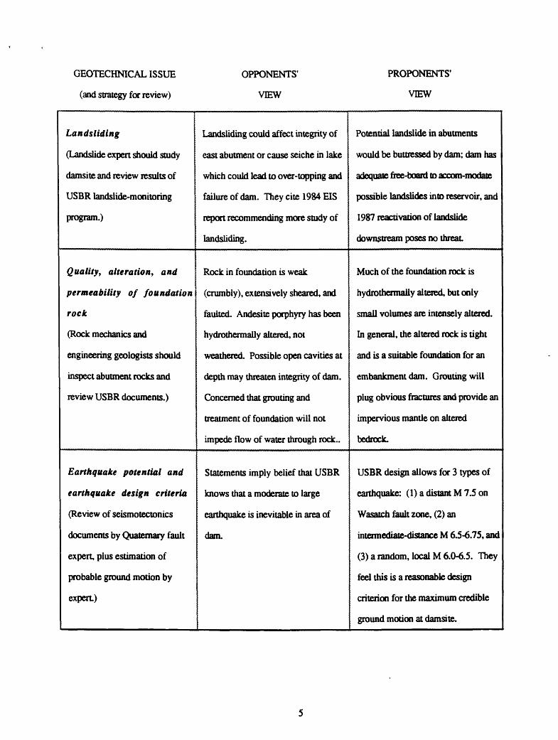
GEOTECHNICAL ISSUE
(and strategy for review)
OPPONENTS'
VIEW
PROPONENTS'
VIEW
Active faults in area of
abutment
(Structural and Quaternary
geologists should review damsite
geology and reports.)
Believe that an active fault (the
Cottonwood) passes through the
damsite. Believe that movement on
this fault could cause catastrophic
failure of the dam.
Believe that no active faults are
present and that faults and shear
zones in exposed foundation rock are
old and are related to emplacement of
Tertiary intrusive rocks.
Geologic structures that
may control buried
channel of Provo River
(Must rely on USER mapping
and drilling, and on inspection
by consultants. Review by
structural geologist)
A buried channel in the Provo River
flood plain could be controlled by
north-south trending fault
The sediment-filled channel is
fluvial (caused by erosion) rather than
structural (caused by faulting) based
on drilling, geophysics, and exposure
of the "foundation's footprint."
Other geologic structures
in abutments that threaten
the dam
(Structural geologist should
study available exposures at
damsite (one half of abutments
is still exposed) and review
results of USSR's mapping.)
Many of the structures exposed are
interpreted as active or potentially
active faults and shears. Much of
evidence is based on unpublished
mapping and personal knowledge.
Mapping has documented the origin,
nature, and history of deformation.
Shears and joints are restricted to
andesite porphyry and are related to
emplacement of andesite, not
younger faulting. There is no
evidence of through-going faults in
the foundation.
GEOTECHNICAL ISSUE
(and strategy for review)
OPPONENTS'
VIEW
PROPONENTS'
VIEW
Landsliding
(Landslide expert should study
damsite and review results of
USBR landslide-monitoring
program.)
Landsliding could affect integrity of
east abutment or cause seiche in lake
which could lead to over-topping and
failure of dam. They cite 1984 EIS
report recommending more study of
landsliding.
Potential landslide in abutments
would be buttressed by dam; dam has
adequate, free-board to accom-modate
possible landslides into reservoir, and
1987 reactivation of landslide
downstream poses no threat
Quality, alteration, and
permeability of foundation
rock
(Rock mechanics and
engineering geologists should
inspect abutment rocks and
review USBR documents.)
Rock in foundation is weak
(crumbly), extensively sheared, and
faulted. Andesite porphyry has been
hydrothermally altered, not
weathered. Possible open cavities at
depth may threaten integrity of dam.
Concerned that grouting and
treatment of foundation will not
impede flow of water through rock..
Much of the foundation rock is
hydrothermally altered, but only
small volumes are intensely altered.
In general, the altered rock is tight
and is a suitable foundation for an
embankment dam. Grouting will
plug obvious fractures and provide an
impervious mantle on altered
bedrock.
Earthquake potential and
earthquake design criteria
(Review of seismotectonics
documents by Quaternary fault
expert, plus estimation of
probable ground motion by
expert)
Statements imply belief that USBR
knows that a moderate to large
earthquake is inevitable in area of
dam.
USBR design allows for 3 types of
earthquake: (1) a distant M 7.5 on
Wasatch fault zone, (2) an
intermediate-distance M 6.5-6.75, and
(3) a random, local M 6.0-6.5. They
feel this is a reasonable design
criterion for the maximum credible
ground motion at damsite.
GEOTECHNICAL REVIEW
The U.S. Geological Survey agreed to review the adequacy of the USBR response to perceived safety concerns
dealing with geotechnical issues at the Jordaneile damsite. We discuss these issues in separate sections of this report
in the order tabulated above. We describe the nature and extent of the issues and make explicit and direct conclusions
about their impact on safety of the dam. Discussions that support our conclusions are necessarily somewhat more
technical than the conclusions. In this report, we use the following informal age divisions for the Quaternary (the
past 1.65 million years): late Pleistocene (10,000-130,000 years ago), middle Pleistocene (130,000-750,000 years
ago), and early Pleistocene (750,000 years to 1.65 million years ago). The Quaternary is comprised of the
Pleistocene and the Holocene (past 10,000 years).
ACTIVE FAULTS IN AREA OF ABUTMENT
INTRODUCTION
Much of the concern over the long-term safety of the Jordaneile Dam, as expressed by opponents of the dam,
rests on the possibility that surface rupturing or ground shaking associated with a large-magnitude (M>6.5)
earthquake may damage the structure and lead to its catastrophic failure. The consequences of such a failure could be
catastrophic. Leon Hansen (written commun., 1991) has suggested that failure of the dam could flood much of the
Heber Valley and lead to overtopping and subsequent failure of the Deer Creek Dam, which is located about 9 mi (15
km) downstream from Heber. From this point, floodwaters would pour down Provo Canyon and spread out across
much of Orem and Provo, jeopardizing much of Utah Valley. Clearly, the potential, however remote, for active
faulting at or near the damsite is being taken seriously by all parties concerned.
Investigations by USBR geologists, as well as previous geologic mapping, have demonstrated that much of the
rock in and surrounding the dam's foundation and abutments has been subjected to faulting. This is not an
unexpected finding, but the key question is whether or not any of the faults are capable of producing a damaging
earthquake. Leon Hansen contends that the Cottonwood fault, which has been mapped as a reverse fault in Paleozoic
and Tertiary rocks (Bromfield and others, 1970), is such an active fault. Moreover, USBR geologists (Sullivan,
1988a) have mapped a north-striking normal fault 0.4 mi (0.6 km) west of the west abutment of the dam. This
newly recognized fault (the Bald Mountain fault) appears to have been active sometime before the late Quaternary

(past 130,000 years), as evidenced by faulted sediments in one exploratory trench. A fault with a documented record
of no movement in the past 130,000 years is not regarded as a likely candidate for movement in the near future
owing to inherently long recurrence intervals and low slip rates. Finally, trenches at Jordanelle exposed many faults
that cut poorly consolidated gravels; some of these faults might be young and potentially active.
To address whether faults in the Jordaneile area are active, the Panel reviewed the seismotectonic studies of
Jordanelle Dam and Reservoir with specific reference to the Cottonwood fault, as well as other potential Quaternary-
age faults in the vicinity. USBR trench logs and field study of some of the remaining open-trench exposures at the
Jordanelle damsite were particularly informative.
THE COTTONWOOD FAULT
For a number of years, Leon Hansen has suggested that the Cottonwood fault is an active, through-going
structure capable of generating earthquakes. His basis for suggesting that the Cottonwood fault is young is its
alignment with suspected faults having roughly the same northeasterly trend, which he feels are active on the basis
of geomorphic expression, recent slumping, tracing faults upward to "the root zone" of soils, and the presence of
fault gouge. The Panel has no doubt that the Cottonwood fault is one of a family of northeast-trending faults and
agrees that it may continue beneath rocks that form the foundation for Jordanelle Dam. However, the Panel disagrees
with Hansen's inference of the age of the fault.
The USBR (Sullivan and others, 1988a) found no evidence of surficial expression of the Cottonwood fault or
other faults in either abutment from their geomorphic and aerial-photography studies. A roadcut along the new
alignment of U.S. Highway 40, directly west of Jordanelle, exposes the Cottonwood fault. It has an apparent dip of
about 50° to the north, strikes to the east, and is comprised of two main splays within a zone of deformation about
100 ft (30 m) wide. The Weber Quartzite (Pennsylvania^ and sandstone and limestone of the Park City Formation
(Permian) have been up-faulted southward over finer grained rocks of the Triassic Woodside Shale and Thanes
Formation (Bromfield and others, 1970). Faulting has placed more resistant rock over less resistant rock, but the
south-facing hillslope at the surface trace of the Cottonwood fault is relatively smooth. If the Cottonwood had been
recently active, one would expect to see a steepening of slope at the fault trace. In addition, there is no geomorphic
evidence of recent faulting on the flood plain and hillslopes adjacent to the Jordanelle damsite. Inasmuch as the
USBR was cognizant of Quaternary faulting in the back valleys of the Wasatch Range, .and because they had

investigated a number of probable Quaternary faults as pan of a larger study of seismotectonics for the Central Utah
Project (Sullivan and others, 1988a), the Panel is confident that the USBR's seismotectonic investigations (Sullivan,
1988b) explored all evidence of surface faulting at the Jordanelle damsite.
Although there is no geomorphic evidence of recent surface rupturing along the Cottonwood fault, late
Quaternary scarps along the Cottonwood fault could have been removed by erosion. This is a reasonable argument
for areas where there is active erosion or mass wasting, such as at the west end of the west abutment To evaluate
whether the argument is valid, the USBR conducted a program of exploratory trenching along the projection of the
trace of the Cottonwood fault, as mapped by Bromfield and others (1970).
ACTIVE FAULTS IN THE RIGHT ABUTMENT OF THE DAM
Before excavating the foundation and abutments for the dam, the USBR used bulldozers and backhoes to expose
the geology of the west abutment The USBR excavated 23 bulldozer trenches and nine supplemental backhoe
trenches in a 560 ft by 800 ft (170 m by 245 m) area. The results of these excavations were described in the USBR
1986 Technical Summary documents and in supplemental logs of trenches. During our first visit to the damsite, we
inspected a number of the remaining open trenches in order to familiarize ourselves with the exposed stratigraphic
and structural relations.
The trenches show clear evidence of faults that cut the Tertiary intrusive and volcaniclastic sedimentary rocks,
and the overlying basin-fill sediment In all of the examples that we saw, none of the faults cut the overlying
siuficial materials, which are comprised primarily of colluvium and locally derived piedmont alluvium of Quaternary
age. The basin-fill sediment is interpreted as late Tertiary because of interfingering relations with the intrusive and
volcaniclastic rocks, but the upper part of the basin-fill sediment may be as young 500,000 years according to the
USBR (Sullivan, 1988b). This middle Pleistocene age estimate seems reasonable on the basis of regional studies of
basin-fill stratigraphy and tephrochronology (volcanic ash studies) in the Keetley Valley. In several of the remaining
trench exposures, there are faults that cut Tertiary materials and extend to or near the surface. During our first visit,
Leon Hansen referred to such relations ("faults extending to the soil line") as evidence that the faults are young.
However, we do not consider such relations to be diagnostic of young faulting for the following reasons: (1) faults
in bedrock commonly are present at the surface owing to erosion of overlying materials; (2) unless a soil is formed
in a younger (surficial) deposit, the presence of a fault in the soil or extending to the "soil line" is evidence only for
8
movement that is younger than the bedrock that is involved (Oligocene, 26-38 million years, in this case); and (3)
faulting that extends to the surface usually results in the formation of a fault scarp. Degradation of the scarp requires
the deposition of material (fault-scarp coliuvium) adjacent to the fault This material (commonly referred to as a
coiluvial wedge) provides a demonstrable stratigraphic record of faulting. Paleoseismic studies of the surrounding
region (Sullivan and others, 1988a; Machette and others, 1991) have documented the presence and usefulness of
coiluvial wedges for determining the prehistoric record of surface faulting events. In the Panel's cursory inspection,
no stratigraphic evidence indicative of young (Holocene or late Pleistocene) faulting specifically, geomorphic
expression of faulting, faulted surficial deposits, or a stratigraphic record of faulting was found in the numerous
exposures at or near the west abutment of Jordanelle Dam.
OTHER QUATERNARY FAULTS NEAR THE DAMSITE
Recent mapping by the USBR (Sullivan and others, 1988a, 1988b), by the U.S. Geological Survey (Machette,
1989), and a soon-to-be-published compilation by the Utah Geological Survey (Hecker, in preparation; see also
Goter, 1991) reveals a pattern of Quaternary faulting that is dominated by north-south-striking normal faults in the
Wasatch Range and adjoining valleys. The majority of these faults are considered to be late Pleistocene or older,
although Holocene faulting has been documented along the Wasatch fault zone and on several other faults.
Paleoseismic investigations of the Wasatch fault zone show that it is the most active fault in Utah (Machette and
others, 1991) and has produced a magnitude 7.0-7.5 earthquake once every 400 years, on the average, during the past
6,000 years. The Wasatch fault zone is comprised of discrete fault segments. The Salt Lake City segment, which
bounds the eastern side of the Utah Valley about 20 mi (32 km) to the west of Jordanelle, is the closest segment of
the Wasatch fault zone that could produce a large-magnitude earthquake. Most Quaternary faults in the region around
Jordanelle, which are short and unspectacular in comparison to the Wasatch fault, bound valleys within the Wasatch
Range.
The Bald Mountain fault
During investigations at Jordanelle, the USBR uncovered evidence of a Quaternary fault northwest of the west
abutment Geophysical investigations and drilling confirmed the existence of this fault which became known as the
Bald Mountain fault (Bald Mountain is about 3 mi (5 km) northwest of Jordanelle). Although the surface trace is
not marked by vegetation alignments, lineations, or scarps, the discovery of a Quaternary fault just 0.4 mi (0.6 km)
west of the west abutment of the dam warranted investigation.
The USER excavated three trenches in surficial materials across about 0.6 mi (1 km) of the inferred trace of the
Bald Mountain fault, as projected from adjacent bedrock and from subsurface drilling control. No evidence of
Quaternary faulting was found in two of the three trenches (J-9 and J-13). However, trench J-10 revealed faulted
basin-fill sediment, but the overlying Holocene deposits were undisturbed. Thus, evidence from trench J-10 allows
an interpretation of surficial faulting in the past 500,000 years (youngest age of basin-fill sediment; Sullivan,
1988b), but before 10,000 years ago. From evidence in trenches J-9 and J-13, the USER argued that late Pleistocene
soils (estimated to be 130,000 years old) are not faulted elsewhere along the fault Thus, on the basis of lack of
surficial expression and unfaulted late Pleistocene soils, the USBR considers the last movement on the Bald
Mountain fault to be pre-late Pleistocene in age (> 130,000, but <500,000 years ago).
Although Quaternary movement is inferred on the Bald Mountain fault, it is not a candidate for probable surface
rupture. The fault has a long recurrence interval (more than 130,000 years), as determined from the degree of
development of soils on faulted basin-fill sediment (Sullivan and others, 19885), and lacks geomorphic expression of
late Quaternary displacement If movement were to occur, the surface rupture would probably be along the
postulated trace of the fault which has a length of only 2 mi (3 km). The trace would be well upslope and
northwest of the west abutment. Such faulting would be accompanied by seismic shaking (see following section on
"Earthquake potential and earthquake design criteria").
Other late Quaternary faults in the vicinity of Jordanelle
Reconnaissance mapping, as pan of the study of seismotectonics for the USER* Central Utah Project revealed
the presence of several Quaternary and suspected Quaternary faults in the valleys within the Wasatch Range.
Although these faults pose no surface rupturing threat to the dam, they could produce seismic shaking of the
embankment materials if a large-magnitude earthquake were to occur on any one of them. In the vicinity of
Jordanelle, no Quaternary movement has been documented on range-bounding faults in the Keetley Valley, other than
on the aforementioned Bald Mountain fault Faults that have known or suspected Quaternary displacement of similar
age bound the eastern side of Kamas Valley (about 8 mi (12 km) to the east of Jordanelle) and the eastern side of
Deer Valley (about 4 mi (6 km) to the northwest of Jordanelle). The faults that bound Round Valley, 12 mi (20 km)
10

to the south of Jordanelle, appear to be late Quaternary (Sullivan and others, 1998b), and thus are the youngest faults
in the valleys of the Wasatch Range. Because the Round Valley faults are the closest faults that have been active in
the past 130,000 years, the USER considers them most likely to cause severe ground shaking at the damsite (see
following section on "Earthquake potential and earthquake design criteria"). Although recent faulting is commonly
assumed to signify increased earthquake potential (owing to inferred high slip rates), recent faults are only most
likely to be reactivated if they have markedly shorter recurrence intervals than other faults in the region. Little or no
information exists for recurrence intervals of faulting in the valleys of the Wasatch Range, at least in this region;
thus one cannot improve on the USBR's assumption of potential activity of the Round Valley faults.
On August 26 and July 31,1991, Leon Hansen sent us strongly worded statements regarding faults exposed in a
quarry north-northwest of Hailstone, about one mile (1.6 km) north of the damsite. Hansen indicated that he was in
possession of ample evidence justifying classification of at least one of the faults there as "active." Even though
requested, Hansen provided us with no geologic evidence to substantiate his claim, and a brief visit to the quarry by
two members of the Panel failed to reveal any evidence for active faulting. However, the excavations provided
excellent exposure of a major west-northwest-stnking fault mapped several years earlier by USER geologists. As a
point for comparison, a strand of the Lake Mead fault zone that has offset Tertiary volcanic rocks at least 12 mi (20
km) passes through the lake basin within 2 mi (3.2 km) of Hoover Dam, but poses no recognizable threat to the
dam because the fault strand is not active.
CONCLUSIONS ACTIVE FAULTS
The nearest major fault, the Cottonwood fault, is shown on published geologic maps as an east-trending reverse
fault that displaces Tertiary and older rocks directly west of the damsite. Despite suggestions that the Cottonwood is
an active fault that extends across the damsite, the Panel finds no definitive evidence that the fault is either young or
crosses the damsite as a coherent recognizable geologic structure. The major displacement on the Cottonwood fault
clearly predates intrusion of the Oligocene (26-38 million years old) andesite porphyry that makes up most of the
dam's foundation.
Characterizations of the Cottonwood fault as an "active fault" are not supported by the scientific data acquired
during the several years of research that have focused on this specific question, or by information supplied by
opponents of the dam. No stratigraphic evidence indicative of young (Holocene or late Pleistocene) fault
11
movement specifically, geomorphic expression of faulting, faulted surficial deposits, or a stratigraphic record of
faulting were found on faults in the foundation or abutments of Jordanelle Dam, or in numerous exposures adjacent
to the west abutment. The Panel agrees with the USBR's conclusion that movement on faults in the west abutment
occurred before the late Pleistocene (> 130,000 years ago), and probably is much older than that In addition, the
possibility of hidden traces of an active fault beneath flood-plain deposits of the Prove River seems remote and
scientifically untenable (see following discussion of "Geologic structures that may control.... Provo River").
Quaternary movement has been documented on the 2-mi- (3-km-) long Bald Mountain fault, but this fault is
unlikely to cause surface displacement. Evidence that this fault has been active before the late Pleistocene (> 130,000
years ago) is circumstantial and found in only one of three trenches. If movement were to occur on the Bald
Mountain fault, ruptuhng would probably be confined to the postulated trace of the fault, well upslope and northwest
of the west abutment
Although several faults in the valleys of the Wasatch Range produced surface offset during the Quaternary, they
pose no surface-rupturing threat to the dam but could produce seismic shaking at the damsite. The nearest suspected
active faults are those in Round Valley 12 mi (20 km) south of Jordanelle; they have produced surface ruptures in the
past 130,000 years. In addition, the Wasatch fault zone has produced earthquakes as close as 19 mi (30 km) from the
damsite.
12

GEOLOGIC STRUCTURES (FAULTS) THAT MAY CONTROL BURIED
CHANNEL OF PROVO RIVER
Preliminary investigations to determine the top of bedrock (Oligocene andesite porphyry and volcaniclastic
sedimentary rocks) along the axis of the dam beneath the flood plain revealed a north-south-trending channel.
Opponents of the dam suggested that this channel may be controlled by geologic structures (such as faults) whose
surface traces have either been removed by erosion or buried. To test this hypothesis, the USBR conducted several
geophysical surveys across this supposed structure, parallel to the dam; they also drilled and cored the foundation
rock for the same purpose. Although these studies showed no significant changes in stratigraphy across this
channel, opponents argued that a near-vertical fault could still be projected through the drill holes. To resolve
remaining uncertainty, a program of angle drilling was conducted in 1986.
In preparing the foundation of the dam, the USBR excavated the alluvium-filled channel of the Provo River to
bedrock and mapped the exposed footprint in detail (1:600 scale) These maps show a pattern of short, unconnected,
northeast- and northwest-striking faults and shear zones, some of which are hydrothermally altered (see following
discussion of "Faults in the dam foundation"). More revealing, however, was the lateral continuity of these
structures, which cross the purported channel-controlling fault without apparent lateral or horizontal offset The
exposure of foundation rock in the channel eliminated the possibility that the position of the buried channel of the
Provo River is fault-controlled.
CONCLUSIONS STRUCTURAL CONTROL OF PROVO RIVER
The USBR studies revealed a sediment-filled channel of the Provo River that lies beneath the damsite. The
hypothesis that the position of this channel is controlled by a north-south-trending fault is without scientific merit
Exposed and cleaned bedrock surfaces display structural continuity, thus proving that the postulated fault does not
exist
13

OTHER GEOLOGIC STRUCTURES IN DAM ABUTMENTS
In the section on active faults, we approached the problem of the presence or absence of active faults from the
youngest pan of the geologic record. In this section, we approach the problem from the older (Tertiary) part of the
geologic record for the purpose of evaluating what portions of the faults and other structural features at Jordanelle are
likely to be so old that they are not candidates for being seismogenically active. This approach requires that we
review salient aspects of the Tertiary geologic history of the area.
TERTIARY GEOLOGIC HISTORY
The Jordanelle area is located east of the region affected by east-directed thrust faulting of the late Cretaceous and
earliest Tertiary Sevier orogeny. It is situated within an area affected by early Tertiary Laramide deformation, the
nearest major structural element of which is the east-west-trending Uinta uplift Major east-striking faults in
Paleozoic and Mesozoic rocks in the region may be related to the Laramide-age deformation that formed the Unita
uplift, but details are lacking owing to a strong overprint by younger igneous activity. Oligocene igneous rocks that
formed during this younger event are widespread in the Jordanelle region; these rocks include the Keetley Volcanics,
which are locally as much as 2,700 ft (1 km) thick, and numerous genetically related shallow subvolcanic plutons,
such as the andesite porphyry that is exposed in much of the dam's foundation and the nearby Mayflower stock. The
thick sequence of volcanic rocks apparently accumulated in a structural depression between the Unita and Cotton wood
uplifts. USBR geologists conclude that the main displacement on a major fault near the damsite, the Cottonwood
fault, is related to the emplacement of the Mayflower stock, and that this displacement predates intrusion of the
andesite porphyry that makes up most of the dam's foundation.
Jordanelle is in the southern part of the Keetley Valley, one of several structurally controlled valleys within the
Wasatch Range that, together, form an elongate, north-south belt that extends parallel to and east of the Wasatch
fault zone and associated Wasatch Front Miocene and younger faulting along the Wasatch and associated faults has
resulted in the characteristic basin-and range-physiography of the eastern Great Basin, the block-like uplift of the
Wasatch Front and the valleys to the east Most of this physiography reflects normal faulting resulting from
westward-directed extension.
14

ORIGIN OF THE ANDESITE PORPHYRY
Two main types of Tertiary rock are present in the dam foundation and abutments: (1) nonbedded andesite
porphyry (about 90 percent), and (2) bedded rocks with volcanic affinities (about 10 percent). The bedded rocks are
strongly tilted and faulted in the vicinity of the damsite. The extrusive-versus-intrusive origin of the andesite
porphyry and the relative age of the two rock types are important in determining the Tertiary structural history of the
foundation area which, in turn, is relevant to the history and range of potential hazards that can be reasonably
assigned to the Cottonwood fault or other potentially active faults in the area. The following two hypotheses may
help to show why this is so.
1. If both rock types are part of a layered stratigraphic assemblage of coeval bedded volcaniclastic rocks and
extrusive lava flows, the entire assemblage must have been subjected to the strong strata! tilting and faulting to
which the bedded volcaniclastic rocks have been subjected. In this case, much of the movement on the
Cottonwood fault could be young, unless evidence exists to the contrary.
2. If, on the other hand, the andesite porphyry intrudes the bedded volcaniclastic rocks, their tilted and faulted
condition could have been produced during and directly following intrusion which, in turn, could postdate all
significant displacement on the Cottonwood fault
In written documents and in discussions, Leon Hansen expressed strong concerns about whether the andesite
porphyry in the dam foundation is of extrusive or intrusive origin and about the USBR's inconsistency, over the
duration of the Jordaneile project, regarding the mode of origin of the andesite porphyry. Whether the andesite
porphyry originated as an extrusive or shallow intrusive body is of no apparent consequence either to the integrity of
the rock and its suitability as foundation material or to potential problems posed by physical properties of its
contacts with other rocks (see the following discussion of "Foundation rock quality, alteration, and hydrologic
characteristics"). However, as noted in the previous paragraph, it is important in deciphering the structural history of
the damsite. Therefore, we note here some observations that tend to confirm the interpretation by the USER and its
consultants. They favor an intrusive origin for the andesite porphyry at the damsite.
In the exposures the Panel observed, most of the andesite porphyry has a conspicuously uniform, coarsely
porphyritic texture and lacks oxidized, vesiculated, or autobrecciated zones features that are typical of lava flows. In
the newly exposed south-facing pan of the west abutment, we found three steep northwest-striking zones a few
15

centimeters to a few tens of centimeters wide that show strong variations in grain size from the normal texturally
uniform porphyry to very fine-grained, apparently nonporphyritic, rock of presumed similar composition. These
textural variations apparently mark steep contacts across which all rock is dense, highly lilhified, nonbrecciated,
unoxidized, and nonvesiculated. The Panel concludes that these are partially chilled intrusive contacts, analogous to
the steep northwest-striking intrusive contact observed by USER consultant Myron Best (1986) near the south
boundary of the andesite porphyry in the middle west abutment. These contacts indicate that the andesite porphyry at
the west abutment is a composidonally uniform, but composite, intrusive body.
Beneath the central pan of the dam, an inclined drill hole (DH-548) crosses at least three contacts between
andesite porphyry and volcaniclastic rock. In our study of core recovered from two of the contacts, we did not see
any features common to extrusive flows. The contacts are very tight and show a minor decrease in grain size toward
the volcaniclastic country rock, again suggesting an intrusive origin for the andesite porphyry.
In three separate excavations on and adjacent to the east abutment, we observed features at contacts between
andesite porphyry and bedded rocks of the Keetley Volcanics indicative of an intrusive origin for the andesite
porphyry. The most convincing is an excavation at the northern end of the emergency spillway where the andesite
porphyry cuts across bedding in volcaniclastic sedimentary rock. The andesite porphyry has a 50-70-cm-wide steep,
irregular, foliated fine-grained, chilled zone against the sedimentary rock, indicating an intrusive origin.
In summary, on the basis of contact relationships throughout the damsite, the Panel concludes that the andesite
porphyry that forms about 90 percent of the dam's footprint is an intrusive mass a conclusion that is consistent
with (1) the varied and comprehensive observations reported by Best (1986), (2) comparisons made by R.H Merrium,
consultant to the USBR (1980), of rock textures in the andesite porphyry to other shallow intrusives in the world,
and (3) ground-magnetic and aeromagnetic data indicating an intrusive mass beneath the dam's axis with at least
4,000 ft (1,220 m) of depth extent as report by USBR consultant Fox (1984). This interpretation allows virtually
all of the displacement on the Cottonwood fault to predates intrusion of the andesite porphyry that cuts across the
fault zone. Emplacement of the andesite porphyry probably caused much of the deformation in the Keetley
Volcanics where they form the surrounding country rock.
16

POST-INTRUSION FAULTS IN THE DAM FOUNDATION
Acceptance of an intrusive origin of the andesite porphyry allows for, but does not require, a pre-intrusive age of
displacement on the Cottonwood fault or other faults in the area. Any effects of post-intrusion faulting should be
visible within the exposed andesite porphyry or at its contacts with other rocks. Experts who have studied the
foundation area agree that such faults exist, and USBR mapping confirms their presence. There is, however, much
disagreement on the location, continuity, significance, and age of these faults. The chief disagreement centers on
whether or not major young faults pass through the foundation. Most of the rock critical to resolving this
disagreement was covered by embankment materials prior to our first visit Therefore, for one side of the
disagreement, the Panel relied on projections of faults to the central part of the foundation from nearby mine
workings, roadcuts, trenches, and natural exposures, as well as projections of topographic lineaments. For the other
side, the Panel used maps, photographs, descriptions, and reports resulting from drilling and excavation, as well as
detailed maps of the nearly completely exposed foundation supplied by the USBR. The Panel notes that this degree
of exposure of foundation rock is unique and, when combined with the subsurface drill-core network, provides a rare
opportunity to assess the presence or absence of critical structures, such as major through-going faults. In the
paragraphs that follow, we review evidence from the exposed foundation and from drill holes that bears on the
location and continuity of faults, and the indirect evidence indicating that much of the faulting is old (Tertiary) and
does not represent a major post-intrusion deformational episode.
Location and continuity of faults
The USBR's detailed maps of joints, shears, and faults in the foundation reveal discontinuous structures that
form a blocky or mosaic pattern arising mainly from the intersection of east-northeast and north-south to north-
northwest striking joints and faults. USBR investigations have emphasized the lack of through-going faults or fault
zones, such as the Cottonwood fault and the F-10 faults. Our review tends to confirm this aspect of fault
terminations in the foundation area. The Panel observed two of the more conspicuous steep north-striking faults in
the large, newly exposed south-facing excavation at the west abutment that appeared to us to be the most likely
candidates for classification as through-going faults that might have significant displacement However, our attempt
to trace these faults southward across the floor of the excavation showed that they terminate abruptly within the
exposed foundation rock. Although the nature of the terminations was not determined, the discontinuous aspect of
17

these faults is consistent with the general pattern of intersecting fractures that are part of the carefully mapped mosaic
pattern in the andesite porphyry elsewhere in the foundation area. It is also consistent with the general observation
of USBR geologists and their consultants that displacement on the faults ends abruptly as they are traced from the
andesite porphyry toward contacts with adjacent country rocks.
The strongest evidence for the discontinuous nature of the faults in the dam foundation is (1) the lack of
correlation of faults from drill hole to drill hole within the network of holes drilled across the foundation, and (2) the
general lack of correlation of faults mapped on the surface of the cleaned foundation with those intercepted by drill
holes, especially the system of inclined drill holes. This well documented discontinuous nature shows that the
projections of faults, such as the Cottonwood fault, through the foundation from localities beyond the foundation is
scientifically unsound unless supported by direct evidence.
The excellent examples of fault terminations and mosaic patterns mapped in detail in the dam foundation provide
a basis for understanding faults, such as the F-10 fault, that are much more conjectural than the Cottonwood fault
The existence of the F-10 fault was conjectured by USBR geologists on the basis of indirect evidence such as drill
hole and magnetic data. The drill-hole data indicated a need for a fault to explain an anomalously low elevation of
the bedrock-alluvium contact in part of the reservoir basin north of the dam. A northeast-striking, east-side-down,
graben-bounding, Basin and Range-type fault with Quaternary displacement was postulated in 1984-1985 by USBR
geologists. At that time the USBR acknowledged two problems with their postulation: (1) no complimentary fault
could be found in the east abutment to bound the graben on the east, and (2) displacement on the F-10 fault
apparently decreased southward toward the damsite. To resolve these problems, USBR geologists postulated an east-
west structure north of the damsite against which the graben terminates southward. At the same time, R. L. Bridges
(1984) postulated (on the basis of his connecting exposures of faulted rock at Hailstone with faulted rock south of
the damsite 2 miles away) that the F-10 fault passes through the damsite. It is important to note that neither the
direction nor amount of displacement are constrained by offset of stratigraphic markers anywhere along this
postulated fault After complete exposure of the dam's footprint, detailed mapping by the USBR failed to identify
the F 10 fault as a through-going structure in bedrock or, more important, as a feature offsetting the bedrock-
alluvium contact After having developed an understanding of the nature of fault terminations and the mosaic fault
18
pattern, the USER, having previously postulated such termination for the F 10 fault, lost interest in it as a structure
with which they need be concerned.
Although the lack of through-going faults precludes projection of a large-displacement fault (such as the
Cottonwood) through the foundation as a single fault, it does not preclude the possibility that (1) somehow large
displacement is dispersed through the andesite porphyry along many elements of the mosaic pattern, or (2) large
displacement is transferred from the Cottonwood fault to the contact between the andesite porphyry and its country
rock and, thus, somehow is deflected around the intrusive body. The first possibility has not been advanced by
opponents to the Jordanelle dam, and the Panel does not consider it likely (see discussion of hydrothermal alteration
in subsequent section of this report). The second possibility was recognized by Best (1986). The USBR's detailed
maps, trench logs, drill logs, photographs, and descriptions, as well as our field review, produced considerable
evidence of post-intrusion deformation at die south margin of the andesite porphyry in the middle of the west
abutment (the zone referred to as SZ1 by the USBR). The rocks are broken and sheared along the contact. This
deformation could be taken as evidence for some son of accommodation for displacement on the Cottonwood fault,
but not as evidence that the Cottonwood fault passes through the dam foundation. Bridges (1984) suggested that the
deformation results from uplift of the Jordanelle stock (andesite porphyry) subsequent to its emplacement and
solidification.
Age of faulting
In a 1990 summary report on foundation conditions at the Jordanelle dam, Douglas Campbell (a member of the
most recent Consulting Group) made several very cogent observations that have a strong indirect bearing on
estimating the age of many of the faults in the foundation. He noted that many structures originally thought to be
broad shear zones are actually fracture-controlled zones of hydrothermal alteration within which the parent rock is
largely converted to clay. He also noted that much of the altered (clayey) rock, which should be highly susceptible
to shearing and development of a shear fabric, lacks evidence of post-alteration shearing. He concluded that the rocks
remain largely undeformed subsequent to alteration. The Panel studied one conspicuous east-striking, steep zone of
bleaching that is 6-10-ft (2-4-m) wide in the east abutment (designated ST5 by USBR) and found that it marks a zone
of hydrothermal alteration along a fault zone. Normal displacement (throw) of weak layering in the north side of the
zone is less than 3 ft (1 m), and total throw is probably less than 10 ft (3 m). Individual fractures in STS are only
19
on the order of a tenth of an inch (a few mm) wide and are tight, although they clearly served as a channelway for
hydrothermal fluids that attacked and partially altered the wall rock to clay minerals. There is no evidence of post-
alteration displacement on ST5. These structural relations support Campbell's conclusion that alteration was fault-
controlled and that little, if any, faulting postdates the alteration.
If the time of the alteration can be established, much of the faulting can be reasonably interpreted to predate it
The hydrothermal alteration at Jordanelle requires long-term upward movement of hot aqueous fluids, a process
common in country rock above crystallizing magma chambers. Most episodes of hydrothermal alteration are closely
tied to an underlying intrusive body, and may continue for several million years or until the source of heat is
dissipated. The Panel considers it likely that the hydrothermal alteration at Jordanelle accompanied the Oligocene
igneous activity that is well documented in the region and as was suggested by Campbell (1990). All faults that
served as channelways for hydrothermal fluids must be at least that old. The control exerted by faults on the
distribution of altered rock seen in the plan-view map of the dam foundation (scale 1:1,200) suggests that most faults
and joints in the foundation must be coeval with the igneous episode, and thus are of Oligocene age (26-38 million
years ago).
Exceptions to the general absence of post-alteration displacement were noted in the newly exposed south-facing
excavation in the west abutment where fault zones with steep to moderate dips and north to north-northwest strikes
contain fragments of hydrothermally altered rock that float in reddish-gray gouge. This relation suggests post-
alteration displacement on these faults. However, as noted in the previous subsection of this report, we were unable
to trace these same faults across the floor of the excavation. USER geologists are currently mapping these faults in
detail. The Panel does not consider these faults to be a threat to the safety of the dam because they are
discontinuous, do not lie along any mapped major faults, and are not known to have been active in the late
Quaternary (from photogeologic and trenching studies).
The Panel concludes that most faults in the intrusive andesite porphyry of the foundation of the dam formed
during the Oligocene episode of igneous and hydrothermal activity and have since been essentially inactive. Some
faults that are currently being studied in the west abutment show evidence of younger displacements, but we do not
consider them to be a threat to the dam.
20

Relation between the Cottonwood fault and faults in the dam foundation
We note above that deformation at the south margin of the andesite porphyry could be taken as evidence for
post-intrusion accommodation for displacement on the Cottonwood fault, but not as evidence that the fault passes
through the dam's foundation. Many of the east-northeast- to northeast-striking faults that cut the andesite porphyry
in the foundation lie along reasonable (northeastward) projections of the Cottonwood fault Because of their location
and trend, and because they tend to be more highly concentrated along reasonable projections of the Cottonwood fault
than elsewhere in the foundation, the Panel interprets them as indicating post-intrusion displacement on the
Cottonwood fault Several of these faults controlled the distribution of hydrothermal alteration by serving as
channelways for long-term upward movement of hydrothermal fluids. As we note in the previous section of this
report, these faults are most likely Oligocene in age and show little, if any, evidence of younger displacement In
particular, excavation of the bedrock-alluvium contact along the full width of the foundation failed to reveal evidence
of geologically young fault offset of that critical contact
CONCLUSIONS OTHER GEOLOGIC STRUCTURES
There is strong evidence that the andesite porphyry was intruded across the Cottonwood fault in Oligocene time
(26-38 million years ago). After solidification, there was renewed faulting, possibly including renewed movement
on the Cottonwood fault The andesite porphyry along the projection of the Cottonwood fault was cut by many
faults, thus forming a complex intersecting mosaic pattern. These post-intrusive faults are conspicuously
discontinuous as revealed by detailed mapping and closely spaced drill holes. These faults served as channelways for
migration of hydrothermal fluids during the episode of igneous activity in the Oligocene. However, the absence of a
well-developed shear fabric in these altered rocks suggests little, if any, displacement on most of the faults since
Oligocene time. On the basis of the well-documented, discontinuous nature of the post-intrusive faults and indirect
evidence that the faults are old (Oligocene), the Panel concludes that no faults with major young displacements can
be projected through the foundation of the dam.
Exceptions to the predominantly Oligocene faulting are found in the west abutment where steeply and gently
dipping faults with generally north-northwest strikes show evidence of post-alteration displacement These faults are
also discontinuous within the area of the abutment They are currently being mapped by the USER. Although the
timing of movement on these faults cannot be constrained any closer than Oligocene or younger from the exposures
21

in the foundation, none of them appear to be associated with faulting at the surface as shown by trenching and pro-
excavation USBR aerial photography. The Panel does not consider these faults a seismic threat to the dam because
there is no direct evidence that they are continuous with major faults that have been active recently.
LANDSLIDE HAZARDS
INTRODUCTION
Landslides have been a continuing problem in the valley of the Prove River. During historic time, landslides
commonly have been caused by periods of abnormally high precipitation (both snow and rain), such as occurred in
1982-85. In 1930,1931, and 1938, major landslides dammed the Provo River in Provo Canyon, some 20 mi (32
km) downstream from the Jordanelle damsite. Because of this past history of landsliding in the area and along the
valley walls of the Provo River, it has been suggested that there is a hazard to Jordanelle Dam and Reservoir from
future landslide activity. As a result, the Panel carried out a technical reconnaissance and airphoto interpretation of
the valley wall in the vicinity of Jordanelle Dam and along the shoreline of the future Jordanelle Reservoir with the
goal of noting possible landslide hazards.
We will discuss the possibility of landslide activity at Jordanelle Dam and Reservoir due to the filling of the
reservoir and fluctuation in reservoir levels, and the effect that these landslides might have on the integrity and safety
of the dam, reservoir, and appurtenant structures. Potential landslides and their effects will be discussed for three
segments of the Provo River and its tributaries: (1) directly downstream of the dam, (2) at the dam, and (3) along the
shoreline of the future reservoir.
22
LANDSLIDE HAZARDS DOWNSTREAM FROM THE DAM
The valley walls of the Provo River directly downstream from Jordanelle Dam are steeply incised (maximum
slopes of about 35°) in volcanic breccia and andesite of Tertiary age. The volcanic breccia is susceptible to
landsliding, some of which has occurred during the past 10 years. In addition, there are several scars on the valley
walls that were caused by prehistoric landslides.
On the west valley wall, a large snowmelt-triggered rockslide occurred in volcanic breccia in 1984 about 4,000 ft
(1,220 m) downstream from the centerline of Jordanelle Dam. This 10-acre (4-ha) slide, which partially blocked the
Provo River, apparently moved slowly; instrumentation monitored by the USBR has indicated no subsequent
movement since 1984. There is a possibility of renewed activity of this slide during periods of future heavy
precipitation or seismic activity, but it is far enough downstream that it poses no threat to Jordanelle Dam or
Reservoir. This slide, which was caused by weakening of the valley wall by ground water from snowmelt, probably
is typical of the worst type of slide that might be expected to occur in the valley walls upstream from the dam during
filling of the reservoir. Although such slides can be fairly large, they do not attain sufficient velocities to produce
destructive waves in the reservoir.
Abnormally warm weather, rain, and wet snow in February 1986 resulted in flooding and saturated soil
conditions along the Provo River at the site of Jordanelle Dam. This excess water caused surficial slips and
mudflows at the surface of older landslide debris, "pyroclastic" rocks, and soils a few hundred feet downstream of the
east abutment of Jordanelle Dam. The scars from these surficial slips and mudflows are still evident on the valley
wall. Because they are downstream from the dam, reactivation would pose no hazard to the dam or reservoir.
Although these slips and mudflows would cross the alignment of the emergency spillway, no damage or blockage is
likely to occur because this section of the spillway has a covered, box-type construction. If deeper landslides
occurred in this area, the spillway could be damaged; however, it could be repaired without affecting the integrity of
the dam itself.
A large prehistoric landslide headscarp is evident at the top of the east valley wall at a distance of about 800-
1,700 ft (245-520 m) downstream from the centerline of the dam. Below the headscarp, there is evidence of small
prehistoric landslides. These slides did not reactivate during the 1982-85 wet cycle and are unlikely to fail again.
23
But if they do move again, they are far enough downstream that they pose no danger to the dam. At worst, they
would damage the emergency spillway, which would not affect the dam or reservoir.
LANDSLIDE HAZARDS AT THE DAM DAMSITE
The east abutment area exposes a regularly jointed rockmass of unweathered and unaltered andesite porphyry. In
the area where the core material of the dam will be placed, shallow-dipping joint surfaces intersect with steeply
dipping, slightly overhanging joint surfaces to form a stepwise arrangement of large blocks. Downdip movement of
these blocks is of little consequence and is apparent only along the leading edges of the steps. A blocky exposure of
jointed andesite (approx. 100,000 cubic yards; 76,500 m^) directly downstream from the core area, commonly
referred to as the "rock slide," appears to rest on low-angle westward-dipping joint surfaces. This rock exposure has
been instrumentally monitored by the USBR since 1987, and no movement has been detected. Potential for any
future movement, however unlikely, will be further reduced when the rockmass is fully buttressed by the downstream
shell of the dam.
A set of low-angle, rotational failure surfaces is exposed in highly fractured Tertiary andesite porphyry on the
steep, south-facing slope of the west abutment near USBR station 8, which is directly upstream from the crest of
the dam. Surficial gravitational movement may have occurred on these failure surfaces in the past Because no
headscarps are in evidence in the alluvial slopes above the features, any movement must have been prehistoric and
probably pre-Holocene in age. From the attitude of the failure surfaces and the geologic relations exposed in the
west abutment, it appears that the mass of igneous rock on top of these potential slide surfaces will be almost
completely buttressed and enveloped by the upstream shell of the dam. Therefore, if activation or reactivation as
gravitational slides were to occur during the filling of the reservoir (or during fluctuation in reservoir level), the
safety of the dam would not be affected.
The Tertiary-age Woodside shale is exposed in the valley wall a few hundred feet downstream of the dam and
100-300 ft (30-90 m) above the west abutment. Small prehistoric landslides occur in the weak strata of the
Woodside shale, but this unit does not crop out in the dam foundation. Any future landsliding in the Woodside shale
would be safely downstream from the dam.
24
LANDSLIDE HAZARDS ALONG THE RESERVOIR SHORELINE
Jordanelle Reservoir will store 320,000 acre-ft (25,900 ha-m) of water at its active storage capacity. The
landforms along its 28-mi (45-km) shoreline range from gently sloping alluvial terraces to steep (as much as 45°)
slopes in volcanic rocks. The Panel conducted a field and airphoto reconnaissance of this shoreline looking for
evidence of landslide activity prehistoric, historic, or current. We made note of slopes that might be susceptible to
landsliding during or after the filling of the reservoir. The following discussion of landslide susceptibility divides the
shoreline into three areas: (1) the southeastward-flowing reach of the Provo River from Jordanelle Dam to the site of
Hailstone, (2) the westward-flowing reach of the Provo River from the head of the reservoir to the site of Hailstone,
and (3) Drain Tunnel Creek, upstream (north) of Hailstone.
Provo River Jordanelle Dam to Hailstone
The east valley wall in this stretch (along the east-abutment haul road) is steeply incised into andesite and
volcanic breccia. Slopes as steep as 45° exist at the foot of the valley wall for about a mile (1.6 km) upstream from
the dam. Most of the material forming these steep slopes is a stable andesite which itself is not susceptible to
landsliding, but minor raveling of slopes should be expected during filling of the reservoir. This raveling will be on
a small enough scale as to have very little effect on the reservoir; it poses no threat of causing a wave that might
endanger the integrity of the dam.
The shoreline at maximum-reservoir stage will be mainly in volcanic breccia on slopes of 15-20°; landslides
should not be expected on these slopes. However, the breccia is not a very strong material, and where local slopes
are steeper than 15°-20°, minor slumping/sliding should be expected, particularly with seasonal fluctuation of lake
level. These slumps/slides will not be large, nor will they move with high velocity; thus, they will have little effect
on the reservoir and none on the dam.
The northwest side of the valley between Jordanelle Dam and Hailstone consists mainly of gently sloping
alluvial terraces that will not generate major landslides either during or after reservoir filling. If any slides do occur
on the faces of these terraces, they will be shallow and small and will not affect the reservoir or dam.
25

Provo River Upstream from Hailstone
This part of the valley is incised mainly in volcanic breccia, which is susceptible to landsliding where it forms
steep slopes. The southern (north-facing) wall of the valley is generally steep (maximum slope about 35°); the
northern valley wall is less steep, commonly 20° or less. There is evidence of at least two large prehistoric
landslides in the volcanic breccia one on the south valley wall in sec. 33 and the other on the north side in sec. 34.
Neither of these slides shows any evidence of recent activity. Because the volcanic breccia is not a strong rock, some
minor sliding and raveling will probably occur on the steep south valley wall during filling of the reservoir and
fluctuations in water level after filling. However, there is no reason to expect any large, high-velocity slides.
Very little future landslide activity is expected along the less-steep northern side of the valley. Activity will
probably be limited to small failures on locally steep slopes. It should be noted that if any large slides do occur
along this stretch of the reservoir, they will move in a north to south (or south to north) direction, and any waves
produced will move mainly in that direction and dissipate against the opposite valley wall. There is no chance that a
wave of destructive height and force caused by a slide in this part of the valley would move downstream and turn the
comer to reach Jordanelle Dam.
Drain Tunnel Creek Upstream from Hailstone
Except for a 2-mi (3.2-km) stretch of strong intrusive rock that forms the east valley wall (general slope 10°-
15°) of Drain Tunnel Creek between Hailstone and Keetley, the shoreline of the reservoir on Drain Tunnel Creek will
be on gently sloping (less than 10°) alluvial terraces. The slopes in the intrusive rock will not be subject to
landsliding because the rock is strong and the slopes are only moderately steep.
A few very small, shallow slips occurred on the faces of the alluvial terraces directly west of Keetley during the
period of extreme precipitation of 1982-85. It is possible that these failures will be reactivated during reservoir
filling, but they are too small and would be too slow-moving to have any effect on the reservoir.
26

CONCLUSIONS LANDSLIDE HAZARDS
There is no evidence of recent (Holocene) landsliding in the foundation of Jordaneile Dam, and there is no
substantive evidence to indicate potential for landsliding that would damage the dam. Rocks that lie above low-angle
slip surfaces in the north side of the west abutment will be almost entirely buttressed by the embankment, thereby
preventing any possibility of failure into the reservoir.
Although minor landslide activity along the shoreline of Jordaneile Reservoir is to be expected during reservoir
filling and during post-filling fluctuations of reservoir level, there is no indication that any of the slides will be large
enough or of high-enough velocity to form waves that could overtop or damage the dam.
Continued landslide activity downstream from the dam could result from periods of heavy precipitation in the
future. The only structure related to the Jordaneile damsite in this area is the emergency spillway. Because the
spillway is covered, it is not likely to be damaged by shallow landslides. If damaged by deeper landslides, it could be
repaired without affecting the integrity of the dam itself.
QUALITY, ALTERATION, AND PERMEABILITY OF FOUNDATION ROCK
The Panel's review confirms the findings of the USER and its consultants that most rocks at and directly
adjacent to the dam foundation are cut by faults, and that fault spacing in the west abutment is much less than in the
east abutment These faults dip at a variety of angles, and range from steep to relatively shallow. Faults or fault
zones in the foundation of an embankment dam do not necessarily pose a safety threat to the dam: they are a
potential threat if they are active, are channelways for significant fluid flow, or are characterized by damaged rock that
is so weak that it cannot withstand superimposed loads. As a point of comparison, the volcanic tuffs, breccias, and
flows that form the abutments for Hoover Dam in southern Nevada contain an estimated minimum of two million
slickensided faults per cubic mi (one-half million per cubic km).
During our field review we briefly studied several well-exposed faults to evaluate their influence on foundation
strength and (or) permeability. The most continuous faults and presumably those having the largest displacements
are marked by gouge and strong shear fabric in zones that are generally less than 2 in (5 cm) wide. These zones grade
outward through fractured and, locally, brecciated rock to intact rock within a distance of 3-10 ft (1-3 m). Fault-
damaged rock forms irregular, prismatic, or lensoid masses where it has either collected at fault bends or been excised
27

at fault intersections. Shear fabrics in these masses are commonly discordant to the boundary shears, indicating
rotation. Also, some shears internal to the masses of fault-damaged rock are truncated at the boundary shears. These
features indicate a protracted displacement history, the youngest elements of which are the through-going shears that
traverse the excavations. The fault-damaged rock is progressively weaker (less resistant to excavation) toward the
center of discrete shear zones. In no fault or fault zone that we observed is the fault-damaged rock likely to be weaker
than the embankment materials or weak enough to collapse or seriously compress under the influence of the
embankment Concerns over the strength of fault-damaged rock should be relieved by the results of index texts of
the strength of foundation rock (USER, 1986). These tests, which include tests on fault-damaged rock, show a wide
range of values (965-35300 psi; 7-243 MPa), but with an aggregate average strength of 13,900 psi (96 MPa). Such
strength values characterize the foundation as strong, solid, and capable of supporting the weight of the embankment
dam.
Leon Hansen has repeatedly characterized the volcanigenic sedimentary rocks of the Keetley Volcanics as "mud-
ash deposits" and inferred that they are inherently unsuitable as foundation materials. The USER conducted 60 point-
load strength tests and 20 unconfined compressive strength tests on rocks of the Keetley Volcanics (including
andesite autobreccia, lapilli tuff, lapilli breccia, and sedimentary breccia) at Jordanelle (USER, 1986, v. II,
Engineering Geology, p. 54). The specific range of variability for the Keetley Volcanics is 678-21,300 psi from
point-load tests and 700-8,000 psi for unconfined compressive tests. The range of average values for the four
separate rock types that make up most of the Keetley Volcanics is 3,600-6,300 psi for point-load tests and 3,800-
5,1000 psi for unconfined compressive tests. These results show that, as a group and as separate map units, the
rocks collectively referred to as "mud-ash deposits" and which comprise only a small percentage of the foundation of
the dam have adequate strength to support an embankment dam.
Concern has been expressed over the allegedly high permeability of the foundation rock of the Jordanelle Dam
and whether treatment of permeable zones in the foundation has been adequate. With respect to the Teton Dam
failure, these points are of concern to both the local populace and the scientific and engineering community. During
our two visits to the damsite, members of the Panel inspected a number of fault, shear, and alteration zones, mainly
in the abutments of the dam (the base of the foundation was largely covered). We observed no fault-damaged rocks
with openings that could serve as conduits for the kind of rapid fluid flow that would compromise the integrity of the
28
dam by erosion at the embankment-foundation interface. Nor did inspections of the flood-plain section of the
foundation by consultants to the USER disclose any potential open conduits. The grouting procedures implemented
by the USER especially the excavation and insertion of grout keels along zones of hydrothermally altered or fault-
damaged rock will reduce access of impounded waters to any potential open conduits and reduce seepage to
manageable levels.
Concerns have been expressed as to whether or not "enhanced" matrix permeability and/or flow through channels
in the faulted and altered portions of the foundation will cause the foundation to leak. This issue has been addressed
by mapping and characterization of the thoroughly cleaned and fully exposed "foot print" in the east and west
abutments and flood plain, and the findings are detailed in the 1990 reports of the Consulting Group to the USBR.
Some rocks that have been extensively altered to clay have lower permeability than unaltered rock. The amount of
grout used in the construction of grout curtains along the full length of the foundation indicates that the connectivity
along the joints and faults in the andesite is low to nonexistent Along the downstream grout curtain (which is
designated as line 4), the consumption of grout per foot of hole is 0.51 bags in the west abutment, 0.19 bags in the
flood plain, and 0.16 bags in the east abutment (USBR unpublished computer printouts and engineering drawings).
These grout-consumption values indicate a low-to-nonexistent fracture connectivity. (For purposes of comparison,
an empty 3-in.- (8-cm-) diameter hole will require about 0.05 bags of grout per ft of depth.) Along the toe region of
the west abutment, the grout intake locally increased to 0.78 bags/ft, whereas along a parallel section of the
upstream grout curtain (which is designated as line 3.5) the grout intake was only 0.09 bags/ft
The low-to-nonexistent fracture connectivity indicated by the aforementioned grout consumption records is
consistent with the low degree of fracture connectivity revealed in detailed maps of the andesite porphyry in the
foundation, as well as the general tendency for faults in the andesite porphyry to terminate abruptly at or near
contacts with country rock. Even the largest faults characterized by shear fabrics and slickensides (classified as B2
shears by the USBR) show this characteristic lack of connectivity. That this characteristic extends into the
subsurface to depths of at least 300 ft (about 100 m) beneath the dam is verified by vertical and inclined drill holes
that form a drill-hole curtain along the dam's axis. Cores recovered from some of the most fault-damaged intervals
(the B2 shear zones) directly beneath the dam exhibit little or no evidence of either pervasive shear fabric or extensive
breccia. The zones appear tight with sparse striated surfaces bounding 1/2-in. (1-cm) size fragments and no
29
suggestions of thick gouge. Moreover, shear zones cannot be correlated from one drill hole to another or from drill
holes to mapped surface structure. These findings confirm the USBR conclusion that the faults and shear zones are a
locally developed and somewhat random network of non-connected to poorly connected fractures. Collectively, these
fractures will not cause the foundation to leak beyond levels that the design can accomodate.
An unplanned permeability test occurred when the USBR excavated alluvium from the sediment-filled channel of
the Provo River to about 80 ft (25 m) beneath the Hood plain of the Provo River (see previous discussion of
"Geologic structures that may control.... Provo River"). Bedrock exposed in the walls of the channel through the
foundation of the dam yielded extremely low seepage rates, confirming the generally low permeability of the
foundation rock.
CONCLUSIONS FOUNDATION ROCK
From an engineering standpoint, bedrock in the dam's foundation has not been significantly weakened by
faulting, nor by hydrothermal alteration. The clayey alteration products resulting from the Oligocene-age
hydrothermal alteration have tended to make former hydrothermal channelways less permeable than the unaltered
rock. Except for localized and seemingly random zones of joint intersections and concentrations of joints, the small
amounts of grout pumped into holes that penetrate the foundation at least 100 ft (33 m) support the general
perception that the foundation rock has a low permeability or seepage rate. This characteristic is confirmed by the
extremely low seepage rates observed in the deep pan of the excavation into the buried river channel. If any through-
going flow channels still exist, access to them by impounded waters will be effectively reduced by the grout curtains,
blankets, and keels.
30

EARTHQUAKE POTENTIAL AND EARTHQUAKE DESIGN CRITERIA
EARTHQUAKE POTENTIAL
Assessments of the potential for earthquakes that may cause damage to the Jordanelle Dam, either by surface
rupturing or by ground motion, are based largely on records of modern seismicity and on estimates of prehistoric
seismicity. Information on the timing and recurrence of past earthquakes has been gleaned from careful studies of
prehistoric faulting in the region (paleoseismology), and by making estimates of the magnitudes of past earthquakes
using empirical relations established from modern surface-rupturing earthquakes on similar faults in extensional
regimes of the Western United States. Using seismotectonic information from the Jordanelle damsite (Sullivan and
others, 1988b) and from the adjacent region (Sullivan, 1988a), the USER estimated the maximum magnitude of
earthquakes at three different distances that may affect the Jordanelle damsite in the foreseeable future. Rather than
use probability estimates, as is commonly done in hazards analyses, their approach has been to consider each of these
model earthquakes as credible in their estimates of ground motion.
Maximum credible earthquake
The USER chose to model ground motion at the Jordaneiie damsite on the basis of three different maximum
credible earthquake (MCE) scenarios. These scenarios involve (1) a very large-magnitude earthquake on the Wasatch
fault zone, which represents a distant source; (2) a large-magnitude earthquake on an intermediate-distance source (the
Round Valley faults), and (3) a lesser, but still large, magnitude earthquake on a local source (beneath the dam). On
the basis of what is known about the seismotectonics of the region (Sullivan and others, 1988a, 1988b; Machette
and others, 1991), these scenarios are both realistic and appropriate.
A very large-magnitude earthquake on the Wasatch fault zone is considered to be potentially of magnitude 7.5,
and recent paleoseismic investigations by Machette and others (1991) confirm this estimate as geologically
reasonable. Prehistoric ruptures on segments of the Wasatch fault are 25 to 44 mi (40 to 70 km) long and
commonly had 7-10 ft (2-3 m) to a maximum of 15 ft (4.5 m) of displacement; these ruptures probably are
associated with earthquakes that had moment-magnitudes (Mw) of 7.1-7.4 (Machette and others, 1991). These values
are similar to Walter Arabasz's independent MCE estimate of surface-wave magnitude (Ms) 7.5-7.7 (cited in Peck and
others, 1990) for the Wasatch fault zone. None of the basic parameters that the USER used in their assessment of
MCE for the Wasatch fault zone have been modified by more recent investigations (Machette and others, 1991).
31
The second scenario a surface-rupturing earthquake of magnitude (Ms 6.5-6.75) from an intermediate distance
source, such as the Round Valley faults is entirely credible for the Jordanelle damsite. Empirical relations from
historical faulting in the Basin and Range province and Intermountain Seismic Belt (see review in Machette and
others, 1991) suggest that surface-rupturing faults in the vicinity of the damsite that could generate an earthquake of
this size would form scarps that are as much as 6-12 mi (10-20) km in length and perhaps 3-7 ft (1-2 m) high. The
Panel feels assured that the USBR seismotectonic investigations (Sullivan 1988a, 1988b) would have detected such
scarps in the vicinity of the Jordanelle damsite if they had formed in the late Quaternary (less than 130,000 years
ago). Thus, modeling based on recurrence of movement on the Round Valley faults (or an equally distant and
capable fault) is reasonable, both geologically and seismologically.
The third scenario a lesser, but still large-magnitude (ML 6.0-6.5) earthquake on a local source (beneath the
dam) provides an appropriately conservative and important case for an "unknown" earthquake"; that is, one that
might not occur on a fault that was mapped at the surface. Much of the seismicity in Utah occurs in a belt that
includes valleys within the Wasatch Range, well east of the more prominent Wasatch fault zone. Arabasz and others
(1987) have been unable to link these earthquakes with known surface faults, although several models exist to
explain the occurrence of earthquakes in this belt. The USSR's estimate of maximum earthquake magnitude
(M<6.5) for the Bald Mountain fault is based on empirical relations between rupture length and surface displacement
on historical faults in the Western United States. Therefore, on the basis of the proximity of the Bald Mountain
fault (see previous discussion of "Active faults") and historic patterns of seismicity, the Panel believes that
consideration of a local, randomly located, (Mu£6.5) earthquake is prudent
32

EARTHQUAKE DESIGN CRITERIA
Evaluating the safety of Jordanelle Dam with respect to earthquake ground shaking involves three steps: (1)
identifying the earthquakes that would produce the most severe ground motion that might occur at the damsite, (2)
describing the ground motion from such earthquakes, and (3) calculating the effects of the ground motion on the dam.
Design earthquakes and anticipated ground motion
The USBR selected two different earthquakes for evaluating the design of the dam: a magnitude 7.5 earthquake
on the Wasatch fault at a closest distance of 19 mi (30 km) and a magnitude 6.0-6.5 earthquake beneath the damsite
(Sullivan and others, 1988b). A magnitude 6.5-6.75 earthquake at an intermediate distance (such as Round Valley,
12 mi (20 km) away) was correctly judged to produce the least ground motion at Jordanelle damsite. Thus, it is not
considered in the following discussion. We consider magnitude 6.5 appropriate for the local earthquake and
magnitude 7.5 appropriate for the earthquake on the Wasatch fault. To represent the ground motion from these
design earthquakes, the USBR used three records of simulated ground motion (Wilson, 1989). In judging the
appropriateness of the records, we will look at the peak acceleration, the peak velocity, and the duration. For
earthfill dams that are the size of the Jordanelle Dam (300 ft (93 m) high), peak velocity is better than peak
acceleration as a measure of the effect of ground motion. For a given peak acceleration and velocity, the damaging
effect of ground motion tends to increase with increasing duration.
The first of the three simulated ground-motion records was obtained from the late H.B. Seed of the University of
California, Berkeley (Wilson, 1989); this record was scaled by multiplying all of the acceleration values by a
constant to obtain a peak acceleration of 0.67 g. The peak velocity of the scaled record is 30 in/s (76 cm/s); it was
chosen to represent the local earthquake. By way of comparison, equations given by Joyner and Boore (1988) yield
median values of 0.42 g and 21 in/s (53 cm/s) and 84th percentile values of 0.79 g and 44 in/s (113 cm/s) for a
magnitude 6.5 earthquake at zero distance. The peak acceleration of the first record corresponds to the 76th
percentile, according to the Joyner-Boore equations, and the peak velocity corresponds to the 68th percentile. Some
might argue that larger motions with smaller probabilities of being exceeded should be used in view of the extreme
consequences of failure of the dam. That argument can be rejected, however, because the magnitude 6.5 earthquake at
zero distance is itself a low-probability event, and it is not necessary to also consider a low-probability ground
motion. Equations given by Dobry and others (1978) yield a median duration of 9 s and an 84th percentile value of
33

12 s for a magnitude 6.5 earthquake at a rock site (such as Jordanelle). We have not computed the duration of the
USSR's first record according to the Dobry and others' definition (which the Panel considers the best to use), but
from our visual examination of the record, we are confident it exceeds 12s. In summary, the Panel considers the
first record an appropriate representation of the magnitude 6.5 earthquake at the damsite.
The second simulated ground-motion record was generated synthetically to represent the local earthquake. It has
a peak acceleration of 0.55 g and a peak velocity of 14 in/s (35 cm/s). The peak acceleration corresponds to the 66th
percentile for a magnitude 6.5 earthquake at zero distance, according to the Joyner and Boore (1988) equations, but
the peak velocity corresponds only to the 29th percentile, significantly below the median. Examination of the record
indicates that the duration is approximately equal to the median value of 9 s given by the equations of Dobry and
others (1978). The Panel does not consider the second record an adequate representation of the magnitude 6.5 local
earthquake because of the small value of peak velocity, but this deficency is compensated by the previously described
record.
The third simulated ground-motion record was obtained by scaling a simulated record developed by H.B. Seed and
I.M. Idriss at the University of California, Berkeley. The record appears to be the one described by Seed and Idriss
(1969). The record was scaled to a peak acceleration of 0.29 g to represent the magnitude 7.5 earthquake on the
Wasatch fault at a distance of 30 km. The peak acceleration corresponds to the 82nd percentile, according to the
Joyner and Boore (1988) equations. The peak velocity of the scaled record is not given, but judging from the
velocity-response spectrum, the motion is sufficiently strong in the period range corresponding to structures like the
Jordanelle Dam. (The velocity-response spectrum shown by Wilson (1989) is incorrectly labeled; the vertical scale
should be feet per second, not inches per second.) The entire record is not shown in the documents that we reviewed,
but judging from the 36 s of record shown and referring to Seed and Idriss (1969), we conclude that the duration
exceeds the 84th percentile value of 33 s given by Dobry and others (1978) for a magnitude 7.5 earthquake at a rock
site. The Panel considers the third simulated ground-motion record an appropriate representation of the magnitude
7.5 earthquake on the Wasatch fault 19 mi (30 km) away.
Effects of ground motion on dam
To determine the effect these three simulated ground-motion records would have on the dam, the USBR used a
variation of the widely accepted Newmark (1965) method. Evaluation of the USBR's calculations is an engineering
34
matter that the Panel is not prepared or qualified to make. We will, however, describe the results briefly.
Preliminary calculations by Wilson (1989) indicated that deformations were much larger for the first record than for
the other two records, and that the maximum vertical deformation for the first record was 4.6 ft (1.4 m), only about
1/4 of the freeboard designed for the dam (18 ft, 5.5 m). Later, when test data on the compacted earthfill became
available, the calculations were repeated using the first record and strength values that the USBR believes are
conservative in light of the newer data (McLean, 1990). The recalculated maximum vertical deformation was 13 ft (4
m), larger than in the preliminary calculations by a factor of three, but still less than the design freeboard of 18 ft
(5.5 m) The lowest factor of safety was 1.24, indicating that the embankment would retain sufficient strength to
remain stable.
In the preliminary calculations, it was shown that the vertical deformations were much larger for the adopted
downstream slope of 1.5:1 than for slopes of 1.75:1 or 2:1. The 1.5:1 slope is steeper than that for "most
comparable dams of similar material," which have slopes in the range of 1.75:1 to 2.25:1 (Peck and others, 1988).
The 1988 Consulting Group, however, commended the designers "for breaking from an uitraconservative tradition"
(Peck and others, 1988).
RESERVOIR-INDUCED SEISMICITY
Impoundment of reservoirs may actually cause earthquakes either because of weight of the reservoir water or the
increase in pore-water pressure in the underlying materials due to the presence of the reservoir (Simpson, 1986).
Jordanelle Dam will create a reservoir that will be 230-282 ft (70-86 m) deep when filled to active conservation
capacity, and to as much as 290-341 ft (88-104 m) at maximum capacity (spillway level). Evaluation of dam safety
must include consideration of the possibility of reservoir-induced seismicity. Lack of evidence for reservoir-induced
seismicity at existing USBR reservoirs in the valleys within the Wasatch Range of north-central Utah (Sullivan and
others, 1988a) means little because they are all shallower than the planned Jordanelle Reservoir and the probability of
reservoir-induced seismicity is sensitively dependent on depth.
The USBR (Sulk* van and others, 1988b) estimates the probability of reservoir-induced seismicity at Jordanelle as
6-7 percent, based on the methods of Baecher and Keeney (1982), which rely on a number of reservoir characteristics.
This estimate is similar to the 6-percent estimate given by Stuart-Alexander and Mark (1976) for reservoirs between
295 ft and 395 ft (90 m and 120 m) in depth. Probabilities of this magnitude are not negligible when considering a
35

structure such as a dam whose failure may have extremely serious consequences. The ground-shaking hazard from
reservoir-induced earthquakes needs no additional consideration, because the natural design earthquakes include a
magnitude 6.5 earthquake directly under the damsite. The largest earthquake in the world that is thought to be
reservoir-induced is the 1967 magnitude 6.5 earthquake at Koyna Dam in India. What needs consideration in
connection with reservoir-induced seismicity is the possibility of a fault in the dam foundation which has such a low
rate of natural activity that it goes unrecognized, but which will move when the reservoir is filled. To understand
this possibility, one must consider the analysis of induced seismicity by Simpson (1986). He showed that a fault
with an arbitrarily large return period for natural activity (recurrence interval) will have a probability of induced
rupture that is equal to the stress change due to the reservoir divided by the stress drop of the earthquake. The stress
change for a 328-ft (100-m) reservoir is 10 bars, and the stress drop in earthquakes, though poorly determined, is
generally in the range of 10 to 100 bars, giving a probability on the order of 10 percent, independent of the rate of
natural earthquake activity.
There is no reason to consider that surface rupture will be unlikely in an induced earthquake. Of the seven major
reservoir-induced earthquakes listed by Simpson (1986), three have reported surface rupture: Koyna, India, 1967
(A/=6.5); Hsinfengkiang, China, 1962 (A/-6.1); and Oroville, California, 1975 (A/=5.9). The reservoir depths at
Koyna (328 ft (100 m)) and Hsinfengkiang (262 ft (80 m)) (Woodward-Clyde Consultants, 1977) are about the same
as that planned for Jordanelle. The Koyna earthquake was accompanied by one ft (30 cm) of left-lateral surface
rupture on a Holocene fault (Woodward-Clyde Consultants, 1977; Lloyd S. Cluff, personal commun., 1991) and the
Hsingfengkiang earthquake was accompanied by 9 in (19 cm) of surface rupture (Woodward-Clyde Consultants,
1977). The reservoir depth at Oroville is about 650 ft (200 m), and the Oroville earthquake, whose status as a
reservoir-induced earthquake is less clear than the other two, was accompanied by surface rupture with a maximum
slip of 2.2 in (5.5 cm) (Clark and others, 1976; Bell and Nur, 1978). The USER has allowed for as much as 6 in
(15 cm) of fault rupture in the foundation. The possibility of reservoir-induced faulting might lead one to consider
displacements as large as 20 in (50 cm). Ralph B. Peck (member of the USER 1990 Consulting Group), however,
assured us (personal commun., 1991) that the earthfill dam as designed will tolerate 20 in (50 cm) of displacement, if
faulting did occur.
36

The Panel understands that the USER plans to monitor seismicity 'during filling of the reservoir. The Panel
endorses these plans, but warn that monitoring and staged filling cannot be relied upon to protect against large
reservoir-induced earthquakes. "At Oroville and Koyna, the water levels had been close to the maximum for 4 to 6
years prior to the time of the large earthquakes." (Simpson, 1986).
CONCLUSIONS EARTHQUAKE POTENTIAL AND DESIGN CRITERIA
USER seismotectonic investigations suggest three different scenarios for earthquakes that may affect the
Jordanelle damsite. Although these earthquakes are unlikely (they have inferred repeat times of 2,000 to more than
50,000 years), the USER used a conservative approach in their design, which allows the occurrence of these
earthquakes during the life-span of the dam. A conservative approach is appropriate for a structure such as a dam
whose failure may have serious consequences. Seismotectonic data obtained since 1988 do not alter USER estimates
of the maximum credible earthquake that could affect the damsite.
The USER used two of the design earthquakes to represent the earthquake potential of the damsite, a magnitude
7.5 earthquake on the Wasatch fault 19 mi (30) km distant and a magnitude 6.0-6.5 earthquake in the immediate
vicinity of the damsite. We consider magnitude 6.5 appropriate for the local earthquake and magnitude 7.5
appropriate for the Wastach fault To represent the ground motion from these design earthquakes, the USER used
three records of simulated motions. The first two records were intended to represent the local earthquake and the third
to represent a magnitude 7.5 on the Wasatch fault at a distance of 19 mi (30 km). The Panel is not entirely satisfied
with the second record, but we believe that the first and third records taken together provide an appropriate basis for
design. The USER used these records to calculate the effects of the two earthquakes on the dam. Evaluation of the
calculations is a matter of engineering judgment that the Panel is not prepared to undertake, but we note the the
calculations, based on assumed strength values that the USER considers conservative, indicate that the dam design is
Evaluation of the earthquake safety of the dam must include consideration of the potential of earthquakes of
magnitude up to 6.5 that are induced by the impoundment of water in the reservoir. The ground-shaking hazard from
such earthquakes does not need special consideration because there is no reason to expect that the shaking would
exceed that represented by the design ground-motion records described above. However, an argument can be made
that fault rupture in an induced earthquake might exceed the 6-in (15-cm) upper limit given by the USER. The most
37
recent Consulting Group has assured us that the dam, as designed, can safely accommodate rupture displacements as
large as 20 in (50 cm), which, in our opinion, are as large as need be considered.
OVERALL CONCLUSIONS
The U.S. Geological Survey Panel has found no safety concerns relating to geologic or seismologic issues that
remain to be resolved at the Jordaneile damsite. The near-complete exposure of the foundation rock, an effort which
is unprecedented for a damsite such as Jordaneile, has provided an excellent base for the USSR comprehensive and
detailed mapping of the foundation exposures and has allowed them to integrate extensive subsurface drill-hole data
with surface geology. We have reviewed the USSR investigations at the Jordaneile damsite with reference to
perported hazards from active faulting, leaky and crumbly foundation rock, landsu'ding, embankment failure due to
ground shaking from earthquakes, and induced seismicity each of which are important considerations in the design
and construction of a critical facility. The Panel is satisfied that the USSR has fully demonstrated that these issues
do not constitute a bonaiide threat to the dam.
38

REFERENCES CITED
Arabasz, W J., Pechmann, J.C., and Brown, E.D., 1987, Observational seismology and the evolution of earthquake
hazards and risk in the Wasatch Front area, Utah, in Gori, P.A. and Hays, W.W., eds., Assessment of
Regional Earthquake Hazards and Risk along the Wasatch Front, Utah: U.S. Geological Survey Open-File
Report 87-585-1, p. D1-D58.
Baecher, G.B., and Keeney, R.L., 1982, Statistical examination of reservoir-induced seismicity: Seismological
Society of American Bulletin, v. 72, p. 553-569.
Bell, MX., and Nur, A., 1978, Strength changes due to reservoir-induced pore pressure and stresses and application
to Lake Oroville: Journal of Geophysical Research, v. 83, p. 4469-4483.
Best, M.G., 1986, Review of the geology of the middle east abutment of the Jordanelle, Utah, Damsite, in
Jordanelle Dam Technical Summary Document: U.S. Bureau of Reclamation, Bonneville Construction
Office, Prove, Utah, v. 1,11 p. (September, 1986).
Bridges, Robert, 1984, Geology report, Jordanelle Reservoir, in Geologic Design Data Report for Jordanelle damsite
and reservoir, Central Utah Project, Utah: U.S. Bureau of Reclamation, Bonneville Construction Office,
Prove, Utah, v. VII (Consultant's Reports), 40 p., 8 figures (April 1985).
Bromfield, C.S., Baker, A.A., and Crittenden, M.D., Jr., 1970, Geologic map of the Heber quadrangle, Wasatch and
Summit Counties, Utah: U.S. Geological Survey Geologic Quadrangle Map GQ-864, scale 1:24,000
Clark, M.M., Sharp, R.V., Castle, R.O., and Harsh, P.W., 1976, Surface faulting near Lake Oroville, California in
August 1975: Seismological Society of America Bulletin, v. 66, p. 1101-1110.
Dobry, R., Idriss, I.M., and Ng, E., 1978, Duration characteristics of horizontal components of strong-motion
earthquake records: Seismological Society of America Bulletin, v. 68, p. 1487-1520.
Fox, R.C. (Practical Geophysics Inc.), 1984, Geophysical survey, Jordanelle damsite, 1984 in Geologic Design Data
Report for Jordanelle damsite and reservoir, Central Utah Project, Utah: U.S. Bureau of Reclamation,
Bonneville Construction Office, Provo, Utah, v. VII (Consultant's Reports), 6 p., 5 plates, 11 figures
(April 1985).
Goter, Susan, compiler, 1991, Earthquakes in Utah, 1884-1989: U.S. Geological Survey Open-File Report 91-128,
scale 1: 500,000.
39
Hecker, Suzanne, in preparation (1991), [Map of] Quaternary tectonics of Utah with emphasis on seismic-source
characterization: Utah Geological Survey Bulletin (or Special Series), scale 1:500,000.
Joyner, W.B., and Boore, D.M., 1988, Measurement, characterization and prediction of strong ground motion, in
Earthquake Engineering and Soil Dynamics II, Proceedings of the American Society of Civil Engineering
Geotechnical Engineering Division Specialty Conference, June 27-30,1988, Park City, Utah, p. 43-102.
Machette, M.N., Personius, S.F., Nelson, A.R., Schwartz, D.P., and Lund, W.R., 1991, The Wasatch fault zone,
Utah Segmentation and history of Holocene earthquakes: Journal of Structural Geology, v. 13, no. 2, p.
137-149.
McLean, F.G., 1990, Letter to Dr. Ralph Peck, dated February 12, 1990: U.S. Bureau of Reclamation, Center for
Engineering Research, Denver, Colorado, 5 p. (plus figures).
Merriam, R. H., 1980, Preliminary geologic mapping at Jordanelle Damsite, in Geologic Design Data Report for
Jordaneile damsite and reservoir, Central Utah Project, Utah: U.S. Bureau of Reclamation, Bonneville
Construction Office, Provo, Utah, v. VII (Consultants Reports), 14 p., 9 sheets at 1:2,400 scale (July,
1980).
Newmark, N.M., 1965, Effects of earthquakes on dams and embankments: Geotechnique, v. 15, p. 139-160.
Peck, R.B., Arabasz, W J., and McCusker, T., 1988, Jordanelle Dam: Joint report of architect-engineer consulting
group to U.S. Bureau of Reclamation, Engineering and Research Center, Denver, Colorado, May 30,1988.
Seed, H.B., and Idriss, I.M., 1969, Rock motion accelerograms for high magnitude earthquakes: Earthquake
Engineering Research Center, University of California, Berkeley, Report No. EERC 69-7,8 p.
Simpson, D.W., 1976, Seismicity changes associated with reservoir loading: Engineering Geology, v. 10, p. 123-
150.
___1986, Triggered earthquakes: Annual Review of Earth and Planetary Sciences, v. 14, p. 21-41.
Stuart-Alexander, D.E., and Mark, R.K., 1976, Impoundment-induced seismicity associated with large reservoirs:
U.S. Geological Survey Open-File Report 76-770.
Sullivan, J.T., Nelson, A.R., LaForge, R.C., Wood, C.K., and Hansen, R.A., 1988a, Central Utah regional
seismotectonic study for USBR dams in the Wasatch Mountains: Denver, Colorado, U.S. Bureau of
Reclamation Seismotectonic Report 88-5,269 p.
40
Sullivan, J.T., Martin, R.A., Foley, L.L., Wood, C.K., and LaForge, R.C., 1988b, Seismotectonic study for
Jordanelle Dam, Bonneville Unit, Central Utah Project, Utah: Denver, Colorado, U.S. Bureau of
Reclamation Seismotectonic Report 88-6,76 p. (plus appendices).
U.S. Bureau of Reclamation, 1985, Geologic design data report for Jordanelle damsite and reservoir, Central Utah
Project, Utah: U.S. Bureau of Reclamation, Bonneville Construction Office, Provo, Utah, v. VII
(Consultants Reports), April 1985.
U.S. Bureau of Reclamation, 1986, Jordanelle Dam Technical summary document: U.S. Bureau of Reclamation,
Bonneville Construction Office, Provo, Utah, four volumes (September 1986).
Wilson, J.A., 1989, Seismically induced embankment deformations, Jordanelle Dam, Central Utah Project, Utah:
U.S. Bureau of Reclamation, Geotechnical Engineering and Geology Division, Technical Memorandum No.
JD-3620-8,8 p. (plus references, tables, and figures).
Woodward-Clyde Consultants, 1977, Reservoir-induced seismicity (v. 6), in Earthquake evaluauon studies of the
Auburn Dam area [California]: Woodward-Clyde Consultants report to U.S. Bureau of Reclamation, Office
of Design and Construction, Denver, Colorado, July 1977, v. 6,124 p., appendices and references.
DOCUMENTS REVIEWED
The majority of pre-1985 documents relate to initial stages of construction at Jordanelle, and many of these have
been superseded by later documents. The majority of our investigation centers around current issues at Jordanelle,
thus the Panel has largely restricted our investigation to these matters and pertinent documents. In addition to the
list of cited references, we reviewed the following list of major USSR technical documents and other unpublished
materials that were supplied by third party-scientists, such as Leon Hansen.
Arabasz, W.J., 1990, Brief letter report of review and one-day site visit, Jordanelle Dam, Bonneville Unit, Central
Utah Project: U.S. Bureau of Reclamation, Engineering and Research Center, Denver, Colorado (May 12,
1990).
Arabasz, W J., Jahns, R.H., and Peck, R.B., 1983, Review and analysis of geologic, Seismotectonic, and design data
for the proposed Jordanelle Dam, Bonneville Unit, Central Utah Project: Joint report to U.S. Bureau of
Reclamation, Engineering and Research Center, Denver, Colorado (February, 1983).
41
Campbell, D.D., 1990, Summary report, Jordanelle Dam, Bonneville Unit, Central Utah Project U.S. Bureau of
Reclamation, Engineering and Research Center, Denver, Colorado (August 19,1990).
Peck, R.B., 1990, Brief letter report of review and one-day site visit, Jordanelle Dam, Bonneville Unit, Central Utah
Project U.S. Bureau of Reclamation, Engineering and Research Center, Denver, Colorado (November 7,
1989).
Peck, R.B., Arabasz, W J., Tarbox, G.S., and Campbell, 1986, Joint report of Architect-Engineer Consulting
Group, Jordaneile Dam, Bonneville Unit, Central Utah Project U.S. Bureau of Reclamation, Engineering
and Research Center, Denver, Colorado (December 3,1986).
Peck, R.B., Arabasz, W J., McCusker, T., 1988, Joint report of Architect-Engineer Consulting Group, Jordaneiie
Dam, Bonneville Unit, Central Utah Project: U.S. Bureau of Reclamation, Engineering and Research
Center, Denver, Colorado (May 30,1988).
Sullivan, J.T., Nelson, A.R., LaForge, R.C., Wood, C.K., and Hansen, R.A., 1988a, Central Utah regional
seismotectonic study for USBR dams in the Wasatch Mountains: Denver, Colorado, U.S. Bureau of
Reclamation Seismotectonic Report 88-5,269 p.
Sullivan, J.T., Martin, R.A., Foley, LI-., Wood, C.K., and LaForge, R.C., 1988b, Seismotectonic study for
Jordanelle Dam, Bonneville Unit, Central Utah Project, Utah: Denver, Colorado, U.S. Bureau of
Reclamation Seismotectonic Report 88-6,76 p.
U.S. Bureau of Reclamation, 1985, Geologic design data report for Jordanelle damsite and reservoir, Central Utah
Project, Utah: U.S. Bureau of Reclamation, Bonneviile Construction Office, Provo, Utah, v. VII
(Consultant's Reports), April 1985.
U.S. Bureau of Reclamation, 1986, Jordanelle Dam Technical summary document U.S. Bureau of Reclamation,
Bonneviile Construction Office, Provo, Utah, 4 volumes (September 1986).
U.S. Bureau of Reclamation, 1987, Geology report for results of Jordanelle Dam angle hole drilling program
proposed by the 1986 Consulting Group: U.S. Bureau of Reclamation, Bonneville Construction Office,
Provo, Utah, 1 volume (August, 1987).
U.S. Bureau of Reclamation, 1991, Maps of foundation geology (ongoing program): U.S. Bureau of Reclamation,
Bonneville Construction Office, Provo, Utah, 3 sheets (JORD 150,250, and 350), scale 1:600.
42

Wilson, J.A., 1989, Seismically induced embankment deformations, Jordanelle Dam, Central Utah Project, Utah:
U.S. Bureau of Reclamation Technical Memorandum No. JD-3620,9 p., 3 tables, 18 figures (includes
correspondence and enclosures of 1/26/90 from F.G. McLean to R.B. Peck).
43


