
Page | i
University of Southern Queensland
Faculty of Health, Engineering and Sciences
Review of Shared Zones as a Solution to
Grade and Space Restrictive Residential
Streets
A dissertation submitted by
Stephen Russell
In fulfilment of the requirements of
ENG4111 and 4112 Research Project
Towards the degree of
Bachelor of Engineering (Honours) (Civil)
Submitted 13 October 2016

Page | ii
Abstract
Nelson City Council (NCC) has difficulty in some of the older areas of town in
implementing standard compliant roading asset renewals due to the restrictive
nature of grade and road reserve width. As a response to these issues, NCC has
implemented three shared zone projects where the road upgrade reduces the
requirements set out in the design manuals and provides a space in which vehicles,
cyclists and pedestrians all share the same road space. Rather than providing
footpaths and full parking width, the road is constructed in a way that formalises
the existing narrow nature.
This dissertation intends to provide a means by which to assess existing zones based
on how well they meet the objectives they set out to achieve, and provide the ability
for NCC to assess the suitability for future upgrades.
A literature review was undertaken based on global and local best practice in this
space. It was found that whilst the zones are meeting the basic requirements of
shared space, there is significant room for improvement.
A set of performance objectives, and criteria by which to assess them, were
developed based on the literature. It was intended that the objectives provide a
qualitative and quantitative means by which to assess the shared zones.
A comparative assessment has been undertaken between a shared zone design
treatment and a standard compliant treatment based on the selected candidate site
of Airlie Street, Glenduan. It was found that the shared zone treatment has a
positive benefit over existing maintenance regime. Quantifying the cost effect that
benefits provided have on the net present value was not undertaken however it is
hypothesised due to the low volume nature of the roads, these effects will be
minimal in relation to the capital outlay of the projects.
Finally a guidance document was produced based on this work. This is presented
in draft form with the intention of obtaining Council approval for its use. Further
analysis of some of the existing shared zones is yet to be undertaken. This was
deemed beyond the scope of this project.

Page | iii
University of Southern Queensland
Faculty of Health, Engineering and Sciences
ENG4111 & ENG4112 Research Project
Limitations of Use
The Council of the University of Southern Queensland, its Faculty of
Health, Engineering and Sciences, and the staff of the University of
Southern Queensland do not accept any responsibility for the truth,
accuracy or completeness of material contained within or associated
with this dissertation.
Persons using all or part of this material do so at their own risk, and not
at the risk of the Council of the University of Southern Queensland, its
Faculty of Health, Engineering and Sciences or the staff of the
University of Southern Queensland.
This dissertation reports and educational exercise and has no purpose
or validity beyond this exercise. The sole purpose of the course pair
entitled “Research Project” is to contribute to the overall education
within the student’s chosen degree program. This document, the
associated hardware, software, drawings, and any other material set out
in the associated appendices should not be used for any other purpose:
if they are so used, it is entirely at the risk of the user.

Page | iv
Certification
I certify that the ideas, designs and experimental work, results,
analyses and conclusions set out in this dissertation are entirely my
own effort, except where otherwise indicated and acknowledged.
I further certify that the work is original and has not been previously
submitted for assessment in any other course or institution, except
where specifically stated.
Stephen Russell
Student Number: 0050055028
………………………………..
Signed
13 October 2016

Page | v
Acknowledgements
I would like to thank the following for their time, effort support and generally
putting up with me over the duration of this project.
- Sue for planting the seed of an idea
- Trevor Drysdale for letting me get on with it but providing appropriate
pushes in the right direction when needed
- Colleagues at Nelson City Council who allowed me to pick their brains
- Melissa for her proofing
And on a more personal note:
My parents Kerri and Rod Springborg who believed I could get here eventually
Sarah Little, who probably doesn’t know how much I appreciate all she has done
for me
Without these terrific people in my life I would still be picking fruit in my home
town
And finally I would like to dedicate this dissertation to my grandfather Bill Naylor
who was the inspiration to make something of myself to start with.

Page | vi
Glossary of Terms
NZTA New Zealand Transport Agency
LATM Local Area Traffic Management
NCC Nelson City Council
LDM Land Development Manual
NRMP Nelson Resource Management Plan
CBD Central Business District
AADT Annual Average Daily Traffic
MoTSaM Manual of Traffic Signs and Markings
MPa Megapascal
LiDAR Light Detection and Ranging
NPV Net Present Value
IPENZ Institute of Professional Engineers New Zealand

Page | vii
Contents
1. Introduction ............................................................................................................... 1
1.1 Background ............................................................................................................. 2
1.2 Project Aims ............................................................................................................ 2
1.3 Methodology ........................................................................................................... 3
1.4 Project Justification ................................................................................................. 5
2. Literature Review...................................................................................................... 6
2.1 Justification for the use of shared space .................................................................. 6
2.2 Road speed environment and safety ...................................................................... 10
2.3 Methods for achieving target design speed ........................................................... 12
2.4 Shared Space functionality .................................................................................... 13
2.4.1 Features of ‘true’ shared space .......................................................................... 13
2.4.2 Difficulties in implementation .......................................................................... 14
2.5 Shared zone use and assessment ........................................................................... 14
2.5.1 UK Home Zones ............................................................................................... 15
2.5.2 Dutch Woonerven ............................................................................................. 16
2.5.3 Local Area Traffic Management (LATM) ........................................................ 16
2.5.4 European Shared Space Research Project ......................................................... 18
2.5.5 Guidance on Shared Space in New Zealand ..................................................... 19
2.6 Road Authority position on Shared Space in New Zealand .................................. 21
2.6.1 Auckland City Council ...................................................................................... 21
2.6.2 Wellington City Council ................................................................................... 23
2.6.3 Christchurch City Council................................................................................. 23
2.6.4 Other New Zealand Local Authorities .............................................................. 23
2.6.5 New Zealand Transport Agency ....................................................................... 24
3. Objectives and Performance Indicators ................................................................ 25
3.1 Placemaking .......................................................................................................... 25
3.2 Catering for a range of road users ......................................................................... 26
3.3 Economic Impetus ................................................................................................. 27
3.4 Road user behaviour change ................................................................................. 28
4. Shared Zone Objective Assessment ....................................................................... 29
4.1 Resident survey ..................................................................................................... 29
4.1.1 Survey Development ......................................................................................... 29
4.1.2 Methodology ..................................................................................................... 31
4.1.3 Summary of Responses ..................................................................................... 31

Page | viii
4.1.4 Analysis ............................................................................................................. 31
4.2 Council Expert survey ........................................................................................... 33
4.2.1 Survey Development ......................................................................................... 34
4.2.2 Methodology ..................................................................................................... 34
4.2.3 Analysis ............................................................................................................. 35
5. Comparative Assessment Shared Zone Approach ........................................... 38
5.1 Selection of study site ........................................................................................... 38
5.2 Detailed Site Analysis ........................................................................................... 38
5.3 Design ................................................................................................................... 41
5.3.1 Design brief ....................................................................................................... 41
5.3.2 Parameters and Methodology ............................................................................ 46
5.3.3 Expected Outcomes ........................................................................................... 47
5.3.4 Quantities .......................................................................................................... 47
5.3.5 Estimates ........................................................................................................... 47
5.3.6 Ongoing Maintenance Costs ............................................................................. 49
5.3.7 Net Present Value Assessment of Options ........................................................ 50
6. Guidance Document ................................................................................................ 52
6.1 Legislative Considerations .................................................................................... 52
6.2 Local Government Approval ................................................................................. 52
6.3 Guidance on Use and Expectations ....................................................................... 52
6.4 Catering for lower mobility and disability ............................................................ 53
6.5 Document Specifics .............................................................................................. 53
7. Limitations and Further Work ........................................................................ 54
8. Conclusions .............................................................................................................. 56
9. References ................................................................................................................ 58
Appendix A – Shared Zone Upgrade Preliminary Design ................................................ 61
Appendix B – LDM 2010 Upgrade Preliminary Design ................................................... 65
Appendix C – Shared Zone Estimate ................................................................................ 69
Appendix D – Standard Compliant Estimate .................................................................... 85
Appendix E – Net Present Value Analysis ..................................................................... 100
Appendix F – Nelson City Council Shared Zone Guidance ........................................... 105

Page | ix
List of Tables
Table 2.1 – Expected minimum parameters for “Local Road” hierarchy level ....... 7
Table 2.2 – Vehicle travel speed and pedestrian injury severity modified to
indicate kilometers per hour .................................................................................. 11
Table 2.3 – Summary of literature review results relating to change in speed and
crash reduction factor in LATM ............................................................................ 17
Table 3.1 – Objective statements and performance indicators for placemaking ... 25
Table 3.2 – Objective statements and performance indicators for catering for a
range of road users ................................................................................................. 26
Table 3.3 – Objective statements and performance indicators for economic
impetus .................................................................................................................. 26
Table 3.4 – Objective statements and performance indicators for road user
behavior change ..................................................................................................... 27
Table 4.1 – Resident survey question chart ........................................................... 29
Table 4.2 – Summary of resident survey responses ............................................... 30
Table 4.3 – Summary of resident survey results .................................................... 30
Table 4.4 – Council expert survey question chart ................................................. 33
Table 4.5 – Summary of council expert survey results .......................................... 33
Table 5.1 – Design parameters for LDM 2010 compliant upgrade ....................... 39
Table 5.2 – Design parameters for shared zone upgrade ....................................... 41
Table 5.3 – Estimate summary for shared zone upgrade ....................................... 46
Table 5.4 – Estimate summary for LDM compliant upgrade ................................ 46
Table 5.5 – Asset maintenance unit rates .............................................................. 47
Table 5.6 – Net present value comparison ............................................................. 48

Page | x
List of Figures
Figure 2.1 – Locking Street prior to road upgrade .................................................. 7
Figure 2.2 – Locking Street post upgrade ................................................................ 8
Figure 2.3 – Graphical representation of change in stopping distance required at
varying speeds ........................................................................................................ 10
Figure 2.4 – Likelihood of fatality in relation to impact speed of a pedestrian crash
............................................................................................................................... 11
Figure 2.5 – Ejby shared zone project as part of the shared space research project
............................................................................................................................... 18
Figure 2.6 – Excerpt from Nelson City Council guidance page on residential
shared zones .......................................................................................................... 21
Figure 2.7 – O’Connell Street shared zone upgrade before and after .................... 22
Figure 5.1 –Locality plan of Glenduan in relation to Nelson City ........................ 40
Figure 5.2 – Topographic representation of Airlie Street ...................................... 40
Figure 5.3 – Typical cross section of treatment compliant with LDM .................. 43
Figure 5.4 – Typical cross section of shared zone treatment ................................. 44
Figure 5.5 – Typical layout of threshold treatment ............................................... 44
Figure 5.6 – Typical section through threshold treatment ..................................... 45
Figure 5.7 – Typical section at crossing point in LDM compliant upgrade
requiring retaining structures ................................................................................. 45

Page | 1
1. Introduction
Nelson City Council is facing difficulties in funding infrastructure renewal in some
of the oldest areas in the city. The steep terrain and narrow road reserves make
reconstruction of the roads cost prohibitive through both the need to retain large
sections of steep cut and fill areas and the need to purchase adjacent land to widen
the road reserve to meet requirements set out in its own development standards.
In response to these challenges the Council has implemented shared zones in
residential areas in an effort to reduce costs of construction whilst improving the
safety and amenity of the streets.
The decisions made to implement these treatments were primarily cost driven.
Although efforts were made to ensure that the new treatments were in line with
industry best practice, it was difficult to ensure that the right design choices were
made for the area in which the upgrades occurred.
The lack of research in New Zealand literature relating to shared space within a
residential environment is the key driver for this dissertation. It is intended that
answers be sought to the following as part of this research:
- How can a residential street be identified as a suitable space for shared zone
treatment?
- How can a shared zone be assessed on whether it is achieving the objectives
it sets out to achieve?
- What are the key features that make up a successful shared zone treatment
in the New Zealand context?
This section of the research intends to provide background to the problem, outline
the aims and objectives of the research, set out the intended methodology of
determining these outcomes and provide a level of insight into foreseen limitations.

Page | 2
1.1 Background
In 2009 Nelson City Council undertook to develop a renewal project on Locking
Street in the suburb of Nelson South. Soon after project initiation it became clear
that a standard treatment on the road was going to be prohibitively costly to
implement under the funding limitations provided for the project. Rather than
requesting increased budget through extra borrowings, a shared zone was suggested
as a solution.
Research into the current best practice at the time led project staff to discover that
there had been few upgrades of the scale and type intended for Locking Street.
Whilst traffic calming upgrades had been regularly undertaken throughout the
country, shared space projects road were found to be scarce. For this reason
extensive public consultation was entered into along with ensuring that the upgrade
met the requirements of the Land Transport Rule for setting of speed limits. It was
also undertaken to ensure the authority to amend the speed environment and
implement the treatment type fell into the delegated power of a Regional Road
Authority under the Local Government Act 2009.
After consulting the available literature and undertaking public consultation it was
determined that the shared zone treatment would be undertaken on Locking Street.
This upgrade was to serve as a trial of the concept and subsequently similar
treatments have been implemented on Queens Road in Britannia Heights and Iwa
Road in The Wood. There have also been minor improvement works on other roads
that follow similar principles however these fall into the category of local area
traffic management rather than shared zones.
The key feature that is missing from this process is an objective assessment on how
well the shared residential zones function and a reflection on whether they meet the
intentions that were set at the conception of the projects.
1.2 Project Aims
The project aims to provide an objective assessment of the current residential shared
zones of Locking Street and Iwa Road by developing a set of objectives to assess
them by. This assessment is intended to identify what is working well in the spaces
and what improvements could be made to improve their functionality.

Page | 3
It is also intended to provide a comparative assessment of the cost benefit of
utilising this type of upgrade in opposition to a conventional, development standard
compliant, upgrade.
The ultimate aim of the project is to develop a guidance document on the
implementation and evaluation of residential shared zones which directs the user in
how to assess the suitability of the treatment for a site and how best to achieve the
desired outcomes. It is intended that this document be presented to Council for
discussion and adoption as a tool to assist in developing business cases for future
capital projects.
1.3 Methodology
The methodology used to achieve the project aims was split into five key areas as
follow.
- Literature review in both a domestic and international context;
- Development of a set of objectives for shared zones and performance
indicators used to determine how well the existing zones meet these
objectives;
- Two designs undertaken on a selected candidate site meeting the objectives
of a conventional and shared zone upgrade respectively;
- Cost benefit analysis of the treatment types using estimates based on the two
designs;
- Development of a guidance document for use in considering future
residential shared zones and implementing design features within the zones.
The literature review has been undertaken to cover both the domestic and
international context of the associated topic matter. It was identified early in the
project that there are significant differences in the way the road environment is
perceived in New Zealand compared to some of the European areas where these
zones are prevalent. For this reason the original approach has been modified
slightly to provide comment on how mind sets vary within the different settings.
The objectives used to assess the shared zones were developed from a set of
objectives identified by Reid, Kocak and Hunt in their report to the United Kingdom
Department for Transport in 2009. (Reid S, Kocak N & Hunt L, 2009). These

Page | 4
objectives aptly summarise the objectives of shared space in a central business
district (CBD) context but lack in ability to be used for residential shared space
where the nature of use is considerably different. From these objectives a revised
set was developed specific to a residential street environment. Furthermore a set of
key performance indicators were identified to assist in determining whether a zone
is meeting the objectives it sets out to achieve.
In developing the performance objectives for the zones it became apparent that user
perception of the spaces was of particular importance in assessing how well the
objectives are met. This led to the development of two surveys to obtain qualitative
information from residents of the streets and expert Council officers who had either
involvement with the upgrades or extensive experience in decision making in
regards to Nelson road infrastructure.
The conventional upgrade design was undertaken in accordance with the Land
Development Manual 2010 (Nelson City Council, 2010). This document prescribes
the minimum standards to which design needs to adhere in relation to the
requirements of the Nelson Resource Management Plan (Nelson City Council,
2012). The alternate design was developed using design parameters deemed
suitable for the site chosen for the study. Estimates have been produced in
accordance with Nelson City Council procurement procedures and using a database
of prices that is kept current as of the last 5 median tendered prices for a standard
item. Where an item was specialised in nature or data was minimal, a first principles
estimate approach was undertaken based on known day hire rates from recent
projects, and material prices from local suppliers.
The designs have been produced to a preliminary design standard. Based on the
Nelson City Council’s Capital Project Quality Assurance processes, a preliminary
design should be produced to an accuracy of +/- 20% of the final cost. It would be
expected that this would be achieved if the project were to proceed to detailed
design and procurement.
A simple analysis of the benefits associated with each upgrade type in relation to
the cost of implementation and ongoing maintenance was performed. The fact that
the design data is at a high level means that the cost benefit analysis was kept to a
similar preliminary level. Further analysis could have been undertaken but it was

Page | 5
deemed that little value would be added to the research for the effort that would be
required. This means that social factors and benefits have not been costed into the
overall analysis and a simple net present value (NPV) comparison was undertaken.
The guidance document has been developed to a draft level ready for peer review.
This is the final extent to which this document will be developed as part of this
research due to deadlines required of the research project, and local body elections
negating the ability for the document to be presented to Council until early in 2017.
The intention is to hold a workshop with the Senior Leadership Team of Nelson
City Council and then present the document to the Works and Infrastructure
Committee at a later date.
1.4 Project Justification
A gap in knowledge exists in assessing the success or otherwise of shared spaces in
residential areas in New Zealand. The project aims and methodology outlined seek
to inform this gap by providing a locally relevant way in which to make decisions
on the suitability of a shared zone treatment in residential areas.
Key to providing this information is the development of the performance indicators
allowing direct assessment of the objectives to be made. It is intended that the
guidance document developed becomes a benchmark against industry best practice
in relation to residential shared zones.

Page | 6
2. Literature Review
The purpose of the literature review is to determine best practice in relation to the
implementation of shared space in residential areas and to understand how some of
the features of this space contribute to a safe and functional road environment. It is
intended to focus on the following areas:
- Background to the shared zones in Nelson City Council Area
- Road speed environment and safety considerations
- Methods for achieving target design speed
- Shared space functionality
- Shared zone use and assessment
- Shared Space within New Zealand
- New Zealand local authority position on shared space
2.1 Justification for the use of shared space
The road environments in which the proposed zones are to be used incorporate the
majority of the following features:
- Steep terrain
- Narrow road reserve or usable space within the reserve
- Residential use as their primary function
- Vehicle counts less than 100 vehicles per hour (1000 vpd)
- Significant barriers to widening (cut, fill, retaining)
- Existing naturally low prevailing speeds
- High demand for on-street vehicle parking
- Moderate to high proportion of pedestrian relative to vehicle movements
- Aging road and stormwater drainage infrastructure
The areas pose significant challenges to the local authority to provide safe and
functional upgrades to meet the requirements of the Nelson City Council Land
Development Manual 2010 (LDM) (Nelson City Council, 2010)
The LDM outlines the target requirements for a local road as defined in table 2.1:

Page | 7
Road
Hierarchy
Zoning Traffic
Lanes
Cycle
Lanes
Parking Berm Foot
paths
Service
Strips
Local Roads Residential 1x5.2m - 1x2m 2x1.5m 2x1.5m 2x1.6m
Residential
<25
dwellings
1x3.5m - 1x2m 2x1.5m 1x1.5m 2x1.6m
Table 2.1 – Expected minimum parameters for Local Road hierarchy level (Nelson
City Council, 2010)
The overall minimum width required by the LDM is 16.4m for a standard
residential local road and 13.2m for a residential local road with less than 25
dwellings. These prescribed widths are difficult and costly to achieve in
implementing a roading upgrade on many Nelson City Council streets due to the
nature of the road environment.
The Locking Street project was the first to use a shared zone. This was chosen for
the site based on the steep grades (12-15%) and the narrow available workable
roadway width. (Nelson City Council, 2010). Figure 2.1 shows the street before
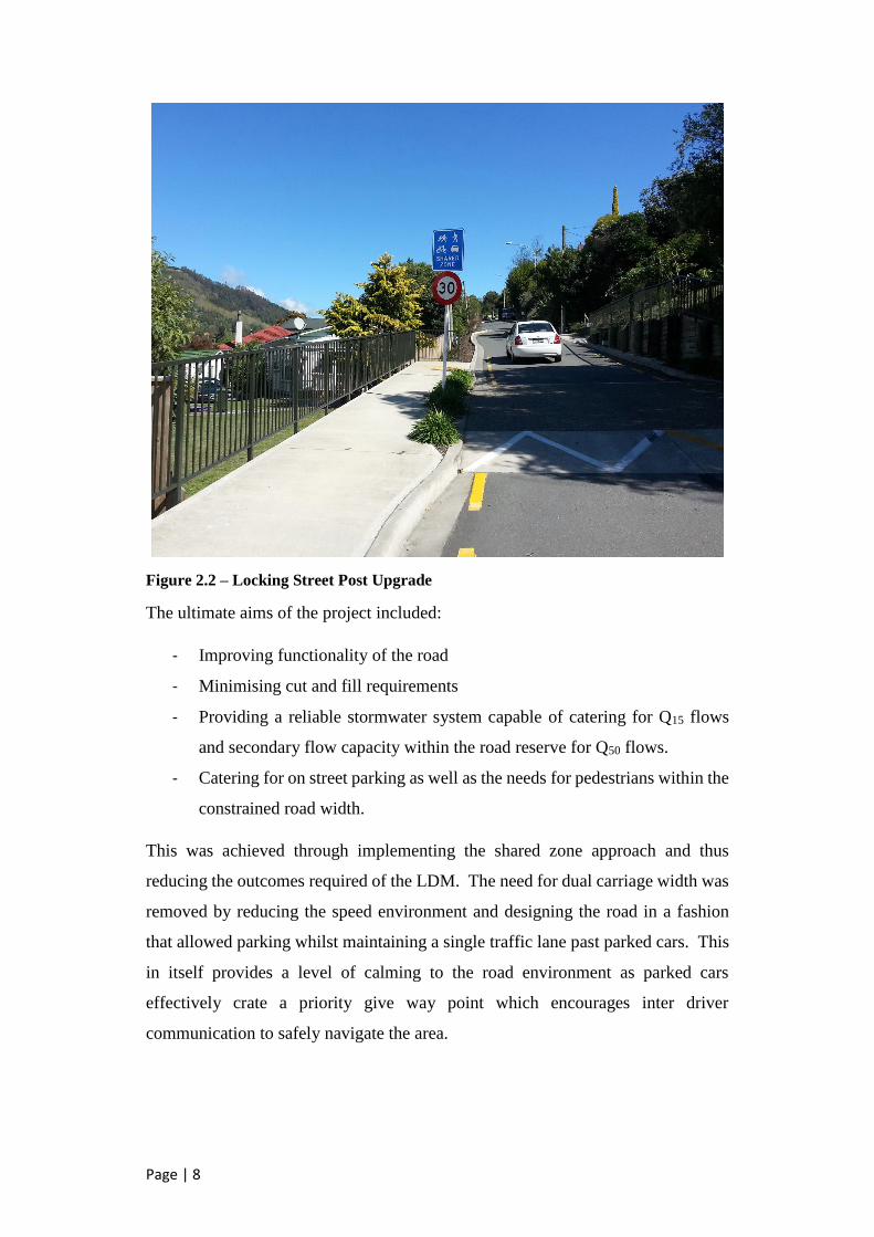
upgrade was constructed and Figure 2.2 shows the resulting road environment.
Figure 2.1 – Locking Street prior to road upgrade (Google Street View, 2016)
Page | 8
Figure 2.2 – Locking Street Post Upgrade
The ultimate aims of the project included:
- Improving functionality of the road
- Minimising cut and fill requirements
- Providing a reliable stormwater system capable of catering for Q15 flows
and secondary flow capacity within the road reserve for Q50 flows.
- Catering for on street parking as well as the needs for pedestrians within the
constrained road width.
This was achieved through implementing the shared zone approach and thus
reducing the outcomes required of the LDM. The need for dual carriage width was
removed by reducing the speed environment and designing the road in a fashion
that allowed parking whilst maintaining a single traffic lane past parked cars. This
in itself provides a level of calming to the road environment as parked cars
effectively crate a priority give way point which encourages inter driver
communication to safely navigate the area.

Page | 9
In the report to Council seeking approval to proceed with the upgrade of Locking
Street (Nelson City Council, 8 April 2010) a brief outline of what constitutes a
shared zone was identified. Advantages of the shared zones were identified as:
- Improvement to street character and amenity;
- Safety;
- Reduced risk of speeding vehicles;
- Community Cohesion;
- Reduced cost of upgrade.
In contrast to these benefits, disadvantages were identified as:
- No separate footpath for pedestrians;
- Slower vehicle speeds being seen as a negative by some;
- Concerns relating to vulnerable and visually impaired road users.
The features identified in this report go only as far as to identify the potential that
they exist. No specific consideration was given specifically to how these benefits
were to be achieved and how the disadvantages were to be mitigated. From the
report and recommendation it is suspected that the key driver for implementation
of the Locking Street upgrade treatment was cost reduction.
The reduction of speed in the shared zone is undertaken in accordance with the
Land Transport Rule Setting of Speed Limits – 2003 in particular Clause 3.2(6)
which specifies that for a speed limit less than 50kmh to be implemented the
following must be met:
- The calculated speed limit for the relevant road is 50kmh;
- The proposed speed limit would be likely to increase the safety of
pedestrians, cyclists or other road users; and
- Safe and appropriate traffic engineering methods are installed so that the
measured mean operating speed is within 5kmh of the proposed speed limit.
The current shared zones in Nelson City Council provide a speed limit of 30kmh.
This speed has been determined through the literature to be the most commonly
used speed where pedestrians, cyclists and vehicles need to use the same space.

Page | 10
2.2 Road speed environment and safety
There has been a significant volume of research undertaken on road speed
environment and the effect this has on safety. The Transport Research Laboratory
undertook a study into the stopping distance required at varying speeds in both wet
and dry conditions. This comparison is graphically represented in Figure 2.2.
Figure 2.3 – Graphical representation of change in stopping distance required at
varying speeds (Transport Research Laboratory, UK, 2007)
The Nelson City Council shared zones utilise a 30km/h design speed. This leads to
a reduction in required stopping distance of between 13.2m and 20.3m depending
on the road conditions.
The National Highway Traffic Safety Administration (U.S. Department of
Transportation, 1999) analysed pedestrian fatality and injury data over a vast range
of accidents and related the consequence of the accidents to speed. Table 2.2
outlines the relationship between injury severity and speed. This table has been
modified to indicate the location of the 30kmh and 50kmh speed limits as the
original data is presented in mph.

Page | 11
Injury Severity
Travel Speed (Officer Estimate)
Total 1-20 mph
21-25 mph
26-30 mph
31-35 mph
36-45 mph
46+ mph
Fatal (K) injury 1.1% 3.7% 6.1% 12.5% 22.4% 36.1% 6.5%
Incapacitating (A) 19.4% 32.0% 35.9% 39.3% 40.2% 33.7% 27.0% Non incapacitating (B) 43.8% 41.2% 36.8% 31.6% 24.7% 20.5% 38.8% Possible Inj. (C) or none 35.6% 23.0% 21.2% 16.6% 12.7% 9.7% 27.7%
Total Frequency 13.368 1.925 2.873 2.188 2.493 0.906 23.753
30km/h 50km/h
Table 2.2 – Vehicle travel speed and pedestrian injury severity modified to indicate
kilometres per hour (Table 2, U.S. Department of Transportation, 1999)
The data indicates a dramatic increase (1.1% - 6.1%) in the percentage of fatal
accidents with an increase of 10mph (16kmh).
The Royal Society for the prevention of Accidents (RoSPA, UK, 2007) states that
at an impact speed of 30kmh a pedestrian has a 10% chance of being killed. At
50kmh the likelihood of fatality jumps to 50%.
A study undertaken in Sweden (Rosen & Sander, 2009) determined the risk factor
of fatality as shown in Figure 3.2. This study indicates a likelihood of fatality at
30kmh of 1.5% (0.7%-3% confidence range at 95%) and 8.1% (5.5%-17%
confidence range at 95%).
Figure 2.4 – Likelihood of fatality in relation to impact speed of a pedestrian crash
Grundy Et Al. found in their study on the effect of 20mph traffic speed zones in
London from 1986 – 2006 (Grundy Et Al, 2009) that there was a 41.9% reduction
in road casualties associated with a reduction in speed limits to 20mph (32kph)
(Adjusted for time and with a 95% confidence interval 36% to 47.8%)

Page | 12
From the available literature two factors are clear:
1. There is significant variation in the determined likelihood of fatality across
research in the field. This indicates that there are a number of factors that
influence the likelihood calculations outside direct correlation with speed.
2. In all cases there is a significant jump in the likelihood of fatality between
30kmh and 50kmh. This suggests that a reduction in speed zone of 20kmh
is likely to have a tangible positive effect on the survivability of pedestrian
crashes.
2.3 Methods for achieving target design speed
Achieving the target speed of 30kmh for the shared zones is critical to the success
of the shared zone concept. The UK Department for Transport’s Manual for Streets
(Department for Transport, UK, 2007) outlines the methods for passively enforcing
speed zones in residential streets. This can consist of a combination or individual
components of the following:
1. Physical features such as horizontal or vertical deflection (Least preferred
method)
2. Changes in priority at junctions and pedestrian crossings
3. Narrowing of street dimensions
4. Reducing forward visibility
5. Psychology and perception including visually narrowing the roadway with
line marking, carriageway obstructions, pedestrian refuges and on-street
parking.
Physical features such as speed bumps, chicane arrangements and threshold
treatments are the least preferred method for controlling speed but are an integral
part of the implementation of shared zones. They create a visible change in road
environment and alert the driver to the required interaction with pedestrians and
cyclists. The Austroads Guide to Traffic Management Part 8 (Austroads, 2012)
outlines the specific factors to consider in implementing local traffic areas. The
concepts developed in this guide are expanded on in the UK Manual for Streets
which specifically outlines how a home zone should look and function.

Page | 13
Martens, Comte and Kaptein found in 1997 that the most effective methods of speed
reduction are those that force the driver to reduce speed. The paper discusses that
this is not necessarily the best outcome and that the options that provide a voluntary
reduction are the most effective through passive enforcement and self-explaining
roads.
Charlton Et Al. take the self-explaining concept further by finding that self-
explaining roads can be designed to maximise visual differences between road
categories. The paper demonstrates through the use of increased landscaping,
forward visibility limitations and removal of road markings a distinct local road
environment can be created (Charlton Et Al. 2007, Waikato, New Zealand). The
results of these treatments led to a reduction in the prevailing speed of the roads in
which the endemic road features were employed but also a homogenisation of speed
variation.
2.4 Shared Space functionality
For shared space to function effectively there needs to be alternative routes
through or around the space to effectively maintain the low traffic movement
areas within the zone. A reduction in through traffic within these spaces reduces
demand placed on the streets by traffic seeking a route from one place to another.
Shared zones should aim to provide sojourn areas where they provide an
environment in which people can move freely and where they have the option to
get to know the area. They should not be designed as a traffic space but rather a
space for living and experiencing the area. (Methorst et al. 2007)
2.4.1 Features of ‘true’ shared space
There is an argument to be made that there are very few places in New Zealand
where the treatments implemented hold true to the fundamental outcomes a shared
space is designed to achieve. There is a drive in the public sector space to provide
prescriptive detailed methods of implementing engineering parameters and this is
directly opposite to what the provision of shared space intends.
The shared space concept originated with Dutch traffic engineer Hans Monderman
in The Netherlands in the 1970s as a response to post-war auto centric street

Page | 14
designs. (Collarte, N 2012, Cambridge, USA). Within these areas there is a
complete removal of the features that have come to be recognised within a road
environment. Typical speeds within the zones vary depending upon the actual
needs of the place rather than a prescribed target that is commonly the aim of
modern traffic engineering.
These spaces aim to engender a level of doubt and confusion within the road user,
short of leading to discomfort, which encourages communication. The Dutch zones
tend to incorporate a level of awareness of human behaviour and psychology that
is sometimes missing from attempts at employing similar zones in other locations.
Flow Transportation Specialists in their Shared Space in Urban Environments –
Guidance Note, produced on behalf of the Institute of Professional Engineers New
Zealand (Joyce, 2012), state that drivers are only willing to accept a certain level of
task complexity. By reducing the complexity of the driving task (Through
standardising the road environment and separating pedestrians and vehicles) the
result is an increase in vehicle speed.
2.4.2 Difficulties in implementation
The difficulties in creating true shared space in New Zealand is the push towards
standardisation that exists in other areas of traffic and transport engineering. By
their nature, shared spaces should be designed in direct compliment to the
environment in which they are being implemented. Caution should be taken when
stipulating standard features such as traffic calming and threshold treatments. (Flow
Transportation Specialists, 2012).
2.5 Shared zone use and assessment
The use of shared space across the globe has been approached in a number of
different ways. Typically within a domestic context they have been viewed as a
novelty treatment approach more so than a viable solution to some transport issues
within road networks. The following section touches on a number of approaches
worldwide and domestically in the effort to understand best practice.

Page | 15
2.5.1 UK Home Zones
One of the most widely employed systems of shared spaces are implemented as part
of the UK “Home Zone” scheme. These schemes were introduced to deal with local
road areas where space was at a premium due to historical buildings and narrow
streets. The benefits that have stemmed from these zones are stated by UK Ministry
for Transport as:
1. Creating a high-quality street environment
2. Striking balance between the needs of the local community and drivers
3. Encourage low vehicle speeds
4. Create an environment where pedestrians can walk, or stop and chat,
without feeling intimidated by motor traffic
5. Make it easier for people to move around in their local area
6. Promote social interaction
The implementation of shared surface zones can lead to some problems (Ministry
of Transport, UK 2007):
1. Poor parking behaviours through unclear area designation
2. Vulnerable road users feel threatened by having no separation from
vehicular traffic
3. Visual clutter created through the implementation of traffic calming devices
4. Unclear path of travel for the visually impaired.
Reid, Kocak & Hunt in their report to the UK Transport Department (Reid, Kocak
& Hunt, 2009) conclude that the design and implementation of shared zones is
inevitably a compromise between the needs of a range of road users which seeks to
accommodate rather than exclude particular uses. They go further to state that well
designed zones in the UK have brought benefits in terms of visual amenity,
economic performance and perceptions of personal safety.
The appraisal of shared space is neutral on the actual safety benefits presented by
the zones but alludes to some trends of slight increase in casualties in some areas
and some decrease in others.
The final conclusion is presented that shared spaces should be approached utilising
a “Design Approach” rather than attempting to employ a “Design Type” utilising a

Page | 16
set of standard features. The general consensus is that the zones should be
developed on a case by case basis and the mixture of treatment types and functions
should be representative of the particular environment in which the zones are being
employed.
2.5.2 Dutch Woonerven
Most of the world’s shared spaces are modelled in principle on the concept
developed in the late sixties in The Netherlands known as Woonerven (Living
Streets). The development of these spaces was in opposition to the auto-centric
views in transport engineering at the time and was a new direction for urban
planning and development. (Collarte, 2012).
Typically the Dutch zones tend to be much more vigorous in their deployment of
the features that make up shared spaces. In 1976 the first regulations in relation to
the Woonerf’s were developed by the Dutch government and the two defining
regulations are (Eran, BJ 1995):
- Article 88a RVV: Pedestrians may use the full width of the highway within
an area defined as a ‘Woonerf’, playing on the road is also permitted;
- Article 88b RVV: Drivers within a ‘Woonerf’ may not drive faster than at
walking pace. They must make allowance for the possible presence of
pedestrians, including children at play, unmarked objects and irregularities
in the road surface, and the alignment of the roadway.
2.5.3 Local Area Traffic Management (LATM)
It can be argued that the outcomes desired of the shared zones in Nelson derive
from the stated aims of Local Area Traffic Management as prescribed in Austroads
Guide to Traffic Management Part 8 – Local Area Traffic Management (Austroads,
2016). This guide specifies an LATM as a treatment to an area of the road network,
between arterial roads and collector roads, with the intended aim of improving
functionality, reducing speed and removing unnecessary trips within the area. The
main difference between the Nelson zones and LATM approach is the isolated
nature of the shared zones. Whereas LATM intends to approach the area as a whole,
a shared zone is specific to the road environment in which it is employed.
Page | 17
The Austroads guide references a study undertaken by Brindle and Morrissey
(1998) as justification for this approach. Their review of LATM practices in
Australia concludes that:
- LATM generally results in a reduction in crashes within the space –
Typically by up to 50%;
- Speeds within LATM were generally reduced substantially with numbers of
vehicles exceeding 60km/h greatly reduced;
- Community perception of effectiveness of LATM in reducing speed varied
significantly across the literature with approximately 60% believing they
were effective in this manner;
- LATM is compatible with bicycle use if properly designed;
- Vertical calming devices were more effective than horizontal devices in
reducing speed and were generally more accepted by the public than
previously thought.
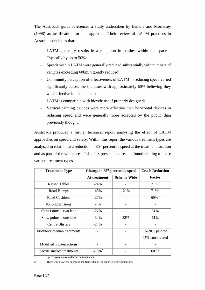
Austroads produced a further technical report analysing the effect of LATM
approaches on speed and safety. Within this report the various treatment types are
analysed in relation to a reduction in 85th percentile speed at the treatment location
and as part of the wider area. Table 2.3 presents the results found relating to these
various treatment types.
Treatment Type Change in 85th percentile speed Crash Reduction
Factor At treatment Scheme Wide
Raised Tables -24% - 71%3
Road Humps -45% -21% 71%3
Road Cushions -27% - 60%4
Kerb Extensions -7% - -
Slow Points – two lane -27% - 51%
Slow points – one lane -34% -32%1 61%
Centre Blisters -24% - -
Midblock median treatments - - 15-20% painted
45% constructed
Modified T intersections - - -
Tactile surface treatments -2.5%2 - 60%2
1. Speeds were measured between treatments
2. There was a low confidence in the figure due to the reported study limitations.

Page | 18
3. This UK-based figure referred to all crashes and was not adjusted for regression to the mean.
4. Estimated from speed reduction and other relevant studies rather than crash data.
Table 2.3 – Summary of literature review results relating to change in speed and crash
reduction factor (Austroads 2009)
2.5.4 European Shared Space Research Project
Between 2004 and 2008 seven project partners from five different countries in
northern Europe collaborated with the aim of applying shared space principles to a
variety of contexts within the road environment and assessing their effectiveness
and benefits. (Shared Space, Fryslận Province, 2008)
Key projects incorporated as part of this scheme include:
- Stroobossertrekvaart, Province of Fryslận, The Netherlands
- Bremer Straβe, Municipality of Bohmte, Germany
- Ejby, Municipality of Middelfart, Denmark
- Hesselterbrink, Municipality of Emmen, The Netherlands
- Konterdam Neighbourhood, City of Oostende, Belgium
- Ipswich, Suffolk County Council, United Kingdom
- Noordlaren and Onnen, Municipality of Haren, The Netherlands
Figure 2.5 – Ejby shared zone project as part of the shared space research project.
(Project for Public Spaces, 2016)

Page | 19
A number of parameters were identified as being common aims for these projects
being:
- Road Safety – High value placed on reducing the number of deaths and
injuries and removing perceptions of danger that act as a barrier to walking
or cycling
- Community Safety – Shared interest in reduction of crime and increase in
perception of security within the projects
- Public Engagement – Wider participation in the analysis, design and
management of streets and public places
- Liveability – Shared interest in promoting the attractiveness and
sustainability of a space within the community.
2.5.5 Guidance on Shared Space in New Zealand
Until recently the concept of shared space in New Zealand has been limited to
central business districts and street scaping projects and has not focussed on the real
benefits that the concept can bring to the road environment. The prescriptive nature
of New Zealand transport engineering has slowed the development and creativity
that can be employed to improve the street environment as a whole. Karndacharuk
et al argue that there are certain design elements that need to be incorporated to
make a space truly shared space. (Karndacharuk A, Wilson DJ & Dunn R, 2014).
Auckland City has developed a number of shared spaces based on the principles
outlined earlier. In 2012 a guidance note on shared space was developed by Flow
transportation specialists for the Institute of Professional Engineers New Zealand
(IPENZ) This guide outlines the general approach to employ shared space however
it is centralised on CBD and street scaping areas more so than residential streets.
Outside private property in residential developments there are very few real
examples of shared spaces in a residential setting in similar vein to the “Home
Zones” and “Woonerven” in Europe.
There has been little assessment of the effectiveness of shared residential space
within a New Zealand context and this poses a gap in the literature. The difficulty
lies in the subjectiveness of assessing how effective the zones are in achieving the
five objectives and performance indicators as developed by Reid Et al in their report
for the UK Department for Transport (Reid S, Kocak N & Hunt L, 2009):

Page | 20
1. Placemaking – The street should provide better use of public space via a
lively quality of the environment that attracts users to spend time within the
space. It is also reflected in a wider range of street activities. The
performance indicators include time spent in the area or user dwell time
(which is a possible measure to indicate that the zone is an origin/destination
rather than a through route), use of facilities provided, type of activity
occurring (e.g. eating, chatting etc.) and user perceptions.
2. Pedestrian Focus – This objective involves an environment with improving
pedestrian priority and the ability to walk along and across as well as freely
roam the street. The performance indicators include pedestrian flows,
number and density of pedestrians, safety and user perceptions.
3. Economic Impetus – A road space that complements the operation and
prosperity of the surrounding businesses. The performance indicators
include property and leasing values, retail occupancy rates and user
perceptions.
4. Vehicle Behaviour Change – A goal is to reduce the current dominance of
the motor vehicle and the driver in the environment. This change of priority
should enable the measurement of the vehicle driver feeling more like a
guest within the environment. The performance indicators include traffic
volume and speed reductions, travel time increase through the zone and
observed sharing behaviour. The traffic data on the surrounding road
network will also be measured to determine the impact of a shared space on
the surrounding environment as it cannot be taken in isolation.
5. Safety For All Users – Shared spaces are to provide a safer environment for
all users, including cyclists, the elderly and children. The performance
indicators include crash history, injury severity and costs, user demography
and perceptions.
These objectives and performance indicators are an adequate assessment of the
goals and objectives of areas with high road user volumes however the intended
study areas in residential streets have a different set of drivers to determine what a
successful implementation of shared space constitutes.

Page | 21
2.6 Road Authority position on Shared Space in New Zealand
There are still very few shared space upgrades in a residential context evident within
New Zealand. Where the features of shared space are applied they still tend to be
limited to very low volume and private residential areas or central business district
destination areas.
Figure 2.6 – Excerpt from Nelson City Council information page regarding residential
shared zones
Nelson City Council is the only local authority in New Zealand to actively define a
shared zone as part of its standard approach to hierarchy. Whilst the prescribed
features of the roads still fall short of those from foreign zones, it is actively
encouraged in guidance that the zones attempt to achieve some of the same level
outcomes. Particular similarity to UK home zones is drawn in the prescribed
approach to Nelson City Council zones (Shearer, 2011). Further reference is made
to the specifics of these zones at the start of this literature review.
2.6.1 Auckland City Council
Auckland City Council have undertaken a number of shared space upgrades within
their CBD spaces based on their city centre masterplan developed in 2011.

Page | 22
Figure 2.5 – O’Connell Street shared zone upgrade before and after (Auckland City
Council, 2016)
The Auckland Transport Code of Practice Chapter 5 – Special Routes and Road
Elements (Auckland City Council, 2013) provides a measure of guidance to the
provision of these spaces. There is significant guidance for urban orientated spaces
within the document but limited approach to the provision of shared space in
residential areas.
The document refers to “Home Zones” as section 5.5.6 (pp. 77) with a coverall
statement advising that for residential shared spaces the aforementioned urban zone
design principles are generally applicable with the following further considerations:
- Rather than relying on active frontage for user interactions in the case of
non-residential shared spaces in activity centres, a home zone
implementation looks to the residents and local communities for the sense
of ownership in utilising and maintaining the public (road) space.
- The motor vehicle movements should be strictly restrained. A residential
shared zone should only cater for vehicle traffic generated specifically for
the immediate local community it is designed for.
- The design and location of on-street parking spaces within a home zone
should be restricted in number and time only to cater for the local residents.
- Community focal points and facilities are to be provided to reinforce the
community ownership aspects.
The provision and clarity of requirements for residential shared space in the
Auckland Transport Code of Practice is deemed to be of low level with the primary
focus in this space being central activity areas.

Page | 23
2.6.2 Wellington City Council
The Wellington City Council code of Practice for Development: Part C – Road
Design and Construction (Wellington City Council, 2012) tends along the route of
the Austroads LATM outlined earlier in the literature review. Section C.1.9 –
Traffic Calming Measures for Residential Areas typically summarise their response
to local traffic areas in two points:
- Carriageway and alignment of traffic calming measures shall discourage
motorists from travelling above the intended speed;
- Local roads shall not provide routes which are more convenient for through
traffic than roads higher in the network category.
Some of the principles and objectives of shared space are provided for in the Urban
Development Design Objectives (Wellington City Council, 2016) including
reference to Walkability, sense of identity and place, connectivity and Accessibility.
These tend to be more overarching design principles with a general view rather than
specific detailed approaches.
Details of Wellington’s approach to shared space are difficult to find and what is
available tends to be underdeveloped in providing a sense of direction or guidance.
2.6.3 Christchurch City Council
Christchurch City Council, as with other major cities, prescribe the requirements
of LATM outlined earlier. The Christchurch City Council Infrastructure Design
Standard (Christchurch City Council, 2015) presents the requirements for traffic
management, calming device use and references the Austroads Guide for LATM
for further information.
Christchurch City Council’s level of guidance appears to be highly prescriptive in
nature rather than site specific. In terms of maturity of approach to shared space
the Council is underdeveloped.
2.6.4 Other New Zealand Local Authorities
In general New Zealand Councils across the board have relatively low flexibility
in terms of providing for shared space in a residential context. Whilst they tend to
be open to main street developments and town square type treatments, the

Page | 24
guidance documents for transport infrastructure tend towards specifying the New
Zealand Standard, NZS4404:2010 Land Development and Subdivision
Infrastructure or the various Austroads Guides as their basis.
Typically a specific approach to shared space is not presented. Rather if these
types of spaces are to be approved by the local authority, then they need to be on
an individual basis and subject to significant level of bureaucracy to achieve the
desired outcomes. For this reason it is argued that the lack of guidance from local
authorities in the area of shared space is a roadblock to developing better
functioning zones within residential spaces.
2.6.5 New Zealand Transport Agency
The NZTA provides some literature regarding the use of shared space for the road
network. The guidance provided relies heavily on the guidance note produced by
IPENZ (Joyce 2012) and the Land Transport (Road User) Rule 2004 specifically
stating that:
- A driver of a vehicle entering or proceeding along or through a shared zone
must give way to a pedestrian who is in the shared zone
- A pedestrian in a shared zone must not unduly impede the passage of any
vehicle in the shared zone.
Whilst providing a number of definitions regarding what might constitute a shared
zone, such as an off street carpark with no designated footpaths, the guidance stops
short of providing any details regarding the use of the zones.
Furthermore they make mention of the ‘trafficable zone’ within the space rather
than identifying the use of the entire space by all road users.
The NZTA tends to remove responsibility from itself in the implementation of
shared space by stating that a local authority can produce by-law declaring an area
as a shared zone. This is reasonable as the state controlled network would have very
few areas in which this type of approach is suitable.
Overall the NZTA has a position whereby they could advance and improve the use
of these zones, but tend to shy away from imparting their will on what is deemed a
local road authority domain.

Page | 25
3. Objectives and Performance Indicators
Objectives and performance indicators for a shared residential space have been
developed to assess the success and functionality of existing zones as well as giving
guidance for future upgrades. The key areas to be assessed have been simplified
and adapted to the residential environment from those proposed by Reid et al.:
- Placemaking
- Catering for a range of road users
- Economic Impetus
- Road user behaviour change
In this assessment it is intended that the focus on pedestrian dominance in these
zones be modified to allow an equal share of dominance between all road users.
The development of uncertainty in pedestrian, cyclist and vehicle movements is
more likely to create the safety and functionality outcomes desired in the zones.
It should be noted that the performance indicators within residential shared zone
are more qualitative in nature than those for high traffic destination zones in central
areas. The guidance on residential shared zones limits their implementation to areas
of a maximum of 100 vehicle movements per hour. Crash data, if it exists, is likely
to be minimal and statistically insignificant. Due to tight road reserves and steep
grades, it is likely that prevailing vehicle speeds are already low. For these reasons
perception and judgement are likely to be the major drivers in assessing
performance and success of the zones.
3.1 Placemaking
The drive to create a destination in residential zones is not as prevalent as in shared
spaces in CBD environs. The residential nature of the areas already denotes the
space as a destination space. For this reason the critical indicators for placemaking
are more focussed towards enhancing liveability of the street. Factors to be
incorporated include an enhancement in perceived safety from crime, Table 3.1
outlines the proposed objective statement and performance indicator for the concept
of placemaking.

Page | 26
Objective Statement Performance Indicators
Creates a street environment that
encourages interaction between
residents and relegates vehicular
operation to a secondary function
- Resident interaction increases
- Reduction in vehicle
movements within the space
Improves liveability of the street as a
result of encouraging active modes of
transport and providing social safety
aspects.
- Increase of cycling and walking
journeys to and from the street
- Enhancement in perception of
safety from crime and anti-
social behaviour
Table 3.1 – Objective statements and performance indicators for placemaking
3.2 Catering for a range of road users
Shared space in a residential area has a slightly lower level of focus on pedestrian
dominance however the aim should still be providing a safe and easy access for
pedestrians as an equal user of the space. The distinct feature of a lack of footpaths
in the space requires that thought be given specifically to the desired route of
pedestrians. Whilst the space overall should be designed to enable free access to
all users, a specific route for pedestrians should be considered. This should include
designated bypass routes through pinch points in the space.
Cyclists should also be considered in the design through ensuring rough surfaces
are avoided. They should be encouraged to utilise the main flow through the space
with vehicles rather than feeling the need to secede to them. It is critical that the
design speed be such that maximum vehicle speeds match reasonably close to those
achievable by cyclists. Even though the zones are speed restricted to 30km/h, the
aim should be to provide a road environment that passively enforces this limit.
Vehicular traffic in the space still needs to be considered as a major function
although the focus should be to actively encourage residents to use alternative
modes of transport for journeys within the immediate area. The aim is to encourage
trips to local amenities, such as a convenience store or park, to be undertaken via
active transport modes rather than driving.

Page | 27
The indicators and objectives for catering for a range of road users are aligned to
vehicle speeds and level and manner of use through the zone and are the best
quantitative measure of the success of the space. Table 3.2 shows the proposed
objectives and indicators.
Objective Statement Performance Indicators
Provides a sense of safety in route for
vulnerable pedestrians whilst
encouraging use of the entire road
space.
- Pedestrian perception of safety
increases
- Pedestrian use increases
Caters for cyclists using the space as
part of the traffic flow.
- Cyclist perception of safety
increases
- Cyclist use increases
Design to passively enforce design
speed of 30km/h or lower.
- 85th percentile speed of traffic
through space within 5km/h of
design speed
Table 3.2 – Objective statements and performance indicators for catering for a range
of road users
3.3 Economic Impetus
Economic impetus of residential shared space is of lower importance than that for
high traffic, destination spaces. However it is still important to consider the
economic impact that a potential upgrade could have.
For residential streets the indicator should be more focussed towards demographic
of adjacent occupiers rather than occupancy rates in themselves. A successful zone
is likely to see a shift towards a higher density of owner occupiers than renters.
This indicator is the most subjective of the proposed performance measures and is
the most difficult to quantify. However enhancement of property value should
remain as an aim in any potential upgrades to a shared residential zone. Proposed
objectives and indicators for economic impetus are outlined in table 3.3.

Page | 28
Objective Statement Performance Indicators
Provides an increase to the perceived
and actual value of adjacent properties
through street appeal.
- Increase in perception of street
appeal
- Increase in number of owner
occupiers in adjacent
residences.
Table 3.3 – Objective statements and performance indicators for economic impetus
3.4 Road user behaviour change
Behaviour change in road users aligns closely with the objectives associated with
catering for a range of road users with the key difference being a stated aim of
changing the road user’s perception of appropriate behaviour within the zone.
Providing a measure of this indicator is difficult and for the most part relies on
subjective opinion of the road user. However it is an important aim to achieve a
road environment that actively encourages users to align their behaviour with the
intended outcomes of a residential shared zone upgrade.
A key measure of the success for this objective is the level of interaction between
road users. Engagement of road users with each other within the zone are key to
measuring this performance
Objective Statement Performance Indicators
Road users possess an understanding
of the expected behaviour within the
zone.
- Increase in perception of
expected behaviour
- Increase in the level of
communication between road
users
Table 3.4 – Objective statements and performance indicators for economic impetus

Page | 29
4. Shared Zone Objective Assessment
It was intended to develop a model for assessing the objectives for residential shared
zones using a combination of methods to make judgement on the success in each of
the performance indicators. Three key areas make up this assessment:
- Gathering of data prior to and post shared zone implementation;
- Development and carrying out a resident survey to assess the qualitative
indicators;
- Survey of key persons in roading asset management and maintenance areas
with Nelson City Council.
4.1 Resident survey
The resident survey has been designed to take into account the views of the residents
in the area. Whilst there is a risk of bias dependent upon the views of particular
residents in relation to how their street should function the information should give
a good picture of how the residents perceive the residential area in which they live
and possible improvements to the zones could be sourced.
4.1.1 Survey Development
In developing the resident survey it is important to distinguish between long term
and short term residents of the streets in question. Those who lived in the street
prior to the shared zone implementation will be able to give comparative
assessments on indicators whereas those who have moved to the street since the
upgrade will be able to assess how the street environment contributed to their
selection of property.
The survey has been designed with 6 questions stemming from the initial parameter
of whether they lived in the street prior to the upgrade. Table 4.1 shows the question
flow chart:

Page | 30
Did you live in the street prior to the upgrade?
YES NO
Do you feel there has been an increase
in safety through implementing the
street upgrade?
Did the street environment provide
extra appeal to your purchase of the
property?
Do you think the upgrade has improved
how well you interact with your
neighbours?
Do you think the street environment
contributes to getting to know your
neighbours?
Do you think the upgrade has
contributed to an increase in value of
your property?
Do you feel safe from crime and
antisocial behaviour in the street?
Do you think the upgrade has
contributed to a decline in crime and
antisocial behaviour in the street?
BOTH
Do you regularly walk or cycle for short trips?
Are you comfortable with the speed and behaviour of other drivers in the street?
Table 4.1 – Resident survey question chart
Residents in Locking Street and Iwa Road were selected to participate in the survey.
Whilst there is a third residential shared zone on Queens Road, this zone is not
considered as part of this research as it was retrofitted after the fact rather than
consisting of a full road upgrade.
Owner occupiers of properties were selected as targets for the survey based on their
investment in the street environment and the direct effect that it plays on the way in
which they live and perceive the zones. It was decided not to target renters as there
are a large variety of reasons outside physical desire to live in the area that could
have implication on why they are renting the property. They also do not have any
real economic drivers beyond price to select a property in these streets.

Page | 31
4.1.2 Methodology
Residents who are owner-occupiers were targeted with the survey to gain an insight
into what they value about their home environment and factors residents believe
could be improved within the shared spaces.
The survey was delivered as a paper copy with the two options provided for those
that lived in the street prior to the upgrade and those that have moved there since.
The survey was also offered online via the “survey monkey” platform. It was
deemed important that a paper based version of the survey be offered to ensure the
views of those who are not technically adept with internet were still encouraged to
respond.
Surveys were issued 13th of August with no timeframe identified for completion.
A follow up letter drop to the residents targeted was completed on 5th of September
advising that the survey would close on the 9th of September.
4.1.3 Summary of Responses
By the survey close there had been three responses online from residents who lived
in the streets prior to the upgrade and two who had moved to the streets since the
upgrades. In addition to this a further 3 paper based responses were returned from
residents who lived on the streets prior to the upgrades. Survey responses are
summarised in table 4.2.
Number of respondents who lived in the streets prior to upgrade 6
Number of respondents who moved to the streets since the upgrades 2
Number of respondents who view the zones as a positive treatment 3
Number of residents who were somewhat satisfied with the treatments but
suggested improvements
4
Number of respondents entirely unsatisfied with the treatment type 1
Table 4.2 – Summary of survey responses
4.1.4 Analysis
The small sample group made it difficult to obtain statistically relevant data which
was anticipated by the open question style. The value of this survey lies in the

Page | 32
suggestions and responses to questions based on the individual views of residents.
Throughout the surveys a number of common suggestions became apparent. These
are presented in table 4.3.
Car parking
space
A number of respondents suggested that the most irritating
feature of the shared zones is the way in which residents park.
The narrow nature of the road space means that parking is
restricted in a number of areas. Of particular concern was how
well emergency vehicles are able to transit the street. 3
respondents declared concerns that a fire truck would not be
able to move freely through the street at all times due to
vehicles parking opposite each other creating pinch points.
Desire for one-
way operation
2 respondents suggested they would prefer if the street
operated in a one-way fashion. This was driven by concerns in
regards to the narrow nature of the street and increased parking
demand due to development of land below the street.
Crime and anti-
social
behaviour
Crime and anti-social behaviour was a critical point in a
number of the surveys. Whilst one respondent believed the
street environment contributed to a reduction in poor behaviour
a number advised that it had no impact. It is likely that the
respondent who suggested it created a reduction was from the
Iwa Road zone whereas the other respondents were from
Locking Street. It is also likely that a recent spate of vandalism
in the area at large contributed to poor responses to this
question.
Active modes
of transport
Whilst there were two negative comments in relation to feeling
safe within the road environment, all 8 of the respondents
advised that they regularly walk or cycle for short trips. Whilst
it is difficult to draw conclusions regarding the contribution
shared space makes to encouraging active modes of transport,
it is clear that those in the areas are utilising these transport
modes.
Speed and
safety factors
A number of respondents declared concerns in relation to the
speed and behaviour of road users in the shared space. Whilst

Page | 33
generally respondents were content with the speed in the zones
the general concern stemmed from the occasional driver
travelling too fast. There was also comment made in regards
to cyclists on the uphill sections of the street frustrating
impatient motorists due to slow speeds and lack of space to
pass. Anecdotally there are instances where cyclists have been
required to veer to the side of the road to allow vehicles pass.
Economic
Impetus and
place making
Respondents were generally neutral on how they feel the street
contributes to an increase in property price and whether the
upgrade creates a desirable place to live. Comment was made
in relation to landscaping and how it was implemented and
maintained. Two respondents suggested that there should have
been more landscaping included and maintenance should be of
a higher standard. There was also suggestion that the nature of
the streets tend to oppose the concept of placemaking. Most
dwellings are set back and are significantly higher or lower in
elevation than road level. This leads to individual properties
being disconnected from the street space.
Traffic calming
devices
Most of the responses received were positive in relation to
speed control devices. In particular there were two responses
that suggested that the narrow control points spaced every 80m
in Locking Street were not enough alone. The respondents
were of the opinion that these devices should have all been
combined with speed tables to reduce travel speed further.
Table 4.3 – Summary of survey respondent themes
4.2 Council Expert survey
A second set of questions has been developed to assess success of the zones by
experts currently working with Nelson City Council. Five officers have been
selected based on either their involvement with the original projects or their
ongoing maintenance involvement with the streets:

Page | 34
4.2.1 Survey Development
Team Leader Roading Operations – Supervises the roading maintenance of
Council’s operations and champions road safety initiatives.
Capital Projects Engineer – Project managed the Locking Street upgrade project.
Capital Projects Senior Engineering Officer – Project managed the Iwa Road
upgrade and has extensive experience with roading safety upgrades.
Group Manager Infrastructure – Manages the functions of the infrastructure group
within Council and is the Senior Leadership Team member for the group. Also
provides a link between the elected officials and staff within the group.
Senior Asset Advisor – Asset manager for roading and was involved with all of the
shared space initiatives.
The proposed questions are outlined in Table 4.4:
Do you think the design of the streets in question contribute positively or
negatively to road safety?
Do the upgrades contribute to a better functioning street in relation to all road
users?
Do you feel the street environment contributes to active modes of transport?
Do you feel the street environments meet the objectives of:
- Placemaking
- Catering for a range of road users
- Economic Impetus
- Road user behaviour
Are there any improvements you feel would contribute to meeting these
objectives?
Table 4.4 – Council expert question chart
4.2.2 Methodology
The council expert survey was developed to obtain expert information from officers
within Council who have either extensive experience in the field of road safety, or
were directly involved with the upgrades.

Page | 35
The choice of questions focussed on the previously developed objectives for the
shared zones and the performance indicators associated with each.
Officers were interviewed individually with discussion free to cover topics
prompted by the questions in the survey. The officers were then requested to
complete the survey afterwards to obtain direct answers to the questions
incorporated. In this way it was possible to determine opinions on the subject that
may have been outside the range of discussion in the interviews.
4.2.3 Analysis
Generally responses to the questions asked were positive, however there were a
number of improvements that could have been made. Table 4.5provides a summary
of the areas covered:
Economic
Drivers
The main theme that came through from a number for the
respondents was the fact that the main drivers for the shared
zones tended to be for cost reduction rather than suitability for
the treatment type. Whilst costly, full upgrade treatment was an
option in the reconstruction of Locking Street. Further to this
some of the design features important to this treatment type
were deemed to be of lower importance which may have led to
the zone not functioning as well as it could.
Public
Engagement
Engaging with the public and seeking feedback was identified
as the most difficult stage of the upgrades. Some of the concepts
involved in the development of shared zones seem counter
intuitive to those lacking experience in the transport field. An
example of this was given in trying to explain how lack of
forward visibility contributes to lower speeds and safer road
environment. Generally the opinions related to this feature were
negative and were difficult to convince members of the public
who attended information sessions.
Continuing the
status quo
The road environments in which the shared zone upgrades have
taken place are effectively formalising what has already been
occurring within the street. The roads prior to upgrade were
already very narrow and steep and the upgrades, particularly

Page | 36
Locking Street, have accentuated this rather than attempting to
change the dynamic in which they function. All officers
surveyed agreed that this has led to easier acceptance of the
shared zone concept as it is seen as an improvement rather than
a reduction in level of service.
Cyclist Speed There were issues raised in relation to the Locking Street
upgrade in relation to cyclist speed on the downhill sections.
Potential to consider designing in a way that reduces cyclist
speed at critical points.
Parking
Behaviour
Parking was identified as an issue within the zones with
difficulty in ensuring residents park in appropriate areas and
don’t reduce the overall capacity of the road to carry the traffic
required.
Cost as main
driver for
upgrade
All officers interviewed suggested that the main driver for these
upgrades has been cost. Whilst all agreed that other benefits had
been achieved through the upgrades, there was a general
agreement that these benefits are difficult to quantify in a
meaningful way to present to decision makers. The asset
managers in particular were interested in methods to quantify
these benefits in a manner useful to the business case approach
that Council takes to capital project upgrades.
Ongoing
education and
promotion of
shared zone
behaviours
Ongoing education of residents in both in the shared zones and
in surrounding areas was identified as a potential area for
improvement. As time passes and new residents move to these
areas, the original message relating to how the zones should
function tends to get lost. Regular updates and flyers to these
spaces could potentially negate this issue.
Targeting
shared zones
to their
audience
It was identified by one of the officers interviewed that the
existing zones tended to be too generic in their approach. A site
specific approach to the zones is needed to ensure that the
shared zones are achieving the benefits required.

Page | 37
Cul-de-sac
approach to
through roads
Serious consideration should be given to blocking through
access on linked roads in the areas in which the treatment type
is being considered. Vehicles are far more likely to travel at the
design speed if it serves no benefit to them to travel quicker as
they are already close to their destination. This will also provide
potential reduction in traffic volumes on the roads although may
negatively impact surrounding streets if not thoroughly
considered.
Vulnerable
pedestrians
The issue of vulnerable pedestrians including children, the
elderly and vision impaired were considered by a number of the
respondents. Although the consensus was that council should be
catering for these users where possible, there was also a general
acceptance of a reduction in level of service based on the
accessibility of the road prior to the upgrade.
Table 4.5 – Summary of council expert survey responses

Page | 38
5. Comparative Assessment Shared Zone Approach
The second section of the project incorporates development of a preliminary design
matching the current requirements of Council’s Land Development Manual and
comparatively assessing it against a preliminary design attempting to achieve the
objectives developed for residential shared zone assessment. The designs have
been compared by estimating the construction costs using median tendered rates
from the past three years of Nelson City Council capital projects. Where rates from
particular items are unavailable, an estimate from first principles was developed.
5.1 Selection of study site
Council asset managers have previously identified a number of sites that could be
considered for the shared zone approach. After analysing these potential sites, Airlie
Street in the village of Glenduan was chosen to undertake the comparative designs
upon. This decision was made based on the following:
- Availability of site information. As a detailed design had been undertaken
on the location by a consultant in 2013, survey information and knowledge
of service locations was readily accessible;
- Nature of the site – The difficult grades and proximity of the road to property
boundaries meant the location would clearly highlight any issues with the
upgrade designs;
- The small nature of the village and the fact that the road is already a dead
end meant that the impact on surrounding areas of the shared zone approach
was deemed minimal.
- The traffic and speed parameters fit the previously identified guidance on
shared zones. (Less than 100 vehicles per hour and local road hierarchy).
5.2 Detailed Site Analysis
Glenduan is situated approximately 15km north east of the Nelson City CBD.
Located off State Highway 6 the small population is made up of primarily lifestyle
blocks with slightly larger section size than would typically be found on a potential

Page | 39
shared residential zone site. A typical steep grade and narrow road reserve are
present and the road is well overdue for upgrade or reconstruction.
The street rises from approximately 30m above sea level to 65m above sea level
over 315m length. This gives an approximate average grade of 11%. The average
width of road reserve is 15m, however steep cross grades prevent the full width
being deemed usable space.
A major consideration of any potential upgrade will be capturing stormwater within
the road space. Historical floods have inundated a number of properties along this
stretch of road so it will be critical that the upgrade design caters for carrying
significant stormwater flows. It was decided that an assumed stormwater design
would be undertaken and estimated using sizing from similar projects.
There was also a current shortage of on road parking space so any upgrade proposed
would need to at least provide for the number of spaces currently available to the
area. Property accesses were be of significance in design and on street parking was
able to be used to provide slow points on the road to allow passive enforcement of
target speeds through side friction effects.
The average daily traffic on the road is around 140 vehicles per day and the primary
purpose of the road is a residential local road. The main local trip generators for
the area are a local park and beach. Outside of these destinations, all trips are likely
to be undertaken in a vehicle based on the distance from amenities including shops,
workplaces, schools and sporting facilities. This poses the problem that there will
be more vehicular movements than might normally be the case in a residential
shared space but should provide a good baseline in demonstrating the effectiveness
of catering for all road users.
The residence types bordering the street tend towards larger properties matching
the lifestyle blocks they are located on. The general demographic is appealing
towards retirees who prefer to be away from the central areas of the city. For this
reason it was assumed that an ageing demographic is required to be catered for. On
this basis it was deemed likely that considerations for vulnerable pedestrians would
be significant in the designs.
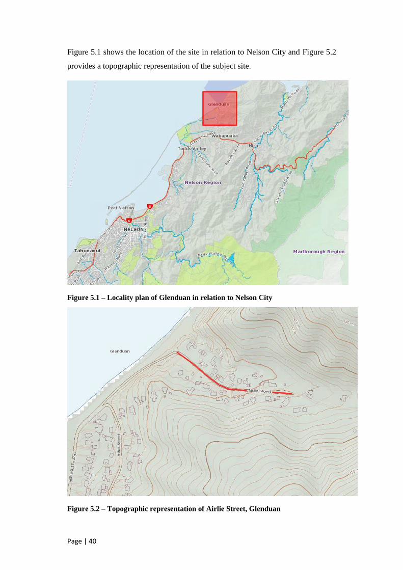
Page | 40
Figure 5.1 shows the location of the site in relation to Nelson City and Figure 5.2
provides a topographic representation of the subject site.
Figure 5.1 – Locality plan of Glenduan in relation to Nelson City
Figure 5.2 – Topographic representation of Airlie Street, Glenduan

Page | 41
5.3 Design
Two designs have been developed as part of the project with the intention of
providing quantities for comparative estimates. These designs were undertaken in
accordance with Nelson City Council design standards to a preliminary design
level.
5.3.1 Design brief
The intention was to develop two designs to a preliminary design standard suitable
for taking quantities. The first design was to outline a standard upgrade on a
residential street with greater than 20 dwellings. The design parameters for this are
outlined in Table 9.1 based on the requirements of the Nelson City Council Land
Development Manual 2010:
Parameter Value Comment
Lane Width 1 x 5.5m traffic lane This lane is to cater for traffic in
both directions.
Parking width 1 x 2.0m parking lane 2m may be on either side of the
road and contributes to the
overall road width rather than a
specific parking bay.
Footpaths 2 x 1.5m wide footpaths May be reduced to one side if
space is prohibitive. At least one
continuous footpath should be
provided for the length of the
upgrade with road crossing points
at strategic points to ensure this
connectivity is maintained.
Berm /
Service
alignment
2 X 1.5m wide berm /
service corridor
Provided to allow for future
telecommunication, power or
council services as required.
Usually requires separate berms
and service corridors but it is
common practice to combine
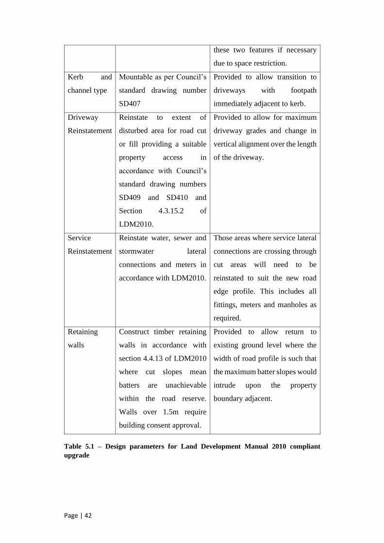
Page | 42
these two features if necessary
due to space restriction.
Kerb and
channel type
Mountable as per Council’s
standard drawing number
SD407
Provided to allow transition to
driveways with footpath
immediately adjacent to kerb.
Driveway
Reinstatement
Reinstate to extent of
disturbed area for road cut
or fill providing a suitable
property access in
accordance with Council’s
standard drawing numbers
SD409 and SD410 and
Section 4.3.15.2 of
LDM2010.
Provided to allow for maximum
driveway grades and change in
vertical alignment over the length
of the driveway.
Service
Reinstatement
Reinstate water, sewer and
stormwater lateral
connections and meters in
accordance with LDM2010.
Those areas where service lateral
connections are crossing through
cut areas will need to be
reinstated to suit the new road
edge profile. This includes all
fittings, meters and manholes as
required.
Retaining
walls
Construct timber retaining
walls in accordance with
section 4.4.13 of LDM2010
where cut slopes mean
batters are unachievable
within the road reserve.
Walls over 1.5m require
building consent approval.
Provided to allow return to
existing ground level where the
width of road profile is such that
the maximum batter slopes would
intrude upon the property
boundary adjacent.
Table 5.1 – Design parameters for Land Development Manual 2010 compliant
upgrade
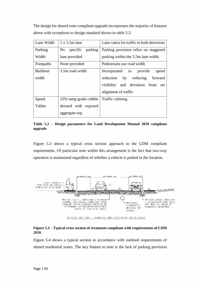
Page | 43
The design for shared zone compliant upgrade incorporates the majority of features
above with exceptions to design standard shown in table 5.2:
Lane Width 1 x 5.5m lane Lane caters for traffic in both directions
Parking
Width
No specific parking
lane provided
Parking provision relies on staggered
parking within the 5.5m lane width.
Footpaths None provided Pedestrians use road width
Buildout
width
3.5m road width Incorporated to provide speed
reduction by reducing forward
visibility and deviation from set
alignment of traffic
Speed
Tables
15% ramp grade cobble
dressed with exposed
aggregate top.
Traffic calming.
Table 5.2 – Design parameters for Land Development Manual 2010 compliant
upgrade
Figure 5.3 shows a typical cross section approach to the LDM compliant
requirements. Of particular note within this arrangement is the fact that two-way
operation is maintained regardless of whether a vehicle is parked in the location.
Figure 5.3 – Typical cross section of treatment compliant with requirements of LDM
2010.
Figure 5.4 shows a typical section in accordance with outlined requirements of
shared residential zones. The key feature to note is the lack of parking provision

Page | 44
meaning that any parked vehicle within the space contributes to achieving the
design speed of the zone.
Figure 5.4 – Typical cross section of treatment to LDM 2010 standard
The threshold treatment for the shared zone treatment is particularly important in
identifying the area as a change from the normal road environment. It needs to
actively encourage a reduction in vehicle speed as well as visually signalling drivers
of the potential for interactivity with other road users. Figure 5.5 shows the layout
for the threshold treatment and Figure 5.6 demonstrates a typical section through
the speed table.
Figure 5.5 – Typical layout of threshold treatment

Page | 45
Figure 5.6 – Typical section through threshold treatment
Retaining structures are required to be used wherever cut and fill requirements
require vertical changes in elevation. These walls have been designed to an
indicative level only with no consideration made to geotechnical conditions of the
site. The walls are assumed to be constructed of 250mm treated timber piles with
half 100mm diameter bollards used to clad the wall. These features are assumed
based on the retaining structures implemented in the Locking Street Upgrade.
Figure 5.7 shows a typical cross section through these proposed retaining walls.
Figure 5.7 – Typical section at crossing point requiring retaining walls

Page | 46
5.3.2 Parameters and Methodology
The steep cross grade of the road means that tie in to driveways will be difficult in
areas of cut. For this reason the decision has been made to maintain the vertical
geometry as near to existing as possible. Whilst this will minimise cut areas on the
upslope side of the road, there will still be areas that need to have specific design
of property accesses considered. This has been incorporated by modelling problem
driveways in civil 3d and ensuring that the levels tie in with the proposed roading
upgrade. Quantities of the driveway reconstruction have been included.
Stormwater would be a normal consideration of an upgrade of this magnitude.
Outside of potential extra sump requirements in the shared zone upgrade, there is
no real variation in the size and installation requirements between the two design
options. This leads to the inclusion of stormwater as an indicative size in the
estimates and an indicative alignment only. No consideration of stormwater design
is made beyond an indicative alignment and sump placements along with an
assumption of diameter based on similar designs in other locations.
Service alignments have been shown indicatively on plans and the alignment of
road upgrade adjusted to suit as required. It is assumed that all service crossings are
at depth sufficient for the required upgrade. Where the roading alignment impinges
on the alignment of services likely requiring relocation, this has been considered in
the estimate. Of particular note is the alignment of 100mm water main on the
upslope side of the upgrade. It is likely that any significant cut in this area will
require relocation of the water main. Depth of this service is assumed to be at
minimum 700mm shown indicatively on cross sections.
The alignment of the road centreline has been designed to match with the existing
road. There may be instances that require superelevation generation or radius
adjustment on curves but this has been deemed beyond the scope of preliminary
design. The design for the shared zone upgrade is presented as Appendix A and the
LDM compliant design as Appendix B to this report.

Page | 47
5.3.3 Expected Outcomes
The upgrade in compliance with the LDM 2010 requires a significantly greater
amount of cut and fill than that of the shared type treatment. Further to this there is
a need to construct extra pavement area and footpaths.
The extra cut and fill and wider profile of the LDM compliant treatment is expected
to require extensive retaining of adjacent slopes to allow the space to cater for it.
This will increase the overall cost through the retaining structures directly as well
as extra earthworks associated with them.
The LDM compliant design also has difficulty in obtaining suitable linkage with
existing property accesses. This is likely to increase the area and subsequent cost of
reinstating property accesses after construction.
Extra cut and fill also leads to the need to relocate service laterals in the road as
well as potential to require full service relocation depending on depth again
increasing costs.
It is expected that the shared zone treatment will result in a significantly lower
construction estimate than the LDM compliant treatment. In addition it is likely
that ongoing maintenance costs of the shared zone treatment will be lower.
5.3.4 Quantities
Quantities for the designed upgrades have been extracted based on length and area
for most items shown in the schedule. Whilst draft cross sections were produced to
extract cut and fill volumes outside of the road profile, these sections have not been
included in the preliminary design which is standard practice at a preliminary
design stage. The fact that the design is based on LiDAR data with +/- 50mm
accuracy supports this decision.
The full schedule of quantities for each option form part of the estimate documents
and are included as Appendices C and D to this report.
5.3.5 Estimates
The estimates for each option have been produced using rates from NCCs database
of median tendered prices from the last three years with engineering judgement
made on the suitability of rates. Judgement on the most suitable rate for specific

Page | 48
quantities depended on other projects with similar amounts and the age of the prices
included. Projects with an age outside three years old have been excluded from use
in averages.
The shared zone upgrade was estimated at $774,866.40 including a 15%
contingency amount and excluding GST. Table 5.3 provides a summary of the
estimate excluding the contingency amount. The full estimate is available as
Appendix C to this report.
ITEM DESCRIPTION Amount
A PRELIMINARY AND GENERAL $ 91,000.00
B WATERWORKS $ 18,825.00
C DRAINAGE WORKS (STORMWATER) $ 228,000.00
D SEWERAGE $ 11,200.00
E EARTHWORKS $ 68,270.00
F ROADWORKS / CYCLEWAY CONSTRUCTION $ 240,750.00
G ROADMARKING AND SIGNS $ 5,500.00
H MISCELLANEOUS $ 7,335.00
J UNSCHEDULED WORKS $ -
TOTAL THIS TENDER
(carried to Form of Tender – Excl. GST) $ 670,880.00
Table 5.3 – Estimate summary for shared zone upgrade
The standard compliant upgrade has been estimated as $1,062,099.75 including
15% contingency amount and excluding GST.
Table 5.4 provides a summary of the estimate excluding the contingency amount.
The full estimate is located in Appendix D to this report.

Page | 49
ITEM DESCRIPTION Amount
A PRELIMINARY AND GENERAL $ 110,000.00
B WATERWORKS $ 45,675.00
C DRAINAGE WORKS (STORMWATER) $ 228,000.00
D SEWERAGE $ 11,200.00
E EARTHWORKS $ 95.120.00
F ROADWORKS / CYCLEWAY CONSTRUCTION $ 358,000.00
G ROADMARKING AND SIGNS $ 7,000.00
H MISCELLANEOUS $ 68,570.00
J UNSCHEDULED WORKS $ -
TOTAL THIS TENDER
(carried to Form of Tender – Excl. GST) $ 923,565.00
Table 5.4 – Estimate summary for standard compliant upgrade
5.3.6 Ongoing Maintenance Costs
A net present value analysis was undertaken on the designs to determine the cost
benefit they deliver. The baseline of this assessment has been based on a “do
nothing” approach where ongoing maintenance costs of the road are assumed
without capital renewal intervention.
Ongoing maintenance costs of both the existing “Do nothing” option as well as
those for the proposed upgrade types have been estimated using base rates as follow
in Table 5.5. Rates are present value with 2016/17 financial year as zero year.
Asset Renewal Requirement Unit Rate
Reseal m2 $13.45
Moderate Pavement Repair (Assume 10% repair area) m2 $134.41
Major Pavement Repair (Assume 25% Repair area) m2 $134.41
Slope Stability Maintenance Lump Sum $100,000
Major Pavement Rehabilitation (Stabilisation) Lump Sum $250,000
Table 5.5 Asset maintenance unit rates
A value for slope stability maintenance has been assumed based on historical slips
previously during sever weather events. The arbitrary figure of $100,000.00 has

Page | 50
been taken to represent an estimate of varying annual costs over a 15 year period
during the life of the asset.
Reseals have been assumed to be required every 12 years in all cases which aligns
with current NCC practice.
The pavement along the length of Airlie Street is of low structural integrity and as
such is prone to high levels of failure. A major pavement stabilisation is assumed
to be required as part of ongoing maintenance. It is also assumed that after this
major pavement stabilisation, significant reduction in ongoing pavement repair
costs will eventuate.
A capital outlay of $375,000 has been assumed for stabilisation based on an
approximate cost of $100,000 per kilometre including resurfacing. The suitability
of this stabilisation based on material present has not been considered as the
alternative would require a full reconstruction of the pavement leading to one of the
capital upgrades being considered as alternatives.
5.3.7 Net Present Value Assessment of Options
A net present value (NPV) analysis was performed based on capital expenditure of
the two upgrade options as well as ongoing maintenance requirements of the
existing road. NZTA assessment tools have been used in determining these values.
The tools are used by Council when providing cost benefit analysis for NZTA
subsidised capital projects. The tool provides a 40 year project life with ongoing
maintenance of the capital upgrade options included in the consideration.
Table 5.6 provides the comparison of NPV determined by this analysis. A full
summary of the analysis is available in Appendix E to this report.
Option Net Present Value
Do nothing approach – Continue with existing maintenance
regime with stabilisation in year
$954,357.00
Standard Compliant Upgrade – Provision of a full LDM
compliant upgrade as based on preliminary design estimate
$1,176,214.00
Shared Zone Upgrade – Provision of a shared zone upgrade
based on preliminary design estimate
$806,218.00
Table 5.6 – Net Present Value comparison

Page | 51
Based on the determined NPV for the three alternatives it was found that the shared
zone upgrade option has a NPV benefit factor of 1.2. The NPV benefit factor for
the LDM compliant upgrade is determined as less than one at 0.81.
It is noted that the NPV analysis does not take benefit costs into account on each of
the options. Factors such as improved physical amenity and increase to road safety
are difficult to quantify in the case of a road with the low volume that Airlie Street
has. One of the major difficulties in determining the value that the upgrades add in
this regard is the lack of significant data,
Further analysis could be undertaken in the following areas to enhance the cost
benefit ratio of the potential upgrades however this was deemed beyond the scope
of the project:
- Reduction in crash rates
- Improvement to physical amenity of road environment
- Increase in the use of active modes of transport contributing to resident
wellbeing
- Provision of resilience to disaster and climate change through upgrade of
stormwater system to appropriate levels
- Reduction to ground stability risk based on retaining structures
- Improvement to accessibility in the street
- Overall increase to adjacent property values

Page | 52
6. Guidance Document
The ultimate aim of the guidance document is to provide a manual for use by Nelson
City Council when developing and implementing future shared zone treatments. It
is intended that this document be presented to Council and approved for reference
in the Land Development Manual upon its review in 2017. The document expands
on the current 2 page guidelines produced in conjunction with the original Locking
Street Upgrade.
6.1 Legislative Considerations
In implementing a shared zone the lower speed limit of 30km/h presents a
legislative challenge. Whilst the local authority has the power to implement speed
zones appropriate to the road environment, 30km/h is significantly lower than the
standard 50km/h limit. Each individual 30km/h zone is required to seek approval
for the lower speed from New Zealand Transport Agency.
6.2 Local Government Approval
The document will be required to seek Council approval to be implemented for use
on future capital projects. The process involves presenting a report to the Senior
Leadership Team (SLT) and subsequently presenting the report to the Works and
Infrastructure committee of council. Upon their approval it might be necessary to
present to the full Council depending on the resolution made by the Works and
Infrastructure committee.
6.3 Guidance on Use and Expectations
The document is expected to be used as a guide only. The nature of the shared zone
is such that each individual upgrade should be designed specifically to the merits
and constraints of each site. For this reason the term ‘should’ is used more
frequently than ‘shall’. The document presents details of how the zones should
function rather than prescriptively stating detailed design standards.

Page | 53
6.4 Catering for lower mobility and disability
It is of particular importance that road users with lower mobility or physical
impairment are taken into account in implementing shared zones. Of particular
concern are vision impaired users who through removal of designated footpaths
lose their cues to move freely within the space. For this reason one of the defining
decision points in choosing whether to implement a shared zone should be whether
the upgrade will make navigability more difficult for those with visual impairment.
The majority of the road environments where this could be considered as a
treatment have limited to no footpath facilities in their current form. Furthermore
the road terrain is such that navigability by users with reduced mobility is likely to
be minimal anyway. However when designing the road these users should still be
catered for. Tactile paths for the visually impaired and providing footpaths through
narrow points should be considered. It is also reasonable to expect that parking
should be provided for on one side of the road only to allow a consistent path of
travel through the shared zone by those lacking in mobility or vision.
6.5 Document Specifics
The guidance document provides direction in the key areas that relate to achieving
the objectives of shared residential space as developed previously.
It is intended that the guidance document provides direction to the user rather than
instructing them directly in what should and shouldn’t perform part of their project.
Each potential site for a shared zone treatment will vary in the way in which it
performs and should be assessed using the parameters within the document and
engineering judgement made as to the suitability of the project.
A checklist is provided at the end of the document. This checklist runs the user
through the particular requirements of a shared zone approach such as traffic
volumes and prevailing speed. It then runs the user through a series of yes or no
questions relating directly to the performance indicators developed as part of this
dissertation. The full document is included as Appendix F to this report.

Page | 54
7. Limitations and Further Work
This dissertation set out with one of the aims to provide a level of qualitative
measure on the performance of the shared zones. Due to the low volumes of traffic
and significant gaps in available data for the roads it was deemed inappropriate to
continue with the proposed comparison between crash rates and speed parameters
for the areas. This provides the potential for a major point of research that could be
undertaken upon the next implementation of a shared zone treatment in the Nelson
City Council area. It is intended that measures be put in place now to understand
the dynamics of traffic within the zones prior to a potential upgrade. The author is
currently seeking approval to obtain this data through a range of counts on the roads
that have been identified as potential future shared zone candidates.
Further work is to be undertaken on the guidance document developed as part of
this dissertation. Potential improvements include:
- Providing further detail into the performance objectives identified as part of
this dissertation.
- Incorporate an overview of the literature into the document as guidance for
to the user on the benefits that may be encountered and what can go wrong
if the design does not meet the needs of the environment into which it is
being placed.
It is also intended that the shared zone approach be formalised into the road
hierarchy in transport planning policy of Nelson City Council. This could be
difficult as there is a current push to a standardised approach to road network
hierarchy across New Zealand and where shared zones fall within this framework
is yet to be determined.
There is also potential to further the study in a number of areas including:
- Comparatively assessing the differences between residential and CBD
zones and their drivers;
- Study into the effect of the shared zones on surrounding streets as a whole;

Page | 55
- Effect of engaging a Local Area Traffic Management approach to some of
the streets in question and assessing how well they function compared to the
shared zones;

Page | 56
8. Conclusions
The use of shared zones in the Nelson City Council area for a solution to grade and
space restrictive residential streets is proposed as a suitable option.
The benefits found in the literature review provide justification for their use
however there are a number of areas in which the current zones are failing. Options
to remedy these issues in line with the performance objectives presented in Chapter
3 should be considered. Of particular concern is the way in which vulnerable
pedestrians are catered for within the zones.
Generally the target speeds within the zones are being achieved however there
remains a level of concern regarding the expected behaviour of drivers in the road
space. More thought needs to be given to ensuring that the public understand how
the zones are supposed function and educating drivers to be more accommodating
to pedestrians within the spaces.
Placemaking amenity within the existing zones is adequate although improvements
to the way they look and feel could enhance this objective further.
A comparison was made between a design undertaken in accordance with the
Nelson City Council design standards and one developed based on the shared zone
principles. The net present value analysis based on estimates for the shared zone
was found to have a benefit factor greater than 1 for the shared zone and less than
1 for the LDM compliant upgrade in comparison with an estimate of routine
maintenance over a 40 year life span. This demonstrates that the potential cost
benefits along with the unvalued social benefits that the approach can provide are
likely to outweigh those achieved through a full LDM compliant upgrade.
A guidance document has been developed to assist Nelson City Council in
implementing future zones. This has been based on the best practice determined
from the literature review with the central focus based on the performance
objectives previously identified. The document requires significant further refining
and is presented in draft format for this project.

Page | 57
The dissertation intended to answer the questions posed as problem statements in
the introduction. Through the development of the dissertation it became clear that
there were a number of further areas of study that should be undertaken to
complement the findings of this research.

Page | 58
9. References
Leaf, WA & Preusser, DF 1998, Literature Review on Vehicle Travel Speeds
and Pedestrian Injuries Among Selected Racial / Ethnic Groups, U.S.
Department of Transportation, Washington D.C., United States of America
Mao, B, Chen, H & Chen, S 2002, Sustainability assessment of speed
regulation of urban traffic, IATTS Research Journal, Vol 26, No. 2: 2002, pp.
18-24, , International Association of Traffic and Safety Sciences
Grundy, C, Steinbach, R, Edwards, P, Wilkinson, P & Green, J 2008, 20 mph
zones and road safety in London, London Road Safety Unit, London, United
Kingdom
Collarte, N 2012, The Woonerf Concept: “Rethinking a Residential Street in
Somerville, Tufts University, Cambridge, United States of America
Karndacharuk, A, Wilson, DJ & Dunn, R 2014, A review of the evolution of
shared (street) space concepts in urban environments, Transport Reviews,
Vol. 34, No. 2: 2014, Taylor and Francis Online
Karndacharuk, A, Wilson, DJ & Dunn, R 2016, Qualitative evaluation of
urban shared spaces in New Zealand, Transportation Research Part D:
Transport and Environment, Vol. 42, Jan 2016, pp. 119-134, Elsevier Ltd
Reid, S, Kocak, N & Hunt, L 2009, Shared Space Project – Stage 1:
Appraisal of shared space, MVA Consultancy, Department for Transport,
United Kingdom,
<http://www.dft.gov.uk/pgr/sustainable/sharedspace/stage1/pdf/stage1.pdf>
Cycling in Christchurch 2014, #2walkandcycle: Interesting stuff around
Nelson, <http://cyclingchristchurch.co.nz/2014/11/08/2walkandcycle-
interesting-stuff-around-nelson/>, viewed May 2016
Nelson City Council 2013, Residential Shared Zones,
<http://nelson.govt.nz/services/transport/roads/residential-shared-zones/>,
viewed February 2016
United Kingdom Department for Transport 2007. Manual for Streets, Thomas
Telford Publishing, London, United Kingdom
Hamilton-Baillie, B 2008, Interreg IIIB Project – Shared Space, Fryslận
Province, Leeuwarden, Netherlands
Commission for Architecture and the Built Environment, Civilised Streets –
Briefing Paper, CABE, London, United Kingdom
Wegman, F 2007, Sustainable Safety in the Netherlands, 2nd UN Stakeholders
Forum on Global Road Safety, SWOV Institute for Road Safety Research

Page | 59
New Zealand Law of Transportation, Supplementary Update – Land
Transport Rule: Setting of Speed Limits 2003, Thomson Brookers, 2003
Waitakere City Council 2009, Slow Street and Traffic Calming Policy and
Guidelines, Transport Assets Department, Waitakere, New Zealand
BBC News 2009, ‘20mph speed zones cut road injuries by 40%, study says’,
11 December 2009, viewed 23 February 2016,
<http://news.bbc.co.uk/2/hi/health/8406569.stm>
Edwards, W 2005, Local Streets for Liveable Neighbourhoods, Wes Edwards
Consulting, Auckland, New Zealand
Cameron, Gibson & Wells Ltd 2010, Nelson City Council Locking Street
Upgrade, Design Plans, Nelson, New Zealand
Nelson City Council 2010, Nelson Residential Shared Zones Internal
Guidelines, Nelson, New Zealand
Nelson City Council 2010, Report to General Council Meeting – Residential
Shared Zones, Report 887705, Nelson, New Zealand
Joyce, M & Coomer-Smit, B 2012, Shared Space – Guidance Note, Flow
Transportation Specialists Ltd, Auckland, New Zealand
Rosen, E & Sander, U 2009, Pedestrian fatality risk as a function of car
impact speed, Accident Analysis and Prevention, vol. 41, 2009, pp. 536-542
Austroads 2008, Guide to Traffic Management Part 8L Local Area Traffic
Management, Austroads Incorporated, Sydney, Australia
Austroads 2000, Pedestrian and Cyclist Safety – Recent Developments,
Austroads Incorporated, Sydney, Australia
Austroads 2009, Impacts of LATM Treatments on Speed and Safety, Austroads
Incorporated, Sydney, Australia
Eran, BJ 1995, Changing the residential street scene: Adapting the shared
street (Woonerf) concept to the suburban environment, Journal of the
American Planning Association, vol. 61, no. 4, pp. 504-515
Charlton, SG, Mackie, HW, Baas, PH, Hay, K, Menezes, & Dixon, C 2010,
Using endemic road features to create self-explaining roads and reduce
vehicles speeds, University of Waikato, New Zealand
Nelson City Council 2010, Land Development Manual – Section 4 –
Transport, Nelson, New Zealand
Minnema, R 2006, The evaluation of the effectiveness of traffic calming
devices in reducing speeds on “Local” urban roads in New Zealand,
University of Canterbury, Christchurch, New Zealand
Nelson City Council 2012, Transport activity management plan – 2012-2015,
Nelson, New Zealand

Page | 60
Grundy, C, Steinbach, R, Edwards, P, Green, J, Armstrong, B & Wilkinson, P
2010, Effect of 20 mph traffic speed zones on road injuries in London, 1986 –
2006: controlled interrupted time series analysis, British Medical Journal, vol.
339:2009
Shearer, D 2010, Shared Spaces in New Zealand Urban Areas, University of
Otago, Dunedin, New Zealand
Christchurch City Council 2015, Infrastructure Design Standards,
Christchurch, New Zealand
Auckland City Council 2013, Auckland Transport Code of Practice: Chapter
5 – Special Routes and Road Elements, Auckland, New Zealand
Wellington City Council 2012, Code of Practice for Development: Part C –
Road Design and Construction, Wellington, New Zealand
Wellington City Council 2016, Urban Development Design Objectives,
viewed September 2016, < http://wellington.govt.nz/your-council/plans-
policies-and-bylaws/urban-development/urban-design>
Auckland City Council 2016, Council Projects – Shared Spaces, viewed
September 2016,
<http://www.aucklandcouncil.govt.nz/en/planspoliciesprojects/councilprojects
/sharedspaces/Pages/home.aspx>
Standards New Zealand, NZS4404:2010 Land Development and Subdivision
Infrastructure, Wellington, New Zealand

Page | 61
Appendix A – Shared Zone Upgrade Preliminary Design

Page | 62

Page | 63

Page | 64

Page | 65
Appendix B – LDM 2010 Upgrade Preliminary Design

Page | 66

Page | 67

Page | 68

Page | 69
Appendix C – Shared Zone Estimate

Page | 70

Page | 71

Page | 72

Page | 73

Page | 74

Page | 75

Page | 76

Page | 77

Page | 78

Page | 79

Page | 80

Page | 81

Page | 82

Page | 83

Page | 84

Page | 85
Appendix D – Standard Compliant Estimate

Page | 86

Page | 87

Page | 88

Page | 89

Page | 90

Page | 91

Page | 92

Page | 93

Page | 94

Page | 95

Page | 96

Page | 97

Page | 98

Page | 99

Page | 100
Appendix E – Net Present Value Analysis

Page | 101

Page | 102

Page | 103

Page | 104

Page | 105
Appendix F – Nelson City Council Shared Zone Guidance
Page | 106
Shared Zone use and Assessment Guidelines
Nelson City Council
Page | 107
Introduction
The purpose of this document is to provide a tool for Nelson City Council officers to assess whether a
shared zone treatment is a suitable option and to provide guidance on the techniques and features
that make for a successful shared zone.
It is intended that the guidance document provides a guide rather than prescriptive design standards.
Each potential site will vary in the way in which it performs and should be assessed on an individual
basis using the parameters within this document.
Objectives
The objectives of shared zone use should reflect the outcomes identified as part of the Nelson 2060
plan, The Nelson City Council Transport activity management plan and the outcomes of the current
Nelson City Council long term plan.
Typically the requirements of these documents can be met by achieving all of the following objectives
when implementing a shared zone.
- Provide a safe space for residents, pedestrians, cyclists and motor vehicles, with priority given
to pedestrians;
- The space is safely navigable through negotiation between road users;
- Creates a space that is appealing and retains or improves the character of the area;
- Provides a level of economic benefit to adjacent properties;
- Encourages the use of active modes of transport;
- Provides a sense of placemaking;
- Road users understand what is required of them within the space and actively demonstrate
this behaviour;
- 85th percentile speed within 5km/h of the desired 30km/h speed limit is achieved or bettered.
This list is by no means exhaustive and the user should reference current strategies, guidelines and
legislation specific to the implementation of a residential shared zone.

Page | 108
Features
The features within a Nelson City Council shared zone should aim to achieve or enhance the objectives
of the spaces. Design of the zones should take into consideration all of the following, however the
designer should not consider this an exhaustive list of options.
The road site chosen should be assessed on the particular merits it presents and treatments outside
of those within this document are acceptable as long as they contribute to the overall objectives of
the zone.
Design Speed
The speed within the zones should be as low as practicably achievable to improve pedestrian and
cyclist safety. The highest speed within the zone should be within 5km/h of the posted speed limit
of 30km/h.
This design speed should be achieved through the combination of methods appropriate to the
candidate site including:
- Calming Devices
- Road width narrowing
- Limitation of forward visibility
- Provision of on street parking
- Changes in vertical and horizontal alignments
Threshold Treatment
It is important that the shared zones are clearly distinguished from other areas of the road network.
This is to be achieved by utilising a threshold treatment consisting of a raised speed table at the
entrance combined with the approved shared zone sign and a 30km/h speed limit sign (RS1B). The
signage arrangement is to be provided both sides of the speed table. Figure 1 shows the gated signage
arrangement and speed table approved for use.

Page | 109
Figure 1 – Shared Zone Threshold Treatment
The following components shall be the minimum threshold treatment employed for a new shared
zone:
- 5m long speed table with exposed aggregate top. The table should be clearly distinguishable
from the surrounding road surface and will differ from the tables utilised in the central
business district of Nelson.
- Planted buildouts are to be provided to narrow the space.
- If queueing space is available prior to the threshold treatment then the entry shall be
narrowed to a single trafficked lane. If a lack of space is present then the threshold treatment
will be wide enough to enable two vehicles to pass.
Longitudinal Details
Mid-block treatments shall be incorporated where deemed appropriate depending on the nature of
the road to which the treatment is being applied. They should be provided at regular intervals no
greater than 90m and may or may not include speed tables as part of their design. When
implementing mid-block treatments the following shall be considered:
- Forward visibility
- Impediment to driveway access and parking
- Stormwater drainage requirements
- Consideration of grade in relation to buildout locations and difficulty slowing and giving way.

Page | 110
Width Details
The road width in shared zones should typically be aligned with the existing constraints of the street.
Ambiguous road widths should be avoided to ensure that motorists are provided clear guidance on
whether it is clear to pass or not. Typically the road width will either be 3m at narrow sections or
5.5m at two way locations.
If the existing road width is wider than 6m then it should be reduced through the provision of
landscaping features or provision of on street parking. Maximum lane width within these spaces shall
be 2.7m.
Footpaths
Footpaths should only be provided within the zones where the road environment presents risks to
vulnerable pedestrians that cannot be overcome through other means. Examples of this include
provision at locations where the road edge has a steep drop or sheer wall in conjunction with a one
way section of the street (3m wide).
The presence of footpaths within the shared zones reduces the ability of the zone to function as true
shared space. Pedestrians may see a footpath provided in some locations as limiting their ability of
negotiating right of way with other road users. The extra earthworks and retaining likely required is
a further negative outcome of the provision of footpaths within these zones.
Kerb and Channel
Kerb and channel should only be used as necessary and should be of mountable type. Kerb and
channel provides a visual barrier to the free movement of pedestrians into the road space and as such
may increase uncertainty, particularly with vulnerable road users.
Where appropriate to the stormwater catchment requirements, low impact stormwater collection
should be employed through the use of:
- Swale collection drains;
- Unobtrusive collection structures;
- Rain gardens and landscaping to disguise drainage infrastructure;
- Providing an understanding of secondary flow paths and modification to prevent affects to
adjacent properties.

Page | 111
Parking
Parking consideration is of particular importance to shared zones. It should be clear where parking is
and is not allowed in an effort to ensure that at least a single lane exists in all locations and passing
opportunities are provided regularly. With clever planning, the provision of on street parking can add
to the shared space environment through limiting forward visibility in the space and providing side
friction to vehicle drivers.
There is potential to create reluctance from pedestrians to utilise the full road area when they
encounter a travelling and parked vehicle restricting available space. To avoid this consideration
should be given to pedestrian escape routes at points of potential conflict. Subtle variation to road
width and clever use of parking space location can provide a sense of space whilst not reducing the
desire to utilise the entire road area. By widening the road space from 5.5 metres to 6 metres in
locations where parking is allowed, provision is made for extra manoeuvring space particularly
relevant to larger emergency vehicles and small heavy vehicles like rubbish collection trucks.
The width should return back to designated width at driveway locations. Not only will this provide a
level of side friction in its own right, but it will also tend to discourage vehicles from parking and
obstructing property access.
Landscaping
The provision of landscaping, particularly at kerb buildout locations, is critical to ensuring that the
shared zone looks and feels like shared space. This is designed to not only provide a place making
sense, but is also important for forward visibility reduction and adding to reduction of speed within
the zone.
Varieties of plants selected should be suitable for the particular growing conditions in the areas
required. This might mean extra thought and change in planting variety along the length of and
upgrade as the conditions change.
The planting should also aim to minimise future maintenance requirements as they are generally
located outside routinely maintained locations. Figure 2 shows poor performing landscaping in the
Locking Street shared zone. It can be seen there is a lack of side friction being created and even the
potential for the kerb buildout to be overlooked by vehicles due to the lack of defining feature outside
the kerb line.

Page | 112
Figure 2 – Poorly implemented landscaping in a shared zone
Safety and Crime Prevention
It is important that consideration be given to the principles of crime prevention through
environmental design (CPTED) when implementing shared space. The nature of the spaces can be
conducive to these principles through providing a tight space meaning closer proximity of observers
to anti-social behaviour. There is, however, the potential to create issues in the same way. Reducing
forward visibility and planting of vegetation has the potential to create dark spots in the road
environment and obscure observer visibility.
An overall balance should be found between the provision of shared zone infrastructure and the
requirement for providing a safe space for road users. This might mean measures such as:
- Increase in street lighting
- Providing a higher level of maintenance to the space than would normally be considered;
- Consider security measures that could be employed as part of the upgrade
For more information relating to the CPTED principles refer to A1340746.

Page | 113
Lighting
Potential difficulty lies in determining the level of lighting necessary for the shared zone. Whilst safety
in route for pedestrians at night is paramount, it is also important to recognise the residential nature
of the street and the issues that over lighting can cause.
The approach to determine lighting location and levels should take into account the likely travelled
path of a pedestrian within the space. This will allow the designer to determine the most economic
distribution of lighting in the area whilst also ensuring that proper coverage is provided.
Assessment Checklist
A quality control checklist has been developed to assist the document user to assess whether an
existing zone meets the needs of a shared zone approach. The document also provides prompts in
the areas of the key objectives identified as being critical to the success of a residential shared zone
treatment:
- Placemaking
- Catering for a range of road users
- Economic Impetus
- Road user behaviour change
The checklist document is attached as an appendix to this guide.
Conclusion
In implementing a shared zone the designer should consult documentation well beyond the scope of
this guideline. A variety of references are available for further information. The following is a list of
some of the most informative
- Manual for Streets – United Kingdom Department for Streets (Specific reference is made to
the Home Zone concept)
- Shared Space Guidance Note – Flow Transportation and IPENZ
- Civilised Streets Briefing Paper - Commission for Architecture and the Built Environment
- Austroads Guide to Traffic Management – Part 8 – Local Area Traffic Management (LATM)

Page | 114
Appendix A – Checklist for proposed shared zone
Residential Shared Zone – Implementation Checklist
This checklist should be used to assess whether a residential shared zone approach is suitable for a
proposed upgrade. The purpose of the document is to engage thought processes in the main
objectives that a shared zone should intend to achieve.
PARAMETERS FOR DESIGN SUITABILITY
No Description Yes / No Reference Comments
Is the AADT on the proposed
site less than 1000v.p.d.
Is the current 85% speed within
10 of 30km/h. (N.B. if the
current 85% speed is greater
than 50km/h, the use of a
shared zone approach should
be reconsidered)
If the 85% speed is greater than
50 you should consult with
transport asset managers in
relation to methods of reducing
this speed or the suitability of the
shared zone approach.
Is the proposed road a through
route in the network?
Is the upgrade likely to divert
traffic to alternate routes?
Have the impacts of this been
considered at a network level?
Discuss with transport asset
managers and roading operations
team leader.
Is the proposed upgrade in an
area with high proportion of
elderly residents or other
vulnerable road users?
Consideration should be given to
providing a safe route through the
shared zone. This doesn’t
necessarily require footpaths but
travelled path of pedestrians
should be considered in design.
Is there potential for the
implementation of low impact
stormwater features allowing
kerb and channel to be
excluded from the design?
Has feedback been sought from
residents in the potential street
to obtain their views?
Local knowledge is crucial in this
type of project and getting
affected residents on board with
the project will contribute greatly
to its success.
PLACEMAKING
No Description Yes / No Reference Comments
Will the proposed design
provide for resident
interaction?
Does the proposed upgrade
contribute to increasing active
modes of transport?
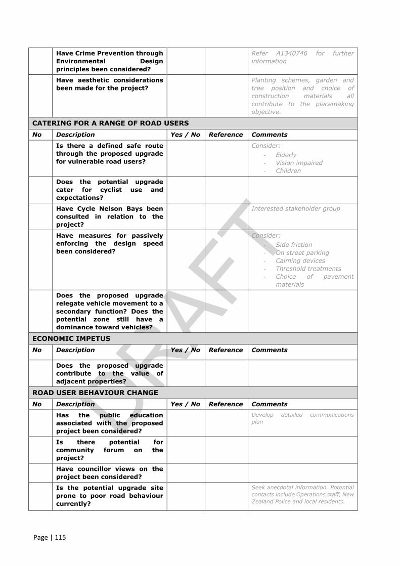
Page | 115
Have Crime Prevention through
Environmental Design
principles been considered?
Refer A1340746 for further
information
Have aesthetic considerations
been made for the project?
Planting schemes, garden and
tree position and choice of
construction materials all
contribute to the placemaking
objective.
CATERING FOR A RANGE OF ROAD USERS
No Description Yes / No Reference Comments
Is there a defined safe route
through the proposed upgrade
for vulnerable road users?
Consider:
- Elderly
- Vision impaired
- Children
Does the potential upgrade
cater for cyclist use and
expectations?
Have Cycle Nelson Bays been
consulted in relation to the
project?
Interested stakeholder group
Have measures for passively
enforcing the design speed
been considered?
Consider:
- Side friction
- On street parking
- Calming devices
- Threshold treatments
- Choice of pavement
materials
Does the proposed upgrade
relegate vehicle movement to a
secondary function? Does the
potential zone still have a
dominance toward vehicles?
ECONOMIC IMPETUS
No Description Yes / No Reference Comments
Does the proposed upgrade
contribute to the value of
adjacent properties?
ROAD USER BEHAVIOUR CHANGE
No Description Yes / No Reference Comments
Has the public education
associated with the proposed
project been considered?
Develop detailed communications
plan
Is there potential for
community forum on the
project?
Have councillor views on the
project been considered?
Is the potential upgrade site
prone to poor road behaviour
currently?
Seek anecdotal information. Potential
contacts include Operations staff, New
Zealand Police and local residents.

Page | 116
Appendix G – Project Specification
ENG4111/4112 Research Project
Project Specification
For: Stephen William Russell
Title: Review of “Shared Zones” as a solution to grade and space restrictive residential streets
Major: Civil Engineering
Supervisors: Trevor Drysdale
Chris Pawson – Nelson City Council
Sue McAuley – Nelson City Council
Enrolment: ENG4111 – EXT S1, 2016
ENG4112 – EXT S1, 2016
Project Aim: To evaluate the existing Nelson City Council use of shared zones in grade restrictive
residential streets and to undertake a benefit analysis of the zones.
Programme: Issue B, 5 April 2016
1. Literature review based on the use of shared zones worldwide and domestically (New Zealand)
2. Resident survey – Undertake a resident survey within the existing shared zones streets to obtain
public perception information.
3. Safety data collection and collation – Undertake manual counts at each of the three shared zones
identified and relate to existing data.
4. Desktop study of candidate shared zone sites and selection of proposed study site.
5. Preliminary design of traditional and shared zone approach and estimate of costs to construct.
6. Data collation and analysis
7. Report Writing is to run alongside project.
If time permits:
8. Develop report to Council advising of findings of dissertation
9. Develop a section for consideration as part of Land Development Manual review to include a
standard approach to determining the suitability of the shared zone treatment and how this
treatment should be developed.


