
42A01SEW13 2.10097 OTTO 010
GEOPHYSICAL STUDY
MAGNETIC SURVEY
AND
HORIZONTAL LOOP ELECTROMAGNETIC SURVEY (HEM)
DISTRICT OF OTTO AND TECK
ONTARIO
MADE FOR: HSK MINERALS LTD.
RECEIVEDMAY 2 8 1987
MINING LANDS SECTION
BY: DENIS BOISCONSULTANT GEOLOGIST
APRIL 1987
42AeiSE*el3 2.18097 OTTO 010U
TABLE OF COKTENTS
Page
INTRODUCTION
LOCATION AND ACCESS. . . . . . . . . . . . . . . . . . . . . . . . . . . . . . . . . . . . l
DESCRIPTION OF PROPERTY................................ 2
List of claims...................................... 2
GEOLOGY OF PROPERTY AND SURROUNDINGS................... 3
DESCRIPTION OF SURVEY.................................. 4
INTERPRETATION OF RESULTS.............................. 4
Magnetic survey..................................... 4
Electromagnetic survey.............................. 7
CONCLUSION. . . . . . . . . . . . . . . . . . . . . . . . . . . . . . . . . . . . . . . . . . . . . 8
RECOMMENDATIONS. . . . . . . . . . . . . . . . . . . . . . . . . . . . . . . . . . . . . . . . 10
BIBLIOGRAPHY. . . . . . . . . . . . . . . . . . . . . . . . . . . . . . . . . . . . . . . . . . . 12
INTRODUCTION:
This document comments the results of a magnetic and
horizontal loop electromagnetic survey (HEM), done by MAGMA
EXPLORATION, for HSK MINERALS LTD., during the month of
February 1987, on a property located in the Kirkland Lake
district, Ontario.
LOCATION AND ACCESS:
The property under study in this report is located in
the central-southern part of the district of Teck and the
northern part of the district of Otto, at approximately five
(5) miles south-west of Kirkland Lake, Ontario. The property
is easily accessible by Highway 66, which goes through its
northern part.
Reference: map 1:50 000
GEOLOGY OF PROPERTY AND SURROUNDINGS:
The property is located in the central-southern part
of the Abitibi Belt. In this area, volcanic, sedimentary and
associated intrusive rocks are enclosed in a syncline going
down towards the east. Two main groups of rocks make up this
area, they are:
The Temiscamink Group in the north, made up of mafic
and felsic breccia, flow breccia, tufs and arkosic sedi
mentary formation. Many syenitic intrusives are associated
with it.
In the southern part, we find the Larder Lake Group,
made of ultramafic and basaltic komateites, calcoalea line
andesites, conglomerates, argilites and iron formations.
Sills and stock of ultramafic to mafic composition may also
be observed deeper south. The Temiskamlnk and Larder Lake
groups are separated in the northern part of the property by
the Cadillac-Larder Lake break, oriented east-north-east in
this area. Numerous gold showings have been found in this
zone. More than 23 million ounces of gold have been
extracted from the immediate area of Kirkland Lake located
less than five (5) miles from the property under survey.

DESCRIPTION OF SURVEY:
The geophysical surveys have been made on a grid
comprising 24 lines spaced at 300 feet and oriented 355 N.
This grid totals more than 14.7 mi. in length.
The magnetic survey has been carried out with an
instrument called OMNI IV from EDA. The readings have been
taken every 50 feet, following the grid lines, on a total
surveyed distance of approximately 14.2 mi.i
The horizontal loop electromagnetic survey (HEM) has
been carried out with an instrument called Max-Min II, from
APEX. The readings have been taken every 50 feet. A
separation of 100 meters between the coils has been used.
The 444 Hz, 1777 Hz and 3555 Hz frequencies have been used
for this work. A total of 9.2 mi. of line has been covered
during this survey.
INTERPRETATION OF RESULTS
Magnetic survey:

The property is caracterized by the presence of
magnetic axes oriented 90 N to 100 N. The central-southern
part of the property shows the presence of a series of basic
units cut by a structure of direction 325 N.
Only the magnetic axis M-9 shows an association with
an electromagnetic conductor. The coincidence of these
anomalies could be associated to the presence of sulfurs.
We observe in the northern part of the property, an
important magnetic depression cutting the basic formation in
this area. Striking in a 320 N direction this signature does
not show electromagnetic association.
The Ml and MA axes are oriented towards 90 N and are
separated by a directionnal structure 325 N. These axes may
reach 1,000 feet in length and close to 1,500 nT of amplitude
at the position of line 15+OOE to 1+50S. With a wavelength
inferior to 150 feet, these axes could be the indication of
this basic units or of magnetic sulfides horizons located
less than 50 feet under the surface.
The M2 and M3 axes reach 3,000 feet in length and are
also separated by the same directionnal structure 325 N.
These axes are found in a sector with stronger magnetic
expression than the previous ones. These axes show ampli
tudes reaching 800 nT at the line 9+OOE at position 8+50S.
These two axes are moved up for a few tens of feet along a
plan axis of direction 325 N, and are separated by a magnetic
depression due to the dipole effect, generated at the
extremity of M2 and M3 axes. These axes tend to show varia
tions in the contents of magnetic minerals of the underlying
basic units.
The axis shows the southern limit of an area whose
average magnetic expression is 200 to 300 nT superior to the
background. This axis of more than 2,000 feet in length is
bordered on its southern part by the EM1 and EM2 conductors.
This axis could indicate the presence of basic breccia.
The M6 axis indicates the northern limit of this
area. The latter is not associated with any conductor, and
may reach 1,000 nT. This axis longer than 2,500 feet, could
indicate the presence of a basic unit.
The M4A, M5 and M8 axes are punctual anomalies found
respectively at lines 9+OOE and 48+OOE. These anomalies may
reach 1,000 nT. The dipolar character of these anomalies
suggests the presence of concentrations of magnetic minerals,
and this, at a depth inferior to 30 feet below the surface.
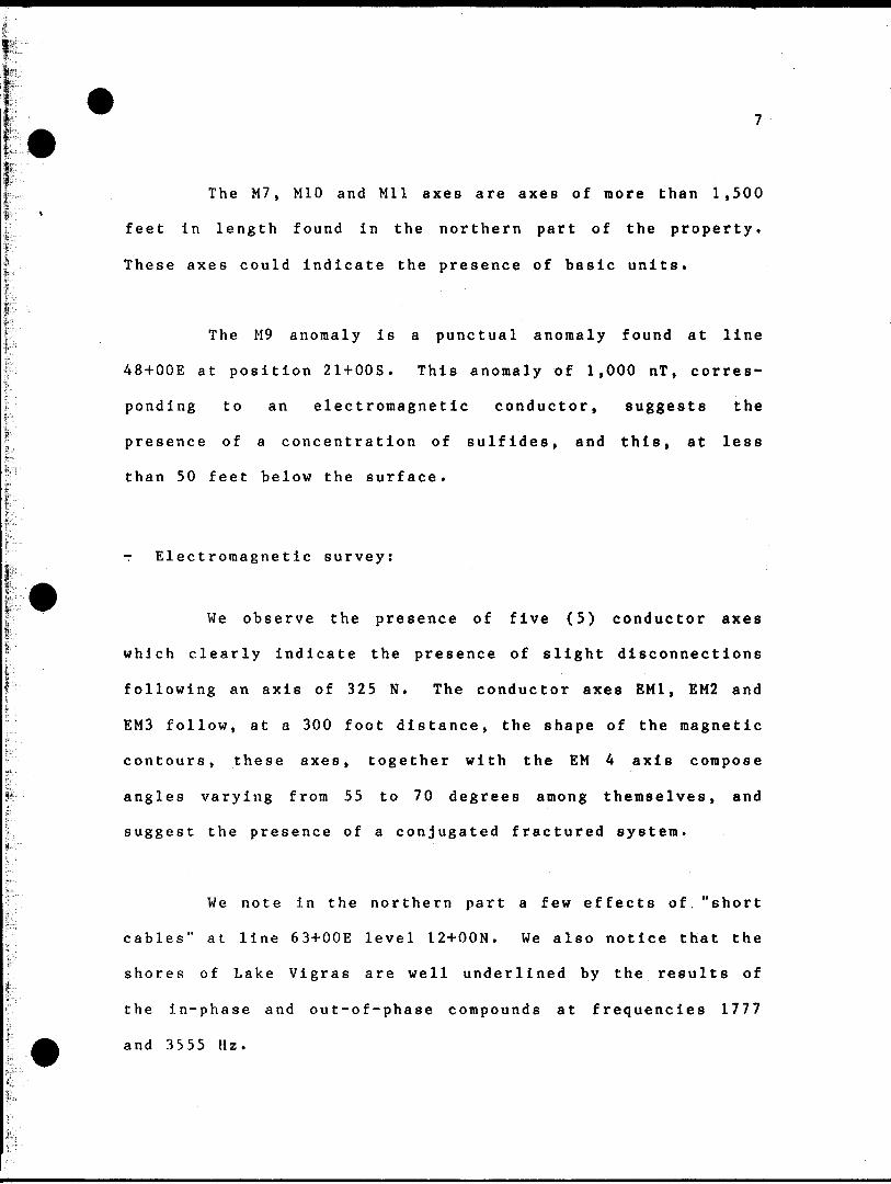
The M7, M10 and Mil axes are axes of more than 1,500
feet in length found in the northern part of the property.
These axes could indicate the presence of basic units.
The M9 anomaly is a punctual anomaly found at line
48+OOE at position 21+OOS, This anomaly of 1,000 nT, corres
ponding to an electromagnetic conductor, suggests the
presence of a concentration of sulfides, and this, at less
than 50 feet below the surface.
- E lectromagnetic survey:
We observe the presence of five (5) conductor axes
which clearly indicate the presence of slight disconnections
following an axis of 325 N. The conductor axes EM1, EM2 and
EMS follow, at a 300 foot distance, the shape of the magnetic
contours, these axes, together with the EM 4 axis compose
angles varying from 55 to 70 degrees among themselves, and
suggest the presence of a conjugated fractured system.
We note in the northern part a few effects of."short
cables" at line 63+OOE level 12+OON. We also notice that the
shores of Lake Vigras are well underlined by the results of
the in-phase and out-of-phase compounds at frequencies 1777
and 3555 Hz.

We have kept during this interpretation, only the
anomalies which showed significant variations of the in-phase
and out-of-phase results at frequency 444 Hz. In relation to
a more thorough study of the geological structure which
existing on this property, certain signatures could eventual
ly be reevaluated.
CONCLUSION:
Eleven (11) magnetic axes and five (5) conductor-
zones have been defined during the recent survey. Based upon
the work done to this day, the sector of magnetic anomaly M9
and conductor EMS as well as the disconnection zones along
the axes EM1 , EM2, EM3 and EM4 warrant further investiga
tion. These anomalies show interesting characteristics; it
is thus recommended to continue the investigations on this
property .
Denis Bois Consultant Geologist
April 1987
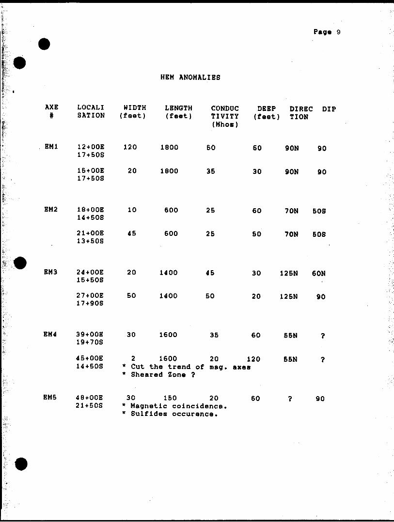
Page 9
HEM ANOMALIES
AXE LOCALI WIDTH LENGTH CONDUC DEEP DIREC DIP # SATION (feet) (feet) TIVITY (feet) TION
(Mhos)
EM2
EM3
EM4
EMB
12+OOE 17+50S
15+OOE 17+508
18+OOE 14+508
21+OOE 13+508
24+OOE 15+508
27+OOE 17+90S
39+OOE 19+708
45+OOE 14+508
48+OOE 21+508
120
20
10
45
20
50
30
1800
1800
600
600
1400
1400
1600
2 1600 * Cut the trend of * Sheared Zone ?
50 60
35 30
25 60
25 50
45 30
50 20
35 60
20 120 mag. axes
30 150 20 60 * Magnetic coincidence.
90N 90
90N 90
70N 50S
70N 50S
125N 60N
125N 90
55N ?
55N ?
? 90

10
RECOMMENDATIONS:
It is important to identify the nature of the
conductors. The coexistence of magnetic anomaly M9 and of
conductor EM5 suggests the presence of an intraformational
conductor associated to a concentration of sulfides. The
existence of a conjugated fractured system close to the
Cadillac-Larder Lake break, has been considered. This sector
warrants a more thorough investigation.
It is thus be recommended:
1) Establish precise correlations between these
anomalic axes, the surface cartography and the
previous drilling data.
2) Carry out an inducted polarisation survey (I.P.)
on the existing lines, between 12+OOE and 51+OOE,
and this from the base line to the southern limit
of the property, on a total distance of 5 miles.
The actual orientation of the lines would allow
the identification of a possible anomaly on the

11
conductor axes as well as on the disconnection
plans. A configuration for N - 4 and A - 100
feet, would be advisable according to the depth
estimates of the conductors as obtained so far.
3) Carry out a cross study of induced polarization
for N - 4 and A - 100 feet, along the line
60+OOE, and this, from the base line up to
position 25-t-OON, in order to evaluate the
potential in polarizable material of the magnetic
depression previously reported in this sector.

BIBLIOGRAPHY :
Page 12
DV-83-16 Lithostratigraphic Map of the Abitibi Subprovince. MERQ-OGS, 15500,000, 1983
Kerrich R. Watson C. P. The Macassa Mine, Archean Load Gold Deposit, Kirkland Lake Ontario Geology Patterns of Alteration and Hydrothermal Regimes* Economic Geology, Vol 79, 1984
Ploeger F.R. St Cracket J.H. Relationship of Gold to Syenitic Intrusive Rocks in Kirkland Lake CIMM S.V. 24, 1982.
XEROX TELECOPIER 495-1: 9-10-87:10:29AM
, F F: O M 5 0 9 S
* 4169216926;* 1
'87.10.89 89:32
FAX TRANSMIT T AL
DATE
TO :
FROM :...C... B**S
H le,.. Vb-
FAX NO:
FAX NO: -4/t-- S6W- -SO 9

XEROX TELECOPIER 495-l; 9-1 0-87; 10: 30AM ; * 4169216926;# 2
,* FROM 50 9 S '87.10.69 09133
PROFESSIONAL ASSESMINT
i dtol&rti i
I fttt Canadian eitUtn.
Univttftity0in Inl'™' ***r** l n ^^in^ring O tology front
I work in Abitibi lino* md n tibi lino* 19 1 *i txplonition md (in tw*oh*r 6 f Survnying, Hydroftology andt tht Hinvral Ttohnologry Deart *m*n t '" *m*n t of th*
in th* oom^ny for did thv
DENIS BOIS 20-08-67

Report of Work ^j(Goopiv/si-ol, Geoloyic-.l,
^A81SE0913 2.10897 OTTO 300
Geophysical- Ground EM, MAG.
SK Minerals Limited
ITowrsh:p C' -V 03
Teck, Otto'Projector's L icence No.
T-1391
IPO-lll Richmond Street West, Toronto M5H 2G4 ________y ConiiMiiy ' Oa;e of Survey ( from s, ic) 'Total Miles of line Cut
*agma. Corporation ^, ??, 8l j \*. Ql 8 ?, . AL.... .^...l"-,'an.i Ai'rtrcss o* Author ; of Q?n-Tnrhnir:.-)l loor.rt'
Penis Bois, 20 Reilly ST. Rouyn, Quebec J9X-3N9
4K' ; !S Requested per Each Claim in Columns at rig Clairns T raversed (List i n numerical sociuonce)
tfei
s
1'
i?!''
fi1
i
t
W l! Provisions
7cr first surv.-y:
Enter 40 riays. (This includes ii-.e cutting)
For eoch additional survey: us ng the same nud:
Enter 20 days i!or eacni
C1 ^ vs fjcr Geophvs'Cfll '
Cl.'iicn
- E.ectron-^netic ^ Q ^
- MagnotorTkerer ^ 0
- Rodiometf 'c
- Other
Geological
Geochemical !
Mining Claim
Prol Number
89J181^ i891856
9". Days
ft ji.'l ?i'ei"!oTH"s! liere
j Note: S rwciai provisions
credits do not jppi
Vpa Ot Work Performed
Total number of mining clairrs covered by this fODort o' work.
For Office Use Onlytv.j. D.r/s Cr. Oato Racorded i.' 'ung Facorder
.Datft Approvori a s flecornod 3r jncr Oec
li.May f 13,1987'
' -'t'iv. :.':'" ; ', T.'vit : - iv- .- RIM'';:;C:H ^'.i .I'tinvit;- r.i-.m-.ii'c;:^ i:: T: MCTS ofit forth m ;ne Report of Work .innexcci hurtto, naving performed the work

Ministry ofNorthern Development
Ontario
Technical Assessment Work Credits
Det*
October 26, 1987
File
2.10097Mlnlno Recorder'i Report of Work No. . -^
220
Recorded HolderH.S.K. Minerals Limited
Townthlp or Are*
Teck A Otto
' i '
l''
1
sij,,,...,.
jL:L '
i;., i'*',
sil. 1 :
f"
j,.
1L:.
fe-
trimriM,,
iff:i ; .1fL!
if-
t
f.1;!h
I..
Type of survey and number of Assessment days credit per claim
Geophysical17
40Maonfttomflter ^w rUyt
Rxrlinnvtru- rtnyf
fnHiiMri pnlxrimtlnn clay.
Othor rfjiy*
Section 77 (1 9) See "Mining Claims Assessed" column
Geological days
Man days Q Airborne Q
Special provision Q Ground [X]
Q Credits have been reduced because of partialcoverage of claims.
Q Credits have been reduced because of correctionsto work dates and figures of applicant.
Mining Claims Assessed
L 894181*891856-891860*842767-842782'842660-843400-843837*843171
Special credits under section 77 (16) for the following mining claims
No credits have been allowed for the following mining claims
C") not sufficiently covered by the survey Insufficient technical data filed
The Mining Becorder may reduce the above crediu if necessary In order that the total number of approved assessment days recorded on each claim does not exceed the maximum allowed as follows: Geophysical - 80; Geologocal - 40; Geochemical - 40; Section 77(19)-60.
28(85/12}

Ontario
Ministry of Natural Resources
GEOPHYSICAL - GEOLOGICAL - GEOCHEMICAL TECHNICAL DATA STATEMENT
File.
TO BE ATTACHED AS AN APPENDIX TO TECHNICAL REPORTFACTS SHOWN HERE NEED NOT BE REPEATED IN REPORT
TECHNICAL REPORT MUST CONTAIN INTERPRETATION, CONCLUSIONS ETC.
Type of Survey(s)
Township or Area t?\ Claim Holder(s)
Survey Company
Author of Report
Address of Author
Covering Dates of Survey
Total Miles of Line Cut
(linecutting to office)
SPECIAL PROVISIONS CREDITS REQUESTED
ENTER 40 days (includes line cutting) for first survey.
ENTER 20 days for each additional survey using same grid.
~ i . i Geophysical
-Electromagnetic
DAYS per claim
Radiometric
-Other —Geological.
Geochemical.
AIRBORNE CREDITS (Special provision credits do not apply to airborne surveys)
Magnetometer. .Electromagnetic . Radiometric
DATE:
(enter days per claim)
SIGNATURE:
Res. Geo!.. .Qualifications.
Previous Surveys File No. Type Date Claim Holder
MINING CLAIMS TRAVERSED List numerically
(prefix) number)
i
l
TOTAL CLAIMS. 12L
837 (5/79)

GEOPHYSICAL TECHNICAL DATA
GROUND SURVEYS — If more than one survey, specify data for each type of survey
Number of Stations Station interval
Profile scale
^ "X
(670) io4O Number of Readings | Line sparing "5OQ
Contour interval &OO
yBW ZC<5
Instrument ——'Accuracy — Scale constant.
Diurnal correction method
Base Station check-in interval (hours). Base Station location and value___________\Jfr\UuB,
InstrumentCoil configuration
Coil separation -—
Accuracy -———— Method:
l DO(To
CD Fixed transmitter
-t-
CD Shoot back D? In line CD Parallel line
Parameters me^nred(specify V.L.F. itation)
'P
O
InstrumentScale constantCorrections made.
Base station value and location
Elevation accuracy.
Instrument
INDUCED POLARIZATION
MethodParameter
*H
E2•H
W Power —.*4
ElectrodeElectrode
Tvoe of e
1 _ l lime Domain S — On time
Off time
— Delay time
— Integration time
spacing ——————————————— - — ——
lectrorle . ... ——————— —
1 _ i frequency uomaui
Frequency
Range

SELF POTENTIALInstrument________________________________________ Range.Survey Method————————————-—-——————————^—.-—-—..—.——-—.————.
Corrections made.
RADIOMETRICInstrument ——-—. Values measured —.
Energy windows (levels) _________^____________^__^________^______Height of instrument____________________________Background Count. Size of detector..————^--——————————————————...———^-.——.——.^——Overburden —.^^—.—-^.^-—-—.——-^.^^.^.—...-.—...—--——.———..^-..^^.^-———.——.
{type, depth - include outcrop map)
OTHERS (SEISMIC, DRILL WELL LOGGING ETC.) Type of survey_________________:—————Instrument .-^-....——————.——^^-^^—^^—.—— Accuracy.^^^———^—^————————————Parameters measured.
Additional information (for understanding results).
AIRBORNE SURVEYS Type of survey(s)——^— Instrument(s) ——————
(specify for each type of survey)Accu racy—-—-—-————————-—.
(specify for each type of survey) Aircraft used.—^—^——————.^—.^^-———-.—————....————.
Sensor altitude-Navigation and flight path recovery method.
Aircraft altitude.—.____________________________Line Sparing Miles flown over total area———.——-—-——-—.—-—-—.....——.——Over claims only.

GEOCHEMICAL SURVEY - PROCEDURE RECORD
Numbers of claims from which samples taken.
Total Number of Samples. Type of Sample.
(Nature of Material)
Average Sample Weight——————— Method of Collection————————
Soil Horizon Sampled. Horizon Development- Sample Depth————Terrain————————
Drainage Development——————————— Estimated Range of Overburden Thickness.
ANALYTICAL METHODSValues expressed in: per cent Q
p. p. m. Dp. p. b. LJ
Cu, Pb, Zn,
Others_____
Ni, Co, Ag, Mo, As.-(circle)
Field AnalysisExtraction Method. Analytical Method- Reagents Used——
Field Laboratory AnalysisNo. ^—.———-.—
SAMPLE PREPARATION(Includes drying, screening, crushing, ashing)
Mesh size of fraction used for analysis———-
Extraction Method. Analytical Method . Reagents Used——.
Commercial Laboratory (- Name of Laboratory.— Extraction Method— Analytical Method -Reagents Used ————.
.tests)
.tests)
-tests)
General. General.

Suite 800,111 Richmond Street West Toronto, Ontario M5H 2G4
TEL. (416) 364-0001 MINERALS LIMITED PAX. (416) 364-5098
May 2 5, 1987
Mr. Gary L. Weatherson,Mining Lands Section,Mineral Development and Lands Branch,Mines and Minerals Division,Whitney Block, Room 6610,Queen's Park,Toronto, Ontario.M7A 1W3
Dear Sir:
Re: HSK Minerals LimitedTechnical Report for Geophysical Survey Otto and Teck Townships
Enclosed please find a completed Technical Data Statement for geophysical surveys performed on the 13 claim HSK property in Otto and Teck Twp. The Work Report for this survey has already been filed with the mining recorders office, a copy is enclosed.
I trust this i s satisfactory but if more information is required plerase contact at your earliest convenience.
Yours turly,HSK MINERALS LIMITED
RECEIVEDc. E. Page" MAY 28Consulting Geologist
MINING LANDS SECTION

' '; f^i*' f* i .- j.1 - * V l- i* H if fm j
November 12, 1987
NOV11 feW
fi u a P?, \ \f l POur File: 2.10097
Mining RecorderMinistry of Northern Development and Mines4 Government Road EastKirkland Lake. OntarioP2N 1A2
Dear Sir:. - ' - ' - , - . ' ' ' ' '' . r ' - ' i. . - ,. x ,,.''. i" 1 ., *v':*-. *:'".-'- J \ - ' .'
RE: Notice of Intent dated October 26. 1987Geophysical (Electromagnetic and Magnetometer) ,. ,Survey on Mining Claims 1-894181 et alIn the Townships of Teck and Otto
The assessment work credits* as listed with the above-mentioned Notice of Intent* have been approved as of the above date*
Please Inform the recorded holder of these mining claims and so Indicate on your records.
Yours sincerely*
W.R. Cowan* Manager Mining Lands Section Mines and Minerals Division
Whitney Block. Room 6610 Queen's Park Toronto. Ontario M7A 1M3
Telephone: (416) 965-4888
AB:plEnclosure: Technical Assessment Work Credits
cc: Mr. G.H. FergusonMining A Lands Commissioner Toronto* Ontario
HSK Minerals LimitedSuite 800111 Richmond Street WestToronto* OntarioM5H 2G4
Resident Geologist Kirkland Lake* Ontario

'1
Vi '•- -'\ S'--.- - - 'i, "i - - t ' f- -i* "- l B1 - -- c i*.-. 'f-,/*"- . - \**'.?-* : i --. ' '*
,/ . -i.; -- :: . ;:.-.iii., .. , S'^',,-.- -.*v ' ' --* - --' v^jr-"/ . , — ! -* .-r, - •-i.. iLfv: -"-i;- "-'' - "
-*.r 'j. ''-w^! .T'- c—-Xj-'^V^ TB^- -(t-1 -- ..
^,.. ; ^^-r*^
,j" ^ i?'.;-
It'vfc
V' -'ivS'"'^.^*^ ••i"-* 1**^'-' '-i*,^': ^ " f' jf'yc* ;v^* T---v- - ""^ v' ""' "V" :~!i."'-.'*^
^'!fE?ck;Tj^^
t; ® t U ®|
8457 tJFWSft*
f?" C; .v,
-'^V^r^-Vi ^'-* ' 'v a . -'
-**S^t-iT3
^ V \- rr-Vj-6^.^-4^
•*"J-3-rv-tfl
i L - i1
H5*3-H^a :,,-^,.( fp)1 - . i '-c/
laso-*o7" 'ii,--—.-p — T— —
1 '1 '
? '; © i ©i.-:
- 1 L1A* -501 i,54H9C2
t
—— , -i
^ 1 . l-
546904 1543903j
- T f
Li~T@^~~
55C3G3: ^TU^^*. 'a^s1, ' :'T©!^^' :
*4-S*2-i- V53C302iS.CJ**7r -i|t.ri-"."i it.V"V /The -i. '^^- -©- — 4 -^-~^^- -JcVio *" r L ] C"..'" 6L j
j L
^sys-M.
®
L V.^HHwmKBiVT'PH i nm 1' ii^mr-Bnn^a Lil
JM1 Vj '
0*4i |MSS3C^ ^^ '— _ .
L '
1
u r1 *t^rf'-^j"\n,^.H
WW J t^J ;
L -:p ..3 Q 43 9V'T1
a®
II
L l U
"W5*-?? | i*a-atrzr---J-,.., -
L- - i i.1
^mg-L-wj s^H^B-rs5
"— —— .w-y.™^-?-.-"— -' ' — -r— i- l i- 1
i- i^T~\ ~^l t ft *y J x4*6556^5537^ "' ""^— '~
- — ™^'^^^ ' /a^ r . ^ n ^,-, r•fr*a-^5'5ia-ts^34 1
m-*5/ L (^7) :5iC257 'r 54-if533,
L.-, ^^.
A-*4 }550Z9H ^^5^4^
i —
/
®1
f CPL
T*^74-,?**-t?*
^iiOp'il'e--
^OOSTh-
.-T^S- fr^T5TD r^oO5'6^ ^6^t^6 r?'Jt)-''JS J
L
^
i-rtre-S-4*'
L L
•^t4rS^'r-'Zfi-a4jXa
-f ea tyo- i-y^s^i^- :1
^r
- .-.^^catws^ts
S e cert
fp^Ro'jnd
rv-t ^ P n! H S{Vi ,-~--i j \ V W s ^-•i
THE TOWNSHIP
OTTODISTRICT OF ^TIMISKAMING
,
-;. ; LARDER; LAKE., ' . MINING DIVISION -^
f ' ' * * ""
SCALE:1-INCH^4O CHAINS
LEGEND
PATENTED ^ tAHDCROWN LAHO SALSLEASES,UXATED LANDU1CENS2 OF OCCUPATIONMINING RIGHTS ONLYSURFACE RIGHTS . ONLYROADSIMPROVED ROADSKING'S HIGHWAYS ,,RAILWAYS , -~POWEH LINESMARSH OR MUSKEGMINES .- iC ;--CAHCELLEO *"^- PATENTED S.R.O. .
or
: ' NOTES
l 400' surface rights peservalton q-Jong ,, the 'shores of all lakes ana rivers.
S/J^V ,- yM/ S^ 2'-j iro w-
^\ ,'*
--r.".wii"^i'^aiBaswff
42A01SE0013 2.10097 OTTO 200
,
PLAN NO,-V::- -
*** K r- 1, * ' ,X^i y™iiOj OF r

KIRKLAND
?'*' 1. ' ,*Sfe\ C ")''i. .
.: -r 'T
Bernhart' Twp. M.327
Amikouga
52JI
-, l L ake,W77 \ 76
OttO TWO. M.379
T-
THE TOWNSHIP
TECKDISTRICT OFTIMISKAMING
LARDER LAKE MINING DIVISION
SCALE'l-INCH^O CHAINS
DISPOSITION CROW L ANDS
PATENT, SURFACE AND MINING RIGHTS....." , SURFACE RIGHTS ON^Y ......,....." , MINING RIGHTS ONLY^....^^
LEASE, SURFACE AND MINING RIGHTS...." , SURFACE RIGHTS ONLY .........." , M.NING RIGHTS ONOT,.. ^..^..
LICENCE OF OCCUPATION ,. .. ... ..^.^.,ROADS — , IMPROVED ROADS ~ ^ KING'S HIGHWAYS R A l L W AY S POWER LINES MARSH OR MUSKEGMINES CANCELLED
•SyT
a
c.
NOTES400' surface rights reservation along the shores of all lakes and rivers.
.Areas shown thus V-^H for slime disposal.'"
Mining claim L.5779 — Mining Rights subject to Sec. 36 of the Mining Act. (R.S.O. 1950)
AREAS WITHDRAWN FROM STAKING
SURFACE RIGHTS KITHDRAHN TROMSECIIGI 3*/* ORDcfi NO. rf. 76/fo f 4^n ———:——r-—————
[2/ S URFACE AND HIKING RIGHTS WITHDRAWN TROH STAKING SECTION 36/80 QRDF.R NO. tt). ! 08
(3/ SURFACE AND MINING RIGHTS NITHDRAWN FRO* ST&KIIMi SECTION 35/80 ORDER NO. yy/. Q /Qb
ftND MINING RIGHTS WITHDRAWN FROf STAKING SECTION 36/80 ORDER NO. \Vr jj3t* ' *
SURFACE AND MINING RIGHTS WITHDRAWN FROM STAKING SECTION 36/80 ORDER NO. J.i
M1NSN3 RIGHTS WITHDRAWN FROM S1AKING
SECTION1 iG/80 OrtDER UO. W 90/67 N R
PLAN NO.-MIVI
OM
MINISTRY OF NATURAL RESOURCESSURVEYS ANJft MAPPiwn

TEC
K To
wns
hip
LE
GE
ND
Inst
rum
ent
: M
AX
MIN
Freq
uenc
y :
44
4 H
z
Sep
arat
ion
IOO
m
Verti
cal
scal
ein
ch *
40
'/o
l.p
10+0
0 s
10 to
20
O. P
•9 x •w x l
•y \ V
•H •H
-20
15+O
O s
OTT
O
Tow
nshi
pC
ondu
ctor
:
Faul
t :
20*00
SD
a
843837
25+O
O
S
O O 4- O 1. -J
UJ o o 4- 10 \. J
UJ o o 4- (D i.
Ui O
O 4 O) 1. -J
UJ o o 4- l. -l
UJ o o 4- l. -J
Ul o o 4- CDl
UJ o o 4- \-
UJ o o -t ^J- OJ l. -J
UJ o o CM
l
UJ o o -v O
rO i.
UJ
O o * ro lO i- J
UJ o o -4- to
UJ o o ro i.
UJ o o 4- (M
t.
UJ o o 4- vn ^T \. -l
Ul
O o 4- GO ^J- \.
UJ o o \ -l
UJ o o VO
KE
Y
MA
P
SC
AL
E:
C2
5O
OO
O
42
A0
15
E0
01
3
2.1
0097
OTT
O2
20
HSK
Min
eral
s Li
mite
d
(PR
OFI
LES
)
H.E
.M.
SU
RV
EY
MA
GM
AE
XP
LO
RA
TIO
N
DAT
E M
arch
1 9
87D
RAW
N
BY:
D. L
ariv
tore
, Y. G
oule
tA
PP
RO
VE
D
BY
:
SC
AL
E:
100
O IO
O
20
0
300
40
0
5OO

Blan
che
TEC
K To
wns
hip
B L
-0*0
0
: w
f-i
w \
\ 'T
\
\ K
f
LEG
EN
D
Inst
rum
ent
: M
AX
MIN
H
Freq
uenc
y :
1777
Hz
Sep
arat
ion
100
m
Ver
tical
sc
ale
l inc
h *
40
07o
:l
IO+
OO
S
/2O
O. R
-10 x 7 7
^ -H. \
- \
-20
I5+
OO
S
OTT
O
Tow
nshi
p
2O+O
O S
84
38
37
25+O
O
S
O O •*- o l. J
UJ o o t TOl. -J
111 o o
UJ o o * O) l -J
UJ o o -4- OJ l.
UJ o o
UJ o o * COt- -T
UJ o
o CVJ l
UJ o o 4- 1.
UJ o o t -l
UJ o o -fr o to l.
Ul o o 4- to to t- -J
UJ o o -t-
(O TO
UJ o o to l J
UJ o o •*-
CM
I.
UJ o o
LL) O
O •*- CD 't l. -l
UJ
O o -*- in i.
UJ o o •4- "3- lO l' -l
KE
Y
MA
P
SCAL
E:
1:25
0000
42A
01S
E0813
2.1
0097
OTT
O230
HSK
M
iner
als
Lim
ited
(PR
OFI
LES)
H. E
M.
SUR
VEY
MA
GM
AE
XP
LOR
AT
ION
DA
TE
Mar
ch
1987
DR
AWN
BY
: o.
Lar
fvie
re ,
Y.
G.A
PP
RO
VE
D
BY
SC
ALE

TEC
K To
wns
hip
LEG
END
Inst
rum
ent
: M
AX
M IN
H
Freq
uenc
y :
3555
Hz
Sepa
ratio
n :
100
m
Verti
cal
scal
el in
ch -
40
10+0
0 s
20
+ 2O
OR
•0* \ i i
•W *
l•
t t •1, \ , \ x
•rt
^ x
-SO
15+
00
SO
TTO
To
wns
hip
20*0
0 s
D
D
843837
25+O
O
S
O
O * O l. -l
UJ o o •*- to t. -l
UJ o o \.
LU O
O
l. -l
UJ o o t. -l
UJ o o -f lO l. -J
UJ o o -V CO l
UJ o o
UJ o o •4- CO
1.
Ul o o 4- N (M
l
UJ o o \. -l
UJ o o 4-
10 to
\. -J
Ul o o to
UJ o o 4- 0^ K) l. J
UJ o o 4- CM
UJ o o 4- lO ~ l. J
UJ o o 4- GO *t l. -J
UJ o o in l. -J
UJ o o 4- tf ID I-
KEY
MAP
SC
AL
E:
C25
OO
OO
42
A0
1S
Ee
*13
OTT
O2
40
HSK
Min
eral
s Li
mite
d
(PR
OFI
LES)
H. E
M.
SUR
VEY
MA
GM
AE
XP
LOR
ATI
ON
DAT
E M
arch
19
87D
RA
WN
B
Y:
D.
Lariv
iere
, Y
Gou
let
AP
PR
OV
ED
BY
SC
AL
E:
l"-3
OO
'

TEC
K To
wns
hip
LEG
END
nstru
men
t
Base
va
lue
ED
A
OM
NI
IV
58000
Gam
mas
Mag
netic
co
ntou
rs:
v.40
0
^^
- IO
UV
—s.
^-
2000
-v
^-3
00
0-^
10+0
0 s
Mag
netic
de
pres
sion
-.
15+
00
SO
TTO
To
wns
hip
Mag
netic
ax
is :
Faul
t :
20+0
0 s
D
D
25+O
O
S
O
O 4- O l. -J
LiJ O O •*- to l.
UJ o o •t- (D l
UJ o o * O) l. -l
UJ o o l.
UJ o o -*- lO l. -l
UJ o o -*- OD 1. -l
UJ o o CM
l.
ut o o 4- ^t (M l.
UJ o o 4- N CM
1.
UJ O
O -*- o 10 t. -l
UJ o o -*- to TOl. -J
UJ o o to l-
UJ o o 4- O) to l. J
UJ o o 4- CM
UJ o o 4- in r i. -J
UJ o o •f 00
UJ o o 4- ID l
UJ o o 4-
l
KEY
MAP
SC
ALE
: C
28O
OO
O
. tf
*
42A
01S
E*0
13
2.1
00
97
O
TTO
25
0
HSK
Min
eral
s Li
mite
d
(CO
NTO
URS)
MA
GN
ETI
CS
UR
VE
Y
MA
GM
AE
XP
LOR
ATI
ON
DA
TE
Mar
ch
1987
DR
AW
N
BY
: D.
L
orf
V!*
rt
AP
PR
OV
ED
B
Y: f t*
t *


