Section 404401 Joint Application for Department of Army Permit MIA ndash Great Miami Bridge Connector PID 84756 Bikeway over Great Miami River Prepared for Ohio Department of Transportation 1930 West Broad Street Columbus Ohio 43223 Date February 2013
MIA ndash Great Miami Bridge Connector PID 84756 401404 Permit Application
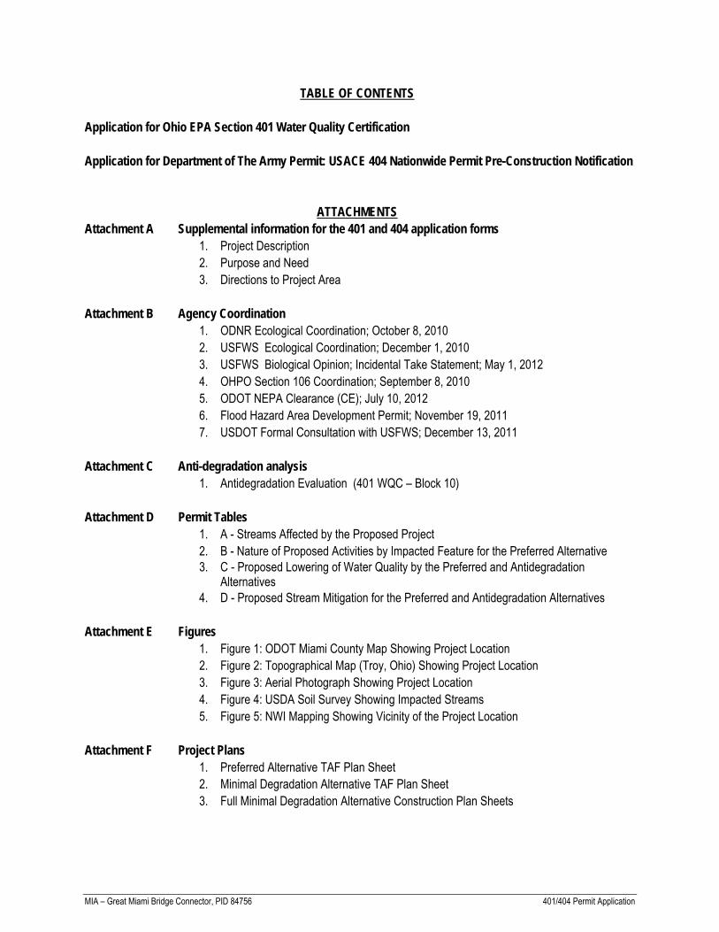
TABLE OF CONTENTS
Application for Ohio EPA Section 401 Water Quality Certification Application for Department of The Army Permit USACE 404 Nationwide Permit Pre-Construction Notification
ATTACHMENTS Attachment A Supplemental information for the 401 and 404 application forms 1 Project Description 2 Purpose and Need 3 Directions to Project Area Attachment B Agency Coordination 1 ODNR Ecological Coordination October 8 2010 2 USFWS Ecological Coordination December 1 2010 3 USFWS Biological Opinion Incidental Take Statement May 1 2012 4 OHPO Section 106 Coordination September 8 2010 5 ODOT NEPA Clearance (CE) July 10 2012 6 Flood Hazard Area Development Permit November 19 2011 7 USDOT Formal Consultation with USFWS December 13 2011 Attachment C Anti-degradation analysis 1 Antidegradation Evaluation (401 WQC ndash Block 10) Attachment D Permit Tables 1 A - Streams Affected by the Proposed Project 2 B - Nature of Proposed Activities by Impacted Feature for the Preferred Alternative
3 C - Proposed Lowering of Water Quality by the Preferred and Antidegradation
Alternatives 4 D - Proposed Stream Mitigation for the Preferred and Antidegradation Alternatives Attachment E Figures 1 Figure 1 ODOT Miami County Map Showing Project Location 2 Figure 2 Topographical Map (Troy Ohio) Showing Project Location 3 Figure 3 Aerial Photograph Showing Project Location 4 Figure 4 USDA Soil Survey Showing Impacted Streams 5 Figure 5 NWI Mapping Showing Vicinity of the Project Location Attachment F Project Plans 1 Preferred Alternative TAF Plan Sheet 2 Minimal Degradation Alternative TAF Plan Sheet 3 Full Minimal Degradation Alternative Construction Plan Sheets
MIA ndash Great Miami Bridge Connector PID 84756 401404 Permit Application
Attachment G Photo Log 1 Photo Log ndash from ESR 2 Photographs ndash From ESR Attachment H OEPA Life Use 1 OEPA Life Use Designations 2 OEPA Division of Water ndash Watershed Assessment Unit Summary Attachment I Mitigation Plan 1 Lost Creek Pooled Mitigation Area Approval 2 Lost Creek Pooled Mitigation Area Mapping 3 Lost Creek Pooled Mitigation Area Ledgercredits available
APPLICATION FOR OHIO EPA SECTION 401 WATER QUALITY CERTIFICATION
Effective October 1 1996 Revised August 1998
This application must be completed whenever a proposed activity requires an individual Clean Water Act Section 401 Water Quality Certification (Section 401 certification) from Ohio EPA A Section 401 certification from the State is required to obtain a federal Clean Water Act Section 404 permit from the US Army Corps Engineers or any other federal permits or licenses for projects that will result in a discharge of dredged or fill material to any waters of the State To determine whether you need to submit this application to Ohio EPA contact the US Army Corps of Engineers District Office with jurisdiction over your project or other federal agencies reviewing your application for a federal permit to discharge dredged or fill material to waters of the State or an Ohio EPA Section 401 Coordinator at (614) 644-2001
The Ohio EPA Section 401 Water Quality Certification Program is authorized by Section 401 of the Clean Water Act (33 USC 1251) and the Ohio Revised Code Section 611103(P) Ohio Administrative Code (OAC) Chapter 3745-32 outlines the application process and criteria for decision by the Director of Ohio EPA In order for Ohio EPA to issue a Section 401 certification the project must comply with Ohios Water Quality Standards (OAC 3745-1) and not potentially result in an adverse long-term or short-term impact on water quality Included in the Water Quality Standards is the Antidegradation Rule (OAC Rule 3745-1-05) effective October 1 1996 revised October 1997 and May 1998 The Rule includes additional application requirements and public participation procedures Because there is a lowering of water quality associated with every project being reviewed for Section 401 certification every Section 401 certification applicant must provide the information required in Part 10 (pages 3 and 4) of this application In addition applications for projects that will result in discharges of dredged or fill material to wetlands must include a wetland delineation report approved by the Corps of Engineers a wetland assessment with a proposed assignment of wetland category (ies) official documentation on evaluation of the wetland for threatened or endangered species and appropriate avoidance minimization and mitigation as prescribed in OAC 3745-1-50 to 3745-1-54 Ohio EPA will evaluate the applicantrsquos proposed wetland category assignment and make the final assignment
Information provided with the application will be used to evaluate the project for certification and is a matter of public record If the Director determines that the application lacks information necessary to determine whether the applicant has demonstrated the criteria set forth in OAC Rule 3745-32-05(A) and OAC Chapter 3745-1 Ohio EPA will inform the applicant in writing of the additional information that must be submitted The application will not be accepted until the application is considered complete by the Section 401 Coordinator An Ohio EPA Section 401 Coordinator will inform you in writing when your application is determined to be complete
Please submit the following to ldquoSection 401 Supervisor Ohio EPADSW PO Box 1049 Columbus Ohio 43216-1049 bull Four (4) sets of the completed application form including the location of the project (preferably on a USGS quadrangle) and 8-12 x 11
scaled plan drawings and sections bull One (1) set of original scaled plan drawings and cross-sections (or good reproducible copies)
(See Application Primer for detailed instructions)
1 The federal permitting agency has determined this project (check appropriate box and fill in blanks)
a requires an individual 404 permit401 certification- Public Notice (if known)
b X requires a Section 401 certification to be authorized by Nationwide Permit 14
c requires a modified 404 permit401 certification for original Public Notice
d requires a federal permit under jurisdiction identified by
e requires a modified federal permit under jurisdiction identified by
Page 1 of 4
Page 2 of 4
2 Application number (to be assigned by Ohio EPA)
3 Name and address of applicant Telephone number during business hours Jerry Wray Director Ohio Department of Transportation 1980 West Broad Street Columbus Ohio 43223
( ) (Residence)
( 614 ) 644‐0377 (Office)
3a Signature of Applicant Date
4 Name address and title of authorized agent Telephone number during business hours Adrienne Earley Ohio Department of Transportation (WPU) 1980 West Broad Street Columbus Ohio 43223
( ) (Residence)
( 614 ) 446‐2159 (Office)
4a Statement of Authorization I hereby designate and authorize the above-named agent to act in my behalf in the processing of this permit
application and to furnish upon request supplemental information in support of the application
Signature of Applicant Date
5 Location on land where activity exists or is proposed Indicate coordinates of a fixed reference point at the impact site (if known) and the coordinate system and datum used
Address
Farrington RoadPeterson Road (Latitude 40105833 Longitude ‐84228889)
Street Road Route and Coordinates or other descriptive location
50200015080001 Miami Staunton Ohio 45373
Watershed County Township City State Zip Code
6 Is any portion of the activity for which authorization is sought complete Yes X No If answer is yes give reasons month and year activity was completed Indicate the existing work on the drawings
7 List all approvals or certifications and denials received from other federal interstate state or local agencies for any structures
construction discharge or other activities described in this application
Issuing Agency Type of Approval Identification No Date of Application Date of Approval Date of Denial USFWS Ecological MOA 93010 12110
ODNR Ecological MOA 93010 11810 USFWS Biological Opinion (Section 7) 31420‐2011‐F‐0021 121311 5112
ODOT Cultural Resources ndash IOC PID 84756 NA 9810
ODOT CE (NEPA Document) PID 84756 NA 7102012 FEMA Flood Plain Permit 255 NA 111910
8 DESCRIPTION OF THE ACTIVITY (fill in information in the following four blocks - 8a 8b 8c amp 9)
8a Activity Describe the Overall Activity The proposed multi‐use trail will extend north from the terminus of the MIA‐Great Miami Bikeway Phase 2 will cross the Great Miami
River on a new bridge continue north through the wooded floodplain of the Great Miami River then cut across an agricultural field to
terminate at the new parking lot off Farrington RoadPeterson Road Minor temporary and permanent impacts will result from the
construction of the proposed bridge over the Great Miami River The total length of the multi‐use trail will be approximately 1900
Additional details provided in Attachment A (Block 8A ‐ Continued)
Page 3 of 4
8b Purpose Describe the purpose need and intended use of the activity
The proposed project is intended to address a gap in the existing Great Miami River Recreation Trail System and provide improved bicyclepedestrian access to area points of interest
See Attachment A (Block 8B ‐ Continued) for additional details
8c Discharge of dredged or fill material Describe type quantity of dredged material (in cubic yards) and quantity of fill material (in cubic yards)
Dredge materials Great Miami River (GMR) 1665 cu yds of clean non‐erodible fill removed upon completion of bridge construction activities Fill materials Temporary GMR 1665 cu yds consisting of clean non‐erodible fill for construction causeway Permanent GMR 70 cu yd consisting of 61 cu yd of concrete and 9 cu yd of RCP placed below the OHWM for the support structure within the GMR and protection of the support abutments on each bank of the GMR
9 Waterbody and location of waterbody or upland where activity exists or is proposed or location in relation to a stream lake wetland wellhead or water intake (if known) Indicate the distance to and the name of any receiving stream if appropriate
The proposed project will impact the main channel of the Great Miami River (GMR) approximately 1000 ft south of the existing Peterson Road Bridge over the GMR The adjacent upland areas will be impacted to complete the upland construction activities of the the multiuse trail The Great Miami River a Traditional Navigable Water (TNW) that has OEPA use designations Exceptional Warmwater Habitat (EWH) Primary Contact Recreation (PCR) agricultural water supply (AWS) and industrial water supply (IWS) The Great Miami River discharges into the Ohio River at Ohio River Mile 291 approximately 113 miles downstream of the proposed project area
10 To address the requirements of the Antidegradation Rule your application must include a report evaluating the
Preferred Design (your project) and Mitigative Techniques
Minimal Degradation Alternative(s) (scaled-down version(s) of your project) and Mitigative Techniques
Non-Degradation Alternative(s) (project resulting in avoidance of all waters of the state)
At a minimum item a) below must be completed for the Preferred Design the Minimal Degradation Alternative(s) and the Non- Degradation Alternative(s) followed by completion of item b) for each alternative and so on until all items have been discussed for each alternative (see Primer for specific instructions)
10a) Provide a detailed description of any construction work fill or other structures to occur or to be placed in or near the surface
water Identify all substances to be discharged including the cubic yardage of dredged or fill material to be discharged to the surface water
10b) Describe the magnitude of the proposed lowering of water quality Include the anticipated impact of the proposed lowering of
water quality on aquatic life and wildlife including threatened and endangered species (include written comments from Ohio Department of Natural Resources and US Fish and Wildlife Service) important commercial or recreational sport fish species other individual species and the overall aquatic community structure and function Include a Corps of Engineers approved wetland delineation
Page 4 of 4
10c) Include a discussion of the technical feasibility cost effectiveness and availability In addition the reliability of each alternative shall be addressed (including potential recurring operational and maintenance difficulties that could lead to increased surface water degradation)
10d) For regional sewage collection and treatment facilities include a discussion of the technical feasibility cost effectiveness and
availability and long-range plans outlined in state or local water quality management planning documents and applicable facility planning documents
10e) To the extent that information is available list and describe any government andor privately sponsored conservation projects that
exist or may have been formed to specifically target improvement of water quality or enhancement of recreational opportunities on the affected water resource
10f) Provide an outline of the costs of water pollution controls associated with the proposed activity This may include the cost of best
management practices to be used during construction and operation of the project
10g) Describe any impacts on human health and the overall quality and value of the water resource
10h) Describe and provide an estimate of the important social and economic benefits to be realized through this project Include the number and types of jobs created and tax revenues generated and a brief discussion on the condition of the local economy
10i) Describe and provide an estimate of the important social and economic benefits that may be lost as a result of this project
Include the effect on commercial and recreational use of the water resource including effects of lower water quality on recreation tourism aesthetics or other use and enjoyment by humans
10j) Describe environmental benefits including water quality lost and gained as a result of this project Include the effects on the
aquatic life wildlife threatened or endangered species
10k) Describe mitigation techniques proposed (except for the Non-Degradation Alternative)
Describe proposed Wetland Mitigation (see OAC 3745-1-54 and Primer)
Describe proposed Stream Lake Pond Mitigation (see Primer)
11 Application is hereby made for a Section 401 Water Quality Certification I certify that I am familiar with the information contained in this application and to the best of my knowledge and belief such information is true complete and accurate I further certify that I possess the authority to undertake the proposed activities or I am acting as the duly authorized agent of the applicant
Signature of Applicant Date Signature of Agent
The application must be signed by the person who desires to undertake the proposed activity (applicant) or it may be signed by a duly authorized agent if the statement in Block 3 has been filled out and signed
401401appl898
ENG FORM 4345 SEPT 2009 EDITION OF OCT 2004 IS OBSOLETE Proponent CECW-OR
APPLICATION FOR DEPARTMENT OF THE ARMY PERMIT (33 CFR 325)
OMB APPROVAL NO 0710-003 Expires 31 August 2012
Public reporting burden for this collection of information is estimated to average 11 hours per response including the time for reviewing the instructions searching existing data sources gathering and maintaining the data needed and completing and reviewing the collection of information Send comments regarding this burden estimate or any other aspect of this collection of information including suggestions for reducing this burden to Department of Defense Washington Headquarters Executive Services and Communications Directorate Information Management Division and to the Office of Management and Budget Paperwork Reduction Project (0710-0003) Respondents should be aware that notwithstanding any other provision of law no persons shall be subject to any penalty for failing to comply with a collection of information if it does not display a currently valid OMB control number Please DO NOT RETURN your form to either of those addresses Completed applications must be submitted to the District Engineer having jurisdiction over the location of the proposed activity
PRIVACY ACT STATEMENT Authorities Rivers and Harbors Act Section 10 33 USC 403 Clean Water Act Section 404 33 USC 1344 Maritime Protection Research and Sanctuaries Act Section 103 33 USC 1413 Regulatory Programs of the Corps of Engineers Final Rule 33 CFR 320-332 Principal Purpose Information provided on this form will be used in evaluating the application for a permit Routine Uses This information may be shared with the Department of Justice and other federal state and local government agencies and the public and may be made available as part of a public notice as required by Federal law Submission of requested information is voluntary however if information is not provided the permit application cannot be evaluated nor can a permit be issued One set of original drawings or good reproducible copies which show the location and character of the proposed activity must be attached to this application (see sample drawings and instruction) and be submitted to the District Engineer having jurisdiction over the location of the proposed activity An application that is not completed in full will be returned
(ITEMS 1 THRU 4 TO BE FILLED BY THE CORPS)
1 APPLICATION NO
2 FIELD OFFICE CODE
3 DATE RECEIVED
4 DATE APPLICATION COMPLETE
(ITEMS BELOW TO BE FILLED BY APPLICANT)
5 APPLICANTrsquoS NAME 8 AUTHORIZED AGENTrsquoS NAME AND TITLE (an agent is not required)
First ndash Jerry Middle - Last - Wray First ndash Adrienne Middle - Last ndash Earley
Company ndash Ohio Department of Transportation (ODOT) Company ndash ODOT
E-mail Address ndash JerryWraydotstateohus E-mail Address ndash AdrienneEarleydotstateohus
6 APPLICANTrsquoS ADDRESS 9 AGENTrsquoS ADDRESS
Address - 1980 West Broad Street Address ndash 1980 West Broad Street
City - Columbus State - OH Zip-43223 Country - USA City - Columbus State - OH Zip-43223 Country - USA
7 APPLICANTrsquoS PHONE NOS WAREA CODE Tim Hill
10 AGENTrsquoS PHONE NOS WAREA CODE Adrienne Earley
a Residence ( ) b Business (614)644-0377 c Fax (614)728-7368 a Residence ( ) - b Business (614)466-2159 c Fax (614)728-7368
STATEMENT OF AUTHORIZATION
11 I hereby authorize to act in my behalf as my agent in the processing of this application and to furnish upon request supplemental information in support of this permit application
APPLICANTrsquoS SIGNATURE DATE
NAME LOCATION AND DESCRIPTION OF PROJECT
12 PROJECT NAME OR TITLE (see instructions) MIA - Great Miami Bridge ndash Connector (PID 84756)
13 NAME OF WATERBODY IF KNOWN (if applicable) Great Miami River HUC 05080001070080
14 PROJECT STREET ADDRESS (if applicable) Address ndash NA City - StauntonTwp State - Ohio Zip - 45356
15 LOCATION OF PROJECT ndash Miami County Ohio Latitude 40105833N Longitude -84228889W
16 OTHER LOCATION DESCRIPTIONS IF KNOWN (see instructions)
State Tax Parcel ID Municipality -
Section - Township ndash Staunton Range -
17 DIRECTIONS TO THE SITE See Attachment A ndash Directions to site from I-70 Columbus Ohio
Adrienne Earley
18 Nature of Activity (description of project include all features) The proposed multi-use trail will extend north from the terminus of the MIA-Great Miami Bikeway Phase 2 will cross the Great Miami River (GMR) on a new bridge continue north through the wooded floodplain of the Great Miami River then cut across an agricultural field to terminate at the new parking lot off Farrington RoadPeterson Road The total length of the multi-use trail will be approximately 1900 The proposed bridge will be a 2-span composite pre-cast I-beam structure with concrete deck and reinforced concrete semi-integral abutments and wall type pier The proposed clear spans will each be 144 The bridge will offer a pavement width of 14 face-to-face of balustrades The permanent fill for the bridge embankments will be obtained from a borrow pit to be excavated east of the proposed bridge location Additional detailed information is provided in Block 8A of OEPA 401 WQC and Attachment A (OEPA 401 WQC Block 8A ndash Continued)
19 Project Purpose (describe the reason or purpose of the project see instructions) The proposed project is intended to address a gap in the existing Great Miami River Recreation Trail System and provide improved bicyclepedestrian access to area points of interest Additional details information is provided in Block 8B of OEPA 401 WQC and Attachment A (See OEPA 401 WQC Block 8B ndash Continued)
USE BLOCKS 20-22 IF DREDGED ANDOR FILL MATERIAL IS TO BE DISCHARGED
20 Reason(s) for Discharge To construct a bridge crossing over the Great Miami River to complete the connection of a large multi-use trail system within the Great Miami Riparian Corridor
21 Type(s) of Material Being Discharged and the Amount of Each Type in Cubic Yards
Dredge materials Great Miami River (GMR) 1665 cu yds of clean non-erodible fill removed upon completion of bridge construction activities Fill materials Temporary GMR 1665 cu yds consisting of clean non-erodible fill for construction causeway Permanent GMR 70 cu yd consisting of 61 cu yd of concrete and 9 cu yd of RCP placed below the OHWM for the support structure within the GMR and protection of the support abutments on each bank of the GMR
22 Surface Area in Acres of Wetlands or Other Waters Filled (see instructions) Acres GMR 030 acres of temporary impact from the proposed construction causeway 002 acres of permanent impact concrete footings and RCP Linear Feet 116 linear ft of impact to GMR from the temporary construction causeway and permanent impact from concrete footings and RCP
23 Description of Avoidance Minimization and Compensation (see instructions) Originally the proposed project involved the multiuse trail to cross the GMR along adjacent roadways thereby eliminating impacts to water resources in the vicinity of the project area However it was realized that the use of adjacent roadways could not meet the NEPA purpose and need of creating a safe route of travel along the GMR Trail by removing cyclist or pedestrian traffic from local roadways and therefore a standalone bridge for the multiuse trail would be necessary The proposed crossing of the GMR will be completed by the construction of a bridge with minimal permanent impacts to the GMR Although impacts could not be totally avoided impacts were minimized to the maximum extent practicable only requiring 002 acre permanent impacts for the construction of the in-stream support pier and placement of RCP below the OHWM Stormwater BMPs will be used throughout construction The proposed construction methods will require approximately 1665 cu yds of temporary fill due to the need for a work pad and causeway within the GMR Temporary fill will be removed upon completion of the bridge and only the necessary permanent fill will remain within the GMR The project area will be re-vegetated to pre-construction conditions
24 Is Any Portion of the Work Already Complete Yes No IF YES DESCRIBE THE COMPLETED WORK
25 Addresses if Adjoining Property Owners Lessees Etc Whose Property Adjoins the Waterbody (If more than can be entered here please attach a supplemental list)
The Board of Commissioners of the Miami Park District 2645 E St Rt 41 Troy OH 45373
Miami Conservancy District 38 E Monument Ave Dayton OH 45402
26 List of Other Certifications or ApprovalsDenials Received for other Federal State or Local Agencies for Work Described in This Application AGENCY TYPE APPROVAL IDENTIFICATION NUMBER DATE APPLIED DATE APPROVED DATE DENIED
USFWS Ecological MOA 93010 12110 ODNR Ecological MOA 93010 11810 USFWS Biological Opinion (Section 7) 31420-2011-F-0021 121311 5112 ODOT Cultural Resources ndash IOC PID 84756 NA 9810 ODOT CE (NEPA Document) PID 84756 NA 7102012 FEMA Flood Plain Permit 255 NA 111910
27 Application is hereby made for a permit or permits to authorize the work described in this application I certify that the information in this application is complete and accurate I further certify that I possess the authority to undertake the work described herein or am acting as the duly authorized agent of the applicant
SIGNATURE OF APPLICANT DATE SIGNATURE OF AGENT DATE The application must be signed by the person who desires to undertake the proposed activity (applicant) or it may be signed by a duly authorized agent if the statement in block 11 has been filled out and signed 18 USC Section 1001 provides that Whoever in any manner with the jurisdiction of any department or agency of the United States knowingly and willfully falsifies conceals or covers up any trick scheme or disguises a material Fact or makes false fictitious or fraudulent statements or represents or makes or uses any false writing or document knowingly same to contain any false fictitious or fraudulent statements or entry shall be fined not more than $10000 or imprisoned not more than five years or both
ENG FORM 4345 SEPT 2009
MIA ndash Great Miami Bridge Connector PID 84756 401404 Permit Application
ATTACHMENT A
Supplemental Information for the 401 and 404 application forms
SECTION 401 WQC ‐ BLOCK 8A (CONTINUED)
PROJECT DESCRIPTION MIAMI COUNTY DISTRICT ndash GREAT MIAMI CONNECTOR
The Miami County Park District has proposed a project to connect two segments of Great
Miami River Recreation Trail (the Trail) A recently completed segment of the Trail terminates
south of the Great Miami River and is the south terminus of the proposed project The Miami
County Park District has recently completed a parking lot off Farrington RoadPeterson Road
this parking lot is the north terminus of the project area and is a staging area for a Trail segment
recently completed north Farrington RoadPeterson Road
The facility will be constructed to ODOT and AASHTO design standards for independent multi‐
use trails The typical pavement section will offer 10 pavement and 3 graded shoulders
Based on preliminary engineering the proposed bridge will be a 2‐span composite haunched
steel welded plate girder structure with concrete deck and reinforced concrete semi‐integral
abutments and wall type pier The proposed clear spans will each be 144 The bridge will offer
a pavement width of 14 face‐to‐face of balustrades Permanent fill for the bridge
embankments will be obtained from a borrow pit to be excavated east of the proposed bridge
location
Minor temporary and permanent impacts to the Great Miami River will occur during
construction activities These impacts consisting of clean non‐erodible fill and associated
culvert pipes to enable the construction of temporary causeway The temporary construction
causeway materials will be removed from the Great Miami River upon completion of
construction activities associated with the bridge decking and support pier Permanent impacts
to the Great Miami River will consist of the placement of a minimal amount of concrete for a
support pier and rock channel protection adjacent to support abutments on each bank
SECTION 401 WQC - BLOCK 8B (CONTINUED)
PURPOSE DESCRIBE THE PURPOSE NEED AND INTENDED USE OF THE ACTIVITY
One element that the proposed project will address is the gap in access between the Trail segment south of the Great Miami River along CR 25A and the Trail segment north of Farrington RoadPeterson Road Currently cyclists and pedestrians desiring to continue on the Trail must divert to CR 25A and Farrington Road in order to bridge the gap between these two segments of the Trail The second element that the proposed project will provide improved bicycle and pedestrian access to area points of interest including the Great Miami River a small waterfall on an unnamed tributary paralleling Farrington RoadPeterson Road remnants of the Miami amp Erie Canal the Twin Arch Reserve Pond the Eldean Road Covered Bridge and the Twin Arch Stone Culvert
SECTION 404 ENG FORM 4345 ‐ Block 17
Directions from Columbus Ohio to Miami County Ohio to Great Miami
Connector
1 Travel on west on I‐70 from Columbus for approximately 65 miles to exit 33 (I‐75 north
towards Toledo)
2 Travel on I‐75 north take exit 78 for approximately 17 miles to County Road 25A
3 Turn left (north) on to County Road 25A and continue for approximately 05 miles to the
intersection of County Road 25AWest Peterson Road
4 Turn right onto West Peterson Road travel approximately 01 miles and turn right into
the parking areaaccess point to the proposed stream crossing
5 Park in the parking area and the proposed stream crossing is located approximately
1100 feet south of the parking area
MIA ndash Great Miami Bridge Connector PID 84756 401404 Permit Application
ATTACHMENT B
Agency Coordination
ATTACHMENT B1
ODNR Ecological Coordination October 8 2010
TriciaTriciaTriciaTricia BishopBishopBishopBishop PlanningPlanningPlanningPlanning DDDD07070707ODOTODOTODOTODOT
11162010 0202 PM
To
cc
bcc
Subject Fw 10-0389 ODOT MOA Dated September 30th 2010
----- Forwarded by Megan MichaelEnvironmentalCENODOT on 11162010 0152 PM -----
MitchMitchMitchMitch BrianBrianBrianBrian ltltltltBrianBrianBrianBrian MitchMitchMitchMitchdnrdnrdnrdnr statestatestatestate ohohohohususususgtgtgtgt
11082010 1107 AM
To lttimhilldotstateohusgt
cc ltMeganMichaeldotstateohusgt
ltMikePettegrewdotstateohusgtSubject 10-0389 ODOT MOA Dated September 30th 2010
ODNR COMMENTS TO Timothy M Hill ODOT Office of Environmental Services 1980 West Broad
Street Columbus Ohio 43223
Project The ODOT MOA Dated September 30th
2010 includes projects with the following PIDs 75647 86486
80695 84044 83520 82086 85151 81574 25236 82924 85078 82420 82921 87928 80704 83100 83858
78166 84756 79451 83324 86657 84824 88169 83544 83380 85896 88640 and 85132 These projects will
require bridge or culvert replacements andor roadway alignments on essentially the existing alignments
Location The projects are located in multiple counties in ODOT Districts 1 2 3 4 5 6 7 9 10 11 12
The Ohio Department of Natural Resources (ODNR) has completed a review of the above referenced project
These comments were generated by an inter-disciplinary review within the Department These comments have
been prepared under the authority of the Fish and Wildlife Coordination Act (48 Stat 401 as amended 16 USC
661 et seq) the National Environmental Policy Act the Coastal Zone Management Act Ohio Revised Code and
other applicable laws and regulations These comments are also based on ODNRrsquos experience as the state natural
resource management agency and do not supersede or replace the regulatory authority of any local state or federal
agency nor relieve the applicant of the obligation to comply with any local state or federal laws or regulations
Fish and Wildlife The ODNR Division of Wildlife (DOW) has the following comments
POR-14225-25431026 (PID 81574) The Ohio Biodiversity Database (OBD) records show Structures 2652 and
2747 are within the Berlin Lake Wildlife Area If the project is to impact wildlife area property the DOW
recommends ODOT contact the area manager at 1806 Bonner Road Deerfield OH 44411 telephone (330)
654-2392
SUM 91-2111 (PID 85078) The consultant who prepared the level 1 ecological survey report for this project
provided the DOW with a GIS shapefile for review Unfortunately it was in the NAD83 Ohio North State Plane
projection We need it in the NAD83 South projection or the site appears in the incorrect location when we open it
in our database The review for this project was therefore performed on an incorrect location (Noble Co) so the
data that was provided back to the consultant and included in the report was also incorrect
The DOW has reprocessed the project into the correct location and performed another review The shapefiles for
the correct data are attached The data file refers to rare species records The ib file shows locations of Indiana
bat records within a ten mile radius There were no managed areas scenic rivers or conservation sites within a one
mile radius of the project corridor
Records from the OBD show a great blue heron rookery near the project area The DOW recommends all work
stay at least 500 yards away from the rookery If work must be done within 500 yards of the rookery we
recommend this work be avoided from March to May
The OBD shows a record for the Indiana bat (Myotis sodalis ) near the project area Therefore as indicated in the
information provided the DOW recommends trees within the project area are cleared only between September 15
and April 15 preferably September 30 and April 1
MIA-Great Miami Bridge Connector (PID 84756) Due to the number of freshwater mussels found in the area as
well as a history of mussels found in the Great Miami River the DOW recommends a professional malacologist
approved by the DOW conduct a mussel survey in the area of this project
MIA-CR81-221 (PID 83324) Due to the fresh dead mussel shells found in the project area as well as records from
the Ohio State University Database showing a history of mussels found in Greenville Creek the DOW recommends
a professional malacologist approved by the DOW conduct a mussel survey in the area of this project
MOT-CR50-235 (PID 84824) Due to records from the Ohio State University Database showing a history of
mussels found in the Great Miami River in West Carrollton the DOW recommends a professional malacologist
approved by the DOW conduct a mussel survey in the area of this project
HEN-SR 108-1610 (PID 86846) The Ohio Biodiversity Database (OBD) shows this project is within 1500 feet of
the Maumee State Scenic River
MRG-TR 48W-066 (PID 83544) The OBD shows several other records for mussels in the Muskingum River at
the mouth of Turkey Run besides the endangered Long Solid (Fusconaia maculata maculata ) which is mentioned
in the project documentation They include the butterfly (Ellipsaria lineolata) state endangered threehorn
wartyback (Obliquaria reflexa) state threatened Ohio pigtoe (Pleurobema cordatum) state endangered
fawnsfoot (Truncilla donaciformis) state threatened purple wartyback (Cyclonaias tuberculata) state species of
concern and one fish the Eastern sand darter (Ammocrypta pellucida ) state species of concern Although habitat
for these species may not be present within the project area downstream impacts are possible BMPs should be
used to prevent sedimentation from entering Turkey Run
Boating and Navigation The ODNR Division of Watercraft has the following comments
POR-14225-25431026 (PID 81574) ODOT may want to consider developing foot path access for recreational
paddlers where structures POR 225 1433 and POR 225 1426 cross the West Branch of the Mahoning River at
SR225
In general the Division of Watercraft always wants to take advantage of access development opportunities for the
paddlers and boaters of Ohio when they present themselves
Scenic Rivers The ODNR Division of Watercraft Scenic Rivers Section has the following comments
MIA-CR81-221 (PID 83324)
Bridge Replacement Conditions Greenville Creek State Scenic River
1 A sediment and erosion control plan shall be developed for the site and implemented before
earthwork commences Particular attention shall be given to any drainage ways ditches and streams
that could convey sediment laden water directly to the Greenville Creek State Scenic River Properly
installed (framed and entrenched) sediment fence shall be utilized around the work site perimeter and
storm water inlets Appropriately designed rock-check dams and other erosion controls shall be
utilized in ditches and drainage ways All controls shall be properly maintained until final site
stabilization is achieved All sediment and erosion controls shall be removed upon stabilization of the
project area with vegetation Straw bales shall not be permitted as a form of erosion control All
denuded areas including ditches culverts and riverstream banks shall be permanently seeded and
mulched (or fiber mat) immediately upon completion of earthwork or temporarily seeded and
mulched (or fiber mat) within seven days if the area is to remain idle for more than thirty days
Access roads constructed on slopes shall be graveled to prevent erosion from surface runoff
2 Idle equipment petrochemicals and toxichazardous materials shall not be stored in the
floodplain or near any drainage ways ditches or streams that could convey such materials to the
Greenville Creek State Scenic River Petrochemicals and toxichazardous materials shall not be
discharged into the Scenic River its floodplain or any drainage ways ditches or streams Refueling of
equipment shall not occur in the floodplain or near any drainage ways ditches or streams A spill
containment and cleanup plan shall be generated prior to the start of the project
3 Where feasible for replacement structures or bridges on new alignments no in-stream structural
components will be permitted All piers and abutments should be placed above the normal high water
mark of the stream bank and should be placed as far back from the top of the bank as is possible
Columnar piers will be preferred over flat faced piers Bridge approaches should be elevated on
columnar piers so as to limit the placement of fill for embankments within the one-hundred year
floodplain This measure will allow for less restriction of flood flows Every attempt shall be made to
expand the structural opening to accommodate the one-hundred year flood flow
4 For bridge replacement projects all components of the existing structure (piers abutments etc)
shall be completely removed Piers shall be removed down to the same elevation as the surrounding
riverbed Every effort shall be made to keep deck material and other debris out of the river during
removal Asphalt deck material shall be removed before any portion of the bridge is removed If any
material falls into the water it shall be removed immediately All debris excess fill material and
material excavated from the river bottom shall be disposed of at an approved upland site (above 100
year flood elevations) Disposal in wetlands floodplains or within 1000 feet of the Greenville Creek
State Scenic River is prohibited
5 Rip- rap used shall be kept to the minimum amount needed to prevent scour and shall consist of
clean rock only (free of any toxic or fine material) All fill material used as rip rap work platforms or
cofferdams shall be a minimum of three inches in diameter and be washed to remove fine particulate
matter (clay silt sand and soil) Work platforms shall be kept to the absolute minimum size needed
to facilitate in-stream work In-stream work shall be conducted through the use of water diversions
not requiring the placement of earthen fill (sheet piling membrane dams etc) wherever possible
Any fill shall be completely removed from the streambed immediately upon completion of in-stream
work If feasible the use of Aqua Barriers is recommended
6 If dewatering is necessary to facilitate in-stream work or pier construction all wastewater shall
be pumped onto a vegetated area a sufficient distance from the Scenic River to allow for complete
infiltration No wastewater of any kind shall be discharged directly into the Scenic River or any other
drainage ways ditches or streams All storm water drainage shall be directed onto a vegetated area to
allow for complete infiltration If discharge to a vegetated area is not feasible then wastewater shall
be discharged into a sediment filter bag or into a temporary detentionretention pond with sufficient
retention time to permit for the settling of all suspended solids
7 All streambank vegetation shall be left undisturbed to the maximum extent possible Areas
where vegetation is removed shall be re-vegetated with native tree species Any disturbed
streambanks shall be returned to previously existing contours and elevations A native tree species list
will be provided by the (regional scenic river manager) Trees shall be one inch in diameter and
balled burlap nursery stock After a full growing season for the trees any stakes and guide wires
shall be removed and properly disposed of Any trees that die during the first growing season shall be
replaced Cutting or clearing of any riparian vegetation within 1000 feet of the Scenic River beyond
the existing right-of-way shall be prohibited however vertical trimming is permitted where necessary
Care shall be taken not to girdle or scuff tree trunks or damage any standing trees
8 If painting sand or water blasting any portion of the bridge is necessary then appropriate aprons
shall be utilized to provide for complete containment of all paint debris particles and other debris
Appropriate aprons shall be utilized to provide for complete containment of all paint andor sealant
over-spray Any such debris shall be removed immediately from 1000 feet of the Greenville Creek
State Scenic River and disposed of at an approved upland site (above 100 year flood elevations)
Disposal in wetlands floodplains or within 1000 feet of the State Scenic River is prohibited
9 Tim Kwiatkowski Assistant Scenic River Manager shall be invited to a pre-construction
meeting with the contractor present The Regional Scenic River Manager shall be notified of the
project start date and completion date be allowed to conduct a final inspection before the project
closes and receive a final plan set for review Periodic inspections of the project shall take place to
ensure Scenic River requirements are being met The Scenic River Act ORC 154782 requires the
ODNR Director or his representative to approve any public project Such approval shall be granted
after a review of the final plan set by Scenic River staff
Timothy J Kwiatkowski Assistant Scenic River Manager
Scenic Rivers Program
ODNR Division of Watercraft
1407 Cleveland Road
Sandusky Ohio 44870
Phone (419) 621-1302
Cell (440) 949-9132
Fax 419-625-4603
Email timkwiatkowskidnrstateohus
10 Signs stating (ldquoGreenville Creek State Scenic Riverrdquo) shall be provided and installed at both
approaches of the new bridge A sign stating ldquoCovington-Gettysburg Road Bridgerdquo shall be installed
on the upstream side of the new bridge
11 These conditions shall be included in the final project plan set and must be made available to all
construction personnel throughout the duration of the project This shall ensure that the contractors
understand Scenic River requirements
These are conditions for the bridge replacement PID 83324 MIA-CR81-0221 A site visit is planned for
November 19th
2010 where final recommendations will be made prior to approval set forth by the ORC
154782
POR-303-569 (PID25236) Scenic Rivers would like to see some type of false fascia work or under decking that
would prevent debris and other materials from falling into the river channel
Steve Roloson had coordinated quite thoroughly with ODOT to develop the construction plans Please change the
contact information to
Matthew Smith
NE Region Scenic River Manager
ODNR Div of Watercraft
2010 Milton Blvd C-1
PO Box 441
Newton Falls Ohio 44444
Office 330-872-0040
Cell 440-225-5582
Fax 330-872-1227
Matthewsmithdnrstateohus
ODNR appreciates the opportunity to provide these comments Please contact Brian Mitch at (614) 265-6378 if
you have questions about these comments or need additional information
Brian Mitch Environmental Review Manager
Ohio Department of Natural Resources
Environmental Services Section
2045 Morse Road Building F-3
Columbus Ohio 43229-6693
Office (614) 265-6378
Fax (614) 262-2197
brianmitchdnrstateohus
ATTACHMENT B2
USFWS Ecological Coordination December 1 2010
United States Department of the Interior
FISH AND WILDLIFE SERVICE
Ecological Services 4625 Morse Road Suite 104
Columbus Ohio 43230 (614) 416-8993 FAX (614) 416-8994
December 1 2010
Timothy M Hill Office of Environmental Services Ohio Department of Transportation
TAILS 31420-2011-[-0057 (PID 868[ 2) 31420-2011-1-0021 (PID 84756)
PO Box 899 3 [420-20[ [-1-0024 (P[D 84824)
Columbus OH 43216-0899 3 [420-201 1-1-0022 (PID 83324) 31420-20[ 1-1-0101 (PID 80695)
Attn Michael Pettegrew Megan Michael
RE WIL-34-26112422 (pill 86812) MIA-Great Miami Bridge Connector (pill 84756) MOT-CR50-235 (PID 84824) MIA-CR81-221 (PID 83324) LUC-IR475-315 (PID 80695)
Dear Mr Hill
Below are additional comments on five projects recently submitted by the Ohio Department of Transportation (ODOT) requesting US Fish amp Wildlife Service (Service) concurrence on Endangered Species Act section 7(a)(2) effects determinations for federally listed mussel species
WIL-34-26112422 (PID 86812) This project proposes to resurface SR-34 from the Edon corporation limit to SR-576 and from SR-191 to the Henry County line in Williams County Seven bridges will be crossed for this activity including five bridges that will require additional rehabilitation (eg pier and abutment patching deck work and placement of rock channel protection (RCP)) The Ecological Survey Report (ESR) for this project indicates that three streams are present in the project area St Joseph River Bear Creek and Brush Creek Although the Streams table in the ESR indicates that no impacts to these streams will occur the project description suggests that in-channel work below the ord inary high water mark (OHWM) will be conducted for at least three of the crossings (SFN 8601569 SFN 8601410 and SFN 8601380) ODOT has determined that this project may affect but is not likely to adversely affect the white catspaw (Epioblasma obliquata perobliqua) clubshell (Pleurobema clava) northern riffleshell (Epioblasma torulosa rangiana) rabbitsfoot (Quadrula c cylindrica) and rayed bean (Villosajabalis) mussels Records for these species exist within the St Joseph River andor Bear Creek but detailed project information has only been provided for the crossing on the S1 Joseph River Your letter indicates that suitable mussel habitat is present at the S1 Joseph crossing site but mussel sampling during ODOTs field survey was limited due to deep and turbid water The Service requests additional information on the in-water work to be conducted below the OHWM for the crossings at the St Joseph River and Bear Creek Therefore we cannot concur with your effects determination for these mussel species at this time
Upon review of the additional information requested the Service may request a detailed mussel survey in the S1 Joseph River andor Bear Creek A survey if warranted should be designed and conducted in coordination with the Endangered Species Coordinator for this office and conducted by a surveyor holding valid Federal and State permits to survey for federally listed mussels in Ohio
In addition we that the Service be of the construction for this project and that we be the opportunity to conduct periodic site visits
project included in ODOTs 302010 MOA submittal proposes to construct a new over the Great Miami River (GMR) on a multi-use trail in Miami County Your letter and
that 130 of impacts to the GMR are and a work in the GMR will be required construction of the center bridge pier ODOT has determined that this may affect
to adversely affect the rayed bean Your letter and ESR that habitat the was found within the project area and only shallow areas were
the impacts to the river we recommend survey should be designed and conducted in coordination
Coordinator for
Based on the above information we cannot concur your determination for the rayed bean at this time
This project included in 3020 I0 MOA submittal proposes to rehabilitate the Farmersvil Carrollton Pike over the Great Miami River in Montgomery
County Your and ESR indicate that 80 impacts to GMR are and placement a work pad in the GMR will be for construction access ODOT has determined that project may affect but is not likely to adversely affect the rayed bean
We understand that ODNR Division Wildlife has requested a detailed mussel survey at this project site We support Wildlifes recommendation and that survey be and conducted in coordination with Endangered Coordinator for this
Based on the above we cannot concur with your determination the rayed bean at this time
project included in 20 I 0 MOA submittal proposes to replace the bridge over Greenville Creek (a tributary to the Stillwater River) along CR-8J in Miami County Your letter
that 100 of to Greenville Creek are during removal of the bridge and construction of the new structure ODOT has determined that this project will have no effect on snuffbox triquetra) or bean mussels
In an email November 2010 Megan Michael (ODOT OES) provided additional information on potential habitat for mussels at project site We understand that ODOT field the site summer 2010 and found present including two Ohio of concern the creek heelsplitter and (Alasmidonta Megan Michaels email also indicated that suitable mussel habitat was found under the bridge but ODOT sampled along one bank
In an email datedNovember2010Tricia Bishop (ODOT District 7) indicated that a extending across the stream will be during We understand from that ODNR Rivers did not to temporary access fill for construction However we that ODNR Division of Wildlife has requested a detailed survey at project site
Based on the above information we do not agree that a no effect determination for proposed federally listed mussels is appropriate We support Division of Wildlifes recommendation and request that a survey be designed and conducted in coordination with the Endangered Species Coordinator for this office
LUC-IR475-3 15 Deck Replacement (pm 80695) This project included in ODOTs September 302010 MOA submittal proposes to rehabilitate an 11shyspan steel beam structure along IR-475 over Manley Road Swan Creek and the Ohio Turnpike in Lucas County Your letter and ESR indicate that 150 of impacts to Swan Creek are expected but the nature of those impacts is not described ODOT has determined that this project may affect but is not likely to adversely affect the rayed bean
In an email dated November 15 2010 Megan Michael provided additional information about a survey she conducted at the project site to assess habitat suitability for the rayed bean At that time several live mussels were seen siphoning under the bridge but mussels could not be removed from the substrate due to the cold temperature of the water However a fresh dead rayed bean was found at the site
An email from Richard Perse (ODOT District 2) dated November 24 2010 forwarded to our office by Megan Michael on November 302010 indicated that the bridge piers will be widened by approximately 19 feet and this work will likely require the construction of cofferdams Additionally this email states that the work is expected to impact the area between the normal water level and the OHWM It is unclear at this time whether a work pad will be placed in the stream
Based on the potential impacts to Swan Creek a detailed mussel survey in the project area is warranted The survey should be designed and conducted in coordination with the Endangered Species Coordinator for this office
These comments have been prepared under the authority of the Fish and Wildlife Coordination Act (48 Stat 401 as amended 16 USC 661 et seq) the Endangered Species Act of 1973 as amended and are consistent with the intent ofthe National Environmental Policy Act of 1969 and the US Fish and Wildlife Services Mitigation Policy This concludes consultation on this action as required by section 7(a)(2) of the Endangered Species Act Should during the term of this action additional information on listed or proposed species or their critical habitat become available or if new information reveals effects of the action that were not previously considered consultation with the Service should be reinitiated to assess whether the determinations are still valid
If you have questions or if we may be of further assistance in this matter please contact Karen Hallberg at extension 23 in this office
Sincerely
~1Y~iJ~ Field Sl~~~isor
Enc
cc ODNR DOW SCEA Unit Columbus OH (email only) Ohio Regulatory Transportation Office Columbus OH (email only) OEPA CollUllbus OH (email only)
ATTACHMENT B3
USFWS Biological Opinion Incidental Take Statement May 1 2012
United States Department of the Interior
FISH AND WILDLIFE SERVICE
Ecological Services 4625 Morse Road Suite 104
Columbus Ohio 43230 RECEI D (614) 416-8993 FAX (614) 416-8994
MAY 07 2012
OFFICE OF ENVIR NMENTAL SERVI ES
May 12012
Laurie S Leffler Administrator TA1LS 31420-2011-F-0021 (PID 84756)
Federal Highway AdmirUstration Ohio Division Office FHW A RE HDA-OH 200 N High Street Columbus OH 43215
RE Biological Opinion on the MIA-Great Miami Bridge Connector Project (PID 84756) on the Great Miami River in Miami County Ohio
Dear Ms Leffler
This letter accompanies the US Fish and Wildlife Services (Service) enclosed Biological Opinion based on our review of the proposed construction of a multi-use trail and bridge across the Great Miami River (Ohio Department of Transportation (ODOT) Project MIA-Great Miami Bridge Connector PID 84756)) and its effects on the endangered rayed bean mussel (Villosafabalis) under section 7(a)(2) of the Endangered Species Act (ESA) of 1973 as amended (16 USC 1531 et seq) The Federal Highway Administrations (FHWA) December 13 2011 letter requesting formal consultation was received on December 142011 We provided you with a January 122012 letter notifying you that we had initiated formal consultation effective December 132011 We submitted a draft Biological Opinion to you for review on April 192012 and received your agencys and ODOrs final comments on May 12012 Upon consideration of the comments we have made the appropriate modifications and clarifications in the fmal document
In this Opinion the Service concludes that the proposed action is likely to adversely affect but is not likely to jeopardize the continued existence of the rayed bean Additionally the Service has previously concluded that the proposed action may affect but is not likely to adversely affect the Indiana bat (Myotis sodalis) or the snuffbox (Epioblasma triquetra) both federally endangered species Because no critical habitat is designated for any of these species none will be affected by the proposed action
Incidental take is defined as take that is incidental to and not the purpose of the carrying out of an otherwise lawful activity Under the terms of section 7(b )(4) and section 7(0)(2) of the ESA taking that is incidental to and not intended as part of the agency action is not considered to be prohibited under the ESA provided that such taking is in compliance with the terms and conditions of this Incidental Take Statement (ITS) The ITS accompanying this Biological Opinion pursuant to section 7(b)(4) of the ESA exempts the incidental taking of two individual rayed bean mussels within the 247 acre area to be impacted (directly or indirectly) during the construction of the multi-use trail bridge over the Great Miami River activity that is part of the Great Miami Bridge Connector project
MIA ndash Great Miami Bridge Connector PID 84756 401404 Permit Application
TABLE OF CONTENTS
Application for Ohio EPA Section 401 Water Quality Certification Application for Department of The Army Permit USACE 404 Nationwide Permit Pre-Construction Notification
ATTACHMENTS Attachment A Supplemental information for the 401 and 404 application forms 1 Project Description 2 Purpose and Need 3 Directions to Project Area Attachment B Agency Coordination 1 ODNR Ecological Coordination October 8 2010 2 USFWS Ecological Coordination December 1 2010 3 USFWS Biological Opinion Incidental Take Statement May 1 2012 4 OHPO Section 106 Coordination September 8 2010 5 ODOT NEPA Clearance (CE) July 10 2012 6 Flood Hazard Area Development Permit November 19 2011 7 USDOT Formal Consultation with USFWS December 13 2011 Attachment C Anti-degradation analysis 1 Antidegradation Evaluation (401 WQC ndash Block 10) Attachment D Permit Tables 1 A - Streams Affected by the Proposed Project 2 B - Nature of Proposed Activities by Impacted Feature for the Preferred Alternative
3 C - Proposed Lowering of Water Quality by the Preferred and Antidegradation
Alternatives 4 D - Proposed Stream Mitigation for the Preferred and Antidegradation Alternatives Attachment E Figures 1 Figure 1 ODOT Miami County Map Showing Project Location 2 Figure 2 Topographical Map (Troy Ohio) Showing Project Location 3 Figure 3 Aerial Photograph Showing Project Location 4 Figure 4 USDA Soil Survey Showing Impacted Streams 5 Figure 5 NWI Mapping Showing Vicinity of the Project Location Attachment F Project Plans 1 Preferred Alternative TAF Plan Sheet 2 Minimal Degradation Alternative TAF Plan Sheet 3 Full Minimal Degradation Alternative Construction Plan Sheets
MIA ndash Great Miami Bridge Connector PID 84756 401404 Permit Application
Attachment G Photo Log 1 Photo Log ndash from ESR 2 Photographs ndash From ESR Attachment H OEPA Life Use 1 OEPA Life Use Designations 2 OEPA Division of Water ndash Watershed Assessment Unit Summary Attachment I Mitigation Plan 1 Lost Creek Pooled Mitigation Area Approval 2 Lost Creek Pooled Mitigation Area Mapping 3 Lost Creek Pooled Mitigation Area Ledgercredits available
APPLICATION FOR OHIO EPA SECTION 401 WATER QUALITY CERTIFICATION
Effective October 1 1996 Revised August 1998
This application must be completed whenever a proposed activity requires an individual Clean Water Act Section 401 Water Quality Certification (Section 401 certification) from Ohio EPA A Section 401 certification from the State is required to obtain a federal Clean Water Act Section 404 permit from the US Army Corps Engineers or any other federal permits or licenses for projects that will result in a discharge of dredged or fill material to any waters of the State To determine whether you need to submit this application to Ohio EPA contact the US Army Corps of Engineers District Office with jurisdiction over your project or other federal agencies reviewing your application for a federal permit to discharge dredged or fill material to waters of the State or an Ohio EPA Section 401 Coordinator at (614) 644-2001
The Ohio EPA Section 401 Water Quality Certification Program is authorized by Section 401 of the Clean Water Act (33 USC 1251) and the Ohio Revised Code Section 611103(P) Ohio Administrative Code (OAC) Chapter 3745-32 outlines the application process and criteria for decision by the Director of Ohio EPA In order for Ohio EPA to issue a Section 401 certification the project must comply with Ohios Water Quality Standards (OAC 3745-1) and not potentially result in an adverse long-term or short-term impact on water quality Included in the Water Quality Standards is the Antidegradation Rule (OAC Rule 3745-1-05) effective October 1 1996 revised October 1997 and May 1998 The Rule includes additional application requirements and public participation procedures Because there is a lowering of water quality associated with every project being reviewed for Section 401 certification every Section 401 certification applicant must provide the information required in Part 10 (pages 3 and 4) of this application In addition applications for projects that will result in discharges of dredged or fill material to wetlands must include a wetland delineation report approved by the Corps of Engineers a wetland assessment with a proposed assignment of wetland category (ies) official documentation on evaluation of the wetland for threatened or endangered species and appropriate avoidance minimization and mitigation as prescribed in OAC 3745-1-50 to 3745-1-54 Ohio EPA will evaluate the applicantrsquos proposed wetland category assignment and make the final assignment
Information provided with the application will be used to evaluate the project for certification and is a matter of public record If the Director determines that the application lacks information necessary to determine whether the applicant has demonstrated the criteria set forth in OAC Rule 3745-32-05(A) and OAC Chapter 3745-1 Ohio EPA will inform the applicant in writing of the additional information that must be submitted The application will not be accepted until the application is considered complete by the Section 401 Coordinator An Ohio EPA Section 401 Coordinator will inform you in writing when your application is determined to be complete
Please submit the following to ldquoSection 401 Supervisor Ohio EPADSW PO Box 1049 Columbus Ohio 43216-1049 bull Four (4) sets of the completed application form including the location of the project (preferably on a USGS quadrangle) and 8-12 x 11
scaled plan drawings and sections bull One (1) set of original scaled plan drawings and cross-sections (or good reproducible copies)
(See Application Primer for detailed instructions)
1 The federal permitting agency has determined this project (check appropriate box and fill in blanks)
a requires an individual 404 permit401 certification- Public Notice (if known)
b X requires a Section 401 certification to be authorized by Nationwide Permit 14
c requires a modified 404 permit401 certification for original Public Notice
d requires a federal permit under jurisdiction identified by
e requires a modified federal permit under jurisdiction identified by
Page 1 of 4
Page 2 of 4
2 Application number (to be assigned by Ohio EPA)
3 Name and address of applicant Telephone number during business hours Jerry Wray Director Ohio Department of Transportation 1980 West Broad Street Columbus Ohio 43223
( ) (Residence)
( 614 ) 644‐0377 (Office)
3a Signature of Applicant Date
4 Name address and title of authorized agent Telephone number during business hours Adrienne Earley Ohio Department of Transportation (WPU) 1980 West Broad Street Columbus Ohio 43223
( ) (Residence)
( 614 ) 446‐2159 (Office)
4a Statement of Authorization I hereby designate and authorize the above-named agent to act in my behalf in the processing of this permit
application and to furnish upon request supplemental information in support of the application
Signature of Applicant Date
5 Location on land where activity exists or is proposed Indicate coordinates of a fixed reference point at the impact site (if known) and the coordinate system and datum used
Address
Farrington RoadPeterson Road (Latitude 40105833 Longitude ‐84228889)
Street Road Route and Coordinates or other descriptive location
50200015080001 Miami Staunton Ohio 45373
Watershed County Township City State Zip Code
6 Is any portion of the activity for which authorization is sought complete Yes X No If answer is yes give reasons month and year activity was completed Indicate the existing work on the drawings
7 List all approvals or certifications and denials received from other federal interstate state or local agencies for any structures
construction discharge or other activities described in this application
Issuing Agency Type of Approval Identification No Date of Application Date of Approval Date of Denial USFWS Ecological MOA 93010 12110
ODNR Ecological MOA 93010 11810 USFWS Biological Opinion (Section 7) 31420‐2011‐F‐0021 121311 5112
ODOT Cultural Resources ndash IOC PID 84756 NA 9810
ODOT CE (NEPA Document) PID 84756 NA 7102012 FEMA Flood Plain Permit 255 NA 111910
8 DESCRIPTION OF THE ACTIVITY (fill in information in the following four blocks - 8a 8b 8c amp 9)
8a Activity Describe the Overall Activity The proposed multi‐use trail will extend north from the terminus of the MIA‐Great Miami Bikeway Phase 2 will cross the Great Miami
River on a new bridge continue north through the wooded floodplain of the Great Miami River then cut across an agricultural field to
terminate at the new parking lot off Farrington RoadPeterson Road Minor temporary and permanent impacts will result from the
construction of the proposed bridge over the Great Miami River The total length of the multi‐use trail will be approximately 1900
Additional details provided in Attachment A (Block 8A ‐ Continued)
Page 3 of 4
8b Purpose Describe the purpose need and intended use of the activity
The proposed project is intended to address a gap in the existing Great Miami River Recreation Trail System and provide improved bicyclepedestrian access to area points of interest
See Attachment A (Block 8B ‐ Continued) for additional details
8c Discharge of dredged or fill material Describe type quantity of dredged material (in cubic yards) and quantity of fill material (in cubic yards)
Dredge materials Great Miami River (GMR) 1665 cu yds of clean non‐erodible fill removed upon completion of bridge construction activities Fill materials Temporary GMR 1665 cu yds consisting of clean non‐erodible fill for construction causeway Permanent GMR 70 cu yd consisting of 61 cu yd of concrete and 9 cu yd of RCP placed below the OHWM for the support structure within the GMR and protection of the support abutments on each bank of the GMR
9 Waterbody and location of waterbody or upland where activity exists or is proposed or location in relation to a stream lake wetland wellhead or water intake (if known) Indicate the distance to and the name of any receiving stream if appropriate
The proposed project will impact the main channel of the Great Miami River (GMR) approximately 1000 ft south of the existing Peterson Road Bridge over the GMR The adjacent upland areas will be impacted to complete the upland construction activities of the the multiuse trail The Great Miami River a Traditional Navigable Water (TNW) that has OEPA use designations Exceptional Warmwater Habitat (EWH) Primary Contact Recreation (PCR) agricultural water supply (AWS) and industrial water supply (IWS) The Great Miami River discharges into the Ohio River at Ohio River Mile 291 approximately 113 miles downstream of the proposed project area
10 To address the requirements of the Antidegradation Rule your application must include a report evaluating the
Preferred Design (your project) and Mitigative Techniques
Minimal Degradation Alternative(s) (scaled-down version(s) of your project) and Mitigative Techniques
Non-Degradation Alternative(s) (project resulting in avoidance of all waters of the state)
At a minimum item a) below must be completed for the Preferred Design the Minimal Degradation Alternative(s) and the Non- Degradation Alternative(s) followed by completion of item b) for each alternative and so on until all items have been discussed for each alternative (see Primer for specific instructions)
10a) Provide a detailed description of any construction work fill or other structures to occur or to be placed in or near the surface
water Identify all substances to be discharged including the cubic yardage of dredged or fill material to be discharged to the surface water
10b) Describe the magnitude of the proposed lowering of water quality Include the anticipated impact of the proposed lowering of
water quality on aquatic life and wildlife including threatened and endangered species (include written comments from Ohio Department of Natural Resources and US Fish and Wildlife Service) important commercial or recreational sport fish species other individual species and the overall aquatic community structure and function Include a Corps of Engineers approved wetland delineation
Page 4 of 4
10c) Include a discussion of the technical feasibility cost effectiveness and availability In addition the reliability of each alternative shall be addressed (including potential recurring operational and maintenance difficulties that could lead to increased surface water degradation)
10d) For regional sewage collection and treatment facilities include a discussion of the technical feasibility cost effectiveness and
availability and long-range plans outlined in state or local water quality management planning documents and applicable facility planning documents
10e) To the extent that information is available list and describe any government andor privately sponsored conservation projects that
exist or may have been formed to specifically target improvement of water quality or enhancement of recreational opportunities on the affected water resource
10f) Provide an outline of the costs of water pollution controls associated with the proposed activity This may include the cost of best
management practices to be used during construction and operation of the project
10g) Describe any impacts on human health and the overall quality and value of the water resource
10h) Describe and provide an estimate of the important social and economic benefits to be realized through this project Include the number and types of jobs created and tax revenues generated and a brief discussion on the condition of the local economy
10i) Describe and provide an estimate of the important social and economic benefits that may be lost as a result of this project
Include the effect on commercial and recreational use of the water resource including effects of lower water quality on recreation tourism aesthetics or other use and enjoyment by humans
10j) Describe environmental benefits including water quality lost and gained as a result of this project Include the effects on the
aquatic life wildlife threatened or endangered species
10k) Describe mitigation techniques proposed (except for the Non-Degradation Alternative)
Describe proposed Wetland Mitigation (see OAC 3745-1-54 and Primer)
Describe proposed Stream Lake Pond Mitigation (see Primer)
11 Application is hereby made for a Section 401 Water Quality Certification I certify that I am familiar with the information contained in this application and to the best of my knowledge and belief such information is true complete and accurate I further certify that I possess the authority to undertake the proposed activities or I am acting as the duly authorized agent of the applicant
Signature of Applicant Date Signature of Agent
The application must be signed by the person who desires to undertake the proposed activity (applicant) or it may be signed by a duly authorized agent if the statement in Block 3 has been filled out and signed
401401appl898
ENG FORM 4345 SEPT 2009 EDITION OF OCT 2004 IS OBSOLETE Proponent CECW-OR
APPLICATION FOR DEPARTMENT OF THE ARMY PERMIT (33 CFR 325)
OMB APPROVAL NO 0710-003 Expires 31 August 2012
Public reporting burden for this collection of information is estimated to average 11 hours per response including the time for reviewing the instructions searching existing data sources gathering and maintaining the data needed and completing and reviewing the collection of information Send comments regarding this burden estimate or any other aspect of this collection of information including suggestions for reducing this burden to Department of Defense Washington Headquarters Executive Services and Communications Directorate Information Management Division and to the Office of Management and Budget Paperwork Reduction Project (0710-0003) Respondents should be aware that notwithstanding any other provision of law no persons shall be subject to any penalty for failing to comply with a collection of information if it does not display a currently valid OMB control number Please DO NOT RETURN your form to either of those addresses Completed applications must be submitted to the District Engineer having jurisdiction over the location of the proposed activity
PRIVACY ACT STATEMENT Authorities Rivers and Harbors Act Section 10 33 USC 403 Clean Water Act Section 404 33 USC 1344 Maritime Protection Research and Sanctuaries Act Section 103 33 USC 1413 Regulatory Programs of the Corps of Engineers Final Rule 33 CFR 320-332 Principal Purpose Information provided on this form will be used in evaluating the application for a permit Routine Uses This information may be shared with the Department of Justice and other federal state and local government agencies and the public and may be made available as part of a public notice as required by Federal law Submission of requested information is voluntary however if information is not provided the permit application cannot be evaluated nor can a permit be issued One set of original drawings or good reproducible copies which show the location and character of the proposed activity must be attached to this application (see sample drawings and instruction) and be submitted to the District Engineer having jurisdiction over the location of the proposed activity An application that is not completed in full will be returned
(ITEMS 1 THRU 4 TO BE FILLED BY THE CORPS)
1 APPLICATION NO
2 FIELD OFFICE CODE
3 DATE RECEIVED
4 DATE APPLICATION COMPLETE
(ITEMS BELOW TO BE FILLED BY APPLICANT)
5 APPLICANTrsquoS NAME 8 AUTHORIZED AGENTrsquoS NAME AND TITLE (an agent is not required)
First ndash Jerry Middle - Last - Wray First ndash Adrienne Middle - Last ndash Earley
Company ndash Ohio Department of Transportation (ODOT) Company ndash ODOT
E-mail Address ndash JerryWraydotstateohus E-mail Address ndash AdrienneEarleydotstateohus
6 APPLICANTrsquoS ADDRESS 9 AGENTrsquoS ADDRESS
Address - 1980 West Broad Street Address ndash 1980 West Broad Street
City - Columbus State - OH Zip-43223 Country - USA City - Columbus State - OH Zip-43223 Country - USA
7 APPLICANTrsquoS PHONE NOS WAREA CODE Tim Hill
10 AGENTrsquoS PHONE NOS WAREA CODE Adrienne Earley
a Residence ( ) b Business (614)644-0377 c Fax (614)728-7368 a Residence ( ) - b Business (614)466-2159 c Fax (614)728-7368
STATEMENT OF AUTHORIZATION
11 I hereby authorize to act in my behalf as my agent in the processing of this application and to furnish upon request supplemental information in support of this permit application
APPLICANTrsquoS SIGNATURE DATE
NAME LOCATION AND DESCRIPTION OF PROJECT
12 PROJECT NAME OR TITLE (see instructions) MIA - Great Miami Bridge ndash Connector (PID 84756)
13 NAME OF WATERBODY IF KNOWN (if applicable) Great Miami River HUC 05080001070080
14 PROJECT STREET ADDRESS (if applicable) Address ndash NA City - StauntonTwp State - Ohio Zip - 45356
15 LOCATION OF PROJECT ndash Miami County Ohio Latitude 40105833N Longitude -84228889W
16 OTHER LOCATION DESCRIPTIONS IF KNOWN (see instructions)
State Tax Parcel ID Municipality -
Section - Township ndash Staunton Range -
17 DIRECTIONS TO THE SITE See Attachment A ndash Directions to site from I-70 Columbus Ohio
Adrienne Earley
18 Nature of Activity (description of project include all features) The proposed multi-use trail will extend north from the terminus of the MIA-Great Miami Bikeway Phase 2 will cross the Great Miami River (GMR) on a new bridge continue north through the wooded floodplain of the Great Miami River then cut across an agricultural field to terminate at the new parking lot off Farrington RoadPeterson Road The total length of the multi-use trail will be approximately 1900 The proposed bridge will be a 2-span composite pre-cast I-beam structure with concrete deck and reinforced concrete semi-integral abutments and wall type pier The proposed clear spans will each be 144 The bridge will offer a pavement width of 14 face-to-face of balustrades The permanent fill for the bridge embankments will be obtained from a borrow pit to be excavated east of the proposed bridge location Additional detailed information is provided in Block 8A of OEPA 401 WQC and Attachment A (OEPA 401 WQC Block 8A ndash Continued)
19 Project Purpose (describe the reason or purpose of the project see instructions) The proposed project is intended to address a gap in the existing Great Miami River Recreation Trail System and provide improved bicyclepedestrian access to area points of interest Additional details information is provided in Block 8B of OEPA 401 WQC and Attachment A (See OEPA 401 WQC Block 8B ndash Continued)
USE BLOCKS 20-22 IF DREDGED ANDOR FILL MATERIAL IS TO BE DISCHARGED
20 Reason(s) for Discharge To construct a bridge crossing over the Great Miami River to complete the connection of a large multi-use trail system within the Great Miami Riparian Corridor
21 Type(s) of Material Being Discharged and the Amount of Each Type in Cubic Yards
Dredge materials Great Miami River (GMR) 1665 cu yds of clean non-erodible fill removed upon completion of bridge construction activities Fill materials Temporary GMR 1665 cu yds consisting of clean non-erodible fill for construction causeway Permanent GMR 70 cu yd consisting of 61 cu yd of concrete and 9 cu yd of RCP placed below the OHWM for the support structure within the GMR and protection of the support abutments on each bank of the GMR
22 Surface Area in Acres of Wetlands or Other Waters Filled (see instructions) Acres GMR 030 acres of temporary impact from the proposed construction causeway 002 acres of permanent impact concrete footings and RCP Linear Feet 116 linear ft of impact to GMR from the temporary construction causeway and permanent impact from concrete footings and RCP
23 Description of Avoidance Minimization and Compensation (see instructions) Originally the proposed project involved the multiuse trail to cross the GMR along adjacent roadways thereby eliminating impacts to water resources in the vicinity of the project area However it was realized that the use of adjacent roadways could not meet the NEPA purpose and need of creating a safe route of travel along the GMR Trail by removing cyclist or pedestrian traffic from local roadways and therefore a standalone bridge for the multiuse trail would be necessary The proposed crossing of the GMR will be completed by the construction of a bridge with minimal permanent impacts to the GMR Although impacts could not be totally avoided impacts were minimized to the maximum extent practicable only requiring 002 acre permanent impacts for the construction of the in-stream support pier and placement of RCP below the OHWM Stormwater BMPs will be used throughout construction The proposed construction methods will require approximately 1665 cu yds of temporary fill due to the need for a work pad and causeway within the GMR Temporary fill will be removed upon completion of the bridge and only the necessary permanent fill will remain within the GMR The project area will be re-vegetated to pre-construction conditions
24 Is Any Portion of the Work Already Complete Yes No IF YES DESCRIBE THE COMPLETED WORK
25 Addresses if Adjoining Property Owners Lessees Etc Whose Property Adjoins the Waterbody (If more than can be entered here please attach a supplemental list)
The Board of Commissioners of the Miami Park District 2645 E St Rt 41 Troy OH 45373
Miami Conservancy District 38 E Monument Ave Dayton OH 45402
26 List of Other Certifications or ApprovalsDenials Received for other Federal State or Local Agencies for Work Described in This Application AGENCY TYPE APPROVAL IDENTIFICATION NUMBER DATE APPLIED DATE APPROVED DATE DENIED
USFWS Ecological MOA 93010 12110 ODNR Ecological MOA 93010 11810 USFWS Biological Opinion (Section 7) 31420-2011-F-0021 121311 5112 ODOT Cultural Resources ndash IOC PID 84756 NA 9810 ODOT CE (NEPA Document) PID 84756 NA 7102012 FEMA Flood Plain Permit 255 NA 111910
27 Application is hereby made for a permit or permits to authorize the work described in this application I certify that the information in this application is complete and accurate I further certify that I possess the authority to undertake the work described herein or am acting as the duly authorized agent of the applicant
SIGNATURE OF APPLICANT DATE SIGNATURE OF AGENT DATE The application must be signed by the person who desires to undertake the proposed activity (applicant) or it may be signed by a duly authorized agent if the statement in block 11 has been filled out and signed 18 USC Section 1001 provides that Whoever in any manner with the jurisdiction of any department or agency of the United States knowingly and willfully falsifies conceals or covers up any trick scheme or disguises a material Fact or makes false fictitious or fraudulent statements or represents or makes or uses any false writing or document knowingly same to contain any false fictitious or fraudulent statements or entry shall be fined not more than $10000 or imprisoned not more than five years or both
ENG FORM 4345 SEPT 2009
MIA ndash Great Miami Bridge Connector PID 84756 401404 Permit Application
ATTACHMENT A
Supplemental Information for the 401 and 404 application forms
SECTION 401 WQC ‐ BLOCK 8A (CONTINUED)
PROJECT DESCRIPTION MIAMI COUNTY DISTRICT ndash GREAT MIAMI CONNECTOR
The Miami County Park District has proposed a project to connect two segments of Great
Miami River Recreation Trail (the Trail) A recently completed segment of the Trail terminates
south of the Great Miami River and is the south terminus of the proposed project The Miami
County Park District has recently completed a parking lot off Farrington RoadPeterson Road
this parking lot is the north terminus of the project area and is a staging area for a Trail segment
recently completed north Farrington RoadPeterson Road
The facility will be constructed to ODOT and AASHTO design standards for independent multi‐
use trails The typical pavement section will offer 10 pavement and 3 graded shoulders
Based on preliminary engineering the proposed bridge will be a 2‐span composite haunched
steel welded plate girder structure with concrete deck and reinforced concrete semi‐integral
abutments and wall type pier The proposed clear spans will each be 144 The bridge will offer
a pavement width of 14 face‐to‐face of balustrades Permanent fill for the bridge
embankments will be obtained from a borrow pit to be excavated east of the proposed bridge
location
Minor temporary and permanent impacts to the Great Miami River will occur during
construction activities These impacts consisting of clean non‐erodible fill and associated
culvert pipes to enable the construction of temporary causeway The temporary construction
causeway materials will be removed from the Great Miami River upon completion of
construction activities associated with the bridge decking and support pier Permanent impacts
to the Great Miami River will consist of the placement of a minimal amount of concrete for a
support pier and rock channel protection adjacent to support abutments on each bank
SECTION 401 WQC - BLOCK 8B (CONTINUED)
PURPOSE DESCRIBE THE PURPOSE NEED AND INTENDED USE OF THE ACTIVITY
One element that the proposed project will address is the gap in access between the Trail segment south of the Great Miami River along CR 25A and the Trail segment north of Farrington RoadPeterson Road Currently cyclists and pedestrians desiring to continue on the Trail must divert to CR 25A and Farrington Road in order to bridge the gap between these two segments of the Trail The second element that the proposed project will provide improved bicycle and pedestrian access to area points of interest including the Great Miami River a small waterfall on an unnamed tributary paralleling Farrington RoadPeterson Road remnants of the Miami amp Erie Canal the Twin Arch Reserve Pond the Eldean Road Covered Bridge and the Twin Arch Stone Culvert
SECTION 404 ENG FORM 4345 ‐ Block 17
Directions from Columbus Ohio to Miami County Ohio to Great Miami
Connector
1 Travel on west on I‐70 from Columbus for approximately 65 miles to exit 33 (I‐75 north
towards Toledo)
2 Travel on I‐75 north take exit 78 for approximately 17 miles to County Road 25A
3 Turn left (north) on to County Road 25A and continue for approximately 05 miles to the
intersection of County Road 25AWest Peterson Road
4 Turn right onto West Peterson Road travel approximately 01 miles and turn right into
the parking areaaccess point to the proposed stream crossing
5 Park in the parking area and the proposed stream crossing is located approximately
1100 feet south of the parking area
MIA ndash Great Miami Bridge Connector PID 84756 401404 Permit Application
ATTACHMENT B
Agency Coordination
ATTACHMENT B1
ODNR Ecological Coordination October 8 2010
TriciaTriciaTriciaTricia BishopBishopBishopBishop PlanningPlanningPlanningPlanning DDDD07070707ODOTODOTODOTODOT
11162010 0202 PM
To
cc
bcc
Subject Fw 10-0389 ODOT MOA Dated September 30th 2010
----- Forwarded by Megan MichaelEnvironmentalCENODOT on 11162010 0152 PM -----
MitchMitchMitchMitch BrianBrianBrianBrian ltltltltBrianBrianBrianBrian MitchMitchMitchMitchdnrdnrdnrdnr statestatestatestate ohohohohususususgtgtgtgt
11082010 1107 AM
To lttimhilldotstateohusgt
cc ltMeganMichaeldotstateohusgt
ltMikePettegrewdotstateohusgtSubject 10-0389 ODOT MOA Dated September 30th 2010
ODNR COMMENTS TO Timothy M Hill ODOT Office of Environmental Services 1980 West Broad
Street Columbus Ohio 43223
Project The ODOT MOA Dated September 30th
2010 includes projects with the following PIDs 75647 86486
80695 84044 83520 82086 85151 81574 25236 82924 85078 82420 82921 87928 80704 83100 83858
78166 84756 79451 83324 86657 84824 88169 83544 83380 85896 88640 and 85132 These projects will
require bridge or culvert replacements andor roadway alignments on essentially the existing alignments
Location The projects are located in multiple counties in ODOT Districts 1 2 3 4 5 6 7 9 10 11 12
The Ohio Department of Natural Resources (ODNR) has completed a review of the above referenced project
These comments were generated by an inter-disciplinary review within the Department These comments have
been prepared under the authority of the Fish and Wildlife Coordination Act (48 Stat 401 as amended 16 USC
661 et seq) the National Environmental Policy Act the Coastal Zone Management Act Ohio Revised Code and
other applicable laws and regulations These comments are also based on ODNRrsquos experience as the state natural
resource management agency and do not supersede or replace the regulatory authority of any local state or federal
agency nor relieve the applicant of the obligation to comply with any local state or federal laws or regulations
Fish and Wildlife The ODNR Division of Wildlife (DOW) has the following comments
POR-14225-25431026 (PID 81574) The Ohio Biodiversity Database (OBD) records show Structures 2652 and
2747 are within the Berlin Lake Wildlife Area If the project is to impact wildlife area property the DOW
recommends ODOT contact the area manager at 1806 Bonner Road Deerfield OH 44411 telephone (330)
654-2392
SUM 91-2111 (PID 85078) The consultant who prepared the level 1 ecological survey report for this project
provided the DOW with a GIS shapefile for review Unfortunately it was in the NAD83 Ohio North State Plane
projection We need it in the NAD83 South projection or the site appears in the incorrect location when we open it
in our database The review for this project was therefore performed on an incorrect location (Noble Co) so the
data that was provided back to the consultant and included in the report was also incorrect
The DOW has reprocessed the project into the correct location and performed another review The shapefiles for
the correct data are attached The data file refers to rare species records The ib file shows locations of Indiana
bat records within a ten mile radius There were no managed areas scenic rivers or conservation sites within a one
mile radius of the project corridor
Records from the OBD show a great blue heron rookery near the project area The DOW recommends all work
stay at least 500 yards away from the rookery If work must be done within 500 yards of the rookery we
recommend this work be avoided from March to May
The OBD shows a record for the Indiana bat (Myotis sodalis ) near the project area Therefore as indicated in the
information provided the DOW recommends trees within the project area are cleared only between September 15
and April 15 preferably September 30 and April 1
MIA-Great Miami Bridge Connector (PID 84756) Due to the number of freshwater mussels found in the area as
well as a history of mussels found in the Great Miami River the DOW recommends a professional malacologist
approved by the DOW conduct a mussel survey in the area of this project
MIA-CR81-221 (PID 83324) Due to the fresh dead mussel shells found in the project area as well as records from
the Ohio State University Database showing a history of mussels found in Greenville Creek the DOW recommends
a professional malacologist approved by the DOW conduct a mussel survey in the area of this project
MOT-CR50-235 (PID 84824) Due to records from the Ohio State University Database showing a history of
mussels found in the Great Miami River in West Carrollton the DOW recommends a professional malacologist
approved by the DOW conduct a mussel survey in the area of this project
HEN-SR 108-1610 (PID 86846) The Ohio Biodiversity Database (OBD) shows this project is within 1500 feet of
the Maumee State Scenic River
MRG-TR 48W-066 (PID 83544) The OBD shows several other records for mussels in the Muskingum River at
the mouth of Turkey Run besides the endangered Long Solid (Fusconaia maculata maculata ) which is mentioned
in the project documentation They include the butterfly (Ellipsaria lineolata) state endangered threehorn
wartyback (Obliquaria reflexa) state threatened Ohio pigtoe (Pleurobema cordatum) state endangered
fawnsfoot (Truncilla donaciformis) state threatened purple wartyback (Cyclonaias tuberculata) state species of
concern and one fish the Eastern sand darter (Ammocrypta pellucida ) state species of concern Although habitat
for these species may not be present within the project area downstream impacts are possible BMPs should be
used to prevent sedimentation from entering Turkey Run
Boating and Navigation The ODNR Division of Watercraft has the following comments
POR-14225-25431026 (PID 81574) ODOT may want to consider developing foot path access for recreational
paddlers where structures POR 225 1433 and POR 225 1426 cross the West Branch of the Mahoning River at
SR225
In general the Division of Watercraft always wants to take advantage of access development opportunities for the
paddlers and boaters of Ohio when they present themselves
Scenic Rivers The ODNR Division of Watercraft Scenic Rivers Section has the following comments
MIA-CR81-221 (PID 83324)
Bridge Replacement Conditions Greenville Creek State Scenic River
1 A sediment and erosion control plan shall be developed for the site and implemented before
earthwork commences Particular attention shall be given to any drainage ways ditches and streams
that could convey sediment laden water directly to the Greenville Creek State Scenic River Properly
installed (framed and entrenched) sediment fence shall be utilized around the work site perimeter and
storm water inlets Appropriately designed rock-check dams and other erosion controls shall be
utilized in ditches and drainage ways All controls shall be properly maintained until final site
stabilization is achieved All sediment and erosion controls shall be removed upon stabilization of the
project area with vegetation Straw bales shall not be permitted as a form of erosion control All
denuded areas including ditches culverts and riverstream banks shall be permanently seeded and
mulched (or fiber mat) immediately upon completion of earthwork or temporarily seeded and
mulched (or fiber mat) within seven days if the area is to remain idle for more than thirty days
Access roads constructed on slopes shall be graveled to prevent erosion from surface runoff
2 Idle equipment petrochemicals and toxichazardous materials shall not be stored in the
floodplain or near any drainage ways ditches or streams that could convey such materials to the
Greenville Creek State Scenic River Petrochemicals and toxichazardous materials shall not be
discharged into the Scenic River its floodplain or any drainage ways ditches or streams Refueling of
equipment shall not occur in the floodplain or near any drainage ways ditches or streams A spill
containment and cleanup plan shall be generated prior to the start of the project
3 Where feasible for replacement structures or bridges on new alignments no in-stream structural
components will be permitted All piers and abutments should be placed above the normal high water
mark of the stream bank and should be placed as far back from the top of the bank as is possible
Columnar piers will be preferred over flat faced piers Bridge approaches should be elevated on
columnar piers so as to limit the placement of fill for embankments within the one-hundred year
floodplain This measure will allow for less restriction of flood flows Every attempt shall be made to
expand the structural opening to accommodate the one-hundred year flood flow
4 For bridge replacement projects all components of the existing structure (piers abutments etc)
shall be completely removed Piers shall be removed down to the same elevation as the surrounding
riverbed Every effort shall be made to keep deck material and other debris out of the river during
removal Asphalt deck material shall be removed before any portion of the bridge is removed If any
material falls into the water it shall be removed immediately All debris excess fill material and
material excavated from the river bottom shall be disposed of at an approved upland site (above 100
year flood elevations) Disposal in wetlands floodplains or within 1000 feet of the Greenville Creek
State Scenic River is prohibited
5 Rip- rap used shall be kept to the minimum amount needed to prevent scour and shall consist of
clean rock only (free of any toxic or fine material) All fill material used as rip rap work platforms or
cofferdams shall be a minimum of three inches in diameter and be washed to remove fine particulate
matter (clay silt sand and soil) Work platforms shall be kept to the absolute minimum size needed
to facilitate in-stream work In-stream work shall be conducted through the use of water diversions
not requiring the placement of earthen fill (sheet piling membrane dams etc) wherever possible
Any fill shall be completely removed from the streambed immediately upon completion of in-stream
work If feasible the use of Aqua Barriers is recommended
6 If dewatering is necessary to facilitate in-stream work or pier construction all wastewater shall
be pumped onto a vegetated area a sufficient distance from the Scenic River to allow for complete
infiltration No wastewater of any kind shall be discharged directly into the Scenic River or any other
drainage ways ditches or streams All storm water drainage shall be directed onto a vegetated area to
allow for complete infiltration If discharge to a vegetated area is not feasible then wastewater shall
be discharged into a sediment filter bag or into a temporary detentionretention pond with sufficient
retention time to permit for the settling of all suspended solids
7 All streambank vegetation shall be left undisturbed to the maximum extent possible Areas
where vegetation is removed shall be re-vegetated with native tree species Any disturbed
streambanks shall be returned to previously existing contours and elevations A native tree species list
will be provided by the (regional scenic river manager) Trees shall be one inch in diameter and
balled burlap nursery stock After a full growing season for the trees any stakes and guide wires
shall be removed and properly disposed of Any trees that die during the first growing season shall be
replaced Cutting or clearing of any riparian vegetation within 1000 feet of the Scenic River beyond
the existing right-of-way shall be prohibited however vertical trimming is permitted where necessary
Care shall be taken not to girdle or scuff tree trunks or damage any standing trees
8 If painting sand or water blasting any portion of the bridge is necessary then appropriate aprons
shall be utilized to provide for complete containment of all paint debris particles and other debris
Appropriate aprons shall be utilized to provide for complete containment of all paint andor sealant
over-spray Any such debris shall be removed immediately from 1000 feet of the Greenville Creek
State Scenic River and disposed of at an approved upland site (above 100 year flood elevations)
Disposal in wetlands floodplains or within 1000 feet of the State Scenic River is prohibited
9 Tim Kwiatkowski Assistant Scenic River Manager shall be invited to a pre-construction
meeting with the contractor present The Regional Scenic River Manager shall be notified of the
project start date and completion date be allowed to conduct a final inspection before the project
closes and receive a final plan set for review Periodic inspections of the project shall take place to
ensure Scenic River requirements are being met The Scenic River Act ORC 154782 requires the
ODNR Director or his representative to approve any public project Such approval shall be granted
after a review of the final plan set by Scenic River staff
Timothy J Kwiatkowski Assistant Scenic River Manager
Scenic Rivers Program
ODNR Division of Watercraft
1407 Cleveland Road
Sandusky Ohio 44870
Phone (419) 621-1302
Cell (440) 949-9132
Fax 419-625-4603
Email timkwiatkowskidnrstateohus
10 Signs stating (ldquoGreenville Creek State Scenic Riverrdquo) shall be provided and installed at both
approaches of the new bridge A sign stating ldquoCovington-Gettysburg Road Bridgerdquo shall be installed
on the upstream side of the new bridge
11 These conditions shall be included in the final project plan set and must be made available to all
construction personnel throughout the duration of the project This shall ensure that the contractors
understand Scenic River requirements
These are conditions for the bridge replacement PID 83324 MIA-CR81-0221 A site visit is planned for
November 19th
2010 where final recommendations will be made prior to approval set forth by the ORC
154782
POR-303-569 (PID25236) Scenic Rivers would like to see some type of false fascia work or under decking that
would prevent debris and other materials from falling into the river channel
Steve Roloson had coordinated quite thoroughly with ODOT to develop the construction plans Please change the
contact information to
Matthew Smith
NE Region Scenic River Manager
ODNR Div of Watercraft
2010 Milton Blvd C-1
PO Box 441
Newton Falls Ohio 44444
Office 330-872-0040
Cell 440-225-5582
Fax 330-872-1227
Matthewsmithdnrstateohus
ODNR appreciates the opportunity to provide these comments Please contact Brian Mitch at (614) 265-6378 if
you have questions about these comments or need additional information
Brian Mitch Environmental Review Manager
Ohio Department of Natural Resources
Environmental Services Section
2045 Morse Road Building F-3
Columbus Ohio 43229-6693
Office (614) 265-6378
Fax (614) 262-2197
brianmitchdnrstateohus
ATTACHMENT B2
USFWS Ecological Coordination December 1 2010
United States Department of the Interior
FISH AND WILDLIFE SERVICE
Ecological Services 4625 Morse Road Suite 104
Columbus Ohio 43230 (614) 416-8993 FAX (614) 416-8994
December 1 2010
Timothy M Hill Office of Environmental Services Ohio Department of Transportation
TAILS 31420-2011-[-0057 (PID 868[ 2) 31420-2011-1-0021 (PID 84756)
PO Box 899 3 [420-20[ [-1-0024 (P[D 84824)
Columbus OH 43216-0899 3 [420-201 1-1-0022 (PID 83324) 31420-20[ 1-1-0101 (PID 80695)
Attn Michael Pettegrew Megan Michael
RE WIL-34-26112422 (pill 86812) MIA-Great Miami Bridge Connector (pill 84756) MOT-CR50-235 (PID 84824) MIA-CR81-221 (PID 83324) LUC-IR475-315 (PID 80695)
Dear Mr Hill
Below are additional comments on five projects recently submitted by the Ohio Department of Transportation (ODOT) requesting US Fish amp Wildlife Service (Service) concurrence on Endangered Species Act section 7(a)(2) effects determinations for federally listed mussel species
WIL-34-26112422 (PID 86812) This project proposes to resurface SR-34 from the Edon corporation limit to SR-576 and from SR-191 to the Henry County line in Williams County Seven bridges will be crossed for this activity including five bridges that will require additional rehabilitation (eg pier and abutment patching deck work and placement of rock channel protection (RCP)) The Ecological Survey Report (ESR) for this project indicates that three streams are present in the project area St Joseph River Bear Creek and Brush Creek Although the Streams table in the ESR indicates that no impacts to these streams will occur the project description suggests that in-channel work below the ord inary high water mark (OHWM) will be conducted for at least three of the crossings (SFN 8601569 SFN 8601410 and SFN 8601380) ODOT has determined that this project may affect but is not likely to adversely affect the white catspaw (Epioblasma obliquata perobliqua) clubshell (Pleurobema clava) northern riffleshell (Epioblasma torulosa rangiana) rabbitsfoot (Quadrula c cylindrica) and rayed bean (Villosajabalis) mussels Records for these species exist within the St Joseph River andor Bear Creek but detailed project information has only been provided for the crossing on the S1 Joseph River Your letter indicates that suitable mussel habitat is present at the S1 Joseph crossing site but mussel sampling during ODOTs field survey was limited due to deep and turbid water The Service requests additional information on the in-water work to be conducted below the OHWM for the crossings at the St Joseph River and Bear Creek Therefore we cannot concur with your effects determination for these mussel species at this time
Upon review of the additional information requested the Service may request a detailed mussel survey in the S1 Joseph River andor Bear Creek A survey if warranted should be designed and conducted in coordination with the Endangered Species Coordinator for this office and conducted by a surveyor holding valid Federal and State permits to survey for federally listed mussels in Ohio
In addition we that the Service be of the construction for this project and that we be the opportunity to conduct periodic site visits
project included in ODOTs 302010 MOA submittal proposes to construct a new over the Great Miami River (GMR) on a multi-use trail in Miami County Your letter and
that 130 of impacts to the GMR are and a work in the GMR will be required construction of the center bridge pier ODOT has determined that this may affect
to adversely affect the rayed bean Your letter and ESR that habitat the was found within the project area and only shallow areas were
the impacts to the river we recommend survey should be designed and conducted in coordination
Coordinator for
Based on the above information we cannot concur your determination for the rayed bean at this time
This project included in 3020 I0 MOA submittal proposes to rehabilitate the Farmersvil Carrollton Pike over the Great Miami River in Montgomery
County Your and ESR indicate that 80 impacts to GMR are and placement a work pad in the GMR will be for construction access ODOT has determined that project may affect but is not likely to adversely affect the rayed bean
We understand that ODNR Division Wildlife has requested a detailed mussel survey at this project site We support Wildlifes recommendation and that survey be and conducted in coordination with Endangered Coordinator for this
Based on the above we cannot concur with your determination the rayed bean at this time
project included in 20 I 0 MOA submittal proposes to replace the bridge over Greenville Creek (a tributary to the Stillwater River) along CR-8J in Miami County Your letter
that 100 of to Greenville Creek are during removal of the bridge and construction of the new structure ODOT has determined that this project will have no effect on snuffbox triquetra) or bean mussels
In an email November 2010 Megan Michael (ODOT OES) provided additional information on potential habitat for mussels at project site We understand that ODOT field the site summer 2010 and found present including two Ohio of concern the creek heelsplitter and (Alasmidonta Megan Michaels email also indicated that suitable mussel habitat was found under the bridge but ODOT sampled along one bank
In an email datedNovember2010Tricia Bishop (ODOT District 7) indicated that a extending across the stream will be during We understand from that ODNR Rivers did not to temporary access fill for construction However we that ODNR Division of Wildlife has requested a detailed survey at project site
Based on the above information we do not agree that a no effect determination for proposed federally listed mussels is appropriate We support Division of Wildlifes recommendation and request that a survey be designed and conducted in coordination with the Endangered Species Coordinator for this office
LUC-IR475-3 15 Deck Replacement (pm 80695) This project included in ODOTs September 302010 MOA submittal proposes to rehabilitate an 11shyspan steel beam structure along IR-475 over Manley Road Swan Creek and the Ohio Turnpike in Lucas County Your letter and ESR indicate that 150 of impacts to Swan Creek are expected but the nature of those impacts is not described ODOT has determined that this project may affect but is not likely to adversely affect the rayed bean
In an email dated November 15 2010 Megan Michael provided additional information about a survey she conducted at the project site to assess habitat suitability for the rayed bean At that time several live mussels were seen siphoning under the bridge but mussels could not be removed from the substrate due to the cold temperature of the water However a fresh dead rayed bean was found at the site
An email from Richard Perse (ODOT District 2) dated November 24 2010 forwarded to our office by Megan Michael on November 302010 indicated that the bridge piers will be widened by approximately 19 feet and this work will likely require the construction of cofferdams Additionally this email states that the work is expected to impact the area between the normal water level and the OHWM It is unclear at this time whether a work pad will be placed in the stream
Based on the potential impacts to Swan Creek a detailed mussel survey in the project area is warranted The survey should be designed and conducted in coordination with the Endangered Species Coordinator for this office
These comments have been prepared under the authority of the Fish and Wildlife Coordination Act (48 Stat 401 as amended 16 USC 661 et seq) the Endangered Species Act of 1973 as amended and are consistent with the intent ofthe National Environmental Policy Act of 1969 and the US Fish and Wildlife Services Mitigation Policy This concludes consultation on this action as required by section 7(a)(2) of the Endangered Species Act Should during the term of this action additional information on listed or proposed species or their critical habitat become available or if new information reveals effects of the action that were not previously considered consultation with the Service should be reinitiated to assess whether the determinations are still valid
If you have questions or if we may be of further assistance in this matter please contact Karen Hallberg at extension 23 in this office
Sincerely
~1Y~iJ~ Field Sl~~~isor
Enc
cc ODNR DOW SCEA Unit Columbus OH (email only) Ohio Regulatory Transportation Office Columbus OH (email only) OEPA CollUllbus OH (email only)
ATTACHMENT B3
USFWS Biological Opinion Incidental Take Statement May 1 2012
United States Department of the Interior
FISH AND WILDLIFE SERVICE
Ecological Services 4625 Morse Road Suite 104
Columbus Ohio 43230 RECEI D (614) 416-8993 FAX (614) 416-8994
MAY 07 2012
OFFICE OF ENVIR NMENTAL SERVI ES
May 12012
Laurie S Leffler Administrator TA1LS 31420-2011-F-0021 (PID 84756)
Federal Highway AdmirUstration Ohio Division Office FHW A RE HDA-OH 200 N High Street Columbus OH 43215
RE Biological Opinion on the MIA-Great Miami Bridge Connector Project (PID 84756) on the Great Miami River in Miami County Ohio
Dear Ms Leffler
This letter accompanies the US Fish and Wildlife Services (Service) enclosed Biological Opinion based on our review of the proposed construction of a multi-use trail and bridge across the Great Miami River (Ohio Department of Transportation (ODOT) Project MIA-Great Miami Bridge Connector PID 84756)) and its effects on the endangered rayed bean mussel (Villosafabalis) under section 7(a)(2) of the Endangered Species Act (ESA) of 1973 as amended (16 USC 1531 et seq) The Federal Highway Administrations (FHWA) December 13 2011 letter requesting formal consultation was received on December 142011 We provided you with a January 122012 letter notifying you that we had initiated formal consultation effective December 132011 We submitted a draft Biological Opinion to you for review on April 192012 and received your agencys and ODOrs final comments on May 12012 Upon consideration of the comments we have made the appropriate modifications and clarifications in the fmal document
In this Opinion the Service concludes that the proposed action is likely to adversely affect but is not likely to jeopardize the continued existence of the rayed bean Additionally the Service has previously concluded that the proposed action may affect but is not likely to adversely affect the Indiana bat (Myotis sodalis) or the snuffbox (Epioblasma triquetra) both federally endangered species Because no critical habitat is designated for any of these species none will be affected by the proposed action
Incidental take is defined as take that is incidental to and not the purpose of the carrying out of an otherwise lawful activity Under the terms of section 7(b )(4) and section 7(0)(2) of the ESA taking that is incidental to and not intended as part of the agency action is not considered to be prohibited under the ESA provided that such taking is in compliance with the terms and conditions of this Incidental Take Statement (ITS) The ITS accompanying this Biological Opinion pursuant to section 7(b)(4) of the ESA exempts the incidental taking of two individual rayed bean mussels within the 247 acre area to be impacted (directly or indirectly) during the construction of the multi-use trail bridge over the Great Miami River activity that is part of the Great Miami Bridge Connector project

MIA ndash Great Miami Bridge Connector PID 84756 401404 Permit Application
Attachment G Photo Log 1 Photo Log ndash from ESR 2 Photographs ndash From ESR Attachment H OEPA Life Use 1 OEPA Life Use Designations 2 OEPA Division of Water ndash Watershed Assessment Unit Summary Attachment I Mitigation Plan 1 Lost Creek Pooled Mitigation Area Approval 2 Lost Creek Pooled Mitigation Area Mapping 3 Lost Creek Pooled Mitigation Area Ledgercredits available
APPLICATION FOR OHIO EPA SECTION 401 WATER QUALITY CERTIFICATION
Effective October 1 1996 Revised August 1998
This application must be completed whenever a proposed activity requires an individual Clean Water Act Section 401 Water Quality Certification (Section 401 certification) from Ohio EPA A Section 401 certification from the State is required to obtain a federal Clean Water Act Section 404 permit from the US Army Corps Engineers or any other federal permits or licenses for projects that will result in a discharge of dredged or fill material to any waters of the State To determine whether you need to submit this application to Ohio EPA contact the US Army Corps of Engineers District Office with jurisdiction over your project or other federal agencies reviewing your application for a federal permit to discharge dredged or fill material to waters of the State or an Ohio EPA Section 401 Coordinator at (614) 644-2001
The Ohio EPA Section 401 Water Quality Certification Program is authorized by Section 401 of the Clean Water Act (33 USC 1251) and the Ohio Revised Code Section 611103(P) Ohio Administrative Code (OAC) Chapter 3745-32 outlines the application process and criteria for decision by the Director of Ohio EPA In order for Ohio EPA to issue a Section 401 certification the project must comply with Ohios Water Quality Standards (OAC 3745-1) and not potentially result in an adverse long-term or short-term impact on water quality Included in the Water Quality Standards is the Antidegradation Rule (OAC Rule 3745-1-05) effective October 1 1996 revised October 1997 and May 1998 The Rule includes additional application requirements and public participation procedures Because there is a lowering of water quality associated with every project being reviewed for Section 401 certification every Section 401 certification applicant must provide the information required in Part 10 (pages 3 and 4) of this application In addition applications for projects that will result in discharges of dredged or fill material to wetlands must include a wetland delineation report approved by the Corps of Engineers a wetland assessment with a proposed assignment of wetland category (ies) official documentation on evaluation of the wetland for threatened or endangered species and appropriate avoidance minimization and mitigation as prescribed in OAC 3745-1-50 to 3745-1-54 Ohio EPA will evaluate the applicantrsquos proposed wetland category assignment and make the final assignment
Information provided with the application will be used to evaluate the project for certification and is a matter of public record If the Director determines that the application lacks information necessary to determine whether the applicant has demonstrated the criteria set forth in OAC Rule 3745-32-05(A) and OAC Chapter 3745-1 Ohio EPA will inform the applicant in writing of the additional information that must be submitted The application will not be accepted until the application is considered complete by the Section 401 Coordinator An Ohio EPA Section 401 Coordinator will inform you in writing when your application is determined to be complete
Please submit the following to ldquoSection 401 Supervisor Ohio EPADSW PO Box 1049 Columbus Ohio 43216-1049 bull Four (4) sets of the completed application form including the location of the project (preferably on a USGS quadrangle) and 8-12 x 11
scaled plan drawings and sections bull One (1) set of original scaled plan drawings and cross-sections (or good reproducible copies)
(See Application Primer for detailed instructions)
1 The federal permitting agency has determined this project (check appropriate box and fill in blanks)
a requires an individual 404 permit401 certification- Public Notice (if known)
b X requires a Section 401 certification to be authorized by Nationwide Permit 14
c requires a modified 404 permit401 certification for original Public Notice
d requires a federal permit under jurisdiction identified by
e requires a modified federal permit under jurisdiction identified by
Page 1 of 4
Page 2 of 4
2 Application number (to be assigned by Ohio EPA)
3 Name and address of applicant Telephone number during business hours Jerry Wray Director Ohio Department of Transportation 1980 West Broad Street Columbus Ohio 43223
( ) (Residence)
( 614 ) 644‐0377 (Office)
3a Signature of Applicant Date
4 Name address and title of authorized agent Telephone number during business hours Adrienne Earley Ohio Department of Transportation (WPU) 1980 West Broad Street Columbus Ohio 43223
( ) (Residence)
( 614 ) 446‐2159 (Office)
4a Statement of Authorization I hereby designate and authorize the above-named agent to act in my behalf in the processing of this permit
application and to furnish upon request supplemental information in support of the application
Signature of Applicant Date
5 Location on land where activity exists or is proposed Indicate coordinates of a fixed reference point at the impact site (if known) and the coordinate system and datum used
Address
Farrington RoadPeterson Road (Latitude 40105833 Longitude ‐84228889)
Street Road Route and Coordinates or other descriptive location
50200015080001 Miami Staunton Ohio 45373
Watershed County Township City State Zip Code
6 Is any portion of the activity for which authorization is sought complete Yes X No If answer is yes give reasons month and year activity was completed Indicate the existing work on the drawings
7 List all approvals or certifications and denials received from other federal interstate state or local agencies for any structures
construction discharge or other activities described in this application
Issuing Agency Type of Approval Identification No Date of Application Date of Approval Date of Denial USFWS Ecological MOA 93010 12110
ODNR Ecological MOA 93010 11810 USFWS Biological Opinion (Section 7) 31420‐2011‐F‐0021 121311 5112
ODOT Cultural Resources ndash IOC PID 84756 NA 9810
ODOT CE (NEPA Document) PID 84756 NA 7102012 FEMA Flood Plain Permit 255 NA 111910
8 DESCRIPTION OF THE ACTIVITY (fill in information in the following four blocks - 8a 8b 8c amp 9)
8a Activity Describe the Overall Activity The proposed multi‐use trail will extend north from the terminus of the MIA‐Great Miami Bikeway Phase 2 will cross the Great Miami
River on a new bridge continue north through the wooded floodplain of the Great Miami River then cut across an agricultural field to
terminate at the new parking lot off Farrington RoadPeterson Road Minor temporary and permanent impacts will result from the
construction of the proposed bridge over the Great Miami River The total length of the multi‐use trail will be approximately 1900
Additional details provided in Attachment A (Block 8A ‐ Continued)
Page 3 of 4
8b Purpose Describe the purpose need and intended use of the activity
The proposed project is intended to address a gap in the existing Great Miami River Recreation Trail System and provide improved bicyclepedestrian access to area points of interest
See Attachment A (Block 8B ‐ Continued) for additional details
8c Discharge of dredged or fill material Describe type quantity of dredged material (in cubic yards) and quantity of fill material (in cubic yards)
Dredge materials Great Miami River (GMR) 1665 cu yds of clean non‐erodible fill removed upon completion of bridge construction activities Fill materials Temporary GMR 1665 cu yds consisting of clean non‐erodible fill for construction causeway Permanent GMR 70 cu yd consisting of 61 cu yd of concrete and 9 cu yd of RCP placed below the OHWM for the support structure within the GMR and protection of the support abutments on each bank of the GMR
9 Waterbody and location of waterbody or upland where activity exists or is proposed or location in relation to a stream lake wetland wellhead or water intake (if known) Indicate the distance to and the name of any receiving stream if appropriate
The proposed project will impact the main channel of the Great Miami River (GMR) approximately 1000 ft south of the existing Peterson Road Bridge over the GMR The adjacent upland areas will be impacted to complete the upland construction activities of the the multiuse trail The Great Miami River a Traditional Navigable Water (TNW) that has OEPA use designations Exceptional Warmwater Habitat (EWH) Primary Contact Recreation (PCR) agricultural water supply (AWS) and industrial water supply (IWS) The Great Miami River discharges into the Ohio River at Ohio River Mile 291 approximately 113 miles downstream of the proposed project area
10 To address the requirements of the Antidegradation Rule your application must include a report evaluating the
Preferred Design (your project) and Mitigative Techniques
Minimal Degradation Alternative(s) (scaled-down version(s) of your project) and Mitigative Techniques
Non-Degradation Alternative(s) (project resulting in avoidance of all waters of the state)
At a minimum item a) below must be completed for the Preferred Design the Minimal Degradation Alternative(s) and the Non- Degradation Alternative(s) followed by completion of item b) for each alternative and so on until all items have been discussed for each alternative (see Primer for specific instructions)
10a) Provide a detailed description of any construction work fill or other structures to occur or to be placed in or near the surface
water Identify all substances to be discharged including the cubic yardage of dredged or fill material to be discharged to the surface water
10b) Describe the magnitude of the proposed lowering of water quality Include the anticipated impact of the proposed lowering of
water quality on aquatic life and wildlife including threatened and endangered species (include written comments from Ohio Department of Natural Resources and US Fish and Wildlife Service) important commercial or recreational sport fish species other individual species and the overall aquatic community structure and function Include a Corps of Engineers approved wetland delineation
Page 4 of 4
10c) Include a discussion of the technical feasibility cost effectiveness and availability In addition the reliability of each alternative shall be addressed (including potential recurring operational and maintenance difficulties that could lead to increased surface water degradation)
10d) For regional sewage collection and treatment facilities include a discussion of the technical feasibility cost effectiveness and
availability and long-range plans outlined in state or local water quality management planning documents and applicable facility planning documents
10e) To the extent that information is available list and describe any government andor privately sponsored conservation projects that
exist or may have been formed to specifically target improvement of water quality or enhancement of recreational opportunities on the affected water resource
10f) Provide an outline of the costs of water pollution controls associated with the proposed activity This may include the cost of best
management practices to be used during construction and operation of the project
10g) Describe any impacts on human health and the overall quality and value of the water resource
10h) Describe and provide an estimate of the important social and economic benefits to be realized through this project Include the number and types of jobs created and tax revenues generated and a brief discussion on the condition of the local economy
10i) Describe and provide an estimate of the important social and economic benefits that may be lost as a result of this project
Include the effect on commercial and recreational use of the water resource including effects of lower water quality on recreation tourism aesthetics or other use and enjoyment by humans
10j) Describe environmental benefits including water quality lost and gained as a result of this project Include the effects on the
aquatic life wildlife threatened or endangered species
10k) Describe mitigation techniques proposed (except for the Non-Degradation Alternative)
Describe proposed Wetland Mitigation (see OAC 3745-1-54 and Primer)
Describe proposed Stream Lake Pond Mitigation (see Primer)
11 Application is hereby made for a Section 401 Water Quality Certification I certify that I am familiar with the information contained in this application and to the best of my knowledge and belief such information is true complete and accurate I further certify that I possess the authority to undertake the proposed activities or I am acting as the duly authorized agent of the applicant
Signature of Applicant Date Signature of Agent
The application must be signed by the person who desires to undertake the proposed activity (applicant) or it may be signed by a duly authorized agent if the statement in Block 3 has been filled out and signed
401401appl898
ENG FORM 4345 SEPT 2009 EDITION OF OCT 2004 IS OBSOLETE Proponent CECW-OR
APPLICATION FOR DEPARTMENT OF THE ARMY PERMIT (33 CFR 325)
OMB APPROVAL NO 0710-003 Expires 31 August 2012
Public reporting burden for this collection of information is estimated to average 11 hours per response including the time for reviewing the instructions searching existing data sources gathering and maintaining the data needed and completing and reviewing the collection of information Send comments regarding this burden estimate or any other aspect of this collection of information including suggestions for reducing this burden to Department of Defense Washington Headquarters Executive Services and Communications Directorate Information Management Division and to the Office of Management and Budget Paperwork Reduction Project (0710-0003) Respondents should be aware that notwithstanding any other provision of law no persons shall be subject to any penalty for failing to comply with a collection of information if it does not display a currently valid OMB control number Please DO NOT RETURN your form to either of those addresses Completed applications must be submitted to the District Engineer having jurisdiction over the location of the proposed activity
PRIVACY ACT STATEMENT Authorities Rivers and Harbors Act Section 10 33 USC 403 Clean Water Act Section 404 33 USC 1344 Maritime Protection Research and Sanctuaries Act Section 103 33 USC 1413 Regulatory Programs of the Corps of Engineers Final Rule 33 CFR 320-332 Principal Purpose Information provided on this form will be used in evaluating the application for a permit Routine Uses This information may be shared with the Department of Justice and other federal state and local government agencies and the public and may be made available as part of a public notice as required by Federal law Submission of requested information is voluntary however if information is not provided the permit application cannot be evaluated nor can a permit be issued One set of original drawings or good reproducible copies which show the location and character of the proposed activity must be attached to this application (see sample drawings and instruction) and be submitted to the District Engineer having jurisdiction over the location of the proposed activity An application that is not completed in full will be returned
(ITEMS 1 THRU 4 TO BE FILLED BY THE CORPS)
1 APPLICATION NO
2 FIELD OFFICE CODE
3 DATE RECEIVED
4 DATE APPLICATION COMPLETE
(ITEMS BELOW TO BE FILLED BY APPLICANT)
5 APPLICANTrsquoS NAME 8 AUTHORIZED AGENTrsquoS NAME AND TITLE (an agent is not required)
First ndash Jerry Middle - Last - Wray First ndash Adrienne Middle - Last ndash Earley
Company ndash Ohio Department of Transportation (ODOT) Company ndash ODOT
E-mail Address ndash JerryWraydotstateohus E-mail Address ndash AdrienneEarleydotstateohus
6 APPLICANTrsquoS ADDRESS 9 AGENTrsquoS ADDRESS
Address - 1980 West Broad Street Address ndash 1980 West Broad Street
City - Columbus State - OH Zip-43223 Country - USA City - Columbus State - OH Zip-43223 Country - USA
7 APPLICANTrsquoS PHONE NOS WAREA CODE Tim Hill
10 AGENTrsquoS PHONE NOS WAREA CODE Adrienne Earley
a Residence ( ) b Business (614)644-0377 c Fax (614)728-7368 a Residence ( ) - b Business (614)466-2159 c Fax (614)728-7368
STATEMENT OF AUTHORIZATION
11 I hereby authorize to act in my behalf as my agent in the processing of this application and to furnish upon request supplemental information in support of this permit application
APPLICANTrsquoS SIGNATURE DATE
NAME LOCATION AND DESCRIPTION OF PROJECT
12 PROJECT NAME OR TITLE (see instructions) MIA - Great Miami Bridge ndash Connector (PID 84756)
13 NAME OF WATERBODY IF KNOWN (if applicable) Great Miami River HUC 05080001070080
14 PROJECT STREET ADDRESS (if applicable) Address ndash NA City - StauntonTwp State - Ohio Zip - 45356
15 LOCATION OF PROJECT ndash Miami County Ohio Latitude 40105833N Longitude -84228889W
16 OTHER LOCATION DESCRIPTIONS IF KNOWN (see instructions)
State Tax Parcel ID Municipality -
Section - Township ndash Staunton Range -
17 DIRECTIONS TO THE SITE See Attachment A ndash Directions to site from I-70 Columbus Ohio
Adrienne Earley
18 Nature of Activity (description of project include all features) The proposed multi-use trail will extend north from the terminus of the MIA-Great Miami Bikeway Phase 2 will cross the Great Miami River (GMR) on a new bridge continue north through the wooded floodplain of the Great Miami River then cut across an agricultural field to terminate at the new parking lot off Farrington RoadPeterson Road The total length of the multi-use trail will be approximately 1900 The proposed bridge will be a 2-span composite pre-cast I-beam structure with concrete deck and reinforced concrete semi-integral abutments and wall type pier The proposed clear spans will each be 144 The bridge will offer a pavement width of 14 face-to-face of balustrades The permanent fill for the bridge embankments will be obtained from a borrow pit to be excavated east of the proposed bridge location Additional detailed information is provided in Block 8A of OEPA 401 WQC and Attachment A (OEPA 401 WQC Block 8A ndash Continued)
19 Project Purpose (describe the reason or purpose of the project see instructions) The proposed project is intended to address a gap in the existing Great Miami River Recreation Trail System and provide improved bicyclepedestrian access to area points of interest Additional details information is provided in Block 8B of OEPA 401 WQC and Attachment A (See OEPA 401 WQC Block 8B ndash Continued)
USE BLOCKS 20-22 IF DREDGED ANDOR FILL MATERIAL IS TO BE DISCHARGED
20 Reason(s) for Discharge To construct a bridge crossing over the Great Miami River to complete the connection of a large multi-use trail system within the Great Miami Riparian Corridor
21 Type(s) of Material Being Discharged and the Amount of Each Type in Cubic Yards
Dredge materials Great Miami River (GMR) 1665 cu yds of clean non-erodible fill removed upon completion of bridge construction activities Fill materials Temporary GMR 1665 cu yds consisting of clean non-erodible fill for construction causeway Permanent GMR 70 cu yd consisting of 61 cu yd of concrete and 9 cu yd of RCP placed below the OHWM for the support structure within the GMR and protection of the support abutments on each bank of the GMR
22 Surface Area in Acres of Wetlands or Other Waters Filled (see instructions) Acres GMR 030 acres of temporary impact from the proposed construction causeway 002 acres of permanent impact concrete footings and RCP Linear Feet 116 linear ft of impact to GMR from the temporary construction causeway and permanent impact from concrete footings and RCP
23 Description of Avoidance Minimization and Compensation (see instructions) Originally the proposed project involved the multiuse trail to cross the GMR along adjacent roadways thereby eliminating impacts to water resources in the vicinity of the project area However it was realized that the use of adjacent roadways could not meet the NEPA purpose and need of creating a safe route of travel along the GMR Trail by removing cyclist or pedestrian traffic from local roadways and therefore a standalone bridge for the multiuse trail would be necessary The proposed crossing of the GMR will be completed by the construction of a bridge with minimal permanent impacts to the GMR Although impacts could not be totally avoided impacts were minimized to the maximum extent practicable only requiring 002 acre permanent impacts for the construction of the in-stream support pier and placement of RCP below the OHWM Stormwater BMPs will be used throughout construction The proposed construction methods will require approximately 1665 cu yds of temporary fill due to the need for a work pad and causeway within the GMR Temporary fill will be removed upon completion of the bridge and only the necessary permanent fill will remain within the GMR The project area will be re-vegetated to pre-construction conditions
24 Is Any Portion of the Work Already Complete Yes No IF YES DESCRIBE THE COMPLETED WORK
25 Addresses if Adjoining Property Owners Lessees Etc Whose Property Adjoins the Waterbody (If more than can be entered here please attach a supplemental list)
The Board of Commissioners of the Miami Park District 2645 E St Rt 41 Troy OH 45373
Miami Conservancy District 38 E Monument Ave Dayton OH 45402
26 List of Other Certifications or ApprovalsDenials Received for other Federal State or Local Agencies for Work Described in This Application AGENCY TYPE APPROVAL IDENTIFICATION NUMBER DATE APPLIED DATE APPROVED DATE DENIED
USFWS Ecological MOA 93010 12110 ODNR Ecological MOA 93010 11810 USFWS Biological Opinion (Section 7) 31420-2011-F-0021 121311 5112 ODOT Cultural Resources ndash IOC PID 84756 NA 9810 ODOT CE (NEPA Document) PID 84756 NA 7102012 FEMA Flood Plain Permit 255 NA 111910
27 Application is hereby made for a permit or permits to authorize the work described in this application I certify that the information in this application is complete and accurate I further certify that I possess the authority to undertake the work described herein or am acting as the duly authorized agent of the applicant
SIGNATURE OF APPLICANT DATE SIGNATURE OF AGENT DATE The application must be signed by the person who desires to undertake the proposed activity (applicant) or it may be signed by a duly authorized agent if the statement in block 11 has been filled out and signed 18 USC Section 1001 provides that Whoever in any manner with the jurisdiction of any department or agency of the United States knowingly and willfully falsifies conceals or covers up any trick scheme or disguises a material Fact or makes false fictitious or fraudulent statements or represents or makes or uses any false writing or document knowingly same to contain any false fictitious or fraudulent statements or entry shall be fined not more than $10000 or imprisoned not more than five years or both
ENG FORM 4345 SEPT 2009
MIA ndash Great Miami Bridge Connector PID 84756 401404 Permit Application
ATTACHMENT A
Supplemental Information for the 401 and 404 application forms
SECTION 401 WQC ‐ BLOCK 8A (CONTINUED)
PROJECT DESCRIPTION MIAMI COUNTY DISTRICT ndash GREAT MIAMI CONNECTOR
The Miami County Park District has proposed a project to connect two segments of Great
Miami River Recreation Trail (the Trail) A recently completed segment of the Trail terminates
south of the Great Miami River and is the south terminus of the proposed project The Miami
County Park District has recently completed a parking lot off Farrington RoadPeterson Road
this parking lot is the north terminus of the project area and is a staging area for a Trail segment
recently completed north Farrington RoadPeterson Road
The facility will be constructed to ODOT and AASHTO design standards for independent multi‐
use trails The typical pavement section will offer 10 pavement and 3 graded shoulders
Based on preliminary engineering the proposed bridge will be a 2‐span composite haunched
steel welded plate girder structure with concrete deck and reinforced concrete semi‐integral
abutments and wall type pier The proposed clear spans will each be 144 The bridge will offer
a pavement width of 14 face‐to‐face of balustrades Permanent fill for the bridge
embankments will be obtained from a borrow pit to be excavated east of the proposed bridge
location
Minor temporary and permanent impacts to the Great Miami River will occur during
construction activities These impacts consisting of clean non‐erodible fill and associated
culvert pipes to enable the construction of temporary causeway The temporary construction
causeway materials will be removed from the Great Miami River upon completion of
construction activities associated with the bridge decking and support pier Permanent impacts
to the Great Miami River will consist of the placement of a minimal amount of concrete for a
support pier and rock channel protection adjacent to support abutments on each bank
SECTION 401 WQC - BLOCK 8B (CONTINUED)
PURPOSE DESCRIBE THE PURPOSE NEED AND INTENDED USE OF THE ACTIVITY
One element that the proposed project will address is the gap in access between the Trail segment south of the Great Miami River along CR 25A and the Trail segment north of Farrington RoadPeterson Road Currently cyclists and pedestrians desiring to continue on the Trail must divert to CR 25A and Farrington Road in order to bridge the gap between these two segments of the Trail The second element that the proposed project will provide improved bicycle and pedestrian access to area points of interest including the Great Miami River a small waterfall on an unnamed tributary paralleling Farrington RoadPeterson Road remnants of the Miami amp Erie Canal the Twin Arch Reserve Pond the Eldean Road Covered Bridge and the Twin Arch Stone Culvert
SECTION 404 ENG FORM 4345 ‐ Block 17
Directions from Columbus Ohio to Miami County Ohio to Great Miami
Connector
1 Travel on west on I‐70 from Columbus for approximately 65 miles to exit 33 (I‐75 north
towards Toledo)
2 Travel on I‐75 north take exit 78 for approximately 17 miles to County Road 25A
3 Turn left (north) on to County Road 25A and continue for approximately 05 miles to the
intersection of County Road 25AWest Peterson Road
4 Turn right onto West Peterson Road travel approximately 01 miles and turn right into
the parking areaaccess point to the proposed stream crossing
5 Park in the parking area and the proposed stream crossing is located approximately
1100 feet south of the parking area
MIA ndash Great Miami Bridge Connector PID 84756 401404 Permit Application
ATTACHMENT B
Agency Coordination
ATTACHMENT B1
ODNR Ecological Coordination October 8 2010
TriciaTriciaTriciaTricia BishopBishopBishopBishop PlanningPlanningPlanningPlanning DDDD07070707ODOTODOTODOTODOT
11162010 0202 PM
To
cc
bcc
Subject Fw 10-0389 ODOT MOA Dated September 30th 2010
----- Forwarded by Megan MichaelEnvironmentalCENODOT on 11162010 0152 PM -----
MitchMitchMitchMitch BrianBrianBrianBrian ltltltltBrianBrianBrianBrian MitchMitchMitchMitchdnrdnrdnrdnr statestatestatestate ohohohohususususgtgtgtgt
11082010 1107 AM
To lttimhilldotstateohusgt
cc ltMeganMichaeldotstateohusgt
ltMikePettegrewdotstateohusgtSubject 10-0389 ODOT MOA Dated September 30th 2010
ODNR COMMENTS TO Timothy M Hill ODOT Office of Environmental Services 1980 West Broad
Street Columbus Ohio 43223
Project The ODOT MOA Dated September 30th
2010 includes projects with the following PIDs 75647 86486
80695 84044 83520 82086 85151 81574 25236 82924 85078 82420 82921 87928 80704 83100 83858
78166 84756 79451 83324 86657 84824 88169 83544 83380 85896 88640 and 85132 These projects will
require bridge or culvert replacements andor roadway alignments on essentially the existing alignments
Location The projects are located in multiple counties in ODOT Districts 1 2 3 4 5 6 7 9 10 11 12
The Ohio Department of Natural Resources (ODNR) has completed a review of the above referenced project
These comments were generated by an inter-disciplinary review within the Department These comments have
been prepared under the authority of the Fish and Wildlife Coordination Act (48 Stat 401 as amended 16 USC
661 et seq) the National Environmental Policy Act the Coastal Zone Management Act Ohio Revised Code and
other applicable laws and regulations These comments are also based on ODNRrsquos experience as the state natural
resource management agency and do not supersede or replace the regulatory authority of any local state or federal
agency nor relieve the applicant of the obligation to comply with any local state or federal laws or regulations
Fish and Wildlife The ODNR Division of Wildlife (DOW) has the following comments
POR-14225-25431026 (PID 81574) The Ohio Biodiversity Database (OBD) records show Structures 2652 and
2747 are within the Berlin Lake Wildlife Area If the project is to impact wildlife area property the DOW
recommends ODOT contact the area manager at 1806 Bonner Road Deerfield OH 44411 telephone (330)
654-2392
SUM 91-2111 (PID 85078) The consultant who prepared the level 1 ecological survey report for this project
provided the DOW with a GIS shapefile for review Unfortunately it was in the NAD83 Ohio North State Plane
projection We need it in the NAD83 South projection or the site appears in the incorrect location when we open it
in our database The review for this project was therefore performed on an incorrect location (Noble Co) so the
data that was provided back to the consultant and included in the report was also incorrect
The DOW has reprocessed the project into the correct location and performed another review The shapefiles for
the correct data are attached The data file refers to rare species records The ib file shows locations of Indiana
bat records within a ten mile radius There were no managed areas scenic rivers or conservation sites within a one
mile radius of the project corridor
Records from the OBD show a great blue heron rookery near the project area The DOW recommends all work
stay at least 500 yards away from the rookery If work must be done within 500 yards of the rookery we
recommend this work be avoided from March to May
The OBD shows a record for the Indiana bat (Myotis sodalis ) near the project area Therefore as indicated in the
information provided the DOW recommends trees within the project area are cleared only between September 15
and April 15 preferably September 30 and April 1
MIA-Great Miami Bridge Connector (PID 84756) Due to the number of freshwater mussels found in the area as
well as a history of mussels found in the Great Miami River the DOW recommends a professional malacologist
approved by the DOW conduct a mussel survey in the area of this project
MIA-CR81-221 (PID 83324) Due to the fresh dead mussel shells found in the project area as well as records from
the Ohio State University Database showing a history of mussels found in Greenville Creek the DOW recommends
a professional malacologist approved by the DOW conduct a mussel survey in the area of this project
MOT-CR50-235 (PID 84824) Due to records from the Ohio State University Database showing a history of
mussels found in the Great Miami River in West Carrollton the DOW recommends a professional malacologist
approved by the DOW conduct a mussel survey in the area of this project
HEN-SR 108-1610 (PID 86846) The Ohio Biodiversity Database (OBD) shows this project is within 1500 feet of
the Maumee State Scenic River
MRG-TR 48W-066 (PID 83544) The OBD shows several other records for mussels in the Muskingum River at
the mouth of Turkey Run besides the endangered Long Solid (Fusconaia maculata maculata ) which is mentioned
in the project documentation They include the butterfly (Ellipsaria lineolata) state endangered threehorn
wartyback (Obliquaria reflexa) state threatened Ohio pigtoe (Pleurobema cordatum) state endangered
fawnsfoot (Truncilla donaciformis) state threatened purple wartyback (Cyclonaias tuberculata) state species of
concern and one fish the Eastern sand darter (Ammocrypta pellucida ) state species of concern Although habitat
for these species may not be present within the project area downstream impacts are possible BMPs should be
used to prevent sedimentation from entering Turkey Run
Boating and Navigation The ODNR Division of Watercraft has the following comments
POR-14225-25431026 (PID 81574) ODOT may want to consider developing foot path access for recreational
paddlers where structures POR 225 1433 and POR 225 1426 cross the West Branch of the Mahoning River at
SR225
In general the Division of Watercraft always wants to take advantage of access development opportunities for the
paddlers and boaters of Ohio when they present themselves
Scenic Rivers The ODNR Division of Watercraft Scenic Rivers Section has the following comments
MIA-CR81-221 (PID 83324)
Bridge Replacement Conditions Greenville Creek State Scenic River
1 A sediment and erosion control plan shall be developed for the site and implemented before
earthwork commences Particular attention shall be given to any drainage ways ditches and streams
that could convey sediment laden water directly to the Greenville Creek State Scenic River Properly
installed (framed and entrenched) sediment fence shall be utilized around the work site perimeter and
storm water inlets Appropriately designed rock-check dams and other erosion controls shall be
utilized in ditches and drainage ways All controls shall be properly maintained until final site
stabilization is achieved All sediment and erosion controls shall be removed upon stabilization of the
project area with vegetation Straw bales shall not be permitted as a form of erosion control All
denuded areas including ditches culverts and riverstream banks shall be permanently seeded and
mulched (or fiber mat) immediately upon completion of earthwork or temporarily seeded and
mulched (or fiber mat) within seven days if the area is to remain idle for more than thirty days
Access roads constructed on slopes shall be graveled to prevent erosion from surface runoff
2 Idle equipment petrochemicals and toxichazardous materials shall not be stored in the
floodplain or near any drainage ways ditches or streams that could convey such materials to the
Greenville Creek State Scenic River Petrochemicals and toxichazardous materials shall not be
discharged into the Scenic River its floodplain or any drainage ways ditches or streams Refueling of
equipment shall not occur in the floodplain or near any drainage ways ditches or streams A spill
containment and cleanup plan shall be generated prior to the start of the project
3 Where feasible for replacement structures or bridges on new alignments no in-stream structural
components will be permitted All piers and abutments should be placed above the normal high water
mark of the stream bank and should be placed as far back from the top of the bank as is possible
Columnar piers will be preferred over flat faced piers Bridge approaches should be elevated on
columnar piers so as to limit the placement of fill for embankments within the one-hundred year
floodplain This measure will allow for less restriction of flood flows Every attempt shall be made to
expand the structural opening to accommodate the one-hundred year flood flow
4 For bridge replacement projects all components of the existing structure (piers abutments etc)
shall be completely removed Piers shall be removed down to the same elevation as the surrounding
riverbed Every effort shall be made to keep deck material and other debris out of the river during
removal Asphalt deck material shall be removed before any portion of the bridge is removed If any
material falls into the water it shall be removed immediately All debris excess fill material and
material excavated from the river bottom shall be disposed of at an approved upland site (above 100
year flood elevations) Disposal in wetlands floodplains or within 1000 feet of the Greenville Creek
State Scenic River is prohibited
5 Rip- rap used shall be kept to the minimum amount needed to prevent scour and shall consist of
clean rock only (free of any toxic or fine material) All fill material used as rip rap work platforms or
cofferdams shall be a minimum of three inches in diameter and be washed to remove fine particulate
matter (clay silt sand and soil) Work platforms shall be kept to the absolute minimum size needed
to facilitate in-stream work In-stream work shall be conducted through the use of water diversions
not requiring the placement of earthen fill (sheet piling membrane dams etc) wherever possible
Any fill shall be completely removed from the streambed immediately upon completion of in-stream
work If feasible the use of Aqua Barriers is recommended
6 If dewatering is necessary to facilitate in-stream work or pier construction all wastewater shall
be pumped onto a vegetated area a sufficient distance from the Scenic River to allow for complete
infiltration No wastewater of any kind shall be discharged directly into the Scenic River or any other
drainage ways ditches or streams All storm water drainage shall be directed onto a vegetated area to
allow for complete infiltration If discharge to a vegetated area is not feasible then wastewater shall
be discharged into a sediment filter bag or into a temporary detentionretention pond with sufficient
retention time to permit for the settling of all suspended solids
7 All streambank vegetation shall be left undisturbed to the maximum extent possible Areas
where vegetation is removed shall be re-vegetated with native tree species Any disturbed
streambanks shall be returned to previously existing contours and elevations A native tree species list
will be provided by the (regional scenic river manager) Trees shall be one inch in diameter and
balled burlap nursery stock After a full growing season for the trees any stakes and guide wires
shall be removed and properly disposed of Any trees that die during the first growing season shall be
replaced Cutting or clearing of any riparian vegetation within 1000 feet of the Scenic River beyond
the existing right-of-way shall be prohibited however vertical trimming is permitted where necessary
Care shall be taken not to girdle or scuff tree trunks or damage any standing trees
8 If painting sand or water blasting any portion of the bridge is necessary then appropriate aprons
shall be utilized to provide for complete containment of all paint debris particles and other debris
Appropriate aprons shall be utilized to provide for complete containment of all paint andor sealant
over-spray Any such debris shall be removed immediately from 1000 feet of the Greenville Creek
State Scenic River and disposed of at an approved upland site (above 100 year flood elevations)
Disposal in wetlands floodplains or within 1000 feet of the State Scenic River is prohibited
9 Tim Kwiatkowski Assistant Scenic River Manager shall be invited to a pre-construction
meeting with the contractor present The Regional Scenic River Manager shall be notified of the
project start date and completion date be allowed to conduct a final inspection before the project
closes and receive a final plan set for review Periodic inspections of the project shall take place to
ensure Scenic River requirements are being met The Scenic River Act ORC 154782 requires the
ODNR Director or his representative to approve any public project Such approval shall be granted
after a review of the final plan set by Scenic River staff
Timothy J Kwiatkowski Assistant Scenic River Manager
Scenic Rivers Program
ODNR Division of Watercraft
1407 Cleveland Road
Sandusky Ohio 44870
Phone (419) 621-1302
Cell (440) 949-9132
Fax 419-625-4603
Email timkwiatkowskidnrstateohus
10 Signs stating (ldquoGreenville Creek State Scenic Riverrdquo) shall be provided and installed at both
approaches of the new bridge A sign stating ldquoCovington-Gettysburg Road Bridgerdquo shall be installed
on the upstream side of the new bridge
11 These conditions shall be included in the final project plan set and must be made available to all
construction personnel throughout the duration of the project This shall ensure that the contractors
understand Scenic River requirements
These are conditions for the bridge replacement PID 83324 MIA-CR81-0221 A site visit is planned for
November 19th
2010 where final recommendations will be made prior to approval set forth by the ORC
154782
POR-303-569 (PID25236) Scenic Rivers would like to see some type of false fascia work or under decking that
would prevent debris and other materials from falling into the river channel
Steve Roloson had coordinated quite thoroughly with ODOT to develop the construction plans Please change the
contact information to
Matthew Smith
NE Region Scenic River Manager
ODNR Div of Watercraft
2010 Milton Blvd C-1
PO Box 441
Newton Falls Ohio 44444
Office 330-872-0040
Cell 440-225-5582
Fax 330-872-1227
Matthewsmithdnrstateohus
ODNR appreciates the opportunity to provide these comments Please contact Brian Mitch at (614) 265-6378 if
you have questions about these comments or need additional information
Brian Mitch Environmental Review Manager
Ohio Department of Natural Resources
Environmental Services Section
2045 Morse Road Building F-3
Columbus Ohio 43229-6693
Office (614) 265-6378
Fax (614) 262-2197
brianmitchdnrstateohus
ATTACHMENT B2
USFWS Ecological Coordination December 1 2010
United States Department of the Interior
FISH AND WILDLIFE SERVICE
Ecological Services 4625 Morse Road Suite 104
Columbus Ohio 43230 (614) 416-8993 FAX (614) 416-8994
December 1 2010
Timothy M Hill Office of Environmental Services Ohio Department of Transportation
TAILS 31420-2011-[-0057 (PID 868[ 2) 31420-2011-1-0021 (PID 84756)
PO Box 899 3 [420-20[ [-1-0024 (P[D 84824)
Columbus OH 43216-0899 3 [420-201 1-1-0022 (PID 83324) 31420-20[ 1-1-0101 (PID 80695)
Attn Michael Pettegrew Megan Michael
RE WIL-34-26112422 (pill 86812) MIA-Great Miami Bridge Connector (pill 84756) MOT-CR50-235 (PID 84824) MIA-CR81-221 (PID 83324) LUC-IR475-315 (PID 80695)
Dear Mr Hill
Below are additional comments on five projects recently submitted by the Ohio Department of Transportation (ODOT) requesting US Fish amp Wildlife Service (Service) concurrence on Endangered Species Act section 7(a)(2) effects determinations for federally listed mussel species
WIL-34-26112422 (PID 86812) This project proposes to resurface SR-34 from the Edon corporation limit to SR-576 and from SR-191 to the Henry County line in Williams County Seven bridges will be crossed for this activity including five bridges that will require additional rehabilitation (eg pier and abutment patching deck work and placement of rock channel protection (RCP)) The Ecological Survey Report (ESR) for this project indicates that three streams are present in the project area St Joseph River Bear Creek and Brush Creek Although the Streams table in the ESR indicates that no impacts to these streams will occur the project description suggests that in-channel work below the ord inary high water mark (OHWM) will be conducted for at least three of the crossings (SFN 8601569 SFN 8601410 and SFN 8601380) ODOT has determined that this project may affect but is not likely to adversely affect the white catspaw (Epioblasma obliquata perobliqua) clubshell (Pleurobema clava) northern riffleshell (Epioblasma torulosa rangiana) rabbitsfoot (Quadrula c cylindrica) and rayed bean (Villosajabalis) mussels Records for these species exist within the St Joseph River andor Bear Creek but detailed project information has only been provided for the crossing on the S1 Joseph River Your letter indicates that suitable mussel habitat is present at the S1 Joseph crossing site but mussel sampling during ODOTs field survey was limited due to deep and turbid water The Service requests additional information on the in-water work to be conducted below the OHWM for the crossings at the St Joseph River and Bear Creek Therefore we cannot concur with your effects determination for these mussel species at this time
Upon review of the additional information requested the Service may request a detailed mussel survey in the S1 Joseph River andor Bear Creek A survey if warranted should be designed and conducted in coordination with the Endangered Species Coordinator for this office and conducted by a surveyor holding valid Federal and State permits to survey for federally listed mussels in Ohio
In addition we that the Service be of the construction for this project and that we be the opportunity to conduct periodic site visits
project included in ODOTs 302010 MOA submittal proposes to construct a new over the Great Miami River (GMR) on a multi-use trail in Miami County Your letter and
that 130 of impacts to the GMR are and a work in the GMR will be required construction of the center bridge pier ODOT has determined that this may affect
to adversely affect the rayed bean Your letter and ESR that habitat the was found within the project area and only shallow areas were
the impacts to the river we recommend survey should be designed and conducted in coordination
Coordinator for
Based on the above information we cannot concur your determination for the rayed bean at this time
This project included in 3020 I0 MOA submittal proposes to rehabilitate the Farmersvil Carrollton Pike over the Great Miami River in Montgomery
County Your and ESR indicate that 80 impacts to GMR are and placement a work pad in the GMR will be for construction access ODOT has determined that project may affect but is not likely to adversely affect the rayed bean
We understand that ODNR Division Wildlife has requested a detailed mussel survey at this project site We support Wildlifes recommendation and that survey be and conducted in coordination with Endangered Coordinator for this
Based on the above we cannot concur with your determination the rayed bean at this time
project included in 20 I 0 MOA submittal proposes to replace the bridge over Greenville Creek (a tributary to the Stillwater River) along CR-8J in Miami County Your letter
that 100 of to Greenville Creek are during removal of the bridge and construction of the new structure ODOT has determined that this project will have no effect on snuffbox triquetra) or bean mussels
In an email November 2010 Megan Michael (ODOT OES) provided additional information on potential habitat for mussels at project site We understand that ODOT field the site summer 2010 and found present including two Ohio of concern the creek heelsplitter and (Alasmidonta Megan Michaels email also indicated that suitable mussel habitat was found under the bridge but ODOT sampled along one bank
In an email datedNovember2010Tricia Bishop (ODOT District 7) indicated that a extending across the stream will be during We understand from that ODNR Rivers did not to temporary access fill for construction However we that ODNR Division of Wildlife has requested a detailed survey at project site
Based on the above information we do not agree that a no effect determination for proposed federally listed mussels is appropriate We support Division of Wildlifes recommendation and request that a survey be designed and conducted in coordination with the Endangered Species Coordinator for this office
LUC-IR475-3 15 Deck Replacement (pm 80695) This project included in ODOTs September 302010 MOA submittal proposes to rehabilitate an 11shyspan steel beam structure along IR-475 over Manley Road Swan Creek and the Ohio Turnpike in Lucas County Your letter and ESR indicate that 150 of impacts to Swan Creek are expected but the nature of those impacts is not described ODOT has determined that this project may affect but is not likely to adversely affect the rayed bean
In an email dated November 15 2010 Megan Michael provided additional information about a survey she conducted at the project site to assess habitat suitability for the rayed bean At that time several live mussels were seen siphoning under the bridge but mussels could not be removed from the substrate due to the cold temperature of the water However a fresh dead rayed bean was found at the site
An email from Richard Perse (ODOT District 2) dated November 24 2010 forwarded to our office by Megan Michael on November 302010 indicated that the bridge piers will be widened by approximately 19 feet and this work will likely require the construction of cofferdams Additionally this email states that the work is expected to impact the area between the normal water level and the OHWM It is unclear at this time whether a work pad will be placed in the stream
Based on the potential impacts to Swan Creek a detailed mussel survey in the project area is warranted The survey should be designed and conducted in coordination with the Endangered Species Coordinator for this office
These comments have been prepared under the authority of the Fish and Wildlife Coordination Act (48 Stat 401 as amended 16 USC 661 et seq) the Endangered Species Act of 1973 as amended and are consistent with the intent ofthe National Environmental Policy Act of 1969 and the US Fish and Wildlife Services Mitigation Policy This concludes consultation on this action as required by section 7(a)(2) of the Endangered Species Act Should during the term of this action additional information on listed or proposed species or their critical habitat become available or if new information reveals effects of the action that were not previously considered consultation with the Service should be reinitiated to assess whether the determinations are still valid
If you have questions or if we may be of further assistance in this matter please contact Karen Hallberg at extension 23 in this office
Sincerely
~1Y~iJ~ Field Sl~~~isor
Enc
cc ODNR DOW SCEA Unit Columbus OH (email only) Ohio Regulatory Transportation Office Columbus OH (email only) OEPA CollUllbus OH (email only)
ATTACHMENT B3
USFWS Biological Opinion Incidental Take Statement May 1 2012
United States Department of the Interior
FISH AND WILDLIFE SERVICE
Ecological Services 4625 Morse Road Suite 104
Columbus Ohio 43230 RECEI D (614) 416-8993 FAX (614) 416-8994
MAY 07 2012
OFFICE OF ENVIR NMENTAL SERVI ES
May 12012
Laurie S Leffler Administrator TA1LS 31420-2011-F-0021 (PID 84756)
Federal Highway AdmirUstration Ohio Division Office FHW A RE HDA-OH 200 N High Street Columbus OH 43215
RE Biological Opinion on the MIA-Great Miami Bridge Connector Project (PID 84756) on the Great Miami River in Miami County Ohio
Dear Ms Leffler
This letter accompanies the US Fish and Wildlife Services (Service) enclosed Biological Opinion based on our review of the proposed construction of a multi-use trail and bridge across the Great Miami River (Ohio Department of Transportation (ODOT) Project MIA-Great Miami Bridge Connector PID 84756)) and its effects on the endangered rayed bean mussel (Villosafabalis) under section 7(a)(2) of the Endangered Species Act (ESA) of 1973 as amended (16 USC 1531 et seq) The Federal Highway Administrations (FHWA) December 13 2011 letter requesting formal consultation was received on December 142011 We provided you with a January 122012 letter notifying you that we had initiated formal consultation effective December 132011 We submitted a draft Biological Opinion to you for review on April 192012 and received your agencys and ODOrs final comments on May 12012 Upon consideration of the comments we have made the appropriate modifications and clarifications in the fmal document
In this Opinion the Service concludes that the proposed action is likely to adversely affect but is not likely to jeopardize the continued existence of the rayed bean Additionally the Service has previously concluded that the proposed action may affect but is not likely to adversely affect the Indiana bat (Myotis sodalis) or the snuffbox (Epioblasma triquetra) both federally endangered species Because no critical habitat is designated for any of these species none will be affected by the proposed action
Incidental take is defined as take that is incidental to and not the purpose of the carrying out of an otherwise lawful activity Under the terms of section 7(b )(4) and section 7(0)(2) of the ESA taking that is incidental to and not intended as part of the agency action is not considered to be prohibited under the ESA provided that such taking is in compliance with the terms and conditions of this Incidental Take Statement (ITS) The ITS accompanying this Biological Opinion pursuant to section 7(b)(4) of the ESA exempts the incidental taking of two individual rayed bean mussels within the 247 acre area to be impacted (directly or indirectly) during the construction of the multi-use trail bridge over the Great Miami River activity that is part of the Great Miami Bridge Connector project
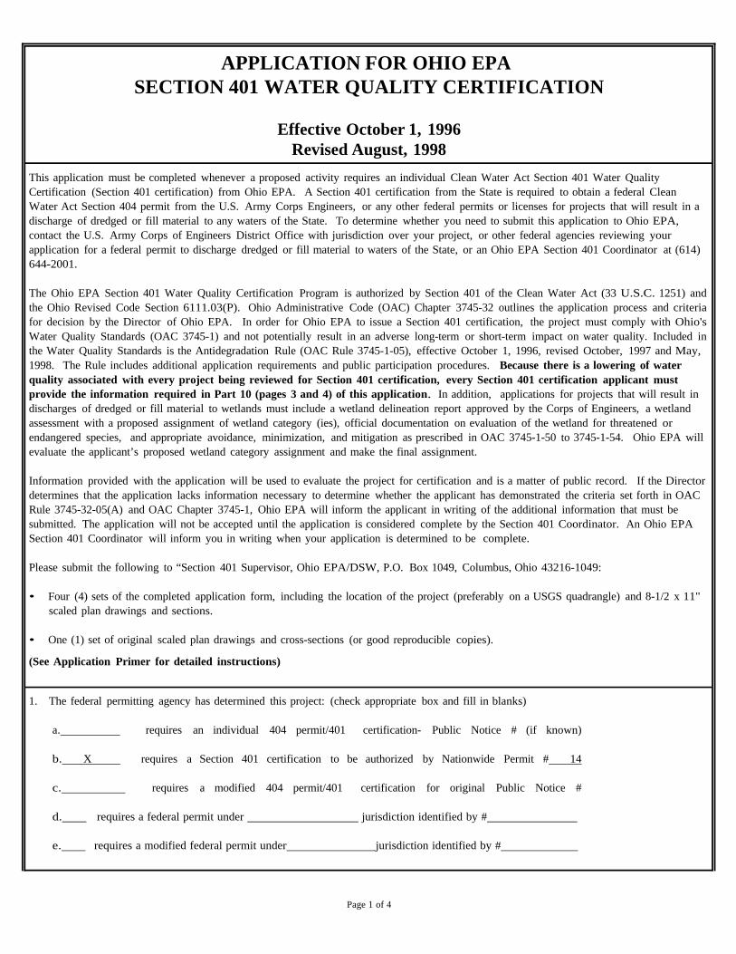
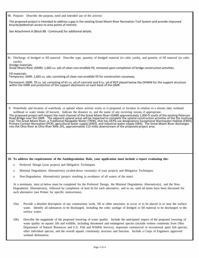
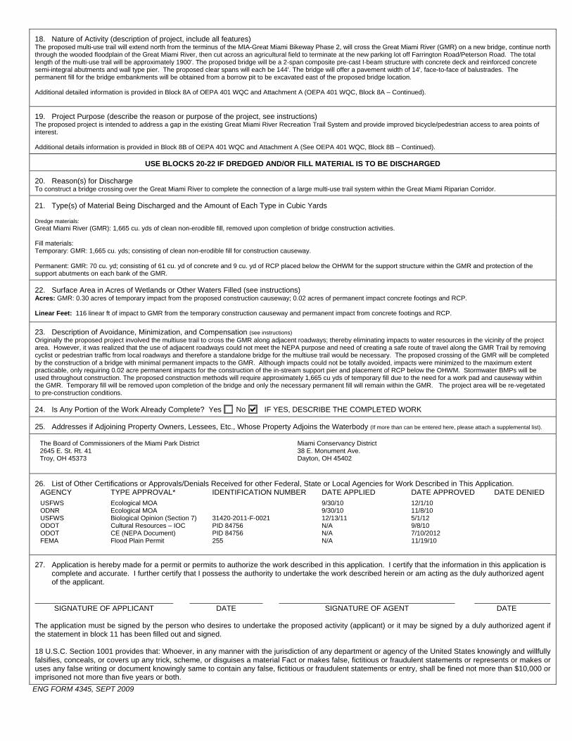

MIA ndash Great Miami Bridge Connector PID 84756 401404 Permit Application
ATTACHMENT A
Supplemental Information for the 401 and 404 application forms
SECTION 401 WQC ‐ BLOCK 8A (CONTINUED)
PROJECT DESCRIPTION MIAMI COUNTY DISTRICT ndash GREAT MIAMI CONNECTOR
The Miami County Park District has proposed a project to connect two segments of Great
Miami River Recreation Trail (the Trail) A recently completed segment of the Trail terminates
south of the Great Miami River and is the south terminus of the proposed project The Miami
County Park District has recently completed a parking lot off Farrington RoadPeterson Road
this parking lot is the north terminus of the project area and is a staging area for a Trail segment
recently completed north Farrington RoadPeterson Road
The facility will be constructed to ODOT and AASHTO design standards for independent multi‐
use trails The typical pavement section will offer 10 pavement and 3 graded shoulders
Based on preliminary engineering the proposed bridge will be a 2‐span composite haunched
steel welded plate girder structure with concrete deck and reinforced concrete semi‐integral
abutments and wall type pier The proposed clear spans will each be 144 The bridge will offer
a pavement width of 14 face‐to‐face of balustrades Permanent fill for the bridge
embankments will be obtained from a borrow pit to be excavated east of the proposed bridge
location
Minor temporary and permanent impacts to the Great Miami River will occur during
construction activities These impacts consisting of clean non‐erodible fill and associated
culvert pipes to enable the construction of temporary causeway The temporary construction
causeway materials will be removed from the Great Miami River upon completion of
construction activities associated with the bridge decking and support pier Permanent impacts
to the Great Miami River will consist of the placement of a minimal amount of concrete for a
support pier and rock channel protection adjacent to support abutments on each bank
SECTION 401 WQC - BLOCK 8B (CONTINUED)
PURPOSE DESCRIBE THE PURPOSE NEED AND INTENDED USE OF THE ACTIVITY
One element that the proposed project will address is the gap in access between the Trail segment south of the Great Miami River along CR 25A and the Trail segment north of Farrington RoadPeterson Road Currently cyclists and pedestrians desiring to continue on the Trail must divert to CR 25A and Farrington Road in order to bridge the gap between these two segments of the Trail The second element that the proposed project will provide improved bicycle and pedestrian access to area points of interest including the Great Miami River a small waterfall on an unnamed tributary paralleling Farrington RoadPeterson Road remnants of the Miami amp Erie Canal the Twin Arch Reserve Pond the Eldean Road Covered Bridge and the Twin Arch Stone Culvert
SECTION 404 ENG FORM 4345 ‐ Block 17
Directions from Columbus Ohio to Miami County Ohio to Great Miami
Connector
1 Travel on west on I‐70 from Columbus for approximately 65 miles to exit 33 (I‐75 north
towards Toledo)
2 Travel on I‐75 north take exit 78 for approximately 17 miles to County Road 25A
3 Turn left (north) on to County Road 25A and continue for approximately 05 miles to the
intersection of County Road 25AWest Peterson Road
4 Turn right onto West Peterson Road travel approximately 01 miles and turn right into
the parking areaaccess point to the proposed stream crossing
5 Park in the parking area and the proposed stream crossing is located approximately
1100 feet south of the parking area
MIA ndash Great Miami Bridge Connector PID 84756 401404 Permit Application
ATTACHMENT B
Agency Coordination
ATTACHMENT B1
ODNR Ecological Coordination October 8 2010
TriciaTriciaTriciaTricia BishopBishopBishopBishop PlanningPlanningPlanningPlanning DDDD07070707ODOTODOTODOTODOT
11162010 0202 PM
To
cc
bcc
Subject Fw 10-0389 ODOT MOA Dated September 30th 2010
----- Forwarded by Megan MichaelEnvironmentalCENODOT on 11162010 0152 PM -----
MitchMitchMitchMitch BrianBrianBrianBrian ltltltltBrianBrianBrianBrian MitchMitchMitchMitchdnrdnrdnrdnr statestatestatestate ohohohohususususgtgtgtgt
11082010 1107 AM
To lttimhilldotstateohusgt
cc ltMeganMichaeldotstateohusgt
ltMikePettegrewdotstateohusgtSubject 10-0389 ODOT MOA Dated September 30th 2010
ODNR COMMENTS TO Timothy M Hill ODOT Office of Environmental Services 1980 West Broad
Street Columbus Ohio 43223
Project The ODOT MOA Dated September 30th
2010 includes projects with the following PIDs 75647 86486
80695 84044 83520 82086 85151 81574 25236 82924 85078 82420 82921 87928 80704 83100 83858
78166 84756 79451 83324 86657 84824 88169 83544 83380 85896 88640 and 85132 These projects will
require bridge or culvert replacements andor roadway alignments on essentially the existing alignments
Location The projects are located in multiple counties in ODOT Districts 1 2 3 4 5 6 7 9 10 11 12
The Ohio Department of Natural Resources (ODNR) has completed a review of the above referenced project
These comments were generated by an inter-disciplinary review within the Department These comments have
been prepared under the authority of the Fish and Wildlife Coordination Act (48 Stat 401 as amended 16 USC
661 et seq) the National Environmental Policy Act the Coastal Zone Management Act Ohio Revised Code and
other applicable laws and regulations These comments are also based on ODNRrsquos experience as the state natural
resource management agency and do not supersede or replace the regulatory authority of any local state or federal
agency nor relieve the applicant of the obligation to comply with any local state or federal laws or regulations
Fish and Wildlife The ODNR Division of Wildlife (DOW) has the following comments
POR-14225-25431026 (PID 81574) The Ohio Biodiversity Database (OBD) records show Structures 2652 and
2747 are within the Berlin Lake Wildlife Area If the project is to impact wildlife area property the DOW
recommends ODOT contact the area manager at 1806 Bonner Road Deerfield OH 44411 telephone (330)
654-2392
SUM 91-2111 (PID 85078) The consultant who prepared the level 1 ecological survey report for this project
provided the DOW with a GIS shapefile for review Unfortunately it was in the NAD83 Ohio North State Plane
projection We need it in the NAD83 South projection or the site appears in the incorrect location when we open it
in our database The review for this project was therefore performed on an incorrect location (Noble Co) so the
data that was provided back to the consultant and included in the report was also incorrect
The DOW has reprocessed the project into the correct location and performed another review The shapefiles for
the correct data are attached The data file refers to rare species records The ib file shows locations of Indiana
bat records within a ten mile radius There were no managed areas scenic rivers or conservation sites within a one
mile radius of the project corridor
Records from the OBD show a great blue heron rookery near the project area The DOW recommends all work
stay at least 500 yards away from the rookery If work must be done within 500 yards of the rookery we
recommend this work be avoided from March to May
The OBD shows a record for the Indiana bat (Myotis sodalis ) near the project area Therefore as indicated in the
information provided the DOW recommends trees within the project area are cleared only between September 15
and April 15 preferably September 30 and April 1
MIA-Great Miami Bridge Connector (PID 84756) Due to the number of freshwater mussels found in the area as
well as a history of mussels found in the Great Miami River the DOW recommends a professional malacologist
approved by the DOW conduct a mussel survey in the area of this project
MIA-CR81-221 (PID 83324) Due to the fresh dead mussel shells found in the project area as well as records from
the Ohio State University Database showing a history of mussels found in Greenville Creek the DOW recommends
a professional malacologist approved by the DOW conduct a mussel survey in the area of this project
MOT-CR50-235 (PID 84824) Due to records from the Ohio State University Database showing a history of
mussels found in the Great Miami River in West Carrollton the DOW recommends a professional malacologist
approved by the DOW conduct a mussel survey in the area of this project
HEN-SR 108-1610 (PID 86846) The Ohio Biodiversity Database (OBD) shows this project is within 1500 feet of
the Maumee State Scenic River
MRG-TR 48W-066 (PID 83544) The OBD shows several other records for mussels in the Muskingum River at
the mouth of Turkey Run besides the endangered Long Solid (Fusconaia maculata maculata ) which is mentioned
in the project documentation They include the butterfly (Ellipsaria lineolata) state endangered threehorn
wartyback (Obliquaria reflexa) state threatened Ohio pigtoe (Pleurobema cordatum) state endangered
fawnsfoot (Truncilla donaciformis) state threatened purple wartyback (Cyclonaias tuberculata) state species of
concern and one fish the Eastern sand darter (Ammocrypta pellucida ) state species of concern Although habitat
for these species may not be present within the project area downstream impacts are possible BMPs should be
used to prevent sedimentation from entering Turkey Run
Boating and Navigation The ODNR Division of Watercraft has the following comments
POR-14225-25431026 (PID 81574) ODOT may want to consider developing foot path access for recreational
paddlers where structures POR 225 1433 and POR 225 1426 cross the West Branch of the Mahoning River at
SR225
In general the Division of Watercraft always wants to take advantage of access development opportunities for the
paddlers and boaters of Ohio when they present themselves
Scenic Rivers The ODNR Division of Watercraft Scenic Rivers Section has the following comments
MIA-CR81-221 (PID 83324)
Bridge Replacement Conditions Greenville Creek State Scenic River
1 A sediment and erosion control plan shall be developed for the site and implemented before
earthwork commences Particular attention shall be given to any drainage ways ditches and streams
that could convey sediment laden water directly to the Greenville Creek State Scenic River Properly
installed (framed and entrenched) sediment fence shall be utilized around the work site perimeter and
storm water inlets Appropriately designed rock-check dams and other erosion controls shall be
utilized in ditches and drainage ways All controls shall be properly maintained until final site
stabilization is achieved All sediment and erosion controls shall be removed upon stabilization of the
project area with vegetation Straw bales shall not be permitted as a form of erosion control All
denuded areas including ditches culverts and riverstream banks shall be permanently seeded and
mulched (or fiber mat) immediately upon completion of earthwork or temporarily seeded and
mulched (or fiber mat) within seven days if the area is to remain idle for more than thirty days
Access roads constructed on slopes shall be graveled to prevent erosion from surface runoff
2 Idle equipment petrochemicals and toxichazardous materials shall not be stored in the
floodplain or near any drainage ways ditches or streams that could convey such materials to the
Greenville Creek State Scenic River Petrochemicals and toxichazardous materials shall not be
discharged into the Scenic River its floodplain or any drainage ways ditches or streams Refueling of
equipment shall not occur in the floodplain or near any drainage ways ditches or streams A spill
containment and cleanup plan shall be generated prior to the start of the project
3 Where feasible for replacement structures or bridges on new alignments no in-stream structural
components will be permitted All piers and abutments should be placed above the normal high water
mark of the stream bank and should be placed as far back from the top of the bank as is possible
Columnar piers will be preferred over flat faced piers Bridge approaches should be elevated on
columnar piers so as to limit the placement of fill for embankments within the one-hundred year
floodplain This measure will allow for less restriction of flood flows Every attempt shall be made to
expand the structural opening to accommodate the one-hundred year flood flow
4 For bridge replacement projects all components of the existing structure (piers abutments etc)
shall be completely removed Piers shall be removed down to the same elevation as the surrounding
riverbed Every effort shall be made to keep deck material and other debris out of the river during
removal Asphalt deck material shall be removed before any portion of the bridge is removed If any
material falls into the water it shall be removed immediately All debris excess fill material and
material excavated from the river bottom shall be disposed of at an approved upland site (above 100
year flood elevations) Disposal in wetlands floodplains or within 1000 feet of the Greenville Creek
State Scenic River is prohibited
5 Rip- rap used shall be kept to the minimum amount needed to prevent scour and shall consist of
clean rock only (free of any toxic or fine material) All fill material used as rip rap work platforms or
cofferdams shall be a minimum of three inches in diameter and be washed to remove fine particulate
matter (clay silt sand and soil) Work platforms shall be kept to the absolute minimum size needed
to facilitate in-stream work In-stream work shall be conducted through the use of water diversions
not requiring the placement of earthen fill (sheet piling membrane dams etc) wherever possible
Any fill shall be completely removed from the streambed immediately upon completion of in-stream
work If feasible the use of Aqua Barriers is recommended
6 If dewatering is necessary to facilitate in-stream work or pier construction all wastewater shall
be pumped onto a vegetated area a sufficient distance from the Scenic River to allow for complete
infiltration No wastewater of any kind shall be discharged directly into the Scenic River or any other
drainage ways ditches or streams All storm water drainage shall be directed onto a vegetated area to
allow for complete infiltration If discharge to a vegetated area is not feasible then wastewater shall
be discharged into a sediment filter bag or into a temporary detentionretention pond with sufficient
retention time to permit for the settling of all suspended solids
7 All streambank vegetation shall be left undisturbed to the maximum extent possible Areas
where vegetation is removed shall be re-vegetated with native tree species Any disturbed
streambanks shall be returned to previously existing contours and elevations A native tree species list
will be provided by the (regional scenic river manager) Trees shall be one inch in diameter and
balled burlap nursery stock After a full growing season for the trees any stakes and guide wires
shall be removed and properly disposed of Any trees that die during the first growing season shall be
replaced Cutting or clearing of any riparian vegetation within 1000 feet of the Scenic River beyond
the existing right-of-way shall be prohibited however vertical trimming is permitted where necessary
Care shall be taken not to girdle or scuff tree trunks or damage any standing trees
8 If painting sand or water blasting any portion of the bridge is necessary then appropriate aprons
shall be utilized to provide for complete containment of all paint debris particles and other debris
Appropriate aprons shall be utilized to provide for complete containment of all paint andor sealant
over-spray Any such debris shall be removed immediately from 1000 feet of the Greenville Creek
State Scenic River and disposed of at an approved upland site (above 100 year flood elevations)
Disposal in wetlands floodplains or within 1000 feet of the State Scenic River is prohibited
9 Tim Kwiatkowski Assistant Scenic River Manager shall be invited to a pre-construction
meeting with the contractor present The Regional Scenic River Manager shall be notified of the
project start date and completion date be allowed to conduct a final inspection before the project
closes and receive a final plan set for review Periodic inspections of the project shall take place to
ensure Scenic River requirements are being met The Scenic River Act ORC 154782 requires the
ODNR Director or his representative to approve any public project Such approval shall be granted
after a review of the final plan set by Scenic River staff
Timothy J Kwiatkowski Assistant Scenic River Manager
Scenic Rivers Program
ODNR Division of Watercraft
1407 Cleveland Road
Sandusky Ohio 44870
Phone (419) 621-1302
Cell (440) 949-9132
Fax 419-625-4603
Email timkwiatkowskidnrstateohus
10 Signs stating (ldquoGreenville Creek State Scenic Riverrdquo) shall be provided and installed at both
approaches of the new bridge A sign stating ldquoCovington-Gettysburg Road Bridgerdquo shall be installed
on the upstream side of the new bridge
11 These conditions shall be included in the final project plan set and must be made available to all
construction personnel throughout the duration of the project This shall ensure that the contractors
understand Scenic River requirements
These are conditions for the bridge replacement PID 83324 MIA-CR81-0221 A site visit is planned for
November 19th
2010 where final recommendations will be made prior to approval set forth by the ORC
154782
POR-303-569 (PID25236) Scenic Rivers would like to see some type of false fascia work or under decking that
would prevent debris and other materials from falling into the river channel
Steve Roloson had coordinated quite thoroughly with ODOT to develop the construction plans Please change the
contact information to
Matthew Smith
NE Region Scenic River Manager
ODNR Div of Watercraft
2010 Milton Blvd C-1
PO Box 441
Newton Falls Ohio 44444
Office 330-872-0040
Cell 440-225-5582
Fax 330-872-1227
Matthewsmithdnrstateohus
ODNR appreciates the opportunity to provide these comments Please contact Brian Mitch at (614) 265-6378 if
you have questions about these comments or need additional information
Brian Mitch Environmental Review Manager
Ohio Department of Natural Resources
Environmental Services Section
2045 Morse Road Building F-3
Columbus Ohio 43229-6693
Office (614) 265-6378
Fax (614) 262-2197
brianmitchdnrstateohus
ATTACHMENT B2
USFWS Ecological Coordination December 1 2010
United States Department of the Interior
FISH AND WILDLIFE SERVICE
Ecological Services 4625 Morse Road Suite 104
Columbus Ohio 43230 (614) 416-8993 FAX (614) 416-8994
December 1 2010
Timothy M Hill Office of Environmental Services Ohio Department of Transportation
TAILS 31420-2011-[-0057 (PID 868[ 2) 31420-2011-1-0021 (PID 84756)
PO Box 899 3 [420-20[ [-1-0024 (P[D 84824)
Columbus OH 43216-0899 3 [420-201 1-1-0022 (PID 83324) 31420-20[ 1-1-0101 (PID 80695)
Attn Michael Pettegrew Megan Michael
RE WIL-34-26112422 (pill 86812) MIA-Great Miami Bridge Connector (pill 84756) MOT-CR50-235 (PID 84824) MIA-CR81-221 (PID 83324) LUC-IR475-315 (PID 80695)
Dear Mr Hill
Below are additional comments on five projects recently submitted by the Ohio Department of Transportation (ODOT) requesting US Fish amp Wildlife Service (Service) concurrence on Endangered Species Act section 7(a)(2) effects determinations for federally listed mussel species
WIL-34-26112422 (PID 86812) This project proposes to resurface SR-34 from the Edon corporation limit to SR-576 and from SR-191 to the Henry County line in Williams County Seven bridges will be crossed for this activity including five bridges that will require additional rehabilitation (eg pier and abutment patching deck work and placement of rock channel protection (RCP)) The Ecological Survey Report (ESR) for this project indicates that three streams are present in the project area St Joseph River Bear Creek and Brush Creek Although the Streams table in the ESR indicates that no impacts to these streams will occur the project description suggests that in-channel work below the ord inary high water mark (OHWM) will be conducted for at least three of the crossings (SFN 8601569 SFN 8601410 and SFN 8601380) ODOT has determined that this project may affect but is not likely to adversely affect the white catspaw (Epioblasma obliquata perobliqua) clubshell (Pleurobema clava) northern riffleshell (Epioblasma torulosa rangiana) rabbitsfoot (Quadrula c cylindrica) and rayed bean (Villosajabalis) mussels Records for these species exist within the St Joseph River andor Bear Creek but detailed project information has only been provided for the crossing on the S1 Joseph River Your letter indicates that suitable mussel habitat is present at the S1 Joseph crossing site but mussel sampling during ODOTs field survey was limited due to deep and turbid water The Service requests additional information on the in-water work to be conducted below the OHWM for the crossings at the St Joseph River and Bear Creek Therefore we cannot concur with your effects determination for these mussel species at this time
Upon review of the additional information requested the Service may request a detailed mussel survey in the S1 Joseph River andor Bear Creek A survey if warranted should be designed and conducted in coordination with the Endangered Species Coordinator for this office and conducted by a surveyor holding valid Federal and State permits to survey for federally listed mussels in Ohio
In addition we that the Service be of the construction for this project and that we be the opportunity to conduct periodic site visits
project included in ODOTs 302010 MOA submittal proposes to construct a new over the Great Miami River (GMR) on a multi-use trail in Miami County Your letter and
that 130 of impacts to the GMR are and a work in the GMR will be required construction of the center bridge pier ODOT has determined that this may affect
to adversely affect the rayed bean Your letter and ESR that habitat the was found within the project area and only shallow areas were
the impacts to the river we recommend survey should be designed and conducted in coordination
Coordinator for
Based on the above information we cannot concur your determination for the rayed bean at this time
This project included in 3020 I0 MOA submittal proposes to rehabilitate the Farmersvil Carrollton Pike over the Great Miami River in Montgomery
County Your and ESR indicate that 80 impacts to GMR are and placement a work pad in the GMR will be for construction access ODOT has determined that project may affect but is not likely to adversely affect the rayed bean
We understand that ODNR Division Wildlife has requested a detailed mussel survey at this project site We support Wildlifes recommendation and that survey be and conducted in coordination with Endangered Coordinator for this
Based on the above we cannot concur with your determination the rayed bean at this time
project included in 20 I 0 MOA submittal proposes to replace the bridge over Greenville Creek (a tributary to the Stillwater River) along CR-8J in Miami County Your letter
that 100 of to Greenville Creek are during removal of the bridge and construction of the new structure ODOT has determined that this project will have no effect on snuffbox triquetra) or bean mussels
In an email November 2010 Megan Michael (ODOT OES) provided additional information on potential habitat for mussels at project site We understand that ODOT field the site summer 2010 and found present including two Ohio of concern the creek heelsplitter and (Alasmidonta Megan Michaels email also indicated that suitable mussel habitat was found under the bridge but ODOT sampled along one bank
In an email datedNovember2010Tricia Bishop (ODOT District 7) indicated that a extending across the stream will be during We understand from that ODNR Rivers did not to temporary access fill for construction However we that ODNR Division of Wildlife has requested a detailed survey at project site
Based on the above information we do not agree that a no effect determination for proposed federally listed mussels is appropriate We support Division of Wildlifes recommendation and request that a survey be designed and conducted in coordination with the Endangered Species Coordinator for this office
LUC-IR475-3 15 Deck Replacement (pm 80695) This project included in ODOTs September 302010 MOA submittal proposes to rehabilitate an 11shyspan steel beam structure along IR-475 over Manley Road Swan Creek and the Ohio Turnpike in Lucas County Your letter and ESR indicate that 150 of impacts to Swan Creek are expected but the nature of those impacts is not described ODOT has determined that this project may affect but is not likely to adversely affect the rayed bean
In an email dated November 15 2010 Megan Michael provided additional information about a survey she conducted at the project site to assess habitat suitability for the rayed bean At that time several live mussels were seen siphoning under the bridge but mussels could not be removed from the substrate due to the cold temperature of the water However a fresh dead rayed bean was found at the site
An email from Richard Perse (ODOT District 2) dated November 24 2010 forwarded to our office by Megan Michael on November 302010 indicated that the bridge piers will be widened by approximately 19 feet and this work will likely require the construction of cofferdams Additionally this email states that the work is expected to impact the area between the normal water level and the OHWM It is unclear at this time whether a work pad will be placed in the stream
Based on the potential impacts to Swan Creek a detailed mussel survey in the project area is warranted The survey should be designed and conducted in coordination with the Endangered Species Coordinator for this office
These comments have been prepared under the authority of the Fish and Wildlife Coordination Act (48 Stat 401 as amended 16 USC 661 et seq) the Endangered Species Act of 1973 as amended and are consistent with the intent ofthe National Environmental Policy Act of 1969 and the US Fish and Wildlife Services Mitigation Policy This concludes consultation on this action as required by section 7(a)(2) of the Endangered Species Act Should during the term of this action additional information on listed or proposed species or their critical habitat become available or if new information reveals effects of the action that were not previously considered consultation with the Service should be reinitiated to assess whether the determinations are still valid
If you have questions or if we may be of further assistance in this matter please contact Karen Hallberg at extension 23 in this office
Sincerely
~1Y~iJ~ Field Sl~~~isor
Enc
cc ODNR DOW SCEA Unit Columbus OH (email only) Ohio Regulatory Transportation Office Columbus OH (email only) OEPA CollUllbus OH (email only)
ATTACHMENT B3
USFWS Biological Opinion Incidental Take Statement May 1 2012
United States Department of the Interior
FISH AND WILDLIFE SERVICE
Ecological Services 4625 Morse Road Suite 104
Columbus Ohio 43230 RECEI D (614) 416-8993 FAX (614) 416-8994
MAY 07 2012
OFFICE OF ENVIR NMENTAL SERVI ES
May 12012
Laurie S Leffler Administrator TA1LS 31420-2011-F-0021 (PID 84756)
Federal Highway AdmirUstration Ohio Division Office FHW A RE HDA-OH 200 N High Street Columbus OH 43215
RE Biological Opinion on the MIA-Great Miami Bridge Connector Project (PID 84756) on the Great Miami River in Miami County Ohio
Dear Ms Leffler
This letter accompanies the US Fish and Wildlife Services (Service) enclosed Biological Opinion based on our review of the proposed construction of a multi-use trail and bridge across the Great Miami River (Ohio Department of Transportation (ODOT) Project MIA-Great Miami Bridge Connector PID 84756)) and its effects on the endangered rayed bean mussel (Villosafabalis) under section 7(a)(2) of the Endangered Species Act (ESA) of 1973 as amended (16 USC 1531 et seq) The Federal Highway Administrations (FHWA) December 13 2011 letter requesting formal consultation was received on December 142011 We provided you with a January 122012 letter notifying you that we had initiated formal consultation effective December 132011 We submitted a draft Biological Opinion to you for review on April 192012 and received your agencys and ODOrs final comments on May 12012 Upon consideration of the comments we have made the appropriate modifications and clarifications in the fmal document
In this Opinion the Service concludes that the proposed action is likely to adversely affect but is not likely to jeopardize the continued existence of the rayed bean Additionally the Service has previously concluded that the proposed action may affect but is not likely to adversely affect the Indiana bat (Myotis sodalis) or the snuffbox (Epioblasma triquetra) both federally endangered species Because no critical habitat is designated for any of these species none will be affected by the proposed action
Incidental take is defined as take that is incidental to and not the purpose of the carrying out of an otherwise lawful activity Under the terms of section 7(b )(4) and section 7(0)(2) of the ESA taking that is incidental to and not intended as part of the agency action is not considered to be prohibited under the ESA provided that such taking is in compliance with the terms and conditions of this Incidental Take Statement (ITS) The ITS accompanying this Biological Opinion pursuant to section 7(b)(4) of the ESA exempts the incidental taking of two individual rayed bean mussels within the 247 acre area to be impacted (directly or indirectly) during the construction of the multi-use trail bridge over the Great Miami River activity that is part of the Great Miami Bridge Connector project
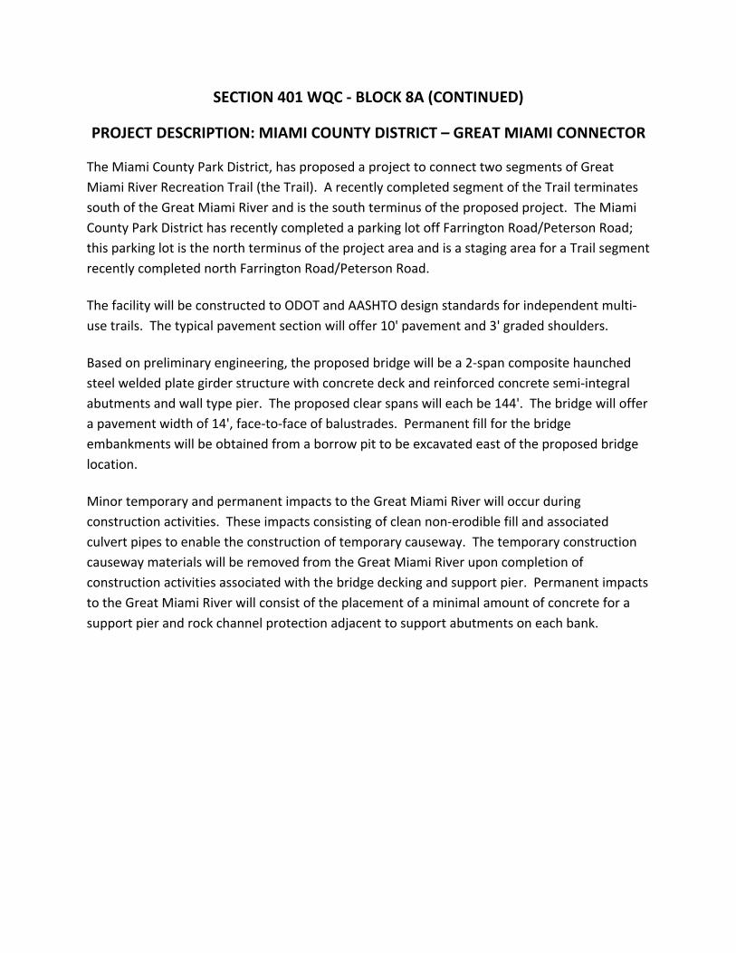
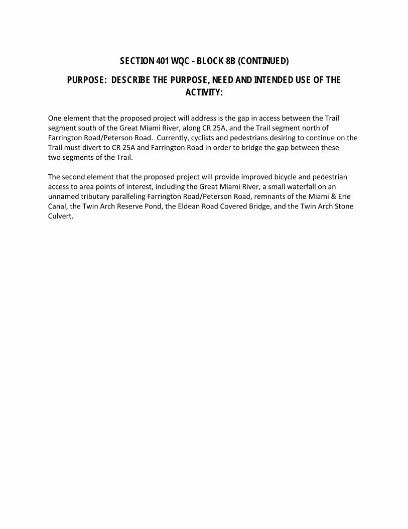
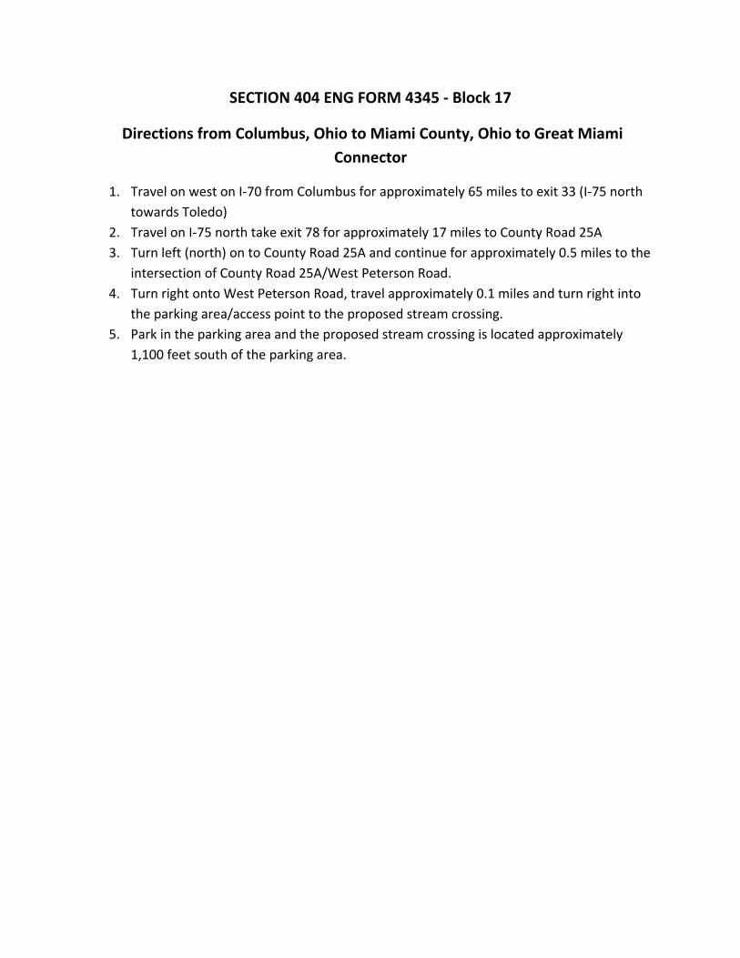
United States Department of the Interior
FISH AND WILDLIFE SERVICE
Ecological Services 4625 Morse Road Suite 104
Columbus Ohio 43230 (614) 416-8993 FAX (614) 416-8994
December 1 2010
Timothy M Hill Office of Environmental Services Ohio Department of Transportation
TAILS 31420-2011-[-0057 (PID 868[ 2) 31420-2011-1-0021 (PID 84756)
PO Box 899 3 [420-20[ [-1-0024 (P[D 84824)
Columbus OH 43216-0899 3 [420-201 1-1-0022 (PID 83324) 31420-20[ 1-1-0101 (PID 80695)
Attn Michael Pettegrew Megan Michael
RE WIL-34-26112422 (pill 86812) MIA-Great Miami Bridge Connector (pill 84756) MOT-CR50-235 (PID 84824) MIA-CR81-221 (PID 83324) LUC-IR475-315 (PID 80695)
Dear Mr Hill
Below are additional comments on five projects recently submitted by the Ohio Department of Transportation (ODOT) requesting US Fish amp Wildlife Service (Service) concurrence on Endangered Species Act section 7(a)(2) effects determinations for federally listed mussel species
WIL-34-26112422 (PID 86812) This project proposes to resurface SR-34 from the Edon corporation limit to SR-576 and from SR-191 to the Henry County line in Williams County Seven bridges will be crossed for this activity including five bridges that will require additional rehabilitation (eg pier and abutment patching deck work and placement of rock channel protection (RCP)) The Ecological Survey Report (ESR) for this project indicates that three streams are present in the project area St Joseph River Bear Creek and Brush Creek Although the Streams table in the ESR indicates that no impacts to these streams will occur the project description suggests that in-channel work below the ord inary high water mark (OHWM) will be conducted for at least three of the crossings (SFN 8601569 SFN 8601410 and SFN 8601380) ODOT has determined that this project may affect but is not likely to adversely affect the white catspaw (Epioblasma obliquata perobliqua) clubshell (Pleurobema clava) northern riffleshell (Epioblasma torulosa rangiana) rabbitsfoot (Quadrula c cylindrica) and rayed bean (Villosajabalis) mussels Records for these species exist within the St Joseph River andor Bear Creek but detailed project information has only been provided for the crossing on the S1 Joseph River Your letter indicates that suitable mussel habitat is present at the S1 Joseph crossing site but mussel sampling during ODOTs field survey was limited due to deep and turbid water The Service requests additional information on the in-water work to be conducted below the OHWM for the crossings at the St Joseph River and Bear Creek Therefore we cannot concur with your effects determination for these mussel species at this time
Upon review of the additional information requested the Service may request a detailed mussel survey in the S1 Joseph River andor Bear Creek A survey if warranted should be designed and conducted in coordination with the Endangered Species Coordinator for this office and conducted by a surveyor holding valid Federal and State permits to survey for federally listed mussels in Ohio
In addition we that the Service be of the construction for this project and that we be the opportunity to conduct periodic site visits
project included in ODOTs 302010 MOA submittal proposes to construct a new over the Great Miami River (GMR) on a multi-use trail in Miami County Your letter and
that 130 of impacts to the GMR are and a work in the GMR will be required construction of the center bridge pier ODOT has determined that this may affect
to adversely affect the rayed bean Your letter and ESR that habitat the was found within the project area and only shallow areas were
the impacts to the river we recommend survey should be designed and conducted in coordination
Coordinator for
Based on the above information we cannot concur your determination for the rayed bean at this time
This project included in 3020 I0 MOA submittal proposes to rehabilitate the Farmersvil Carrollton Pike over the Great Miami River in Montgomery
County Your and ESR indicate that 80 impacts to GMR are and placement a work pad in the GMR will be for construction access ODOT has determined that project may affect but is not likely to adversely affect the rayed bean
We understand that ODNR Division Wildlife has requested a detailed mussel survey at this project site We support Wildlifes recommendation and that survey be and conducted in coordination with Endangered Coordinator for this
Based on the above we cannot concur with your determination the rayed bean at this time
project included in 20 I 0 MOA submittal proposes to replace the bridge over Greenville Creek (a tributary to the Stillwater River) along CR-8J in Miami County Your letter
that 100 of to Greenville Creek are during removal of the bridge and construction of the new structure ODOT has determined that this project will have no effect on snuffbox triquetra) or bean mussels
In an email November 2010 Megan Michael (ODOT OES) provided additional information on potential habitat for mussels at project site We understand that ODOT field the site summer 2010 and found present including two Ohio of concern the creek heelsplitter and (Alasmidonta Megan Michaels email also indicated that suitable mussel habitat was found under the bridge but ODOT sampled along one bank
In an email datedNovember2010Tricia Bishop (ODOT District 7) indicated that a extending across the stream will be during We understand from that ODNR Rivers did not to temporary access fill for construction However we that ODNR Division of Wildlife has requested a detailed survey at project site
Based on the above information we do not agree that a no effect determination for proposed federally listed mussels is appropriate We support Division of Wildlifes recommendation and request that a survey be designed and conducted in coordination with the Endangered Species Coordinator for this office
LUC-IR475-3 15 Deck Replacement (pm 80695) This project included in ODOTs September 302010 MOA submittal proposes to rehabilitate an 11shyspan steel beam structure along IR-475 over Manley Road Swan Creek and the Ohio Turnpike in Lucas County Your letter and ESR indicate that 150 of impacts to Swan Creek are expected but the nature of those impacts is not described ODOT has determined that this project may affect but is not likely to adversely affect the rayed bean
In an email dated November 15 2010 Megan Michael provided additional information about a survey she conducted at the project site to assess habitat suitability for the rayed bean At that time several live mussels were seen siphoning under the bridge but mussels could not be removed from the substrate due to the cold temperature of the water However a fresh dead rayed bean was found at the site
An email from Richard Perse (ODOT District 2) dated November 24 2010 forwarded to our office by Megan Michael on November 302010 indicated that the bridge piers will be widened by approximately 19 feet and this work will likely require the construction of cofferdams Additionally this email states that the work is expected to impact the area between the normal water level and the OHWM It is unclear at this time whether a work pad will be placed in the stream
Based on the potential impacts to Swan Creek a detailed mussel survey in the project area is warranted The survey should be designed and conducted in coordination with the Endangered Species Coordinator for this office
These comments have been prepared under the authority of the Fish and Wildlife Coordination Act (48 Stat 401 as amended 16 USC 661 et seq) the Endangered Species Act of 1973 as amended and are consistent with the intent ofthe National Environmental Policy Act of 1969 and the US Fish and Wildlife Services Mitigation Policy This concludes consultation on this action as required by section 7(a)(2) of the Endangered Species Act Should during the term of this action additional information on listed or proposed species or their critical habitat become available or if new information reveals effects of the action that were not previously considered consultation with the Service should be reinitiated to assess whether the determinations are still valid
If you have questions or if we may be of further assistance in this matter please contact Karen Hallberg at extension 23 in this office
Sincerely
~1Y~iJ~ Field Sl~~~isor
Enc
cc ODNR DOW SCEA Unit Columbus OH (email only) Ohio Regulatory Transportation Office Columbus OH (email only) OEPA CollUllbus OH (email only)
ATTACHMENT B3
USFWS Biological Opinion Incidental Take Statement May 1 2012
United States Department of the Interior
FISH AND WILDLIFE SERVICE
Ecological Services 4625 Morse Road Suite 104
Columbus Ohio 43230 RECEI D (614) 416-8993 FAX (614) 416-8994
MAY 07 2012
OFFICE OF ENVIR NMENTAL SERVI ES
May 12012
Laurie S Leffler Administrator TA1LS 31420-2011-F-0021 (PID 84756)
Federal Highway AdmirUstration Ohio Division Office FHW A RE HDA-OH 200 N High Street Columbus OH 43215
RE Biological Opinion on the MIA-Great Miami Bridge Connector Project (PID 84756) on the Great Miami River in Miami County Ohio
Dear Ms Leffler
This letter accompanies the US Fish and Wildlife Services (Service) enclosed Biological Opinion based on our review of the proposed construction of a multi-use trail and bridge across the Great Miami River (Ohio Department of Transportation (ODOT) Project MIA-Great Miami Bridge Connector PID 84756)) and its effects on the endangered rayed bean mussel (Villosafabalis) under section 7(a)(2) of the Endangered Species Act (ESA) of 1973 as amended (16 USC 1531 et seq) The Federal Highway Administrations (FHWA) December 13 2011 letter requesting formal consultation was received on December 142011 We provided you with a January 122012 letter notifying you that we had initiated formal consultation effective December 132011 We submitted a draft Biological Opinion to you for review on April 192012 and received your agencys and ODOrs final comments on May 12012 Upon consideration of the comments we have made the appropriate modifications and clarifications in the fmal document
In this Opinion the Service concludes that the proposed action is likely to adversely affect but is not likely to jeopardize the continued existence of the rayed bean Additionally the Service has previously concluded that the proposed action may affect but is not likely to adversely affect the Indiana bat (Myotis sodalis) or the snuffbox (Epioblasma triquetra) both federally endangered species Because no critical habitat is designated for any of these species none will be affected by the proposed action
Incidental take is defined as take that is incidental to and not the purpose of the carrying out of an otherwise lawful activity Under the terms of section 7(b )(4) and section 7(0)(2) of the ESA taking that is incidental to and not intended as part of the agency action is not considered to be prohibited under the ESA provided that such taking is in compliance with the terms and conditions of this Incidental Take Statement (ITS) The ITS accompanying this Biological Opinion pursuant to section 7(b)(4) of the ESA exempts the incidental taking of two individual rayed bean mussels within the 247 acre area to be impacted (directly or indirectly) during the construction of the multi-use trail bridge over the Great Miami River activity that is part of the Great Miami Bridge Connector project
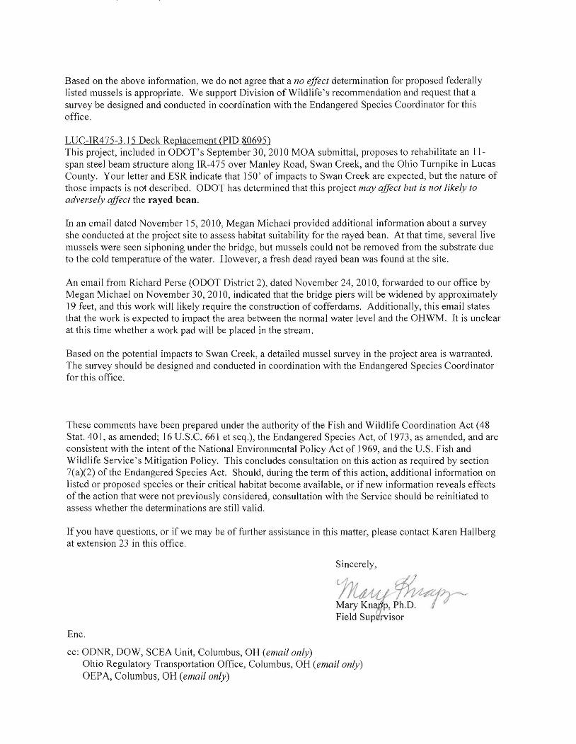


