Download - SITE PLAN REVIEW REGULATIONS

SITE PLAN REVIEW
REGULATIONS
Town of Stratham, N.H.
Adopted February 3, 1987 As amended to May 2019
2019

Stratham, NH Site Plan Review Regulations July 2010
This page has been intentionally left blank.
Stratham, NH Site Plan Review Regulations May 2019
Page 3 of 62
SITE PLAN REVIEW REGULATIONS
Town of Stratham, N.H.
- TABLE OF CONTENTS - SECTION: Page
SECTION I:
GENERAL PROVISIONS 6
1.1 AUTHORITY: 6
1.2 PURPOSES: 6
1.3 TITLE: 6
SECTION II:
DEFINITIONS 7
2.1 DEFINITIONS: 7
SECTION III:
SCOPE & REQUIREMENTS 8
3.1 SCOPE: 8
3.2 RELATIONSHIP TO OTHER REQUIREMENTS: 8
3.3 SITE PLAN REVIEW REQUIRED: 9
3.4 BUILDING PERMIT: 9
SECTION IV:
APPLICATION PROCEDURES & REQUIREMENTS 10
4.1 PRELIMINARY CONSULTATION: (Rev. 0/06) 10
4.2 FORMAL APPLICATION REVIEW PROCESS: (Rev. 8/99) 11
4.3 DATA REQUIRED: 15
4.4 FORMAL REVIEW PROCEDURE: (Rev. 1/01) 18
4.5 BOARD ACTION: (Rev. 11/93) (Revised 06/07) 18
SECTION V:
DESIGN & CONSTRUCTION REQUIREMENTS 20
5.1 ACCESS DESIGN: 20
5.2 LANDSCAPE DESIGN STANDARDS: 22

Stratham, NH Site Plan Review Regulations May 2019
Page 4 of 62
5.3 STORM DRAINAGE 31
5.4 FLOOD CONTROL: 31
5.5 SNOW STORAGE: 32
5.6 SOLID WASTE DISPOSAL SCREENING: 32
5.7 SIDEWALKS: 32
5.8 ILLUMINATION/ NOISE EMISSIONS: 32
5.9 PARKING REQUIREMENTS: (Amended 7/20/10) 36
5.10 WATER AND SEWER SERVICE: 46
5.11 FIRE PROTECTION: 46
5.12 UTILITIES: 47
5.14 STREET CONSTRUCTION: 48
5.15 ARCHITECTURAL PLANS: 48
5.16 OPEN SPACE SETBACK: (Rev. 11/95) 49
SECTION VI:
SUPPLEMENTARY PROVISIONS 50
6.1 CONSTRUCTION STANDARDS: 50
6.2 AS-BUILT DRAWINGS: 50
6.3 SITE INSPECTIONS AND FEE: (deleted 11/93) 50
SECTION VII:
AGREEMENTS & BONDING 50
7.1 SITE REVIEW AGREEMENT: 50
7.2 FINANCIAL GUARANTY: 51
7. 3 MAINTENANCE BOND: 51
SECTION VIII:
WAIVERS 51
8.1 WAIVERS: 51
SECTION IX:
ENFORCEMENT 51
9.1 ENFORCEMENT PROVISIONS: 51
SECTION X:
VALIDITY 52

Stratham, NH Site Plan Review Regulations May 2019
Page 5 of 62
10.1 DECLARATION: 52
10.2 EFFECTIVE DATE: 52
ADDENDUM A: CISTERN SPECIFICATIONS (05/04) 53
ADDENDUM B: DIGITAL SUBMISSION (added07/06) 54
ADDENDUM C: STORMWATER REGULATIONS (ADDED 5/19) 55
APPENDIX A: RECORD OF AMENDMENTS 64

Stratham, NH Site Plan Review Regulations May 2019
Page 6 of 62
SECTION I: GENERAL PROVISIONS
1.1 AUTHORITY:
These Regulations are enacted in accordance with the authority conferred in RSA
674:43-44 and based upon the authority given to the Planning Board at the Town Meeting
held on March 10, 1981.
1.2 PURPOSES:
The purposes of these Regulations are to:
a. Provide for the safe and attractive development of the site and guard against such
conditions as would involve danger or injury to health, safety, or prosperity by reason
of: (1) inadequate drainage or conditions conducive to flooding of the property or that
of another; (2) inadequate protection for the quality of groundwater; (3) undesirable
and preventable elements of pollution such as noise, smoke, soot, particulates, or any
other discharge into the environment which might prove harmful to persons,
structures, or adjacent properties; and (4) inadequate provision for fire safety,
prevention, and control;
b. Provide for the harmonious and aesthetically pleasing development of the
municipality and its environs and to promote the goal of maintaining the rural
character of the Town; (Rev. 11/95)
c. Provide for open spaces and green spaces of adequate proportions and of adequate
visibility from public streets, roads, or subdivided and/or developed residential areas; (Rev. 11/95)
d. Require the proper arrangement and coordination of streets within the site in relation
to other existing or planned streets or with features of the official map of the
municipality;
e. Require suitably located streets of sufficient width to accommodate existing and
prospective traffic and to afford adequate light, air, and access for fire fighting
apparatus and equipment to buildings, and be coordinated so as to compose a
convenient system;
f. Require in proper cases, that plats showing new streets or narrowing or widening of
such streets be submitted to the Planning Board for approval;
g. Require that the land indicated on plats submitted to the Planning Board shall be of
such character that it can be used for building purposes without danger to health; and
h. Include such provisions as will tend to create conditions favorable for health, safety,
convenience, and prosperity.
1.3 TITLE:
These Regulations shall be known as the "Site Plan Review Regulations of the Town of
Stratham, New Hampshire."

Stratham, NH Site Plan Review Regulations May 2019
Page 7 of 62
SECTION II: DEFINITIONS
2.1 DEFINITIONS:
Unless the context otherwise requires, the following definitions shall be used in the
interpretation and construction of these Regulations. If subsections of these regulations
contain alternate definitions, the more restrictive term or definition shall apply unless
otherwise determined by the Planning Board on a case-by-case basis. Words used in the
present tense include the future; the singular number shall include the plural, and the
plural the singular; the word "building" shall include the word "structure"; and the word
"shall" is mandatory and not optional. (Rev. 5/19)
In general, words and terms used in these Regulations shall have their customary
dictionary meanings. Definitions described in the existing Town of Stratham Zoning
Ordinance shall apply therein. The following words are specifically defined:
2.1.1 Abutter: means any person whose property is located in New Hampshire and adjoins or
is directly across any street or any other way or stream from the land to be considered or
under consideration by the Planning Board for Site Plan Review approval. For purposes
of receiving testimony and not for purposes of specific notification, the term abutter shall
include any person who is able to demonstrate that his/her land will be directly affected
by the proposal to be considered or under consideration.
2.1.2 Development: means the construction of improvements on a tract or tracts of land, which
shall include the enlargement of the structure or physical changes to the site to
accommodate the intended use.
2.1.3 Engineer or Surveyor: means the duly designated and legally recognized engineer or
licensed surveyor of the developer as may be pertinent to the actual services to be
performed.
2.1.4 Enlargement: means the increase in size or the expansion of any structure or
appurtenance, whether said appurtenance exists alone or in service of a structure or other
appurtenance.
2.1.5 Hardpan: means a compact soil layer high in silt and very fine sand and generally low in
clay with a permeability of less than 0.6 inches per hour.
2.1.6 Improvement: means all structures, appurtenances, or additions to the site whether above
or below the surface of the land, and including but not limited to buildings, construction
of any kind, site grading, landscaping, street construction, utilities (including water,
sewer, electric, gas, storm drainage), whether proposed by the developer, or required by
the Board under these Regulations.
2.1.7 Non-Public or Individual Waste Disposal System: means any treatment system other
than a public sewer, which receives sewage or other wastes.
2.1.8 Non-Public or Individual Water Supply System: means any private system providing
potable water.
2.1.9 Non-Residential Use: means any use other than that of a residence, provided, however,
that these Regulations and procedures shall not apply to the construction, expansion,
siting or permitted use with respect to any accessory use buildings on the same site as a

Stratham, NH Site Plan Review Regulations May 2019
Page 8 of 62
principal residence in the Agricultural - Residential District defined in the Zoning
Ordinance of the Town of Stratham.
2.1.10 Seasonal High Water Table: means the upper limit of the groundwater in a soil, which
becomes seasonally saturated with water.
2.1.11 Street: means the same as the definition provided in Section 1.5.26 of the Subdivision
Regulations. (Rev. 8/99)
2.1.12 Subdivision: means the division of a lot, tract or parcel of land for the purpose, whether
immediate or in the future, of sale, rent, lease, condominium conveyance or building
development. It includes re-subdivision and, when appropriate to the context, relates to
the process of subdividing or to the land or territory subdivided. The division of a parcel
of land held in common and subsequently divided into parts among the several owners
shall be deemed a subdivision under these Regulations.
2.1.13 Wetlands: means the same as the definition provided in Section 1.5.29 of the Subdivision
Regulations. (Rev. 8/99)
SECTION III: SCOPE & REQUIREMENTS 3.1 SCOPE:
The Planning Board is hereby authorized to review, and approve or disapprove site plans
for the development of tracts for nonresidential uses or for multifamily dwelling units
(any structure containing in excess of two dwelling units) whether or not such
development includes a subdivision or re-subdivision of the site.
3.2 RELATIONSHIP TO OTHER REQUIREMENTS:
3.2.1 Compliance with Other Regulations:
The Site Plan Review procedure in no way relieves the applicant from compliance with
or approval under the provisions of the Town's Zoning Ordinance, Subdivision
Regulations, Building Codes, and/or other regulations which pertain to or govern the
proposed development. No Site Plan will be approved unless it is in compliance with all
pertinent ordinances and regulations.
In cases where a variance is required from the Zoning Ordinance, the applicant shall first
present the plan to the Planning Board so as to allow the Board to render a decision at a
public hearing. (Rev. 7/89) (Rev. 8/99) (Rev. 6/00)
At the Applicant’s request, the Planning Board may, at its sole discretion, waive the
general requirements for a complete application, in accordance with these regulations, in
order to advance the application to the Zoning Board of Appeals. Said waivers would be
granted for the sole purpose of accepting the application, thereby providing the Board
with jurisdiction to render a formal decision on the plan. Waivers of any or all of these
general requirements shall be granted on a one time only basis and shall not be
considered as justification for any future waivers of said regulations. The applicant
assumes all risk of any further zoning relief that may be found necessary as a result of
subsequent Planning Board reviews of the application. (Rev. 6/00)

Stratham, NH Site Plan Review Regulations May 2019
Page 9 of 62
3.2.2 Minimum Not Maximum:
These Regulations shall be interpreted as Minimum Requirements and compliance with
these minimum requirements in no way obligates the Planning Board to approve any
particular application solely on that basis. The Planning Board will fully consider all
aspects of an application before rendering its decision. This will include study of all site
design and technical aspects of the proposal as well as consideration of the impact of the
development on the open space, wildlife habitat and other natural resources, on local
traffic patterns and on available public utilities, services, municipal resources and, in
general, in compliance with the Stratham Master Plan. Only after the Planning Board has
fully satisfied itself that the proposed project is in the public interest and that it will not
prove detrimental to the public health, safety, welfare, or prosperity, will the application
be approved.
3.2.3 Conflicting Provisions:
If any other provision of the Town, or any provision of State or federal law relates to any
matter covered herein, the provision, which imposes the greater restriction or higher
standard, shall govern.
3.3 SITE PLAN REVIEW REQUIRED:
The Planning Board requires site plans to be submitted to it for review by any applicant
seeking any of the following:
a. The construction of any new non-residential or multi-family use;
b. The enlargement of any existing non-residential or multi-family use, which requires
development of the site;
c. The construction or conversion of any non-residential or multi-family use in which
development of the site be contemplated or required by virtue of any other Town or
State ordinance, statute, regulation or decision of the Town's Zoning Board of
Adjustment;
d. The change within a structure from one permitted use to another permitted use which
will require development of the site including, but not limited to, improvement or
alteration to the site required by virtue of any other Town or State ordinance, statute,
or regulation.
3.4 BUILDING PERMIT:
No building permit shall be issued by the Building Inspector for the construction or
expansion of a building or other facilities subject to these regulations, until final approval
is granted by the Planning Board and the Building Inspector is so notified in writing by
the Planning Board.

Stratham, NH Site Plan Review Regulations May 2019
Page 10 of 62
SECTION IV: APPLICATION PROCEDURES & REQUIREMENTS
4.1 PRELIMINARY CONSULTATION: (Rev. 0/06)
An individual who anticipates submitting a formal application for site plan review shall be required, to consult with the Planning Board prior to submission of the formal application and supporting documentation.
4.1.1 Purposes of the Consultation:
An individual who anticipates submitting a formal application for a site plan review
approval shall be required, to consult with the Planning Board prior to submission of the
formal application and supporting documentation. The purpose of the consultation is to
familiarize the Planning Board with the basic concept of the proposed site plan. The
consultation is further designed to acquaint the potential applicant with the formal
application process and particular information that the Board may request, to suggest
methods for resolving possible problems in the development, design and layout, and to
make the potential applicant aware of the recommendations in the Master Plan (if
applicable) to the property in question. Any request for consultation shall be made at least
7 days prior to the meeting at which such consultation shall occur.
4.1.2 Documents:
In order to facilitate discussion, the potential applicant is requested to prepare a base map of the property to be developed. It should be drawn to scale, and may be drawn in pencil. The proposed development should be drawn on the base map. Dimensions may be approximate. The data may be tentative, but all information shall be sufficiently clear to illustrate all conditions and the proposed development of the property.
The following information or data is requested to be submitted for review of the concept by the Planning Board:
a. General description of existing conditions on the site including characteristics of the land, topography, vegetation, and similar features;
b. General description of available community facilities and utilities;
c. General description of the proposed development, including size and dimensions, and a general use plan for the site.

Stratham, NH Site Plan Review Regulations May 2019
Page 11 of 62
4.1.3 Limits of the Review:
The Planning Board shall conduct the Preliminary Consultation at a regularly scheduled meeting of the Board. The applicant will make a presentation defining the general scope and concept of the development and how the land will be used. Any documents presented to the Board will be made a part of the record for future reference purposes.
Neither the applicant nor the Planning Board shall be bound by the discussions. However, the Planning Board shall be entitled to make recommendations with respect to the material presented to assist the applicant in preparing a formal application that will meet the development standards of the Town as expressed in these Regulations and in other ordinances and/or regulations. The Planning Board shall enter into the minutes and shall verbally communicate to the applicant any suggestions, recommendations, or other factors that the Board finds prudent and necessary.
4.1.4 Separation of Process:
It is hereby declared that no processing time limits shall apply as defined in RSA 676:4. Such time limits shall apply only when a formal application is submitted in accordance with Section 4.2 of these Regulations.
4.2 FORMAL APPLICATION REVIEW PROCESS: (Rev. 8/99)
Whether or not a Preliminary Consultation has been conducted, an applicant shall prepare and submit an application for site plan approval in accordance with and to the standards set forth in these Regulations. This formal review process is designed to afford the Planning Board, the applicant, abutters, and parties in interest a clearly delineated method for examining the proposed site plan thus allowing the Planning Board to make a timely and informed decision on the proposal.
4.2.1 Submission Period: (Rev. 5/02)
a. An application for site plan approval shall be submitted to the Town Office, c/o Chairperson of the Planning Board, prior to 12-PM, at least twenty (20) days in advance of a regularly scheduled Planning Board meeting. The application form and the supporting exhibits required are set forth in Section 4.2.2 of these Regulations;
b. In the case of continued applications, all new information, including but not limited to plan revisions, special studies, waiver requests, and conditional use permit requests, must be submitted to the Planning Department prior to 4-PM, at least ten (10) days in advance of the continued meeting date;
c. Applications submitted later than the deadline date in (a) above will not be placed on the following meeting’s agenda. New information in (b) above that is submitted later than ten days prior to the meeting date will not be considered by the Planning Board. In the case of late submission of new information, the Board shall automatically continue the application to the next scheduled meeting date.
4.2.2 Exhibits Required at Time of Submission:
The applicant shall submit the following information when a formal application is made for site plan approval. The Planning Board shall not determine whether or not the

Stratham, NH Site Plan Review Regulations May 2019
Page 12 of 62
application is complete until it reviews all of the documents at its next regularly scheduled meeting.
a. A completely filled out form entitled: "Application for Site Plan Approval." Forms may be obtained from the Town Office;
b. A list of the names and addresses of all abutters obtained from the Town Records not more than five (5) days before the date of filing of the application;
c. Six (6) complete sets of blackline or blueline prints of all plans drawn to scale appropriate to the size of the project. Plans shall be prepared under the supervision of and stamped by a registered land surveyor licensed to practice in New Hampshire; roadway, drainage and all utility plans prepared and stamped by a professional engineer licensed to practice in New Hampshire. The information to be contained in and standards to be followed for the preparation of these plans are set forth in Section 4.3 of these regulations;
d. High intensity soils information with lot size calculations and cover letter from a soil scientist;
e. Data on test pits and percolation tests including: location of test pits, percolation test data and rate, certification of test witness, and outline of area reserved for leach fields; (Rev. 7/89)
f. Completed Town of Stratham Land Use Development Tracking Form, most recently revised version, utilizing the companion instructions and definitions OR the online Pollution Tracking and Accounting Project (PTAP) portal.
g. Any supporting documentation necessary to explain the proposal to the Planning Board, abutters, and the general public.
4.2.3 Planning Board Responsibilities in Initial Processing:
The Planning Board will accept the exhibit materials specified in Section 4.2.2 and determine its completeness at its next regularly scheduled meeting.
a. The Board, at least ten days in advance of the meeting, shall mail notice to the applicant and abutters stating that an application for site plan approval has been filed. The notice will contain the following:
i. Name and address of the applicant;
ii. The location of the proposed development;
iii. A general description of the proposed project.
b. The Planning Board will also post the information contained in Section 4.2.3.a in the Town Offices.
c. At least seven (7) days prior to the meeting date where application completeness is scheduled to be determined, the Town Planner will issue formal comments relative to application completeness to the Board. These comments are made available to assist the Board in their determination of application completeness and are purely advisory. Only a vote of the Board shall determine application completeness. As a courtesy, these comments will be copied to the applicant for their consideration. (Rev. 5/02)
Stratham, NH Site Plan Review Regulations May 2019
Page 13 of 62
d. At the regularly scheduled meeting the Planning Board will:
i. Review the application for completeness and determine its acceptability for further processing;
ii. Advise the applicant of additional information that may be needed to process or evaluate the application;
iii. Set the date for a public hearing on the application;
iv. Determine the need for special investigative studies and advise the applicant of the time and the need for financial support from the applicant;
v. Notify the applicant verbally at the meeting and confirm in writing if the application is formally accepted for evaluation. The date of the formal acceptance shall be used for calculating the time period for decision by the Board.
The Planning Board may begin formal consideration of the application upon determination by vote that the application is complete, so long as a public hearing was noticed.
e. If not complete, the Planning Board will advise the applicant of what information is needed to complete the application package and when it will next be considered by the Board.
f. The Planning Board will arrange with the applicant for an inspection of the site (if determined necessary or desirable by the Board) by the Board, a committee or a member of the Board, or a Town employee appointed for said purpose by the Chairperson. Abutters shall be notified at the hearing of such inspection and shall be permitted to attend.
4.2.4 Public Hearing and Notice: (deleted 1/01; reinserted 12/03)
The Planning Board, before taking action on a site plan, shall hold at least one public hearing thereon. The Planning Board shall take testimony from the applicant, abutters, and parties in interest to the proposal either in person and/or in writing.
The applicant and abutters shall be notified of the public hearing and the time of place of such hearing by certified mail, not less than ten (10) days before the date fixed for the hearing. In addition, notice to the general public of the public hearing shall be published in the Portsmouth Herald and posted in the Town Offices at least ten (10) days before the date fixed for the hearing. The notice to the applicant, abutters and general public shall contain the information as specified in Section 4.2.3.a.
4.2.5 Concurrent and Joint Hearings:
The Planning Board may hold a hearing on a site plan or for a subdivision plat (Rev. 1/01) in conjunction with each other if both are required for a project. A hearing for either by the Planning Board may be held at the same time and place that a hearing for a special exception or variance is held for the project by the Board of Adjustment, provided that such a hearing is mutually agreed to in advance by the Boards.
4.2.6 Submission Deadline: (deleted 1/01)
Stratham, NH Site Plan Review Regulations May 2019
Page 14 of 62
4.2.7 Fees and Charges:
The applicant shall pay the following fees and charges as are applicable.
a. Filing Fee: The applicant shall pay a filing fee of one-hundred ($100) dollars for each 1,000 square feet of building construction — with a minimum of one hundred ($100) dollars. (Rev. 8/99) (Rev. 10/07)
b. For a Preliminary Consultation as provided for under Section 4.1, a filling fee of
$75.00.
c. Notice Costs: The applicant shall pay $150.00 plus $8.00 per abutter and per applicant for the costs of all notice requirements including the cost of postage for certified mail, reproduction costs, and any publication and/or posting costs. (Rev. 8/99)
(Rev. 10/07)
d. Special Investigative Costs: The Board may require the applicant to pay reasonable costs of special investigative studies which may be necessary for the Planning Board to evaluate the impact of a proposed development.
e. Recording Costs: The applicant shall prepare a check payable to the Rockingham County Registry of Deeds for submission to Rockingham County after the site plan has been approved. The amount shall be determined by Rockingham County at the time of submission. Recording check and mylar plan shall be delivered to the Planning Board Secretary after Planning Board approval. It will be the responsibility of the Town to record all plans. (Rev. 11/93)
f. Municipal Review Costs: (Rev. 11/93)
The Board will require the applicant to reimburse the Town for the cost of having duly appointed agents of the municipality review a submitted plan. Such costs may be encountered in the following instances:
i. Witnessing of test pits by an agent designated by the Board;
ii. Review of roadway design, drainage and stormwater management, and erosion
and sediment control plans by an agent appointed by the Board;
iii. Periodic construction inspections and/or tests;
iv. In accordance with RSA 674:44, V, and RSA 676:4 I, (g), the Board shall also require an applicant to reimburse the Town for expenses incurred by the Rockingham Planning Commission Circuit Rider Planner; including, but not limited to, time spent for technical review of plans, meetings with the applicant subsequent to application, and other reasonable expenses directly accountable to the particular application, the rate shall reflect the current hourly rate charged to the Town for this service, however, no fee shall be charged for time spent in meetings during contracted office hours, or contracted night meetings, or the first 2 hours of technical review of an application submitted to the Board. The amount of this fee will vary according to the particular aspects of any application. The Circuit Rider shall provide a detailed accounting of the time spent reviewing an application to the Town for purposes of proper billing. (Rev. 12/96)
Stratham, NH Site Plan Review Regulations May 2019
Page 15 of 62
4.3 DATA REQUIRED:
The following data or information is required on the site plan(s) or as part of the submission package showing existing and proposed features as described:
4.3.1 Existing Data:
The following existing site data shall be provided unless inappropriate for the specific project:
a. Location of site and the current names and addresses of developer, owners of record, abutting landowners, and professionals preparing and/or stamping the plan;
b. Names and address of person or firm preparing the map (which must be prepared and stamped by a registered architect or registered professional engineer), the scale of the map, north arrow and date. Name and address of persons or firm preparing other data and information if different from the preparer of the map;
c. The boundary lines of the area included in the site, including angles or bearings of the lines, dimensions, and the lot area;
d. Sketch plan of the site showing existing natural features including watercourses and water bodies, trees and other significant vegetation, topographic features, and any other features, which should be considered in the site design process. Existing trees over 6" in caliper at 4 ft. above the existing ground elevation must be shown on the existing conditions plan (in some cases the Board may waive this requirement if an inventory of standing timber of significant or unique species (Rev. 1/01) is provided by a licensed forester). The landscape design must indicate which of existing trees meeting the stated minimum size requirement will be removed during the development; (Rev. 8/99)
e. The existing grades, drainage systems, structures, and topographic contours at intervals not exceeding two (2) feet with spot elevations where grade is less than three percent (3%);
f. The shape, size, height, and location of existing structures on abutting properties and access roads within 200 feet of the site; (Rev. 11/95)
g. All easements and rights-of-way;
h. Man-made features such as, but not limited to, existing roads, and structures indicating which of such features are to be retained and which are to be removed or altered;
i. The size and location of all existing public and private utilities and all existing landscaping including the location and size of existing public utilities that are located off-site with which connection is planned or located within 100 feet of the site;
j. A vicinity sketch (no smaller than 1 inch equals 1000 ft.) showing the location of the site in relation to the surrounding public street system and the zoning districts and boundaries for the site and within 1,000 feet of the site. One hundred-year flood elevation contour shall be included within floodplain;
k. Soils map showing all soil types and delineating any poorly or very poorly drained soils;

Stratham, NH Site Plan Review Regulations May 2019
Page 16 of 62
l. Tax map and parcel number; (Rev. 7/89)
m. Size of parcel in acres; (Rev. 7/89)
4.3.2 Proposed Plans:
The following site data shall be provided for the proposed development, as appropriate:
a. Proposed grades, topographic contours at intervals not exceeding two (2) feet with spot elevations where the grade is less than three percent (3%). All elevations at the base of existing trees, which are over 6" in caliper at 4 ft. above the existing ground level and affected by proposed grading, shall be shown. Proposed finish grade elevations around these trees shall be shown; (Rev. 11/95) (Rev. 8/99)
b. Plan view of the shape, size, height and location of the proposed structures, including expansion or other alterations of existing buildings;
c. The location, size, direction of travel, if appropriate, curbing, paving and the radii of all streets, driveways, access ways, and sidewalks within the site and its relationship to the off-site street system;
d. The size, location, and layout of all on-site parking and loading facilities;
e. The size and location of all public and private utilities including water lines, sewage facilities, gas lines, power lines, telephone lines, fire alarm connections, storage tanks (underground and above ground), and other utilities; (Rev. 11/93)
f. A storm drainage plan, performed by a Registered Professional Engineer, including a plan for the retention and slow release of storm water where necessary, together with supporting calculations in accordance with Addendum C;
g. The location, type, and size of all proposed landscaping and screening as well as a plan for the retention of existing significant natural features (open spaces, green areas, etc.) on the site;
h. A statement, prepared by the project architect, landscape architect, or landscape designer, and included on the landscape plan indicating that the design is compatible and complementary to the building and hardscape design. The statement shall read as follows:
"I certify that the landscape design as depicted hereon is compatible with and complementary to the building and hardscape design for the site."
Signed___________________________
Project Architect
(Landscape Architect or Landscape Designer); (Rev. 11/95)
i. The location, size, and design of proposed signs and other advertising or instructional devices. The calculation of the sign area must be shown on the sign design submitted to the Planning Board. A sign permit shall be obtained from the Town of Stratham Code Enforcement Officer prior to the submission of site plan approval. (Rev. 11/95)
Signs may be two-faced with the area of each face equal to the area allowed by the Zoning Ordinance. Only one face may be seen from any one view. Sign standards or

Stratham, NH Site Plan Review Regulations May 2019
Page 17 of 62
supports along with any elements cannot exceed in area, on the same plane, as the sign more than 50% of the allowed signage area for the sign without the express approval of the Planning Board; (Rev. 11/95) Signage design shall be submitted in the Site Plan
Review, with colors specified by the architect and color samples submitted to and approved by the Planning Board; (Rev. 11/95)
j. The location, type, and design of outdoor lighting;
k. Surveyed property lines showing their bearings and distances and showing monument locations;
l. Construction details, including but not limited to pavement, walks, steps, curbing, drainage structures, and erosion and sedimentation control techniques.
m. Any other exhibits or data that the Planning Board may require in order to evaluate adequately the proposed development including but not limited to:
i. Calculations relating to stormwater runoff;
ii. Information on the composition and quantity of wastewater generated;
iii. Information on air, water, or land pollutants discharged;
iv. Estimates of noise generation.
n. Traffic Impact Analysis: All proposed commercial, industrial or residential development shall be reviewed by the Planning Board to ascertain that adequate provisions have been made by the owner or his/her authorized agent for traffic safety. To facilitate this review, the Planning Board may require the developer to provide a traffic impact analysis when deemed necessary by the Board due to the size, location, or traffic-generating characteristic of the development. Traffic impact analyses shall address each of the following:
i. Traffic circulation and access, including adequacy of adjacent street and intersections, entrances and exits, traffic flow, sight distances, accident statistics, curb cuts, turning lanes, and existing or recommended traffic signalization;
ii. Pedestrian safety and access;
iii. Off-street parking and loading;
iv. Emergency vehicle access;
v. Necessary off-site improvements, to be constructed by the developer.
o. A copy of the plans submitted in a digital format as provided for in Addendum D:
Digital Submission Requirements. (added 07/06)
4.3.3 Other Permits:
The applicant may be required to secure permits from other levels of government as part of the approval process. The applicant may submit approvals in any logical order. However, the Site Plan will not receive final approval until evidence is placed in the record that all other permits have been received.

Stratham, NH Site Plan Review Regulations May 2019
Page 18 of 62
4.4 FORMAL REVIEW PROCEDURE: (Rev. 1/01)
The Board shall act to approve or disapprove a site plan within sixty-five (65) days of the formal acceptance as determined in Section 4.2.3(d)(v).
The Planning Board may apply to the Board of Selectmen for an extension not to exceed ninety (90) days before acting to approve or disapprove an application. The applicant may waive the requirement for Planning Board action within the time periods specified and consent to such extension as may be mutually agreeable.
Upon failure of the Planning Board to approve or disapprove within sixty-five (65) days (or within additional days, if granted by the Selectmen), the applicant may obtain from the Selectmen an order directing the Planning Board to act within thirty (30) days. Failure of the Planning Board to act upon such order shall constitute grounds for action in the Superior Court in accordance with RSA 676:4.
4.4.1 Public Hearing and Notice (deleted 1/01)
4.5 BOARD ACTION: (Rev. 11/93) (Revised 06/07)
Within the appropriate time frames as established by NH RSA 676:4, the Board shall
approve, conditionally approve, approve with conditions, table or disapprove the
application. The reasons for disapproval of a plan shall be stated in the record of the
Board. Approval of a plan shall be endorsed on the plan by the Chairman or Vice Chair
of the Board. The time to act may be extended in accordance with NH RSA 676:4-f.
4.5.1 Conditional Approval:
All conditional approvals are valid for a period of not more than 120 days, unless the
Planning Board, at their discretion, chooses to extend the number of days required to
meet precedent conditions. All precedent conditions of approval must be met within this
120-day period (or time period established by the Planning Board at time of conditional
approval) or the approval shall be considered null and void. In cases where extenuating
circumstances prevent the meeting of precedent conditions within 120 days, the applicant
may request an extension, to be filed (in writing and with justification) with the Board no
later than 14 days prior to the expiration date of the conditions. The Planning Board shall
then vote on whether or not to grant such extensions.
4.5.2 Approval with Conditions:
The Board may attach reasonable conditions to ensure that the public interest is upheld.
Such conditions may include, but are not limited to the following:
a. The posting of a performance guarantee (in the form of a bond, passbook, or cash
only) in an amount and under conditions satisfactory to the Planning Board; (Rev. 8/91)
b. The execution of a written agreement stating the nature, conditions, and time for
performance of the approved application;
c. Phasing of the development approval providing that the portions approved and
portions to be approved subsequently are clearly delineated on the documents to be
filed with the Rockingham County Registry of Deeds;
Stratham, NH Site Plan Review Regulations May 2019
Page 19 of 62
d. Any other conditions that the Planning Board finds necessary to secure the public
interest.
4.5.3 Table:
If the Planning Board finds that certain administrative/procedural requirements have
not been met or additional investigative studies are needed, the Planning Board may
table the application to a time certain.
If such a finding is made, the Planning Board shall advise the applicant in writing what
is necessary to correct the administrative/procedural defect or what investigative studies
are needed.
4.5.4 Disapproval:
If the Planning Board finds that the application does not meet the standards of these
Regulations, fails to comply with other local or State laws, or will have an adverse
impact on surrounding areas or the community, the Planning Board shall disapprove the
application. (Rev. 8/99)
In the event of disapproval, the grounds for disapproval shall be specified in the records
of the Board and communicated to the applicant in writing. If the Board denies an
application, based on the need for a variance or special exception, the applicant may
appeal the decision to the Stratham Zoning Board of Adjustment per Section XVII of
the Stratham Zoning Ordinance. The granting of said variance or special exception by
the Zoning Board of Adjustment does not relieve the applicant from the need to obtain
Planning Board approval for the site plan. (Rev. 8/99)
4.5.5 Building Permit Time Limitations
All certified (signed by the Planning Board Chair or Vice Chair) site plans must obtain
a building permit within 1 year from the date the plan was signed. Failure to obtain a
building permit within 1 year will render the approval null and void. In cases where
extenuating circumstances prevent the receipt of a building permit within 1 year, the
applicant may request an extension of not more than 1 additional year. Such request
must be filed (in writing and with justification) with the Board no later than 14 days
prior to expiration. The Planning Board shall then vote on whether or not to grant such
extensions.
4.5.6 Vesting
Approved site plans shall be protected from future changes in regulations and
ordinances in accordance with NH RSA 674:39 as summarized by the following:
a. Every site plan approved by the Planning Board shall be exempt from all subsequent
changes in Site Plan Regulations and Zoning Ordinances adopted by the Town of
Stratham, except those regulations and ordinances which expressly protect public
health standards, such as water quality and sewage treatment requirements, for a
period of 4 years after the date of certification of the site plan by the Planning Board;
provided, however, once substantial completion of the improvements as shown on the
plans have occurred in compliance with the approved plans, or the terms of said
approval or unless otherwise stipulated by the Planning Board, the rights of the owner
or the owner's successor in interest shall vest and no subsequent changes in Site Plan
Stratham, NH Site Plan Review Regulations May 2019
Page 20 of 62
Regulations or Zoning Ordinances shall operate to affect such improvements; and
further provided that:
i. Active and substantial development or building has begun on the site by the
owner or the owner's successor in interest in accordance with the approved plans
within 12 months after the date of approval (certification by the Planning Board),
or in accordance with the terms of the approval, and, if a bond or other security to
cover the costs of roads, drainage structures, landscaping, drains or septic/sewer is
required in connection with such approval, such bond or other security is posted
with the Town, at the time of commencement of such development;
ii. The development remains in full compliance with the public health regulations
and ordinances of the Town of Stratham; and
iii. At the time of approval (certification of the plans by the Planning Board), the
site plan conforms to the Site Plan Regulations, and Zoning Ordinances then in
effect at that time.
b. For purposes of these regulations, "active & substantial development" shall be
defined as:
i. Construction of and/or installation of basic infrastructure to support the
development (including all of the following: foundation walls and footings of
proposed buildings; roadways, access ways, parking lots, etc. to a minimum of
gravel base; and utilities placed in underground conduit ready for connection to
proposed buildings/structures) in accordance with the approved plans; and
ii. Construction and completion of drainage improvements to service the
development (including all of the following: detention/retention basins,
treatment swales, pipes, underdrain, catch basins, etc.) in accordance with the
approved plans; and
iii. All erosion control measures (as specified on the approved plans) must be in
place and maintained on the site; and
iv. Items i, ii, and iii shall be reviewed and approved by the Town’s Road Agent &
Building Inspector or their designated agents.
Movement of earth, excavation, or logging of a site without completion of items i, ii, iii, & iv, above, shall not be considered "active and substantial development.” Plans approved in phases shall be subject to this definition for the phase currently being developed.
SECTION V: DESIGN & CONSTRUCTION REQUIREMENTS The layout of the proposed site plan is subject to the requirements and provisions of these
Regulations.
5.1 ACCESS DESIGN:
Traffic access to the site from Town streets must ensure the safety of vehicles and
pedestrians.
Stratham, NH Site Plan Review Regulations May 2019
Page 21 of 62
a. The Planning Board must give its approval of the design for a proposed access/egress
point onto the public way, which point shall provide as adequate sight distance, grade,
width and curb.
b. In all cases, the number of points of access to a given street shall be held to a
minimum, preferably one, in order to reduce traffic hazards from turning movements
and installation of traffic control devices.
c. The Planning Board may require improvement of existing access/egress point(s) to
provide safe flow onto abutting streets should increased traffic be generated by the
development.
Any approval or requirements above shall in no way be in lieu of or superior to any
approval or permit which may be granted by the State of New Hampshire Department
of Public Works and Highways in any case where that body has preemptive
jurisdiction.
d. Off-site requirements may be required, such as pavement width, deceleration lanes,
curbing, or signal devices.
The Planning Board, at its sole discretion, may require the developer of the subject
property to install granite curbing on all frontages facing public thoroughfares. The
curbing shall be installed in accordance with the State of New Hampshire Department
of Transportation specifications. (Rev. 6/00)
In the event that the State, County or Town has documented plans to adjust the
frontage roads within three years of the submission of the site plan, the developer
may not be required to install the curbing specified prior to site plan approval. In lieu
of such installation, the developer must post a bond with the Town in an amount
equal to 125% of an estimate for curbing installation provided by the Town Highway
Agent. The Town will have the right to require installation of the curbing at any time,
without regard to Federal, State, or Town road improvement plans. (Rev. 11/95)
The Planning Board, at its sole discretion, may require the developer of General
Commercial (GCM), Professional/Residential (PRE), Town Center (TC), Commercial
Light Industrial Office (CLIO) and Retirement Planned Community (RPC) zoned
property to install granite curbing in accordance with the State of New Hampshire
Department of Transportation specifications wherever paved areas abut open space.
(Rev. 11/95) (Rev. 8/99) (Rev. 6/00)
e. Traffic circulation, pedestrian access, parking and loading facilities, emergency and
fire access shall be designed and located to ensure safety on the site.
f. Parking areas and drives shall be paved if public use is intended; however, the
Planning Board may waive or modify paving to reduce runoff which cannot be
conveniently disposed of.
g. Access to public streets will meet the requirements of the New Hampshire
Department of Public Works and Highways and/or the Town, as adopted and
amended, and shall conform to whichever standards are higher.
Stratham, NH Site Plan Review Regulations May 2019
Page 22 of 62
5.2 LANDSCAPE DESIGN STANDARDS:
A. The existing landscape of Stratham is diverse, containing natural wooded environments, orchards and open fields, as well as marsh, wetlands and streams. New development should be respectful and sensitive to the dominant landscape character of Stratham as a whole.
B. Purpose:
The purpose of landscaping design standards in Stratham is to:
1. Preserve and enhance the character of Stratham’s landscape.
2. Enhance the goals of the Master Plan, and provide attractive settings for new
development, which promotes aesthetically pleasing relationship of scale between
buildings and their natural surroundings.
3. Preserve and enhance local and regional open space resources.
4. Support and encourage the use of sustainable design principles and operating
practices that preserve and enhance wildlife habitats, water quality, and overall
health of the natural environment.
5. Encourage the use of indigenous plant material to provide natural habitat and food
sources and to maintain ecological diversity.
6. Retain mature vegetation in place or transplant and reuse it on site to the greatest
extent feasible and reinforce the visual image of Stratham through the planting of
shade trees along roadways, the installation of underground utilities, and the
design of “monument or pedestal” signage.
7. Enhance the visual impact of public spaces and promote “pedestrian friendly”
environments by including sidewalks, barrier-free street crossings, public
benches, and bicycle racks.
8. Offer adequate buffering between abutting parcels and to protect neighboring
properties from potentially adverse impacts of structures, lighting glare, noise,
wind velocities, and odors.
9. Provide visual and climatic relief from broad expanses of pavement and define
pedestrian and vehicular circulation.
10. Enhance the natural drainage of the site and facilitate the reintegration of
stormwater run-off on the site.
C. General Requirements:
1. All required landscaping shall be located entirely within the lot, unless
agreements have been made with the Town for landscaping in the road right-of-
way.
2. Landscaping and screening must be provided with proper regard to adjacent
properties, the public highway and within the site, including interior landscaping
of parking areas. The proposed landscape design must be sensitive to any well-
executed and maintained adjoining property landscape design. The landscape

Stratham, NH Site Plan Review Regulations May 2019
Page 23 of 62
design, as submitted to the Planning Board, shall indicate prominent landscape
elements on adjoining properties within 25 feet abutting the subject site. A
minimum of 60% of the required open space on any lot shall be readily visible
from public streets, roads, or subdivided and/or developed residential areas.
3. Where the site abuts residential property, activity on the subject property shall be
screened to a reasonable level from the residential property by appropriate
landscaping, including the use of plant materials, and/or existing natural
vegetation. Fencing alone will not be considered an acceptable method of
screening. (Rev. 11/95)
4. Buffer strips of at least twenty-five (25) feet minimum width, or more, if required
by the Zoning Ordinance, must be provided where a proposed non-residential
development abuts residential properties. Where appropriate, existing growth
must be incorporated into the buffer strips or landscaping design. Buffer strips
must contain vegetation, which will screen the view from adjacent residential
property during all seasons. (Rev. 7/89)
5. The use of native plant varieties or the cultivars of natives is encouraged. Plants
shall be selected for their ability to thrive in the environment encountered and for
their ability to achieve a desired effect. In addition:
a. Plants shall be installed in contiguous planting beds in masses of three or more so as to appear more natural.
b. Plant varieties shall be selected to ensure long-term survival.
c. Plant varieties shall be selected so as to reduce long-term maintenance.
d. A partial list of acceptable plants includes:
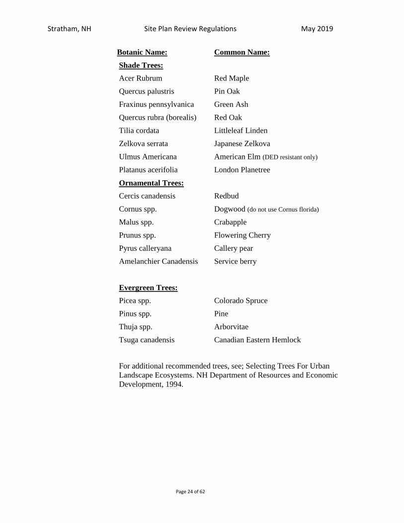
Stratham, NH Site Plan Review Regulations May 2019
Page 24 of 62
Botanic Name: Common Name:
Shade Trees:
Acer Rubrum Red Maple
Quercus palustris Pin Oak
Fraxinus pennsylvanica Green Ash
Quercus rubra (borealis) Red Oak
Tilia cordata Littleleaf Linden
Zelkova serrata Japanese Zelkova
Ulmus Americana American Elm (DED resistant only)
Platanus acerifolia London Planetree
Ornamental Trees:
Cercis canadensis Redbud
Cornus spp. Dogwood (do not use Cornus florida)
Malus spp. Crabapple
Prunus spp. Flowering Cherry
Pyrus calleryana Callery pear
Amelanchier Canadensis Service berry
Evergreen Trees:
Picea spp. Colorado Spruce
Pinus spp. Pine
Thuja spp. Arborvitae
Tsuga canadensis Canadian Eastern Hemlock
For additional recommended trees, see; Selecting Trees For Urban
Landscape Ecosystems. NH Department of Resources and Economic
Development, 1994.

Stratham, NH Site Plan Review Regulations May 2019
Page 25 of 62
Botanic Name: Common Name:
Evergreen Shrubs:
Ilex spp. Holly
Juniperus spp. Juniper
Kalmia latifolia Mountain Laurel
Pieris spp. Andromeda
Rhodondendron spp. Rhododendron
Taxus spp. Yew
Deciduous Shrubs:
Azalea spp. Azalea
Cornus spp. Dogwood
Cotoneaster spp. Cotoneaster
Euonymus app. Euonymus
Forsythia spp. Forsythia
Myrica pensylvanica Northern Bayberry
Syringa spp. Lilac
Viburnum spp. Viburnum
6. Under no circumstances shall any plants be used that are recognized by the State
of New Hampshire Department of Agriculture as invasive.
7. All plant material shall have minimum winter hardiness for Zone 5B as
determined by the U.S. Department of Agriculture.
8. Minimum sizes for plant material, unless indicated elsewhere in these regulations
or the Zoning Ordinance, shall be as follows:
a. Deciduous shade trees: three-inch caliper,
b. Deciduous ornamental trees: two inch caliper, and
c. Evergreen trees: six-foot height.
10. Sizing and measuring shall be governed by the American Association of
Nurserymen and defined in the publication, “American Standard for Nursery
Stock”
Stratham, NH Site Plan Review Regulations May 2019
Page 26 of 62
11. Landscaping shall be laid out in informal drifts rather than formal rows and shall
undulate with site topography. Individual clusters of trees or islands of shrub beds
are acceptable as long as the tree clusters and/or shrub islands overlap. Linear
solutions shall be avoided wherever possible.
12. The applicant may request that the Planning Board determine whether existing
vegetation is suitably located, sufficiently dense, and vigorous enough to be
substituted in lieu of new planting required by these regulations.
13. Plant material located within 20 feet of any road or other paved area shall consist
of only those plants tolerant of roadway deicing salts.
14. Landscaping shall be maintained in good condition. If within one year from the
date of installation any plant is in a deteriorating state or is dead it shall be
replaced in kind in a timely manner.
15. No person shall deface, alter the location of, or remove any stonewall which was
made for the purpose of delineating a boundary or border of a lot, road or right of
way in the Town of Stratham or other stone wall or historic structure located
within the proposed development area, except upon the issuance of a Conditional
Use Permit by the Planning Board with written comments from the Heritage
Commission.
16. Landscaping shall be designed so that it does not interfere with sight distances at
driveways.
17. Use a variety of species to assemble new landscaping masses.
a. Create visual depth in plant massing by layering plants of various textures,
sizes and colors.
b. Include flowering or fruiting species for color, interest and wildlife habitat
where appropriate.
18. Integrate existing mature trees and vegetation into the landscape plan.
a. Preserve the function of existing vegetation, such as groves of trees that
separate land uses or provide a natural backdrop for development.
19. Use plantings to enhance the relationship of buildings to their surroundings.
a. Layered plantings soften edges and corners and reduce the scale of buildings in the landscape.
b. Masses of trees and vegetation near buildings reduce the perceived scale of
buildings and set them into the landscape.
c. Trees shall have a 3”caliper minimum at the time of planting.
d. Consider plant massing along with architectural massing during the design
process.
e. Balance the mass, proportion and rhythm of landscape and building elements.
Minimize lawn area, as most lawn grasses require supplemental irrigation and
regular applications of fertilizer to stay green.

Stratham, NH Site Plan Review Regulations May 2019
Page 27 of 62
18. Where lawn is necessary favor fescues and other drought tolerant species.
D. Preservation of Existing Vegetation
1. Buildings, parking, loading docks, access roads, and other site elements shall be
sited to preserve existing healthy mature vegetation and maintain natural
topography to the maximum extent feasible.
2. Healthy trees with a minimum 12-inch caliper, and existing wooded areas are
recommended for preservation, particularly those trees located within setback
areas where buildings cannot be constructed.
3. Construction activities and site alterations shall not disturb the root zone of the
trees designated for preservation. During construction, the applicant shall install
and maintain tree protection fencing, or other protective measures approved by
the Planning Board, located 12 inches off the drip-line of the trees to be protected.
All no-cut zones shall be appropriately monumented and delineated on the site
plan.
4. The applicant shall be responsible to replace any trees designated to remain,
which have been damaged, killed, or removed as a result of construction
activities. The Planning Board shall require replacement-in-kind, per caliper inch
of deciduous trees and by height for evergreens. Two-inch caliper deciduous
trees and 4-foot tall evergreens shall be the minimum size used for replacement.
For example, if a 24-inch caliper deciduous tree is damaged or killed during
construction, the applicant shall replace the tree with six 4-inch caliper trees, or
any other combination that adds up to 24 caliper inches. A 36-foot tall evergreen,
for example shall be replaced with six 6 foot tall evergreen, or any other
combination adding up to 36 feet.
E. Screening
1. Screening shall be a year-round visually impermeable barrier that may be
existing, constructed, or a combination thereof.
a. Existing screens may consist of natural topographic landforms, rock outcrops,
or vegetation that is dense enough to be visually impermeable.
b. Constructed screens may consist of built screens, such as walls or fences,
topographic screens, such as berms or landforms, vegetative screens
consisting of primarily evergreen material, or a combination thereof.
2. Screening is required to soften the visual impact of buildings, parking areas,
loading docks, trash disposal areas, exterior storage, and other unsightly areas
associated with or generated by a particular development as viewed from a public
right-of-way, residential zoning districts, and the principal entrances of buildings
on abutting lots.
3. The use of existing vegetation, topography, and natural features to comply with
screening requirements is encouraged.

Stratham, NH Site Plan Review Regulations May 2019
Page 28 of 62
4. Vegetative screens shall achieve a minimum of 75% vertical opacity to a height of
6 feet, year-round, within one year of installation. Screens shall not be located so
as to impede vehicular or pedestrian traffic.
F. Screening of Unsightly Features
1. Locate storage/stockpile areas out of view of public or in a screened area: fenced
enclosure required.
2. Locate loading docks/receiving areas out of view or in a screened area.
3. Minimum one evergreen tree per linear foot of screen perimeter; minimum tree
height equal to 1/2 maximum height of items to be screened.
4. An enclosure constructed of materials compatible with the principal structure may
be substituted for screening requirements.
G. Street Tree Landscape Strip
1. Minimum one shade tree per 40’ frontage; minimum 3” caliper may substitute one
new tree for each existing tree over 3” caliper preserved within strip.
2. Minimum tree height equal to 1/2 proposed building height.
3. Buffer strip should include a combination of deciduous and/or evergreen trees and
shrubs, grass, fences, berms and walls.
H. Parking Areas
1. Planting islands should be used to define vehicular and pedestrian circulation
patterns, to break up large expanses of pavement and to facilitate site drainage. In
general, islands should be distributed throughout the parking lot. A combination
of end cap islands and linear islands running parallel to parking rows are
preferred. Islands should include trees and be planted with either grass or
evergreen shrubs and shall be designed to absorb run-off from the parking areas.
2. There shall be landscaped open space within the parameter of the parking areas in
the minimum amount of 5 % of the gross parking area.
3. Provide minimum area of 200 sf per landscaped island and at least one tree per
island; trees must be minimum 4’ from curbing.
4. Divider islands. Provide at least one island for every four parking rows at least 10
ft. wide; space trees not more than 50 ft. apart in each contiguous landscape area;
or provide one tree per 200 sf of ground area.
5. Terminal islands. Provide at ends of parking rows at least every 25 spaces;
provide at least two trees per island and evergreen shrubs 3’ on center, or
grass/ground cover with approval of Planning Board. All landscape areas shall
contain shrub and ground cover plantings. They may not be totally covered with
mulch.
6. Strategically placed island crossings constructed of modular pervious paving is
encouraged to minimize soil compaction within the island.
I. Adjacent Buildings
Stratham, NH Site Plan Review Regulations May 2019
Page 29 of 62
1. Provide minimum 10’ deep area with trees and shrubs around building sides with public access.
J. Signage Landscape Strip
1. Require minimum 4’ wide area around each freestanding sign. 2. Existing vegetation, which is preserved, may be substituted for required plantings.
K. Soil Preparation
Landscaped areas where soil compaction has occurred due to construction activities
should be deep tilled to a depth of 12 inches to facilitate deep-water penetration and
soil oxygenation. Use of soil amendments is encouraged to improve water drainage,
moisture penetration, soil oxygenation, and/or water holding capacity. Soil
amendments are organic matter such as compost, Biosolids, and forest by products,
but do not include topsoil or any mix with soil as an element.
For all newly landscaped areas, organic matter (3-4 cubic yards of organic matter per
1,000 square feet of landscape area) should be incorporated to a depth of 4 to 6
inches. Organic content of landscaped soils shall not be less than 18% by volume in
the top 6 inches of the finished topsoil.
For newly landscaped areas where topsoil is limited or nonexistent, or where soil
drainage is impeded due to subsurface hardpan or bedrock, 6 to 24 inches of sandy
loam topsoil should be spread in all planting and turf areas, in addition to the
incorporation of organic matter into the top horizon of the imported soil. Organic
content of landscaped soils shall not be less than 18% by volume in the top 6 inches
of the finished topsoil.
Soil analysis of new or renovated turf areas should include a determination of soil
texture, including percentage of organic matter; an approximated soil infiltration rate;
and a measure of pH value.
L. Mulching
1. Mulch should be applied regularly to, and maintained in all, planting areas to
assist soils in retaining moisture, reducing weed growth, and minimizing erosion.
Mulches include organic materials such as wood chips, compost and shredded
bark and inert organic materials such as decomposed lava rock, coble, and gravel.
If weed barrier mats are used, the use of organic mulches is recommended. Non-
porous materials, such as plastic sheeting, are not recommended for use in any
areas of the landscaping because of down-slope erosion potential soil
contamination from herbicide washing and increased runoff coefficients.
Mulches should be applied to the following depths; 3 inches over bare soil, and 2
inches where plant material will cover. Mulches for stormwater management
areas should be heavier and not of a type that will float away.
M. Maintenance
1. The owner of any lot shall be responsible for the maintenance of all landscaped
open space, natural screens, and constructed screens within the lot. Landscaping
shall be maintained in good condition such that planting shall be vigorous and in
good health at all times and that the parcel shall present a healthy, neat, and
Stratham, NH Site Plan Review Regulations May 2019
Page 30 of 62
orderly appearance, free from refuse and debris. Any dead vegetation that is part
of the approved landscaping design shall be replaced within one year.
2. Landscaping shall be maintained so that it does not interfere with sight distances
at driveways.
3. The Planning Board, at its discretion, may require a landscape maintenance and
water management plan. The maintenance plan shall include, but not be limited
to the following:
i. Integrated Turf Management: mowing schedule, weed control, pest control,
soil pH management, fertilizer plan, aeration/dethatching schedule and
repair/replacement plan.
ii. Shrub and Groundcover Management: mulch schedule, weed control, pruning
where needed for visibility, preventative pest/disease management,
repair/replacement plan.
iii. Tree Management: mulch schedule, weed control, deadwood removal,
pruning schedule, particularly for trees located next to walkways or roadways,
fertilizing schedule, preventative pest/disease management,
repair/replacement plan.
iv. Water Systems Management: water source, system description, spring start-
up, fall closeout, system testing schedule, and repair/replacement plan. The
applicant may install a permanent water supply system consisting of a
sprinkler system and/or hose bibs placed at appropriate locations and
intervals. Wherever possible, irrigation water shall be derived from sources
other than a public water system, including “gray water,” re-used water,
detained stormwater or roof drainage. “Gray water” is water from sinks,
showers, dishwashers, and washing machines. On-site cisterns may be
installed to store water for irrigation.
v. Seasonal Maintenance: Spring clean-up plan, fall clean-up plan, disposal plans
for leaves and plant debris, winter plowing plan, winter deicing plan.
4. Provide a landscape maintenance bond for one year.
5. A note shall be provided on the plan stating” All conditions on this plan shall
remain in effect for perpetuity.”
N. Preparation of a Landscape Plan:
Landscape Plan shall be prepared in sufficient detail to indicate compliance with these regulations. The plan shall include:
a. A plant schedule (keyed to plants shown on the plan) with quantity, plant name
(common and scientific) and size. Sizing and measuring shall be governed by the
American Association of Nurserymen and defined in the publication, “American
Standard for Nursery Stock”
b. Written planting notes and details.
2. The Plan shall be prepared by a Professional Landscape Architect registered in the
State of New Hampshire, or certified by the Council of Landscape Architectural

Stratham, NH Site Plan Review Regulations May 2019
Page 31 of 62
Registration Boards (CLARB). The Landscape Architect shall sign and stamp the
Plan as a requirement for a complete Site Plan application. The Planning Board may
waive the requirements of this section where the overall cost of site improvements
and building are less than $ 400,000.
The Landscape Plan shall be prepared to include the following certification:
I _____________ _, hereby certify that I prepared or have
sufficiently reviewed this plan and am confident that the design meets the requirements
of the Town of Stratham’s Landscape Design Standards.
I am a Landscape Architect licensed by the State of NH # ___________ and/or I
CLARB # _____________.
5.3 STORM DRAINAGE
a. An adequate surface stormwater drainage system must be provided. Storm drainage
shall be carried to existing watercourses, or connect to existing storm drains. Storm
water runoff shall be restricted to existing drainage ways. No new drainage ways
shall be created unless necessary easements are obtained by the applicant. No
increase in surface runoff shall be permitted if such increased runoff passes beyond
the property lines unless it is to be within an existing approved public storm
drainage system.
b. Drainage swales, culverts, storm sewers, detention/retention ponds, and other
drainage facilities shall be based on the storm frequencies stipulated in Addendum
C. (Rev. 7/89) (Rev. 8/99)(Rev. 19)
5.4 FLOOD CONTROL:
Provision shall be made to assure that the proposal is consistent with the need to
minimize flood damage that all public utilities and facilities, such as sewer, electrical and
water systems, are constructed and that adequate drainage is provided so as to reduce
exposure to flood hazards. Design provisions shall also be made to minimize or
eliminate infiltration of floodwaters into new or replacement water supply systems and/or
sanitary sewage systems and discharges from these systems into floodwaters. On-site
waste disposal systems shall be located so as to avoid impairment to them or
contamination from them during flooding.

Stratham, NH Site Plan Review Regulations May 2019
Page 32 of 62
5.5 SNOW STORAGE:
Provision shall be made to store snow accumulation during the winter months, and such
provisions shall be shown on the site plan and shall not be located in wetland or
shoreland protection districts. (Rev. 8/99)
5.6 SOLID WASTE DISPOSAL SCREENING:
The manner of waste disposal must be specified on the site plan and include areas for safe
disposal. Litter and/or garbage collection and holding areas must be secured. All
outdoor storage areas and trash receptacles must be located or screened to prevent
visibility from within the parking and neighboring properties. The use of either fencing
or hedges is permitted for the foregoing purposes. However, as a condition of approval,
the Board may require earth berms and plantings of shrubs and/or trees.
5.7 SIDEWALKS:
Sidewalks must be provided for pedestrian traffic to permit passageways between the
entrances of commercial, housing, or industrial establishments, and parking areas. All
such sidewalks must be at least six (6) inches above grade and protected by curbing. The
design must include means for access by handicapped persons.
All paving, except for walks and drive entries, shall be set back 25 feet from all property
lines, except for those fronting Portsmouth Avenue. In the case of Portsmouth Avenue
all paving, except for walks and approved entry drives, shall be set back a minimum of 35
feet from the front property line, with an average setback no less than 50 feet from the
front property line. (Rev. 11/95)
5.8 ILLUMINATION/ NOISE EMISSIONS:
Outdoor lighting must be provided subject to the following conditions:
a. Outdoor lighting must not directly shine on abutting properties or on public highways
or streets. All lighting cast will be confined to within property lines and will not
illuminate adjacent properties; (Rev. 11/95)
b. Indirect lighting should be used on signs advertising goods or services offered on the
premises. Moving, fluttering, blinking or flashing lights or signs shall not be
permitted;
c. Outdoor lighting must be restricted to that which is necessary for advertising, safety,
and security of the development. All parking, roadway, and walk areas within the
proposed development will be illuminated to a level sufficient to provide reasonable
security lighting during hours of darkness; (Rev. 11/95)
d. All security lighting shall be located on light standards not exceeding 25 feet in
height, with the illumination source directed downward and not visible in the
horizontal plane. In addition to light standards, security lights may be building-
mounted, subject to the review and approval of the Planning Board for the
Stratham, NH Site Plan Review Regulations May 2019
Page 33 of 62
specifications of all such fixtures and mounting locations. Light standards used to
illuminate the exterior of the buildings may not exceed four feet in height. All
building, security, and general-purpose lighting fixtures and locations must be
approved by the Planning Board; (Rev. 11/95)
e. All external loudspeaker (or enunciation) systems, including bells, buzzers, and
public address systems are prohibited. Intercom systems, such as those used in the
operation of drive-in fast-food restaurants and drive-in bank tellers are specifically
exempt from this provision. (Rev. 11/95)
f. The building and all site improvements will be designed to contain operational and
mechanical noise, such that the noise level on abutting properties will not exceed 60
decibels. (Rev. 11/95)
5.8.1 Illumination: (Adopted 08/01)
This regulation is intended to reduce the problems created by improperly designed and
installed outdoor lighting for non-residential development. It is intended to eliminate
problems of glare, minimize light trespass minimize obtrusive light, protect the quality of
the New Hampshire night sky, Stratham’s rural character, and conserve energy and
resources while maintaining safety, security and productivity by establishing regulations
which limit the area that certain kinds of outdoor-lighting fixtures can illuminate and by
limiting the total allowable illumination of lots located in the Town of Stratham.
a. Definitions:
For the purposes of this Regulation, terms used shall be defined as follows:
Cut-off Angle (of a luminaire) - The angle formed by a line drawn from the direction
of the direct light rays at the light source with respect to the vertical, beyond which no
direct light is emitted.
Direct Light: Light emitted directly from the lamp, off of the reflector or reflector
diffuser, or through the refractor or diffuser lens, of a luminaire.
Fixture: The assembly that houses the lamp or lamps and can include all or some of
the following parts: a housing, a mounting bracket or pole socket, a lamp holder, a
ballast, a reflector or mirror, and/or a refractor or lens.
Flood or Spot Light: Any light fixture or lamp that incorporates a reflector or a
refractor to concentrate the light output into a directed beam in a particular direction.
Foot-Candle: A unit of illuminance amounting to one lumen per square foot. A
measure of light falling on a given surface. One foot-candle is equal to the amount of
light generated by one candle shining on a square foot surface one foot away.
Fully Shielded: A fully shielded luminaire is a luminaire constructed or shielded in
such a manner that all light emitted by the luminaire, either directly from the lamp or
indirectly from the luminaire, is projected below an angle of 20 degrees below the
horizontal plane through the luminaire’s lowest light emitting part as determined by
photometric test or certified by the manufacturer.
Glare: Light emitting from a luminaire with an intensity great enough to reduce a
viewer's ability to see, and in extreme cases causing momentary blindness.

Stratham, NH Site Plan Review Regulations May 2019
Page 34 of 62
Height of Luminaire: The height of a luminaire shall be the vertical distance from the
ground directly below the centerline of the luminaire to the lowest direct-light-
emitting part of the luminaire.
Illuminance: The quantity of light arriving at a surface divided by the area of the
illuminated surface, measured in foot-candles.
Lamp: The component of a luminaire that produces the actual light.
Light Trespass: The shining of light produced by a luminaire beyond the boundaries
of the property on which it is located.
Lumen: A measure of light energy generated by a light source. One footcandle is
one lumen per square foot. For the purposes of this Regulation, the lumen-output
values shall be the INITIAL lumen output ratings of a lamp.
Luminaire: This is a complete lighting system, and includes a lamp or lamps and a
fixture.
Outdoor Lighting: The night-time illumination of an outside area or object by any
man-made device located outdoors that produces light by any means.
Partially Shielded: Shall mean outdoor light fixtures shielded or constructed so that
no more than ten percent of the light rays are emitted by the installed fixture at angles
greater than 20 degrees below the horizontal plan, and shall not extend above the
horizontal plane, as certified by a photometry test report.
Temporary Outdoor Lighting: The specific illumination of an outside area of object
by any man-made device located outdoors that produces light by any means for a
period of less than 7 days, with at least 180 days passing before being used again.
Uplighting: Any light source that distributes illumination above a 90-degree
horizontal plane.
b. General Lighting Requirements:
i. Illumination levels at property boundaries will not exceed 0.3 foot-candles, except
when a property abuts a residential lot where illumination levels shall not exceed
0.2 foot-candles at the shared boundary;
ii. All lighting in the Town of Stratham is required to be fully shielded.;
iii. Up-lighting by any method is prohibited; however, the Planning Board may allow
limited use of upward landscape lighting on a case by case basis;
iv. Non-cutoff wallpack type fixtures are prohibited.
c. Control of Glare – Luminaire Design Factors:
Any luminaire with a lamp or lamps rated at a total of MORE than 1800 lumens, and
all flood or spot luminaires with a lamp or lamps rated at a total of MORE than 900
lumens, shall not emit any direct light above a horizontal plane through the lowest
direct-light-emitting part of the luminaire.
Any luminaire with a lamp or lamps rate at a total of MORE than 1800 lumens, and
all flood or spot luminaires with a lamp or lamps rated at a total of MORE than 900

Stratham, NH Site Plan Review Regulations May 2019
Page 35 of 62
lumens, shall be mounted at a height equal to or less than the value 3 + (D/3), where
D is the distance in feet to the nearest property boundary. The maximum height of the
luminaire may not exceed 25 feet.
The luminaire’s maximum illuminance shall not exceed the MINIMUM illuminance
recommended for that purpose as defined in the most RECENT “Illuminating
Engineering Society Lighting Handbook/References & Applications.”
d. Submission of Plans:
The submission shall contain but shall not necessarily be limited to the following:
i. Plans indicating the location on the premises, and the type of illuminating devices,
fixtures, lamps, supports, reflectors, and other devices;
ii. Description of the illuminating devices, fixtures, lamps, supports, reflectors, and
other devices and the description may include, but is not limited to, catalog cuts
by manufacturers and drawings (including sections where required);
iii. Photometric data, such as that furnished by manufacturers, or similar showing the
angle of cut off or light emissions;
iv. A visual impact photometric plan that demonstrates both light coverage and light
spillage resulting from the proposed lighting plan.
Additional Submission: The above required plans, descriptions and data shall be
sufficiently complete to readily determine whether compliance with the requirements
of this regulation are met. If such plans, descriptions and data cannot enable this
ready determination, by reason of the nature or configuration of the devices, fixtures,
or lamps proposed, the applicant shall additionally submit as evidence of compliance
to enable such determination such certified reports of tests as will do so provided that
these tests shall have been performed and certified by a recognized testing laboratory.
e. Exceptions:
i. Any luminaire with a lamp or lamps rated at a total of 1800 lumens or LESS, and
all flood or spot luminaires with a lamp or lamps rated at 900 lumens or LESS,
may be used without restriction to light distribution or mounting height, except
that if any spot of flood luminaire rated 900 lumens or LESS is aimed, directed, or
focused such as to cause direct light from the luminaire to be directed toward
residential buildings on adjacent or nearby land, or to create glare perceptible to
persons operating motor vehicles on public ways, the luminaire shall be redirected
or its light output controlled as necessary to eliminate such conditions.
ii. Luminaires used for public-roadway illumination may be installed at a maximum
height of 25 feet and may be positioned at that height up to the edge of any
bordering property. Proposed streetlights or replacement of existing streetlights
shall be fully shielded.
iii. All temporary emergency lighting need by the Police or Fire Departments or other
emergency services, as well as all vehicular luminaires, shall be exempt from the
requirements of this article.

Stratham, NH Site Plan Review Regulations May 2019
Page 36 of 62
iv. All hazard warning luminaires required by Federal regulatory agencies are exempt
from the requirements of this article, except that all luminaires used must be red
and must be shown to be as close as possible to the Federally required minimum
lumen output requirement for the specific task.
v. Luminaires used primarily for sign illumination may be mounted at any height to
a maximum of 25 feet, regardless of lumen rating.
f. Prohibitions:
i. Mercury Vapor Lamps Fixtures and Lamps: The installation of any mercury
vapor fixture or lamp for use as outdoor lighting is prohibited;
ii. Laser Source Light: The use of laser source light or any similar high intensity
light for outdoor advertising or entertainment, when projected above the
horizontal is prohibited;
iii Searchlights: The operation of searchlights for advertising purposes is permitted
by permit issued by the building inspector.
5.8.2 Noise Emissions:
a. All external loudspeaker or enunciation systems, including bells, buzzers, and public
address systems, are prohibited. Intercom systems, such as those used in the
operation of drive-in fast-food restaurants, and drive-in bank tellers, are specially
exempt from this provision. (Rev. 11/95)
b. The building and all site improvements will be designed to contain operation and
mechanical noise, such that the noise level on abutting properties will not exceed 60
decibels. (Rev. 11/95)
5.9 PARKING REQUIREMENTS: (Amended 7/20/10)
1. Purpose and Intent
In order to minimize traffic congestion, air pollution, and the risk of motor vehicle
and pedestrian accidents, as well as to promote other elements of sound community
planning; off-street parking, loading spaces, circulation, and access shall be required
of all structures and land uses. Parking spaces, aisles, and circulation shall be
provided for all permitted and conditional uses of structures, lots, and land in amounts
not less than those specified in this Ordinance. It is further the intent of this ordinance
to:
a. Safe, adequate, and convenient vehicular and pedestrian traffic must be
maintained both within and adjacent to the development.
b. Ensure that any land use involving the arrival, departure, or storage of motor
vehicles on such land be so designed as to reduce hazards to pedestrians and
abutters.
c. Encourage the sharing and integration of parking resources to serve multiple
uses/users.
d. Reduce congestion in the streets by assuring adequate space for parking of
vehicles off the street.
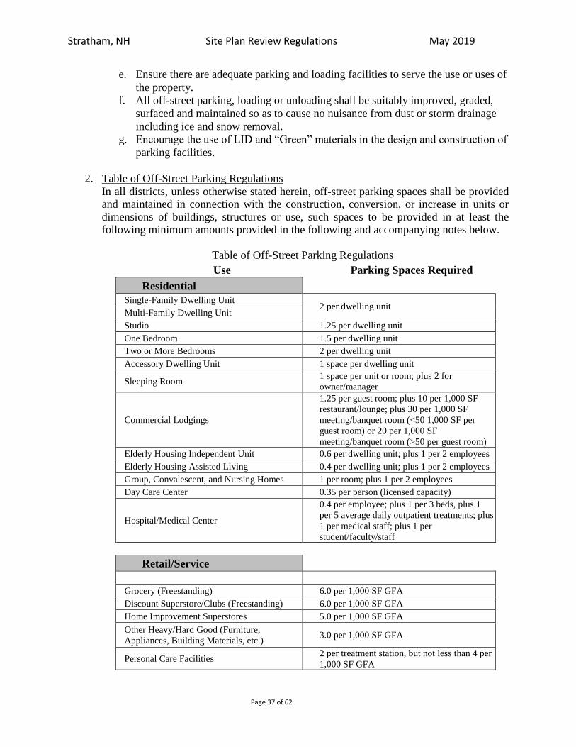
Stratham, NH Site Plan Review Regulations May 2019
Page 37 of 62
e. Ensure there are adequate parking and loading facilities to serve the use or uses of
the property.
f. All off-street parking, loading or unloading shall be suitably improved, graded,
surfaced and maintained so as to cause no nuisance from dust or storm drainage
including ice and snow removal.
g. Encourage the use of LID and “Green” materials in the design and construction of
parking facilities.
2. Table of Off-Street Parking Regulations
In all districts, unless otherwise stated herein, off-street parking spaces shall be provided and maintained in connection with the construction, conversion, or increase in units or dimensions of buildings, structures or use, such spaces to be provided in at least the following minimum amounts provided in the following and accompanying notes below.
Table of Off-Street Parking Regulations
Use Parking Spaces Required
Residential
Single-Family Dwelling Unit 2 per dwelling unit
Multi-Family Dwelling Unit
Studio 1.25 per dwelling unit
One Bedroom 1.5 per dwelling unit
Two or More Bedrooms 2 per dwelling unit
Accessory Dwelling Unit 1 space per dwelling unit
Sleeping Room 1 space per unit or room; plus 2 for
owner/manager
Commercial Lodgings
1.25 per guest room; plus 10 per 1,000 SF
restaurant/lounge; plus 30 per 1,000 SF
meeting/banquet room (<50 1,000 SF per
guest room) or 20 per 1,000 SF
meeting/banquet room (>50 per guest room)
Elderly Housing Independent Unit 0.6 per dwelling unit; plus 1 per 2 employees
Elderly Housing Assisted Living 0.4 per dwelling unit; plus 1 per 2 employees
Group, Convalescent, and Nursing Homes 1 per room; plus 1 per 2 employees
Day Care Center 0.35 per person (licensed capacity)
Hospital/Medical Center
0.4 per employee; plus 1 per 3 beds, plus 1
per 5 average daily outpatient treatments; plus
1 per medical staff; plus 1 per
student/faculty/staff
Retail/Service
Grocery (Freestanding) 6.0 per 1,000 SF GFA
Discount Superstore/Clubs (Freestanding) 6.0 per 1,000 SF GFA
Home Improvement Superstores 5.0 per 1,000 SF GFA
Other Heavy/Hard Good (Furniture,
Appliances, Building Materials, etc.) 3.0 per 1,000 SF GFA
Personal Care Facilities 2 per treatment station, but not less than 4 per
1,000 SF GFA

Stratham, NH Site Plan Review Regulations May 2019
Page 38 of 62
Coin-Operated Laundries 1 per 2 washing and drying machines
Motor Vehicle Sales and Service
2.5 per 1,000 SF GFA interior sales area, plus
1.5 per 1,000 SF GFA interior or
storage/display area, plus 2 per service bay
Motor Vehicle Laundries / Car Wash 2, plus 1 per each 2 peak shift employees
Other Retail Not Otherwise Listed Above 3.5 per 1,000 SF GFA
Food and Beverage
Restaurant - No Lounge 1 per 3 seats
Restaurant - With Lounge 1 per 2 seats
Fast Food – No Drive Through Facility 14.0 per 1,000 SF GFA
Fast Foot – With Drive Through Facility 12.0 per 1,000 SF GFA
Office and Business Services
Medical Offices (multi-tenant) 4.5 per 1,000 SF GFA
Clinic (medical offices with outpatient
treatment: no overnight stays) 5.5 per 1,000 SF GFA
Veterinary Establishment, Kennel or Pet Shop
or Similar Establishments 0.3 per 1,000 SF GFA
Bank Branch with Drive Though 3 per 1,000 SF GFA
Funeral or Undertaking Establishment 0.05 per 1,000 SF GFA
Other Business or Office Uses Not Otherwise
Listed Above 3.0 per 1,000 SF GFA
Industrial
R&D establishment, manufacturing, industrial
services, or extractive industry 0.5 per 1,000 SF GFA
Industrial 2.0 per 1,000 SF GFA
Manufacturing/Light Industrial (Single-Use) 1.5 per 1,000 SF GFA
Industrial Park (Multi-tenant or mix of service,
warehouse) 2.0 per 1,000 SF GFA
Warehouse 0.5 per 1,000 SF GFA
Storage 0.25 per 1,000 SF GFA
Other Industrial and Transportation Uses Not
Otherwise Listed
As determined by the Planning Board, but not
less than 0.25 per 1,000 SF GFA
Governmental and Educational
Elementary, and Secondary Schools 0.35 per student; plus 1 per 2 employees
Government Offices 1 per 200 SF
College or University Determined by parking study specific to
subject institution
Cultural/Recreational/Entertainment
Public Assembly 0.25 per person in permitted capacity
Museum 1.5 per 1,000 annual visitors
Library 4.5 per 1,000 SF GFA

Stratham, NH Site Plan Review Regulations May 2019
Page 39 of 62
Religious Centers 0.5 per seat
Cinemas
Single-Screen: 0.5 per seat; Up to 5 screens:
0.33 per seat; 5 to 10 screens: 0.3 per seat,
plus 1 per 2 employees
Theaters (live performance) 0.4 per seat
Arenas and Stadiums 0.33 per seat
Health Clubs and Recreational Facilities 2 per player or 1 per 3 persons permitted
capacity
Accessory Uses
Home Occupation or Home Office
1 per room used for office, or occupation
space; plus 1 per non-resident employee; plus
1 per dwelling unit
Notes:
1. When the computation of required parking or loading spaces results in the requirement of a
fractional space, any fraction over one-half shall require one space.
2. Where development of a site results in the loss of on-street parking spaces, the number of on-street
parking spaces lost shall be provided on the site, in addition to the number of spaces required for
the use unless otherwise stated herein.
3. In appropriate circumstances, where the provision of adequate off-street parking is not otherwise
feasible, the Planning Board may include on-street parking within the determination of adequate
parking arrangements for a particular use, most notably in the Town Center, General Commercial
District, and Gateway Commercial Business Overlay District.
3. Dimensional Requirements
a. Parking Spaces:
i. Each required off-street parking space shall be a minimum of the following:
Width (feet) Length (feet)
Minimum 9’ 18’
Parallel 8’ 22’
ii. Except on lots occupied by one and two-family dwellings, each off street parking
shall open directly upon an aisle or driveway width as follows:
Parking Angle (degrees) Aisle Width (feet)
45 16’
60 20’
90 24’
iii. The aisle or driveway shall be unobstructed and allow for the passage of
emergency vehicles at all times. The angle shall be measured between the
centerline of the parking space and the centerline of the aisle.
b. ADA Compliance:
i. Parking lots shall be in compliance with the Americans With Disabilities Act of
1990 (ADA)
ii. Wheelchair Accessible Parking Spaces. All sites which provide on-site parking
shall provide wheelchair accessible parking spaces and accompanying access
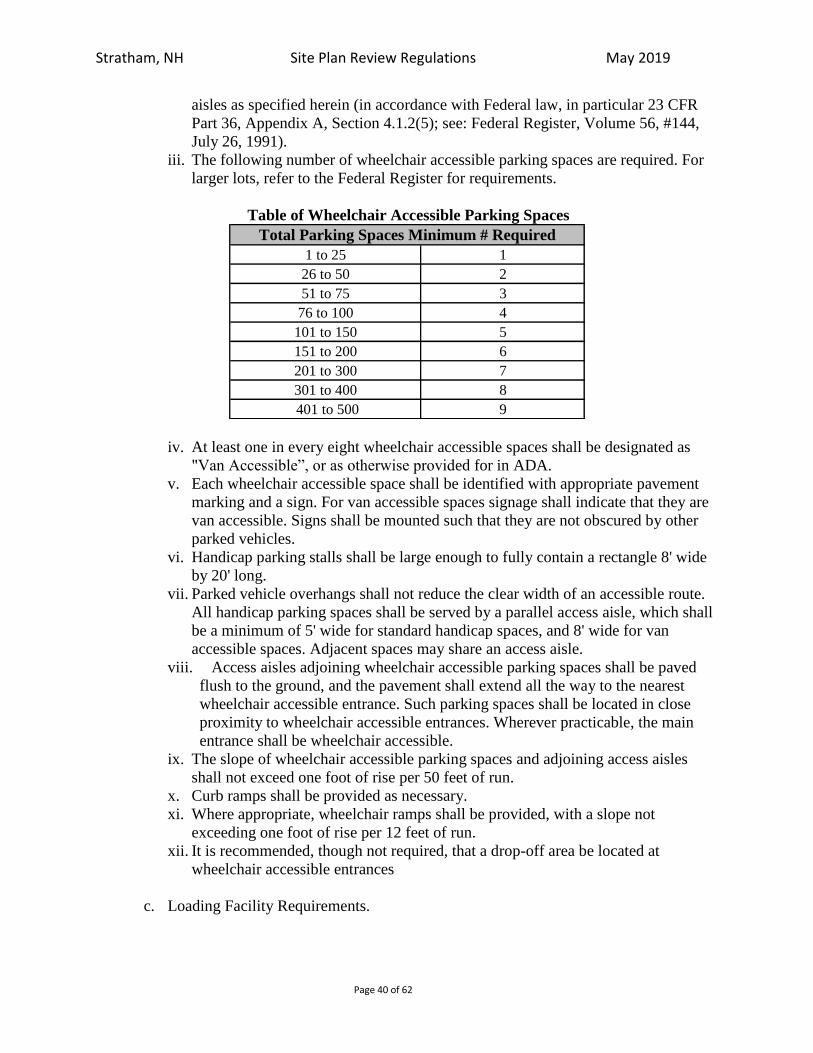
Stratham, NH Site Plan Review Regulations May 2019
Page 40 of 62
aisles as specified herein (in accordance with Federal law, in particular 23 CFR
Part 36, Appendix A, Section 4.1.2(5); see: Federal Register, Volume 56, #144,
July 26, 1991).
iii. The following number of wheelchair accessible parking spaces are required. For
larger lots, refer to the Federal Register for requirements.
Table of Wheelchair Accessible Parking Spaces
1 to 25 1
26 to 50 2
51 to 75 3
76 to 100 4
101 to 150 5
151 to 200 6
201 to 300 7
301 to 400 8
401 to 500 9
Total Parking Spaces Minimum # Required
iv. At least one in every eight wheelchair accessible spaces shall be designated as
"Van Accessible”, or as otherwise provided for in ADA.
v. Each wheelchair accessible space shall be identified with appropriate pavement
marking and a sign. For van accessible spaces signage shall indicate that they are
van accessible. Signs shall be mounted such that they are not obscured by other
parked vehicles.
vi. Handicap parking stalls shall be large enough to fully contain a rectangle 8' wide
by 20' long.
vii. Parked vehicle overhangs shall not reduce the clear width of an accessible route.
All handicap parking spaces shall be served by a parallel access aisle, which shall
be a minimum of 5' wide for standard handicap spaces, and 8' wide for van
accessible spaces. Adjacent spaces may share an access aisle.
viii. Access aisles adjoining wheelchair accessible parking spaces shall be paved
flush to the ground, and the pavement shall extend all the way to the nearest
wheelchair accessible entrance. Such parking spaces shall be located in close
proximity to wheelchair accessible entrances. Wherever practicable, the main
entrance shall be wheelchair accessible.
ix. The slope of wheelchair accessible parking spaces and adjoining access aisles
shall not exceed one foot of rise per 50 feet of run.
x. Curb ramps shall be provided as necessary.
xi. Where appropriate, wheelchair ramps shall be provided, with a slope not
exceeding one foot of rise per 12 feet of run.
xii. It is recommended, though not required, that a drop-off area be located at
wheelchair accessible entrances
c. Loading Facility Requirements.

Stratham, NH Site Plan Review Regulations May 2019
Page 41 of 62
i. All non-residential sites shall provide off-street loading facilities. These facilities
shall be located and designed to minimize traffic flow disruptions of entering and
exiting vehicles.
ii. In all districts, unless otherwise stated herein, off-street loading spaces shall be
provided and maintained in connection with the construction, conversion, or
increase in units or dimensions of buildings, structures or use, such spaces to be
provided in at least the following minimum amounts provided below.
Table of Off-Street Loading Regulations
iii. Unless waived by the Planning Board, the required loading facilities shall have a
minimum dimensions of twelve (12) feet wide by twenty-five (25) feet in length
by fourteen (14) feet in height, located, arranged, and of sufficient number to
allow service by the type of vehicle customarily excepted for the use while such
vehicle is parked completely clear of any public way or sidewalk.
4. Construction Requirements.
a. All parking spaces shall be striped with white or yellow traffic paint (4” minimum
line width).
b. The minimum grade for parking areas shall be one percent (1%) and the maximum
grade shall be five percent (5%).
a. Loam and/or yielding material must be removed to a depth of no less than fourteen
(14) inches below finished grade;
c. A bank run gravel sub-base of six (6) inches must be applied or compacted, followed
by a six (6) inch base of crushed gravel, then compacted and rolled true to grade lines
with a roller weighing not less than 12 tons.
d. A one and one half (1.5) inch rolled binder course and a one (1) inch rolled wearing
surface of bituminous concrete pavement.
e. Design and choice of paving materials used in pedestrian areas shall consider such
factors as function, climate, characteristics of users, availability, cost maintenance,
glare, drainage, noise, appearance, and compatibility with surroundings.
f. If approved by the Board, permeable pavement may be used which might minimize
dust, erosion, and runoff conditions that could have detrimental effect on abutting or
neighboring properties
g. The Planning Board may also allow for graveled parking and aisle surfaces in certain
cases when considering the unique characteristics of the land, the proposed use,
Principal UseFirst Loading Facility Required For
Area Shown Below
One Additional Loading Facility Required
For Area Shown Below
Dormitory and Hotel/Motel
Institutional Uses
Recreation and Entertainment
Restaurant and Fast Food
Office Uses 15,000 50,000
Retail Services 5,000 20,000
Personal and Consumer Services 5,000 25,000
Vehicular Services
Industrial Uses
Wholesale and Storage Uses
10,000 50,000
10,000 25,000

Stratham, NH Site Plan Review Regulations May 2019
Page 42 of 62
drainage, dust control, and if a graveled parking surface would promote and/or
preserve the rural character of Stratham.
h. Snow removal shall be considered for all sites, and the general plan for snow removal
shall be indicated in a note. Locations for snow storage shall be designated on the
plat, or there shall be a note indicating that all snow shall be removed from site. In no
case shall snow be stored on a landscaped area in which the snow pile could destroy
the landscaping or be allowed within a designated wetland area.
5. Pedestrian and Bicycle Circulation.
a. Insofar as practical, pedestrian and bicycle circulation shall be separated from motor
vehicle circulation. Safe and convenient pedestrian circulation, including appropriate
sidewalks, shall be provided on the site and its approaches.
b. All sites shall provide for safe pedestrian access and circulation and shall include
sidewalk access to existing street side sidewalks if applicable, pedestrian aisles
through parking lots and other facilities as are appropriate for the site.
6. Bicycle Parking.
a. Off-street bicycle parking may be required by the Planning Board in the General
Commercial, Gateway Commercial Business District, and Town Center Zoning
Districts whenever any new use is established or any existing use is enlarged for
which more than ten (10) automobile parking spaces are required. If required by the
Planning Board, the quantity of required bicycle stalls will be determined as shown in
Table below:
Tabular Bicycle Parking Requirements
10 - 50 10% of vehicles
51 - 100 5% of vehicles
100+ 3% of vehicles
Auto Spaces Required Bicycle Stalls Required
b. Requirements are additive. Once a threshold is met the previously existing
requirement shall be maintained and additional stalls shall be provided at the new
level until the next threshold is met.
c. A minimum of two (2) and a maximum of twenty (20) stalls shall be provided
d. In calculating stall requirements all decimals and fractions shall be rounded up to the
nearest whole number.
e. All bicycle parking stalls shall be located within one-hundred (100) feet of the
primary use or as close as the closest auto space.
f. A bicycle “stall’ shall include a delineated and safe parking area and an appropriate
structure to which bicycles can be locked.
g. Appropriate structure means a stand or other device constructed so as to enable the
user to secure by locking the frame and one wheel of each bicycle parked therein.
h. Racks must be easily usable with both U-locks and cable locks. Racks should support
the bikes in a stable upright position so that a bike, if bumped, will not fall or roll
down.
i. Racks that support a bike primarily by a wheel, such as standard 'wire racks' are
damaging to wheels and thus are not acceptable.

Stratham, NH Site Plan Review Regulations May 2019
Page 43 of 62
j. Bicycle parking racks, shelters or lockers must be securely anchored to the ground or
to a structure.
k. Outdoor bicycle parking areas shall be surfaced with hard-surfacing material having a
minimum depth of two inches, such as pavers, asphalt or concrete, unless otherwise
permitted by the Planning Board.
7. Walls and Fences.
a. Walls and fences shall be erected where required for privacy, screening, separation,
security, erosion control, or to serve other necessary and reasonable function.
b. The design and materials used shall be functional and compatible with existing and
proposed site architecture.
c. No fence or wall shall be so constructed or installed as to constitute a hazard to traffic
or safety.
8. Lighting.
a. All parking area lighting shall be subject to the lighting standards of Section 5.8.1 as
most recently amended.
b. All artificial lighting used to illuminate a parking lot shall be so arranged that all
direct rays from lighting fall entirely within such parking lot or accessory walkways.
c. The maximum mounting height of a lighting fixture above the ground shall be twenty
(20) feet in a residential district and twenty-five (25) feet in a nonresidential.
9. Signage
a. Adequate directional signage shall be provided, per the Manual on Uniform Traffic
Control Devices for Streets and Highways, as most recently published.
10. Mitigating the Impacts of Parking Lots.
a. As a supplement to the parking lot landscaping standards contained in the Section 5.2,
a minimum percentage of the overall interior area of a parking lot (as measured by the
exterior perimeter) shall be dedicated to landscaped areas (to be included on the
landscape plans) with ground cover, shrubbery, and trees, as appropriate, as follows:
i. 10% on parking lots located in front of the principal building or on otherwise
vacant lots.
ii. 8% on parking lots located on the side of the principal building, set back from the
front boundary line at least even with the front of the principal building.
iii. 5% on parking lots which are located at the rear of the principal building and
largely obscured from the road.
b. Landscaping within parking areas shall provide visual and climatic relief from broad
expanses of pavement and shall be designed to channel and define logical areas for
pedestrian and vehicular circulation.
c. Internal parking lot landscaping, as required by item “a”, above, shall contain one
deciduous shade tree for every 15 parking spaces. Trees shall be distributed
throughout the parking lot as evenly as possible. Trees shall be set back at least 5 feet
minimum from the face of the curb. Tree placement and parking lot lighting shall not
conflict. Interior parking lot landscaping may be waived in truck parking areas
provided they are screened and perimeter plantings, as described in items e-g below,
are provided.

Stratham, NH Site Plan Review Regulations May 2019
Page 44 of 62
d. All landscaped areas shall be protected from encroachment by vehicles by curbing,
landscaping timbers, curb stops, or other acceptable means.
e. Shade trees shall be provided around the perimeter of all parking areas at a minimum
ratio of 1 tree per 20 feet of parking lot perimeter. In portions of parking areas where
screening is required, shade trees shall be provided along the perimeter at a minimum
ration of 1 tree per 50 feet of parking lot perimeter in addition to the required
screening.
f. All off-street parking areas located at the front or side of principal buildings or on
vacant lots shall be screened from the public right-of-way with appropriate screening.
g. Screening from Residences: All off-street parking areas shall be screened from
abutting residences or vacant lots in residential zoning districts located at the side or
rear of the property with a wall, fence, vegetation or other means deemed appropriate.
11. Alternative Parking Standards.
a. To encourage better overall site design, improve the management and efficient use of
parking facilities, and reduce the dependency upon automobiles, the Planning Board
may allow deviations from the parking requirements set forth in Section 5.9.2 The
Planning Board will make a determination that the relief does not cause detriment to
the surrounding neighborhood and/or roadway system based upon any of the
following applicable criteria:
i. Increase in traffic volumes;
ii. Increased traffic congestion or queuing of vehicles;
iii. Change in the type(s) of traffic;
iv. Change in traffic patterns and access to the site;
v. Reduction in on-street parking; and/or,
vi. Unsafe conflict of motor vehicle and pedestrian traffic.
b. The following additional guidelines and standards are offered:
i. Modification of Parking Requirements for Non-Conforming Structures and Lots.
Where the total number of parking spaces required by this regulation is five (5) or
fewer for lots or sites that are determined by the Building Inspector to be
nonconforming with respect to parking.
ii. Municipal Parking Facility.
To allow the substitution of space on a particular lot with parking spaces located
within a municipal parking lot to satisfy the parking requirements of this Section,
provided the municipal parking lot where such parking spaces are located is
within a distance of four hundred (400) feet of the building or use (measured from
property line to property line), which is intended to be served and demonstration
that doing so will not exceed the cumulative peak demand of said municipal
parking lot in a manner which is inconsistent with the objectives of this Section.
iii. Parking on a Separate Lot / Satellite Parking.
1. Required off-street parking facilities shall be provided on the same lot or
premises as the principal use they are intended to serve, or on a lot in the same
ownership adjacent to such use. When practical difficulties, as determined by
the Planning Board, preclude the establishment of the required parking spaces
on such lot or premises (or lot or premises adjacent thereto), the Planning

Stratham, NH Site Plan Review Regulations May 2019
Page 45 of 62
Board may allow the establishment of parking on such other lot upon such
terms and conditions as the Planning Board may deem necessary to ensure the
continued availability of such spaces.
2. Where the applicant does not own such other lot, the applicant shall provide
executed instruments establishing to the satisfaction of the Planning Board
that sufficient legal interest has been acquired in such premises to assure their
availability for required parking as long as the use served is in existence. The
provision of satellite (remote) parking areas, provided that:
a. The satellite parking spaces will be used solely by the employees and,
where practicable, the clientele of the non-residential use;
b. The off-site parking spaces shall be located to adequately serve the
proposed use and shall be within four hundred (400) feet of the property
served for clientele of the commercial use as measured from property line
to property line;
iv. Common Parking Areas and Multiple Use Facilities.
a. Notwithstanding the normal provisions of this Section, where two or more
activities or uses provide the required parking or loading in a common parking
facility or loading area, the number of parking spaces or loading bays
ordinarily required may be reduced below the sum of the spaces or bays
required for separate activities or uses, if it can be determined that the hours,
days, or peak parking or loading demand for the uses are so different that a
lower total will provide adequately for all uses or activities served by the
parking facility or loading bay, and that the location of the parking facility in
relation to the uses proposed to be served by it is appropriate.
b. Deviation from the normal standard shall only be granted upon submission of
calculated parking demand for combined land uses based on methodologies
and indices of the Institute of Transportation Engineers, Urban Land Institute,
or other recognized methodology approved in writing by the Planning Board.
A formal parking demand study may be waived by the Planning Board for
small developments where there is established experience with the land use
mix and its impact is expected to be minimal.
c. Where such facilities are shared by more than two (2) owners, the applicant
shall provide executed and filed instruments with the Registry of Deeds
establishing to the satisfaction of the Planning Board that sufficient legal
interest has been acquired in such premises to assure that the property(s) have
a shared parking arrangement or peak hour parking arrangement and the
availability for required parking as long as the uses served are in existence.
v. Land Banked Parking.
a. To reduce the area of impervious surface, encourage open space,
accommodate future changes in land use and/or ownership, and shifts in
shared parking demand, up to forty percent (40%) of the land area that would
otherwise be needed to provide the required amount of parking may be land
banked or set aside on the site to provide for the future construction of a
parking area.
b. The parking facility shall be designed/engineered to enable the site to satisfy
the requirements of this Section to meet the peak demands of the project(s) or

Stratham, NH Site Plan Review Regulations May 2019
Page 46 of 62
use(s). Where it can be demonstrated by the applicant in the future that there
is a need to convert all or a portion of the land-banked parking facilities
because parking demand is in excess of 80% of parking supply on the
property, then the applicant may convert the requisite number of land banked
parking spaces to functioning parking spaces.
c. For purposes hereof, parking demand shall be demonstrated through a report
of the applicant’s (or the then current owner’s traffic engineering consultant),
as the case may be, certifying that at any time during the four-hour peak
demand period on a weekday or Saturday, the actual parking demand and
utilization is in excess of 80% of parking supply on the property, with actual
field site observations being conducted on two separate days during any
consecutive 45-day period.
d. Upon the Planning Board’s determination the applicant has established the
requisite parking need, and upon submission of the report to the Planning
Board, the Planning Board may allow the conversion of all or a portion of the
land-banked parking.
vi. Reduction in Parking.
a. Where it can be demonstrated that a use or establishment needs a lesser
number of parking spaces or loading bays than is required by this Section,
such as housing for persons with disabilities, low rate of vehicle ownership,
the availability and implementation of transportation demand management
alternatives, or other such circumstances as may be deemed appropriate by the
Planning Board, the number of such parking spaces or bays may be reduced
by not more than thirty percent (30%).
b. An applicant shall submit documentary evidence satisfactory to the Planning
Board that the parking or loading experience of the specific use justifies a
lesser number of spaces or bays.
c. This allowance shall lapse upon change to a different type of use unless
otherwise determined by the Planning Board, and shall not be considered to
constitute a legal nonconformity with respect to parking for any new use.
5.10 WATER AND SEWER SERVICE:
Water supplies and sewage disposal systems must be sized to meet the needs of the
proposed use. Percolation test and design of sewage disposal systems shall comply with
the Town of Stratham Zoning Ordinance Section XX (Rev. 8/99) and applicable State
standards as outlined in the New Hampshire Code of Administrative Rules. Newly
proposed public water systems, as defined by RSA 485:1, shall be designed by a
professional engineer licensed in New Hampshire. (Rev. 11/93) All septic vents shall be
screened from view by use of appropriately sized plantings. (Rev. 11/95)
5.11 FIRE PROTECTION:
a. Fire alarms, fire hydrants, cisterns and fire ponds shall be provided as specified by the Stratham Fire Department. These items shall be shown on the site plan and installed by the applicant. Above ground storage tanks having capacities of forty (40) gallons

Stratham, NH Site Plan Review Regulations May 2019
Page 47 of 62
or more shall have their contents clearly marked on the outside of the tank(s) in order to aid fire-fighting efforts. Tanks shall be marked according to the most recent Hazard Identification Code as developed by the National Fire Protection Association (NFPA). (Rev. 11/93) (Rev. 8/99) (Rev. 5/04)
b. Where required, it is recommended that cisterns be designed and installed according to the Specifications for 30,000 Gallon Single-Wall FRP Tank For Fire Cistern as amended to these regulations and provided as Addendum “A” of the Stratham Site Plan Review Regulations. (Rev. 5/04)
5.12 UTILITIES:
a. All utilities serving the property shall be placed underground;
b. Propane tanks, and other tanks used to store fuels, gases or liquids must be buried
underground in accordance with environmental regulations and sound engineering
practices, except as otherwise noted. If tanks must be located above ground, tanks,
tank pads, and any related appurtenances must be adequately screened with fencing
and landscaping.
5.13 STORMWATER MANAGEMENT AND EROSION CONTROL: (Rev. 11/93)
The purpose of this regulation is to control runoff as well as erosion and sedimentation
resulting from development. Subdivision and site plans shall include plans for managing
stormwater and controlling erosion and sedimentation as provided below.
a. Definitions:
Best Management Practice (BMP): A proven and accepted structural, non-structural,
or vegetative measure, the application of which reduces erosion, sedimentation, or
peak storm discharge.
Critical Areas: Disturbed areas of any size within 50 feet of a water-course,
waterbody, poorly drained soil or very poorly drained soil; disturbed areas exceeding
2,000 square feet in highly erodible soils; or, disturbed areas containing slope lengths
exceeding 25 feet on slopes greater than 15 percent.
Disturbed Area: An area where the natural vegetation has been removed exposing the
underlying soil.
Highly Erodible Soils: Any soil with an erodibility class (K factor) greater than or
equal to .43 in any layer as found in Table 3-1 of the "Stormwater Management and
Erosion and Sediment Control Handbook for Urban and Developing Areas of New
Hampshire".
b. Where Required:
The applicant shall submit pursuant to Addendum C.

Stratham, NH Site Plan Review Regulations May 2019
Page 48 of 62
5.14 STREET CONSTRUCTION:
Streets or access ways in non-residential and multi-family developments shall be
constructed to Town specifications as set forth in the Subdivision Regulations.
Streets serving non-residential (unless a public roadway such as in an industrial park)
shall remain in private ownership, and the applicant shall execute and provide legal
instruments to insure their continued maintenance and ownership, any such instruments
being subject to approval by the Town Attorney and Board of Selectmen. (Rev. 7/89)
5.15 ARCHITECTURAL PLANS:
No building permit shall be granted for a commercial building unless architectural
elevations and a building footprint depicting exterior features drawn to scale meet all of
the requirements of the Planning Board. Specifications shall have been filed with and
approved by the Planning Board. (Rev. 8/99)
As documented in the 1985 and subsequent Stratham Master Plans, a majority of the
residents of Stratham prefer that the character of the town maintain a rural, residential,
countrified flavor. This preference is represented in the scale of commercial
development to residential/agricultural development desired, and in the aesthetic
characteristics of the buildings and structures that have been developed. To this end, the
Site Plan Review Regulations have been amended to require building design that
incorporates significant features representing a rural New England colonial design theme. (Rev. 11/95)
The Stratham Planning Board strongly believes that by reviewing the building design and
holding the applicant to stringent design standards, the integrity and character of the
community will be preserved, the property values will be maintained and the community
will benefit from aesthetically pleasing, high quality development along major
transportation corridors within Stratham. (Rev. 11/95)
The features in the design of buildings, structures and outbuildings noted below shall be
required in the Professional/Residential (PRE), Town Center (TC), General Commercial
(GCM), Commercial Light Industrial Office (CLIO) and Retirement Planned Community
(RPC) - all districts located along Portsmouth Avenue corridor and extremely visible to
the general public. The Planning Board strongly encourages applicants to consider and
include these design features within the Industrial (IND) district however, due to the lack
of visibility by the general public, these standards are not mandatory within the Industrial
District. (Rev. 11/95) (Rev. 8/99) The design features shall include:
a. Pitched roofs of at least a 4:12 pitch; (Rev. 11/95) (Rev. 8/99)
b. Roofing materials and roofing colors in keeping with the New England theme; (Rev.
11/95)
c. Building components, such as windows, doors, and eaves that are adequately
proportioned. Use of multiple paned windows is encouraged; (Rev. 11/95)
d. Exterior cladding materials allowed are clapboard, shakes, brick, plaster, stone or
other similar materials or similar fabricated materials. Disallowed is the use of

Stratham, NH Site Plan Review Regulations May 2019
Page 49 of 62
prefabricated metal, concrete blocks, T-111 plywood, or other similar materials; (Rev.
11/95)
e. Exterior colors in muted tones, with no more than 15% of any exterior face of the
buildings(s), including the roof, in an overly bright color. Colors to be implemented
in the design will be specified on the architect’s drawing, and a color board shall be
submitted to the Planning Board prior to site plan approval; (Rev. 11/95)
f. All buildings and outbuildings shall be designed by a professional, registered
architect; (Rev. 11/95)
g. No mechanical equipment incorporated on or in the building, including electrical,
plumbing, heating, ventilation, and air conditioning equipment and antennas shall be
exposed to view. (Rev. 11/95) Such elements shall be appropriately screened by
incorporation in the building design;
h. Whether attached to the building or freestanding from the building, the following
items shall be completely architecturally screened and clad with materials similar to
the building(s):
i. Trash dumpsters and compactors;
ii. Surface mounted mechanical equipment;
iii. Material storage areas;
iv. Above ground storage tanks (Rev. 11/95)
i. Vehicle entry doors will not be located on the front or side faces of the building(s).
Where these vehicle entry doors face to residential property, these doors shall be
screened, taking into account the proximity and exposure to the residential property; (Rev. 11/95)
j. The front, sides, and rear of the building(s) shall be attractively designed and
articulated to eliminate large spans of blank exterior wall. (Rev. 11/95)
The Architectural Plan shall indicate:
i. The architectural design of the exterior of the building;
ii. The type of windows and doors to be installed on the building;
iii. The type of building material to be used on the exterior walls of the building.
5.16 OPEN SPACE SETBACK: (Rev. 11/95)
Furthermore, it should be noted that in addition to the building setbacks contained in the
Stratham Zoning Ordinance, all paving, except for walks and approved drive entries,
shall be set back a minimum of 35 feet from the front property line, with an average
setback no less than 50 feet from the front property line. Setbacks shall be measured
along a line parallel to the front property line, with said line beginning 25 feet from side
property lines.
Stratham, NH Site Plan Review Regulations May 2019
Page 50 of 62
SECTION VI: SUPPLEMENTARY PROVISIONS The site plans shall also comply with the following provisions.
6.1 CONSTRUCTION STANDARDS:
Construction of improvements shall also comply with, and be inspected pursuant to, the
requirements of "Building Ordinance - Town of Stratham."
Unless otherwise specified on the site plan and approved by the Planning Board,
roadway and ancillary improvements shall comply with the State of New Hampshire
Department of Public Work and Highways' manual, "Standard Specifications for Road
and Bridge Construction,” dated 1990, as amended. (Rev. 8/99)
6.2 AS-BUILT DRAWINGS:
Prior to the issuance of a Certificate of Occupancy, the applicant shall have prepared by
licensed land surveyor or engineer an "as-built plan" showing the accurate location, invert
and top grade of all drainage structures, all sewer structures, water mains and
appurtenances and ties thereto, and profiles, centerline street and ditch grades on 100-foot
stations to the nearest .1 feet. Three prints of this information shall be submitted to the
Planning Board, or its agent, for approval. (Rev. 8/99)
In the event that the Planning Board or its agent shall determine that the as-built plans
shall differ in any respect from the plans previously approved by the Planning Board, the
Board shall decide whether such differences are sufficiently material as to require a
resubmission of portions or all of the project plans to the Planning Board under these
Regulations or any part thereof.
6.3 SITE INSPECTIONS AND FEE: (deleted 11/93)
SECTION VII: AGREEMENTS & BONDING
7.1 SITE REVIEW AGREEMENT:
As a condition of the Planning Board's approval, the applicant must execute a legal
agreement, which specifies the terms and conditions, and the understandings between the
parties with respect to these Regulations. Terms and conditions of the Site Review
Agreement shall indicate any stipulation or condition which may be necessary to secure
the public health, safety, and welfare and insure compliance with all the Ordinances of
the Town of Stratham, requirements of the Town's Building Code, and including the
posting of a performance and/or guaranty bond to insure that all site development and
construction is completed according to the plan approved. No building permit shall be
issued until the Site Review Agreement is executed by both parties.

Stratham, NH Site Plan Review Regulations May 2019
Page 51 of 62
7.2 FINANCIAL GUARANTY:
The Planning Board may require a performance surety (in the form of a bond, passbook,
or cash only) for such facilities that it believes should be guaranteed before any work
commences on the development. (Rev. 8/91) The steps for issuing and releasing a
performance bond (or other surety) shall be the same as required in the pertinent Zoning
Ordinance and Subdivision Regulations, including but not limited to determining the
amount, the sufficiency, term, and form of the bond (or other surety).
7.2.1 Certificate of Occupancy:
No dwelling unit or building may be occupied or used unless a certificate of occupancy
has been issued by the Building Inspector. If any corrections, changes, or other
stipulations are required by the Building Inspector prior to issuance of a Certificate of
Occupancy, the Building Inspector shall keep a copy of said required actions in his office.
7. 3 MAINTENANCE BOND:
The Planning Board may require a performance surety (in the form of a bond, passbook,
or cash only) covering maintenance of roads and improvements for a period of one (1)
year from the date of completion, in an amount not to exceed 10% of said cost of
improvements. (Rev. 8/91) If repair or unusual maintenance is needed or additional
improvements required, then such costs as necessary shall be borne by the applicant or
sought from said surety.
SECTION VIII: WAIVERS
8.1 WAIVERS:
The requirements of the foregoing Regulations may be waived or modified by the
Planning Board where appropriate hardship exists or specific circumstances warrant. The
applicant shall write to the Planning Board describing the requested term to be waived.
The granting of said waiver shall not impair nor diminish the public health, safety, and
welfare, and shall conform to and carry out the purpose and intent of these Regulations
and the Master Plan.
SECTION IX: ENFORCEMENT
9.1 ENFORCEMENT PROVISIONS:
These Regulations shall be enforced by the Board or its duly authorized representative.
In the event that the Board, or its representative shall determine that these Regulations
have not been complied with, or that the terms of any approval given under these
Regulations has not been met or satisfied in a timely fashion, the Board shall have the
authority to take such action as it shall deem lawful or necessary, including but not
limited to the revocation of any approval(s) granted, the withdrawal of any building

Stratham, NH Site Plan Review Regulations May 2019
Page 52 of 62
permits which may have been issued, or the withholding of any building permit by
request of the Selectmen.
The Board shall notify any offending person, firm, or organization by certified mail
which notice shall contain the specifics of the Board's findings and if necessary shall
contain a cease and desist order.
SECTION X: VALIDITY
10.1 DECLARATION:
If any section, clause, provision, or portion of these Regulations is held to be invalid or
unconstitutional by any court of competent jurisdiction, such holdings shall not affect or
impair any other section, clause, provision, or portion of these Regulations.
10.2 EFFECTIVE DATE:
These Regulations are effective as of February 3, 1987, on which day they were filed
with the Stratham Town Clerk and Board of Selectmen.

Stratham, NH Site Plan Review Regulations May 2019
Page 53 of 62
ADDENDUM A: CISTERN SPECIFICATIONS (05/04)
These standards currently are not available in digital format. Please contact the Stratham Planning Office for a hard copy of the document at:
Planning Department
Town of Stratham 10 Bunker Hill Avenue
Stratham, NH 03885 (603) 772-7391

Stratham, NH Site Plan Review Regulations May 2019
Page 54 of 62
ADDENDUM B: DIGITAL SUBMISSION REQUIRMENTS (added07/06)
With the submission of any new application for Site Plan Review and prior to the recording of a
Mylar, an Applicant shall submit a complete electronic file of all of the drawings in the plan set
for the Town of Stratham’s records, in accordance with the following:
1. All submitted plans shall be submitted to the Town Planner in a format compatible with the
town’s ArcGIS (Shapefile .shp) format.
2. All digital files shall be projected in NH State Plane feet, NAD83.
3. All digital Files shall be submitted on a CD-ROM or 3.5” floppy disk (note that files
compressed and spanned with multiple floppy disks will not be accepted). Arrangements may
be made to send digital data via FTP, email, or on other media on a case-by-case basis by
approval of the Town Planner;
4. If submitted via disk the following information shall be labeled on the disk: file name;
property owner name; parcel identification number (tax map and lot number); and name of
submitting consultant;
5. Horizontal control points shall have an adjusted accuracy of 1:10,000 (Third Order, Class I);
6. Entities and their data layer properties shall correspond to the following:
a. Property lines entities shall be created on a “ Lot Line” layer.
b. Parking lots shall be created on a “Parking” layer.
c. Driveways shall be created on a “Driveway” layer.
d. Building outlines shall be created on a “Structure” layer.
e. Location of wetlands, streams and ponds shall be created on a “Hydro” layer.
f. Distance and bearing annotation shall be created on a “Dimtxt” layer.
g. The digital file shall have a layer named “NHSPCS”. NH State Plane NAD83 referenced
points and the easting, northing and vertical descriptions of at least 2 referenced points
shall be annotated on this layer.
7. All lines representing property lines shall consist of continuous line work snapped to
endpoints. Stonewall representations, unless created using a line type will not be accepted.

Stratham, NH Site Plan Review Regulations May 2019
Page 55 of 62
ADDENDUM C TOWN OF STRATHAM STORMWATER REGULATIONS
Provisions and Standards for Construction Stormwater Management
1. These provisions and standards shall apply to all development activities including but
not limited to construction of roads, drainage infrastructure, utilities and other structures
or development that support the subdivision.
2. Development on residential lots shall incorporate best management practices from the
NHDES Homeowners Guide to Stormwater Management (2011, as amended), NH
Stormwater Manual. Volumes 1 and 2, December 2008 as amended (or most current
version), and the 2017 NH Small MS4 General Permit to manage and treat runoff.
3. The provisions and standards of this Addendum are implemented for the purpose of:
Managing stormwater runoff to protect water quality and quantity.
Causing no increase in contribution of a pollutant for which a water body is impaired.
Treating new runoff discharged to a municipal drainage system, surface water
body or wetland.
Resulting in no discharge of runoff to properties in excess of runoff discharged in
the existing developed or undeveloped condition.
A. APPLICABILITY STANDARDS
i. These standards apply to all projects subject to Site Plan Review Regulations or
Subdivision Regulations. Additionally, all applications will be required to
include a post-construction stormwater management plan prepared by a NH
licensed engineer.
ii. All projects under review by the Planning Board of such magnitude as to require
a stormwater permit from EPA Construction General Permit (CGP) program or
NH Department of Environmental Services (NHDES) Alteration of Terrain
(AOT) program shall comply with the standards of EPA and/or NHDES permits
and this section, whereas the stricter standards shall apply.
B. MINIMUM THRESHOLDS FOR APPICABILITY
i. Minimum Thresholds for Applicability: These stormwater management
standards apply to all projects requiring Planning Board review and approval
under the Subdivision or Site Plan Review Regulations. For smaller projects that
disturb less than 43,560 square feet an applicant may request a waiver of the full
standards providing minimum protections and management are implemented.
For the purpose of these standards, disturbance is defined as any alteration of the
land surface or permanent removal of vegetation or trees associated with a
development activity (refer to the Definitions, below).
ii. Waiver Option for Small Development Projects: At the request of an applicant,

Stratham, NH Site Plan Review Regulations May 2019
Page 56 of 62
the Planning Board may grant a waiver to any or all stormwater standards for
projects that: disturb less than 43,560 square feet; create less than 20,000 square
feet of new impervious surface; and do not disturb land within 100 feet of a
surface water body or wetland comprised of less than 5,000 square feet based on
wetland delineation.
iii. Conditions for Granting of Waivers: In order for the Planning Board to issue a
waiver, the applicant must demonstrate and board must find the application
meets the minimum criteria listed below and, if granted, will be considered
conditions of approval:
i. Runoff from new impervious surfaces shall be directed to a filtration
and/or infiltration device.
ii. Impervious surfaces for parking areas and roads should be minimized to
the extent possible (including minimum parking requirements for
proposed uses and minimum road widths).
iii. Runoff generated from new impervious surfaces should be retained on
the development site and mimic natural hydrology.
iv. Compliance with standards 3.a-3.c above will be determined by the
Planning Board on a case by case basis as site conditions and constraints
will differ greatly between various redevelopment proposals.
C. BEST MANAGEMENT PRACTICES
i. Performance Specifications: Stormwater management will meet or exceed
requirements for the 2017 NH Small MS4 General Permit. All proposed
stormwater practices and measures shall be installed and maintained in
accordance with manufacturers’ specifications and performance specifications in
the NH Stormwater Management Manual Volume 2 (December 2008 or current
revision) a copy of which is available from the NHDES website at
www.des.nh.gov/organization/divisions/water/stormwater/manual.htm
ii. Water Quality Protection: All aspects of the application shall be designed to
protect the quality of surface waters and groundwater of the Town of Stratham as
follows:
iii. All storage facilities for fuel, chemicals, chemical or industrial wastes,
and biodegradable raw materials shall meet the regulations of the New
Hampshire Department of Environmental Services (NHDES) including but not
limited to those involving Underground Storage Tanks (UST), Above Ground
Storage Tanks, hazardous Waste and Best Management Practices for
Groundwater Protection (Env-Wa 401).
iv. Stormwater Management for New Development: All proposed stormwater
management and treatment systems shall meet the following performance
standards.
i. Existing surface waters, including lakes, ponds, rivers, perennial and
intermittent streams (natural or channelized), and wetlands (including
vernal pools) shall be protected by the minimum buffer setback distances
Stratham, NH Site Plan Review Regulations May 2019
Page 57 of 62
(as specified in the Zoning and Regulations). Stormwater and erosion and
sediment control BMPs shall be located outside the specified buffer zone
unless otherwise approved by the Planning Board. Alternatives to stream
and wetland crossings that eliminate or minimize environmental impacts
shall be considered whenever possible. When necessary, as determined
by the Planning Board or their representative, stream and wetland
crossings shall comply with state recommended design standards to
minimize impacts to flow and enhance animal passage (see the
University of New Hampshire Stream Crossing Guidelines (May 2009,
as amended) available from the UNH Environmental Research Group
website at
http://www.unh.edu/erg/stream_restoration/nh_stream_crossing_guideline
s_unh_web_rev_2. pdf)
ii. Low Impact Development (LID) site planning and design strategies
should be used in order to reduce the generation of the stormwater runoff
volume for both new development and redevelopment projects (see
Element D for redevelopment standards). An applicant must document in
writing why LID strategies are not appropriate if not used to manage
stormwater.
iii. All stormwater treatment areas should be planted with native plantings
appropriate for the site conditions: grasses, shrubs and/or other native
plants in sufficient numbers and density to prevent soil erosion and to
achieve the water quality treatment requirements of this section.
iv. All areas that receive rainfall runoff should be designed to drain within a
maximum of 72 hours.
v. Salt storage areas should be covered and loading/offloading areas shall
be designed and maintained in accordance with NH DES published
guidance such that no untreated discharge to receiving waters results.
Snow storage areas shall be located in accordance with NH DES
published guidance such that no direct untreated discharges to receiving
waters should be possible. Runoff from snow and salt storage areas shall
enter treatment areas as specified above before being discharged to
receiving waters or allowed to infiltrate into the groundwater. See
NHDES published guidance fact sheets on road salt and water quality,
and snow disposal at
http://des.nh.gov/organization/commissioner/pip/factsheets/wmb/index.ht
m.
vi. Runoff should be directed into recessed vegetated and landscape areas
designed for treatment and/or filtration to minimize Effective Impervious
Cover (EIC) and reduce the need for irrigation systems.
vii. Newly generated stormwater, whether from new development or
expansion of existing development (redevelopment), should be treated on
the development site. Runoff should not be discharged to surface water
bodies or wetlands in excess of volumes discharged under existing
conditions (developed condition or undeveloped condition).
Stratham, NH Site Plan Review Regulations May 2019
Page 58 of 62
viii. A development plan should include provisions to retain stormwater on
the site by using the natural flow patterns of the site. Runoff from
impervious surfaces shall be treated with BMPs AND optimized for
Total Nitrogen (TN) generated from the total post-construction
impervious area as per the 2017 NH Small MS4 Section 2.3.6
Stormwater Management in New Development and Redevelopment (Post
Construction Stormwater Management Section a.ii.d)1)b., and as
specified in the NH Stormwater Manual. Volumes 1 and 2, December
2008 as amended (or most current version) (refer to Volume 2, page 6,
Table 2.1 Summary of Design Criteria, Water Quality Volume for
treatment criteria) or other equivalent means. Where practical, the use of
natural, vegetated filtration and/or infiltration BMPs or subsurface gravel
wetlands for water quality treatment is preferred given its relatively high
nitrogen removal efficiency. Note: The Anti-Degradation provisions of
the State Water Quality Standards require that runoff from new
development shall not lower water quality or contribute to existing water
body impairments.
ix. Measures shall be taken to control the post-development peak rate runoff
so that it does not exceed pre-development runoff for the 2-year, 10-year
and 25-year, 24-hour storm events. Similar measures shall be taken to
control the post-development runoff volume to infiltrate the groundwater
recharge volume GRV according to the current AOT guidelines unless
demonstrated for sites where infiltration is limited or not practicable.
Infiltration structures should be in locations with the highest permeability
on the site.
x. The design of the stormwater drainage system should provide for the
disposal of stormwater without flooding or functional impairment to
streets, adjacent properties, downstream properties, soils, or vegetation.
xi. The design of the stormwater management systems should take into
account upstream and upgradient runoff that flows onto, over, or through
the site to be developed or re-developed, and provide for this contribution
of runoff.
xii. Appropriate erosion and sediment control measures should be installed
prior to any soil disturbance, the area of disturbance shall be kept to a
minimum, and any sediment in runoff shall be retained within the project
area. Wetland areas and surface waters should be protected from
sediment. Disturbed soil areas shall be either temporarily or permanently
stabilized consistent with the NHDES Stormwater Manual Volume 3
guidelines. In areas where final grading has not occurred, temporary
stabilization measures should be in place within 7 days for exposed soil
areas within 100 feet of a surface water body or wetland and no more
than fourteen (14) days for all other areas. Permanent stabilization should
be in place no more than 14 days following the completion of final
grading of exposed soil areas.
xiii. All temporary control measures should be removed after final site

Stratham, NH Site Plan Review Regulations May 2019
Page 59 of 62
stabilization. Trapped sediment and other disturbed soil areas resulting
from the removal of temporary measures shall be permanently stabilized
prior to removal of temporary control measures.
xiv. Porous pavements should be considered for feasibility for commercial
and industrial applications for general and overflow parking areas.
Construction quality assurance during installation and production of
porous pavements, and long term operations and maintenance will be
required to ensure success. Pervious pavement shall be appropriately
sited and designed for traffic and vehicle loading conditions. Porous
pavement will generally not be included in the calculation of impervious
surface areas for site development.
xv. Whenever practicable, native site vegetation shall be retained, protected,
or supplemented. Any stripping of vegetation shall be done in a manner
that minimizes soil erosion.
D. REDEVELOPMENT CRITERIA
i. Criteria
1. In order to determine the stormwater requirements for redevelopment projects,
the percentage of the site covered by existing impervious areas must be
calculated. Stormwater requirements for redevelopment will vary based upon
the amount of site surface area that is covered by existing impervious surfaces.
2. For sites meeting the definition of a redevelopment project and having less than
40% existing impervious surface coverage, the stormwater management
requirements will be the same as other new development projects with the
important distinction that the applicant can meet those requirements either on-
site or at an approved off-site location. The applicant should satisfactorily
demonstrate that impervious area reduction, LID strategies and BMPs have
been implemented on-site.
3. For sites meeting the definition of a redevelopment project and having more
than 40% existing impervious surface coverage, stormwater should be managed
for water quality in accordance with one or more of the following techniques,
listed in order of preference:
a. Implement measures onsite that result in disconnection or treatment of
at least 30% of the existing impervious cover as well as 50% of the
additional proposed impervious surfaces and pavement areas through
the application of filtration media; or
b. Implement other LID techniques onsite to the maximum extent
practicable to provide treatment for at least 50% of the entire site area.
c. Runoff from impervious surfaces shall be treated with BMPs as per the
NH Stormwater Manual or equivalent, AND for Total Nitrogen (TN)
removal, as per MS4 2.3.6 Stormwater Management in New
Development and Redevelopment (Post Construction Stormwater
Management Section a.ii.e)1)b.
ii. Off-Site Mitigation:
1. In cases where the applicant demonstrates, to the satisfaction of the planning
board, that on- site treatment has been implemented or is not feasible, off-site

Stratham, NH Site Plan Review Regulations May 2019
Page 60 of 62
mitigation will be an acceptable alternative if implemented within the same
subwatershed, within the project’s drainage area or within the drainage area of
the receiving water body. To comply with local watershed objectives the
mitigation site would be preferably situated in the same subwatershed as the
development and impact/benefit the same receiving water.
2. Off-site mitigation should be equivalent to no less than the total area of
impervious cover NOT treated on-site.
3. An approved off-site location must be identified, the specific management
measures identified, and an implementation schedule developed in accordance
with planning board review. The applicant must also demonstrate that there is no
downstream drainage or flooding impacts as a result of not providing on-site
management for large storm events.
E. STORMWATER MANAGEMENT PLAN APPROVAL AND RECORDATION
Plan Approval and Review. The Planning Board shall approve the Stormwater
Management Plan if it complies with the requirements of these regulations and other
requirements as provided by law. At the discretion of the Planning Board, a technical
review by a third party may be required of any stormwater management and erosion
control plan prepared under these regulations. The technical review shall be performed
by a qualified professional consultant, as determined by the Planning Board, and the
expense of which shall be the full responsibility of the applicant.
F. OPERATIONS AND MAINTENANCE CRITERIA
Stormwater management and sediment and erosion control plans shall be incorporated
as part of any approved site plan or subdivision plan. The Notice of Decision shall
reference the requirements for maintenance pursuant to the stormwater management and
erosion and sediment control plans as approved by the Planning Board.
G. POST-CONSTRUCTION STORMWATER INFRASTRUCTURE –
INSPECTION AND RESPONSIBILITY
Municipal staff or their designated agent shall have site access to complete routine inspections to ensure compliance with the approved stormwater management and sediment and erosion control plans. Expenses associated with inspections shall be the responsibility of the applicant/property owner. Routine inspections, cleaning, and maintenance will be conducted as per requirements of the 2017 NH Small MS4 General Permit, Section 2.3.7.1 Operations and Maintenance Programs including annual inspection reports.
The applicant shall bear final responsibility for the installation, construction, inspection,
reporting, and disposition of all stormwater management and erosion control measures required by the Planning Board. Site development shall not begin before the Stormwater Management Plan receives written approval by the Planning Board.

Stratham, NH Site Plan Review Regulations May 2019
Page 61 of 62
The municipality retains the right, though accepts no responsibility, to repair or maintain stormwater infrastructure if: a property is abandoned or becomes vacant; and in the event a property owner refuses to repair infrastructure that is damaged or is not functioning properly.
H. DEFINITIONS
a) ADAPTIVE MANAGEMENT – Management of resources that is a structured,
iterative process of robust decision making in the face of uncertainty, with an aim
to reducing uncertainty over time via system monitoring. In this way, decision
making simultaneously meets one or more resource management objectives and,
either passively or actively, accrues information needed to improve future
management.
b) BEST MANAGEMENT PRACTICES (BMPs) - A structural or non-structural
device designed to temporarily store or treat urban stormwater runoff in order to
mitigate flooding, reduce pollution and provide other amenities.
c) BIORETENTION – A water quality practice that utilizes vegetation and soils to
treat urban stormwater runoff by collecting it in shallow depressions, before
filtering through an engineered bioretention planting soil media.
d) BUFFER – A special type of preserved area along a watercourse or wetland where
development is restricted or prohibited. Buffers protect and physically separate a
resource from development. Buffers also provide stormwater control flood storage
and habitat values. Wherever possible, riparian buffers should be sized to include
the 100- year floodplain as well as steep banks and freshwater wetlands.
e) DISTURBED AREA – An area in which the natural vegetative soil cover has been
removed or altered and, therefore, is susceptible to erosion.
f) ECOSYSTEM SERVICES - The benefits of natural systems to individuals,
communities, and economies. These benefits include provisioning services such as
food and water; regulating services such as flood and disease control; cultural
services such as spiritual, recreational, and cultural benefits; and supporting
services such as nutrient cycling that maintain the conditions for life on Earth.
g) EFFECTIVE IMPERVIOUS COVER (EIC) – The total impervious surface areas
less the area of disconnected impervious cover (areas where runoff is captured and
infiltrated or otherwise treated).
h) ENVIRONMENTAL (NATURAL RESOURCE) PROTECTION - Policies and
procedures aimed at conserving natural resources, preserving the current state of
natural environments and, where possible, reversing degradation. Any activity to
maintain or restore environmental quality through preventing the emission of
pollutants or reducing the presence of polluting substances in environmental
media, and preventing physical removal or degradation of natural resources.
i) FILTRATION – The process of physically or chemically removing pollutants from
runoff. Practices that capture and store stormwater runoff and pass it through a
filtering media such as sand, organic material, or the native soil for pollutant
removal. Stormwater filters are primarily water quality control devices designed to
remove particulate pollutants and, to a lesser degree, bacteria and nutrients.
j) GROUNDWATER RECHARGE – The process by which water that seeps into the ground,
eventually replenishing groundwater aquifers and surface waters such as lakes, streams,
and the oceans. This process helps maintain water flow in streams and wetlands and

Stratham, NH Site Plan Review Regulations May 2019
Page 62 of 62
preserves water table levels that support drinking water supplies.
k) GROUNDWATER RECHARGE VOLUME – The post-development design
recharge volume (i.e., on a storm event basis) required to minimize the loss of
annual pre-development groundwater recharge. The Rev is determined as a
function of annual pre-development recharge for site-specific soils or surficial
materials, average annual rainfall volume, and amount of impervious cover on a
site.
l) IMPAIRED WATERS – Those waterbodies not meeting water quality standards.
Pursuant to Section 303(d) of the federal Clean Water Act, each state prepares a
list of impaired waters (known as the 303(d) list) which is presented in the state's
Integrated Water Report as Category 5 waters. Those impaired waters for which a
TMDL has been approved by US EPA and is not otherwise impaired, are listed in
Category 4A.
m) IMPERVIOUS COVER – Those surfaces that cannot effectively infiltrate rainfall
consisting of surfaces such as building rooftops, pavement, sidewalks, driveways,
compacted gravel (e.g., driveways and parking lots).
n) INFILTRATION – the process of runoff percolating into the ground (subsurface
materials). Stormwater treatment practices designed to capture stormwater runoff
and infiltrate it into the ground over a period of days.
o) LOW IMPACT DEVELOPMENT (LID) - Low impact development is a site
planning and design strategy intended to maintain or replicate predevelopment
hydrology through the use of site planning, source control, and small-scale
practices integrated throughout the site to prevent, infiltrate and manage runoff as
close to its source as possible. Examples of LID strategies are pervious pavement,
rain gardens, green roofs, bioretention basins and swales, filtration trenches, and
other functionally similar BMPs located near the runoff source.
p) MAXIMUM EXTENT PRACTICABLE (MEP) - To show that a proposed
development has met a standard to the maximum extent practicable, the applicant
must demonstrate the following: (1) all reasonable efforts have been made to meet
the standard, (2) a complete evaluation of all possible management measures has
been performed, and (3) if full compliance cannot be achieved, the highest
practicable level of management is being implemented.
q) MITIGATION – Activities, strategies, policies, programs, actions that, over time,
will serve to avoid, minimize, or compensate for (by treating or removing
pollution sources) the impacts to or disruption of water quality and water
resources.
r) MS4 – Refers to the Small Municipal Separate Storm Sewer System General
Permit - the MS4 General Permit - issued by the EPA under the Clean Water Act.
MS4 applies to municipalities that contain any portion of an urbanized area as
defined by the Census. It applies to stormwater conveyances owned by a State,
city, town, or other public entity that discharge to ‘Waters of the United States’.
The MS4 Permit requires that operators of small MS4s develop a Storm Water
Management Program that uses appropriate Best Management Practices (BMPs)
for each of the six minimum control measures required in the MS4 permit.
s) NATIVE VEGETATION AND PLANTINGS - Plants that are indigenous to the
region, adapted to the local soil and rainfall conditions, and require minimal

Stratham, NH Site Plan Review Regulations May 2019
Page 63 of 62
supplemental watering, fertilizer, and pesticide application.
t) POLLUTANT LOAD – means an amount of pollutants that is introduced into a
receiving waterbody measured in units of concentration or mass per time (i.e.
concentration (mg/l) or mass (lbs/day)).
u) REDEVELOPMENT - Any construction, alteration, or improvement that disturbs a
total of 20,000 square feet or more of existing impervious area where the existing
land use is commercial, industrial, institutional, governmental, recreational, or
multifamily residential. Building demolition is included as an activity defined as
“redevelopment”, but building renovation is not. Similarly, removing of roadway
materials down to the erodible soil surface is an activity defined as
“redevelopment,” but simply resurfacing of a roadway surface is not. Pavement
excavation and patching that is incidental to the primary project purpose, such as
replacement of a collapsed storm drain, is not classified as redevelopment. In
general, the requirements in this manual do not apply to projects or portions of
projects when the total existing impervious area disturbed is less than 20,000
square feet. However, specific regulatory programs may impose additional
requirements. Any creation of new impervious area over portions of the site that
are currently pervious is required to comply fully with the requirements of this
manual, with the exception of infill projects.
v) RETENTION – The amount of precipitation on a drainage area that does not
escape as runoff. It can be expressed as the difference between total precipitation
and total runoff from an area.
w) TOTAL SUSPENDED SOLIDS (TSS) – The total amount of soils particulate matter
which is suspended in the water column.
x) WATER QUALITY VOLUME - The storage needed to capture and treat 90% of the
average annual stormwater runoff volume. In Rhode Island, this equates to 1-inch
of runoff from impervious surfaces.
y) WATERSHED – All land and water area from which runoff may run to a common
(design) discharge point.

Stratham, NH Site Plan Review Regulations May 2019
Page 64 of 62
APPENDIX A: RECORD OF AMENDMENTS
(Most recently amended on 5/2019 back to adoption of revamped Site Plan Regulations on 2/3/1987)
May 15, 2019
Addendum C: Stormwater Regulations added; editorial revisions throughout SPR as required for compliance
with the addition.
July 21, 2010
Section 5.9: Parking Requirements
- To replace Section 5.9 Parking Requirements in its entirety with an updated table of parking
requirements, establishing design standards, and creating flexible regulations to improve the overall
parking design, function, and safety of parking facilities within all zoning districts.
October 3, 2007
Section 2.3.6: Fees and Charges
- To amend section 2.3.6 of the subdivision regulations and section 4.2.7 of the site plan review regulations
pertaining to fees & charges to increase the fees to reflect the current cost of services.
September 19, 2007
Section 4.3: Soils-Based Lot Size Determination
- Conservation Land Exception . Any portion of a lot or other land which was protected by recorded
conservation easement or shown as intended or dedication on any plan conditionally approved and not
revoked by the Planning Board at the time of application, shall not be included in the calculation of
minimum lot size or in the calculation of any Yield Plan as defined under Section 4.6.4 (OPEN SPACE
CLUSTER SUBDIVISION).
September 6, 2006
Section 5.2: Landscaping Design Standards
- To amend the Site Plan Review Regulations Section 5.2 Landscaping Design Standards to replace the
entire section with new standards for landscaping requirements for all Site Review applications brought
before the Planning Board.
July 19, 2006
Section 4.3.2: Proposed Plans
- To amend section 4.3.2 to add a new subsection g as follows:
A copy of the plans submitted in a digital format as provided for in Addendum D: Digital Submission
Requirements.
- Also add a new ADDENDEM B to the end of the Site Review regulations.
June 7, 2006
Section 4.5: Board Action
- Amend Section 4.5 Board Action of the Site Review Regulations to replace the section with a new Section
4.5 providing for a definition of “Active and Substantial Development” and providing conditions for the
vesting of subdivisions and setting time limits for the completion of conditions when a project is approved.
May 3, 2006
Section 4.1: Preliminary Consultations
- Amendment to the site plan review regulations Section 4.1 Preliminary Consultation, to require a
preliminary site plan review on certain site plans prior to submission to the planning board.

Stratham, NH Site Plan Review Regulations May 2019
Page 65 of 62
May 19, 2004
Section 5.11: Fire Protection
- Amend the Stratham Site Review Regulations to provide for a specification for the installation or Fire
Cisterns within projects as may be required. Add a new Section 5.11 (b).
August 6th, 2003
Section 4.2.4: Public Hearing and Notice
- Amended section by reinserting provision that was inadvertently deleted on January 31st, 2001.
May 1, 2002
Section 4.2.1: Submission Period
- Amended advance submittal requirement from 15 to 20 days in (a).
- Added provision regarding 10-day advance submittal for continued applications in (b).
- Added provision that Planning Board review of tardy submittals will be delayed in (c).
- Added provision regarding Town Planner issuing an advisory determination of complete application.
August 1, 2001
- Adopted detailed lighting regulations for non-residential development (see Appendix A).
June 6, 2001
Section 5.9: Parking Areas and Access Drives
- Amended section generally and included a new subsection (f) relating to parking lots and spaces which was
formally contained in Section VI of the Stratham Zoning Ordinance.
January 31, 2001
Section 4.2.6: Submission Deadline
- Deleted section entirety due to duplication elsewhere in the regulation.
Section 4.2.4: Public Hearing and Notice
- Deleted section entirety due to duplication elsewhere in the regulation.
Section 4.2.5: Concurrent and Joint Hearings
- Amended first sentence in this section to reference a hearing on both site plans or for a subdivision plat.
Section 4.3.1: Existing Data
- Amend subsection (d) to added the words “…of significant or unique species…”
Section 4.4.1: Public Hearing and Notice
- Deleted section entirely due to duplication elsewhere in the regulation.
Section 4.4: Formal Review Procedure
- Amended section generally to reflect the time requirements and procedures established by current state
statute.
Stratham, NH Site Plan Review Regulations May 2019
Page 66 of 62
June 21, 2000
Section 3.2.1: Compliance with Other Regulations
- Removed reference to special exceptions and added a second paragraph which outlines a waiver procedure.
Section 5.1: Access Design
- Amended Section 5.1(d) to clarify the need for granite curbing.
August 18, 1999
Section 2.1: Definitions
- Amended Section 2.1.11 to correct cross-reference
- Amended Section 2.1.13 to correct cross-reference
Section 3.2.1: Compliance with Other Regulations:
- Amended language to clarify Planning Board procedure for variances and special exceptions
Section 4.1: Preliminary Consultation
- Amended language to mirror subdivision procedures
Section 4.2: Formal Application Review Process
- Amended Section 4.2 language to mirror subdivision procedures
- Amended Section 4.2.2 (c) to require additional plans sets at time of submission
- Amended Section 4.2.7 to modify fees and charges
Section 4.3: Data Required
- Amended Section 4.3.1 (d) to allow an inventory of standing timber to be provided
- Amended Section 4.3.2 (a) to change the spot elevations grade requirement from 5% to 3% and to require
trees affected by grading be shown on the plan
Section 4.5.4: Disapproval
- Amended to change the word MAY to SHALL
- Added paragraph three to direct an applicant to the Zoning Board of Adjustment upon denial based on the
need for a variance.
Section 5.1 (d): Access Design
- Amended to add CLIO and RPC zones in paragraph four.
Section 5.3 (b): Storm Drainage
- Amended to change cross-reference from Section 4.5.2 to Addendum C
Section 5.5: Snow Storage
- Amend to prohibit snow storage in wetland and shoreland protection areas.
Section 5.10: Water & Sewer Service
- Added language stipulating compliance with Section XX of the Zoning Ordinance

Stratham, NH Site Plan Review Regulations May 2019
Page 67 of 62
Section 5.11: Fire Protection
- Amended language to require fire protection sources to be approved by the Fire Department.
August 18, 1999 (continued)
Section 5.15: Architectural Plans
- Amended to add the word “building” before “permit” in the first sentence.
- Added CLIO & RPC zones to section
Section 6.1: Construction Standards
- Amended to change year of referenced publication
Section 6.2: As-Built Drawings
- Amended to change the word “competent” with “licensed land”
December 4, 1996
Section 4.2.3: Fees and Charges
- Added section 4.2.3 (e) 4 (reimbursement for services)
November 1, 1995
Section 1.2: Purpose
- Added language to subsection (b) regarding maintaining rural character of Stratham
- Added language to subsection (c) regarding providing adequate open space visible from public ways
Section 4.3.1 (f): Existing Data
- Combined subsection f. and subsection j. into one subsection
Section 4.3.2: Proposed Plans
- Added language in (a) for measurement of existing and proposed elevations at base of existing trees
- Added a new subsection (h) which requires language be placed on the plan that the landscape design is
compatible to the building and hardscape.
- Added language in newly designated (i) that requires a sign permit be obtained from the Code Enforcement
Officer prior to the submission of the site plan and requires sign area calculations, colors, standards or
supports and other information relative to the sign is provided to the Board.
Section 5.1: Access Design
- Added language regarding installation of granite curbing within State right-of-way and/or bonding of
granite installation work when improvements are scheduled for State rights-of-way
Section 5.2: Landscaping and Screening
- Added language regarding berming and mounding to obscure parking
- Added language on screening of residential property from the site
- Added language regarding color, style, and location of fencing

Stratham, NH Site Plan Review Regulations May 2019
Page 68 of 62
November 1, 1995 (continued)
Section 5.7: Sidewalks
- Add setbacks for open space along Portsmouth Avenue and provisions which excludes walks and drive
entries from the setback requirements
Section 5.8: Illumination and Noise Emissions
- Added in (a) language that all lighting will be confined to the property
- Added in (c) language which indicates that outside lighting must be to a level for security purposes
- Added in (d) language which specifies height and location of light standards
- Added a new subsection (e) regarding loudspeaker/enunciation systems
- Added a new subsection (f) which limits noise to buildings and limits decibel levels on abutting properties
Section 5.10: Water and Sewer Service
- Added language to require screening of septic vents.
Section 5.15: Architectural Plans
- Added reference to Master Plan and desire to retain the rural, agricultural character of the community.
Includes language regarding required improvements to various zoning districts, and provisions for stringent
design standards
- Added requirements for design features including roof slopes, roof materials and colors, building
components, cladding materials, building colors, locations of mechanical equipment, and other building
design and site standards
Section 5.16 (Open Space Setback)
- Added new dimensional requirement for open space setbacks from front property line
November 17, 1993
Section 4.2: Formal Application Review Process
- Amended Section 4.2.3 to add a new Item (d) and (e)
Section 4.3: Data Required
- Amended Section 4.3.2, Item (e) to add new language
Section 4.5: Board Action
- Replaced Section 4.5.1 with new language
Section 5.10: Water and Sewer Service
- Revised Section 5.10 to delete old language
Section 5.11: Fire Protection
- Added a new sentence to Section 5.11

Stratham, NH Site Plan Review Regulations May 2019
Page 69 of 62
Section 5.12: Erosion and Sedimentation Plans
- Changed the name and replace the text of Section 5.12
November 17, 1993 (continued)
Section 6.3: Site Inspection Fee
- Deleted Section 6.3
August 21, 1991
Section 4.2.3: Fees and Charges
- Amended Section 4.2.3 (a)
Section 4.5.1: Approval With or Without Conditions
- Amended Section 4.5.1 (a)
Section 5.12: Erosion and Sedimentation Plans
- Replaced Section 5.12 in its entirety
Section 7.2: Financial Guarantee
- Amended second sentence of Section 7.2
Section 7.3: Maintenance Bond
- Amended first sentence of Section 7.3
July 26, 1989
Section 2.1: Definitions
- Amended Section 2.1.11 (Street)
- Amended Section 2.1.13 (Wetlands)
Section 3.2.1: Compliance with Other Regulations
- Added second paragraph
Section 4.2.2: Exhibits Required at Time of Submission
- Inserted Sections 4.2.2(d) and (e)
Section 4.3.1: Existing Data
- Added Section 4.3.1(n) and (o)
Section 5.3: Storm Drainage
- Amended Section 5.3(b)
Section 5.13: Street Construction
- Amended second paragraph
Section 5.14: Design and Construction Requirements
- Added Section 5.14 (Architectural Plan)

Stratham, NH Site Plan Review Regulations May 2019
Page 70 of 62
February 3rd, 1987
- Adoption of Revamped Site Plan Regulations. The Town of Stratham originally adopted Site Plan
Regulations on March 6th, 1973.


