
STATE OF CALIFORNIA
STATE WATER RIGHTS BOARD
In the Matter of Applications 353, i
360, 5640, 10750, 10979, 11023, 1
11075, 15231 and 16469 held by ;
Fresno Irrigation District as 1 1
Trustee, 14608 and 14609 of City of ) )
0, I, Fresno, and 19836, 20002, 20098, 1 20486, 20585 and 20679 of Others )
) \
Adopted November 30, 1967
/&g&c/ /kG-&g
Decision D 1290
Source: Kings River, its Tributaries and Distrib- utaries
Counties: Fresno, Kings and Tulare

STATE OF CALIFORNIA
STATE WATER RIGHTS BOARD
In the Matter of Applications 353, {
360, 5640, 10750, 10979, 11023, 1
11075, 15231 and 16469 held by j
Fresno Irrigation District as 1 >
Trustee, 14608 and 14609 of City of > 1
Fresno, and 19836, 20002, 20098, )
20486, 20585 and 20679 of Others 1 \
Decision D 1290
Source: Kings River, its Tributaries and Distrib- utaries
Counties: Fresno, Kings and Tulare
Adopted November 30, 1967

INDEX
Subject Matter Page
The Applications ............................... 1
Protests, Hearing, and Issues ..................... 6
Description of the Watershed *...................o 7
Watershed Development
Pine Flat and Upstream . . . . . . . . . . . . . . . . . . . . . . . 8
Below Pine Flat Dam . . . . . . . . . . . . . . . . . . . . ..e.... 10
Water Supply and Use of Water in the "Kings River Service Area" . . . . . . . . . . . . . . . . . . . 15
Reservoirs and their Operation for Consumptive Use . . . . . . . . . . . . . . . . . . . . . . . . . . . . . . 20
Protection of Vested Rights . . . . . . . . . . . . . . . . . . . . . . 22
The High-Flow Channel Below Peoples Weir . . . . . . 22
Area of Kings River Riparian and Percolating Water Users Association . . . . . ...0. 29
Unappropriated Water . . . . . . . . . . . . . . . . ..'........... 33
Fresno Irrigation District, Trustee, Applications to be Approved . . . . . . . . . . . . . . ...*... 35
Applications on Sycamore and Mill Creeks or Tributaries Thereto . . . . . . . . . . . . . . . . . . . . 37
Conclusion 0....0...............................*. 42
Order, a...............,........................... 44

Tables
Page
1 Summary of Applications of Fresno Irrigation District, Trustee . . . . . . . . . . . . . . 4
Lo Summary of Applications to Appropriate from Upper Watershed of Kings River . . . . . . . . . . . 5
3 Annual Discharge of Kings River at Piedra . . . . 17
Plates
IA
IB
f’;
IC
II
III
IV
Kings River Water-Association Points of Diversion Near Pine Flat Dam
Kings River Water Association Points of Diversion
Kings River Water Association Points of Diversion
Kings River Watershed Major Development Upstream from Piedra
Related to Decision D 1290
Kings River Service Area and Principal Control Structures
Kings River Channels and Structures Peoples Weir to Lemoore Weir

STATE OF CALIFORNIA
STATE WATER RIGHTS BOARD
In the.Matter of Applications 353, 360, {
5640, 10750, 10979, 11023, 11075, 15231 1
and 16469 Held by Fresno Irrigation 1
District as Trustee, 14608 and 14609 of ) )
City of Fresno, and 19836, 20002, 20098, ) > Decision D 1290.
20486, 20585 and 20679 of Others to !
Appropriate Water from the Kings River, ) )
Its Tributaries and Distributaries in !
Fresno,' Kings and Tulare Counties !
DECISION APPROVING APPLICATIONS 353, 360, 5640, 11023, 11075, 15231, 16469 AND 20486; APPROVING IN PART APPLICATION 10979; DENYING APPLICATIONS 10750, 14608 AND 14609; AND DEFERRING ACTION ON APPLICATIONS 19836, 20002, 20098, 20585 AND 20679
The Applications
Nine applications held by Fresno Irrigation District,
Trustee,, ( f re erred to herein as the applicant trustee) re-
late to storage of water for irrigation and other uses in
Pine Flat Reservoir of the United States Army Corps of
Engineers (Corps of Engineers), storage for downstream irriga-
tion use in two upstream reservoirs of Pacific Gas & Electric
Company (PG~E), direct diversion or rediversion of stored

water at over
course of the
60 downstream points located over the entire
river and its distributaries, and storage of
water in Tulare Lake Basin, The beneficiaries of the trust
are.all members of the Kings River Water Association (KRWA).
They all are named and a copy of the trust agreement, dated
September 16, 1964, is included in the supplements to
Application 5640, as amended on September 22, 1965.
During the course of the hearing of these applica-
tions, the applicant trustee filed petitions to amend
Application 360, 1.0979, 11023 and 16469 "to conform in all
respects to Application 5640 insofar as it relates to the
place of use, downstream points of diversion and beneficiaries
set for and designated therein," These petitions, as amended,
are dated July 18, 1967. No objections at the hearing were
made to them. Application 5640 covers most of the water
sought to be appropriated by all these applications. Since
full publicity was given to the hearing of Application 5640,
no additional notice is reasonably required, and the Board
finds , pursuant to Water Code Section 1702, that the proposed
changes will not operate to the injury of any legal user of
the water involved. An order will approve these petitions.
No appearance 9 presentation, or excuse for non-
appearance was made by the City of Fresno on behalf of Appli-
cations 14608 or 14609, by J. G. and M. I. Wittig for their
Application 20098, by W. J. Vann, et al., for their Application
20585, or by Lester Bo Vaughn-; et al.;for"their Application
20679. The Board finds that Applications 14608 and
-2-

N
14609 have been abandoned. As authorized by Water Code Sec-
tion 1352, they will be denied. The applicant trustee had
no proposed project or presentation to make for Application
10750. (See RT 23*.) Application 10750 is also found to be
abandoned, and will be denied, For reasons to be explained
near the end of this decision, action will be deferred on
five applications, including Applications 20098, 20585 and
20679, to appropriate from the-upper watershed of the Kings
River.
Several applications scheduled for hearing with the
above-mentioned applications were authorized by their respective
applicants to be withdrawn and canceled. These are Appli-
cations 2042 of Orange Cove Irrigation District, 3179,'3180
and 3181 of South Lake Farms, et al., and Applications 4439
and 4440 of Tulare Lake Basin Water Storage District, These
applications have been canceled by separate orders.
Also heard at the same time were three applications of
cattle ranchers to appropriate relatively small quantities of
water from the upper reaches of the Kings River watershed for
stockwatering and related uses.
The essential features of applicant trustee's nine
applications are set forth in Table 1, and of the three up-
stream applications in Table 2.
* Reporter's Transcript, page 23.
-3-

TAxlEl *
baaaxy of Applications of Fresno Irrigation Mstrlct, Trustee .-
138,563 acres within a area of 190,003
shown on Plates IA, IB, and IC
l,lOO,OOO acres within-a
Irrigation use: l,lOO,OOO acres within a gross area
11023 Kings River Mrect diversion Pine Flat 10,000 l/l - 12131 I l,lOO,OOO acres within a Reservoir and points shown on (Hot to exceed l,OOO,OOO afa) gross area of 1,130,OOO Plates IA, IB, and IC acres
llo75 Kings River hpire Weir No. 2 2,000 l/l - 12/31 I l72,OOO acres within a (Not to exceed 136,700 afa) gross area of 190,003 acres
15231 Tulare Lake Tulare Lake Basin and around 2,500 1,ooo,OOo l/l - 12/31 I, D, S 172,000 acres withina levee of Lake gross area of 190,003
acres
16469
I
Helms Creek Courtright Reservoir 123,300 102,500 l/l - 12/31 I 1,100,000 acres within rediverslon points same as a gross area of 1,130,OOO A-5640 acres
(1) cfs = Cubic Feet per Second
(2) afa = Acre-Feet per Annum
(3) I-= Irrigation; P = Power; D = Domestic; S = Stockwatering; R = Recreation; FC = Flood Control

2
0 .A
‘i‘
0 TABLE 2
SUMMARY OF APPLICATIONS TO APPROPRIATE FROM UPPER WATERSHED OF KINGS RIVER
i i; 0
APPlo Date Point of Diversion -Amount Diversion Purpose ;;_‘ No, Filed - .-. pg . . S:T :R @fS afa Season (I>
19836 10-31-60
20002 2-23-61
20098 4-21-61
20486 11-9-61
+ 20585 2-2-62
20679 3-26-62
Watkin L, and Helen Owen Unnamed Stream NW NW 15 14s 27E
A. M, and L, A. Van Dyne Unnamed Stream NW SW 23 10s 24E Unnamed Spring NE NW 23 10s 24E
J. G, and M, I, Wittig Flint Rock Creek NW NW 27 10s 24E
R. A, and J. M, Taylor 2 unnamed NW SE 30 13s 27E 11 streams NE NW 31 13s 27E 21
W. J. Vann, et al Unnamed Creek SE SW I 14s 26~ 6
Lester B, Vaughn, et al Unnamed Stream SW NE 23 10s 24E II
100
005 7/1--9/V I,S,R 3599 10/I-5/31 F
11/1-6/l I&S
11/1-6/I D,I,s 1/l-12/31
10/I-5/1 S,F
11/l-3/31 s
II/I5-5/I5 s,R
(I) Purposes same as for Table 1, except F = Fish Culture

0 Protests, Hearing, and Issues
r* Protests having been received, public hearings were
held in Fresno, California, conducted by Board Members . 6,
George B, Maul (Chairman), Ralph J, McGill, and W, A, Alexander.
Testimony was received by the Board during a total of 15 days
between April 4 and July 20, 1967.
Hearing of the applications which are now held by
the applicant trustee had been postponed for .many years--
first, to await construction of Pine FlatDam and Reservoir;
second, for an agreement between trust beneficiaries regarding
division of water; and third, for a permanent contract with
the United States relating to operation of the dam and use of
$0 . its storage capacity for irrigation purposes.
Well over a hundred protests had originally been
i
i
0 Y
filed to the applicant trustee's nine applications., Many of
the original protes%ants are now members of the Kings River
Water Association. As beneficiaries under the trust, they
appeared at the hearing in support of the applications. The
only protestants to these applications who appeared at the
hearing were individuals in an unincorporated organization
known as the Kings RiverRiparian & Percolating Water Users
Assooiation, a representative of a sportsmanas club, and various
individuals with property along or near the river channels
inside the boundaries of the Kings County Water District,
which distric,t appeared in these proceedings as an interested
party. The latter were represented by the attorney and an
-6-

engineering expert for that district, and will sometimes be
referred to collectively as KCWD. None of these protestants
objected to approval of any of the nine applications, Their
protests and their evidenceweredirected toward permit
conditions proposed by them to require certain releases of
water in downstream channels, primarily for what they con-
sidered to be vested riparian and overlying rights,,
The upstream applications are protested by the appli-
cant trustee on the ground of lack of unappropriated water,
Description of the Watershed
All of the applications included in this hearing
propose the appropriation of Kings River water either from
its tributaries, the .main channel, one of its forks, Tulare
Lake Basin, or Fresno Slough down to its junction with the
San Joaquin River,
In general, the Kings River originates in the highest,
most rugged part of the Sierra Nevada. The north, middle,
and south forks all head near the summit of the range in
eastern Fresno County at elevations of over 11,500 feet. The
divide is characterized by rugged peaks of 12,000 to over
14,000 feet in height. At these altitudes, the watershed
usually receives a heavy annual snowfall which is retained
until late spring or early summer. In unusual years, the
snowpack may support a substantial flow into late summer.,
-7-

-
0
0
The eastern escarpment of the.Sierras is abrupt
and precipitous, but the western side slopes downward much
less abruptly, reaching an elevation of about 200 feet on
the San Joaquin Valley floor at a distance of about 50 miles
from the summit. The watershed is capable of producing sub-
stantial quantities of water from rainfall at lower elevations.
This variety in topography and climatic conditions tends to
produce a dependable flow of water in the Kings River through-
out 'much of the year.
Watershed Development
Pine Flat and Upstream
Pine Flat Dam, located in'section 2, T13S, R2&E*,
forms a reservoir with spillway elevation of 953e5 feet
U.S.G.S. datum, and is the principal control structure on
the Kings River. Located in the Sierra foothills, it is con-
venient to use the dam as a point of reference in describing
the watershed and its development.
The watershed above Pine Flat Dam is wild and rugged,
with deep canyons and very little arable land. Domestic
and irrigation uses of water are minimal and agricultural
use is not expected to constitute a major factor in future
development. It is anticipated that domestic use for summer .
homes and recreational facilities will undergo a large
0 .i * All references to township and range are from Mount Diablo Base and Meridian (MDB&M),
-8-
-
increase, but the total amount will not be a substantial per-
centage of available supply.
Generation of hydroelectric power is the principal
water-related development above Pine Flat Dam, PG&E has
constructed a series of dams and powerhousess including
Courtright Dam and Reservoir on Helms Creek with a spillway
elevation of 8,170 feet. Power storage in the 123,300 acre-
foot reservoir began in 1958,
About 2-5 miles below Courtright Dam, Helms Creek
joins the North Fork Kings River. Wishon Dam is approximately
four miles farther downstream on the north fork, Spillway
elevation at Wishon is 6,539 feet and the capacity of Wishon
Reservoir is about 128,500 acre-feet. Storage began in 1957.
In addition to these two major structures, the PG&E
power facilities include the Haas powerhouse, the Balch
Reservoir (1,260 acre-feet), the Balch powerhouse, and the
Balch afterbay on the North Fork Kings River. Another power-
house is located on the Kings River upstream from Pine Flat
Reservoirs The general location of these features and Pine
Flat Dam are shown on Plate II,
Pine Flat Dam forms a reservoir with a capacity of
1,013,400 acre-feet to the top of spillway gates. It is
located on the Kings River about 3.5 miles upstream from
Piedra, This multipurpose dam was constructed by the Corps
of Engineers primarily for flood control, but it also provides
-9-
/'

i
valuable conservation benefits in the regulation and storage
of water used on over a million acres of intensively
cultivated land on and adjacent to the alluvial fan of the
Kings River in the San Joaquin Valley, Some regulation by
the reservoir began December 4, 1951, with the reservoir in
full operation by 1954.
Below Pine Flat Dam
Agricultural development below Pine Flat Dam on the
alluvial fan of the Kings River dates back to Mexican land
grants made before California was admitted as a state, As
the cultivation of crops became more intensive over the years,
the need for irrigation canals, diversion facilities, and
river control projects became necessary and were constructed,
Below .Pine Flat Dam, the river follows a southwesterly
course for about eight miles where it emerges upon the floor
of the San Joaquin Valley, It is at this approximate
location that the Friant-Kern Canal, a United States Bureau
of Reclamation (Bureau) conduit leading from the San Joaquin
River, siphons under the Kings River and has outlet facilities
to discharge water into the Kings River. It is also the loca-
tion of some of the major headworks of irrigation canals
diverting water for use in the Kings River service area. In
all, 24 canals of the Kings River Water Association originate
in this general area, including five large ones. Their names
-lO-

and locations are shown on Plate I-A, which was taken from
Kings River Water.Association Exhibit No, 10, (Downstream
points of diversion are shown on Plates I-B and I-C)
The next major structure is Peoples Weir, which
is located about 34 miles downstream from Pine Flat Dam
and one mile west of U, S. Highway 99,, Peoples Weir and
other principal control structures are shown on Plate III,
Lakelands Canal, Peoples Ditch, and Riverside Ditch divert
water at Peoples Weir.
A short distance below Peoples Weir, the river
separates into two branches, Cole Slough and the high-flow
channel of Kings River. The main branch, Cole Slough, flows
to the right in a southwesterly direction until it separates
into ,two channelso The right or northern branch continues
as Cole Slough to Reynolds Weir and Murphy Slough Weir, the
latter being a control structure at the head of Murphy
Slough. The southern branch of Cole Slough is called Dutch
John Cut and has aweirat its head to control the division
of flow down Dutch John Cut and Lower Cole Slough. Dutch John
Cut flows in a more southerly direction until it rejoins
the Kings River high-flow channel, which is the left or
southern branch of the bifurcation below Peoples Weir, Kings
River in this reach is also known as Old Kings River, since
almost all of the water now flows down Cole Slough., Cole
Slough rejoins the Kings River about two miles west of
-ll-
0 .
l
i
l *
Dutch John Cut and one mile north of Last Chance Weir, The
next major structure on the river, some three miles to the
west, is Lemoore Weir.
About six miles west and somewhat south of Lemoore
Weir, flow of Kings River became divided under natural
conditions. This point is known as the "bifurcation", and
the immediate vicinity as the bifurcation area. The north
fork, or Kings River North, flows in a westerly direction
about five miles, where the stream divides again, one branch
flowing north (Fresno Slough) to join the San Joaquin River.
Crescent Weir, at the head of Fresno Slough, controls the
amount of water flowing through that channel and out of the
Kings River service area. Crescent Weir also is the means
by which water is diverted into Crescent Canal and Summit
Lake Ditch. The southerly branch of Kings River North flows
to its terminus in Tulare Lake Basin.
At the bifurcation, the flow into Kings River North
is controlled by -Island Weir and the flow into Kings River
South is controlled by Army Weir. Kings River South also
forms two channels, the main channel being called Clarks
Fork of Kings River and the other channel being called the
South Fork. Both forks join Kings River North as it flows
south to Tulare Lake Basin.
As the.Kings River approaches Tulare Lake,
a large weir, the Empire No, 2, diverts water into the canal
-12-

of Tulare Lake Canal Company. This canal circles the bed
of Tulare Lake to the north and east where it empties into
large distribution canals traversing the lakebed. Below
Empire Weir No. 2, the remaining flow of the Kings River
enters the distribution canals in Tulare Lake at its northern
edge,
One hundred years ago the bed of Tulare Lake was
covered at all times by water which formed a lake varying
in size from 150,000 to 300,000 acres. Since then, the bed
of the lake has been reclaimed for agriculture with a
comprehensive system of irrigation-drainage canals bordered
by levees. These levees form a system of cellular storage
areas into which flood waters .may be diverted when inflow
to the lakebed exceeds irrigation requirements. The Kings
River service area of the Kings River Water Association
(KRwA) is shown on Plate III. Plate IV depicts in more detail
the controversial area between Peoples and Lemoore Weirs,
The need for supplementary flood control works was
emphasized by the disastrous floods of 1937 and 1938. Run-
off.of the Kings River at Piedra during the year 1937 was
2,478,OOO acre-feet or 148 percent of the average for the
preceding 42 years, A flood peak of 80,000 cubic feet per
second occurred on December 11, 1937. This resulted in
the flooding of thousands of acres of valuable farmland and
extensive damage to roads and bridges.
-13-

0 I
.
During 1938, the runoff was 3,181,380 acre-feet or
186 percent of the average for the previous 43 years. Canals
of the KRWA diverted 1,653,900 acre-feet. The balance flowed
about equally to the San Joaquin River
Basin,
and Tulare Lake
The bed of Tulare Lake Basin,
elevation, is about 179 feet, U.S,G,S,
at its lowest
datum, but during
the 1938 flood the water reached an elevation of 195.35 feet
and.receded to 193.06 feet after all' the levee breaks had
occurred* At that time, the lake contained a little over
l,lOO,OOO acre-feet of water. It did not again beco.me com-
pletely unwatered until October of 1946, although,before that
time, water was confined to a limited area to permit farming
of as much land as possible.
In recognition of the need to minimize loss of income
and property damage in this agriculturally rich area, the
Corps of Engineers made an engineering study with plans for
improvements and submitted this to Congress in February of
19400
In addition to Pine Flat Dam, the plans included
levee and channel work in the Kings River Service Area which,
when constructed, resulted in a larger measure of flood
control in both the area below Pine Flat Dam and in Tulare
Lake Basin,
-14-

Water Supply and Use of Water in the "Kings RiverService Area"
The "Kings River Service Area", as the phrase is
used by the
and service
of whom are
applicant trustee, includes all district lands
areas of the 28 beneficiaries of the trust, all
members of the Kings River Water Association.
At its greatest dimensions, the Kings River service area
extends about 60 miles from east to west, and 75 miles fro.m
north to south. It includes about 1,100,000~irrigable acres,
and contains nearly all the lands served water from the
Kings River. That it does not contain all lands that re-
ceive a surface or ground-water supply from the Kings River
is pointed out by the protestants, particularly those
individuals who have property near Cole Slough or the Old
Kings River in the general vicinity of Dutch John Cut,
As the Kings River flows out on the floor of the
San Joaquin Valley, the river channel changes from gravel
and sand to sand and finer detrital ;material, This sandy
material is permeable
of river water to the
of the Kings River.
and serves as a medium for trans.mission
ground-water basin underlying the delta
Approximately 30 miles from the Sierra foothills
in a southwesterly direction, the permeable soils of the
Kings River delta are separated horizontally by an impervious
stratum called the Corcoran clay. Water from the free ground-
water table upstream or east of this clay formation can, and
-15-

does, seep underneath the clay and becomes confined, a
situation which, in the past, has given rise to a supply
of artesian water to the west, Percolating waters also are
trapped and form an unconfined water table above the clay.
The primary source of all ground waterin'the
Kings River service area is the river and its distributaries,
including percolation from applied irrigation water, direct
rainfall, and some imported water,
The annual water supply of the Kings River has
for many years been measured or calculated at Piedra, which
is located just downstream from Pine Flat Dam, (See Plate II.)
The average annual runoff at Piedra for the period 1896-1966
inclusive equals 1,626,256 acre-feet. Maximum year was
1906, with about 3,958,300 acre-feet, and .minimum year was
1924, with about 399,500 acre-feet (See Table 3e)
Since the Kings River drainage area receives 80
percent of its precipitation in the form of snow (RT 88),
the runoff tends to peak between April and Juiy, with
relatively small flows in the late summer and fall months.
(Staff Exh, 13.) Even with storage and regulation, normal
operation requires a supplementary use of ground water in
nearly all the Kings River service area. The ground-water
overdraft in the San Joaquin Valley south of the San Joaquin
River is estimated to be 2,000,OOO acre-feet per year
(RT 199). In the Kings River service area, the ground-water
-16-

TABLE 3
Annual Discharge of Kings River at Piedra" From U,S.G.S, Records (Thousands of Acre-Feet)
Year Total Year Total
18960) 1,54505 1897 I,98807 1898 81706 1859 1,34j.6 1900 1,331,2
1903 1,615.7 1904 1,827J 1905 1,308,4
1906 3,958.3 1926 1,099.o 1907 2,714.5 1927 1398304 1908 982.5 1928 894.4 1909 2,908.4 1929 837.2 1910 1,668,5 1930 869.6
1911 2,836.7 1912 932.3 1913 961.4 1914 2,559,2 1915 b796.5 "Calendar Year
1916 3,142,5 1917 1,782,5 1918 1,478,6 1919 1,101.7 1920 1,446,4
1921 1922 1923 1924 1925
1931 513.7 1951 1,244.l 1932 2,043,2 1952 2,828.2 1933 1,201,4 1953 1,118,5 1934 647.8 1954(2)1,33705 1935 1,615~ 1955 L504.3
1,52oo5 2,220,7 1,5ooe3 39905
1,283,O
Year Total
1936 1,9o5oo 1937 2,47ao5 1938 3,181,4 i;zz 1,841.6 918,8
1941 2,547.3 1942 1,970*3 1943 1,993,2 1944 1,218,O 1945 2,184.4
1946 1,569.l 1947 981.7
1948 1949 E?; 1950 1,701:6
Mean annual runoff at Piedra, 1896-1966, Inc1.=1,626,256 acre-feet
(1) Unadjusted for years 1896 through 1953, inclusive, and 1967-(9 months),
_
Year Total
1956 2,214.2 1957 1,267.7 1958 2,504.4
:;56: ;eE 0
1961 553.7 1962 L899.6 1963(3) 1,981.9 1964X3) 946.4 1965(4) 1,931nl
1966(5) 1,105.3 1967(6) l&19.5
(2)
(3)
(4)
(5)
(6)
Kings River Water Association adjustment for years 1954 through 1963 inclusive,
U,S.G.S, adjustment for change in storage in Wishon, Courtright, and Pine Flat Reservoirs and evaporation from Pine Flat Reservoir,
U.S.G.S, adjustment for storage in contents in Wishon, Courtright, and Pine Flat Reservoirs and evaporation from Pine Flat Reservoir for period January 1 to September 30 and Kings River Water Association adjustment for period October 1 to December 31.
Kings River Water Association adjustment for period January 1 to September 30 and no adjustment for period October 1 to December 31.
For nine month period January 1 to September 30.
-17-

deficiency manifests itself by receding ground-water levels.
In ground-water units of the Alta, Fresno, and Cons'olidated
Irrigation Districts between 1921 and 1965, the average
depth to ground water dropped by 20.5 feet, 40.8 feet, and
20.5 feet, respectively (RT 197, 198). In'the lower Kings
River comparable records were not kept prior to 1959.
A water deficiency in the Kings River service area
is also indicated by an analysis of consumptive uses of the
main crops. Referring to Table 104 on page 157 of Bulletin
No. 2 (Staff Exh. 9), we find the relative acreages of these
crops planted in 1955 and are able to determine that the
average' consumptive use was 2.3 acre-feet per acre exclusive
of rainfall. Depending upon the crops planted, this figure
will vary somewhat from year to year, but total water require-
ments will amount to about 2,500,OOO acre-feet for the KRWA's
’ l,lOO,OOO irrigable acres.
Some water from sources outside the Kings River
service area is being imported into the area for the primary
purpose of ground-water recharge* During the period 1954
through 1964, the amount of water that was
units in the Kings River servic,e area from
Division of the Central Valley Project was
purchased by
the Friant
704,638 acre-
feet. Members of the Kings River Water Association who
purchased water during this period include Fresno Irrigation
District, Consolidated Irrigation District, Alta Irrigation
-18-

*
0
District, Tulare Lake Basin Water Storage District-, Last
Chance Water Ditch Company, Corcoran Irrigation'District,
Laguna Irrigation District, Riverdale Irrigation District,
Stratford Irrigation District, and Empire West Side Irri-
gation District. Included in the total given above was
73,373 acre-feet purchased by the Kings County Water Dis-
trict, Tulare Lake Basin Water Storage District has signed
a contract with the State of California Department of Water
Resources for delivery of 110,000 acre-feet per annum
from the California Aqueduct (RT 2l3), In addition,
Tranquillity and James Irrigation Districts have leased
their basic Kings River rights to KRWA, and the water
represented by those rights is now being released down the
Kings River below Peoples Weir to help .make up the heavy
channel losses that are now occurring, particularly in the
reach above Lemoore Weir. With the proceeds of this
transaction, Tranquillity and James Irrigation Districts are
now buying 20,200 and 9,700 acre-feet per annum, respectively,
from the United States Bureau of Reclamation at Mendota
Pool on the San Joaquin River. The same districts have
also contracted with the Bureau for supplemental supplies of
13,800 and 35,300 acre-feet per annum. All these import
supplies of water still leave a substantial overdraft of
water in the Kings River service area.
-19-

Reservoirs and Their Operation for Consumptive Use
Since Pine Flat Reservoir was constructed by the
Corps of Engineers primarily for flood control purposes,
it is operated by the Corps pursuant to a reservoir
regulation manual (F,I,D, Exh, 1). The regulations on
Plate 8 contain a flood control storage reservation
diagram and cri,teria for flood control operation, The
entire reservoir capacity is available for conservation
space after July 31, but this space starts to di.minish
on October 1, and is little more than half the reservoir"s
capacity through the months of December and January,
After February 1, there is a conditional flood control space
requirement that could require use of up to the entire
reservoir capacity, based on predicted runoff,
A permanent contract for ,the repayment of irriga-
tion benefits was entered upon between the U, S. Bureau of
Reclamation and members of the KRWA on December 23, 1963,
(F.I,D, Exh; 14-91, The contract in general provides for
use of the available conservation space, reregulation of
irrigation water, and release of stored waters, pursuant
to operating instructions of the association, but without
interference with basic flood control operations by the
Corps of .Engineers, This prevents damaging floods during
peak runoff on the river, reduces the outflow to the ocean,
and .minimizes the flooding of valuable agricultural land in
Tulare Lake Basin.
-2c-

Courtright and Wishon Reservoirs were both built
by PG&E upstream from Pine Flat Reservoir for the primary
purpose of power generation. They are operated pursuant to
agreements both with the members of the KRWA (F.I.D. Exhs. 17
and 18) and with the United States. The latter agreement is
reflected in the operating criteria for flood control
operation of Pine Flat Reservoir, which provides:
“5 0 The flood control reservation shall be decreased by the amount of flood control space in upstream P.G.&E reservoirs, but not to a value smaller than the rain-flood reservation value."
The effect of this agreement is to make additional conserva-
tion storage space available in Pine Flat Reservoir., The
contracts with members of the KRWA result in the controlled
release of water from these reservoirs to satisfy down-
stream requirements for irrigation and ground-water recharge.
The construction and operation of Pine Flat
Reservoir has provided storage and regulation of flood
waters which formerly flowed out Fresno Slough or into Tulare
Lake Basin. This has increased the area in the basin which
is now farmed, and which in turn requires increasing
quantities of surface and ground water for farming operations.
Water which formerly evaporated in the Tulare Lake Basin will
be discussed in connection with unappropriated water.
-21-

Protection of Vested Rights
In passing upon applications for unappropriated
water, the Board does not have the powers of a court, but
it nevertheless has a duty to protect vested rights from
unreasonable infringement or damage resulting from the
construction and operation of approved projects. In the
case of Meridian, Ltd, v. San Francisco (1939), 13 Calif.
(2d) 424, the court states:
"It should be the first concern of the court in any case pending before it and of the department (now the board) in the exercise of its powers under ,the act to recognize and protect the interests of those who have prior and paramount rights to the use of the waters of the stream."
The High-Flow Channel Below Peoples Weir
,”
The evidence shows that there is an area of about
nine miles of river channel that has been directly and
adversely affected with respect to the recharge of ground
water by the construction and operation of Pine Flat Dam
and Reservoir. This is the high-flow channel of the Kings
River which is shown on Plate IV. It extends from about a
quarter of a mile below Peoples Weir to Dutch John Cut.
This is referred to as a high-flow channel because
its elevation is higher than that of Cole Slough, and no
water flows in the high-flow channel unless the flow below
i
! 0 ‘7
Peoples Weir amounts to several thousand cubic feet per second.
-22-

There is no substantial disagreement by the experts as to
the amount of water required to produce a flow of water
down the high-flow channel of the Kings River. The
engineering expert for protestants stated that average
daily flows of 4,096 second-feet below Peoples Weir
initiated flow in the high-flow channel in 1966, and the
KRWA watermaster said that this figure was 4,094 cubic
feet per second (cfs) (RT 1485). An engineering expert
for the applicant trustee testified that the elevation of
the high-flow channel had varied somewhat from year to year
with respect to the elevation of Cole Slough. (See F.I.D.
Exhs. 39 and 41.) According to him, a flow of 4,650 cfs
#
in 1956 was required to initiate a flow in the high-flow
channel (RT 1874). We believe and find that over the years
3 prior to construction of Pine Flat Dam, an average daily
flow of approximately 4,500 cfs below Peoples Weir would
result in flows down the high-flow channel.
The protestants8 expert analyzed the KRWA water-
master records. When the flow below Peoples Weir was not
directly available, he subtracted from daily recorded or
calculated flows at Piedra all recorded diversions downstream
to and including those at Peoples Weir.
He made no allowance for channel losses above
Peoples Weir because the Kings River is considered a gain-
ing stream in this reach. This procedure and these assumptions
‘0 . .
-23-

‘.
0
0 ,
‘0
we find to be consfstent with other testimony, and to be .
reasonablea For the 58-year period of 1896-1953, he found
that there was an average of 20.4 days of flows down
the high-flow channel, on the further assumption that
4,500 cfswererequired below Peoples Weir to initiate such
flows.
The protestants" expert estimated ground-water
recharge in the high-flow channel to be at the rate of 6.2
cfs per mile. "Predicated upon the foregoing, the losses
In the Kings River ChanneL between Old Cole Slough and one
mile upstream from its confluence with Dutch John Cut are
estimated at6.2 cfs/mi. x 9.0 mi. or 55e8 cfs, say 56
cubic feet per second" (KCWD Exh. 22), For convenience,
we will consider these figures to approximate 55 cfs or
110 acre-feet per day of ground-water recharges
Note the reference of the protestants' expert to
a termination of the high-flow channel at a point "one mile
upstream from its confluence with Dutch John Cut." This
is because water which flows down Dutch John Cut backs up
in the high-flow channel for approximately one mile,
The protestants' expert also "estimated that 400
acre-feet of inflow to this reach of the river is dissipated
in channel storage and saturation of the riverbed materials
and accrues
percolation
Sheet 3).
to the ground-water supply in addition to
from sustained surface flows" (KCWD Exh. 22,
-24-
P
.
losses was not seriously questioned on cross-examination,
nor was it controverted by other expert testimony. We
find it to be reasonable and to represent pre-project con-
ditions as applied to the nine .miles of the high-flow
channel, when coupled with the finding that 4,500 cfs
below Peoples Weir caused water to flow down the high-flow
channel. We further find that nearly all of this pre-
This testimony as to percolating and channel
project percolation to the high-flow channel has
as a result of the construction and operation of
Flat Dam. This conclusion tends to be supported
comparison of the change in ground-water surface
been lost
Pine
by a
elevations
during the lb-year periods that preceded and followed the
construction and operation of Pine Flat Dam,,although the
two periods are not fully comparable (KCWD Exhs, 32 and 33).
These findings are limited to ground-water defi-
ciencies resulting from the operation of Pine Flat Reservoir.
They do not take into consideration any quantities of water
that might have been pumped from the high-flow channel under
possible claim of riparian or
so irregular in this reach of
ground water had to be relied
meet irrigation requirements.
other right. Surface flow was
the Kings River that wells and
upon almost exclusively.to
For reasons that will be discussed in connection
with other areas, we find that the only area of the Kings
River that was directly and unreasonably interfered with as
-25- 9
_-.__ __________
l
A’
0
to its ground-water supply by the construction and
operation of Pine Flat Reservoir was the nine-mile reach
of the high-flow channel described above.
We also believe it is possible to calculate,
within a reasonable range, the river flows at Piedra at
all different months of the year which would have resulted
in flows down the Kings River high-flow channel except
for the presence and operation of Pine Flat and the other
upstream reservoirs to which these applications relate.
In pre-Pine Flat days, the KRWA watermaster
calculate'd the entitlement of all members of the association
based on daily flows at Piedra and in accordance with the
agreement dated May 3, 1927, as supplemented and amended
on June 1, 1949, (F.I.D. Exhs. 12(a), 12(b) and 13).
Watermaster records are prepared daily, and show recorded
and calculated flows at Piedra. The annual reports also
show daily diversions made by the watermaster (Staff Exh. 13).
If all members of KRWA located upstream from
Peoples Weir had taken their full entitlements in pre-
project days, the following flows at Piedra would have
resulted in flow below Peoples Weir at a rate of 4,500 cfs
or more, according to F.I.D. Exhibit 13:
January - February - ;9;::
July 10,700
- 8:500 August 89800
March September 89700 April - 10,~00 October May - 11,000 November June - 119100 December
-26-

In the 13-year period 1940-1952, the number of days when
,.
c
0 ?I
the high flow equalled or exceeded the above rates of flow
amounted to only about 60 percent of the days when the
records show the flows below Peoples Weir equalled or
exceeded 4,500 cfs, as the watermaster records are analyzed
and reported by the protestants' expert (KCWD Exh. 19).
A further analysis of the watermaster records for this
period shows that not all members of the KRWA located
above Peoples Weir took their full entitlements in the first
half of the year, In fact, the analysis of records for this
period shows that in the first half of the year when the
high flows 'at Piedra exceeded the above figures, these
upstream members of KRWA had diverted about 1,000 cfs less
than their full entitlements. *
A further analysis was .made, assuming that in pre-
project days the KRWA diverted their full entitlements from
July 1 through December, but that during the first half of
the year their actual diversions--that would result in flows
of 4,500 cfs below Peoples Weir--were not in excess of the
following monthly rates, in cfs:
January - 6,000 April - 9,500 February - 7,000 May - 10,000 March_ - 7,500 June - 10,000
A comparison was then made for this 13-year period
between the modified entitlement%method, described above,
and the daily flows recorded in the watermaster reports, as
-Term-used for convenience, has no legal significance
-27-

0 P
,.
reported by the protestants" expert Henning. A comparison
of these two methods of computing flows at Piedra required
to result in flows in excess of 4,500 cfs below Peoples
Weir is as follows:
(Days of flow down the
Year 1940 1941 1942. 1943
(Henning (Method 23 56 32 25
(Modified (Entitlement 17 46 23 18
Year 1947 1948 1949 1950
(Henning (Method 0 1 0 7
(Modified (Entitlement 0 2 0 9
The modified entitlement method
high-flow channel)
1944 1945 1946
0 21 4
0 25 6
1951 1952
2 54
3 53
follows the Henning
method closely on an annual basis, and results in a 13-year
total that is 90 percent of the Henning total. The modified
entitlement method is explained in this detail because it
affords a reasonable basis for looking at the daily recorded
and calculated Piedra flows during each month of the year,
and calculating on an approximate basis what specific high-
flow days in the absence of Pine Flat Reservoir would have
resulted in flows and percolation of water in the Kings River
high-flow channel, Permits to be approved with upstream
points of diversion will be conditioned accordingly, for the
protection of vested rights to percolating water in and near
the high-flow channel.
-28-

Area of Kings River,Riparian and 7
0 4
The Kings River Riparian and Percolating Water
Users Association (for convenfence sometimes referred to
as the Riparian Association, or R.A,) is the name of an
unincorporated and loosely organized group of people without
constitution or bylaws who have in common a desire to make
sure that thefr property and water supply is not prejudiced
by the operations of the KRWA and its watermaster. The
property of persons who at any time have contributed to
the Riparian Association is shown by most but not all of the
pink areas on R.A. Exhibit 1. These pink areas extend in
a sporadic and irregular mannerfrom Peoples Weir to
Stinson Weir, and as far south as the Clark's Fork near
the North Fork of the Kings River.
The Riparian Associationes protests will be con-
sidered in the light of the testimony of its members, about
ten in number, who appeared at the hearing. R. A. Exhibit 1
is .marked in ink to show the location of the property of
thes.e Individuals. Most of them have property located along
or between Cole Slough and the Kings River, just upstream or
downstream from Dutch John Cut. A few have property along
the high-flow channel of the Kings River, and are located
within the area previously discussed, One individual who
appeared on behalf of the Riparian Association has property
located along Fresno Slough, and another is on Clarkes Fork
near the North Fork,

0 !.
.
0 ,
For several reasons we believe that the evidence
does not require or justify imposition of any of the various
permit conditions proposed by the Riparian Association.
The KRWA watermaster reports show that since the
construction of Pine Flat Dam, each year there are many
additional thousands of acre-feet of channel losses in the
reach between Peoples Weir and Lemoore Weir. Channel losses,
as defined in these reports, include percolation in the
channel and pumped diversions. Part of the increased
channel losses result from the large quantities of stored ’
water which now are released down the Kings River channels in
the late summere Part of the increased channel losses result
from the increased pumpage of water either directly from the
river channels or from ground-water wells located near these
channels. It is reasonable to conclude that the total supply
of river and ground water available to and used by Riparian
Association members with property located between Peoples
Weirand Lemoore weir is augmented--not decreased--as a result
of the construction and operation of Pine Flat Dam and
Reservoir. There is no reason to anticipate any change in
this situation in the future.
None of the protestants contend that the project
deprived them of ground water. Some of them testified to
the lowering of the ground-water levels after the construction
of Pine Flat Dam. This testimony must be weighed in the light
-3o-
0 ‘j.
of the large water deficiency and the general lowering of
ground-water levels throughout the Kings River service area
before as well as after the construction of Pine Flat Dam.
In some instances, individuals claimed to have
riparian rights to a share of the natural flow of the Kings
River that had been interfered with by the project for
,which the applicant trustee seeks permits, Undoubtedly
some of these individuals do have, or have had, riparian
rights, but in no instance was the testimony before the
Board clear as to'interference with riparian rights. In
general, in most reaches of the Kings River, there have been
more days of flow during the irrigation season after the
construction of Pine Flat Dam than there was in pre-project
days, so most riparians would have difficultly in showing
any damage attributable to the project (F.I.D, Exh. 45). It
is assumed that all these members of the Riparian Association
with ground-water ,wells located in the Kings River ground-
water area do have overlying rights. Their protests are
considered on the basis of that assumption.
Another reason for not adopting permit conditions
proposed by the Riparian Association relates to the nature
of the downstream channels. The evidence did not show the
loss of flood percolation directly attributable to the
project in any channels downstream from Dutch John Cut. The
many downstream channelshavewater diverted to or fro.m them ,
0 .
-3l-

pursuant to KRWA agreements and operations that have been
in existence for many years, and which withstood attack
in the recent case of Turner, et al vO Kings River Conservation
District (1966), 360 Fe 2d 184.
Additional reasons for not adopting permit con-
ditions proposed by the Riparian Association include the
fact that their members are located in the same ground-water
area as the members of KRWA, and gratuitously benefit from
the ground-water recharge purchases and activities of KRWA.
No evidence indicated the purchase of any import supplies by
members of the Riparian Association.
The Riparian Association evidence and argument is
admittedly thin as to present damage resulting from the
project-- it is more directed to the possibility of future
damage, such as might result from the changing of points of
diversion or places of use. The holders of pre-1914 appro-
priative rights (the basic rights held by most members of
KRWA) are authorized by Water Code Section 1706 to "change'
the point of diversion, place of use, or purpose of use if
others are not injured by such a change." It is for the
courts to determine whether such injury takes place; no
such jurisdiction over pre-1914 appropriative rights is
given to this Board.
Although the Board does not find it reasonable to
impose streamflow permit conditions for the area downstream
-32-

C
v
from Dutch John Cut, it will, acting within its authorized
jurisdiction, be prepared to cooperate with the parties
for the elimination of any specific instances of damage to
vested rights which is clearly and., directly attributable
to the project.
The protest of the Kings County Sportsman's Club,
Inc,, is similar to the request of the Riparian Association f.
for a permit condition to require a live stream in all
channels of the river at all times. This would require
more water in the river channels than in pre-project days
and is found not to be justified by the evidence. The
California Department of Fish and Game originally filed
@ a somewhat comparable protest which it later withdrew after
reaching an agreement with the KRWA and the applicant
\+ trustee.
Unappropriated Water
Before the Board approves an application, it must
make a finding of the existence and availability of unappro-
priated water.
Unappropriated water is included in the water
which in the pre-project days flowed out of the Kings River
service area. From 1932 to 1953 the total outflow ranged
from zero to over 800,000 acre-feet per annum and averaged
170,350 afa (F,I.D. Exh, 21). This quantity can be broken
-33-

down into two parts, The applicant trustee considers that
28,900 afa is the portion of this total which for this
period represents the "apparent unappropriated water in
Kings River" (F,I,D, Exh. 21), The balance of 141,450
afa is claimed by the applicant trustee and by KRWA to
constitute pre-1914 appropriative rights to the first
2,000 cfs of outflow through the Fresno Slough that were
formerly held by the U. S. Bureau of Reclamation, and prior
to that by several canal companies by various court judgments.
By an agreement dated April 23, 1965, in consideration of
a payment of $750,000, the Bureau relinquished all claims
to Kings River water through Fresno Slough, and assigned
its Application 10750 to the KRWA, It is the position of
the applicant trustee and KRWA that the first 2,000 cfs of
Fresno Slough outflow are pre-1914 appropriative rights, with
respect to which they can and are moving upstream the points
of diversion and place of use. The Board has no reason
to question this concept. If for any reason a court should
consider the 2,000 cfs settlement to have resulted in
unappropriated water, the total supply thereof would be
increased accordingly, but it would make no difference to
the pending applications.
The project has also caused total Kings River
evaporation losses to decrease by many thousand acre-feet
a year, The former high evaporation losses from the wide
-34-

0
.o :1
and shallow surface of Tulare Lake have been substantially
decreased by storage in the deeper upstream reservoirs
which have less surface area subject to evaporation,
Most of the water stored behind the upstream
dams is water that formerly was consumptively used down-
stream by members of KRWA under claim of pre-1914 appro-
priative rights,, California law is not clear as to
whether a permit is required for the storage from one
season to another of pre-1914 direct diversion appropriative
rights. Certainly permits eliminate any question of the
validity of such storage for consumptive use under
California law, A permit clause will provide for the
prevention of excessive combined rights as the result of the
overlapping of rights,
Fresno. .Ir.rigation District, Trustee, Applications to be Approved
It is the intention of KRWA to utilize all of the
runoff of the river. While this is not possible in years
of extreme flood, the association members have planned
their overall project to take maximum advantage of all
storage facilities available to them. This includes recharge
of ground water and underground storage as well as the
storage of flood waters in Tulare Lake Basin and .maximum
retention in Pine Flat Reservoir. Consulting Engineer
-35-

0 Henry Karrer testified to the effect that under certain
/- ideal conditions, about 2,000,OOO acre-feet could be
stored and regulated in Pine Flat Reservoir in any one
year (RT 192)~ He also said that up to l,OOO,OOO acre-feet
of water could be stored in the cellular dyke system in
Tulare Lake Basin (RT 192). Thus, total storage capacity,
including that in Wishon and Courtright Reservoirs, would
be about 3,230,500 acre-feet,
The evidence justifies approval for irrigation
and related uses of the following amounts of direct diver-
sion and storage:
Application No.
353
360
5640
10979
11023
11075
15231
16469
Direct Diversion (cfs) Storage (afa)
2,000(l) 300,000(1)
5,000 600,000(2)
5,000 1,~40,000(2)
128,000(3)
10,000(4)
2,000(5)
2,500(6) 1,000,000(7)
102,500(8)
At Empire Weir No. 2 and Tulare Lake At Pine Flat Reservoir At Wishon Reservoir on North Fork Kings River Not to exceed l,OOO,OOO acre-feet per annum At Empire Weir No. 2 not to exceed 136,700 acre- feet per annum At inlet channels to Tulare Lake Basin In Tulare Lake Basin In Courtright Reservoir on Helms Creek
0 ‘.
-36-

Storage to be approved totals 3,670,500 acre-
feet per annum compared to total storage capacity of
3,230,500 acre-feet, exclusive of underground storage,
and maximum recorded runoff of 3,958,300 acre-feet per *
annum at Piedra. Storage at Pine Flat totals 2,140,OOO
acre-feet per annum0 Total direct diversion to be
approved, exclusive of flood flows, is 16,500 cubic feet
per second as compared to total diversion capacity of
irrigation canals aggregating somewhat over 15,500 cubic
feet per second (See Application 5640 and RT 132).
Applications on Sycamore and Mill Creeks or Tributaries Thereto
As is indicated by the preceding discussion, the
amounts of water applied for by Fresno Irrigation District,
Trustee, exceed the long-term mean annual runoff at Piedra
and, in addition, include flood flows in order to utilize
the entire flow of the Kings River.
Only in years of exceptionally high runoff would
any water be allowed to leave the Kings River service area-
through Fresno Slough. Since Pine Flat Dam began storing
water, outflow through Fresno Slough has occurred in less
than one-third of the years, and for nine consecutive years
there was no such outflow, Under these circumstances, it
must be concluded that the prior major applications which
are to be approved will appropriate essentially all of the
-37-

0
I a .s.,*
available unappropriated water of the Kings River.
Evaporation savings resulting from the project cannot be
considered as available to the area above Pine Flat
because it results from the conservation operation of
storage reservoirs under contracts with the KRWA, The
association's conservation of water is not available for
the Board to transfer to other parties in the guise of
unappropriated water,
Upstream applicants appeared and testified on
behalf of Applications 19836, 20002 and 20486.
Application 19836 was filed on October 31, 1960,
by Watkin L, and Helen Owen for storage of 100 afa in two
reservoirs diverting from an unnamed stream tributary to
Mill Creek, which joins the Kings River from the south a
short distance below Pine Flat Dam.
Two small reservoirs had been constructed on the
applicants' farm prior to their purchase of the property.
The prior owners had not applied for a permit to build
these. Applicants desire to increase the size of both
reservoirs and want a permit to authorize the proposed
storage. Formerly, the total capacity of both reservoirs
together was reported to be less than 40 acre-feet. Water
has been used for irrigation of 15 acres of pasture and
stockwatering, Mr. Owen wants to increase the acreage of
irrigated pasture to 40 (RT 503)0
-38-

According to applicant Owen, the only water that
reaches his reservoirs is produced during heavy winter
storms when his ponds fill quickly (RT 509). Immediately
after every rain or snow, the small ravine dries up com-
pletely and there is no continuity of flow from the
ravine to Mill Creek (RT 504 and 508), In this case and
those of the other two upstream applicants under considera-
tion, lack of continuity of flow has no bearing on applica-
tions forwinter storage, since Fresno Irrigation District
and the .members of the trusteeship claim total appropriation
of unappropriated water including winter runoff,
Application 20002 was filed on February 23, 1961,
by A, M, and Loistene A, Van Dyne for direct diversion of
6,000 gallons per day, year-round, and storage of 15 afa
during the period November 1 to June 1 of the succeeding
year, The uses are domestic, irrigation, and stockwatering.
The source of direct diversion is an unnamed spring and
storage is on an unnamed stream, both located in Section
TlOS, R24E, and both tributary to Sycamore Creek, thence
Pine Flat Reservoir,
23,
The spring is on a neighbor's property owned by a
protestant who did not appear at the hearing, Water from
the spring is piped to a tank near the Van Dyne residence
and the overflow continues on to his pond, which is used
1 for recreation and stockwatering (RT 514), The only other
0 protestant is Fresno Irrigation District, as trustee.
9
-39-
. Mro Van Dyne introduced into evidence a decree
in the matter of Ford v0 Van Dyne, Fresno County Superior
Court No. 116841, issued on October 27, 1966, (Van Dyne
Exh. 1). As between the-parties to that action, the
decree allows Van Dyne to continue diverting from .
his neighbor's spring in the manner he has been doing for
the past 18 years, Mr, Van Dyne said that the previous .
owner of his property had also used the water in the same
manner for an additional 16 years (RT 516).
Application 20486 was filed by Ralph A. and
Jeanette M. Taylor on November 9, 1961, for storage of
32 afa in two reservoirs located in Sections 30 and 31,
T13S, R27E. The source is two unnamed streams tributary to
Milk Ranch Canyon, thence Mill Creek. The season of diver-
sion would be October 1 to the succeeding May 1, The use
is stockwatering of 250 head of cattle and fish culture.
Mr. Taylor owns 555 acres of table land and his
immediate neighbors own about 300 acres more in this area.
The surrounding land all belongs to the U. S. Forest Service
(RT 528). He said that the soil on his land is only six to
eighteen inches deep and overlies about 30 feet of decomposed
granite and then solid granite. He has drilled a number of
wells and they produce not more than five gallons per minute
(RT 528-529). Generally, the area receives 30 to 40 inches
of rain during the year and this either runs off or is used
by the brush. In late summer, it is usually dry and the
cattle have to be moved (RT 530).
-4o-

-
0 n
Mr. Taylor stated during his testimony that
he has cleared about 350 to 400 acres of dense brush from
his land in order to plant grass for his cattle and con-
serve water. He also said he has a regular maintenance
program to keep the brush off his land (RT 534-5-6). :
In past decisions of the State Water Rights Board,
recognition has been taken of brush clearing programs
insofar as they conserve water which the brush normally
consumes. The U. S. Bureau of Reclamation and other
agencies have also recognized that brush clearing, in effect,
generates new water and that the person who clears the
land and keeps it clear is entitled to use the water he
generates in this .manner. The ratio of acreage of brush
cleared to acre-feet of water requested to be appropriated
is comparable to the ratio in other applications that have
been approved by the Board, subject to a permit condition
requiring(>continued maintenance of the brush clearance
program.
While the brush clearing program of the Taylors
permits a finding of unappropriated water and approval of
Application 20486, there remains a problem of finding
sufficient unappropriated water available to justify the
other two applications on the basis of the present record.
The Board does know that a relatively small quantity of
water could satisfy the consumptive use requirements of
-41,

the upper watershed for recreation, fish and wildlife,
and for stockwatering and related uses0
Both the needs of the upper area and the problem
of unappropriated water were anticipated by the Board at
'the hearing when Board Members discussed the possibility
of exchange contracts to serve this area. This Board has
been instrumental in bringing into existence such con-
tracts in other comparable foothill areas to serve the
same purpose as is needed here. Counsel for the KRWA i
expressed sympathy with the idea, but no such contract is
yet in existence. The Board believes that the possibility
of exchange contracts is of such importance that action
should be deferred on Applications 19836 and 20002 for a
reasonable period of time to give the applicants an
opportunity to negotiate such contracts which might provide
a sound basis for approval of these applications. For
the same reason action will now be deferred on Applica-
tions 20098, 20585 and 20679 because of a possible
impression by these applicants that their applications
would be denied at this time for want of necessary unappro-
priated water.
Conclusion
The evidence indicates and the Board finds that
unappropriated water exists in the Kings River and its
0 '9
-42-

tributaries at times and.in sufficient quantities to
justify approval in their amended f.orm of Applications 353,
360, 5640, 11023, 11075, 15231 and 16469 for the full
amount and season requested; approval of Application
insofar as it covers storage for irrigation purposes 10979
in
Wishon Reservoir, for the full amount and season requested;
denial of Application 10979 insofar as power is concerned,
at Wishon Dam, Haas, Balch, and Kings River Powerhouses,
for want of any proposed project there; that the direct
diversion and storage features of Application 10979 at Pine
Flat Dam and Reservoir be denied insofar as irrigation is
concerned, as being surplus to the applicants" require-
ments; and that the power features of Application 10979 at
Pine Flat Dam and Reservoir be held in abeyance for hear-
fng at a later date. Unappropriated water is also available
to justify approval of Application 20486.
The Board also finds that the uses proposed under
the applications named above are beneficial; that the
water sought to be appropriated may be taken and used, as
proposed, subject to certain conditions, without inter-
ference with the exercise of prior rights; and that the
applications should be approved as indicated and permits
issued pursuant thereto, subject to the usual terms and
conditions and the special terms and conditions indicated
in this decision.

. For the reasons explained above, action will be
deferred at this time on Applications 19836, 20002, 20098,
20585 and 20679.
C?RDER
IT IS HEREBY ORDERED that the petitions to
amend Applications 360, 10979, 11023 and 16469 "to conform
in all respects to Application 5640 insofar as it relates
to the place of use, downstream points of diversion and
beneficiaries set forth and designated therein," as such
petitions were amended July 18, 1967, be, and they are,
approved.
IT IS FURTHER ORDERED that Applications 353, 360,
85640, 11023, 11075, 15231 and 16469,be, and they are,
approved, and that Application 10979 be, and it is, approved
inpart, and that permits be issued to the applicant
subject to vested rights and to the following limitations
and conditions:
1-a. The water appropriated under the permit
issued pursuant to Application'353 shall be limited to the
quantity which can be beneficially used and shall not
exceed 2,000 cubic feet per second by direct diversion from
about January 1 to about July 15 of each year and 300,000
acre-feet per annum by storage in Tulare Lake Basin, to
be collected between about January 1 and July 15 of each
year.
-44-

0 ,a.
l-b, The water appropriated under the permit
issued pursuant to Application 360 shall be limited
to the quantity which can be beneficially used and shall
not exceed 5,000 cubic feet per second by direct diver-
sion, year-round, and 600,000 acre-feet per annum by
storage in Pine Flat Reservoir, to be collected year-
round,
l-c. The water appropriated under the permit
issued pursuant to Application 5640 shall be limited, to
the quantity which can be beneficially used and shall
not exceed 5,000 cubic feet per second by direct diver-
sion, year-round, and 1,540,OOO acre-fee't per annum
by storage in Pine Flat Reservoir, to be collected year-
round.
l-d. The
issued pursuant to
the quantity which
not exceed 128,000
water appropriated under the permit
Application 10979 shall be limited to
can be beneficially used and shall
acre-feet per annum by storage in
Wishon Reservoir for irrigation use only, to be collected
year-round.
l-e. The
issued pursuant to
the quantity which
water appropriated under the permit
Application llO23 shall be limited to
can be beneficially used and shall
not exceed 10,000 cubic feet per second by direct diver-
sion, year-round, or a total of l,OOO,OOO acre-feet per
annum*
-45s

l-f. The water appropriated under the permit
issued pursuant to Application 11075 shall be limited
to the quantity which can be beneficially used and
shall not exceed 2,000
diversion, year-round,
per annum,
cubic feet per second by direct
or a total of 136,700 acre-feet
l-g, The water appropriated under the permit
issued pursuant to Application 15231 shall be limited
to the quantity which can be benefioially used and
shall not exceed 2,500 cubic feet per second by direct
diversion, year-round, and l,OOO,OOO acre-feet per
annum by storage in Tulare Lake Basin, to be collected
year-round.
l-h. The water appropriated under the permit
issued pursuant to Application 16469 shall be limited to
the quantity which can be beneficially used and shall
not exceed 102,500 acre-feet per annum by storage in
Courtright Reservoir, to be collected year-round,
2. The maximum quantity herein stated .may be re-
duced in the license if investigation warrants.
30 Complete application of the water to the pro-
posed use shall be made on or before December 1, 1971.
4. Progress reports shall be filed promptly by
permittee on forms which will be provided annually by the
State Water Rights Board until license is issued.
-46-

,*
50 All rights and privileges under these permits,
including method of diversion, method of use, and
quantity of water diverted are subject to the continuing
authority of the State Water Rights Board in accordance
with law and in the interest of the public welfare to
prevent waste, unreasonable use, unreasonable method of use,
or unreasonable method of diversion of said water.
60 Permittee shall allow representatives of the
State Water Rights Board and other parties, as may be author-
ized from time to time by said Board,
project works to determine compliance
these permits.
7. Water appropriated under
reasonable access to
with the terms of
these permits, to the
extent it includes water already in use pursuant to other
rights, shall be inclusive of and not in addition to such
water.
8. The permits issued pursuant to Applications 360,
5640 and 11023 are subject to the following condition:
Permittee shall deliver water from the Kings
River into the Kings River's high-flow channel which is
located near and downstream from the Cole Slough bifurcation
below Peoples Weir (herein called the "high-flow channel")
in order to replenish the underground water supply for the
benefit of overlying owners, as follows:
*
0 i -47-

0 ,.‘.
4
0 i
(1) Permittee shall maintain a current record
showing each day when the Kings River Water Association's
"CALCULATED PRE-PROJECT PIEDRA" daily discharges, in
cubic feet per second, equal or exceed the rate of flow
applicable to the current month, as follows:
January - 6,000 July - 10,700
February - 7,000 August - 8,800
March 7,500 September - 8,700
.April 9,500 October - 7,600
May 10,000 November - 7,800
June 10,000 December - 7,500
Each day will be referred to herein as a "high-flow day,!'
(2) For each high-flow day, calculated as above,
permittee shall deliver into the high-flow channel suffi-
cient water to cause the channel to flow as a live stream
continuously for one day in the direction of and as far as
Dutch John Cut, subject to a maximum daily delivery
requirement of 500 acre-feet for the first delivery day of
each year, and of 110 acre-feet for all other days.
Deliveries shall be made in excess of the maximum daily de-
livery requirement when necessary for the maintenance of a
live stream to Dutch John Cut; but any such excess
deliveries shall be deducted from the cumulative annual
delivery obligation, Delivery requirements into the high-
flow channel, as calculated by flows at Piedra, shall be
-48-

reduced by one day for each day or fraction of a day that
flood conditions cause water to flow down the high-flow
channel as far as Dutch John Cut.
(3) Permittee may make deliveries under this
condition at any convenient time, except that all out-
standing deliveries shall be completed not later than the
end of July of each year. When permittee has surplus water
available, it may build up an advance recharge credit of
not to exceed 1,800 acre-feet at any one time by delivering
water into the high-flow channel pursuant to this condition.
(4) Permittee shall report to the Board its
deliveries under this condition at least once each year,
and at such additional times and in such detail as may be
requested by the Board,
(5) The Board reserves the right to cancel this
condition if the high-flow channel is not so maintained that
water can flow freely and unimpeded by temporary or
permanent dams, roads, or other obstacles.
(6) This condition may be .modified to conform to
any agreement between permittee and the Kings County Water
District. This conhition will be modified or canceled to
conform to the requirements of the judgment of any court
of competent jurisdiction.
9. The permit issued'pursuant to Application 5640
is subject to this additional condition:
-49-

0 A
Before making any change in the project determined
by the State Water Rights Board to be substantial, permittee
shall submit such change to the Board for its approval in
compliance with Water Code Section 10504.5(a).
100 The permits issued pursuant to Applications
10979 and 16469 will each contain the following additional
condition:
Unless otherwise agreed by permittee and Pacific
Gas and Electric Company, permittee shall store and release
water under this permit only in accordance with the provisions
of the agreement dated December 20, 1954, by the Kings River
Water Association and its members and the Pacific Gas and
Electric Company, and the agreement dated February 15, 1955,
by the Kings River Water District and the Pacific Gas and
Electric Company, or as such agreements may hereafter be amended
or superseded, to the extent that the provisions of such agree-
ments are within the jurisdiction of the Board.
IT IS FURTHER ORDERED that Application 20486 be, and
it is, approved,, and that a permit be issued to the applicants
subject to vested rights and to the following limitations and
conditions:
1, The water appropriated shall be limited to the
quantity which can be beneficially used and shall not exceed
32 acre-feet per annum by storage to be collected from about
October 1 of each year 'to about May 1 of the succeeding year.
This permit does not authorize collection of water to storage ,i
'0 outside the specified season to offset evaporation and
i seepage losses or for any other purpose,
-5o-

0 2, After the R reservoir, permittee's
initial fillingof the storage
right under this permit extends
s* only to water necessary to keep the reservoir full by re-
placing water beneficially used or lost by evaporation and
seepage and refill if emptied for necessary maintenance
or repair.
.30 The maximum quantity herein stated .may be
reduced in the license if investigation warrants.
4. Actual construction work shall begin on or
before Septe.mber 1, 1968, and shall thereafter be
prosecuted with reasonable diligence, and if not so com-
menced and prosecuted, this permit may be revoked.
0 5. Construction work shall be completed on or
before December 1, 1970. < 6. Complete application of the water to the pro-
posed use shall be made on or before December 1, 1971.
7. Progress reports shall be filed promptly by
permittee on forms which will be provided annually by the
State Water Rights Board until license is issued,
8. All rights and privileges under this permit,
including method of diversion, method of use, and quantity
of water diverted are subject to the continuing authority
of the State Water Rights Board in accordance with law and
in the interest of the public welfare to prevent waste, un-
reasonable use, unreasonable method of use, or unreasonable
'0 method of diversion of said water, "
-5l-
-;“_:-
e
e .‘
9. Permittee shall allow representatives of the
State Water Rights Board and other parties, as may be
authorized from time to time by said Board, reasonable
access to project works to determine compliance with the
terms of this permit.
10. Permittee shall maintain a continuous program
of brush clearance to the satisfaction of the Board that
will keep cleared of brush at least 350 out of 500 acres
that are located near the two reservoirs which are covered
by this permit,
IT IS FURTHER ORDERED 'that Applications 10750, 14608
and 14609 be, and they are, denied,
IT IS FURTHER ORDERED that action be deferred, for
the reasons set forth in this decision, on Applications 19836,
20002, 20098, 20585 and 20679, and that action be deferred on
the part of Application 10979 that requests the appropriation
of water for power at Pine Flat Dam,
Adopted as the decision and order of the State Water
Rights Board at a meeting duly called and held at Sacramento,
California,
Dated: November 30, 1967
/s/ George B. Maul George B, Maul, Chairman
s/ Ralph J, McGill Ralph J, McGill, Member
/s/ W, A. Alexander W, A. Alexander, Member
-52-

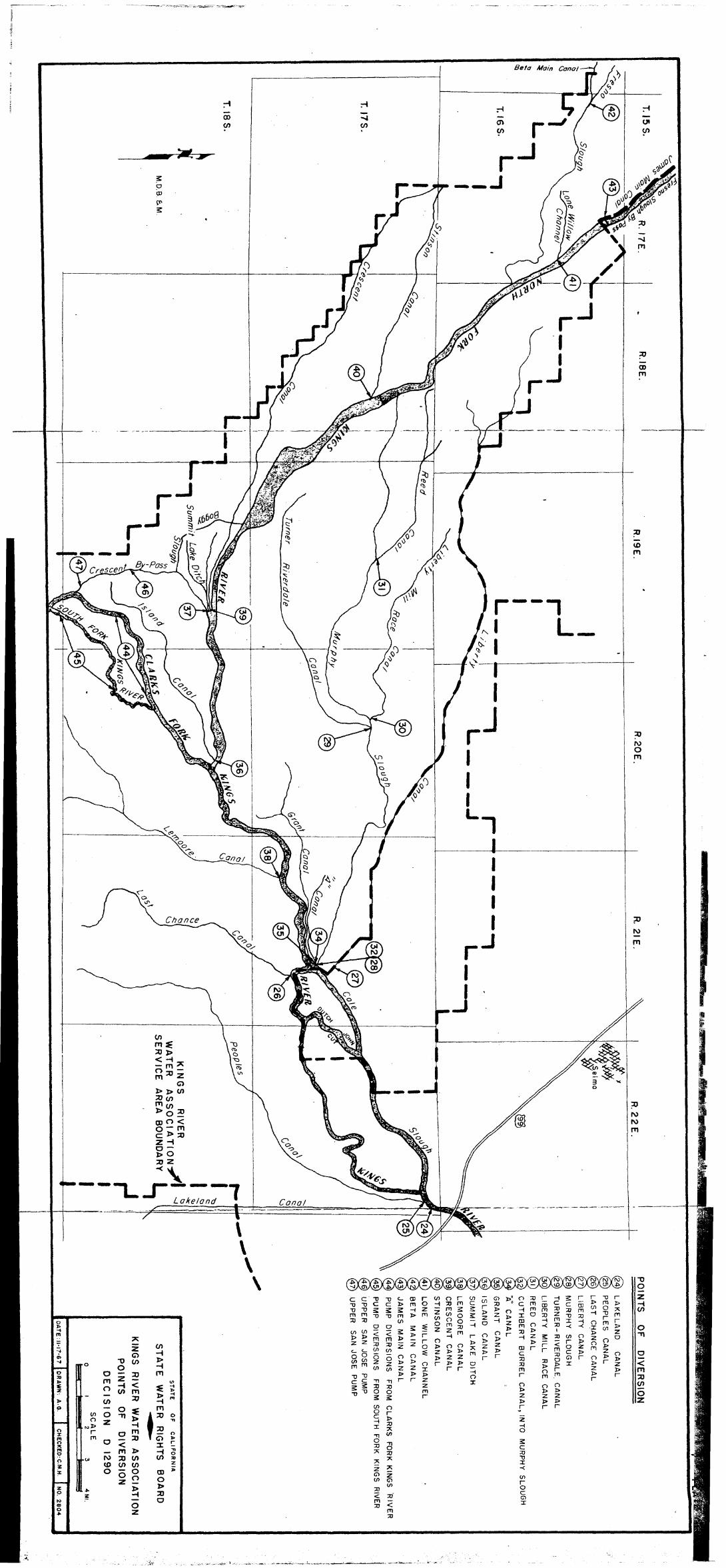


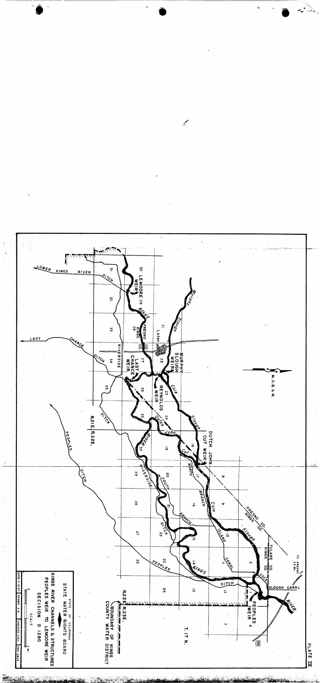
STATE OF CALIFORNIA STATE WATER RESOURCES CONTROL BOARD
In the Matter of Applications 360,
5640, 11023 and 16469 Held by
Fresno Irrigation District, Trustee
DECPPSPON DENYING PETITION FOR RECONSIDERATION AND ORDER AMENDING ORDER IN DECISION D 1290
Petition of Fresno Irrigation District, Trustee, for Reconsideration of Decision D 1290
On November 30, 1967, the State Water Rights Board
* adopted Decision D 1290. This decision, insofar as it relates
to Fresno Irrigation Dfstrfct, Trustee (here?Ln called "Trustee
District"), approved its Applications 353, 360, 5640, 11023,
11075, 15231 and 16469, approved in part Application 10979,
and denied Application 10750., On December 1, 1967, the State
Water Resources Control Board succeeded to the duties of the
State Water Rights Board, and the latter board was abolished,
pursuant to Chapter 284, Statutes of 1967. On December 29, 1967,
the Trustee Dfstr%ct ffled a petition for reconsideration of
Decfsfon D 1290 "with respect to the fmposftion of condition 8
on Applications 360, 5640 and 11023." Condition 8 provides for
the delfvery of water into a hfghflow channel of the Kings River,
about nSne miles in length, in order to replenish the ground ,I
8 water for the benefit of overlying owners.

The petition does not question the BoardOs analysis of
the evidence or its findings, whfch include the following:
1. "The evidence shows that there is an area of about nine
miles of rfver channel that has been directly and ad-
versely affected with respect to the recharge of ground
water by the construction and operation of Pine Flat
Dam and reservoir." (PO 22)
2, s’soo the losses [by percolatfon] in the Kings River
Channel ..* are estimated at O.O 56 cubic feet per
second e..e” (P. 24)
"This testfmony as to percolating and channel losses
was not seriously questioned on cross-examination, nor
was it controverted by other expert testfmony." (~0 25)
30 "The modified entitlement method [used fn Condition 81 *.a
affords a reasonable basis for looking at the daily re-
corded and calculated Piedra flows during each month of
the year, and calculating on an approxfmate basfs what
specific hfgh-flow days in the absence of Pine Flat
Reservoir would have resulted in flows and percolation
of water in the Kings River high-flow channel,ss (~0 28)
The petition for reconsideration 1s lfmfted to the
ground that the Board lacked $.M.sdictfon to include Condf-
tion 8 as a permit condition. Its argument falls under two
main headfngs:
-2-

e
A. Pre-1914 Appropriative Rights
The petition states that to a large extent Condition 8
of the decfsion relates to and affects the exercise of pre-1914
appropriatfve rights of the Trustee District and fts trust bene-
ficiaries. Rowever, the Board's actfons are confined to the
framework of the Trustee District's own applications, and to
the Board's duty to protect vested rfghts, (See Meridian, Ltd.
v. City and County of San Franc%sco, 13 Cal 2d 42Lco)
Inclusion of Condftfon 8 does not hurt whatever pre-
1914 rights the Trustee DSstrfct or its beneficiaries own;
it merely prevents them from acquiring a wfndfall equivalent
to the amount of the high-flow channel losses which occurred
naturally prior to the constructfon of Pine Flat Dam9 but which
no longer take place as a result of the construction and opera-
tion of Pine Flat Dam and Reservoir,
It is trueg as is pointed out by the petition, that
relief is requested for the high-flow channel area of the Kings
Rfver as well as for other areas, in the actfon before the
Superior Court In Kings County entftled Kings County Water Dfs-
trict v. Laguna Irrigation Distrect, et al., A demurrer is now
pending with respect to thfs action, To avofd any possible con-
flict with this or any other action9 including possible proceed-
ings before the United States Court of Claims, Condition 8
concludes as follows:
"This condftfon will be modfffed or canceled to con- form to the requirements of the Judgment of any court of competent jurisdfctfon,"
-3-

We do not believe that the pendency of the Kings County
action suspends the Board's duty to protect vested rights, al-
though the Board will conform Condition 8 to the requirements
of any judgment, as is expressly indicated,
B. Effect of Turner Case (Max E. Turner9 et al. v. Kings River Conservation District, et al,, 360 F 2d 184)
It is the position of petitioner that Condition 8 is
prohibited by the Circuit Court's decision in the Turner case.
We do not understand
Turner decision.
The Turner
that to be the holding or effect of the
case was an action by owners of riparian
and overlying lands against officials operating Pine Flat Dam
and Reservoir, built by the United States on the Kings River pur-
suant to the Flood Control Act of 1944, and against the Kings
River Conservation District and its members, in which an injunc-
tion was sought, The Court of Appeals held, among other things,
that United States officials in the operation of Pine Flat Dam
and Reservoir were authorized to interfere with riparian and
overlying owners' rights, and that the owners' remedy against
the United States was not an action in the U. S. District Court
for an injunction but a suit in the Court of Claims for damages.
Since the action related directly to the operation of the dam
and reservoir, the United States was found to be
able party, but the United States had authorized
@ to be brought against it in the federal district
an indispens-
no such suit
court.
-4-

: .
0 Condition 8 does not have any direct effect upon the
operation of Pine Flat Dam and Reservoir by the United States.
The applfeatfons befng heard by the Board were those of the Trus-
tee D%strict, not of the United statea. Condftion 8 relates to
a high-flow channel which is about 34 miles downstream from Pfne
Flat Dam, fn the midst of an area where river dfversfons are
controlled by the watermaster for the Kings River Conservation
DfstrfcYt,
There is only an Indirect connection between Condf-
tion 8 and operation of Pine Flat Dam and Reservoir, By con-
tract between the United States and the Kings River Conservation
Rfstrfct, the project is operated to store and release water as
requested by the district, but without interfering with mandatory
flo_od storage operations, CompPiance with Condition 8 would
probably require the Trustee District to order the releases of
certain quantities of waterby the United States for delivery
Into the high-flow channel no later than the end of July of each
year when requ%red, Th%s is water which the Trustee District9
in the absence of Condftion 8, would have ordered for release
and delivery to members of the Kfngs River Conservation Dfs-
trict, who are also beneficiarfes of the trust, It is not water
which the United States has any Interest in after it leaves the
reservoir, The deliveries into the high-flow channel would be
expected to average somewhat more than one-tenth of one percent
of the average flow of the Kings Rfver at Piedra, This amount
-5-

of water is small in comparison with the total operation of the
Kings River Conservation District, and with the additional quan-
tities of unappropriated water which are approved for appropriation
by these applications.
Insofar as the Turner case involved proceedings against
the Kings River Conservation District, its members and officials,
the decision left open the possibility of future state action,
in court or administrative proceedings, as appropriate. In this
connection the Court stated at page 199:
"We are satisfied that there was no basis for federal jurisdiction of appellants' second cause of action which did not require the presence of the United States: diversity of citizenship was lacking; and the interests of the United-States were inextricably involved in all of appellants' claims arising under federal statutes,"
For the foregoing reasons this petition for reconsid-
eration will be denied.
II
Petition by California Department of Fish and Game for Order Amending Order in Decision D 1290
By a petition dated December 22, 1967, the California
Department of Fish and Game (Department) requested an amendment
of the order in Decision D 1290.
The Department points out that not only does it have
an agreement w%th the Trustee District regarding releases
of water to be made,below Pine Flat Dam for the protection
-6-
- ~.,__

2 .
and enhancement of fish and wildlife, but that dismissal of
the DepartmentIs protest was contingent upon inclusion of the
agreement by reference or otherwise as a permit condition.
The Department also points out that it had requested
that any permit issued on Application 16469 expressly require
the same releases of water below Courtright Reservoir as are
required by order of the Federal Power Commission,, issued Sep-
tember 3, 1958 (Fish and Game Exh. 4); and the Trustee District
so stipulated on April 6, 1967 (RT 427, 428),
These permit conditions requested by the Department
were omitted by clerical error and oversight, and the order in
0 Decision D 1290 will be corrected to include them, pursuant to
Water Code Section 135g0
ORDER
IT IS HEREBY ORDERED that the petition for reconsider-
ation of Decision D 1290, filed by Fresno Irrigation District,
Trustee, be, and it is, denied,
IT IS FURTHER ORDERED that the order in Decision D 1290,
starting on page 44 and concluding on page 50, which approves,
among other applications, Applications 5640, 11023 and 16469,
be amended by adding after Condition 10 the following:
11, The permits issued pursuant to Applica-
tions 5640 and 11023 will each contain the following addi-
tional condition:
-7-

Unless otherwise agreed by permittee and Califor- nia Department of Fish'and Game9 permittee shall store and release water under this permit only in accordance with the provisions of the agreement dated September 11, 1964, by permittee and said Department, for the preser- vation and enhancement of fish and wfldlffe.
12, The permit issued pursuant to Application 16469
will contain the following additional condition:
Permittee shall maintain, in the stream downstream from Courtright Damp water flows for the preservation of ffsh and aquatic life, in the quantities and for periods hereinafter specified:
June 1 December 1 through through Dry November 30 May 31 Years
4 cfs 2 cfs 2 cfs
A dry year shall be defined as one in which the unim- paired seasonal runoff of Kings River at Piedra, as esti- mated on May 1 by the State of Calffornfa,Department of Water Resources, will be l,OOO,OOO acre-feet or less. The point of measurement of the above flows shall be just ,downstream from the point where the flow through the discharge tunnel returns to the stream,
Ad,opted as the decision and order of the State Water Re-
sources Control Board at a meeting duly called and held at Sacra-
mento, California.
Dated: JAN 18 1968 / / George B, Maul GEorge B. Maul, Chairman
/s/ W, A, Alexander W. A. Alexander, Vice Chairman
/s/ Ralph J. McGill Ralph J. McGill, Member
participated Board Members Norman B, Hume and E. F. Dibble, not having in hearings on these applications or in Decision D 1290,
disqualified themselves from participating in this decision and order.
-8-


![[XLS] · Web view2143.404 5556 2383 3230 11168 1999 2081.4140000000002 2499.8240000000001 7710.9740000000002 12292.212 2315.788 5695 3530 5384 14608 2000 2723.9 7719.4369999999999](https://cdn.vdocument.in/doc/165x107/5ac1d34f7f8b9ac6688dd1c9/xls-view2143404-5556-2383-3230-11168-1999-20814140000000002-24998240000000001.jpg)


