
CEMEX UK Cement Ltd Barrington Cement Works Surrender Site Condition Report EPR/BK09731K/S007
BCW-EP-REP001
Issue | 7 January 2014
This report takes into account the particular instructions and requirements of our client.
It is not intended for and should not be relied upon by any third party and no responsibility is undertaken to any third party. Job number 232348
Ove Arup & Partners Ltd New Oxford House 30 Barkers Pool Sheffield S1 2HB United Kingdom www.arup.com

BCW-EP-REP001 | Issue | 7 January 2014 J:\230000\232348-00\0 ARUP\0-03 GROUND ENGINEERING\0-03-08 REPORTS\ISSUE SURRENDER REPORT\SURRENDER SITE CONDITION REPORT ISSUE.DOCX
Document Verification
Job title Barrington Cement Works Job number
232348 Document title Surrender Site Condition Report
EPR/BK09731K/S007 File reference
0-3-8 Document ref BCW-EP-REP001 Revision Date Filename Surrender Site Condition Report.docx Draft 1 18 Dec
2013 Description First draft
Prepared by Checked by Approved by
Name Lucy Taylor Gez Studds Andy Hornung
Signature
Issue 7 Jan 2014
Filename Surrender Site Condition Report Issue.docx Description Minor revisions following client review
Prepared by Checked by Approved by
Name Lucy Taylor Gez Studds Andy Hornung
Signature
Filename Description
Prepared by Checked by Approved by
Name
Signature Filename
Description
Prepared by Checked by Approved by
Name
Signature Issue Document Verification with Document

CEMEX UK Cement Ltd Barrington Cement Works Surrender Site Condition Report EPR/BK09731K/S007
BCW-EP-REP001 | Issue | 7 January 2014 J:\230000\232348-00\0 ARUP\0-03 GROUND ENGINEERING\0-03-08 REPORTS\ISSUE SURRENDER REPORT\SURRENDER SITE CONDITION REPORT ISSUE.DOCX
Contents Page
1 Introduction 3
1.1 Report Context 3 1.2 Background 3 1.3 Permit Surrender Requirements 3 1.4 Installation Details 3
2 Environmental Setting 5
2.1 Site History 5 2.2 Geology 6 2.3 Hydrology 7 2.4 Hydrogeology 8 2.5 Pollution Incidents 9 2.6 Environmental Receptors 9
3 Permitted Activities 10
3.1 Permitted Activities 10 3.2 Non-permitted Activities 11
4 Summary of Application Site Condition Record 12
4.1 Background 12 4.2 2001 Ground Investigation 12 4.3 Application Baseline Conditions 13
5 Groundwater and Surface Water Monitoring 16
5.1 Groundwater Monitoring Wells 16 5.2 Surface Water Monitoring 17
6 Decommissioning 18
7 Ground Investigation 19
7.1 Methodology 19 7.2 Summary of Ground Conditions 20 7.3 Laboratory Test Results 20
8 Summary of Surrender Site Condition 23
9 Statement of Site Condition 25
References

CEMEX UK Cement Ltd Barrington Cement Works Surrender Site Condition Report EPR/BK09731K/S007
BCW-EP-REP001 | Issue | 7 January 2014 J:\230000\232348-00\0 ARUP\0-03 GROUND ENGINEERING\0-03-08 REPORTS\ISSUE SURRENDER REPORT\SURRENDER SITE CONDITION REPORT ISSUE.DOCX
Tables Table 1 Site History Table 2: Surface water abstractions Table 3: Discharge Consents Table 4: Groundwater abstractions Table 5: 2001 Exploratory Hole Locations Table 6: Results of Soil Chemical Testing Table 7 Groundwater monitoring boreholes used to derive baseline data Table 8: Groundwater Baseline Conditions Table 9 Groundwater monitoring boreholes Table 10: Groundwater monitoring results Table 11: Surface water monitoring Table 12 2013 Ground Investigation Table 13: Summary of ground conditions Table 14: Soils test results summary Table 15 Concentrations above baseline conditions Figures Figure 1 Site Location Figure 2 Site Details Figure 3 Groundwater Monitoring Wells and 2013 Window Sample Locations Appendices
Appendix A
Envirocheck Report
Appendix B
Groundwater and Surface Water Monitoring
Appendix C
2013 Ground Investigation Factual Report

CEMEX UK Cement Ltd Barrington Cement Works Surrender Site Condition Report EPR/BK09731K/S007
BCW-EP-REP001 | Issue | 7 January 2014 J:\230000\232348-00\0 ARUP\0-03 GROUND ENGINEERING\0-03-08 REPORTS\ISSUE SURRENDER REPORT\SURRENDER SITE CONDITION REPORT ISSUE.DOCX
Page 1
Executive Summary The former Barrington Cement Works is owned by CEMEX UK Cement Ltd (CEMEX).
Environmental permit BK09731K for the cement works was granted in 2001. The permit application was accompanied by a site condition report and intrusive ground investigation in order to provide baseline data characterising the site.
CEMEX wishes to surrender the permit following cessation of cement manufacture in 2008. This report has been prepared to describe the condition of the land and groundwater in support of a permit application for a full surrender of the permit.
The baseline soil and groundwater conditions showed generally low levels of contaminants across the site associated with the cement works.
The permit application boundary included a greater area of land to the north of the cement works, comprising landfills LS24 and LS116 and the operational quarry. The permit boundary was subsequently varied to include only the operational area of the cement works.
Monitoring of the site has been undertaken in accordance with the permit. There has been no recorded pollution incident during the lifetime of the permit.
Groundwater monitoring during the lifetime of the permit has shown that the results are consistent with baseline groundwater concentrations for all of the determinands.
The surface water discharge consent is not being surrendered, but monitoring results are within compliance limits. CEMEX intend to transfer the discharge consent permits onto the landfill permit BV1461 as advised by the Environment Agency.
In 2008, process decommissioning was undertaken in accordance with the environmental permit to minimise environmental risks.
As part of the surrender application a ground investigation was carried out in 2013 comprising 17 window sample holes and soil laboratory testing to establish the current site condition at permit surrender.
The results of the laboratory testing were consistent with baseline soil conditions across the site for the majority of determinands. There were slightly higher than baseline concentrations for the following determinands: arsenic, chromium, copper, iron, magnesium, manganese, PAH and phosphorous.
The elevated metals are considered to be natural variations across the site rather than as a result of constituents used in the cement manufacturing process. None of the elevated determinands exceed generic assessment criteria (GAC) for commercial land use.

CEMEX UK Cement Ltd Barrington Cement Works Surrender Site Condition Report EPR/BK09731K/S007
BCW-EP-REP001 | Issue | 7 January 2014 J:\230000\232348-00\0 ARUP\0-03 GROUND ENGINEERING\0-03-08 REPORTS\ISSUE SURRENDER REPORT\SURRENDER SITE CONDITION REPORT ISSUE.DOCX
Page 2
The elevations do not represent a significant change from baseline conditions.
The Surrender Site Condition Report has demonstrates that the land has not deteriorated from baseline conditions and is in a satisfactory state.

CEMEX UK Cement Ltd Barrington Cement Works Surrender Site Condition Report EPR/BK09731K/S007
BCW-EP-REP001 | Issue | 7 January 2014 J:\230000\232348-00\0 ARUP\0-03 GROUND ENGINEERING\0-03-08 REPORTS\ISSUE SURRENDER REPORT\SURRENDER SITE CONDITION REPORT ISSUE.DOCX
Page 3
1 Introduction
1.1 Report Context The former Barrington Cement Works is owned by CEMEX UK Cement Ltd (CEMEX).
This report has been produced for CEMEX by Ove Arup & Partners Ltd (Arup) to support the surrender of Environmental Permit (EP) BK09731K for Barrington Cement Works.
1.2 Background An Environmental Permit application was submitted in 2001 following replacement of Part I of the EPA 1990 with the Pollution Prevention and Control (England and Wales) Regulations 2000 Statutory Instrument 2000/1973. The permit application was accompanied by a site condition report and intrusive ground investigation in order to provide baseline data characterising the site.
CEMEX wishes to surrender the permit following cessation of cement manufacture in 2008. In 2008, process decommissioning was undertaken in accordance with the environmental permit to minimise environmental risks. This is described in more detail in Section 6.
1.3 Permit Surrender Requirements In order to surrender the permit for the works it must be demonstrated that the necessary measures have been taken[1] –
(a) to avoid a pollution risk resulting from the operation of the regulated facility; and
(b) to return the site of the regulated facility to a satisfactory state, having regard to the state of the site before the facility was put into operation.
This surrender site condition report has been prepared to assess whether the ground and groundwater beneath the site are in a suitable condition for surrender.
Reference sources used in preparing this report include the following documents:
• RGN 9: Surrender • H5 Site Condition Reports • Landmark Envirocheck 2013 (Appendix A)
1.4 Installation Details The former cement works is located to the north of Barrington and approximately 10km to the south west of Cambridge at National Grid Reference TL 39483E, 50552N as shown in Figure 1. The site is bounded to the east and south east by Haslingfield Road beyond which lies open countryside.
The permit boundary and site layout is shown on Figure 2.
The permitted area comprises decommissioned industrial buildings associated with the former cement works, disused railway sidings, access roads and a lagoon

CEMEX UK Cement Ltd Barrington Cement Works Surrender Site Condition Report EPR/BK09731K/S007
BCW-EP-REP001 | Issue | 7 January 2014 J:\230000\232348-00\0 ARUP\0-03 GROUND ENGINEERING\0-03-08 REPORTS\ISSUE SURRENDER REPORT\SURRENDER SITE CONDITION REPORT ISSUE.DOCX
Page 4
(known as Gault Pit) previously used as a source of water for the production process. The permit boundary intersects the southerly part of the restored LS24 cement kiln dust (CKD) landfill.
Three drainage ditches run off-site on the south western boundary of the site and two drainage ditches join and run off-site on the south eastern boundary.
The main features and site infrastructure associated with the former cement plant are listed below and identified in Figure 2, including areas that have been decommissioned:
• Lagoon (Gault Pit) • Raw Plant • Slurry kiln feed tank • Secondary liquid fuel tank • Kiln • Clinker pit • Cement mill • Gas oil/diesel tanks and oil stores at several locations around the works area • A transport garage in the north eastern corner of the works • Electricity substation/transformers located opposite the gantry store and at the
Raw Plant.
CEMEX UK Cement Ltd Barrington Cement Works Surrender Site Condition Report EPR/BK09731K/S007
BCW-EP-REP001 | Issue | 7 January 2014 J:\230000\232348-00\0 ARUP\0-03 GROUND ENGINEERING\0-03-08 REPORTS\ISSUE SURRENDER REPORT\SURRENDER SITE CONDITION REPORT ISSUE.DOCX
Page 5
2 Environmental Setting An Envirocheck Report is included in Appendix A.
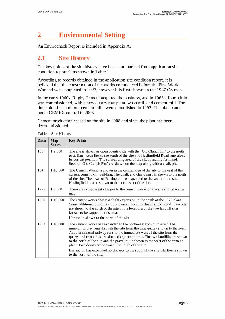
2.1 Site History The key points of the site history have been summarised from application site condition report,[2] as shown in Table 1.
According to records obtained in the application site condition report, it is believed that the construction of the works commenced before the First World War and was completed in 1927, however it is first shown on the 1937 OS map.
In the early 1960s, Rugby Cement acquired the business, and in 1963 a fourth kiln was commissioned, with a new quarry raw plant, wash mill and cement mill. The three old kilns and four cement mills were demolished in 1992. The plant came under CEMEX control in 2005.
Cement production ceased on the site in 2008 and since the plant has been decommissioned.
Table 1 Site History Dates Map
Scales Key Points
1937 1:2,500 The site is shown as open countryside with the ‘Old Clunch Pit’ to the north east. Barrington lies to the south of the site and Haslingfield Road runs along its current position. The surrounding area of the site is mainly farmland. Several ‘Old Clunch Pits’ are shown on the map along with a chalk pit.
1947 1:10,560 The Cement Works is shown in the central area of the site to the east of the current cement kiln building. The chalk and clay quarry is shown to the north of the site. The town of Barrington has expanded to the south of the site. Haslingfield is also shown to the north east of the site.
1975 1:2,500 There are no apparent changes to the cement works on the site shown on the map.
1960 1:10,560 The cement works shows a slight expansion to the south of the 1975 plant. Some additional buildings are shown adjacent to Haslingfield Road. Two pits are shown to the north of the site in the locations of the two landfill sites known to be capped in this area. Harlton in shown to the north of the site.
1982 1:10,000 The cement works has expanded to the north-east and south-west. The mineral railway runs through the site from the lime quarry shown to the north. Another mineral railway runs to the immediate west of the site from the quarry and two tanks are situated adjacent to this. The two landfills are shown to the north of the site and the gravel pit is shown to the west of the cement plant. Two drains are shown at the south of the site. Barrington has expanded northwards to the south of the site. Harlton is shown to the north of the site.

CEMEX UK Cement Ltd Barrington Cement Works Surrender Site Condition Report EPR/BK09731K/S007
BCW-EP-REP001 | Issue | 7 January 2014 J:\230000\232348-00\0 ARUP\0-03 GROUND ENGINEERING\0-03-08 REPORTS\ISSUE SURRENDER REPORT\SURRENDER SITE CONDITION REPORT ISSUE.DOCX
Page 6
2.1.1 Offsite Landfills The original permit boundary included landfills LS24 and LS116 to the north of the current permit boundary as described below and shown in Figure 2.
Landfill LS24
• Closed landfill on the northern boundary infilled with dry cement kiln dust (CKD), inert waste and slurried kiln dust.
• Capped with low permeability clay and restored to agriculture.
• LS24 has not been in general use since 1994.
Adjacent to LS24 landfill is a second lagoon (North Pit) and an area which has been quarried, backfilled with overburden Glacial Till and covered with restoration soils. This area is now used for agricultural purposes.
Landfill Environmental Permit BV1461 IV
• Formerly Waste Management Licence (WML) LS116.
• The permitted landfill at the northern end of the quarry commenced operation in 1991 comprising Cell 1 and Cell 2.
• Cell 1 contains Cement Kiln Dust (CKD), waste refractory bricks and road sweepings. Final levels have not been reached, and thus void space is available for further landfilling.
• Cell 2 currently remains unused but is permitted to accept inert waste.
• Landfilling was suspended when cement manufacturing ceased in 2008.
To the east of landfill BV1461 is an extensive mineral extracted area which includes the Barrington Chalk Pit Site of Special Scientific Interest (SSSI) for its exposure of Cretaceous Cambridge Greensand.
A historical landfill site, LS918, is noted in the Envirocheck report to the north east of the site in an area known as the Old Clunch Pit. It is estimated to be situated within 100m of the site and contain industrial, commercial and household waste. The last input date for the landfill is reported to be September 1981.
2.2 Geology British Geological Society (BGS) records do not record any superficial deposits on the site area. The geology of the site is taken from BGS Sheet 32 North Essex.
The whole site is underlain by Cretaceous Grey Chalk, part of the Lower Chalk. Below the Grey Chalk lies a bed of Totternhoe Stone (locally known as Clunch) which is underlain by the West Melbury Marly Chalk, still part of the Lower Chalk. The base of the Lower Chalk is formed by the Cambridge Greensand.
The Lower Chalk is underlain by grey and grey blue clays of the Gault Clay, which in turn are underlain by green and brown sands and sandstones of the Lower Greensand.

CEMEX UK Cement Ltd Barrington Cement Works Surrender Site Condition Report EPR/BK09731K/S007
BCW-EP-REP001 | Issue | 7 January 2014 J:\230000\232348-00\0 ARUP\0-03 GROUND ENGINEERING\0-03-08 REPORTS\ISSUE SURRENDER REPORT\SURRENDER SITE CONDITION REPORT ISSUE.DOCX
Page 7
A band of boulder clay, approximately 700m in width, runs from east to west over the Grey Chalk to the north of the cement works. This material was used as the backfill in the central area of the quarry, to the north of the LS24 landfill.
2.3 Hydrology
2.3.1 Site Drainage Following cessation of cement manufacture, there was no longer a requirement to use surface water in the works process. A review of the surface water management at the site was undertaken in 2010[3] in response to an improvement condition which detailed a revised monitoring and management strategy. A summary is provided below:
To the north of the site surface water is pumped from the quarry void via drainage channels to North Pit, along with surface water run-off from BK1461 Cell 1 and restored land to the south of Cell 1.
Water levels in the North Pit are controlled by pumping when required, water being discharged into the western drainage ditch which enters the site and continues southward to the River Rhee /Cam at discharge point S15 located inside the permit boundary. Water can also be discharged to Gault Pit, en route to the River Rhee/ Cam following monitoring.
2.3.2 Surface Water Abstractions One surface water abstraction lies within 1km of the site. The abstraction is reported to be operated by CEMEX UK at the River Rhee for General Use and Evaporative Cooling in Industrial/Commercial/Public services, as shown in Table 2. The surface water abstraction will no longer be required following the decommissioning of the cement works and the abstraction licence will be surrendered along with the Environmental Permit for the site.
Table 2: Surface water abstractions Licence No. National Grid
Reference Surface water course
Purpose
6/33/30/*S/0151 540160 249580
River Rhee south-east of Barrington
Other Industrial/Commercial/Public Services: General Use (Medium Loss), Evaporative Cooling,
2.3.3 Discharge Consents There are two discharge consents to controlled waters on the site included within the permit: discharge of surface water to a tributary of the River Rhee and final/treated sewage effluent to a tributary of the River Rhee as shown in Table 3. As the discharge consents are within the permitted boundary, CEMEX intend to transfer the discharge consent permits onto landfill permit BV1461 as advised by the Environment Agency.
One other discharge consent within 500m of the site allows final/treated effluent to discharge to a tributary of the River Rhee.

CEMEX UK Cement Ltd Barrington Cement Works Surrender Site Condition Report EPR/BK09731K/S007
BCW-EP-REP001 | Issue | 7 January 2014 J:\230000\232348-00\0 ARUP\0-03 GROUND ENGINEERING\0-03-08 REPORTS\ISSUE SURRENDER REPORT\SURRENDER SITE CONDITION REPORT ISSUE.DOCX
Page 8
Table 3: Discharge Consents Reference National Grid
Reference Receiving Water Purpose
Pr1nf2642 539740 250500
Tributary to River Rhee
Discharge of Other Matter – Surface Water
Pr1nf2643 539690 250250
Tributary to River Rhee
Sewage Discharges – Final/Treated Effluent – Not Water Company
Prcnf14324 540000 250080
Ditch Tributary to River Rhee
Sewage Discharges – Final/Treated Effluent – Not Water Company
2.4 Hydrogeology
2.4.1 Aquifer Classifications The Lower Chalk is classified as a Principal Aquifer (highly permeable) by the Environment Agency.
The Lower Chalk is underlain by Cambridge Greensand and Gault Clay which provides a low permeability barrier to protect the underlying Lower Greensand. The Lower Greensand is classified as a Secondary A aquifer.
2.4.2 Ground water abstractions There are two licenced groundwater abstractions on the site and one abstraction within 100m of the site, as shown in Table 4. Groundwater abstraction is licenced for spray irrigation, general domestic use and evaporative cooling and process water for mineral products.
Table 4: Groundwater abstractions Licence No NGR Source Purpose Licensed
annual abstraction rate (m3/a)
6/33/30/*G/0130
539580 250780
Groundwater General Agriculture: Spray Irrigation – Direct; General Farming and Domestic; Mineral Products – Evaporative Cooling; Mineral Products – Process Water;
Not supplied
6/33/30/*G/0130
539100 250700
Groundwater General Agriculture: Spray Irrigation – Direct; Mineral Products – Evaporative Cooling; General Farming and Domestic; Mineral Products – Process Water;
Not supplied
6/33/30/*G/0130
539505 250890
Groundwater Mineral Products – Evaporative Cooling; General Agriculture:
Not supplied
CEMEX UK Cement Ltd Barrington Cement Works Surrender Site Condition Report EPR/BK09731K/S007
BCW-EP-REP001 | Issue | 7 January 2014 J:\230000\232348-00\0 ARUP\0-03 GROUND ENGINEERING\0-03-08 REPORTS\ISSUE SURRENDER REPORT\SURRENDER SITE CONDITION REPORT ISSUE.DOCX
Page 9
Spray Irrigation – Direct; General Farming and Domestic; Mineral Products – Process Water;
2.4.3 Groundwater Flow Regional groundwater flow in the Lower Chalk in the vicinity of the site is south easterly towards the River Rhee, although it may have been modified locally by abstractions of water from boreholes and lagoons on site for use in the works.
2.5 Pollution Incidents No pollution incidents are recorded during the lifetime of the permit.
The Envirocheck reports one pollution incident to controlled waters within 500m of the site. The pollutant is recorded as unknown and the severity is considered as a Category 3-minor incident. The incident is dated April 1992.
2.6 Environmental Receptors The following environmental receptors were identified in the environmental permit application:
• River Rhee (Cam); and • Lower Chalk aquifer.

CEMEX UK Cement Ltd Barrington Cement Works Surrender Site Condition Report EPR/BK09731K/S007
BCW-EP-REP001 | Issue | 7 January 2014 J:\230000\232348-00\0 ARUP\0-03 GROUND ENGINEERING\0-03-08 REPORTS\ISSUE SURRENDER REPORT\SURRENDER SITE CONDITION REPORT ISSUE.DOCX
Page 10
3 Permitted Activities
3.1 Permitted Activities Environmental Permit BK09731K was granted in 2001.
3.1.1 Changes to permit Variation DP3130GR was notified to take effect from 31 March 2009. The permitted activities consisted of:
• Raw materials storage, handling and preparation; • Solid fuel handling, storage and preparation; • Cement kiln and associated cooler; • Cement clinker storage and associated milling; • Cement storage and dispatch; • Substitute fuels.
3.1.2 Dangerous substances resulting from permitted activities
None of the materials resulting from the permitted activities are considered dangerous substances.
Waste produced as a result of permitted activities is as follows:
• Metals • Bund water • Interceptor wastes • General wastes • Paper/cardboard • Oils • Oil contaminated waste • Vehicle batteries • Fluorescent lamps • Kiln bricks • Oil drums • Filter bags • Rubber conveyor • Waste process materials (cement additives, cement clinker, gypsum filter,
sand, chalk, iron oxide, clay, PFA, CKD, coal and petcoke) • Cement Kiln Dust (CKD).

CEMEX UK Cement Ltd Barrington Cement Works Surrender Site Condition Report EPR/BK09731K/S007
BCW-EP-REP001 | Issue | 7 January 2014 J:\230000\232348-00\0 ARUP\0-03 GROUND ENGINEERING\0-03-08 REPORTS\ISSUE SURRENDER REPORT\SURRENDER SITE CONDITION REPORT ISSUE.DOCX
Page 11
.Sufficient measures are required by the permit to properly contain and dispose of these wastes.
3.1.3 Measures taken to protect the land The permit does not allow any emissions to the land from the permitted installation.
3.2 Non-permitted Activities There is no record of non-permitted activities taking place on site.

CEMEX UK Cement Ltd Barrington Cement Works Surrender Site Condition Report EPR/BK09731K/S007
BCW-EP-REP001 | Issue | 7 January 2014 J:\230000\232348-00\0 ARUP\0-03 GROUND ENGINEERING\0-03-08 REPORTS\ISSUE SURRENDER REPORT\SURRENDER SITE CONDITION REPORT ISSUE.DOCX
Page 12
4 Summary of Application Site Condition Record
4.1 Background In order to comply with the requirements for an environmental permit application, a Site Condition Report was prepared in 2001 to set baseline conditions for the site.
Three phases of investigation were undertaken which comprised the following:
Phase 1a Desk based research and site reconnaissance
Phase 1b Further desk based research and exploratory site investigation
Phase 2 Intrusive investigation and supplementary investigation
The information gathered in the Phase 1a and combined Phase 1b and 2 investigations was used to develop a conceptual model for the site. The underlying groundwater and the River Rhee, which lies approximately 1 km south of the site, were identified as the principal potential receptors. The potential migration pathway was movement through the unsaturated zone and subsequent flow in the saturated zone within the Lower Chalk, a principal aquifer.
Baseline conditions for the site were derived from the phase 1 and phase 2 investigations, which included soil and water analysis, along with a review of historical groundwater, landfill leachate and gas monitoring data for the two landfills to the north.
4.2 2001 Ground Investigation To supplement existing information for the site, a ground investigation was undertaken adjacent to existing and former potential sources of contamination which comprised fourteen probe holes and one ‘open hole’ rotary borehole at the locations shown in Table 5 and Figure 3. Samples of soil and groundwater were taken for chemical testing in the laboratory.
Table 5: 2001 Exploratory Hole Locations Exploratory Hole Location Rationale
WS1 Water effluent plant
WS2 Secondary Liquid Fuel plant
WS3 Secondary Liquid Fuel plant
WS4 Diesel tanks
WS5 Slurry kiln feed tanks
WS6 Oil storage
WS7 Clinker storage
WS8 Coke and pet coke store
WS9 Former Kilns
WS10 Diesel Storage

CEMEX UK Cement Ltd Barrington Cement Works Surrender Site Condition Report EPR/BK09731K/S007
BCW-EP-REP001 | Issue | 7 January 2014 J:\230000\232348-00\0 ARUP\0-03 GROUND ENGINEERING\0-03-08 REPORTS\ISSUE SURRENDER REPORT\SURRENDER SITE CONDITION REPORT ISSUE.DOCX
Page 13
WS11 Waste oil drums
WS12 Waste oil sump
WS13 Concrete mixer and diesel tanks
WS14 Iron oxide store
BH01/1 Raw Plant
4.2.1 Summary of Ground Conditions The site investigation identified the presence of Made Ground to a maximum depth of 1.8m overlying Marl Chalk of the Lower Chalk.
The Made Ground comprised clinker, sand, gravel, brick, concrete chalk and flint across the site. Marl was proven to the full depth of the continuous soil sampling holes (up to 2 to 3m below ground level).
There was no evidence of visual/olfactory contamination from investigation.
4.3 Application Baseline Conditions Baseline conditions for the permit application were as follows:
4.3.1 Soil The baseline conditions identified for soils showed the following:
• Low levels of metal contamination and elevated alkalinity; • Slightly elevated levels of inorganic soil contamination at the site of the
former kilns; • No hydrocarbon contamination was identified in the soils; • For a number of parameters a slightly wider range of values were determined
for the old kiln area. Table 6 summarises the results of the laboratory testing carried out on soil samples during the investigation. Table 6: Results of Soil Chemical Testing Determinand Baseline Concentration
Operational area (mg/kg) WS1-WS8 & WS10-WS14
Baseline Concentration Former Kiln area (mg/kg) WS9
Ammoniacal Nitrogen as N 10 – 155 10
Arsenic , Total as As <1 – 27 14
Cadmium, Total as Cd <0.5 - 0.9 0.6
Chloride, Total as Cl <0.01 0.03
Chromium , Total as Cr 1.8 – 12 20
Copper , Total as Cu 3.5 – 27 23
Diesel range organics (DRO) <10 <10
Gasoline range organics (GRO) <10 <10

CEMEX UK Cement Ltd Barrington Cement Works Surrender Site Condition Report EPR/BK09731K/S007
BCW-EP-REP001 | Issue | 7 January 2014 J:\230000\232348-00\0 ARUP\0-03 GROUND ENGINEERING\0-03-08 REPORTS\ISSUE SURRENDER REPORT\SURRENDER SITE CONDITION REPORT ISSUE.DOCX
Page 14
Iron, Total as Fe 4,800 – 78,000 20,000
Lead , Total as Pb <1 – 38 16
Magnesium, Total as Mg 920 – 2,400 3,200
Manganese, Total as Mn 390 – 730 390 – 730
Mercury, Total as Mg <0.1 <0.1
Nickel , Total as Ni 6.3 – 24 29
PAH, Total (of the 16 USEPA) <10 <10
pH 8.2 - 12.5 9.9
Phenols, Total <1 <1
Phosphorus, Total Inorg as P 300 - 530 340
Potassium, Total as K 760 – 2700 8800
Sodium, Total as Na 300 – 630 1600
Sulphate, Total as SO4 0.05 – 0.85 1.68
Zinc , Total as Zn 11 – 100 100
4.3.2 Groundwater Baseline concentrations for groundwater were derived from long term groundwater monitoring and laboratory analysis of groundwater samples collected during the ground investigation from the boreholes in Table 7.
Table 7 Groundwater monitoring boreholes used to derive baseline data Borehole reference Geological Strata Monitored
BH1 Chalk & Cambridge Greensand
BH2a Chalk & Cambridge Greensand
BH4 Chalk
BH13* Chalk
BH22 Chalk & Cambridge Greensand
90/2 Till/ Made Ground & Gault Clay
90/4 Cambridge Greensand & Gault Clay
91/1* Gault Clay
92/2a Chalk, Cambridge Greensand & Gault Clay
97/1 Chalk
BH01/1 Chalk
*Boreholes located outside of the revised permit boundary
The baseline conditions identified for groundwater in the Lower Chalk are summarised below:
• The majority of the determinands to be below detection limit, including all the hydrocarbon based determinands assessed;
• Groundwater across the site occasionally showed slightly elevated levels of chloride, sulphate, potassium, electrical conductivity and ammoniacal nitrogen. These results were consistent with pre-application site monitoring;

CEMEX UK Cement Ltd Barrington Cement Works Surrender Site Condition Report EPR/BK09731K/S007
BCW-EP-REP001 | Issue | 7 January 2014 J:\230000\232348-00\0 ARUP\0-03 GROUND ENGINEERING\0-03-08 REPORTS\ISSUE SURRENDER REPORT\SURRENDER SITE CONDITION REPORT ISSUE.DOCX
Page 15
• The elevated parameters were likely to be associated with the landfills to the north as they were typical of cement kiln dust leachate;
• BH4 in the Old Clunch Pit displayed elevated concentrations of ammoniacal nitrogen and chloride which may be attributable to the former municipal landfill.
Table 8: Groundwater Baseline Conditions Determinand Baseline concentration
Alkalinity 250 – 875 mg/l
Ammoniacal Nitrogen as N BDL – 8 mg/l
Calcium, Total as Ca 150 – 390 mg/l
Chemical oxygen demand (COD) 12 – 58 mg/l
Chloride, Total as Cl 33 - 400 mg/l
Electrical conductivity 550 - 3500 µS/cm
Fluoride as F (mg/l) <0.1 – 1 mg/l
Magnesium, Total as Mg 8.2 - 1100 mg/l
Nitrate as N (mg/l) BDL - 50 mg/l
pH 6.7 - 7.5
Potassium, Total as K 2.4 - 270 mg/l
Sodium, Total as Na 14 – 260 mg/l
Sulphate, Total as SO4 (mg/l) 130 - 1700 mg/l
4.3.3 Leachate and Gas Leachate and gas baseline conditions were established for the landfills located to the north of the permit boundary. These are monitored in accordance with permit BV1461 and therefore does not form part of the permit surrender.

CEMEX UK Cement Ltd Barrington Cement Works Surrender Site Condition Report EPR/BK09731K/S007
BCW-EP-REP001 | Issue | 7 January 2014 J:\230000\232348-00\0 ARUP\0-03 GROUND ENGINEERING\0-03-08 REPORTS\ISSUE SURRENDER REPORT\SURRENDER SITE CONDITION REPORT ISSUE.DOCX
Page 16
5 Groundwater and Surface Water Monitoring
5.1 Groundwater Monitoring Wells Groundwater has been monitored on a monthly basis during the lifetime of the permit at the locations listed in Table 9 as shown in Figure 3 and for the determinands listed in Table 10.
Table 9 Groundwater monitoring boreholes Borehole reference Geological Strata Monitored
BH2a Chalk & Cambridge Greensand
BH3 Chalk
BH4 Chalk
90/4 Cambridge Greensand & Gault Clay
97/1 Chalk
BH01/1 Chalk
5.1.1 Summary of Results The results of groundwater monitoring between March 2005 and August 2013 are compared with baseline concentration data as shown in Table 10. Appendix B shows the monitoring results plotted against baseline conditions for each determinand.
Table 10: Groundwater monitoring results Determinand Baseline concentration
2001 Monitoring results Mar 2005-Aug 2013
Alkalinity 250 – 875 mg/l 159-733 mg/l
Ammoniacal Nitrogen as N BDL* – 8 mg/l BDL - 5.45mg/l
Calcium, Total as Ca 150 – 390 mg/l 230 - 431mg/l
Chemical oxygen demand (COD) 12 – 58 mg/l BDL - 53mg/l
Chloride, Total as Cl 33 - 400 mg/l 54 - 522mg/l
Electrical conductivity 550 - 3500 µS/cm 570-4510 µS/cm
Fluoride as F (mg/l) <0.1 – 1 mg/l BDL - 0.7mg/l
Magnesium, Total as Mg 8.2 - 1100 mg/l 8.2 - 31mg/l
Nitrate as N (mg/l) BDL - 50 mg/l BDL - 22.9mg/l
pH 6.7 – 7.5 6.8 – 7.9
Potassium, Total as K 2.4 - 270 mg/l 8.9 - 268mg/l
Sodium, Total as Na 14 – 260 mg/l 14 - 199mg/l
Sulphate, Total as SO4 (mg/l) 130 - 1700 mg/l 10.4 - 565mg/l
* below detection limit

CEMEX UK Cement Ltd Barrington Cement Works Surrender Site Condition Report EPR/BK09731K/S007
BCW-EP-REP001 | Issue | 7 January 2014 J:\230000\232348-00\0 ARUP\0-03 GROUND ENGINEERING\0-03-08 REPORTS\ISSUE SURRENDER REPORT\SURRENDER SITE CONDITION REPORT ISSUE.DOCX
Page 17
The results are consistent with baseline groundwater concentrations for all of the determinands. There were marginally higher than baseline concentrations for calcium, chloride, electrical conductivity and pH as described below and as shown in the plotted charts in Appendix B.
Chart 3 shows that calcium has been marginally above the baseline concentration in BH1/1 only, and there have been no elevated readings since 09/2012. As borehole BH1/1 only had one baseline reading, it is considered that the slightly elevated readings are natural variations in monitoring.
Chart 4 shows that chloride has been marginally above the maximum recorded baseline concentration in BH1/1, BH2a and BH3. This is likely to be a result of natural variations and increased monitoring in these boreholes from 2010 rather than site activities.
Chart 6 shows that field electrical conductivity has been marginally above the maximum recorded baseline concentration in BH2a and BH3 in only four samples. Chart 7 shows that all of the laboratory electrical conductivity results are below the maximum recorded baseline concentration.
5.2 Surface Water Monitoring Surface water has been monitored in accordance with the discharge consent attached to the permit for the parameters listed in Table 11.
Table 11: Surface water monitoring Parameter Limit Monitoring Frequency
pH max 9 Monthly
pH min 6.5 Monthly
Oil or grease None visible Monthly
The results for pH monitoring between 2007 and 2013 are within the lower and upper compliance limits as shown in Chart 16 in Appendix B. There has been no evidence of oil grease during the period of monitoring.

CEMEX UK Cement Ltd Barrington Cement Works Surrender Site Condition Report EPR/BK09731K/S007
BCW-EP-REP001 | Issue | 7 January 2014 J:\230000\232348-00\0 ARUP\0-03 GROUND ENGINEERING\0-03-08 REPORTS\ISSUE SURRENDER REPORT\SURRENDER SITE CONDITION REPORT ISSUE.DOCX
Page 18
6 Decommissioning Following cessation of cement manufacture in 2008, process decommissioning commenced to minimise environmental risks. This included the following:
• Received raw materials – all raw material stocks were run down to minimise wastage. Raw material stockpiles were made safe by removing steep sides.
• Slurried raw materials – all slurry basins and pipelines were emptied and the kiln feed system run down to the lowest practicable levels. Slurry pumps were dismantled and cleaned down and all equipment physically isolated and fuses removed to prevent unauthorised use.
• Fuel handling and storage – Fuel storage tanks have been emptied. All coal hoppers were run down and the coal plant filter bags removed. The hoppers and mill were run through with chalk to eliminate pulverised fuel accumulation. All plant has been physically isolated and fuses removed to prevent unauthorised use.
• Secondary Liquid Fuel – both SLF tanks have been run down to operational empty levels and flushed through with clean diesel oil with the diesel residue being removed by an authorised waste disposal company. Both tanks have had decontamination certificates issued. All plant has been physically isolated, fuses removed and are secured to prevent unauthorised access and use.
• Climafuel – the Climafuel pods were emptied of fuel into the kiln as far as operationally possible. The pods were vacuum cleaned and the residue disposed of by an authorised waste disposal company. All plant has been physically isolated, fuses removed and are secured to prevent unauthorised access and use.
• Kiln system – the kiln tube has been run empty and physically isolated by removal of fuses. The Electrostatic Precipitator has been run empty of dust and physically isolated. The compressors and cooling water systems have been drained and isolated.
• Cement mill and storage silos – pipework and conveying has been emptied and systems isolated
A site shutdown folder has been maintained onsite.
In accordance with the permit, the site protection and monitoring programme (SPMP) was updated in 2009 to include a review of the systems and procedures in place for controlling the environmental impacts from the site, resulting from the cessation of manufacturing.

CEMEX UK Cement Ltd Barrington Cement Works Surrender Site Condition Report EPR/BK09731K/S007
BCW-EP-REP001 | Issue | 7 January 2014 J:\230000\232348-00\0 ARUP\0-03 GROUND ENGINEERING\0-03-08 REPORTS\ISSUE SURRENDER REPORT\SURRENDER SITE CONDITION REPORT ISSUE.DOCX
Page 19
7 Ground Investigation
7.1 Methodology To support the surrender application a ground investigation was undertaken to determine whether there have been any changes to the ground conditions since the permit application and to enable comparison with the baseline soil conditions.
The scope of the investigation was agreed with the Environment Agency and comprised seventeen window samples at the locations shown in Table 12 and Figure 3.
The investigation was based on a similar spatial distribution to the ground investigation at permit application and included three additional exploratory holes in new areas around the kiln clinker pit and where tin sulphate has been added at the cement mill building.
Table 12 2013 Ground Investigation Exploratory Hole Location Rationale
WS101 Water effluent plant
WS102 Secondary Liquid Fuel plant
WS103 Secondary Liquid Fuel plant
WS104 Diesel tanks
WS105 Slurry kiln feed tanks
WS106 Cement mill building
WS107 Cement mill building
WS108 Former coke and pet coke store
WS109 Former kilns
WS110 Diesel tank
WS111 Waste oil drum
WS112 Waste oil sump
WS113 Diesel tank
WS114 Iron oxide store
WS115 Clinker pit
WS116 Clinker pit
WS117 Tin sulphate addition system

CEMEX UK Cement Ltd Barrington Cement Works Surrender Site Condition Report EPR/BK09731K/S007
BCW-EP-REP001 | Issue | 7 January 2014 J:\230000\232348-00\0 ARUP\0-03 GROUND ENGINEERING\0-03-08 REPORTS\ISSUE SURRENDER REPORT\SURRENDER SITE CONDITION REPORT ISSUE.DOCX
Page 20
7.2 Summary of Ground Conditions The ground investigation was undertaken in November 2013 and included window sampling to a depth of 3.0m.
A summary of the ground conditions encountered is shown in Table 13. Exploratory hole logs are included in the factual report in Appendix C.
Table 13: Summary of ground conditions Strata Depth
(m bgl) Thickness (m)
Description
Made Ground Ground level 0.1 to 2.15m Topsoil over Made Ground comprising brown slightly sandy slightly gravelly clay and dark grey gravelly sand. Gravel is fine to coarse chalk and quartz with concrete, sub-base, bricks, tiles and flint with occasional roots and rootlets.
Marl 0.1 Up to 2.9m Firm to stiff light grey (mottled) slightly sandy calcareous CLAY with rare fossils and shell fragments
There was a hydrocarbon odour adjacent to former diesel tank at WS104 and waste oil drum at WS111.
Soil sampling was undertaken at each location and sent to a UKAS accredited laboratory for chemical testing.
7.3 Laboratory Test Results Twenty two soil samples were tested in the laboratory for a range of chemical analytes including metals, organics and inorganics.
The results of the soil testing are shown in Table 14. A factual report, including window sample logs, photographs and chemical testing results is included in Appendix C.
Table 14: Soils test results summary Determinand 2013 investigation results (mg/kg)
Ammoniacal Nitrogen as N 3.8 - 18
Arsenic , Total as As 2.9 – 69
BTEX < 0.01
Cadmium, Total as Cd 0.1 – 0.9
Chromium , Total as Cr 7.9 – 52
Copper , Total as Cu 5.2 – 31
Iron, Total as Fe 6,200 – 95,000
Lead , Total as Pb 3.6 – 30
Magnesium, Total as Mg 330 – 4700
Manganese, Total as Mn 290 – 1,100
Mercury, Total as Mg <0.05
Nickel , Total as Ni 7.1 – 33

CEMEX UK Cement Ltd Barrington Cement Works Surrender Site Condition Report EPR/BK09731K/S007
BCW-EP-REP001 | Issue | 7 January 2014 J:\230000\232348-00\0 ARUP\0-03 GROUND ENGINEERING\0-03-08 REPORTS\ISSUE SURRENDER REPORT\SURRENDER SITE CONDITION REPORT ISSUE.DOCX
Page 21
PAH, Total (of the 16 USEPA) <1.6 – 260
PCB < 0.01
pH 8.5 – 12.1
Phenols, Total <0.3 – 0.5
Phosphorus, Total Inorg as P 4.4 – 1,100
Potassium, Total as K 280 – 7,700
Sodium, Total as Na 75 – 960
Sulphate, Total as SO4 0.04 – 1.2
Tin <1.0 – 1.3
Zinc , Total as Zn 12 - 90
The results of the laboratory testing were consistent with baseline soil conditions across the site for the majority of determinands. There were slightly higher than baseline concentrations for the following determinands: arsenic, chromium, copper, iron, magnesium, manganese, PAH and phosphorous but are generally within the same order of magnitude as shown in Table 15.
PAH’s were detected in samples taken close to the former diesel store and are therefore likely to be due to minor spillages. PAHs were not widespread across the site and concentrations were below commercial generic assessment criteria (GAC) for speciated PAH and are not, therefore, considered to be significant.
The concentrations of metals measured are considered to be natural variations across the site rather than arising from the cement manufacturing process.
Where determinand levels have exceeded the baseline conditions, generic assessment criteria (GAC) for commercial land use have been presented as a comparison. GACs do not exist for iron, magnesium, manganese and phosphorus as these constituents are not harmful to human health and are generally considered to be nutrients rather than contaminants.

CEMEX UK Cement Ltd Barrington Cement Works Surrender Site Condition Report EPR/BK09731K/S007
BCW-EP-REP001 | Issue | 7 January 2014 J:\230000\232348-00\0 ARUP\0-03 GROUND ENGINEERING\0-03-08 REPORTS\ISSUE SURRENDER REPORT\SURRENDER SITE CONDITION REPORT ISSUE.DOCX
Page 22
Table 15 Concentrations above baseline conditions Determinand No of
samples No: of exceedances above the baseline
Generic Assessment Criteria (mg/kg) Commercial
Baseline conditions (mg/kg)
Results > baseline (mg/kg)
Window sample
Arsenic 22 2 640 <1 – 27 69 WS103
29 WS114
Chromium 22 1 114 1.8 – 20 52 WS106
Copper 22 1 2300 mg/l 3.5 – 27 31 WS106
Iron 22 1 N/A 4,800 – 78,000
95,000 WS106
Magnesium 22 15 N/A 920 – 3,200
4,000 WS102
4,700 WS103
3,700 WS104
3,900 WS105
4,700 WS106
4,300 3,400
WS107
3,500 WS108
3,900 WS109
3,900 WS110
3,300 WS111
3,700 WS112
3,500 WS113
4,200 WS114
3,600 WS115
Manganese 22 7 N/A 390 – 730 1,100 WS102
880 WS103
740 WS104
820 WS105
840 WS108
750 WS113
860 WS117
PAH 21 2 N/A <10 38 WS104
260 WS111
Phosphorus 22 7 N/A 300 - 530 520 WS104
1,100 WS105
850 WS106
550 WS107
600 WS108
CEMEX UK Cement Ltd Barrington Cement Works Surrender Site Condition Report EPR/BK09731K/S007
BCW-EP-REP001 | Issue | 7 January 2014 J:\230000\232348-00\0 ARUP\0-03 GROUND ENGINEERING\0-03-08 REPORTS\ISSUE SURRENDER REPORT\SURRENDER SITE CONDITION REPORT ISSUE.DOCX
Page 23
590 WS112
810 WS117 *Generic Assessment Criteria produced by Arup using risk assessment software (CLEA v1.06) in accordance with the CLEA assessment framework

CEMEX UK Cement Ltd Barrington Cement Works Surrender Site Condition Report EPR/BK09731K/S007
BCW-EP-REP001 | Issue | 7 January 2014 J:\230000\232348-00\0 ARUP\0-03 GROUND ENGINEERING\0-03-08 REPORTS\ISSUE SURRENDER REPORT\SURRENDER SITE CONDITION REPORT ISSUE.DOCX
Page 24
8 Summary of Surrender Site Condition The surrender conditions identified for groundwater in the Lower Chalk are summarised below:
• The results are consistent with baseline groundwater concentrations for all of the determinands;
• There were marginally higher than baseline concentrations for calcium, chloride, electrical conductivity and pH, but the values measured do not represent a significant change from baseline conditions;
• Groundwater has not deteriorated during the lifetime of the permit.
The surrender conditions identified for soils showed the following:
• The results of the laboratory testing were consistent with baseline soil conditions across the site for the majority of determinands;
• Slightly higher than baseline concentrations were measured for arsenic, chromium, copper, iron, magnesium and manganese and phosphorous. The concentrations measured are considered to be due to natural variations across the site rather than arising from the cement manufacturing process.
• The concentrations of arsenic, chromium and copper measured are within generic assessment criteria for commercial use. GACs are not available for iron, magnesium, manganese and phosphorus as these are commonly found within the natural environment and are not considered to be harmful.
• Slightly elevated concentrations of PAH’s were present adjacent to former fuel storage, however the concentrations measured are not considered to represent a risk to people or groundwater;
• The results of the laboratory testing do not represent a significant change from baseline conditions.
Although the surface water discharge consent is not being surrendered, monitoring results for pH monitoring between 2007 and 2013 are within the lower and upper compliance limits.

CEMEX UK Cement Ltd Barrington Cement Works Surrender Site Condition Report EPR/BK09731K/S007
BCW-EP-REP001 | Issue | 7 January 2014 J:\230000\232348-00\0 ARUP\0-03 GROUND ENGINEERING\0-03-08 REPORTS\ISSUE SURRENDER REPORT\SURRENDER SITE CONDITION REPORT ISSUE.DOCX
Page 25
9 Statement of Site Condition The cement works has not been in operation since 2008. Process decommissioning has been undertaken to minimise environmental risks which has included emptying storage tanks, fuel tanks, slurry basins and pipes.
The Surrender Site Condition Report has demonstrated through groundwater and surface water monitoring data, environmental data searches and intrusive ground investigation that the land is in a satisfactory state.
Groundwater and surface water monitoring records during the lifetime of the permit and soil chemical testing undertaken during a ground investigation in 2013 show that the land has not deteriorated from baseline concentration data provided as part of the permit application.

References

CEMEX UK Cement Ltd Barrington Cement Works Surrender Site Condition Report EPR/BK09731K/S007
BCW-EP-REP001 | Issue | 7 January 2014 J:\230000\232348-00\0 ARUP\0-03 GROUND ENGINEERING\0-03-08 REPORTS\ISSUE SURRENDER REPORT\SURRENDER SITE CONDITION REPORT ISSUE.DOCX
[1] Environmental Permitting Regulations (England and Wales) 2010. Regulatory Guidance Note, RGN 9: Surrender. LIT 8220, Version 3.0 May 2013
[2] IPPC Site Condition Report, Barrington Cement Works, WEEKS Consulting (August, 2001)
[3] ESI 2010. Barrington Cement Works and Landfill: Revised surface water and leachate management and monitoring plan. Report reference: 6879R3r1
[4] Environmental Permit BK0973IK, Variation DP3130GR.
[5] Barrington Cement Works and Landfill: Revised surface water and leachate management and monitoring plan, ESI Environmental Consultants (March, 2010)
[6] Importation by rail of restoration material at Barrington Quarry, Haslingfield Road, Barrington, Planning Permission S/01080/10/CW dated 5.08.2011. Submission of details for approval pursuant to condition 57. Revised Surface Water Drainage Scheme (June 2013)

Figures

CEMEX UK Cement Ltd Barrington Cement Works Surrender Site Condition Report EPR/BK09731K/S007
BCW-EP-REP001 | Issue | 7 January 2014 J:\230000\232348-00\0 ARUP\0-03 GROUND ENGINEERING\0-03-08 REPORTS\ISSUE SURRENDER REPORT\SURRENDER SITE CONDITION REPORT ISSUE.DOCX
Figure 1 Site Location Figure 2 Site Details Figure 3 Groundwater Monitoring Wells and 2013 Window Sample Locations

532000 533000 534000 535000 536000 537000 538000 539000 540000 541000 542000 543000 544000 545000 546000 54700024
4000
2450
0024
6000
2470
0024
8000
2490
0025
0000
2510
0025
2000
2530
0025
4000
2550
0025
6000
2570
00
Job No232348-00Drawing No IssueFigure 1 P0
Drawing StatusPreliminary
Job Title
Client
Admiral House Rose Wharf78 East Street Leeds LS9 8EETel +44 (0) 113 242 8498 Fax +44 (0) 113 242 8573www.arup.com
0 1,000 2,000500
Metres
Legend
Site boundary!°
© Arup
Cemex UK Cement Ltd
Barrington CP Surrender
A3
MXD Location
9/18/2
013 1
2:28:2
9 PM
Site Location Plan
Scale at A31:50,000
Contains Ordnance Survey data © Crown copyright and database rights2013.
Issue Date By Chkd Appd
P0 2013-09-18 ST GS AGH
Notes:

IL
IL
STN
STN
MH
MH
MHMH
MHMHMH
SIGN
OSBM
OSBM
WL
WL
BLBL
BL
BL
28.80
28.6728.84
29.0029.42
28.200
31.653
26.9
25.840
26.181
43.736
27.9
31.697
24.49524.648
24.046
23.565 21.73020.91
23.32
25.768
25.88325.
775
26.17
29.819
30.09930.035 30.162
30.219
30.084
27.849
27.597
27.189
26.79826.636
27.988
33.45
8900 0004
46.9m
CHAPEL HILL
14
0010
8725
8716
8311Church Farm
BM 19.63m
Drain
Pond
Sluice
6116Moat
Drain
Path (um)
Chimney
Drain
HASLINGF
IELD ROA
D
21.6m
FB
Tank
Drain
EngineShed
Tank
Mineral Railway
LevelCrossing
23.3m
BM 23.81m
FB
FB
Conveyor
Conveyor
Water
Tank
Drain
Cement Works
WB
26.3m
CHAPEL H
ILL
26.8mTank
0170
Tanks
Water
Track
41.7m
Drain
Track
Pond
Track
Track
Track
Wheatsheaf
ChurchMeadows
ElSub Sta
8
Pond
7826
Pond
Track
Path (um)
Wilsmere Down Farm
Drain
Silos
Drain
Path (um)
Track
60
60
55
35
35
35
35
40
4040
40
45
45
45
45
50
30
30
30
2015
50
30
30
35
35
30
35
45
22
Kiln
Transport garage
LANDFILLLS24
S15 dischargeconsent
NORTHPIT
GAULTPIT
Raw Plant andIron Oxide Store
Diesel Tank
Slurry KilnFeed Tank
Tin SulphateAddition
Clinker Pit
Coke andPetcoke Store
SLFTank
Water TreatmentPlant
Site Offices
Diesel Tank
OilStore
Cement MillBuilding
Diesel TankWaste Oil Drum
Old Clunch PitHistoric Landfill LS918
F o r m e rK i l n s
LANDFILLLS1116
LANDFILLLS24
Not to scale
538700 538800 538900 539000 539100 539200 539300 539400 539500 539600 539700 539800 539900 54000025
0100
2502
0025
0300
2504
0025
0500
2506
0025
0700
2508
0025
0900
2510
0025
1100
Job No232348-00Drawing No IssueFigure 2 P0
Drawing StatusPreliminary
Job Title
Client
Admiral House Rose Wharf78 East Street Leeds LS9 8EETel +44 (0) 113 242 8498 Fax +44 (0) 113 242 8573www.arup.com
0 80 16040
Metres
LegendSite boundary!°
© Arup
Cemex UK Cement Ltd
Barrington CP Surrender
A3
MXD Location
12/9/
2013
11:03
:29 AM
Site Details
Scale at A31:4,000
Contains Ordnance Survey data © Crown copyright and database rights2013.
Issue Date By Chkd Appd
P0 2013-12-09 ST GS AGH
Notes:1. Topographic Survey dated 05-10-2010.

IL
IL
STN
STN
MH
MH
MHMH
MHMHMH
SIGN
OSBM
OSBM
WL
WL
peg
BLBL
BL
BL
28.80
28.6728.84
29.0029.42
28.200
31.653
26.9
25.840
26.181
43.736
27.9
31.697
24.49524.648
24.046
23.565 21.73020.91
23.32
25.768
25.88325.
775
26.17
29.819
30.09930.035 30.162
30.219
30.084
27.849
27.597
27.189
26.79826.636
27.988
33.45
8900 0004
46.9m
CHAPEL HILL
0010
8725
8716
8311Church Farm
BM 19.63m
Drain
Pond
6116Moat
Drain
Path (um)
Chimney
Drain
HASLINGF
IELD ROA
D
21.6m
FB
Tank
Drain
EngineShed
Tank
Mineral Railway
LevelCrossing
23.3m
BM 23.81m
FB
FB
Conveyor
Conveyor
Water
Tank
Drain
Cement Works
WB
26.3m
CHAPEL H
ILL
26.8mTank
0170
Tanks
Water
Track
41.7m
Drain
Track
Pond
Track
Track
Track
Wheatsheaf
ChurchMeadows
ElSub Sta
Pond
7826
Pond
Track
Path (um)
Wilsmere Down Farm
Drain
Silos
Drain
Path (um)
Track
60
60
55
35
35
35
35
40
4040
40
45
45
45
45
50
5050
30
30
30
2015
50
30
30
35
35
30
35
35
35
45
22
''
'
'
'
'
'
' '
'
''
'
'
''
'
A
A
@A
@A
@A@A
WS114
WS108
WS112 WS111
WS117
WS106
WS110
WS105
WS107
WS116WS115
WS113
WS103
WS104WS101WS102
WS109BH1/01
BH97/1
BH90/4
BH3
BH2A
BH4
538800 538900 539000 539100 539200 539300 539400 539500 539600 539700 539800 539900 54000025
0200
2503
0025
0400
2505
0025
0600
2507
0025
0800
2509
0025
1000
2511
0025
1200
Job No232348-00Drawing No IssueFigure 3 P0
Drawing StatusPreliminary
Job Title
Client
Admiral House Rose Wharf78 East Street Leeds LS9 8EETel +44 (0) 113 242 8498 Fax +44 (0) 113 242 8573www.arup.com
0 80 16040
Metres
!°
© Arup
Cemex UK Cement Ltd
Barrington CP Surrender
A3
MXD Location
12/9/
2013
11:03
:29 AM
Groundwater Monitoring Wells and 2013 Window Sample Locations
Scale at A31:4,000
Contains Ordnance Survey data © Crown copyright and database rights2013.
Issue Date By Chkd Appd
P0 2013-12-09 ST GS AGH
Notes:1. Topographic Survey dated 05-10-2010.
Legend
Surrender Ground Investigation (2013)
' Window Sample
Permit boundary
@A Groundwater monitoring wells

Appendix A
Envirocheck Report

Order Details
Site DetailsRugby Cement, Haslingfield Road, Barrington, CAMBRIDGE, CB22 7RQ
Order Number:Customer Ref:National Grid Reference:Slice:Site Area (Ha):Search Buffer (m):
49009263_1_1232348-00539450, 250670A31.1500
Tel:Fax:Web:
0844 844 99520844 844 9951www.envirocheck.co.uk
Page 1 of 5A Landmark Information Group Service v15.0 09-Sep-2013
Site Sensitivity Context Map - Slice A
Groundwater Vulnerability

Order Details
Site DetailsRugby Cement, Haslingfield Road, Barrington, CAMBRIDGE, CB22 7RQ
Order Number:Customer Ref:National Grid Reference:Slice:Site Area (Ha):Search Buffer (m):
49009263_1_1232348-00539450, 250670A31.1500
Tel:Fax:Web:
0844 844 99520844 844 9951www.envirocheck.co.uk
Page 2 of 5A Landmark Information Group Service v15.0 09-Sep-2013
Site Sensitivity Context Map - Slice A
Bedrock Aquifer Designation

Order Details
Site DetailsRugby Cement, Haslingfield Road, Barrington, CAMBRIDGE, CB22 7RQ
Order Number:Customer Ref:National Grid Reference:Slice:Site Area (Ha):Search Buffer (m):
49009263_1_1232348-00539450, 250670A31.1500
Tel:Fax:Web:
0844 844 99520844 844 9951www.envirocheck.co.uk
Page 3 of 5A Landmark Information Group Service v15.0 09-Sep-2013
Site Sensitivity Context Map - Slice A
Superficial Aquifer Designation

Order Details
Site DetailsRugby Cement, Haslingfield Road, Barrington, CAMBRIDGE, CB22 7RQ
Order Number:Customer Ref:National Grid Reference:Slice:Site Area (Ha):Search Buffer (m):
49009263_1_1232348-00539450, 250670A31.1500
Tel:Fax:Web:
0844 844 99520844 844 9951www.envirocheck.co.uk
Page 4 of 5A Landmark Information Group Service v15.0 09-Sep-2013
Site Sensitivity Context Map - Slice A
Source Protection Zones

Order Details
Site DetailsRugby Cement, Haslingfield Road, Barrington, CAMBRIDGE, CB22 7RQ
Order Number:Customer Ref:National Grid Reference:Slice:Site Area (Ha):Search Buffer (m):
49009263_1_1232348-00539450, 250670A31.1500
Tel:Fax:Web:
0844 844 99520844 844 9951www.envirocheck.co.uk
Page 5 of 5A Landmark Information Group Service v15.0 09-Sep-2013
Site Sensitivity Context Map - Slice A
Sensitive Land Uses

Order Number: 49009263_1_1 Date: 09-Sep-2013 rpr_ec_datasheet v47.0 A Landmark Information Group Service
Datasheet
Order Details:Order Number:
Customer Reference:
National Grid Reference:
Slice:
Site Area (Ha):
Search Buffer (m):
Site Details:
Client Details:
49009263_1_1
232348-00
539450, 250670
A
31.1
500
Rugby Cement, Haslingfield RoadBarringtonCAMBRIDGECB22 7RQ
Ms L TaylorOve Arup & Partners International LtdNew Oxford House30 Barkers PoolSheffieldSouth YorkshireS1 2HB
Report:®Envirocheck

Order Number: 49009263_1_1 Date: 09-Sep-2013 rpr_ec_datasheet v47.0 A Landmark Information Group Service
Summary
Agency & Hydrological
Waste
Hazardous Substances
Geological
Industrial Land Use
Sensitive Land Use
Data Currency
Data Suppliers
Useful Contacts
Introduction
Copyright Notice
Natural England Copyright Notice
Ove Arup Copyright Notice
Peter Brett Associates Copyright Notice
Radon Potential dataset Copyright Notice
The Environment Act 1995 has made site sensitivity a key issue, as the legislation pays as much attention to the pathways by which contamination could spread, and to the vulnerable targets of contamination, as it does the potential sources of contamination. For this reason, Landmark's Site Sensitivity maps and Datasheet(s) place great emphasis on statutory data provided by the Environment Agency and the Scottish Environment Protection Agency; it also incorporates data from Natural England (and the Scottish and Welsh equivalents) and Local Authorities; and highlights hydrogeological features required by environmental and geotechnical consultants. It does not include any information concerning past uses of land. The datasheet is produced by querying the Landmark database to a distance defined by the client from a site boundary provided by the client.
In the attached datasheet the National Grid References (NGRs) are rounded to the nearest 10m in accordance with Landmark's agreements with a number of Data Suppliers.
© Landmark Information Group Limited 2013. The Copyright on the information and data and its format as contained in this Envirocheck® Report ("Report") is the property of Landmark Information Group Limited ("Landmark") and several other Data Providers, including (but not limited to) Ordnance Survey, British Geological Survey, the Environment Agency and Natural England, and must not be reproduced in whole or in part by photocopying or any other method. The Report is supplied under Landmark's Terms and Conditions accepted by the Customer. A copy of Landmark's Terms and Conditions can be found with the Index Map for this report. Additional copies of the Report may be obtained from Landmark, subject to Landmark's charges in force from time to time. The Copyright, design rights and any other intellectual rights shall remain the exclusive property of Landmark and /or other Data providers, whose Copyright material has been included in this Report.
Site of Special Scientific Interest, National Nature Reserve, Ramsar, Special Protection Area, Special Conservation Area, Marine Nature Reserve data (derived from Ordnance Survey 1:10000 raster) is provided by, and used with the permission of, Natural England who retain the copyright and Intellectual Property Rights for the data.
The Data provided in this report was obtained on Licence from Ove Arup & Partners Limited (for further information, contact [email protected]). No reproduction or further use of such Data is to be made without the prior written consent of Ove Arup & Partners Limited. The information and data supplied in the product are derived from publicly available records and other third party sources and neither Ove Arup & Partners nor Landmark warrant the accuracy or completeness of such information or data.
The cavity data presented has been extracted from the PBA enhanced version of the original DEFRA national cavity databases. PBA/DEFRA retain the copyright & intellectual property rights in the data. Whilst all reasonable efforts are made to check that the information contained in the cavity databases is accurate we do not warrant that the data is complete or error free. The information is based upon our own researches and those collated from a number of external sources and is continually being augmented and updated by PBA. In no event shall PBA/DEFRA or Landmark be liable for any loss or damage including, without limitation, indirect or consequential loss or damage arising from the use of this data.
Information supplied from a joint dataset compiled by The British Geological Survey and the Health Protection Agency.
Report Section Page Number
Contents
Report Version v47.0
-
1
16
-
18
27
28
29
33
34

Order Number: 49009263_1_1 Date: 09-Sep-2013 rpr_ec_datasheet v47.0 A Landmark Information Group Service
Summary
Data Type PageNumber On Site 0 to 250m
Agency & Hydrological
Waste
251 to 500m
Contaminated Land Register Entries and Notices
Discharge Consents
Enforcement and Prohibition Notices
Integrated Pollution Controls
Integrated Pollution Prevention And Control
Local Authority Integrated Pollution Prevention And Control
Local Authority Pollution Prevention and Controls
Local Authority Pollution Prevention and Control Enforcements
Nearest Surface Water Feature
Pollution Incidents to Controlled Waters
Prosecutions Relating to Authorised Processes
Prosecutions Relating to Controlled Waters
Registered Radioactive Substances
River Quality
River Quality Biology Sampling Points
River Quality Chemistry Sampling Points
Substantiated Pollution Incident Register
Water Abstractions
Water Industry Act Referrals
Groundwater Vulnerability
Bedrock Aquifer Designations
Superficial Aquifer Designations
Source Protection Zones
Extreme Flooding from Rivers or Sea without Defences
Flooding from Rivers or Sea without Defences
Areas Benefiting from Flood Defences
Flood Water Storage Areas
Flood Defences
BGS Recorded Landfill Sites
Historical Landfill Sites
Integrated Pollution Control Registered Waste Sites
Licensed Waste Management Facilities (Landfill Boundaries)
Licensed Waste Management Facilities (Locations)
Local Authority Recorded Landfill Sites
Registered Landfill Sites
Registered Waste Transfer Sites
Registered Waste Treatment or Disposal Sites
2
2
9
Yes
16
Yes
Yes
1
1
6
2
1
8
n/a
n/a
n/a
1
1
1
2
1
1
n/a
n/a
n/a
n/a
n/a
n/a
n/a
n/a
1
1
(*11)
(*up to 1000m)
pg 1
pg 1
pg 3
pg 5
pg 6
pg 6
pg 6
pg 14
pg 15
pg 16
pg 16
pg 16
pg 16
pg 17
pg 17

Order Number: 49009263_1_1 Date: 09-Sep-2013 rpr_ec_datasheet v47.0 A Landmark Information Group Service
Summary
Data Type PageNumber On Site 0 to 250m
Hazardous Substances
Geological
Industrial Land Use
251 to 500m
Control of Major Accident Hazards Sites (COMAH)
Explosive Sites
Notification of Installations Handling Hazardous Substances (NIHHS)
Planning Hazardous Substance Consents
Planning Hazardous Substance Enforcements
BGS 1:625,000 Solid Geology
BGS Estimated Soil Chemistry
BGS Recorded Mineral Sites
BGS Urban Soil Chemistry
BGS Urban Soil Chemistry Averages
Brine Compensation Area
Coal Mining Affected Areas
Mining Instability
Man-Made Mining Cavities
Natural Cavities
Non Coal Mining Areas of Great Britain
Potential for Collapsible Ground Stability Hazards
Potential for Compressible Ground Stability Hazards
Potential for Ground Dissolution Stability Hazards
Potential for Landslide Ground Stability Hazards
Potential for Running Sand Ground Stability Hazards
Potential for Shrinking or Swelling Clay Ground Stability Hazards
Radon Potential - Radon Affected Areas
Radon Potential - Radon Protection Measures
Contemporary Trade Directory Entries
Fuel Station Entries
Yes
Yes
1
Yes
Yes
Yes
Yes
Yes
n/a
Yes
5
n/a
n/a
n/a
3
Yes
Yes
Yes
Yes
Yes
Yes
Yes
n/a
n/a
2
n/a
Yes
1
n/a
n/a
n/a
1
n/a
n/a
n/a
n/a
n/a
n/a
n/a
n/a
n/a
(*up to 1000m)
pg 18
pg 18
pg 23
pg 24
pg 25
pg 25
pg 25
pg 25
pg 25
pg 26
pg 26
pg 26
pg 27

Order Number: 49009263_1_1 Date: 09-Sep-2013 rpr_ec_datasheet v47.0 A Landmark Information Group Service
Summary
Data Type PageNumber On Site 0 to 250m
Sensitive Land Use
251 to 500m
Areas of Adopted Green Belt
Areas of Unadopted Green Belt
Areas of Outstanding Natural Beauty
Environmentally Sensitive Areas
Forest Parks
Local Nature Reserves
Marine Nature Reserves
National Nature Reserves
National Parks
Nitrate Sensitive Areas
Nitrate Vulnerable Zones
Ramsar Sites
Sites of Special Scientific Interest
Special Areas of Conservation
Special Protection Areas
1
1
1
(*up to 1000m)
pg 28
pg 28
pg 28

Order Number: 49009263_1_1 Date: 09-Sep-2013 rpr_ec_datasheet v47.0 A Landmark Information Group Service Page 1 of 34
Agency & Hydrological
MapID Details
QuadrantReference (Compass Direction)
EstimatedDistanceFrom Site
Contact NGR
1
2
3
4
5
Discharge Consents
Discharge Consents
Discharge Consents
Integrated Pollution Controls
Integrated Pollution Controls
A7NE(SE)
A7SW(SE)
A7SE(SE)
A7NW(SE)
A7NW(SE)
0
0
342
0
0
1
1
1
1
1
Operator:Property Type:Location:Authority:Catchment Area:Reference:Permit Version:Effective Date:Issued Date:Revocation Date:Discharge Type:Discharge Environment:Receiving Water:Status:
Positional Accuracy:
Operator:Property Type:Location:Authority:Catchment Area:Reference:Permit Version:Effective Date:Issued Date:Revocation Date:Discharge Type:Discharge Environment:Receiving Water:Status:
Positional Accuracy:
Operator:Property Type:Location:Authority:Catchment Area:Reference:Permit Version:Effective Date:Issued Date:Revocation Date:Discharge Type:Discharge Environment:Receiving Water:Status:Positional Accuracy:
Name:Location:Authority:Permit Reference:Dated:Process Type:Description:
Status:Positional Accuracy:
Name:Location:Authority:Permit Reference:Dated:Process Type:Description:
Status:
Positional Accuracy:
Rugby Portland Cement PlcNot SuppliedBarrington Cement Works, Barrington, Cambs.Environment Agency, Anglian RegionRiver Rhee / River Mel / River ShepPr1nf2642124th August 198724th August 198729th July 1997Discharge Of Other Matter-Surface WaterFreshwater Stream/River
Trib River RheeRevoked (Water Resources Act 1991, Section 88 & Schedule 10 as amended by Environment Act 1995)Located by supplier to within 10m
The Rugby Group PlcSewage Disposal Works - OtherBarrington Cement Wks, Barrington Cambs.Environment Agency, Anglian RegionRiver Rhee / River Mel / River ShepPr1nf2643124th August 198724th August 198729th July 1997Sewage Discharges - Final/Treated Effluent - Not Water CompanyFreshwater Stream/River
Trib River RheeRevoked (Water Resources Act 1991, Section 88 & Schedule 10 as amended by Environment Act 1995)Located by supplier to within 10m
Challis Fields (Barrington)Domestic Property (Single)Bendyshe Way No.8b, Barrington, Cambridge, Cambs, Cb2 5rsEnvironment Agency, Anglian RegionRiver Rhee / River Mel / River ShepPrcnf1432414th April 200010th April 2000Not SuppliedSewage Discharges - Final/Treated Effluent - Not Water CompanyFreshwater Stream/River
Ditch Trib Of The River RheeNew Consent, by Application (Water Resources Act 1991, Section 88)Located by supplier to within 10m
Rugby Group LtdBarrington Works, CAMBRIDGE, CB2 5RGEnvironment Agency, Anglian RegionBk617324th July 2001IPC minor (non-substantial) variation to previous variation3.1 A (A) Cement/Lime manufacture and associated processes within the Mineral IndustryRevoked - Now IPPCManually positioned to the address or location
Rugby Group LtdBarrington Works, Cambridge, CB2 5RQEnvironment Agency, Anglian RegionBs1694Not SuppliedIPC minor (non-substantial) variation to previous variation3.1 A (A) Cement/Lime manufacture and associated processes within the Mineral IndustryApplication has met the requirements for authorisation (but not yet authorised)Not Yet AuthorisedManually positioned to the address or location
539740250500
539690250250
540000250080
539602250478
539690250515

Order Number: 49009263_1_1 Date: 09-Sep-2013 rpr_ec_datasheet v47.0 A Landmark Information Group Service Page 2 of 34
Agency & Hydrological
MapID Details
QuadrantReference (Compass Direction)
EstimatedDistanceFrom Site
Contact NGR
6
6
6
6
6
6
Integrated Pollution Controls
Integrated Pollution Controls
Integrated Pollution Controls
Integrated Pollution Controls
Integrated Pollution Controls
Integrated Pollution Controls
A7SW(S)
A7SW(S)
A7SW(S)
A7SW(S)
A7SW(S)
A7SW(S)
200
204
205
209
210
214
1
1
1
1
1
1
Name:Location:
Authority:Permit Reference:Dated:Process Type:Description:
Status:
Positional Accuracy:
Name:Location:
Authority:Permit Reference:Dated:Process Type:Description:
Status:
Positional Accuracy:
Name:Location:Authority:Permit Reference:Dated:Process Type:Description:
Status:
Positional Accuracy:
Name:Location:
Authority:Permit Reference:Dated:Process Type:
Description:
Status:
Positional Accuracy:
Name:Location:Authority:Permit Reference:Dated:Process Type:Description:
Status:
Positional Accuracy:
Name:Location:
Authority:Permit Reference:Dated:Process Type:Description:
Status:
Positional Accuracy:
Rugby Group LtdBarrington Hall, Haslingfield Road, Barrington, CAMBRIDGE, Cambridgeshire,CB2 5RGEnvironment Agency, Anglian RegionBF878027th August 1999IPC major (substantial) variation3.1 A (A) Cement/Lime manufacture and associated processes within the Mineral IndustryAuthorisation superseded by a substantial or non substantial variationSupersededManually positioned to the address or location
Rugby Group LtdBarrington Hall, Haslingfield Road, Barrington, CAMBRIDGE, Cambridgeshire,CB2 5RGEnvironment Agency, Anglian RegionAQ13828th November 1995IPC major (substantial) variation3.1 A (A) Cement/Lime manufacture and associated processes within the Mineral IndustryAuthorisation superseded by a substantial or non substantial variationSupersededManually positioned to the address or location
Rugby Group LtdBarrington Works, CAMBRIDGE, Gloucestershire, CB2 5RGEnvironment Agency, Anglian RegionBE005824th November 1998IPC minor (non-substantial) variation to previous variation3.1 A (A) Cement/Lime manufacture and associated processes within the Mineral IndustryAuthorisation superseded by a substantial or non substantial variationSupersededManually positioned to the address or location
Rugby Group LtdBarrington Hall, Haslingfield Road, Barrington, CAMBRIDGE, Cambridgeshire,CB2 5RGEnvironment Agency, Anglian RegionAH873530th September 1993IPC application for process that was regulated by HMIP for air releases under previous legislation3.1 A (A) Cement/Lime manufacture and associated processes within the Mineral IndustryAuthorisation superseded by a substantial or non substantial variationSupersededManually positioned to the address or location
Rugby Group LtdBarrington Works, CAMBRIDGE, Cambridgeshire, CB2 5RGEnvironment Agency, Anglian RegionAZ06752nd February 1998IPC major (substantial) variation3.1 A (A) Cement/Lime manufacture and associated processes within the Mineral IndustryAuthorisation superseded by a substantial or non substantial variationSupersededManually positioned to the address or location
Rugby Group LtdBarrington Hall, Haslingfield Road, Barrington, CAMBRIDGE, Cambridgeshire,CB2 5RGEnvironment Agency, Anglian RegionBi849230th June 2000IPC minor (non-substantial) variation to previous variation3.1 A (A) Cement/Lime manufacture and associated processes within the Mineral IndustryAuthorisation superseded by a substantial or non substantial variationSupersededManually positioned to the address or location
539552249997
539547249992
539552249992
539547249987
539552249987
539545249982

Order Number: 49009263_1_1 Date: 09-Sep-2013 rpr_ec_datasheet v47.0 A Landmark Information Group Service Page 3 of 34
Agency & Hydrological
MapID Details
QuadrantReference (Compass Direction)
EstimatedDistanceFrom Site
Contact NGR
7
7
7
7
7
Integrated Pollution Prevention And Control
Integrated Pollution Prevention And Control
Integrated Pollution Prevention And Control
Integrated Pollution Prevention And Control
Integrated Pollution Prevention And Control
A7NW(SE)
A7NW(SE)
A7NW(SE)
A7NW(SE)
A7NW(SE)
0
0
0
0
0
1
1
1
1
1
Name:Location:
Authority:Permit Reference:Original Permit Ref:Effective Date:Status:Application Type:App. Sub Type:Positional Accuracy:Activity Code:Activity Description:
Primary Activity:
Name:Location:
Authority:Permit Reference:Original Permit Ref:Effective Date:Status:Application Type:App. Sub Type:Positional Accuracy:Activity Code:Activity Description:Primary Activity:
Name:Location:Authority:Permit Reference:Original Permit Ref:Effective Date:Status:Application Type:App. Sub Type:Positional Accuracy:Activity Code:Activity Description:
Primary Activity:
Name:Location:Authority:Permit Reference:Original Permit Ref:Effective Date:Status:Application Type:App. Sub Type:Positional Accuracy:Activity Code:Activity Description:Primary Activity:
Name:Location:
Authority:Permit Reference:Original Permit Ref:Effective Date:Status:Application Type:App. Sub Type:Positional Accuracy:Activity Code:Activity Description:
Primary Activity:
Cemex Uk Cement LtdBarrington Works Landfill, Barrington Cement Works, Haslingfield Road,,Barrington, CAMBRIDGE, Cambridgeshire, CB22 7RQEnvironment Agency, Anglian RegionTP3233TKBv1461iv20th December 2010Superseded By VariationVariationStandardAutomatically positioned to the address5.2 A(1) (A)Waste Landfilling; Greater Than 10 T/D With Capacity Greater Than 25,000T Excluding Inert WasteY
Cemex Uk Cement LtdBarrington Cement Works, Barrington Cement Plant, Haslingfield Road,,, Barrington, Cambs, CB22 7RQEnvironment Agency, Anglian RegionDP3130GRBk0973ik31st March 2009EffectiveVariationStandardManually positioned to the address or location3.1 A(1) (A)Cement And Lime; Producing Etc Cement ClinkerY
Cemex Uk Cement LtdHaslingfield Road, Barrington, Cambridge, CB22 7RQEnvironment Agency, Anglian RegionJP3037LABv1461iv5th July 2007Superseded By VariationVariationMinorAutomatically positioned to the address5.2 A(1) (A)Waste Landfilling; Greater Than 10 T/D With Capacity Greater Than 25,000T Excluding Inert WasteY
Cemex Uk Cement LtdBarrington Cement Works, Barrington, Cambridge, Cambridgeshire, CB2 5RGEnvironment Agency, Anglian RegionEP3935MMBk0973ik12th October 2006Superseded By VariationVariationSimple Standard VariationManually positioned within the geographical locality3.1 A(1) (A)Cement And Lime; Producing Etc Cement ClinkerY
Cemex Uk Cement LtdBarrington Works Landfill, Barrington Works, Haslingfield Road, Barrington, Cambridge, CB2 5RQEnvironment Agency, Anglian RegionBv1461ivBv1461iv13th April 2004Superseded By VariationApplicationNewAutomatically positioned to the address5.2 A(1) (A)Waste Landfilling; Greater Than 10 T/D With Capacity Greater Than 25,000T Excluding Inert WasteY
539695250514
539694250514
539695250514
539651250516
539695250514

Order Number: 49009263_1_1 Date: 09-Sep-2013 rpr_ec_datasheet v47.0 A Landmark Information Group Service Page 4 of 34
Agency & Hydrological
MapID Details
QuadrantReference (Compass Direction)
EstimatedDistanceFrom Site
Contact NGR
8
9
9
Integrated Pollution Prevention And Control
Integrated Pollution Prevention And Control
Integrated Pollution Prevention And Control
A11SW(E)
A11SW(E)
A11SW(E)
0
0
0
1
1
1
Name:Location:
Authority:Permit Reference:Original Permit Ref:Effective Date:Status:Application Type:App. Sub Type:Positional Accuracy:Activity Code:Activity Description:Primary Activity:
Name:Location:
Authority:Permit Reference:Original Permit Ref:Effective Date:Status:Application Type:App. Sub Type:Positional Accuracy:Activity Code:Activity Description:Primary Activity:
Name:Location:
Authority:Permit Reference:Original Permit Ref:Effective Date:Status:Application Type:App. Sub Type:Positional Accuracy:Activity Code:Activity Description:
Primary Activity:Activity Code:Activity Description:Primary Activity:Activity Code:Activity Description:
Primary Activity:Activity Code:Activity Description:Primary Activity:Activity Code:Activity Description:Primary Activity:
Cemex Uk Cement LtdBarrington Cement Works, Barrington Cement Plant, Haslingfield Road,,, Barrington, Cambs, CB22 7RQEnvironment Agency, Anglian RegionNP3934XJBk0973ik8th April 2008Superseded By VariationVariationMinorManually positioned to the address or location3.1 A(1) (A)Cement And Lime; Producing Etc Cement ClinkerY
Cemex Uk Cement LtdBarrington Cement Works, Barrington Works, Barrington,, CAMBRIDGE, CB25RGEnvironment Agency, Anglian RegionHp3432syBk0973ik21st December 2005Superseded By VariationVariationStandardManually positioned to the address or location3.1 A(1) (A)Cement And Lime; Producing Etc Cement ClinkerY
Rugby Group LtdBarrington Cement Works, Barrington Works, Barrington, Cambridge, CB2 5RGEnvironment Agency, Anglian RegionBu1652irBk0973ik1st May 2005Superseded By VariationVariationStandardManually positioned to the address or location3.1 B (B)Cement And Lime; Blending/Using Cement In Bulk (Unless At A Construction Site)N5.1 A(1) (C)Incineration Of Non Hazardous Waste Greater Than 1 T/HrN3.5 B (A)Other Mineral Activities; Any Processing With Release Of Particulates Into Air (Unless A(1) Or A(2)), (Except Stone Ecutting)N3.1 A(1) (A)Cement And Lime; Producing Etc Cement ClinkerY3.1 B (A)Cement And Lime; Loading Etc Cement And Clinker, Bulk In And OutN
539628250599
539616250621
539587250642

Order Number: 49009263_1_1 Date: 09-Sep-2013 rpr_ec_datasheet v47.0 A Landmark Information Group Service Page 5 of 34
Agency & Hydrological
MapID Details
QuadrantReference (Compass Direction)
EstimatedDistanceFrom Site
Contact NGR
9
10
10
11
Integrated Pollution Prevention And Control
Integrated Pollution Prevention And Control
Integrated Pollution Prevention And Control
Local Authority Pollution Prevention and Controls
A11SW(E)
A11NE(NE)
A11NE(NE)
A7SW(S)
0
119
119
210
1
1
1
2
Name:Location:
Authority:Permit Reference:Original Permit Ref:Effective Date:Status:Application Type:App. Sub Type:Positional Accuracy:Activity Code:Activity Description:
Primary Activity:Activity Code:Activity Description:Primary Activity:Activity Code:Activity Description:
Primary Activity:Activity Code:Activity Description:Primary Activity:Activity Code:Activity Description:
Primary Activity:Activity Code:Activity Description:Primary Activity:
Name:Location:
Authority:Permit Reference:Original Permit Ref:Effective Date:Status:Application Type:App. Sub Type:Positional Accuracy:Activity Code:Activity Description:
Primary Activity:
Name:Location:
Authority:Permit Reference:Original Permit Ref:Effective Date:Status:Application Type:App. Sub Type:Positional Accuracy:Activity Code:Activity Description:
Primary Activity:
Name:Location:
Authority:Permit Reference:Dated:Process Type:
Description:
Status:Positional Accuracy:
Rugby Group LtdBarrington Cement Works, Barrington Works, Barrington, Cambridge, CB2 5RGEnvironment Agency, Anglian RegionBk0973ikBk0973ik13th December 2002Superseded By VariationApplicationNewManually positioned to the address or location3.5 B (A)Other Mineral Activities; Any Processing With Release Of Particulates Into Air (Unless A(1) Or A(2)), (Except Stone Ecutting)N5.1 A(1) (C)Incineration Of Non Hazardous Waste Greater Than 1 T/HrN3.1 B (B)Cement And Lime; Blending/Using Cement In Bulk (Unless At A Construction Site)N3.1 A(1) (A)Cement And Lime; Producing Etc Cement ClinkerY5.2 A(1) (A)Waste Landfilling; Greater Than 10 T/D With Capacity Greater Than 25,000T Excluding Inert WasteN3.1 B (A)Cement And Lime; Loading Etc Cement And Clinker, Bulk In And OutN
Cemex Uk Cement LtdBarrington Works Landfill, Barrington Cement Works, Haslingfield Road,,Barrington, CAMBRIDGE, Cambridgeshire, CB22 7RQEnvironment Agency, Anglian RegionPP3733ZDBv1461iv16th October 2012EffectiveVariationMinorLocated by supplier to within 100m5.2 A(1) (A)Waste Landfilling; Greater Than 10 T/D With Capacity Greater Than 25,000T Excluding Inert WasteY
Cemex Uk Cement LtdBarrington Works Landfill, Barrington Cement Works, Haslingfield Road,,Barrington, CAMBRIDGE, Cambridgeshire, CB22 7RQEnvironment Agency, Anglian RegionYP3036UVBv1461iv22nd April 2008Superseded By VariationVariationSimple Standard VariationLocated by supplier to within 100m5.2 A(1) (A)Waste Landfilling; Greater Than 10 T/D With Capacity Greater Than 25,000T Excluding Inert WasteY
Rugby Group PlcBarrington Hall, Haslingfield Road, Barrington, CAMBRIDGE, Cambridgeshire,CB2 5RGSouth Cambridgeshire District Council, Environmental Health DepartmentAH423323rd December 1992Application (pre- April 1991) under SI 318, 1989 The Control of Industrial Air Pollution (Registration of Works) Regulations 1989Processes registered under S. 9 of the Alkali Act 1906 and S. 5 of the Health & Safety at Work Act 1974AuthorisedManually positioned to the address or location
539587250642
539900251100
539900251100
539548249986

Order Number: 49009263_1_1 Date: 09-Sep-2013 rpr_ec_datasheet v47.0 A Landmark Information Group Service Page 6 of 34
Agency & Hydrological
MapID Details
QuadrantReference (Compass Direction)
EstimatedDistanceFrom Site
Contact NGR
12
13
13
13
Nearest Surface Water Feature
Pollution Incidents to Controlled Waters
Water Abstractions
Water Abstractions
Water Abstractions
A10SE(W)
A7SE(SE)
A11SW(NE)
A11SW(NE)
A11SW(NE)
0
389
0
0
0
-
1
1
1
1
Property Type:Location:Authority:Pollutant:Note:Incident Date:Incident Reference:Catchment Area:Receiving Water:Cause of Incident:Incident Severity:Positional Accuracy:
Operator:Licence Number:Permit Version:Location:Authority:Abstraction:Abstraction Type:Source:Daily Rate (m3):Yearly Rate (m3):Details:Authorised Start:Authorised End:Permit Start Date:Permit End Date:Positional Accuracy:
Operator:Licence Number:Permit Version:Location:Authority:Abstraction:Abstraction Type:Source:Daily Rate (m3):Yearly Rate (m3):Details:Authorised Start:Authorised End:Permit Start Date:Permit End Date:Positional Accuracy:
Operator:Licence Number:Permit Version:Location:Authority:Abstraction:Abstraction Type:Source:Daily Rate (m3):Yearly Rate (m3):Details:Authorised Start:Authorised End:Permit Start Date:Permit End Date:Positional Accuracy:
Not GivenEly DistrictEnvironment Agency, Anglian RegionUnknownNot Supplied4th April 19921624Not GivenNot GivenUnknownCategory 3 - Minor IncidentLocated by supplier to within 100m
Cemex Uk Cement Ltd6/33/30/*G/0130101Borehole A N Of BarringtonEnvironment Agency, Anglian RegionGeneral Agriculture: Spray Irrigation - DirectWater may be abstracted from a single pointGroundwaterNot SuppliedNot SuppliedNot Supplied01 January31 December12th June 2008Not SuppliedLocated by supplier to within 10m
Cemex Uk Cement Ltd6/33/30/*G/0130101Borehole A N Of BarringtonEnvironment Agency, Anglian RegionGeneral Farming And DomesticWater may be abstracted from a single pointGroundwaterNot SuppliedNot SuppliedNot Supplied01 January31 December12th June 2008Not SuppliedLocated by supplier to within 10m
Cemex Uk Cement Ltd6/33/30/*G/0130101Borehole A N Of BarringtonEnvironment Agency, Anglian RegionMineral Products: Evaporative CoolingWater may be abstracted from a single pointGroundwaterNot SuppliedNot SuppliedNot Supplied01 January31 December12th June 2008Not SuppliedLocated by supplier to within 10m
539096250747
540001249996
539580250780
539580250780
539580250780

Order Number: 49009263_1_1 Date: 09-Sep-2013 rpr_ec_datasheet v47.0 A Landmark Information Group Service Page 7 of 34
Agency & Hydrological
MapID Details
QuadrantReference (Compass Direction)
EstimatedDistanceFrom Site
Contact NGR
13
13
13
13
Water Abstractions
Water Abstractions
Water Abstractions
Water Abstractions
A11SW(NE)
A11SW(NE)
A11SW(NE)
A11SW(NE)
0
0
0
0
1
1
1
1
Operator:Licence Number:Permit Version:Location:Authority:Abstraction:Abstraction Type:Source:Daily Rate (m3):Yearly Rate (m3):Details:Authorised Start:Authorised End:Permit Start Date:Permit End Date:Positional Accuracy:
Operator:Licence Number:Permit Version:Location:Authority:Abstraction:Abstraction Type:Source:Daily Rate (m3):Yearly Rate (m3):Details:Authorised Start:Authorised End:Permit Start Date:Permit End Date:Positional Accuracy:
Operator:Licence Number:Permit Version:Location:Authority:Abstraction:Abstraction Type:Source:Daily Rate (m3):Yearly Rate (m3):Details:Authorised Start:Authorised End:Permit Start Date:Permit End Date:Positional Accuracy:
Operator:Licence Number:Permit Version:Location:Authority:Abstraction:Abstraction Type:Source:Daily Rate (m3):Yearly Rate (m3):Details:Authorised Start:Authorised End:Permit Start Date:Permit End Date:Positional Accuracy:
Cemex Uk Cement Ltd6/33/30/*G/0130101Borehole A N Of BarringtonEnvironment Agency, Anglian RegionMineral Products: Process WaterWater may be abstracted from a single pointGroundwaterNot SuppliedNot SuppliedNot Supplied01 January31 December12th June 2008Not SuppliedLocated by supplier to within 10m
Rugby Group Plc6/33/30/*G/0130100Borehole A N Of BarringtonEnvironment Agency, Anglian RegionGeneral Agriculture: Spray Irrigation - DirectWater may be abstracted from a single pointGroundwaterNot SuppliedNot SuppliedGreensand 3; Status: Perpetuity01 January31 December6th October 1992Not SuppliedLocated by supplier to within 10m
Rugby Group Plc6/33/30/*G/0130100Borehole A N Of BarringtonEnvironment Agency, Anglian RegionMineral Products: Evaporative CoolingWater may be abstracted from a single pointGroundwaterNot SuppliedNot SuppliedGreensand 3; Status: Perpetuity01 January31 December6th October 1992Not SuppliedLocated by supplier to within 10m
Rugby Group Plc6/33/30/*G/0130100Borehole A N Of BarringtonEnvironment Agency, Anglian RegionGeneral Farming And DomesticWater may be abstracted from a single pointGroundwaterNot SuppliedNot SuppliedGreensand 3; Status: Perpetuity01 January31 December6th October 1992Not SuppliedLocated by supplier to within 10m
539580250780
539580250780
539580250775
539585250785

Order Number: 49009263_1_1 Date: 09-Sep-2013 rpr_ec_datasheet v47.0 A Landmark Information Group Service Page 8 of 34
Agency & Hydrological
MapID Details
QuadrantReference (Compass Direction)
EstimatedDistanceFrom Site
Contact NGR
13
14
14
14
Water Abstractions
Water Abstractions
Water Abstractions
Water Abstractions
A11SW(NE)
A10SE(W)
A10SE(W)
A10SE(W)
0
0
0
0
1
1
1
1
Operator:Licence Number:Permit Version:Location:Authority:Abstraction:Abstraction Type:Source:Daily Rate (m3):Yearly Rate (m3):Details:Authorised Start:Authorised End:Permit Start Date:Permit End Date:Positional Accuracy:
Operator:Licence Number:Permit Version:Location:Authority:Abstraction:Abstraction Type:Source:Daily Rate (m3):Yearly Rate (m3):Details:Authorised Start:Authorised End:Permit Start Date:Permit End Date:Positional Accuracy:
Operator:Licence Number:Permit Version:Location:Authority:Abstraction:Abstraction Type:Source:Daily Rate (m3):Yearly Rate (m3):Details:Authorised Start:Authorised End:Permit Start Date:Permit End Date:Positional Accuracy:
Operator:Licence Number:Permit Version:Location:Authority:Abstraction:Abstraction Type:Source:Daily Rate (m3):Yearly Rate (m3):Details:Authorised Start:Authorised End:Permit Start Date:Permit End Date:Positional Accuracy:
Rugby Group Plc6/33/30/*G/0130100Borehole A N Of BarringtonEnvironment Agency, Anglian RegionMineral Products: Process WaterWater may be abstracted from a single pointGroundwaterNot SuppliedNot SuppliedGreensand 3; Status: Perpetuity01 January31 December6th October 1992Not SuppliedLocated by supplier to within 10m
Cemex Uk Cement Ltd6/33/30/*G/0130101Borehole C N Of BarringtonEnvironment Agency, Anglian RegionGeneral Agriculture: Spray Irrigation - DirectWater may be abstracted from a single pointGroundwaterNot SuppliedNot SuppliedNot Supplied01 January31 December12th June 2008Not SuppliedLocated by supplier to within 100m
Cemex Uk Cement Ltd6/33/30/*G/0130101Borehole C N Of BarringtonEnvironment Agency, Anglian RegionMineral Products: Evaporative CoolingWater may be abstracted from a single pointGroundwaterNot SuppliedNot SuppliedNot Supplied01 January31 December12th June 2008Not SuppliedLocated by supplier to within 100m
Cemex Uk Cement Ltd6/33/30/*G/0130101Borehole C N Of BarringtonEnvironment Agency, Anglian RegionGeneral Farming And DomesticWater may be abstracted from a single pointGroundwaterNot SuppliedNot SuppliedNot Supplied01 January31 December12th June 2008Not SuppliedLocated by supplier to within 100m
539585250775
539100250700
539100250700
539100250700

Order Number: 49009263_1_1 Date: 09-Sep-2013 rpr_ec_datasheet v47.0 A Landmark Information Group Service Page 9 of 34
Agency & Hydrological
MapID Details
QuadrantReference (Compass Direction)
EstimatedDistanceFrom Site
Contact NGR
14
14
14
14
Water Abstractions
Water Abstractions
Water Abstractions
Water Abstractions
A10SE(W)
A10SE(W)
A10SE(W)
A10SE(W)
0
0
0
0
1
1
1
1
Operator:Licence Number:Permit Version:Location:Authority:Abstraction:Abstraction Type:Source:Daily Rate (m3):Yearly Rate (m3):Details:Authorised Start:Authorised End:Permit Start Date:Permit End Date:Positional Accuracy:
Operator:Licence Number:Permit Version:Location:Authority:Abstraction:Abstraction Type:Source:Daily Rate (m3):Yearly Rate (m3):Details:Authorised Start:Authorised End:Permit Start Date:Permit End Date:Positional Accuracy:
Operator:Licence Number:Permit Version:Location:Authority:Abstraction:Abstraction Type:Source:Daily Rate (m3):Yearly Rate (m3):Details:Authorised Start:Authorised End:Permit Start Date:Permit End Date:Positional Accuracy:
Operator:Licence Number:Permit Version:Location:Authority:Abstraction:Abstraction Type:Source:Daily Rate (m3):Yearly Rate (m3):Details:Authorised Start:Authorised End:Permit Start Date:Permit End Date:Positional Accuracy:
Cemex Uk Cement Ltd6/33/30/*G/0130101Borehole C N Of BarringtonEnvironment Agency, Anglian RegionMineral Products: Process WaterWater may be abstracted from a single pointGroundwaterNot SuppliedNot SuppliedNot Supplied01 January31 December12th June 2008Not SuppliedLocated by supplier to within 100m
Rugby Group Plc6/33/30/*G/0130100Borehole C N Of BarringtonEnvironment Agency, Anglian RegionMineral Products: Process WaterWater may be abstracted from a single pointGroundwaterNot SuppliedNot SuppliedGreensand 3; Status: Perpetuity01 January31 December6th October 1992Not SuppliedLocated by supplier to within 10m
Rugby Group Plc6/33/30/*G/0130100Borehole C N Of BarringtonEnvironment Agency, Anglian RegionGeneral Farming And DomesticWater may be abstracted from a single pointGroundwaterNot SuppliedNot SuppliedGreensand 3; Status: Perpetuity01 January31 December6th October 1992Not SuppliedLocated by supplier to within 10m
Rugby Group Plc6/33/30/*G/0130100Borehole C N Of BarringtonEnvironment Agency, Anglian RegionGeneral Agriculture: Spray Irrigation - DirectWater may be abstracted from a single pointGroundwaterNot SuppliedNot SuppliedGreensand 3; Status: Perpetuity01 January31 December6th October 1992Not SuppliedLocated by supplier to within 10m
539100250700
539100250700
539100250700
539100250700

Order Number: 49009263_1_1 Date: 09-Sep-2013 rpr_ec_datasheet v47.0 A Landmark Information Group Service Page 10 of 34
Agency & Hydrological
MapID Details
QuadrantReference (Compass Direction)
EstimatedDistanceFrom Site
Contact NGR
14
15
15
15
Water Abstractions
Water Abstractions
Water Abstractions
Water Abstractions
A10SE(W)
A11SW(N)
A11SW(N)
A11SW(N)
0
75
78
78
1
1
1
1
Operator:Licence Number:Permit Version:Location:Authority:Abstraction:Abstraction Type:Source:Daily Rate (m3):Yearly Rate (m3):Details:Authorised Start:Authorised End:Permit Start Date:Permit End Date:Positional Accuracy:
Operator:Licence Number:Permit Version:Location:Authority:Abstraction:Abstraction Type:Source:Daily Rate (m3):Yearly Rate (m3):Details:Authorised Start:Authorised End:Permit Start Date:Permit End Date:Positional Accuracy:
Operator:Licence Number:Permit Version:Location:Authority:Abstraction:Abstraction Type:Source:Daily Rate (m3):Yearly Rate (m3):Details:Authorised Start:Authorised End:Permit Start Date:Permit End Date:Positional Accuracy:
Operator:Licence Number:Permit Version:Location:Authority:Abstraction:Abstraction Type:Source:Daily Rate (m3):Yearly Rate (m3):Details:Authorised Start:Authorised End:Permit Start Date:Permit End Date:Positional Accuracy:
Rugby Group Plc6/33/30/*G/0130100Borehole C N Of BarringtonEnvironment Agency, Anglian RegionMineral Products: Evaporative CoolingWater may be abstracted from a single pointGroundwaterNot SuppliedNot SuppliedGreensand 3; Status: Perpetuity01 January31 December6th October 1992Not SuppliedLocated by supplier to within 10m
Rugby Group Plc6/33/30/*G/0130100Borehole B N Of BarringtonEnvironment Agency, Anglian RegionMineral Products: Evaporative CoolingWater may be abstracted from a single pointGroundwaterNot SuppliedNot SuppliedGreensand 3; Status: Perpetuity01 January31 December6th October 1992Not SuppliedLocated by supplier to within 10m
Cemex Uk Cement Ltd6/33/30/*G/0130101Borehole B N Of BarringtonEnvironment Agency, Anglian RegionGeneral Agriculture: Spray Irrigation - DirectWater may be abstracted from a single pointGroundwaterNot SuppliedNot SuppliedNot Supplied01 January31 December12th June 2008Not SuppliedLocated by supplier to within 10m
Cemex Uk Cement Ltd6/33/30/*G/0130101Borehole B N Of BarringtonEnvironment Agency, Anglian RegionGeneral Farming And DomesticWater may be abstracted from a single pointGroundwaterNot SuppliedNot SuppliedNot Supplied01 January31 December12th June 2008Not SuppliedLocated by supplier to within 10m
539100250700
539505250890
539500250890
539500250890

Order Number: 49009263_1_1 Date: 09-Sep-2013 rpr_ec_datasheet v47.0 A Landmark Information Group Service Page 11 of 34
Agency & Hydrological
MapID Details
QuadrantReference (Compass Direction)
EstimatedDistanceFrom Site
Contact NGR
15
15
15
15
Water Abstractions
Water Abstractions
Water Abstractions
Water Abstractions
A11SW(N)
A11SW(N)
A11SW(N)
A11SW(N)
78
78
78
79
1
1
1
1
Operator:Licence Number:Permit Version:Location:Authority:Abstraction:Abstraction Type:Source:Daily Rate (m3):Yearly Rate (m3):Details:Authorised Start:Authorised End:Permit Start Date:Permit End Date:Positional Accuracy:
Operator:Licence Number:Permit Version:Location:Authority:Abstraction:Abstraction Type:Source:Daily Rate (m3):Yearly Rate (m3):Details:Authorised Start:Authorised End:Permit Start Date:Permit End Date:Positional Accuracy:
Operator:Licence Number:Permit Version:Location:Authority:Abstraction:Abstraction Type:Source:Daily Rate (m3):Yearly Rate (m3):Details:Authorised Start:Authorised End:Permit Start Date:Permit End Date:Positional Accuracy:
Operator:Licence Number:Permit Version:Location:Authority:Abstraction:Abstraction Type:Source:Daily Rate (m3):Yearly Rate (m3):Details:Authorised Start:Authorised End:Permit Start Date:Permit End Date:Positional Accuracy:
Cemex Uk Cement Ltd6/33/30/*G/0130101Borehole B N Of BarringtonEnvironment Agency, Anglian RegionMineral Products: Evaporative CoolingWater may be abstracted from a single pointGroundwaterNot SuppliedNot SuppliedNot Supplied01 January31 December12th June 2008Not SuppliedLocated by supplier to within 10m
Cemex Uk Cement Ltd6/33/30/*G/0130101Borehole B N Of BarringtonEnvironment Agency, Anglian RegionMineral Products: Process WaterWater may be abstracted from a single pointGroundwaterNot SuppliedNot SuppliedNot Supplied01 January31 December12th June 2008Not SuppliedLocated by supplier to within 10m
Rugby Group Plc6/33/30/*G/0130100Borehole B N Of BarringtonEnvironment Agency, Anglian RegionMineral Products: Process WaterWater may be abstracted from a single pointGroundwaterNot SuppliedNot SuppliedGreensand 3; Status: Perpetuity01 January31 December6th October 1992Not SuppliedLocated by supplier to within 10m
Rugby Group Plc6/33/30/*G/0130100Borehole B N Of BarringtonEnvironment Agency, Anglian RegionGeneral Farming And DomesticWater may be abstracted from a single pointGroundwaterNot SuppliedNot SuppliedGreensand 3; Status: Perpetuity01 January31 December6th October 1992Not SuppliedLocated by supplier to within 10m
539500250890
539500250890
539500250890
539505250895

Order Number: 49009263_1_1 Date: 09-Sep-2013 rpr_ec_datasheet v47.0 A Landmark Information Group Service Page 12 of 34
Agency & Hydrological
MapID Details
QuadrantReference (Compass Direction)
EstimatedDistanceFrom Site
Contact NGR
15Water Abstractions
Water Abstractions
Water Abstractions
Water Abstractions
A11SW(N)
A3SW(S)
A3SW(S)
A3SW(S)
82
757
759
762
1
1
1
1
Operator:Licence Number:Permit Version:Location:Authority:Abstraction:Abstraction Type:Source:Daily Rate (m3):Yearly Rate (m3):Details:Authorised Start:Authorised End:Permit Start Date:Permit End Date:Positional Accuracy:
Operator:Licence Number:Permit Version:Location:Authority:Abstraction:Abstraction Type:Source:Daily Rate (m3):Yearly Rate (m3):Details:Authorised Start:Authorised End:Permit Start Date:Permit End Date:Positional Accuracy:
Operator:Licence Number:Permit Version:Location:Authority:Abstraction:Abstraction Type:Source:Daily Rate (m3):Yearly Rate (m3):Details:Authorised Start:Authorised End:Permit Start Date:Permit End Date:Positional Accuracy:
Operator:Licence Number:Permit Version:Location:Authority:Abstraction:Abstraction Type:Source:Daily Rate (m3):Yearly Rate (m3):Details:Authorised Start:Authorised End:Permit Start Date:Permit End Date:Positional Accuracy:
Rugby Group Plc6/33/30/*G/0130100Borehole B N Of BarringtonEnvironment Agency, Anglian RegionGeneral Agriculture: Spray Irrigation - DirectWater may be abstracted from a single pointGroundwaterNot SuppliedNot SuppliedGreensand 3; Status: Perpetuity01 January31 December6th October 1992Not SuppliedLocated by supplier to within 10m
R J E Chapman & B D Duncan6/33/30/*s/187 Not SuppliedRiver Cam B, ARRINGTON Environment Agency, Anglian RegionSpray IrrigationNot SuppliedStream08180Status: RevokedNot SuppliedNot SuppliedNot SuppliedNot SuppliedLocated by supplier to within 10m
R J E Chapman & B D Duncan6/33/30/*s/187 Not SuppliedLocation Description Not AvailableEnvironment Agency, Anglian RegionSpray IrrigationNot SuppliedStream08180Status: RevokedNot SuppliedNot SuppliedNot SuppliedNot SuppliedLocated by supplier to within 10m
R J E Chapman & B D Duncan6/33/30/*s/164 Not SuppliedRiver Cam At, BARRINGTONEnvironment Agency, Anglian RegionSpray IrrigationNot SuppliedStream08180Status: RevokedNot SuppliedNot SuppliedNot SuppliedNot SuppliedLocated by supplier to within 10m
539500250895
539580249440
539600249440
539580249435

Order Number: 49009263_1_1 Date: 09-Sep-2013 rpr_ec_datasheet v47.0 A Landmark Information Group Service Page 13 of 34
Agency & Hydrological
MapID Details
QuadrantReference (Compass Direction)
EstimatedDistanceFrom Site
Contact NGR
Water Abstractions
Water Abstractions
Water Abstractions
Water Abstractions
A3SW(S)
A3SW(S)
A3SW(S)
A4NW(SE)
763
764
764
804
1
1
1
1
Operator:Licence Number:Permit Version:Location:Authority:Abstraction:Abstraction Type:Source:Daily Rate (m3):Yearly Rate (m3):Details:Authorised Start:Authorised End:Permit Start Date:Permit End Date:Positional Accuracy:
Operator:Licence Number:Permit Version:Location:Authority:Abstraction:Abstraction Type:Source:Daily Rate (m3):Yearly Rate (m3):Details:Authorised Start:Authorised End:Permit Start Date:Permit End Date:Positional Accuracy:
Operator:Licence Number:Permit Version:Location:Authority:Abstraction:Abstraction Type:Source:Daily Rate (m3):Yearly Rate (m3):Details:Authorised Start:Authorised End:Permit Start Date:Permit End Date:Positional Accuracy:
Operator:Licence Number:Permit Version:Location:Authority:Abstraction:Abstraction Type:Source:Daily Rate (m3):Yearly Rate (m3):Details:Authorised Start:Authorised End:Permit Start Date:Permit End Date:Positional Accuracy:
R J E Chapman & B D Duncan6/33/30/*s/177 Not SuppliedRiver Cam At, BARRINGTONEnvironment Agency, Anglian RegionSpray IrrigationNot SuppliedStream08180Status: RevokedNot SuppliedNot SuppliedNot SuppliedNot SuppliedLocated by supplier to within 10m
R J E Chapman & B D Duncan6/33/30/*s/164 Not SuppliedRiver Cam At, BARRINGTONEnvironment Agency, Anglian RegionSpray IrrigationNot SuppliedStream08180Status: RevokedNot SuppliedNot SuppliedNot SuppliedNot SuppliedLocated by supplier to within 10m
R J E Chapman & B D Duncan6/33/30/*s/177 Not SuppliedRiver Cam At, BARRINGTONEnvironment Agency, Anglian RegionSpray IrrigationNot SuppliedStream08180Status: RevokedNot SuppliedNot SuppliedNot SuppliedNot SuppliedLocated by supplier to within 10m
Cemex Uk Cement Ltd6/33/30/*S/0151101River Rhee Se Of BarringtonEnvironment Agency, Anglian RegionOther Industrial/Commercial/Public Services: General Use (Medium Loss)Water may be abstracted from a single pointSurfaceNot SuppliedNot SuppliedNot Supplied01 January31 December12th June 2008Not SuppliedLocated by supplier to within 10m
539585249435
539600249435
539605249435
540160249580

Order Number: 49009263_1_1 Date: 09-Sep-2013 rpr_ec_datasheet v47.0 A Landmark Information Group Service Page 14 of 34
Agency & Hydrological
MapID Details
QuadrantReference (Compass Direction)
EstimatedDistanceFrom Site
Contact NGR
Water Abstractions
Water Abstractions
Water Abstractions
Water Abstractions
Groundwater Vulnerability
A4NW(SE)
A4SW(SE)
A4SW(SE)
A4SW(SE)
A11SW(SE)
804
813
817
820
0
1
1
1
1
1
Operator:Licence Number:Permit Version:Location:Authority:Abstraction:Abstraction Type:Source:Daily Rate (m3):Yearly Rate (m3):Details:Authorised Start:Authorised End:Permit Start Date:Permit End Date:Positional Accuracy:
Operator:Licence Number:Permit Version:Location:Authority:Abstraction:Abstraction Type:Source:Daily Rate (m3):Yearly Rate (m3):Details:Authorised Start:Authorised End:Permit Start Date:Permit End Date:Positional Accuracy:
Operator:Licence Number:Permit Version:Location:Authority:Abstraction:Abstraction Type:Source:Daily Rate (m3):Yearly Rate (m3):Details:Authorised Start:Authorised End:Permit Start Date:Permit End Date:Positional Accuracy:
Operator:Licence Number:Permit Version:Location:Authority:Abstraction:Abstraction Type:Source:Daily Rate (m3):Yearly Rate (m3):Details:Authorised Start:Authorised End:Permit Start Date:Permit End Date:Positional Accuracy:
Soil Classification:
Map Sheet:Scale:
Cemex Uk Cement Ltd6/33/30/*S/0151101River Rhee Se Of BarringtonEnvironment Agency, Anglian RegionOther Industrial/Commercial/Public Services: Evaporative CoolingWater may be abstracted from a single pointSurfaceNot SuppliedNot SuppliedNot Supplied01 January31 December12th June 2008Not SuppliedLocated by supplier to within 10m
Rugby Group Plc6/33/30/*S/0151100River Rhee Se Of BarringtonEnvironment Agency, Anglian RegionOther Industrial/Commercial/Public Services: General Use (Medium Loss)Water may be abstracted from a single pointSurfaceNot SuppliedNot SuppliedStatus: Perpetuity01 January31 December1st October 1992Not SuppliedLocated by supplier to within 10m
Rugby Group Plc6/33/30/*S/0151100River Rhee Se Of BarringtonEnvironment Agency, Anglian RegionOther Industrial/Commercial/Public Services: Evaporative CoolingWater may be abstracted from a single pointSurfaceNot SuppliedNot SuppliedStatus: Perpetuity01 January31 December1st October 1992Not SuppliedLocated by supplier to within 10m
The Rugby Group Plc6/33/30/*s/151 Not SuppliedLocation Description Not AvailableEnvironment Agency, Anglian RegionUnspecifiedNot SuppliedStream2272954550Status: PerpetuityNot SuppliedNot SuppliedNot SuppliedNot SuppliedLocated by supplier to within 10m
Soils of High Leaching Potential (H1) - Soils which readily transmit liquid discharges because they are either shallow, or susceptible to rapid by-pass flow directly to rock, gravel or groundwaterSheet 32 North Essex1:100,000
540160249580
540160249570
540160249565
540165249565
539450250668

Order Number: 49009263_1_1 Date: 09-Sep-2013 rpr_ec_datasheet v47.0 A Landmark Information Group Service Page 15 of 34
Agency & Hydrological
MapID Details
QuadrantReference (Compass Direction)
EstimatedDistanceFrom Site
Contact NGR
Groundwater Vulnerability
Drift Deposits
Bedrock Aquifer Designations
Superficial Aquifer Designations
Extreme Flooding from Rivers or Sea without Defences
Flooding from Rivers or Sea without Defences
Areas Benefiting from Flood Defences
Flood Water Storage Areas
Flood Defences
A11SW(N)
A11SW(NE)
A11SW(SE)
0
0
0
1
1
3
Soil Classification:
Map Sheet:Scale:
Drift Deposit:
Map Sheet:Scale:
Aquifer Desination:
Soils of High Leaching Potential (H3)- Coarse textured or moderately shallow soils which readily transmit non-absorbed pollutants and liquid discharges but which have some ability to attenuate absorbed pollutants because of their large clay or organic matter contentsSheet 32 North Essex1:100,000
Low permeability drift deposits occuring at the surface and overlying Major andMinor Aquifers are head, clay-with-flints, brickearth, peat, river terrace depositsand marine and estuarine alluviumSheet 32 North Essex1:100,000
Principal Aquifer
No Data Available
None
None
None
None
None
539467250777
539599250890
539450250668

Order Number: 49009263_1_1 Date: 09-Sep-2013 rpr_ec_datasheet v47.0 A Landmark Information Group Service Page 16 of 34
Waste
MapID Details
QuadrantReference (Compass Direction)
EstimatedDistanceFrom Site
Contact NGR
16
17
18
19
20
BGS Recorded Landfill Sites
Historical Landfill Sites
Licensed Waste Management Facilities (Landfill Boundaries)
Licensed Waste Management Facilities (Landfill Boundaries)
Licensed Waste Management Facilities (Locations)
A11SW(NW)
A11NE(NE)
A11SW(NW)
A14SE(N)
A11SW(N)
0
90
0
413
24
3
1
1
1
1
Site Name:Location:Authority:Ground Water:Surface Water:Geology:Positional Accuracy:Boundary Accuracy:
Licence Holder:Location:Name:Operator Location:Boundary Accuracy:Provider Reference:First Input Date:Last Input Date:Specified Waste Type:EA Waste Ref:Regis Ref:WRC Ref:BGS Ref:Other Ref:
Name:Licence Number:Location:
Licence Holder:Authority:Site Category:Max Input Rate:Licence Status:IssuedPositional Accuracy:Boundary Accuracy:
Name:Licence Number:Location:Licence Holder:Authority:Site Category:Max Input Rate:Licence Status:IssuedPositional Accuracy:Boundary Accuracy:
Licence Number:Location:
Operator Name:Operator Location:Authority:Site Category:Licence Status:Issued:Last Modified:Expires:Suspended:Revoked:Surrendered:IPPC Reference:Positional Accuracy:
The Rugby Portland CementBARRINGTON, CambsBritish Geological Survey, National Geoscience Information ServiceInformation not availableInformation not availableN/APositioned by the supplierModerate
Cambridge County CouncilBarringtonChapel HillNot SuppliedAs SuppliedEAHLD0178630th June 197730th September 1981Deposited Waste included Industrial, Commercial and Household Waste
Not SuppliedNot Supplied0500/0073Not SuppliedLS 918
Cemex Uk Cement Ltd, Barrington Cement Works70124Cemex U K Cement Ltd, Haslingfield Road, Barrington, Cambridgeshire, CB2 5RQRugby Portland CementEnvironment Agency - Anglian Region, Central AreaIndustrial Waste LandfillsNot SuppliedIssued14th April 1977Positioned by the supplierAs Supplied
Barrington Cement Works70143Barrington Cement Works, Haslingfield Road, Barrington, CambridgeshireCemex U K Cement LtdEnvironment Agency - Anglian Region, Central AreaIndustrial Waste LandfillsNot SuppliedIPPC29th May 1991Positioned by the supplierAs Supplied
70124Cemex U K Cement Ltd, Haslingfield Road, Barrington, Cambridgeshire, CB2 5RQRugby Portland CementNot SuppliedEnvironment Agency - Anglian Region, Central AreaIndustrial Waste LandfillsIssued14th April 1977Not SuppliedNot SuppliedNot SuppliedNot SuppliedNot SuppliedNot SuppliedLocated by supplier to within 100m
539433250691
539903251078
539419250719
539288251396
539500250800

Order Number: 49009263_1_1 Date: 09-Sep-2013 rpr_ec_datasheet v47.0 A Landmark Information Group Service Page 17 of 34
Waste
MapID Details
QuadrantReference (Compass Direction)
EstimatedDistanceFrom Site
Contact NGR
21
22
23
24
Licensed Waste Management Facilities (Locations)
Local Authority Landfill Coverage
Local Authority Landfill Coverage
Local Authority Recorded Landfill Sites
Registered Landfill Sites
Registered Landfill Sites
A14SE(N)
A11NE(NE)
A11SW(NE)
A11NE(NE)
460
0
0
98
41
168
1
4
9
4
1
1
Licence Number:Location:Operator Name:Operator Location:Authority:Site Category:Licence Status:Issued:Last Modified:Expires:Suspended:Revoked:Surrendered:IPPC Reference:Positional Accuracy:
Name:
Name:
Location:Reference:Authority:Last Reported Status:Types of Waste:Date of Closure:Positional Accuracy:Boundary Quality:
Licence Holder:Licence Reference:Site Location:Licence Easting:Licence Northing:Operator Location:Authority:Site Category:Max Input Rate:Waste Source Restrictions:Status:Dated:Preceded By Licence:Superseded By Licence:Positional Accuracy:Boundary Accuracy:Authorised Waste
Prohibited Waste
Licence Holder:Licence Reference:Site Location:Licence Easting:Licence Northing:Operator Location:Authority:Site Category:Max Input Rate:Waste Source Restrictions:Status:Dated:Preceded By Licence:Superseded By Licence:Positional Accuracy:Boundary Accuracy:Authorised Waste
70143Barrington Cement Works, Haslingfield Road, Barrington, CambridgeshireCemex U K Cement LtdNot SuppliedEnvironment Agency - Anglian Region, Central AreaIndustrial Waste LandfillsIPPC29th May 199113th April 2004Not SuppliedNot SuppliedNot SuppliedNot SuppliedBV1461IVLocated by supplier to within 100m
South Cambridgeshire District Council - Has supplied landfill data
Cambridgeshire County Council - Has not been able to supply Landfill data
Barrington, Chapel Hill, Barrington, South Cambridgeshire918South Cambridgeshire District CouncilClosed
Category 2Not SuppliedPositioned by the supplierModerate
Rugby Portland Cement CoLS 24Rugby Cement Works, Haslingfield Road, Barrington, Cambridgeshire539600250900Crown House, RUGBY, Warwickshire, CV21 2DTEnvironment Agency - Anglian Region, Central AreaLandfillSmall (Equal to or greater than 10,000 and less than 25,000 tonnes per year)Only waste produced on site
Site Closed4th July 1977Not Given
Not Given
Manually positioned to the address or locationNot ApplicableCambs Cat.1; (Inert)Cement Kiln DustMax.Waste Permitted By LicenceWaste N.O.S.
Cambridgeshire C.C.RESChapel Hill Site, Barrington, Cambridgeshire539900251150Castle Court, Shire Hall, CAMBRIDGE, Cambridgeshire, CB3 0APEnvironment Agency - Anglian Region, Central AreaLandfillUndefinedNo known restriction on source of waste
Licence lapsed/cancelled/defunct/not applicable/surrenderedCancelledNot SuppliedNot Given
Not Given
Manually positioned to the address or locationNot ApplicableCambs Cat. A -((Inert)) *Cambs Cat. B -((Semi-Inert)) *Cambs Cat. C -((House/Putres/Gen)) *
539200251400
539450250668
539450250668
539917251070
539600250900
539900251150

Order Number: 49009263_1_1 Date: 09-Sep-2013 rpr_ec_datasheet v47.0 A Landmark Information Group Service Page 18 of 34
Geological
MapID Details
QuadrantReference (Compass Direction)
EstimatedDistanceFrom Site
Contact NGR
BGS 1:625,000 Solid Geology
BGS Estimated Soil Chemistry
BGS Estimated Soil Chemistry
BGS Estimated Soil Chemistry
BGS Estimated Soil Chemistry
BGS Estimated Soil Chemistry
BGS Estimated Soil Chemistry
A11SW(SE)
A10SW(W)
A11SW(SE)
A11NW(N)
A11NW(N)
A11NW(N)
A10NE(NW)
0
0
0
15
32
83
92
3
5
5
5
5
5
5
Description:
Source:Soil Sample Type:Arsenic Concentration:Cadmium Concentration:Chromium Concentration:Lead Concentration:Nickel Concentration:
Source:Soil Sample Type:Arsenic Concentration:Cadmium Concentration:Chromium Concentration:Lead Concentration:Nickel Concentration:
Source:Soil Sample Type:Arsenic Concentration:Cadmium Concentration:Chromium Concentration:Lead Concentration:Nickel Concentration:
Source:Soil Sample Type:Arsenic Concentration:Cadmium Concentration:Chromium Concentration:Lead Concentration:Nickel Concentration:
Source:Soil Sample Type:Arsenic Concentration:Cadmium Concentration:Chromium Concentration:Lead Concentration:Nickel Concentration:
Source:Soil Sample Type:Arsenic Concentration:Cadmium Concentration:Chromium Concentration:Lead Concentration:Nickel Concentration:
Chalk including Red Chalk
British Geological Survey, National Geoscience Information ServiceRural Soil<15 mg/kg
<1.8 mg/kg
60 - 90 mg/kg
<150 mg/kg30 - 45 mg/kg
British Geological Survey, National Geoscience Information ServiceRural Soil<15 mg/kg
<1.8 mg/kg
40 - 60 mg/kg
<150 mg/kg30 - 45 mg/kg
British Geological Survey, National Geoscience Information ServiceRural Soil<15 mg/kg
<1.8 mg/kg
60 - 90 mg/kg
<150 mg/kg30 - 45 mg/kg
British Geological Survey, National Geoscience Information ServiceRural Soil<15 mg/kg
<1.8 mg/kg
60 - 90 mg/kg
<150 mg/kg30 - 45 mg/kg
British Geological Survey, National Geoscience Information ServiceRural Soil<15 mg/kg
<1.8 mg/kg
60 - 90 mg/kg
<150 mg/kg30 - 45 mg/kg
British Geological Survey, National Geoscience Information ServiceRural Soil<15 mg/kg
<1.8 mg/kg
40 - 60 mg/kg
<150 mg/kg30 - 45 mg/kg
539450250668
539000250668
539450250668
539450251000
539575251042
539588251090
539047251000

Order Number: 49009263_1_1 Date: 09-Sep-2013 rpr_ec_datasheet v47.0 A Landmark Information Group Service Page 19 of 34
Geological
MapID Details
QuadrantReference (Compass Direction)
EstimatedDistanceFrom Site
Contact NGR
BGS Estimated Soil Chemistry
BGS Estimated Soil Chemistry
BGS Estimated Soil Chemistry
BGS Estimated Soil Chemistry
BGS Estimated Soil Chemistry
BGS Estimated Soil Chemistry
A10NW(NW)
A10NW(NW)
A10NW(NW)
A11SE(E)
A11NE(NE)
A11NW(NE)
98
110
125
132
133
136
5
5
5
5
5
5
Source:Soil Sample Type:Arsenic Concentration:Cadmium Concentration:Chromium Concentration:Lead Concentration:Nickel Concentration:
Source:Soil Sample Type:Arsenic Concentration:Cadmium Concentration:Chromium Concentration:Lead Concentration:Nickel Concentration:
Source:Soil Sample Type:Arsenic Concentration:Cadmium Concentration:Chromium Concentration:Lead Concentration:Nickel Concentration:
Source:Soil Sample Type:Arsenic Concentration:Cadmium Concentration:Chromium Concentration:Lead Concentration:Nickel Concentration:
Source:Soil Sample Type:Arsenic Concentration:Cadmium Concentration:Chromium Concentration:Lead Concentration:Nickel Concentration:
Source:Soil Sample Type:Arsenic Concentration:Cadmium Concentration:Chromium Concentration:Lead Concentration:Nickel Concentration:
British Geological Survey, National Geoscience Information ServiceRural Soil<15 mg/kg
<1.8 mg/kg
60 - 90 mg/kg
<150 mg/kg30 - 45 mg/kg
British Geological Survey, National Geoscience Information ServiceRural Soil<15 mg/kg
<1.8 mg/kg
60 - 90 mg/kg
<150 mg/kg30 - 45 mg/kg
British Geological Survey, National Geoscience Information ServiceRural Soil<15 mg/kg
<1.8 mg/kg
60 - 90 mg/kg
<150 mg/kg30 - 45 mg/kg
British Geological Survey, National Geoscience Information ServiceRural Soil<15 mg/kg
<1.8 mg/kg
40 - 60 mg/kg
<150 mg/kg15 - 30 mg/kg
British Geological Survey, National Geoscience Information ServiceRural Soil<15 mg/kg
<1.8 mg/kg
40 - 60 mg/kg
<150 mg/kg15 - 30 mg/kg
British Geological Survey, National Geoscience Information ServiceRural Soil15 - 25 mg/kg
<1.8 mg/kg
60 - 90 mg/kg
<150 mg/kg30 - 45 mg/kg
539000250988
539000251000
538959251000
540000250668
540000251000
539661251091

Order Number: 49009263_1_1 Date: 09-Sep-2013 rpr_ec_datasheet v47.0 A Landmark Information Group Service Page 20 of 34
Geological
MapID Details
QuadrantReference (Compass Direction)
EstimatedDistanceFrom Site
Contact NGR
BGS Estimated Soil Chemistry
BGS Estimated Soil Chemistry
BGS Estimated Soil Chemistry
BGS Estimated Soil Chemistry
BGS Estimated Soil Chemistry
BGS Estimated Soil Chemistry
A11NE(NE)
A10NW(NW)
A11NE(NE)
A10NW(NW)
A12SW(E)
A7SW(S)
141
145
165
190
191
195
5
5
5
5
5
5
Source:Soil Sample Type:Arsenic Concentration:Cadmium Concentration:Chromium Concentration:Lead Concentration:Nickel Concentration:
Source:Soil Sample Type:Arsenic Concentration:Cadmium Concentration:Chromium Concentration:Lead Concentration:Nickel Concentration:
Source:Soil Sample Type:Arsenic Concentration:Cadmium Concentration:Chromium Concentration:Lead Concentration:Nickel Concentration:
Source:Soil Sample Type:Arsenic Concentration:Cadmium Concentration:Chromium Concentration:Lead Concentration:Nickel Concentration:
Source:Soil Sample Type:Arsenic Concentration:Cadmium Concentration:Chromium Concentration:Lead Concentration:Nickel Concentration:
Source:Soil Sample Type:Arsenic Concentration:Cadmium Concentration:Chromium Concentration:Lead Concentration:Nickel Concentration:
British Geological Survey, National Geoscience Information ServiceRural Soil<15 mg/kg
<1.8 mg/kg
40 - 60 mg/kg
<150 mg/kg15 - 30 mg/kg
British Geological Survey, National Geoscience Information ServiceRural Soil<15 mg/kg
<1.8 mg/kg
60 - 90 mg/kg
<150 mg/kg30 - 45 mg/kg
British Geological Survey, National Geoscience Information ServiceRural Soil<15 mg/kg
<1.8 mg/kg
40 - 60 mg/kg
<150 mg/kg15 - 30 mg/kg
British Geological Survey, National Geoscience Information ServiceRural Soil<15 mg/kg
<1.8 mg/kg
60 - 90 mg/kg
<150 mg/kg30 - 45 mg/kg
British Geological Survey, National Geoscience Information ServiceRural Soil<15 mg/kg
<1.8 mg/kg
40 - 60 mg/kg
<150 mg/kg15 - 30 mg/kg
British Geological Survey, National Geoscience Information ServiceRural Soil<15 mg/kg
<1.8 mg/kg
40 - 60 mg/kg
<150 mg/kg30 - 45 mg/kg
540000251034
539000251038
540000251084
539000251086
540080250914
539450250000

Order Number: 49009263_1_1 Date: 09-Sep-2013 rpr_ec_datasheet v47.0 A Landmark Information Group Service Page 21 of 34
Geological
MapID Details
QuadrantReference (Compass Direction)
EstimatedDistanceFrom Site
Contact NGR
BGS Estimated Soil Chemistry
BGS Estimated Soil Chemistry
BGS Estimated Soil Chemistry
BGS Estimated Soil Chemistry
BGS Estimated Soil Chemistry
BGS Estimated Soil Chemistry
A11NE(NE)
A12NW(E)
A10NW(NW)
A3NW(S)
A9NE(W)
A12NW(NE)
207
246
323
337
359
372
5
5
5
5
5
5
Source:Soil Sample Type:Arsenic Concentration:Cadmium Concentration:Chromium Concentration:Lead Concentration:Nickel Concentration:
Source:Soil Sample Type:Arsenic Concentration:Cadmium Concentration:Chromium Concentration:Lead Concentration:Nickel Concentration:
Source:Soil Sample Type:Arsenic Concentration:Cadmium Concentration:Chromium Concentration:Lead Concentration:Nickel Concentration:
Source:Soil Sample Type:Arsenic Concentration:Cadmium Concentration:Chromium Concentration:Lead Concentration:Nickel Concentration:
Source:Soil Sample Type:Arsenic Concentration:Cadmium Concentration:Chromium Concentration:Lead Concentration:Nickel Concentration:
Source:Soil Sample Type:Arsenic Concentration:Cadmium Concentration:Chromium Concentration:Lead Concentration:Nickel Concentration:
British Geological Survey, National Geoscience Information ServiceRural Soil15 - 25 mg/kg
<1.8 mg/kg
60 - 90 mg/kg
<150 mg/kg30 - 45 mg/kg
British Geological Survey, National Geoscience Information ServiceRural Soil<15 mg/kg
<1.8 mg/kg
40 - 60 mg/kg
<150 mg/kg15 - 30 mg/kg
British Geological Survey, National Geoscience Information ServiceRural Soil<15 mg/kg
<1.8 mg/kg
60 - 90 mg/kg
<150 mg/kg30 - 45 mg/kg
British Geological Survey, National Geoscience Information ServiceRural Soil<15 mg/kg
<1.8 mg/kg
40 - 60 mg/kg
<150 mg/kg15 - 30 mg/kg
British Geological Survey, National Geoscience Information ServiceRural Soil<15 mg/kg
<1.8 mg/kg
60 - 90 mg/kg
<150 mg/kg30 - 45 mg/kg
British Geological Survey, National Geoscience Information ServiceRural Soil<15 mg/kg
<1.8 mg/kg
40 - 60 mg/kg
<150 mg/kg15 - 30 mg/kg
540000251144
540126250934
539000251234
539412249873
538572251000
540239251000

Order Number: 49009263_1_1 Date: 09-Sep-2013 rpr_ec_datasheet v47.0 A Landmark Information Group Service Page 22 of 34
Geological
MapID Details
QuadrantReference (Compass Direction)
EstimatedDistanceFrom Site
Contact NGR
BGS Estimated Soil Chemistry
BGS Estimated Soil Chemistry
BGS Estimated Soil Chemistry
BGS Estimated Soil Chemistry
BGS Estimated Soil Chemistry
BGS Estimated Soil Chemistry
A7SE(SE)
A14SW(NW)
A12NW(E)
A12SW(E)
A12NW(E)
A12NW(E)
385
424
429
436
437
438
5
5
5
5
5
5
Source:Soil Sample Type:Arsenic Concentration:Cadmium Concentration:Chromium Concentration:Lead Concentration:Nickel Concentration:
Source:Soil Sample Type:Arsenic Concentration:Cadmium Concentration:Chromium Concentration:Lead Concentration:Nickel Concentration:
Source:Soil Sample Type:Arsenic Concentration:Cadmium Concentration:Chromium Concentration:Lead Concentration:Nickel Concentration:
Source:Soil Sample Type:Arsenic Concentration:Cadmium Concentration:Chromium Concentration:Lead Concentration:Nickel Concentration:
Source:Soil Sample Type:Arsenic Concentration:Cadmium Concentration:Chromium Concentration:Lead Concentration:Nickel Concentration:
Source:Soil Sample Type:Arsenic Concentration:Cadmium Concentration:Chromium Concentration:Lead Concentration:Nickel Concentration:
British Geological Survey, National Geoscience Information ServiceRural Soil<15 mg/kg
<1.8 mg/kg
40 - 60 mg/kg
<150 mg/kg15 - 30 mg/kg
British Geological Survey, National Geoscience Information ServiceRural Soil15 - 25 mg/kg
<1.8 mg/kg
60 - 90 mg/kg
<150 mg/kg30 - 45 mg/kg
British Geological Survey, National Geoscience Information ServiceRural Soil<15 mg/kg
<1.8 mg/kg
40 - 60 mg/kg
<150 mg/kg15 - 30 mg/kg
British Geological Survey, National Geoscience Information ServiceRural Soil<15 mg/kg
<1.8 mg/kg
40 - 60 mg/kg
<150 mg/kg15 - 30 mg/kg
British Geological Survey, National Geoscience Information ServiceRural Soil<15 mg/kg
<1.8 mg/kg
40 - 60 mg/kg
<150 mg/kg15 - 30 mg/kg
British Geological Survey, National Geoscience Information ServiceRural Soil<15 mg/kg
<1.8 mg/kg
40 - 60 mg/kg
<150 mg/kg15 - 30 mg/kg
540000250000
538988251345
540296251000
540301250668
540305251000
540305251011

Order Number: 49009263_1_1 Date: 09-Sep-2013 rpr_ec_datasheet v47.0 A Landmark Information Group Service Page 23 of 34
Geological
MapID Details
QuadrantReference (Compass Direction)
EstimatedDistanceFrom Site
Contact NGR
25
26
27
28
29
BGS Estimated Soil Chemistry
BGS Recorded Mineral Sites
BGS Recorded Mineral Sites
BGS Recorded Mineral Sites
BGS Recorded Mineral Sites
BGS Recorded Mineral Sites
A12NW(NE)
A10SE(W)
A11NW(NE)
A11NE(NE)
A10NW(NW)
A10NE(N)
447
12
81
149
199
208
5
3
3
3
3
3
Source:Soil Sample Type:Arsenic Concentration:Cadmium Concentration:Chromium Concentration:Lead Concentration:Nickel Concentration:
Site Name:Location:Source:Reference:Type:Status:Operator:Operator Location:Periodic Type:Geology:Commodity:Positional Accuracy:
Site Name:Location:Source:Reference:Type:Status:Operator:Operator Location:Periodic Type:Geology:Commodity:Positional Accuracy:
Site Name:Location:Source:Reference:Type:Status:Operator:Operator Location:Periodic Type:Geology:Commodity:Positional Accuracy:
Site Name:Location:Source:Reference:Type:Status:Operator:Operator Location:Periodic Type:Geology:Commodity:Positional Accuracy:
Site Name:Location:Source:Reference:Type:Status:Operator:Operator Location:Periodic Type:Geology:Commodity:Positional Accuracy:
British Geological Survey, National Geoscience Information ServiceRural Soil<15 mg/kg
<1.8 mg/kg
40 - 60 mg/kg
<150 mg/kg15 - 30 mg/kg
Barrington Cement Works, Barrington, Royston, CambridgeshireBritish Geological Survey, National Geoscience Information Service145529OpencastCeasedUnknown OperatorUnknown OperatorCretaceousWest Melbury Marly Chalk FormationChalkLocated by supplier to within 10m
Barrington Cement Works, Barrington, Royston, CambridgeshireBritish Geological Survey, National Geoscience Information Service145531OpencastCeasedUnknown OperatorUnknown OperatorCretaceousWest Melbury Marly Chalk FormationChalkLocated by supplier to within 10m
Barrington Quarry, Barrington, CambridgeBritish Geological Survey, National Geoscience Information Service8603OpencastCeasedUnknown OperatorUnknown OperatorCretaceousTotternhoe Stone MemberChalkLocated by supplier to within 10m
Balk Plantation Clunch Pit, Harlton, Cambridge, CambridgeshireBritish Geological Survey, National Geoscience Information Service145526OpencastCeasedUnknown OperatorUnknown OperatorCretaceousTotternhoe Stone MemberChalkLocated by supplier to within 10m
Barrington Cement Works, Barrington, Royston, CambridgeshireBritish Geological Survey, National Geoscience Information Service145530OpencastCeasedUnknown OperatorUnknown OperatorCretaceousWest Melbury Marly Chalk FormationChalkLocated by supplier to within 10m
540305251079
539360250687
539642250965
539920251125
538987251091
539375250961
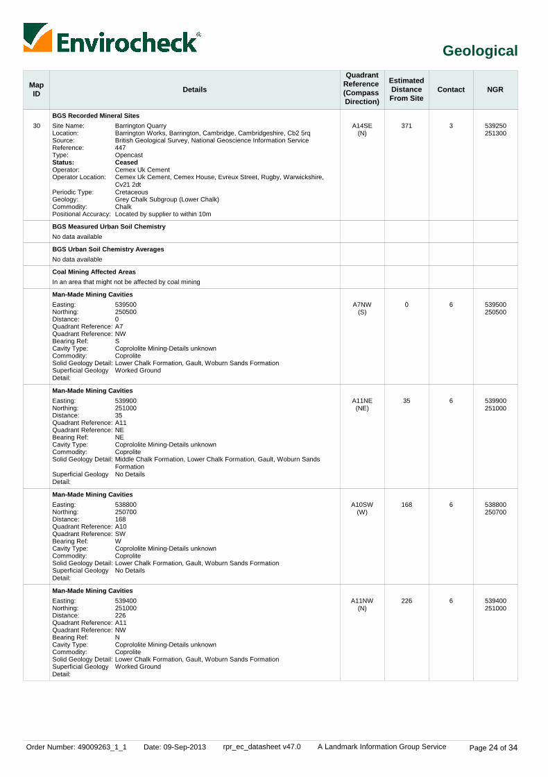
Order Number: 49009263_1_1 Date: 09-Sep-2013 rpr_ec_datasheet v47.0 A Landmark Information Group Service Page 24 of 34
Geological
MapID Details
QuadrantReference (Compass Direction)
EstimatedDistanceFrom Site
Contact NGR
30BGS Recorded Mineral Sites
BGS Measured Urban Soil Chemistry
BGS Urban Soil Chemistry Averages
Coal Mining Affected Areas
Man-Made Mining Cavities
Man-Made Mining Cavities
Man-Made Mining Cavities
Man-Made Mining Cavities
A14SE(N)
A7NW(S)
A11NE(NE)
A10SW(W)
A11NW(N)
371
0
35
168
226
3
6
6
6
6
Site Name:Location:Source:Reference:Type:Status:Operator:Operator Location:
Periodic Type:Geology:Commodity:Positional Accuracy:
Easting:Northing:Distance:Quadrant Reference:Quadrant Reference:Bearing Ref:Cavity Type:Commodity:Solid Geology Detail:Superficial Geology Detail:
Easting:Northing:Distance:Quadrant Reference:Quadrant Reference:Bearing Ref:Cavity Type:Commodity:Solid Geology Detail:
Superficial Geology Detail:
Easting:Northing:Distance:Quadrant Reference:Quadrant Reference:Bearing Ref:Cavity Type:Commodity:Solid Geology Detail:Superficial Geology Detail:
Easting:Northing:Distance:Quadrant Reference:Quadrant Reference:Bearing Ref:Cavity Type:Commodity:Solid Geology Detail:Superficial Geology Detail:
Barrington QuarryBarrington Works, Barrington, Cambridge, Cambridgeshire, Cb2 5rqBritish Geological Survey, National Geoscience Information Service447OpencastCeasedCemex Uk CementCemex Uk Cement, Cemex House, Evreux Street, Rugby, Warwickshire, Cv21 2dtCretaceousGrey Chalk Subgroup (Lower Chalk)ChalkLocated by supplier to within 10m
5395002505000A7NWSCoprololite Mining-Details unknownCoproliteLower Chalk Formation, Gault, Woburn Sands FormationWorked Ground
53990025100035A11NENECoprololite Mining-Details unknownCoproliteMiddle Chalk Formation, Lower Chalk Formation, Gault, Woburn Sands FormationNo Details
538800250700168A10SWWCoprololite Mining-Details unknownCoproliteLower Chalk Formation, Gault, Woburn Sands FormationNo Details
539400251000226A11NWNCoprololite Mining-Details unknownCoproliteLower Chalk Formation, Gault, Woburn Sands FormationWorked Ground
No data available
No data available
In an area that might not be affected by coal mining
539250251300
539500250500
539900251000
538800250700
539400251000

Order Number: 49009263_1_1 Date: 09-Sep-2013 rpr_ec_datasheet v47.0 A Landmark Information Group Service Page 25 of 34
Geological
MapID Details
QuadrantReference (Compass Direction)
EstimatedDistanceFrom Site
Contact NGR
Man-Made Mining Cavities
Non Coal Mining Areas of Great Britain
Non Coal Mining Areas of Great Britain
Non Coal Mining Areas of Great Britain
Potential for Collapsible Ground Stability Hazards
Potential for Collapsible Ground Stability Hazards
Potential for Collapsible Ground Stability Hazards
Potential for Compressible Ground Stability Hazards
Potential for Compressible Ground Stability Hazards
Potential for Compressible Ground Stability Hazards
Potential for Compressible Ground Stability Hazards
Potential for Ground Dissolution Stability Hazards
Potential for Ground Dissolution Stability Hazards
Potential for Ground Dissolution Stability Hazards
Potential for Ground Dissolution Stability Hazards
Potential for Landslide Ground Stability Hazards
Potential for Landslide Ground Stability Hazards
Potential for Landslide Ground Stability Hazards
A14SE(NW)
A11SW(SE)
A11SE(E)
A7SW(S)
A11SW(SE)
A11SE(E)
A7SW(S)
A11SW(SE)
A11NE(NE)
A11SE(E)
A7SW(S)
A11NW(NE)
A11NW(N)
A11NE(NE)
A11NE(NE)
A11SW(SE)
A6NE(SW)
A11SE(E)
461
0
133
195
0
133
195
0
111
133
195
137
190
208
224
0
0
133
6
3
3
3
3
3
3
3
3
3
3
3
3
3
3
3
3
3
Easting:Northing:Distance:Quadrant Reference:Quadrant Reference:Bearing Ref:Cavity Type:Commodity:Solid Geology Detail:
Superficial Geology Detail:
Risk:Source:
Risk:Source:
Risk:Source:
Hazard Potential:Source:
Hazard Potential:Source:
Hazard Potential:Source:
Hazard Potential:Source:
Hazard Potential:Source:
Hazard Potential:Source:
Hazard Potential:Source:
Hazard Potential:Source:
Hazard Potential:Source:
Hazard Potential:Source:
Hazard Potential:Source:
Hazard Potential:Source:
Hazard Potential:Source:
Hazard Potential:Source:
539100251400461A14SENWCoprololite Mining-Details unknownCoproliteMiddle Chalk Formation, Lower Chalk Formation, Gault, Woburn Sands FormationWorked Ground
RareBritish Geological Survey, National Geoscience Information Service
RareBritish Geological Survey, National Geoscience Information Service
RareBritish Geological Survey, National Geoscience Information Service
Very LowBritish Geological Survey, National Geoscience Information Service
Very LowBritish Geological Survey, National Geoscience Information Service
Very LowBritish Geological Survey, National Geoscience Information Service
No HazardBritish Geological Survey, National Geoscience Information Service
ModerateBritish Geological Survey, National Geoscience Information Service
No HazardBritish Geological Survey, National Geoscience Information Service
No HazardBritish Geological Survey, National Geoscience Information Service
Very LowBritish Geological Survey, National Geoscience Information Service
No HazardBritish Geological Survey, National Geoscience Information Service
Very LowBritish Geological Survey, National Geoscience Information Service
No HazardBritish Geological Survey, National Geoscience Information Service
Very LowBritish Geological Survey, National Geoscience Information Service
No HazardBritish Geological Survey, National Geoscience Information Service
No HazardBritish Geological Survey, National Geoscience Information Service
539100251400
539450250668
540001250668
539450250001
539450250668
540001250668
539450250001
539450250668
539869251129
540001250668
539450250001
539662251092
539651251156
540001251145
540001251165
539450250668
539259250573
540001250668

Order Number: 49009263_1_1 Date: 09-Sep-2013 rpr_ec_datasheet v47.0 A Landmark Information Group Service Page 26 of 34
Geological
MapID Details
QuadrantReference (Compass Direction)
EstimatedDistanceFrom Site
Contact NGR
Potential for Landslide Ground Stability Hazards
Potential for Landslide Ground Stability Hazards
Potential for Running Sand Ground Stability Hazards
Potential for Running Sand Ground Stability Hazards
Potential for Running Sand Ground Stability Hazards
Potential for Running Sand Ground Stability Hazards
Potential for Running Sand Ground Stability Hazards
Potential for Shrinking or Swelling Clay Ground Stability Hazards
Potential for Shrinking or Swelling Clay Ground Stability Hazards
Potential for Shrinking or Swelling Clay Ground Stability Hazards
Potential for Shrinking or Swelling Clay Ground Stability Hazards
Potential for Shrinking or Swelling Clay Ground Stability Hazards
Radon Potential - Radon Protection Measures
Radon Potential - Radon Affected Areas
A7SW(S)
A11NE(NE)
A6NE(SW)
A11SW(SE)
A11SE(E)
A7SW(S)
A11NE(NE)
A11SW(SE)
A11SE(E)
A11NW(NE)
A7SW(S)
A11NE(NE)
A11SW(SE)
A11SW(SE)
195
208
0
0
133
195
208
0
133
137
195
208
0
0
3
3
3
3
3
3
3
3
3
3
3
3
3
3
Hazard Potential:Source:
Hazard Potential:Source:
Hazard Potential:Source:
Hazard Potential:Source:
Hazard Potential:Source:
Hazard Potential:Source:
Hazard Potential:Source:
Hazard Potential:Source:
Hazard Potential:Source:
Hazard Potential:Source:
Hazard Potential:Source:
Hazard Potential:Source:
Protection Measure:
Source:
Affected Area:
Source:
No HazardBritish Geological Survey, National Geoscience Information Service
Very LowBritish Geological Survey, National Geoscience Information Service
No HazardBritish Geological Survey, National Geoscience Information Service
Very LowBritish Geological Survey, National Geoscience Information Service
No HazardBritish Geological Survey, National Geoscience Information Service
No HazardBritish Geological Survey, National Geoscience Information Service
Very LowBritish Geological Survey, National Geoscience Information Service
No HazardBritish Geological Survey, National Geoscience Information Service
No HazardBritish Geological Survey, National Geoscience Information Service
LowBritish Geological Survey, National Geoscience Information Service
No HazardBritish Geological Survey, National Geoscience Information Service
LowBritish Geological Survey, National Geoscience Information Service
No radon protective measures are necessary in the construction of new dwellings or extensionsBritish Geological Survey, National Geoscience Information Service
The property is in an intermediate probability radon area, as between 1 and 3% of homes are above the action levelBritish Geological Survey, National Geoscience Information Service
539450250001
540001251145
539259250573
539450250668
540001250668
539450250001
540001251145
539450250668
540001250668
539662251092
539450250001
540001251145
539450250668
539450250668

Order Number: 49009263_1_1 Date: 09-Sep-2013 rpr_ec_datasheet v47.0 A Landmark Information Group Service Page 27 of 34
Industrial Land Use
MapID Details
QuadrantReference (Compass Direction)
EstimatedDistanceFrom Site
Contact NGR
31
32
Contemporary Trade Directory Entries
Contemporary Trade Directory Entries
A7NE(SE)
A7SE(SE)
5
127
-
-
Name:Location:Classification:Status:Positional Accuracy:
Name:Location:
Classification:Status:Positional Accuracy:
CemexHaslingfield Rd, Barrington, Cambridge, Cambridgeshire, CB22 7RQCement Manufacturers & DistributorsInactiveManually positioned to the road within the address or location
Out Board (Sheriff Technology) LtdUnit 4, Church Meadows, Haslingfield Road, Barrington, Cambridge, CB22 7RGSound Equipment Systems ManufacturersInactiveAutomatically positioned to the address
539750250462
539731250115

Order Number: 49009263_1_1 Date: 09-Sep-2013 rpr_ec_datasheet v47.0 A Landmark Information Group Service Page 28 of 34
Sensitive Land Use
MapID Details
QuadrantReference (Compass Direction)
EstimatedDistanceFrom Site
Contact NGR
33
34
35
Areas of Adopted Green Belt
Nitrate Vulnerable Zones
Sites of Special Scientific Interest
A7NE(E)
A11SW(SE)
A10SE(W)
12
0
0
4
7
8
Authority:Plan Name:Status:Plan Date:
Name:Description:Source:
Name:Multiple Areas:Total Area (m2):Source:Reference:Designation Details:Designation Date:Date Type:
South Cambridgeshire District CouncilCore StrategyAdopted31st January 2007
Not SuppliedNVZ AreaDepartment for Environment, Food and Rural Affairs (DEFRA - formerly FRCA)
Barrington Chalk PitN970726.64Natural England2000301Geological Conservation Review3rd October 1997Notified
539777250571
539450250668
539129250773

Order Number: 49009263_1_1 Date: 09-Sep-2013 rpr_ec_datasheet v47.0 A Landmark Information Group Service Page 29 of 34
Data Currency
Agency & Hydrological Version Update CycleContaminated Land Register Entries and Notices
Discharge Consents
Enforcement and Prohibition Notices
Integrated Pollution Controls
Integrated Pollution Prevention And Control
Local Authority Integrated Pollution Prevention And Control
Local Authority Pollution Prevention and Controls
Local Authority Pollution Prevention and Control Enforcements
Nearest Surface Water Feature
Pollution Incidents to Controlled Waters
Prosecutions Relating to Authorised Processes
Prosecutions Relating to Controlled Waters
Registered Radioactive Substances
River Quality
River Quality Biology Sampling Points
River Quality Chemistry Sampling Points
Substantiated Pollution Incident Register
Water Abstractions
Water Industry Act Referrals
Groundwater Vulnerability
Drift Deposits
Bedrock Aquifer Designations
Superficial Aquifer Designations
Source Protection Zones
Extreme Flooding from Rivers or Sea without Defences
February 2013
July 2013
March 2013
October 2008
July 2013
February 2013
February 2013
February 2013
July 2012
September 1999
March 2013
March 2013
July 2013
November 2001
July 2012
July 2012
July 2013
July 2013
July 2013
January 2011
January 1999
October 2012
October 2012
July 2013
August 2013
Annual Rolling Update
Quarterly
Quarterly
Not Applicable
Quarterly
Annual Rolling Update
Annual Rolling Update
Annual Rolling Update
Quarterly
Not Applicable
Quarterly
Quarterly
Quarterly
Not Applicable
Annually
Annually
Quarterly
Quarterly
Quarterly
Not Applicable
Not Applicable
Annually
Annually
Quarterly
Quarterly
South Cambridgeshire District Council
Environment Agency - Anglian Region
Environment Agency - Anglian Region
Environment Agency - Anglian Region
Environment Agency - Anglian Region
South Cambridgeshire District Council - Environmental Health Department
South Cambridgeshire District Council - Environmental Health Department
South Cambridgeshire District Council - Environmental Health Department
Ordnance Survey
Environment Agency - Anglian Region
Environment Agency - Anglian Region
Environment Agency - Anglian Region
Environment Agency - Anglian Region
Environment Agency - Head Office
Environment Agency - Head Office
Environment Agency - Head Office
Environment Agency - Anglian Region - Central Area
Environment Agency - Anglian Region
Environment Agency - Anglian Region
Environment Agency - Head Office
Environment Agency - Head Office
British Geological Survey - National Geoscience Information Service
British Geological Survey - National Geoscience Information Service
Environment Agency - Head Office
Environment Agency - Head Office

Order Number: 49009263_1_1 Date: 09-Sep-2013 rpr_ec_datasheet v47.0 A Landmark Information Group Service Page 30 of 34
Data Currency
Agency & Hydrological
Waste
Hazardous Substances
Version
Version
Version
Update Cycle
Update Cycle
Update Cycle
Flooding from Rivers or Sea without Defences
Areas Benefiting from Flood Defences
Flood Water Storage Areas
Flood Defences
BGS Recorded Landfill Sites
Historical Landfill Sites
Integrated Pollution Control Registered Waste Sites
Licensed Waste Management Facilities (Landfill Boundaries)
Licensed Waste Management Facilities (Locations)
Local Authority Landfill Coverage
Local Authority Recorded Landfill Sites
Registered Landfill Sites
Registered Waste Transfer Sites
Registered Waste Treatment or Disposal Sites
Control of Major Accident Hazards Sites (COMAH)
Explosive Sites
Notification of Installations Handling Hazardous Substances (NIHHS)
Planning Hazardous Substance Enforcements
Planning Hazardous Substance Consents
August 2013
August 2013
August 2013
August 2013
June 1996
July 2013
October 2008
July 2013
April 2013
May 2000May 2000
April 2003May 2000
March 2003
March 2003
March 2003
August 2013
March 2013
November 2000
November 2012November 2012
November 2012November 2012
Quarterly
Quarterly
Quarterly
Quarterly
Not Applicable
Quarterly
Not Applicable
Quarterly
Quarterly
Not ApplicableNot Applicable
Not ApplicableNot Applicable
Not Applicable
Not Applicable
Not Applicable
Bi-Annually
Bi-Annually
Not Applicable
Annual Rolling UpdateAnnual Rolling Update
Annual Rolling UpdateAnnual Rolling Update
Environment Agency - Head Office
Environment Agency - Head Office
Environment Agency - Head Office
Environment Agency - Head Office
British Geological Survey - National Geoscience Information Service
Environment Agency - Anglian Region - Central Area
Environment Agency - Anglian Region
Environment Agency - Anglian Region - Central Area
Environment Agency - Anglian Region - Central Area
Cambridgeshire County CouncilSouth Cambridgeshire District Council
South Cambridgeshire District CouncilCambridgeshire County Council
Environment Agency - Anglian Region - Central Area
Environment Agency - Anglian Region - Central Area
Environment Agency - Anglian Region - Central Area
Health and Safety Executive
Health and Safety Executive
Health and Safety Executive
Cambridgeshire County CouncilSouth Cambridgeshire District Council
Cambridgeshire County CouncilSouth Cambridgeshire District Council

Order Number: 49009263_1_1 Date: 09-Sep-2013 rpr_ec_datasheet v47.0 A Landmark Information Group Service Page 31 of 34
Data Currency
Geological
Industrial Land Use
Version
Version
Update Cycle
Update Cycle
BGS 1:625,000 Solid Geology
BGS Estimated Soil Chemistry
BGS Recorded Mineral Sites
Brine Compensation Area
Coal Mining Affected Areas
Mining Instability
Non Coal Mining Areas of Great Britain
Potential for Collapsible Ground Stability Hazards
Potential for Compressible Ground Stability Hazards
Potential for Ground Dissolution Stability Hazards
Potential for Landslide Ground Stability Hazards
Potential for Running Sand Ground Stability Hazards
Potential for Shrinking or Swelling Clay Ground Stability Hazards
Radon Potential - Radon Affected Areas
Radon Potential - Radon Protection Measures
Contemporary Trade Directory Entries
Fuel Station Entries
August 1996
January 2010
April 2013
August 2011
January 2012
October 2000
February 2011
February 2011
February 2011
February 2011
February 2011
February 2011
February 2011
July 2011
July 2011
May 2013
August 2013
Not Applicable
Variable
Bi-Annually
Not Applicable
As notified
Not Applicable
Not Applicable
Annually
Annually
Annually
Annually
Annually
Annually
As notified
As notified
Quarterly
Quarterly
British Geological Survey - National Geoscience Information Service
British Geological Survey - National Geoscience Information Service
British Geological Survey - National Geoscience Information Service
Cheshire Brine Subsidence Compensation Board
The Coal Authority - Mining Report Service
Ove Arup & Partners
British Geological Survey - National Geoscience Information Service
British Geological Survey - National Geoscience Information Service
British Geological Survey - National Geoscience Information Service
British Geological Survey - National Geoscience Information Service
British Geological Survey - National Geoscience Information Service
British Geological Survey - National Geoscience Information Service
British Geological Survey - National Geoscience Information Service
British Geological Survey - National Geoscience Information Service
British Geological Survey - National Geoscience Information Service
Thomson Directories
Catalist Ltd - Experian

Order Number: 49009263_1_1 Date: 09-Sep-2013 rpr_ec_datasheet v47.0 A Landmark Information Group Service Page 32 of 34
Data Currency
Sensitive Land Use Version Update CycleAreas of Adopted Green Belt
Areas of Unadopted Green Belt
Areas of Outstanding Natural Beauty
Environmentally Sensitive Areas
Forest Parks
Local Nature Reserves
Marine Nature Reserves
National Nature Reserves
National Parks
Nitrate Sensitive Areas
Nitrate Vulnerable Zones
Ramsar Sites
Sites of Special Scientific Interest
Special Areas of Conservation
Special Protection Areas
August 2013
August 2013
July 2013
July 2013
April 1997
July 2013
July 2013
July 2013
July 2013
February 2012
February 2013
July 2013
July 2013
July 2013
July 2013
As notified
As notified
Bi-Annually
Annually
Not Applicable
Bi-Annually
Bi-Annually
Bi-Annually
Bi-Annually
Not Applicable
Annually
Bi-Annually
Bi-Annually
Bi-Annually
Bi-Annually
South Cambridgeshire District Council
South Cambridgeshire District Council
Natural England
Natural England
Forestry Commission
Natural England
Natural England
Natural England
Natural England
Department for Environment, Food and Rural Affairs (DEFRA - formerly FRCA)
Department for Environment, Food and Rural Affairs (DEFRA - formerly FRCA)
Natural England
Natural England
Natural England
Natural England

Order Number: 49009263_1_1 Date: 09-Sep-2013 rpr_ec_datasheet v47.0 A Landmark Information Group Service Page 33 of 34
Data Suppliers
Ordnance Survey
Environment Agency
Scottish Environment Protection Agency
The Coal Authority
British Geological Survey
Centre for Ecology and Hydrology
Countryside Council for Wales
Scottish Natural Heritage
Natural England
Health Protection Agency
Ove Arup
Peter Brett Associates
Data Supplier Data Supplier Logo
A selection of organisations who provide data within this report

Order Number: 49009263_1_1 Date: 09-Sep-2013 rpr_ec_datasheet v47.0 A Landmark Information Group Service Page 34 of 34
Useful Contacts
Contact Name and Address Contact Details
1
2
3
4
5
6
7
8
9
-
-
Environment Agency - National Customer Contact Centre (NCCC)
South Cambridgeshire District Council - EnvironmentalHealth Department
British Geological Survey - Enquiry Service
South Cambridgeshire District Council
Landmark Information Group Limited
Peter Brett Associates
Department for Environment, Food and Rural Affairs (DEFRA - formerly FRCA)
Natural England
Cambridgeshire County Council
Health Protection Agency - Radon Survey, Centre for Radiation, Chemical and Environmental Hazards
Landmark Information Group Limited
PO Box 544, Templeborough, Rotherham, S60 1BY
118 Water Lane, Oakington, Cambridge, Cambridgeshire, CB4 5AL
British Geological Survey, Kingsley Dunham Centre, Keyworth, Nottingham, Nottinghamshire, NG12 5GG
South Cambridgeshire Hall, Cambourne Business Park, Cambourne, Cambridgeshire, CB3 6EA
Imperium, Imperial Way, Reading, Berkshire, RG2 0TD
Caversham Bridge House, Waterman Place, Reading, Berkshire, RG1 8DN
Government Buildings, Otley Road, Lawnswood, Leeds, West Yorkshire, LS16 5QT
Northminster House, Northminster Road, Peterborough, Cambridgeshire, PE1 1UA
Shire Hall, Castle Hill, Cambridge, Cambridgeshire, CB3 OAP
Chilton, Didcot, Oxfordshire, OX11 0RQ
Imperium, Imperial Way, Reading, Berkshire, RG2 0TD
Telephone: 08708 506 506Email: [email protected]
Telephone: 01223 443132Fax: 01223 301027Website: www.scambs.gov.uk
Telephone: 0115 936 3143Fax: 0115 936 3276Email: [email protected]: www.bgs.ac.uk
Telephone: 08450 450 500Website: www.scambs.gov.uk
Telephone: 0844 844 9952Fax: 0844 844 9951Email: [email protected]: www.landmarkinfo.co.uk
Telephone: 0118 950 0761Fax: 0118 959 7498Email: [email protected]: www.pba.co.uk
Telephone: 0113 2613333Fax: 0113 230 0879
Telephone: 0845 600 3078Fax: 01733 455103Email: [email protected]: www.naturalengland.org.uk
Telephone: 01223 717111Fax: 01223 717201Website: www.camcnty.gov.uk
Telephone: 01235 822622Fax: 01235 833891Email: [email protected]: www.hpa.org.uk
Telephone: 0844 844 9952Fax: 0844 844 9951Email: [email protected]: www.landmarkinfo.co.uk
Please note that the Environment Agency / SEPA have a charging policy in place for enquiries.

Order Details
Site DetailsRugby Cement, Haslingfield Road, Barrington, CAMBRIDGE, CB22 7RQ
Order Number:Customer Ref:National Grid Reference:Slice:Site Area (Ha):Search Buffer (m):
49009263_1_1232348-00539450, 250670A31.1500
Tel:Fax:Web:
0844 844 99520844 844 9951www.envirocheck.co.uk
Page 1 of 3A Landmark Information Group Service v47.0 09-Sep-2013
Site Sensitivity Map - Slice A

Order Details
Site DetailsRugby Cement, Haslingfield Road, Barrington, CAMBRIDGE, CB22 7RQ
Order Number:Customer Ref:National Grid Reference:Slice:Site Area (Ha):Search Buffer (m):
49009263_1_1232348-00539450, 250670A31.1500
Tel:Fax:Web:
0844 844 99520844 844 9951www.envirocheck.co.uk
Page 2 of 3A Landmark Information Group Service v47.0 09-Sep-2013
Flood Map - Slice A

Order Details
Site DetailsRugby Cement, Haslingfield Road, Barrington, CAMBRIDGE, CB22 7RQ
Order Number:Customer Ref:National Grid Reference:Slice:Site Area (Ha):Search Buffer (m):
49009263_1_1232348-00539450, 250670A31.1500
Tel:Fax:Web:
0844 844 99520844 844 9951www.envirocheck.co.uk
Page 3 of 3A Landmark Information Group Service v47.0 09-Sep-2013
Borehole Map - Slice A
For Borehole information please refer to the Borehole .csv file which accompanied this slice.
A copy of the BGS Borehole Ordering Form is available to download from the Support section of www.envirocheck.co.uk.

Order Details
Site DetailsRugby Cement, Haslingfield Road, Barrington, CAMBRIDGE, CB22 7RQ
Order Details:Customer Ref:National Grid Reference:Slice:Site Area (Ha):Search Buffer (m):
49009263_1_1232348-00539450, 250670A31.1500
Tel:Fax:Web:
0844 844 99520844 844 9951www.envirocheck.co.uk
Page 1 of 5A Landmark Information Group Service v47.0 09-Sep-2013
Estimated Soil Chemistry Arsenic - Slice A

Order Details
Site DetailsRugby Cement, Haslingfield Road, Barrington, CAMBRIDGE, CB22 7RQ
Order Details:Customer Ref:National Grid Reference:Slice:Site Area (Ha):Search Buffer (m):
49009263_1_1232348-00539450, 250670A31.1500
Tel:Fax:Web:
0844 844 99520844 844 9951www.envirocheck.co.uk
Page 2 of 5A Landmark Information Group Service v47.0 09-Sep-2013
Estimated Soil Chemistry Cadmium - Slice A
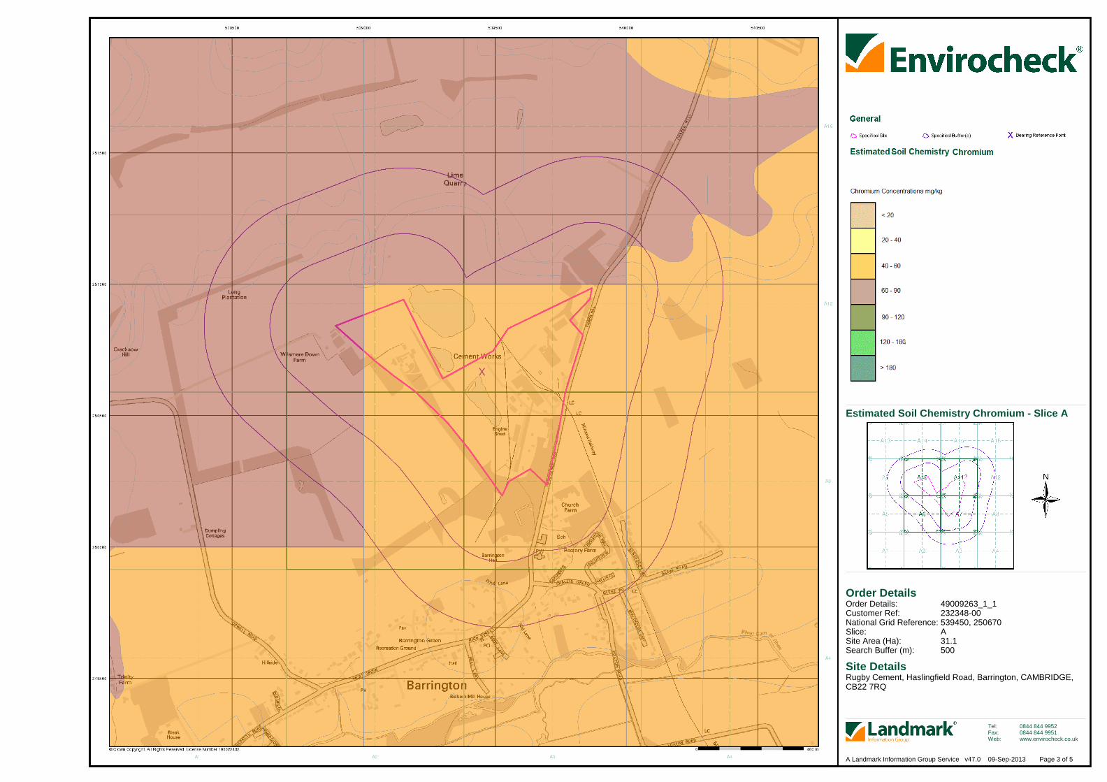
Order Details
Site DetailsRugby Cement, Haslingfield Road, Barrington, CAMBRIDGE, CB22 7RQ
Order Details:Customer Ref:National Grid Reference:Slice:Site Area (Ha):Search Buffer (m):
49009263_1_1232348-00539450, 250670A31.1500
Tel:Fax:Web:
0844 844 99520844 844 9951www.envirocheck.co.uk
Page 3 of 5A Landmark Information Group Service v47.0 09-Sep-2013
Estimated Soil Chemistry Chromium - Slice A

Order Details
Site DetailsRugby Cement, Haslingfield Road, Barrington, CAMBRIDGE, CB22 7RQ
Order Details:Customer Ref:National Grid Reference:Slice:Site Area (Ha):Search Buffer (m):
49009263_1_1232348-00539450, 250670A31.1500
Tel:Fax:Web:
0844 844 99520844 844 9951www.envirocheck.co.uk
Page 4 of 5A Landmark Information Group Service v47.0 09-Sep-2013
Estimated Soil Chemistry Lead - Slice A

Order Details
Site DetailsRugby Cement, Haslingfield Road, Barrington, CAMBRIDGE, CB22 7RQ
Order Details:Customer Ref:National Grid Reference:Slice:Site Area (Ha):Search Buffer (m):
49009263_1_1232348-00539450, 250670A31.1500
Tel:Fax:Web:
0844 844 99520844 844 9951www.envirocheck.co.uk
Page 5 of 5A Landmark Information Group Service v47.0 09-Sep-2013
Estimated Soil Chemistry Nickel - Slice A

Order Details
Site Details
Full Terms and Conditions can be found on the following link:
Rugby Cement, Haslingfield Road, Barrington, CAMBRIDGE, CB22 7RQ
http://www.landmarkinfo.co.uk/Terms/Show/430
Order Number:Customer Ref:National Grid Reference:Site Area (Ha):Search Buffer (m):
49009263_1_1232348-00539470, 25062031.1500
Tel:Fax:Web:
0844 844 99520844 844 9951www.envirocheck.co.uk
Page 1 of 1A Landmark Information Group Service v47.0 09-Sep-2013
Index Map
Slice
Segment
Quadrant
Client Details
For ease of identification, your site and buffer have been split into Slices, Segments and Quadrants. These are illustrated on the Index Map opposite and explained further below.
Each slice represents a 1:10,000 plot area (2.7km x 2.7km) for your site and buffer. A large site and buffer may be made up of several slices (representedby a red outline), that are referenced by letters of the alphabet, starting from the bottom left corner of the slice "grid". This grid does not relate to National Grid lines but is designed to give best fit over the site and buffer.
A segment represents a 1:2,500 plot area. Segments that have plot files associated with them are shown in dark green, others in light blue. These arenumbered from the bottom left hand corner within each slice.
A quadrant is a quarter of a segment. These are labelled as NW, NE, SW, SE and are referenced in the datasheet to allow features to be quickly locatedon plots. Therefore a feature that has a quadrant reference of A7NW will be in Slice A, Segment 7 and the NW Quadrant.
A selection of organisations who provide data within this report:
Envirocheck reports are compiled from 136 different sources of data.
Ms L Taylor, Ove Arup & Partners International Ltd, New Oxford House, 30 Barkers Pool, Sheffield, South Yorkshire,S1 2HB

Appendix B
Groundwater and Surface Water Monitoring

CEMEX UK Cement Ltd Barrington Cement Works Surrender Site Condition Report EPR/BK09731K/S007
BCW-EP-REP001 | Issue | 7 January 2014 J:\230000\232348-00\0 ARUP\0-03 GROUND ENGINEERING\0-03-08 REPORTS\ISSUE SURRENDER REPORT\SURRENDER SITE CONDITION REPORT ISSUE.DOCX
Page B1
B1 Groundwater

4th Floor, New Oxford House
30 Barkers Pool, Sheffield S1 2HB
Tel +44 (0)114 272 8247 Fax +44 (0)114 275 9553
www.arup.com
A3 A
1
B C D E F G H
2
3
4
5
Do not scale
Issue Date By Chkd Appd
Job Title
© Arup
Job No
Discipline
Scale at A3
Drawing No Issue
Drawing Status
Client
Barrington Cement Works
CEMEX (UK)
Groundwater monitoringdata - Alkalinity
232348-00
Chart 1 1
Preliminary
0
100
200
300
400
500
600
700
800
900
1000
14/01/2004 28/05/2005 10/10/2006 22/02/2008 06/07/2009 18/11/2010 01/04/2012 14/08/2013 27/12/2014
Alk
alin
ity
(mg/
l)
1/01
BH2A
BH3
BH4
BH90/4
BH97/1
Linear (lowerbaseline limit)
Linear (upperbaseline limit)
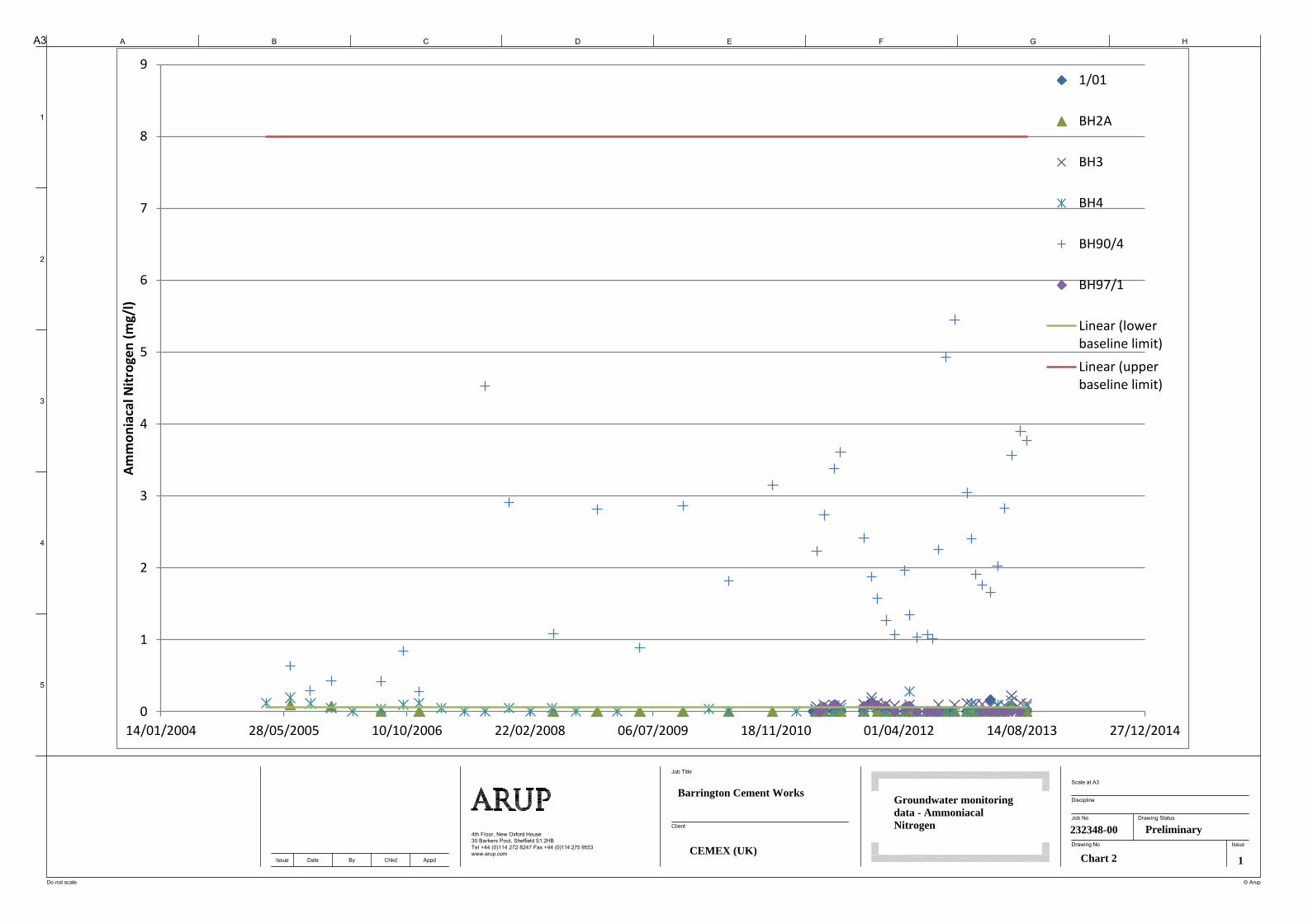
4th Floor, New Oxford House
30 Barkers Pool, Sheffield S1 2HB
Tel +44 (0)114 272 8247 Fax +44 (0)114 275 9553
www.arup.com
A3 A
1
B C D E F G H
2
3
4
5
Do not scale
Issue Date By Chkd Appd
Job Title
© Arup
Job No
Discipline
Scale at A3
Drawing No Issue
Drawing Status
Client
Barrington Cement Works
CEMEX (UK)
Groundwater monitoringdata - AmmoniacalNitrogen 232348-00
Chart 2 1
Preliminary
0
1
2
3
4
5
6
7
8
9
14/01/2004 28/05/2005 10/10/2006 22/02/2008 06/07/2009 18/11/2010 01/04/2012 14/08/2013 27/12/2014
Am
mo
nia
cal N
itro
gen
(m
g/l)
1/01
BH2A
BH3
BH4
BH90/4
BH97/1
Linear (lowerbaseline limit)
Linear (upperbaseline limit)

4th Floor, New Oxford House
30 Barkers Pool, Sheffield S1 2HB
Tel +44 (0)114 272 8247 Fax +44 (0)114 275 9553
www.arup.com
A3 A
1
B C D E F G H
2
3
4
5
Do not scale
Issue Date By Chkd Appd
Job Title
© Arup
Job No
Discipline
Scale at A3
Drawing No Issue
Drawing Status
Client
Barrington Cement Works
CEMEX (UK)
Groundwater monitoringdata - Calcium
232348-00
Chart 3 1
Preliminary
0
50
100
150
200
250
300
350
400
450
500
14/01/2004 28/05/2005 10/10/2006 22/02/2008 06/07/2009 18/11/2010 01/04/2012 14/08/2013 27/12/2014
Cal
ciu
m (
mg/
l)
1/01
BH2A
BH3
BH4
BH90/4
BH97/1
Linear (lowerbaseline limit)
Linear (upperbaseline limit)

4th Floor, New Oxford House
30 Barkers Pool, Sheffield S1 2HB
Tel +44 (0)114 272 8247 Fax +44 (0)114 275 9553
www.arup.com
A3 A
1
B C D E F G H
2
3
4
5
Do not scale
Issue Date By Chkd Appd
Job Title
© Arup
Job No
Discipline
Scale at A3
Drawing No Issue
Drawing Status
Client
Barrington Cement Works
CEMEX (UK)
Groundwater monitoringdata - Chloride
232348-00
Chart 4 1
Preliminary
0
100
200
300
400
500
600
14/01/2004 28/05/2005 10/10/2006 22/02/2008 06/07/2009 18/11/2010 01/04/2012 14/08/2013 27/12/2014
Ch
lori
de
(m
g/l)
1/01
BH2A
BH3
BH4
BH90/4
BH97/1
Linear (lowerbaseline limit)Linear (lowerbaseline limit)

4th Floor, New Oxford House
30 Barkers Pool, Sheffield S1 2HB
Tel +44 (0)114 272 8247 Fax +44 (0)114 275 9553
www.arup.com
A3 A
1
B C D E F G H
2
3
4
5
Do not scale
Issue Date By Chkd Appd
Job Title
© Arup
Job No
Discipline
Scale at A3
Drawing No Issue
Drawing Status
Client
Barrington Cement Works
CEMEX (UK)
Groundwater monitoringdata - Chemical OxygenDemand (COD) 232348-00
Chart 5 1
Preliminary
0
10
20
30
40
50
60
70
14/01/2004 28/05/2005 10/10/2006 22/02/2008 06/07/2009 18/11/2010 01/04/2012 14/08/2013 27/12/2014
Ch
em
ical
Oxy
gen
De
man
d (
mg/
l)
1/01
BH2A
BH3
BH4
BH90/4
BH97/1
Linear (lowerbaseline limit)
Linear (upperbaseline limit)

4th Floor, New Oxford House
30 Barkers Pool, Sheffield S1 2HB
Tel +44 (0)114 272 8247 Fax +44 (0)114 275 9553
www.arup.com
A3 A
1
B C D E F G H
2
3
4
5
Do not scale
Issue Date By Chkd Appd
Job Title
© Arup
Job No
Discipline
Scale at A3
Drawing No Issue
Drawing Status
Client
Barrington Cement Works
CEMEX (UK)
Groundwater monitoringdata - ElectricalConductivity (field) 232348-00
Chart 6 1
Preliminary
0
500
1000
1500
2000
2500
3000
3500
4000
4500
14/01/2004 28/05/2005 10/10/2006 22/02/2008 06/07/2009 18/11/2010 01/04/2012 14/08/2013 27/12/2014
Ele
ctri
cal C
on
du
ctiv
ity
(fie
ld)
(µS/
cm)
1/01
BH2A
BH3
BH4
BH90/4
BH97/1
Linear (lowerbaseline limit)Linear (upperbaseline limit)

4th Floor, New Oxford House
30 Barkers Pool, Sheffield S1 2HB
Tel +44 (0)114 272 8247 Fax +44 (0)114 275 9553
www.arup.com
A3 A
1
B C D E F G H
2
3
4
5
Do not scale
Issue Date By Chkd Appd
Job Title
© Arup
Job No
Discipline
Scale at A3
Drawing No Issue
Drawing Status
Client
Barrington Cement Works
CEMEX (UK)
Groundwater monitoringdata - ElectricalConductivity 232348-00
Chart 7 1
Preliminary
0
500
1000
1500
2000
2500
3000
3500
4000
14/01/2004 28/05/2005 10/10/2006 22/02/2008 06/07/2009 18/11/2010 01/04/2012 14/08/2013 27/12/2014
Ele
ctri
cal C
on
du
ctiv
ity
(µS/
cm)
1/01
BH2A
BH3
BH4
BH90/4
BH97/1
Linear (lowerbaseline limit)Linear (upperbaseline limit)

4th Floor, New Oxford House
30 Barkers Pool, Sheffield S1 2HB
Tel +44 (0)114 272 8247 Fax +44 (0)114 275 9553
www.arup.com
A3 A
1
B C D E F G H
2
3
4
5
Do not scale
Issue Date By Chkd Appd
Job Title
© Arup
Job No
Discipline
Scale at A3
Drawing No Issue
Drawing Status
Client
Barrington Cement Works
CEMEX (UK)
Groundwater monitoringdata - Fluoride
232348-00
Chart 8 1
Preliminary
0
0.2
0.4
0.6
0.8
1
1.2
14/01/2004 28/05/2005 10/10/2006 22/02/2008 06/07/2009 18/11/2010 01/04/2012 14/08/2013 27/12/2014
Flu
ori
de
(m
g/l)
1/01
BH2A
BH3
BH4
BH90/4
BH97/1
Linear (lower baseline limit)
Linear (upper baseline limit)

4th Floor, New Oxford House
30 Barkers Pool, Sheffield S1 2HB
Tel +44 (0)114 272 8247 Fax +44 (0)114 275 9553
www.arup.com
A3 A
1
B C D E F G H
2
3
4
5
Do not scale
Issue Date By Chkd Appd
Job Title
© Arup
Job No
Discipline
Scale at A3
Drawing No Issue
Drawing Status
Client
Barrington Cement Works
CEMEX (UK)
Groundwater monitoringdata - Magnesium
232348-00
Chart 9 1
Preliminary
0
200
400
600
800
1000
1200
14/01/2004 28/05/2005 10/10/2006 22/02/2008 06/07/2009 18/11/2010 01/04/2012 14/08/2013 27/12/2014
Mag
ne
siu
m (
mg/
l)
1/01
BH2A
BH3
BH4
BH90/4
BH97/1
Linear (lowerbaseline limit)Linear (upperbaseline limit)

4th Floor, New Oxford House
30 Barkers Pool, Sheffield S1 2HB
Tel +44 (0)114 272 8247 Fax +44 (0)114 275 9553
www.arup.com
A3 A
1
B C D E F G H
2
3
4
5
Do not scale
Issue Date By Chkd Appd
Job Title
© Arup
Job No
Discipline
Scale at A3
Drawing No Issue
Drawing Status
Client
Barrington Cement Works
CEMEX (UK)
Groundwater monitoringdata - Nitrate
232348-00
Chart 10 1
Preliminary
0
10
20
30
40
50
60
14/01/2004 28/05/2005 10/10/2006 22/02/2008 06/07/2009 18/11/2010 01/04/2012 14/08/2013 27/12/2014
Nit
rate
(m
g/l)
1/01
BH2A
BH3
BH4
BH90/4
BH97/1
Linear (lower baseline limit)
Linear (upper baseline limit)

4th Floor, New Oxford House
30 Barkers Pool, Sheffield S1 2HB
Tel +44 (0)114 272 8247 Fax +44 (0)114 275 9553
www.arup.com
A3 A
1
B C D E F G H
2
3
4
5
Do not scale
Issue Date By Chkd Appd
Job Title
© Arup
Job No
Discipline
Scale at A3
Drawing No Issue
Drawing Status
Client
Barrington Cement Works
CEMEX (UK)
Groundwater monitoringdata - pH
232348-00
Chart 11 1
Preliminary
6
6.2
6.4
6.6
6.8
7
7.2
7.4
7.6
7.8
8
14/01/2004 28/05/2005 10/10/2006 22/02/2008 06/07/2009 18/11/2010 01/04/2012 14/08/2013 27/12/2014
pH
1/01
BH2A
BH3
BH4
BH90/4
BH97/1
Linear (lowerbaseline limit)
Linear (upperbaseline limit)

4th Floor, New Oxford House
30 Barkers Pool, Sheffield S1 2HB
Tel +44 (0)114 272 8247 Fax +44 (0)114 275 9553
www.arup.com
A3 A
1
B C D E F G H
2
3
4
5
Do not scale
Issue Date By Chkd Appd
Job Title
© Arup
Job No
Discipline
Scale at A3
Drawing No Issue
Drawing Status
Client
Barrington Cement Works
CEMEX (UK)
Groundwater monitoringdata - pH (field)
232348-00
Chart 12 1
Preliminary
6
6.5
7
7.5
8
8.5
9
9.5
14/01/2004 28/05/2005 10/10/2006 22/02/2008 06/07/2009 18/11/2010 01/04/2012 14/08/2013 27/12/2014
Fie
ld p
H
1/01
BH2A
BH3
BH4
BH90/4
BH97/1
Linear (lowerbaseline limit)
Linear (upperbaseline limit)

4th Floor, New Oxford House
30 Barkers Pool, Sheffield S1 2HB
Tel +44 (0)114 272 8247 Fax +44 (0)114 275 9553
www.arup.com
A3 A
1
B C D E F G H
2
3
4
5
Do not scale
Issue Date By Chkd Appd
Job Title
© Arup
Job No
Discipline
Scale at A3
Drawing No Issue
Drawing Status
Client
Barrington Cement Works
CEMEX (UK)
Groundwater monitoringdata - Potassium
232348-00
Chart 13 1
Preliminary
0
50
100
150
200
250
300
14/01/2004 28/05/2005 10/10/2006 22/02/2008 06/07/2009 18/11/2010 01/04/2012 14/08/2013 27/12/2014
Po
tass
ium
(m
g/l)
1/01
BH2A
BH3
BH4
BH90/4
BH97/1
Linear (lowerbaseline limit)
Linear (upperbaseline limit)

4th Floor, New Oxford House
30 Barkers Pool, Sheffield S1 2HB
Tel +44 (0)114 272 8247 Fax +44 (0)114 275 9553
www.arup.com
A3 A
1
B C D E F G H
2
3
4
5
Do not scale
Issue Date By Chkd Appd
Job Title
© Arup
Job No
Discipline
Scale at A3
Drawing No Issue
Drawing Status
Client
Barrington Cement Works
CEMEX (UK)
Groundwater monitoringdata - Sodium
232348-00
Chart 14 1
Preliminary
0
50
100
150
200
250
300
14/01/2004 28/05/2005 10/10/2006 22/02/2008 06/07/2009 18/11/2010 01/04/2012 14/08/2013 27/12/2014
Sod
ium
(m
g/l)
1/01
BH2A
BH3
BH4
BH90/4
BH97/1
Linear (lowerbaseline limit)Linear (upperbaseline limit)

4th Floor, New Oxford House
30 Barkers Pool, Sheffield S1 2HB
Tel +44 (0)114 272 8247 Fax +44 (0)114 275 9553
www.arup.com
A3 A
1
B C D E F G H
2
3
4
5
Do not scale
Issue Date By Chkd Appd
Job Title
© Arup
Job No
Discipline
Scale at A3
Drawing No Issue
Drawing Status
Client
Barrington Cement Works
CEMEX (UK)
Groundwater monitoringdata - Sulphate
232348-00
Chart 15 1
Preliminary
0
200
400
600
800
1000
1200
1400
1600
1800
14/01/2004 28/05/2005 10/10/2006 22/02/2008 06/07/2009 18/11/2010 01/04/2012 14/08/2013 27/12/2014
Sulp
hat
e (
mg/
l)
1/01
BH2A
BH3
BH4
BH90/4
BH97/1
Linear (lowerbaseline limit)Linear (upperbaseline limit)
CEMEX UK Cement Ltd Barrington Cement Works Surrender Site Condition Report EPR/BK09731K/S007
BCW-EP-REP001 | Issue | 7 January 2014 J:\230000\232348-00\0 ARUP\0-03 GROUND ENGINEERING\0-03-08 REPORTS\ISSUE SURRENDER REPORT\SURRENDER SITE CONDITION REPORT ISSUE.DOCX
Page B2
B2 Surface Water
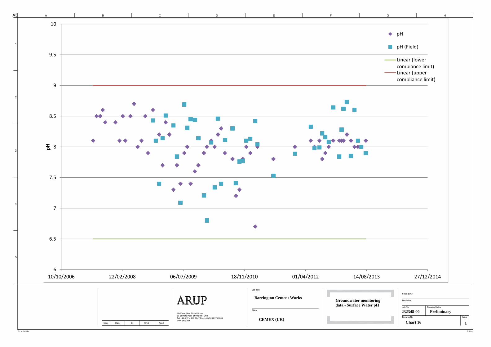
4th Floor, New Oxford House
30 Barkers Pool, Sheffield S1 2HB
Tel +44 (0)114 272 8247 Fax +44 (0)114 275 9553
www.arup.com
A3 A
1
B C D E F G H
2
3
4
5
Do not scale
Issue Date By Chkd Appd
Job Title
© Arup
Job No
Discipline
Scale at A3
Drawing No Issue
Drawing Status
Client
Barrington Cement Works
CEMEX (UK)
Groundwater monitoringdata - Surface Water pH
232348-00
Chart 16 1
Preliminary
6
6.5
7
7.5
8
8.5
9
9.5
10
10/10/2006 22/02/2008 06/07/2009 18/11/2010 01/04/2012 14/08/2013 27/12/2014
pH
pH
pH (Field)
Linear (lowercompiance limit)Linear (uppercompliance limit)

Appendix C
2013 Ground Investigation Factual Report

CEMEX UK Cement Ltd Barrington Cement Works Surrender Site Condition Report
| Draft 1 | 7 January 2014 J:\230000\232348-00\0 ARUP\0-03 GROUND ENGINEERING\0-03-08 REPORTS\ISSUE SURRENDER REPORT\SURRENDER SITE CONDITION REPORT ISSUE.DOCX
Page C1
C1 See separate bound report – ‘Geotechnics’ Factual Report Dec 2013: project number PC135444


