TECHNICAL APPENDIX 8.1 PHASE I TARGET NOTES – WIND FARM DEVELOPMENT
AREA
A report to
E.ON Climate and Renewables
Atmos Report Ref: 4045/R1/Rev1 Issued: 29th June 2009

Ochiltree Wind Farm / Phase 1 Survey Notes]
Disclaimer This report has been prepared by Atmos Consulting Ltd with all reasonable skill and care within the terms of the agreement with the client. We disclaim any responsibility to any parties in respect of matters outside this scope. Information supplied by the client or any other parties and used in this report is assumed to be correct and Atmos Consulting Ltd accepts no responsibility for inaccuracies in the data supplied. Atmos Consulting Ltd accepts no responsibility to third parties who duplicate, use, or disclose this report in whole or in part. Such third parties rely upon this report at their own risk.
Issue Log 4045/R1/Rev1 Document Issued 29th June 2009
Document prepared for EON. Climate & Renewables
Document prepared by
Name Matthew Hopkins Title Senior Consultant Atmos Consulting Ltd Tower Mains Studios 18g Liberton Brae Edinburgh EH16 6AE
Atmos Consulting Ltd In-Business Centre Stadium Business Park 24 Longman Drive Inverness IV1 1SU
Atmos Consulting Ltd Regus House Herald Way Pegasus Business Park Castle Donington DE74 2TX
Atmos Consulting Ltd The Granary Waen Farm Nercwys Road Mold, Flintshire CH7 4EW
Tel: 0131 672 1888 Fax: 0131 672 1999
Tel: 01463 259209 Fax: 01463 259240
Tel: 01332 638014 Tel: 01352 744512 Fax: 01352 700291
www.atmosconsulting.com

Ochiltree Wind Farm / Phase 1 Survey Notes]
Table 1: Botanical Species Lists
Vascular plants – Scientific Names
Velvet bent Agrostis canina Common bent Agrostis capillaris Creeping bent Agrostis stolonifera Bog Rosemary Andromeda polifolia Wood rush Anemone nemorosa Wild Angelica Angelica sylvestris Sweet vernal grass Anthoxanthum odoratum Daisy Bellis perennis Silver birch Betula pendula Birch Betula pubescens Hard Fern Blechnum spicant Common Water-Starwort Callitriche stagnalis Ling-Heath Calluna vulgaris Kingcup – Marsh Marigold -May Blobs
Caltha palustris
Bellflower Campanula rotundifolia Wood Bitter-cress Cardamine flexuosa Cuckoo flower – Lady's-Smock Cardamine pratensis Ribbed Sedge Carex binervis Spring Sedge Carex caryophyllea Tawny Sedge Carex hostiana Common Sedge Carex nigra Carnation – Grass Carex panicea Pill-Headed Sedge Carex pilulifera Flea Sedge Carex pulicaris Beaked Sedge Bottle Sedge Carex rostrata Common Yellow Sedge Carex viridula oedocarpa Lesser Knapweed Centaurea nigra Common Mouse Ear Cerastium fontanum Purple Saxifrage Chrysosplenium oppositifolium Creeping Thistle Cirsium arvense Marsh Thistle Cirsium palustre Spear Thistle Cirsium vulgare Pignut- Earthnut Conopodium majus Hazel - Cob-Nut Corylus avellana Hawthorn Crataegus monogyna Crested Dogs Tail Cynosurus cristatus Cocksfoot Dactylis glomerata Tufted Hair grass Deschampsia cespitosa Wavy hair Grass Deschampsia flexuosa Foxglove Digitalis purpurea Sundew Drosera rotundifolia Narrow Buckler – Fern Dryopteris carthusiana Broad Buckler -Fern Dryopteris dilatata Common Male –Fern Dryopteris filix-mas Marsh Willow Herb Epilobium palustre

Ochiltree Wind Farm / Phase 1 Survey Notes]
Bell Heather Erica cinerea Crossed Leaved Heath Erica tetralix Sheep’s Fescue Festuca ovina Red Fescue Festuca rubra Meadow Sweet Filipendula ulmaria Ash Fraxinus excelsior Marsh Bedstraw Galium palustre Heath Bedstraw Galium saxatile Ivy Hedera helix Yorkshire Fog Holcus lanatus Bluebell Hyancinthoides non-scripta Marsh Pennywort Hydrocotyle vulgaris St Johns Wort Hypericum pulchrum Cats Ear Hypochaeris radicata Lake Quillwort Isoetes lacustris Sharp Flower Rush Juncus acutiflorus Jointed Rush Juncus articulatus Bulbous Rush Juncus bulbosus Soft Rush Juncus effusus Heath Rush Juncus squarrosus Shore weed Littorella uniflora Water Lobelia Lobelia dortmanna Perennial Ryegrass Lolium perenne Common Honeysuckle Lonicera periclymenum Birdsfoot Trefoil Lotus corniculatus Greater Birds Foot trefoil Lotus uliginosus Field Wood Rush Luzula campestris Great Wood-Rush Luzula sylvatica Water Mint Mentha aquatica Purple Moor Grass Molinia caerulea Water-Blinks -Annual Water Miners Lettuce
Montia fontana
Bog Myrtle – Sweet Gale Myrica gale Matt Grass Nardusw stricta Bog Asphodel Narthecium ossifragum Mountain Fern Oreopteris limbosperma Wood Sorrel Oxalis acetosella Loosewort Pedicularis sylvatica Reed Phragmites australis Mouse- Eared Hawk Weed Pilosella officinarum Common Butter-Wort Pinguicula vulgaris Scots Pine Pinus sylvestris Ribwort -Plantain Plantago lanceolata Meadow Grass Poa pratensis Common Milkwort Polygala serpyllifolia Bog Pondweed Potamogeton polygonifolius Common Tormentil Potentilla erecta Marsh cinquefoil Potentilla palustris Primrose Primula vulgaris Self-heal Prunella vulgaris

Ochiltree Wind Farm / Phase 1 Survey Notes]
Gean – Wild Cherry Prunus avium Bracken Pteridium aquilinum Darmask Oak – Sessile Oak Quercus petraea Meadow Buttercup Ranunculus acris Lesser Celandine - Pilewort Ranunculus ficaria Lesser Spearwort Ranunculus flammula Creeping Buttercup Ranunculus repens Blackberry Rubus fruticosus Raspberry Rubus idaeus Sorrel Rumex acetosa Sheeps Sorrel Rumex acetosella Eared Sallow Salix aurita Great Sallow – Goat Willow Salix caprea Common Sallow Salix cinerea Creeping Willow Salix repens Lesser Clubmoss Selaginella selaginoides Rowan – Mountain Ash Sorbus aucuparia Chickweed Stellaria media Bog Stitchwort Stellaria uliginosum Dandelion Taraxacum officinale Wood Sage Teucrium scorodonia Deer-grass Trichophorum cespitosum White Clover – Dutch Clover Trifolium repens Gorse Ulex europaeus Stinging Nettle Urtica dioica Bilberry Vaccinium myrtillus Cranberry Vaccinium oxycoccos Valerian Valeriana officinalis Brooklime Veronica beccabunga Heath Violet Viola canina Marsh Violet Viola palustris

Ochiltree Wind Farm / Phase 1 Survey Notes]
Bryophytes
Aneura pinguis Aulacomium palustre Breutelia chrysocoma Calliergonella cuspidata Campylium stellatum Campylopus atrovirens Campylopus introflexus Cladonia portentosa Climacium dendroides Dicranum scoparium Diplophyllum albicans Hylocomium splendens Hypnum jutlandicum Leucobryum glaucum Mylia taylori Odontoschisma sphagni Philonotis fontana Pleurozium schreberi Rhytidiadelphus loreus Rhytidiadelphus squarrosus Rhytidiadelphus triquetrus Scorpidium revolvens Scorpidium scorpioides Sphagnum capillifolium Sphagnum denticulatum Sphagnum fallax Sphagnum inundatum Sphagnum magellanicum Sphagnum palustre Sphagnum papillosum Sphagnum subnitens Thuidium tamariscinum Warnstofia fluitans
Ochiltree Wind Farm /Extended Phase I Habitat & Species Target Notes
Atmos Consulting Ltd EON Climate & Renewables xxi
Table 2: Target Notes Habitats – May 2008
Target Notes Grid Reference Feature
1 232830 575430 upper part of blanket bog polygon is flattish M17 with Myrica, Erica tetralix, S. capillifolium, Eriophorum vaginatum, Narthecium, Eriophorum angustifolium, Trichophorum; slopes between here &
flatter areas nearer road often Sphagnum-poor, tussocky M25
2 232688 575360 species-poor M6b flush (AF) with Carex nigra, C. panicea, Ranunculus flammula, S. denticulatum
3 232575 575350 Wet heath here at edge & further S on small flattened knolls is Calluna 15-40, Erica tetralix 0-10, Trichophorum 20-60, Pleurozium schreberi 25-50, Molinia 5-30, S. capillifolium 0-15
4 232578 575280 Vaccinium oxycoccos occasional-frequent in this very old peat cutting - relatively Sphagnum-rich blanket bog
5 232575 575233 Sphagnum magellanicum in often heavily trampled blanket bog on flat rise - original surface. S. tenellum, S. capillifolium & S. capillifolium also present
6 232564 575227 Vaccinium oxycoccos on mixed S. cuspidatum-S. capillifolium cushion; Mylia taylori locally abundant nearby, forming low hummocks
7 232549 575194 more Sphagnum magellanicum; Sphagnum cover still averaging 30% (10-60)
8 232486 574992 Acid flush with Carex rostrata
9 232469 575032 Complex mosaic – blanket bog c. 65; marshy grassland-M35, small amounts of wet heath, acid flush & acid grassland; much is c. 50 cm peat, with sometimes more Sphagnum in areas with < 50 cm;
some of complex topography undoubtedly due to very old peat cuttings
10 232444 575146 more Vaccinium oxycoccos on S. capillifolium-S. cuspidatum carpet - locally abundant immediately to N
11 232407 575459 Vaccinium oxycoccos on big S. capillifolium hummock; much, though not all, bog here is Sphagnum-poor tussocky Molinia with E. vaginatum & Myrica
12 232229 575264 Sphagnum magellanicum in waterlogged track
13 232218 575262 conspicuous how much Calluna in forest-bog, with good Sphagnum cover & Vaccinium oxycoccos frequent-abundant
14 232167 575163 shoreline - 5 m wide zone dominated by Juncus effusus, Carex nigra, Hydrocotyle, Ranunculus flammula, Viola palustris, Warnstorfia fluitans, Juncus bulbosus etc; Littorella, Lobelia dortmanna &
Isoetes lacustris all on strandline
15 232235 575049 swamp with Potentilla palustris, Veronica beccabunga, S. denticulatum, Carex nigra, Galium palustre, Ranunculus flammula, Cardamine pratensis, Juncus acutiflorus, Filipendula ulmaria (at N end); emergent in mini-bay - C. rostrata, Phragmites
16 232283 575069 clump of Salix aurita with Potentilla palustris, S. squarrosum, Juncus effusus; 2 Crataegus monogyna on S side
17 232133 574519 Polygon with scrub - Salix aurita with a few Salix cinerea, Crataegus monogyna at edge; Juncus, Potentilla palustris, Cirsium palustre understory
18 232154 574523 SB 70, AG20, MG 10, SS< 1; occasional blanket bog patches in hollows; Viola canina near grid reference
19 232179 574083 Polygon with very complex topography: MG 40-50, SB 25, AG 20-30 with some WH & BB; Anemone nemorosa locally abundant in W
20 231962 573786 small patch of Salix aurita beside wall
21 232205 573914 Vaccinium oxycoccos in BB-M (M25) on deep peat
22 232459 573799 blanket bog with good Sphagnum (Sphagnum magellanicum at grid reference) , Erica tetralix; Vaccinium oxycoccos to W
23 232512 573830 borrow pits' steep sides here have ADH with Polygala serpyllifolia, Viola canina, Campanula rotundifolia; with AG; AF right by road
24 232691 573822 wet heath patch just W of grid reference with very unhealthy Calluna
25 232768 573860 Complicated mosaic - MG 50, WH 30, BB 10 with SB, AF, ADH; MG & AF in depressions, drainage lines, WH on sides tops of knolls, BB in occasional wider basins, mini-valleys
26 232804 574232 PGN - AG 40, WH 30-40, MG 20-30; WH on flatter areas on knolls, MG in between knolls & AG on thinner soils
27 232912 574178 small (40 x 30) basin bog; Molinia-dominated, S. capillifolium main Sphagnum; Vaccinium oxycoccos near grid reference
28 233145 574314 25 m N of here is beginning of lower ground with Molinia dominance & ~ no WH
29 233148 574383 slightly basic flush with Carex viridula oedocarpa, C. panicea, Carex rostrata, Succisa; in matrix of AF with M25 BB-M
30 233041 574595 PGN - BB 60-70 (but mostly BB-M - quite sp.-poor M25), MG 30-40, AF locally prominent
31 232846 574444 BF - M10 – Scorpidium (ex-Drepanocladus) revolvens, Scorpidium scorpidium, Pinguicula vulgaris, Carex viridula oedocarpa, Campylium stellatum; trampled habitat
32 232680 574110 Top of Ochiltree Hill with MG dominant with some patches of AG near summit
33 232468 574245 Basic flush - sp.-poor M10 with Campylium stellatum, Breutelia chrysocoma, C. panicea, Aneura pinguis
34 232488 574384 scattered M10-ish flushes (BF) with Carex viridula oedocarpa, C. panicea in MG here (close to WH, but dwarf-shrubs grazed out)
35 232492 574448 more grassy M10 - BF - Carex viridula oedocarpa, C. panicea, Campylium stellatum, Campylopus atrovirens, Pinguicula vulgaris, Scorpidium revolvens, Selaginella selaginella
36 232577 574635 Area with- MG 70-85, AG 5-10, BF 1-5, SB, ADH; distinguished from MG-dominated polygon to E by BFs; much MG is close to flushed WH; U5c type vegetation frequent
37 232390 574360 Hyacinthoides non-scriptus & Anemone nemorosa (Viola canina slightly less frequent) common on AG-SB slopes opposite Ochiltree cottage (& c. 300 m in both directions)
38 233298 575064 BB-M (Molinia-dominated (70-90%) M25a with scattered Myrica, occasional Sphagnum, Erica tetralix) with MG at fringes, some AF (M6c); N 1/3 has better Sphagnum (S. capillifolium, S. subnitens) & Erica tetralix
39 233131 574940 Polygon - BB 70 (less Molinia-dominated than most in this area, but M-H grazed), MG 20, AF 5-10; Drosera rotundifolia present
40 233141 575168 where MG pgns almost meet, but grid reference is actually MG10 NG around sheilings rubble
41 232723 575031 first of 3 small knolls in polygon which is MG 30-SB 30-AG 20-BB 20, with tops of knolls AG-SB mosaic, sides & some of troughs MG & BB on some flatter valleysides/terraces/mini-basins
42 232951 575265 tiny knoll with some dry heath
Ochiltree Wind Farm /Extended Phase I Habitat & Species Target Notes
Atmos Consulting Ltd EON Climate & Renewables xxii
43 233019 575302 Scattered scrubby Betula pubescens, Sorbus aucuparia
44 232750 574910 Area along road, 80-200 m wide; MG 50 with AG 25, SB 15, also AF, BB, ADH; consists of series of knolls, dissected by flushes, small channels, punctuated by occasional rock outcrops; some flushes almost
basic
45 232546 574610 flushed AG (U4c/CG10b) with Carex pulicaris, C. caryophyllea, C. panicea, C. pilulifera, Plantago lanceolata, Anemone nemorosa, Anthoxanthum, Viola canina; similar areas scattered all along this slope from here S towards Ochiltree cottage; Campylium sp.
46 232537 574523 Carex viridula oedocarpa-C. panicea-Breutelia chrysocoma flushes into AG frequent in this area (extending 70-80 m to S), e.g., at grid ref; U5c-ish; Pedicularis sylvatica rare in this kind of vegetation
47 232511 574466 Carex caryophyllea also here
48 233064 575492 Carex rostrata M4 (AF) in corner by forestry
49 233158 575628 Area - BB 70-75 with frequent AFs, some AG flats, MG; BB often with decent dwarf shrub cover, Sphagnum, but also often trampled, M-H grazed; M6d often in old peat cuttings
50 233337 575788 Area - MG 55, BB 30, AG 15; MG often Sphagnum & Trichophorum-rich; BB badly trampled
51 233240 575975 quite soft BB with Sphagnum papillosum, Trichophorum, Eriophorum vaginatum, E. angustifolium, Erica tetralix, S. capillifolium
52 233131 575988 M4 with Carex rostrata
53 233046 576039 two tiny patches of lichen-rich dry acid heath (grid reference is for E one)
54 232940 576145 very species-poor M25 (BB-M) at NW end before fence
55 232905 576161 Vaccinium oxycoccos in dryish BB
56 232861 576181 Sphagnum magellanicum in good Trichophorum-E. vaginatum-S. capillifolium-S. papillosum-Erica tetralix-Narthecium-Molinia M17 with some Cladonia portentosa & Myrica (Odontoschisma sphagni & Calluna rare);
some hummock-hollow microtopography beginning jus
57 232776 576165 Aulacomnium palustre-S. capillifolium-Vaccinium oxycocos hummock; S. magellanicum nearby
58 232727 576186 patch of Andromeda polifolia on W slope of 'dome'
59 232694 576180 from grid reference W & NW BB becomes more broken, fragmented - 2 small low 'domes' to W & WNW; generally more Molinia water tracks & Molinia encroachment of BB
60 232695 576313 classic M25A BB-M - just Molinia (with some Myrica); much better - with Trichophorum, Erica tetralix, E. vaginatum, S. capillifolium etc - between Barlamachan & Barbegs
61 232596 576378 Vaccinium oxycoccos; BB here more trampled, drier than big good bog to SE, though floristics & Sphagnum good & some (albeit drying) hummock-hollow microtopography;
drain through bog near grid reference
62 232575 576395 Sphagnum magellanicum with Vaccinium oxycoccos at grid reference (more to NW); moor grips at c. 30 m intervals - look to be 10-20 years old; S. cuspidatum 'flats' common in this area
63 232456 576426 more Andromeda - probably more widespread
64 232266 576277 Conopodium majus & Viola canina, Anemone nemorosa in U20a (CB)
65 232175 576467 Vaccinium oxycoccos in small patch of wet heath-like BB
66 232189 576527 PGN - BB-M mainly (c. 66%), some Sphagnum-rich BB with Erica tetralix; accompanied by MG, AG, SB, ADH; topography complex - scattered drainage lines, knolls with rocky outcrops, etc
67 232344 576685 rock outcrops & knolls by river, e.g., at grid reference, with AG, CB, trees (e.g., Fraxinus, Crataegus monogyna, Sorbus aucuparia); CB has Anemone nemorosa, Oxalis acetosella, Digitalis, Conopodium majus' so is AG dominating
68 232479 576696 Centaurea nigra with Luzula sylvatica, Conopodium majus, Oreopteris limbosperma, Blechnum; Carex binervis nearby
69 232521 576697 Filipendula ulmaria with Chrysosplenium oppositifolium, Montia fontana, Epilobium palustre, Valeriana officinalis, Stellaria uliginosum
70 232661 576686 Mentha aquatica with Chrysosplenium oppositifolium, Juncus acutiflorus, Valeriana officinalis, Hydrocotyle
71 232779 576760 Carex caryophyllea in U4b - AG
72 232821 576772 spring with Philonotis fontana, Calliergonella cuspidata, Climacium dendroides
73 232955 576528 BB around grid reference - Erica tetralix, E. vaginatum-rich, but quite dry - Sphagnum at significantly lower cover than bogs to N
74 233169 576819 BB here quite good - Trichophorum-Eriophorum vaginatum-S. capillifolium-S.papillosum-Erica tetralix-Narthecium; Molinia only 5-15% cover; however, no hummock-hollow patterning
75 233306 576499 NW corner of polygon with undulating topography, including several rock outcrops - MG 40, WH 25 with ADH, BB, AG, AF
76 233520 575913 Carex caryophyllea in slightly species-rich AG on grassy hummock overlooking track
77 232978 575018 Patchy wet heath within marshy grassland on slope above rocks. Curlew and drumming snipe.
78 232862 574839 Drain with Achillea ptarmica, Hypericum pulchrum and Blechnum spicant.
79 232807 574818 Stream channel, with Viola palustris, Ranunculus acris, Potamogeton polygonifolius and Rumex acetosa.
80 232808 574861 Ridge along stream with grassy dry acid heath, with locally abundant, heavily-grazed Calluna vulgaris.
81 232784 574918 Rock outcrop with dry acid heath, with heavily-grazed Calluna vulgaris, Cladonia portentosa, Leucobryum glaucum and Carex binervis. Scrub and rocks here with Whitethroat, Wheatear and Stonechat.
82 233204 575266 Molinia-dominated bog with abundant soft, wet Sphagnum papillosum, S. capillifolium and S. subnitens.
83 233223 575262 Eared willow by M23 flush crossing wall
84 233242 575135 Edge of semi-improved grassland field with old ruined boundary wall.
85 233334 574960 Anemone nemorosa abundant in marshy grassland dominated by Molinia caerulea with Myrica gale, such habitat frequent across whole site.
86 233383 574842 Small areas of species-poor acid flush within marshy grassland and bog areas, usually associated with old drains.
87 233504 574980 Basic flush with Carex panicea, Carex viridula oedicarpa, Carex hostiana and Scorpidium scorpioides.
Ochiltree Wind Farm /Extended Phase I Habitat & Species Target Notes
Atmos Consulting Ltd EON Climate & Renewables xxiii
88 233543 574990 Wide flushed area with Caltha palustris, Ranunculus ficaria, Anemone nemorosa, Viola palustris, Juncus articulatus and Carex panicea.
89 233569 575011 Flushed area
90 233581 575020 Small stream with trampled margins, with Juncus articulatus, Ranunculus acris, Carex panicea, Carex viridula oedicarpa.
91 233720 575078 Acid grassland here with frequent Carex caryophyllea and Luzula campestris.
92 233750 575091 Acid flush with Molinia caerulea, Carex panicea, C. viridula oedicarpa, C. nigra and Sphagnum denticulatum.
93 234079 575342 Fieldcorner with ash, downy birch, Juncus effusus, Holcus lanatus, Agrostis stolonifera and Ranunculus repens.
94 234111 575383 Small patch of woodland in hollow surrounded by old ruined boundary wall with downy birch, ash, wild cherry and hawthorn.
95 233999 575371 Edge of woodland with old sallow, downy birch, ash, wild cherry, hawthorn and a wet, flushed field layer with Ranunculus ficaria, Deschampsia cespitosa, Viola canina, Filipendula ulmaria, Cirsium palustre and scattered Primula vulgaris.
96 233925 575389 Wet woodland close to fence dominated by downy birch and eared willow, field layer locally with Molinia caerulea.
97 233956 575425 Old hazel coppice with mature ash close to old, ruined boundary wall. Field layer with Digitalis purpurea, Oxalis acetosella, Urtica dioica and Viola canina.
98 233936 575467 Open woodland on old grassy bank with frequent bluebells Hyacinthoides non-scripta, frequent dead wood.
99 233921 575494 Woodland margin here with sallow and marginal strip of marshy grassland.
100 233867 575534 Marshy grassland around drain with Angelica sylvestris, Dryopteris carthusiana, Valeriana officinalis and Filipendula ulmaria.
101 233836 575549 Marshy grassland with abundant birch seedlings and saplings, all heavily browsed.
102 233717 575570 Main woodland cattle-grazed and trampled, downy birch, ash and hawthorn over a grassy field layer.
103 233590 575543 Grazed woodland fieldlayer with scattered bluebell leaves, no flowerheads.
104 233520 575272 Flushes on woodland margin with eared willow, sallow, Filipendula ulmaria and Anemone nemorosa.
105 233406 575284 Functioning drain with Potamogeton polygonifolius, Juncus effusus, J. articulatus and Sphagnum denticulatum.
106 233340 575359 scattered knolls and raised ground with locally abundant Calluna vulgaris, frequent Juncus squarrosus and Leucobryum glaucum. Brown hare in area.
107 233559 575781 Wet woodland along drain with sallow, downy birch, hawthorn and raspberry.
108 233577 575775 Flushed area alongside stream between woodland and scrub along fenceline.
109 234200 576044 Main drain collecting water from all the drains on the woodland slope, 50cm wide, running water 10cm deep, with Callitriche stagnalis, Potamogeton polygonifolius, Cardamine flexuosa and Juncus effusus. Banks built up with stones and patches of acid grassland
110 234288 576058 Terrain close to drains hummocky, with small knolls with acid grassland and, locally, with acid dry heath. Calluna vulgaris locally dominant, heavily grazed, also with some Carex binervis and Potentilla erecta.
111 234370 576108 Blanket bog dissected by small old drains, mostly not maintained, some flushing and drainage around margins, bog often Molinia caerulea - dominated.
112 234420 576136 Patch of good blanket bog on soft peat with Sphagnum magellanicum and Drosera rotundifolia.
113 234424 576007 Edge of better blanket bog with a low peat cliff, 50cm high, often hagged. Below (to north) is Molinia-dominated bog with patchy Sphagnum. The blanket bog is sheep-grazed and trampled,
with Calluna vulgaris, Erica tetralix, and Eriophorum vaginatum,
114 234451 575833 Base of bank with ditches and acid flushes.
115 233526 576041 Curlew in dry Molinia-dominated bog.
116 233614 576173 Small circular bog at base of curved grassy escarpment, with Calluna vulgaris, Sphagnum capillifolium, S subnitens, Eriophorum vaginatum, Drosera rotundifolia and Narthecium ossifragum.
117 233721 576197 Large complicated area with ridges and hummocks within marshy grassland and blanket bog. Bog is often Molinia-dominated but does contain some more species-rich patches on soft peat. Ridges and hummocks with acid grassland, scattered bracken.
118 233807 576216 Patch of better bog on soft peat with Calluna vulgaris, Erica tetralix, Eriophorum vaginatum, Sphagnum papillosum, Narthecium ossifragum, Drosera rotundifolia
119 234079 576252 A few knolls with heavily-grazed Calluna vulgaris within blanket bog. Scattered to frequent knolls north and east of here, often associated with drains.
120 234246 576369 Overgrown drain with acid flush vegetation.
121 234368 576510 Rocky ridge with scattered bracken and acid grassland containing some Carex caryophyllea, Pilosella officinarum, Succisa pratensis and Campanula rotundifolia, surrounding bog hollow.
122 234390 576506 Small patch of wet heath at base of ridge, 10x10m.
123 234506 576469 Grassy knolls with scattered bracken, two brown hares.
124 234525 576308 20m wide flush with Molinia caerulea, Myrica gale and Sphagnum along wall.
125 234536 576577 Wooded stream with sallow, eared willow, downy birch, rowan and honeysuckle.
126 234502 576620 River Cree. Gorge with trees including some Scot's pine, sessile oak, downy birch, hawthorn, willows, gorse and rowan with a heath field layer containing Calluna vulgaris and Vaccinium myrtillus.
127 234435 576704 Flushed river bank with Ranunculus ficaria, Hyacinthoides non-scripta, Anemone nemorosa and Luzula sylvatica.
128 234388 576711 River bank less wooded with patches of gorse, dry acid heath and bracken, river fast-flowing in rocky stream bed, bank gradient more shallow, start of gorge to east.
129 234346 576610 Circular bog with curved ridge, Molinia-dominated but with abundant Sphagnum papillosum, S. capillifolium, S. fallax and S. denticulatum. Topography more like a valley mire, but clearly a bog. Patch of eared willow at southern edge and along outflow drain
130 234106 576920 Stream banks with dense Myrica gale
131 233921 576684 Series of ridges and outcrops around stream valleys, with scattered bracken, acid grassland and patches of dry acid heath
132 234041 576702 50 metre strip of scrub along stream, mostly willows (sallow and eared willow) but also some rowan and downy birch.
Ochiltree Wind Farm /Extended Phase I Habitat & Species Target Notes
Atmos Consulting Ltd EON Climate & Renewables xxiv
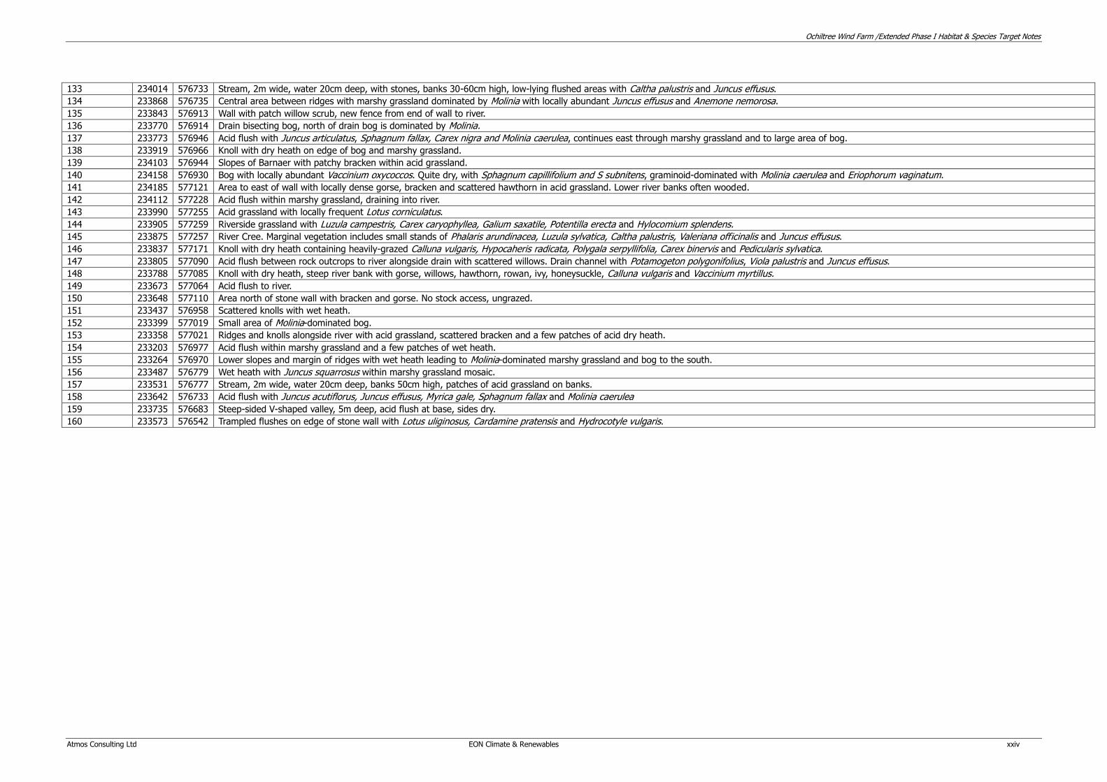
133 234014 576733 Stream, 2m wide, water 20cm deep, with stones, banks 30-60cm high, low-lying flushed areas with Caltha palustris and Juncus effusus.
134 233868 576735 Central area between ridges with marshy grassland dominated by Molinia with locally abundant Juncus effusus and Anemone nemorosa.
135 233843 576913 Wall with patch willow scrub, new fence from end of wall to river.
136 233770 576914 Drain bisecting bog, north of drain bog is dominated by Molinia.
137 233773 576946 Acid flush with Juncus articulatus, Sphagnum fallax, Carex nigra and Molinia caerulea, continues east through marshy grassland and to large area of bog.
138 233919 576966 Knoll with dry heath on edge of bog and marshy grassland.
139 234103 576944 Slopes of Barnaer with patchy bracken within acid grassland.
140 234158 576930 Bog with locally abundant Vaccinium oxycoccos. Quite dry, with Sphagnum capillifolium and S subnitens, graminoid-dominated with Molinia caerulea and Eriophorum vaginatum.
141 234185 577121 Area to east of wall with locally dense gorse, bracken and scattered hawthorn in acid grassland. Lower river banks often wooded.
142 234112 577228 Acid flush within marshy grassland, draining into river.
143 233990 577255 Acid grassland with locally frequent Lotus corniculatus.
144 233905 577259 Riverside grassland with Luzula campestris, Carex caryophyllea, Galium saxatile, Potentilla erecta and Hylocomium splendens.
145 233875 577257 River Cree. Marginal vegetation includes small stands of Phalaris arundinacea, Luzula sylvatica, Caltha palustris, Valeriana officinalis and Juncus effusus.
146 233837 577171 Knoll with dry heath containing heavily-grazed Calluna vulgaris, Hypocaheris radicata, Polygala serpyllifolia, Carex binervis and Pedicularis sylvatica.
147 233805 577090 Acid flush between rock outcrops to river alongside drain with scattered willows. Drain channel with Potamogeton polygonifolius, Viola palustris and Juncus effusus.
148 233788 577085 Knoll with dry heath, steep river bank with gorse, willows, hawthorn, rowan, ivy, honeysuckle, Calluna vulgaris and Vaccinium myrtillus.
149 233673 577064 Acid flush to river.
150 233648 577110 Area north of stone wall with bracken and gorse. No stock access, ungrazed.
151 233437 576958 Scattered knolls with wet heath.
152 233399 577019 Small area of Molinia-dominated bog.
153 233358 577021 Ridges and knolls alongside river with acid grassland, scattered bracken and a few patches of acid dry heath.
154 233203 576977 Acid flush within marshy grassland and a few patches of wet heath.
155 233264 576970 Lower slopes and margin of ridges with wet heath leading to Molinia-dominated marshy grassland and bog to the south.
156 233487 576779 Wet heath with Juncus squarrosus within marshy grassland mosaic.
157 233531 576777 Stream, 2m wide, water 20cm deep, banks 50cm high, patches of acid grassland on banks.
158 233642 576733 Acid flush with Juncus acutiflorus, Juncus effusus, Myrica gale, Sphagnum fallax and Molinia caerulea
159 233735 576683 Steep-sided V-shaped valley, 5m deep, acid flush at base, sides dry.
160 233573 576542 Trampled flushes on edge of stone wall with Lotus uliginosus, Cardamine pratensis and Hydrocotyle vulgaris.

TECHNICAL APPENDIX 8.3 NATIONAL VEGETATION CLASSIFICATION SURVEY –
OCHILTREE WINDFARM
A report to
E.ON Climate and Renewables
Atmos Report Ref: 4045/R2/Rev1 Issued: 29th June 2009

Ochiltree Wind Farm /NVC Survey Species List & Target Notes
Atmos Consulting Ltd EON Climate & Renewables i
Disclaimer This report has been prepared by Atmos Consulting Ltd with all reasonable skill and care within the terms of the agreement with the client. We disclaim any responsibility to any parties in respect of matters outside this scope. Information supplied by the client or any other parties and used in this report is assumed to be correct and Atmos Consulting Ltd accepts no responsibility for inaccuracies in the data supplied. Atmos Consulting Ltd accepts no responsibility to third parties who duplicate, use, or disclose this report in whole or in part. Such third parties rely upon this report at their own risk.
Issue Log 4045/R2/Rev1 Document Issued 29th June 2009
Document prepared for EON. Climate & Renewables
Document prepared by
Name Matthew Hopkins Title Principal Ecologist Atmos Consulting Ltd Tower Mains Studios 18g Liberton Brae Edinburgh EH16 6AE
Atmos Consulting Ltd In-Business Centre Stadium Business Park 24 Longman Drive Inverness IV1 1SU
Atmos Consulting Ltd Regus House Herald Way Pegasus Business Park Castle Donington DE74 2TX
Atmos Consulting Ltd The Granary Waen Farm Nercwys Road Mold, Flintshire CH7 4EW
Tel: 0131 672 1888 Fax: 0131 672 1999
Tel: 01463 259209 Fax: 01463 259240
Tel: 01332 638014 Tel: 01352 744512 Fax: 01352 700291
www.atmosconsulting.com

Ochiltree Wind Farm /NVC Survey Species List & Target Notes
Atmos Consulting Ltd EON Climate & Renewables ii
Table 1: Botanical Species Lists
Common Names Scientific Name
Higher Plants Velvet Bent Grass Agrostis canina
Common Bent Grass Agrostis capillaris
Creeping Bent Agrostis stolonifera
Bog Rosemary Andromeda polifolia
Wood Anemone Anemone nemorosa
Wild Angelica Angelica sylvestris
Sweet Vernal – Grass Anthoxanthum odoratum
Daisy Bellis perennis
Silver Birch Betula pendula
Birch Betula pubescens
Hard Fern Blechnum spicant
Common water-starwort Callitriche stagnalis
Heath Calluna vulgaris
Kingcup Marsh Marigold Caltha palustris
Bellflower Campanula rotundifolia
Wood Bitter-cress Cardamine flexuosa
Cuckoo Flower Lady’s Smock Cardamine pratensis
Ribbed Sedge Carex binervis
Spring Sedge Carex caryophyllea
Tawny Sedge Carex hostiana
Common Sedge Carex nigra
Carnation Grass Carex panicea
Pill Headed Sedge Carex pilulifera
Flea sedge Carex pulicaris
Beaked Sedge – Bottle Sedge Carex rostrata
Common Yellow Sedge Carex viridula oedocarpa
Lesser Knapweed- Hard Heads Centaurea nigra
Mouse Eared Chickweed Cerastium fontanum
Purple Saxifrage Chrysosplenium oppositifolium
Creeping Thistle Cirsium arvense
Marsh Thistle Cirsium palustre
Spear Thistle Cirsium vulgare
Pig-Nut – Earth Nut Conopodium majus
Hazel- Cobnut* Corylus avellana
Hawthorn Crataegus monogyna
Crested Dogs tail Cynosurus cristatus
Cocksfoot Dactylis glomerata
Tufted Hair Grass Deschampsia cespitosa
Wavy Hair Grass Deschampsia flexuosa
Foxglove Digitalis purpurea
Sundew Drosera rotundifolia
Narrow Buckler – Fern Dryopteris carthusiana
Broad Buckler – Fern Dryopteris dilatata
Common Male Fern Dryopteris filix-mas
Marsh Willow herb Epilobium palustre
Bell Heather Erica cinerea
Cross Leaved Heath – Bog Heather Erica tetralix
Sheep's Fescue Festuca ovina
Red Fescue Festuca rubra
Meadow Sweet Filipendula ulmaria
Ash Fraxinus excelsior
Marsh Bedstraw Galium palustre
Heath Bedstraw Galium saxatile

Ochiltree Wind Farm /NVC Survey Species List & Target Notes
Atmos Consulting Ltd EON Climate & Renewables iii
Ivy Hedera helix
Yorkshire Fog Holcus lanatus
Bluebell Hyancinthoides non-scripta
Marsh Pennywort Hydrocotyle vulgaris
St Johns Wort Hypericum pulchrum
Cats Ear – False Dandelion Hypochaeris radicata
Lake Quill Wort Isoetes lacustris
Sharp Flowered Juncus acutiflorus
Jointed Rush Juncus articulatus
Bulbous Rush Juncus bulbosus
Soft Rush Juncus effusus
Heath Rush Juncus squarrosus
Shore Weed Littorella uniflora
Water Lobelia Lobelia dortmanna
Perennial Ryegrass Lolium perenne
Common Honeysuckle Lonicera periclymenum
Birdsfoot Trefoil Lotus corniculatus
Greater Birds-Foot Trefoil Lotus pedunculatus
Field woodrush Luzula campestris
Great woodrush Luzula sylvatica
Water Mint Mentha aquatica
Purple Moor grass Molinia caerulea
Blinks Montia fontana
Bog Myrtle Sweet Gale. Myrica gale
Matt Grass Nardusw stricta
Bog Asphodel Narthecium ossifragum
Mountain Fern Oreopteris limbosperma
Wood-Sorrel Oxalis acetosella
Loose Wort Pedicularis sylvatica
Reed Phragmites australis
Mouse-eared Hawkweed Pilosella officinarum
Common Butterwort Pinguicula vulgaris
Scots Pine Pinus sylvestris
Ribwort Plantago lanceolata
Meadow Grass Poa pratensis
Common Milkwort Polygala serpyllifolia
Bog Pondweed Potamogeton polygonifolius
Common Tormentil Potentilla erecta
Marsh Cinquefoil Potentilla palustris
Primrose Primula vulgaris
Self-heal Prunella vulgaris
Wild Cherry – Gean Prunus avium
Bracken Pteridium aquilinum
Sessile Oak – Damask Oak Quercus petraea
Meadow Buttercup Ranunculus acris
Lesser Caladine Ranunculus ficaria
Lesser Spearwort Ranunculus flammula
Creeping Buttercup Ranunculus repens
Blackberry Rubus fruticosus
Raspberry Rubus idaeus
Sorrel Rumex acetosa
Sheeps Sorrel Rumex acetosella
Eared Willow Salix aurita
Goat Willow. Great Willow Salix caprea
Common Sallow Salix cinerea
Creeping Willow Salix repens
Lesser Clubmoss Selaginella selaginoides
Rowan – Mountain Ash Sorbus aucuparia

Ochiltree Wind Farm /NVC Survey Species List & Target Notes
Atmos Consulting Ltd EON Climate & Renewables iv
Chickweed Stellaria media
Bog Stichwort Stellaria uliginosa
Devil’s Bit-Scabious Succisa pratensis
Dandelion Taraxacum officinale
Wood Sedge Teucrium scorodonia
Deer Grass Trichophorum cespitosum
White Clover Trifolium repens
Gorse Ulex europaeus
Stinging Nettle Urtica dioica
Bilberry, Blaeberry, Whorleberry Vaccinium myrtillus
Cranberry Vaccinium oxycoccos
Valerian Valeriana officinalis
Brooklime Veronica beccabunga
Heath Violet Viola canina
Marsh Violet Viola palustris
Lower plants Aneura pinguis
Aulacomnium palustre
Breutelia chrysocoma
Calliergonella cuspidata
Campylium stellatum
Campylopus atrovirens
Campylopus introflexus
Cladonia portentosa
Climacium dendroides
Dicranum scoparium
Diplophyllum albicans
Hylocomium splendens
Hypnum jutlandicum
Leucobryum glaucum
Lophocolea bidentata
Mylia taylori
Odontoschisma sphagni
Philonotis fontana
Pleurozium schreberi
Rhytidiadelphus loreus
Rhytidiadelphus squarrosus
Rhytidiadelphus triquetrus
Scleropodium purum
Scorpidium revolvens
Scorpidium scorpioides
Sphagnum capillifolium
Sphagnum cuspidatum
Sphagnum denticulatum
Sphagnum fallax
Sphagnum inundatum
Sphagnum magellanicum
Sphagnum palustre
Sphagnum papillosum
Sphagnum squarrosum
Sphagnum subnitens
Sphagnum tenellum
Thuidium tamariscinum
Warnstorfia fluitans
Ochiltree Wind Farm /NVC Survey Species List & Target Notes
Atmos Consulting Ltd EON Climate & Renewables i
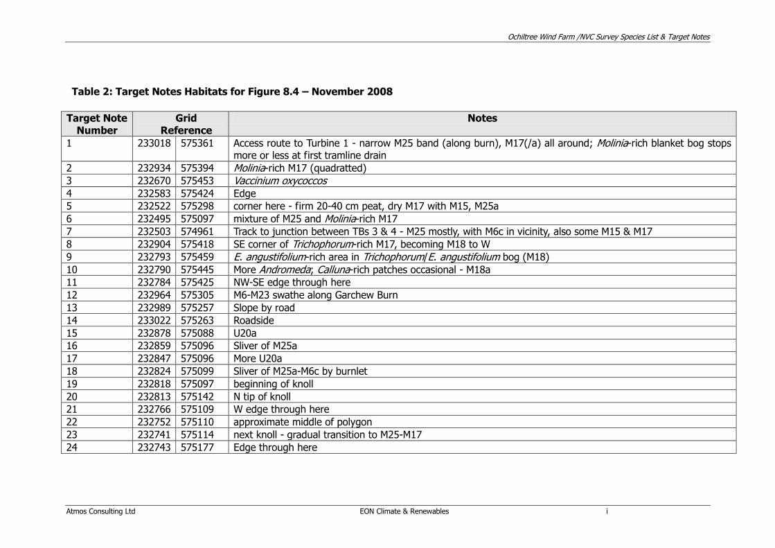
Table 2: Target Notes Habitats for Figure 8.4 – November 2008
Target Note Number
Grid Reference
Notes
1 233018 575361 Access route to Turbine 1 - narrow M25 band (along burn), M17(/a) all around; Molinia-rich blanket bog stops more or less at first tramline drain
2 232934 575394 Molinia-rich M17 (quadratted) 3 232670 575453 Vaccinium oxycoccos 4 232583 575424 Edge
5 232522 575298 corner here - firm 20-40 cm peat, dry M17 with M15, M25a
6 232495 575097 mixture of M25 and Molinia-rich M17
7 232503 574961 Track to junction between TBs 3 & 4 - M25 mostly, with M6c in vicinity, also some M15 & M17
8 232904 575418 SE corner of Trichophorum-rich M17, becoming M18 to W
9 232793 575459 E. angustifolium-rich area in Trichophorum/E. angustifolium bog (M18) 10 232790 575445 More Andromeda; Calluna-rich patches occasional - M18a
11 232784 575425 NW-SE edge through here
12 232964 575305 M6-M23 swathe along Garchew Burn
13 232989 575257 Slope by road
14 233022 575263 Roadside
15 232878 575088 U20a
16 232859 575096 Sliver of M25a
17 232847 575096 More U20a
18 232824 575099 Sliver of M25a-M6c by burnlet
19 232818 575097 beginning of knoll
20 232813 575142 N tip of knoll
21 232766 575109 W edge through here
22 232752 575110 approximate middle of polygon
23 232741 575114 next knoll - gradual transition to M25-M17
24 232743 575177 Edge through here

Ochiltree Wind Farm /NVC Survey Species List & Target Notes
Atmos Consulting Ltd EON Climate & Renewables ii
Target Note Number
Grid Reference
Notes
25 232688 575082 S transitional edge through here
26 232675 574997 M25a completely dominant around here
27 232652 574981 M17 patches around this area
28 232576 574905 S of track
29 232450 574998 junction between 3 & 4 is dryish M17/M15b (E. vaginatum too prominent for M25) on 30 cm peat
30 232431 574967 N swathe along wall in field
31 232409 574910 Edge with P17
32 232359 574836 Edge
33 232352 574772 Edge
34 232455 574736 Mostly U4 (by gate)
35 232478 574670 Slope with M25a, much less U20, some U4b & M23b, impoverished M10a flush & lichen-rich H10 heath
36 232198 574433 MG6/U4b - no photographs - nothing to show
37 232460 574481 More species-rich M25a(-M15a-b) fading by grid reference
38 232544 574484 tussocky Molinia 39 232583 574504 mix of M25, U4, M15a, M6a, M15d plus small amounts of M10
40 232675 574531 Steeper slope with U4-U20a
41 232640 574512 W edge of break in slope
42 232669 574444 tiny U4 patch
43 232905 574373 wetter M25 w Myrica-rich M15a
44 232636 574543 M15d with M25a
45 232696 574387 Long gash with M25 just dominant partner in mosaic with M23b, U20 and U4
46 232739 574344 Middle of polygon
47 232926 574374 starts here (or c. 20 m W); more M15d on N-facing slopes
48 233022 574434 N edge through here
49 232981 574387 M15b with M6d, M25a - M15d nearby
50 233091 574470 around & E of grid reference
51 233081 574600 dense Molinia with M17a occasional; Carex rostrata occasional-rare
52 233113 574612 marsh - impoverished M10 flushes nearby
Ochiltree Wind Farm /NVC Survey Species List & Target Notes
Atmos Consulting Ltd EON Climate & Renewables iii
Target Note Number
Grid Reference
Notes
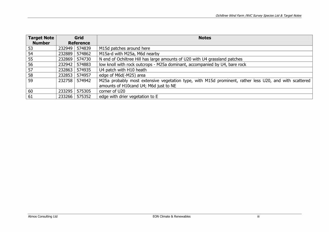
53 232949 574839 M15d patches around here
54 232889 574862 M15a-d with M25a, M6d nearby
55 232869 574730 N end of Ochiltree Hill has large amounts of U20 with U4 grassland patches
56 232942 574883 low knoll with rock outcrops - M25a dominant, accompanied by U4, bare rock
57 232863 574935 U4 patch with H10 heath
58 232853 574957 edge of M6d(-M25) area
59 232758 574942 M25a probably most extensive vegetation type, with M15d prominent, rather less U20, and with scattered amounts of H10cand U4; M6d just to NE
60 233295 575305 corner of U20
61 233266 575352 edge with drier vegetation to E
Ochiltree Wind Farm /NVC Survey Species List & Target Notes
Atmos Consulting Ltd EON Climate & Renewables iv
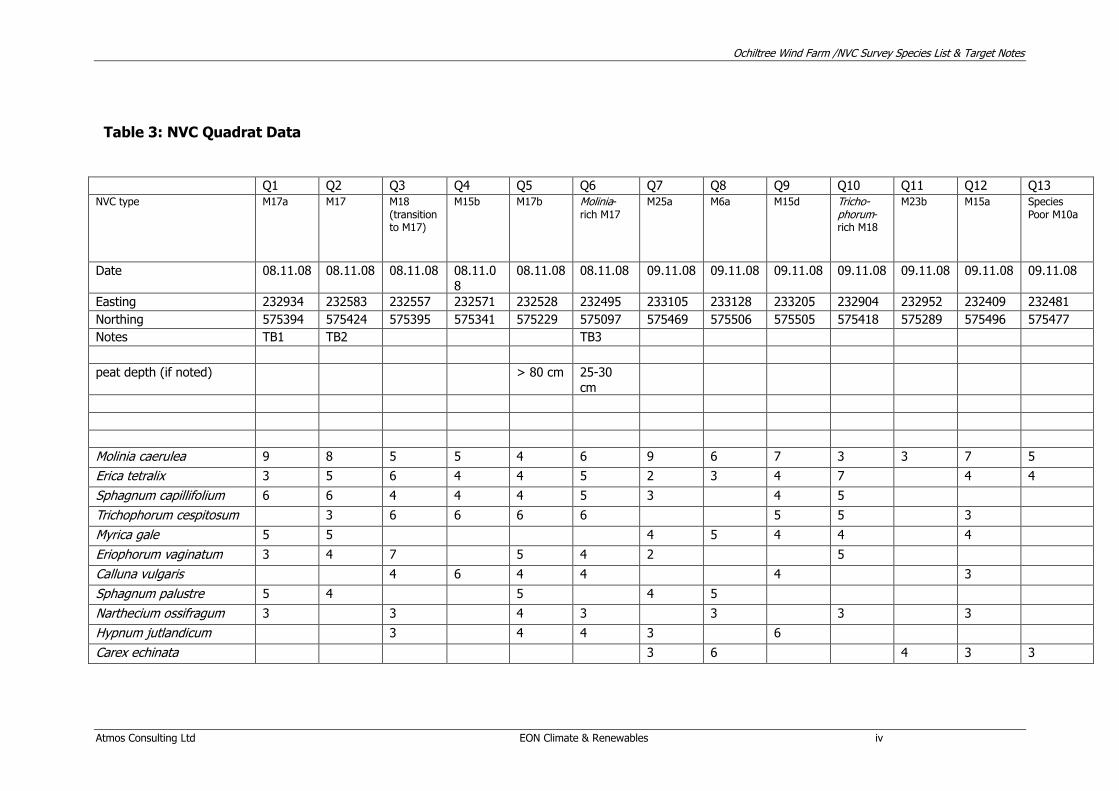
Table 3: NVC Quadrat Data
Q1 Q2 Q3 Q4 Q5 Q6 Q7 Q8 Q9 Q10 Q11 Q12 Q13
NVC type M17a M17 M18 (transition to M17)
M15b M17b Molinia-rich M17
M25a M6a M15d Tricho-phorum-rich M18
M23b M15a Species Poor M10a
Date 08.11.08 08.11.08 08.11.08 08.11.0
8
08.11.08 08.11.08 09.11.08 09.11.08 09.11.08 09.11.08 09.11.08 09.11.08 09.11.08
Easting 232934 232583 232557 232571 232528 232495 233105 233128 233205 232904 232952 232409 232481
Northing 575394 575424 575395 575341 575229 575097 575469 575506 575505 575418 575289 575496 575477
Notes TB1 TB2 TB3
peat depth (if noted) > 80 cm 25-30
cm
Molinia caerulea 9 8 5 5 4 6 9 6 7 3 3 7 5
Erica tetralix 3 5 6 4 4 5 2 3 4 7 4 4
Sphagnum capillifolium 6 6 4 4 4 5 3 4 5
Trichophorum cespitosum 3 6 6 6 6 5 5 3
Myrica gale 5 5 4 5 4 4 4
Eriophorum vaginatum 3 4 7 5 4 2 5
Calluna vulgaris 4 6 4 4 4 3
Sphagnum palustre 5 4 5 4 5
Narthecium ossifragum 3 3 4 3 3 3 3
Hypnum jutlandicum 3 4 4 3 6
Carex echinata 3 6 4 3 3

Ochiltree Wind Farm /NVC Survey Species List & Target Notes
Atmos Consulting Ltd EON Climate & Renewables v
Sphagnum tenellum 4 2 4 4 4
Eriophorum angustifolium 3 1 3 4 4 2
Potentilla erecta 3 2 1 3 3 2 3
Rhytidiadelphus squarrosus
5 7 4
Pleurozium schreberi 4 6 5
Juncus effusus 4 8
Carex panicea 3 4 4
Carex viridula oedocarpa 3 7
Sphagnum subnitens 4 5
Sphagnum fallax 4 4
Sphagnum denticulatum 4 4
Sphagnum papillosum 3 5
Juncus squarrosus 4 4
Holcus lanatus 5 3
Dicranum scoparium 1 2 4
Cirsium palustre 3 3
Calliergonella cuspidata 6
Juncus acutiflorus 5
Lophocolea bidentata 3 2
Campylium stellatum 5
Festuca ovina 4
Agrostis canina 4
Scleropodium purum 4
Succisa pratensis 1 3
Hylocomium splendens 4
Cladonia portentosa 3
Cladonia uncialis 3

Ochiltree Wind Farm /NVC Survey Species List & Target Notes
Atmos Consulting Ltd EON Climate & Renewables vi
Carex rostrata 3
Andromeda polifolia 3
Vaccinium oxycoccos 3
Ranunculus acris 3
Stellaria uliginosa 3
Galium plaustre 3
Euphrasia officinalis agg. 3
Vaccinium myrtillus 2
Nardus stricta 2
Cardamine pratensis 2
Polygala serpyllifolia 1
Plagiothecium undulatum 1
Thuidium tamarascinum 1
Ochiltree Wind Farm /NVC Survey Species List & Target Notes
Atmos Consulting Ltd EON Climate & Renewables xxi
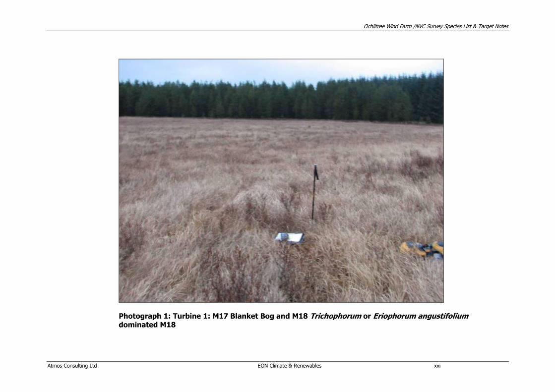
Photograph 1: Turbine 1: M17 Blanket Bog and M18 Trichophorum or Eriophorum angustifolium dominated M18

Ochiltree Wind Farm /NVC Survey Species List & Target Notes
Atmos Consulting Ltd EON Climate & Renewables xxii
Photograph 2: Turbine 2 - Molinia dominated M17 blanket bog/M25a Molinia grassland

Ochiltree Wind Farm /NVC Survey Species List & Target Notes
Atmos Consulting Ltd EON Climate & Renewables xxiii
Photograph 3: Turbine 3 - M17 Blanket Bog – former peat cuttings
Ochiltree Wind Farm /NVC Survey Species List & Target Notes
Atmos Consulting Ltd EON Climate & Renewables xxiv
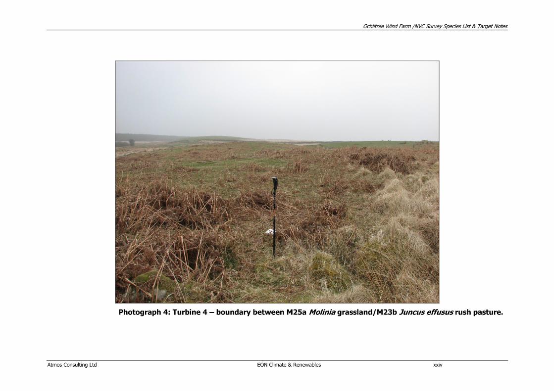
Photograph 4: Turbine 4 – boundary between M25a Molinia grassland/M23b Juncus effusus rush pasture.

Ochiltree Wind Farm /NVC Survey Species List & Target Notes
Atmos Consulting Ltd EON Climate & Renewables xxv
No photograph for the location of Turbine 5 is presented due to the lack of botanical conservation issues; however it is located on improved grassland
Similarly, there is no photograph for the location of Turbine 6 as there are no botanical issues within its location.
Ochiltree Wind Farm /NVC Survey Species List & Target Notes
Atmos Consulting Ltd EON Climate & Renewables xxvi
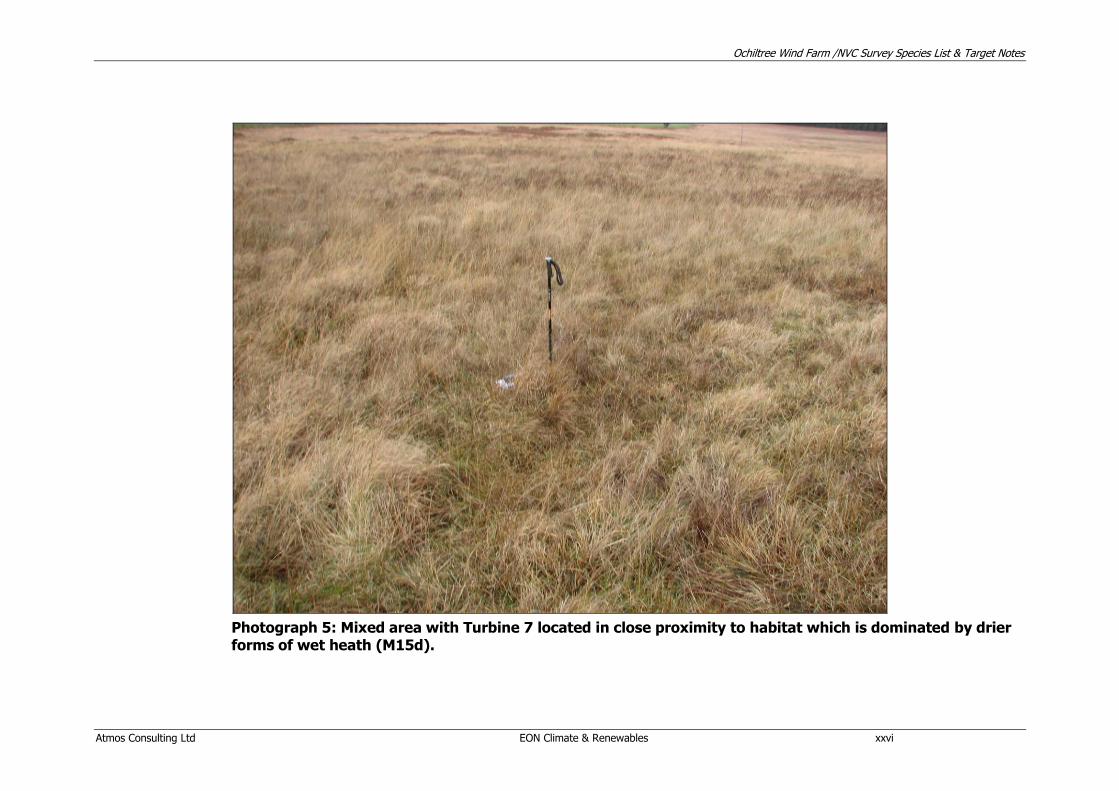
Photograph 5: Mixed area with Turbine 7 located in close proximity to habitat which is dominated by drier forms of wet heath (M15d).
Ochiltree Wind Farm /NVC Survey Species List & Target Notes
Atmos Consulting Ltd EON Climate & Renewables xxvii
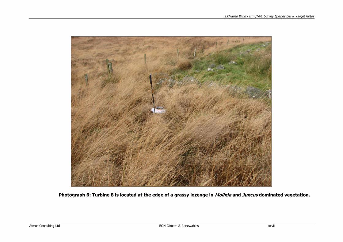
Photograph 6: Turbine 8 is located at the edge of a grassy lozenge in Molinia and Juncus dominated vegetation.

Ochiltree Wind Farm /NVC Survey Species List & Target Notes
Atmos Consulting Ltd EON Climate & Renewables xxviii
Photograph 7: Turbine 9 is located in acid grassland which extended northwards to the Hill of Ochiltree

Ochiltree Wind Farm /NVC Survey Species List & Target Notes
Atmos Consulting Ltd EON Climate & Renewables xxix
Photograph 8: Turbine 10: Molinia dominated, species poor M15 wet heath with M25 dominant in the vicinity

OCHILTREE WIND FARM ORNITHOLOGICAL STUDY TECHNICAL APPENDIX 8.5
A report to
E.ON Climate & Renewables

Ochiltree Wind Farm Ornithological Studies Technical Appendix 2009
Atmos Consulting Ltd i
Disclaimer This report has been prepared by Atmos Consulting Ltd with all reasonable skill and care within the terms of the agreement with the client. We disclaim any responsibility to any parties in respect of matters outside this scope. Information supplied by the client or any other parties and used in this report is assumed to be correct and Atmos Consulting Ltd accepts no responsibility for inaccuracies in the data supplied. Atmos Consulting Ltd accepts no responsibility to third parties who duplicate, use, or disclose this report in whole or in part. Such third parties rely upon this report at their own risk.
Issue Log
Document prepared for E.ON Climate and Renewables
Document prepared by
Name John G Inglis Title Senior Ecologist
Atmos Consulting Ltd Tower Mains Studios 18g Liberton Brae Edinburgh EH16 6AE
Atmos Consulting Ltd In-Business Centre Stadium Business Park 24 Longman Drive Inverness IV1 1SU
Atmos Consulting Ltd Regus House Herald Way Pegasus Business Park Castle Donington DE74 2TX
Atmos Consulting Ltd The Granary Waen Farm Nercwys Road Mold, Flintshire CH7 4EW
Tel: 0131 672 1888 Fax: 0131 672 1999
Tel: 01463 259209 Fax: 01463 259240
Tel: 01332 638014 Tel: 01352 744512 Fax: 01352 700291
www.atmosconsulting.com

Ochiltree Wind Farm Ornithological Studies Technical Appendix 2009
Atmos Consulting Ltd ii
Table of Contents
1.1 INTRODUCTION 1
1.2 METHODS 1
1.3 RESULTS 6
1.4 COLLISION RISK MODELLING 12
1.5 SUMMARY 16
1.6 REFERENCES 17
APPENDIX 1: DETAILS OF THE VANTAGE POINT WATCHES 18
APPENDIX 2: COMPLETE SPECIES LIST 21
APPENDIX 3: DETAILS OF SURVEYS 23
APPENDIX 4: COLLISION RISK MODELLING 25

Ochiltree Wind Farm Ornithological Studies Technical Appendix 2009
Atmos Consulting Ltd E.ON Climate & Renewables 1
1.1 INTRODUCTION 1.1.1 Atmos Consulting were commissioned by E.ON Climate and Renewables to
undertake an ornithological study at Hill of Ochiltree, South West Scotland for a proposed wind farm. This report presents the results of the ornithological study completed at Hill of Ochiltree from October 2007 to June 2009.
1.1.2 This document provides details of the methods used and results collected. Key species are considered to be those:
Included in Annex 1 of the EC Wild Birds Directive (79/409/EEC);
Listed in Schedule 1 of the Wildlife and Countryside Act 1981 (as amended);
UK Biodiversity Action Plan (UKBAP) species;
The Dumfries and Galloway Local Biodiversity Action Plan (LBAP); and
Those identified as potentially at risk from impacts of onshore wind farms (SNH, 2006).
1.1.3 All figure references refer to figures in ES Volume 3. This technical appendix includes the following information:
Baseline survey methodology;
Baseline methods;
Baseline results;
Collision risk modelling; and
Summary. 1.2 METHODS
Baseline Data and Surveys 1.2.1 The following surveys were completed at the site of Hill of Ochiltree
proposed wind farm development , a full description of the methodologies follows.
Vantage point watches (non-breeding and breeding seasons);
Winter Walkover Survey;
Black Grouse Survey;
Upland Breeding Bird Survey;
Woodland Point Counts Survey;
Breeding Raptor Survey;
Breeding Diver Survey; and
Nightjar Survey.
1.2.2 Field surveys were undertaken by the following experienced ornithological
surveyors:
Ochiltree Wind Farm Ornithological Studies Technical Appendix 2009
Atmos Consulting Ltd E.ON Climate & Renewables 2
Tim Drew (TD),Atmos Consulting Ltd (Schedule 1 licence holder);
Alan Rothery (AR) (Freelance ornithologist);
Eddie McGuire (EM) Atmos Consulting Ltd); and
John Inglis (JI) Atmos Consulting Ltd).
Diurnal Vantage Point Watches
1.2.3 The vantage point (VP) watches have been undertaken using the methods
recommended by Scottish Natural Heritage (SNH 2005). Each VP watch was undertaken by a single observer in conditions of good visibility. Surveyors positioned themselves as inconspicuously as possible to minimise their effects on the birds‟ natural behaviour.
1.2.4 During each watch, the landscape was scanned continuously until a target bird species1 was detected. Once detected, the bird was observed until it landed or flew out of sight. The exact time that a bird spent in each height band was recorded for each period that the bird was in view, in one of three height bands: <20m, 20-125m and >125m.
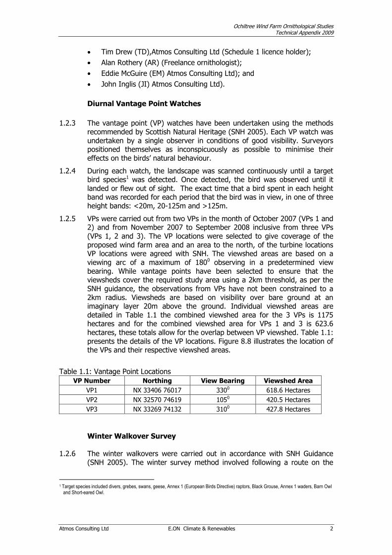
1.2.5 VPs were carried out from two VPs in the month of October 2007 (VPs 1 and 2) and from November 2007 to September 2008 inclusive from three VPs (VPs 1, 2 and 3). The VP locations were selected to give coverage of the proposed wind farm area and an area to the north, of the turbine locations VP locations were agreed with SNH. The viewshed areas are based on a viewing arc of a maximum of 1800 observing in a predetermined view bearing. While vantage points have been selected to ensure that the viewsheds cover the required study area using a 2km threshold, as per the SNH guidance, the observations from VPs have not been constrained to a 2km radius. Viewsheds are based on visibility over bare ground at an imaginary layer 20m above the ground. Individual viewshed areas are detailed in Table 1.1 the combined viewshed area for the 3 VPs is 1175 hectares and for the combined viewshed area for VPs 1 and 3 is 623.6 hectares, these totals allow for the overlap between VP viewshed. Table 1.1: presents the details of the VP locations. Figure 8.8 illustrates the location of the VPs and their respective viewshed areas.
Table 1.1: Vantage Point Locations
VP Number Northing View Bearing Viewshed Area
VP1 NX 33406 76017 3300 618.6 Hectares
VP2 NX 32570 74619 1050 420.5 Hectares
VP3 NX 33269 74132 3100 427.8 Hectares
Winter Walkover Survey
1.2.6 The winter walkovers were carried out in accordance with SNH Guidance
(SNH 2005). The winter survey method involved following a route on the
1 Target species included divers, grebes, swans, geese, Annex 1 (European Birds Directive) raptors, Black Grouse, Annex 1 waders, Barn Owl
and Short-eared Owl.

Ochiltree Wind Farm Ornithological Studies Technical Appendix 2009
Atmos Consulting Ltd E.ON Climate & Renewables 3
survey site between VPs (not specifically those for diurnal VP watches) and ensuring that each part of the site was viewed. The route was walked slowly and the area was scanned periodically by stopping at suitable VPs (stopping for periods up to an hour if appropriate). These shortened VPs aimed to target areas in the landscape where potential ornithological important features such as ponds, streams, rocky out crops etc. may attract bird activity that may not be observed from the formal diurnal VP surveys. Three surveys were completed over the winter period during the months December to February. The start point was randomly selected each month. These surveys were carried out over the proposed wind farm development site. The surveys were carried out in suitable weather conditions, avoiding conditions such as high winds, poor visibility and rain.
Black Grouse Survey
1.2.7 The study area holds suitable habitat for black grouse and they are known to be present in the region. The black grouse survey (Gilbert et al., 1998) involved visiting the study area between the end of March and early May, surveys were undertaken on three occasions. Preparatory visits to identify any lek sites prior to specific surveys were conducted. The preparatory visits were undertaken up to two hours after dawn or in the evening before dusk to avoid any unintentional disturbance of birds, the aim was to cover all areas in the survey area to within 500 meters.
1.2.8 Once potential lek sites are identified a visit to count any displaying males and any grey hens will be made within three days of identifying the potential lek sites. Timing of these surveys was from one hour before sunrise to one hour after. Discreet observations of the lek‟s were made so as not to disturb birds displaying.
Upland Breeding Bird Survey
1.2.9 An upland breeding bird survey was carried out using the Brown and Shepherd breeding bird survey method (Gilbert et al., 1998). The Brown and Shepherd bird survey is used to census breeding waders such as golden plover, dunlin, curlew and others on open moor. A minimum of two visits are recommended between early April to July (SNH 2005) avoiding high winds and other poor weather conditions. The method is based on constant search effort, allowing 20 to 25 minutes per 500 x 500m quadrant of open land. A predetermined route through each square has to be followed so that all parts of each quadrant are approached to within at least 100m. For this assessment, the method was modified in that, the location and behaviour of all species (not just waders) encountered during the survey visits were recorded, this was considered satisfactory as there were low numbers of waders present.
1.2.10 The behaviour and location of all wader species were recorded on 1:10,000 scale maps, using standard BTO codes. Birds were assumed to be breeding or holding territory at the recorded location if one or more of the following was observed:
Courtship, displaying or singing;
Ochiltree Wind Farm Ornithological Studies Technical Appendix 2009
Atmos Consulting Ltd E.ON Climate & Renewables 4
Presence of a nest, eggs or young (including newly fledged);
Agitated behaviour, including alarm calls or distraction display; and or
Territorial disputes.
1.2.11 In the absence of any of these indicative behaviour traits, a pair observed together in suitable habitat was considered to represent a breeding pair. Other records were considered to be of non-breeding birds.
1.2.12 Within visits, duplicate records of birds separated by less than a threshold distance of 500m were arbitrarily considered to correspond to birds of the same pair, while those separated by more than these threshold distances were considered to be from different pairs. Exceptions to this are where surveyors recorded that birds seen within this threshold distance of each other represented different pairs and vice versa. Appropriate annotations were made on the field maps to indicate where this was the case. The area covered by the upland breeding bird surveys is illustrated on Figure 8.7.
Woodland Point Counts
1.2.13 Woodland Point Counts (WPC) were carried out in spring 2008 to provide a
bird species inventory of the conifer plantation area to the north west of the site and an area of semi-natural birch woodland. Three visits were carried out between mid April and June within the first six hours of sunrise. During May and June 2009 WPCs were completed along the proposed access route through Pnninghame Forest. Visits were carried out in favourable weather conditions (no wet weather or strong winds) (SNH 2005, Bibby et al. 1992). Table 7.2 provides grid references for the 40 locations that were surveyed in 2008 and Table 7.3 provides grid references for the 35 locations that were surveyed in 2009; Figure 8.10 illustrates the location of each WPC completed in 2008, WPCs completed in 2009 are not illustrated.
Table 7.2: Woodland Point Count Locations
WPC Number
Grid reference WPC
Number Grid reference
WPC Number
Grid reference
1 NX 33559 75711 15 NX 32259 75791 29 NX 33082 76002
2 NX 33574 75547 16 NX 31985 75829 30 NX 33116 75890
3 NX 33585 75404 17 NX 32059 75961 31 NX 33092 75668
4 NX 33607 75277 18 NX 31977 75624 32 NX 32859 75495
5 NX 33739 75317 19 NX 31999 75505 33 NX 32700 75510
6 NX 33894 75373 20 NX 32043 75360 34 NX 32531 75528
7 NX 33925 75589 21 NX 32145 75376 35 NX 32334 75457
8 NX 33802 75573 22 NX 32200 75487 36 NX 34923 76512
9 NX 33019 75474 23 NX 32269 75614 37 NX 35056 76198
10 NX 32930 75593 24 NX 32437 75924 38 NX 34943 76431
11 NX 32816 75707 25 NX 32542 76137 39 NX 34967 76630
12 NX 32783 75762 26 NX 32355 76135 40 NX 34968 76769
13 NX 32635 75802 27 NX 32695 76145
14 NX 32379 75799 28 NX 32895 76112
Table 7.3: Woodland Point Count Locations (Access Route 2009)
WPC Number
Grid Reference WPC
Number Grid Reference
WPC Number
Grid Reference
1 NX 32770 73118 13 NX 34210 71498 25 NX 35950 70302

Ochiltree Wind Farm Ornithological Studies Technical Appendix 2009
Atmos Consulting Ltd E.ON Climate & Renewables 5
WPC Number
Grid Reference WPC
Number Grid Reference
WPC Number
Grid Reference
2 NX 32789 72885 14 NX 34499 71405 26 NX 36201 70457
3 NX 32790 72660 15 NX 34573 71162 27 NX 36475 70518
4 NX 32701 72487 16 NX 34540 70836 28 NX 36697 70610
5 NX 32808 72227 17 NX 34573 70572 29 NX 37060 70603
6 NX 32898 72062 18 NX 34772 70320 30 NX 37392 70378
7 NX 32899 71873 19 NX 34869 70080 31 NX 37521 70181
8 NX 32980 71708 20 NX 35017 69872 32 NX 37741 69963
9 NX 33135 71485 21 NX 35215 69841 33 NX 37849 69861
10 NX 33348 71378 22 NX 35494 69981 34 NX 38052 69703
11 NX 33666 71406 23 NX 35681 70413 35 NX 38066 69588
12 NX 33922 71528 24 NX 35711 70161
Breeding Diver and Raptor Surveys
1.2.14 Surveys for breeding raptors and divers were carried out between April and June 2008.
1.2.15 For divers, the survey methods described in Gilbert et al., 1998 were followed which recommends two visits between the end of May and July. Diver surveys can be carried out at any time of the day avoiding days with poor visibility, persistent rain or high winds. All small pools and lochans in the study area were visited at least twice and observed from a distance to check for the presence of divers on the water. If no diver or other species of concern was seen, the lochs were approached and the shoreline walked and searched for any signs of breeding divers such as empty nest scrapes, incubating birds, broken eggshells or dead chicks.
1.2.16 The habitat at the Ochiltree wind farm could be suitable for a variety of raptors such as peregrine, merlin, hen harrier and short-eared owl. For all these species, surveys were carried out as described by Hardey et al. 2006.
1.2.17 The surveys were carried out using a combination of foot searches through suitable breeding habitats within the study area and shortened VP watches (Hardey 1998) (the VP locations were not necessarily those used for the Diurnal VP watches). Surveyors recorded the presence and behaviour of all raptor species encountered and also searched for signs of presence such as pellets, regularly used plucking sites, feathers and others.
1.2.18 An incidental observation of hen harrier was received early in 2009, as a precaution additional surveys over the Ochiltree development site were carried out. Surveys were carried out in the months of March and April using the methodology described above.
Nightjar Survey
1.2.19 Nightjars have been recorded to the south of Ochiltree wind farm area, a nightjar survey was therefore required. The methods adopted are as described in Gilbert et al (1998) and involved walking the survey area in order to detect any churring males in the area.

Ochiltree Wind Farm Ornithological Studies Technical Appendix 2009
Atmos Consulting Ltd E.ON Climate & Renewables 6
1.3 RESULTS 1.3.1 Results of the ornithological surveys carried out on the Ochiltree study area
are presented in the following paragraphs.
Diurnal Vantage Point Watches
1.3.2 A total of 229 hours of VP watches were completed between October 2007 and September 2008. No watches were completed at VP 3 in October 2007 as access to the location of VP 3 was not available. Table 1.4 summarises the completed VP effort. Details of VP survey dates, time, duration, surveyor and weather conditions can be found in Appendix 1.
1.3.3 The minimum effort required for raptors as recommended by SNH is 36 hours per season. The minimum requirements between October 2007 and March 2008 inclusive have been obtained for VPs 1 and 2, VP 3 due to the late start only obtained 30 hours of effort. During the summer season VPs 1, 2 and 3 exceeded the minimum 36 hours required.
Table 1.4: Vantage Point Effort (hours)
Date VP1 VP2 VP3 Total / Month
Oct-07 06:00 06:00 12:00
Nov-07 06:00 06:00 06:00 18:00
Dec-07 06:00 06:00 06:00 18:00
Jan-08 06:00 06:00 06:00 18:00
Feb-08 06:00 06:00 06:00 18:00
Mar-08 06:00 06:00 06:00 18:00
Seasonal Total / VP 36:00 36:00 30:00
Apr-08 09:00 09:00 09:00 27:00
May-08 09:00 12:00 07:00 28:00
Jun-08 06:00 06:00 06:00 18:00
Jul-08 06:00 06:00 06:00 18:00
Aug-08 06:00 06:00 06:00 18:00
Sep-08 06:00 06:00 06:00 18:00
Seasonal Total / VP 42:00 45:00 40:00
1.3.4 During VP watches between October 2007 and September 2008, seven
target species were recorded. Two raptor species: barn owl (1 flight), and short-eared owl (1 flight), three wader species; golden plover (2 flights), curlew (3 flights) and oystercatcher (1 flight), two species of waterfowl; greylag goose (13 flights) and Canada goose (1 flight). Raven flights were also recorded on 10 occasions. Table 1.5 summarises the species flight data and Table 1.6 details individual flights. Figure 8.9 illustrates the flight lines of all target species recorded from VPs.
Table 1.5: Summary Target Species Flight Line Data
Species Total Flight Time (secs) Total Flight Time at Risk (secs) Total Number of Birds
Barn Owl 265 0 1
Canada goose 20 0 2
Curlew 46 0 3

Ochiltree Wind Farm Ornithological Studies Technical Appendix 2009
Atmos Consulting Ltd E.ON Climate & Renewables 7
Species Total Flight Time (secs) Total Flight Time at Risk (secs) Total Number of Birds
Golden Plover 430 365 43
Greylag Goose 370 219 105
Oystercatcher 140 0 2
Short-eared Owl 48 0 1
Table 1.6: Target Species Flight Line Data
Species Visit Date Time First
Observed
VP Number
Number of Birds
Average Flight Height
Total Flight Time (secs)
Total Flight
Time at Risk (secs)
Golden Plover 25-Oct-07 13.47 VP2 6 30 130 130
Greylag Goose 31-Oct-07 14.10 VP2 2 100 70 70
Greylag Goose 27-Nov-07 13.19 VP1 11 45 45
Greylag Goose 27-Jan-08 8.12 VP3 8 15 15
Greylag Goose 27-Jan-08 8.22 VP3 8 12 0
Greylag Goose 27-Jan-08 12.51 VP3 8 35 0
Greylag Goose 10-Feb-08 8.02 VP3 23 15 40 0
Greylag Goose 10-Feb-08 8.30 VP3 7 5 10 0
Greylag Goose 16-Mar-08 7.15 VP2 16 8 30 0
Golden Plover 15-Apr-08 14.09 VP3 37 300 235
Curlew 15-Apr-08 14.23 VP3 1 10 22 0
Greylag Goose 15-Apr-08 15.04 VP2 14 10 10 0
Curlew 27-Apr-08 10.03 VP2 1 10 12 0
Greylag Goose 27-Apr-08 10.20 VP2 2 15 15 15
Greylag Goose 09-May-08 14.03 VP2 2 30 36 36
Curlew 09-May-08 17.10 VP2 1 10 12 0
Oystercatcher 19-May-08 18.07 VP2 2 15 140 0
Greylag Goose 09-Jun-08 17.34 VP3 2 30 38 38
Greylag Goose 21-Jun-08 21.48 VP2 2 10 14 0
Barn Owl 21-Jun-08 22.05 VP2 1 5 265 0
Short-eared Owl 25-Aug-08 20.45 VP3 1 2 48 0
Canada goose 07-Sep-08 07.20 VP2 2 5 20 0
1.3.5 A total of sixty three secondary species were observed during the VP
watches, of this assemblage twenty two species are considered to be of conservation concern. Two Annex 1 species were recorded; golden plover and short-eared owl, four Schedule 1 species; barn owl, fieldfare, redwing (the Schedule 1 designation applies only to fieldfare and redwing if they are found to be breeding) and common crossbill, eleven UKBAP species; curlew, herring gull, cuckoo, skylark, song thrush, grasshopper warbler, starling, linnet, lesser redpoll, bullfinch and reed bunting, sixteen Scottish Priority species; kestrel, golden plover, curlew, black-headed gull, herring gull, barn owl, short-eared owl, skylark, robin, song thrush, redwing, siskin, linnet, bullfinch and reed bunting, nine LBAP species; cormorant, golden plover, snipe, curlew, barn owl, skylark, swallow, linnet and reed bunting.
1.3.6 Other secondary species of note observed from VP watches were one sighting of a long-eared owl perched on a tree at NX 331 759 on the 25/10/2007. Cormorants were observed on several occasions on Loch Ochiltree and two goldeneye were observed on Loch Ochiltree on one occasion.
1.3.7 Appendix 2 lists all species observed during VP watches for the 12 months of surveys, also listed are any designation awarded to each species.
Ochiltree Wind Farm Ornithological Studies Technical Appendix 2009
Atmos Consulting Ltd E.ON Climate & Renewables 8
Winter Walkover Survey
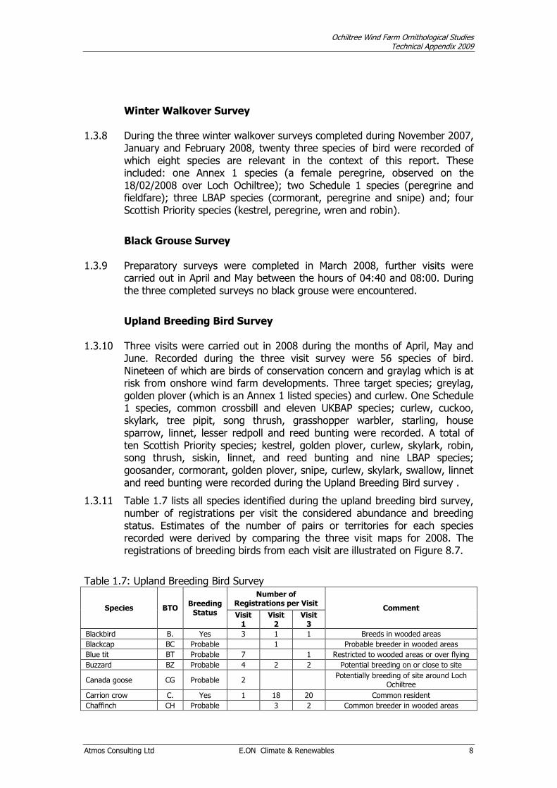
1.3.8 During the three winter walkover surveys completed during November 2007, January and February 2008, twenty three species of bird were recorded of which eight species are relevant in the context of this report. These included: one Annex 1 species (a female peregrine, observed on the 18/02/2008 over Loch Ochiltree); two Schedule 1 species (peregrine and fieldfare); three LBAP species (cormorant, peregrine and snipe) and; four Scottish Priority species (kestrel, peregrine, wren and robin).
Black Grouse Survey
1.3.9 Preparatory surveys were completed in March 2008, further visits were carried out in April and May between the hours of 04:40 and 08:00. During the three completed surveys no black grouse were encountered.
Upland Breeding Bird Survey
1.3.10 Three visits were carried out in 2008 during the months of April, May and June. Recorded during the three visit survey were 56 species of bird. Nineteen of which are birds of conservation concern and graylag which is at risk from onshore wind farm developments. Three target species; greylag, golden plover (which is an Annex 1 listed species) and curlew. One Schedule 1 species, common crossbill and eleven UKBAP species; curlew, cuckoo, skylark, tree pipit, song thrush, grasshopper warbler, starling, house sparrow, linnet, lesser redpoll and reed bunting were recorded. A total of ten Scottish Priority species; kestrel, golden plover, curlew, skylark, robin, song thrush, siskin, linnet, and reed bunting and nine LBAP species; goosander, cormorant, golden plover, snipe, curlew, skylark, swallow, linnet and reed bunting were recorded during the Upland Breeding Bird survey .
1.3.11 Table 1.7 lists all species identified during the upland breeding bird survey, number of registrations per visit the considered abundance and breeding status. Estimates of the number of pairs or territories for each species recorded were derived by comparing the three visit maps for 2008. The registrations of breeding birds from each visit are illustrated on Figure 8.7.
Table 1.7: Upland Breeding Bird Survey
Species BTO Breeding
Status
Number of Registrations per Visit
Comment Visit
1 Visit
2 Visit
3
Blackbird B. Yes 3 1 1 Breeds in wooded areas
Blackcap BC Probable 1 Probable breeder in wooded areas
Blue tit BT Probable 7 1 Restricted to wooded areas or over flying
Buzzard BZ Probable 4 2 2 Potential breeding on or close to site
Canada goose CG Probable 2 Potentially breeding of site around Loch
Ochiltree
Carrion crow C. Yes 1 18 20 Common resident
Chaffinch CH Probable 3 2 Common breeder in wooded areas
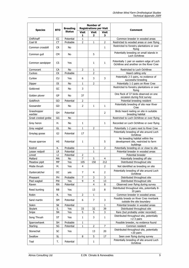
Ochiltree Wind Farm Ornithological Studies Technical Appendix 2009
Atmos Consulting Ltd E.ON Climate & Renewables 9
Species BTO Breeding
Status
Number of Registrations per Visit
Comment Visit
1 Visit
2 Visit
3
Chiffchaff CC Potential 1 Common breeder in wooded areas
Coal tit CT Probable 2 1 2 Restricted to wooded areas or over flying
Common crossbill CR No 1 Restricted to forestry plantations or over
flying
Common gull CM No 5 Potentially breeding on small islands in
Loch Ochiltree
Common sandpiper CS Yes 1 1 Potentially 1 pair on eastern edge of Loch Ochiltree and another on the River Cree
Cormorant CA No 2 1 Restricted to Loch Ochiltree
Cuckoo CK Probable 2 Heard calling only
Curlew CU Yes 6 3 3 Potentially 2-3 pairs, no evidence of
successful breeding
Dipper DI No 1 2 Potentially 1-2 pairs on River Cree
Goldcrest GC No 3 Restricted to forestry plantations or over
flying
Golden plover GP No 37 One flock of 37 birds observed on one
occasion during first survey
Goldfinch GO Potential 2 Potential breeding resident
Goosander GD No 2 1 1 Potentially breeding of site near River
Cree
Grasshopper warbler
GH Potential 2 Birds heard reeling on site in suitable
breeding habitat
Great crested grebe GG No Restricted to Loch Ochiltree or over flying
Grey heron H. No 1 1 Recorded on Loch Ochiltree or over flying
Grey wagtail GL No 1 2 Potentially 1-2 pairs next to River Cree
Greylag goose GJ Potential 17 Potentially breeding of site around Loch
Ochiltree
House sparrow HS Potential 1 5 No breeding habitat within the
development site, restricted to farm buildings
Kestrel K. Probable 1 2 Potentially breeding on or close to site
Lesser redpoll LR Potential 1 Potential breeder in wooded areas
Linnet LI Potential 2 Potential breeder
Mallard MA No 7 5 4 Potentially breeding off site
Meadow pipit MP Yes 105 150 212 Distributed throughout site
Mistle thrush M. Yes 4 2 Not identified as breeding on site
Oystercatcher OC yes 7 4 2 Potentially breeding of site around Loch
Ochiltree
Pheasant PH Probable 7 3 3 Distributed throughout site
Pied wagtail PW Yes 9 4 13 Distributed throughout site
Raven RN Potential 4 8 Observed over flying during survey
Reed bunting RB Yes 13 8 Distributed throughout site, potentially 8-
10 pairs
Robin R. Yes 2 1 Common breeder in wooded areas
Sand martin SM Potential 6 7 3 Possibly breeds on River Cree riverbank
outside the site boundary
Siskin SK Potential 1 Potential breeder in wooded areas
Skylark S. Yes 33 32 39 Distributed throughout site
Snipe SN Yes 5 5 3 Rare (but probably under recorded)
Song Thrush ST Yes 1 3 1 Distributed throughout site, potentially
<2-3 pairs
Sparrowhawk SH Probable 1 Possible breeder, no evidence found
Starling SG Potential 1 2 7 Common resident
Stonechat SC Yes 13 20 Distributed throughout site, potentially
<20 pairs
Swallow SL 8 5 17 Seen over flying during survey
Teal T. Potential 1 Potentially breeding of site around Loch
Ochiltree

Ochiltree Wind Farm Ornithological Studies Technical Appendix 2009
Atmos Consulting Ltd E.ON Climate & Renewables 10
Species BTO Breeding
Status
Number of Registrations per Visit
Comment Visit
1 Visit
2 Visit
3
Tree pipit TP Potential 1 Potentially breeding of site
Treecreeper TC Potential 1 Restricted to wooded areas or over flying
Wheatear W. Yes 2 16 7 Distributed throughout site, potentially >8
pairs
Whinchat WC Yes 6 4 Distributed throughout site, >2 pairs
Whitethroat WH Potential 1 Potential breeder
Willow warbler WW Probable 3 12 2 Restricted to wooded areas
Woodpigeon WP Yes 2 2 6 Restricted to wooded areas
Wren WR Yes 9 9 8 Distributed throughout site
Woodland Point Counts (WPCs)
1.3.12 WPC surveys were completed during the months of April, May and June 2008. During the three WPCs surveys, thirty five species were recorded, eight of which were of conservation concern. One Schedule 1 species; common crossbill, four UKBAP species; dunnock, song thrush, lesser redpoll and bullfinch, six Scottish Priority species; kestrel, robin, song thrush, siskin, and bullfinch were all recorded during woodland point counts.
1.3.13 WPCs surveys completed in 2009 during May and June covering the proposed access route through Penninghame Forest, recorded thirty three species, ten species were of conservation concern. Two Schedule 1 species; goshawk and common crossbill were recorded, seven UKBAP species; cuckoo, skylark, tree pipit, dunnock, song thrush, grass hopper warbler and lesser redpoll were recorded. Five species are listed as Scottish Priority species; skylark, wren robin, song thrush and siskin were all recorded during these WPCs. Skylark although recorded was not breeding within the forestry, being recorded at points close to the woodland edge.
1.3.14 Table 1.8 lists all species identified during the WPCs survey (2008), the considered abundance and breeding status. Table 1.9 lists all species identified during the WPCs survey, their considered abundance and breeding status completed in 2009 . The (Sum) column for each visit shows the total number of individuals counted for a species per visit. The (Count) column shows the number of woodland point count locations at which the species were recorded. The (%) column shows the frequency with which each species was recorded over the total WPC locations.
Table: 1.8: Woodland Point Counts Survey Results (2008)
Species Status during Survey
Breeding Status
April Visit May Visit June Visit
sum count % sum count % sum count %
Blackbird occasional yes 2 2 5.0 2 2 5.0 2 1 2.5
Bullfinch rare yes 0.0 0.0 1 1 2.5
Blue Tit occasional yes 4 3 7.5 6 3 7.5 7 4 10.0
Buzzard rare yes 1 1 2.5 2 2 5.0 1 1 2.5
Carrion Crow occasional yes 5 4 10.0 7 5 12.5 6 5 12.5
Chiffchaff rare yes 2 2 5.0 0.0 1 1 2.5
Chaffinch frequent yes 45 25 62.5 31 21 52.5 20 14 35.0
Common Crossbill occasional yes 7 4 10.0 6 2 5.0 3 2 5.0
Coal Tit frequent yes 32 21 52.5 15 13 32.5 16 11 27.5

Ochiltree Wind Farm Ornithological Studies Technical Appendix 2009
Atmos Consulting Ltd E.ON Climate & Renewables 11
Species Status during Survey
Breeding Status
April Visit May Visit June Visit
sum count % sum count % sum count %
Dunnock rare yes 0.0 2 2 5.0 1 1 2.5
Green Woodpecker rare potential 0.0 0.0 3 1 2.5
Goldcrest frequent yes 14 11 27.5 10 8 20.0 9 6 15.0
Grey Wagtail rare no 1 1 2.5 0.0 0.0
Goldfinch occasional probable 0.0 4 1 2.5 10 2 5.0
Great Spotted Woodpecker rare yes 4 3 7.5 1 1 2.5 1 1 2.5
Great Tit occasional yes 7 7 17.5 6 5 12.5 6 4 10.0
Garden Warbler rare potential 0.0 1 1 2.5 0.0
Jackdaw rare probable 0.0 2 1 2.5 2 1 2.5
Kestrel rare probable 0.0 1 1 2.5 2 1 2.5
Long-eared Owl rare probable 1 1 2.5 1 1 2.5 0.0
Lesser Redpoll occasional potential 4 3 7.5 5 3 7.5 5 3 7.5
Long-tailed Tit rare yes 0.0 2 1 2.5 2 1 2.5
Mistle Thrush rare yes 8 8 20.0 3 3 7.5 1 1 2.5
Pheasant rare yes 6 5 12.5 2 2 5.0 0.0
Pied Wagtail rare yes 1 1 2.5 1 1 2.5 2 2 5.0
Robin frequent yes 35 25 62.5 30 26 65.0 21 19 47.5
Raven rare potential 3 2 5.0 0.0 0.0
Stonechat rare no 1 1 2.5 0.0 0.0
Sparrowhawk rare probable 1 1 2.5 0.0 0.0
Siskin frequent yes 8 7 17.5 5 4 10.0 17 7 17.5
Song Thrush occasional yes 7 6 15.0 8 8 20.0 7 7 17.5
Treecreeper rare probable 3 2 5.0 0.0 4 3 7.5
Tawny Owl rare probable 0.0 1 1 2.5 0.0
Whitethroat rare probable 0.0 0.0 1 1 2.5
Woodpigeon occasional yes 4 2 5.0 11 9 22.5 8 5 12.5
Wren frequent yes 12 10 25.0 10 9 22.5 5 4 10.0
Willow Warbler frequent yes 8 8 20.0 29 20 50.0 15 11 27.5
Grand Total 226 204 179
Table 1.9: Woodland Point Counts Survey Results (Access Route 2009)
Species Status during Survey
Breeding Status
1st Visit 2nd Visit 3rd Visit
sum count % sum count % sum count %
Blackbird frequent yes 20 16 45.7 11 10 28.6 7 6 17.1
Blackcap occasional yes 2 1 2.9 2 2 5.7 3 3 8.6
Blue Tit rare probable 0.0 0.0 2 1 2.9
Buzzard rare probable 2 2 5.7 1 1 2.9 2 2 5.7
Carrion Crow rare probable 3 2 5.7 0.0 6 4 11.4
Chaffinch frequent yes 38 23 65.7 46 25 71.4 67 31 88.6
Chiffchaff occasional yes 7 6 17.1 6 4 11.4 8 6 17.1
Coal Tit occasional yes 21 11 31.4 12 8 22.9 15 9 25.7
Crossbill frequent probable 4 2 5.7 21 8 22.9 5 4 11.4
Cuckoo rare probable 1 1 2.9 3 3 8.6 1 1 2.9
Dunnock rare probable 0.0 0.0 2 1 2.9
Goldcrest occasional yes 11 5 14.3 19 7 20.0 16 9 25.7
Goshawk rare potential 0.0 1 1 2.9 0.0
Grasshopper Warbler rare yes 0.0 0.0 2 1 2.9
Great Spotted Woodpecker rare yes 0.0 3 2 5.7 2 2 5.7
Great Tit occasional yes 1 1 2.9 6 2 5.7 11 6 17.1
Grey Heron rare potential 2 1 2.9 0.0 0.0
Grey Wagtail rare yes 2 1 2.9 0.0 4 3 8.6
Lesser Redpoll rare potential 3 2 5.7 2 1 2.9 2 1 2.9

Ochiltree Wind Farm Ornithological Studies Technical Appendix 2009
Atmos Consulting Ltd E.ON Climate & Renewables 12
Species Status during Survey
Breeding Status
1st Visit 2nd Visit 3rd Visit
sum count % sum count % sum count %
Long-tailed Tit rare probable 0.0 0.0 8 1 2.9
Mallard rare potential 1 1 2.9 0.0 0.0
Mistle Thrush rare potential 0.0 2 2 5.7 1 1 2.9
Raven rare potential 0.0 0.0 3 2 5.7
Robin frequent yes 44 30 85.7 44 25 71.4 23 17 48.6
Siskin frequent yes 16 8 22.9 41 12 34.3 42 16 45.7
Skylark rare potential 0.0 1 1 2.9 2 2 5.7
Song Thrush frequent yes 9 9 25.7 16 14 40.0 20 18 51.4
Swallow rare no 0.0 1 1 2.9 1 1 2.9
Tree Pipit occasional yes 4 3 8.6 7 4 11.4 4 3 8.6
Whitethroat frequent yes 6 4 11.4 6 3 8.6 14 5 14.3
Willow Warbler frequent yes 38 20 57.1 51 26 74.3 31 18 51.4
Wood Pigeon occasional yes 3 3 8.6 5 4 11.4 8 6 17.1
Wren frequent yes 19 16 45.7 28 19 54.3 58 30 85.7
Grand Total 257 335 370
Breeding Diver and Raptor Surveys 1.3.15 Surveys were carried out during the months of April, May and June 2008, a
fourth visit was not completed as recommended by Hardey et al., 2006 as no raptors of conservation concern were identified breeding on site. The additional hen harrier surveys were carried out in March April 2009.
1.3.16 No target raptor or diver species were identified as breeding within the survey area in either 2008 or 2009.
Nightjar Survey
1.3.17 Surveys were completed on two occasions during June and July 2008 between the hours of 02:00 and 04:30. No nightjars were identified within the survey area during surveys.
Appendix 2 lists all species observed during ornithological studies, also listed are any designation awarded to each species.
Appendix 3. Details survey dates, time, duration, surveyor and weather conditions during the winter walkover, upland breeding bird, woodland point counts, breeding diver / raptor surveys and nightjar surveys.
1.4 Collision Risk Modelling 1.4.1 A collision risk model (CRM) was carried out for the following species:
golden plover and greylag goose. For golden plovers and geese, the collision risk is usually calculated using the linear model as their flight movements during the breeding season for golden plover and during autumn and spring migration for geese are often predictable and follow a predictable pattern. However after assessing the flight line data that was gathered during the VP watches it was concluded that the movements for these species did not

Ochiltree Wind Farm Ornithological Studies Technical Appendix 2009
Atmos Consulting Ltd E.ON Climate & Renewables 13
follow predictable patterns but occurred rather randomly over the site. Golden plover were not breeding on Ochiltree but birds were only present briefly whilst on route to and from breeding grounds and the two flights of multiple birds were not linear. The greylag geese present were not migratory birds and were considered as part of a resident feral population, with an unpredictable flight pattern. Examples of the workings of the CRM used can be found in Appendix 4.
1.4.2 Therefore for the two species analysed a random model has been used to assess the theoretical collision impact on golden plover and greylag goose.
1.4.3 The general methodology used to predict collision risk is provided by SNH (SNH, 2000b). In summary, the following steps were followed in this assessment:
Review the flight line data, which in this instance indicated that a random collision analysis should be conducted for each species;
Digitise all flight lines and record relevant characteristics (including species, number of birds, start time of flight and height at 15 second intervals or exact time at each height) in linked database;
Identify all flights for each species which are at any point within the „at risk‟ height band and sum the total „at risk‟ flight duration for each vantage point, multiplying any flight at risk time by the number of birds observed, where more than one bird is recorded per flight line;
Calculate an „occupancy rate‟ for each vantage point, defined as the observed „at risk‟ activity levels divided by total observation time and area observed, giving an occupancy per unit time and unit area for each vantage point;
Average the occupancy rate across the vantage points using an un-weighted mean approach;
Apply the average occupancy rate to the wind development site, based on a site area, risk volume and total turbine rotor volume, applying a factor to estimate the total time that the birds could theoretically be active during the period of interest, to determine the total predicted time spent by the individual species within air space which could be swept by turbine blades;
Run the collision model with relevant turbine and ornithological parameters to calculate the theoretical proportion of transits resulting in a collision assuming no avoiding action; and
Calculate the number of transits based on occupancy time and flight speed; multiply the number of transits by the collision rate, avoidance factor and operating parameters of the project to estimate the theoretical number of collisions per year.
1.4.4 The predicted mortality through collision is dependent on a number of variables, including flight activity within the turbine envelope, the species‟ physiology, nocturnal flight behaviour and flight velocity, weather

Ochiltree Wind Farm Ornithological Studies Technical Appendix 2009
Atmos Consulting Ltd E.ON Climate & Renewables 14
conditions, the predicted avoidance rate, the number, rotational speed and dimensions of the turbines and the proportion of the time that the turbines are operational throughout the year.
1.4.5 For a given analysis, all of these variables may be defined with an acceptable degree of accuracy, other than the avoidance rate. A precautionary figure of 95% avoidance for waders and raptors has been assumed for collision modelling purposes in the past, but a review of post-construction monitoring studies which combined flight observations with corpse surveys, controlling for search effectiveness, indicates that a much higher avoidance rate of 99.82% is likely to be more accurate (Fernley et al., 2006). This is consistent with Percival (2004), in which an avoidance rate of 99.62% for waterfowl was calculated.
1.4.6 Studies of raptor avoidance behaviour have indicated 98% + avoidance rate would be a more accurate assumption (Whitfield & Madders, 2006). Whitfield & Madders (2006) state that „in the absence of any means to use any empirically derived avoidance rate, two options are available in practice; use a generic 95% „precautionary‟ rate or use a rate based on empirically derived measures in other birds of prey‟ They then state „most estimates of avoidance rates in bird of prey lie between 98% and 100%. At least at some sites avoidance rates are not 100% in red kites and so an initial assumption was made that red kites would show an avoidance rate of above or equal to 98% but below 100%‟ Their study did not contradict this initial assumption (Whitfield & Madders, 2006a). This study presents a collision model using a precautionary 95% avoidance rate for golden plover and a 99% for greylag goose.
1.4.7 All flights at risk height were included into the collision risk random model with the following data. Table 1.10 details the seconds entered into collision risk model per species.
Table 1.10: Total Flight Seconds entered in the Collision Risk Model
Species VP
Number Seconds at Risk
Height Number of Birds
Number of Flights
Golden plover
VP2 780 6 1
VP3 8695 37 1
Greylag goose
VP1 495 11 1
VP2 242 6 3
VP3 196 10 2
1.4.8 The proposed ten turbines at Ochiltree, dimensions are approximately a maximum tip height 115 metres, the tower height to centre of hub is 75 metres with a 40 metre blades and the estimated operation rate is 85%.
1.4.9 The following assumptions were made for the various species:
A daylight calculator was used to produce figures for the total daylight period at Ochiltree for 2008.
Biometric data (bird length and wingspan) for the various species were obtained from the BTO webpage.
Golden plover are assumed to be potentially present all year round although no birds were identified breeding or over wintering.
Feral Greylag geese are assumed to be present all year round.

Ochiltree Wind Farm Ornithological Studies Technical Appendix 2009
Atmos Consulting Ltd E.ON Climate & Renewables 15
1.4.10 The following Table 1.11 summarises the assumptions for the random
model.
Table 1.11: Biometric Data and Assumptions used for the Collision Risk Modelling
Species Bird
Length (m)
Wingspan (m)
Bird speed (m/s)
Avoidance rate
Months Active
Daylight Hours
Activity Flapping
or Gliding
Golden plover
0.29 0.76 10 0.95 year 4500 daylight hours only
Flapping
Greylag goose
0.82 1.64 13 0.99 year 4500
daylight hours plus 25% night
Flapping
1.4.11 The results for the collision risk model for the golden plover and greylag
geese are summarised in Table 1.12. Detailed calculated models follow for each species calculated at 95% avoidance as examples of the workings of the model.
Table 1.12: Collision Risk Model Results per Species at Three Avoidance Rates
Species Avoidance
Rate Predicted Annual
Collision Risk Number of Years
per Collision
Number of Birds Collisions over 25
years
Golden plover
95% 0.73 1.38 18.18
97% 0.44 2.29 10.91
99% 0.15 6.88 3.64
Greylag goose
95% 0.12 8.37 2.99
97% 0.02 41.87 0.60
99% 0.02 41.87 0.60
Ochiltree Wind Farm Ornithological Studies Technical Appendix 2009
Atmos Consulting Ltd E.ON Climate & Renewables 16
1.5 Summary 1.5.1 The results from the surveys carried out at the Ochiltree development site
between October 2007 and June 2009 provide the baseline ornithological assemblage. Three Annex 1 species were recorded; peregrine, golden plover and short-eared owl. Both peregrine and short-eared owl were recorded on only one occasion, neither were found to breed within the development site boundary. Golden plover was recorded on both the VP survey and the Upland Breeding Bird (UBB) survey, however was not identified as breeding.
1.5.2 Five Schedule 1 species were recorded, which were peregrine and as mentioned above was recorded on only one occasion, goshawk recorded once during WPCs in 2009 and barn owl also recorded once during VP watches. Common crossbill recorded during VPs, UBB and WPCs surveys, fieldfare and redwing recorded during VP watches and WW surveys.
1.5.3 A total of fourteen UKBAP species were recorded during the survey period, there were also seventeen species which are listed as Scottish Priority species recorded. From the Dumfries and Galloway Biodiversity Action Plan, there were a total of eleven LBAP species recorded.
1.5.4 Six species identified at risk from wind development (SNH 2006) were recorded during the ornithological surveys at Ochiltree. Goshawk was recorded during WPCs in 2009 on the access route through Penninghame Forest. The other species; greylag geese, peregrine, golden plover, curlew and short-eared owl, were all potentially at risk of collision with turbines. Flight activity data gathered during VPs surreys showed that only two species were recorded flying at collision risk height; these were greylag geese and golden plover. Both species were analysed by collision risk modelling.

Ochiltree Wind Farm Ornithological Studies Technical Appendix 2009
Atmos Consulting Ltd E.ON Climate & Renewables 17
1.6 References
Bibby, C.J., Burgess, N.D., Hill, D.A. & Mustoe, S. 2000. Bird Census Techniques. 2nd Edition. Academic Press, London.
Fernley J., Lowther S. and Whitefield P. 2006 A review of goose collisions at operating wind farms and estimation of the goose avoidance rate. Natural Research/ West Coast Energy / Hyder
Gilbert, G., Gibbons, D.W. & Evans, J. (1998) Bird Monitoring Methods: a manual of techniques for key UK species. RSPB, Sandy, Bedfordshire
Hardey, J. Humphrey, C., Riley, H., Wernham, C. Etheridge, B & Thompson, D. 2006: Raptors a field guide to survey and monitoring. TSO, Edinburgh
Scottish Natural Heritage 2005. Survey methods for use in assessing the impacts of onshore wind farms on bird communities. SNH Guidance. SNH, Battleby.
Scottish Natural Heritage 2000. Wind farms and birds: calculating a theoretical collision risk assuming no avoidance action. SNH Guidance Note Series. SNH, Battleby.
Whitfield, D.P. & Madders, M. 2006. A review of the impacts of wind farms on hen harriers Circus cyaneus and an estimation of collision avoidance rates. Natural Research Information Note 1 (revised). Natural Research Ltd, Banchory, UK.
Whitfield, D.P. & Madders, M. 2006a. Deriving collision avoidance rates for red kites Milvus milvus. Natural Research Information Note 3. Natural Research Ltd, Banchory, UK.
SNH 2006: Guidance: Assessing significance of impacts from onshore wind farms on birds outwith designated areas
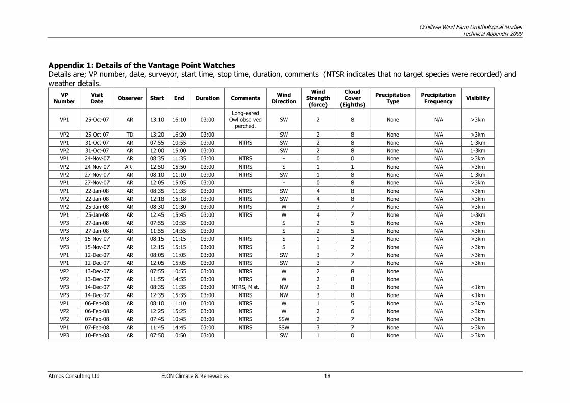
Ochiltree Wind Farm Ornithological Studies Technical Appendix 2009
Atmos Consulting Ltd E.ON Climate & Renewables 18
Appendix 1: Details of the Vantage Point Watches Details are; VP number, date, surveyor, start time, stop time, duration, comments (NTSR indicates that no target species were recorded) and weather details.
VP Number
Visit Date
Observer Start End Duration Comments Wind
Direction
Wind Strength (force)
Cloud Cover
(Eighths)
Precipitation Type
Precipitation Frequency
Visibility
VP1 25-Oct-07 AR 13:10 16:10 03:00 Long-eared
Owl observed perched.
SW 2 8 None N/A >3km
VP2 25-Oct-07 TD 13:20 16:20 03:00 SW 2 8 None N/A >3km
VP1 31-Oct-07 AR 07:55 10:55 03:00 NTRS SW 2 8 None N/A 1-3km
VP2 31-Oct-07 AR 12:00 15:00 03:00 SW 2 8 None N/A 1-3km
VP1 24-Nov-07 AR 08:35 11:35 03:00 NTRS - 0 0 None N/A >3km
VP2 24-Nov-07 AR 12:50 15:50 03:00 NTRS S 1 1 None N/A >3km
VP2 27-Nov-07 AR 08:10 11:10 03:00 NTRS SW 1 8 None N/A 1-3km
VP1 27-Nov-07 AR 12:05 15:05 03:00 - 0 8 None N/A >3km
VP1 22-Jan-08 AR 08:35 11:35 03:00 NTRS SW 4 8 None N/A >3km
VP2 22-Jan-08 AR 12:18 15:18 03:00 NTRS SW 4 8 None N/A >3km
VP2 25-Jan-08 AR 08:30 11:30 03:00 NTRS W 3 7 None N/A >3km
VP1 25-Jan-08 AR 12:45 15:45 03:00 NTRS W 4 7 None N/A 1-3km
VP3 27-Jan-08 AR 07:55 10:55 03:00 S 2 5 None N/A >3km
VP3 27-Jan-08 AR 11:55 14:55 03:00 S 2 5 None N/A >3km
VP3 15-Nov-07 AR 08:15 11:15 03:00 NTRS S 1 2 None N/A >3km
VP3 15-Nov-07 AR 12:15 15:15 03:00 NTRS S 1 2 None N/A >3km
VP1 12-Dec-07 AR 08:05 11:05 03:00 NTRS SW 3 7 None N/A >3km
VP1 12-Dec-07 AR 12:05 15:05 03:00 NTRS SW 3 7 None N/A >3km
VP2 13-Dec-07 AR 07:55 10:55 03:00 NTRS W 2 8 None N/A
VP2 13-Dec-07 AR 11:55 14:55 03:00 NTRS W 2 8 None N/A
VP3 14-Dec-07 AR 08:35 11:35 03:00 NTRS, Mist. NW 2 8 None N/A <1km
VP3 14-Dec-07 AR 12:35 15:35 03:00 NTRS NW 3 8 None N/A <1km
VP1 06-Feb-08 AR 08:10 11:10 03:00 NTRS W 1 5 None N/A >3km
VP2 06-Feb-08 AR 12:25 15:25 03:00 NTRS W 2 6 None N/A >3km
VP2 07-Feb-08 AR 07:45 10:45 03:00 NTRS SSW 2 7 None N/A >3km
VP1 07-Feb-08 AR 11:45 14:45 03:00 NTRS SSW 3 7 None N/A >3km
VP3 10-Feb-08 AR 07:50 10:50 03:00 SW 1 0 None N/A >3km
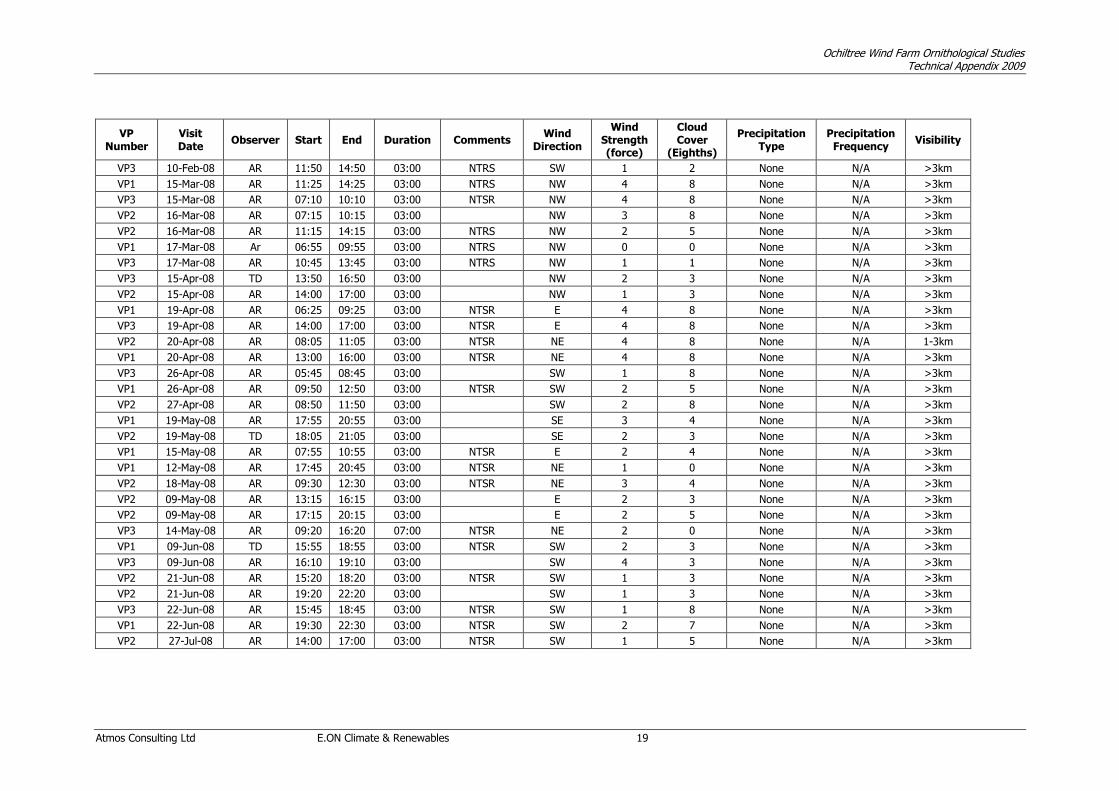
Ochiltree Wind Farm Ornithological Studies Technical Appendix 2009
Atmos Consulting Ltd E.ON Climate & Renewables 19
VP Number
Visit Date
Observer Start End Duration Comments Wind
Direction
Wind Strength (force)
Cloud Cover
(Eighths)
Precipitation Type
Precipitation Frequency
Visibility
VP3 10-Feb-08 AR 11:50 14:50 03:00 NTRS SW 1 2 None N/A >3km
VP1 15-Mar-08 AR 11:25 14:25 03:00 NTRS NW 4 8 None N/A >3km
VP3 15-Mar-08 AR 07:10 10:10 03:00 NTSR NW 4 8 None N/A >3km
VP2 16-Mar-08 AR 07:15 10:15 03:00 NW 3 8 None N/A >3km
VP2 16-Mar-08 AR 11:15 14:15 03:00 NTRS NW 2 5 None N/A >3km
VP1 17-Mar-08 Ar 06:55 09:55 03:00 NTRS NW 0 0 None N/A >3km
VP3 17-Mar-08 AR 10:45 13:45 03:00 NTRS NW 1 1 None N/A >3km
VP3 15-Apr-08 TD 13:50 16:50 03:00 NW 2 3 None N/A >3km
VP2 15-Apr-08 AR 14:00 17:00 03:00 NW 1 3 None N/A >3km
VP1 19-Apr-08 AR 06:25 09:25 03:00 NTSR E 4 8 None N/A >3km
VP3 19-Apr-08 AR 14:00 17:00 03:00 NTSR E 4 8 None N/A >3km
VP2 20-Apr-08 AR 08:05 11:05 03:00 NTSR NE 4 8 None N/A 1-3km
VP1 20-Apr-08 AR 13:00 16:00 03:00 NTSR NE 4 8 None N/A >3km
VP3 26-Apr-08 AR 05:45 08:45 03:00 SW 1 8 None N/A >3km
VP1 26-Apr-08 AR 09:50 12:50 03:00 NTSR SW 2 5 None N/A >3km
VP2 27-Apr-08 AR 08:50 11:50 03:00 SW 2 8 None N/A >3km
VP1 19-May-08 AR 17:55 20:55 03:00 SE 3 4 None N/A >3km
VP2 19-May-08 TD 18:05 21:05 03:00 SE 2 3 None N/A >3km
VP1 15-May-08 AR 07:55 10:55 03:00 NTSR E 2 4 None N/A >3km
VP1 12-May-08 AR 17:45 20:45 03:00 NTSR NE 1 0 None N/A >3km
VP2 18-May-08 AR 09:30 12:30 03:00 NTSR NE 3 4 None N/A >3km
VP2 09-May-08 AR 13:15 16:15 03:00 E 2 3 None N/A >3km
VP2 09-May-08 AR 17:15 20:15 03:00 E 2 5 None N/A >3km
VP3 14-May-08 AR 09:20 16:20 07:00 NTSR NE 2 0 None N/A >3km
VP1 09-Jun-08 TD 15:55 18:55 03:00 NTSR SW 2 3 None N/A >3km
VP3 09-Jun-08 AR 16:10 19:10 03:00 SW 4 3 None N/A >3km
VP2 21-Jun-08 AR 15:20 18:20 03:00 NTSR SW 1 3 None N/A >3km
VP2 21-Jun-08 AR 19:20 22:20 03:00 SW 1 3 None N/A >3km
VP3 22-Jun-08 AR 15:45 18:45 03:00 NTSR SW 1 8 None N/A >3km
VP1 22-Jun-08 AR 19:30 22:30 03:00 NTSR SW 2 7 None N/A >3km
VP2 27-Jul-08 AR 14:00 17:00 03:00 NTSR SW 1 5 None N/A >3km
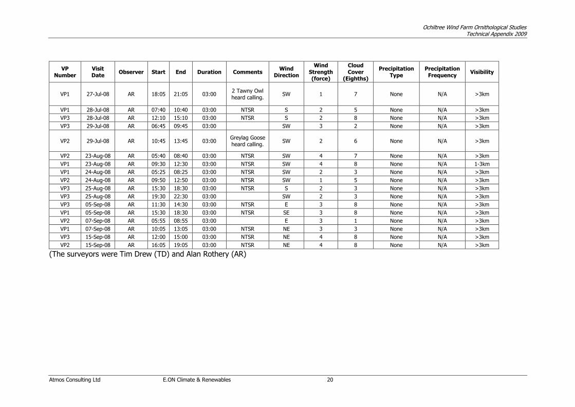
Ochiltree Wind Farm Ornithological Studies Technical Appendix 2009
Atmos Consulting Ltd E.ON Climate & Renewables 20
VP Number
Visit Date
Observer Start End Duration Comments Wind
Direction
Wind Strength (force)
Cloud Cover
(Eighths)
Precipitation Type
Precipitation Frequency
Visibility
VP1 27-Jul-08 AR 18:05 21:05 03:00 2 Tawny Owl heard calling.
SW 1 7 None N/A >3km
VP1 28-Jul-08 AR 07:40 10:40 03:00 NTSR S 2 5 None N/A >3km
VP3 28-Jul-08 AR 12:10 15:10 03:00 NTSR S 2 8 None N/A >3km
VP3 29-Jul-08 AR 06:45 09:45 03:00 SW 3 2 None N/A >3km
VP2 29-Jul-08 AR 10:45 13:45 03:00 Greylag Goose heard calling.
SW 2 6 None N/A >3km
VP2 23-Aug-08 AR 05:40 08:40 03:00 NTSR SW 4 7 None N/A >3km
VP1 23-Aug-08 AR 09:30 12:30 03:00 NTSR SW 4 8 None N/A 1-3km
VP1 24-Aug-08 AR 05:25 08:25 03:00 NTSR SW 2 3 None N/A >3km
VP2 24-Aug-08 AR 09:50 12:50 03:00 NTSR SW 1 5 None N/A >3km
VP3 25-Aug-08 AR 15:30 18:30 03:00 NTSR S 2 3 None N/A >3km
VP3 25-Aug-08 AR 19:30 22:30 03:00 SW 2 3 None N/A >3km
VP3 05-Sep-08 AR 11:30 14:30 03:00 NTSR E 3 8 None N/A >3km
VP1 05-Sep-08 AR 15:30 18:30 03:00 NTSR SE 3 8 None N/A >3km
VP2 07-Sep-08 AR 05:55 08:55 03:00 E 3 1 None N/A >3km
VP1 07-Sep-08 AR 10:05 13:05 03:00 NTSR NE 3 3 None N/A >3km
VP3 15-Sep-08 AR 12:00 15:00 03:00 NTSR NE 4 8 None N/A >3km
VP2 15-Sep-08 AR 16:05 19:05 03:00 NTSR NE 4 8 None N/A >3km
(The surveyors were Tim Drew (TD) and Alan Rothery (AR)

Ochiltree Wind Farm Ornithological Studies Technical Appendix 2009
Atmos Consulting Ltd E.ON Climate & Renewables 21
APPENDIX 2: COMPLETE SPECIES LIST (list of Species Recorded per Survey Type: “VP” Vantage Point, “UBB” Upland Breeding Bird, “WW” Winter Walkover and “WPC” Woodland Point Counts).
British (English) Scientific name Survey Type Annex
1 Schedule
1 UK BAP
L BAP
Scottish Priority
Red and Amber Listed
Sensitive to Wind Farms VP UBB WW WPC WPC 09
Greylag Goose Anser anser A
Canada Goose Branta canadensis
Teal Anas crecca A
Mallard Anas platyrhynchos
Goldeneye Bucephala clangula A
Goosander Mergus merganser
Pheasant Phasianus colchicus
Great Crested Grebe Podiceps cristatus
Cormorant Phalacrocorax carbo A
Grey Heron Ardea cinerea
Goshawk Accipiter gentilis
Sparrowhawk Accipiter nisus
Buzzard Buteo buteo
Kestrel Falco tinnunculus A
Peregrine Falco peregrinus A
Oystercatcher Haematopus ostralegus A
Golden Plover Pluvialis apricaria
Snipe Gallinago gallinago A
Curlew Numenius arquata A
Common Sandpiper Actitis hypoleucos
Black-headed Gull Larus ridibundus A
Common Gull Larus canus A
Herring Gull Larus argentatus A
Stock Dove Columba oenas A
Woodpigeon Columba palumbus
Cuckoo Cuculus canorus A
Barn Owl Tyto alba A
Tawny Owl Strix aluco
Long-eared Owl Asio otus
Short-eared Owl Asio flammeus A
Great Spotted Woodpecker Dendrocopos major
Skylark Alauda arvensis R
Sand Martin Riparia riparia A
Swallow Hirundo rustica A
House Martin Delichon urbicum A
Tree Pipit Anthus trivialis R
Meadow Pipit Anthus pratensis A
Grey Wagtail Motacilla cinerea A
Pied Wagtail Motacilla alba

Ochiltree Wind Farm Ornithological Studies Technical Appendix 2009
Atmos Consulting Ltd E.ON Climate & Renewables 22
British (English) Scientific name Survey Type Annex
1 Schedule
1 UK BAP
L BAP
Scottish Priority
Red and Amber Listed
Sensitive to Wind Farms VP UBB WW WPC WPC 09
Dipper Cinclus cinclus
Wren Troglodytes troglodytes
Dunnock Prunella modularis A
Robin Erithacus rubecula
Whinchat Saxicola rubetra
Stonechat Saxicola torquatus A
Wheatear Oenanthe oenanthe
Blackbird Turdus merula
Fieldfare Turdus pilaris A
Song Thrush Turdus philomelos R
Redwing Turdus iliacus A
Mistle Thrush Turdus viscivorus A
Grasshopper Warbler Locustella naevia R
Sedge Warbler Acrocephalus schoenobaenus
Blackcap Sylvia atricapilla
Garden Warbler Sylvia borin
Whitethroat Sylvia communis
Chiffchaff Phylloscopus collybita
Willow Warbler Phylloscopus trochilus A
Goldcrest Regulus regulus A
Long-tailed Tit Aegithalos caudatus
Blue Tit Cyanistes caeruleus
Great Tit Parus major
Coal Tit Periparus ater
Treecreeper Certhia familiaris
Magpie Pica pica
Jackdaw Corvus monedula
Carrion Crow Corvus corone
Raven Corvus corax
Starling Sturnus vulgaris R
House Sparrow Passer domesticus R
Chaffinch Fringilla coelebs
Goldfinch Carduelis carduelis
Siskin Carduelis spinus
Linnet Carduelis cannabina R
Lesser Redpoll Carduelis cabaret A
Common Crossbill Loxia curvirostra
Bullfinch Pyrrhula pyrrhula R
Reed Bunting Emberiza schoeniclus R
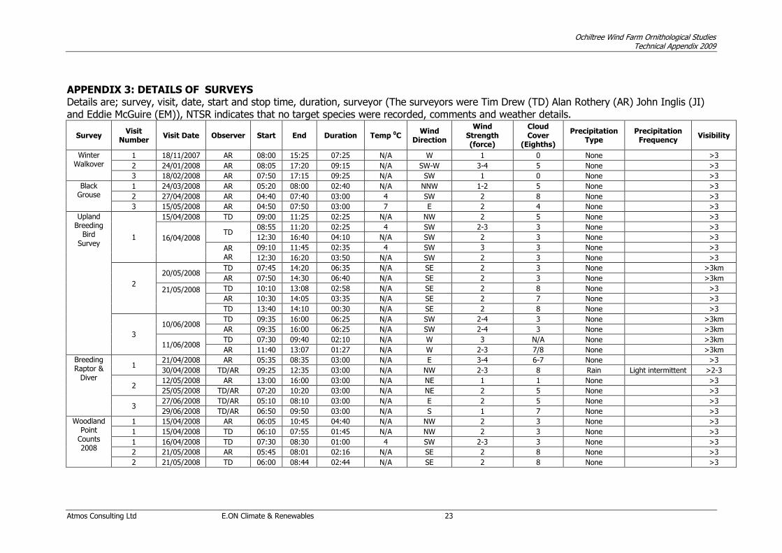
Ochiltree Wind Farm Ornithological Studies Technical Appendix 2009
Atmos Consulting Ltd E.ON Climate & Renewables 23
APPENDIX 3: DETAILS OF SURVEYS Details are; survey, visit, date, start and stop time, duration, surveyor (The surveyors were Tim Drew (TD) Alan Rothery (AR) John Inglis (JI) and Eddie McGuire (EM)), NTSR indicates that no target species were recorded, comments and weather details.
Survey Visit
Number Visit Date Observer Start End Duration Temp 0C
Wind Direction
Wind Strength (force)
Cloud Cover
(Eighths)
Precipitation Type
Precipitation Frequency
Visibility
Winter Walkover
1 18/11/2007 AR 08:00 15:25 07:25 N/A W 1 0 None >3
2 24/01/2008 AR 08:05 17:20 09:15 N/A SW-W 3-4 5 None >3
3 18/02/2008 AR 07:50 17:15 09:25 N/A SW 1 0 None >3
Black Grouse
1 24/03/2008 AR 05:20 08:00 02:40 N/A NNW 1-2 5 None >3
2 27/04/2008 AR 04:40 07:40 03:00 4 SW 2 8 None >3
3 15/05/2008 AR 04:50 07:50 03:00 7 E 2 4 None >3
Upland Breeding
Bird Survey
1
15/04/2008 TD 09:00 11:25 02:25 N/A NW 2 5 None >3
16/04/2008
TD 08:55 11:20 02:25 4 SW 2-3 3 None >3
12:30 16:40 04:10 N/A SW 2 3 None >3
AR AR
09:10 11:45 02:35 4 SW 3 3 None >3
12:30 16:20 03:50 N/A SW 2 3 None >3
2
20/05/2008 TD 07:45 14:20 06:35 N/A SE 2 3 None >3km
AR 07:50 14:30 06:40 N/A SE 2 3 None >3km
21/05/2008
TD 10:10 13:08 02:58 N/A SE 2 8 None >3
AR 10:30 14:05 03:35 N/A SE 2 7 None >3
TD 13:40 14:10 00:30 N/A SE 2 8 None >3
3
10/06/2008 TD 09:35 16:00 06:25 N/A SW 2-4 3 None >3km
AR 09:35 16:00 06:25 N/A SW 2-4 3 None >3km
11/06/2008 TD 07:30 09:40 02:10 N/A W 3 N/A None >3km
AR 11:40 13:07 01:27 N/A W 2-3 7/8 None >3km
Breeding Raptor &
Diver
1 21/04/2008 AR 05:35 08:35 03:00 N/A E 3-4 6-7 None >3
30/04/2008 TD/AR 09:25 12:35 03:00 N/A NW 2-3 8 Rain Light intermittent >2-3
2 12/05/2008 AR 13:00 16:00 03:00 N/A NE 1 1 None >3
25/05/2008 TD/AR 07:20 10:20 03:00 N/A NE 2 5 None >3
3 27/06/2008 TD/AR 05:10 08:10 03:00 N/A E 2 5 None >3
29/06/2008 TD/AR 06:50 09:50 03:00 N/A S 1 7 None >3
Woodland Point
Counts 2008
1 15/04/2008 AR 06:05 10:45 04:40 N/A NW 2 3 None >3
1 15/04/2008 TD 06:10 07:55 01:45 N/A NW 2 3 None >3
1 16/04/2008 TD 07:30 08:30 01:00 4 SW 2-3 3 None >3
2 21/05/2008 AR 05:45 08:01 02:16 N/A SE 2 8 None >3
2 21/05/2008 TD 06:00 08:44 02:44 N/A SE 2 8 None >3

Ochiltree Wind Farm Ornithological Studies Technical Appendix 2009
Atmos Consulting Ltd E.ON Climate & Renewables 24
Survey Visit
Number Visit Date Observer Start End Duration Temp 0C
Wind Direction
Wind Strength (force)
Cloud Cover
(Eighths)
Precipitation Type
Precipitation Frequency
Visibility
2 21/05/2008 AR 08:28 10:03 01:35 N/A SE 2 8 None >3
2 25/05/2008 AR 05:45 06:50 01:0 N/A NE 2 4 None >3
3 11/06/2008 AR 05:05 11:35 06:30 N/A W 2-3 7 None >3
3 11/06/2008 TD 05:00 06:50 01:50 N/A W 3 6 None
3 11/06/2008 TD 10:10 11:40 01:30 N/A W 2 7 None
3 27/06/2008 AR 08:30 09:30 01:00 N/A E 2 3 None >3
Nightjar Survey
1 11/06/2008 TD/AR 02:00 04:00 02:00 N/A W 3 8 None
2 11/07/2008 TD/AR 02:00 04:00 02:00 N/A S 1 8 None
Woodland Point
Counts 2009
1 13/05/2009 JI 05:40 11:02 05:22 8 SW 1 0 None >3
1 14/05/2009 JI 05:10 10:36 05:26 8 E 2 7 None >3
2 04/06/2009 JI 04:40 11:00 06:20 10 ? 0 4 None >3
2 05/06/2009 JI 05:00 09:30 04:30 8 NNE 1 7 None >3
3 22/06/2009 JI 05:00 11:00 06:00 14 ? 0 8 Rain Light intermittent 1-2
3 23/06/2009 JI 04:50 10:00 05:10 11 ? 1 2 None >2
Additional Raptor Survey
1 26/03/2009 EM 11:30 20:20 07:45 7 SW 4 4-7 Rain Blustery Showers 1-3
2 27/03/209 EM 05:30 14:00 07:00 N/A SW 1.2 3 None >3
3 16/04/2009 AR 08:05 15:55 15 E 3-4 1 None >3

Ochiltree Wind Farm Ornithological Studies Technical Appendix 2009
Atmos Consulting Ltd E.ON Climate & Renewables 25
APPENDIX 4: COLLISION RISK MODELLING Collision Risk Model Calculations for Golden Plover for Ochiltree at 95% Avoidance. Stage 1: Number of birds flying through the rotors per year
1.1
VP Area
(Ha)
Time
(hours)
1 618.6 78
2 420.5 81
3 427.8 70
Total 1467 229
1.2 8.7E-05
Mean bird activity =Total bird activity/number of VPs
Mean bird activity = 8.70156670188152E-052.90052223396051E-05 s/ha/3 = s/ha
Overall area covered by VPs (excluding overlap) = 1175 ha
% of time birds active in the area = Overall area (excluding overlaps) in ha x mean bird activity (s/ha)
% of time birds active in area = 1175 x 2.90052223396051E-05 =
1.3
Corrected bird activity=Proportion of actual height band x % birds active in the area
Hub height = 75 m Observed height band max = 125 m
Rotor radius = 40 m Observed height band min = 20 m
Rotor max height= hub height + rotor radius
Rotor min height= hub height - rotor radius
Rotor max height = 115 m
Rotor min height = 35 m
Proportion of actual height band = (115 - 35)/(125 - 20)
Proportion of actual height band = 0.762
Corrected bird activity =
1.4
Hours potentially active = 4500.93911163438
No. of hours of bird occupancy in the airspace per year =hours potentially active x bird activity
No. of hours of bird occupancy in the airspace per year = 4500.93911163438 x 0.0259665799992655
No. of hours of bird occupancy = 116.874
1.5 Calculate the flight risk volume
Flight risk volume (Vw) = Overall area (ha) x 10000 x rotor radius (m) x 2
Vw = 1175 x 10000 x 40 x 2
Vw = 940000000 m3 940000000
Calculate the time the site was observed for and how long birds (as a % area-time activity) were
seen in the observation area during this time and bird activity for each vantage point
Proportion of actual height band = (Rotor max height – rotor min height)/(observed height band
max – observed height band min)
Hours potentially active are taken as daylight hours only for the year and then calculated, where the
day length is a function of latitude and day of the year[1]
Calculate the number of hours per day the birds are potentially active over a year and
the number of hours of bird occupancy in the airspace per year
Correct for differences between the recording height band and the actual
height band swept by the rotors
Calculate the average bird observation activity in all areas and the percentage of time birds active
within the overall observed area
Ha hours
48250.80
335920.10
29946.00
34060.50
94751209312360
Ha seconds
(hours x 3600)
173702880
122617800
107805600
Flight time
observed in risk
window (s)
0780
8695
Bird Activity
0.0000E+00
6.3612E-06
8.0654E-05
3.4081E-02
2.597E-02
2.901E-05
8.7016E-05

Ochiltree Wind Farm Ornithological Studies Technical Appendix 2009
Atmos Consulting Ltd E.ON Climate & Renewables 26
1.6 Calculate the combined rotor swept volume
Number of turbines = 10
Maximum chord = 3.25 m
Bird length = 0.29 m
Vr = 10 x Pi x 40 x 40 x (3.25 + 0.29)
Vr = 177939.808 m3 177939.81
1.7 Calculate the bird occupancy in the rotor swept volume
Bird occupancy in rotor swept volume = 116.873995514077 x 3600 x 177939.81/940000000
Bird occupancy in rotor swept volume = 79.64631
1.8 Calculate the bird transit time through the rotors and the potential number of transits per year
Bird speed = 10 m/s
Bird transit time through the rotors = (maximum chord + bird length) /bird speed
No. of transits = bird occupancy in the rotor swept volume/bird transit time
No. of transits = 79.64631/0.354
No. of transits = 224.989577 224.98958
Stage 2: Collision risk for bird passing through rotor area (assuming no avoidance)
2.1 Convert pitch of chord into radians
K:1D or 3D (0 or 1) 1
No. of blades 3
Maximum chord 3.25 m
Pitch (degrees) 15 0.262
Rotor radius 40 m
Rotation Period 4 s
Pitch in radians = pitch (degrees) x Pi/180
Pitch in radians = 15 x Pi/180
Pitch in radians = 0.2618 0.262
2.2 Calculate the bird aspect ratio
Bird length 0.29 m
Wingspan 0.76 m
Bird speed 10 m/s
F:Flapping 1
Bird aspect ratio (b) = bird length/wingspan
Bird aspect ratio (b) = 0.29/0.76
Bird aspect ratio (b) = 0.3816 0.381578947
Bird transit time through the rotors = (3.25 + 0.29)/10
No. of hours of bird occupancy (converted to seconds) x Combined rotor swept volume/Flight risk
volume = n x (Vr/Vw)
Combined rotor swept volume (Vr) = number of turbines (N) x Pi x r2 x (maximum chord + bird
length)
Bird transit time through the rotors = 0.354 s

Ochiltree Wind Farm Ornithological Studies Technical Appendix 2009
Atmos Consulting Ltd E.ON Climate & Renewables 27
2.3 Calculation of alpha and p(collision) as a function of radius
0.025 0.575 6.366198 16.81 1 0.00125 15.8461 1 0.00125 0.00125
0.075 0.575 2.122066 5.927 0.4445193 0.003333895 4.95959 0.3719691 0.002789768 0.0075
0.125 0.7015 1.27324 4.362 0.327124 0.004089049 3.1815 0.2386127 0.002982659 0.0125
0.175 0.8601 0.909457 3.87 0.2902705 0.005079734 2.42331 0.181748 0.00318059 0.0175
0.225 0.99435 0.707355 3.582 0.2686518 0.006044666 1.90921 0.1431904 0.003221785 0.0225
0.275 0.94665 0.578745 2.956 0.2217027 0.006096823 1.36346 0.1022598 0.002812144 0.0275
0.325 0.89895 0.489708 2.51 0.1882735 0.006118888 0.99799 0.0748491 0.002432595 0.0325
0.375 0.85125 0.424413 2.173 0.1629562 0.006110859 0.74067 0.0555504 0.00208314 0.0375
0.425 0.80355 0.374482 1.911 0.1432925 0.00608993 0.55874 0.0419051 0.001780968 0.0425
0.475 0.75585 0.335063 1.721 0.1290625 0.006130467 0.44925 0.0336936 0.001600447 0.0475
0.525 0.70815 0.303152 1.56 0.1169697 0.006140911 0.36826 0.0276194 0.001450019 0.0525
0.575 0.66045 0.276791 1.419 0.1064567 0.006121262 0.30833 0.0231249 0.001329683 0.0575
0.625 0.61275 0.254648 1.295 0.0971443 0.006071521 0.31559 0.023669 0.00147931 0.0625
0.675 0.56505 0.235785 1.184 0.0887657 0.005991687 0.34705 0.026029 0.00175696 0.0675
0.725 0.51735 0.219524 1.082 0.0811277 0.005881761 0.36865 0.0276485 0.002004518 0.0725
0.775 0.46965 0.205361 0.988 0.074087 0.005741742 0.38228 0.0286708 0.002221984 0.0775
0.825 0.42195 0.192915 0.9 0.0675349 0.005571631 0.38939 0.0292043 0.002409357 0.0825
0.875 0.37425 0.181891 0.819 0.0613877 0.005371427 0.39111 0.029333 0.002566637 0.0875
0.925 0.32655 0.172059 0.741 0.0555798 0.00514113 0.3883 0.0291224 0.002693824 0.0925
0.975 0.27885 0.163236 0.667 0.0500589 0.004880741 0.38166 0.0286248 0.00279092 0.0975
0.1072581 0.0448373 0.9988
Average probability of collision = (upwind collision total + downwind collision total)/2
Average probability of collision = (0.107258124606542 + 0.044837307946593)/2
Average probability of collision = 0.076048
Stage 3: Mitigation Effects
3.1 Annual collision risk for Golden plover assuming no avoidance
Annual collision risk = no. of transits per year through the rotors x the average probability of collision
Annual collision risk = 224.989576873953 x 0.076048
Annual collision risk = 17.109944 birds 17.1099
3.2 Corrected annual collision risk assuming avoidance
Golden plover avoidance rate = 0.95
Annual collision risk, with avoidance = annual collision risk x (1 - avoidance rate)
Annual collision risk, with avoidance = 17.1099435072953 x (1 - 0.95)
Annual collision risk, with avoidance = 0.855497175364768 birds
3.3 Corrected for assumed operational downtime of the rotors
Proportion of time wind turbines operational = 0.85
Corrected annual risk = annual risk, with avoidance x proportion of time wind turbines operational
Corrected annual risk = 0.727173 birds 0.72717
3.4 Calculate number of years per collision
Number of years per collision for Golden plover = 1/corrected annual risk
Number of years per collision for Golden plover = 1/0.727172599060053
Number of years per collision for Golden plover = 1.3752
check
area
total
Overall p(collision) Upwind
contribution
from radius r
r/R
radius
c/C chord a alpha
collide
length
Downwind
Upwind: Downwind:
collide
length
p(collision)contribution
from radius r
p(collision)

Ochiltree Wind Farm Ornithological Studies Technical Appendix 2009
Atmos Consulting Ltd E.ON Climate & Renewables 28
Collision Risk Model Calculations for Greylag Goose for Ochiltree at 95% Avoidance. Stage 1: Number of birds flying through the rotors per year
1.1
VP Area
(Ha)
Time
(hours)
1 618.6 78
2 420.5 81
3 427.8 70
Total 1467 229
1.2 6.6E-06
Mean bird activity =Total bird activity/number of VPs
Mean bird activity = 6.64139336995583E-062.21379778998528E-06 s/ha/3 = s/ha
Overall area covered by VPs (excluding overlap) = 1175 ha
% of time birds active in the area = Overall area (excluding overlaps) in ha x mean bird activity (s/ha)
% of time birds active in area = 1175 x 2.21379778998528E-06 =
1.3
Corrected bird activity=Proportion of actual height band x % birds active in the area
Hub height = 75 m Observed height band max = 125 m
Rotor radius = 40 m Observed height band min = 20 m
Rotor max height= hub height + rotor radius
Rotor min height= hub height - rotor radius
Rotor max height = 115 m
Rotor min height = 35 m
Proportion of actual height band = (115 - 35)/(125 - 20)
Proportion of actual height band = 0.762
Corrected bird activity =
1.4
Hours potentially active = 5571.70433372579
No. of hours of bird occupancy in the airspace per year =hours potentially active x bird activity
No. of hours of bird occupancy in the airspace per year = 5571.70433372579 x 0.00198187611674872
No. of hours of bird occupancy = 11.04243
1.5 Calculate the flight risk volume
Flight risk volume (Vw) = Overall area (ha) x 10000 x rotor radius (m) x 2
Vw = 1175 x 10000 x 40 x 2
Vw = 940000000 m3 940000000
2.6012E-03
1.982E-03
2.214E-06
6.6414E-06
Bird Activity
2.8497E-06
1.9736E-06
1.8181E-06
Flight time
observed in risk
window (s)
495242
196
Ha seconds
(hours x 3600)
173702880
122617800
1078056009331209312360
48250.80
335920.10
29946.00
34060.50
Calculate the time the site was observed for and how long birds (as a % area-time activity) were
seen in the observation area during this time and bird activity for each vantage point
Proportion of actual height band = (Rotor max height – rotor min height)/(observed height band
max – observed height band min)
Hours potentially active are taken as daylight hours plus 25% night time hours for the year and then
calculated, where the day length is a function of latitude and day of the year[1]
Calculate the number of hours per day the birds are potentially active over a year and
the number of hours of bird occupancy in the airspace per year
Correct for differences between the recording height band and the actual
height band swept by the rotors
Calculate the average bird observation activity in all areas and the percentage of time birds active
within the overall observed area
Ha hours
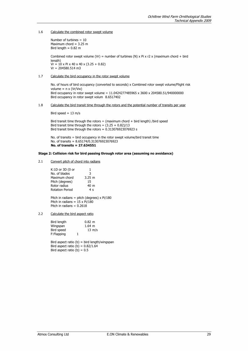
Ochiltree Wind Farm Ornithological Studies Technical Appendix 2009
Atmos Consulting Ltd E.ON Climate & Renewables 29
1.6 Calculate the combined rotor swept volume
Number of turbines = 10
Maximum chord = 3.25 m
Bird length = 0.82 m
Vr = 10 x Pi x 40 x 40 x (3.25 + 0.82)
Vr = 204580.514 m3 204580.51
1.7 Calculate the bird occupancy in the rotor swept volume
Bird occupancy in rotor swept volume = 11.0424277485965 x 3600 x 204580.51/940000000
Bird occupancy in rotor swept volume = 8.6517402
1.8 Calculate the bird transit time through the rotors and the potential number of transits per year
Bird speed = 13 m/s
Bird transit time through the rotors = (maximum chord + bird length) /bird speed
No. of transits = bird occupancy in the rotor swept volume/bird transit time
No. of transits = 8.65174/0.313076923076923
No. of transits = 27.634551 27.634551
Stage 2: Collision risk for bird passing through rotor area (assuming no avoidance)
2.1 Convert pitch of chord into radians
K:1D or 3D (0 or 1) 1
No. of blades 3
Maximum chord 3.25 m
Pitch (degrees) 15 0.262
Rotor radius 40 m
Rotation Period 4 s
Pitch in radians = pitch (degrees) x Pi/180
Pitch in radians = 15 x Pi/180
Pitch in radians = 0.2618 0.262
2.2 Calculate the bird aspect ratio
Bird length 0.82 m
Wingspan 1.64 m
Bird speed 13 m/s
F:Flapping 1
Bird aspect ratio (b) = bird length/wingspan
Bird aspect ratio (b) = 0.82/1.64
Bird aspect ratio (b) = 0.5 0.5
Bird transit time through the rotors = 0.313076923076923 s
No. of hours of bird occupancy (converted to seconds) x Combined rotor swept volume/Flight risk
volume = n x (Vr/Vw)
Combined rotor swept volume (Vr) = number of turbines (N) x Pi x r2 x (maximum chord + bird
length)
Bird transit time through the rotors = (3.25 + 0.82)/13

Ochiltree Wind Farm Ornithological Studies Technical Appendix 2009
Atmos Consulting Ltd E.ON Climate & Renewables 30
2.3 Calculation of alpha and p(collision) as a function of radius
0.025 0.575 8.276057 29 1 0.00125 28.028 1 0.00125 0.00125
0.075 0.575 2.758686 9.988 0.5762045 0.004321534 9.02021 0.5203966 0.003902975 0.0075
0.125 0.7015 1.655211 6.95 0.4009449 0.005011812 5.76956 0.3328593 0.004160742 0.0125
0.175 0.8601 1.182294 5.855 0.3377728 0.005911025 4.40776 0.254294 0.004450145 0.0175
0.225 0.99435 0.919562 5.215 0.300861 0.006769372 3.5421 0.2043522 0.004597925 0.0225
0.275 0.94665 0.752369 4.266 0.246118 0.006768244 2.67347 0.1542388 0.004241568 0.0275
0.325 0.89895 0.63662 3.597 0.2075067 0.006743969 2.08446 0.1202572 0.003908359 0.0325
0.375 0.85125 0.551737 3.095 0.1785745 0.006696545 1.66321 0.0959546 0.003598299 0.0375
0.425 0.80355 0.486827 2.724 0.1571516 0.006678944 1.37213 0.0791614 0.003364358 0.0425
0.475 0.75585 0.435582 2.489 0.1436161 0.006821763 1.21776 0.0702554 0.003337132 0.0475
0.525 0.70815 0.394098 2.292 0.1322178 0.006941433 1.10044 0.0634868 0.003333055 0.0525
0.575 0.66045 0.359829 2.122 0.1223992 0.007037955 1.0105 0.0582978 0.003352125 0.0575
0.625 0.61275 0.331042 1.972 0.1137813 0.007111329 0.94136 0.0543095 0.003394344 0.0625
0.675 0.56505 0.306521 1.839 0.1060971 0.007161555 0.88842 0.051255 0.003459711 0.0675
0.725 0.51735 0.285381 1.719 0.0991536 0.007188633 0.84831 0.048941 0.003548225 0.0725
0.775 0.46965 0.26697 1.609 0.0928073 0.007192562 0.82144 0.047391 0.003672804 0.0775
0.825 0.42195 0.25079 1.507 0.0869496 0.007173344 0.84273 0.048619 0.00401107 0.0825
0.875 0.37425 0.236459 1.413 0.0814969 0.007130977 0.857 0.0494421 0.004326187 0.0875
0.925 0.32655 0.223677 1.324 0.0763834 0.007065462 0.86538 0.049926 0.004618157 0.0925
0.975 0.27885 0.212207 1.24 0.0715569 0.006976799 0.8688 0.0501229 0.004886978 0.0975
0.1279533 0.0754142 0.9988
Average probability of collision = (upwind collision total + downwind collision total)/2
Average probability of collision = (0.127953255753433 + 0.0754141568974884)/2
Average probability of collision = 0.101684
Stage 3: Mitigation Effects
3.1 Annual collision risk for Greylag goose assuming no avoidance
Annual collision risk = no. of transits per year through the rotors x the average probability of collision
Annual collision risk = 27.6345510536029 x 0.101684
Annual collision risk = 2.809984 birds 2.80998
3.2 Corrected annual collision risk assuming avoidance
Greylag goose avoidance rate = 0.95
Annual collision risk, with avoidance = annual collision risk x (1 - avoidance rate)
Annual collision risk, with avoidance = 2.80998357377051 x (1 - 0.95)
Annual collision risk, with avoidance = 0.140499178688526 birds
3.3 Corrected for assumed operational downtime of the rotors
Proportion of time wind turbines operational = 0.85
Corrected annual risk = annual risk, with avoidance x proportion of time wind turbines operational
Corrected annual risk = 0.119424 birds 0.11942
3.4 Calculate number of years per collision
Number of years per collision for Greylag goose = 1/corrected annual risk
Number of years per collision for Greylag goose = 1/0.119424301885247
Number of years per collision for Greylag goose = 8.3735
Downwind
Upwind: Downwind:
collide
length
p(collision)contribution
from radius r
p(collision)
check
area
total
Overall p(collision) Upwind
contribution
from radius r
r/R
radius
c/C chord a alpha
collide
length
CB CONSULTING REPORT NO: 172A
OCHILTREE WIND FARM:
PEAT STABILITY ASSESSMENT
ISSUE DATE: JUNE 2009
CLIENT: ATMOS CONSULTING LTD
AUTHOR: CHRISTOPHER BAKER CENV MIEEM
E-MAIL: [email protected]
REVIEWER: MANUELA TOTH CENG MCIWEM
REPORT STATUS: FINAL
JOB NO: 0172A
COPY NO: 01
REV. NO: 03

Ochiltree Wind FarmPeat Stability Assessment June 2009
i
Contents
1. Introduction 1
2. The Site 2
3. Desk Study 3
4. Ground Investigation 5
5. Ground Conditions 6
6. Peat Conditions 7
7. Risk Assessment 11
8. General Construction Recommendations 15
9. Conclusions 17
10. References 18
11. Appendix A: Peat Probe Results 19
12. Appendix B: Plates 28
13. Appendix C: Von Post Scale 32
Ochiltree Wind FarmPeat Stability Assessment June 2009
1
1. INTRODUCTION
1.1 GENERAL
1.1 CB Consulting were commissioned by Atmos Consulting Ltd, in 2009, to preparea Peat Stability Assessment, carried out in support of the application toDumfries and Galloway Council for the Ochiltree Wind Farm development. Thescheme comprises ten turbines and associated on-site access roads.
1.2 To facilitate the preparation of the Assessment, a site walkover was undertakenby a CB Consulting during March 2009. This included peat probing todetermine the depth of the peat deposits and an assessment of slope angles.
1.3 The investigative works and this report have been undertaken in accordancewith the Scottish Executive document ‘Peat Landslide Hazard and RiskAssessments – Best Practice Guide for Proposed Electricity GenerationDevelopments1.’
1.2 LIMITATIONS
1.4 The interpretation of the ground conditions is based on the informationobtained from the intrusive works. All reasonable skill, care and diligence hasbeen exercised in carrying out this report, within the timescales available.Notwithstanding the efforts made in carrying out this report, within thetimescales available, it is possible that other soil and groundwater conditions, asyet undetected, may exist, and this must be taken into account in any relianceon the findings of this report.
1.5 This report is prepared for Atmos Consulting Ltd in relation to the OchiltreeWind Farm, and takes into account the client’s particular instructions andrequirements. It is provided to the client subject to the terms of ourappointment. Save to the extent we expressly agree in writing, it is notintended to be relied upon by any third party and no responsibility isundertaken to any third party.
1.6 This report does not cover assessment of the new access track from the southconnecting the A714 at Penninghame to the U59W at Glenruther.
Ochiltree Wind FarmPeat Stability Assessment June 2009
2
2. THE SITE
2.1 LOCATION AND TOPOGRAPHY
2.1 The proposed Ochiltree Wind Farm is situated 8 miles northeast of NewtonStewart in Dumfries and Galloway. The proposed site is centred on NationalGrid Reference NX327 748, and covers an approximate area of 150ha.
2.2 Ground levels within the site in the vicinity of the proposed access tracks andturbine locations vary from around 100m Above Ordnance Datum (AOD) to190m AOD.
2.3 The landscape is characterised by a ridge of low lying hills running east tosouth, with north-west facing slopes sweeping gently down to the shores ofLoch Ochiltree and Calnavie Moss.
2.2 PROPOSED WORKS
2.4 It is proposed to construct a ten turbine wind farm. Access tracks to theseturbines will be required, with these joining the existing minor road the U59W.
2.5 The layout of the proposed wind farm is shown on Figure 1.2 Site Layoutprovided by Atmos Consulting.
2.6 Appendix A includes details of the National Grid References of the proposedturbine locations:

Ochiltree Wind FarmPeat Stability Assessment June 2009
3
3. DESK STUDY
3.1 GEOLOGY
3.1 British Geological Survey (BGS) drift maps1 (paper and digital) indicate that thedrift deposits overlying the site consist of three distinct areas of peataccumulation (of >0.5m) (including Calnavie Moss, an area north of Top of TheFell, and a small area within the upper reaches of the Garchew Burn) andglacial deposits (in the form of drumlins), (see Figure 9.4 Drift Geology). Theunderlying solid geology at the site, shown on the BGS maps2 is thin tomedium, vertically or near vertically, bedded greywacke sedimentary rocks ofthe Kirkcolm Formation of the Barrhill Group of the Ordovician period, (seeFigure 9.3 Bedrock Geology).
3.2 HYDROGEOLOGY AND HYDROLOGY
3.2 The 1:625,000 Hydrogeological Map of Scotland (BGS, 1988) shows that theregion is underlain by Ordovician impermeable rocks, generally withoutgroundwater except at shallow depth. Largely greywackes with groundwaterconfined to near surface cracks and joints. Rare springs and boreholes produceweakly mineralised water except where contact is made with sulphide-rich blackshales.
3.3 The Groundwater Vulnerability Map of Scotland (BGS, 1995) describes thebedrock in the area as weakly permeable, not widely containing groundwater inexploitable quantities.
3.4 The Vulnerability of Groundwater in the Uppermost Aquifer Map (SEPA, 2004)shows that groundwater flow within the bedrock is by fracture flow only. Thesuperficial glacial and peat deposits will however provide some protection, dueto their low permeabilities, by slowing or preventing the flow of surface waterinto bedrock fractures.
3.5 The Superficial Aquifers Map (SEPA, 2004) shows that the site may supportsmall superficial aquifers of low productivity intergranular flow, most likelywithin alluvial deposits.
3.6 The Garchew Burn drains the majority of the site to the River Cree. The rest ofthe site drains to Loch Ochiltree which drains via the Beoch Burn into the RiverBladnoch. There are also a number of artificial drains across the site.
3.3 AERIAL PHOTOGRAPH INTERPRETATION
3.7 An aerial photograph, shown on Figure 1.3 Aerial Photograph, of the siteidentified the peatland habitat across the site to broadly speaking comprisethree categories:
Smooth surface on gently sloping areas often drained by ditches (grips).Interpreted as relatively deep peat;
Mottled occasionally hummocky surface on moderate slopes. Interpreted asrelatively thin; and
1 BGS. Carrick 8 (W) drift edition 1:50,000 series.2 BGS. Carrick 8W solid edition 1:50,000 series.

Ochiltree Wind FarmPeat Stability Assessment June 2009
4
Grainy appearance often incised by shallow rills or deeper gullies. Interpretedas patchy, i.e. thin to absent.
3.8 The three peat accumulation areas all show evidence of artificial drainage.Calnavie Moss has a regular parallel drainage channels, draining fromsouthwest to northeast across the remainder of the unplanted Moss.
3.9 The small peat accumulation within the upper reaches of the Garchew Burn alsoshows evidence of artificial drainage, draining from southeast to northwestdown to the Garchew Burn.
3.10 The area of peat accumulation north of Top of The Fell shows evidence of aless dense irregular pattern of artificial drainage.
3.11 No areas of peat instability were identified from the aerial photograph.
3.4 DIGITAL TERRAIN MODEL
3.12 A Digital Terrain Model (DTM) was prepared for the Peat Stability Assessment,which has then been used by Atmos Consulting to produce a peat depth andslope figure, see Figure 9.2 Peat Depth Survey.
3.13 The Peat Depth Survey figure shows that in the area of the proposed windfarm, slope angles typically vary between <2o and 8°.
3.14 As can be seen from the field results in Appendix A, the slope angles generatedby the DTM are generally in agreement with the site based observations at theproposed turbine bases using a clinometer. This corroboration of data providesadditional confidence in using the above slope angle data in the Peat StabilityAssessment.

Ochiltree Wind FarmPeat Stability Assessment June 2009
5
4. GROUND INVESTIGATION
4.1 GENERAL
4.1 A site walkover and ground investigation was carried out in March 2009 by CBConsulting.
4.2 SCOPE OF WORKS
4.2 The site work comprised a targeted assessment (of the three areas of identifiedpeat accumulation) of peat depth by probing.
4.3 In total, the following works were carried out at the site:
147 No. Peat Probes
4.4 Slope angle measurements were taken using a hand held clinometer at theproposed turbine locations.
4.5 The results of the probing are contained in Appendix A.
4.3 PEAT PROBES
4.6 The probe consisted of a 3.5m long segmental fibreglass rod with an enlargedmetal tip. This was pushed into the peat to record the thickness of the deposit.It also enabled an approximate identification of the underlying stratum to bemade. For example, an impenetrable material and a ‘ringing’ sound wasconsidered to indicate rock or a boulder, whilst a significant increase in theforce required to further advance the probe suggested the presence ofweathered glacial material.
4.7 A targeted peat depth survey, of the areas of identified peat accumulation, wascarried out at the locations of the relevant turbines, and at points 25m upslopeand 25m downslope of the turbines.
4.8 Peat depths were recorded along the proposed access track alignments acrossthe identified areas of peat accumulation. Probing was undertaken in two lineseither side of, and parallel to, the proposed track route centre. The probing wasundertaken along these two lines at 25m intervals. The locations at whichprobing was undertaken are shown on Figure 9.2 Peat Depth Survey.
4.9 These investigations enabled an evaluation of peat depths across the site to bemade.
4.4 SLOPE ANGLE MEASUREMENT
4.10 Slope angles were measured at each of the proposed turbine locations using aclinometer. Reference was also made to the slope angles provided on theDigital Terrain Model (DTM) shown on Figure 9.2.
Ochiltree Wind FarmPeat Stability Assessment June 2009
6
5. GROUND CONDITIONS
5.1 GENERAL
5.1 The probing encountered peat at all locations across the site except forTurbines 4, 5 and 6 and their associated access tracks, which confirmed thedesk study findings. The peat was variously underlain by clays, granular glacialdeposits, and bedrock.
5.2 The results of the probing are contained within Appendix A.
5.2 PEAT
Description
5.3 The peat layer at the site varied in thickness from 0.1m to in excess of 3.3m,with an average thickness of less than 1.0m. In general, the thickestaccumulations were encountered in the headwaters of the Garchew Burn, in thenorth area around the proposed tracks and turbines bases associated withturbines 1, 2 and 3 (across Calnavie Moss), and in the south east along theproposed access track to the east of turbine 10 (the edge of a blanket bogextending down from below Top of the Fell.
5.4 The thinnest peat accumulations were typically identified in association withturbine 7 and its access track in the middle of the site. Turbines 8, 10 and theassociated access tracks were characterised by thin peat deposits typically lessthan 0.5m deep.
5.5 The surface vegetation typically varied from heather, to moss, grasses andrushes. Rushes were typically present on the wetter ground.
5.6 Through onsite peat coring, using a Russian Auger, a fibrous root network witha thickness varying between 0.2m to 0.4m was generally encountered beneaththe surface vegetation during probing (see Plates 1 and 2 in Appendix B). Inthe locations, where the deeper peat deposits were encountered, the peatdeeper than 0.5m typically comprised a highly decomposed amorphousmaterial.
5.7 Towards the base of the peat deposits, increasing resistance to probepenetration was frequently noted. This is considered indicative of an increasein strength within the interface zone between the peat and the underlyingstrata.
5.8 Plate 3 (in Appendix B) shows an exposed bank face within a stream bed, thefibrous peat and underlying glacial till are clearly visible, with the transition zonebetween also evident.
Underlying Strata
5.9 The peat was typically considered to be underlain by sedimentary bedrock(Greywackes). An exception to this was Turbine 9 and Turbine 10 and theassociated access track where the peat layer was typically less than 0.5m thick,and was considered to be underlain by thin glacial clays over bedrock.
Ochiltree Wind FarmPeat Stability Assessment June 2009
7
6. PEAT CONDITIONS
6.1 MORPHOLOGY
6.1 There are two distinct layers within a peat bog2, the upper acrotelm and thelower catotelm. The acrotelm is the fibrous surface to the peat bog, typically0.2m to 0.5m thick; which exists between the growing bog surface and thelowest position of the water table in dry summers. Below this are various stagesof decomposition of the vegetation as it slowly becomes assimilated into thebody of the peat.
6.2 For geotechnical purposes the degree of decomposition (humification) can beestimated in the field by applying the ‘squeezing test’ proposed by von Post andGrunland3 (1926). The humification value ranges from H1 (no decomposition)to H10 (highly decomposed). The extended system set out by Hobbs4 providesa means of correlating the types of peat with their physical, chemical andstructural properties (See Appendix C).
6.3 The relative position of the water table within the peat controls the balancebetween accumulation and decomposition and therefore its stability, henceartificial adjustment of the water table by drainage requires carefulconsideration.
6.4 The ground investigation identified the presence of peat over three areas of thesite. The average thickness of this stratum was less than 1m. Peat in excess3.3m was encountered in three locations (zones of accumulation), generally theflatter areas.
6.5 Typically the peat on the site comprises three layers:
The upper vegetation layer consisting of grasses and moss - this also includedthe root layer of undecomposed sphagnum mosses (H1-H3), permeability ishigh;
The fibrous peat - this was encountered below around 0.2m down to 0.5m,permeability is moderate. The fibrous nature of this material is attributable tothe presence of decomposing vegetation, and this layer is typically above theaverage groundwater level (H4-H6); and
Amorphous peat - this was identified beneath the fibrous layer, jelly like. Thismaterial is located beneath the water table and is typically of relatively lowpermeability (H6-H10).
6.2 HYDROLOGY
6.6 The primary watercourse in the site is the Garchew Burn, flowing in a northerlydirection through the site. This is fed by secondary streams flowingapproximately north-westwards from the slopes of the Hill of Ochiltree, Top ofthe Fell and Butter Cairn. There are four small unnamed burns draining the sitewestwards into Loch Ochiltree.
6.7 In addition to the watercourses, areas of marshy ground and bogs were alsoencountered across the site. The largest of these is Calnavie Moss in the northof the site. This Moss has been gripped (artificially drained) and over plantedwith non-native conifers adjacent to the site.

Ochiltree Wind FarmPeat Stability Assessment June 2009
8
6.3 STABILITY
6.8 Commonly observed failures in peat strata include:
Bog flows (typically localised and of a small volume);
Bog bursts (large catastrophic failures); and
Translational slides (lateral movement along a defined failure plane).
6.9 The roof collapse of peat pipes can also be considered as a small, localisedfailure.
6.10 With the exception of peat pipe and underground stream collapses, for theabove failure mechanisms to occur, an inclined peat surface must be present.It is considered that slopes with angles in excess of 6° are at particular risk,although mass movements have been observed on shallower slopes althoughfailures of slopes less than 4° are rare.
6.11 Many peat failures, at least in part, are attributable to the presence of excessivevolumes of water, and high excess pore water pressures. Poorly drained areasof peat moorland are therefore at an increased risk from such failures.
6.12 Translational slides in peat are often triggered or accentuated by the lubricatingeffect of water along the failure plane. The presence of desiccation cracking, orsubterranean pipes, has the ability to allow the rapid transfer of water from thesurface to the failure plane, and hence can increase the potential for slides tooccur. The failure plane for such slides may be the interface between the peatand the underlying strata, or may occur within the peat, typically between thefibrous and the amorphous layers. Translational failures may also occur alongpre-existing relict slip surfaces.
6.13 Peat slides can occur for the following reasons:
High rainfall which results in the peat becoming much wetter, and the increasedload causes the peat layers to shear
As the bottom layer of the peat becomes wetter after periods of rainfall, the toplighter layer can again shear off
Flash flooding after a prolonged dry period, because the roots of the top layerof the bog have died back, lowering the stability of the upper layer of peat
Existing weak areas caused by previous peat slippage
Peat pipes which are suddenly inundated with water.
6.14 The thickness of the peat can also be a controlling factor. Where thin peat ispresent (less than 1.0m), the significance of a slide is likely to be low.
6.15 Human activity can also trigger a peat slide, when the peat is in a susceptiblecondition. The types of activity during the construction and operation of a windfarm that may have the potential to cause peat slides include:
Poorly constructed or maintained drainage channels, where the peat becomeswaterlogged;
Poorly located buffer strips and attenuation ponds;
Dewatering from excavations being spread across peat areas, increasing thewater loading;

Ochiltree Wind FarmPeat Stability Assessment June 2009
9
Severing of peat pipes;
Loading onto the peat, from vehicle movements, equipment or spoil material;
Severing of the peat surface along floating roads; and
Poorly designed management of drainage in clear-felled areas, where surfacewater run-off is accelerated.
6.16 The triggers of peat slides are summarised in the Table 6.1.
Table 6.1: Causes of Peat Slides
Factor Causing Failures Natural Cause Anthropogenic Cause
1. Presence of excessivevolumes of water
Extreme rainfall event Alteration of drainage regime by constructionworks + access tracks may provide preferentialpathway for elevated surface water flow (resultingin soil erosion & increased pore water pressures)
2. Weak bonding between,(a) layers in the peat, (b)peat and underlying strata
Naturally occurringphenomena
Alteration of groundwater level by constructionworks
3. Networks ofsubterranean peat pipes
Naturally occurringphenomena
Alteration of drainage regime by constructionworks creating conditions favourable for peat pipeformation
4. Presence of desiccationcracks
Periods of drought Excessive dewatering during construction works
5. Removal of supportfrom the base of slopes
Undercutting of slopeby rivers/streams
Creating cuttings for road formation
6. Excessive loading ofslopes
Accumulated debrisfrom mass movementson higher slopes
Road formation/Presence of turbine foundations
7. Steep slope angles(over 6°)
Underlying geology Earthworks for road formation
8. Movement on previousfailure surface
High rainfall intensities Construction work and road formation on slopes
6.4 POTENTIAL CONSEQUENTIAL IMPACTS
Health and Safety
6.17 Once a peat slide occurs, the speed at which the flow moves depends onseveral factors such as the gradient of the slope, the wetness of the peat andthe volume of material involved. The flow can pick up more material as ittravels down the slope.
6.18 In a peat slide, contractor’s equipment may be knocked over, cranes can beover toppled, and roads blocked, all of which are safety hazards.
Hydrology
6.19 The peat slide can be triggered in valleys that lead towards streams and burns.The resultant material entering the watercourses can affect the water quality;both in terms of chemistry and sediment load, and have potential effects onwater extractions and fishing, as well as the local ecology (see below).

Ochiltree Wind FarmPeat Stability Assessment June 2009
10
Ecology
6.20 As noted above, water pollution resulting from a peat slide can have an adverseeffect on watercourse ecology, including fish and mammal kills.
6.21 The slide itself can remove sensitive habitats which would be difficult to restore.

Ochiltree Wind FarmPeat Stability Assessment June 2009
11
7. RISK ASSESSMENT
7.1 GENERAL
7.1 A risk assessment has been carried out to evaluate the risk of peat stabilityissues occurring associated with the construction of the proposed OchiltreeWind Farm. This was undertaken in general accordance with the ScottishExecutive document ‘Peat Landslide Hazard and Risk Assessments – BestPractice Guide for Proposed Electricity Generation Developments1.’
7.2 The principal engineering factors considered to control stability of the peatmass are the ground surface profile as well as the depth and condition of thepeat layer at each turbine location. Therefore, the ground conditions and theslope angle have been identified, with a ground conditions coefficient, and aslope angle coefficient being applied. A similar approach has been taken to thegeneral routes of the proposed access tracks. From this, a slope stability riskrating is derived and used to define the potential significance.
7.3 The natural moisture content and undrained shear strength of the peat are alsoconsidered to be important engineering factors in determining the stability of aparticular peat slope. However, in such an analysis, it would be prudent toassume that the peat is saturated and of low strength, and therefore thesefactors would tend to be constants.
7.4 Although no shear vane testing on the peat stratum has been undertaken aconservative approach has been taken whereby a low shear strength value hasbeen assumed for the peat on the site.
Ground Conditions
7.5 Ground conditions were assessed by the peat depths recorded during theprobing. Thin peat accumulations were classed as being 1.0m and below indepth, with accumulations in excess of this being classed as thick peat.
7.6 Table 7.1 below gives the coefficients applied to the various ground conditions:
Table 7.1: Ground Conditions Coefficients
Ground Conditions Ground Conditions Coefficient
Bedrock / Glacial Till 0
Thin Peat 2
Thick Peat 4
Slips / Collapses / Creep / Flows 8
Slope Angles
7.7 The slope angle was assessed by the clinometer readings taken during the siteinspection, and by reference to the digital terrain model. Table 7.2 below givesthe slope angle coefficients:

Ochiltree Wind FarmPeat Stability Assessment June 2009
12
Table 7.2: Slope Angle Conditions Coefficients
Slope Angle (°) Slope Angle Coefficient
<4 0
4 to 8 2
9 to 15 4
>15 8
Risk Rating
7.8 The Risk Rating Coefficient was derived by multiplying the Slope AngleCoefficient, and the Ground Conditions Coefficient. By multiplying the twocoefficients, any area of possible concern is clearly highlighted. For the PeatStability Assessment, the Potential Stability Risk classes, depicted in Table 7.3below were applied:
Table 7.3: Potential Stability Risk Classes
Risk Rating Coefficient Potential Stability Risk (Pre-Mitigation)
<5 Negligible
6 – 15 Low
16 – 31 Medium
>31 High
7.2 RESULTS
7.9 The risk assessment results are tabulated below in Table 7.4. These set out thecoefficients obtained for each turbine location as well as the tracks runningbetween.
Tables of Results
Turbine Locations
7.10 Table 7.4 below shows that the following Potential Stability Risks exist atturbine locations:
‘Negligible’ risk at all turbine locations; and
No ‘Low, Medium’ or ‘High’ risk locations were identified.

Ochiltree Wind FarmPeat Stability Assessment June 2009
13
Table 7.4: Turbine Location Results
LocationSlopeAngle
(°)
SlopeAngle Co-Efficient
GroundConditions
GroundConditionsCo-Efficient
Risk RatingCo-Efficient
PotentialStability
Risk (Pre-Mitigation)
Turbine 1 <4 0 Thick Peat 4 0 Negligible
Turbine 2 <4 0 Thick Peat 4 0 Negligible
Turbine 3 <4 0 Thick Peat 4 0 Negligible
Turbine 4 4 to 8 2 Rock / Glacial Till 0 0 Negligible
Turbine 5 9 to 15 4 Rock / Glacial Till 0 0 Negligible
Turbine 6 9 to 15 4 Rock / Glacial Till 0 0 Negligible
Turbine 7 4 to 8 2 Thin Peat 2 4 Negligible
Turbine 8 4 to 8 2 Thin Peat 2 4 Negligible
Turbine 9 4 to 8 2 Thin Peat 2 4 Negligible
Turbine 10 4 to 8 2 Thin Peat 2 4 Negligible
Access Tracks
7.11 Table 7.5 below shows where significantly different slope angles and groundconditions have been identified.
7.12 Table 7.5 shows that the following Potential Stability Risks exist at access tracklocations:
‘Negligible’ risk at all access track lengths; and
No ‘Low, Medium’ or ‘High’ risk locations were identified.
Table 7.5: Access Track Results
LocationSlopeAngle
(°)
SlopeAngle Co-Efficient
GroundConditions
GroundConditionsCo-Efficient
RiskRating Co-Efficient
PotentialStability
Risk (Pre-Mitigation)
Track to T1 <4 0 Thick Peat 4 0 Negligible
Track to T2and T3
<4 0 Thick Peat 4 0 Negligible
Track to T7 2 to 8 2 Thin Peat 2 4 Negligible
Track to T4 0 to 8 2 Rock / Glacial Till 0 0 Negligible
Track to T5 2 to 15 4 Rock / Glacial Till 0 0 Negligible
Track to T6 8 to 10 4 Rock / Glacial Till 0 0 Negligible
T6 to T8 2 to 8 2 Thin Peat 2 4 Negligible
T8 to T10 2 to 8 2 Thin Peat 2 4 Negligible
T10 to T9 2 to 8 2 Thin Peat 2 4 Negligible
7.3 RECOMMENDED ACTIONS
7.13 Where the risk assessment identifies a ‘Negligible’ or ‘Low’ risk of peat stabilityissues, no mitigation measures would be considered necessary. It is thereforeapparent that as the proposed Ochiltree Wind Farm incurs no risks greater than‘Negligible’ in magnitude, no specific mitigation measures need be specified.However, carefully managed construction practices should nevertheless be
Ochiltree Wind FarmPeat Stability Assessment June 2009
14
employed to minimise disturbance to the peat layer. The minorrecommendations noted below in relation to specific locations should befollowed.
Specific Locations
7.14 Although the risk assessment identified all turbine locations and trackalignments to have a ‘Negligible’ risk of peat stability issues, during the sitewalkover, a number of observations were made which may necessitate micro-siting of turbines and tracks. These are discussed below, and it considered thatthese should be accommodated during the detailed design stage.
7.15 As stated in Section 7.3 above, all construction works should minimise thedisturbance to the peat layer by adopting the measures described in Section 8below.
Turbine 3 and associated track
7.16 During the walkover a wet flush was encountered at the proposed site ofTurbine 3. This wet flush is draining east- west down toward Loch Ochiltree. Itis recommended that the Turbine is micro-sited 25m either to the east or south.
7.17 It was considered that by micro-siting the turbine base around 25m from theexisting alignment, the wet flush would be avoided. The newly proposedposition is of the same slope angle (<4°) and also has thick peat. This resultsin no change of the ‘Negligible’ risk of peat stability issues identified in theRisk Assessment.
Turbine 7 and associated track
7.18 During the walkover a wet flush was encountered at the proposed site ofTurbine 7. This wet flush is draining north-west down to the Garchew Burn. Itis recommended that the Turbine is micro-sited 60m to the east on to higherground.
7.19 It was considered that by micro-siting the turbine base around 60m east of theexisting alignment, the wet flush would be avoided. The newly proposedposition is of the same slope angle (4-8°) and also has thin peat. This results inno change of the ‘Negligible’ risk of peat stability issues identified in the RiskAssessment.

Ochiltree Wind FarmPeat Stability Assessment June 2009
15
8. GENERAL CONSTRUCTION RECOMMENDATIONS
8.1 GENERAL
8.1 The Peat Stability Assessment concluded that as all turbine locations and trackalignments had a ‘Negligible’ risk of peat stability issues, no specific mitigationmeasures were necessary (with the exception of the minor recommendationsnoted in Section 7.3 in relation to localised issues). However, it isrecommended that careful construction practices should be adopted, and theseshould include, but should not be limited to those detailed in the followingsections.
8.2 GENERAL MEASURES
Turbine Bases
8.2 During the formation of foundations, the following construction practices arerecommended:
Care must be taken during peat excavation to avoid undercutting, and removingsupport from the base of slopes. Any excavation should be sloped to as shallowan angle as possible;
Excavated material should not be placed on marginally stable ground above theexcavation;
Water pumped from foundation excavations must be carefully managed toavoid water logging a localised area;
Dewatering of foundation excavations should be carefully managed to preventexcessive drainage leading to the formation of desiccation cracks; and
The dewatering scheme should minimise the introduction of sediment intonatural watercourses.
Access Tracks
8.3 During the construction of access tracks, the following practices arerecommended:
Where possible, road alignments should avoid slopes of over 6°. Slopes morethan 4° should be assessed on a site-by-site basis;
Road cuttings should be sloped to as shallow an angle as possible to preventthe undercutting of slopes in accordance with the above criteria;
Excavated material from cuttings should not be placed on the ground above thecutting;
Road drainage should avoid creating areas of concentrated flow; and
Drainage schemes should minimise the introduction of sediment into naturalwatercourses.
Borrow Pits
8.4 The following measures are recommended for the borrow pits:
Excavations in peat should be sloped to as shallow an angle as possible;

Ochiltree Wind FarmPeat Stability Assessment June 2009
16
Excavated material should not be placed on marginally stable ground aroundthe excavation;
The drainage scheme should be designed to minimise the impact on the localhydrology; and
Every attempt should be made to reduce vibrations during the quarryingoperations.

Ochiltree Wind FarmPeat Stability Assessment June 2009
17
9. CONCLUSIONS
9.1 This peat stability assessment for the Ochiltree Wind Farm has indentified thatpeat accumulations are present throughout most of the site, and are onaverage less than 1.0m in thickness.
9.2 The current risk assessment has identified no significant issues regarding peatstability with ‘Negligible’ risks being determined for all turbine locations andaccess track alignments. Consequently, no specific peat stability mitigationmeasures are considered necessary.
9.3 Several minor recommendations were made regarding turbine and trackalignment, and it is considered that these can be accommodated during thedetailed design stage.
9.4 Although no specific mitigation measures are necessary, it is considered thatcareful construction procedures should be adopted to minimise disturbance tothe peat.

Ochiltree Wind FarmPeat Stability Assessment June 2009
18
10. REFERENCES
[1] Peat Landslide Hazard and Risk Assessments – Best Practice Guide for ProposedElectricity Generation Developments, Scottish Executive, December 2006.
[2] Ingram, H.A.P., (1978), ‘Soil layers in mires: function and terminology’. Journalof Soil Science, 29, 224-227.
[3] Von Post, L. and Grunland, E., (1926), ‘Sodra Sveriges torvillganger 1’ SvergesGeol. Unders. Avh., C335, 1-127.
[4] Hobbs, N.B., (1986), ‘Mire morphology and the properties and behaviour ofsome British and foreign peats.’ Quarterly Journal of Engineering Geology, London, 19,7-80.

Ochiltree Wind FarmPeat Stability Assessment June 2009
19
11. APPENDIX A: PEAT PROBE RESULTS

Ochiltree Wind FarmPeat Stability Assessment June 2009
20
Appendix A: Peat Probe Results
Turbine Results
Turbine Grid Reference Peat Slope
T1 NX32907 75389 >3.3m 2 to 4
T2 NX32492 75439 1.8m 2 to 4
T3 NX32545 75114 1.8-2.7m 2 to 4
T4 NX32308 74795 0m n/a
T5 NX32207 74432 0m n/a
T6 NX33146 75178 0m n/a
T7 NX32886 74874 0.5m 4 to 8
T8 NX33214 74694 0.3m 4 to 8
T9 NX32677 74520 0.3m 4 to 8
T10 NX32980 74374 0.4m 4 to 8
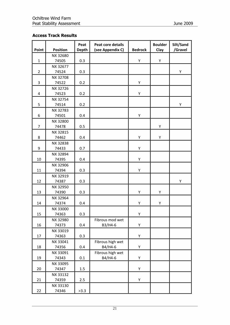
Ochiltree Wind FarmPeat Stability Assessment June 2009
21
Access Track Results
Point PositionPeat
DepthPeat core details(see Appendix C) Bedrock
BoulderClay
Silt/Sand/Gravel
1NX 32680
74505 0.3 Y Y
2NX 32677
74524 0.3 Y
3NX 32708
74522 0.2 Y
4NX 32726
74523 0.2 Y
5NX 32754
74514 0.2 Y
6NX 32783
74501 0.4 Y
7NX 32800
74478 0.5 Y
8NX 32815
74462 0.4 Y Y
9NX 32838
74433 0.7 Y
10NX 32894
74395 0.4 Y
11NX 32906
74394 0.3 Y
12NX 32919
74387 0.3 Y
13NX 32950
74390 0.3 Y Y
14NX 32964
74374 0.4 Y Y
15NX 33000
74363 0.3 Y
16NX 32980
74373 0.4Fibrous mod wet
B3/H4-6 Y
17NX 33019
74363 0.3 Y
18NX 33041
74356 0.4Fibrous high wet
B4/H4-6 Y
19NX 33091
74343 0.1Fibrous high wet
B4/H4-6 Y
20NX 33095
74347 1.5 Y
21NX 33132
74359 2.5 Y
22NX 33130
74346 >3.3
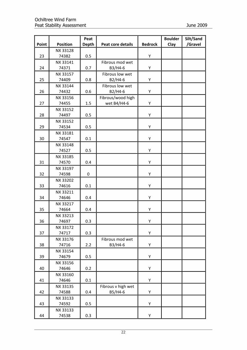
Ochiltree Wind FarmPeat Stability Assessment June 2009
22
Point PositionPeat
Depth Peat core details BedrockBoulder
ClaySilt/Sand/Gravel
23NX 33128
74382 0.5 Y
24NX 33141
74371 0.7Fibrous mod wet
B3/H4-6 Y
25NX 33157
74409 0.8Fibrous low wet
B2/H4-6 Y
26NX 33144
74432 0.6Fibrous low wet
B2/H4-6 Y
27NX 33156
74455 1.5Fibrous/wood high
wet B4/H4-6 Y
28NX 33152
74497 0.5 Y
29NX 33152
74534 0.5 Y
30NX 33181
74547 0.1 Y
NX 3314874527 0.5 Y
31NX 33185
74570 0.4 Y
32NX 33197
74598 0 Y
33NX 33202
74616 0.1 Y
34NX 33211
74646 0.4 Y
35NX 33217
74664 0.4 Y
36NX 33213
74697 0.3 Y
37NX 33172
74717 0.3 Y
38NX 33176
74716 2.2Fibrous mod wet
B3/H4-6 Y
39NX 33154
74679 0.5 Y
40NX 33156
74646 0.2 Y
41NX 33160
74646 0.1 Y
42NX 33135
74588 0.4Fibrous v high wet
B5/H4-6 Y
43NX 33133
74592 0.5 Y
44NX 33133
74538 0.3 Y
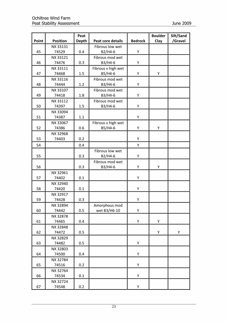
Ochiltree Wind FarmPeat Stability Assessment June 2009
23
Point PositionPeat
Depth Peat core details BedrockBoulder
ClaySilt/Sand/Gravel
45NX 33131
74529 0.4Fibrous low wet
B2/H4-6 Y
46NX 33121
74476 0.3Fibrous mod wet
B3/H4-6 Y
47NX 33111
74468 1.5Fibrous v high wet
B5/H4-6 Y Y
48NX 33116
74444 1.2Fibrous mod wet
B3/H4-6 Y
49NX 33107
74418 1.8Fibrous mod wet
B3/H4-6 Y
50NX 33112
74397 1.5Fibrous mod wet
B3/H4-6 Y
51NX 33094
74387 1.1 Y
52NX 33067
74386 0.6Fibrous v high wet
B5/H4-6 Y Y
53NX 32968
74403 0.2 Y
54 0.4 Y
55 0.3Fibrous low wet
B2/H4-6 Y
56 0.3Fibrous mod wet
B3/H4-6 Y Y
57NX 32961
74402 0.1 Y
58NX 32940
74420 0.1 Y
59NX 32917
74428 0.3 Y
60NX 32894
74442 0.5Amorphous mod
wet B3/H6-10 Y
61NX 32878
74465 0.4 Y Y
62NX 32848
74472 0.5 Y Y
63NX 32829
74482 0.5 Y
64NX 32803
74500 0.4 Y
65NX 32784
74516 0.2 Y
66NX 32764
74534 0.1 Y
67NX 32724
74548 0.2 Y

Ochiltree Wind FarmPeat Stability Assessment June 2009
24
Point PositionPeat
Depth Peat core details BedrockBoulder
ClaySilt/Sand/Gravel
68NX 32693
74570 0.3Fibrous low wet
B2/H4-6 Y
69NX 32666
74570 0.3 Y
70NX 32596
74927 2.2 Y
71NX 32552
74933 1.9 Y
72NX 32521
74959 0.9 Y
73NX 32512
74971 2 Y
74NX 32514
74998 0.7Fibrous high wet
B4/H4-6 Y
75NX 32516
75030 0.7 Y
76NX 32518
75063 1.1Fibrous mod wet
B3/H4-6 Y
77NX 32503
75086 0.4Fibrous mod wet
B3/H4-6 Y
78NX 32486
75122 0.5 Y
79NX 32478
75153 2 Y
80NX 32451
75167 1.6 Y
81NX 32444
75182 1.3 Y
82NX 32441
75206 1.3 Y
83NX 32447
75240 0.5 Y Y
84NX 32461
75265 0.5 Y
85NX 32465
75291 1.1Fibrous mod wet
B3/H4-6 Y
86NX 32475
75305 0.5 Y
87NX 32479
75329 0.3 Y
88NX 32478
75358 0.6 Y
89NX 32478
75385 0.4 Y
90NX 32484
75403 0.7 Y
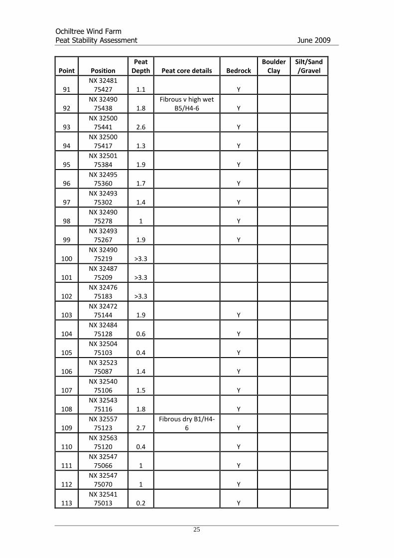
Ochiltree Wind FarmPeat Stability Assessment June 2009
25
Point PositionPeat
Depth Peat core details BedrockBoulder
ClaySilt/Sand/Gravel
91NX 32481
75427 1.1 Y
92NX 32490
75438 1.8Fibrous v high wet
B5/H4-6 Y
93NX 32500
75441 2.6 Y
94NX 32500
75417 1.3 Y
95NX 32501
75384 1.9 Y
96NX 32495
75360 1.7 Y
97NX 32493
75302 1.4 Y
98NX 32490
75278 1 Y
99NX 32493
75267 1.9 Y
100NX 32490
75219 >3.3
101NX 32487
75209 >3.3
102NX 32476
75183 >3.3
103NX 32472
75144 1.9 Y
104NX 32484
75128 0.6 Y
105NX 32504
75103 0.4 Y
106NX 32523
75087 1.4 Y
107NX 32540
75106 1.5 Y
108NX 32543
75116 1.8 Y
109NX 32557
75123 2.7Fibrous dry B1/H4-
6 Y
110NX 32563
75120 0.4 Y
111NX 32547
75066 1 Y
112NX 32547
75070 1 Y
113NX 32541
75013 0.2 Y
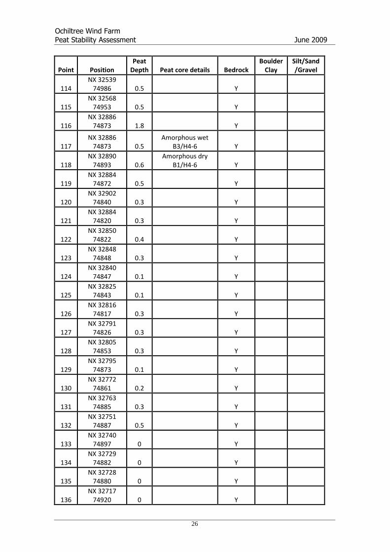
Ochiltree Wind FarmPeat Stability Assessment June 2009
26
Point PositionPeat
Depth Peat core details BedrockBoulder
ClaySilt/Sand/Gravel
114NX 32539
74986 0.5 Y
115NX 32568
74953 0.5 Y
116NX 32886
74873 1.8 Y
117NX 32886
74873 0.5Amorphous wet
B3/H4-6 Y
118NX 32890
74893 0.6Amorphous dry
B1/H4-6 Y
119NX 32884
74872 0.5 Y
120NX 32902
74840 0.3 Y
121NX 32884
74820 0.3 Y
122NX 32850
74822 0.4 Y
123NX 32848
74848 0.3 Y
124NX 32840
74847 0.1 Y
125NX 32825
74843 0.1 Y
126NX 32816
74817 0.3 Y
127NX 32791
74826 0.3 Y
128NX 32805
74853 0.3 Y
129NX 32795
74873 0.1 Y
130NX 32772
74861 0.2 Y
131NX 32763
74885 0.3 Y
132NX 32751
74887 0.5 Y
133NX 32740
74897 0 Y
134NX 32729
74882 0 Y
135NX 32728
74880 0 Y
136NX 32717
74920 0 Y

Ochiltree Wind FarmPeat Stability Assessment June 2009
27
Point PositionPeat
Depth Peat core details BedrockBoulder
ClaySilt/Sand/Gravel
137NX 33019
75460 >3.3Amorphous dry
B1/H6-10
138NX 33019
75461 >3.3Amorphous mod
wet B3/ H6-10
139NX 32982
75425 >3.3Amorphous mod
wet B3/ H6-10
140NX 32910
75385 >3.3Amorphous mod
wet B3/ H6-10
141NX 32918
75395 >3.3Amorphous mod
wet B3/ H6-10
142NX 32912
75409 >3.3Amorphous mod
wet B3/ H6-10
143NX 32919
75418 >3.3Amorphous mod
wet B3/ H6-10
144NX 32936
75440 >3.3Amorphous mod
wet B3/ H6-10
145NX 32962
75459 >3.3Amorphous mod
wet B3/ H6-10
146NX 32974
75474 >3.3Amorphous mod
wet B3/ H6-10
147NX 32998
75467 >3.3Amorphous mod
wet B3/ H6-10

Ochiltree Wind FarmPeat Stability Assessment June 2009
28
12. APPENDIX B: PLATES

Ochiltree Wind FarmPeat Stability Assessment June 2009
29
Plate 1: Peat dome, peat exposure at a sheep rub, along the proposed access tracksbetween Turbine 2 and Turbine 3.
Plate 2: Core showing, thin fibrous, peat (H4-6) overlying glacial clays. Typical of theaccess track between Turbine 9 and Turbine 10.

Ochiltree Wind FarmPeat Stability Assessment June 2009
30
Plate 3: Core showing fibrous peat (H4-6 typical of deposits around Turbine 7)
Plate 4: Core showing amorphous peat (H6-10) deposits on areas of deeper peat(typical of Calnavie Moss - Turbine 1)

Ochiltree Wind FarmPeat Stability Assessment June 2009
31
Plate 5: Exposed burn bank section, between turbine 9 and turbine 10, showingglacial clay deposits (and boulders) underlying fibrous peat (H4-6).

Ochiltree Wind FarmPeat Stability Assessment June 2009
32
13. APPENDIX C: VON POST SCALE

Ochiltree Wind FarmPeat Stability Assessment June 2009
33
Appendix C: Von Post Scale of Humification
The Von Post Scale of Humification (source Ekono 1981)
Symbol Description
H1 Completely undecomposed peat which, when squeezed, releases almost clear water. Plantremains easily identifiable. No amorphous material present.
H2 Almost entirely undecomposed peat which, when squeezed, releases clear or yellowish water.Plant remains still easily identifiable. No amorphous material present.
H3 Very slightly decomposed peat which, when squeezed, releases muddy brown water, but fromwhich no peat passes between the fingers. Plant remains still identifiable, and no amorphousmaterial present.
H4 Slightly decomposed peat which, when squeezed, releases very muddy dark water. No peat ispassed between the fingers but the plant remains are slightly pasty and have lost some of theiridentifiable features.
H5 Moderately decomposed peat which, when squeezed, releases very “muddy” water with a verysmall amount of amorphous granular peat escaping between the fingers. The structure of theplant remains is quite indistinct although it is still possible to recognize certain features. Theresidue is very pasty.
H6 Moderately highly decomposed peat with a very indistict plant structure. When squeezed, aboutone-third of the peat escapes between the fingers. The residue is very pasty but shows the plantstructure more distinctly than before squeezing.
H7 Highly decomposed peat. Contains a lot of amorphous material with very faintly recognizableplant structure. When squeezed, about one-half of the peat escapes between the fingers. Thewater, if any is released, is very dark and almost pasty.
H8 Very highly decomposed peat with a large quantity of amorphous material and very indistinctplant structure. When squeezed, about two-thirds of the peat escapes between the fingers. Asmall quantity of pasty water may be released. The plant material remaining in the hand consistsof residues such as roots and fibres that resist decomposition.
H9 Practically fully decomposed peat in which there is hardly any recognizable plant structure. Whensqueezed it is a fairly uniform paste.
H10 Completely decomposed peat with no discernible plant structure. When squeezed, all the wetpeat escapes between the fingers.
B1 Dry peat
B2 Low moisture content
B3 Moderate moisture content
B4 High moisture content
B5 Very high moisture content
Note: The moisture regime of each peat sample is estimated using the above scale of 1-5 andsymbol “B” (derived from Swedish blöthet = wetness).

HAYES MCKENZIE PARTNERSHIP LTD
Prepared for:
Atmos Consulting Ltd.
The Granary
Waen Farm
Nercwys Road
CH7 4EW
Hill of Ochiltree Wind Farm
Construction Noise Assessment
HM: 1927/R2
24th
August 2009
16a, The Courtyard, Dean Hill Park, West Dean, Salisbury SP5 1EY, UK
Tel. +44 (0)1794 342343, Fax +44 (0)1794 342344, [email protected]
Offices in Salisbury & Machynlleth
Hill of Ochiltree Wind Farm: Construction Noise Assessment
HM: 1927/R2 – DRAFT Version 1.0 – 24/08/09
Client: Page 2 of 11 Issued by: Atmos Consulting Ltd Hayes McKenzie Partnership Ltd
HILL OF OCHILTREE WIND FARM
CONSTRUCTION NOISE ASSESSMENT
Report 1927/R1
DRAFT Version 1.0, 24th
August 2009
1 Introduction
1.1 An indicative assessment of noise from the construction and decommissioning of the Hill of
Ochiltree Wind Farm development has been carried out.
1.2 Noise during the construction period will arise from the construction of the turbine foundations,
the erection of the turbines, the excavation of trenches for cables, and the construction of
associated hard standings, access tracks, construction compound and substation. Noise from
vehicles on local roads and access tracks will also arise resulting from the delivery of the turbine
components and construction materials, notably aggregates, concrete and steel reinforcement.
1.3 Noise will also arise during decommissioning from the removal of the turbines and breaking of
the exposed part of the concrete bases.
2 Noise Planning Guidance
On Site Construction Noise
2.1 Guidance on construction noise in PPG24, Planning and Noise, [1] refers to British Standard
BS 5228: 1997 Code of Practice for Noise and Vibration Control on Construction and Open
Sites which has been re-issued as BS 5228: 2009 [2]. This provides example criteria for the
assessment of the significance of construction noise effects and a method for prediction of noise
levels from construction activities. Two example methods are provided for assessing
significance.
2.2 The first is based on the use of criteria defined in Department of the Environment Advisory
Leaflet (AL) 72, Noise Control On Building Sites [3] which sets a fixed limit of 70 dB(A) in
rural suburban and urban areas away from main roads and traffic. Noise levels are generally

Hill of Ochiltree Wind Farm: Construction Noise Assessment
HM: 1927/R2 – DRAFT Version 1.0 – 24/08/09
Client: Page 3 of 11 Issued by: Atmos Consulting Ltd Hayes McKenzie Partnership Ltd
taken as façade LAeq values with free-field levels taken to be 3dB lower giving an equivalent
noise criterion of 67 dB LAeq.
2.3 The second is based on noise change but applies minimum criteria of 45, 55 and 65 dB LAeq for
night-time (2300-0700), evening and weekends, and daytime (0700-1900) including Saturdays
(0700-1300) respectively, applicable when existing noise levels are low, which they would be at
this site, and subject to a duration of one month or more.
Construction Traffic
2.4 The effect of construction traffic can be assessed in terms of changes in overall traffic noise or
in terms of the absolute noise levels generated by construction traffic movements. At locations
which are not subject to significant levels of traffic flow in the absence of any construction
activity it is necessary to follow the latter approach.
2.5 Planning Advice Note PAN56, Planning and Noise states that “For noise of a similar
character, a change of 3 dB(A) is the minimum perceptible under normal conditions, and a
change of 10 dB(A) corresponds roughly to halving and doubling the loudness of a sound”. It
is therefore considered that where the increase in noise level is shown to be less than 3 dB(A) it
can be considered that noise from construction traffic is insignificant.
2.6 Where there is no significant existing traffic noise, construction traffic noise is assessed using
the criteria of 65 dB LAeq for on site daytime construction activity discussed in section 3.
3 Assessment of Noise from Construction Plant and Activities
3.1 Predictions have been made of noise levels at six residential properties representative of the
nearest noise sensitive receptors to the development using the methods prescribed in BS 5228:
2009. It is assumed that all construction works will occur during daytime hours (0800-1800)
including Saturdays (0800-1300).
The nearest residential properties affected by construction and decommissioning noise are:

Hill of Ochiltree Wind Farm: Construction Noise Assessment
HM: 1927/R2 – DRAFT Version 1.0 – 24/08/09
Client: Page 4 of 11 Issued by: Atmos Consulting Ltd Hayes McKenzie Partnership Ltd
Penninghame;
Glenhapple;
Glassoch;
Beoch:
Glenruther;
Garchew; and,
Glenvernoch Farm.
3.2 In carrying out the predictions it has been assumed that all plant involved with track and
compound construction are located at the nearest possible point to each property. It should be
noted that this is unlikely to occur in practice, but gives very much worst case noise levels. The
plant assumed for each activity is shown in Table 1 with assumed octave band sound power
levels for each item provided in Appendix A of this report. For the calculations, 50% soft
ground attenuation has been used throughout with no topographical barrier attenuation. In
practice it is likely that at least some of the plant will be screened from view, but the calculation
represents a realistic worst case.
Table 1: Assumed Plant Location and Number
Location / Activity Plant List No. of
Items
Deforestation
Tracked Excavator 1
Petrol hand-held circular saw 2
Tractor (towing trailer) 1
Borrow Pits
Tracked mobile Drilling Rig 1
Tracked semi-mobile Crusher 1
Tracked hydraulic Excavator 4
Dump Truck 4
Wheeled Backhoe Loader 1
Compound
Construction
Dozer 1
Articulated dump truck 2
Concrete Pump + cement mixer truck (discharging) 1
Concrete Mixer Truck 2

Hill of Ochiltree Wind Farm: Construction Noise Assessment
HM: 1927/R2 – DRAFT Version 1.0 – 24/08/09
Client: Page 5 of 11 Issued by: Atmos Consulting Ltd Hayes McKenzie Partnership Ltd
Location / Activity Plant List No. of
Items
Access Routes
Dozer 1
Wheeled Backhoe Loader 1
Dump Truck 2
Tracked Excavator 2
Concrete Batching
Wheeled Excavator 1
Wheeled Loader 1
Concrete Mixer Truck 1
Fuel Tanker Lorry/Water Bowser 2
Water Pump 1
Road Lorry (full) 3
Concrete Batching Plant 1
Excavation for
Turbine Base
Tracked Excavator 4
Dump Truck 4
Wheeled Backhoe Loader 1
Build of
Turbine Base
Concrete Pump + Cement Mixer Truck 1
Concrete Mixer Truck 2
Water pump (diesel) 1
Crane in Turbines
Tracked Mobile Crane 1
Tracked Mobile Crane 1
Road Lorry (full) 2
Construction
Substation
Articulated dump truck 2
Concrete Pump + cement mixer truck (discharging) 1
Concrete Mixer Truck 2
Wheeled Backhoe Loader 1

Hill of Ochiltree Wind Farm: Construction Noise Assessment
HM: 1927/R2 – DRAFT Version 1.0 – 24/08/09
Client: Page 6 of 11 Issued by: Atmos Consulting Ltd Hayes McKenzie Partnership Ltd
Location / Activity Plant List No. of
Items
Decommissioning
Compound
Dozer 1
Articulated dump truck 2
Breaker mounted on wheeled backhoe 1
Tracked Crusher 2
Decommissioning
Turbines
Tracked Excavator 4
Dump Truck 4
Backhoe mounted hydraulic breaker 1
Tracked Mobile Crane 1
Tracked Mobile Crane 1
Decommissioning Substation
Tracked Excavator 2
Dump Truck 4
Backhoe mounted hydraulic breaker 1
3.3 The results of worst-case noise predictions at each of the seven receptor locations are shown in
Table 2. Predicted free field noise levels have been calculated for each of the construction
activity. It should be noted that average noise levels over the construction period will be lower,
particularly where high levels are predicted for work on the access tracks at close proximity to
housing.
3.4 It can be seen that predicted noise levels are below the 65 dB LAeq daytime criterion for all
considered construction and decommissioning activities except for deforestation and building of
the access track in the vicinity of Penninghame.
3.5 High noise levels at Penninghame will only occur for a short period of time as a result of its
proximity to the building of an access track and the deforestation in that area. Once the part of
the track closest to the property is completed, noise levels will be significantly lower.

Hill of Ochiltree Wind Farm: Construction Noise Assessment
HM: 1927/R2 – DRAFT Version 1.0 – 24/08/09
Client: Page 7 of 11 Issued by: Atmos Consulting Ltd Hayes McKenzie Partnership Ltd
Table 2: Results of Construction and Decommissioning Noise Predictions
Predicted Sound Pressure Level (dB Leq) at Receptor
Contributing Construction Activities
Penninghame Glenhapple Glassoch Beoch Glenruther Garchew Glenvernoch
Farm
69.1 49.0 35.5 47.5 59.4 29.1 29.5 Deforestation
50.6 58.6 53.6 44.2 40.4 33.5 35.1 Borrow Pits
29.3 31.6 35.1 25.2 22.6 18.6 20.0 Site Compound Construction
84.0 53.4 46.1 52.1 62.7 48.9 44.5 Access Tracks
32.2 34.1 37.3 28.6 26.6 23.3 24.4 Concrete Batching
15.4 19.5 21.4 31.1 43.2 46.0 41.4 Turbine Base Excavation
8.8 11.2 12.7 21.3 32.8 35.6 31.2 Build of Turbine Base
13.7 16.8 18.2 25.9 36.3 38.7 34.7 Build of Wind Turbines
15.5 18.1 20.8 29.6 40.2 31.7 30.3 Construction Substation
13.7 16.8 18.2 25.9 36.3 38.7 34.7 Turbine Dismantling
15.5 19.9 21.9 31.9 44.0 46.9 42.3 Breakup of Foundation Bases
13.7 17.2 20.6 31.6 44.6 34.2 32.5 Decommissioning of Substation

Hill of Ochiltree Wind Farm: Construction Noise Assessment
HM: 1927/R2 – DRAFT Version 1.0 – 24/08/09
Client: Page 8 of 11 Issued by: Atmos Consulting Ltd Hayes McKenzie Partnership Ltd
4 Assessment of Noise from Construction Traffic Movements
4.1 Paragraph 11.6.7 and 11.6.8 from Chapter 11 of the ES state that the most significant vehicular
movements in any one day will occur when the concrete of the wind turbine foundations is
being poured. It is stated that the concrete is supplied in 100 movements per day.
4.2 Current traffic count data for the access route from the A75 is available in Chapter 11 of the ES.
Predictions have been carried out to assess the likely increase in noise levels produced at
Knockbrex by Newton Stewart at which this traffic count data is available using Calculation of
Road Traffic Noise by the Department of Transport, 1988 (CRTN). The traffic count data is
shown in Table 11.8 in Chapter 11 of the ES.
4.3 Table 3 shows the predicted increase of traffic noise at Knockbrex (for both directions) and an
assumed increase of HGV traffic of 30% on the A714 as no traffic count data is available.
Table 3: Predicted increase of traffic noise
Location
Existing
Traffic (Non-
HGV)
Additional
Traffic (HGV)
Increase of
HGV Traffic
Predicted
Increase
(dB(A))
A75 Knockbrex 2742 100 14 % 0.4
4.4 Table 3 shows that the increase in noise level at both locations can be considered insignificant
according to the 3 dB(A) criteria.
4.5 For locations on the roads in the vicinity of the site where existing noise level can be expected
to be low, an absolute predicted façade noise level of 60.6 dBLAeq has been calculated using
equation F.6 from BS 5228: 2009, Code of Practice for Noise and Vibration Control on
Construction and Open Sites [2]. The above worst case figure of 100 movements per day has
been equated to an hourly figure of 9 movements over a 12 hour working day (0700-1900) and a
separation distance of 5 m assumed to represent a worst case façade noise level for any property
along the routes to and from site. The noise calculation has been based on the use of concrete
mixer trucks (assumed equivalent to BS 5228: 2009, C.2 34) to deliver the concrete to site (see
Paragraph 11.6.9).

Hill of Ochiltree Wind Farm: Construction Noise Assessment
HM: 1927/R2 – DRAFT Version 1.0 – 24/08/09
Client: Page 9 of 11 Issued by: Atmos Consulting Ltd Hayes McKenzie Partnership Ltd
4.6 The worst case predicted façade noise level of 60.6 dBLAeq is below the 65 dB LAeq daytime
criterion for all considered construction and decommissioning activities.
5 Mitigation Proposals
5.1 Although noise levels from on site activity will be below the 65 dB LAeq daytime significance
criterion for most properties most of the time, there will be periods when noise generated by
track works, or other construction activities, will be clearly audible at properties close to the
associated construction activity. For all activities, everything possible will be done to reduce
noise levels albeit with due regard to practicality and cost as per the concept of ‘best practicable
means’ as defined in Section 72 of the Control of Pollution Act 1974.
5.2 BS 5228 states that the ‘attitude of the contractor’ is important in minimising the likelihood of
complaints and therefore consultation with the local authority will be required along with letter
drops to inform residents of intended activity. Non-acoustic factors, which influence the overall
level of complaints such as mud on roads and dust generation, will also be controlled.
5.3 Site operations would be limited to a period of 0700 to 1900 weekdays and 0700 to 1200 on
Saturday. No operations would take place outside those hours except in exceptional
circumstances, or in the interests of safety. In the event that construction and decommissioning
activities are necessary outside these times, agreement would be sought with the Councils, as
appropriate, prior to work commencing.

Hill of Ochiltree Wind Farm: Construction Noise Assessment
HM: 1927/R2 – DRAFT Version 1.0 – 24/08/09
Client: Page 10 of 11 Issued by: Atmos Consulting Ltd Hayes McKenzie Partnership Ltd
6 Conclusions
6.1 An indicative assessment of noise from the construction and decommissioning of Hill of
Ochiltree Wind Farm has been carried out.
6.2 Predicted noise levels from all on site construction and decommissioning activities are below
the adopted daytime criterion of 65 dB LAeq at the nearest residential properties to the site and
properties close to the access route except for Penninghame where there is a limited period of
high noise levels during deforestation and building of the closest part of the access track.
6.3 On roads where existing traffic flows are relatively high, predicted increases in noise due to
construction traffic are not significant.
6.4 On roads where existing traffic levels are low, noise from construction traffic is predicted to be
below the 65 dB LAeq daytime criterion.

Hill of Ochiltree Wind Farm: Construction Noise Assessment
HM: 1927/R2 – DRAFT Version 1.0 – 24/08/09
Client: Page 11 of 11 Issued by: Atmos Consulting Ltd Hayes McKenzie Partnership Ltd
References
[1] Department of the Environment. Planning Policy Guidance PPG24, Planning and Noise, 1994.
[2] BSI. British Standard BS 5228:2009, Code of Practice for Noise and Vibration Control on
Construction and Open Sites, 2009.
[3] DoE. Department of the Environment Advisory Leaflet (AL) 72, Noise Control on Building
Sites, 1969.

APPENDIX A
ASSUMED PLANT OCTAVE BAND
SOUND POWER LEVELS

Location /
ActivityTable Ref Ref No. Equipment
Power
Rating, kW
Equipment Size, weight
(mass), capacity63 125 250 500 1k 2k 4k 8k
A-weighted sound
pressure level, Laeq,
dB at 10m
Number
of Plant
C.2 3 Tracked Excavator 102 kW 22 t 80 83 76 73 72 70 69 66 78 1
C.4 70 Petrol hand-held circular saw 3 kW 9 kg / 300 mm diameter 72 89 81 80 80 82 86 85 91 2
C.4 75 Tractor (towing trailer) 71 kW 3.5 t 93 86 76 76 73 72 64 59 79 1
C.9 2 Tracked mobile drilling rig 270 kW 23t/110 mm dia. 94 95 90 91 87 85 80 73 92 1
C.9 15 Tracked semi-mobile crusher 250 kW 38 t 98 98 97 94 91 88 82 72 96 1
C.9 6 Tracked hydraulic Excavator 235 kW 47 t 95 93 89 89 86 82 76 74 91 4
C.9 16 Dump Truck 699 kW 90 t 86 89 88 88 86 83 76 70 91 4
C.2 8 Wheeled Backhoe Loader 62 kW 8 t 74 66 64 64 63 60 59 50 68 1
C.5 12 Dozer 104 kW 14 t 80 78 71 70 74 68 65 61 77 1
C.5 16 Articulated dump truck 194 kW 25 t 88 90 80 79 76 71 65 61 81 2
C.4 24 Concrete Pump + cement mixer truck (discharging) 223 kW 8 t / 350 bar 69 64 64 66 63 59 53 47 67 1
C.4 27 Concrete Mixer Truck - - 84 74 74 73 73 75 65 59 79 2
C.5 12 Dozer 104 kW 14 t 80 78 71 70 74 68 65 61 77 1
C.2 8 Wheeled Backhoe Loader 62 kW 8 t 74 66 64 64 63 60 59 50 68 1
C.9 16 Dump Truck 699 kW 90 t 86 89 88 88 86 83 76 70 91 2
C.5 35 Tracked Excavator 27 kW - 82 72 71 69 69 70 61 54 74 2
C.4 12 Wheeled Excavator 63 kW 14 t 84 82 77 75 72 68 60 52 77 1
C.4 13 Wheeled Loader 75 kW 37 t 83 72 70 69 65 64 57 49 71 1
C.4 20 Concrete Mixer Truck 83 74 66 69 70 78 60 55 80 1
C.4 15 Fuel tanker lorry/Water bowser 11 t 79 73 71 75 72 67 59 50 76 2
C.2 45 Water pump 20 kW 6 in 73 68 62 62 61 56 53 41 65 1
C.9 16 Road lorry (full) 270 kW 39 t 96 82 74 73 77 72 71 64 80 3
D.6 11 Concrete Batching Plant 360m3/day 80 1
C.2 14 Tracked Excavator 226 kW 40 t 85 78 77 77 73 71 68 63 79 4
C.2 31 Dump Truck (Empty) 306 kW 29 t 86 79 79 79 79 84 69 60 87 4
C.2 8 Wheeled Backhoe Loader 62 kW 8 t 74 66 64 64 63 60 59 50 68 1
C.4 24 Concrete Pump + cement mixer truck (discharging) 223 kW 8 t / 350 bar 69 64 64 66 63 59 53 47 67 1
C.4 27 Concrete Mixer Truck - - 84 74 74 73 73 75 65 59 79 2
C.4 88 Water pump (diesel) 10 kW 100 kg 70 65 66 64 64 63 56 46 68 1
C.4 50 Tracked Mobile Crane 390 kW 600 t / 125 m 68 71 68 62 66 66 55 46 71 1
C.4 52 Tracked Mobile Crane 240 kW 105 t 73 71 66 67 74 66 58 49 75 1
C.6 21 Road Lorry (full) 270 kW 39 t 96 82 74 73 77 72 71 64 80 2
C.5 16 Articulated dump truck 194 kW 25 t 88 90 80 79 76 71 65 61 81 2
C.4 24 Concrete Pump + cement mixer truck (discharging) 223 kW 8 t / 350 bar 69 64 64 66 63 59 53 47 67 1
C.4 27 Concrete Mixer Truck 84 74 74 73 73 75 65 59 79 2
C.2 8 Wheeled Backhoe Loader 62 kW 8 t 74 66 64 64 63 60 59 50 68 1
C.2 14 Tracked Excavator 226 kW 40 t 85 78 77 77 73 71 68 63 79 4
C.2 31 Dump Truck (Empty) 306 kW 29 t 86 79 79 79 79 84 69 60 87 4
C.5 1 Backhoe mounted hydraulic breaker 67 kW - 86 80 78 77 81 83 82 81 88 1
C.4 50 Tracked Mobile Crane 390 kW 600 t / 125 m 68 71 68 62 66 66 55 46 71 1
C.4 52 Tracked Mobile Crane 240 kW 105 t 73 71 66 67 74 66 58 49 75 1
C.2 14 Tracked Excavator 226 kW 40 t 85 78 77 77 73 71 68 63 79 2
C.2 31 Dump Truck (Empty) 306 kW 29 t 86 79 79 79 79 84 69 60 87 4
C.5 1 Backhoe mounted hydraulic breaker 67 kW - 86 80 78 77 81 83 82 81 88 1
Borrow Pits
Compound
Construction
Access Routes
Decommissioning
Turbines
Deforestation
Decommissioning
Substation
Excavation for
Turbine Base
Build of
Turbine Base
Crane in Turbines
Construction
Substation
Concrete
Batching Plant
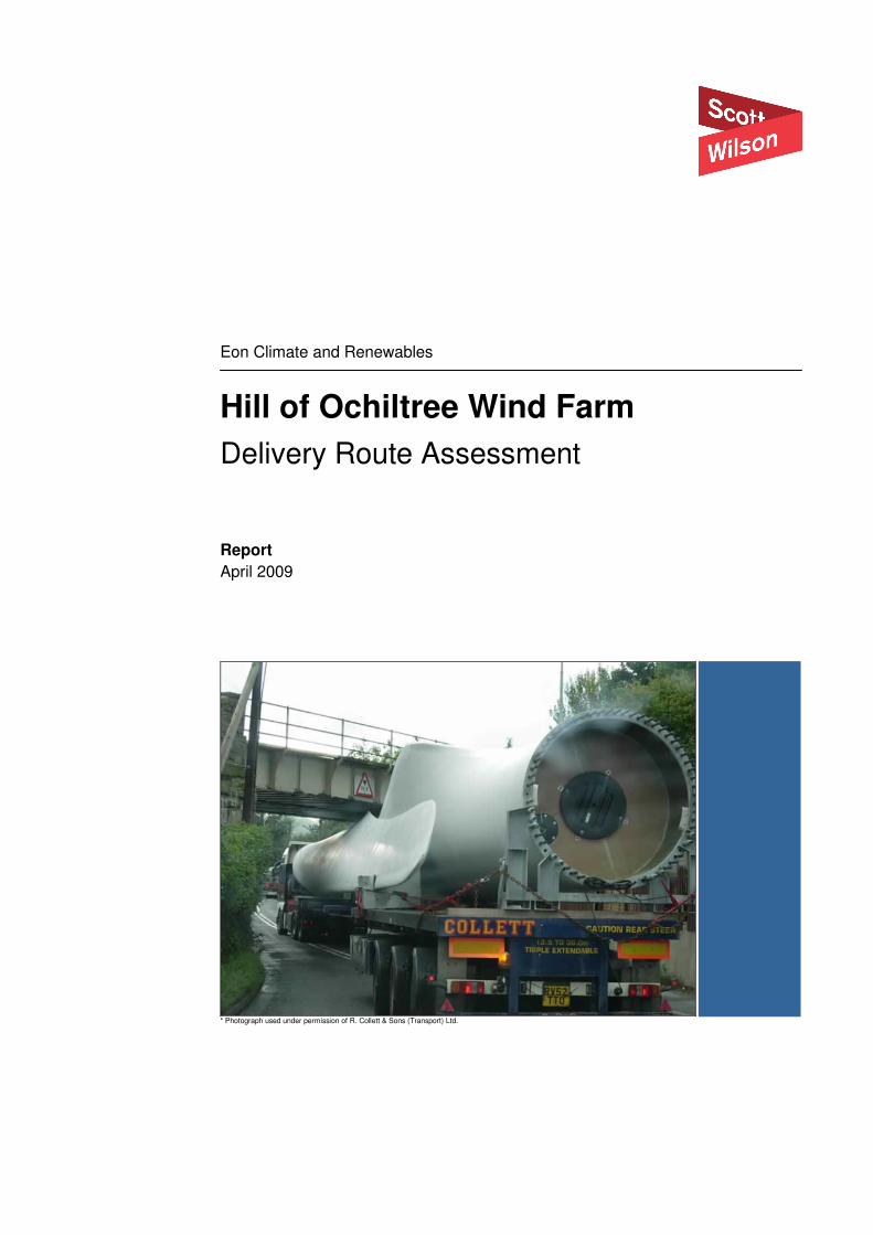
Eon Climate and Renewables
Hill of Ochiltree Wind Farm
Delivery Route Assessment
Report
April 2009
* Photograph used under permission of R. Collett & Sons (Transport) Ltd.


Eon Climate and Renewables
Hill of Ochiltree Wind Farm – Delivery Route Assessment
April 2009
This document has been prepared in accordance with the scope of Scott Wilson's
appointment with its client and is subject to the terms of that appointment. It is addressed
to and for the sole and confidential use and reliance of Scott Wilson's client. Scott Wilson
accepts no liability for any use of this document other than by its client and only for the
purposes for which it was prepared and provided. No person other than the client may
copy (in whole or in part) use or rely on the contents of this document, without the prior
written permission of the Company Secretary of Scott Wilson Scotland Ltd. Any advice,
opinions, or recommendations within this document should be read and relied upon only
in the context of the document as a whole. The contents of this document do not provide
legal or tax advice or opinion.
© Scott Wilson Scotland Ltd 2008
Scott Wilson
Citypoint 2
25 Tyndrum Street
Glasgow
G4 0JY
Scotland
Tel 0141 354 5600
Fax 0141 354 5601
www.scottwilson.com
Revision Schedule
Delivery Route Assessment
April 2009
S105996-DR-01
Rev Date Details Prepared by Reviewed by Approved by
01 8/4/09 Issue for
Comment
Cody Wardensky
Assistant Engineer
Simon Shillington
Associate
Simon Shillington
Associate
02 09/4/09 Final Cody Wardensky
Assistant Engineer
Simon Shillington
Associate
Simon Shillington
Associate

Eon Climate and Renewables
Hill of Ochiltree Wind Farm – Delivery Route Assessment
April 2009
Contents
1.0 Introduction .....................................................................................................1
1.1 Background.....................................................................................................1
1.2 Assessment Scope .........................................................................................1
2.0 Delivery route..................................................................................................2
3.0 Design transport vehicles................................................................................3
4.0 Consultee responses ......................................................................................4
5.0 Conclusions ....................................................................................................6
5.1 Summary of consultations...............................................................................6
5.2 Further works..................................................................................................6
6.0 Appendix 1 Highways Agency BE16 (09/07) Forms ......................................7
7.0 Appendix 2 Additional Transport Scotland Information Forms ........................8
8.0 Appendix 3 Delivery Vehicle Specifications ....................................................9
9.0 Appendix 4 Consultee Responses................................................................10
10.0 Appendix 5 Drawing S105996/I/021 – Delivery Route ..................................11

Eon Climate and Renewables
Hill of Ochiltree Wind Farm – Delivery Route Assessment
09 April 2009 Page No 1
1.0 Introduction
1.1 Background
This report has been prepared by Scott Wilson Ltd as engineering consultants to
Atmos Consulting who in turn are agents to Eon Climate and Renewables.
This report summarises the assessment process to determine the suitability for
travel over public roads by the design turbine component delivery vehicles
(abnormal loads) from the sea port at Cairnryan to U59W site access road for the
Hill of Ochiltree Wind Farm.
The assessment of the delivery route was undertaken through consultation with the
national transport agency for Scotland, Transport Scotland, who coordinate the
movements of all abnormal loads throughout the Scottish road network.
Turbine component delivery vehicles are review based on their length, width,
height, and weight to permit an impact assessment on the existing road network,
and specifically under and over bridge structures to be undertaken.
This report will therefore summarise the responses received from Transport
Scotland and their consultees against these criteria.
1.2 Assessment Scope
Scott Wilson’s brief in preparing this report was to :-
• Research likely turbine transport vehicle types (weights and dimensions)
• Submit abnormal indivisible load applications to Transport Scotland, Amey
(South West Scotland’s Trunk Road Operator), Dumfries and Galloway Police,
and Dumfries and Galloway Council for comment/approval.
• Prepare report detailing and explaining findings

Eon Climate and Renewables
Hill of Ochiltree Wind Farm – Delivery Route Assessment
09 April 2009 Page No 2
2.0 Delivery route
One main delivery route was assessed from the sea port at Cairnryan to the U59W
site access road with a further alternative route option to bypass the town of
Newton Stewart as shown in drawing “S105996/I/021 Delivery Route” appended to
this report.
The access route follows: -
• the A77 south from the sea port at Cairnryan;
• the A751 south;
• the A75 east;
• the A714 north at Newton Stewart; and
• to, but not including, the U59W.
The Newton Stewart bypass alternative route option uses the U52W Barnkirk Road.

Eon Climate and Renewables
Hill of Ochiltree Wind Farm – Delivery Route Assessment
09 April 2009 Page No 3
3.0 Design transport vehicles
Four design transport vehicles were submitted comprising: -
• A 40 metre blade trailer
• A turbine nacelle trailer
• A turbine base tower section trailer
• A turbine top tower section.
The submission forms are appended with this report defining the characteristics of
each vehicle and the number of movements anticipated.
It should be noted that the assessment was undertaken using component parts
based on a Siemens SWT-2.3-82 wind turbine. The specifications for design
vehicles carrying components for this type of turbine have been used for this
assessment and vehicle loading illustrations append this report. Should a different
supplier be proposed, unless a material change in dimensions or weight results, it is
anticipated that this will have no impact on the assessment undertaken.

Eon Climate and Renewables
Hill of Ochiltree Wind Farm – Delivery Route Assessment
09 April 2009 Page No 4
4.0 Consultee responses
4.1.1 Dumfries and Galloway Council
Dumfries and Galloway Council Architecture and Engineering Design Services have
confirmed that the route proposed is acceptable.
They note that they have no record of any structures under the U59W.
4.1.2 Amey
Amey have responded to the consultation as route managers of the south west
Trunk Road Network.
They have confirmed that a height restriction occurs on the railway bridge at
Dunragit which will impact on movements of the tower base section as well as any
other element of height greater than 4.3 metres.
Amey have confirmed that a diversion route does exist via the B7084 at Dunragit.
Amey highlight the following areas of potential concern: -
• An assessment should be undertaken of the B7084 diversion to ensure vehicles
proposed can negotiate route.
4.1.3 Dumfries and Galloway Police
Dumfries and Galloway Police with the exception of the section of the route though
Newton Stewart perceive no issues with the proposed approach to the windfarm.
They would strongly appose any route through Newton Stewart due to potential
constraints from car parking and the fact that there is limited off street parking in the
town and therefore any temporary restriction would have a significant impact.
In favour they would anticipate that bypassing the town via the U52W Barnkirk
Road, which is a two lane carriageway, would be acceptable.
Dumfries and Galloway Council highlight one areas of potential concern: -
• The left turn from Barnkirk road onto the A714 northbound.
4.1.4 Jacobs Babtie
Jacobs Babtie have responded to Transport Scotland in their capacity as disused
railway bridge assessment engineers for Network Rail.

Eon Climate and Renewables
Hill of Ochiltree Wind Farm – Delivery Route Assessment
09 April 2009 Page No 5
They have confirmed that the route should avoid the unclassified road from the A75
at East Knockbrex as there is a bridge over the disused rail line that is unsuitable
for the loads proposed.
It is noted that this route is not to be used as part of the preferred or alternative
options and Jacobs Babtie have no other comments.
4.1.5 Transport Scotland
As defined in the previous sections of this report, all consultees have responded to
the application for approval to convey abnormal loads via the route defined in this
report, and specifically adopting the bypass option at Newton Stewart.
On this basis, Transport Scotland have confirmed that they agree in principle to the
proposed movements, subject to a trial run being carried out prior to component
delivery.
Eon Climate and Renewables
Hill of Ochiltree Wind Farm – Delivery Route Assessment
09 April 2009 Page No 6
5.0 Conclusions
5.1 Summary of consultations
Based on the summary provided in this report:-
• It has been confirmed that the main route is generally acceptable to conslutees
for the turbine delivery vehicles proposed.
• A diversion for some or all vehicles may be required at Dunragit to avoid a
limited height bridge (4.3 metres) under the existing rail line. A diversion exists
via the B7084 at this location.
• The alternative route via the U52W Barnkirk Road is preferred to avoid the
centre of Newton Stewart.
• Dumfries and Galloway Council have advised that they do not have any record
of any structures that may be impacted by the proposed vehicles.
5.2 Further works
Based on the consultation responses, the following detailed works should be
undertaken: -
• Vehicle tracking of the diversion route at Dunragit via the B7084 to confirm
acceptability for proposed vehicles.
• Vehicle tracking of the junction from the U52W onto the A714 to confirm
acceptability for proposed vehicles.
• A trial run by hauliers to highlight any unforeseen issues.

Eon Climate and Renewables
Hill of Ochiltree Wind Farm – Delivery Route Assessment
09 April 2009 Page No 7
6.0 Appendix 1
Highways Agency BE16 (09/07) Forms

Highways Agency BE16 (09/07)
VEHICLE DETAILS for abnormal load movements authorised by Special Order
You must send this form in at least 8 weeks before the date of your proposed first movement. (Photocopies of this
form are acceptable)
Part A – General
1. Name, address & postcode of haulier: _TBC__________________________________________________
____________________________________________________________________________________
Phone: Fax: Operator's Licence No:________________________
Email address: ____________________________________________________
2. Name, address & postcode at which movement will start: _DG9 8RA (OS 26672, 568355)
______________________________________________________________________________
3. Name, address & postcode at which movement will end: __OS 235351, 575460
__________________________________________________________________________________
4. Description of piece(s): Turbine Top Tower Section 5. No. of movements: 10
6. No. of pieces to be carried at a time: 1 7. Date of 1st movement: ____TBC_____
8. Overall dimensions of piece(s) - metric units
Height: ____ Width: ____ Length: 39.300m Weight: 68.0 te
9. Name (block capitals): CODY WARDENSKY Date: _____04/03/09_____________
Does overall width exceed 6.100m? Yes No X
Is rigid length over 30.00m? Yes X No __
(If yes to either of the above, please complete Part B below and overleaf).
Does gross weight exceed 150,000kgs? Yes No X
If yes, please complete Part C overleaf.
Is suggested route attached? Yes X No __
PART B - Width over 6.100m and/or rigid length over 30.000m?
1. (a) Description of vehicles on which the load is to be carried: (please tick)
Drawbar trailer ___ Bogie(s) X Semi-trailer ___ Artic tractor X
Other (please state): _________________________________________
(b) Weight of load plus load carrying vehicles: 68.0 te
Note: Do not include the weight of separate (drawbar) tractor(s).
2. For separate (drawbar) tractor(s), please state (in metric units):
Weight of tractor: No. of axles: ___________ No. of wheels per axle: ____________
Axle weights: ______________________________
Axle spacing: (including axle spacing between tractor and trailer): ____________________________________
Height: _______________________ Width: _______________
3. Is rear bogie steerable?: Yes X No __

4. Overhang of load behind rear of trailer (in metric units): 3.954m

5. Overall (metric) dimensions of the train: Max Height Tractor (Semi-trailer only): ___ Max Height Trailer: ____________ Reducible to:
Width: Overall Length: 39.300m Rigid Length: 33.430m
6. Details of vehicles described in 1 (a) overleaf:
Axles 1st 2nd 3rd 4th 5th 6th 7th 8th 9th 10th 11th 12th 13th 14th 15th
No. of wheels per axle: 2 4 4 8 8 8 8
Lateral spacing between
tyre centres:
Weight per axle: (Kg) 8000 10000 10000 10000 10000 10000 10000
Spacing between axles: (mm) 3200 1370 24028 1310 1810 1310
Size of tyres (width x wheel diameter): Outside Track:
PART C - Weight over 150,000kgs
Trailer
No.
No. of
Axles
Travelling
Height
(ground
clearance
in brackets)
Reduced
Height
(ground
clearance
in brackets)
Width Length
of train
Length
of trailer
without
drawbar
Gross
weight
(kgs)
Axle
load
(kgs)
Axle Spacing Wheel
base
Tyre
sizes
Tyre
centres
Outside
track
No of tractors
(pulling) or
(pushing).
Also fill in
Q2 of Part B
Send completed form to: For movements starting in England or Wales - For movements starting in Scotland -
Highways Agency Transport Scotland
Abnormal Loads Trunk Roads - Network Management Division – Admin Team
C6, 5 Broadway, Broad Street, Buchanan House, 8th Floor
BIRMINGHAM B15 1BL 58 Port Dundas Road, GLASGOW G4 0HF
Tel: 0121 678 8068 Tel: 0141 272 7334
Fax: 0121 678 8569 Fax: 0141 272 7373

Highways Agency BE16 (09/07)
VEHICLE DETAILS for abnormal load movements authorised by Special Order
You must send this form in at least 8 weeks before the date of your proposed first movement. (Photocopies of this
form are acceptable)
Part A – General
1. Name, address & postcode of haulier: _TBC__________________________________________________
____________________________________________________________________________________
Phone: Fax: Operator's Licence No:________________________
Email address: ____________________________________________________
2. Name, address & postcode at which movement will start: _DG9 8RA (OS 26672, 568355)
______________________________________________________________________________
3. Name, address & postcode at which movement will end: __OS 235351, 575460
__________________________________________________________________________________
4. Description of piece(s): Turbine Base Tower Section 5. No. of movements: 10
6. No. of pieces to be carried at a time: 1 7. Date of 1st movement: ____TBC_____
8. Overall dimensions of piece(s) - metric units
Height: ____ Width: ____ Length: 38.450m Weight: 111.0 te
9. Name (block capitals): CODY WARDENSKY Date: _______04/03/09___________
Does overall width exceed 6.100m? Yes No X
Is rigid length over 30.00m? Yes X No __
(If yes to either of the above, please complete Part B below and overleaf).
Does gross weight exceed 150,000kgs? Yes No X
If yes, please complete Part C overleaf.
Is suggested route attached? Yes X No __
PART B - Width over 6.100m and/or rigid length over 30.000m?
1. (a) Description of vehicles on which the load is to be carried: (please tick)
Drawbar trailer ___ Bogie(s) _X Semi-trailer ___ Artic tractor _X
Other (please state): _________________________________________
(b) Weight of load plus load carrying vehicles: 111.0 te
Note: Do not include the weight of separate (drawbar) tractor(s).
2. For separate (drawbar) tractor(s), please state (in metric units):
Weight of tractor: No. of axles: ___________ No. of wheels per axle: ____________
Axle weights: ______________________________
Axle spacing: (including axle spacing between tractor and trailer): ____________________________________
Height: _______________________ Width: _______________
3. Is rear bogie steerable?: Yes X No __

4. Overhang of load behind rear of trailer (in metric units): __________

5. Overall (metric) dimensions of the train: Max Height Tractor (Semi-trailer only): ___ Max Height Trailer: ____________ Reducible to:
Width: Overall Length: 38.450m Rigid Length: 22.758m
6. Details of vehicles described in 1 (a) overleaf:
Axles 1st 2nd 3rd 4th 5th 6th 7th 8th 9th 10th 11th 12th 13th 14th 15th
No. of wheels per axle: 2 2 4 4 4 8 8 8 8 8
Lateral spacing between
tyre centres:
Weight per axle: (Kg) 9000 9000 8000 10000 10000 13000 13000 13000 13000 13000
Spacing between axles: (mm) 1500 2000 1350 1350 2691 22758 1500 1500 1500
Size of tyres (width x wheel diameter): Outside Track:
PART C - Weight over 150,000kgs
Trailer
No.
No. of
Axles
Travelling
Height
(ground
clearance
in brackets)
Reduced
Height
(ground
clearance
in brackets)
Width Length
of train
Length
of trailer
without
drawbar
Gross
weight
(kgs)
Axle
load
(kgs)
Axle Spacing Wheel
base
Tyre
sizes
Tyre
centres
Outside
track
No of tractors
(pulling) or
(pushing).
Also fill in
Q2 of Part B
Send completed form to: For movements starting in England or Wales - For movements starting in Scotland -
Highways Agency Transport Scotland
Abnormal Loads Trunk Roads - Network Management Division – Admin Team
C6, 5 Broadway, Broad Street, Buchanan House, 8th Floor
BIRMINGHAM B15 1BL 58 Port Dundas Road, GLASGOW G4 0HF
Tel: 0121 678 8068 Tel: 0141 272 7334
Fax: 0121 678 8569 Fax: 0141 272 7373

Highways Agency BE16 (09/07)
VEHICLE DETAILS for abnormal load movements authorised by Special Order
You must send this form in at least 8 weeks before the date of your proposed first movement. (Photocopies of this
form are acceptable)
Part A – General
1. Name, address & postcode of haulier: _TBC__________________________________________________
____________________________________________________________________________________
Phone: Fax: Operator's Licence No:________________________
Email address: ____________________________________________________
2. Name, address & postcode at which movement will start: _DG9 8RA (OS 26672, 568355)
______________________________________________________________________________
3. Name, address & postcode at which movement will end: __OS 235351, 575460
__________________________________________________________________________________
4. Description of piece(s): Turbine Nacelle 5. No. of movements: 10
6. No. of pieces to be carried at a time: 1 7. Date of 1st movement: ____TBC_____
8. Overall dimensions of piece(s) - metric units
Height: ____ Width: ____ Length: _______ Weight: 82.0 te
9. Name (block capitals): CODY WARDENSKY Date: ___04/03/09________________
Does overall width exceed 6.100m? Yes No X
Is rigid length over 30.00m? Yes No X
(If yes to either of the above, please complete Part B below and overleaf).
Does gross weight exceed 150,000kgs? Yes X No __
If yes, please complete Part C overleaf.
Is suggested route attached? Yes X No __
PART B - Width over 6.100m and/or rigid length over 30.000m?
1. (a) Description of vehicles on which the load is to be carried: (please tick)
Drawbar trailer ___ Bogie(s) ___ Semi-trailer ___ Artic tractor ___
Other (please state): _________________________________________
(b) Weight of load plus load carrying vehicles: _______________________
Note: Do not include the weight of separate (drawbar) tractor(s).
2. For separate (drawbar) tractor(s), please state (in metric units):
Weight of tractor: No. of axles: ___________ No. of wheels per axle: ____________
Axle weights: ______________________________
Axle spacing: (including axle spacing between tractor and trailer): ____________________________________
Height: _______________________ Width: _______________
3. Is rear bogie steerable?: Yes No __

4. Overhang of load behind rear of trailer (in metric units): ________________
5. Overall (metric) dimensions of the train: Max Height Tractor (Semi-trailer only): ___ Max Height Trailer: ____________ Reducible to:
Width: Overall Length: _____ Rigid Length: ________
6. Details of vehicles described in 1 (a) overleaf:
Axles 1st 2nd 3rd 4th 5th 6th 7th 8th 9th 10th 11th 12th 13th 14th 15th
No. of wheels per axle:
Lateral spacing between
tyre centres:
Weight per axle:
Spacing between axles:
Size of tyres (width x wheel diameter): Outside Track:
PART C - Weight over 150,000kgs
Trailer
No.
No. of
Axles
Travelling
Height
(ground
clearance
in brackets)
Reduced
Height
(ground
clearance
in brackets)
Width Length
of train
Length
of trailer
without
drawbar
Gross
weight
(kgs)
Axle
load
(kgs)
Axle Spacing Wheel
base
Tyre
sizes
Tyre
centres
Outside
track
No of tractors
(pulling) or
(pushing).
Also fill in
Q2 of Part B
1 10 34.575m 25.310m 159.0 te 11.6 te 1.500m 2.75m
Send completed form to: For movements starting in England or Wales - For movements starting in Scotland -
Highways Agency Transport Scotland
Abnormal Loads Trunk Roads - Network Management Division – Admin Team
C6, 5 Broadway, Broad Street, Buchanan House, 8th Floor
BIRMINGHAM B15 1BL 58 Port Dundas Road, GLASGOW G4 0HF
Tel: 0121 678 8068 Tel: 0141 272 7334
Fax: 0121 678 8569 Fax: 0141 272 7373

Highways Agency BE16 (09/07)
VEHICLE DETAILS for abnormal load movements authorised by Special Order
You must send this form in at least 8 weeks before the date of your proposed first movement. (Photocopies of this
form are acceptable)
Part A – General
1. Name, address & postcode of haulier: _TBC__________________________________________________
____________________________________________________________________________________
Phone: Fax: Operator's Licence No:________________________
Email address: ____________________________________________________
2. Name, address & postcode at which movement will start: _DG9 8RA (OS 26672, 568355)
______________________________________________________________________________
3. Name, address & postcode at which movement will end: __OS 235351, 575460
__________________________________________________________________________________
4. Description of piece(s): 40m Turbine Blade 5. No. of movements: 30
6. No. of pieces to be carried at a time: 1 7. Date of 1st movement: ____TBC_____
8. Overall dimensions of piece(s) - metric units
Height: ____ Width: ____ Length: 43.133m Weight: 35.0 te
9. Name (block capitals): CODY WARDENSKY Date: ______04/03/09_______________
Does overall width exceed 6.100m? Yes No X
Is rigid length over 30.00m? Yes X No __
(If yes to either of the above, please complete Part B below and overleaf).
Does gross weight exceed 150,000kgs? Yes No X
If yes, please complete Part C overleaf.
Is suggested route attached? Yes X No __
PART B - Width over 6.100m and/or rigid length over 30.000m?
1. (a) Description of vehicles on which the load is to be carried: (please tick)
Drawbar trailer ___ Bogie(s) _X Semi-trailer ___ Artic tractor __
Other (please state): _________________________________________
(b) Weight of load plus load carrying vehicles: 35.0 te
Note: Do not include the weight of separate (drawbar) tractor(s).
2. For separate (drawbar) tractor(s), please state (in metric units):
Weight of tractor: No. of axles: ___________ No. of wheels per axle: ____________
Axle weights: ______________________________
Axle spacing: (including axle spacing between tractor and trailer): ____________________________________
Height: _______________________ Width: _______________
3. Is rear bogie steerable?: Yes X No __

4. Overhang of load behind rear of trailer (in metric units): 6.925m

5. Overall (metric) dimensions of the train: Max Height Tractor (Semi-trailer only): ___ Max Height Trailer: ____________ Reducible to:
Width: Overall Length: 43.133m Rigid Length: 37.296m
6. Details of vehicles described in 1 (a) overleaf:
Axles 1st 2nd 3rd 4th 5th 6th 7th 8th 9th 10th 11th 12th 13th 14th 15th
No. of wheels per axle: 2 4 4 2 2 2
Lateral spacing between
tyre centres:
Weight per axle:(Kg) 7000 8000 8000 4000 4000 4000
Spacing between axles:(mm) 3200 1370 24921 1850 1850
Size of tyres (width x wheel diameter): Outside Track:
PART C - Weight over 150,000kgs
Trailer
No.
No. of
Axles
Travelling
Height
(ground
clearance
in brackets)
Reduced
Height
(ground
clearance
in brackets)
Width Length
of train
Length
of trailer
without
drawbar
Gross
weight
(kgs)
Axle
load
(kgs)
Axle Spacing Wheel
base
Tyre
sizes
Tyre
centres
Outside
track
No of tractors
(pulling) or
(pushing).
Also fill in
Q2 of Part B
Send completed form to: For movements starting in England or Wales - For movements starting in Scotland -
Highways Agency Transport Scotland
Abnormal Loads Trunk Roads - Network Management Division – Admin Team
C6, 5 Broadway, Broad Street, Buchanan House, 8th Floor
BIRMINGHAM B15 1BL 58 Port Dundas Road, GLASGOW G4 0HF
Tel: 0121 678 8068 Tel: 0141 272 7334
Fax: 0121 678 8569 Fax: 0141 272 7373

Eon Climate and Renewables
Hill of Ochiltree Wind Farm – Delivery Route Assessment
09 April 2009 Page No 8
7.0 Appendix 2
Additional Transport Scotland Information Forms

DIMENSIONS OF PIECE
Height =
Width =
Length =
Weight =
LADEN DIMENSIONS
Length (Rigid) = 33.430m
Length (Overall) = 39.300m
Weight = 68 Te
No. Axles = 7
No. Wheels/Axle = 1No. @ 2, 2No. @ 4, 4No @ 8
Axle Weights = . 1No. @ 8Te, 6No. @ 10Te,
Axle Spacings = 3.2m, 1.37m, 24.028m, 1.31m, 1.81m, 1.31m
Rear Overhang = 3.954m
SUGGESTED ROUTE
1. Cairnryan port – South on the A77
2. South on the A751
3. East on the A75
4. North on A714 through Newton Stewart
** Alternative Option @ 4. North on minor by-pass road to west of Newton Stewart **
5. North on A714
Approximate mileage = 35 Miles

DIMENSIONS OF PIECE
Height =
Width =
Length =
Weight =
LADEN DIMENSIONS
Height =
Height (Reducible) =
Width = m
Length (Rigid) = 25.074m
Length (Overall) = 34.575m
Weight = 159 Te
No. Axles = 15
No. Wheels/Axle = 2No. @ 2, 3No. @ 4, 10No @ 8
Axle Weights = . 2No. @ 8Te, 1No. @ 7Te, 2No. @ 10Te, 10No. @ 11.6Te
Axle Spacings = 1.5m, 2.0m, 1.35m, 1.35m, 2.605m, 1.5m, 1.5m, 1.5m, 11.410m, 1.5m, 1.5m,
1.5m, 1.5m, 1.5m
Rear Overhang = 0m
SUGGESTED ROUTE
1. Cairnryan port – South on the A77
2. South on the A751
3. East on the A75
4. North on A714 through Newton Stewart
** Alternative Option @ 4. North on minor by-pass road to west of Newton Stewart **
5. North on A714
Approximate mileage = 35 Miles

DIMENSIONS OF PIECE
Height =
Width =
Length =
Weight =
LADEN DIMENSIONS
Height = 5.0m
Height (Reducible) =
Width = 4.82m
Length (Rigid) = 30.839m
Length (Overall) = 38.450m
Weight = 111 Te
No. Axles = 10
No. Wheels/Axle = 2No. @ 2, 3No. @ 4, 5No @ 8
Axle Weights = . 2No. @ 9Te, 1No. @ 8Te, 2No. @ 10Te, 5No. @ 13.0Te
Axle Spacings = 1.5m, 2.0m, 1.35m, 1.35m, 2.691m, 22.758m, 1.5m, 1.5m, 1.5m,
Rear Overhang = 0m
SUGGESTED ROUTE
1. Cairnryan port – South on the A77
2. South on the A751
3. East on the A75
4. North on A714 through Newton Stewart
** Alternative Option @ 4. North on minor by-pass road to west of Newton Stewart **
5. North on A714
Approximate mileage = 35 Miles

DIMENSIONS OF PIECE
Height =
Width =
Length =
Weight =
LADEN DIMENSIONS
Height = 4.0m
Height (Reducible) =
Width = m
Length (Rigid) = 37.296m
Length (Overall) = 43.133m
Weight = 359 Te
No. Axles = 6
No. Wheels/Axle = 4No. @ 2, 2No. @ 4,
Axle Weights = . 1No. @ 7Te, 2No. @ 8Te, 3No. @ 4Te
Axle Spacings = 3.2m, 1.37m, 24.921m, 1.85m, 1.85m, 1.75m
Rear Overhang = 6.925m
SUGGESTED ROUTE
1. Cairnryan port – South on the A77
2. South on the A751
3. East on the A75
4. North on A714 through Newton Stewart
** Alternative Option @ 4. North on minor by-pass road to west of Newton Stewart **
5. North on A714
Approximate mileage = 35 Miles

Eon Climate and Renewables
Hill of Ochiltree Wind Farm – Delivery Route Assessment
09 April 2009 Page No 9
8.0 Appendix 3 Delivery Vehicle Specifications

Delivery Vehicle Specifications
4

Eon Climate and Renewables
Hill of Ochiltree Wind Farm – Delivery Route Assessment
09 April 2009 Page No 10
9.0 Appendix 4 Consultee Responses


Cody Wardensky
From: [email protected]
Sent: 27 March 2009 09:37
To: Cody Wardensky
Subject: FW: 1146 - Abnormal Load Route Assessment
Page 1 of 5
09/04/2009
Morning Cody
Please see police response below. They have advised that the loads should not be allowed to travel
through Newton Stewarts Town Centre and that your alternative route should be used.
Taking all of the responses into consideration an agreement in principal is given for these proposed
movements.
Kind regards
Eric Ewing
Bridges & Operations Adminstrator
Transport Scotland
From: Howat Susan [mailto:[email protected]]
Sent: 27 March 2009 08:37 To: Ewing E (Eric)
Subject: RE: 1146 - Abnormal Load Route Assessment
Eric
This is the reply that I received from my Sergeant in Stranraer:
As discussed the proposed route I have no real problems with, however I am strongly against the load going
through Newton Stewart town centre as should anyone be double parked, when the load approaches, it will
be nothing less than grid lock. No parking cones are not an option either as there is limited parking for Newton
Stewart as it is.
With regards to the route, the A77, A751 and A75 roads should be no problem at all. Likewise the left turn
from the A75 onto the Barnkirk Road should be negotiatable as well, however the wide load will need to
encroach onto opposing carriageway in order to make the right turn. The Barnkirk Road is the U52w which
they class as a minor road but is actually a two way undivided carriageway.
The Barnkirk road should be passable without too much trouble as will the A714, however I have identified 3
areas of concern: These areas are as follows:
1) the left hand turn from the Barnkirk Road onto the A714.
2) a bridge on the A714 at a part thereof near to the middle bridge of Cree, Bargrennan, Newton Stewart
3) a bridge on the A714 at a part thereof near to the Wheeb brige, Arnimean, Newton Stewart (close to our
border)
Point 1) concerns me as the junction is not the widest and the convoy may take some negotiating in order to
get round. Points 2) and 3) both refer to the narrow bridge crossings. As with most narrow bridges they are
preceded by sharp bends at either end and the bridge may be difficult to negotiate given the length of the
load. I appreciate that hauliers can lift the height of the load but road alterations may still be necessary (in
particularly at point 3 above), as it would allow a wider turn onto the bridge.
I would strongly recommend that a route run through be done using an unladen vehicle, the trailer of which
was set at the length of the longest road to ensure that the run is possible.
I hope that this helps.

Cheers.
S.
Susan Howat
Warrants Officer/Abnormal Loads Officer
Force Communications Centre
Police HQ
Cornwall Mount
DUMFRIES
DG1 1PZ
Tel No: 0845 600 5701
Direct dial: 01387 242214
CISCO: 401031
[email protected] or [email protected] or [email protected]
-----Original Message-----
From: [email protected] [mailto:[email protected]] Sent: 24 March 2009 15:43
To: Howat Susan; Abnormal Loads; [email protected]; [email protected]
Subject: FW: 1146 - Abnormal Load Route Assessment
Further to my email below I would appreciate your comments on the proposed movements
from Cairnryan to Newton Stewart.
I would be grateful for a response by 27th
March 2009.
Many thanks
Eric Ewing
Bridges & Operations Administrator
Transport Scotland
From: Ewing E (Eric)
Sent: 06 March 2009 11:32
To: '[email protected]'; '[email protected]'; '[email protected]'; '[email protected]'; '[email protected]';
'[email protected]'; '[email protected]'; 'McGinlay Suzanne' Subject: FW: 1146 - Abnormal Load Route Assessment
We have received the attached enquiry from Scott Wilson Ltd for proposed movements from
Cairnryan to Newton Stewart
Could I please have your written comments on the proposed movements using the vehicles
and suggested route by 20th
March 2009.
Many thanks
Eric
From: Cody Wardensky [mailto:[email protected]]
Page 2 of 5
09/04/2009
1
Cody Wardensky
From: [email protected]
Sent: 26 March 2009 09:10
To: Cody Wardensky
Subject: Movement from Cairnryan to Newton Stewart
Attachments: map.pdf
map.pdf
Morning Cody
Jacobs Babtie have advised that the movements must not use the unclassified road that
runs north west of the A75 from East Knockbrex as the bridge over the disused railway
line on this road is totally unsuited to the loads you have detailed.
The location of the bridge is circled on the attached map.
Otherwise Jacobs have no objections.
Regards
Eric Ewing
Network Administrator
Transport Scotland
TRNMD
Direct Line: 0141 272 7337
********************************************************
This e-mail (and any files or other attachments transmitted with it) is intended
solely for the attention of the addressee(s). Unauthorised use, disclosure, storage,
copying or distribution of any part of this e-mail is not permitted. If you are not
the intended recipient please destroy the email, remove any copies from your system
and inform the sender immediately by return.
Communications with the Scottish Government may be monitored or recorded in order to
secure the effective operation of the system and for other lawful purposes. The views
or opinions contained within this e-mail may not necessarily reflect those of the
Scottish Government.
********************************************************
The original of this email was scanned for viruses by the Government Secure Intranet
virus scanning service supplied by Cable&Wireless in partnership with MessageLabs.
(CCTM Certificate Number 2007/11/0032.) On leaving the GSi this email was certified
virus free.
Communications via the GSi may be automatically logged, monitored and/or recorded for
legal purposes.
________________________________________________________________________
This e-mail has been scanned for all viruses by Star. The service is powered by
MessageLabs. For more information on a proactive anti-virus service working around the
clock, around the globe, visit:
http://www.star.net.uk
________________________________________________________________________

Cody Wardensky
From: [email protected]
Sent: 06 March 2009 15:09
Subject: 1146 - Scott Wilson - Cairnryan to Newton Stewart - Amey - OK - 6 March 2009
Page 1 of 3
09/04/2009
Eric,
Regarding the attached enquiry for the proposed movement of wind turbine components from Cairnryan to
Newton Stewart, I wish to advise you as follows :
On form BE16 (09/07) the weight of the pieces given, is the same as the laden dimensions for the 35, 68 &
111Ton loads
1) The 35Ton Turbine blades showing a laden height of 4m is o.k
2) The 68Ton Turbine Top Tower Section does not show a laden height
3) The 111Ton Turbine Base Tower Section shows a laden height of 5m
4) The 159 Ton Turbine Nacelle does not show a laden height
It should be noted that The Challoch Rail Bridge at Dunragit has a signed height of 4.3m. The Dunragit
bypass onto the B7084
and return onto the A75 would require to be used by No.3 above,and No.2 & 4 if the laden height exceeded
4.3m
The South West Unit would have no objections to the movements (other than above comments ) provided that
the haulier is satisfied that the drivers of the vehicles can negotiate the route safely prior to departure.
Regards
Ian Lyall
Abnormal Loads ( Amey)
South West Trunk Roads
Tel;0141 781 6576
From: [email protected] [mailto:[email protected]] Sent: 06 March 2009 11:26
To: [email protected]; [email protected]; Lyall, Iain;
[email protected]; [email protected]; [email protected]; [email protected]; [email protected]
Subject: 1146 - Abnormal Load Route Assessment
We have received the attached enquiry from Scott Wilson Ltd for proposed movements from
Cairnryan to Newton Stewart
Could I please have your written comments on the proposed movements using the vehicles and
suggested route by 20th
March 2009.
Many thanks
Eric
From: Cody Wardensky [mailto:[email protected]]
Sent: 05 March 2009 15:11 To: Ewing E (Eric)
Subject: Abnormal Load Route Assessment

Eon Climate and Renewables
Hill of Ochiltree Wind Farm – Delivery Route Assessment
09 April 2009 Page No 11
10.0 Appendix 5
Drawing S105996/I/021 – Delivery Route


Consultation response from JRC
Dear Sam
On behalf of the UK Fuel & Power Industry, JRC analyses proposals for
wind farms in order to assess their potential to cause interference to
radio systems operated by utility companies in support of their
regulatory operational requirements.
In the case of this proposed wind development, details as stated in the
title of this e.mail, the JRC does not foresee any potential problems
based on known interference scenarios and the data you have provided.
If any details of the wind farm change, in particular the disposition
or scale of any of the turbines, it will be necessary to re-validate
the proposal.
In making this judgement, JRC has used its best endeavours with the
available data, although we recognise that there may be effects which
are as yet unknown or inadequately predicted. JRC cannot therefore be
held liable if subsequently problems arise that we have not predicted.
It should be noted that this clearance pertains only to the date of its
issue. As the use of the spectrum is dynamic, the use of the band is
changing on an ongoing basis and consequently, you are advised to seek
re-coordination prior to submitting a planning application, as this
will negate the possibility of an objection being raised at that time
as a consequence of any links assigned between your enquiry and the
finalisation of your project.
JRC offers a range of radio planning and analysis services. If you
require any assistance, please get in touch by phone or email.
Regards
Chas Griffin
Wind Farm Team
The Joint Radio Company Limited
Dean Bradley House,
52 Horseferry Road,
LONDON SW1P 2AF
United Kingdom
TEL: +44 20 7706 5190
SWITCHBOARD: +44 20 7706 5199
Skype: chas_jrc
The information supplied herein is strictly confidential and is
intended for the use of the addressee only. It shall not be disclosed
to any third party without permission of the JRC.

JRC Ltd. is a Joint Venture between the Energy Networks Association (on
behalf of the UK Energy Industries) and National Grid.
Registered in England & Wales: 2990041
<http://www.jrc.co.uk/about>

Dear Sirs,
I am responding to an e-mail of 20th February 2009, regarding this proposed development.
The above application has now been examined in relation to UHF Radio Scanning Telemetry
communications used by our Client in that region. I am pleased to inform you that there is NO
OBJECTION to the proposed Wind Farm / Turbine at:
Site Centre NGR NX 32638 74547
This no objection is based on a 1.5km radius from the site centre given above.
Please note that this No Objection is not in relation to any Microwave Links
operated by Scottish Water.
Should any alteration be made at the above turbine locations regarding your proposals could I
kindly ask you to inform CSS Spectrum Management Services Ltd via the following email
address: [email protected]
If you wish to discuss this matter, please do not hesitate to get in touch. Thank you for consulting
us on this occasion and we would be pleased if you would do the same if you are involved with
similar developments in the UK.
Regards
Jenny Blythman Windfarm Co-ordinator CSS Spectrum Management Services Limited
Tel: 01458 273789
Fax: 01458 273883
This e-mail and any attachments are strictly confidential and intended for the addressee(s) only. The content may also
contain legal, professional or other privileged information. If you are not the intended recipient, could you please notify the
sender immediately and then delete the e-mail and any attachments, you should not disclose, copy or take any action in
reliance of this transmission. CSS Spectrum Management Services can be contacted on 01458 273789.
You should not copy; forward or otherwise disclose the contents of this e-mail or any of its attachments without express
consent. Please ensure you have adequate virus protection before you open or detach any documents from this
transmission. CSS Spectrum Management Services does not accept any liability for viruses.
Name & Trading Office:
CSS Spectrum Management Services Limited
Unit10 Canvin Court
Bancombe Business Park
Somerton
Somerset
TA11 6SB
Tel: 01458 273789
Fax: 01458 273883
Commercial in Confidence
Commercial in Confidence
Hill of Ochiltree Windfarm: Aviation Impact Assessment Activities
This document is of UK origin and has been prepared by Osprey Consulting Services
Limited (Osprey) and, subject to any existing rights of third parties; Osprey is the owner
of the copyright therein. The document is furnished in confidence under existing laws,
regulations and agreements covering the release of data. This document contains
proprietary information of Osprey and the contents or any part thereof shall not be
copied or disclosed to any third party without Osprey‟s prior written consent.
© Osprey Consulting Services Limited 2009
Ref: Wind/EON/7049/06 Issue 2
Date: 16th February 2009

Commercial in Confidence
Ref: Wind/EON/7049/06 Issue 2
Date: 16th February 2009
Commercial in Confidence
Control Page
Document Details
Document Title Hill of Ochiltree Windfarm: Aviation Impact Assessment Activities
Issue Issue 2
Date 16th February 2009
Author Lindsay Perks
Approved by Jon Arden
Distribution Sam Hesling, Atmos Consulting; Hayley Meadley, E.ON Climate & Renewables.
Amendment Record
Issue Amendment Date
Draft A Document created 9th January 2009
Issue 1 Document first released 3rd February 2009
Issue 2 Revised following client comments and design freeze consultation with MOD
16th February 2009
Approvals
Approval Level Authority Name Signature
Author Osprey CSL Lindsay Perks
Internal Approval Osprey CSL Jon Arden
Client 1 Approval Atmos Consulting Sam Hesling
Client 2 Approval E.ON Climate &
Renewables
Hayley Meadley
Regulator
Commercial in Confidence
Ref: Wind/EON/7049/06 Issue 2
Date: 16th February 2009
Commercial in Confidence
Summary
MANAGEMENT SUMMARY
E.ON Climate & Renewables are proposing the development of a wind energy site known as Hill of Ochiltree, southwest of Bargrennan in Dumfries and Galloway,
Scotland. There are ten turbines proposed for the site.
This report describes the activities carried out by Osprey Consulting Services Ltd during assessment and resolution of the aviation impact of the proposed Hill of
Ochiltree scheme. All of the activities were carried out on behalf of E.ON Climate & Renewables however this report is delivered to Atmos Consulting Ltd who are
responsible for putting together the Environmental Statement for E.ON Climate & Renewables; this report will be referenced in the Infrastructure, Safety and Aviation Chapter.
Overview
All aviation issues relating to the Hill of Ochiltree site have been explored and
addressed through the activities described in this report. National Air Traffic Services (NATS) have no objection to the site; the Civil Aviation Authority (CAA)
has no observations; Glasgow and Prestwick airports were consulted for completeness and had no objections. E.ON Climate & Renewables and Osprey worked hard to address the Ministry of Defence (MOD) objection which was
successfully resolved in November 2008.
Since Issue 1 of this report, the site reached the „design freeze‟ stage and minor
refinement of the layout means that the turbines have moved slightly (by less than 50m). These final coordinates were communicated by Osprey to Defence Estates who responded by email on behalf of MOD indicating their continued support of the
scheme [„...providing the grid co-ordinates remain as stated in your letter and within the original boundaries discussed at your meeting with Sqn Ldr Hale...‟].
Osprey understand that it is standard practice within wind energy planning applications to include a micro-siting allowance of up to 50m from the final coordinates to allow for minor variations in the location of the turbines for
construction purposes. Osprey has communicated this to Defence Estates.
Recommendations
Osprey recommend that E.ON Climate & Renewables continue discussions with MOD regarding their request for 25 candela lights to be fitted to the corner most
turbines and one central turbine. MOD have said that if the suggested 25 candela lighting has too great an impact on the local landscape they would like to discuss other options which may include 18 candela lights (invisible to naked eye but bright
to Night Vision Goggle technology) or other Infra-Red solutions.
If planning permission is granted for the Hill of Ochiltree scheme E.ON Climate &
Renewables must advise the MOD of the following in order to ensure continued safe flight operations in the area:
Date of construction start and completion;

Commercial in Confidence
Ref: Wind/EON/7049/06 Issue 2
Date: 16th February 2009
Commercial in Confidence
Summary
Maximum altitude/height of construction equipment (e.g. cranes for lifting the structures into place;
Precise latitude and longitude of the final position of every turbine;
Details of any applicable lighting.
Commercial in Confidence
Ref: Wind/EON/7049/06 Issue 2
Date: 16th February 2009
Commercial in Confidence
Contents
TABLE OF CONTENTS
1. INTRODUCTION .................................................................................... 3
1.1. General ............................................................................................. 3
1.2. Background to the Impact of Turbines on Aviation Stakeholders .............. 3
1.3. Purpose and Scope ............................................................................. 4
1.4. Exclusions ......................................................................................... 4
1.5. Document Structure ........................................................................... 4
2. HILL OF OCHILTREE WINDFARM ............................................................. 5
2.1. Overview .......................................................................................... 5
2.2. Final Optimum Layout ......................................................................... 5
2.3. Map of Location ................................................................................. 6
2.4. Wind Farm Site Footprint .................................................................... 6
3. INITIAL AVIATION STAKEHOLDER CONSULTATION .................................... 7
3.1. Overview .......................................................................................... 7
3.2. NATS Consultation.............................................................................. 7
3.3. CAA Consultation ............................................................................... 7
3.4. MOD Consultation .............................................................................. 7
4. MOD OBJECTION AND RESOLUTION ........................................................ 8
4.1. Overview .......................................................................................... 8
4.2. UK Military Low Flying System ............................................................. 8
4.3. Addressing the Objection .................................................................... 8
4.4. Meeting with MOD at Defence Estates ................................................... 9
4.5. Removal of MOD Objection .................................................................. 9
5. FURTHER AVIATION CONSULTATION ..................................................... 10
5.1. Overview ........................................................................................ 10
5.2. Prestwick Airport .............................................................................. 10
5.3. Correspondence with Prestwick .......................................................... 10
5.4. Glasgow Airport ............................................................................... 10
5.5. Correspondence with Glasgow ........................................................... 11
6. CONCLUSIONS AND RECOMMENDATIONS .............................................. 12
6.1. Overview ........................................................................................ 12
Commercial in Confidence
Ref: Wind/EON/7049/06 Issue 2
Date: 16th February 2009
Commercial in Confidence
Contents
6.2. Recommendations ............................................................................ 12
ANNEX A SUPPORTING CORRESPONDENCE ..................................................... 13
Appendix 1: NATS Technical Assessment ......................................................... 13
Appendix 2: CAA Observations ....................................................................... 14
Appendix 3: DE Objection Email ..................................................................... 15
Appendix 4: Osprey Letter to Defence Estates ................................................. 16
Appendix 5: MOD Objection July 2008 ............................................................ 17
Appendix 6: MOD Formal Retraction of Objection ............................................. 19
Appendix 7: Correspondence with Prestwick Airport .......................................... 21
Appendix 8: Correspondence with Glasgow Airport ........................................... 24
This document includes maps reproduced from Ordnance Survey digital map data © Crown copyright 2008. All rights reserved. License number AL100048146. Mapping is included solely as a backdrop to information presented in this document, to give spatial significance to that information and shall not be otherwise reproduced.
Commercial in Confidence
Ref: Wind/EON/7049/06 Issue 2
Date: 16th February 2009
COMMERCIAL IN CONFIDENCE
3
1. INTRODUCTION
1.1. General
E.ON Climate & Renewables are proposing the development of a wind energy site
known as the Hill of Ochiltree, southwest of Bargrennan in Dumfries and Galloway, Scotland. The final layout plan for the site proposes a total of ten turbines.
This report describes the activities carried out by Osprey Consulting Services Ltd
during assessment and resolution of the aviation impact attributable to the Hill of Ochiltree proposal. All of the activities were carried out on behalf of E.ON Climate &
Renewables however this report is to be delivered to Atmos Consulting Ltd who are responsible for putting together the Environmental Statement where it will be
referenced in the Infrastructure, Safety and Aviation Chapter.
1.2. Background to the Impact of Turbines on Aviation Stakeholders
Wind energy developments can pose two separate threats to the safety of air traffic
operating in the vicinity:
Impact on Air Traffic Control/ Radar services provided by an aerodrome or en-
route operator;
Physical obstruction to safe operations at a given airfield or within an operationally significant area.
In terms of the radar impact, wind turbines are a significant cause of false returns processed by Primary Surveillance Radar (PSR) because the rotating blades impart a
„Doppler Shift‟1 onto the returned PSR signal which is most pronounced when the rotor is side on to the radar. When the rotor is facing directly towards or away from the radar then a more complex effect manifests within the Moving Target Indication (MTI)
processor. In both cases these false returns are output to the radar display and can be interpreted by the controller as real aircraft or they can be so significant as to
create a patch of on-screen clutter capable of „hiding‟ real targets.
There can also be an effect on Radar sensitivity in the immediate vicinity of the turbines; sensitivity is reduced due to Radar returns from the substantial Radar Cross
Sectional Area of the turbine blades, tower and nacelle, which may even exceed that of a large aircraft by four or more orders of magnitude, effectively blinding the radar
to wanted targets in the vicinity.
The above effects singly or in combination can reduce the effectiveness of Radar to an unacceptable level and hence compromise the continued safe operation of a given
Radar Service. It is for these reasons that radar operators generally object to turbine developments.
In terms of creating a physical obstruction a turbine (or number of turbines) can impact on aviation in two ways:
1 A change (in frequency and wavelength) to the signal that indicates to the radar signal
processor that an object is moving towards/away from the radar.

Commercial in Confidence
Ref: Wind/EON/7049/06 Issue 2
Date: 16th February 2009
COMMERCIAL IN CONFIDENCE
4
1. The turbine(s) may breach the obstacle limitation surfaces at a given airfield. The effective utilisation of an aerodrome may be considerably influenced by
natural features and man-made constructions inside and outside of its boundary. The existence of such obstacles may affect the distances available
for take-off and landing at the airfield as well as imposing meteorological restrictions on when aircraft can take-off and land. For these reasons, certain
areas of the local airspace must be regarded as integral parts of the aerodrome environment and in fact the licensing of an aerodrome depends on the degree to which these areas are free from existing or new obstacles (Reference 1, CAP
168); where a wind turbine breaches any of the safeguarded or obstacle limitation surfaces at a given aerodrome, that aerodrome has no choice but to
object to the development until safety can be assured;
2. Turbines can present a physical obstruction to aircraft flying at low-level across the UK; the UK Military Low Flying System covers the open airspace of the
whole of the UK up to 2,000ft above the ground or mean sea level. Despite their significant size, wind turbines can be difficult to see in certain
meteorological conditions and therefore where a scheme falls within a preferred training area for the MOD consideration must be given to the impact on aircraft operating in that area. As well as presenting a hazard to safety the turbines
may place unacceptable manoeuvring restrictions on crucial military training operations.
1.3. Purpose and Scope
The purpose of this report is to present an account of the aviation impact activities that were carried out by Osprey on behalf of E.ON Climate & Renewables and to
present evidence that there are no unresolved aviation issues applicable to the Hill of Ochiltree Scheme.
1.4. Exclusions
This report considers only the impact of the turbines once they are fully installed and although some relevant recommendations will be made the report does not fully
address the safety issues relating to construction, installation or through life support of the turbines on the site.
1.5. Document Structure
Section 1 is the Introduction; Section 2 describes the Hill of Ochiltree Scheme. Section 3 describes the initial aviation stakeholder consultation that took place prior to
Osprey being consulted on the scheme. Section 4 explores the MOD objection and describes how the issues were addressed. Section 5 presents the additional aviation
consultations carried out by Osprey (Glasgow and Prestwick) and Section 6 presents the conclusions and recommendations. There is one Annex to the report and eight appendices containing the main correspondence items applicable to this report.
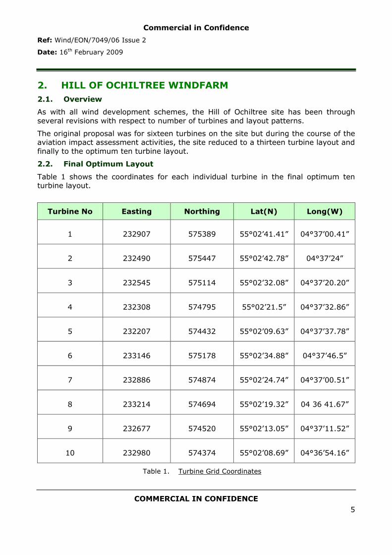
Commercial in Confidence
Ref: Wind/EON/7049/06 Issue 2
Date: 16th February 2009
COMMERCIAL IN CONFIDENCE
5
2. HILL OF OCHILTREE WINDFARM
2.1. Overview
As with all wind development schemes, the Hill of Ochiltree site has been through
several revisions with respect to number of turbines and layout patterns.
The original proposal was for sixteen turbines on the site but during the course of the aviation impact assessment activities, the site reduced to a thirteen turbine layout and
finally to the optimum ten turbine layout.
2.2. Final Optimum Layout
Table 1 shows the coordinates for each individual turbine in the final optimum ten turbine layout.
Turbine No Easting Northing Lat(N) Long(W)
1 232907 575389 55°02‟41.41” 04°37‟00.41”
2 232490 575447 55°02‟42.78” 04°37‟24”
3 232545 575114 55°02‟32.08” 04°37‟20.20”
4 232308 574795 55°02‟21.5” 04°37‟32.86”
5 232207 574432 55°02‟09.63” 04°37‟37.78”
6 233146 575178 55°02‟34.88” 04°37‟46.5”
7 232886 574874 55°02‟24.74” 04°37‟00.51”
8 233214 574694 55°02‟19.32” 04 36 41.67”
9 232677 574520 55°02‟13.05” 04°37‟11.52”
10 232980 574374 55°02‟08.69” 04°36‟54.16”
Table 1. Turbine Grid Coordinates

Commercial in Confidence
Ref: Wind/EON/7049/06 Issue 2
Date: 16th February 2009
COMMERCIAL IN CONFIDENCE
6
2.3. Map of Location
Figure 1 shows a map of the location of the proposed turbines.
Figure 1. Map of Hill of Ochiltree Wind Turbines
2.4. Wind Farm Site Footprint
In terms of impact on radar that has line of sight of the site, the „clutter footprint‟ of the site is likely to measure approximately 1.5km by 1.5km (0.8nm), allowing for the nominal 100m either side of a turbine as per CAA CAP 764.
Commercial in Confidence
Ref: Wind/EON/7049/06 Issue 2
Date: 16th February 2009
COMMERCIAL IN CONFIDENCE
7
3. INITIAL AVIATION STAKEHOLDER CONSULTATION
3.1. Overview
When Osprey were first consulted in March 2008 the scheme consisted of sixteen
turbines and had the following observations from Aviation Stakeholders:
NATS – NATS offered no objection to the site;
CAA – The CAA had no observations on the site;
MOD – Defence Estates objected to the site on behalf of MOD.
3.2. NATS Consultation
E.ON Climate & Renewables applied to NATS for a technical assessment of the Hill of Ochiltree site to determine whether the turbines would conflict with the radar services
provided by NATS. The application was submitted under the former name for the site: Glenvernoch Fell and was based on a larger sixteen turbine layout.
The results of the NATS technical assessment showed that although the site is within
operational range of several NATS radar systems, the turbines themselves would have a negligible impact on radar services. It is Ospreys informed opinion that this
translates into the Hill of Ochiltree turbines being screened from the radars in question.
The response from NATS is included at Annex A, Appendix 1 to this report.
3.3. CAA Consultation
E.ON Climate & Renewables submitted the Hill of Ochiltree proposal to the CAA
Directorate of Airspace Policy (DAP) and the response declared that the Directorate had no observations; the site is not within the statutory notification zone of any civilian aerodrome.
The response from the CAA DAP is included at Annex A, Appendix 2 to this report.
3.4. MOD Consultation
Defence Estates is an organisation of the Ministry of Defence (MOD) whose main responsibility is the strategic management of all land and estate assets belonging to the MOD. This responsibility includes the safeguarding of estate and training assets
on behalf of the MOD and it is through Defence Estates that MOD will raise an objection (or otherwise) to a given wind farm proposal.
Defence Estates objected to the Hill of Ochiltree scheme on behalf of the MOD stating that the turbines will be “inside Low Flying Area 20T and will unacceptably affect military activities [in the area]”.
The MOD objection and the work carried out to resolve the issue is discussed in detail in Section 4.
Commercial in Confidence
Ref: Wind/EON/7049/06 Issue 2
Date: 16th February 2009
COMMERCIAL IN CONFIDENCE
8
4. MOD OBJECTION AND RESOLUTION
4.1. Overview
The MOD objection centres on the proposed site being within Low Flying Tactical
Training Area 20T. Low Flying remains a crucial skill for military aircrew; UK armed forces are often deployed abroad at extremely short notice and with no time for „work up‟ training. They must be able to fulfil the tasks expected of them immediately and
as effectively as possible.
UK military aircrew undertake a variety of roles including reconnaissance, fast
jet/combat operations, helicopter search and rescue/combat/troop deployment operations, transportation of battle field equipment and delivery of humanitarian aid.
They are only able to fulfil their missions through specialist training utilising the UK Military Low Flying System.
4.2. UK Military Low Flying System
The UK Military Low Flying system covers the open airspace of the whole of the UK and surrounding coastal areas from the surface up to 2000ft above ground or mean
sea level. There are however areas within the UK that are more formally adopted by the MOD for tactical training due to specific characteristics of the environment and terrain; area 20T is one such area.
Inside 20T, training takes place down to 100ft above ground level (or to within 100ft of ground based obstacles). The combination of high ground, long valleys and low
population density makes this an extremely valuable training area.
4.3. Addressing the Objection
The original objection to the sixteen turbine scheme was raised via email
correspondence between Chris Evans of Defence Estates and Hayley Meadley (nee Jackson) at E.ON Climate & Renewables (see Annex A, appendix 3) on 31st May 2005.
The MOD were concerned that the site would restrict their use of the River Cree Valley and push military traffic towards settlements along the A714 (refer to map in Figure 1, Section 2). Defence Estates recommended that the relocation of five turbines on
the north east of the site might help address the concerns.
E.ON Climate & Renewables subsequently rearranged the layout of the site and
identified a thirteen turbine scheme that reduced the north east extent of the site. Osprey consulted Defence Estates on EON‟s behalf and submitted the new thirteen turbine scheme for consideration by MOD on 16th April 2008. Osprey‟s letter to
Defence Estates (Appendix A, Annex 4) explained that the gap between the A714 and the turbines had been widened by 1km.
The response from Defence Estates on 28th July 2008 (Appendix A, Annex 5) made no mention of E.ON Climate & Renewables‟ attempts to move the turbines away from the valley and instead simply stated that their main concern is that the Hill of Ochiltree
turbines “[are] not only a safety hazard but also severely impacts on utilisation of the area...”.

Commercial in Confidence
Ref: Wind/EON/7049/06 Issue 2
Date: 16th February 2009
COMMERCIAL IN CONFIDENCE
9
A further revision of the Hill of Ochiltree scheme reduced the number of turbines to ten and although this was submitted to Defence Estates for consideration, it was felt
that no further progress could be made without a meeting between E.ON Climate & Renewables and the MOD.
4.4. Meeting with MOD at Defence Estates
Osprey arranged a meeting with E.ON Climate & Renewables and Defence Estates
which was held on 6th November 2008. Squadron Leader Mike Hale of the Low Flying Ops Squadron attended on behalf of MOD.
The meeting was a success with MOD recognising the effort that E.ON Climate &
Renewables had put in to reducing the size and moving the turbines towards the southwest and hence away from the all important Cree Valley area. Sqn Ldr Mike
Hale explained the importance of the lower terrain and described how operationally, the higher ground on the Hill of Ochiltree was of less importance and that moving the site southwest pushed the turbines towards this higher ground.
E.ON Climate and Renewables and MOD engaged in discussions regarding the flight safety lighting of tall structures such as wind turbines. From E.ON Climate &
Renewables point of view, augmenting the turbines with the standard 200 candela aviation obstruction lighting increases the visual impact of the turbines on the landscape and hence increases the risk for local environmental objection. MOD stated
that lighting would enable aircrew to operate safely in the vicinity of the turbines at night but that they would be happy with 25 candela lighting which is compatible with
Night Vision Goggle (NVG) technology to 5nm.
E.ON Climate & Renewables were of the opinion that 25 candela lighting might still present an unacceptable visual impact but agreed to continue to work with MOD
towards a lighting solution. The recommended first steps were that E.ON investigate the actual visual impact of lighting some of the turbines on the site with 25 candela
lighting whilst MOD continue to investigate 18 candela and Infra-Red options that are invisible to naked eye but bright to NVG.
4.5. Removal of MOD Objection
The meeting was followed up with a formal retraction of the MOD objection in a letter to EON dated 21st November 2008. The letter included the recommendation that the
corner most turbines and on central turbine be augmented with 25 candela omni-directional red lighting in the interest of ensuring safe operations during the hours of darkness. The letter is included at Annex A, Appendix 6 to this report.
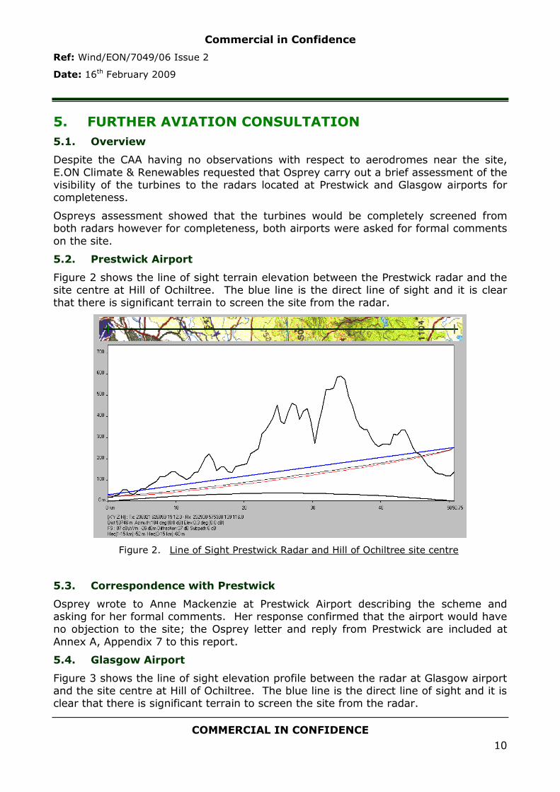
Commercial in Confidence
Ref: Wind/EON/7049/06 Issue 2
Date: 16th February 2009
COMMERCIAL IN CONFIDENCE
10
5. FURTHER AVIATION CONSULTATION
5.1. Overview
Despite the CAA having no observations with respect to aerodromes near the site,
E.ON Climate & Renewables requested that Osprey carry out a brief assessment of the visibility of the turbines to the radars located at Prestwick and Glasgow airports for completeness.
Ospreys assessment showed that the turbines would be completely screened from both radars however for completeness, both airports were asked for formal comments
on the site.
5.2. Prestwick Airport
Figure 2 shows the line of sight terrain elevation between the Prestwick radar and the site centre at Hill of Ochiltree. The blue line is the direct line of sight and it is clear that there is significant terrain to screen the site from the radar.
Figure 2. Line of Sight Prestwick Radar and Hill of Ochiltree site centre
5.3. Correspondence with Prestwick
Osprey wrote to Anne Mackenzie at Prestwick Airport describing the scheme and asking for her formal comments. Her response confirmed that the airport would have no objection to the site; the Osprey letter and reply from Prestwick are included at
Annex A, Appendix 7 to this report.
5.4. Glasgow Airport
Figure 3 shows the line of sight elevation profile between the radar at Glasgow airport and the site centre at Hill of Ochiltree. The blue line is the direct line of sight and it is clear that there is significant terrain to screen the site from the radar.

Commercial in Confidence
Ref: Wind/EON/7049/06 Issue 2
Date: 16th February 2009
COMMERCIAL IN CONFIDENCE
11
Figure 3. LOS Glasgow radar to Hill of Ochiltree centre
5.5. Correspondence with Glasgow
Osprey wrote to Colin Cragg at British Airport Authority (BAA) who are responsible for
planning and safeguarding of Glasgow airport. The response confirmed that the airport would have no objection to the site; the Osprey letter and reply from Glasgow
are included at Annex A, Appendix 8 to this report.
Commercial in Confidence
Ref: Wind/EON/7049/06 Issue 2
Date: 16th February 2009
COMMERCIAL IN CONFIDENCE
12
6. CONCLUSIONS AND RECOMMENDATIONS
6.1. Overview
All aviation issues relating to the Hill of Ochiltree site have been explored and addressed. NATS have no objection to the site; the CAA has no observations;
Glasgow and Prestwick airport were consulted for completeness and E.ON Climate & Renewables and Osprey worked hard to address the MOD objection which was successfully resolved in November 2008.
Since Issue 1 of this report, the site reached the „design freeze‟ stage and minor
refinement of the layout means that the turbines have moved slightly (by less than 50m). These final coordinates were communicated by Osprey to Defence Estates who responded by email on behalf of MOD indicating their continued support of the
scheme [„...providing the grid co-ordinates remain as stated in your letter and within the original boundaries discussed at your meeting with Sqn Ldr Hale...‟].
Osprey understand that it is standard practice within wind energy planning applications to include a micro-siting allowance of up to 50m from the final
coordinates – this will allow for any minor variations in the location of the turbines during the construction phase. Osprey have communicated this to Defence Estates.
6.2. Recommendations
Osprey recommend that E.ON Climate & Renewables continue discussions with MOD regarding their request for 25 candela lights to be fitted to the corner most
turbines and one central turbine. MOD have said that if the suggested 25 candela lighting has too great an impact on the local landscape they would like to discuss other options which may include 18 candela lights (invisible to naked eye but bright
to NVG) or other Infra-Red solutions.
If planning permission is granted EON must advise MOD of:
Date of construction start and completion;
Maximum altitude/height of construction equipment (e.g. cranes for lifting the structures into place;
Precise latitude and longitude of the final position of every turbine.
The aim is to ensure continued safe flight operations in the area.

Commercial in Confidence
Ref: Wind/EON/7049/06 Issue 2
Date: 16th February 2009
COMMERCIAL IN CONFIDENCE
13
ANNEX A SUPPORTING CORRESPONDENCE
Appendix 1: NATS Technical Assessment
Previous name for the Hill of Ochiltree site

Commercial in Confidence
Ref: Wind/EON/7049/06 Issue 2
Date: 16th February 2009
COMMERCIAL IN CONFIDENCE
14
Appendix 2: CAA Observations

Commercial in Confidence
Ref: Wind/EON/7049/06 Issue 2
Date: 16th February 2009
COMMERCIAL IN CONFIDENCE
15
Appendix 3: DE Objection Email

Commercial in Confidence
Ref: Wind/EON/7049/06 Issue 2
Date: 16th February 2009
COMMERCIAL IN CONFIDENCE
16
Appendix 4: Osprey Letter to Defence Estates
Date: 16th April 2008
Ref: Wind/EON/7049/02
Dear Chris Evans,
Ochiltree Windfarm – Previously Glenvernoch Fell DE Ref: 4694
Enclosed is a copy of the MOD windfarm developers pro-forma; this letter aims to
provide some background information on the Ochiltree Site as it has previously been considered by Defence Estates (DE) under the name of Glenvernoch Fell.
Osprey Consulting Services Ltd is acting in the role of independent aviation consultant for the developers, E.ON UK Renewables.
The scheme falls in a preferred area for operational low flying, close to Bargrennan, Dumfries and Galloway. The last correspondence from DE (email to Hayley
Meadley nee Jackson at E.ON dated 31st May 2005) raised concerns that with the 16 turbine layout, fast jet traffic would be pushed towards settlements along the A714. The indication was that if E.ON were able to remove the 5 most north-
easterly turbines then it may help remove low flying concerns.
In order to help ensure the development remains viable for E.ON, they would like DE to consider a new layout of 13 turbines on the site (3 turbines have been removed from the NE of the site and the others slightly shuffled) in the hope that
the new layout allows sufficient gap between Bargrennan and the wind turbines. Note that removing the 3 turbines widens the gap by approximately 1km (including
the required 500ft obstacle separation).
Yours Sincerely,
Lindsay Perks
Senior Consultant
Osprey Consulting Services Ltd

Commercial in Confidence
Ref: Wind/EON/7049/06 Issue 2
Date: 16th February 2009
COMMERCIAL IN CONFIDENCE
17
Appendix 5: MOD Objection July 2008
DE Operations North Safeguarding Wind Energy Kingston Road, Sutton Coldfield, B75 7RL
Chris Evans: 0121 311 2025
Claire Duddy: 0121 311 3714
Facsimile: 0121 311 2218
Mobile: 07901 751770
E-mail: [email protected]
E-mail: [email protected]
Internet Site: www.defence-estates.mod.uk
Internet Site: www.defence-estates.mod.uk
Ms Lindsay Perks
Osprey Consulting Services Ltd
The Grove
Sylvan Avenue
Woodhall Spa
Lincolnshire
LN10 6SL
Your Reference:
Our Reference:
DE/C/SUT/43/10/1/4694
Date:
28 July 2008
Dear Ms Perks
DE Ref Number: 4694
Site Name: Glenvernoch
Following your request for a further review, I am writing to confirm that we have the following concerns with your proposal. This has been assessed on the grid references below (as submitted in your pro-forma) for 13 turbine(s) of 125 metres to blade tip height.
Turbine 100km Square letter Easting Northing
1 NX 32965 75434
2 NX 33187 75146
3 NX 33349 74821
4 NX 33029 74299
5 NX 32692 75094
6 NX 32879 74786
7 NX 32653 74423
8 NX 32656 74045
9 NX 32454 75484
10 NX 32270 75098
11 NX 32199 74638
12 NX 32202 74259

Commercial in Confidence
Ref: Wind/EON/7049/06 Issue 2
Date: 16th February 2009
COMMERCIAL IN CONFIDENCE
18
13 NX 31826 73974
We will look at suggested mitigations that you may wish to propose. However, the MOD will object if you apply for planning permission without addressing these concerns to our satisfaction.
Low Flying
The turbine(s) will be within Low Flying Area 20T and will unacceptably affect military activities. These are areas made available for Military Operational Low Flying Training. Within Tactical Training Areas, military fast jets and Hercules aircraft may operate down to a height of 100ft separation distance from the ground and other obstacles. The proliferation of obstacles within this area, therefore, is not only a safety hazard but also severely impacts on the utilisation of the area for this essential Low Flying Training.
Yours sincerely
Chris Evans
Assistant Safeguarding Officer – Wind Energy Defence Estates
SAFEGUARDING SOLUTIONS TO DEFENCE NEEDS

Commercial in Confidence
Ref: Wind/EON/7049/06 Issue 2
Date: 16th February 2009
COMMERCIAL IN CONFIDENCE
19
Appendix 6: MOD Formal Retraction of Objection
DE Operations North
Safeguarding Wind Energy
Kingston Road, Sutton Coldfield, B75 7RL
Claire Duddy: 0121 311 3714
Facsimile: 0121 311 2218
Mobile: 07901 751770
E-mail: [email protected]
Internet Site: www.defence-estates.mod.uk
Ms Hayley Meadley
E.ON UK Renewables
c/o Winnington CHP
Winnington Lan, Winnington
Northwich
Cheshire
CW8 4GX
Your Reference:
Our Reference:
DE/C/SUT/43/10/1/4694
Date:
21 November 2008
Dear Ms Meadley
DE Ref Number: 4694
Site Name: GLENVERNOCH FELL / OCHILTREE
I am writing to tell you that the following a detailed assessment of the revised application, the MOD no longer has concerns with the proposal as set out in your email dated 07 November 2008.
The application is for 10 turbine(s) at 115 metres to blade tip. This has been assessed using the grid reference/s below as submitted in your email.
Turbine 100km Square Letter
Easting Northing
1 NX 32930 75388
2 NX 32581 75422
3 NX 32496 75096
4 NX 32355 74775
5 NX 32204 74437
6 NX 33200 75106

Commercial in Confidence
Ref: Wind/EON/7049/06 Issue 2
Date: 16th February 2009
COMMERCIAL IN CONFIDENCE
20
7 NX 32890 74862
8 NX 33195 74712
9 NX 32638 74547
10 NX 32984 74389
In the interest of air safety, the Ministry of Defence recommends that the corner most turbines and one in the middle are fitted with 25 candela omni-directional red lighting at the highest practicable point.
If the application is altered in any way we must be consulted again as even the slightest change could unacceptably affect us.
If you apply for planning permission you must ensure that the relevant planning authority consults this office to ensure that no concerns have arisen since the date of this letter.
If planning permission is granted you must tell us;
the date construction starts and ends; the maximum height of construction equipment; the latitude and longitude of every turbine.
This information is vital as it will be plotted on flying charts to make sure that military aircraft avoid this area.
Yours sincerely
Claire Duddy
Safeguarding Officer – Wind Energy
Defence Estates
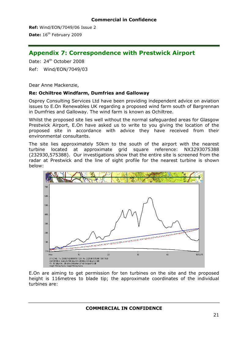
Commercial in Confidence
Ref: Wind/EON/7049/06 Issue 2
Date: 16th February 2009
COMMERCIAL IN CONFIDENCE
21
Appendix 7: Correspondence with Prestwick Airport
Date: 24th October 2008
Ref: Wind/EON/7049/03
Dear Anne Mackenzie,
Re: Ochiltree Windfarm, Dumfries and Galloway
Osprey Consulting Services Ltd have been providing independent advice on aviation
issues to E.On Renewables UK regarding a proposed wind farm south of Bargrennan in Dumfries and Galloway. The wind farm is known as Ochiltree.
Whilst the proposed site lies well without the normal safeguarded areas for Glasgow Prestwick Airport, E.On have asked us to write to you giving the location of the proposed site in accordance with advice they have received from their
environmental consultants.
The site lies approximately 50km to the south of the airport with the nearest
turbine located at approximate grid square reference: NX3293075388 (232930,575388). Our investigations show that the entire site is screened from the
radar at Prestwick and the line of sight profile for the nearest turbine is shown below:
E.On are aiming to get permission for ten turbines on the site and the proposed
height is 116metres to blade tip; the approximate coordinates of the individual turbines are:
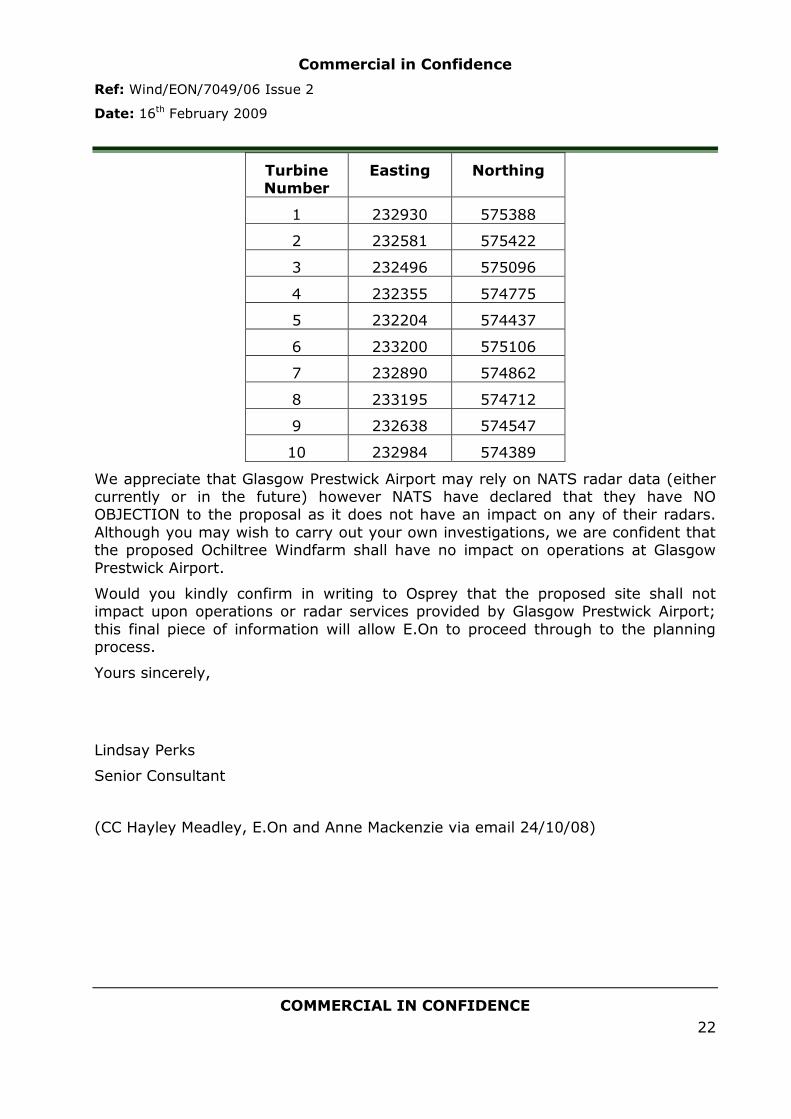
Commercial in Confidence
Ref: Wind/EON/7049/06 Issue 2
Date: 16th February 2009
COMMERCIAL IN CONFIDENCE
22
Turbine Number
Easting Northing
1 232930 575388
2 232581 575422
3 232496 575096
4 232355 574775
5 232204 574437
6 233200 575106
7 232890 574862
8 233195 574712
9 232638 574547
10 232984 574389
We appreciate that Glasgow Prestwick Airport may rely on NATS radar data (either currently or in the future) however NATS have declared that they have NO OBJECTION to the proposal as it does not have an impact on any of their radars.
Although you may wish to carry out your own investigations, we are confident that the proposed Ochiltree Windfarm shall have no impact on operations at Glasgow
Prestwick Airport.
Would you kindly confirm in writing to Osprey that the proposed site shall not impact upon operations or radar services provided by Glasgow Prestwick Airport;
this final piece of information will allow E.On to proceed through to the planning process.
Yours sincerely,
Lindsay Perks
Senior Consultant
(CC Hayley Meadley, E.On and Anne Mackenzie via email 24/10/08)

Commercial in Confidence
Ref: Wind/EON/7049/06 Issue 2
Date: 16th February 2009
COMMERCIAL IN CONFIDENCE
23

Commercial in Confidence
Ref: Wind/EON/7049/06 Issue 2
Date: 16th February 2009
COMMERCIAL IN CONFIDENCE
24
Appendix 8: Correspondence with Glasgow Airport
Date: 24th October 2008
Ref: Wind/EON/7049/04
Dear Colin Cragg,
Re: Glasgow Airport and Ochiltree Windfarm (Dumfries and Galloway)
Osprey Consulting Services Ltd have been providing independent advice on aviation
issues to E.On Renewables UK regarding a proposed wind farm south of Bargrennan in Dumfries and Galloway. The wind farm is known as Ochiltree.
At ~93km from Glasgow Airport, the proposed site is well without the normal notification range however E.On are acting upon advice received from their environmental consultants and have asked us to write to you giving the location of
the turbines. Our line of sight investigation shows that the site is fully screened from the Glasgow PSR and the profile for the turbine 1 is shown below: Grid
Reference NX3293075388 (232930, 575388).
E.On are aiming to get permission for ten turbines on the site and the proposed
height is 116metres to blade tip; the approximate coordinates of the individual turbines are:
Turbine
Number
Easting Northing
1 232930 575388

Commercial in Confidence
Ref: Wind/EON/7049/06 Issue 2
Date: 16th February 2009
COMMERCIAL IN CONFIDENCE
25
2 232581 575422
3 232496 575096
4 232355 574775
5 232204 574437
6 233200 575106
7 232890 574862
8 233195 574712
9 232638 574547
10 232984 574389
NATS have not objected to the site and have informed E.On that the turbines shall
have NO IMPACT on their radar systems. Although you may wish to carry out your own investigations, we are confident that the proposed Ochiltree Windfarm shall
have no impact on operations and radar services provided by Glasgow Airport.
Would you kindly confirm in writing to Osprey that the proposed site shall not impact upon operations at Glasgow Airport; this final piece of information will allow
E.On to proceed through to the planning process.
Yours sincerely
Lindsay Perks
Senior Consultant
(CC Hayley Meadley, E.On and Colin Cragg via email 24/10/08)
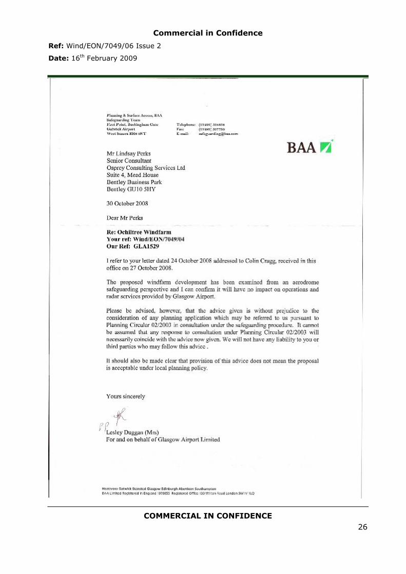
Commercial in Confidence
Ref: Wind/EON/7049/06 Issue 2
Date: 16th February 2009
COMMERCIAL IN CONFIDENCE
26


