Download - TECHNICAL REGULATIONS - WMO

W O R L D M E T E O R O L O G I C A L O R G A N I Z A T I O N
TECHNICAL REGULATIONS
VOLUME II
Meteorological Servicefor
International Air Navigation
2004 edition
Basic Documents No. 2
Secretariat of the World Meteorological Organization – Geneva – Switzerland2004
WMO-No. 49

2004 edition
2004, World Meteorological Organization
ISBN 92-63-18049-0
N O T E
The designations employed and the presentation of material in this publication do not imply the expression of any opinionwhatsoever on the part of the Secretariat of the World Meteorological Organization concerning the legal status of anycountry, territory, city or area or of its authorities, or concerning the delimitation of its frontiers or boundaries.

TABLE FOR NOTING SUPPLEMENTS AND NOTIFICATION OF DEVIATIONS
2004 edition
1 1
2 2
3 3
4 4
5 5
6 6
7 7
8 8
9 9
10 10
11 11
12 12
13 13
14 14
15 15
16 16
17 17
18 18
19 19
20 20
21 21
22 22
23 23
24 24
25 25
LIST OF DEVIATIONS
Inserted
datebyNo. Date
SUPPLEMENT
Inserted
datebyNo. Date


2004 edition
INTRODUCTORY NOTE
The present edition of Volume II of the Technical Regulations contains C.3.1 — International standards and recom-mended practices and C.3.3 — Format and preparation of flight documentation, resulting from Resolution 4 (EC-LVI),which approved the alignment of WMO Technical Regulations, Volume II, C.3.1 with Amendment 73 to Annex 3 to theConvention on International Civil Aviation. Resolution 4 (EC-LVI) also approved the restructuring of relevant parts of theWMO Technical Regulations into two parts. Part I contains core standards and recommended practices. Part II containsconsequential changes in the appendices and attachments. The present edition of Volume II also contains C.3.2 —Aeronautical climatology, and its attachment which arise from Recommendation 2 (CAeM-VII).
______________


2004 edition
1. The WMO Technical Regulations (WMO Publication No.49) are presented in three volumes:
Volume I — General meteorological standards andrecommended practices
Volume II — Meteorological service for international airnavigation
Volume III — Hydrology.
Purpose of the Technical Regulations
2. The Technical Regulations of the World MeteorologicalOrganization are determined by Congress in accordancewith Article 8(d) of the Convention.
3. These Regulations are designed:
(a) To facilitate cooperation in meteorology and hydrologybetween Members;
(b) To meet, in the most effective manner, specific needs ofthe various fields of application of meteorology andoperational hydrology in the international sphere; and
(c) To ensure adequate uniformity and standardization inthe practices and procedures employed in achieving (a)and (b) above.
Types of Regulations and notes
4. The Technical Regulations comprise standard practicesand procedures and recommended practices and procedures.
5. The definitions of these two types of Regulations are asfollows:
The standard practices and procedures:
(a) Shall be the practices and procedures which it isnecessary that Members follow or implement; andtherefore
(b) Shall have the status of requirements in a technicalresolution in respect of which Article 9(b) of theConvention is applicable; and
(c) Shall invariably be distinguished by the use of the termshall in the English text, and by suitable equivalent termsin the French, Spanish and Russian texts.
The recommended practices and procedures:
(a) Shall be the practices and procedures which it isdesirable that Members follow or implement; andtherefore
(b) Shall have the status of recommendations to Members,to which Article 9(b) of the Convention shall not beapplied;
(c) Shall be distinguished by the use of the term should inthe English text (except where otherwise provided bydecision of Congress) and by suitable equivalent termsin the French, Russian and Spanish texts.
6. In accordance with the above definitions, Members shalldo their utmost to implement the standard practices and procedures. In accordance with Article 9(b) of theConvention and in conformity with the provisions of GeneralRegulation 127, Members shall formally notify the Secretary-General, in writing, of their intention to apply the standardpractices and procedures of the Technical Regulations,except those for which they have lodged a specific deviation.Members shall also inform the Secretary-General, at leastthree months in advance, of any change in the degree oftheir implementation of a standard practice or procedure aspreviously notified and the effective date of the change.
7. Members are urged to comply with recommendedpractices and procedures, but it is not necessary to notify theSecretary-General of non-observance except with respect tothose contained in sub-section C.3.1.
8. In order to clarify the status of the various Regulations,the standard practices and procedures are distinguishedfrom the recommended practices and procedures by adifference in typographical practice, as indicated in theeditorial note.
9. Certain notes (preceded by the indication NOTE) areincluded in the Technical Regulations for explanatorypurposes; they may, for instance, refer to relevant WMOGuides and WMO publications of factual information. Thesenotes do not have the status of Technical Regulations. (TheWMO Guides describe practices, procedures andspecifications which Members are invited to follow orimplement in establishing and conducting theirarrangements in compliance with the Technical Regulationsand in developing meteorological and hydrological servicesin their respective countries.)
Status of annexes, appendices and attachments
10. WMO publications (other than the Technical Regulations(Volumes I to III) which contain regulatory material havingthe status of the Technical Regulations are annexes to theTechnical Regulations. These annexes, normally also calledmanuals, are established by decision of Congress and are
INTRODUCTION
2004 edition
intended to facilitate the application of Technical Regulationsto specific fields. In principle, annexes may contain bothstandard and recommended practices and procedures.
11. Texts called appendices and attachments appearing inthe Technical Regulations or in an annex to the TechnicalRegulations have the same status as the Regulations to whichthey refer.
Updating of the Technical Regulations
12. The Technical Regulations are updated, as necessary, inthe light of developments in meteorology and hydrologyand meteorological and hydrological techniques and in theapplications of meteorology. Certain principles previouslyagreed upon by Congress and applied in the selection ofmaterial for inclusion in the Technical Regulations arereproduced below. These principles provide guidance forconstituent bodies, in particular technical commissions,when dealing with matters pertaining to the TechnicalRegulations:
(a) Technical commissions should not recommend that aRegulation be a standard practice unless it is supportedby a strong majority;
(b) Technical Regulations should contain appropriateinstructions to Members regarding implementation ofthe provision in question;
(c) No major changes should be made in the TechnicalRegulations without consulting the appropriate technicalcommissions;
(d) Any amendments proposed to these TechnicalRegulations submitted by Members or by constituentbodies should be communicated to all Members at leastthree months before they are submitted to Congress.
13. Amendments proposed to the Technical Regulations —as a rule — are approved by Congress.
14. If a recommendation for an amendment is made by asession of the appropriate technical commission and if thenew regulation needs to be implemented before the time ofnext Congress, the Executive Council may, on behalf of theOrganization, approve the amendment in accordance withArticle 14(c) of the Convention. Amendments to annexes tothe Technical Regulations proposed by the appropriatetechnical commissions are normally approved by theExecutive Council.
15. If a recommendation for an amendment is made by theappropriate technical commission and the implementationof the new regulation is urgent, the President of theOrganization may, on behalf of the Executive Council, takeaction as provided by General Regulation 9(5).
16. As far as the publication of updated material in WMO-No. 49 is concerned, new editions of Volumes I and III arenormally issued after each session of Congress (i.e. four-yearly). The material in Volume II is prepared by the WorldMeteorological Organization and the International CivilAviation Organization working in close cooperation, inaccordance with the Working Arrangements agreed bythese Organizations; this also applies to the issuing of neweditions of Volume II. In the period between the publi-cation of two subsequent editions, the TechnicalRegulations are kept up to date by means of supplements,as necessary.
17. As decided by Resolution 1 (Cg-X), the amendmentsto the Technical Regulations adopted by Tenth Congressand incorporated in the 1988 edition of Volumes I and IIIand into the present introduction came into force on1 July 1988.
INTRODUCTIONVIII
______________

2004 edition
CONTENTS
[C.3.1.] INTERNATIONAL STANDARDS AND RECOMMENDED PRACTICES
PART I Core standards and recommended practices
[C.3.1.] 1 Definitions ................................................................................................................. C.3.1 — 1[C.3.1.] 1.1 Definitions ................................................................................................................. C.3.1 — 1[C.3.1.] 1.2 Terms used with a limited meaning............................................................................ C.3.1 — 4
[C.3.1.] 2 General provisions ..................................................................................................... C.3.1 — 4[C.3.1.] 2.1 Objective, determination and provision of meteorological service.............................. C.3.1 — 4[C.3.1.] 2.2 Supply, quality assurance and use of meteorological information ............................... C.3.1 — 5[C.3.1.] 2.3 Notifications required from operators ........................................................................ C.3.1 — 5
[C.3.1.] 3 World area forecast system and meteorological offices ............................................... C.3.1 — 6[C.3.1.] 3.1 Objectives of the world area forecast system.............................................................. C.3.1 — 6[C.3.1.] 3.2 World area forecast centres ........................................................................................ C.3.1 — 6[C.3.1.] 3.3 Meteorological offices................................................................................................ C.3.1 — 7[C.3.1.] 3.4 Meteorological watch offices ..................................................................................... C.3.1 — 7[C.3.1.] 3.5 Volcanic ash advisory centres ..................................................................................... C.3.1 — 8[C.3.1.] 3.6 Member volcano observatories .................................................................................. C.3.1 — 8[C.3.1.] 3.7 Tropical cyclone advisory centres ............................................................................... C.3.1 — 8
[C.3.1.] 4 Meteorological observations and reports ................................................................... C.3.1 — 9[C.3.1.] 4.1 Aeronautical meteorological stations and observations............................................... C.3.1 — 9[C.3.1.] 4.2 Agreement between air traffic services authorities and Meteorological Authorities ..... C.3.1 — 9[C.3.1.] 4.3 Routine observations and reports ............................................................................... C.3.1 — 10[C.3.1.] 4.4 Special observations and reports ................................................................................ C.3.1 — 10[C.3.1.] 4.5 Contents of reports.................................................................................................... C.3.1 — 10[C.3.1.] 4.6 Observing and reporting meteorological elements..................................................... C.3.1 — 11[C.3.1.] 4.7 Reporting of meteorological information from automatic observing systems.............. C.3.1 — 12[C.3.1.] 4.8 Observations and reports of volcanic activity ............................................................. C.3.1 — 12
[C.3.1.] 5 Aircraft observations and reports................................................................................ C.3.1 — 12[C.3.1.] 5.1 Obligations of Members ............................................................................................ C.3.1 — 13[C.3.1.] 5.2 Types of aircraft observations ..................................................................................... C.3.1 — 13[C.3.1.] 5.3 Routine aircraft observations — designation............................................................... C.3.1 — 13[C.3.1.] 5.4 Routine aircraft observations — exemptions............................................................... C.3.1 — 13[C.3.1.] 5.5 Special aircraft observations ....................................................................................... C.3.1 — 13[C.3.1.] 5.6 Other non-routine aircraft observations ..................................................................... C.3.1 — 14[C.3.1.] 5.7 Reporting of aircraft observations during flight .......................................................... C.3.1 — 14[C.3.1.] 5.8 Relay of air-reports bz ATS units ................................................................................. C.3.1 — 14[C.3.1.] 5.9 Recording and post-flight reporting of aircraft observations of volcanic activity.......... C.3.1 — 14
[C.3.1.] 6 Forecasts.................................................................................................................... C.3.1 — 14[C.3.1.] 6.1 Interpretation and use of forecasts ............................................................................. C.3.1 — 14[C.3.1.] 6.2 Aerodrome forecasts .................................................................................................. C.3.1 — 14[C.3.1.] 6.3 Landing forecasts....................................................................................................... C.3.1 — 15[C.3.1.] 6.4 Forecasts for take-off.................................................................................................. C.3.1 — 15[C.3.1.] 6.5 Area and route forecasts, other than forecasts issued within the framework of the
world area forecast system.......................................................................................... C.3.1 — 15[C.3.1.] 6.6 Area forecasts for low-level flights .................................................................................. C.3.1 — 15
[C.3.1.] 7 SIGMET and AIRMET information, aerodrome warnings and wind shear warnings ..... C.3.1 — 16[C.3.1.] 7.1 SIGMET information .................................................................................................. C.3.1 — 16
Page

[C.3.1.] 7.2 AIRMET information................................................................................................... C.3.1 — 16[C.3.1.] 7.3 Aerodrome warnings ................................................................................................. C.3.1 — 17[C.3.1.] 7.4 Wind shear warnings ................................................................................................. C.3.1 — 17
[C.3.1.] 8 Aeronautical climatological information ..................................................................... C.3.1 — 17[C.3.1.] 8.1 General provisions ..................................................................................................... C.3.1 — 17[C.3.1.] 8.2 Aerodrome climatological tables ................................................................................ C.3.1 — 17[C.3.1.] 8.3 Aerodrome climatological summaries......................................................................... C.3.1 — 17[C.3.1.] 8.4 Copies of meteorological observational data.............................................................. C.3.1 — 18
[C.3.1.] 9 Service for operators and flight crew members .......................................................... C.3.1 — 18[C.3.1.] 9.1 General provisions ..................................................................................................... C.3.1 — 18[C.3.1.] 9.2 Information for operators for pre-flight planning and for in-flight re-planning under
centralized operational control................................................................................... C.3.1 — 18[C.3.1.] 9.3 Briefing, consultation and display .............................................................................. C.3.1 — 19[C.3.1.] 9.4 Flight documentation ................................................................................................ C.3.1 — 19[C.3.1.] 9.5 Automated pre-flight information systems for briefing, consultation, flight planning
and flight documentation .......................................................................................... C.3.1 — 20[C.3.1.] 9.6 Information for aircraft in flight.................................................................................. C.3.1 — 20
[C.3.1.] 10 Information for air traffic services, search and rescue services and aeronauticalinformation services ................................................................................................... C.3.1 — 20
[C.3.1.] 10.1 Information for air traffic services units....................................................................... C.3.1 — 20[C.3.1.] 10.2 Information for search and rescue services units......................................................... C.3.1 — 21[C.3.1.] 10.3 Information for aeronautical information services units .............................................. C.3.1 — 21
[C.3.1.] 11 Requirements for, and use of, communications .......................................................... C.3.1 — 21[C.3.1.] 11.1 Requirements for communications............................................................................. C.3.1 — 21[C.3.1.] 11.2 Use of aeronautical fixed service communications — meteorological bulletins in
alphanumeric format ................................................................................................. C.3.1 — 22[C.3.1.] 11.3 Use of aeronautical fixed service communications — world area forecast system
products .................................................................................................................... C.3.1 — 22[C.3.1.] 11.4 Use of aeronautical mobile service communications................................................... C.3.1 — 22[C.3.1.] 11.5 Use of aeronautical data link service — contents of D-VOLMET.................................. C.3.1 — 22[C.3.1.] 11.6 Use of aeronautical broadcasting service — contents of VOLMET broadcasts ............. C.3.1 — 22
PART II Appendices and Attachments
Appendices to C.3.1
Appendix 1 — Flight documentation — model charts and forms ...................................................... C.3.1 – App.1 — 1
Appendix 2 — Technical specifications related to world area forecast system and meteorologicaloffices ........................................................................................................................ C.3.1 – App.2 — 1
Appendix 3 — Technical specifications related to meteorological observations and reports ............... C.3.1 – App.3 — 1
Appendix 4 — Technical specifications related to aircraft observations and reports ........................... C.3.1 – App.4 — 1
Appendix 5 — Technical specifications related to forecasts................................................................ C.3.1 – App.5 — 1
Appendix 6 — Technical specifications related to SIGMENT and AIRMET information, aerodromewarnings and wind shear warnings ............................................................................ C.3.1 – App.6 — 1
Appendix 7 — Technical specifications related to aeronautical climatological information................. C.3.1 – App.7 — 1
Appendix 8 — Technical specifications related to service for operators and flight crew members ...... C.3.1 – App.8 — 1
Appendix 9 — Technical specifications related to information for air traffic services, search andrescue services and aeronautical information services................................................. C.3.1 – App.9 — 1
Appendix 10 — Technical specifications related to requirements for, and use of, communications .... C.3.1 – App.10 — 1
CONTENTSX
2004 edition
Page

Attachments to C.3.1
Attachment A — Operationally-desirable and currently-attainable accuracy of measurement orobservation ............................................................................................................ C.3.1 — Att.A – 1
Attachment B — Operationally-desirable accuracy of forecasts .......................................................... C.3.1 — Att.B – 1Attachment C — Back-up procedures at the World Area Forecast Centres ......................................... C.3.1 — Att.C – 1Attachment D — Selected criteria applicable to aerodrome reports................................................... C.3.1 — Att.D – 1Attachment E — Conversion of instrumented readings into runway visual range and visibility........... C.3.1 — Att.E – 1
[C.3.2.] AERONAUTICAL CLIMATOLOGY
[C.3.2.] 1 General provisions ............................................................................................................ C.3.2 — 1[C.3.2.] 2 Aerodrome climatological tables....................................................................................... C.3.2 — 1[C.3.2.] 3 Aerodrome climatological summaries ............................................................................... C.3.2 — 1
Attachment to C.3.2 — Aerodrome climatological summary — model forms ................. C.3.2 — Att — 1
[C.3.3.] FORMAT AND PREPARATION OF FLIGHT DOCUMENTATION
[C.3.3.] 1 Flight documentation....................................................................................................... C.3.3 — 1
[C.3.3.] 2 Preparation of flight documentation................................................................................. C.3.3 — 1[C.3.3.] 2.1 General ............................................................................................................................ C.3.3 — 1
[C.3.3.] 3 Charts prepared by world area forecast centres ................................................................ C.3.3 — 1[C.3.3.] 3.1 General ............................................................................................................................ C.3.3 — 1[C.3.3.] 3.2 Map bases and projections ............................................................................................... C.3.3 — 1[C.3.3.] 3.3 Contents of charts ............................................................................................................ C.3.3 — 2
[C.3.3.] 4 Completion of models...................................................................................................... C.3.3 — 2[C.3.3.] 4.1 Model A — Aerodrome forecasts (Example 1 — Tabular form) ......................................... C.3.3 — 2[C.3.3.] 4.2 Model A — Aerodrome forecasts (Example 2 — TAF)........................................................ C.3.3 — 4[C.3.3.] 4.3 Model TA — Tabular forecast of en-route conditions ........................................................ C.3.3 — 4[C.3.3.] 4.4 Model TB — Tabular forecast of upper winds and upper-air temperatures ........................ C.3.3 — 5[C.3.3.] 4.5 Model IS — Chart for depicting upper winds and temperatures ....................................... C.3.3 — 5[C.3.3.] 4.6 Models SWH, SWM and SWL — Significant weather charts .............................................. C.3.3 — 6[C.3.3.] 4.7 Model VAG — Volcanic ash advisory information in graphical format ............................... C.3.3 — 7[C.3.3.] 4.8 Model SN — Sheet of notations used in flight documentation.......................................... C.3.3 — 7
CONTENTS XI
2004 edition
Page

C.3.1
INTERNATIONAL STANDARDS AND RECOMMENDED PRACTICES
PART I
CORE STANDARDS AND RECOMMENDED PRACTICES


[C.3.1.] 1
DefinitionsNOTE: The designation (RR) in these definitions indicates a
definition which has been extracted from the RadioRegulations of the International Telecommunication Union(ITU) (see Handbook on Radio Frequency SpectrumRequirements for Civil Aviation including Statement ofApproved ICAO Policies (Doc 9718)).
[C.3.1.] 1.1
Definitions
When the following terms are used in [C.3.1.], they havethe following meanings:
Aerodrome. A defined area on land or water (including anybuildings, installations and equipment) intended to be usedeither wholly or in part for the arrival, departure and surfacemovement of aircraft.
Aerodrome climatological summary. Concise summary ofspecified meteorological elements at an aerodrome, basedon statistical data.
Aerodrome climatological table. Table providing statisticaldata on the observed occurrence of one or moremeteorological elements at an aerodrome.
Aerodrome control tower. A unit established to provide airtraffic control service to aerodrome traffic.
Aerodrome elevation. The elevation of the highest point ofthe landing area.
Aerodrome meteorological office. An office, located at anaerodrome, designated to provide meteorological servicefor international air navigation.
Aeronautical fixed service (AFS). A telecommunicationservice between specified fixed points provided primarily forthe safety of air navigation and for the regular, efficient andeconomical operation of air services.
Aeronautical fixed telecommunication network (AFTN). Aworldwide system of aeronautical fixed circuits provided, aspart of the aeronautical fixed service, for the exchange ofmessages and/or digital data between aeronautical fixedstations having the same or compatible communicationscharacteristics.
Aeronautical meteorological station. A station designated tomake observations and meteorological reports for use ininternational air navigation.
Aeronautical mobile service (RR SI.32). A mobile servicebetween aeronautical stations and aircraft stations, orbetween aircraft stations, in which survival craft stationsmay participate; emergency position-indicating radiobeacon stations may also participate in this service ondesignated distress and emergency frequencies.
Aeronautical telecommunication station. A station in theaeronautical telecommunication service.
Aircraft. Any machine that can derive support in theatmosphere from the reactions of the air other than thereactions of the air against the Earth’s surface.
Aircraft observation. The evaluation of one or moremeteorological elements made from an aircraft in flight.
AIRMET information. Information issued by ameteorological watch office concerning the occurrence orexpected occurrence of specified en-route weatherphenomena which may affect the safety of low-level aircraftoperations and which was not already included in theforecast issued for low-level flights in the flight informationregion concerned or sub-area thereof.
Air-report. A report from an aircraft in flight prepared inconformity with requirements for position, and operationaland/or meteorological reporting.
NOTE: Details of the AIREP form are given in the ICAO Proceduresfor Air Navigation Services — Rules of the Air and Air TrafficServices (PANS-ATM, Doc 4444).
Air traffic services unit. A generic term meaning variously, airtraffic control unit, flight information centre or air trafficservices reporting office.
Alternate aerodrome. An aerodrome to which an aircraftmay proceed when it becomes either impossible orinadvisable to proceed to, or to land at, the aerodrome ofintended landing. Alternate aerodromes include thefollowing:
Take-off alternate. An alternate aerodrome at which anaircraft can land should this become necessary shortlyafter take-off and it is not possible to use the aerodromeof departure.
En-route alternate. An aerodrome at which an aircraftwould be able to land after experiencing an abnormal oremergency condition while en route.
ETOPS en-route alternate. A suitable and appropriatealternate aerodrome at which an aeroplane would beable to land after experiencing an engine shut-down or
2004 edition
C.3.1
PART I
CORE STANDARDS AND RECOMMENDED PRACTICES

other abnormal or emergency condition while en route inan ETOPS operation.
Destination alternate. An alternate aerodrome to which anaircraft may proceed should it become impossibleor inadvisable to land at the aerodrome of intendedlanding.
NOTE: The aerodrome from which a flight departs may also be anen-route or a destination alternate aerodrome for that flight.
Altitude. The vertical distance of a level, a point or an objectconsidered as a point, measured from mean sea level (MSL).
Approach control unit. A unit established to provide airtraffic control service to controlled flights arriving at, ordeparting from, one or more aerodromes.
Appropriate ATS authority. The relevant authoritydesignated by the Member responsible for providing airtraffic services in the airspace concerned.
Area control centre. A unit established to provide air trafficcontrol service to controlled flights in control areas under itsjurisdiction.
Automatic dependent surveillance (ADS). A surveillancetechnique in which aircraft automatically provide, via a datalink, data derived from on-board navigation and position-fixing systems, including aircraft identification, four-dimensional position and additional data, as appropriate.
Briefing. Oral commentary on existing and/or expectedmeteorological conditions.
Cloud of operational significance. A cloud with the height ofcloud base below 1 500 m (5 000 ft) or below the highestminimum sector altitude, whichever is greater.
Consultation. Discussion with a meteorologist or anotherqualified person of existing and/or expected meteorologicalconditions relating to flight operations; a discussion includesanswers to questions.
Control area. A controlled airspace extending upwards froma specified limit above the Earth.
Cruising level. A level maintained during a significantportion of a flight.
Elevation. The vertical distance of a point or a level, on oraffixed to the surface of the Earth, measured from mean sealevel.
Extended-range operation. Any flight by an aeroplane withtwo turbine power-units where the flight time at the onepower-unit inoperative cruise speed (in ISA and still airconditions), from a point on the route to an adequatealternate aerodrome, is greater than the threshold timeapproved by the Member of the Operator.
Flight crew member. A licensed crew member charged withduties essential to the operation of an aircraft during a flightduty period.
Flight documentation. Written or printed documents,including charts or forms, containing meteorologicalinformation for a flight.
Flight information centre. A unit established to provide flightinformation service and alerting service.
Flight information region. An airspace of defined dimensionswithin which flight information service and alerting serviceare provided.
Flight level. A surface of constant atmospheric pressurewhich is related to a specific pressure datum, 1013.2hectopascals (hPa), and is separated from other suchsurfaces by specific pressure intervals.
NOTE 1: A pressure type altimeter calibrated in accordance withthe Standard Atmosphere:
(a) When set to a QNH altimeter setting, will indicatealtitude;
(b) When set to a QFE altimeter setting, will indicateheight above the QFE reference datum; and
(c) When set to a pressure of 1 013.2 hPa, may beused to indicate flight levels.
NOTE 2: The terms “height” and “altitude”, used in NOTE 1,indicate altimetric rather than geometric heights andaltitudes.
Forecast. A statement of expected meteorologicalconditions for a specified time or period, and for a specifiedarea or portion of airspace.
GAMET area forecast. An area forecast in abbreviated plainlanguage for low-level flights for a flight information regionor sub-area thereof, prepared by the meteorological officedesignated by the Meteorological Authority concerned andexchanged with meteorological offices in adjacent flightinformation regions, as agreed between the MeteorologicalAuthorities concerned.
Grid-point data in digital form. Computer-processedmeteorological data for a set of regularly spaced points on achart, for transmission from a meteorological computer toanother computer in a code form suitable for automateduse.
NOTE: In most cases, such data are transmitted on medium orhigh speed telecommunications channels.
Height. The vertical distance of a level, a point or anobject considered as a point, measured from a specifieddatum.
Human Factors principles. Principles which apply toaeronautical design, certification, training, operations andmaintenance and which seek safe interface between thehuman and other system components by properconsideration to human performance.
International airways volcano watch (IAVW). Internationalarrangements for monitoring and providing warnings toaircraft of volcanic ash in the atmosphere.
NOTE: The IAVW is based on the cooperation of aviation andnon-aviation operational units using informationderived from observing sources and networks that areprovided by Members. The watch is coordinated by ICAOwith the cooperation of other concerned internationalorganizations.
Level. A generic term relating to vertical position of anaircraft in flight and meaning variously height, altitude orflight level.
Meteorological Authority. The authority providing orarranging for the provision of meteorological service forinternational air navigation on behalf of a Member.
INTERNATIONAL STANDARDS AND RECOMMENDED PRACTICESC.3.1 – 2
2004 edition

Meteorological bulletin. A text comprising meteorologicalinformation preceded by an appropriate heading.
Meteorological information. Meteorological report, analysis,forecast and any other statement relating to existing orexpected meteorological conditions.
Meteorological office. An office designated to providemeteorological service for international air navigation.
Meteorological report. A statement of observedmeteorological conditions related to a specified time andlocation.
Meteorological satellite. An artificial Earth satellite makingmeteorological observations and transmitting theseobservations to Earth.
Minimum sector altitude. The lowest altitude which may beused which will provide a minimum clearance of 300 m(1 000 ft) above all objects located in the area containedwithin a sector of a circle of 46 km (25 NM) radius centredon a radio aid to navigation.
Observation (meteorological). The evaluation of one ormore meteorological elements.
Operational control. The exercise of authority over theinitiation, continuation, diversion or termination of a flightin the interest of the safety of the aircraft and the regularityand efficiency of the flight.
Operational flight plan. The operator’s plan for the safeconduct of the flight based on considerations of aeroplaneperformance, other operating limitations and relevantexpected conditions on the route to be followed and at theaerodromes concerned.
Operational planning. The planning of flight operations byan operator.
Operator. A person, organization or enterprise engaged in,or offering to engage in, an aircraft operation.
Pilot-in-command. The pilot designated by the operator, orin the case of general aviation, the owner, as being incommand and charged with the safe conduct of a flight.
Prevailing visibility. The visibility value, observed inaccordance with the definition of “visibility”, which isreached or exceeded within at least half the horizon circle orwithin at least half of the surface of the aerodrome. Theseareas could comprise contiguous or non-contiguous sectors.
NOTE: This value may be assessed by human observation and/orinstrumented systems. When instruments are installed, theyare used to obtain the best estimate of the prevailingvisibility.
Prognostic chart. A forecast of a specified meteorologicalelement(s) for a specified time or period and a specifiedsurface or portion of airspace, depicted graphically on achart.
Quality assurance. All the planned and systematic activitiesimplemented within the quality system, and demonstratedas needed, to provide adequate confidence that an entitywill fulfil requirements for quality (ISO 9000:2000*).
Quality control. The operational techniques andactivities that are used to fulfil requirements for quality(ISO 9000:2000*).
Quality management. All activities of the overallmanagement function that determine the quality policy,objectives and responsibilities, and implementing them bymeans such as quality planning, quality control, qualityassurance and quality improvement within the qualitysystem (ISO 9000:2000*).
Quality system. The organizational structure, procedures,processes and resources needed to implement qualitymanagement (ISO 9000:2000*).
Regional air navigation agreement. Agreement approved bythe Council of ICAO normally on the advice of a regional airnavigation meeting.
Reporting point. A specified geographical location inrelation to which the position of an aircraft can be reported.
Rescue coordination centre. A unit responsible for promotingefficient organization of search and rescue services and forcoordinating the conduct of search and rescue operationswithin a search and rescue region.
Runway. A defined rectangular area on a land aerodromeprepared for the landing and take-off of aircraft.
Runway visual range (RVR). The range over which the pilotof an aircraft on the centre line of a runway can see therunway surface markings or the lights delineating therunway or identifying its centre line.
Search and rescue services unit. A generic term meaning, asthe case may be, rescue coordination centre, rescuesubcentre or alerting post.
Service area (world area forecast system). A geographicalarea within which a world area forecast centre is responsiblefor issuing area forecasts to Meteorological Authorities andother users.
SIGMET information. Information issued by ameteorological watch office concerning the occurrence orexpected occurrence of specified en-route weatherphenomena which may affect the safety of aircraftoperations.
Standard isobaric surface. An isobaric surface used on aworldwide basis for representing and analysing theconditions in the atmosphere.
Threshold. The beginning of that portion of the runwayusable for landing.
Touchdown zone. The portion of a runway, beyond thethreshold, where it is intended landing aeroplanes firstcontact the runway.
Tropical cyclone. Generic term for a non-frontal synoptic-scale cyclone originating over tropical or subtropical waterswith organized convection and definite cyclonic surfacewind circulation.
Tropical cyclone advisory centre (TCAC). A meteorologicalcentre designated by regional air navigation agreement toprovide advisory information to meteorological watchoffices, world area forecast centres and international OPMET
PART I C.3.1 – 3
2004 edition
* ISO Standard 9000:2000 — Quality Management Systems —Fundamentals and Vocabulary.

data banks regarding the position, forecast direction andspeed of movement, central pressure and maximum surfacewind of tropical cyclones.
Upper-air chart. A meteorological chart relating to aspecified upper-air surface or layer of the atmosphere.
Visibility. Visibility for aeronautical purposes is the greater of:
(a) The greatest distance at which a black object ofsuitable dimensions, situated near the ground, can beseen and recognized when observed against a brightbackground;
(b) The greatest distance at which lights in the vicinity of1 000 candelas can be seen and identified against anunlit background.
NOTE: The two distances have different values in air of a givenextinction coefficient, and the latter (b) varies with thebackground illumination. The former (a) is represented bythe meteorological optical range (MOR).
Volcanic ash advisory centre (VAAC). A meteorologicalcentre designated by regional air navigation agreement toprovide advisory information to meteorologicalwatch offices, area control centres, flight informationcentres, world area forecast centres and internationalOPMET data banks regarding the lateral and verticalextent and forecast movement of volcanic ash in theatmosphere following volcanic eruptions.
VOLMET. Meteorological information for aircraft in flight.
Data link-VOLMET (D-VOLMET). Provision of currentaerodrome routine meteorological reports (METAR) andaerodrome special meteorological reports (SPECI),aerodrome forecasts (TAF), SIGMET, special air-reportsnot covered by a SIGMET and, where available, AIRMETvia data link.
VOLMET broadcast. Provision, as appropriate, of currentMETAR, SPECI, TAF and SIGMET by means of continuousand repetitive voice broadcasts.
World area forecast centre (WAFC). A meteorological centredesignated to prepare and issue significant weatherforecasts and upper-air forecasts in digital form on a globalbasis direct to Members by appropriate means as part of theaeronautical fixed service.
World area forecast system (WAFS). A worldwide system bywhich world area forecast centres provide aeronauticalmeteorological en-route forecasts in uniform standardizedformats.
[C.3.1.] 1.2
Terms used with a limited meaning
For the purpose of [C.3.1.], the following terms are usedwith a limited meaning as indicated below:
(a) To avoid confusion in respect of the term “service”between the Meteorological Service considered as anadministrative entity and the service which is provided,“Meteorological Authority” is used for the former and“service” for the latter;
(b) “Provide” is used solely in connection with theprovision of service;
(c) “Issue” is used solely in connection with cases wherethe obligation specifically extends to sending out theinformation to a user;
(d) “Make available” is used solely in connection withcases where the obligation ends with making theinformation accessible to a user; and
(e) “Supply” is used solely in connection with cases whereeither (c) or (d) applies.
[C.3.1.] 2
General provisions
Introductory Note 1: It is recognized that the provisions of[C.3.1.] with respect to meteorological information aresubject to the understanding that the obligation of aMember is for the supply of meteorological information andthat the responsibility for the use made of such informationis that of the user.
Introductory Note 2: (This note appears only in ICAOAnnex 3 since it applies only to ICAO Contracting States.)
Introductory Note 3: (This note appears only in ICAOAnnex 3 since it applies only to ICAO Contracting States.)
[C.3.1.] 2.1
Objective, determination and provision ofmeteorological service
[C.3.1.] 2.1.1
The objective of meteorological service for internationalair navigation shall be to contribute towards the safety,regularity and efficiency of international air navigation.
[C.3.1.] 2.1.2
This objective shall be achieved by supplying thefollowing users: operators, flight crew members, airtraffic services units, search and rescue services units,airport managements and others concerned with theconduct or development of international air navigationwith the meteorological information necessary for theperformance of their respective functions.
[C.3.1.] 2.1.3
Each Member shall determine the meteorological servicewhich it will provide to meet the needs of internationalair navigation. This determination shall be made inaccordance with the provisions of [C.3.1.] and with dueregard to regional air navigation agreements; it shallinclude the determination of the meteorological serviceto be provided for international air navigation overinternational waters and other areas which lie outsidethe territory of the Member concerned.
[C.3.1.] 2.1.4
Each Member shall designate the authority, hereinafterreferred to as the Meteorological Authority, to provideor to arrange for the provision of meteorological servicefor international air navigation on its behalf. Details ofthe Meteorological Authority so designated shall beincluded in the State aeronautical information
INTERNATIONAL STANDARDS AND RECOMMENDED PRACTICESC.3.1 – 4
2004 edition

publication, in accordance with ICAO Annex 15,Appendix 1, GEN 1.1.
[C.3.1.] 2.1.5
Each Member shall ensure that the designatedMeteorological Authority complies with the require-ments of the World Meteorological Organization inrespect of qualifications and training of meteorologicalpersonnel providing service for international airnavigation.
NOTE: Requirements concerning qualifications and training ofmeteorological personnel in aeronautical meteorology aregiven in WMO Publication No. 49, Technical Regulations,Volume I — General Meteorological Standards andRecommended Practices, Chapter B.4 — Education andTraining.
[C.3.1.] 2.2
Supply, quality assurance and use ofmeteorological information
[C.3.1.] 2.2.1
Close liaison shall be maintained between thoseconcerned with the supply and those concerned withthe use of meteorological information on matters whichaffect the provision of meteorological service forinternational air navigation.
[C.3.1.] 2.2.2 (Recommendation)
In order to meet the objective of meteorological service forinternational air navigation, the Member should ensure thatthe designated Meteorological Authority referred to in[C.3.1.] 2.1.4 above establishes and implements a properlyorganized quality system comprising procedures, processesand resources necessary to provide for the qualitymanagement of the meteorological information to besupplied to the users listed in [C.3.1.] 2.1.2, above.
[C.3.1.] 2.2.3 (Recommendation)
The quality system established in accordance with [C.3.1.]2.2.2 above should be in conformity with the InternationalOrganization for Standardization (ISO) 9000 series of qualityassurance standards, and certified by an approvedorganization.
NOTE: International Organization for Standardization (ISO) 9000series of quality assurance standards provide a basicframework for the development of a quality assuranceprogramme. The details of a successful programme are tobe formulated by each Member and in most cases areunique to the Member organization.
[C.3.1.] 2.2.4 (Recommendation)
The quality system should provide the users with assurancethat the meteorological information supplied complies withthe stated requirements in terms of the geographical andspatial coverage, format and content, time and frequency ofissuance and period of validity, as well as the accuracy ofmeasurements, observations and forecasts. Where thequality system indicates that meteorological information tobe supplied to the users does not comply with the stated
requirements, and automatic error correction proceduresare not appropriate, such information should not besupplied to the users unless it is validated with theoriginator.
NOTE 1: Requirements concerning the geographical and spatialcoverage, format and content, time and frequency ofissuance and period of validity of meteorologicalinformation to be supplied to aeronautical users are givenin [C.3.1.] 3, [C.3.1.] 4, [C.3.1.] 6, [C.3.1.] 7, [C.3.1.] 8,[C.3.1.] 9 and [C.3.1.] 10 and in Appendices 2, 3, 5, 6, 7,8 and 9, Part II and the relevant ICAO regional airnavigation plans. Guidance concerning the accuracy ofmeasurements and observations, and accuracy offorecasts is given in Attachments A and B, Part II,respectively.
NOTE 2: Notwithstanding the provisions in [C.3.1.] 2.2.4 above,provisional TAF may still be issued, as necessary, inaccordance with [C.3.1.] 4.4.3 in Appendix 8, Part II.
[C.3.1.] 2.2.5 (Recommendation)
In regard to the exchange of meteorological information foroperational purposes, the quality system should includeverification and validation procedures and resources formonitoring adherence to the prescribed transmissionschedules for individual messages and/or bulletins requiredto be exchanged, and the times of their filing fortransmission. The quality system should be capable ofdetecting excessive transit times of messages and bulletinsreceived.
NOTE: Requirements concerning the exchange of operationalmeteorological information are given in [C.3.1.] 11 and inAppendix 10, Part II.
[C.3.1.] 2.2.6 (Recommendation)
Demonstration of compliance of the quality system appliedshould be by audit. If non-conformity of the system isidentified, action should be initiated to determine andcorrect the cause. All audit observations should beevidenced and properly documented.
[C.3.1.] 2.2.7
The meteorological information supplied to the userslisted in [C.3.1.] 2.1.2 above shall be consistent withHuman Factors principles and shall be in forms whichrequire a minimum of interpretation by these users, asspecified in the following sections.
NOTE: Guidance material on the application of Human Factorsprinciples can be found in the ICAO Human Factors TrainingManual (Doc 9683).
[C.3.1.] 2.3
Notifications required from operators
[C.3.1.] 2.3.1
An operator requiring meteorological service or changesin existing meteorological service shall notify, sufficientlyin advance, the Meteorological Authority or themeteorological office(s) concerned. The minimumamount of advance notice required shall be as agreed
PART I C.3.1 – 5
2004 edition
between the Meteorological Authority or meteorologicaloffice(s) and the operator.
[C.3.1.] 2.3.2
The Meteorological Authority shall be notified by theoperator requiring service when:
(a) New routes or new types of operations areplanned;
(b) Changes of a lasting character are to be made inscheduled operations; and
(c) Other changes, affecting the provision ofmeteorological service, are planned.
Such information shall contain all details necessary forthe planning of appropriate arrangements by theMeteorological Authority.
[C.3.1.] 2.3.3
The aerodrome meteorological office, or themeteorological office concerned, shall be notified by theoperator or a flight crew member:
(a) Of flight schedules;
(b) When non-scheduled flights are to be operated;and
(c) When flights are delayed, advanced or cancelled.
[C.3.1.] 2.3.4 (Recommendation)
The notification to the aerodrome meteorological office, orthe meteorological office concerned, of individual flightsshould contain the following information except that, in thecase of scheduled flights, the requirement for some or all ofthis information may be waived by agreement between themeteorological office and the operator:
(a) Aerodrome of departure and estimated time ofdeparture;
(b) Destination and estimated time of arrival;
(c) Route to be flown and estimated times of arrival at,and departure from, any intermediate aerodrome(s);
(d) Alternate aerodromes needed to complete theoperational flight plan and taken from the relevant listcontained in the ICAO regional air navigation plan;
(e) Cruising level;
(f) For supersonic flights, the alternative subsonic cruisinglevel and the locations of the transonic accelerationand deceleration areas and of the subsonic climb anddescent paths;
(g) Type of flight, whether under the visual or theinstrument flight rules;
(h) Type of meteorological information requested for aflight crew member, whether flight documentationand/or briefing or consultation; and
(i) Time(s) at which briefing, consultation and/or flightdocumentation are required.
[C.3.1.] 3
World area forecast system andmeteorological officesNOTE: Technical specifications and detailed criteria related to this
chapter are given in Appendix 2, Part II.
[C.3.1.] 3.1
Objectives of the world area forecast system
The objectives of the world area forecast system shall beto supply Meteorological Authorities and other userswith forecasts of global upper wind, upper-airtemperature and humidity, direction, speed and heightof maximum wind tropopause height and temperature,and forecasts of significant weather phenomena indigital form.
This objective shall be achieved through acomprehensive, integrated, worldwide and, as far aspracticable, uniform system, and in a cost-effectivemanner, taking full advantage of evolving technologies.
[C.3.1.] 3.2
World area forecast centres
[C.3.1.] 3.2.1
A Member, having accepted the responsibility forproviding a WAFC within the framework of the worldarea forecast system, shall arrange for that centre:
(a) To prepare global forecasts for grid points in digitalform for all required levels and in a standardformat; the forecasts shall comprise upper winds,upper-air temperatures and humidity, tropopauseheights and temperatures and maximum windspeed, direction and height;
(b) To prepare global forecasts of significant weatherphenomena in digital form;
(c) To issue the forecasts referred to in (a) and (b) indigital form to Meteorological Authorities andother users in its service area, as approved by theMember on advice from the MeteorologicalAuthority;
(d) To prepare and issue amendments to the forecasts;
(e) To receive information concerning the accidentalrelease of radioactive materials into the atmosphere,from its associated WMO regional specialized mete-orological centre for the provision of transportmodel products for radiological environmentalemergency response, in order to include the infor-mation in significant weather forecasts; and
(f) To establish and maintain contact with VAACs forthe exchange of information on volcanic activityin order to coordinate the inclusion of informa-tion on volcanic eruptions in significant weatherforecasts.
NOTE 1: Specifications for the preparation of significant weatherand upper-air prognostic charts are contained inAppendix 1, Part II.
INTERNATIONAL STANDARDS AND RECOMMENDED PRACTICESC.3.1 – 6
2004 edition

NOTE 2: The WAFS service areas are given in the regional airnavigation plans.
[C.3.1.] 3.2.2
In case of interruption of the operation of a WAFC, itsfunctions shall be carried out by the other WAFC.
NOTE: Back-up procedures to be used in case of interruption ofthe operation of a WAFC are given in Attachment C,Part II. Back-up procedures are expected to be subject tominor revisions by the World Area Forecast SystemOperations Group (WAFSOPSG) and the latest revisioncan be found on the WAFSOPSG Web site atwww.icao.int/anb/wafsopsg.
[C.3.1.] 3.3
Meteorological offices
[C.3.1.] 3.3.1
Each Member shall establish one or more aerodromeand/or other meteorological offices which shall beadequate for the provision of the meteorological servicerequired to satisfy the needs of international airnavigation.
[C.3.1.] 3.3.2
An aerodrome meteorological office shall carry out all orsome of the following functions as necessary to meetthe needs of flight operations at the aerodrome:
(a) Prepare and/or obtain forecasts and other relevantinformation for flights with which it is concerned;the extent of its responsibilities to prepare forecastsshall be related to the local availability and use ofen-route and aerodrome forecast material receivedfrom other offices;
(b) Prepare and/or obtain forecasts of localmeteorological conditions;
(c) Maintain a continuous survey of meteorologicalconditions over the aerodromes for which it isdesignated to prepare forecasts;
(d) Provide briefing, consultation and flightdocumentation to flight crew members and/orother flight operations personnel;
(e) Supply other meteorological information toaeronautical users;
(f) Display the available meteorological information;
(g) Exchange meteorological information with othermeteorological offices; and
(h) Supply information received on pre-eruptionvolcanic activity, a volcanic eruption or volcanic ashcloud, to its associated air traffic services unit,aeronautical information service unit andmeteorological watch office as agreed between theMeteorological, aeronautical information serviceand ATS Authorities concerned.
[C.3.1.] 3.3.3
The aerodrome meteorological offices at which flightdocumentation is required, as well as the areas to be
covered, shall be determined by regional air navigationagreement.
[C.3.1.] 3.3.4
The aerodromes for which landing forecasts arerequired shall be determined by regional air navigationagreement.
[C.3.1.] 3.3.5
For aerodromes without meteorological offices:
(a) The Meteorological Authority concerned shalldesignate one or more meteorological offices tosupply meteorological information as required; and
(b) The competent authorities shall establish means bywhich such information can be supplied to theaerodromes concerned.
[C.3.1.] 3.4
Meteorological watch offices
[C.3.1.] 3.4.1
A Member, having accepted the responsibility forproviding air traffic services within a flight informationregion or a control area, shall establish one or moremeteorological watch offices, or arrange for anotherMember to do so.
[C.3.1.] 3.4.2
A meteorological watch office shall:
(a) Maintain watch over meteorological conditionsaffecting flight operations within its area ofresponsibility;
(b) Prepare SIGMET and other information relating toits area of responsibility;
(c) Supply SIGMET information and, as required, othermeteorological information to associated air trafficservices units;
(d) Disseminate SIGMET information;
(e) When required by regional air navigationagreement, in accordance with [C.3.1.] 7.2.1 below:
(i) Prepare AIRMET information related to itsarea of responsibility;
(ii) Supply AIRMET information to associated airtraffic services units; and
(iii) Disseminate AIRMET information;
(f) Supply information received on pre-eruptionvolcanic activity, a volcanic eruption and volcanicash cloud for which a SIGMET has not already beenissued to its associated ACC/FIC as agreed betweenthe Meteorological and ATS Authorities concerned,and to its associated VAAC as determined byregional air navigation agreement; and
(g) Supply information received concerning theaccidental release of radioactive materials into theatmosphere, in the area for which it maintains
PART I C.3.1 – 7
2004 edition

watch or adjacent areas, to its associated ACC/FIC,as agreed between the Meteorological and ATSAuthorities concerned, and to aeronauticalinformation service units, as agreed between themeteorological and appropriate civil aviationauthorities concerned. The information shallcomprise location, date and time of the accident,and forecast trajectories of the radioactivematerials.
NOTE: The information is provided, at the request of the delegatedauthority of a Member, by WMO Regional SpecializedMeteorological Centres (RSMCs) for the provision oftransport model products for radiological environmentalemergency response. The information is sent by the RSMCto a single contact point of the National MeteorologicalService of each Member. This contact point has theresponsibility of redistributing the RSMC products withinthe Member concerned.
[C.3.1.] 3.4.3 (Recommendation)
The boundaries of the area over which meteorologicalwatch is to be maintained by a meteorological watch officeshould, in so far as is practicable, be coincident with theboundaries of a flight information region or a control area ora combination of flight information regions and/or controlareas.
[C.3.1.] 3.4.4 (Recommendation)
Meteorological watch should be maintained continuously;however, in areas with a low density of traffic, the watchmay be restricted to the period relevant to expected flightoperations.
[C.3.1.] 3.5
Volcanic ash advisory centres
[C.3.1.] 3.5.1
A Member having accepted, by regional air navigationagreement, the responsibility for providing a VAACwithin the framework of the international airwaysvolcano watch, shall arrange for that centre to respondto a notification that a volcano has erupted, or isexpected to erupt or volcanic ash is reported in its areaof responsibility, by arranging for that centre to:
(a) Monitor relevant geostationary and polar-orbitingsatellite data to detect the existence and extent ofvolcanic ash in the atmosphere in the areaconcerned;
(b) Activate the volcanic ash numerical trajectory/dispersion model in order to forecast themovement of any ash “cloud” which has beendetected or reported;
NOTE: The numerical model may be its own or, by agreement,that of another VAAC.
(c) Issue advisory information regarding the extent andforecast movement of the volcanic ash “cloud” to:
(i) Meteorological watch offices, area controlcentres and flight information centres servingflight information regions in its area ofresponsibility which may be affected;
(ii) Other VAACs whose areas of responsibility maybe affected;
(iii) World area forecast centres, internationalOPMET data banks, international NOTAMoffices, and centres designated by regional airnavigation agreement for the operation ofaeronautical fixed service satellite distributionsystems; and
(iv) Airlines requiring the advisory informationthrough the AFTN address providedspecifically for this purpose;
NOTE: The AFTN address to be used by the VAACs is given in theICAO Handbook on the International Airways Volcano Watch(IAVW) — Operational Procedures and Contact List (Doc9766) and at http://www.icao.int under ICAO Secretariat,Air Navigation, Meteorology.
(d) Issue updated advisory information to the meteoro-logical watch offices, area control centres, flightinformation centres and VAACs referred to in (c), asnecessary, but at least every six hours until such timeas the volcanic ash “cloud” is no longer identifiablefrom satellite data, no further reports of volcanic ashare received from the area, and no further eruptionsof the volcano are reported.
[C.3.1.] 3.5.2
Volcanic ash advisory centres shall maintain a 24-hourwatch.
[C.3.1.] 3.6
Member volcano observatories
Members that maintain volcano observatoriesmonitoring active volcanoes shall arrange that selectedMember volcano observatories, as designated byregional air navigation agreement, observing significantpre-eruption volcanic activity, a volcanic eruption and/orvolcanic ash in the atmosphere shall send thisinformation as quickly as practicable to its associatedACC, MWO and VAAC.
NOTE: Pre-eruption volcanic activity in this context means unusualand/or increasing volcanic activity which could presage avolcanic eruption.
[C.3.1.] 3.7
Tropical cyclone advisory centres
A Member having accepted, by regional air navigationagreement, the responsibility for providing a TCAC shallarrange for that centre to:
(a) Monitor the development of tropical cyclones in itsarea of responsibility, using geostationary andpolar-orbiting satellite data, radar data and othermeteorological information;
(b) Issue advisory information concerning the positionof the cyclone centre, its direction and speed ofmovement, central pressure and maximum surfacewind near the centre; in abbreviated plain languageto:
(i) Meteorological watch offices in its area ofresponsibility;
INTERNATIONAL STANDARDS AND RECOMMENDED PRACTICESC.3.1 – 8
2004 edition

(ii) Other TCACs whose areas of responsibility maybe affected; and
(iii) World area forecast centres, and internationalOPMET data banks, and centres designated byregional air navigation agreement for theoperation of aeronautical fixed service satellitedistribution systems;
(c) Issue updated advisory information to meteoro-logical watch offices for each tropical cyclone, asnecessary, but at least every six hours.
[C.3.1.] 4
Meteorological observations and reportsNOTE: Technical specifications and detailed criteria are given in
Appendix 3, Part II.
[C.3.1.] 4.1
Aeronautical meteorological stations andobservations
[C.3.1.] 4.1.1
Each Member shall establish at aerodromes and otherpoints of significance to international air navigation, inits territory, such aeronautical meteorological stations asit determines to be necessary. An aeronauticalmeteorological station may be a separate station or maybe combined with a synoptic station.
[C.3.1.] 4.1.2 (Recommendation)
Each Member should establish, or arrange for theestablishment of, aeronautical meteorological stations onoffshore structures or at other points of significance insupport of helicopter operations to offshore structures, ifrequired by regional air navigation agreement.
[C.3.1.] 4.1.3
Aeronautical meteorological stations shall make routineobservations at fixed intervals. At aerodromes, theroutine observations shall be supplemented by specialobservations whenever specified changes occur inrespect of surface wind, visibility, runway visual range,present weather, clouds and/or air temperature.
[C.3.1.] 4.1.4 (Recommendation)
Each Member should arrange for its aeronauticalmeteorological stations to be inspected at sufficientlyfrequent intervals to ensure that a high standard ofobservations is maintained, that instruments and all theirindicators are functioning correctly, and to check whetherthe exposure of the instruments has changed significantly.
[C.3.1.] 4.1.5
At aerodromes with runways intended for Category IIand III instrument approach and landing operations,automated equipment for measuring or assessing, asappropriate, and for monitoring and remote indicatingof surface wind, visibility, runway visual range, height ofcloud base, air and dew-point temperatures andatmospheric pressure shall be installed to support
approach and landing and take-off operations. Thesedevices shall be integrated automatic systems foracquisition, processing, dissemination and display in realtime of the meteorological parameters affecting landingand take-off operations. The design of integratedautomatic systems shall observe Human Factorsprinciples and include back-up procedures.
NOTE 1: Categories of precision approach and landing operationsare defined in ICAO Annex 6, Part I.
NOTE 2: Guidance material on the application of Human Factorsprinciples can be found in the ICAO Human FactorsTraining Manual (Doc 9683).
[C.3.1.] 4.1.6 (Recommendation)
At aerodromes with runways intended for Category Iinstrument approach and landing operations, automatedequipment for measuring or assessing, as appropriate, andfor monitoring and remote indicating of surface wind,visibility, runway visual range, height of cloud base, air anddew-point temperatures and atmospheric pressure shouldbe installed to support approach and landing and take-offoperations. These devices should be integrated automaticsystems for acquisition, processing, dissemination anddisplay in real time of the meteorological parametersaffecting landing and take-off operations. The design ofintegrated automatic systems should observe HumanFactors principles and include back-up procedures.
[C.3.1.] 4.1.7 (Recommendation)
Where an integrated automatic system is used for thedissemination/display of meteorological information, itshould be capable of accepting the manual insertion of datacovering those meteorological elements which cannot beobserved by automatic means.
[C.3.1.] 4.1.8
The observations shall form the basis for the preparationof reports to be disseminated at the aerodrome of originand for reports to be disseminated beyond the aero-drome of origin.
[C.3.1.] 4.1.9
Owing to the variability of meteorological elements inspace and time, to limitations of observing techniquesand to limitations caused by the definitions of some ofthe elements, the specific value of any of the elementsgiven in a report shall be understood by the recipient tobe the best approximation to the actual conditions at thetime of observation.
NOTE: Guidance on the operationally-desirable and currently-attainable accuracy of measurement or observation is givenin Attachment A, Part II.
[C.3.1.] 4.2
Agreement between air traffic servicesauthorities and Meteorological Authorities
(Recommendation)
An agreement between the Meteorological Authority andthe appropriate ATS authority should be established tocover, amongst other things:
PART I C.3.1 – 9
2004 edition

(a) The provision in air traffic services units of displaysrelated to integrated automatic systems;
(b) The calibration and maintenance of these displays/instruments;
(c) The use to be made of these displays/instruments byair traffic services personnel;
(d) As and where necessary, supplementary visualobservations (for example, of meteorologicalphenomena of operational significance in theclimb-out and approach areas) if and when madeby air traffic services personnel to update orsupplement the information supplied by themeteorological station;
(e) Meteorological information obtained from aircrafttaking-off or landing (for example, on wind shear); and
(f) If available, meteorological information obtained fromground weather radar.
NOTE: Guidance on the subject of coordination between ATS andaeronautical meteorological services is contained in theICAO Manual on Co-ordination Between Air Traffic Services,Aeronautical Information Services and AeronauticalMeteorological Services (Doc 9377).
[C.3.1.] 4.3
Routine observations and reports
[C.3.1.] 4.3.1
At aerodromes, routine observations shall be madethroughout the 24 hours each day, except as otherwiseagreed between the Meteorological Authority, theappropriate ATS Authority and the operator concerned.Such observations shall be made at intervals of one houror, if so determined by regional air navigationagreement, at intervals of one half-hour. At otheraeronautical meteorological stations, such observationsshall be made as determined by the MeteorologicalAuthority taking into account the requirements of airtraffic services units and aircraft operations.
[C.3.1.] 4.3.2
Reports of routine observations shall be issued as:
(a) Local routine reports only for dissemination at theaerodrome of origin (intended for arriving anddeparting aircraft); and
(b) METAR for dissemination beyond the aerodrome oforigin (mainly intended for flight planning,VOLMET broadcasts and D-VOLMET).
NOTE: Meteorological information used in ATIS (voice-ATIS andD-ATIS) is to be extracted from the local routine report, inaccordance with ICAO Annex 11, 4.3.6.1(g).
[C.3.1.] 4.3.3
At aerodromes that are not operational throughout24 hours in accordance with [C.3.1.] 4.3.1 above,METAR shall be issued prior to the aerodrome resum-ing operations in accordance with regional airnavigation agreement.
[C.3.1.] 4.4
Special observations and reports
[C.3.1.] 4.4.1
A list of criteria for special observations shall beestablished by the Meteorological Authority, inconsultation with the appropriate ATS Authority,operators and others concerned.
[C.3.1.] 4.4.2
Reports of special observations shall be issued as:
(a) Local special reports, only for dissemination at theaerodrome of origin (intended for arriving anddeparting aircraft); and
(b) SPECI for dissemination beyond the aerodrome oforigin (mainly intended for flight planning,VOLMET broadcasts and D-VOLMET).
NOTE: Meteorological information used in ATIS (voice-ATIS andD-ATIS) is to be extracted from the local special report, inaccordance with ICAO Annex 11, 4.3.6.1(g).
[C.3.1.] 4.4.3
At aerodromes that are not operational throughout 24hours in accordance with [C.3.1.] 4.3.1 above, followingthe resumption of the issuance of METAR, SPECI shall beissued, as necessary.
[C.3.1.] 4.5
Contents of reports
[C.3.1.] 4.5.1
Local routine and special reports and METAR and SPECIshall contain the following elements in the orderindicated:
(a) Identification of the type of report;
(b) Location indicator;
(c) Time of the observation;
(d) Identification of an automated or missing report,when applicable;
(e) Surface wind direction and speed;
(f) Visibility;
(g) Runway visual range, when applicable;
(h) Present weather;
(i) Cloud amount, cloud type (only for Cumulonimbusand towering Cumulus clouds) and height of cloudbase or, where measured, vertical visibility;
(j) Air temperature and dew-point temperature;
(k) QNH and, when applicable, QFE (QFE included onlyin local routine and special reports).
NOTE: The location indicators referred to under (b) and theirsignifications are published in ICAO Location Indicators(Doc 7910).
INTERNATIONAL STANDARDS AND RECOMMENDED PRACTICESC.3.1 – 10
2004 edition

[C.3.1.] 4.5.2 (Recommendation)
In addition to elements listed under [C.3.1.] 4.5.1 (a) to (k)above, local routine and special reports and METAR andSPECI should contain supplementary information to beplaced after element (k) above.
[C.3.1.] 4.5.3
Optional elements included under supplementaryinformation shall be included in METAR and SPECI inaccordance with regional air navigation agreement.
[C.3.1.] 4.6
Observing and reporting meteorologicalelements
[C.3.1.] 4.6.1
Surface wind
[C.3.1.] 4.6.1.1
The mean direction and the mean speed of the surfacewind shall be measured, as well as significant variations ofthe wind direction and speed, and reported in degreestrue and kilometres per hour (or knots), respectively.
[C.3.1.] 4.6.1.2 (Recommendation)
When local routine and special reports are used fordeparting aircraft, the surface wind observations for thesereports should be representative of conditions along therunway; when local routine and special reports are used forarriving aircraft, the surface wind observations for thesereports should be representative of the touchdown zone.
[C.3.1.] 4.6.1.3 (Recommendation)
For METAR and SPECI, the surface wind observations shouldbe representative of conditions above the whole runwaywhere there is only one runway and the whole runwaycomplex where there is more than one runway.
[C.3.1.] 4.6.2
Visibility
[C.3.1.] 4.6.2.1
The visibility as defined in [C.3.1.] 1 above shall be measuredor observed, and reported in metres or kilometres.
NOTE: Guidance on the conversion of instrument readings intovisibility is given in Attachment E, Part II.
[C.3.1.] 4.6.2.2 (Recommendation)
When local routine and special reports are used fordeparting aircraft, the visibility observations for these reportsshould be representative of conditions along the runway;when local routine and special reports are used for arrivingaircraft, the visibility observations for these reports should berepresentative of the touchdown zone of the runway.
[C.3.1.] 4.6.2.3 (Recommendation)
For METAR and SPECI, the visibility observations should berepresentative of the aerodrome.
[C.3.1.] 4.6.3
Runway visual range
NOTE: Guidance on the subject of runway visual range iscontained in the Manual of Runway Visual Range Observingand Reporting Practices (Doc 9328).
[C.3.1.] 4.6.3.1
Runway visual range as defined in [C.3.1.] 1 shall beassessed on all runways intended for Categories II and IIIinstrument approach and landing operations.
[C.3.1.] 4.6.3.2 (Recommendation)
Runway visual range as defined in [C.3.1.] 1 should beassessed on all runways intended for use during periods ofreduced visibility, including:
(a) Precision approach runways intended for Category Iinstrument approach and landing operations; and
(b) Runways used for take-off and having high-intensityedge lights and/or centre line lights.
NOTE: Precision approach runways are defined in ICAO Annex 14,Volume I, Chapter 1, under “Instrument runway”.
[C.3.1.] 4.6.3.3
The runway visual range assessed in accordance with[C.3.1.] 4.6.3.1 and [C.3.1.] 4.6.3.2 above, shall bereported in metres throughout periods when either thevisibility or the runway visual range is less than 1 500 m.
[C.3.1.] 4.6.3.4
Runway visual range assessments shall be representativeof:
(a) The touchdown zone of the runway intended fornon-precision or Category I instrument approachand landing operations;
(b) The touchdown zone and the mid-point of therunway intended for Category II instrumentapproach and landing operations; and
(c) The touchdown zone, the mid-point and stop-endof the runway intended for Category III instrumentapproach and landing operations.
[C.3.1.] 4.6.3.5
The units providing air traffic service and aeronauticalinformation service for an aerodrome shall be keptinformed without delay of changes in the serviceabilitystatus of the automated equipment used for assessingrunway visual range.
[C.3.1.] 4.6.4
Present weather
[C.3.1.] 4.6.4.1
The present weather occurring at the aerodrome and/orits vicinity shall be observed and reported as necessary.
PART I C.3.1 – 11
2004 edition

[C.3.1.] 4.6.4.2 (Recommendation)
For local routine and special reports, the present weatherinformation should be representative of conditions at theaerodrome.
[C.3.1.] 4.6.4.3 (Recommendation)
For METAR and SPECI, the present weather informationshould be representative of conditions at the aerodromeand, for certain specified present weather phenomena, in itsvicinity.
[C.3.1.] 4.6.4.4 (Recommendation)
Where observations are made using automatic observingsystems, provision should be made for manual insertion ofthose present weather elements which cannot be determinedadequately by that equipment.
[C.3.1.] 4.6.5
Clouds
[C.3.1.] 4.6.5.1
Cloud amount, cloud type and height of cloud base shallbe observed and reported as necessary to describe theclouds of operational significance. When the sky isobscured, vertical visibility shall be observed andreported, where measured, in lieu of cloud amount,cloud type and height of cloud base. The height of cloudbase and vertical visibility shall be reported in metres (orfeet).
[C.3.1.] 4.6.5.2 (Recommendation)
Cloud observations for local routine and special reportsshould be representative of the approach area.
[C.3.1.] 4.6.5.3 (Recommendation)
Cloud observations for METAR and SPECI should berepresentative of the aerodrome and its vicinity.
[C.3.1.] 4.6.5.4 (Recommendation)
Where observations of cloud amount and/or the height ofcloud base are made using automatic observing systems,provision should be made for manual insertion of cloudamounts and, where appropriate, cloud type, together withthe heights of those layers or masses not directlymeasurable by that equipment.
[C.3.1.] 4.6.6
Air temperature and dew-point temperature
[C.3.1.] 4.6.6.1
The air temperature and the dew-point temperatureshall be measured and reported in degrees Celsius.
[C.3.1.] 4.6.6.2 (Recommendation)
Observations of air temperature and dew-point temperaturefor local routine and special reports and METAR and SPECIshould be representative of the whole runway complex.
[C.3.1.] 4.6.7
Atmospheric pressure
The atmospheric pressure shall be measured and QNHand QFE values shall be computed and reported inhectopascals.
[C.3.1.] 4.6.8
Supplementary information
[C.3.1.] 4.6.8.1 (Recommendation)
Observations made at aerodromes should include theavailable supplementary information concerning signifi-cant meteorological conditions, particularly those in theapproach and climb-out areas. Where practicable, theinformation should identify the location of the meteoro-logical condition.
[C.3.1.] 4.6.8.2 (Recommendation)
Where observations are made using automatic observingsystems, provision should be made for manual insertion ofinformation concerning significant meteorologicalconditions which cannot be determined adequately by thatequipment.
[C.3.1.] 4.7
Reporting of meteorological informationfrom automatic observing systems
(Recommendation)
METAR and SPECI from automatic observing systems shouldonly be used during non-operational hours of theaerodrome. These METAR and SPECI should be identifiedwith the word “AUTO”.
[C.3.1.] 4.8
Observations and reports ofvolcanic activity
(Recommendation)
The occurrence of pre-eruption volcanic activity, volcaniceruptions and volcanic ash cloud should be reportedwithout delay to the associated air traffic services unit,aeronautical information services unit and meteorologicalwatch office. The report should be made in the form of avolcanic activity report comprising the followinginformation in the order indicated:
(a) Message type, VOLCANIC ACTIVITY REPORT;
(b) Station identifier, location indicator or name of station;
(c) Date/time of message;
(d) Location of volcano and name if known; and
(e) Concise description of event including, as appropriate,level of intensity of volcanic activity, occurrence of aneruption and its date and time, and the existence of avolcanic ash cloud in the area together with directionof ash cloud movement and height.
NOTE: Pre-eruption volcanic activity in this context means unusualand/or increasing volcanic activity which could presage avolcanic eruption.
INTERNATIONAL STANDARDS AND RECOMMENDED PRACTICESC.3.1 – 12
2004 edition

[C.3.1.] 5
Aircraft observations and reportsNOTE: Technical specifications and detailed criteria are given in
Appendix 4, Part II.
[C.3.1.] 5.1
Obligations of Members
Each Member shall arrange, according to the provi-sions of [C.3.1.] 5, for observations to be made byaircraft of its registry operating on international airroutes and for the recording and reporting of theseobservations.
[C.3.1.] 5.2
Types of aircraft observations
The following aircraft observations shall be made:
(a) Routine aircraft observations during en-route andclimb-out phases of the flight; and
(b) Special and other non-routine aircraft observationsduring any phase of the flight.
[C.3.1.] 5.3
Routine aircraft observations — designation
[C.3.1.] 5.3.1 (Recommendation)
When air-ground data link is used and automatic dependentsurveillance (ADS) is being applied, automated routineobservations should be made every 15 minutes during theen-route phase and every 30 seconds during the climb-outphase for the first 10 minutes of the flight.
[C.3.1.] 5.3.2
When voice communications are used, routineobservations shall be made during the en-route phase inrelation to those air traffic services reporting points orintervals:
(a) At which the applicable air traffic servicesprocedures require routine position reports; and
(b) Which are those separated by distancescorresponding most closely to intervals of one hourof flying time.
[C.3.1.] 5.3.3 (Recommendation)
For helicopter operations to and from aerodromes on off-shore structures, routine observations should be made fromhelicopters at points and times as agreed between theMeteorological Authorities and the helicopter operatorsconcerned.
[C.3.1.] 5.3.4
In the case of air routes with high-density air traffic (e.g.organized tracks), an aircraft from among the aircraftoperating at each flight level shall be designated, atapproximately hourly intervals, to make routineobservations in accordance with [C.3.1.] 5.3.1 or [C.3.1.]5.3.2 above, as appropriate. The designation proceduresshall be subject to regional air navigation agreement.
[C.3.1.] 5.3.5
In the case of the requirement to report during theclimb-out phase, an aircraft shall be designated, atapproximately hourly intervals, at each aerodrome tomake routine observations in accordance with [C.3.1.]5.3.1 above.
[C.3.1.] 5.4
Routine aircraft observations — exemptions
[C.3.1.] 5.4.1
When voice communications are used, an aircraft shallbe exempted from making the routine observationsspecified in [C.3.1.] 5.3.2 above when:
(a) The aircraft is not equipped with RNAV equipment;or
(b) The flight duration is two hours or less; or
(c) The aircraft is at a distance equivalent to less thanone hour of flying time from the next intendedpoint of landing; or
(d) The altitude of the flight path is below 1 500 m(5 000 ft).
[C.3.1.] 5.4.2 (Recommendation)
When voice communications are used, additionalexemptions may be prescribed by regional air navigationagreement for flights over routes and areas with highdensity air traffic and/or with adequate synoptic networks.Such procedures should take the form of exemption ordesignation procedures and should:
(a) Make it possible for the minimum requirements foraircraft observations of all meteorological officesconcerned to be met; and
(b) Be as simple as possible to implement and preferablynot involving consideration of individual cases.
[C.3.1.] 5.5
Special aircraft observations
Special observations shall be made by all aircraftwhenever the following conditions are encountered orobserved:
(a) Severe turbulence; or
(b) Severe icing; or
(c) Severe mountain wave; or
(d) Thunderstorms, without hail, that are obscured,embedded, widespread or in squall lines; or
(e) Thunderstorms, with hail, that are obscured,embedded, widespread or in squall lines; or
(f) Heavy duststorm or heavy sandstorm; or
(g) Volcanic ash cloud; or
(h) Pre-eruption volcanic activity or a volcanic eruption.
NOTE: Pre-eruption volcanic activity in this context means unusualand/or increasing volcanic activity which could presage avolcanic eruption.
PART I C.3.1 – 13
2004 edition

In addition, in the case of transonic and supersonic flights:
(i) Moderate turbulence; or(j) Hail; or(k) Cumulonimbus clouds.
[C.3.1.] 5.6
Other non-routine aircraft observations
When other meteorological conditions not listed under[C.3.1.] 5.5 above, e.g. wind shear, are encountered andwhich, in the opinion of the pilot-in-command, mayaffect the safety or markedly affect the efficiency of otheraircraft operations, the pilot-in-command shall advise theappropriate air traffic services unit as soon as practicable.
NOTE: Icing, turbulence and, to a large extent, wind shear,are elements which, for the time being, cannot besatisfactorily observed from the ground and for which inmost cases aircraft observations represent the only availableevidence.
[C.3.1.] 5.7
Reporting of aircraft observationsduring flight
[C.3.1.] 5.7.1
Aircraft observations shall be reported by air-grounddata link. Where air-ground data link is not available orappropriate, aircraft observations during flight shall bereported by voice communications.
[C.3.1.] 5.7.2
Aircraft observations shall be reported during flight atthe time the observation is made or as soon thereafteras is practicable.
[C.3.1.] 5.7.3
Aircraft observations shall be reported as air-reports.
[C.3.1.] 5.8
Relay of air-reports by ATS units
The Meteorological Authority concerned shall makearrangements with the appropriate ATS Authority toensure that, on receipt by the ATS units of:
(a) Routine and special air-reports by voice communi-cations, the ATS units relay them without delay totheir associated meteorological watch office;
(b) Routine air-reports by data link communications, theATS units relay them without delay to WAFCs; and
(c) Special air-reports by data link communications, theATS units relay them without delay to theirassociated meteorological watch office and WAFCs.
[C.3.1.] 5.9
Recording and post-flight reporting ofaircraft observations of volcanic activity
Special aircraft observations of pre-eruption volcanicactivity, a volcanic eruption or volcanic ash cloud shall be
recorded on the special air-report of volcanic activityform. A copy of the form shall be included with theflight documentation provided to flights operating onroutes which, in the opinion of the MeteorologicalAuthority concerned, could be affected by volcanic ashclouds.
[C.3.1.] 6
ForecastsNOTE: Technical specifications and detailed criteria are given in
Appendix 5, Part II.
[C.3.1.] 6.1
Interpretation and use of forecasts
[C.3.1.] 6.1.1
Owing to the variability of meteorological elements inspace and time, to limitations of forecasting techniquesand to limitations caused by the definitions of some ofthe elements, the specific value of any of the elementsgiven in a forecast shall be understood by the recipientto be the most probable value which the element islikely to assume during the period of the forecast.Similarly, when the time of occurrence or change of anelement is given in a forecast, this time shall beunderstood to be the most probable time.
NOTE: Guidance on the operationally-desirable accuracy offorecasts is given in Attachment B, Part II.
[C.3.1.] 6.1.2
The issue of a new forecast by a meteorological office,such as a routine aerodrome forecast, shall beunderstood to cancel automatically any forecast of thesame type previously issued for the same place and forthe same period of validity or part thereof.
[C.3.1.] 6.2
Aerodrome forecasts
[C.3.1.] 6.2.1
An aerodrome forecast shall be prepared by themeteorological office designated by the MeteorologicalAuthority concerned.
[C.3.1.] 6.2.2
An aerodrome forecast shall be issued at a specified timeand consist of a concise statement of the expectedmeteorological conditions at an aerodrome for aspecified period.
[C.3.1.] 6.2.3
Aerodrome forecasts and amendments thereto shall beissued as TAF and include the following information inthe order indicated:
(a) Identification of the type of forecast;
(b) Location indicator;
(c) Time of issue of forecast;
(d) Identification of a missing forecast, when pplicable;
INTERNATIONAL STANDARDS AND RECOMMENDED PRACTICESC.3.1 – 14
2004 edition

(e) Date and period of validity of forecast;
(f) Identification of a cancelled forecast, whenapplicable;
(g) Surface wind;
(h) Visibility;
(i) Weather;
(j) Cloud; and
(k) Expected significant changes to one or more ofthese elements during the period of validity.
Optional elements shall be included in TAF inaccordance with regional air navigation agreement.
NOTE: The visibility included in TAF refers to the forecast prevailingvisibility.
[C.3.1.] 6.2.4
Meteorological offices preparing TAF shall keep the fore-casts under continuous review and, when necessary, shallissue amendments promptly. The length of the forecastmessages and the number of changes indicated in the fore-cast shall be kept to a minimum.
[C.3.1.] 6.2.5
TAF that cannot be kept under continuous review shallbe cancelled.
[C.3.1.] 6.2.6 (Recommendation)
The period of validity of a routine TAF should be not lessthan nine hours nor more than 24 hours; this period shouldbe determined by regional air navigation agreement.Routine TAF valid for less than 12 hours should be issuedevery three hours and those valid for 12 to 24 hours shouldbe issued every six hours.
[C.3.1.] 6.3
Landing forecasts
[C.3.1.] 6.3.1
A landing forecast shall be prepared by themeteorological office designated by the MeteorologicalAuthority concerned; such forecasts are intended tomeet requirements of local users and of aircraft withinabout one hour’s flying time from the aerodrome.
[C.3.1.] 6.3.2
Landing forecasts shall be prepared in the form of atrend forecast, as determined by regional air navigationagreement.
[C.3.1.] 6.3.3
A trend forecast shall consist of concise statement of theexpected significant changes in the meteorologicalconditions at that aerodrome to be appended to a localroutine or local special report, or a METAR or SPECI. Theperiod of validity of a trend forecast shall be two hours fromthe time of the report which forms part of the landingforecast.
[C.3.1.] 6.4
Forecasts for take-off
[C.3.1.] 6.4.1
A forecast for take-off shall be prepared by themeteorological office designated by the MeteorologicalAuthority concerned.
[C.3.1.] 6.4.2 (Recommendation)
A forecast for take-off should refer to a specified period oftime and should contain information on expectedconditions over the runway complex in regard to surfacewind direction and speed and any variations thereof,temperature, pressure (QNH), and any other elements asagreed locally.
[C.3.1.] 6.4.3 (Recommendation)
A forecast for take-off should be supplied to operators andflight crew members on request within the three hoursbefore the expected time of departure.
[C.3.1.] 6.4.4 (Recommendation)
Meteorological offices preparing forecasts for take-offshould keep the forecasts under continuous review and,when necessary, should issue amendments promptly.
[C.3.1.] 6.5
Area and route forecasts, other thanforecasts issued within the framework of theworld area forecast system
NOTE: Provisions concerning forecasts issued within the frameworkof the world area forecast system are contained in [C.3.1.] 3above and Appendix 2 Part II, and those concerning areaforecasts for low-level flights under [C.3.1.] 6.6 below andAppendix 5, Part II.
[C.3.1.] 6.5.1
Area and route forecasts shall contain upper winds,upper-air temperatures, significant en-route weatherphenomena and associated clouds. Other elements maybe added as required. This information shall cover theflight operations for which they are intended in respectof time, altitude and geographical extent.
[C.3.1.] 6.5.2
Meteorological offices preparing area and routeforecasts shall keep the forecasts under continuousreview and issue amendments, as necessary.
[C.3.1.] 6.6
Area forecasts for low-level flights
[C.3.1.] 6.6.1
When the density of traffic operating below flightlevel 100 (or up to flight level 150 in mountainousareas, or higher, where necessary) warrants theroutine issue and dissemination of area forecasts forsuch operations, the frequency of issue, the form andthe fixed time or period of validity of those forecasts
PART I C.3.1 – 15
2004 edition

and the criteria of amendments thereto shall be deter-mined by the Meteorological Authority in consultationwith the users.
[C.3.1.] 6.6.2
When the density of traffic operating below flight level100 warrants the issuance of AIRMET information inaccordance with [C.3.1.] 7.2.1 below, area forecasts forsuch operations shall be prepared in a format agreedupon between the Meteorological Authoritiesconcerned. When abbreviated plain language is used,the forecast shall be prepared as a GAMET area forecast,employing approved ICAO abbreviations and numericalvalues. The area forecasts shall be issued to cover thelayer between the ground and flight level 100 (or up toflight level 150 in mountainous areas, or higher, wherenecessary) and shall contain information on en-routeweather phenomena hazardous to low-level flights, insupport of the issuance of AIRMET information, andadditional information required by low-level flights.
[C.3.1.] 6.6.3
Area forecasts for low-level flights prepared in supportof the issuance of AIRMET information shall be issuedevery six hours for a period of validity of six hours andtransmitted to meteorological offices concerned notlater than one hour prior to the beginning of theirvalidity period.
[C.3.1.] 7
SIGMET and AIRMET information,aerodrome warnings and wind shearwarnings
NOTE: Technical specifications and detailed criteria are given inAppendix 6, Part II.
[C.3.1.] 7.1
SIGMET information
[C.3.1.] 7.1.1
SIGMET information shall be issued by a meteorologicalwatch office and shall give a concise description inabbreviated plain language concerning the occurrenceand/or expected occurrence of specified en-routeweather phenomena, which may affect the safety ofaircraft operations, and of the development of thosephenomena in time and space.
[C.3.1.] 7.1.2
SIGMET information shall be cancelled when thephenomena are no longer occurring or are no longerexpected to occur in the area.
[C.3.1.] 7.1.3
The period of validity of a SIGMET message shall be notmore than six hours, and preferably not more than fourhours.
[C.3.1.] 7.1.4 (Recommendation)
In the special case of SIGMET messages for volcanic ashcloud and tropical cyclones, an outlook should be includedgiving information for up to 12 hours beyond the period ofvalidity specified in [C.3.1.] 7.1.3 above, concerning thetrajectory of the volcanic ash cloud and positions of thetropical cyclone centre.
[C.3.1.] 7.1.5 (Recommendation)
SIGMET messages issued in accordance with [C.3.1.] 7.1.4above, concerning volcanic ash cloud and tropical cyclonesshould be based on advisory information provided byVAACs and TCACs respectively, designated by regional airnavigation agreement.
[C.3.1.] 7.1.6
Close coordination shall be maintained between themeteorological watch office and the associated areacontrol centre/flight information centre to ensure thatinformation on volcanic ash included in SIGMET andNOTAM messages is consistent.
[C.3.1.] 7.1.7
A SIGMET message relating to the expected occurrenceof weather phenomena listed in [C.3.1.] 1.1.4 inAppendix 6, Part II with the exception of volcanic ashcloud and tropical cyclones, shall be issued not morethan six hours, and preferably not more than four hours,before the expected time of occurrence of thatphenomenon.
[C.3.1.] 7.1.8 (Recommendation)
SIGMET messages concerning volcanic ash cloud or tropicalcyclones expected to affect a flight informationregion should be issued up to 12 hours before thecommencement of the period of validity or as soon aspracticable if such advance warning of the existence ofthese phenomena is not available. SIGMET messages forvolcanic ash and tropical cyclones should be updated atleast every six hours.
[C.3.1.] 7.2
AIRMET information
[C.3.1.] 7.2.1
AIRMET information shall be issued by a meteorologicalwatch office in accordance with regional air navigationagreement, taking into account the density of air trafficoperating below flight level 100. AIRMET informationshall give a concise description in abbreviated plainlanguage concerning the occurrence and/or expectedoccurrence of specified en-route weather phenomena,which have not been included in the area forecast forlow-level flights issued in accordance with [C.3.1.] 6.6above and which may affect the safety of low-levelflights, and of the development of those phenomena intime and space.
INTERNATIONAL STANDARDS AND RECOMMENDED PRACTICESC.3.1 – 16
2004 edition

[C.3.1.] 7.2.2
AIRMET information shall be cancelled when thephenomena are no longer occurring or are no longerexpected to occur in the area.
[C.3.1.] 7.2.3
The period of validity of an AIRMET message shall benot more than six hours, and preferably not more thanfour hours.
[C.3.1.] 7.3
Aerodrome warnings
[C.3.1.] 7.3.1
Aerodrome warnings shall be issued by themeteorological office designated by the MeteorologicalAuthority concerned and shall give concise informationof meteorological conditions which could adverselyaffect aircraft on the ground, including parked aircraft,and the aerodrome facilities and services.
[C.3.1.] 7.3.2 (Recommendation)
Aerodrome warnings should be cancelled when theconditions are no longer occurring and/or no longerexpected to occur at the aerodrome.
[C.3.1.] 7.4
Wind shear warnings
[C.3.1.] 7.4.1
Wind shear warnings shall be prepared by themeteorological office designated by the MeteorologicalAuthority concerned and shall give concise informationof the observed or expected existence of wind shearwhich could adversely affect aircraft on the approachpath or take-off path or during circling approachbetween runway level and 500 m (1 600 ft) above thatlevel and aircraft on the runway during the landing rollor take-off run. Where local topography has been shownto produce significant wind shears at heights in excessof 500 m (1 600 ft) above runway level, then 500 m(1 600 ft) shall not be considered restrictive.
NOTE: Guidance on the subject of wind shear is contained in theICAO Manual on Wind Shear (Doc 9817, in preparation).
[C.3.1.] 7.4.2 (Recommendation)
Wind shear warnings for arriving aircraft and/or departingaircraft should be cancelled when aircraft reports indicatethat wind shear no longer exists, or alternatively, after anagreed elapsed time. The criteria for the cancellation of awind shear warning should be defined locally for each aero-drome, as agreed between the Meteorological Authority, theappropriate ATS Authority and the operators concerned.
[C.3.1.] 8
Aeronautical climatological informationNOTE: Technical specifications and detailed criteria are given in
Appendix 7, Part II.
[C.3.1.] 8.1
General provisions
NOTE: In cases where it is impracticable to meet the requirementsfor aeronautical climatological information on a nationalbasis, the collection, processing and storage of observationaldata may be effected through computer facilities available forinternational use, and the responsibility for the preparation ofthe required aeronautical climatological information may bedelegated by agreement between the MeteorologicalAuthorities concerned.
[C.3.1.] 8.1.1
Aeronautical climatological information required for theplanning of flight operations shall be prepared in theform of aerodrome climatological tables and aerodromeclimatological summaries. Such information shall besupplied to aeronautical users as agreed between theMeteorological Authority and those users.
NOTE: Climatological data required for aerodrome planningpurposes are set out in ICAO Annex 14, Volume I, 3.1.3 andAttachment A.
[C.3.1.] 8.1.2 (Recommendation)
Aeronautical climatological information should normally bebased on observations made over a period of at least fiveyears and the period should be indicated in the informationsupplied.
[C.3.1.] 8.1.3 (Recommendation)
Climatological data related to sites for new aerodromes andto additional runways at existing aerodromes should becollected starting as early as possible before thecommissioning of those aerodromes or runways.
[C.3.1.] 8.2
Aerodrome climatological tables
(Recommendation)
Each Member should make arrangements for collecting andretaining the necessary observational data and have the capability:
(a) To prepare aerodrome climatological tables for eachregular and alternate international aerodrome withinits territory; and
(b) To make available such climatological tables to anaeronautical user within a time period as agreedbetween the Meteorological Authority and that user.
[C.3.1.] 8.3
Aerodrome climatological summaries
(Recommendation)
Aerodrome climatological summaries should follow theprocedures prescribed by the World MeteorologicalOrganization. Where computer facilities are available tostore, process and retrieve the information, the summaries
PART I C.3.1 – 17
2004 edition

should be published, or otherwise made available toaeronautical users on request. Where such computerfacilities are not available, the summaries should beprepared using the models specified by the WorldMeteorological Organization, and should be published andkept up to date as necessary.
[C.3.1.] 8.4
Copies of meteorological observationaldata
Each Meteorological Authority, on request and to theextent practicable, shall make available to any otherMeteorological Authority, to operators and toothers concerned with the application of meteorologyto international air navigation, meteorologicalobservational data required for research, investigationor operational analysis.
[C.3.1.] 9
Service for operators and flight crewmembers
NOTE: Technical specifications and detailed criteria are given inAppendix 8, Part II.
[C.3.1.] 9.1
General provisions
[C.3.1.] 9.1.1
Meteorological information shall be supplied tooperators and flight crew members for:
(a) Pre-flight planning by operators;
(b) In-flight re-planning by operators using centralizedoperational control of flight operations;
(c) Use by flight crew members before departure;
(d) Aircraft in flight.
[C.3.1.] 9.1.2
Meteorological information supplied to operators andflight crew members shall cover the flight in respect oftime, altitude and geographical extent. Accordingly, theinformation shall relate to appropriate fixed times, orperiods of time, and shall extend to the aerodrome ofintended landing, also covering the meteorologicalconditions expected between the aerodrome ofintended landing and one alternate aerodromedesignated by the operator. In addition, ifagreed between the Meteorological Authority and theoperator, information up to a further aerodrome shallbe supplied.
[C.3.1.] 9.1.3
Meteorological information supplied to operators andflight crew members shall include upper winds andupper-air temperatures, significant en-route weatherphenomena, METAR and SPECI (including trendforecasts), TAF, forecast for take-off, SIGMET informa-tion and those special air-reports not covered by aSIGMET, and AIRMET information, which are available at
the meteorological office and which are relevant to theplanned flight operations.
[C.3.1.] 9.1.4
Where necessary, the Meteorological Authority of theMember providing service for operators and flight crewmembers shall initiate coordinating action with theMeteorological Authorities of other Members with aview to obtaining from them the reports and/orforecasts required.
[C.3.1.] 9.1.5
Meteorological information shall be supplied tooperators and flight crew members at the location to bedetermined by the Meteorological Authority, afterconsultation with the operators and at the time to beagreed upon between the meteorological office and theoperator concerned. The service shall normally beconfined to flights originating within the territory of theMember concerned, unless otherwise agreed betweenthe Meteorological Authority and the operatorconcerned. At an aerodrome without a meteorologicaloffice, arrangements for the supply of meteorologicalinformation shall be as agreed upon between theMeteorological Authority and the operator concerned.
[C.3.1.] 9.2
Information for operators for pre-flightplanning and for in-flight re-planning undercentralized operational control
[C.3.1.] 9.2.1
Meteorological information for pre-flight planning andin-flight re-planning by operators shall include any or allof the following information, as established by theMeteorological Authority in consultation with operatorsconcerned:
(a) Current and forecast upper winds, upper-airtemperatures and humidity;
(b) Tropopause height and temperature, and direction,speed and height of maximum wind;
(c) Existing and expected significant en-route weatherphenomena and amendments thereto;
(d) A forecast for take-off;
(e) METAR and, where available, SPECI (includingtrend forecasts) for the aerodrome of departure,take-off and en-route alternate aerodromes, theaerodrome of intended landing and destinationalternate aerodromes as determined by regional airnavigation agreement;
(f) TAF and amendments thereto for the aerodromesof departure and intended landing, and for take-off, en-route and destination alternate aerodromesas determined by regional air navigationagreement;
(g) SIGMET information and appropriate special air-reports relevant to the whole of the routesconcerned as determined by regional air navigationagreement; and
INTERNATIONAL STANDARDS AND RECOMMENDED PRACTICESC.3.1 – 18
2004 edition

NOTE: Appropriate special air-reports will be those not alreadyused in preparation of SIGMET messages.
(h) AIRMET information for low-level flights asdetermined by regional air navigation agreement.
[C.3.1.] 9.2.2
When upper-air information is supplied in chart form, itshall consist of charts for standard flight levels.
[C.3.1.] 9.2.3 (Recommendation)
The upper wind and upper-air temperature information andthe significant en-route weather information requested forpre-flight planning and in-flight re-planning by theoperator should be supplied as soon as it becomes available,but not later than three hours before departure. Othermeteorological information requested for pre-flightplanning and in-flight re-planning by the operator shouldbe supplied as soon as is practicable.
[C.3.1.] 9.3
Briefing, consultation and display
NOTE: The requirements for the use of automated pre-flightinformation systems in providing briefing, consultation anddisplay are given in [C.3.1.] 9.5, below.
[C.3.1.] 9.3.1
Briefing and/or consultation shall be provided, onrequest, to flight crew members and/or other flightoperations personnel. Its purpose shall be to supply thelatest available information on existing and expectedmeteorological conditions along the route to be flown,at the aerodrome of intended landing, alternateaerodromes and other aerodromes as relevant, either toexplain and amplify the information contained in theflight documentation or, if so agreed between theMeteorological Authority and the operator, in lieu offlight documentation.
[C.3.1.] 9.3.2
Meteorological information used for briefing andconsultation shall include any or all of the informationlisted in [C.3.1.] 9.2.1, above.
[C.3.1.] 9.3.3
If the meteorological office expresses an opinion on thedevelopment of the meteorological conditions at anaerodrome which differs appreciably from theaerodrome forecast included in the flight documenta-tion, the attention of flight crew members shall bedrawn to the divergence. The portion of the briefingdealing with the divergence shall be recorded at thetime of briefing and this record shall be made availableto the operator.
[C.3.1.] 9.3.4
The required briefing, consultation, display and/or flightdocumentation shall normally be provided by themeteorological office associated with the aerodrome ofdeparture. At an aerodrome where these services are
not available, arrangements to meet the requirementsof flight crew members shall be as agreed uponbetween the Meteorological Authority and the operatorconcerned. In exceptional circumstances, such as anundue delay, the meteorological office associated withthe aerodrome shall provide or, if that is not practicable,arrange for the provision of a new briefing, consultationand/or flight documentation, as necessary.
[C.3.1.] 9.3.5 (Recommendation)
The flight crew member or other flight operations personnelfor whom briefing, consultation and/or flight documen-tation has been requested should visit the meteorologicaloffice at the time agreed upon between the meteorologicaloffice and the operator concerned. Where localcircumstances at an aerodrome make personal briefing orconsultation impracticable, the meteorological office shouldprovide those services by telephone or other suitabletelecommunications facilities.
[C.3.1.] 9.4
Flight documentation
NOTE: The requirements for the use of automated pre-flightinformation systems in providing flight documentation aregiven in [C.3.1.] 9.5 below.
[C.3.1.] 9.4.1 (Recommendation)
Flight documentation should cover the whole route to beflown and comprise information listed under [C.3.1.]9.2.1(a) and (c) and (e) to (h) above. However, inaccordance with regional air navigation agreement, or inthe absence thereof when agreed between theMeteorological Authority and operators concerned, flightdocumentation for flights of two hours’ duration or less,after a short stop or turnaround, should be limited to theinformation operationally needed, but in all cases the flightdocumentation should at least comprise information listedunder [C.3.1.] 9.2.1(e), (f), (g) and, if appropriate, (h)above.
[C.3.1.] 9.4.2 (Recommendation)
Meteorological offices should provide information receivedwithin the framework of the world area forecast system forflight documentation. The flight documentation should bepresented in the form of charts, tabular forms, orabbreviated plain-language texts. TAF should be presentedin accordance with the templates in Appendix 5, Part II, orin abbreviated plain-language text using a tabularpresentation.
NOTE: Models of charts and forms for use in the preparation offlight documentation are given in Appendix 1, Part II. Thesemodels and methods for their completion are developed bythe World Meteorological Organization on the basis ofrelevant operational requirements stated by theInternational Civil Aviation Organization.
[C.3.1.] 9.4.3
Whenever it becomes apparent that the meteorologicalinformation to be included in the flight documentationwill differ materially from that made available for
PART I C.3.1 – 19
2004 edition

pre-flight planning and in-flight re-planning, theoperator shall be advised immediately and, ifpracticable, be supplied with the revised information asagreed between the operator and the meteorologicaloffice concerned.
[C.3.1.] 9.4.4 (Recommendation)
Whenever necessary and possible, the flight documentationshould be brought up to date, in writing or orally, before itis supplied to flight crew members. In cases where a needfor amendment arises after the flight documentation hasbeen supplied, and before take-off of the aircraft, themeteorological office should, as agreed locally, issue thenecessary amendment or updated information to theoperator or to the local air traffic services unit, fortransmission to the aircraft.
[C.3.1.] 9.4.5 (Recommendation)
The forms and charts included in flight documentationshould be printed in English, French, Russian or Spanish;they should, wherever practicable, be completed in thelanguage requested by the operator, preferably using one ofthose languages. Where appropriate, approvedabbreviations should be used. The units employed for eachelement should be in accordance with ICAO Annex 5.
[C.3.1.] 9.4.6
The Meteorological Authority shall retain informationsupplied to flight crew members, either as printedcopies or in computer files, for a period of at least 30days from the date of issue. This information shall bemade available, on request, for inquiries or investiga-tions and, for these purposes, shall be retained until theinquiry or investigation is completed.
[C.3.1.] 9.5
Automated pre-flight information systemsfor briefing, consultation, flight planningand flight documentation
[C.3.1.] 9.5.1
Where the Meteorological Authority uses automatedpre-flight information systems to supply and displaymeteorological information to operators and flight crewmembers for self-briefing, flight planning and flightdocumentation purposes, the information supplied anddisplayed shall comply with the relevant provisions in[C.3.1.] 9.1 to [C.3.1.] 9.4 above, inclusive.
[C.3.1.] 9.5.2 (Recommendation)
Automated pre-flight information systems providing for aharmonized, common point of access to meteorologicalinformation and aeronautical information servicesinformation by operators, flight crew members and otheraeronautical personnel concerned should be established byan agreement between the Meteorological Authority andthe relevant civil aviation authority or the agency to whichthe authority to provide service has been delegated inaccordance with ICAO Annex 15, 3.1.1(c).
NOTE: The meteorological and aeronautical information servicesinformation concerned are specified in [C.3.1.] 9.1 to[C.3.1.] 9.4 above and Appendix 8, Part II, and in ICAOAnnex 15, 8.1 and 8.2, respectively.
[C.3.1.] 9.5.3
Where automated pre-flight information systems areused to provide for the harmonized, common point ofaccess to meteorological information and aeronauticalinformation services information by operators, flightcrew members and other aeronautical personnelconcerned, the Meteorological Authority concernedshall remain responsible for the quality control andquality management of meteorological informationprovided by means of such systems in accordance with[C.3.1.] 2.2.2 above.
NOTE: The responsibilities relating to aeronautical informationservices information and the quality assurance of theinformation are given in ICAO Annex 15, Chapter 3.
[C.3.1.] 9.6
Information for aircraft in flight
[C.3.1.] 9.6.1
Meteorological information for use by aircraft in flightshall be supplied by a meteorological office to itsassociated air traffic services unit and throughD-VOLMET or VOLMET broadcasts. Meteorologicalinformation for planning by the operator for aircraft inflight shall be supplied on request, as agreed betweenthe Meteorological Authority or Authorities and theoperator concerned.
[C.3.1.] 9.6.2
Meteorological information for use by aircraft in flightshall be supplied to air traffic services units inaccordance with the specifications of [C.3.1.] 10 below.
[C.3.1.] 9.6.3
Meteorological information shall be supplied throughD-VOLMET or VOLMET broadcasts as determined byregional air navigation agreement, and in accordancewith the specifications of [C.3.1.] 11 below.
[C.3.1.] 10
Information for air traffic services,search and rescue services andaeronautical information servicesNOTE: Technical specifications and detailed criteria are given in
Appendix 9, Part II.
[C.3.1.] 10.1
Information for air traffic services units
[C.3.1.] 10.1.1
The Meteorological Authority shall designate ameteorological office to be associated with each airtraffic services unit. The associated meteorological officeshall, after coordination with the air traffic services unit,supply, or arrange for the supply of up-to-date
INTERNATIONAL STANDARDS AND RECOMMENDED PRACTICESC.3.1 – 20
2004 edition

meteorological information to the unit, as necessary, forthe conduct of its functions.
[C.3.1.] 10.1.2 (Recommendation)
The associated meteorological office for an aerodromecontrol tower or approach control office should be anaerodrome meteorological office.
[C.3.1.] 10.1.3
The associated meteorological office for a flightinformation centre or an area control centre shall be ameteorological watch office.
[C.3.1.] 10.1.4 (Recommendation)
Where, owing to local circumstances, it is convenient for theduties of an associated meteorological office to be sharedbetween two or more meteorological offices, the division ofresponsibility should be determined by the MeteorologicalAuthority in consultation with the appropriate ATS Authority.
[C.3.1.] 10.1.5
Any meteorological information requested by an airtraffic services unit in connection with an aircraftemergency shall be supplied as rapidly as possible.
[C.3.1.] 10.2
Information for, search and,rescue services units
Meteorological offices designated by the MeteorologicalAuthority in accordance with regional air navigationagreement shall supply search and rescue services unitswith the meteorological information they require in aform established by mutual agreement. For thatpurpose, the designated meteorological office shallmaintain liaison with the search and rescue services unitthroughout a search and rescue operation.
[C.3.1.] 10.3
Information for aeronauticalinformation services units
The Meteorological Authority, in coordination with theappropriate civil aviation authority, shall arrange for thesupply of up-to-date meteorological information torelevant aeronautical information services units, asnecessary, for the conduct of their functions.
[C.3.1.] 11
Requirements for, and use of,communications
NOTE 1: Technical specifications and detailed criteria are given inAppendix 10, Part II.
NOTE 2: It is recognized that it is for each Member to decide uponits own internal organization and responsibility forimplementing the telecommunications facilities referredto in [C.3.1.] 11.
[C.3.1.] 11.1
Requirements for communications
[C.3.1.] 11.1.1
Suitable telecommunications facilities shall be madeavailable to permit aerodrome meteorological officesand, as necessary, aeronautical meteorological stationsto supply the required meteorological information to airtraffic services units on the aerodromes for which thoseoffices and stations are responsible, and in particular toaerodrome control towers, approach control offices andthe aeronautical telecommunications stations servingthese aerodromes.
NOTE: Circuits of the aeronautical fixed service are used for thecollection and regional and interregional exchanges ofoperational meteorological information as well as for theaccess to international operational meteorological databanks. Three aeronautical fixed service satellite distributionsystems providing for global coverage are used to supportthe regional and interregional exchanges of operationalmeteorological information. Provisions relating to thesatellite distribution systems are given in ICAO Annex 10,Volume III, Part 1, 10.1 and 10.2.
[C.3.1.] 11.1.2
Suitable telecommunications facilities shall be madeavailable to permit meteorological watch offices tosupply the required meteorological information to airtraffic services and search and rescue services units inrespect of the flight information regions, control areasand search and rescue regions for which those officesare responsible, and in particular to flight informationcentres, area control centres and rescue coordinationcentres and the associated aeronautical telecommuni-cations stations.
[C.3.1.] 11.1.3
Suitable telecommunications facilities shall be madeavailable to permit world area forecast centres to supplythe required world area forecast system products tometeorological offices, Meteorological Authorities andother users.
[C.3.1.] 11.1.4
Telecommunications facilities between meteorologicaloffices and, as necessary, aeronautical meteorologicalstations and aerodrome control towers or approachcontrol offices shall permit communications by directspeech, the speed with which the communications canbe established being such that the required points maynormally be contacted within approximately 15 seconds.
[C.3.1.] 11.1.5 (Recommendation)
Telecommunications facilities between meteorologicaloffices and flight information centres, area control centres,rescue coordination centres and aeronautical telecommuni-cations stations should permit:
(a) Communications by direct speech, the speed withwhich the communications can be established being
PART I C.3.1 – 21
2004 edition
such that the required points may normally becontacted within approximately 15 seconds; and
(b) Printed communications, when a record is required bythe recipients; the message transit time should notexceed five minutes.
NOTE: In [C.3.1.] 11.1.4 and [C.3.1.] 11.1.5 above “approximately15 seconds” refers to telephony communications involvingswitchboard operation and “five minutes” refers to printedcommunications involving retransmission.
[C.3.1.] 11.1.6 (Recommendation)
The telecommunications facilities required in accordancewith [C.3.1.] 11.1.4 and [C.3.1.] 11.1.5 above should besupplemented, as and where necessary, by other forms ofvisual or audio communications, for example, closed-circuittelevision or separate information processing systems.
[C.3.1.] 11.1.7 (Recommendation)
As agreed between the Meteorological Authority andoperators, provision should be made to enable operators toestablish suitable telecommunications facilities for obtainingmeteorological information from aerodrome meteorologicaloffices or other appropriate sources.
[C.3.1.] 11.1.8
Suitable telecommunications facilities shall be madeavailable to permit meteorological offices to exchangeoperational meteorological information with othermeteorological offices.
[C.3.1.] 11.1.9 (Recommendation)
The telecommunication facilities used for the exchange ofoperational meteorological information should be theaeronautical fixed service.
[C.3.1.] 11.2
Use of aeronautical fixed servicecommunications — meteorological bulletinsin alphanumeric format
Meteorological bulletins containing operationalmeteorological information to be transmitted via theaeronautical fixed service shall be originated by theappropriate meteorological office or aeronauticalmeteorological station.
NOTE: Meteorological bulletins containing operationalmeteorological information authorized for transmission viathe aeronautical fixed service are listed in ICAO Annex 10,Volume II, Chapter 4, together with the relevant prioritiesand priority indicators.
[C.3.1.] 11.3
Use of aeronautical fixed servicecommunications — world area forecastsystem products
(Recommendation)
World area forecast system products in digital form shouldbe transmitted using binary data communicationstechniques. The method and channels used for thedissemination of the products should be as determined byregional air navigation agreement.
[C.3.1.] 11.4
Use of aeronautical mobile servicecommunications
The content and format of meteorological informationtransmitted to aircraft and by aircraft shall be consistentwith the provisions of these Technical Regulations.
[C.3.1.] 11.5
Use of aeronautical data link service —contents of D-VOLMET
D-VOLMET shall contain current METAR and SPECI,together with trend forecasts where available, TAF andSIGMET, special air-reports not covered by a SIGMETand, where available, AIRMET.
NOTE: The requirement to provide METAR and SPECI may be metby the data link flight information service (D-FIS) applicationentitled “Data link-aerodrome routine meteorological report(D-METAR) service”; the requirement to provide TAF maybe met by the D-FIS application entitled “Data link-aerodrome forecast (D-TAF) service”; and the requirementto provide SIGMET and AIRMET messages may be met bythe D-FIS application entitled “Data link-SIGMET(D-SIGMET) service”. The details of these data link servicesare specified in the ICAO Manual of Air Traffic Services DataLink Applications (Doc 9694).
[C.3.1.] 11.6
Use of aeronautical broadcasting service —contents of VOLMET broadcasts
[C.3.1.] 11.6.1
Continuous VOLMET broadcasts, normally on very highfrequencies (VHF), shall contain current METAR andSPECI, together with trend forecasts where available.
[C.3.1.] 11.6.2
Scheduled VOLMET broadcasts, normally on highfrequencies (HF), shall contain current METAR andSPECI, with trend forecasts, where available, and, whereso determined by regional air navigation agreement,TAF and SIGMET.
INTERNATIONAL STANDARDS AND RECOMMENDED PRACTICESC.3.1 – 22
2004 edition

C.3.1
INTERNATIONAL STANDARDS AND RECOMMENDED PRACTICES
PART II
APPENDICES AND ATTACHMENTS


MODEL A — Aerodrome forecastsExample 1 — Tabular formExample 2 — TAF
MODEL TA — Tabular forecast of en-route conditionsExample 1 — Low levelExample 2 — Medium level
MODEL TB — Tabular forecast of upper winds and upper-air temperaturesExample — Spot locations
MODEL IS — Upper wind and temperature chart for standard isobaric surfaceExample 1 — Arrows, feathers and pennants (Mercator projection)Example 2 — Arrows, feathers and pennants (Polar stereographic projection)
MODEL SWH — Significant weather chart (high level)Example 1 — Mercator projectionExample 2 — Polar stereographic projectionExample 3 — Polar stereographic projection (showing the jet stream vertical extent and
crossing jet stream depictions)
Note: In accordance with [C.3.1.] 4.3.1.1(m) in Appendix 8, additional information related tovolcanic ash should be placed at the side of the charts.
MODEL SWM — Significant weather chart (medium level)
MODEL SWL — Significant weather chart (low level)— Example 1— Example 2
MODEL VAG — Volcanic ash advisory information in graphical format
MODEL SN — Sheet of notations used in flight documentation
2004 edition
C.3.1
PART II
APPENDIX 1
FLIGHT DOCUMENTATION — MODEL CHARTS AND FORMS(See [C.3.1.] 9 in Part I, Appendix 2 and C.3.3)

INTERNATIONAL STANDARDS AND RECOMMENDED PRACTICESC.3.1 – App.1 – 2
2004 edition
ISSU
ED B
Y..
....
....
....
....
....
....
....
....
....
....
....
....
MET
EORO
LOG
ICA
L O
FFIC
ED
ATE.
....
....
....
....
.TI
ME
....
....
...
(UTC
)
HEI
GH
TS A
BOVE
AER
OD
ROM
E EL
EVAT
ION
Surfa
ce w
ind
mea
nCl
oud
dire
ctio
nLo
wes
t lay
erHi
gher
laye
rsD
ate
and
Perio
d of
Type
and
(deg
rees
true
)am
ount
, heig
ht o
fam
ount
, heig
ht o
fFo
reca
sttim
e of
valid
itytim
e of
mea
n w
ind
spee
dPr
evai
ling
base
(fee
t) an
dba
se (f
eet)
and
tem
pera
ture
Aero
drom
eiss
ue(U
TC)
chan
gem
axim
um w
ind
spee
dvis
ibilit
yW
eath
erty
pe (i
f CB)
type
(if C
B)(d
egre
es C
elsiu
s)Re
mar
ks
MO
MBA
SA15
0350
06–0
615
0/15
KT
10 K
MFE
W 1
500
TEM
PO 0
9–12
VRB/
20 K
T20
0 M
HVY
SH
RASC
T 10
00 C
BBK
N 1
500
MAX
30
AT 1
200Z
MAX
30
KTM
IN 2
0 AT
040
0Z
NAI
ROBI
1421
4003
–15
060/
05 K
T2
000
MO
VC 0
200
EXTR
ACTE
DPR
OB
40N
/AFR
OM
TEM
PO 0
3–05
VRB/
03 K
T50
0 M
FGTA
F 00
–24
BEC
MG
05–
0606
0/10
KT
10 K
MN
SWSC
T 15
00
KHAR
TOU
M15
0400
12–1
803
0/05
KT
10 K
MSC
T 25
00EX
TRAC
TED
PRO
B 30
FRO
MTE
MPO
12–
1503
0/20
KT
100
MM
OD
BLS
AM
AX 3
0 AT
130
0 Z
TAF
06–0
6
CAI
RO15
0345
06–0
606
0/10
KT
C
A
V
O
KM
AX 2
5 AT
140
0 Z
MIN
06
AT 0
500
Z
ROM
E15
1120
12–0
627
0/10
KT
2 00
0 M
HVY
DZR
ABK
N 5
00O
VC 1
500
TAF
06–0
6FM
140
027
0/10
KT
5 00
0 M
MO
D R
ABK
N 1
200
OVC
200
0M
AX 0
6 AT
150
0 Z
AMEN
DED
FM 1
800
330/
15 K
T10
KM
NSW
BKN
250
0M
IN M
S 02
AT
0400
Z
AE
RO
DR
OM
E F
OR
EC
AS
TS
Mo
del
AE
xam
ple
1 —
Tab
ular
fo
rm

PART II C.3.1 – App.1 – 3
2004 edition
AERODROME FORECASTS Model AExample 2 — TAF
ISSUED BY . . . . . . . . . . . . . . . . . . . . . . . . . . METEOROLOGICAL OFFICE (DATE, TIME UTC) . . . . . . . . . . . . . . . . . . . . . . . . .
INTENSITY
“ – ” (light); no indicator (moderate); “ + ” (heavy, or well-developed in the case of dust/sand whirls (dust devils)and funnel clouds) are used to indicate the forecast intensity of certain phenomena
DESCRIPTORS
Ml – shallow DR – low drifting SH – shower(s) FZ – freezing (supercooled)BC – patches BL – blowing TS – thunderstormPR – partial
FORECAST WEATHER ABBREVIATIONS
DZ – drizzle BR – mist PO – dust/sand whirls (dust devils)RA – rain FG – fog SQ – squallSN – snow FU – smoke FC – funnel cloud(s) (tornado or waterspout)SG – snow grains VA – volcanic ash SS – sandstormIC – ice crystals (diamond dust) DU – widespread dust DS – duststormPL – ice pellets SA – sandGR – hail HZ – hazeGS – small hail and/or snow pellets
EXAMPLES
+SHRA – heavy shower of rain TSSN – thunderstorm with moderate snowFZDZ – moderate freezing drizzle SNRA – moderate snow and rain
+TSSNGR – thunderstorm with heavy snow and hail
SELECTED ICAO LOCATION INDICATORS
CYUL Montreal Pierre Elliot KJFK New York/John F. Kennedy Intl RJTT Tokyo IntlTrudeau/Intl LFPG Paris/Charles de Gaulle SBGL Rio de Janeiro/Galeão Intl
EDDF Frankfurt/Main NZAA Auckland Intl YSSY Sydney/Kingsford Smith IntlEGLL London/Heathrow OBBI Bahrain Intl ZBAA Beijing/CapitalHKJK Nairobi/Jomo Kenyatta
RJTT 122130Z 130024 VRB03KT 4000 SCT025 BECMG 0305 9999 T30/12Z T20/06Z =
EGLL 090845Z 091212 27010KT 9999 SCT020 FM2100 30015KT3000 FZDZ BKN006 FM0000 30015KT 0800 +RASNBKN004 BECMG 0305 33020KT 5000 NSW SCT020BECMG 0709 9999 =
LFPG 160910Z 161212 10008KT CAVOK FM2000 VRB03KT 8000SCT012 FM0400 VRB03KT 0800 FG FM0900 10008KT CAVOK =
OBBI 030300Z 030624 03010KT 9999 SCT010 PROB30 TEMPO 0915 03030KT 0500 BLSA FM1800 VRB02KT 8000 SCT020 =
HKJK 280215Z 280624 06010KT 9999 SCT025 TEMPO 12163000 SHRA BKN015 PROB40 TEMPO 1416 VRB20G30KT+TSRA SCT010CB BKN015 =

INTERNATIONAL STANDARDS AND RECOMMENDED PRACTICESC.3.1 – App.1 – 4
2004 edition
TABULAR FORECAST OF EN-ROUTE CONDITIONS Model TAExample 1 — Low level
DATE . . . . . . . . . . . . . . . . . . . . . . . . . . . . . . . . . . . . . . . . . . . . . . . . . . . . . . . . . . . . HEIGHTS IN FEET ABOVE MSL
ROUTE FROM . . . . . . . . . . . . . . . . . . . . . . .TO . . . . . . . . . . . . . . . . . . . . . . . . .VIA . . . . . . . . . . . . . . . . . . . . . . . . .
VALID FOR DEPARTURE BETWEEN . . . . . . . . . . . . . . . . .UTC AND . . . . . . . . . . . . . . . UTC ANDFOR ARRIVAL BETWEEN .. . . . . . . . . . . . . . . . . . . . . . . . . UTC AND . . . . . . . . . . . . . . .UTC
SPECIAL FEATURES OF THE METEOROLOGICAL SITUATION:
ACTIVE COLD FRONT FROM HUMBER TO CHANNEL ISLES AT 1000 UTC MOVING EAST AT 20 KNOTS TOLIE NORTH/SOUTH ACROSS TRACK ABOUT 40 NM WEST OF AMSTERDAM BY 1900 UTC.
ZONE
UPPER WINDS(DEGREES TRUE AND KNOTS)TEMPERATURES(DEGREES CELSIUS)
BIGGIN HILL AMSTERDAM AIRWAYS
10 000 ft5 000 ft2 000 ft
280/30 MS 12 290/25 MS 03290/20 PS 03
250/45 MS 09240/35 00230/30 PS 06
SCT CU
BKN SC
BKN AC LYR
XXX1500
50002500
ISOL EMBD CB
BKN ST
XXX1000
CLOUD
SURFACE VISIBILITY 1 500 M IN SHOWERS 4 000 M IN MODERATE RAIN AND1 000 M IN THUNDERSTORMS
SIGNIFICANT WEATHER
HEIGHT OF 0°C ISOTHERM
FORECAST LOWEST QNH (hPa)
MODERATE OCNLSEVERE ICING
ISOL THUNDERSTORMS
MODERATE OCNLSEVERE ICING
MODERATE OCNL SEVERETUBULENCE IN FRONTAL ZONE
XXX5000
XXX1000
LONDON AMSTERDAM02 ° E
Issued by . . . . . . . . . . . . . . at . . . . . . . . . . . . .UTC on . . . . . . . . . . . . . . . . . . . 20 . . . by . . . . . . . . . . . . . . . Forecaster.
Notes : 1. Positive and negative values are indicated by the prefix “PS” (plus) and “MS” (minus) respectively.2. When a single numerical value of an element is given in a forecast it is to be interpreted as representing
the most probable mean of a range of values which the element may assume during the period of the forecast.
Abbreviations: SKC—0 oktas, FEW—1 to 2 oktas, SCT—3 to 4 oktas, BKN—5 to 7 oktas, OVC—8 oktas, LYR—Layered, LOC—Locally, ISOL—Isolated, OCNL—Occasional, FRQ—Frequent, EMBD—Embedded.
3500
1008
5000
1004
15001700
17002100
100003500
XXX8000
800500
XXX2000
OVC SCAS LYR

PART II C.3.1 – App.1 – 5
2004 edition
TABULAR FORECAST OF EN-ROUTE CONDITIONS Model TAExample 2 — Medium level
DATE . . . . . . . . . . . . . . . . . . . . . . . . . . . . . . . . . . . . HEIGHTS IN PRESSURE ALTITUDE IN HUNDREDS OF FEET
ROUTE FROM . . . . . . . . . . . . . . . . . . . . . . .TO . . . . . . . . . . . . . . . . . . . . . . . . .VIA . . . . . . . . . . . . . . . . . . . . . . .
VALID FOR DEPARTURE BETWEEN . . . . . . . . . . . . . . . . UTC AND . . . . . . . . . . . . . . . UTC ANDFOR ARRIVAL BETWEEN .. . . . . . . . . . . . . . . . . . . . . . . . . UTC AND . . . . . . . . . . . . . . . UTC
SPECIAL FEATURES OF THE METEOROLOGICAL SITUATION (SURFACE CENTRES AND FRONTS):
ACTIVE COLD FRONT FROM HUMBER TO CHANNEL ISLES AT 1000 UTC MOVING EAST AT 20 KNOTS TOLIE NORTH/SOUTH ACROSS TRACK ABOUT 40 NM WEST OF AMSTERDAM BY 1900 UTC.
ZONE
UPPER WINDS(DEGREES TRUE AND KNOTS)TEMPERATURES(DEGREES CELSIUS)
BIGGIN HILL AMSTERDAM AIRWAYS
FL 240FL 180FL 100
260/40 MS 40 270/35 MS 26 280/30 MS 12
240/60 MS 36240/50 MS 24250/45 MS 09
SIGNIFICANT WEATHERAND ASSOCIATED CLOUD
* TROPOPAUSE HEIGHT
* JET STREAM
MODERATE TURBULENCE ISOL THUNDERSTORMS
MODERATE TO SEVEREICING AND TURBULENCE
LONDON AMSTERDAM02 ° E
Issued by . . . . . . . . . . . . . at . . . . . . . . . . . . .UTC on . . . . . . . . . . . . . . . . . .20 . . . by . . . . . . . . . . . . . Forecaster.
Notes: 1. Pressure altitude is the height in feet of a level in the standard atmosphere above the datum level corresponding to a pressure of 1013.2 hPa.
2. Positive and negative values are indicated by the prefix “PS" (plus) and “MS” (minus) respectively. 3. Only cloud associated with significant weather is shown. Low stratus and fog, when expected, will be shown for terminal areas in appropriate aerodrome forecasts. 4. When a single numerical value of an element is given in a forecast, it is to be interpreted as representing the most probable mean of a range of values which the element may assume during the period of the forecast.
Abbreviations: SKC—0 oktas, FEW—1 to 2 oktas, SCT—3 to 4 oktas, BKN—5 to 7 oktas, OVC—8 oktas, LYR—Layered,LOC—Locally, ISOL—Isolated, OCNL—Occasional, FRQ—Frequent, EMBD—Embedded.
15001700
17002100
180XXX
240XXX
* Above planned cruise level if not specified.

INTERNATIONAL STANDARDS AND RECOMMENDED PRACTICESC.3.1 – App.1 – 6
2004 edition
TABULAR FORECAST OF UPPER WINDS AND UPPER-AIR TEMPERATURES Model TBExample — Spot locations
ISSUED BY………………………………………………………………………………………………………………………………
FIXED TIME PROGNOSTIC CHART VALID AT…… UTC ON………………………………………………………………………
BASED ON………………… UTC DATA ON…………………… NEXT ISSUE VALID AT…………………………… UTC ………
Boxes refer to spot winds degrees true and knots atintersections of the LAT/LONG lines covered by the box;temperatures in degrees Celsius; heights are above MSL(thousands of feet).

PART II C.3.1 – App.1 – 7
2004 edition
UP
PE
R W
IND
AN
D T
EM
PE
RAT
UR
E C
HA
RT
FO
R S
TAN
DA
RD
ISO
BA
RIC
SU
RFA
CE
Mo
del
ISE
xam
ple
1 —
Arr
ow
s, f
eath
ers
and
pen
nant
s (M
erca
tor
pro
ject
ion)
ISS
UE
D B
Y W
AFC
……
……
……
……
…W
IND
/TE
MP
ER
ATU
RE
FL…
……
……
……
……
……
……
……
FIX
ED
TIM
E P
RO
GN
OS
TIC
CH
AR
T
VALI
D…
……
… U
TC…
……
… 2
0……
BA
SE
D O
N…
… U
TC D
ATA
ON
……
…
Uni
ts u
sed
: kno
ts; d
egre
es C
elsi
us
Tem
per
atur
es n
egat
ive
unle
ss p
refix
ed b
y +

INTERNATIONAL STANDARDS AND RECOMMENDED PRACTICESC.3.1 – App.1 – 8
2004 edition
UP
PE
R W
IND
AN
D T
EM
PE
RAT
UR
E C
HA
RT
FO
R S
TAN
DA
RD
ISO
BA
RIC
SU
RFA
CE
Mo
del
ISE
xam
ple
2 —
Arr
ow
s, f
eath
ers
and
pen
nant
s (P
ola
r st
ereo
gra
phi
c p
roje
ctio
n)
ISS
UE
D B
Y W
AFC
……
……
……
…..
WIN
D/T
EM
PE
RAT
UR
EFL
……
……
……
……
……
……
..…FI
XE
D T
IME
PR
OG
NO
STI
C C
HA
RT
VALI
D…
…U
TC…
… 2
0……
BA
SE
D O
N…
… U
TC D
ATA
ON
…U
nits
use
d: k
nots
; deg
rees
Cel
sius
Tem
per
atur
es n
egat
ive
unle
ss p
refix
ed b
y +

PART II C.3.1 – App.1 – 9
2004 edition
SIG
NIF
ICA
NT
WE
ATH
ER
CH
AR
T (H
IGH
LE
VE
L)M
od
el S
WH
Exa
mp
le 1
— M
erca
tor
pro
ject
ion
ISS
UE
D B
Y W
AFC
……
……
SIG
WX
AB
OV
E F
L 25
0
TRO
PO
PAU
SE
/JE
T S
TRE
AM
FIXE
D T
IME
PR
OG
NO
STI
C C
HA
RT
VALI
D…
.. U
TC…
.. 20
….
Sym
bol
s
an
d C
B im
ply
mod
erat
e or
sev
ere
turb
ulen
ce,
icin
g an
d h
ail.
Uni
ts u
sed:
kno
ts; a
ltitu
des
in fl
ight
leve
ls. C
heck
SIG
MET
s fo
r vol
cani
c
ash.
1 2 3 4 5
CA
T A
RE
AS
400
300
420
320
420
330
380
280
350
250

INTERNATIONAL STANDARDS AND RECOMMENDED PRACTICESC.3.1 – App.1 – 10
2004 edition
SIG
NIF
ICA
NT
WE
ATH
ER
CH
AR
T (H
IGH
LE
VE
L)M
od
el S
WH
Exa
mp
le 2
— P
ola
r st
ereo
gra
phi
c p
roje
ctio
n
ISS
UE
D B
Y W
AFC
……
……
SIG
WX
AB
OV
E F
L 25
0
TRO
PO
PAU
SE
/JE
T S
TRE
AM
FIX
ED
TIM
E P
RO
GN
OS
TIC
CH
AR
T
VALI
D…
.. U
TC…
.. 20
….
Sym
bol
s
and
CB
imp
ly
mod
erat
e or
sev
ere
turb
ulen
ce,
icin
g an
d h
ail.
Uni
ts u
sed:
kno
ts; a
ltitu
des
in fl
ight
leve
ls. C
heck
SIG
MET
s fo
r vol
cani
c
ash.
1 2 3 4 5
CA
T A
RE
AS
400
300
420
320
350
250
370
270
350
250

PART II C.3.1 – App.1 – 11
2004 edition
ISS
UE
D B
Y W
AFC
……
…...
....…
SIG
WX
AB
OV
E F
L 25
0
TRO
PO
PAU
SE
/JE
T S
TRE
AM
FIX
ED
TIM
E P
RO
GN
OS
TIC
CH
AR
T
VALI
D…
.. U
TC…
.. 20
….
Sym
bol
s
and
CB
imp
ly m
oder
ate
or s
ever
e tu
rbul
ence
, ici
ng a
nd h
ail.
Uni
ts u
sed:
kno
ts; a
ltitu
des
in fl
ight
leve
ls.
Che
ck S
IGM
ETs
for v
olca
nic
ash.
SIG
NIF
ICA
NT
WE
ATH
ER
CH
AR
T (H
IGH
LE
VE
L)M
od
el S
WH
Exa
mp
les
3 —
Po
lar
ster
eog
rap
hic
pro
ject
ion
(sho
win
g t
he je
t st
ream
ver
tical
ext
ent
and
cro
ssin
g je
t st
ream
dep
ictio
ns)
2
1
4
3
1 2 3 4
400
300
310
XX
X
370
XX
X
310
XX
X
CA
T A
RE
AS

INTERNATIONAL STANDARDS AND RECOMMENDED PRACTICESC.3.1 – App.1 – 12
2004 edition
SIG
NIF
ICA
NT
WE
ATH
ER
CH
AR
T (M
ED
IUM
LE
VE
L)M
od
el S
WM
ISS
UE
D B
Y W
AFC
……
……
……
……
…S
IGW
X F
L 10
0 –
250
FIX
ED
TIM
E P
RO
GN
OS
TIC
CH
AR
T
VALI
D…
……
UTC
……
…20
……
Sym
bol
s
and
CB
imp
ly m
oder
ate
or
seve
re t
urb
ulen
ce, i
cing
and
hai
l.
Uni
ts u
sed
: kno
ts; a
ltitu
des
in fl
ight
leve
ls.
PO
LA
R S
TE
RE
OG
RA
PH
IC P
RO
JE
CT
ION
ST
AN
DA
RD
PA
RA
LL
EL
60
°N S
CA
LE
CA
T A
RE
AS xx
x15
0
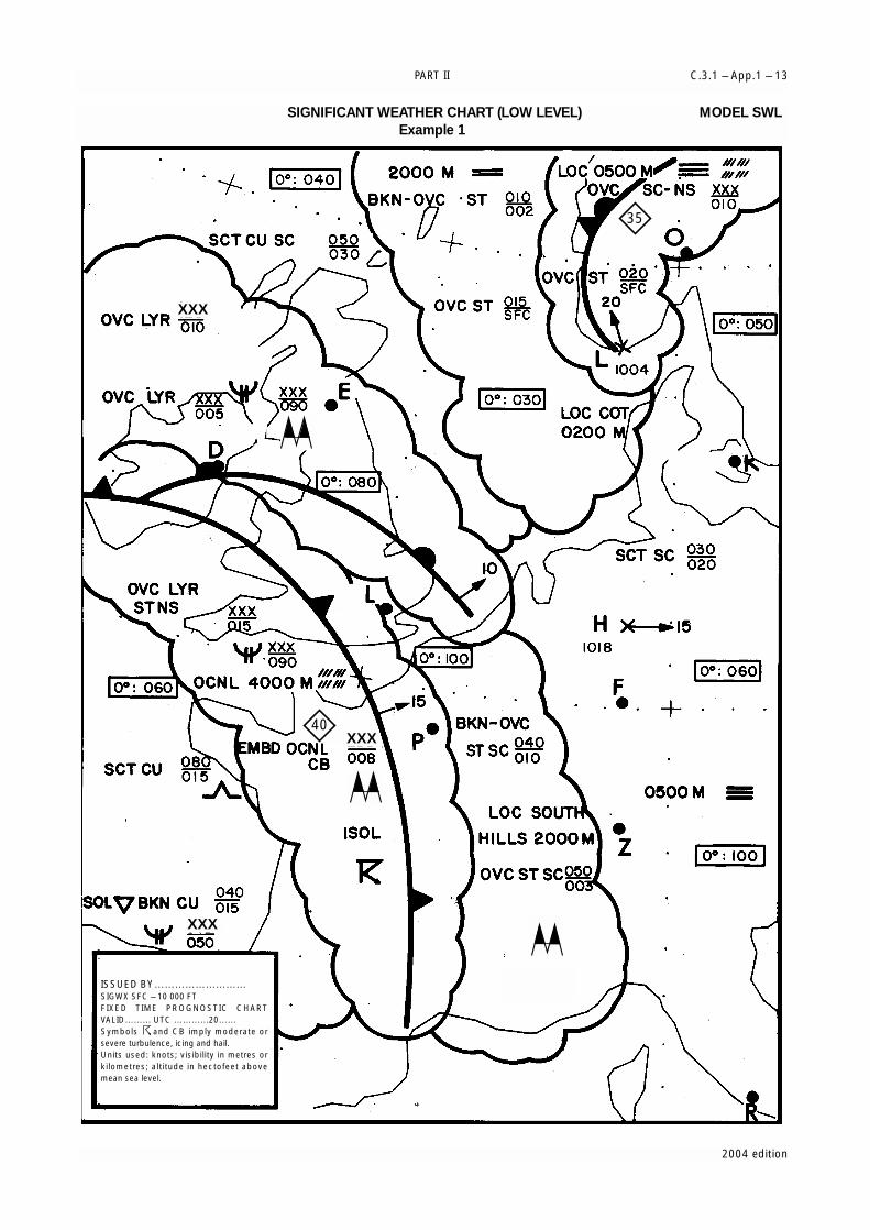
PART II C.3.1 – App.1 – 13
2004 edition
ISSUED BY………………………SIGWX SFC – 10 000 FTFIXED TIME PROGNOSTIC CHARTVALID……… UTC …………20……Symbols and CB imply moderate orsevere turbulence, icing and hail.Units used: knots; visibility in metres orkilometres; altitude in hectofeet abovemean sea level.
40
35
XXX
XXX
XXX
SIGNIFICANT WEATHER CHART (LOW LEVEL) MODEL SWLExample 1
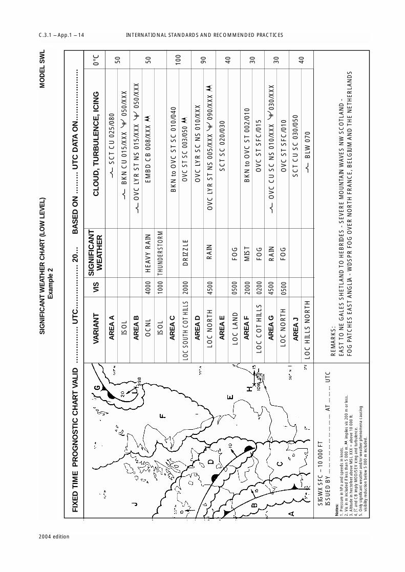
INTERNATIONAL STANDARDS AND RECOMMENDED PRACTICESC.3.1 – App.1 – 14
2004 edition
FIX
ED
TIM
E P
RO
GN
OS
TIC
CH
AR
T V
ALI
D …
……
……
UT
C…
……
……
… 2
0…
B
AS
ED
ON
……
… U
TC
DAT
A O
N…
……
……
……
VAR
IAN
TVI
SS
IGN
IFIC
AN
TW
EAT
HE
RC
LOU
D, T
UR
BU
LEN
CE
, IC
ING
0°C
AR
EA
A
AR
EA
B
AR
EA
C
AR
EA
D
AR
EA
E
AR
EA
F
AR
EA
G
AR
EA
J
SC
T C
U 0
25/0
80
ISO
L
ISO
L10
00
2000
DR
IZZ
LE
THUN
DERS
TORM
OC
NL
4000
HE
AV
Y R
AIN
EM
BD
CB
008
/XX
X
BK
N C
U 0
15/X
XX
050
/XX
X
OV
C L
YR
ST
NS
015
/XX
X
0
50/X
XX
LOC
SOUT
H CO
T HI
LLS
OVC
ST
SC 0
03/0
50
OV
C L
YR
ST
NS
005
/XX
X
0
90/X
XX
LOC
NO
RTH
LOC
HIL
LS N
OR
TH
LOC
NO
RTH
4500
0500
RA
IN
OV
C L
YR
SC
NS
010
/XX
X
SC
T S
C 0
20/0
30
LOC
LA
ND
LOC
CO
T H
ILLS
FOG
MIS
T
FOG
RA
IN
FOG
2000
0200
4500
0500
BK
N t
o O
VC
ST
002/
010
BK
N t
o O
VC
ST
SC
010
/040
OV
C S
T S
FC/0
15
OV
C S
T S
FC/0
10
SC
T C
U S
C 0
30/0
50
BLW
070
OV
C C
U S
C N
S 0
10/X
XX
030
/XX
X
50 50 100
90 40 30 30 40
REM
AR
KS
:EA
ST
TO N
E G
ALE
S S
HET
LAN
D T
O H
EBR
IDES
- S
EVER
E M
OU
NTA
IN W
AVES
NW
SC
OTL
AN
D -
FOG
PAT
CH
ES E
AS
T A
NG
LIA
- W
DS
PR
FO
G O
VER
NO
RTH
FR
AN
CE,
BEL
GIU
M A
ND
TH
E N
ETH
ERLA
ND
S
SIG
WX
SFC
– 1
0 00
0 FT
ISS
UED
BY
……
……
……
……
……
AT
……
… U
TCN
ote
s:
1. P
ress
ure
in h
Pa
and
spee
ds in
kno
ts.
2. V
is in
m in
clud
ed if
less
than
5 0
00 m
.
impl
ies
vis
200
m o
r les
s.3.
Alti
tude
in h
ecto
feet
abo
ve M
SL
XXX
= a
bove
10
000
ft.4.
a
nd C
B im
ply
MO
D/S
EV ic
ing
and
turb
ulen
ce.
5. O
nly
sign
ifica
nt w
eath
er a
nd/o
r wea
ther
phe
nom
ena
caus
ing
v
isib
ility
redu
ctio
n be
low
5 0
00 m
incl
uded
.
SIG
NIF
ICA
NT
WE
ATH
ER
CH
AR
T (L
OW
LE
VEL)
MO
DE
L S
WL
Exa
mpl
e 2

PART II C.3.1 – App.1 – 15
2004 edition
FL550FL350
FL350FL200
FL550SURFACE
(COMPOSITE)
FL200SURFACE
FIXED TIME PROGNOSTIC CHART VALID………UTC………20…(ERUPTION + XX H) BASED ON……UTC DATA ON……20…
FIXED TIME PROGNOSTIC CHART VALID………UTC………20…(ERUPTION + YY H) BASED ON……UTC DATA ON……20…
VAAC……………………………………Volcanic ash advisorty information in graphical format (VAG)
Volcano (Name…………) Lat.……N (or S) Long.……E (or W)Date and time of first eruption…………UTC………20….Duration ……… Hour(s)Height of ash column of FL…… Visibile ash cloud
(Centrelat=17, Centrelon=82, Radius=30)
VOLCANIC ASH ADVISORY INFORMATION IN GRAPHICAL FORMAT Model VAG

INTERNATIONAL STANDARDS AND RECOMMENDED PRACTICESC.3.1 – App.1 – 16
2004 edition
SH
EE
T O
F N
OTA
TIO
NS
US
ED
IN F
LIG
HT
DO
CU
ME
NTA
TIO
NM
OD
EL
SN
3.2
Am
oun
tC
loud
s ex
cep
t C
BS
KC
=sk
y cl
ear
(0/8
)FE
W=
few
(1/8
to
2/8)
SC
T=
scat
tere
d (3
/8 t
o 4/
8)B
KN
=b
roke
n (5
/8 t
o 7/
8)O
VC
=ov
erca
st (8
/8)
CB
onl
yIS
OL
=in
div
idua
l CB
s (is
olat
ed)
OC
NL
=w
ell-
sep
arat
ed C
Bs
(occ
asio
nal)
FRQ
=C
Bs
with
litt
le o
r no
sep
arat
ion
(freq
uent
)E
MB
D=
CB
s em
bed
ded
in la
yers
of o
ther
clo
uds
or c
once
aled
by
haze
(em
bed
ded
)
3.3
Hei
ght
sH
eigh
ts a
re in
dic
ated
on
SW
H a
nd S
WM
cha
rts
in fl
ight
leve
ls (F
L), t
op o
ver
bas
e.W
hen
XX
X is
use
d, t
ops
or b
ases
are
out
sid
e th
e la
yer
of t
he a
tmos
phe
re t
o w
hich
the
char
t ap
plie
s.In
SW
L ch
arts
:i)
Hei
ghts
are
ind
icat
ed a
s al
titud
es a
bov
e m
ean
sea
leve
l;ii)
The
abb
revi
atio
n S
FC is
use
d t
o in
dic
ate
grou
nd le
vel.
4. D
epic
ting
of
lines
and
sys
tem
s o
n sp
ecifi
c ch
arts
4.1
Mod
els
SW
H a
nd S
WM
— S
igni
fican
t wea
ther
cha
rts
(hig
h an
d m
ediu
m)
Sca
llop
ed li
ne=
dem
arca
tion
of a
reas
of s
igni
fican
t w
eath
erH
eavy
bro
ken
line
=d
elin
eatio
n of
are
a of
CAT
Hea
vy s
olid
line
=p
ositi
on o
f jet
str
eam
axi
s w
ith in
dic
atio
n of
win
d d
irect
ion,
inte
rrup
ted
by
win
dsp
eed
in k
t or
km
/h a
nd h
eigh
t in
flig
ht le
vels
. The
ver
tical
arro
w a
nd fl
ight
leve
lex
tent
of t
he je
t st
ream
is in
dic
ated
(in
fligh
t le
vels
) bel
owth
e fli
ght l
evel
, e.g
. FL2
70 a
ccom
pan
ied
by
+20
/–30
ind
icat
esth
at t
he h
eigh
t of
the
jet
exte
nds
from
FL2
40 t
o FL
290.
Figu
res
on a
rrow
s=
spee
d in
kt
or k
m/h
of m
ovem
ents
of f
ront
al s
yste
mFl
ight
leve
ls=
heig
ht in
flig
ht le
vels
of t
rop
opau
se a
t sp
ot lo
catio
ns, e
.g.
insi
de
smal
l rec
tang
les
34
0 . L
ow a
nd h
igh
poi
nts
of t
he t
rop
opau
se t
opog
rap
hyar
e in
dic
ated
by
the
lett
ers
L or
H, r
esp
ectiv
ely,
insi
de
ap
enta
gon
with
the
hei
ght
in fl
ight
leve
ls.
4.2
Mo
del
SW
L —
Sig
nific
ant
wea
ther
cha
rts
(low
leve
l)X
=p
ositi
on o
f pre
ssur
e ce
ntre
s gi
ven
in h
ecto
pas
cals
L=
cent
re o
f low
pre
ssur
eH
=ce
ntre
of h
igh
pre
ssur
eS
callo
ped
line
s=
dem
arca
tion
of a
rea
of s
igni
fican
t w
eath
erD
ashe
d li
nes
=al
titud
e of
0°C
isot
herm
in fe
et (h
ecto
feet
) or
met
res
NO
TE: 0
°C le
vel m
ay a
lso
be
ind
icat
ed b
y 0
°: 0
60 ,
i.e. 0
°Cle
vel i
s at
an
altit
ude
of 6
000
ftFi
gure
s on
arr
ows
=sp
eed
in k
t or
km
/h o
f mov
emen
t of
fron
tal s
yste
ms,
dep
ress
ions
or
antic
yclo
nes
Figu
re in
sid
e th
e st
ate
of t
he s
ea s
ymb
ol =
tot
al w
ave
heig
ht in
feet
or
met
res
Figu
re in
sid
e th
e se
a-su
rfac
e te
mp
erat
ure
sym
bol
= s
ea-s
urfa
ce t
emp
erat
ure
in °
CFi
gure
s in
sid
e th
e st
rong
sur
face
win
d s
ymb
ol =
win
d in
kt
or k
m/h
4.3
Arr
ow
s, f
eath
ers
and
pen
nant
sA
rrow
s in
dic
ate
dire
ctio
n. N
umb
er o
f pen
nant
s an
d/o
r fe
athe
rs c
orre
spon
d t
o sp
eed
.E
xam
ple
:
270°
/115
kt
(eq
uiva
lent
to
213
km/h
)P
enna
nts
corr
esp
ond
to
50 k
t or
93
km/h
Feat
hers
cor
resp
ond
to
10 k
t or
18
km/h
Hal
f-fe
athe
rs c
orre
spon
d t
o 5
kt o
r 9
km/h
1 kn
ot
= 1
.852
kilo
met
res
per
ho
ur
3.1
Typ
eC
I=
Cirr
usC
C=
Cirr
ocum
ulus
CS
= C
irros
trat
usA
C=
Alto
cum
ulus
AS
= A
ltost
ratu
sN
S=
Nim
bos
trat
usS
C=
Str
atoc
umul
us
ST
=S
trat
usC
U=
Cum
ulus
CB
=C
umul
onim
bus
01
23
45
67
89
Kilo
met
res
per
ho
ur
000
1.85
3.70
5.56
7.41
9.26
11.1
112
.96
14.8
216
.67
1018
.52
20.3
722
.22
24.0
825
.93
27.7
829
.63
31.4
833
.34
35.1
9
2037
.04
38.8
940
.74
42.6
044
.45
46.3
048
.15
50.0
051
.86
53.7
1
3055
.56
57.4
159
.26
61.1
262
.97
64.8
266
.67
68.5
270
.38
72.2
3
4074
.08
75.9
377
.78
79.6
481
.49
83.3
485
.19
87.0
488
.90
90.7
5
5092
.60
94.4
596
.30
98.1
610
0.01
101.
8610
3.71
105.
5610
7.42
109.
27
6011
1.12
112.
9711
4.82
116.
6811
8.53
120.
3812
2.23
124.
0812
5.94
127.
79
7012
9.64
131.
4913
3.34
135.
2013
7.05
138.
9014
0.75
142.
6014
4.46
146.
31
8014
8.16
150.
0115
1.86
153.
7215
5.57
157.
4215
9.27
161.
1216
2.98
164.
83
9016
6.68
168.
5317
0.38
172.
2417
4.09
175.
9417
7.79
179.
6418
1.50
183.
35
100
185.
2018
7.05
188.
9019
0.76
192.
6119
4.46
196.
3119
8.16
200.
0220
1.87
110
203.
7220
5.57
207.
4220
9.28
211.
1321
2.98
214.
8321
6.68
218.
5422
0.39
120
222.
2422
4.09
225.
9422
7.80
229.
6523
1.50
233.
3523
5.20
237.
0623
8.91
130
240.
7624
2.61
244.
4624
6.32
248.
1725
0.02
251.
8725
3.72
255.
5825
7.43
140
259.
2826
1.13
262.
9826
4.84
266.
6926
8.54
270.
3927
2.24
274.
1027
5.95
150
277.
8027
9.65
281.
5028
3.36
285.
2128
7.06
288.
9129
0.76
292.
6229
4.47
160
296.
3229
8.17
300.
0230
1.88
303.
7330
5.58
307.
4330
9.28
311.
1431
2.99
170
314.
8431
6.69
318.
5432
0.40
322.
2532
4.10
325.
9532
7.80
329.
6633
1.51
180
333.
3633
5.21
337.
0633
8.92
340.
7734
2.62
344.
4734
6.32
348.
1835
0.03
190
351.
8835
3.73
355.
5835
7.44
359.
2936
1.14
362.
9936
4.84
366.
7036
8.55
kt:
200
210
220
230
240
250
260
270
280
290
km/h
:37
0.40
388.
9240
7.44
425.
9644
4.48
463.
0048
1.52
500.
0451
8.56
537.
08
kt:
300
310
320
330
340
350
360
370
380
390
km/h
:55
5.60
574.
1259
2.64
611.
1662
9.68
648.
2066
6.72
685.
2470
3.76
722.
28
kt:
0.1
0.2
0.3
0.4
0.5
0.6
0.7
0.8
0.9
km/h
:0.
190.
370.
560.
740.
931.
111.
301.
481.
67
Thund
erst
orm
s
Tro
pic
al c
yclo
ne
Sev
ere
squal
l lin
e*
Mo
der
ate
turb
ule
nce
Sev
ere
turb
ule
nce
Mo
unta
in w
aves
Mo
der
ate
airc
raft
icin
g
Sev
ere
airc
raft
icin
g
Wid
esp
read
fo
g
Rad
ioac
tive
mat
eria
ls in
th
e at
mo
spher
e**
Hai
l
Vo
lcan
ic e
rup
tion**
*
Mo
unta
in o
bsc
ura
tion
Drizz
le
Rai
n
Sno
w
Sho
wer
Wid
esp
read
blo
win
g s
no
w
Sev
ere
sand
or
dust
haz
e
Wid
esp
read
san
dst
orm
or
dust
sto
rm
Wid
esp
read
haz
e
Wid
esp
read
mis
t
Wid
esp
read
sm
oke
Fre
ezin
g p
reci
pita
tion *
***
Vis
ible
ash
clo
ud
***
**
Co
ld f
ront
at
the s
urf
ace
Warm
fro
nt
at
the s
urf
ace
Occlu
ded
fro
nt
at
the s
urf
ace
Quasi-
sta
tio
nary
fro
nt
at
the s
urf
ace
Tro
po
pause H
igh
Tro
po
pause L
ow
Tro
po
pause L
evel
FL
270 FL
34
0F
L3
00
Po
sitio
n, sp
eed
and
level o
f m
ax. w
ind
Co
nverg
ence lin
e
Fre
ezi
ng
level
Inte
rtro
pic
al
co
nverg
ence z
one
Sta
te o
f th
e s
ea
Sea-s
urf
ace
tem
pera
ture
Wid
esp
read
S
tro
ng
surf
ace w
ind
*
10
18
40
0°:
10
0
38
0
27
0LH 46
0
Win
d a
rro
ws
ind
icate
the m
axi
mum
win
d in
jet
and
the flig
ht
leve
l at
whic
h it
occurs
. S
ignifi
cant
chang
es
(sp
eed
of 2
0 k
no
ts o
r m
ore
, 3
00
0 ft
(less
if p
ractic
ab
le) in
flig
ht
leve
l) are
m
ark
ed
by
the d
oub
le b
ar.
In t
he e
xam
ple
, at
the d
oub
le b
ar
the w
ind
sp
eed
is 2
25
km
/h (1
20
kt).
The h
eavy
line d
elin
eatin
g t
he je
t axi
s b
eg
ins/
end
s at
the p
oin
ts w
here
a w
ind
speed
of 1
50
km
/h (8
0 k
t) is
fo
recast
.
* T
his
sym
bo
l refe
rs t
o w
idesp
read
surf
ace w
ind
sp
eed
s exc
eed
ing
60
km
/h (3
0 k
t)
1. S
ymb
ols
fo
r si
gni
fican
t w
eath
er3.
Ab
bre
viat
ions
use
d t
o d
escr
ibe
clo
uds
Co
nver
sio
n o
f kn
ots
into
kilo
met
res
per
ho
ur
025
50
050
100
150
200
250
300
350
400
7510
012
515
017
520
0
knot
s km/h
knots
*In
flig
ht d
ocum
enta
tion
for
fligh
ts o
per
atin
g up
to
FL10
0. T
his
sym
bol
ref
ers
to “
squa
ll lin
e”.
**Th
e fo
llow
ing
info
rmat
ion
shou
ld b
e in
clud
ed a
t the
sid
e of
the
char
t: ra
dio
activ
e m
ater
ials
sym
bol
;la
titud
e/lo
ngitu
de
of a
ccid
ent s
ite; d
ate
and
tim
e of
acc
iden
t; ch
eck
NO
TAM
for
furt
her
info
rmat
ion.
***
The
follo
win
g in
form
atio
n sh
ould
be
incl
uded
at
the
sid
e of
the
cha
rt: v
olca
nic
erup
tion
sym
bol
;na
me
and
inte
rnat
iona
l num
ber
of v
olca
no (i
f kno
wn)
; lat
itud
e/lo
ngitu
de;
dat
e an
d t
ime
of t
he fi
rst
erup
tion
(if k
now
n);
Che
ck S
IGM
ETs
and
NO
TAM
or
AS
HTA
M fo
r vo
lcan
ic a
sh.
****
This
sym
bol
doe
s no
t re
fer
to ic
ing
due
to
pre
cip
itatio
n co
min
g in
to c
onta
ct w
ith a
n ai
rcra
ft w
hich
isat
a v
ery
low
tem
per
atur
e.
****
*V
isib
le a
sh c
loud
sym
bol
ap
plie
s on
ly t
o m
odel
VA
G n
ot t
o S
IGW
X c
hart
s.
NO
TE: H
eigh
t ind
icat
ions
bet
wee
n w
hich
phe
nom
ena
are
expe
cted
, top
abo
ve b
ase
as p
er c
hart
lege
nd.
2.Fr
ont
s an
d c
onv
erg
ence
zo
nes
and
oth
er s
ymb
ols
used

2004 edition
[C.3.1.] 1
World area forecast system
[C.3.1.] 1.1
Formats and codes
WAFCs shall adopt uniform formats and codes for thesupply of forecasts and amendments.
[C.3.1.] 1.2
Upper-air wind, temperature and humidityinformation
[C.3.1.] 1.2.1
The forecasts of upper winds, upper-air temperatures,and humidity, direction, speed and height of maximumwinds and tropopause heights and temperaturesprepared four times daily by a WAFC shall be valid for 6,12, 18, 24, 30 and 36 hours after the time (0000, 0600,1200 and 1800 UTC) of the synoptic data on which theforecasts were based and shall be available for start oftransmission in the above order not later than six hoursafter standard time of observation.
[C.3.1.] 1.2.2 (Recommendation)
The grid point forecasts prepared by a WAFC shouldcomprise:
(a) Wind and temperature data for flight levels 50(850 hPa), 100 (700 hPa), 140 (600 hPa), 180(500 hPa), 240 (400 hPa), 300 (300 hPa), 340(250 hPa), 390 (200 hPa) and 450 (150 hPa);
(b) Tropopause height and temperature, and direction,speed and height of maximum wind;
(c) Humidity data for flight levels 50 (850 hPa), 100(700 hPa), 140 (600 hPa) and 180 (500 hPa); and
(d) Wind and temperature data for flight levels 530(100 hPa) and 600 (70 hPa) when and where required.
[C.3.1.] 1.2.3
The foregoing grid point forecasts shall be issued by aWAFC in binary code form using the GRIB code formprescribed by WMO.
NOTE 1: The GRIB code form is contained in WMO PublicationNo. 306, Manual on Codes, Volume I.2, Part B — Binarycodes.
NOTE 2: WAFCs continue to issue forecasts of upper-air wind andtemperature in chart form in accordance with regional airnavigation plans until 1 July 2005.
[C.3.1.] 1.2.4
The foregoing grid point forecasts shall be prepared bya WAFC in a fixed grid with a horizontal resolution of140 km.
NOTE: 140 km represents a distance of about 1.25° of latitude.
[C.3.1.] 1.3
Significant weather information
[C.3.1.] 1.3.1
Forecasts of significant weather phenomena preparedby WAFCs shall be issued four times a day for fixed validtimes of 0000, 0600, 1200 and 1800 UTC. Thetransmission of each forecast shall be completed as soonas technically feasible but at least 12 hours before itsvalidity time.
[C.3.1.] 1.3.2
Forecasts of significant weather phenomena shall beissued in binary code form, using the BUFR code formprescribed by WMO.
NOTE 1: The BUFR code form is contained in WMO PublicationNo. 306, Manual on Codes, Volume I.2, Part B — Binarycodes.
NOTE 2: WAFCs continue to issue forecasts of significant weatherin chart form in accordance with regional air navigationplans until 1 July 2005.
[C.3.1.] 1.3.3
Forecasts of significant weather phenomena shallinclude all the items listed in [C.3.1.] 4.3.1.1 inAppendix 8. The forecasts shall be issued for thefollowing flight levels:
(a) Between flight levels 250 to 630; and
(b) Between flight levels 100 to 250 for limitedgeographical areas, as determined by regional airnavigation agreement. If the average elevation ofthe topography of the area could extend a signifi-cant topographical effect to flight level 100, a higherlevel should be specified for the base of the charts, inconsultation with the WAFC concerned, and inaccordance with regional air navigation agreement.
APPENDIX 2
TECHNICAL SPECIFICATIONS RELATED TO WORLD AREA FORECASTSYSTEM AND METEOROLOGICAL OFFICES
(See [C.3.1.] 3 in Part I)

INTERNATIONAL STANDARDS AND RECOMMENDED PRACTICESC.3.1 – App.2 – 2
2004 edition
[C.3.1.] 1.3.4 (Recommendation)
Amendments to forecasts of significant weather phenomenashould be issued with the minimum possible delay inaccordance with the criteria in [C.3.1.] 1.4 below andsupplied in the form of amended BUFR files.
[C.3.1.] 1.4
Criteria for amendments to WAFS products
[C.3.1.] 1.4.1 (Recommendation)
WAFCs should apply the following criteria for theamendment of significant en-route weather forecasts:
SWH forecasts:
Turbulence and occasional, frequent or embeddedCumulonimbus:
Newly expected occurrence or non-occurrence.
SWM forecasts:
Aircraft icing, turbulence, Cumulonimbus, andsandstorms/ duststorms:
Newly expected occurrence or non-occurrence.
Volcanic eruptions or the accidental release of radioactivematerials into the atmosphere, of significance to aircraftoperations.
Inclusion or removal of volcanic activity symbol, or radiationsymbol.
[C.3.1.] 2
Meteorological offices
[C.3.1.] 2.1
Use of WAFS products
[C.3.1.] 2.1.1
The extent to which an aerodrome meteorological officeprepares forecasts and/or makes use of products fromWAFCs and other sources shall be determined by theMeteorological Authority concerned.
[C.3.1.] 2.1.2 (Recommendation)
Aerodrome meteorological offices should use outputproducts of the world area forecast system in thepreparation of flight documentation.
[C.3.1.] 2.1.3
In order to ensure uniformity and standardization offlight documentation, the WAFS GRIB and BUFR data
received shall be decoded into standard WAFS charts inaccordance with relevant provisions in these TechnicalRegulations, and the content and identification of theoriginator of the WAFS forecasts shall not be amended.
[C.3.1.] 2.2
Notification of WAFC concerning significantdiscrepancies
Meteorological offices using WAFS GRIB and/or BUFRdata shall notify the WAFC concerned immediately ifsignificant discrepancies in accordance with [C.3.1.] 1.4above are detected or reported in respect of WAFS dataand products. The WAFC receiving the message shallacknowledge its receipt to the originator, together witha brief comment on the report and any action taken,using the same means of communication employed bythe originator. If it is considered necessary to issue anamendment, an appropriate ADMIN message shall betransmitted to all users through satellite broadcasts.
NOTE 1: There is no requirement for meteorological offices toreport incidents of radiological emergencies.
NOTE 2: Guidance on reporting significant discrepancies isprovided in the ICAO Manual of AeronauticalMeteorological Practice (Doc 8896).
[C.3.1.] 3
Meteorological watch offices
[C.3.1.] 3.1
Use of WAFS products
The extent to which a meteorological watch officemakes use of products from WAFCs and other sourcesshall be determined by the Meteorological Authorityconcerned.
[C.3.1.] 4
Volcanic Ash Advisory Centres (VAAC)
[C.3.1.] 4.1
Volcanic ash advisory information
[C.3.1.] 4.1.1 (Recommendation)
The advisory information on volcanic ash issued inabbreviated plain language, using approved ICAOabbreviations and numerical values of self-explanatorynature, should be in accordance with the template shown inTable A2-1. When no approved ICAO abbreviations areavailable, English plain language text, to be kept to aminimum, should be used.
*
* *

PART II C.3.1 – App.2 – 3
2004 edition
Table A2-1Template for advisory message for volcanic ash
Key: M = inclusion mandatory, part of every messageO = inclusion optional= = a double line indicates that the text following it should be placed on the subsequent line
NOTE 1: The ranges and resolutions for the numerical elements included in advisory messages for volcanic ash are shown in Appendix 6,Table A6-4.
NOTE 2: The explanations for the abbreviations can be found in the ICAO rocedures for Air Navigation Services — ICAO Abbreviations andCodes (PANS-ABC, Doc 8400).
NOTE 3: Inclusion of a “colon” after each element heading is mandatory.
NOTE 4: The numbers 1 to 18 are included only for clarity and they are not part of the advisory message, as shown in the example.
Element Detailed content Template Examples
1 Identification of the Type of message VOLCANIC ASH ADVISORY VOLCANIC ASH ADVISORYtype of message (M)
2 Year, date and Year month date ISSUED: nnnnnnnn/nnnnZ ISSUED: 20000402/0700Ztime of origin (M) time in UTC or or
date month year nnmonth1nnnn/nnnnZ ISSUED: 02APR2000/0700Ztime in UTC
3 Name of VAAC (M) Name of VAAC VAAC: nnnnnnnnnnnn VAAC: TOKYO
4 Name of volcano (M) Name and IAVCEI2 VOLCANO: nnnnnnnnnnnnnnnnnnnnnn VOLCANO: USUZAN 805-03number of volcano [nnnnnn] or
UNKNOWN or VOLCANO: UNNAMEDUNNAMED
5 Location of Location of volcano LOCATION: Nnnnn or Snnnn LOCATION: N4230 E14048volcano (M) in degrees and Wnnnnn or Ennnnn
minutes or LOCATION: UNKNOWNUNKNOWN orUNNAMED
6 State or region (M) State, or region if AREA: nnnnnnnnnnnnnnnn AREA: JAPANash is not reportedover a State
7 Summit elevation (M) Summit elevation SUMMIT SUMMITin m (or ft) ELEVATION: nnnnM (or nnnnnFT) ELEVATION: 732M
8 Advisory number (M) Advisory number: ADVISORY ADVISORYyear in full and NUMBER: nnnn/nnnn NUMBER: 2000/432message number(separate sequencefor each volcano)
9 Information source (M) Information source INFORMATION free text up to 32 characters INFORMATIONusing free text SOURCE: SOURCE: GMS-JMA
10 Colour code (O) Aviation colour code AVIATION RED or ORANGE or YELLOW AVIATIONCOLOUR or GREEN or UNKNOWN or COLOURCODE: NOT GIVEN or NIL CODE: RED
11 Eruption details (M) Eruption details ERUPTION free text up to 64 characters ERUPTED(including date/ DETAILS: or DETAILS: 20000402/0641Ztime of eruption(s)) UNKNOWN ERUPTION OBS
ASH TO ABV FL300
12 Time of observation Date and time OBS ASH nn/nnnnZ OBS ASH 02/0645Zof ash (M) (in UTC) of DATE/TIME: DATE/TIME:
observation ofvolcanic ash
13 Observed ash Horizontal (in OBS ASH TOP FLnnn or SFC/FLnnn OBS ASH FL150/350cloud (M) degrees an minutes) CLOUD: or FLnnn/nnn CLOUD: N4230 E14048
and vertical extent Nnn[nn] or Snn[nn] Wnnn[nn] -N4300 E14130of the observed ash or Ennn[nn]- -N4246 E14230cloud or, if the base Nnn[nn] or Snn[nn] Wnnn[nn] -N4232 E14150is unknown, the top or Ennn[nn][- -N4230 E14048of the observed ash Nnn[nn] or Snn[nn] Wnnn[nn] SFC/FL150 MOV NEcloud; or Ennn[nn]- 25KT FL150/350

INTERNATIONAL STANDARDS AND RECOMMENDED PRACTICESC.3.1 – App.2 – 4
2004 edition
Element Detailed content Template Examples
Movement of the Nnn[nn] or Snn[nn] Wnnn[nn] MOV E 30KTobserved ash cloud or Ennn[nn]-
Nnn[nn] or Snn[nn] Wnnn[nn] TOP FL240 MOV Wor Ennn[nn]]3 40KMH
TOP FLnnn or SFC/FLnnn orFLnnn/nnnMOV N nnKMH (or KT) orMOV NE nnKMH (or KT) orMOV E nnKMH (or KT) orMOV SE nnKMH(or KT) orMOV S nnKMH (or KT) orMOV SW nnKMH(or KT) orMOV W nnKMH (or KT) orMOV NW nnKMH (or KT)4
or4
ASH NOT IDENTIFIABLE FROMSATELLITE DATA WINDSFLnnn/nnn nnn/nn[n] KMH (KT)3
14 Forecast height and Date and time FCST ASH nn/nnnnZ FCST ASH 02/1245Z SFC/FL200position of the ash (in UTC) (6 hours CLOUD+6HR: SFC or FLnnn/[FL]nnn CLOUD+6HR: N4230 E14048clouds from the “Time of Nnn[nn] or Snn[nn] Wnnn[nn] -N4232 E14150(+ 6 HR) (M) observation of or Ennn[nn]- -N4238 E14300
ash” given in item Nnn[nn] or Snn[nn] Wnnn[nn] -N4246 E1423012 above); or Ennn[nn][- FL200/350
Nnn[nn] or Snn[nn] Wnnn[nn] N4230 E14048Forecast height and or Ennn[nn]- -N4232 E14150position (in degrees Nnn[nn] or Snn[nn] Wnnn[nn] -N4238 E14300and minutes) for each or Ennn[nn]- -N4246 E14230cloud mass for that Nnn[nn] or Snn[nn] Wnnn[nn] FL350/600fixed valid time or Ennn[nn]]3 NO ASH EXP
orNO ASH EXP
15 Forecast height and Date and time FCST ASH nn/nnnnZ FCST ASH 02/1845Z SFC/FL300position of the ash (in UTC) (12 hours CLOUD+12HR: SFC or FLnnn/[FL]nnn CLOUD+12HR: N4230 E14048clouds (+12 HR) (M) from the “Time of Nnn[nn] or Snn[nn] Wnnn[nn] -N4232 E14150
observation of or Ennn[nn]- -N4238 E14300ash” given in item Nnn[nn] or Snn[nn] Wnnn[nn] -N4246 E1423012 above); or Ennn[nn][- FL300/600
Nnn[nn] or Snn[nn] Wnnn[nn] NO ASH EXPForecast height and or Ennn[nn]-position (in degrees Nnn[nn] or Snn[nn] Wnnn[nn]and minutes) for or Ennn[nn]-each cloud mass for Nnn[nn] or Snn[nn] Wnnn[nn]that fixed valid time or Ennn[nn]]3
orNO ASH EXP
16 Forecast height and Date and time (in FCST ASH nn/nnnnZ FCST ASH 03/0045Z SFC/FL600position of the ash UTC) (18 hours CLOUD+18HR: SFC or FLnnn/[FL]nnn CLOUD+18HR: NO ASH EXPclouds (+18 HR) (M) from the “Time of Nnn[nn] or Snn[nn] Wnnn[nn]
observation of or Ennn[nn]-ash” given in item Nnn[nn] or Snn[nn] Wnnn[nn]12 above); or Ennn[nn][-
Nnn[nn] or Snn[nn] Wnnn[nn]Forecast height and or Ennn[nn]-position (in degrees Nnn[nn] or Snn[nn] Wnnn[nn]and minutes) for each or Ennn[nn]-cloud mass for that Nnn[nn] or Snn[nn] Wnnn[nn]fixed valid time or Ennn[nn]]3
orNO ASH EXP
17 Next advisory (M) Year, month, date NEXT nnnnnnnn/nnnnZ NEXT 20000402/1300Zand time in UTC ADVISORY: or ADVISORY:or nnmonth1nnn/nnnnZdate month year ortime in UTC of NO LATER THANissuance of next nnnnnnnn/nnnnZ oradvisory nnmonth1nnnn/nnnnZ

PART II C.3.1 – App.2 – 5
2004 edition
Element Detailed content Template Examples
orNO FURTHER ADVISORIESorWILL BE ISSUED BYnnnnnnnn/nnnnZ ornnmonth1nnnn/nnnnZ
18 Remarks (M) Remarks, as REMARKS: Free text up to 256 characters REMARKS: ASH CLD CANnecessary or NO LONGER BE
NIL DETECTED ONSATELLITE IMAGE
NOTES:
1. Use abbreviations for months of the year from the PANS-ABC (Doc 8400), for example, “JAN”.
2. International Association of Volcanology and Chemistry of the Earth’s Interior (IAVCEI).
3. Up to four selected layers.
4. If ash reported (e.g. AIREP) but not identifiable from satellite data.
Example A2-1Advisory message for volcanic ash
VOLCANIC ASH ADVISORYISSUED: 20000402/0700ZVAAC: TOKYOVOLCANO: USUZAN 805-03LOCATION: N4230E14048AREA: JAPANSUMMIT ELEVATION: 732MADVISORY NUMBER: 2000/432INFORMATION SOURCE: GMS JMAAVIATION COLOUR CODE: REDERUPTION DETAILS: ERUPTED 20000402/0614Z ERUPTION OBS ASH TO ABV FL300OBS ASH DATE TIME: 02/0645ZOBS ASH CLD: FL150/350 N4230E14048-N4300E14130-N4246E14230 –
N4232E14150 – N4230E14048 SFC/FL150 MOV NE 25KTFL150/350 MOV E 30KT
FCST ASH CLD + 6 HR: 02/1245Z SFC/FL200 N4230E14048-N4232E14150-N4238E14300 –N4246 E14230 FL200/350 N4230E14048 –N4232E14150N4238E14300 – N4246E14230 FL350/600 NO ASHEXP
FCST ASH CLD + 12 HR: 02/1845Z SFC/FL300 N4230E14048 – N4232E14150 –N4238E14300 – N4246E14230 FL300/600 NO ASH EXP
FCST ASH CLD + 18 HR: 03/0045Z SFC/FL600 NO ASH EXPNEXT ADVISORY: 20000402/1300ZREMARKS: ASH CLD CAN NO LONGER BE DETECTED ON SATELLITE IMAGE

INTERNATIONAL STANDARDS AND RECOMMENDED PRACTICESC.3.1 – App.2 – 6
2004 edition
[C.3.1.] 4.1.2 (Recommendation)
The volcanic ash advisory information listed in Table A2-1,when issued in graphical format, should be as specified inAppendix 1. When issued in binary format, the BUFR codeform should be used.
NOTE: The BUFR code form is contained in WMO PublicationNo 306, Manual on Codes, Volume I.2, Part B — Binarycodes.
[C.3.1.] 5
Member volcano observatories
[C.3.1.] 5.1
Information from Member volcanoobservatories
Recommendation
The information required to be sent by Member volcanoobservatories to their associated ACCs, MWO and VAACshould comprise for:
(a) Significant pre-eruption volcanic activity: the date/time(UTC) of report; name and, if known, number of thevolcano; location (latitude/longitude) and; descriptionof volcanic activity;
(b) Volcanic eruption: the date/time (UTC) of report andtime of eruption (UTC) if different from time of report;name and, if known, number of the volcano; location(latitude/longitude); and description of the eruptionincluding whether an ash column was ejected and, ifso, an estimate of height of ash column and the extentof any visible volcanic ash cloud, during and followingan eruption.
NOTE: Pre-eruption volcanic activity in this context means unusaland/or increasing volcanic activity which could presage avolcanic eruption.
[C.3.1.] 6
Tropical Cyclone AdvisoryCentres (TCAC)
[C.3.1.] 6.1
Tropical cyclone advisory information
[C.3.1.] 6.1.1 (Recommendation)
The advisory information on tropical cyclones should be inaccordance with the template shown in Table A2-2.
Table A2-2Template for advisory message for tropical cyclones
Key: = = a double line indicates that the text following it should be placed on the subsequent line
NOTE 1: The ranges and resolutions for the numerical elements included in advisory messages for tropical cyclones are shown inAppendix 6, Table A6-4.
NOTE 2: The explanations for the abbreviations can be found in the ICAO Procedures for Air Navigation Services — ICAO Abbreviations andCodes (PANS-ABC, Doc 8400).
NOTE 3: All the elements are mandatory.
NOTE 4: Inclusion of a “colon” after each element heading is mandatory.
NOTE 5: The numbers 1 to 16 are included only for clarity and they are not part of the advisory message, as shown in the example.
Element Detailed content Template Examples
1 Identification of the Type of message TC ADVISORY TC ADVISORYtype of message
2 Year, date and Year, month, date DTG: nnnnnnnn/nnnnZ DTG: 20040925/1600Ztime of origin time in UTC of issue
3 Name of TCAC Name of TCAC TCAC: nnnn or nnnnnnnnnn TCAC: YUFO1
(location indicatoror full name) TCAC: MIAMI
4 Name of tropical Name of tropical TC: nnnnnnnnnnnn TC: GLORIAcyclone cyclone
5 Advisory number Advisory number NR: nn NR: 1(starting with “01”for each cyclone)
6 Position of the Position of the PSN: Nnn[nn] or Snn[nn]Wnnn[nn] PSN: N2706 W07306centre centre of the tropical or Ennn[nn]
cyclone (in degreesand minutes)
1 Fictitious location.

PART II C.3.1 – App.2 – 7
2004 edition
Element Detailed content Template Examples
7 Direction and Direction and speed MOV: N nnKMH (or KT) or MOV: NW 20KMHspeed of movement of movement NE nnKMH (or KT) or
respectively to at E nnKMH (or KT) orleast eight compass SE nnKMH (or KT) orpoints in km/h S nnKMH (or KT) or(or kt), or stationary SW nnKMH (or KT) or
W nnKMH (or KT) orNW nnKMH (or KT) orSTNR
8 Central pressure Central pressure C: nnnHPA C: 965HPA(in hPa)
9 Maximum surface Maximum surface MAX WIND: nn[n]KMH (or nn[n]KT) MAX WIND: 90KMHwind wind near the centre
(mean over10 minutes, inkm/h (or kt))
10 Forecast of Date and time FCST PSN nn/nnnnZ FCST PSN 26/0400Zcentre position (in UTC) (12 hours +12 HR: Nnn[nn] or Snn[nn]Wnnn[nn] +12 HR: N2830 W07430(+12 HR) from the “DTG” or Ennn[nn]
given in item 2above);
Forecast position(in degrees andminutes) of thecentre of thetropical cyclone
11 Forecast of Forecast of maximum FCST MAX nn[n]KMH FCST MAX 90KMHmaximum surface surface wind WIND +12 HR: (or nn[n]KT) WIND +12 HR:wind (+12 HR) (12 hours after the
“DTG” given initem 2 above)
12 Forecast of centre Date and time FCST PSN nn/nnnnZ FCST PSN 26/1000Zposition (+18 HR) (in UTC) (18 hours +18 HR: Nnn[nn] or Snn[nn]Wnnn[nn] +18 HR: N2852 W07500
from the “DTG” or Ennn[nn]given in item 2above);
Forecast position(in degrees andminutes) of thecentre of thetropical cyclone
13 Forecast of Forecast of maximum FCST MAX nn[n]KMH FCST MAX 85KMHmaximum surface surface wind WIND +18 HR: (or nn[n]KT) WIND +18 HR:wind (+18 HR) (18 hours given in
after the “DTG”item 2 above)
14 Forecast of Date and time FCST PSN nn/nnnnZ FCST PSN 26/1600Zcentre position (in UTC) (24 hours +24 HR: Nnn[nn] or Snn[nn]Wnnn[nn] +24 HR: N2912 W07530(+24 HR) from the “DTG” or Ennn[nn]
given in item 2above);
Forecast position(in degrees andminutes) of thecentre of thetropical cyclone
15 Forecast of Forecast of maximum FCST MAX nn[n]KMH FCST MAX 80KMHmaximum surface surface wind WIND +24 HR: (or nn[n]KT) WIND +24 HR:wind (+24 HR) (24 hours after the
“DTG” given initem 2 above)
16 Expected time Expected year, NXT MSG: [BFR] nnnnnnnn/nnnnZ NXT MSG: 20040925/2000Zof issuance of month, date and ornext advisory time (in UTC) of NO MSG EXP
issuance of nextadvisory

INTERNATIONAL STANDARDS AND RECOMMENDED PRACTICESC.3.1 – App.2 – 8
2004 edition
Example A2-2Advisory message for tropical cyclones
TC ADVISORYDTG: 19970925/1600ZTCAC: YUFOTC: GLORIANR: 01PSN: N2706 W07306MOV: NW 20KMHC: 965HPAMAX WIND: 90KMHFCST PSN + 12 HR: 26/0400Z N2830 W07430FCST MAX WIND + 12 HR: 90KMHFCST PSN + 18 HR: 26/1000Z N2852 W07500FCST MAX WIND + 18 HR: 85KMH FCST PSN + 24 HR: 26/1600Z N2912 W07530FCST MAX WIND + 24 HR: 80KMHNXT MSG: 19970925/2000Z
[C.3.1.] 6.1.2 (Recommendation)
When the tropical cyclone advisory information is issued inbinary format, the BUFR code form should be used.
NOTE: The BUFR code form is contained in WMO PublicationNo 306, Manual on Codes, Volume I.2, Part B — Binarycodes.
2004 edition
[C.3.1.] 1
General provisions related tometeorological observations
[C.3.1.] 1.1 (Recommendation)
The meteorological instruments used at an aerodromeshould be situated in such a way as to supply data which arerepresentative of the area for which the measurements arerequired.
NOTE: Specifications concerning the siting and construction ofequipment and installations on operational areas, aimed atreducing the hazard to aircraft to a minimum, arecontained in ICAO Annex 14, Volume I, Chapter 8.
[C.3.1.] 1.2 (Recommendation)
Meteorological instruments at aeronautical meteorologicalstations should be exposed, operated and maintained inaccordance with the practices, procedures and specificationspromulgated by the World Meteorological Organization.
[C.3.1.] 1.3 (Recommendation)
The observers at an aerodrome should be located, in so far asis practicable, so as to supply data which are representative ofthe area for which the observations are required.
[C.3.1.] 1.4 (Recommendation)
Where automated equipment forms part of an integratedsemi-automatic observing system, displays of data which aremade available to the local ATS units should be a subset of,and displayed parallel to, those available in the local meteo-rological service unit. In those displays, each meteorologicalelement should be annotated to identify, as appropriate, thelocations for which the element is representative.
[C.3.1.] 2
General criteria related tometeorological reports
[C.3.1.] 2.1
Format of meteorological reports
[C.3.1.] 2.1.1
Local routine and special reports shall be issued inabbreviated plain language, in accordance with thetemplate shown in Table A3-1.
[C.3.1.] 2.1.2
METAR and SPECI shall be issued in accordance with thetemplate shown in Table A3-2 and disseminated in theMETAR and SPECI code forms prescribed by the WorldMeteorological Organization.
NOTE: The METAR and SPECI code forms are contained in WMOPublication No. 306, Manual on Codes, Volume I.1, Part A —Alphanumeric codes.
[C.3.1.] 2.2
Use of CAVOK
When the following conditions occur simultaneously at thetime of observation:
(a) Visibility, 10 km or more;
NOTE: In local routine and special reports, visibility refers to thevalue(s) to be reported in accordance with [C.3.1.] 4.2.4.2and 4.2.4.3 below; in METAR and SPECI, visibility refers tothe value(s) to be reported in accordance with [C.3.1.]4.2.4.4 below.
(b) No cloud below 1 500 m (5 000 ft) or below thehighest minimum sector altitude, whichever is greater,and no Cumulonimbus;
(c) No weather of significance to aviation as given in[C.3.1.] 4.2.3 and 4.4.2.4 below;
information on visibility, runway visual range, presentweather and cloud amount, cloud type and height of cloudbase shall be replaced in all meteorological reports by theterm “CAVOK”.
[C.3.1.] 2.3
Criteria for issuance of local special reportsand SPECI
[C.3.1.] 2.3.1
The list of criteria for the issuance of local special reportsshall include the following:
(a) Those values which most closely correspond withthe operating minima of the operators using theaerodrome;
(b) Those values which satisfy other local requirementsof the air traffic services units and of the operators;
(c) An increase in air temperature of 2°C or more fromthat given in the latest report, or an alternative
APPENDIX 3
TECHNICAL SPECIFICATIONS RELATED TO METEOROLOGICALOBSERVATIONS AND REPORTS
(See [C.3.1.] 4 in Part I)

threshold value as agreed between theMeteorological Authority, the appropriate ATSauthority and operators concerned;
(d) The available supplementary informationconcerning the occurrence of significantmeteorological conditions in the approach andclimb-out areas as given in Table A3-1; and
(e) Those values which constitute criteria for SPECI.
[C.3.1.] 2.3.2 (Recommendation)
SPECI should be issued whenever changes in accordancewith the following criteria occur:
(a) When the mean surface wind direction has changed by60° or more from that given in the latest report, themean speed before and/or after the change being20 km/h (10 kt) or more;
(b) When the mean surface wind speed has changed by20 km/h (10 kt) or more from that given in the latestreport;
(c) When the variation from the mean surface wind speed(gusts) has increased by 20 km/h (10 kt) or more fromthat given in the latest report, the mean speed beforeand/or after the change being 30 km/h (15 kt) ormore;
(d) When the wind changes through values of operationalsignificance. The threshold values should beestablished by the Meteorological Authority inconsultation with the appropriate ATS authority andoperators concerned, taking into account changes inthe wind which would:
(i) Require a change in runway(s) in use; and
(ii) Indicate that the runway tailwind and crosswindcomponents have changed through valuesrepresenting the main operating limits for typicalaircraft operating at the aerodrome;
(e) When the visibility is improving and changes to, orpasses through, one or more of the following values, orwhen the visibility is deteriorating and passes throughone or more of the following values:
(i) 800, 1 500 or 3 000 m;
(ii) 5 000 m, in cases where significant numbers offlights are operated in accordance with the visualflight rules;
NOTE: In local special reports, visibility refers to the value(s) to bereported in accordance with [C.3.1.] 4.2.4.2 and 4.2.4.3below, in SPECI, visibility refers to the value(s) to bereported in accordance with [C.3.1.] 4.2.4.4 below.
(f) When the runway visual range is improving andchanges to, or passes through, one or more of thefollowing values, or when the runway visual range isdeteriorating and passes through one or more of thefollowing values: 150, 350, 600 or 800 m;
(g) When the onset, cessation or change in intensity of anyof the following weather phenomena or combinationsthereof occurs:
(i) Freezing precipitation;
(ii) Moderate or heavy precipitation (includingshowers thereof);
(iii) Duststorm;
(iv) Sandstorm;
(h) When the onset or cessation of any of the followingweather phenomena or combinations thereof occurs:
(i) Ice crystals;
(ii) Freezing fog;
(iii) Low drifting dust, sand or snow;
(iv) Blowing dust, sand or snow;
(v) Thunderstorm (with or without precipitation);
(vi) Squall;
(vii) Funnel cloud (tornado or waterspout);
(i) When the height of base of the lowest cloud layer ofBKN or OVC extent is lifting and changes to, or passesthrough, one or more of the following values, or whenthe height of base of the lowest cloud layer of BKN orOVC extent is lowering and passes through one ormore of the following values:
(i) 30, 60, 150 or 300 m (100, 200, 500 or 1 000 ft);
(ii) 450 m (1 500 ft), in cases where significantnumbers of flights are operated in accordancewith the visual flight rules;
(j) When the amount of a cloud layer below 450 m(1 500 ft) changes:
(i) From SKC, FEW or SCT to BKN or OVC; or
(ii) From BKN or OVC to SKC, FEW or SCT;
(k) When the sky is obscured and the vertical visibility isimproving and changes to, or passes through, one ormore of the following values, or when the verticalvisibility is deteriorating and passes through one ormore of the following values: 30, 60, 150 or 300 m(100, 200, 500 or 1 000 ft).
[C.3.1.] 2.3.3
When a deterioration of one weather element isaccompanied by an improvement in another element, asingle SPECI shall be issued; it shall then be treated as adeterioration report.
[C.3.1.] 3
Dissemination of meteorological reports
[C.3.1.] 3.1
METAR and SPECI
[C.3.1.] 3.1.1
METAR and SPECI shall be disseminated to internationalOPMET data banks and the centres designated byregional air navigation agreement for the operation ofaeronautical fixed service satellite distribution systems,in accordance with regional air navigation agreement.
INTERNATIONAL STANDARDS AND RECOMMENDED PRACTICESC.3.1 – App.3 – 2
2004 edition

[C.3.1.] 3.1.2
METAR and SPECI shall be disseminated to otheraerodromes in accordance with regional air navigationagreement.
[C.3.1.] 3.1.3 (Recommendation)
SPECI representing a deterioration in conditions should bedisseminated immediately after the observation. A SPECIrepresenting an improvement in conditions should bedisseminated only after the improvement has beenmaintained for 10 minutes; it should be amended beforedissemination, if necessary, to indicate the conditionsprevailing at the end of that 10-minute period. A SPECIrepresenting a deterioration of one weather element and animprovement in another element should be disseminatedimmediately after the observation.
[C.3.1.] 3.2
Local routine and special reports
[C.3.1.] 3.2.1
Local routine reports shall be transmitted to local airtraffic services units and shall be made available to theoperators and to other users at the aerodrome.
[C.3.1.] 3.2.2
Local special reports shall be transmitted to local airtraffic services units as soon as the specified conditionsoccur. However, by agreement between theMeteorological Authority and the appropriate ATSauthority, they need not be issued in respect of:
(a) Any element for which there is in the local air trafficservices unit a display corresponding to the one inthe meteorological station, and where arrange-ments are in force for the use of this display toupdate information included in local routine andspecial reports; and
(b) Runway visual range, when all changes of one ormore steps on the reporting scale in use are beingreported to the local air traffic services unit by anobserver on the aerodrome.
Local special reports shall also be made available to theoperators and to other users at the aerodrome.
[C.3.1.] 4
Observing and reporting ofmeteorological elementsNOTE: Selected criteria applicable to meteorological information
referred to under [C.3.1.] 4.1 to [C.3.1.] 4.8 below forinclusion in aerodrome reports are given in tabular form inAttachment D.
[C.3.1.] 4.1
Surface wind
[C.3.1.] 4.1.1
Siting
[C.3.1.] 4.1.1.1 (Recommendation)
Surface wind should be observed at a height ofapproximately 10 m (30 ft) above the runway(s).
[C.3.1.] 4.1.1.2 (Recommendation)
Representative surface wind observations should beobtained by the use of sensors appropriately sited. Sensorsfor surface wind observations for local routine and specialreports should be sited to give the best practicableindication of conditions along the runway, and touchdownzones. At aerodromes where topography or prevalentweather conditions cause significant differences in surfacewind at various sections of the runway, additional sensorsshould be provided.
NOTE: Since, in practice, the surface wind cannot be measureddirectly on the runway, surface wind observations for take-off and landing are expected to be the best practicableindication of the winds which an aircraft will encounterduring take-off and landing.
[C.3.1.] 4.1.2
Displays
[C.3.1.] 4.1.2.1
Surface wind displays relating to each sensor shall belocated in the meteorological station withcorresponding displays in the appropriate air trafficservices units. The displays in the meteorological stationand in the air traffic services units shall relate to thesame sensors, and where separate sensors are requiredas specified in [C.3.1.] 4.1.1.2 above, the displays shall beclearly marked to identify the runway and section ofrunway monitored by each sensor.
[C.3.1.] 4.1.2.2 (Recommendation)
The mean values of, and significant variations in, the surfacewind direction and speed for each sensor should be derivedand displayed by automated equipment.
[C.3.1.] 4.1.3
Averaging
[C.3.1.] 4.1.3.1
The averaging period for surface wind observations shallbe:
(a) Two minutes for local routine and special reportsand for wind displays in air traffic services units;and
(b) 10 minutes for METAR and SPECI except that whenthe 10-minute period includes a markeddiscontinuity in the wind direction and/or speed,only data occurring since the discontinuity shouldbe used for obtaining mean values, hence the timeinterval in these circumstances should becorrespondingly reduced.
NOTE: A marked discontinuity occurs when there is an abrupt andsustained change in wind direction of 30° or more, with awind speed of 20 km/h (10 kt) before or after the change,or a change in wind speed of 20 km/h (10 kt) or more,lasting at least two minutes.
[C.3.1.] 4.1.3.2 (Recommendation)
The averaging period for measuring variations from themean wind speed (gusts) reported in accordance with
PART II C.3.1 – App.3 – 3
2004 edition

[C.3.1.] 4.1.4.2 (c) below should be three seconds for localroutine and special reports and for METAR and SPECI andfor wind displays used for depicting variations from themean wind speed (gusts) in air traffic services units.
[C.3.1.] 4.1.4
Reporting
[C.3.1.] 4.1.4.1
In local routine and special reports and in METAR andSPECI, the surface wind direction and speed shall bereported in steps of 10 degrees true and 1 kilometre perhour (or 1 knot), respectively. Any observed value whichdoes not fit the reporting scale in use shall be roundedto the nearest step in the scale.
[C.3.1.] 4.1.4.2
In local routine and special reports and in METAR andSPECI:
(a) The units of measurement used for the wind speedshall be indicated;
(b) Variations from the mean wind direction during thepast 10 minutes shall be reported as follows, if thetotal variation is 60° or more:
(i) When the total variation is between 60° and180° and the wind speed is 6 km/h (3 kt) ormore such directional variations shall bereported as the two extreme directionsbetween which the surface wind has varied;
(ii) When the total variation is between 60° and180° and the wind speed is less than 6 km/h(3 kt), the wind direction shall be reported asvariable with no mean wind direction; or
(iii) When the total variation is 180° or more, thewind direction shall be reported as variablewith no mean wind direction;
(c) Variations from the mean wind speed (gusts)during the past 10 minutes shall be reported whenthe maximum wind speed exceeds the mean speedby 20 km/h (10 kt) or more;
(d) When a wind speed of less than 2 km/h (1 kt) isreported, it shall be indicated as calm;
(e) When a wind speed of 200 km/h (100 kt) or more isreported, it shall be indicated to be more than199 km/h (99 kt); and
(f) When the 10-minute period includes a markeddiscontinuity in the wind direction and/or speed,only variations from the mean wind direction andmean wind speed occurring since the discontinuityshall be reported.
NOTE: See note under [C.3.1.] 4.1.3.1 above.
[C.3.1.] 4.1.4.3
In local routine and special reports:
(a) If the surface wind is observed from more than onelocation along the runway, the locations for whichthese values are representative shall be indicated;
(b) When there is more than one runway in use andthe surface wind related to these runways isobserved, the available wind values for eachrunway shall be given, and the runways to whichthe values refer shall be reported;
(c) When variations from the mean wind direction arereported in accordance with [C.3.1.] 4.1.4.2(b)(ii)above, the two extreme directions between whichthe surface wind has varied shall be reported;
(d) When variations from the mean speed (gusts) arereported in accordance with [C.3.1.] 4.1.4.2(c)above, they shall be reported as the maximum andminimum values of the wind speed attained.
[C.3.1.] 4.1.4.4
In METAR and SPECI, when variations from the meanwind speed (gusts) are reported in accordance with[C.3.1.] 4.1.4.2(c) above, the maximum value of thewind speed attained shall be reported.
[C.3.1.] 4.2
Visibility
[C.3.1.] 4.2.1 (Recommendation)
Siting
When instrumented systems are used for the measurementof visibility, representative visibility observations should beobtained by the use of sensors appropriately sited. Sensorsfor visibility observations for local routine and special reportsshould be sited to give the best practicable indications ofvisibility along the runway and touchdown zone. Thevisibility should be measured at a height of approximately2.5 m (7.5 ft) above the runway.
[C.3.1.] 4.2.2
Displays(Recommendation)
When instrumented systems are used for the measurement ofvisibility, visibility displays relating to each sensor should belocated in the meteorological station with correspondingdisplays in the appropriate air traffic services units. The displaysin the meteorological station and in the air traffic services unitsshould relate to the same sensors, and where separate sensorsare required as specified in [C.3.1.] 4.2.1 above, the displaysshould be clearly marked to identify the area, e.g. runway andsection of runway, monitored by each sensor.
[C.3.1.] 4.2.3
Averaging(Recommendation)
When instrumented systems are used for the measurementof visibility, their output should be updated at least every 60seconds to permit provision of current representative values.The averaging period should be:
(a) One minute for local routine and special reports andfor visibility displays in air traffic services units; and
(b) 10 minutes for METAR and SPECI except when the 10-minute period immediately preceding the observation
INTERNATIONAL STANDARDS AND RECOMMENDED PRACTICESC.3.1 – App.3 – 4
2004 edition
includes a marked discontinuity in the visibility, onlythose values occurring after the discontinuity should beused for obtaining mean values.
NOTE: A marked discontinuity occurs when there is an abrupt andsustained change in visibility, lasting at least two minutes,which reaches or passes through criteria for the issuance ofSPECI reports given in [C.3.1.] 2.3 above.
[C.3.1.] 4.2.4
Reporting
[C.3.1.] 4.2.4.1
In local routine and special reports and METAR andSPECI, the visibility shall be reported in steps of 50 mwhen the visibility is less than 800 m; in steps of 100 mwhen it is 800 m or more but less than 5 km; inkilometre steps when the visibility is 5 km or more butless than 10 km; and it shall be given as 10 km when thevisibility is 10 km or more, except when the conditionsfor the use of CAVOK apply. Any observed value whichdoes not fit the reporting scale in use shall be roundeddown to the nearest lower step in the scale.
NOTE: Specifications concerning the use of CAVOK are given in[C.3.1.] 2.2 above.
[C.3.1.] 4.2.4.2
In local routine and special reports, visibility along therunway(s) shall be reported together with the units ofmeasurement.
[C.3.1.] 4.2.4.3 (Recommendation)
In local routine and special reports, when instrumentedsystems are used for the measurement of visibility:
(a) If the visibility is observed from more than one locationalong the runway as specified in [C.3.1.] 4.6.2.2 inPart I, the values representative of the touchdown zoneshould be reported first, followed, as necessary, by thevalues representative of the mid-point and stop-end ofthe runway, and the locations for which these valuesare representative should be indicated; and
(b) When there is more than one runway in use and thevisibility is observed related to these runways, theavailable visibility values for each runway should bereported and the runways to which the values refershould be indicated.
[C.3.1.] 4.2.4.4 (Recommendation)
METAR and SPECI visibility should be reported as prevailingvisibility, as defined in [C.3.1.] 1.1 in Part I. When thevisibility is not the same in different directions and:
(a) When the lowest visibility is different from theprevailing visibility, and less than 1 500 m or less than50 per cent of the prevailing visibility, the lowestvisibility observed should also be reported and itsgeneral direction in relation to the aerodromeindicated by reference to one of the eight points of thecompass. If the lowest visibility is observed in morethan one direction, then the most operationallysignificant direction should be reported; and
(b) When the visibility is fluctuating rapidly and theprevailing visibility cannot be determined, only thelowest visibility should be reported, with no indicationof direction.
[C.3.1.] 4.3
Runway visual range
[C.3.1.] 4.3.1
Siting
[C.3.1.] 4.3.1.1 (Recommendation)
Runway visual range should be assessed at a height ofapproximately 2.5 m (7.5 ft) above the runway.
[C.3.1.] 4.3.1.2 (Recommendation)
Runway visual range should be assessed at a lateral distancefrom the runway centre line of not more than 120 m. Thesite for observations to be representative of the touchdownzone should be located about 300 m along the runwayfrom the threshold. The sites for observations to berepresentative of the mid-point and stop-end of the runwayshould be located at a distance of 1 000 to 1 500 m alongthe runway from the threshold and at a distance of about300 m from the other end of the runway. The exact positionof these sites and, if necessary, additional sites should bedecided after considering aeronautical, meteorological andclimatological factors such as long runways, swamps andother fog-prone areas.
[C.3.1.] 4.3.2
Instrumented systems
NOTE: Since accuracy can vary from one instrument design toanother, performance characteristics are to be checkedbefore selecting an instrument for assessing RVR. Thecalibration of a forward-scatter meter has to be traceableand verifiable to a transmissometer standard, the accuracyof which has been verified over the intended operationalrange. Guidance on the use of transmissometers andforward-scatter meters in instrumented RVR systems is givenin the ICAO Manual of Runway Visual Range Observing andReporting Practices (Doc 9328).
[C.3.1.] 4.3.2.1
Instrumented systems based on transmissometers orforward-scatter meters shall be used to assess runwayvisual range on runways intended for Category II and IIIinstrument approach and landing operations.
[C.3.1.] 4.3.2.2 (Recommendation)
Instrumented systems based on transmissometers orforward-scatter meters should be used to assess runwayvisual range on runways intended for Category I instrumentapproach and landing operations.
[C.3.1.] 4.3.3
Display
[C.3.1.] 4.3.3.1
Where runway visual range is determined byinstrumented systems, one display, or more if required,
PART II C.3.1 – App.3 – 5
2004 edition

shall be located in the meteorological station withcorresponding displays in the appropriate air trafficservices units. The displays in the meteorological stationand in the air traffic services units shall be related to thesame sensors, and where separate sensors are requiredas specified in [C.3.1.] 4.3.1.2 above, the displays shall beclearly marked to identify the runway and section ofrunway monitored by each sensor.
[C.3.1.] 4.3.3.2 (Recommendation)
Where runway visual range is determined by humanobservers, runway visual range should be reported to theappropriate local air traffic services units, whenever there isa change in the value to be reported in accordance with thereporting scale (except where the provisions of [C.3.1.]3.2.2(a) or (b) above apply). The transmission of suchreports should normally be completed within 15 secondsafter the termination of the observation.
[C.3.1.] 4.3.4
Averaging
Where instrumented systems are used for theassessment of runway visual range, output shall beupdated at least every 60 seconds to permit theprovision of current, representative values. Theaveraging period for runway visual range should be:
(a) One minute for local routine and special reportsand for runway visual range displays in air trafficservices units; and
(b) 10 minutes for METAR and SPECI except when the10-minute period immediately preceding theobservation includes a marked discontinuity inrunway visual range values, only those valuesoccurring after the discontinuity shall be used forobtaining mean values.
NOTE: A marked discontinuity occurs when there is an abrupt andsustained change in runway visual range, lasting at least twominutes, which reaches or passes through criteria for theissuance of SPECI reports given in [C.3.1.] 2.3.2(f) above.
[C.3.1.] 4.3.5
Runway light intensity
(Recommendation)
When instrumented systems are used for the assessment ofrunway visual range, computations should be madeseparately for each available runway. RVR should not becomputed for a light intensity of three per cent or less of themaximum light intensity available on a runway. For localroutine and special reports, the light intensity to be used forthe computation should be:
(a) For a runway with the lights switched on, the lightintensity actually in use on that runway; and
(b) For a runway with lights switched off (or at the lowestsetting pending the resumption of operations), theoptimum light intensity that would be appropriate foroperational use in the prevailing conditions.
In METAR and SPECI, the runway visual range should bebased on the maximum light intensity available on therunway.
NOTE: Guidance on the conversion of instrumented readings intorunway visual range is given in Attachment E.
[C.3.1.] 4.3.6
Reporting
[C.3.1.] 4.3.6.1
In local routine and special reports and in METAR andSPECI, the runway visual range shall be reported in stepsof 25 m when the runway visual range is less than400 m, in steps of 50 m when it is between 400 m and800 m, and in steps of 100 m when the runway visualrange is more than 800 m.
[C.3.1.] 4.3.6.2 (Recommendation)
Fifty metres should be considered the lower limit and2 000 m the upper limit for runway visual range. Outside ofthese limits, local routine and special reports and METARand SPEC should merely indicate that the runway visualrange is less than 50 m or more than 2 000 m.
[C.3.1.] 4.3.6.3
In local routine and special reports and in METAR andSPECI:
(a) When runway visual range is above the maximumvalue that can be determined by the system in use,it shall be reported using the abbreviation “ABV” inlocal routine and special reports, and theabbreviation “P” in METAR and SPECI, followed bythe maximum value that can be determined by thesystem; and
(b) When the runway visual range is below theminimum value that can be determined by thesystem in use, it shall be reported using theabbreviation “BLW” in local routine and specialreports and the abbreviation “M” in METAR andSPECI followed by the minimum value that can bedetermined by that system.
[C.3.1.] 4.3.6.4
In local routine and special reports:
(a) The units of measurement used shall be included;
(b) If runway visual range is observed from only onelocation along the runway, i.e. the touchdownzone, it shall be included without any indication oflocation;
(c) If the runway visual range is observed from morethan one location along the runway, the valuerepresentative of the touchdown zone shall bereported first, followed by the values representativeof the mid-point and stop-end and the locations forwhich these values are representative shall beindicated; and
(d) When there is more than one runway in use, theavailable runway visual range values for eachrunway shall be reported and the runways to whichthe values refer shall be indicated.
INTERNATIONAL STANDARDS AND RECOMMENDED PRACTICESC.3.1 – App.3 – 6
2004 edition

[C.3.1.] 4.3.6.5 (Recommendation)
In METAR and SPECI:
(a) Only the value representative of the touchdown zoneshould be reported and no indication of location onthe runway should be included;
(b) Where there is more than one runway available forlanding, touchdown zone runway visual range valuesshould be included for all such runways up to amaximum of four and the runways to which the valuesrefer should be indicated.
[C.3.1.] 4.3.6.6 (Recommendation)
In METAR and SPECI when instrumented systems are usedfor the assessment of runway visual range, the variations inrunway visual range during the 10-minute periodimmediately preceding the observation should be includedas follows:
(a) If the runway visual range values during the10-minute period have shown a distinct tendency,such that the mean during the first five minutesvaries by 100 m or more from the mean during thesecond five minutes of the period, this should beindicated. When the variation of the runway visualrange values shows an upward or downwardtendency, this should be indicated by the abbrevia-tion “U” or “D”, respectively. In circumstances whenactual fluctuations during the 10-minute periodshow no distinct tendency, this should be indicatedusing the abbreviation “N”. When indications oftendency are not available, no abbreviations shouldbe included; and
(b) If the one-minute runway visual range values duringthe 10-minute period vary from the mean value bymore than 50 m or more than 20 per cent of the meanvalue, whichever is greater, the one-minute meanminimum and the one-minute mean maximum valuesshould be reported instead of the 10-minute meanvalue. If the 10-minute period immediately precedingthe observation includes a marked discontinuity inrunway visual range values, only those values occurringafter the discontinuity should be used to obtainvariations.
NOTE: A marked discontinuity occurs when there is an abruptand sustained change in runway visual range, lasting atleast two minutes, which reaches or passes through crite-ria for the issuance of SPECI given in [C.3.1.] 2.3.2(f)above.
[C.3.1.] 4.4
Present weather
[C.3.1.] 4.4.1
Siting
(Recommendation)
When instrumented systems are used for observing presentweather phenomena listed under [C.3.1.] 4.4.2.3 and
[C.3.1.] 4.4.2.4 below, representative information should beobtained by the use of sensors appropriately sited.
[C.3.1.] 4.4.2
Reporting
[C.3.1.] 4.4.2.1
In local routine and special reports, observed presentweather phenomena shall be reported in terms of typeand characteristics and qualified with respect tointensity, as appropriate.
[C.3.1.] 4.4.2.2
In METAR and SPECI, observed present weatherphenomena shall be reported in terms of type andcharacteristics and qualified with respect to intensity orproximity to the aerodrome, as appropriate.
[C.3.1.] 4.4.2.3 (Recommendation)
In local routine and special reports and in METAR and SPECI,the following types of present weather phenomena shouldbe reported, using their respective abbreviations andrelevant criteria, as appropriate:
(a) Precipitation
Drizzle DZ
Rain RA
Snow SN
Snow grains SG
Ice pellets PL
Ice crystals (very small ice crystals ICin suspension, also known asdiamond dust)
– Reported only when associated visibilityis 5 000 m or less
Hail GR
– Reported when diameter of largesthailstones is 5 mm or more
Small hail and/or snow pellets GS
– Reported when diameter of largesthailstones is less than 5 mm
(b) Obscurations (hydrometeors)
Fog FG
– Reported when visibility is less than1 000 m, except when qualified by“MI”, “BC”, “PR” or “VC” (see [C.3.1.]4.4.2.4 and [C.3.1.] 4.4.2.5 below)
Mist BR
– Reported when visibility is at least1 000 m but not more than 5 000 m
(c) Obscurations (lithometeors)
The following should be used only when theobscuration consists predominantly of
PART II C.3.1 – App.3 – 7
2004 edition

lithometeors and the visibility is 5 000 m orless except “SA” when qualified by “DR” (see[C.3.1.] 4.4.2.4 below) and volcanic ash
Sand SA
Dust (widespread) DU
Haze HZ
Smoke FU
Volcanic ash VA
(d) Other phenomena
Dust/sand whirls (dust devils) PO
Squall SQ
Funnel cloud (tornado or waterspout) FC
Duststorm DS
Sandstorm SS
[C.3.1.] 4.4.2.4 (Recommendation)
In local routine and special reports and in METAR and SPECI,the following characteristics of present weatherphenomena, as necessary, should be reported using theirrespective abbreviations and relevant criteria, asappropriate:
Thunderstorm TS
– Used to report a thunderstorm withrain “TSRA”, snow “TSSN”, ice pellets“TSPL”, hail “TSGR” or small hailand/or snow pellets “TSGS” orcombinations thereof, for example,“TSRASN”. When thunder is heard orlightning is detected at the aerodromeduring the 10-minute period precedingthe time of observation but noprecipitation is observed at theaerodrome, the abbreviation “TS”should be used without qualification
Shower SH
– Used to report showers of rain “SHRA”,snow “SHSN”, ice pellets “SHPL”, hail“SHGR”, small hail and/or snow pellets“SHGS”, or combinations thereof, forexample “SHRASN”. Showers observedin the vicinity of the aerodrome (see[C.3.1.] 4.4.2.5 below) should bereported as “VCSH” withoutqualification regarding type or intensityof precipitation
Freezing (supercooled water droplets FZor precipitation, used only with FG,DZ and RA)
Blowing BL
– Used to report DU, SA or SN raised bythe wind to a height of 2 m (6 ft) ormore above the ground
Low drifting (used with DU, SA or DRSN raised by the wind to less than 2 m(6 ft) above ground level)
Shallow (less than 2 m (6 ft) above MIground level)
Patches (fog patches randomly BCcovering the aerodrome)
Partial (a substantial part of the PRaerodrome covered by fog whilethe remainder is clear)
[C.3.1.] 4.4.2.5 (Recommendation)
In local routine and special reports and in METAR and SPECI,the relevant intensity or, as appropriate, the proximity to theaerodrome of the reported present weather phenomenashould be indicated as follows:
(local routine and (METARspecial reports) and SPECI)
Light FBL –Moderate MOD (no indication)Heavy HVY +
– Used only with DZ, GR, GS, PL, RA, SGand SN (or in combinations involvingthese present weather types; in thesecases, intensity refers to precipitation inaccordance with [C.3.1.] 4.4.2.6below); DS and SS (in the cases of DSand SS only moderate and heavyintensities to be indicated)
Vicinity VC– Not at the aerodrome but not further
away than approximately 8 km fromthe aerodrome perimeter and usedonly in METAR and SPECI with DS, SS,FG, FC, SH, PO, BLDU, BLSA, BLSN, TSand VA when not reported under[C.3.1.] 4.4.2.4 above.
[C.3.1.] 4.4.2.6 (Recommendation)
In local routine and special reports and in METAR andSPECI, one or more up to a maximum of three of thepresent weather abbreviations given in [C.3.1.] 4.4.2.3and [C.3.1.] 4.4.2.4 above should be used, as necessary,together with an indication, where appropriate, of thecharacteristics and intensity or proximity to the aero-drome, so as to convey a complete description of thepresent weather of significance to flight operations. Inreporting this information, the indication of intensity orproximity, as appropriate, should be reported firstfollowed respectively by the characteristics and the typeof weather phenomena. Where two different types ofweather are observed, they should be reported in twoseparate groups, where the intensity or proximity indica-tor refers to the weather phenomenon which follows theindicator. However, different types of precipitation occur-ring at the time of observation should be reported as onesingle group with the dominant type of precipitationreported first and preceded by only one intensity qualifierwhich refers to the intensity of the total precipitation.
INTERNATIONAL STANDARDS AND RECOMMENDED PRACTICESC.3.1 – App.3 – 8
2004 edition

[C.3.1.] 4.5
Clouds
[C.3.1.] 4.5.1
Siting
(Recommendation)
When instrumented systems are used for the measurementof the cloud amount and the height of cloud base,representative observations should be obtained by the useof sensors appropriately sited. For local routine and specialreports, in the case of aerodromes with precision approachrunways, sensors for cloud amount and height of cloud baseshould be sited to give the best practicable indications ofthe height of cloud base and cloud amount at the middlemarker site of the instrument landing system or, ataerodromes where a middle marker beacon is not used, at adistance of 900 to 1 200 m (3 000 to 4 000 ft) from thelanding threshold at the approach end of the runway.
NOTE: Specifications concerning the middle marker site of aninstrument landing system are given in ICAO Annex 10,Volume I, Chapter 3 and Attachment C, Table C-5.
[C.3.1.] 4.5.2
Display
(Recommendation)
When automated equipment is used for the measurementof the height of cloud base, height of cloud base display(s)should be located in the meteorological station withcorresponding display(s) in the appropriate air trafficservices units. The displays in the meteorological station andin the air traffic services units should relate to the samesensor, and where separate sensors are required as specifiedin [C.3.1.] 4.5.1 above, the displays should clearly identifythe area monitored by each sensor.
[C.3.1.] 4.5.3
Reference level
(Recommendation)
The height of cloud base should normally be reportedabove aerodrome elevation. When a precision approachrunway is in use which has a threshold elevation 15 m(50 ft) or more below the aerodrome elevation, localarrangements should be made in order that the height ofcloud bases reported to arriving aircraft should refer to thethreshold elevation. In the case of reports from offshorestructures, the height of cloud base should be given abovemean sea level.
[C.3.1.] 4.5.4
Reporting
[C.3.1.] 4.5.4.1 (Recommendation)
In local routine and special reports and in METAR and SPECI:
(a) Cloud amount should be reported using theabbreviations “FEW” (1 to 2 oktas), “SCT” (3 to 4oktas), “BKN” (5 to 7 oktas) or “OVC” (8 oktas);
(b) Cumulonimbus clouds and towering Cumulus cloudsshould be indicated as “CB” and “TCU”, respectively;
(c) The height of cloud base should be reported in steps of30 m (100 ft) up to 3 000 m (10 000 ft) and in stepsof 300 m (1 000 ft) above 3 000 m (10 000 ft);
(d) The vertical visibility should be reported in steps of30 m (100 ft) up to 600 m (2 000 ft);
(e) If there are no clouds and no restriction on verticalvisibility and the abbreviation “CAVOK” is notappropriate, the abbreviation “SKC” should be used;
(f) If there are no clouds of operational significance,no Cumulonimbus and no restriction on verticalvisibility and the abbreviations “CAVOK” and “SKC”are not appropriate, the abbreviation “NSC” should beused;
(g) When several layers or masses of cloud of operationalsignificance are observed, their amount and height ofcloud base should be reported in increasing order ofthe height of cloud base, and in accordance with thefollowing criteria:
(i) The lowest layer or mass regardless of amount, to bereported as FEW, SCT, BKN or OVC as appropriate;
(ii) The next layer or mass covering more than 2/8, tobe reported as SCT, BKN or OVC as appropriate;
(iii) The next higher layer or mass covering more than4/8, to be reported as BKN or OVC as appropriate;
(iv) Cumulonimbus and/or towering Cumulus clouds,whenever observed and not reported in (i) to (iii)above;
(h) When the cloud base is diffused or ragged orfluctuating rapidly, the minimum height of cloud base,or cloud fragments should be reported; and
(i) When an individual layer (mass) of cloud is composedof Cumulonimbus and towering Cumulus clouds witha common cloud base, the type of cloud should bereported as Cumulonimbus only.
NOTE: Towering Cumulus indicates Cumulus congestus clouds ofgreat vertical extent.
[C.3.1.] 4.5.4.2
In local routine and special reports:
(a) The units of measurement used for the height ofcloud base and vertical visibility shall be indicated;
(b) When there is more than one runway in use andthe heights of cloud bases are observed byinstruments for these runways, the availableheights of cloud bases for each runway shall bereported and the runways to which the values refershall be indicated.
[C.3.1.] 4.6
Air temperature and dew-point temperature
[C.3.1.] 4.6.1
Display(Recommendation)
When automated equipment is used for the measurementof air temperature and dew-point temperature, air
PART II C.3.1 – App.3 – 9
2004 edition

temperature and dew-point temperature displays should belocated in the meteorological station with correspondingdisplays in the appropriate air traffic services units. Thedisplays in the meteorological station and in the air trafficservices units should relate to the same sensors.
[C.3.1.] 4.6.2
Reporting
[C.3.1.] 4.6.2.1
In local routine and special reports and in METAR andSPECI, the air temperature and the dew-pointtemperature shall be reported in steps of whole degreesCelsius. Any observed value which does not fit thereporting scale in use shall be rounded to the nearestwhole degree Celsius, with observed values involving0.5° rounded up to the next higher whole degreeCelsius.
[C.3.1.] 4.6.2.2
In local routine and special reports and in METAR andSPECI, a temperature below 0°C shall be identified.
[C.3.1.] 4.7
Atmospheric pressure
[C.3.1.] 4.7.1
Display
When automated equipment is used for themeasurement of pressure, QNH and, if required inaccordance with [C.3.1.] 4.7.3.2(b) below, QFE displaysrelating to the barometer shall be located in themeteorological station with corresponding displays inthe appropriate air traffic services units. When QFEvalues are displayed for more than one runway, asspecified in [C.3.1.] 4.7.3.2(d) below, the displays shallbe clearly marked to identify the runway to which theQFE value displayed refers.
[C.3.1.] 4.7.2
Reference level(Recommendation)
The reference level for the computation of QFE should bethe aerodrome elevation. For non-precision approachrunways, the thresholds of which are 2 m (7 ft) or morebelow or above the aerodrome elevation, and for precisionapproach runways, the QFE, if required, should refer to therelevant threshold elevation.
[C.3.1.] 4.7.3
Reporting
[C.3.1.] 4.7.3.1
For local routine and special reports and in METAR andSPECI, QNH and QFE shall be computed in tenths ofhectopascals and reported therein in steps of wholehectopascals, using four digits. Any observed valuewhich does not fit the reporting scale in use shall berounded down to the nearest lower whole hectopascal.
[C.3.1.] 4.7.3.2
In local routine and special reports:
(a) QNH shall be included;
(b) QFE shall be included if required by users or, if soagreed locally between the meteorological and airtraffic services authorities and operators concerned,on a regular basis;
(c) The units of measurement used for QNH and QFEvalues shall be included; and
(d) If QFE values are required for more than onerunway, the required QFE values for each runwayshall be reported and the runways to which thevalues refer shall be indicated.
[C.3.1.] 4.7.3.3
In METAR and SPECI only, QNH values shall be included.
[C.3.1.] 4.8
Supplementary information
[C.3.1.] 4.8.1
Reporting
[C.3.1.] 4.8.1.1 (Recommendation)
In local routine and special reports, and in METAR andSPECI, the following recent weather phenomena, i.e.weather phenomena observed at the aerodrome during theperiod since the last issued routine report or last hour,whichever is the shorter, but not at the time of observation,should be reported, up to a maximum of three groups, inthe supplementary information:
– freezing precipitation REFZDZ, REFZRA
– moderate or heavyprecipitation (including REDZ, RERA, RESN,showers thereof) RESG, REPL, RESHRA,
RESHSN, RESHGR,RESHGS
– blowing snow REBLSN
– duststorm, sandstorm REDS, RESS
– thunderstorm RETS
– funnel cloud (tornado or REFCwater spout)
– volcanic ash REVA
[C.3.1.] 4.8.1.2 (Recommendation)
In local routine and special reports, the following significantmeteorological conditions, or combinations thereof, shouldbe reported in supplementary information:
– Cumulonimbus clouds CB
– thunderstorm TS
– moderate or severe MOD TURB, SEV
INTERNATIONAL STANDARDS AND RECOMMENDED PRACTICESC.3.1 – App.3 – 10
2004 edition

PART II C.3.1 – App.3 – 11
2004 edition
turbulence TURB
– wind shear WS
– hail GR
– severe squall line SEV SQL
– moderate or severe icing MOD ICE, SEV ICE
– freezing precipitation FZDZ, FZRA
– severe mountain waves SEV MTW
– duststorm or sandstorm DS, SS
– blowing snow BLSN
– funnel cloud (tornado or FCwater spout)
The location of the condition should be indicated. Wherenecessary, additional information should be included usingabbreviated plain language.
[C.3.1.] 4.8.1.3 (Recommendation)
In METAR and SPECI, where local circumstances so warrant,information on wind shear should be added.
NOTE: The local circumstances referred to in [C.3.1.] 4.8.1.3 aboveinclude, but are not necessarily limited to, wind shear of anon-transitory nature such as might be associated with low-level temperature inversions or local topography.
[C.3.1.] 4.8.1.4 (Recommendation)
In METAR and SPECI, the following information should beincluded in the supplementary information, in accordancewith regional air navigation agreement:
(a) Information on sea-surface temperature and the stateof the sea from aeronautical meteorological stationsestablished on offshore structures in support ofhelicopter operations; and
(b) Information on the state of the runway provided bythe appropriate airport authority.
NOTE 1: The state of the sea is specified in WMO PublicationNo. 306, Manual on Codes, Volume I.1, Part A —Alphanumeric codes, Code Table 3700.
NOTE 2: The state of the runway is specified in WMO PublicationNo. 306, Manual on Codes, Volume I.1, Part A —Alphanumeric codes, Code Tables 0366, 0519, 0919 and1079.
[C.3.1.] 4.9
Meteorological information from automaticobserving systems
[C.3.1.] 4.9.1
Reporting
[C.3.1.] 4.9.1.1 (Recommendation)
In automated METAR and SPECI, surface wind, runwayvisual range, air temperature and dew-point temperature,and atmospheric pressure should be reported in accordancewith provisions relevant to METAR and SPECI included in[C.3.1.] 4.1, [C.3.1.] 4.3, [C.3.1.] 4.6, and [C.3.1.] 4.7above, respectively.
[C.3.1.] 4.9.1.2 (Recommendation)
In automated METAR and SPECI, visibility should bereported in accordance with provisions relevant to METARand SPECI included in [C.3.1.] 4.2 above. However, whenvisibility sensors are sited in such a manner that nodirectional variations can be given, the visibility valuereported should be followed by the abbreviation “NDV”.
[C.3.1.] 4.9.1.3 (Recommendation)
In automated METAR and SPECI, present weather should bereported in accordance with provisions relevant to METARand SPECI included in [C.3.1.] 4.4 above. However, inaddition to the precipitation types listed under [C.3.1.]4.4.2.3(a) above, the abbreviation “UP” should be used forunidentified precipitation when the type of precipitationcannot be identified by the automatic observing system.
[C.3.1.] 4.9.1.4 (Recommendation)
In automated METAR and SPECI, clouds and vertical visibilityshould be reported in accordance with provisions relevantto METAR and SPECI included in [C.3.1.] 4.5 above.However,
(a) When the cloud type cannot be observed by theautomatic observing system, the cloud type in eachcloud group should be replaced by “///”;
(b) When no clouds are detected by the automaticobserving system, it should be indicated by using theabbreviation “NCD”.
[C.3.1.] 4.9.1.5 (Recommendation)
In automated METAR and SPECI, supplementaryinformation should be reported in accordance withprovisions relevant to METAR and SPECI included in [C.3.1.]4.8 above. However, in addition to the recent weatherphenomena listed under [C.3.1.] 4.8.1.2 above, theabbreviation “REUP” should be used for recent precipitationwhen the type of precipitation cannot be identified by theautomatic observing system.
INTERNATIONAL STANDARDS AND RECOMMENDED PRACTICESC.3.1 – App.3 – 12
2004 edition
Table A3-1Template for the local routine (MET REPORT) and local special (SPECIAL) report
Key: M = inclusion mandatory, part of every messageC = inclusion conditional, dependent on meteorological conditionsO = inclusion optional
NOTE 1: The ranges and resolutions for the numerical elements included in the local routine and special reports are shown in Table A3-4 ofthis appendix.
NOTE 2: The explanations for the abbreviations used can be found in the ICAO Procedures for Air Navigation Services — ICAO Abbreviationsand Codes (PANS-ABC, Doc 8400).
Detailed content Template(s) Examples
Identification of thetype of report (M)
Type of report MET REPORT or SPECIAL MET REPORT
SPECIAL
Location indicator(M)
ICAO location indicator (M) nnnn YUDO1
Time of theobservation (M)
Date and actual time of theobservation in UTC
nnnnnnZ 221630Z
Name of the element (M) WIND
Runway (O)2 RWY nn[n]
Runway section (O)3 TDZ
Wind direction (M) nnn/ VRB BTN nnn/ AND nnn/
or
VRB
Wind speed (M) [ABV]n[n][n]KMH (or [ABV]n[n]KT)
Significant speed variations(C)4
MAX[ABV]nn [n] MNMn[n]
Significant directionalvariations (C)5
VRB BTNnnn/ANDnnn/
—
CALM
Runway section (O)3 MID
Wind direction (O)3 nnn/ VRB BTN nnn/ AND nnn/
or
VRB
Wind speed (O)3 [ABV]n[n][n]KMH (or [ABV]n[n]KT)
Significant speed variations(C)4
MAX[ABV]nn [n] MNMn[n]
CALM
Significant directionalvariations (C)5
Runway section (O)3 END
Wind direction (O)3 nnn/ VRB BTN nnn/ AND nnn/
or
VRB
Wind speed (O)3
Significant speed variations(C)4
MAX[ABV]nn [n] MNMn[n]
Surface wind (M)
Significant directionalvariations (C)5
VRB BTNnnn/ANDnnn/
VRB BTNnnn/ANDnnn/
—
—
CALM
WIND 240/15KMH(WIND 240/8KT)
WIND RWY 18 TDZ 190/22KMH(WIND RWY 18 TDZ 190/11KT)
WIND VRB4KMH WIND CALM
(WIND VRB2KT)WIND VRB BTN 350/ AND 050/4KMH(WIND VRB BTN 350/ AND 050/2KT)
WIND 270/ABV 199KMH(WIND 270/ABV 99KT)
WIND 120/12KMH MAX35 MNM8(WIND 120/6KT MAX18 MNM4)
WIND 020/20KMH VRB BTN 350/ AND 070/(WIND 020/10KT VRB BTN 350/ AND 070/)
WIND RWY 14R MID 140/22KMH(WIND RWY 14R MID 140/11KT)
WIND RWY 27 TDZ 240/32KMH MAX54MNM20 END 250/28KMH(WIND RWY 27 TDZ 240/16KT MAX27MNM10 END 250/14KT)
Element asspecified in [C.3.1.] 4,
Part I
[ABV]n[n][n]KMH or [ABV]n[n]KT

PART II C.3.1 – App.3 – 13
2004 edition
Detailed content Template(s) Examples
Name of the element(M)
VIS
Runway (O)2 RWY nn[n]
Runway section (O)3 TDZ
Visibility (M) nn[n][n]M or n[n]KM
Runway section (O)3 MID
Visibility (M)
Visibility (O)3
Runway section (O)3
Visibility (O)3
VIS 350MVIS 7KMVIS 10KM
CAVOK
VIS RWY 09 TDZ 800M END1200M
VIS RWY 18 TDZ 6KM RWY27 TDZ 4000M
Name of the element(M)
RVR
Runway (C)7 RWY nn[n]
Runway section (C)8 TDZ
RVR (M) [ABV or BLW] nn[n][n]M
Runway section (C)8 MID
RVR (C)8 [ABV or BLW] nn[n][n]M
Runway section (C)8 END
RVR (C)6
RVR (C)8 [ABV or BLW] nn[n][n]M
RVR RWY 32 400MRVR RWY 20 500M
RVR RWY 10 BLW 50M
RVR RWY 14 ABV 2000M
RVR RWY 10 BLW 150M
RVR RWY 12 ABV 1200MRVR RWY 12 TDZ 1100M MID ABV 1400M
RVR RWY 16 TDZ 600M MID 500M END 400MRVR RWY 26 500M RWY 20 800M
Intensity of presentweather (C)9
FBL orMOD orHVY
—Present weather(C)9,10
Characteristics and typeof present weather(C)9, 11
DZ or RA orSN or SG or PL or DS or SS orTSRA orTSSN or TSPL orTSGR orTSGS orSHRA orSHSN orSHPL orSHGR orSHGS orFZRA orFZDZ
IC or FG or BR or SA or DU orHZ or FU or VA or SQ or PO orFC or TS or FZFG or BLSN orBLSA or BLDU or DRSN orDRSA or DRDU or MIFG orBCFG or PRFG
MOD RA HZ
HVY TSRA FG
HVY DZ VA
FBL SN MIFG
HVY TSRASNFBL SNRAFBL DZ FGHVY SHSN BLSN
Name of the element(M)
CLD
Runway (O)2 RWY nn[n]
Cloud amount (M) orvertical visibility (O)9
FEW orSCT orBKN orOVC
OBSC CLD SCT 300M OVC 600M CLD NSC(CLD SCT 1000FT OVC 2000FT)CLD OBSC VER VIS 150M CLD SKC(CLD OBSC VER VIS 500FT)CLD BKN TCU 270M(CLD BKN TCU 900FT)CLD RWY 08 BKN 60M RWY 26 BKN 90M(CLD RWY 08 BKN 200FT RWY 26 BKN 300FT)
Cloud type (C)9 —
Cloud (M)12
Height of cloud base orthe value of verticalvisibility (C)9
nn[n][n]M(ornnn[n]FT)
[VER VISnn[n]M(or VER VISnnn[n]FT)]
SKC or NSC
CAVOK
Element asspecified in [C.3.1.] 4,
Part I
nn[n][n]M or n[n]KM
END
nn[n][n]M or n[n]KM
CB or TCU

INTERNATIONAL STANDARDS AND RECOMMENDED PRACTICESC.3.1 – App.3 – 14
2004 edition
Detailed content Template(s) Examples
Name of the element(M)
TAir temperature(M)
Air temperature (M) [MS]nn
T17TMS08
Name of the element(M)
DPDew-pointtemperature (M)
Dew-point temperature(M)
[MS]nn
DP15DPMS18
Name of the element(M)
QNH
QNH (M) nnnnHPA
Name of the element(O)
QFE
Pressure values(M)
QFE (O)4 [RWY nn[n]] nnnnHPA [RWYnn[n] nnnnHPA]
QNH 0995HPAQNH 1009HPA
QNH 1022HPA QFE 1001HPAQNH 0987HPA QFE RWY18 0956HPARWY24 0955HPA
Significantmeteorologicalphenomena (C)9
CB or TS or MOD TURB or SEV TURB or WS or GR orSEV SQL or MOD ICE or SEV ICE or FZDZ or FZRA orSEV MTW or SS or DS or BLSN or FC13
Location of thephenomena (C)9
IN APCH [nnnM-WIND nnn/nnKMH] orIN CLIMB-OUT [nnnM-WIND nnn/nnKMH](IN APCH [nnnFT-WIND nnn/nnKT] orIN CLIMB-OUT [nnnFT-WIND nnn/nnKT) orRWY nn[n]
Supplementaryinformation (C)9
Recent weather (C)9, 10 REFZDZ or REFZRA or REDZ or RE[SH]RA orRE[SH]SN or RESG or RE[SH]PL or RESHGR orRESHGS or REBLSN or RESS or REDS or RETSRA orRETSSN or RETSPL or RETSGR or RETSGS or REFCor REVA
FC IN APCHWS IN APCH 60M WIND: 360/50KMHWS RWY 12
REFZRACB IN CLIMB-OUT RETSRA
Name of the element(M)
TREND
Change indicator (M)15 NOSIG BECMG or TEMPO
Period of change (C)9 FMnnnn and/or TLnnnnorATnnnn
Wind (C)9 nnn/[ABV]n[n][n]KMH[MAX[AB V]nn[n]](or nnn/[ABV]n[n]KT[MAX[AB V]nn])
Visibility (C)9 VIS nn[n][n]MorVIS n[n]KM
Weather phenomenon:intensity (C)9
FBL orMOD orHVY
—
TREND NOSIG TREND BECMG FEW 600M(TREND BECMG FEW 2000FT)
TREND TEMPO 250/70KMH MAX 100(TREND TEMPO 250/35KT MAX 50)
TREND BECMG AT1800 VIS 10KM NSWTREND BECMG TL1700 VIS 800M FGTREND BECMG FM1030 TL1130 CAVOKTREND TEMPO TL1200 VIS 600M BECMGAT1230 VIS 8KM NSW NSC
Weather phenomenon:characteristics and type(C)9, 10, 12
NSW
CAVOK
Cloud amount andvertical visibility (C)9
OBSC
Cloud type (C)9 —
Trend forecast(O)14
Height of cloud base orthe value of verticalvisibility (C)9
SKC orNSC
TREND TEMPO FM0300 TL0430 MOD FZRATREND BECMG FM1900 VIS 500M HVY SNRATREND BECMG FM1100 MOD SN TEMPOFM1130 BLSN
TREND BECMG AT1130 CLD OVC 300M
(TREND BECMG AT1130 CLD OVC 1000FT)
TREND TEMPO TL1530 HVY SHRA CLD BKNCB 360M
(TREND TEMPO TL1530 HVY SHRA CLD BKNCB 1200FT)
Element asspecified in [C.3.1.] 4,
Part I
DZ or RA orSN or SG or PL or DS or SS or TSRA orTSSN or TSPL orTSGR orTSGS orSHRA orSHSN orSHPL orSHGR orSHGS orFZRA orFZDZ
IC or FG orBR or SA orDU or HZ or FU or VA orSQ or PO orFC or TS orFZFG orBLSN orBLSA orBLDU orDRSN orDRSA orDRDU orMIFG orBCFG orPRFG
FEW orSCT orBKN orOVC
CB orTCU
nn[n][n]M(ornnn[n]FT)
[VER VISnn[n]M(or VER VISnnn[n]FT)]
Name of the element(C)9
CLD

PART II C.3.1 – App.3 – 15
2004 edition
NOTES:1. Fictitious location.2. Optional values for one or more runways.3. Optional values for one or more sections of the runway.4. To be included in accordance with [C.3.1.] 4.1.4.2(c) in this
appendix.5. To be included in accordance with [C.3.1.] 4.1.4.2(b) in this
appendix.6. To be included if visibility or RVR < 1 500 m.7. To be included in accordance with [C.3.1.] 4.3.6.4(d) in this
appendix.8. To be included in accordance with [C.3.1.] 4.3.6.4(c) in this
appendix.9. To be included whenever applicable.10. One or more, up to a maximum of three groups in
accordance with [C.3.1.] 4.4.2.6 and [C.3.1.] 4.8.1.1 in thisappendix, and with [C.3.1.] 2.2.4.1 in Appendix 5.
11. Precipitation types listed under [C.3.1.] 4.4.2.3(a) in thisappendix may be combined in accordance with [C.3.1.]4.4.2.6 in this appendix and with [C.3.1.] 2.2.4.1 inAppendix 5. Only moderate or heavy precipitation to beindicated in trend forecasts in accordance with [C.3.1.]2.2.4.1 in Appendix 5.
12. Up to four cloud layers in accordance with [C.3.1.]4.5.4.1(g) in this appendix.
13. Abbreviated plain language mat be used in accordance with[C.3.1.] 4.8.1.2 in this appendix.
14. To be included in accordance with [C.3.1.] 6.3.2 in Part I.15. Number of change indicators to be kept to a minimum in
accordance with [C.3.1.] 2.2.1 in Appendix 5, normally notexceeding three groups.

INTERNATIONAL STANDARDS AND RECOMMENDED PRACTICESC.3.1 – App.3 – 16
2004 edition
Table A3-2Template for METAR and SPECI
Key: M = inclusion mandatory, part of every messageC = inclusion conditional, dependent on meteorological conditions or method of observationO = inclusion optional
NOTE 1: The ranges and resolutions for the numerical elements included in METAR and SPECI are shown in Table A3-5 of this appendix.
NOTE 2: The explanations for the abbreviations used can be found in the ICAO Procedures for Air Navigation Services — ICAO Abbreviationsand Codes (PANS-ABC, Doc 8400).
Element asspecified in [C.3.1.] 4,
Part IDetailed content Template(s) Examples
Identification of thetype of report (M)
Type of report (M) METAR, METAR COR, SPECI or SPECI COR METARMETAR CORSPECI
Location indicator(M)
ICAO location indicator (M) nnnn YUDO1
Time of theobservation (M)
Date and actual time of theobservation in UTC (M)
nnnnnnZ 221630Z
Wind direction (M) nnn VRB
Wind speed (M) [P]nn[n]
Significant speed variations(C)3
G[P]nn[n]
Units of measurement (M) KMH (or KT)
Surface wind (M)
Significant directionalvariations (C)4
nnnVnnn —
24015KMH VRB4KMH
(24008KT) (VRB2KT)19022KMH(19011KT)00000KMH(00000KT)140P199KMH(140P99KT)
12012G35KMH(12006G18KT)
24032G54KMH(24016G27KT)
02020KMH 350V070(02010KT 350V070)
Prevailing or minimum5
visibility (M)nnnn
Undirectional visibility (C)6 NDV
Minimum visibility (C)7 nnnn
Visibility (M)
Direction of the minimumvisibility (C)4
N or NE or E or SE or S or SW or W or NW
0350 CAVOK7000NDV9999
0800E
2000 1200NW6000 2800E
Name of the element (M) R
Runway (M) nn[n]/
RVR (M) [P or M]nnnn
RVR variations (C)9 V[P or M]nnnn
RVR (C)8
RVR past tendency (C)10 U, D or N
CAVOK
R32/0400
R10/M0050R14L/P2000R16L/0650 R16C/0500R16R/0450 R17L/0450R20/0700V1200R19/0350VP1200R12/1100UR26/0550N R20/0800D
R09/0375V0600UR10/M0150V0500D
Intensity or proximity ofpresent weather (C)12
– or + VCPresent weather(C)2, 11
Characteristics and type ofpresent weather (M)13
RA HZ VCFG+TSRA FG VCSH+DZ VA VCTS–SN MIFG VCBLSA
+TSRASN–SNRA
–DZ FG+SHSN BLSNUPFZUP
—
Identification of anautomated ormissing report (C)2
Automated or missingreport identifier (C)
AUTO or NIL AUTONIL
END OF METAR IF THE REPORT IS MISSING
FG or PO orFC or DS or SS or TS orSH or BLSNor BLSA orBLDU orVA
DZ or RA orSN or SG or PL or DS or SS or TSRAor TSSN or TSPL orTSGR orTSGS orSHRA orSHSN orSHPL orSHGR orSHGS orFZRA orFZDZ or UP6
or FZUP
IC or FGor BR or SA or DUor HZ or FU or VAor SQ or PO or FCor TS orFZFG orBLSN orBLSA orBLDU orDRSN orDRSA orDRDU orMIFG orBCFG orPRFG

PART II C.3.1 – App.3 – 17
2004 edition
Element as specifiedin [C.3.1.] 4,
Part IDetailed content Template(s) Examples
Cloud amount and heightof cloud base or verticalvisibility (M)
FEWnnn orSCTnnn orBKNnnn orOVCnnn
VVnnn orVV///
Cloud (M)14
Cloud type (C)2 CB orTCU or ///
—
SKC orNSC orNCD6
FEW015 VV005 SKC
OVC030 VV/// NSC
SCT010 OVC020BKN009TCU
SCT008 BKN025CB
Air and dew-pointtemperature (M)
Air and dew-pointtemperature (M)
[M]nn/[M]nn 17/10
02/M08
M01/M10
Name of the element (M) QPressure values (M)
QNH (M) nnnn
Q0995Q1009Q1022Q0987
Recent weather (C)2, 11 REFZDZ or REFZRA or REDZ or RE[SH]RA orRE[SH]SN or RESG or RE[SH]PL or RESHGR orRESHGS or REBLSN or RESS or REDS or RETSRA,RETSSN or RETSPL or RETSGR or RETSGS or REFC orREVA or REUP
Wind shear (C)2 WS RWYnn[n] or WS ALL RWY
Sea-surface temperatureand state of the sea (C)15
W[M]nn/Sn
Runway designator(M)
nn
Runway deposits(M)
n or / CLRD//
Extent of runwaycontamination (M)
n or /
Depth of deposit(M)
nn or //
Supplementaryinformation (C)
State oftherunway(C)16
Friction coefficientor braking action(M)
nn or //
SNOCLO
REFZRA
RETSRA
WS RWY03
WS ALL RWY
W15/S2
99421594SNOCLO14CLRD//
Change indicator (M)18 BECMG or TEMPO
Period of change (C)2 FMnnnn and/or
TLnnnn
or
ATTnnnn
NOSIG BECMG FEW020
Wind (C)2 nnn[P]nn[n][G[P]nn[n]]KMH
(or nnn[P]nn[G[P]nn]KT)
Prevailing visibility (C)2 nnnn
Trend forecast(O)17
Weather phenomenon:intensity (C)12
NOSIG
– or + — N
SW
C
A
V
OK
TEMPO 25070G100KMH
(TEMPO 25035G50KT)
BECMG FM1030 TL1130 CAVOKBECMG TL1700 0800 FGBECMG AT1800 9000 NSWBECMG FM1900 0500 +SNRABECMG FM1100 SN TEMPO FM1130 BLSNTEMPO FM0330 TL0430 FZRA
BKN025///NCD

INTERNATIONAL STANDARDS AND RECOMMENDED PRACTICESC.3.1 – App.3 – 18
2004 edition
NOTES:1. Fictitious location.2. To be included whenever applicable.3. To be included in accordance with [C.3.1.] 4.1.4.2(c) in this
appendix.4. To be included in accordance with [C.3.1.] 4.1.4.2(b)(i) in
this appendix.5. To be included in accordance with [C.3.1.] 4.2.4.4(b) in this
appendix.6. For automated reports only, in accordance with [C.3.1.] 4.9
in this appendix.7. To be included in accordance with [C.3.1.] 4.2.4.4(a) in this
appendix.8. If visibility or RVR < 1 500 m; for up to a maximum of four
runways in accordance with [C.3.1.] 4.3.6.5(b) in thisappendix.
9. To be included in accordance with [C.3.1.] 4.3.6.6(b) in thisappendix.
10. To be included in accordance with [C.3.1.] 4.3.6.6(a) in thisappendix.
11. One or more, up to a maximum of three, groups inaccordance with [C.3.1.] 4.4.2.6 and [C.3.1.] 4.8.1.1 andwith [C.3.1.] 2.2.4.1 in Appendix 5.
12. To be included whenever applicable; no qualifier formoderate intensity in accordance with [C.3.1.] 4.4.2.5 in thisappendix.
13. Precipitation types listed under [C.3.1.] 4.4.2.3(a) in thisappendix may be combined in accordance with [C.3.1.]4.4.2.6 in this appendix and with [C.3.1.] 2.2.4.1 inAppendix 5. Only moderate or heavy precipitation to beindicated in trend forecasts in accordance with [C.3.1.] 2.2.4in Appendix 5.
14. Up to four cloud layers in accordance with [C.3.1.]4.5.4.1(g) in this appendix.
15. To be included in accordance with [C.3.1.] 4.8.1.4(a) in thisappendix.
16. To be included in accordance with [C.3.1.] 4.8.1.4(b) in thisappendix.
17. To be included in accordance with [C.3.1.] 6.3.2 in Part I.18. Number of change indicators to be kept to a minimum in
accordance with [C.3.1.] 2.2.1 in Appendix 5; normally notexceeding three groups.
Element as specifiedin [C.3.1.] 4,
Part IDetailed content Template(s) Examples
Weather phenomenon:characteristics and type(C)2, 11, 13
DZ or RA orSN or SG or PL or DS or SS or TSRAor TSSN or TSPL orTSGR orTSGS orSHRA orSHSN orSHPL orSHGR orSHGS orFZRA orFZDZ
IC or FG or BR or SA or DU or HZ or FU or VA or SQ or PO or FC or TS orFZFG or BLSN orBLSA or BLDU orDRSN or DRSA orDRDU or MIFG orBCFG or PRFG
Cloud amount and heightof cloud base or verticalvisibility (C)2
FEWnnn orSCTnnn orBKNnnn orOVCnnn
VVnnn orVV///
Cloud type (C)2 CB or TCU —
S
K
C
or
N
S
C
TEMPO TL1200 0600 BECMG AT12008000 NSW NSC
BECMG AT1130 OVC010
TEMPO TL1530 +SHRA BKN012CB

PART II C.3.1 – App.3 – 19
2004 edition
Table A3-3Use of change indicators in trend forecasts
Change indicator Time indicator and period Meaning
NOSIG — no significant changes are forecast
BECMG FMn1n1n1n1 TLn2n2n2n2 the change is forecast to commence at n1n1n1n1 UTC and be completedby n2n2n2n2 UTC
TLnnnn commence at the beginning of the trend forecastperiod and be completed by nnnn UTC
FMnnnn commence at nnnn UTC and be completed bythe end of the trend forecast period
ATnnnn occur at nnnn UTC (specified time)
— (a) commence at the beginning of the trendforecast period and be completed by theend of the trend forecast period; or
(b) the time is uncertain
TEMPO FMn1n1n1n1 TLn2n2n2n2 temporary fluctuations commence at n1n1n1n1 UTC and cease byare forecast to n2n2n2n2 UTC
TLnnnn commence at the beginning of the trend forecastperiod and cease by nnnn UTC
FMnnnn commence at nnnn UTC and cease by the end ofthe trend forecast period
— commence at the beginning of the trend forecastperiod and cease by the end of the trend forecastperiod
Example A3-1Routine report
(a) Local routine report (same location and weather conditions as METAR):
MET REPORT YUDO 221630Z WIND 240/15KMH VIS 600M RVR RWY 12 TDZ 1000M MOD DZ FG CLD SCT300M OVC 600M T17 DP16 QNH 1018 HPA TREND BECMG TL1700 VIS 800M FG BECMG AT1800 VIS 10KMNSW
(b) METAR for YUDO (Donlon/International)*:
METAR YUDO 221630Z 24015KMH 0600 R12/1000U DZ FG SCT010 OVC020 17/16 Q1018 BECMG TL17000800 FG BECMG AT1800 9999 NSW
Meaning of both reports:
Routine report for Donlon/International* issued on the 22nd of the month at 1630 UTC; surface wind direction240 degrees; wind speed 15 kilometres per hour; visibility (along the runway(s) in the local routine report;prevailing visibility in METAR) 600 metres; runway visual range representative of the touchdown zone for runway12 is 1 000 metres and the runway visual range values have shown an upward tendency during previous 10minutes (RVR tendency to be included in METAR only); moderate drizzle and fog; scattered cloud at 300 metres;overcast at 600 metres; air temperature 17 degrees Celsius; dew-point temperature 16 degrees Celsius; QNH1018 hectopascals; trend during next two hours visibility (along the runway(s) in the local routine report;prevailing visibility in METAR) becoming 800 metres in fog by 1700 UTC; at 1800 UTC visibility (along therunway(s) in the local routine report; prevailing visibility in METAR) becoming 10 kilometres or more and nilsignificant weather.
NOTE: In this example, the primary units “kilometre per hour” and “metre” were used for wind speed and height of cloud base,respectively. However, in accordance with ICAO Annex 5, the corresponding non-SI alternative units “knot” and “foot” maybe used instead.
________
* Fictitious location

INTERNATIONAL STANDARDS AND RECOMMENDED PRACTICESC.3.1 – App.3 – 20
2004 edition
Example A3-2Special report
(a) Local special report (same location and weather conditions as SPECI):
SPECIAL YUDO 151115Z WIND 050/25KT MAX37 MNM10 VIS 1200M HVY TSRA CLD BKN CB 500FT T25 DP22QNH 1008 HPA TREND TEMPO TL1200 VIS 600M BECMG AT1200 VIS 8KM NSW NSC
(b) SPECI for YUDO (Donlon/International)*:
SPECI YUDO 151115Z 05025G37KT 3000 1200NE+TSRA BKN005CB 25/22 Q1008 TEMPO TL1200 0600BECMG AT1200 8000 NSW NSC
Meaning of both reports:
Selected special report for Donlon/International* issued on the 15th of the month at 1115 UTC; surface winddirection 050 degrees; wind speed 25 knots gusting between 10 and 37 knots (minimum wind speed not to beincluded in SPECI) visibility 1 200 m (along the runway(s) in the local special report); prevailing visibility3 000 metres (in SPECI) with minimum visibility 1 200 m to north-east (directional variations to be included inSPECI only thunderstorm with heavy rain; broken Cumulonimbus cloud at 500 feet; air temperature 25 degreesCelsius; dew-point temperature 22 degrees Celsius; QNH 1008 hectopascals; trend during next two hours,visibility (along the runway(s) in the local special report; prevailing visibility in SPECI) temporarily 600 metresfrom 1115 to 1200, becoming at 1200 UTC visibility (along the runway(s) in the local special report; prevailingvisibility in SPECI) 8 km, thunderstorm ceases and nil significant weather and nil significant cloud.
NOTE: In this example, the non-SI alternative units “knot” and “foot” were used for wind speed and height of cloud base, respectively.However, in accordance with ICAO Annex 5, the corresponding primary units “kilometre per hour” and “metre” may be usedinstead.
________* Fictitious location
Table A3-4Ranges and resolutions for the numerical elements included in local reports
* There is no aeronautical requirement to report surface wind speeds of 200 km/h (100 kt) or more; however, provision has been madefor reporting wind speeds up to 399 km/h (199 kt) for non-aeronautical purposes, as necessary.
Element as specified in [C.3.1.] 4, Part I Range Resolution
Runway 01 – 36 1
Wind direction: °true 010 – 360 10
Wind speed: KMH 1 – 399* 1KT 1 – 199* 1
Visibility: M 0 – 800 50M 800 – 5 000 100
KM 5 – 10 1
RVR M 0 – 400 25M 400 – 800 50M 800 – 2 000 100
Vertical visibility: M 0 – 600 30FT 0 – 2 000 100
Clouds: height of cloud base: M 0 – 1 500 30FT 0 – 5 000 100
Air temperature; dew-pointtemperature: °C –80 – +60 1
QNH; QFE: hPa 0500 – 1 100 1

PART II C.3.1 – App.3 – 21
2004 edition
Table A3-5Ranges and resolutions for the numerical elements included in METAR and SPECI
* There is no aeronautical requirement to report surface wind speeds of 200 km/h (100 kt) or more; however, provision has been madefor reporting wind speeds up to 399 km/h (199 kt) for non-aeronautical purposes, as necessary.
Element as specified in [C.3.1.] 4, Part I Range Resolution
Runway (no units) 01 – 36 1
Wind direction: °true 000 – 360 10
Wind speed: KMH 00 – 399* 1KT 00 – 199* 1
Visibility: M 0000 – 0800 50M 0800 – 5 000 100M 5 000 – 9 000 1 000M 9 000 – 9 999 999
RVR: M 0000 – 0400 25M 0400 – 0800 50M 0800 – 2 000 100
Vertical visibility: 30’s M (100’s FT) 000 – 020 1
Clouds: height of cloud base: 30’s M (100’s FT) 000 – 050 1
Air temperature; dew-point temperature: °C –80 – +60 1
QNH: hPa 0850 – 1 100 1
Sea-surface temperature: °C –10 – +40 1
State of the sea: (no units) 0 – 9 1
State of the runway Runway designator: (no units) 01–36; 51–86; 88; 99 1
Runway deposits: (no units) 0 – 9 1Extent of runway contamination: (no units) 1; 2; 5; 9 –Depth of deposit: (no units) 00 – 90; 92 – 99 1Friction coefficient/braking action: (no units) 00 – 95; 99 1
Example A3-3Volcanic activity report
VOLCANIC ACTIVITY REPORT YUSB* 231500 MT TROJEEN* VOLCANO N5605 W12652 ERUPTED 231445 LARGE ASHCLOUD EXTENDING TO APPROX 30000 FEET MOVING SW
Meaning: Volcanic activity report issued by Siby/Bistock meteorological station at 1500 UTC on the 23rd of the month.Mt Trojeen volcano 56 degrees 5 minutes north 126 degrees 52 minutes west erupted at 1445 UTC on the 23rd; a largeash cloud was observed extending to approximately 30 000 feet and moving in a south-westerly direction.
________
* Fictitious location

INTERNATIONAL STANDARDS AND RECOMMENDED PRACTICESC.3.1 – App.3 – 22
2004 edition

2004 edition
[C.3.1.] 1
Contents of air-reports
[C.3.1.] 1.1
Routine air-reports by air-ground data link
[C.3.1.] 1.1.1
When air-ground data link is used and automaticdependent surveillance (ADS) is being applied, theelements contained in routine air-reports shall be:
Message type designatorAircraft identification
Data block 1
Latitude Level
Longitude Time
Data block 2
Wind direction Temperature
Wind speed Turbulence (if available)
Wind quality flag Humidity (if available)
NOTE: When ADS is being applied, the requirements of routine air-reports may be met by the combination of the basic ADSdata block (data block 1) and the meteorologicalinformation data block (data block 2), available from ADSreports. The ADS message format is specified in the ICAOProcedures for Air Navigation Services — Rules of the Air andAir Traffic Services (PANS-ATM, Doc 4444), Part II, Section14.4 and in ICAO Annex 10, Volume III, Part I.
[C.3.1.] 1.1.2
When air-ground data link is used while ADS is notbeing applied, the elements contained in routine reportsshall be in accordance with [C.3.1.] 1.3 below.
NOTE: When air-ground data link is used while ADS is not beingapplied, the requirements of routine air-reports may be metby the controller-pilot data link communication (CPDLC)application entitled “Position report”. The details of thisdata link application are specified in the ICAO Manual of AirTraffic Services Data Link Applications (Doc 9694) and inICAO Annex 10, Volume III, Part I.
[C.3.1.] 1.2
Special air-reports by air-ground data link
When air-ground data link is used, the elementscontained in special air-reports shall be:
Message type designatorAircraft identification
Data block 1
Latitude Level
Longitude Time
Data block 2
Wind direction Temperature
Wind speed Turbulence (if available)
Wind quality flag Humidity (if available)
Data block 3
Condition prompting the issuance of a special air-report (one condition to be selected from the listpresented in Table A4-3).
NOTE 1: The requirements of special air-reports may be met bythe data link flight information service (D-FIS) applicationentitled “Special air-report service”. The details of thisdata link application are specified in the ICAO Manual ofAir Traffic Services Data Link Applications (Doc 9694).
NOTE 2: In the case of a special air-report of pre-eruption volcanicactivity, volcanic eruption or volcanic ash cloud,additional requirements are indicated in [C.3.1.] 4.2below.
[C.3.1.] 1.3
Routine air-reports by voice communications
When voice communications are used, the elementscontained in routine air-reports shall be:
Message type designator
Section 1
(Position information)
Aircraft identification
Position or latitude and longitude
Time
Flight level or altitude
Next position and time over
Ensuing significant point
Section 2
(Operational information)
Estimated time of arrival
Endurance
APPENDIX 4
TECHNICAL SPECIFICATIONS RELATED TO AIRCRAFTOBSERVATIONS AND REPORTS
(See [C.3.1.] 5 in Part I)

Section 3
(Meteorological information)
Air temperature
Wind direction
Wind speed
Turbulence
Aircraft icing
Humidity (if available)
[C.3.1.] 1.4
Special air-reports by voice communications
When voice communications are used, the elementscontained in special air-reports shall be:
Message type designator
Section 1
(Position information)
Aircraft identification
Position or latitude and longitude
Time
Flight level or altitude
Section 3
(Meteorological information)
Condition prompting the issuance of a special air-report, to be selected from the list presented inTable A4-3.
NOTE 1: Air-reports are considered routine by default. Themessage type designator for special air-reports is specifiedin the ICAO Procedures for Air Navigation Services — Rulesof the Air and Air Traffic Services (PANS-ATM, Doc 4444),Appendix 1.
NOTE 2: In the case of a special air-report of pre-eruption volcanicactivity, volcanic eruption or volcanic ash cloud,additional requirements are indicated in [C.3.1.] 4.2below.
[C.3.1.] 2
Criteria for reporting
[C.3.1.] 2.1
When air-ground data link is used, the wind direction,wind speed, wind quality flag, temperature, turbulenceand humidity included in air-reports shall be reported inaccordance with the following criteria.
[C.3.1.] 2.2
Wind direction
The wind direction shall be reported in terms of degreestrue, rounded to the nearest whole degree.
[C.3.1.] 2.3
Wind speed
The wind speed shall be reported in kilometres per houror knots, rounded to the nearest 2 km/h (1 knot). Theunits used shall be indicated.
[C.3.1.] 2.4
Wind quality flag
The wind quality flag shall be reported as 0 when theroll angle is less than 5 degrees and as 1 when the rollangle is 5 degrees or more.
[C.3.1.] 2.5
Temperature
The temperature shall be reported to the nearest tenthof a degree Celsius.
[C.3.1.] 2.6
Turbulence
The turbulence shall be observed in terms of the eddydissipation rate (EDR).
[C.3.1.] 2.6.1
Routine air-reports
The turbulence shall be reported during the en-routephase of the flight and shall refer to the 15-minuteperiod immediately preceding the observation. Both theaverage and peak value of turbulence, together with thetime of occurrence of the peak value to the nearestminute, shall be observed. The average and peak valuesshall be reported in terms of a turbulence indexcomprising seven intensity levels of EDR as indicated inTable A4-1. The time of occurrence of the peak valueshall be reported as indicated in Table A4-2.
[C.3.1.] 2.6.2
Interpretation of the turbulence index
Turbulence shall be considered:
(a) Severe when the turbulence index is between 15and 27 (i.e. the peak value of the EDR is exceeding0.5);
(b) Moderate when the turbulence index is between 6and 14 (i.e. the peak value of the EDR is exceeding0.3 while not exceeding 0.5);
(c) Light when the turbulence index is between 1 and5 (i.e. the peak value of the EDR is between 0.1 and0.3); and
(d) Nil when the turbulence index is 0 (i.e. the peakvalue of the EDR is less than 0.1).
NOTE: The EDR is an aircraft-independent measure of turbulence.However, the relationship between the EDR index and theperception of turbulence is a function of aircraft type, andthe mass, altitude, configuration and airspeed of theaircraft.
[C.3.1.] 2.6.3
Special air-reports
Special air-reports on turbulence shall be made duringany phase of the flight whenever the peak valueexceeds the EDR value of 0.5. The special air-report on
INTERNATIONAL STANDARDS AND RECOMMENDED PRACTICESC.3.1 – App.4 – 2
2004 edition
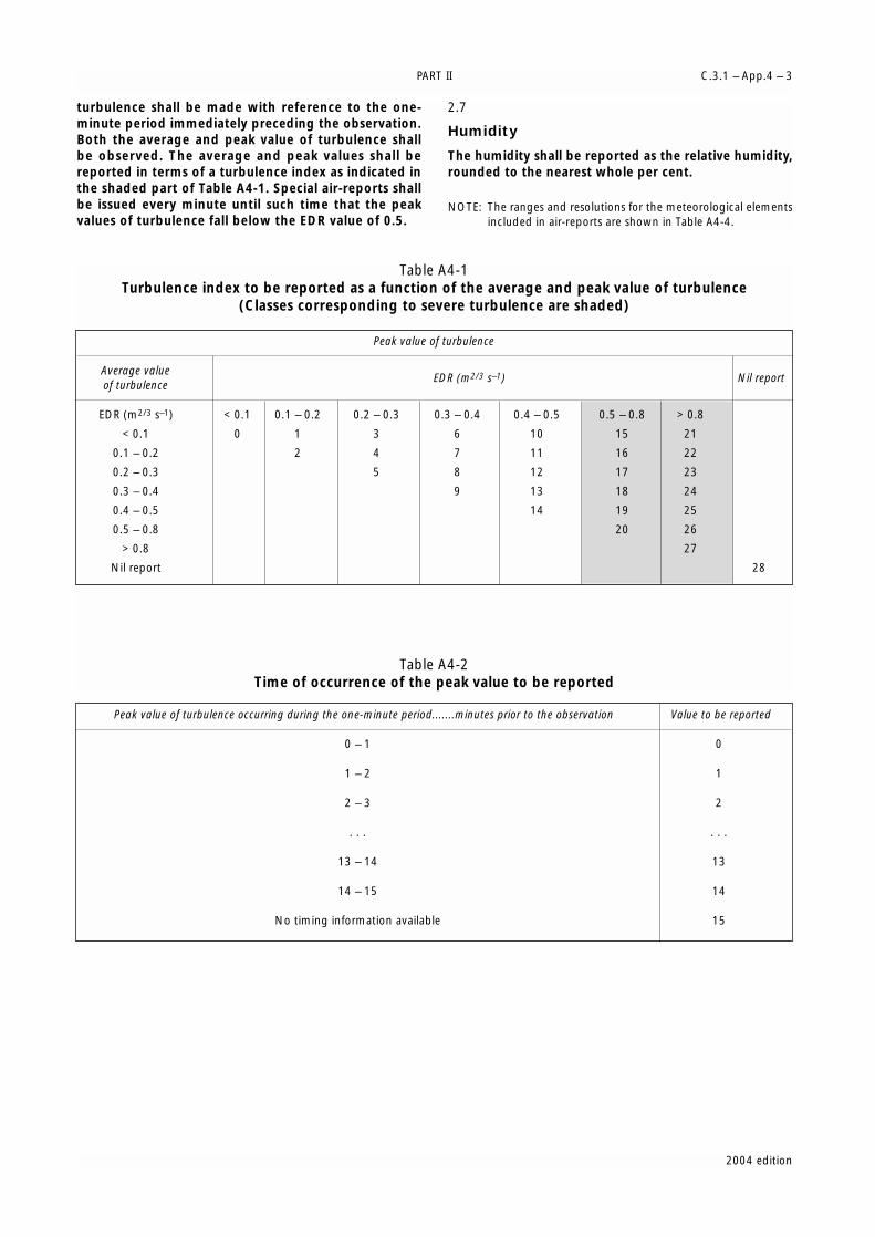
PART II C.3.1 – App.4 – 3
2004 edition
turbulence shall be made with reference to the one-minute period immediately preceding the observation.Both the average and peak value of turbulence shallbe observed. The average and peak values shall bereported in terms of a turbulence index as indicated inthe shaded part of Table A4-1. Special air-reports shallbe issued every minute until such time that the peakvalues of turbulence fall below the EDR value of 0.5.
2.7
Humidity
The humidity shall be reported as the relative humidity,rounded to the nearest whole per cent.
NOTE: The ranges and resolutions for the meteorological elementsincluded in air-reports are shown in Table A4-4.
Table A4-1Turbulence index to be reported as a function of the average and peak value of turbulence
(Classes corresponding to severe turbulence are shaded)
Table A4-2Time of occurrence of the peak value to be reported
Peak value of turbulence
Average valueEDR (m2/3 s–1) Nil report
of turbulence
EDR (m2/3 s–1) < 0.1 0.1 – 0.2 0.2 – 0.3 0.3 – 0.4 0.4 – 0.5
< 0.1 0 1 3 6 10
0.1 – 0.2 2 4 7 11
0.2 – 0.3 5 8 12
0.3 – 0.4 9 13
0.4 – 0.5 14
0.5 – 0.8
> 0.8
Nil report 28
0.5 – 0.8 > 0.8
15 21
16 22
17 23
18 24
19 25
20 26
27
Peak value of turbulence occurring during the one-minute period.......minutes prior to the observation Value to be reported
0 – 1 0
1 – 2 1
2 – 3 2
. . . . . .
13 – 14 13
14 – 15 14
No timing information available 15

INTERNATIONAL STANDARDS AND RECOMMENDED PRACTICESC.3.1 – App.4 – 4
2004 edition
Table A4-3Template for the special air-report (downlink)
Key: M = mandatory, part of every messageC = inclusion conditional; included whenever available
NOTE: Message to be prompted by the pilot-in-command. Currently only the condition “SEV TURB” can be automated (see [C.3.1.] 2.6.3in this appendix).
NOTES:
1. The index and the time of occurrence to be reported in accordance with Tables A4-1 and A4-2, respectively.
2. The turbulence index to be reported in accordance with [C.3.1.] 2.6.3 in this appendix and in Table A4-1.
3. Obscured, embedded or widespread thunderstorms or thunderstorms in squall lines.
4. Duststorm or sandstorm.
5. Pre-eruption volcanic activity or a volcanic eruption.
Table A4-4Ranges and resolutions for the meteorological elements included in air-reports
* Non-dimensional
Element as specified Detailed content Template(s) Examplesin [C.3.1.] 5, Part I
Message type designator (M) Type of the air-report (M) ARS ARS
Aircraft identification (M) Aircraft radiotelephony call sign (M) nnnnnn VA812
DATA BLOCK 1Latitude (M) Latitude in degrees and minutes (M) Nnnnn or Snnnn S4506
Longitude (M) Longitude in degrees and minutes (M) Wnnnnn or Ennnnn E01056
Level (M) Flight level (M) FLnnn FL330
Time (M) Time of occurrence in hours and OBS AT nnnnZ OBS AT 1216Zminutes (M)
DATA BLOCK 2Wind direction (M) Wind direction in degrees true (M) nnn/ 262/
Wind speed (M) Wind speed in kilometres per hour nnnKMH (or nnnKT ) 158KMH(or knots) (M) (079KT)
Wind quality flag (M) Wind quality flag (M) n 1
Temperature (M) Air temperature in tenths of T[M]nnn T127degrees C (M) TM455
Turbulence (C) Turbulence index and the time of EDRnn/nn EDR16/08occurrence of the peak value ( C)1
Humidity (C) Relative humidity in per cent (C) RHnnn RH054
DATA BLOCK 3Condition prompting SEV TURB [EDRnn]2 or SEV TURB EDR16;the issuance of a special SEV ICE or VA CLD FL050/100air-report (M) SEV MTW or
TS GR3 orTS3 orHVY SS4 orVA CLD [FL nnn/nnn] orVA5 [MT nnnnnnnnnnnnnnnnnnnn]
Element as specified in [C.3.1.] 5, Part I Range Resolution
Wind direction: °true 000 – 360 1
Wind speed: KMH 00 – 500 2KT 00 – 250 1
Wind quality flag: (index)* 0 – 1 1
Temperature: °C –80 – +60 0.1
Turbulence: routine air-report: (index)* 0 – 28 1(time of occurrence)* 0 – 15 1
Turbulence: special air-report: (index)* 15 – 27 1
Humidity: % 0 – 100 1

PART II C.3.1 – App.4 – 5
2004 edition
[C.3.1.] 3
Exchange of air-reports
[C.3.1.] 3.1
Responsibilities of the meteorological watchoffices
[C.3.1.] 3.1.1
The meteorological watch offices shall assemble theroutine air-reports received by voice communicationsand shall disseminate them to WAFCs, and othermeteorological offices in accordance with regional airnavigation agreement. The exchange of collectives onan hourly basis may be found desirable when reports arenumerous.
NOTE: The exchange of collectives on an hourly basis may befound desirable when reports are numerous.
[C.3.1.] 3.1.2
The meteorological watch office shall transmit withoutdelay the special air-reports received by voicecommunications to WAFCs.
[C.3.1.] 3.1.3
The meteorological watch office shall transmit withoutdelay special air-reports of pre-eruption volcanic activity,a volcanic eruption or volcanic ash cloud received to theassociated VAACs.
[C.3.1.] 3.1.4
When a special air-report is received at themeteorological watch office but the forecaster considersthat the phenomenon causing the report is notexpected to persist and, therefore, does not warrantissuance of a SIGMET, the special air-report shall bedisseminated in the same way that SIGMET messagesare disseminated in accordance with [C.3.1.] 1.2.1 inAppendix 6, i.e. to meteorological watch offices, WAFCs,and other meteorological offices in accordance withregional air navigation agreement.
[C.3.1.] 3.2
Responsibilities of world area forecastcentres
Air-reports received at WAFCs shall be furtherdisseminated as basic meteorological data.
NOTE: The dissemination of basic meteorological data is normallycarried out on the WMO Global TelecommunicationSystem.
[C.3.1.] 3.3
Supplementary dissemination of air-reports
(Recommendation)
Where supplementary dissemination of air-reports isrequired to satisfy special aeronautical or meteorological
requirements, such dissemination should be arrangedbetween the Meteorological Authorities concerned.
[C.3.1.] 3.4
Format of air-reports
Air-reports shall be exchanged in the format in whichthey are received, except that when voicecommunications are used, if the position is given byreference to an ATS reporting point, it shall beconverted, by the meteorological watch office, into thecorresponding latitude and longitude.
[C.3.1.] 4
Specific provisions related to reportingwind shear and volcanic ash
[C.3.1.] 4.1
Reporting of wind shear
[C.3.1.] 4.1.1 (Recommendation)
When reporting aircraft observations of wind shearencountered during the climb-out and approach phases offlight, the aircraft type should be included.
[C.3.1.] 4.1.2 (Recommendation)
Where wind shear conditions in the climb-out or approachphases of flight were reported or forecast but notencountered, the pilot-in-command should advise theappropriate air traffic services unit as soon as practicableunless the pilot-in-command is aware that the appropriateair traffic services unit has already been so advised by apreceding aircraft.
[C.3.1.] 4.2
Post-flight reporting of volcanic activity
NOTE: The detailed instructions for recording and reportingvolcanic activity observations are given in the ICAOProcedures for Air Navigation Services — Rules of the Air andAir Traffic Services (PANS-ATM, Doc 4444), Appendix 1.
[C.3.1.] 4.2.1
On arrival of a flight at an aerodrome, the completedreport of volcanic activity shall be delivered by theoperator or a flight crew member, without delay, to theaerodrome meteorological office, or if such office is noteasily accessible to arriving flight crew members, thecompleted form shall be dealt with in accordance withlocal arrangements made by the MeteorologicalAuthority and the operator.
[C.3.1.] 4.2.2
The completed report of volcanic activity received by ameteorological office shall be transmitted without delayto the meteorological watch office responsible for theprovision of meteorological watch for the flightinformation region in which the volcanic activity wasobserved.


2004 edition
[C.3.1.] 1
Criteria related to TAF
[C.3.1.] 1.1
TAF format
TAF shall be issued in accordance with the templateshown in Table A5-1 and disseminated in the TAF codeform prescribed by the World MeteorologicalOrganization.
NOTE: The TAF code form is contained in WMO PublicationNo. 306, Manual on Codes, Volume I.1, Part A —Alphanumeric codes.
[C.3.1.] 1.2
Inclusion of meteorological elements in TAF
NOTE: Guidance on operationally-desirable accuracy of forecasts isgiven in Attachment B.
[C.3.1.] 1.2.1
Surface wind
(Recommendation)
In forecasting surface wind, the expected prevailingdirection should be given. When it is not possible to forecasta prevailing surface wind direction due to its expectedvariability, for example, during light wind conditions (lessthan 6 km/h (3 kt)) or thunderstorms, the forecast winddirection should be indicated as variable using “VRB”. Whenthe wind is forecast to be less than 2 km/h (1 kt), theforecast wind speed should be indicated as calm. When theforecast maximum speed (gust) exceeds the forecast meanwind speed by 20 km/h (10 kt) or more, the forecastmaximum wind speed should be indicated. When a windspeed of 200 km/h (100 kt) or more is forecast, it should beindicated to be more than 199 km/h (or 99 kt).
[C.3.1.] 1.2.2
Visibility
(Recommendation)
When the visibility is forecast to be less than 800 m it shouldbe expressed in steps of 50 m; when it is forecast to be 800m or more but less than 5 km, in steps of 100 m; 5 km ormore but less than 10 km, in kilometre steps; and when it isforecast to be 10 km or more it should be expressed as10 km, except when conditions of CAVOK are forecast toapply. The prevailing visibility should be forecast. Whenvisibility is forecast to vary in different directions and the
prevailing visibility cannot be forecast, the lowest forecastvisibility should be given.
[C.3.1.] 1.2.3
Weather phenomena
(Recommendation)
One or more, up to a maximum of three, of the followingweather phenomena or combinations thereof, togetherwith their characteristics and, where appropriate, intensityshould be forecast if they are expected to occur at theaerodrome:
– Freezing precipitation;
– Freezing fog;
– Moderate or heavy precipitation (including showersthereof);
– Low drifting dust, sand or snow;
– Blowing dust, sand or snow;
– Duststorm;
– Sandstorm;
– Thunderstorm (with or without precipitation);
– Squall;
– Funnel cloud (tornado or waterspout);
– Other weather phenomena given in [C.3.1.] 4.4.2.3 inAppendix 3 only if they are expected to cause asignificant change in visibility.
The expected end of occurrence of those phenomenashould be indicated by the abbreviation “NSW”.
[C.3.1.] 1.2.4
Cloud
(Recommendation)
Cloud amount should be forecast using the abbreviations“FEW”, “SCT”, “BKN” or “OVC” as necessary. If no clouds areforecast, and the abbreviation “CAVOK” is not appropriate,the abbreviation “SKC” should be used. When it is expectedthat the sky will remain or become obscured and cloudscannot be forecast and information on vertical visibility isavailable at the aerodrome, the vertical visibility should beforecast in the form “VV” followed by the forecast value ofthe vertical visibility. When several layers or masses of cloudare forecast, their amount and height of base should beincluded in the following order:
APPENDIX 5
TECHNICAL SPECIFICATIONS RELATED TO FORECASTS(See [C.3.1.] 6 in Part I)

(a) The lowest layer or mass regardless of amount, to beforecast as FEW, SCT, BKN or OVC as appropriate;
(b) The next layer or mass covering more than 2/8, to beforecast as SCT, BKN or OVC as appropriate;
(c) The next higher layer or mass covering more than 4/8,to be forecast as BKN or OVC as appropriate; and
(d) Cumulonimbus clouds whenever forecast and notalready included under (a) to (c).
Cloud information should be limited to cloud of operationalsignificance, i.e. cloud below 1 500 m (5 000 ft) or the high-est minimum sector altitude, whichever is greater, andCumulonimbus whenever forecast. In applying this limita-tion, when no Cumulonimbus and no cloud below 1 500 m(5 000 ft) or below the highest minimum sector altitude,whichever is greater, are forecast and “CAVOK” or “SKC” arenot appropriate, the abbreviation “NSC” should be used.
[C.3.1.] 1.2.5
Temperature
(Recommendation)
When forecast temperatures are included in accordancewith regional air navigation agreement, the maximum andminimum temperatures expected to occur during theperiod of validity of the TAF should be given, together withtheir corresponding times of occurrence.
[C.3.1.] 1.3
Use of change groups
[C.3.1.] 1.3.1 (Recommendation)
The criteria used for the inclusion of change groups in TAFor for the amendment of TAF should be based on thefollowing:
(a) When the surface wind is forecast to change throughvalues of operational significance, the threshold valuesshould be established by the Meteorological Authorityin consultation with the appropriate ATS Authority andoperators concerned, taking into account changes inthe wind which would:
(i) Require a change in runway(s) in use; and
(ii) Indicate that the runway tailwind and crosswindcomponents will change through valuesrepresenting the main operating limits for typicalaircraft operating at the aerodrome;
(b) When the visibility is forecast to improve and changeto or pass through one or more of the following values,or when the visibility is forecast to deteriorate and passthrough one or more of the following values:
(i) 150, 350, 600, 800, 1 500 or 3 000 m; and
(ii) 5 000 m in cases where significant numbers offlights are operated in accordance with the visualflight rules;
(c) When any of the following weather phenomena orcombinations thereof are forecast to begin or end orchange in intensity:
(i) Freezing precipitation;
(ii) Moderate or heavy precipitation (includingshowers thereof);
(iii) Duststorm;
(iv) Sandstorm;
(v) Other weather phenomena given in [C.3.1.]4.4.2.3 in Appendix 3 only if they are expected tocause a significant change in visibility;
(d) When the onset or cessation of any of the followingweather phenomena or combinations thereof areforecast to begin or end:
(i) Ice crystals;
(ii) Freezing fog;
(iii) Low drifting dust sand or snow;
(iv) Blowing dust, sand or snow;
(v) Thunderstorm (with or without precipitation);
(vi) Squall;
(vii) Funnel cloud (tornado or waterspout);
(e) When the height of base of the lowest layer or mass ofcloud of BKN or OVC extent is forecast to lift andchange to or pass through one or more of thefollowing values, or when the height of the lowestlayer or mass of cloud of BKN or OVC extent is forecastto lower and pass through one or more of thefollowing values:
(i) 30, 60, 150 or 300 m (100, 200, 500 or 1 000 ft); or
(ii) 450 m (1 500 ft), in cases where significantnumbers of flights are operated in accordancewith the visual flight rules;
(f) When the amount of a layer or mass of cloud below450 m (1 500 ft) is forecast to change:
(i) From SKC, FEW or SCT to BKN or OVC; or
(ii) From BKN or OVC to SKC, FEW or SCT;
(g) When Cumulonimbus clouds are forecast to develop ordissipate;
(h) When the vertical visibility is forecast to improve andchange to, or pass through, one or more of thefollowing values, or when the vertical visibility isforecast to deteriorate and pass through one or moreof the following values: 30, 60, 150 or 300 m (100,200, 500 or 1 000 ft); and
(i) Any other criteria based on local aerodrome operatingminima, as agreed between the MeteorologicalAuthority and the operators.
[C.3.1.] 1.3.2 (Recommendation)
When a change in any of the elements given in [C.3.1.]6.2.3 in Part I is required to be indicated in accordance withthe criteria given in [C.3.1.] 1.3.1 above, the changeindicators “BECMG” or “TEMPO” should be used followedby the time period during which the change is expected tooccur. The time period should be indicated as the beginningand end of the period in whole hours UTC. Only those
INTERNATIONAL STANDARDS AND RECOMMENDED PRACTICESC.3.1 – App.5 – 2
2004 edition

PART II C.3.1 – App.5 – 3
2004 edition
elements for which a significant change is expected shouldbe included following a change indicator. However, in thecase of significant changes in respect of cloud, all cloudgroups, including layers or masses not expected to change,should be indicated.
[C.3.1.] 1.3.3 (Recommendation)
The change indicator “BECMG” and the associated timegroup should be used to describe changes where themeteorological conditions are expected to reach or passthrough specified threshold values at a regular or irregularrate and at an unspecified time during the time period. Thetime period should normally not exceed two hours but inany case should not exceed four hours.
[C.3.1.] 1.3.4 (Recommendation)
The change indicator “TEMPO” and the associated timegroup should be used to describe expected frequent orinfrequent temporary fluctuations in the meteorologicalconditions which reach or pass specified threshold valuesand last for a period of less than one hour in eachinstance and, in the aggregate, cover less than one-half ofthe forecast period during which the fluctuations areexpected to occur. If the temporary f luctuation isexpected to last one hour or longer, the change group“BECMG” should be used in accordance with [C.3.1.]1.3.3 above or the validity period should be subdivided inaccordance with [C.3.1.] 1.3.5 below.
[C.3.1.] 1.3.5 (Recommendation)
Where one set of prevailing weather conditions is expectedto change significantly and more or less completely to adifferent set of conditions, the period of validity should besubdivided into self-contained periods using theabbreviation “FM” followed immediately by a four-figuretime group in whole hours and minutes UTC indicating thetime the change is expected to occur. The subdividedperiod following the abbreviation “FM” should be self-contained and all forecast conditions given before theabbreviation should be superseded by those following theabbreviation.
[C.3.1.] 1.4
Use of probability groups
(Recommendation)
The probability of occurrence of an alternative value of aforecast element or elements should be indicated, asnecessary, by use of the abbreviation “PROB” followed bythe probability in tens of per cent and the time periodduring which the alternative value(s) is (are) expected toapply. The probability information should be placed afterthe element or elements forecast and be followed by thealternative value of the element or elements. The proba-bil ity of a forecast of temporary f luctuations inmeteorological conditions should be indicated, as neces-sary, by use of the abbreviation “PROB” followed by theprobability in tens of per cent, placed before the changeindicator “TEMPO” and associated time group. A proba-bility of an alternative value or change of less than 30 percent should not be considered sufficiently significant tobe indicated. A probability of an alternative value orchange of 50 per cent or more, for aviation purposes,should not be considered a probability but instead shouldbe indicated, as necessary, by use of the change indicators“BECMG” or “TEMPO” or by subdivision of the validityperiod using the abbreviation “FM”. The probabilitygroup should not be used to qualify the change indicator“BECMG” nor the time indicator “FM”.
[C.3.1.] 1.5
Numbers of change and probability groups
(Recommendation)
The number of change and probability groups should bekept to a minimum and should not normally exceed fivegroups.
[C.3.1.] 1.6
Dissemination of TAF
TAF and amendments thereto shall be disseminated tointernational OPMET data banks and the centres desig-nated by regional air navigation agreement for theoperation of aeronautical fixed service satellite distribu-tion systems, in accordance with regional air navigationagreement.
*
* *

INTERNATIONAL STANDARDS AND RECOMMENDED PRACTICESC.3.1 – App.5 – 4
2004 edition
Table A5-1Template for TAF
Key: M = inclusion mandatory, part of every messageC = inclusion conditional, dependent on meteorological conditions or method of observationO = inclusion optional
NOTE 1: The ranges and resolutions for the numerical elements included in TAF are shown in Table A5-3 of this appendix.
NOTE 2: The explanations for the abbreviations used can be found in the ICAO Procedures for Air Navigation Services — ICAO Abbreviationsand Codes (PANS-ABC, Doc 8400).
Element as specifiedin [C.3.1.] 6,
Part IDetailed content Template(s) Examples
Identification of thetype of forecast (M)
Type of forecast (M) TAF or TAF AMD or TAF COR
TAFTAF AMD
Location indicator(M)
ICAO location indicator (M) nnnn YUDO1
Date and time ofissue of forecast (M)
Date and time of issue ofthe forecast in UTC (M)
nnnnnnZ 160000Z
Date and period ofvalidity of forecast(M)
Date and period of thevalidity of the forecast in UTC(M)
nnnnnn 160624
080918
Wind direction (M) nnn or VRB3
Wind speed (M) [P]nn[n]
Significant speed variations(C)2
G[P]nn[n]
Surface wind (M)
Units of measurement (M) KMH (or KT)
24015KMH; VRB064KMH
(24008KT); (VRB02KT)
19022KMH
(19011KT)
00000KMH
(00000KT)
140P199KMH
(140P99KT)
12012G35KMH
(12006G18KT)
24032G54KMH
(24016G27KT)
Visibility (M) Prevailing visibility (M) nnnn 0350 CAVOK
7000
9000
9999
Intensity of weatherphenomena (C)6
– or + —Weather (C)4, 5
Characteristics and type ofweather phenomena (C)7
C
A
V
O
K
RA HZ
+TSRA FG
–FZDZ PRFG
+TSRASN
SNRA FG
Cloud amount and height ofbase or vertical visibility (M)
FEWnnn
or
SCTnnn or
BKNnnn or
OVCnnn
VVnnn or
VV ///
SKCorNSC
Cloud (M)8
Cloud type (C)4 CB —
FEW010VV005SKC
OVC020VV///NSC
SCT005 BKN012
SCT008 BKN025CB
Indentification of amissing forecast (C)
Missing forecastidentifier (C)
NIL
END OF TAF IF THE FORECAST IS MISSING
NIL
Indentification of acancelled forecast(C)
Cancelled forecastidentifier (C)
CNL
END OF TAF IF THE FORECAST IS CANCELLED
CNL
DZ or RA or SN or SG or PL or DS or SS or TSRA orTSSN or TSPL or TSGR orTSGS or SHRA or SHSN orSHPL or SHGR or SHGS orFZRA or FZDZ
IC or FG orBR or SA orDU or HZ orFU or VA orSQ or PO orFC or TS orFZFG orBLSN orBLSA orBLDU orDRSN orDRSA orDRDU orMIFG orBCFG orPRFG

PART II C.3.1 – App.5 – 5
2004 edition
NOTES:1. Fictitious location.2. To be included in accordance with [C.3.1.] 1.2.1 in this
appendix.3. To be used in accordance with [C.3.1.] 1.2.1 in this
appendix.4. To be included whenever applicable.5. One or more, up to a maximum of three groups in
accordance with [C.3.1.] 1.2.3 in this appendix.6. To be included whenever applicable in accordance with
[C.3.1.] 1.2.3 in this appendix. No qualifier for moderateintensity.
7. Weather phenomena to be included in accordance with[C.3.1.] 1.2.3 in this appendix.
8. Up to four cloud layers in accordance with [C.3.1.] 1.2.4 inthis appendix.
9. To be included in accordance with [C.3.1.] 1.2.5 in thisappendix.
10. To be included in accordance with [C.3.1.] 1.3, [C.3.1.] 1.4,and [C.3.1.] 1.5 in this appendix.
Element as specifiedin [C.3.1.] 6,
Part IDetailed content Template(s) Examples
Name of the element (M) TX
Maximum temperature (M) [M]nn/
Time of occurrence of themaximum temperature (M)
nnZ
Name of the element (M) TN
Minimum temperature (M) [M]nn/
Temperature (O)9
Time of occurrence of theminimum temperature (M)
nnZ
TX25/13Z TN09/05Z
TX05/12Z TNM02/03Z
Change or probabilityindicator (M)
PROB30 [TEMPO] or PROB40 [TEMPO] orBECMG or TEMPO or FM
Period of occurrence orchange (M)4
nnnn
Wind (C)4 nnn[P]nn[n][G[P] nn[n]]KMH
or
VRBnnKMH
(or
nnn[P]nn[G[P]nn]KT
or
VRBnnKT)
Prevailing visibility (C)4 nnnn
TEMPO 1518 25070G100KMH
(TEMPO 1518 25035G50KT)
TEMPO 1214 17025G50KMH 1000
TSRA SCT010CB BKN020
(TEMPO 1214 17012G25KT 1000
TSRA SCT010CB BKN020)
BECMG 1011 00000KMH 2400 OVC010
(BECMG 1011 00000KT 2400 OVC010)
PROB30 1214 0800 FG
Weather phenomenon:intensity (C)6
– or + —
Weather phenomenon:characteristics and type(C)4, 7
NSW BECMG 1214 RA
TEMPO 0304 FZRA
TEMPO 1215 BLSN
PROB40 TEMPO 0608 0500 FG
Cloud amount and height ofbase or vertical visibility (C)4
FEWnnn or
SCTnnn or
BKNnnn or
OVCnnn
VVnnn or
VV///
Expected significantchanges to one ormore of the aboveelements during theperiod of validity(C)4, 10
Cloud type (C)4 CB —
SKC or NSC
C
A
V
O
K
FM1230 15015KMH 9999 BKN020
(FM1230 15008KT 9999 BKN020)
BECMG 1820 8000 NSW NSC
BECMG 0608 SCT015CB BKN020
DZ or RA orSN or SG or PL or DS or SS or TSRAor TSSN or TSPL orTSGR orTSGS orSHRA orSHSN orSHPL orSHGR orSHGS orFZRA orFZDZ
IC or FG orBR or SA orDU or HZ or FU or VA orSQ or PO orFC or TS orFZFG orBLSN orBLSA orBLDU orDRSN orDRSA orDRDU orMIFG orBCFG orPRFG

INTERNATIONAL STANDARDS AND RECOMMENDED PRACTICESC.3.1 – App.5 – 6
2004 edition
Table A5-2Use of change and time indicators in TAF
Change or time indicator Time period Meaning
FM nhnhnmnm used to indicate a significant change in most weather elementsoccurring at nhnh hours and nmnm minutes (UTC);all the elements given before “FM” are to be included following“FM” (i.e. they are all superseded by those following the abbreviation)
BECMG n1n1n2n2 the change is forecast to commence at n1n1 hours (UTC) and becompleted by n2n2 hours (UTC);only those elements for which a change is forecast are to be givenfollowing “BECMG”;the time period n1n1n2n2 should normally be less than 2 hours and inany case should not exceed 4 hours
TEMPO n1n1n2n2 temporary fluctuations are forecast to commence at n1n1 hours (UTC)and cease by n2n2 hours (UTC);only those elements for which fluctuations are forecast are to be givenfollowing “TEMPO”;temporary fluctuations should not last more than one hour in eachinstance, and in the aggregate, cover less than half of the period n1n1n2n2
PROBnn — n1n1n2n2 probability of occurrence (in %) of an —alternative value of a forecast elementor elements;nn = 30 or nn=40 only;to be placed after the element(s)concerned
TEMPO n1n1n2n2 probability of occurrence oftemporary fluctuations
Example A5-1TAF
TAF for YUDO (Donlon/International)*:
TAF YUDO 160000Z 160624 13018KMH 9000 BKN020 BECMG 0608 SCT015CB BKN020 TEMPO0812 17025G45KMH 1000 TSRA SCT010CB BKN020 FM1230 15015KMH 9999 BKN020
Meaning of the forecast:
TAF for Donlon/International* issued on the 16th of the month at 0000 UTC valid from 0600 UTC to 2400 UTC onthe 16th of the month; surface wind direction 130 degrees; wind speed 18 kilometres per hour; visibility 9 kilometres;broken cloud at 600 metres; becoming between 0600 UTC and 0800 UTC, scattered Cumulonimbus cloud at 450metres and broken cloud at 600 metres; temporarily between 0800 UTC and 1200 UTC surface wind direction 170degrees; wind speed 25 kilometres per hour gusting to 45 kilometres per hour; visibility 1 000 metres in athunderstorm with moderate rain, scattered Cumulonimbus cloud at 300 metres and broken cloud at 600 metres;from 1230 UTC surface wind direction 150 degrees; wind speed 15 kilometres per hour; visibility 10 km or more; andbroken cloud at 600 metres.
NOTE: In this example, the primary units “kilometre per hour” and “metre” were used for wind speed and height of cloud base, respectively. However, in accordance with ICAO Annex 5, the corresponding non-SI alternative units “knot” and “foot” may beused instead.
________* Fictitious location
Example A5-2Cancellation of TAF
Cancellation of TAF for YUDO (Donlon/International)*:
TAF AMD YUDO 161500Z 160624 CNL
Meaning of the forecast:
Amended TAF for Donlon/International* issued on the 16th of the month at 1500 UTC cancelling the previouslyissued TAF valid from 0600 UTC to 2400 UTC on the 16th of the month.
________* Fictitious location

PART II C.3.1 – App.5 – 7
2004 edition
[C.3.1.] 2
Criteria related to trend forecasts
[C.3.1.] 2.1
Format of trend forecasts
Trend forecasts shall be issued in accordance with thetemplate shown in Appendix 3, Tables A3–1 and A3-2.The units and scales used in the trend forecast shall bethe same as those used in the report to which it isappended.
NOTE: Examples of trend forecasts are given in Appendix 3.
[C.3.1.] 2.2
Inclusion of meteorological elements in trendforecasts
[C.3.1.] 2.2.1
General provisions
The trend forecast shall indicate significant changes inrespect of one or more of the elements surface wind,visibility, weather and clouds. Only those elements shallbe included for which a significant change is expected.However, in the case of significant changes in respect ofcloud, all cloud groups, including layers or masses notexpected to change, shall be indicated. In the case of asignificant change in visibility, the phenomenon causingthe reduction of visibility shall also be indicated. Whenno change is expected to occur, this shall be indicatedby the term “NOSIG”.
[C.3.1.] 2.2.2
Surface wind
The trend forecast shall indicate changes in the surfacewind which involve:
(a) A change in the mean wind direction of 60° ormore, the mean speed before and/or after thechange being 20 km/h (10 kt) or more;
(b) A change in mean wind speed of 20 km/h (10 kt) ormore; and
(c) Changes in the wind through values of operationalsignificance. The threshold values should beestablished by the Meteorological Authority inconsultation with the appropriate ATS Authorityand operators concerned, taking into accountchanges in the wind which would:
(i) Require a change in runway(s) in use; and
(ii) Indicate that the runway tailwind andcrosswind components will change throughvalues representing the main operating limitsfor typical aircraft operating at the aerodrome.
[C.3.1.] 2.2.3
Visibility
When the visibility is expected to improve and change to,or pass through, one or more of the following values, orwhen the visibility is expected to deteriorate and passthrough one or more of the following values: 150, 350,600, 800, 1 500 or 3 000 m, the trend forecast shall indi-cate the change. When significant numbers of flights areconducted in accordance with the visual flight rules, theforecast shall additionally indicate changes to or passingthrough 5 000 m.
NOTE: In trend forecasts appended to local routine and specialreports, visibility refers to the forecast visibility along therunway(s); in trend forecast appended to METAR and SPECI,visibility refers to the forecast prevailing visibility.
[C.3.1.] 2.2.4
Weather phenomena
[C.3.1.] 2.2.4.1
The trend forecast shall indicate the expected onset,cessation or change in intensity of one or more, up to amaximum of three, of the following weatherphenomena or combinations thereof:
Table A5-3Ranges and resolutions for the numerical elements — included in TAF
* There is no aeronautical requirement to report surface wind speeds of 200 km/h (100 kt) or more; however, provision has been made forreporting wind speeds up to 399 km/h (199kt) for non-aeronautical purposes, as necessary.
Element as specified in [C.3.1.] 6, Part I Range Resolution
Wind direction: °true 000 – 360 10
Wind speed: KMH 00 – 399* 1KT 00 – 199* 1
Visibility: M 0000 – 0800 50M 0800 – 5 000 100M 5 000 – 9 000 1000M 9 000 – 9 999 999
Vertical visibility: 30’s M (100’s FT) 000 – 020 1
Cloud: height of base: 30’s M (100’s FT) 000 – 050 1
Air temperature (maximum °C –80 – +60 1and minimum):

– Freezing precipitation;
– Moderate or heavy precipitation (including showersthereof);
– Duststorm;
– Sandstorm;
– Other weather phenomena given in [C.3.1.] 4.4.2.3in Appendix 3 only if they are expected to cause asignificant change in visibility.
[C.3.1.] 2.2.4.2
The trend forecast shall indicate the expected onset orcessation of one or more, up to a maximum of three, ofthe following weather phenomena or combinationsthereof:
— Ice crystals;
— Freezing fog;
— Low drifting dust, sand or snow;
— Blowing dust, sand or snow;
— Thunderstorm (with or without precipitation);
— Squall;
— Funnel cloud (tornado or waterspout).
[C.3.1.] 2.2.4.3
The expected end of occurrence of the weatherphenomena shall be indicated by the abbreviation“NSW”.
[C.3.1.] 2.2.5
Clouds
When the height of the base of a cloud layer of BKN orOVC extent is expected to lift and change to, or passthrough, one or more of the following values, or whenthe height of the base of a cloud layer of BKN or OVCextent is expected to lower and pass through one ormore of the following values: 30, 60, 150, 300 and450 m (100, 200, 500, 1 000 and 1 500 ft), the trendforecast shall indicate the change. When the height ofthe base of a cloud layer is below, or is expected to fallbelow or rise above 450 m (1 500 ft), the trend forecastshall also indicate changes in cloud amount from SKC,FEW or SCT increasing to BKN or OVC, or changes fromBKN or OVC decreasing to SKC, FEW or SCT. When noCumulonimbus and no cloud below 1 500 m (5 000 ft)or below the highest minimum sector altitude,whichever is greater, are forecast and “CAVOK” and“SKC” are not appropriate, the abbreviation “NSC” shallbe used.
[C.3.1.] 2.2.6
Vertical visibility
When the sky is expected to remain or becomeobscured and vertical visibility observations are avail-able at the aerodrome, and the vertical visibility isforecast to improve and change to, or pass through,
one or more of the following values, or when thevertical visibility is forecast to deteriorate and passthrough one or more of the following values: 30, 60,150 or 300 m (100, 200, 500 or 1 000 ft), the trendforecast shall indicate the change.
[C.3.1.] 2.2.7
Additional criteria
Criteria for the indication of changes based on localaerodrome operating minima, additional to thosespecified in [C.3.1.] 2.2.2 to [C.3.1.] 2.2.6 above, shall beused as agreed between the Meteorological Authorityand the operator(s) concerned.
[C.3.1.] 2.3
Use of change indicators
[C.3.1.] 2.3.1
When a change is expected to occur, the trend forecastshall begin with one of the change indicators “BECMG”or “TEMPO”.
[C.3.1.] 2.3.2
The change indicator “BECMG” shall be used to describeforecast changes where the meteorological conditionsare expected to reach or pass through specified valuesat a regular or irregular rate. The period during which,or the time at which, the change is forecast to occurshall be indicated, using the abbreviations “FM”, “TL” or“AT”, as appropriate, each followed by a time group inhours and minutes. When the change is forecast tobegin and end wholly within the trend forecast period,the beginning and end of the change shall be indicatedby using the abbreviations “FM” and “TL”, respectivelywith their associated time groups. When the change isforecast to commence at the beginning of the trendforecast period but be completed before the end of thatperiod, the abbreviation “FM” and its associated timegroup shall be omitted and only “TL” and its associatedtime group shall be used. When the change is forecastto begin during the trend forecast period and becompleted at the end of that period, the abbreviation“TL” and its associated time group shall be omitted andonly “FM” and its associated time group shall be used.When the change is forecast to occur at a specified timeduring the trend forecast period, the abbreviation “AT”followed by its associated time group shall be used.When the change is forecast to commence at thebeginning of the trend forecast period and becompleted by the end of that period or when thechange is forecast to occur within the trend forecastperiod but the time is uncertain, the abbreviations“FM”, “TL” or “AT” and their associated time groupsshall be omitted and the change indicator “BECMG”shall be used alone.
[C.3.1.] 2.3.3
The change indicator “TEMPO” shall be used to describeforecast temporary fluctuations in the meteorologicalconditions which reach or pass specified values and last
INTERNATIONAL STANDARDS AND RECOMMENDED PRACTICESC.3.1 – App.5 – 8
2004 edition

for a period of less than one hour in each instance and,in the aggregate, cover less than one-half of the periodduring which the fluctuations are forecast to occur. Theperiod during which the temporary fluctuations areforecast to occur shall be indicated, using theabbreviations “FM” and/or “TL”, as appropriate, eachfollowed by a time group in hours and minutes. Whenthe period of temporary fluctuations in themeteorological conditions is forecast to begin and endwholly within the trend forecast period, the beginningand end of the period of temporary fluctuations shall beindicated by using the abbreviations “FM” and “TL”,respectively with their associated time groups. When theperiod of temporary fluctuations is forecast tocommence at the beginning of the trend forecast periodbut cease before the end of that period, theabbreviation “FM” and its associated time group shall beomitted and only “TL” and its associated time groupshall be used. When the period of temporaryfluctuations is forecast to begin during the trendforecast period and cease by the end of that period, theabbreviation “TL” and its associated time group shall beomitted and only “FM” and its associated time groupshall be used. When the period of temporaryfluctuations is forecast to commence at the beginning ofthe trend forecast period and cease by the end of thatperiod, both abbreviations “FM” and “TL” and theirassociated time groups shall be omitted and the changeindicator “TEMPO” shall be used alone.
[C.3.1.] 2.4
Use of the probability indicator
The indicator “PROB” shall not be used in trendforecasts.
[C.3.1.] 3
Criteria related to forecasts for take-off
[C.3.1.] 3.1
Format of forecasts for take-off
(Recommendation)
The format of the forecast should be as agreed between theMeteorological Authority and the operator concerned. Theorder of the elements and the terminology, units and scalesused in forecasts for take-off should be the same as thoseused in reports for the same aerodrome.
[C.3.1.] 3.2
Amendments to forecasts for take-off
(Recommendation)
The criteria for the issuance of amendments for forecasts fortake-off for surface wind direction and speed, temperatureand pressure and any other elements agreed locally should beagreed between the Meteorological Authority and theoperators concerned. The criteria should be consistent withthe corresponding criteria for special reports established forthe aerodrome in accordance with [C.3.1.] 2.3.1 inAppendix 3.
[C.3.1.] 4
Criteria related to area and routeforecasts, other than forecasts issuedwithin the framework of the world areaforecast system
[C.3.1.] 4.1
Format of area and route forecasts
[C.3.1.] 4.1.1
Area and route forecasts, and amendments thereto,disseminated locally, shall be in one of the formsprescribed for the exchange of such informationbetween meteorological offices or in another form asagreed locally.
[C.3.1.] 4.1.2
Route forecasts and amendments thereto which areexchanged between meteorological offices shall be in theROFOR code form prescribed by the World MeteorologicalOrganization.
NOTE: The ROFOR code form is contained in WMO PublicationNo. 306, Manual on Codes, Volume I.1, Part A —Alphanumeric codes.
[C.3.1.] 4.1.3 (Recommendation)
The order of the elements in area and route forecasts (oramendments thereto) in abbreviated plain language shouldnormally follow that of the corresponding coded form ofmessage. The terminology and units employed should be consistent with those used in the related aerodrome reportsand forecasts. The identifier employed should be “AREAFCST” or “ROUTE FCST”, respectively, preceded in the caseof amendments by “AMD”. The CAVOK procedure appliedin TAF should not be used in area and route forecasts.
[C.3.1.] 4.2
Amendments to area and route forecasts
[C.3.1.] 4.2.1
A list of criteria to be used for amendments to area androute forecasts shall be established by theMeteorological Authority, in consultation with operatorsand other users concerned.
[C.3.1.] 4.2.2
Amendments to area and route forecasts shall be issuedin accordance with criteria in [C.3.1.] 1.4 in Appendix 2.
[C.3.1.] 5
Criteria related to area forecasts forlow-level flights
[C.3.1.] 5.1
Format and content of GAMET area forecasts
When prepared in GAMET format, they shall containtwo sections: Section I related to information onen-route weather phenomena hazardous to low-level
PART II C.3.1 – App.5 – 9
2004 edition

flights, prepared in support of the issuance of AIRMETinformation, and Section II related to additionalinformation required by low-level flights. The areaforecasts shall contain the following information asnecessary and, when prepared in GAMET format, in theorder indicated. Additional elements in Section II shallbe included in accordance with regional air navigationagreement:
(a) Location indicator of the air traffic services unitserving the flight information region(s) to whichthe area forecast for low-level flights refers; forexample, “YUCC”;
(b) Message identification using the abbreviation“GAMET”;
(c) Date-time groups indicating the period of validityin UTC; for example, “VALID 220600/221200”;
(d) Location indicator of the meteorological officeoriginating the message, followed by a hyphen toseparate the preamble from the text; for example,“YUDO-”;
(e) On the next line, name of the flight informationregion, or a sub-area thereof, for which the areaforecast for low-level flights is issued; for example“AMSWELL FIR/2 BLW FL120”;
(f) On the next line, indication of the beginning of thefirst section of the area forecast using theabbreviation “SECN I”;
(g) Widespread mean surface wind speed exceeding60 km/h (30 kt); for example, “SFC WSPD: 10/12 65KMH”;
(h) Widespread areas of surface visibility below5 000 m including the weather phenomena causingthe reduction of visibility; for example, “SFC VIS:06/08 3000 M BR N OF N51”;
(i) Significant weather conditions encompassingthunderstorms and heavy sand- and duststorm(except for phenomena for which a SIGMETmessage has already been issued); for example,“SIGWX: 11/12 ISOL TS”;
(j) Mountain obscuration; for example, “MT OBSC: MTPASSES S OF N48”;
(k) Widespread areas of broken or overcast cloud withheight of base less than 300 m (1 000 ft) aboveground level (AGL) or above mean sea level (AMSL)and/or any occurrence of Cumulonimbus (CB) ortowering Cumulus (TCU) clouds, giving heightindications of their bases and tops; for example,“SIG CLD: 06/09 OVC 800/1100 FT AGL N OF N5110/12 ISOL TCU 1200/8000 FT AGL”;
(l) Icing (except for that occurring in convective cloudsand for severe icing for which a SIGMET messagehas already been issued); for example, “ICE: MODFL050/080”;
(m) Turbulence (except for that occurring in convectiveclouds and for severe turbulence for which aSIGMET message has already been issued); forexample, “TURB: MOD ABV FL090”;
(n) Mountain wave (except for severe mountain wavefor which a SIGMET message has already beenissued); for example, “MTW: MOD ABV FL080 E OFN63”;
(o) SIGMET messages applicable to the FIR concernedor the sub-area thereof, for which the area forecastis valid; for example, “SIGMETS APPLICABLE: 3,5”;
(p) On the next line, indication of the beginning of thesecond section of the area forecast using theabbreviation “SECN II”;
(q) Pressure centres and fronts and their expectedmovements and developments; for example, “PSYS:06 L 1004 HPA N5130 E01000 MOV NE 25 KTWKN”;
(r) Upper winds and upper-air temperatures for atleast the following altitudes: 600, 1 500 and3 000 m (2 000, 5 000 and 10 000 ft); for example,“WIND/T: 2000 FT 270/70 KMH PS035000 FT 250/80 KMH MS02 10000 FT 240/85 KMHMS11";
(s) Cloud information not included under (k), givingcloud amount, type and height indications of thebases and tops above ground level (AGL) or abovemean sea level (AMSL); for example, “CLD: BKN SC2500/8000 FT AGL”;
(t) Height indication of 0°C level(s) above ground level(AGL) or above mean sea level (AMSL), if lowerthan the top of the airspace for which the forecastis supplied; for example, “FZLVL: 3000 FT AGL”;
(u) Forecast lowest QNH during the period of validity;for example, “MNM QNH: 1004 HPA”;
(v) Sea-surface temperature and state of the sea ifrequired by regional air navigation agreement; forexample, “SEA: T15 HGT 5 M”; and
(w) Location of volcanic eruptions which are producingash clouds of significance to aircraft operations,name of volcano and time of first eruption, ifknown; for example, “VA: MT. HOKKAIDOKOMAGATAKE PSN N4255 E14040 ERUPTED VACLD TOP 4900 FT MOV SE”.
Each of the items (g) to (o) and (q) to (w) shall, whenapplicable, be included in the GAMET area forecastbeginning on a new line and include an indication of thelocation (referring, where possible, to latitude andlongitude and/or locations or geographic features wellknown internationally) and level, where appropriate.Items (g) to (o) for which no hazardous phenomenon isexpected to occur, or which are already covered by aSIGMET message, shall be omitted from the areaforecast. When no weather phenomena hazardous tolow-level flights occur and no SIGMET information isapplicable, the term “HAZARDOUS WX NIL” shallreplace all items listed under (g) to (o).
[C.3.1.] 5.2
Amendments to GAMET area forecasts
When a weather phenomenon hazardous to low-levelflights has been included in the GAMET area forecast
INTERNATIONAL STANDARDS AND RECOMMENDED PRACTICESC.3.1 – App.5 – 10
2004 edition

PART II C.3.1 – App.5 – 11
2004 edition
and the phenomenon forecast does not occur, or is nolonger forecast, a GAMET AMD shall be issued,amending only the weather element concerned.
NOTE: Specifications regarding the issuance of AIRMET informationamending the area forecast in respect of weatherphenomena hazardous for low-level flights are given inAppendix 6.
Example A5-3GAMET area forecast
YUCC GAMET VALID 220600/221200 YUDO
AMSWELL FIR/2 BLW FL100
SECN I
SFC WSPD: 10/12 65 KMH
SFC VIS: 06/08 3000 M BR N OF N51
SIGWX: 11/12 ISOL TS
SIG CLD: 06/09 OVC 800/1100 FT AGL N OF N51 10/12 ISOL TCU1200/8000 FT AGL
ICE: MOD FL050/080
TURB: MOD ABV FL090
SIGMETS APPLICABLE: 3,5
SECN II
PSYS: 06 L 1004 HPA N5130 E01000 MOV NE 25 KT WKN
WIND/T: 2000 FT 270/70 KMH PS03 5000 FT 250/80 KMH MS02 10000 FT240/85 KMH MS11
CLD: BKN SC 2500/8000 FT AGL
FZLVL: 3000 FT AGL
MNM QNH: 1004 HPA
SEA: T15 HGT 5M
VA: NIL
Meaning: An area forecast for low-level flights (GAMET) issued for sub-area twoof the Amswell* flight information region (identified by YUCCAmswell area control centre) for below flight level 100 by theDonlon/International* meteorological office (YUDO); the message isvalid from 0600 UTC to 1200 UTC on the 22nd of the month
Section I:Surface wind speeds: Between 1000 UTC and 1200 UTC 65 kilometres per hourSurface visibility: Between 0600 UTC and 0800 UTC 3 000 metres north of 51 degrees
north (due to mist)Significant weather phenomena: Between 1100 UTC and 1200 UTC isolated thunderstorms without
hailSignificant clouds: Between 0600 UTC and 0900 UTC overcast base 800, top 1 100 feet
above ground level north of 51 degrees north; between 1000 UTCand 1200 UTC isolated towering Cumulus base 1 200, top 8 000 feetabove ground level
Icing: Moderate between flight level 050 and 080
Turbulence: Moderate above flight level 090 (at least up to flight level 100)
SIGMET messages: 3 and 5 applicable to the validity period and sub-area concerned

INTERNATIONAL STANDARDS AND RECOMMENDED PRACTICESC.3.1 – App.5 – 12
2004 edition
[C.3.1.] 5.3
Exchange of area forecasts for low-levelflights
Area forecasts for low-level flights prepared insupport of the issuance of AIRMET information shall
be exchanged between meteorological officesresponsible for the issuance of flight documentationfor low-level flights in the flight information regionsconcerned.
Section II:Pressure systems: At 0600 UTC low pressure of 1 004 hectopascals at 51.5 degrees
north 10.0 degrees east, expected to move north-eastwards at 25knots and to weaken
Winds and temperatures: At 2 000 feet above ground level wind direction 270 degrees; windspeed 70 kilometres per hour, temperature plus 3 degrees Celsius; at5 000 feet above ground level wind direction 250 degrees; windspeed 80 kilometres per hour, temperature minus 2 degrees Celsius;at 10 000 feet above ground level wind direction 240 degrees; windspeed 85 kilometres per hour, temperature minus 11 degrees Celsius
Clouds: Broken Stratocumulus, base 2 500 feet, top 8 000 feet above groundlevel
Freezing level: 3 000 feet above ground level
Minimum QNH: 1 004 hectopascals
Sea: Surface temperature 15 degrees Celsius; and state of sea 5 metres
Volcanic ash: Nil
________
* Fictitious locations

2004 edition
APPENDIX 6
TECHNICAL SPECIFICATIONS RELATED TO SIGMENT AND AIRMET INFORMATION,AERODROME WARNINGS AND WIND SHEAR WARNINGS
(See [C.3.1.] 7 in Part I)
NOTE:Data type designators to be used in abbreviated headings forSIGMET, AIRMET, tropical cyclone and volcanic ash advisorymessages are given in WMO Publication No. 386, Manual onthe Global Telecommunication System.
[C.3.1.] 1
Specifications related to SIGMETinformation
[C.3.1.] 1.1
Format of SIGMET messages
[C.3.1.] 1.1.1
The content and order of elements in a SIGMETmessage shall be in accordance with the templateshown in Table A6-1.
[C.3.1.] 1.1.2
Messages containing SIGMET information for subsonicaircraft shall be identified as “SIGMET”, thosecontaining SIGMET information for supersonic aircraftduring transonic or supersonic flight shall be identifiedas “SIGMET SST”.
[C.3.1.] 1.1.3
The sequence number referred to in the template inTable A6-1 shall correspond with the number of SIGMETmessages issued for the flight information region since0001 UTC on the day concerned. Separate series ofsequence numbers shall be used for “SIGMET” and“SIGMET SST” messages. The meteorological watchoffices whose area of responsibility encompasses morethan one FIR and/or CTA shall issue separate SIGMETmessages for each FIR and/or CTA within its area ofresponsibility.
[C.3.1.] 1.1.4
In accordance with the template in Table A6-1, only oneof the following phenomena shall be included in aSIGMET message, using the abbreviations as indicatedbelow:
(a) At subsonic cruising levels:
thunderstorm– obscured OBSC TS– embedded EMBD TS– frequent FRQ TS– squall line SQL TS
– obscured with hail OBSC TS GR– embedded with hail EMBD TS GR– frequent, with hail FRQ TS GR– squall line with hail SQL TS GR
tropical cyclone
– tropical cyclone TC (+ cyclonewith 10-minute mean name)surface wind speed of63 km/h (34 kt) or more
turbulence
– severe turbulence SEV TURB
icing
– severe icing SEV ICE– severe icing due to SEV ICE (FZRA)
freezing rain
mountain wave
– severe mountain wave SEV MTW
duststorm
– heavy duststorm HVY DS
sandstorm
– heavy sandstorm HVY SS
volcanic ash
– volcanic ash VA (+ volcano(irrespective of altitude) name, if known)
(b) At transonic levels and supersonic cruising levels:
turbulence
– moderate turbulence MOD TURB– severe turbulence SEV TURB
Cumulonimbus
– isolated Cumulonimbus ISOL CB– occasional Cumulonimbus OCNL CB
– frequent Cumulonimbus FRQ CB
hail
– hail GR
volcanic ash
– volcanic ash VA (+ volcano(irrespective of altitude) name, if known)

[C.3.1.] 1.1.5
SIGMET information shall not contain unnecessarydescriptive material. In describing the weatherphenomena for which the SIGMET is issued, nodescriptive material additional to that given in [C.3.1.]1.1.4 above shall be included. SIGMET informationconcerning thunderstorms or a tropical cyclone shall notinclude references to associated turbulence and icing.
[C.3.1.] 1.1.6 (Recommendation)
Meteorological watch offices in a position to do so shouldissue SIGMET information for volcanic ash cloud andtropical cyclones in graphical format using the WMO BUFRcode form, in addition to the issuance of this SIGMETinformation in abbreviated plain language in accordancewith [C.3.1.] 1.1.1 above.
NOTE: The BUFR code form is contained in WMO PublicationNo. 306, Manual on Codes, Volume I.2, Part B — Binarycodes.
[C.3.1.] 1.2
Dissemination of SIGMET messages
[C.3.1.] 1.2.1
SIGMET messages shall be disseminated to meteoro-logical watch offices, WAFCs and to othermeteorological offices in accordance with regional airnavigation agreement. SIGMET messages for volcanicash shall also be disseminated to VAACs.
[C.3.1.] 1.2.2
SIGMET messages shall be disseminated to internationalOPMET data banks and the centres designated byregional air navigation agreement for the operation ofaeronautical fixed service satellite distribution systems,in accordance with regional air navigation agreement.
[C.3.1.] 2
Specifications related to AIRMETinformation
[C.3.1.] 2.1
Format of AIRMET messages
[C.3.1.] 2.1.1
The content and order of elements in an AIRMETmessage shall be in accordance with the templateshown in Table A6-1.
[C.3.1.] 2.1.2
The sequence number referred to in the template inTable A6-1 shall correspond with the number of AIRMETmessages issued for the flight information region since0001 UTC on the day concerned. The meteorologicalwatch offices whose area of responsibility encompassesmore than one FIR and/or CTA shall issue separateAIRMET messages for each FIR and/or CTA within itsarea of responsibility.
[C.3.1.] 2.1.3
The flight information region shall be divided in sub-areas, as necessary.
[C.3.1.] 2.1.4
In accordance with the template in Table A6-1, only oneof the following phenomena shall be included in anAIRMET message, using the abbreviations as indicatedbelow:
At cruising levels below flight level 100 (or belowflight level 150 in mountainous areas, or higher,where necessary):
surface wind speed
– widespread mean surface SFC WSPDwind speed above (+ wind speed and60 km/h (30 kt) units)
surface visibility
– widespread areas affected SFC VISby reduction of visibility to (+ visibility)less than 5 000 m, including (+ one of thethe weather phenomenon following weathercausing the reduction of phenomenon orvisibility combinations
thereof: DZ, RA, SN,SG, PL, IC, GR, GS,FG, BR, SA, DU, HZ,FU, VA, PO, SQ, FC,DS or SS)
thunderstorms
– isolated thunderstorms ISOL TSwithout hail
– occasional thunderstorms OCNL TSwithout hail
– isolated thunderstorms ISOL TSGRwith hail
– occasional thunderstorms OCNL TSGRwith hail
mountain obscuration
– mountains obscured MT OBSC
cloud
– widespread areas of brokenor overcast cloud with heightof base less than 300 m(1 000 ft) above ground level:– broken BKN CLD (+ height
of the base and topand units)
– overcast OVC CLD (+ heightof the base and topand units)
– Cumulonimbus cloudswhich are:– isolated ISOL CB– occasional OCNL CB– frequent FRQ CB
INTERNATIONAL STANDARDS AND RECOMMENDED PRACTICESC.3.1 – App.6 – 2
2004 edition

– towering Cumulus cloudswhich are:– isolated ISOL TCU– occasional OCNL TCU– frequent FRQ TCU
icing
– moderate icing (except for MOD ICEicing in convective clouds)
turbulence
– moderate turbulence MOD TURB(except for turbulencein convective clouds)
mountain wave
– moderate mountain wave MOD MTW
[C.3.1.] 2.1.5
AIRMET information shall not contain unnecessarydescriptive material. In describing the weatherphenomena for which the AIRMET is issued, nodescriptive material additional to that given in [C.3.1.]2.1.4 above shall be included. AIRMET informationconcerning thunderstorms or Cumulonimbus cloudsshall not include references to associated turbulence andicing.
NOTE: The specifications for SIGMET information which is alsoapplicable to low-level flights are given in [C.3.1.] 1.1.4above .
[C.3.1.] 2.2
Dissemination of AIRMET messages
[C.3.1.] 2.2.1 (Recommendation)
AIRMET messages should be disseminated to meteorologicalwatch offices in adjacent flight information regions and toother meteorological offices, as agreed by the Meteoro-logical Authorities concerned.
[C.3.1.] 2.2.2 (Recommendation)
AIRMET messages should be transmitted to internationaloperational meteorological data banks and the centresdesignated by regional air navigation agreement for theoperation of aeronautical fixed service satellite distributionsystems, in accordance with regional air navigationagreement.
[C.3.1.] 3
Specifications related to special air-reportsNOTE: This appendix deals with the uplink of special air-reports.
The general specifications related to special air-reports are inAppendix 4.
[C.3.1.] 3.1 (Recommendation)
Special air-reports should be uplinked for 60 minutes aftertheir issuance.
[C.3.1.] 3.2 (Recommendation)
Information on wind and temperature included inautomated special air-reports should not be uplinked toother aircraft in flight.
[C.3.1.] 4
Detailed criteria related to SIGMET andAIRMET messages and special air-reports(uplink)
[C.3.1.] 4.1
Identification of the flight informationregion
(Recommendation)
In cases where the airspace is divided into a flightinformation region (FIR) and an upper flight informationregion (UIR), the SIGMET should be identified by thelocation indicator of the air traffic services unit serving theFIR.
NOTE: The SIGMET message applies to the whole airspace withinthe lateral limits of the FIR, i.e. to the FIR and to the UIR.The particular areas and/or flight levels affected by themeteorological phenomena causing the issuance of theSIGMET are given in the text of the message.
[C.3.1.] 4.2
Criteria related to phenomena included inSIGMET and AIRMET messages and specialair-reports (uplink)
[C.3.1.] 4.2.1 (Recommendation)
An area of thunderstorms and Cumulonimbus clouds shouldbe considered:
(a) Obscured (OBSC) if it is obscured by haze or smoke orcannot be readily seen due to darkness;
(b) Embedded (EMBD) if it is embedded within cloudlayers and cannot be readily recognized;
(c) Isolated (ISOL) if it consists of individual features whichaffect, or are forecast to affect, an area with amaximum spatial coverage less than 50 per cent of thearea concerned (at a fixed time or during the period ofvalidity); and
(d) Occasional (OCNL) if it consists of well-separatedfeatures which affect, or are forecast to affect, an areawith a maximum spatial coverage between 50 and 75per cent of the area concerned (at a fixed time orduring the period of validity).
[C.3.1.] 4.2.2 (Recommendation)
An area of thunderstorms should be considered frequent(FRQ) if within that area there is little or no separationbetween adjacent thunderstorms with a maximum spatialcoverage greater than 75 per cent of the area affected, orforecast to be affected, by the phenomenon (at a fixed timeor during the period of validity).
PART II C.3.1 – App.6 – 3
2004 edition
INTERNATIONAL STANDARDS AND RECOMMENDED PRACTICESC.3.1 – App.6 – 4
2004 edition
[C.3.1.] 4.2.3 (Recommendation)
Squall line (SQL) should indicate a thunderstorm along aline with little or no space between individual clouds.
[C.3.1.] 4.2.4 (Recommendation)
Hail (GR) should be used as a further description of thethunderstorm, as necessary.
[C.3.1.] 4.2.5 (Recommendation)
Severe and moderate turbulence (TURB) should refer only tolow-level turbulence associated with strong surface winds;rotor streaming; or turbulence whether in cloud or not incloud (CAT). Turbulence should not be used in connectionwith convective clouds.
[C.3.1.] 4.2.6
Turbulence shall be considered:
(a) Severe whenever the turbulence index is between15 and 27 (i.e. the peak value of the eddydissipation rate (EDR) exceeds 0.5); and
(b) Moderate whenever the turbulence index isbetween 6 and 14 (i.e. the peak value of the eddy
dissipation rate (EDR) exceeds 0.3 while notexceeding 0.5).
[C.3.1.] 4.2.7 (Recommendation)
Severe and moderate icing (ICE) should refer to icing inother than convective clouds. Freezing rain (FZRA) shouldrefer to severe icing conditions caused by freezing rain.
[C.3.1.] 4.2.8 (Recommendation)
A mountain wave (MTW) should be considered:
(a) Severe whenever an accompanying downdraft of3.0 m/s (600 ft/min) or more and/or severe turbulenceis observed or forecast; and
(b) Moderate whenever an accompanying downdraft of1.75–3.0 m/s (350–600 ft/min) and/or moderateturbulence is observed or forecast.
[C.3.1.] 4.2.9 (Recommendation)
In the outlook of SIGMET messages for volcanic ash, up tofour layers or levels should be included.
*
* *

Table A6-1Template for SIGMET and AIRMET messages and special air-reports (uplink)
Key: M = inclusion mandatory, part of every messageC = inclusion conditional, included whenever applicable= = a double line indicates that the text following it should be placed on the subsequent line
NOTE: The ranges and resolutions for the numerical elements included in SIGMET/AIRMET messages and in special air-reports are shown inTable A6-4 of this appendix.
PART II C.3.1 – App.6 – 5
2004 edition
Template(s)Element asspecified in
[C.3.1.] 5, Part IDetailed content
SIGMET SIGMET SST1 AIRMET SPECIAL AIR-REPORT 2Examples
Locationindicator ofFIR/CTA (M)3
ICAO locationindicator of theATS unit servingthe FIR or CTAto which theSIGMET/AIRMETrefers (M)
nnnn — YUCC4
YUDD4
Identification(M)
Messageidentificationand sequencenumber5 (M)
SIGMET [nn]n SIGMET SST [nn]n AIRMET [nn]n ARS SIGMET 5SIGMET A3SIGMET SST 1AIRMET 2ARS
Validity period(M)
Date-timegroupsindicating theperiod of validityin UTC (M)
VALID nnnnnn/nnnnnn —6 VALID 221215/221600VALID 101520/101800VALID 251600/252200
Locationindicator ofMWO (M)
Locationindicator ofMWOoriginatingthe messagewith a separatinghyphen (M)
nnnn— YUDO—4
YUSO—4
Name of theFIR/CTA oraircraftidentification(M)
Locationindicator andname of the FIR/CTA7 for whichthe SIGMET/AIRMET is issuedor aircraftradiotelephonycall sign (M)
nnnn nnnnnnnnnn FIR[/UIR] or nnnnnnnnnnnnnn CTA
nnn nnnnnnnnnnFIR[/n]
nnnnn YUCC AMSWELL FIR4
YUDD SHANLONFIR/UIR4
YUCC AMSWELL FIR/24
YUDD SHANLON FIR4
VA812
IF THE SIGMET IS TO BE CANCELLED SEE FOR DETAILS AT THE END OF THE TEMPLATEPhenomenon(M)8
Description ofphenomenoncausing theissuance ofSIGMET/AIRMET(C)
OBSC14 TS [GR10]EMBD12 TS [GR]FRQ13 TS [GR]SQL14 TS [GR]
TC nnnnnnnnnn
SEV TURB11
SEV ICE19
SEV ICE (FZRA)20
SEV MTW21
HVY DSHVY SS
VA[ERUPTION] [MTnnnnnnnnnn] [LOCNnn[nn] or Snn[nn]Ennn[nn] orWnnn[nn]] VA CLD
MOD TURB11
SEV TURB
ISOL15 CB16
OCNL18 CBFRQ13 CB
GR
VA[ERUPTION] [MTnnnnnnnnnn] [LOCNnn[nn] or Snn[nn]Ennn[nn] orWnnn[nn]] VA CLD
SFC WSPD nn[n]KMH(SFC WSPD nn[n]KT)
SFC VIS nnnnM (nn)17
ISOL15 TS[GR]10
OCNL18 TS[GR]
MT OBSC
BKN CLDnnn/[ABV]nnnnM(BKN CLDnnn/[ABV]nnnnFT)
OVC CLDnnn/[ABV]nnnnM(OVC CLDnnn/[ABV]nnnnFT)
ISOL15 CB16
OCNL18 CBFRQ13 CB
ISOL15 TCU16
OCNL18 TCU16
FRQ13 TCU
MOD TURB11
MOD ICE19
MOD MTW21
TSTSGR
SEV TURBSEV ICE
SEV MTW
HVY SS
VA CLD [FL nnn/ nnn]VA [MT nnnnnnnnnn]
SEV TURBFRQ TSOBSC TS GREMD TS GRTC GLORIAVA ERUPTION MTASHVAL LOC S15E073 VA CLD
MOD TURB
MOD MTWISOL CB
BKN CLD 120/900M(BKN CLD400/3000FT)
OVC CLD270/ABV3000M(OVC CLD900/ABV10000FT)
SEV ICE
MOD TURB11
GR10
CB16

INTERNATIONAL STANDARDS AND RECOMMENDED PRACTICESC.3.1 – App.6 – 6
2004 edition
OBS AT nnnnZObserved orforecastphenomenon(M)
Indicationwhether theinformation isobserved andexpected tocontinue, orforecast (M)
OBS [AT nnnnZ]FCSTOBS [AT nnnnZ] AND FCST —
OBS AT 1210ZOBSOBS AND FCST
Location (C) Location(referring tolatitude andlongitude (indegrees andminutes) orlocations orgeographicfeatures wellknowninternationally)
Nnn[nn] Wnnn[nn] orNnn[nn] Ennn[nn] orSnn[nn] Wnnn[nn] orSnn[nn] Ennn[nn] orN OF Nnn[nn] orS OF Nnn[nn] orN OF Snn[nn] orS OF Snn[nn] or [AND]W OF Wnnn[nn] orE OF Wnnn[nn] orW OF Ennn[nn] orE OF Ennn[nn]or[N OF, NE OF, E OF, SE OF, S OF, SW OF, W OF, NW OF]nnnnnnnnnnnnorWI Nnn[nn] or Snn[nn] Wnnn[nn] or Ennn[nn] —Nnn[nn] or Snn[nn] Wnnn[nn] or Ennn[nn] —Nnn[nn] or Snn[nn] Wnnn[nn] or Ennn[nn] —[Nnn[nn] or Snn[nn] Wnnn[nn] or Ennn[nn] —Nnn[nn] or Snn[nn] Wnnn[nn] or Ennn[nn]]
NnnnnWnnnnn orNnnnnWnnnnn orSnnnnWnnnnn orSnnnnEnnnnn
S OF N54N OF N50N2020 W07005YUSB4
N2706 W07306
N48 E010N OF N1515 ANDW OF E13530W OF E1554WI N6030 E02550-N6055 E02500-N6050 E02630
Level (C) Flight levelandextent22 (C)
FLnnn or FLnnn/nnn or TOP FLnnn or [TOP] ABV FLnnn or[TOP] BLW FLnnn or BLW nnnnM (or BLW nnnnFT)
or23
CB TOP [ABV] FLnnn WI nnnKM OF CENTRE(or CB TOP [ABV] FLnnn WI nnnNM OF CENTRE) or(CB TOP [BLW] FLnnn WI nnnKM OF CENTRE)(or CB TOP [BLW] FLnnn WI nnnNM OF CENTRE)
or24
FLnnn/nnn [APRX nnnKM BY nnnKM][Nnn[nn] or Snn[nn]Wnnn[nn] or Ennn[nn] –Nnn[nn] or Snn[nn]Wnnn[nn] or Ennn[nn][– Nnn[nn] or Snn[nn]Wnnn[nn] or Ennn[nn]][– Nnn[nn] or Snn[nn]Wnnn[nn] or Ennn[nn]](or FLnnn/nnn [APRX nnnNM BY nnnNM][Nnn[nn] or Snn[nn]Wnnn[nn] or Ennn[nn] –Nnn[nn] or Snn[nn]Wnnn[nn] or Ennn[nn][– Nnn[nn] or Snn[nn]Wnnn[nn] or Ennn[nn]][– Nnn[nn] or Snn[nn]Wnnn[nn] or Ennn[nn]])
FLnnn FL180FL050/080TOP FL390BLW FL200TOP ABV FL100FL310/450
CB TOP FL500 WI270KM OF CENTRE(CB TOP FL500 WI150NM OF CENTRE)
FL310/350 APRX220KM BY 35KM
FL390
Movement orexpectedmovement (C)
Movement orexpectedmovement(direction andspeed) withreference to oneof the eightpoints of compass,or stationary (C)
MOV N [nnKMH] or MOV NE [nnKMH] or MOV E [nnKMH] or MOV SE [nnKMH] or MOV S [nnKMH] or MOV SW [nnKMH] or MOV W [nnKMH] or MOV NW[nnKMH](or MOV N [nnKT] or MOV NE [nnKT] or MOV E [nnKT] orMOV SE [nnKT] or MOV S[nnKT] or MOV SW [nnKT] orMOV W [nnKT] or MOV NW [nnKT]) orSTNR
— MOV E 40KMH(MOV E 20KT)MOV SESTNR
Changes inintensity (C)
Expectedchanges inintensity (C)
INTSF or WKN or NC — WKN
Forecastposition (C)22
Forecast position ofvolcanic ash cloudor the centre of theTC at the end ofthe validity periodof the SIGMETmessage (C)
FCST nnnnZ TC CENTRENnn[nn] or Snn[nn]Wnnn[nn] or Ennn[nn] orFCST nnnnZ VA CLD APRXNnn[nn] or Snn[nn]Wnnn[nn] or Ennn[nn] –Nnn[nn] or Snn[nn]Wnnn[nn] or Ennn[nn] [– Nnn[nn] or Snn[nn]Wnnn[nn] or Ennn[nn]][– Nnn[nn] or Snn[nn]Wnnn[nn] or Ennn[nn]]
— — FCST 2200Z TCCENTRE N2740W07345
FCST 1700Z VA CLDAPRX S15 E075 – S15 E081 – S17 E083 – S18 E079 – S15 E075
Element asspecified in
[C.3.1.] 5, Part I
Template(s)Detailed content
SIGMET SIGMET SST1 AIRMET SPECIAL AIR-REPORT2Examples

NOTES:1. In accordance with [C.3.1.] 1.1.2 in the appendix.2. No wind and temperature to be uplinked to other aircraft in
flight in accordance with [C.3.1.] 3.2 in the appendix.3. See [C.3.1.] 4.1 in the appendix.4. Fictitious location.5. In accordance with [C.3.1.] 1.1.3 and [C.3.1.] 2.1.2 in the
appendix.6. See [C.3.1.] 3.1 in the appendix.7. See [C.3.1.] 2.1.3 in the appendix.8. In accordance with [C.3.1.] 1.1.4 and [C.3.1.] 2.1.4 in the
appendix.9. In accordance with [C.3.1.] 4.2.1(a) in the appendix.10. In accordance with [C.3.1.] 4.2.4 in the appendix.11. In accordance with [C.3.1.] 4.2.5 and [C.3.1.] 4.2.6 in the
appendix.12. In accordance with [C.3.1.] 4.2.1(b) in the appendix.13. In accordance with [C.3.1.] 4.2.2 in the appendix.14. In accordance with [C.3.1.] 4.2.3 in the appendix.15. In accordance with [C.3.1.] 4.2.1(c) in the appendix.16. The use of Cumulonimbus, CB, is restricted to AIRMETs and
SIGMETs related to SST flight during transonic and
supersonic cruise; the use of towering Cumulus, TCU, isrestricted to AIRMETs in accordance with [C.3.1.] 1.1.4 and[C.3.1.] 2.1.4 in the appendix.
17. In accordance with [C.3.1.] 2.1.4 in the appendix.18. In accordance with [C.3.1.] 4.2.1(d) in the appendix.19. In accordance with [C.3.1.] 4.2.7 in the appendix.20. In accordance with [C.3.1.] 4.2.7 in the appendix.21. In accordance with [C.3.1.] 4.2.8 in the appendix.22. Only for SIGMET messages for volcanic ash cloud and
tropical cyclones.23. Only for SIGMET messages for tropical cyclones.24. Only for SIGMET messages for volcanic ash.25. Up to four layers (or levels) in accordance with [C.3.1.] 4.2.9
in the appendix.26. End of the message (as the SIGMET/AIRMET message is
being cancelled).
General Note: In accordance with [C.3.1.] 1.1.5 and [C.3.1.] 2.1.5in this appendix, severe or moderate icing and severe or moderateturbulence (SEV ICE, MOD ICE, SEV TURB, MOD TURB) associatedwith thunderstorms, Cumulonimbus clouds or tropical cyclonesshould not be included.
PART II C.3.1 – App.6 – 7
2004 edition
Outlook22 (C) Outlookprovidinginformationbeyond theperiod of validityof the trajectoryof the volcanicash cloud andpositions of thetropical cyclonecentre (C)
OTLK nnnnnn TC CENTRENnnnn or SnnnnWnnnnn or Ennnnnnnnnnn TC CENTRE Nnnnn or SnnnnWnnnnn or EnnnnnorOTLK nnnnn VA CLD APRX[FLnnn/nnn]25 Nnn[nn] orSnn[nn]Wnnn[nn] or Ennn[nn] –Nnn[nn] or Snn[nn]Wnnn[nn] or Ennn[nn] –Nnn[nn] or Snn[nn]Wnnn[nn] or Ennn[nn]
[– Nnn[nn] or Snn[nn]Wnnn[nn] or Ennn[nn]][– Nnn[nn] or Snn[nn]Wnnn[nn] or Ennn[nn]]nnnnnn VA CLD APRXNnn[nn] or Snn[nn]Wnnn[nn] or Ennn[nn] –Nnn[nn] or Snn[nn]Wnnn[nn] or Ennn[nn] –Nnn[nn] or Snn[nn]Wnnn[nn] or Ennn[nn] [– Nnn[nn] or Snn[nn]Wnnn[nn] or Ennn[nn]][– Nnn[nn] or Snn[nn]Wnnn[nn] or Ennn[nn]]
— OTLK 260400 TCCENTRE N28030W07430 261000TC CENTRE N3100 W07600
OTLK 212300VA CLD APRX S16 E078 –S17 E084 – S18 E089 – S19 E081 – S16 E078 220300VA CLD APRX S17E081 –S18 E086 – S20 E092 – S21E084 –S17 E081
OR
Cancellation ofSIGMET/AIRMET26 (C)
Cancellation ofSIGMET/AIRMET referringto itsidentification
CNL SIGMET [nn]nnnnnnn/nnnnnn orCNL SIGMET[nn]n nnnnnn/nnnnnn [VA MOV TO nnnnFIR]24
CNL SIGMETSST [nn]nnnnnnn/nnnnnn
CNL AIRMET[nn]nnnnnnn/nnnnnn
— CNL SIGMET 2101200/10160026
CNL SIGMET 3251030/251430 VAMOV TO YUDO FIR26
CNL SIGMET SST 1212330/22013026
CNL AIRMET 151520/15180026
Element asspecified in
[C.3.1.] 5, Part I
Template(s)Detailed content
SIGMET SIGMET SST1 AIRMET SPECIAL AIR-REPORT2Examples

Example A6-1SIGMET and AIRMET message and the corresponding cancellations
SIGMET Cancellation of SIGMET
YUDD SIGMET 2 VALID 101200/101600 YUSO- YUDD SIGMET 3 VALID 101345/101600 YUSO-SHANLON FIR/UIR OBSC TS FCST SHANLON FIR/UIR CNL SIGMET 2 101200/101600S OF N54 TOP FL390 MOV E WKN
AIRMET Cancellation of AIRMET
YUDD AIRMET 1 VALID 151520/151800 YUSO- YUDD AIRMET 2 VALID 151650/151800 YUSO-SHANLON FIR ISOL TS OBS SHANLON FIR CNL AIRMET 1 151520/151800N OF S50 TOP ABV FL100 STNR WKN
INTERNATIONAL STANDARDS AND RECOMMENDED PRACTICESC.3.1 – App.6 – 8
2004 edition
Example A6-2SIGMET message for tropical cyclone
YUCC SIGMET 3 VALID 251600/252200 YUDO-AMSWELL FIR TC GLORIA OBS N2706 W07306 AT 1600Z CB TOP FL500 WI 150NM OF CENTRE MOV NW 10KTNC FCST 2200Z TC CENTRE N2740 W07345OTLK TC CENTRE 260400 N283 W07430 261000 N2912 W07530
Meaning: The third SIGMET message issued for the AMSWELL* flight information region (identified by YUCC Amswell areacontrol centre) by the Donlon/International* meteorological watch office (YUDO) since 0001 UTC; the message is validfrom 1600 UTC to 2200 UTC on the 25th of the month; tropical cyclone Gloria was observed at 27 degrees 6 minutesnorth and 73 degrees 6 minutes west at 1600 UTC with cumulonimbus top at flight level 500 within 150 nautical milesof the centre; the tropical cyclone is expected to move northwestwards at 10 knots and not to undergo any changes inintensity; the forecast position of the centre of the tropical cyclone at 2200 UTC is expected to be at 27 degrees40 minutes north and 73 degrees 45 minutes west.
Outlook: The centre of the tropical cyclone is expected to be on the 26th of the month at 0400 UTC and 1000 UTClocated at 28 degrees 30 minutes north and 74 degrees 30 minutes west, and at 29 degrees 12 minutes north and75 degrees 30 minutes west, respectively.
Example A6-3SIGMET message for volcanic ash
YYUDD SIGMET 2 VALID 211100/211700 YUSO-SHANLON FIR/UIR VA ERUPTION MT ASHVAL LOC S1500 E07348 VA CLD OBS AT 1100Z FL310/450 APRX 220KM BY35KM S1500 E07348E – S1530 E07642 MOV ESE 65KMH FCST 1700Z VA CLD APRX S1506 E07500 – S1518 E08112 –S1712 E08330 – S1824 E07836 OTLK 212300Z VA CLD APRX S1600 E07806 – S1642 E08412 – S1824 E08900 – S1906 E08100 220500Z VA CLD APRXS1700 E08100 – S1812 E08636 – S2000 E09224 – S2130 E08418
Meaning: The second SIGMET message issued for the SHANLON* flight information region (identified by YUDD Shanlonarea control centre) by the Shanlon/International* meteorological watch office (YUSO) since 0001 UTC; the message isvalid from 1100 UTC to 1700 UTC on the 21st of the month; volcanic ash eruption of Mount Ashval* located at 15degrees south and 73 degrees 48 minutes east; volcanic ash cloud observed at 1100 UTC between flight levels 310 and450 in an approximate area of 220 km by 35 km between 15 degrees south and 73 degrees 48 minutes east, and 15degrees 30 minutes south and 76 degrees 42 minutes east; the volcanic ash cloud is expected to move east-southeastwards at 65 kilometres per hour; at 1700 UTC the volcanic ash cloud is forecast to be located approximately inan area bounded by the following points: 15 degrees 6 minutes south and 75 degrees east, 15 degrees 18 minutes southand 81 degrees 12 minutes south, 17 degrees 12 minutes south and 83 degrees 30 minutes east, and 18 degrees 24minutes south and 78 degrees 36 minutes east.
Outlook: The volcanic ash cloud at 2300 UTC on the 21st of the month is expected to be located approximately in an areabounded by the following points: 16 degrees south and 78 degrees 6 minutes east, 16 degrees 42 minutes south and84 degrees 12 minutes east, 18 degrees 24 minutes south and 89 degrees east, and 19 degrees 6 minutes south and81 degrees east; the volcanic ash cloud at 0500 UTC on the 22nd of the month is expected to be located approximatelyin an area bounded by the following points: 17 degrees south and 81 degrees east, 18 degrees 12 minutes south and86 degrees 36 minutes east, 20 degrees south and 92 degrees 24 minutes east, and 21 degrees 30 minutes south and84 degrees 18 minutes east.
________*Fictitious locations

PART II C.3.1 – App.6 – 9
2004 edition
Example A6-5AIRMET message for moderate mountain wave
YUCC AIRMET 2 VALID 221215/221600 YUDO-AMSWELL FIR MOD MTW OBS AT 1205Z AND FCST N48 E10 FL080 STNR NC
Meaning: The second AIRMET message issued for the AMSWELL* flight information region (identified in abbreviated plainlanguage and by YUCC Amswell area control centre) by the Donlon/International* meteorological watch office (YUDO)since 0001 UTC; the message is valid from 1215 UTC to 1600 UTC on the 22nd of the month; moderate mountain wavewas observed at 1205 UTC at 48 degrees north and 10 degrees east at flight level 080; the mountain wave is expected toremain stationary and not to undergo any changes in intensity.
Example A6-4SIGMET message for severe turbulence
YUCC SIGMET 5 VALID 221215/221600 YUDO-AMSWELL FIR SEV TURB OBS AT 1210Z YUSB FL250 MOV E 40KMH WKN
Meaning: The fifth SIGMET message issued for the AMSWELL* flight information region (identified by YUCC Amswell areacontrol centre) by the Donlon/International* meteorological watch office (YUDO) since 0001 UTC; the message is validfrom 1215 UTC to 1600 UTC on the 22nd of the month; severe turbulence was observed at 1210 UTC over Siby/Bistock*aerodrome (YUSB) at flight level 250; the turbulence is expected to move eastwards at 40 kilometres per hour and toweaken in intensity.
________*Fictitious locations
[C.3.1.] 5
Specifications related to aerodromewarnings
[C.3.1.] 5.1
Format and dissemination of aerodromewarnings
[C.3.1.] 5.1.1
The aerodrome warnings shall be issued in accordancewith the template in Table A6-2 where required byoperators or aerodrome services, and shall bedisseminated in accordance with local arrangements tothose concerned.
[C.3.1.] 5.1.2 (Recommendation)
In accordance with the template in Table A6-2, aerodromewarnings should relate to the occurrence or expectedoccurrence of one or more of the following phenomena:
— Tropical cyclone (to be included if the 10-minute meansurface wind speed at the aerodrome is expected to be63 km/h (34 kt) or more);
— Thunderstorm;
— Hail;
— Snow (including the expected or observed snowaccumulation);
— Freezing precipitation;
— Hoar frost or rime;
— Sandstorm;
— Duststorm;
— Rising sand or dust;
— Strong surface wind and gusts;
— Squall;
— Frost;
— Volcanic ash;
— Other phenomena as agreed locally.
[C.3.1.] 5.1.3 (Recommendation)
The use of text additional to the abbreviations listed in thetemplate in Table A6-2 should be kept to a minimum. Theadditional text should be prepared in abbreviated plainlanguage using approved ICAO abbreviations andnumerical values. If no ICAO approved abbreviations areavailable English plain language text should be used.
[C.3.1.] 5.2
Quantitative criteria for aerodrome warnings
(Recommendation)
When quantitative criteria are necessary for the issue ofaerodrome warnings covering, for example, the expectedmaximum wind speed or the expected total snowfall, thecriteria should be established by agreement between themeteorological office and the users of the warnings.
________*Fictitious locations
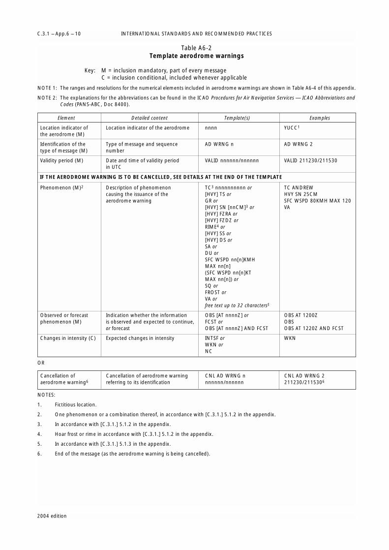
INTERNATIONAL STANDARDS AND RECOMMENDED PRACTICESC.3.1 – App.6 – 10
2004 edition
Table A6-2Template aerodrome warnings
Key: M = inclusion mandatory, part of every messageC = inclusion conditional, included whenever applicable
NOTE 1: The ranges and resolutions for the numerical elements included in aerodrome warmings are shown in Table A6-4 of this appendix.
NOTE 2: The explanations for the abbreviations can be found in the ICAO Procedures for Air Navigation Services — ICAO Abbreviations andCodes (PANS-ABC, Doc 8400).
OR
NOTES:
1. Fictitious location.
2. One phenomenon or a combination thereof, in accordance with [C.3.1.] 5.1.2 in the appendix.
3. In accordance with [C.3.1.] 5.1.2 in the appendix.
4. Hoar frost or rime in accordance with [C.3.1.] 5.1.2 in the appendix.
5. In accordance with [C.3.1.] 5.1.3 in the appendix.
6. End of the message (as the aerodrome warning is being cancelled).
Element Detailed content Template(s) Examples
Location indicator of Location indicator of the aerodrome nnnn YUCC1
the aerodrome (M)
Identification of the Type of message and sequence AD WRNG n AD WRNG 2type of message (M) number
Validity period (M) Date and time of validity period VALID nnnnnn/nnnnnn VALID 211230/211530in UTC
Phenomenon (M)2 Description of phenomenon TC3 nnnnnnnnnn or TC ANDREWcausing the issuance of the [HVY] TS or HVY SN 25CMaerodrome warning GR or SFC WSPD 80KMH MAX 120
[HVY] SN [nnCM]3 or VA[HVY] FZRA or[HVY] FZDZ orRIME4 or[HVY] SS or[HVY] DS orSA orDU orSFC WSPD nn[n]KMHMAX nn[n](SFC WSPD nn[n]KTMAX nn[n]) orSQ orFROST orVA orfree text up to 32 characters5
Observed or forecast Indication whether the information OBS [AT nnnnZ] or OBS AT 1200Zphenomenon (M) is observed and expected to continue, FCST or OBS
or forecast OBS [AT nnnnZ] AND FCST OBS AT 1220Z AND FCST
Changes in intensity (C) Expected changes in intensity INTSF or WKNWKN orNC
IF THE AERODROME WARNING IS TO BE CANCELLED, SEE DETAILS AT THE END OF THE TEMPLATE
Cancellation of Cancellation of aerodrome warning CNL AD WRNG n CNL AD WRNG 2aerodrome warning6 referring to its identification nnnnnn/nnnnnn 211230/2115306

PART II C.3.1 – App.6 – 11
2004 edition
[C.3.1.] 6
Specifications related to wind shearwarnings
[C.3.1.] 6.1
Detection of wind shear
(Recommendation)
Evidence of the existence of wind shear should be derivedfrom:
(a) Ground-based wind shear remote-sensing equipment,for example, Doppler radar;
(b) Ground-based wind shear detection equipment, forexample, a system of surface wind and/or pressuresensors located in an array monitoring a specificrunway or runways and associated approach anddeparture paths;
(c) Aircraft observations during the climb-out or approachphases of flight to be made in accordance with[C.3.1.] 5 in Part I; or
(d) Other meteorological information, for example, fromappropriate sensors located on existing masts ortowers in the vicinity of the aerodrome or nearby areasof high ground.
NOTE: Wind shear conditions are normally associated with thefollowing phenomena:
– Thunderstorms, microbursts, funnel cloud (tornado orwaterspout) and gust fronts;
– Frontal surfaces;
– Strong surface winds coupled with local topography;
– Sea breeze fronts;
– Mountain waves (including low-level rotors in theterminal area);
– Low-level temperature inversions.
[C.3.1.] 6.2
Format and dissemination of wind shearwarnings
NOTE: Information on wind shear is also to be included assupplementary information in local routine and specialreports and METAR and SPECI in accordance with thetemplates in Tables A3-1 and A3-2.
[C.3.1.] 6.2.1
The wind shear warnings shall be prepared inabbreviated plain language in accordance with the
template in Table A6-3 and disseminated foraerodromes where wind shear is considered a factor inaccordance with local arrangements with theappropriate ATS authority and operators concerned andby the meteorological office designated to provideservice for the aerodrome or disseminated directly fromautomated ground-based wind shear remote-sensing ordetection equipment referred to in [C.3.1.] 6.1(a) and(b) above.
[C.3.1.] 6.2.2 (Recommendation)
Where microbursts are observed, reported by pilots ordetected by ground-based wind shear detection or remote-sensing equipment, the wind shear warning should includea specific reference to microburst.
[C.3.1.] 6.2.3 (Recommendation)
Where information from ground-based wind sheardetection or remote-sensing equipment is used to prepare awind shear warning, the warning should, if practicable,relate to specific sections of the runway and distances alongthe approach path or take-off path as agreed between theMeteorological Authority, the appropriate ATS authority andthe operators concerned.
[C.3.1.] 6.2.4 (Recommendation)
When an aircraft report is used to prepare a wind shearwarning, or to confirm a warning previously issued, thecorresponding aircraft report, including the aircraft type,should be given unchanged in the warning.
NOTE 1: Following reported encounters by both arriving anddeparting aircraft, two different wind shear warnings mayexist, one for arriving aircraft and one for departingaircraft.
NOTE 2: Specifications for reporting the intensity of wind shear arestill undergoing development. It is recognized, however,that pilots, when reporting wind shear, may use thequalifying terms “moderate”, “strong” or “severe”, basedto a large extent on their subjective assessment of theintensity of the wind shear encountered. In accordancewith [C.3.1.] 6.2.4 above, such reports are to beincorporated unchanged in wind shear warnings.
[C.3.1.] 6.2.5 (Recommendation)
The use of text additional to the abbreviations listed in thetemplate in Table A6-3 should be kept to a minimum. Theadditional text should be prepared in abbreviated plainlanguage using approved ICAO abbreviations and numericalvalues. If no ICAO approved abbreviations are available,English plain language text should be used.
*
* *

INTERNATIONAL STANDARDS AND RECOMMENDED PRACTICESC.3.1 – App.6 – 12
2004 edition
Table A6-3Template for wind shear warnings
Key: M = inclusion mandatory, part of every messageC = inclusion conditional, included whenever applicable
NOTE 1: The ranges and resolutions for the numerical elements included in wind shear warnings are shown in Table A6-4 of this appendix.
NOTE 2: The explanations for the abbreviations can be found in the ICAO Procedures for Air Navigation Services — ICAO Abbreviations andCodes (PANS-ABC, Doc 8400).
OR
NOTES:
1. Fictitious location.
2. Additional provisions in [C.3.1.] 6.2.5 in this appendix.
3. End of the message (as the wind shear warning is being cancelled).
Element Detailed content Template(s) Examples
Location indicator of Location indicator of the aerodrome nnnn YUCC1
the aerodrome (M)
Identification of the Type of message and sequence WS WRNG [nn] WS WRNG 01type of message (M) number
Date and time of origin Date and time of issue and, where nnnnnn [VALID TL nnnnnn] or 211230 VALID TL 211330and validity of period (M) applicable, validity period in UTC [VALID nnnnnn/nnnnnn]
221200 VALID221215/221315
Phenomenon (M) Identification of the phenomenon [MOD] or [SEV] WS IN APCH or WS APCH RWY12and its location [MOD] or [SEV] WS [APCH] MOD WS RWY34
RWYnnnor WS IN CLIMB-OUT[MOD] or [SEV] WS IN CLIMB-OUTor[MOD] or [SEV] WS CLIMB-OUT MBST APCH RWY26RWYnnn orMBST IN APCH orMBST [APCH] RWYnnn MBST IN CLIMB-OUTorMBST IN CLIMB-OUT orMBST CLIMB-OUT RWYnnn
Observed, reported or Indentification whether the REP AT nnnn nnnnnnnn or REP AT 1510 B747forecast phenomenon phenomenon is observed or reported OBS [AT nnnn] or OBS AT 1205(M) and expected to continue or forecast FCST FCST
Details of the Description of phenomenon causing SFC WIND: nnn/nnKMH (or SFC WIND: 320/20KMHphenomenon (C)2 the issuance of the wind shear nnn/nnKT) nnnM (nnnFT)-WIND: 60M-WIND: 360/50KMH
warning nnn/nnKMH (or nnn/nnKT) (SFC WIND: 320/10KT200FT-WIND: 360/25KT)
or60KMH ASPEEDL 4KM
nnKMH (or nnKT) ASPEEDL nnKM FNA RWY13(or nnNM) FNA RWYnn (30KT ASPEEDL 2NM
FNA RWY13)or
nnKMH (or nnKT) ASPEEDG nnKM(or nnNM) FNA RWYnn
IF THE WIND SHEAR WARNING IS TO BE CANCELLED, SEE DETAILS AT THE END OF THE TEMPLATE
Cancellation of Cancellation of wind shear warning CNL WS WRNG n CNL WS WRNG 1wind shear warning3 referring to its identification nnnnnn/nnnnnn 211230/2113303

PART II C.3.1 – App.6 – 13
2004 edition
Table A6-4Ranges and resolutions for the numerical elements included in volcanic ash and tropical cyclone
advisory messages, SIGMET/AIRMET messages and aerodrome and wind shear warnings
* non-dimensional
Element as specified in Appendices 2 and 6 Range Resolution
Summit elevation M 000 – 8 100 1FT 000 – 27 000 1
Advisory number for VA (index)* 000 – 2 000 1for TC (index)* 00 –99 1
Maximum surface wind KMH 00 – 399 1KT 00 – 199 1
Central pressure hPa 850 – 1 050 1
Surface wind speed KMH 60 – 199 1KT 30 – 99 1
Surface visibility M 0000 – 0800 50M 0800 – 5 000 100
Cloud: height of base M 000 – 300 30FT 000 – 1 000 100
Cloud: height of top M 000 – 3 000 30M 3 000 – 20 000 300FT 000 – 10 000 100FT 10 000 – 60 000 1 000
Latitudes ° (degrees) 00 – 90 1‘ (minutes) 00 – 60 1
Longitudes ° (degrees) 000 – 180 1‘ (minutes) 00 – 60 1
Flight levels 000 – 650 10
Movement KMH 0 – 300 10KT 0 – 150 5


[C.3.1.] 1
Processing of aeronautical climatologicalinformation
(Recommendation)
Meteorological observations for regular and alternateaerodromes should be collected, processed and stored in aform suitable for the preparation of aerodromeclimatological information.
[C.3.1.] 2
Exchange of aeronautical climatologicalinformation
(Recommendation)
Aeronautical climatological information should beexchanged on request between Meteorological Authorities.Operators and other aeronautical users desiring suchinformation should normally apply to the MeteorologicalAuthority responsible for its preparation.
[C.3.1.] 3
Content of aeronautical climatologicalinformation
[C.3.1.] 3.1
Aerodrome climatological tables
[C.3.1.] 3.1.1 (Recommendation)
An aerodrome climatological table should give asapplicable:
(a) Mean values and variations therefrom, includingmaximum and minimum values, of meteorologicalelements (for example, of air temperature); and/or
(b) The frequency of occurrence of present weatherphenomena affecting flight operations at theaerodrome (for example, of sandstorms); and/or
(c) The frequency of occurrence of specified values of one,or of a combination of two or more, elements (forexample, of a combination of low visibility and lowcloud).
[C.3.1.] 3.1.2 (Recommendation)
Aerodrome climatological tables should include informationrequired for the preparation of aerodrome climatologicalsummaries in accordance with [C.3.1.] 3.2 below.
[C.3.1.] 3.2
Aerodrome climatological summaries
(Recommendation)
Aerodrome climatological summaries should cover:
(a) Frequencies of the occurrence of runway visualrange/visibility and/or height of the base of the lowestcloud layer of BKN or OVC extent below specifiedvalues at specified times;
(b) Frequencies of visibility below specified values atspecified times;
(c) Frequencies of the height of the base of the lowestcloud layer of BKN or OVC extent below specifiedvalues at specified times;
(d) Frequencies of occurrence of concurrent winddirection and speed within specified ranges;
(e) Frequencies of surface temperature in specified rangesof 5°C at specified times; and
(f) Mean values and variations therefrom, includingmaximum and minimum values of meteorologicalelements required for operational planning purposes,including take-off performance calculations.
NOTE: Models of climatological summaries related to (a) to (e)above are given in these Technical Regulations, Volume II[C.3.2].
2004 edition
APPENDIX 7
TECHNICAL SPECIFICATIONS RELATED TO AERONAUTICALCLIMATOLOGICAL INFORMATION
(See [C.3.1.] 8 in Part I)


2004 edition
NOTE: Specifications related to flight documentation (includingthe model charts and forms) are in Appendix 1.
[C.3.1.] 1
Means of supply and format ofmeteorological information
[C.3.1.] 1.1
Meteorological information shall be supplied tooperators and flight crew members by one or more ofthe following, as agreed between the MeteorologicalAuthority and operator concerned, and with the ordershown below not implying priorities:
(a) Written or printed material, including specifiedcharts and forms;
(b) Data in digital form;
(c) Briefing;
(d) Consultation;
(e) Display; or
(f) In lieu of (a) to (e), by means of an automated pre-flight information system providing self-briefingand flight documentation facilities while retainingaccess by operators and aircrew members toconsultation, as necessary, with the meteorologicaloffice, in accordance with [C.3.1.] 5.1 below.
[C.3.1.] 1.2
The Meteorological Authority, in consultation with theoperator, shall determine:
(a) The type and format of meteorological informationto be supplied; and
(b) Methods and means of supplying that information.
[C.3.1.] 1.3 (Recommendation)
On request by the operator, the meteorological informationsupplied for flight planning should include data for thedetermination of the lowest usable flight level.
[C.3.1.] 2
Specifications related to information forpre-flight planning and in-flight re-planning
[C.3.1.] 2.1
Format of upper-air information
Upper-air information supplied by WAFCs for pre-flightand in-flight re-planning shall be in the GRIB code form.
NOTE: The GRIB code is contained in WMO Publication No. 306,Manual on Codes, Volume I.2, Part B — Binary codes.
[C.3.1.] 2.2
Format of information on significant weather
Information on significant weather supplied by WAFCsfor pre-flight and in-flight replanning shall be in theBUFR code form.
NOTE: The BUFR code form is contained in WMO PublicationNo. 306, Manual on Codes, Volume I.2, Part B — Binarycodes.
[C.3.1.] 2.3
Specific needs of supersonic aircraft
(Recommendation)
Meteorological information for pre-flight planning and in-flight re-planning by operators for supersonic aircraft shouldinclude data covering the levels used for transonic andsupersonic flight, together with the levels that may be usedfor subsonic flight. Particular mention should be made ofoccurrence and expected occurrence, location and verticalextent of Cumulonimbus clouds, turbulence andprecipitation.
[C.3.1.] 2.4
Specific needs of helicopter operations
(Recommendation)
Meteorological information for pre-flight planning and in-flight re-planning by operators of helicopters flying to off-shore structures should include data covering the layersfrom sea level to flight level 100. Particular mention should
APPENDIX 8
TECHNICAL SPECIFICATIONS RELATED TO SERVICE FOROPERATORS AND FLIGHT CREW MEMBERS
(See [C.3.1.] 9 in Part I)

be made of the expected surface visibility, the amount, type(where available), base and tops of cloud below flight level100, sea state and sea-surface temperature, mean sea-levelpressure, and the occurrence and expected occurrence ofturbulence and icing, as determined by regional airnavigation agreement.
[C.3.1.] 3
Specifications related to briefing andconsultation
[C.3.1.] 3.1
Specific needs of supersonic aircraft
(Recommendation)
Briefing and/or consultation for flight crew members ofsupersonic aircraft should include meteorological informationcovering the flight levels of transonic and supersonic flight.Particular mention should be made of occurrence andexpected occurrence, location and vertical extent ofCumulonimbus clouds, turbulence and precipitation.
[C.3.1.] 3.2
Specific needs of low-level fights
(Recommendation)
Briefing and/or consultation for low-level flights, includingthose in accordance with the visual flight rules, shouldinclude meteorological information covering altitudes up toflight level 100 (or up to flight level 150 in mountainousareas or higher, where necessary). Particular mention shouldbe made of the occurrence or expected occurrence of anyphenomena causing widespread reduction of visibility toless than 5 000 m, as well as the occurrence or expectedoccurrence of clouds which may affect the flight.
[C.3.1.] 3.3
Information required to be displayed
[C.3.1.] 3.3.1
To assist the flight crew members and others concernedwith the preparation of the flight and for use in briefingand consultation, the meteorological office shall displaythe latest available:
(a) METAR and SPECI;
(b) TAF and trend forecasts;
(c) Aerodrome warnings relating to the localaerodrome;
(d) Forecasts for take-off;
(e) SIGMET and AIRMET information and special air-reports not covered by a SIGMET;
(f) Current and prognostic charts;
(g) Meteorological satellite images or mosaics and/ornephanalyses; and
(h) Ground-based weather radar information.
[C.3.1.] 3.3.2 (Recommendation)
The material displayed should be readily accessible to theflight crew members or other flight operations personnelconcerned. By agreement between the MeteorologicalAuthority and the user, the display may be used in lieu ofbriefing and/or consultation.
[C.3.1.] 4
Specifications related to flightdocumentation
[C.3.1.] 4.1
General
[C.3.1.] 4.1.1
Presentation of flight documentation
[C.3.1.] 4.1.1.1 (Recommendation)
Charts included in flight documentation should have a highstandard of clarity and legibility and should have thefollowing physical characteristics:
(a) For convenience, the largest size of charts should beabout 42 × 30 cm (standard size A3) and the smallestsize should be about 21 × 30 cm (standard size A4).The choice between these sizes should depend on theroute lengths and the amount of detail that needs tobe given in the charts as agreed betweenMeteorological Authorities and users;
(b) Major geographical features, such as coastlines, majorrivers and lakes should be depicted in a way thatmakes them easily recognizable;
(c) For charts prepared by computer, meteorological datashould take preference over basic chart information,the former cancelling the latter wherever they overlap;
(d) Major aerodromes should be shown as a dot andidentified by the first letter of the name of the city theaerodrome serves as given in Table AOP of the relevantICAO regional air navigation plan;
(e) A geographical grid should be shown with meridiansand parallels represented by dotted lines at each 10°latitude and longitude; dots should be spaced onedegree apart;
(f) Latitude and longitude values should be indicated atvarious points throughout the charts (i.e. not only atthe edges); and
(g) Labels on the charts for flight documentation shouldbe clear and simple and should present the name ofthe world area forecast centre, or, for non-WAFproducts, the originating centre, the type of chart,date and valid time and, if necessary, the types of unitsused in an unambiguous way.
[C.3.1.] 4.1.1.2 (Recommendation)
Meteorological information included in flight documen-tation should be represented as follows:
(a) Winds on charts should be depicted by arrows withfeathers and shaded pennants on a sufficiently densegrid;
INTERNATIONAL STANDARDS AND RECOMMENDED PRACTICESC.3.1 – App.8 – 2
2004 edition

(b) Temperatures should be depicted by figures on asufficiently dense grid;
(c) Wind and temperature data selected from the data setsreceived from a world area forecast centre should bedepicted in a sufficiently dense latitude/longitude grid;and
(d) Wind arrows should take precedence overtemperatures and either should take precedence overchart background.
[C.3.1.] 4.1.1.3 (Recommendation)
For short-haul flights charts should be prepared coveringlimited areas at a scale of 1:15 × 106 as required and subjectto regional air navigation agreement.
[C.3.1.] 4.1.2
Set of charts to be provided
[C.3.1.] 4.1.2.1 (Recommendation)
The minimum number of charts for flights between flightlevel 250 and flight level 630 should include a high-levelsignificant weather chart (flight level 250 to flight level 630)and a forecast 250 hPa wind and temperature chart. Theactual charts provided for pre-flight and in-flight planningand for flight documentation should be as agreed betweenMeteorological Authorities and other users within a servicearea.
[C.3.1.] 4.1.2.2 (Recommendation)
The set of charts to be provided under the world areaforecast system for flights below flight level 250 should beas agreed between user Members and other users.
[C.3.1.] 4.1.3
Height indications(Recommendation)
In-flight documentation height indications should be givenas follows:
(a) All references to en-route meteorological conditions,such as height indications of upper winds, turbulenceor bases and tops of clouds, should preferably beexpressed in flight levels; they may also be expressedin pressure, altitude or, for low-level flights, heightabove ground level; and
(b) All references to aerodrome meteorological conditions,such as height indications of the bases of clouds,should be expressed in height above the aerodromeelevation.
[C.3.1.] 4.2
Specifications related to upper wind andupper-air temperature information
[C.3.1.] 4.2.1
In chart form
[C.3.1.] 4.2.1.1
Where upper wind and upper-air temperatureinformation is supplied in chart form to flight crew
members before departure, the charts shall be fixed-time prognostic charts for standard flight levels. Intropical areas, or for short flights, current charts may beprovided in lieu of prognostic charts; in such cases, thelevels depicted shall correspond to the standard isobariclevels.
[C.3.1.] 4.2.1.2
Upper wind and upper-air temperature charts for low-level flights shall be supplied for points separated byno more than 500 km (300 NM) and for at least thefollowing altitudes: 600, 1 500 and 3 000 m (2 000,5 000 and 10 000 ft).
[C.3.1.] 4.2.2
In tabular form
(Recommendation)
Where upper wind and upper-air temperature information issupplied in tabular form, it should include data for the sameflight levels as for upper-air charts. This information shouldbe given for spot locations on a regular grid.
NOTE: Examples of the form of presentation of tabular forecasts ofupper winds and upper-air temperatures are given inAppendix 1.
[C.3.1.] 4.3
Specifications related to significant weatherinformation
[C.3.1.] 4.3.1
In chart form
[C.3.1.] 4.3.1.1
Where information on significant en-route weatherphenomena is supplied in chart form to flight crewmembers before departure, the charts shall be significantweather charts valid for a specified fixed time. Suchcharts shall show, as appropriate to the flight:
(a) Thunderstorms;
(b) Tropical cyclone;
(c) Severe squall lines;
(d) Moderate or severe turbulence (in cloud or clear air);
(e) Moderate or severe icing;
(f) Widespread sandstorm/duststorm;
(g) For flight level 100 to flight level 250, cloudsassociated with (a) to (f) above;
(h) Above flight level 250, cumulonimbus cloudassociated with (a) to (f) above;
(i) Surface position of well-defined convergencezones;
(j) Surface positions, speed and direction ofmovement of frontal systems when associated withsignificant en-route weather phenomena;
(k) Tropopause heights;
(l) Jet streams;
PART II C.3.1 – App.8 – 3
2004 edition
(m) Information on the location of volcanic eruptionswhich are producing ash clouds of significance toaircraft operations, including those producing onlysteam, comprising: volcanic eruption symbol at thelocation of the volcano and, at the side of the chart,the volcanic eruption symbol, the name of thevolcano, its international number, latitude/longitude, the date and time of first eruption, ifknown, and a reference to SIGMETs and NOTAM orASHTAM issued for the area concerned; and
(n) Information on the location of an accidental releaseof radioactive materials into the atmosphere ofsignificance to aircraft operations, comprising: theradioactivity symbol at the site of the accident and,at the side of the chart, the radioactivity symbol,latitude/longitude of the site of the accident, dateand time of the accident and a reminder to users tocheck NOTAM for the area concerned.
NOTE 1: For aircraft operating above flight level 250, items (a) to(f) above are only required if expected to be above thatlevel, and in the case of item (a), only thosethunderstorms which warrant the issuance of a SIGMETas given in Appendix 6. Guidance on the use of term“FRQ TS” is given in Appendix 6.
NOTE 2: The abbreviation “CB” should only be included where itrefers to the occurrence or expected occurrence of anarea of widespread Cumulonimbus clouds orCumulonimbus along a line with little or no spacebetween individual clouds, or to Cumulonimbusembedded in cloud layers or concealed by haze. It doesnot refer to isolated or scattered Cumulonimbus notembedded in cloud layers or concealed by haze.
NOTE 3: Where a volcanic eruption or the accidental release ofradioactive materials into the atmosphere warrants theinclusion of the volcanic activity symbol or theradioactivity symbol on significant weather charts, thesymbols are to be included on all such charts (low,medium and high) irrespective of the height to which theash column or radioactive material is reported orexpected to reach.
NOTE 4: The international volcano number is allocated by theInternational Association of Volcanology and Chemistry ofEarth’s Interior (IAVCEI) and listed in the ICAO Manual onVolcanic Ash, Radioactive Material and Toxic ChemicalClouds (Doc 9691).
[C.3.1.] 4.3.1.2 (Recommendation)
On significant weather charts, the inclusion of ”CB“ or thethunderstorm symbol should be understood to include allweather phenomena normally associated withCumulonimbus or thunderstorm, namely, moderate orsevere icing, moderate or severe turbulence and hail.
[C.3.1.] 4.3.1.3 (Recommendation)
Significant weather charts for low-level flights, includingthose in accordance with the visual flight rules, operating upto flight level 100 (up to flight level 150 in mountainousareas or higher, where necessary) should show, asappropriate to the flight:
(a) The phenomena warranting the issuance of a SIGMETas given in Appendix 6 and which are expected toaffect low-level flights; and
(b) The elements included in area forecasts for low-levelflights as given in Appendix 5, except elements (r) and(u) concerning upper winds and upper-airtemperatures and forecast lowest QNH, respectively.
NOTE 1: Examples of the form of presentation of significantweather charts are given in Appendix 1.
NOTE 2: Guidance on the use of terms “ISOL”, “OCNL” and“FRQ” referring to Cumulonimbus clouds andthunderstorms is given in Appendix 6.
[C.3.1.] 4.3.2
In other forms
(Recommendation)
Where flight documentation covering the significant en-route weather conditions is not supplied in chart form, itshould be presented in tabular form and/or as anabbreviated plain-language text.
NOTE: Examples of the form of presentation of tabular forecastsare given in Appendix 1.
[C.3.1.] 4.4
Specifications related to TAF
[C.3.1.] 4.4.1
Requirements for TAF
[C.3.1.] 4.4.1.1
The flight documentation shall in all cases include theTAF for the aerodrome of departure and for theaerodrome of intended landing. In addition, the flightdocumentation shall include TAF for one or moresuitable alternate aerodromes, as needed to completethe operational flight plan and as selected by agreementbetween the Meteorological Authority and theoperators, and taken from the list of aerodromescontained in the relevant ICAO regional air navigationplan.
[C.3.1.] 4.4.1.2
TAF received from other meteorological offices shall beincluded in flight documentation without change insubstance.
[C.3.1.] 4.4.1.3 (Recommendation)
By agreement between the Meteorological Authority andthe operator, the flight documentation should include TAFfor alternate aerodromes en route and of aerodromes whereintermediate stops are planned.
[C.3.1.] 4.4.2
Presentation of TAF
(Recommendation)
TAF should be presented in accordance with the templatesin Appendix 5; they may also be presented in tabular formor in the form of an abbreviated plain-language text. Thelocation indicators and the abbreviations used should beexplained in the flight documentation. If several TAF are
INTERNATIONAL STANDARDS AND RECOMMENDED PRACTICESC.3.1 – App.8 – 4
2004 edition
included, they should be presented in a manner whichpermits the ready identification of the beginning and end ofeach forecast.
NOTE: Examples of the form of presentation of TAF are given inAppendix 1.
[C.3.1.] 4.4.3
Issuance of provisional TAF
(Recommendation)
When a TAF is not received in time, the meteorologicaloffice associated with the aerodrome of departure shouldmake all practicable efforts to obtain the forecast but, ifunobtainable, the office should, if possible, prepare aprovisional forecast. The meteorological office should informthe flight crew member that the forecast is provisional andrecord its origin in the flight documentation.
[C.3.1.] 4.5
Specifications related to low-level flights
[C.3.1.] 4.5.1
In chart form
(Recommendation)
Where the forecasts are supplied in chart form, flightdocumentation for low-level flights, including those inaccordance with the visual flight rules, operating up to flightlevel 100 (or up to flight level 150 in mountainous areas orhigher, where necessary) should contain the following asappropriate to the flight:
(a) Information from relevant SIGMET and AIRMETmessages;
(b) Upper wind and upper-air temperature charts as givenin [C.3.1.] 4.2.1.2 above; and
(c) Significant weather charts as given in [C.3.1.] 4.3.1.3above.
[C.3.1.] 4.5.2
In abbreviated plain language
(Recommendation)
Where the forecasts are not supplied in chart form, flightdocumentation for low-level flights, including those inaccordance with the visual flight rules, operating up to flightlevel 100 (up to flight level 150 in mountainous areas orhigher, where necessary), should contain the followinginformation as appropriate to the flight:
(a) SIGMET and AIRMET information; and
(b) Information included in the area forecasts for low-levelflights as given in Appenidx 5 or, where the forecastsare issued in the form of an abbreviated plain-languagetext, the GAMET area forecasts.
NOTE: An example of the GAMET area forecast is given inAppendix 5.
[C.3.1.] 5
Specifications related to automated pre-flight information systems for briefing,consultation, flight planning and flightdocumentation
[C.3.1.] 5.1
Access to the systems
Automated pre-flight information systems providingself-briefing facilities shall provide for access byoperators and aircrew members to consultation, asnecessary, with a meteorological office by telephone orother suitable telecommunications means.
[C.3.1.] 5.2
Detailed specifications of the systems
(Recommendation)
Automated pre-flight information systems for the supply ofmeteorological information for self-briefing, pre-flightplanning and flight documentation should:
(a) Provide for the continuous and timely updating of thesystem database and monitoring of the validity andintegrity of the meteorological information stored;
(b) Permit access to the system by operators and flightcrew members and also by other aeronautical usersconcerned through suitable telecommunicationmeans;
(c) Use access and interrogation procedures based onabbreviated plain language and, as appropriate, ICAOlocation indicators, and aeronautical meteorologicalcode data-type designators prescribed by WMO, orbased on a menu-driven user interface, or otherappropriate mechanisms as agreed between theMeteorological Authority and operator concerned; and
(d) Provide for rapid response to a user request forinformation.
NOTE: ICAO abbreviations and codes and location indicators aregiven respectively in the ICAO Procedures for Air NavigationServices — ICAO Abbreviations and Codes (PANS-ABC, Doc8400) and ICAO Location Indicators (Doc 7910).Aeronautical meteorological code data-type designators aregiven in WMO Publication No. 386, Manual on the GlobalTelecommunication System.
[C.3.1.] 6
Specifications related to information foraircraft in flight
[C.3.1.] 6.1
Supply of information requested by anaircraft in flight
(Recommendation)
If an aircraft in flight requests meteorological information,the meteorological office which receives the request shouldarrange to supply the information with the assistance, ifnecessary, of another meteorological office.
PART II C.3.1 – App.8 – 5
2004 edition

[C.3.1.] 6.2
Information for in-flight planning by theoperator
(Recommendation)
Meteorological information for planning by the operator foraircraft in flight should be supplied during the period of theflight and should normally consist of any or all of the following:
(a) Meteorological reports, TAF and landing forecasts;
(b) SIGMET and AIRMET information and special air-reports relevant to the flight, unless the latter havebeen the subject of a SIGMET message; and
(c) Upper wind and upper-air temperature information.
[C.3.1.] 6.3
Information for supersonic flights
(Recommendation)
For supersonic aircraft in flight, the meteorological officeserving the aerodrome of intended landing should, onrequest by the operator, supply a forecast covering thetransonic deceleration and subsonic descent phases. Thisforecast should be transmitted to the area control centre orflight information centre concerned within the two hoursbefore arrival. The operator should advise themeteorological office, in good time, of the location of thedescent path and of the time at which the aircraft isexpected to commence the descent.
INTERNATIONAL STANDARDS AND RECOMMENDED PRACTICESC.3.1 – App.8 – 6
2004 edition

[C.3.1.] 1
Information to be provided for air trafficservices units
[C.3.1.] 1.1
List of information for the aerodrome controltower
The following meteorological information shall besupplied, as necessary, to an aerodrome control towerby its associated aerodrome meteorological office:
(a) Local routine and special reports, METAR andSPECI, TAF and trend forecasts, and amendmentsthereto, for the aerodrome concerned;
(b) SIGMET and AIRMET information, wind shearwarnings and aerodrome warnings;
(c) Any additional meteorological information agreedupon locally, such as forecasts of surface wind forthe determination of possible runway changes; and
(d) Information received on volcanic ash cloud, forwhich a SIGMET has not already been issued, asagreed between the Meteorological and ATSAuthorities concerned.
[C.3.1.] 1.2
List of information for the approach controloffice
The following meteorological information shall besupplied, as necessary, to an approach control office byits associated aerodrome meteorological office:
(a) Local routine and special reports, METAR andSPECI, including current pressure data, TAF andtrend forecasts, and amendments thereto, for theaerodrome(s) with which the approach controloffice is concerned;
(b) SIGMET and AIRMET information, wind shearwarnings and appropriate special air-reports for theairspace with which the approach control office isconcerned and aerodrome warnings;
(c) Any additional meteorological information agreedupon locally; and
(d) Information received on volcanic ash cloud, forwhich a SIGMET has not already been issued, as
agreed between the Meteorological and ATSAuthorities concerned.
[C.3.1.] 1.3
List of information for the flight informationcentre
The following meteorological information shall besupplied, as necessary, to a flight information centre oran area control centre by its associated meteorologicalwatch office:
(a) METAR and SPECI, including current pressure datafor aerodromes and other locations, TAF and trendforecasts, and amendments thereto, covering theflight information region or the control area and, ifrequired by the flight information centre or areacontrol centre, covering aerodromes inneighbouring flight information regions, asdetermined by regional air navigation agreement;
(b) Forecasts of upper winds, upper-air temperaturesand significant en-route weather phenomena andamendments thereto, particularly those which arelikely to make operation under visual flight rulesimpracticable, SIGMET and AIRMET informationand appropriate special air-reports for the flightinformation region or control area and, ifdetermined by regional air navigation agreementand required by the flight information centre orarea control centre, for neighbouring flightinformation regions;
(c) Any other meteorological information required bythe flight information centre or area control centreto meet requests from aircraft in flight; if theinformation requested is not available in theassociated meteorological watch office, that officeshall request the assistance of anothermeteorological office in supplying it;
(d) Information received on volcanic ash cloud, forwhich a SIGMET has not already been issued, asagreed between the Meteorological and ATSAuthorities concerned; and
(e) Information received concerning the accidentalrelease of radioactive materials into theatmosphere, as agreed between the meteorologicaland ATS Authorities concerned.
2004 edition
APPENDIX 9
TECHNICAL SPECIFICATIONS RELATED TO INFORMATION FORAIR TRAFFIC SERVICES, SEARCH AND RESCUE SERVICES AND
AERONAUTICAL INFORMATION SERVICES(See [C.3.1.] 10 in Part I)

[C.3.1.] 1.4
Specific provisions related to the supply ofinformation on volcanic ash and volcaniceruptions
[C.3.1.] 1.4.1
Volcanic ash advisory information issued by a VAAC shallbe supplied to area control centres and flight informa-tion centres concerned in its area of responsibility.
[C.3.1.] 1.4.2
Information received on pre-eruption volcanic activityand/or a volcanic eruption shall be supplied, asnecessary, to an ATS unit by its corresponding associatedmeteorological office as agreed between theMeteorological and ATS Authorities concerned.
[C.3.1.] 1.5
Specific provisions related to the supply ofinformation for supersonic aircraft
(Recommendation)
The information supplied to flight information centres andarea control centres for supersonic aircraft should cover thelevels used for transonic and supersonic flight and shouldinclude forecasts for subsonic descent paths to aerodromesin the flight information region.
[C.3.1.] 1.6
Supply of information to aeronauticaltelecommunications stations
Where necessary for flight information purposes,current meteorological reports and forecasts shall besupplied to designated aeronautical telecommunicationstations. A copy of such information shall be forwarded,if required, to the flight information centre or the areacontrol centre.
[C.3.1.] 1.7
Format of information
[C.3.1.] 1.7.1 (Recommendation)
Local routine and special reports, METAR and SPECI, TAFand trend forecasts, SIGMET and AIRMET information,upper wind and upper-air temperature forecasts andamendments thereto should be supplied to air trafficservices units in the form in which they are prepared,disseminated to other meteorological offices or receivedfrom other meteorological offices, unless otherwise agreedlocally.
[C.3.1.] 1.7.2 (Recommendation)
When computer-processed upper-air data for grid points aremade available to air traffic services units in digital form foruse by air traffic services computers, the contents, formatand transmission arrangements should be as agreed
between the Meteorological Authority and the appropriateATS Authority. The data should normally be supplied assoon as is practicable after the processing of the forecastshas been completed.
[C.3.1.] 2
Information to be provided for searchand rescue services units
[C.3.1.] 2.1
List of information
Information to be supplied to rescue coordinationcentres shall include the meteorological conditions thatexisted in the last known position of a missing aircraftand along the intended route of that aircraft withparticular reference to:
(a) Significant en-route weather phenomena;
(b) Cloud amount and type, particularly Cumulonim-bus; height indications of bases and tops;
(c) Visibility and phenomena reducing visibility;
(d) Surface wind and upper wind;
(e) State of ground, in particular, any snow cover orflooding;
(f) Sea-surface temperature, state of the sea, ice cover,if any, and ocean currents, if relevant to the searcharea; and
(g) Sea-level pressure data.
[C.3.1.] 2.2
Information to be provided on request
[C.3.1.] 2.2.1 (Recommendation)
On request from the rescue coordination centre, thedesignated meteorological office should arrange to obtaindetails of the flight documentation which was supplied tothe missing aircraft, together with any amendments to theforecast which were transmitted to the aircraft in flight.
[C.3.1.] 2.2.2 (Recommendation)
To facilitate search and rescue operations, the designatedmeteorological office should, on request, supply:
(a) Complete and detailed information on the current andforecast meteorological conditions in the search area;and
(b) Current and forecast conditions en route, coveringflights by search aircraft from, and returning to, theaerodrome from which the search is being conducted.
[C.3.1.] 2.2.3 (Recommendation)
On request from the rescue coordination centre, thedesignated meteorological office should supply, or arrangefor the supply of meteorological information required byships undertaking search and rescue operations.
INTERNATIONAL STANDARDS AND RECOMMENDED PRACTICESC.3.1 – App.9 – 2
2004 edition

[C.3.1.] 3
Information to be provided foraeronautical information services units
[C.3.1.] 3.1
List of information
The following information shall be supplied, asnecessary, to an aeronautical information services unit:
(a) Information on meteorological service forinternational air navigation, intended for inclusionin the aeronautical information publication(s)concerned;
NOTE: Details of this information are given in ICAO Annex 15,Appendix 1, Part 1, 3.5 and Part 3, 2.2, 2.11, 3.2 and 3.11.
(b) Information necessary for the preparation ofNOTAM or ASHTAM including, in particular,information on:
(i) The establishment, withdrawal and significantchanges in operation of aeronauticalmeteorological services. This information isrequired to be provided to the aeronautical
information services unit sufficiently inadvance of the effective date to permitissuance of NOTAM in compliance with ICAOAnnex 15, 5.1.1 and 5.1.1.1;
(ii) The occurrence of volcanic activity; and
NOTE: The specific information required is given in [C.3.1.] 3.3.2and [C.3.1.] 4.8 in Part I.
(iii) Accidental release of radioactive materials intothe atmosphere, as agreed between theMeteorological and appropriate civil aviationAuthorities concerned;
NOTE: The specific information required is given in [C.3.1.]3.4.2(g) in Part I.
(c) Information necessary for the preparation ofaeronautical information circulars including, inparticular, information on:
(i) Expected important changes in aeronauticalmeteorological procedures, services andfacilities provided; and
(ii) Effect of certain weather phenomena onaircraft operations.
PART II C.3.1 – App.9 – 3
2004 edition


2004 edition
[C.3.1.] 1
Specific requirements forcommunications
[C.3.1.] 1.1
Required transit times of meteorologicalinformation
(Recommendation)
Unless otherwise determined by regional air navigationagreement, AFTN messages and bulletins containingoperational meteorological information should achievetransit times of less than the following:
SIGMET and AIRMET messages, volcanicash and tropical cyclone advisoryinformation and special air-reports . . . . . . . five minutes
Abbreviated plain-language amendmentsto significant weather and upper airforecasts . . . . . . . . . . . . . . . . . . . . . . . . . . . five minutes
Amended TAF and corrections to TAF . . . . . five minutes
METAR 0–900 km(500 NM) . . . . . . . . . . . five minutes
Trend forecasts
TAF more than900 km
SPECI (500 NM) . . . . . . . . . . . 10 minutes
[C.3.1.] 1.2
Grid point data for ATS and operators
[C.3.1.] 1.2.1 (Recommendation)
When upper-air data for grid points in digital form are madeavailable for use by air traffic services computers, thetransmission arrangements should be as agreed betweenthe Meteorological Authority and the appropriate ATSAuthority.
[C.3.1.] 1.2.2 (Recommendation)
When upper-air data for grid points in digital form are madeavailable to operators for flight planning by computer, thetransmission arrangements should be as agreed among theworld area forecast centre concerned, the MeteorologicalAuthority and the operators.
[C.3.1.] 2
Use of aeronautical fixed servicecommunications
[C.3.1.] 2.1
Meteorological bulletins in alphanumericformat
[C.3.1.] 2.1.1
Composition of bulletins
(Recommendation)
Whenever possible, exchanges of operational meteoro-logical information should be made in consolidated bulletinsof the same types of meteorological information.
[C.3.1.] 2.1.2
Filing times of bulletins
(Recommendation)
Meteorological bulletins required for scheduledtransmissions should be filed regularly and at the prescribedscheduled times. METAR should be filed for transmissionnot later than five minutes after the actual time ofobservation. TAF should be filed for transmission at least onehour before the commencement of their period of validity,unless otherwise determined by regional air navigationagreement.
[C.3.1.] 2.1.3
Heading of bulletins
Meteorological bulletins containing operationalmeteorological information to be transmitted via theaeronautical fixed service facilities shall contain aheading consisting of:
(a) An identifier of four letters and two figures;
(b) The ICAO four-letter location indicator corre-sponding to the geographical location of themeteorological office originating or compiling themeteorological bulletin;
(c) A date-time group; and
(d) If required, a three-letter indicator.
APPENDIX 10
TECHNICAL SPECIFICATIONS RELATED TO REQUIREMENTS FOR,AND USE OF, COMMUNICATIONS
(See [C.3.1.] 11 in Part I)

INTERNATIONAL STANDARDS AND RECOMMENDED PRACTICESC.3.1 – App.10 – 2
2004 edition
NOTE 1: Detailed specifications on format and contents of theheading are given in WMO Publication No. 386 —Manual on the Global Telecommunication System, Volume Iand are reproduced in the ICAO Manual of AeronauticalMeteorological Practice (Doc 8896).
NOTE 2: ICAO location indicators are listed in ICAO LocationIndicators (Doc 7910).
[C.3.1.] 2.1.4
Structure of bulletins
Meteorological bulletins containing operationalmeteorological information to be transmitted via theAFTN shall be encapsulated in the text part of the AFTNmessage format.
[C.3.1.] 2.2
World area forecast system products
[C.3.1.] 2.2.1
Telecommunications for the supply of WAFSproducts
(Recommendation)
The telecommunications facilities used for the supply ofworld area forecast system products should be theaeronautical fixed service.
[C.3.1.] 2.2.2
Quality requirements for charts
(Recommendation)
Where world area forecast system products aredisseminated in chart form, the quality of the chartsreceived should be such as to permit reproduction in asufficiently legible form for flight planning anddocumentation. Charts received should be legible over95 per cent of their area.
[C.3.1.] 2.2.3
Quality requirements for transmissions
(Recommendation)
Transmissions should be such as to ensure that theirinterruption should not exceed 10 minutes during anyperiod of six hours.
[C.3.1.] 2.2.4
Heading of bulletins containing WAFS products
Meteorological bulletins containing WAFS products indigital form to be transmitted via aeronautical fixedservice facilities shall contain a heading as given in[C.3.1.] 2.1.3 above.
[C.3.1.] 3
Use of aeronautical mobile servicecommunications
[C.3.1.] 3.1
Content and format of meteorologicalmessages
[C.3.1.] 3.1.1
The content and format of reports, forecasts andSIGMET information transmitted to aircraft shall beconsistent with the provisions of [C.3.1.] 4, [C.3.1.] 6 and[C.3.1.] 7 in Part I.
[C.3.1.] 3.1.2
The content and format of air-reports transmitted byaircraft shall be consistent with the provisions of[C.3.1.] 5 in Part I and of the ICAO Procedures for AirNavigation Services — Rules of the Air and Air Traffic Services(PANS-ATM, Doc 4444), Appendix 1.
[C.3.1.] 3.2
Content and format of meteorologicalbulletins
The substance of a meteorological bulletin transmittedvia the aeronautical mobile service shall remainunchanged from that contained in the bulletin asoriginated.
[C.3.1.] 4
Use of aeronautical data link service —D-VOLMET
[C.3.1.] 4.1
Detailed content of meteorologicalinformation available for D-VOLMET
[C.3.1.] 4.1.1 (Recommendation)
The aerodromes for which METAR, SPECI and TAF are to beavailable for uplink to aircraft in flight should be determinedby regional air navigation agreement.
[C.3.1.] 4.1.2 (Recommendation)
The flight information regions for which SIGMET andAIRMET messages are to be available for uplink to aircraft inflight should be determined by regional air navigationagreement.
[C.3.1.] 4.2
Criteria related to information to beavailable for D-VOLMET
[C.3.1.] 4.2.1 (Recommendation)
The latest available METAR, SPECI, TAF, SIGMET and AIRMETshould be used for uplink to aircraft in flight.

PART II C.3.1 – App.10 – 3
2004 edition
[C.3.1.] 4.2.2 (Recommendation)
TAF included in the D-VOLMET should be amended asnecessary to ensure that a forecast, when made available foruplink to aircraft in flight, reflects the latest opinion of themeteorological office concerned.
[C.3.1.] 4.2.3 (Recommendation)
If no SIGMET message is available for a flight informationregion, an indication of “NIL SIGMET” should be includedin the D-VOLMET.
[C.3.1.] 4.3
Format of information to be available forD-VOLMET
The content and format of reports, forecasts andSIGMET and AIRMET information included in D-VOLMETshall be consistent with the provisions of [C.3.1.] 4,[C.3.1.] 6 and [C.3.1.] 7 in Part I.
[C.3.1.] 5
Use of aeronautical broadcasting service— VOLMET broadcasts
[C.3.1.] 5.1
Detailed content of meteorologicalinformation to be included in VOLMETbroadcasts
[C.3.1.] 5.1.1 (Recommendation)
The aerodromes for which METAR, SPECI and TAF are to beincluded in VOLMET broadcasts, the sequence in whichthey are to be transmitted and the broadcast time should bedetermined by regional air navigation agreement.
[C.3.1.] 5.1.2 (Recommendation)
The flight information regions for which SIGMET messagesare to be included in scheduled VOLMET broadcasts shouldbe determined by regional air navigation agreement. Wherethis is done, the SIGMET message or an indication of “NIL
SIGMET” should be transmitted at the beginning of thebroadcast or of a five-minute time block.
[C.3.1.] 5.2
Criteria related to information to be includedin VOLMET broadcasts
[C.3.1.] 5.2.1 (Recommendation)
When a report has not arrived from an aerodrome in timefor a broadcast, the latest available report should beincluded in the broadcast, together with the time ofobservation.
[C.3.1.] 5.2.2 (Recommendation)
TAF included in scheduled VOLMET broadcasts should havea period of validity of nine hours; they should be issuedevery three hours and should, between these routine issues,be amended as necessary to ensure that a forecast, whentransmitted, reflects the latest opinion of the meteorologicaloffice concerned.
[C.3.1.] 5.3
Format of information to be included inVOLMET broadcasts
[C.3.1.] 5.3.1
The content and format of reports, forecasts andSIGMET information included in VOLMET broadcastsshall be consistent with the provisions of [C.3.1.] 4,[C.3.1.] 6 and [C.3.1.] 7 in Part I.
[C.3.1.] 5.3.2 (Recommendation)
VOLMET broadcasts should use standard radiotelephonyphraseologies.
NOTE: Guidance on the standard radiotelephony phraseologies tobe used in VOLMET broadcasts is given in the ICAO Manualon Coordination between Air Traffic Services, AeronauticalInformation Services and Aeronautical Meteorological Services(Doc 9377), Appendix A.


2004 edition
ATTACHMENT A
OPERATIONALLY-DESIRABLE AND CURRENTLY-ATTAINABLE ACCURACY OFMEASUREMENT OR OBSERVATION
NOTE: The guidance contained in this table relates to [C.3.1.] 4, in particular to [C.3.1.] 4.1.9 in Part I.
* The operationally-desirable accuracy is not intended as an operational requirement; it is to be understood as a goal that has beenexpressed by the operators.
** The accuracy stated refers to assessment by instruments (except for cloud amount); it is not normally attainable in observations madewithout the aid of instruments.
Operationally-desirable AttainableElement to be observed accuracy of measurement accuracy** of measurement
or observation* or observation (1994)
Mean surface wind Direction: ± 10° Direction: ± 5°Speed: ± 2 km/h (1 kt) up to 19 km/h Speed: ± 2 km/h (1 kt)(10 kt) up to 37 km/h (20 kt)± 10% above 19 km/h (10 kt) ± 5% above 37 km/h (20 kt)
Variations from the ± 4 km/h (2 kt), in terms of longitudinal as abovemean surface wind and lateral components
Visibility ± 50 m up to 600 m ± 50 m up to 500 m± 10% between 600 m and 1 500 m ± 10% between 500 m and 2 000 m± 20% above 1 500 m ± 20% above 2 000 m up to 10 km
Runway visual range ± 10 m up to 400 m ± 25 m up to 150 m± 25 m between 400 m and 800 m ± 50 m between 150 m and 500 m± 10% above 800 m ± 10% above 500 m up to 2 000 m
Cloud amount ± 1 okta In daylight, an observer can attain anaccuracy of ± 1 okta at the point ofobservation. In darkness, and whenatmospheric phenomena limit theviewing of low cloud, there will bedifficulty in attaining that accuracy.
Cloud height ± 10 m (33 ft) up to 100 m (330 ft) ± 10 m (33 ft) up to 1 000 m (3 300 ft)± 10% above 100 m (330 ft) ± 30 m (100 ft) above 1 000 m (3 300 ft)
up to 3 000 m (10 000 ft)
Air temperature and ± 1°C ± 0.2°Cdew-point temperature
Pressure value ± 0.5 hPa ± 0.3 hPa(QNH, QFE)


2004 edition
ATTACHMENT B
OPERATIONALLY-DESIRABLE ACCURACY OF FORECASTS
NOTE 1: The guidance contained in this table relates to [C.3.1.] 6, in particular to [C.3.1.] 6.1.1 in Part.
NOTE 2: If the accuracy of the forecasts remains within the operationally-desirable range shown in the second column, for the percentageof cases indicated in the third column, the effect of forecast errors is not considered serious in comparison with the effects ofnavigational errors and of other operational uncertainties.
Element to be forecastOperationally-desirable Minimum percentage ofaccuracy of forecasts cases within range
TAF
Wind direction ± 30° 80% of cases
Wind speed ± 9 km/h (5 kt) up to 46 km/h (25 kt) 80% of cases± 20% above 46 km/h (25 kt)
Visibility ± 200 m up to 700 m 80% of cases± 30% between 700 m and 10 km
Precipitation Occurrence or non-occurrence 80% of cases
Cloud amount ± 2 oktas 70% of cases
Cloud height ± 30 m (100 ft) up to 120 m (400 ft) 70% of cases± 30% between 120 m (400 ft) and 3 000 m (10 000 ft)
Air temperature ± 1°C 70% of cases
TREND FORECAST
Wind direction ± 30° 90% of cases
Wind speed ± 9 km/h (5 kt) up to 46 km/h (25 kt) 90% of cases± 20% above 46 km/h (25 kt)
Visibility ± 200 m up to 700 m 90% of cases± 30% between 700 m and 10 km
Precipitation Occurrence or non-occurrence 90% of cases
Cloud amount ± 2 oktas 90% of cases
Cloud height ± 30 m (100 ft) up to 120 m (400 ft) 90% of cases± 30% between 120 m (400 ft) and 3 000 m (10 000 ft)
FORECAST FOR TAKE-OFF
Wind direction ± 30° 90% of cases
Wind speed ± 9 km/h (5 kt) up to 46 km/h (25 kt) 90% of cases± 20% above 46 km/h (25 kt)
Air temperature ± 1°C 90% of cases
Pressure value (QNH) ± l hPa 90% of cases
AREA, FLIGHT AND ROUTE FORECASTS
Upper-air temperature ± 3°C (mean for 900 km/500 NM) 90% of cases
Upper-wind ± 28 km/h (15 kt) up to flight level 250 90% of cases± 37 km/h (20 kt) above flight level 250(Modulus of vector difference for 900 km/500 NM)
Significant en-route weather Occurrence or non-occurrence 80% of casesphenomena and cloud
Location: ± 100 km/60 NM 70% of cases
Vertical extent: ± 600 m/2 000 ft 70% of cases


2004 edition
1. Introduction
A WAFC will provide any or all of the WAFS services asneeded when the interruption of the operation of the otherWAFC occurs. WAFC London and WAFC Washington havestudied a number of potential service interruption andoutage scenarios, have reviewed the current communi-cation links between the two WAFCs, and have agreed uponthe appropriate responses to each interruption in service.
2. Interruptions in numerical weatherprediction (NWP) or significant weather(SIGWX) forecast production
2.1 WAFC London interruptions
2.1.1 A global gridpoint NWP model runs in Exeter. Theoutput from this NWP model forms the basis for the windand temperature forecasts in the gridded binary (GRIB)code form. Two, largely identical, supercomputers arehoused in separate computer halls, allowing the model torun on either machine. Therefore, routine or non-routinemaintenance can be performed on one of thesupercomputers without affecting the operational capabilityof WAFC London. In the rare event that the model cannotbe run on either supercomputer, the following course ofaction would be taken. When the first model run is delayedsignificantly or is not available, a decision will be made touse the output from the previous model run, incrementedby the appropriate number of hours. In the event that theoutput from a second, consecutive run is unavailable, WAFCLondon would process the GRIB data routinely receivedfrom WAFC Washington to produce the required WAFSforecasts. If the WAFC Washington data cannot beprocessed, WAFC Washington may be notified to begin theproduction of the back-up SIGWX forecasts. These forecastsalong with other WAFS data are then sent to the WAFCLondon message-switching centre for normal distribution.
2.1.2 In the event of a failure at the primary operationalworkstation, the forecaster would use one of the back-upworkstations located on the forecast floor, or in the back-upoperations centre. If WAFC London is affected by a massivefailure, paragraph 5 below describes the action under “Totaloutage of a WAFC.”
2.2 WAFC Washington interruptions
2.2.1 A global spectral model runs at the NationalCentres for Environmental Prediction (NCEP) and producesthe WAFC Washington NWP output. This forms the basis forthe wind and temperature forecasts in the GRIB code form.NCEP maintains the ability to run the global model onredundant systems in the case of a failure of the primary
system. If the NWP is significantly delayed or missing due tothe failure of the primary or secondary computer systems, adecision is made to use the NWP data routinely receivedfrom WAFC London at the National Weather ServiceTelecommunications Gateway (NWSTG), incremented bythe appropriate number of hours, to produce the WAFSforecasts.
2.2.2 If the primary operational workstation fails, theforecaster would use a back-up workstation located on theforecast floor. If the WAFC Washington SIGWX productioncentre is out, WAFC London is called on to produce all ofthe WAFC Washington SIGWX forecasts. These forecasts arethen switched back to the NWSTG with the routine WAFCLondon SIGWX forecasts for dissemination via theInternational Satellite Communication System (ISCS). IfWAFC Washington is affected by a massive failure,paragraph 5 below describes the action under “Total outageof a WAFC.”
3. Interruptions in message switching
3.1 WAFC London interruptions
Two message switches exist at WAFC London. In the rareevent of a failure at the primary switch, the back-up switchwould be used to send and receive data. The back-upmessage switch can be immediately connected to theWashington and Toulouse WMO Global TelecommunicationSystem (GTS) routes, and is permanently connected to thesatellite distribution system for information relating to airnavigation (SADIS) in the event of failure of the primaryswitch. In the extremely unlikely event that WAFC Londoncannot connect to the GTS, an integrated services digitalnetwork (ISDN) circuit between Silver Spring and Exeter willbe used to send and receive data. This circuit is a physicalback-up to the link that is normally in place, and is usedonly when a major failure occurs.
3.2 WAFC Washington interruptions
An integrated services digital network (ISDN) circuit ismaintained between WAFC London and the ISCS uplinksite. In the rare event that the message switch at theNWSTG is out WAFC London would be notified to beginsending WAFS products on the ISDN circuit directly to theISCS uplink site. The ISCS satellites then broadcast theseproducts normally. A back-up message switch at anothersite is scheduled for implementation in 2004.
4. Interruptions in satellite uplink andsatellite distribution systems
The operation of the satellite communications systems usedto provide the SADIS and ISCS broadcasts of the WAFS data
ATTACHMENT C
BACK-UP PROCEDURES AT THE WORLD AREA FORECAST CENTRES(See [C.3.1.] 3.2.2 in Part I)

INTERNATIONAL STANDARDS AND RECOMMENDED PRACTICESC.3.1 – Att.C – 2
2004 edition
is outside the control of the two WAFCs. The reliability andavailability of these services is guaranteed by thecommercial operators, and not by the two WAFCs.
5. Total outage of a WAFC
5.1 WAFC London outage
It is considered extremely unlikely that WAFC London wouldever be totally out. A new state-of-the-art infrastructureensures that both computers can operate completelyindependent of each other. Separate primary and back-uppower supplies are furnished for each computer. The back-up procedures carried out will depend on the nature of theoutage. In a worst-case scenario when the primarysupercomputer becomes inoperable and the WAFCWashington – WAFC London GTS link cannot be regained,the ISDN circuit described in 3.1 above would be used tosend and receive data from Washington. Thus, the failure ofthe primary supercomputer would not affect the ability ofWAFC London to disseminate WAFS products on the SADISbroadcast or send them to Washington for broadcast on theISCS. In the event of the forecast office at WAFC Londonbecoming unserviceable, WAFC Washington may becontacted to initiate back-up production of all the high-leveland medium-level SIGWX forecasts routinely produced byWAFC London. It should be noted that a back-up forecast
office is provisioned at WAFC London in a separate wing ofthe building. Thus, it is considered highly unlikely thatWAFC London would be totally unable to produce theirWAFS SIGWX forecasts. The SIGWX forecasts would still beavailable for SADIS uplink from either forecast office in sucha scenario assuming that either computer is available.
5.2 WAFC Washington outage
The WAFS product generation facilities are located atmultiple sites. Thus, WAFC Washington would never becompletely out. The back-up procedures carried out woulddepend on the facility affected, and have been describedabove. Two independent data paths exist from themessage-switching centre. Thus, a cable cut would notdisrupt communications to or from the switch. However, ina scenario where the Washington message switch iscompletely out, the distribution of products to WAFCLondon and to the ISCS is also severed. A separate locationfor a back-up message switch is planned, but will not beimplemented until 2004.
6. Routine and back-up significant weatherforecasts
Table C-1 summarizes the ICAO areas to be used by WAFCsWashington and London for both routine and back-upSIGWX forecasts.
SWH area Primary WAFC WMO header
A Washington PGEE07 KKCIB London PGSE06 EGRR
B1 Washington PGIE07 KKCIC London PGRE06 EGRRD London PGZE06 EGRRE London PGGE06 EGRRF Washington PGGE07 KKCIG London PGCE06 EGRRH London PGAE06 EGRR
Washington PGAE07 KKCII Washington PGBE07 KKCIJ Washington PGJE07 KKCIK London PGKE06 EGRRM Washington PGDE30 KKCI
SWM area Primary WAFC WMO header
NAT Washington PGNE40 KKCIEUR London PGDE15 EGRRMID London PGCE15 EGRRS ASIA London PGZE15 EGRR
Table C-1Routine and back-up SIGWX areas with WMO headers

2004 edition
AT
TAC
HM
ENT
D
SELE
CT
ED C
RIT
ERIA
AP
PLI
CA
BLE
TO
AER
OD
RO
ME
REP
OR
TS
(The
gui
danc
e in
thi
s ta
ble
rela
tes
to [
C.3
.1.]
4 in
Par
t I a
nd A
pp
endi
x 3)
Surfa
ce w
ind
Visib
ility
(VIS)
RVR1
A B
C –
10–5
(Tim
e, M
IN)
(OBS
TIM
E)
Clou
d
Tem
pera
ture
Pres
sure
(QNH
, QFE
)
Supp
le-m
enta
ryin
form
ation
Amou
ntTy
pe2
Spec
ificat
ions
Past
tend
ency
5Di
rect
ional
varia
tions
4Sp
eed
varia
tions
3
Prev
ailin
gVI
S
Min
imum
and
max
imum
spee
d
VIS
along
the
runw
ay
Prev
ailin
gVI
S an
dm
inim
umVI
S +
dire
ction
Min
imum
VIS
Note
nden
cyob
serv
ed("N
")
Upwa
rd("U
") or
down
ward
("D")
Min
imum
and
max
imum
(inste
ad o
f10
-min
ute
mea
n)
Max
imum
spee
d11 M
ean
+2
extre
me
dire
ction
s
Mea
n +
2ex
trem
edi
rect
ions11
Pres
ent
weat
her
Dire
ction
al va
riatio
ns3
Varia
tions
5La
yers
repo
rted
if co
vera
ge
No g
ener
alcr
iteria
appl
icabl
eto
all
the
WX
phen
omen
a(fo
r spe
cial
crite
ria se
e[C
.3.1
.]4.
4.2.
2–4.
4.2.
5 in
Appe
ndix
3,Pa
rt II
Ident
ificati
on
No c
riter
ia
Para
met
er to
be in
clude
dPa
ram
eter
sre
porte
d
VIS
fluct
uatin
gan
dpr
evail
ing
VIS
cann
ot b
ede
term
ined
Min
imum
VIS
< 1
500
mor
< 0
.5 ×
prev
ailin
gVI
SGe
neral
rule
Exce
edin
gth
e m
ean
spee
d by
≥ 20
km/h
(10
kt)
Upda
ted
ifch
ange
s >ag
reed
mag
nitu
de
≥ 60
° and
< 1
80°
Spec
ial c
ases
Min
imum
VIS
×pr
evail
ing
VIS
Mea
n sp
eed
|R5(
AB)–R
5(BC
)|
| R1
– R10
|>
MAX
[50
mor
200
% ×
R10
]
< 10
0 m
> 6
km/h
(3 kt
)≤ 6
km/h
(3 kt
)≥ 1
00 m
Lowe
stlay
erNe
xtlay
er >
Next
high
erlay
er >
CB6
or T
CU
2 m
in7
2 m
in2
min
1 m
in1
min
Alwa
ys
Alwa
ys
Alwa
ys
Alwa
ys
2/8
2/8
4/84/8
CB TCU CB TCU
QNH
QFE9
Yes
All10
VRB
+ 2
extre
me
dire
ction
s11
MET
AR/
SPEC
I
Loca
l rou
tine
and
spec
ialre
port
Relev
ant
repo
rting
scale
s for
all
mes
sage
s
10 m
in10
min
VRB
(no
extre
mes
)
VRB
(no
extre
mes
)11
2 m
in
10 m
in10
min
10 m
in10
min
1 m
in
QNH
No
VRB
(no
extre
mes
)
Dire
ction
in th
ree f
igur
es ro
unde
dof
f to
the n
eare
st 10
deg
rees
(deg
rees
1–4
dow
n,de
gree
s 5–9
up)
Spee
d in
1 km
/h o
r1
kt
Spee
d <
2 km
/h (1
kt)
indi
cate
d as
CALM
Rece
nt W
X of
oper
ation
alsig
nific
ance
and
wind
shea
r12
Roun
ded
off
to w
hole
dgre
es: u
pfo
r dec
imals
In w
hole
hPa15
roun
ding
dow
n fo
r de
cimals
1–9
N/A
N/A
No te
nden
cy av
ailab
le, th
e te
nden
cy is
to b
e om
itted
If VIS <
800 m
800 m
≤ VIS
< 5 0
00 m
5 000
m ≤
VIS <
10 km
VIS ≥
10 km
Step
appl
icabl
e
: 50
m: 1
00 m
: 1 km
: Non
e, gi
ven
as 1
0 km
or
cov
ered
und
er C
AVOK
If RVR
< 40
0 m
400
m ≤
RVR
≤ 800
m80
0 m
< R
VR <
2 0
00 m
Step
appl
icabl
e
: 25
m: 5
0 m
: 100
m13
If Base
≤ 1
500
m (5
000
ft)
(Refe
renc
e lev
el: A
erod
rom
eele
vatio
n14 o
r mea
n se
a lev
elfo
r offs
hore
stru
ctur
es)
Step
appl
icabl
e
: 30
m (1
00 ft
)
N/A
N/A
N/A8

INTERNATIONAL STANDARDS AND RECOMMENDED PRACTICESC.3.1 – Att.D – 2
2004 edition
NOTES:1. Considered for the past 10 minutes (exception: if the 10-
minute period includes a marked discontinuity (i.e. RVRchanges or passes 150, 350, 600 or 800 m, lasting ≥ 2minutes), only data after the discontinuity to be used). A simplediagrammatic convention is used to illustrate those parts of the10-minute period prior to the observation relevant to RVR crite-ria, i.e. AB, BC and AC.
2. Layer composed of CB and TCU with a common base shouldbe reported as “CB”.
3. Considered for the past 10 minutes (exception: if the 10-minute period includes a marked discontinuity (i.e. thedirection changes ≥ 30° with a speed ≥ 20 km/h or the speedchanges ≥ 20 km/h lasting ≥ 2 minutes), only data after thediscontinuity to be used).
4. If several directions, the most operationally significant directionused.
5. Let R–
1 = any one-minute mean RVR value during period AC, R–
10 = 10-minute mean RVR value during period AC, R–
5(AB) =five-minute mean RVR value during period AB and R
–5(BC) = five-
minute mean RVR value during period BC.6. CB (Cumulonimbus) and TCU (lowering Cumulus = Cumulus
congestus of great vertical extent) if not already indicated asone of the other layers.
7. Time averaging, if applicable, indicated in the upper left-handcorner.
8. N/A = not applicable.9. QFE is to be included if required. Reference elevation for QFE
should be aerodrome elevation except for precision approachrunways and non-precision approach runways with threshold≥ 2 m (ft) below or above aerodrome elevation, where thereference level should be the relevant threshold elevation.
10. As listed in [C.3.1.] 4.8 in Appendix 3.11. According to the WMO Manual on Codes (WMO-No. 306),
Volume I.1 — Alphanumeric codes, Part A, paragraph 15.5.5“It is recommended that the wind measuring systems shouldbe such that peak gusts should represent a three-second aver-age.”
12. Also sea-surface temperature and state of the sea from offshorestructures in accordance with regional air navigation agree-ment.
13. Report if RVR and/or VIS < 1 500 m, limits for assessments 50and 2 000 m.
14. For landing at aerodromes with precision approach runwaysand with the threshold elevation ≥ 15 m below the aerodromeelevation, the threshold elevation to be used as a reference.
15. Measured in 0.1 hPa.

2004 edition
[C.3.2.] 1
General provisions
[C.3.2.] 1.1
Aeronautical climatological information should be based onobservations made over a period of at least five consecutiveyears and that period should be indicated in the informationsupplied. The period should be updated or extended by theaddition of more recent data as soon as practicable.
[C.3.2.] 1.2
Meteorological observations for regular and alternateaerodromes should be collected, processed and stored in aform suitable for the preparation of aerodromeclimatological information in any form or forms and withinthe time period as agreed between the MeteorologicalAuthority and the aeronautical user or users.
NOTE: As it is possible for the collection, processing and storage ofobservational data to be effected by computer facilities avail-able for international use, in cases where it is impracticable tomeet the requirements for aeronautical climatological infor-mation on a national basis, the responsibility for thepreparation of the required aeronautical climatological infor-mation may be delegated by agreement between theMeteorological Authorities concerned.
[C.3.2.] 1.3
Aerodrome climatological tables and summaries shouldcontain information on the location, height and exposure ofthe sensors from which the observations are derived.
[C.3.2.] 1.4
Aerodrome climatological tables and summaries shouldcontain information regarding the total number ofobservations and the observing times on which they arebased.
[C.3.2.] 2
Aerodrome climatological tables
[C.3.2.] 2.1
Aerodrome climatological tables should be prepared in aform suitable to meet the specific request of theaeronautical user. Where appropriate, the layout for theclimatological tables may follow the models for theclimatological summaries.
[C.3.2.] 2.2
Aerodrome climatological tables should be supplied forspecified intervals as agreed between the MeteorologicalAuthority and the aeronautical user. Aerodromeclimatological tables may include the following information:
– Frequencies of specified wind directions and speeds;
– Frequencies of specified range of runway visualrange/visibility;
– Mean number of days with occurrence of specifiedweather phenomena, for example, sandstorms, fog,freezing rain, thunderstorms;
– Frequencies of specified range of the height of theoperationally significant cloud base;
– Frequencies of specified range intervals of surfacetemperatures; and
– Mean atmospheric pressure at aerodrome level.
Upon request, frequencies of simultaneous occurrence ofspecified values of two or more of the elements listed abovemay be provided to meet user requirements.
NOTE 1: Climatological information on low visibility conditionsshould be based on measurements of RVR for thoseaerodromes where such observations are required under[C.3.1.] 4.6.3.2 in Part I.
NOTE 2: Procedures governing light intensity settings and otherparticulars used for the RVR assessment should bespecified.
[C.3.2.] 3
Aerodrome climatological summaries
[C.3.2.] 3.1
Aerodrome climatological summaries should, in general,follow the format of the models given in the Attachmenthereto.
[C.3.2.] 3.2
Aerodrome climatological summaries should include thefollowing information on meteorological conditions at anaerodrome:
– Frequencies (per cent) of the occurrence of runwayvisual range/visibility (both in metres) and/or height ofthe base of the lowest cloud layer (in metres) of BKN
C.3.2
AERONAUTICAL CLIMATOLOGY

or OVC extent below specified values at specified times(Model A);
– Frequencies (per cent) of visibility below specifiedvalues (in metres) at specified times (Model B);
– Frequencies (per cent) of the height of the base (inmetres) of the lowest cloud layer of BKN or OVCextent below specified values at specified times(Model C);
– Frequencies of occurrence of concurrent winddirection (in 30° sectors) and speed within specifiedranges (Model D);
– Frequencies (per cent) of surface temperature (screen)in specified ranges of 5°C at specified times (Model E).
– Mean values and variations therefrom, includingmaximum and minimum values of meteorologicalelements required for operational planning purposesincluding take-off calculations (no model included).
AERONAUTICAL CLIMATOLOGYC.3.2 – 2
2004 edition

2004 edition
A T T A C H M E N T
TO C.3.2
Aerodrome climatology summary — tabular forms
Model A — Frequencies (per cent) of the occurrence of runway visual range/visibility (both in metres) and/or height of thebase of the lowest cloud layer (in metres) of BKN or OVC extent below specified values at specified times
Model B — Frequencies (per cent) of visibility below specified values (in metres) at specified times
Model C — Frequencies (per cent) of the height of the base (in metres) of the lowest cloud layer of BKN or OVC extentbelow specified values at specified times
Model D — Frequencies of occurrence of concurrent wind direction (in 30° sectors) and speed within specified ranges
Model E — Frequencies (per cent) of surface temperature (screen) in specified ranges of 5°C at specified times

ATTACHMENT MODEL A
AERODROME CLIMATOLOGICAL SUMMARYTABULAR FORM MODEL A
AERODROME: _________________ RWY (TDZ): _________ MONTH: ____________ PERIOD OF RECORD: ____________
TOTAL NUMBER OF OBSERVATIONS: ______________________________
LATITUDE: ______________________ LONGITUDE: _____________ ELEVATION ABOVE MSL: _______________________ M
AERONAUTICAL CLIMATOLOGYC.3.2 – Att – 2
2004 edition
FREQUENCIES (PER CENT) OF THE OCCURRENCE OF RUNWAY VISUALRANGE/VISIBILITY (BOTH IN METRES) AND/OR HEIGHT OF THE BASE OF THE
LOWEST CLOUD LAYER (IN METRES) OF BKN OR OVC EXTENTBELOW SPECIFIED VALUES AT SPECIFIED TIMES
REMARKS
TIME(UTC)
0000
0030
0100
0130
0200
0230
0300
•
•
•
•
•
•
•
•
•
•
2200
2230
2300
2330
TOTAL
< 50
—
< 200
—
RVR/HS
< 350
< 30(100 ft)
< 550
< 60(200 ft)
< 1500
< 90(300 ft)
< 800
< 60(200 ft)
< 1500
< 150(500 ft)
VIS/HS
< 3000
< 300(1 000 ft)
< 8000
< 600(2 000 ft)

ATTACHMENT MODEL B
AERODROME CLIMATOLOGICAL SUMMARYTABULAR FORM MODEL B
AERODROME: ___________________ MONTH: _____________________ PERIOD OF RECORD: _______________________
TOTAL NUMBER OF OBSERVATIONS: ______________________________
LATITUDE: ______________________ LONGITUDE: _____________ ELEVATION ABOVE MSL: _______________________ M
NOTE: Frequencies at three-hourly intervals may suffice to describe the main climatological features.
AERONAUTICAL CLIMATOLOGY C.3.2 – Att – 3
2004 edition
FREQUENCIES (PER CENT) OF VISIBILITY BELOW SPECIFIED VALUES(IN METRES) AT SPECIFIED TIMES
TIME (UTC)
00
01
02
03
•
•
•
•
•
•
•
•
•
•
22
23
MEAN
< 200 < 400 < 600 < 800 < 1500 < 3000 < 5000 < 8000
VISIBILITY

ATTACHMENT MODEL C
AERODROME CLIMATOLOGICAL SUMMARYTABULAR FORM MODEL C
AERODROME: ___________________ MONTH: _____________________ PERIOD OF RECORD: _______________________
TOTAL NUMBER OF OBSERVATIONS: ______________________________
LATITUDE: ______________________ LONGITUDE: _____________ ELEVATION ABOVE MSL: _______________________ M
NOTE: Frequencies at three-hourly intervals may suffice to describe the main climatological features.
AERONAUTICAL CLIMATOLOGYC.3.2 – Att – 4
2004 edition
FREQUENCIES (PER CENT) OF THE HEIGHT OF THE BASE (IN METRES) OF THE LOWESTCLOUD LAYER OF BKN OR OVC EXTENT BELOW SPECIFIED VALUES AT SPECIFIED TIMES
TIME (UTC)
00
01
02
03
•
•
•
•
•
•
•
•
•
•
22
23
MEAN
< 30(100 ft)
< 60(200 ft)
< 90(300 ft)
< 150(500 ft)
< 300(1 000 ft)
< 450(1 500 ft)
Hs

ATTACHMENT MODEL D
AERODROME CLIMATOLOGICAL SUMMARYTABULAR FORM MODEL D
AERODROME: ___________________ MONTH: _____________________ PERIOD OF RECORD: _______________________
TOTAL NUMBER OF OBSERVATIONS: ______________________________ OBSERVING TIMES: _________________________
LATITUDE: ______________________ LONGITUDE: _____________ ELEVATION ABOVE MSL: _______________________ M
AERONAUTICAL CLIMATOLOGY C.3.2 – Att – 5
2004 edition
FREQUENCIES OF OCCURRENCE OF CONCURRENT WIND DIRECTION(IN 30° SECTORS) AND SPEED WITHIN SPECIFIED RANGES
WINDDIRECTION 1–5 6–10 11–15 16–20 21–25 26–30 31–35 36–40 41–45 46–50 >50 TOTAL
CALM
VARIABLE
35–36–01
02–03–04
05–06–07
08–09–10
11–12–13
14–15–16
17–18–19
20–21–22
23–24–25
26–27–28
29–30–31
32–33–34
TOTAL
WIND SPEED (KT)

ATTACHMENT MODEL E
AERODROME CLIMATOLOGICAL SUMMARYTABULAR FORM MODEL E
AERODROME: ___________________ MONTH: _____________________ PERIOD OF RECORD: _______________________
TOTAL NUMBER OF OBSERVATIONS: ______________________________
LATITUDE: ______________________ LONGITUDE: _____________ ELEVATION ABOVE MSL: _______________________ M
NOTE 1: The range 5–10 comprises the values 5.0 to 9.9 inclusive.
NOTE 2: Frequencies at three-hourly intervals may suffice to describe the main climatological features.
AERONAUTICAL CLIMATOLOGYC.3.2 – Att – 6
2004 edition
FREQUENCIES (PER CENT) OF SURFACE TEMPERATURE (SCREEN)IN SPECIFIED RANGES OF 5°C AT SPECIFIED TIMES
TIME(UTC)
00
01
02
03
•
•
•
•
•
•
•
•
•
•
22
23
MEAN
–10 – –5 –5–0 0–5 5–10 10–15 15–20 20–25 25–30 ..........
TEMPERATURE

2004 edition
[C.3.3.] 1
Flight documentation
[C.3.3.] 1.1
Flight documentation to be provided in accordance with[C.3.1.] 9.4 in Part I should be prepared as set out in[C.3.3.] 2 below to ensure worldwide standardization.
[C.3.3.] 1.2
Model charts and forms used in flight documentation arereproduced in Appendix 1, Part II.
[C.3.3.] 2
Preparation of flight documentation
[C.3.3.] 2.1
General
[C.3.3.] 2.1.1
Documentation must be clear and legible.
[C.3.3.] 2.1.2
Information identifying the forecast areas, sections of routes,aerodromes, units used, validity dates and times, flight levelsor other height indication, types of charts and in the case ofwind and temperature and volcanic ash forecasts, dates andtimes of observation on which the prognosis is based,should be inserted in the appropriate spaces provided oneach form.
[C.3.3.] 2.1.3
Only those meteorological abbreviations which areapproved by ICAO and WMO should be used in completingthe documents. Other aeronautical abbreviations usedshould be those approved by ICAO.
[C.3.3.] 2.1.4
A range of values should be indicated by giving the limitsseparated by a hyphen except that, in cases where a minusfollows the hyphen, the hyphen must be replaced by theword “to”.
[C.3.3.] 2.1.5
When a meteorological office has to prepare charts whichare normally received from a world area forecast centre
(WAFC), it should apply the provisions given in [C.3.3.] 3below.
[C.3.3.] 2.1.6
Projections and scales of weather charts used for thepreparation of flight documentation should be selected inaccordance with international recommendationspromulgated by WMO.
[C.3.3.] 3
Charts prepared by world area forecastcentres
[C.3.3.] 3.1
General
[C.3.3.] 3.1.1
Charts based on forecasts issued by world area forecastcentres (WAFCs) should be prepared with map bases andprojections as prescribed in [C.3.3.] 3.2 below.
[C.3.3.] 3.1.2
Charts should be fixed-time prognostic charts.
[C.3.3.] 3.1.3
Charts should be clearly identified in accordance with[C.3.3.] 2.1.2 above and include the name of the issuingworld area forecast centre.
[C.3.3.] 3.2
Map bases and projections
[C.3.3.] 3.2.1
Map bases should have:
(a) Latitude indicated by dotted lines at 10° intervals;
(b) Longitude indicated by dotted lines at 10° intervalsfrom the Equator to 80° latitude and at 90° longitudeintervals from 80° latitude to the Pole;
(c) The intersection of latitude and longitude lines at theintervening 5° intervals optionally marked by a crosswhere this adds to the clarity of the chart;
(d) The dots comprising the latitude lines at intervals of:
C.3.3
FORMAT AND PREPARATION OF FLIGHT DOCUMENTATION

(i) 1° of longitude for 10° latitude lines from theEquator to 60° (in the case of polar stereographicprojection);
(ii) 5° of longitude for latitudes 70° and 80°;
(e) The dots comprising the longitude lines at intervals of1° of latitude from the Equator to 80°;
(f) Latitude and longitude values clearly indicated atvarious points throughout the chart (i.e. not only atthe edges);
(g) Major geographical features depicted in a way thatmakes them easily recognizable;
(h) Major aerodromes indicated, where practicable, as adot and identified by the first letter of the name of thecity the aerodrome serves as given in Table AOP of therelevant ICAO regional air navigation plan.
NOTE: Meteorological data should take precedence over chartbackground.
[C.3.3.] 3.2.2
Projections used in middle and high latitudes should bepolar stereographic true at 60° latitude. In low-latituderegions, the Mercator projection true at 22.5°N and 22.5°Sshould be used. When a forecast embraces high and lowlatitudes, the projection appropriate to the larger portion ofthe area should be adopted.
[C.3.3.] 3.3
Contents of charts
[C.3.3.] 3.3.1
Forms of presentation:
(a) Symbols used in models to present significant weathershould be selected from [C.3.3.] Table I (A) or (B) asappropriate;
(b) Symbols used in models to present fronts andconvergence zones and other features should beselected from [C.3.3.] Table II;
(c) Height indication* on significant weather charts isnormally restricted to the limits of the chart (e.g. FL100and FL250). However, in agreement with operators,values outside the chart limits may be included whenappropriate. In particular, the symbol for volcaniceruption should appear on all charts, irrespective of theheight of the observed or forecast ash cloud.
[C.3.3.] 3.3.2
In charts based on forecasts issued by world area forecastcentres, wind direction and speed should be depicted byarrows with feathers and shaded pennants.
[C.3.3.] 4
Completion of modelsNOTE: The model charts and forms are shown in Appendix 1,
Part II.
[C.3.3.] 4.1
Model A — Aerodrome forecasts(Example 1 — Tabular form)
[C.3.3.] 4.1.1
Surface wind direction and speed
The surface wind should be given as indicated in TAF, themean direction in degrees true, followed by an obliquestroke and the value of the mean speed. The unit used shallbe indicated by the appropriate abbreviation, i.e. KT orKMH. The maximum wind speed (gusts) should be added,when appropriate, preceded by the abbreviation MAX, e.g.MAX 35. Wind directions should always be given in threedigits and wind speed in two or three as appropriate. Whenno wind is expected, or when it is expected to be of avariable direction, the indication CALM or VRB, respectively,should be entered in the appropriate column.
[C.3.3.] 4.1.2
Visibility
The visibility and, where applicable, the variations ofvisibility indicated in TAF should be given in accordancewith [C.3.1.] 4.2.4.1 in Appendix 3, Part II; the unit usedshould be indicated by the appropriate abbreviation, i.e. Mor KM. Values less than five kilometres should be given inmetres, and values of five kilometres or more in kilometres.When visibility is 10 kilometres or more, this should beexpressed as “10 KM”. The increments and units should bein accordance with [C.3.1.] 4.2.4.1 in Appendix 3, Part II.
[C.3.3.] 4.1.3
Weather
The expected weather phenomena should be indicated inaccordance with [C.3.1.] 1.2.3 in Appendix 5, Part II; onlythe abbreviations should be used.
[C.3.3.] 4.1.4
Cloud
The amount of cloud should be given as FEW, SCT, BKN orOVC in accordance with [C.3.1.] 4.5.3.1 in Appendix 3,Part II. The type of cloud should be specified only forCumulonimbus (CB) in accordance with [C.3.1.] 1.2.4 inAppendix 5, Part II. The height of cloud should be given inmetres or feet; the unit used should be clearly specified inthe heading of the appropriate column.
[C.3.3.] 4.1.5
When conditions of visibility, weather and cloud are forecastas CAVOK, the term CAVOK should be entered across theappropriate columns.
[C.3.3.] 4.1.6
Type and time of change
Whenever a change is indicated, a new line with theappropriate details of the change should be started so as topresent the information in a complete and unambiguousmanner.
FORMAT AND PREPARATION OF FLIGHT DOCUMENTATIONC.3.3 – 10
2004 edition
* Height indication: See [C.3.1.] 4.1.3 in Appendix 8, Part II.

FORMAT AND PREPARATION OF FLIGHT DOCUMENTATION C.3.3 – 11
2004 edition
Thunderstorms1
Tropical cyclone
Severe squall line
Moderate turbulence
Severe turbulence
Moderate aircraft icing
Severe aircraft icing
Volcanic eruption
Widespread sandstorm or duststorm
A. Significant weather(in accordance with [C.3.1.] 4.3.1 in Appendix 8, Part II)
Thunderstorms
Tropical cyclone
Squall line
Moderate turbulence
Severe turbulence
Mountain waves
Moderate aircraft icing
Severe aircraft icing
Widespread fog
Hail
Volcanic eruption
Drizzle
Rain
Snow
Shower
Widespread blowing snow
Severe sand or dust haze
Widespread sandstorm or duststorm
Widespread haze
Widespread mist
Widespread smoke
Visible ash cloud
Mountain obscuration
Radioactive material
Freezing precipitation2
B. Significant weather(in accordance with [C.3.1.] 4.3.1.3 in Appendix 8, Part II)
Cold front at the surface
Warm front at the surface
Occluded front at the surface
Quasi-stationary front at the surface
FL 270Position, speed and level of max. wind(see [C.3.3.] Table III)
Convergence line
Intertropicalconvergence zone* Visible ash cloud
Freezing level0°:100
Tropopause level380
Tropopause low270L
Tropopause highH460
FL 340
FL 300
Wind arrows indicate the maximum wind in jet and the flight level at which it occurs. Significant changes (speed of 20 knots or more, 3 000 ft (less if practicable) in flight level) are marked by the double bar. In the example, at the double bar the wind speed is 225 km/h–120 kt.
The heavy line delineating the jet axis begins/ends at the points where a wind speed of 150 km/h–80 kt is forecast.
* The separation of the two lines gives a qualitative representation of the width of the zone; thehatched lines may be added to indicate areas of activity.
1 Where the symbol or the abbreviation CB is used it should refer to only those thunderstormswhich warrant the issuance of a SIGMET as given in [C.3.1.] 1.1.4(a) in Appendix 6, Part II.
2 The symbol is used for supercooled precipitation but not for precipitation which istransformed into ice coming into contact with an aircraft which is at a very low temperature.
[C.3.3.] Table III(in accordance with [C.3.3.] 4.6.11)
[C.3.3.] Table II
[C.3.3.] Table I
[C.3.3.] 4.1.7
Remarks
Remarks should include any available information on, orindication of:
(a) Additional elements included in TAF, subject toregional air navigation agreement, i.e. maximum andminimum temperature forecasts for specific times;
(b) The provisional nature of a forecast, if supplied underthe provisions of [C.3.1.] 4.4.3 in Appendix 8, Part II.
[C.3.3.] 4.2
Model A — Aerodrome forecasts(Example 2 — TAF)
[C.3.3.] 4.2.1
Model A (Example 2) consists of the direct reproduction ofTAF as received. Obvious transmission errors should becorrected before reproduction, where possible.
[C.3.3.] 4.2.2
Any provisional aerodrome forecast added by the issuingoffice in accordance with [C.3.1.] 4.4.3 in Appendix 8,Part II should be qualified as such on the form.
[C.3.3.] 4.2.3
An appropriate selection of ICAO location indicators andabbreviations for forecast weather phenomena should becompiled by Meteorological Authorities concerned, toaccompany flight documentation. The location indicatorsshould preferably be in alphabetical order.
[C.3.3.] 4.3
Model TA — Tabular forecast of en-routeconditions
[C.3.3.] 4.3.1
Model TA should be used for operations from aerodromeswhere no facilities exist for the provision of documentationin other forms. Model TA (Example 1) should be used forlow-level (generally up to FL100) short-range operations.Model TA (Example 2) should be used for operations aboveFL100.
[C.3.3.] 4.3.2
No symbols should be used on these forms.
[C.3.3.] 4.3.3
General meteorological situation
A brief statement of the meteorological situation should beinserted with special reference to the intensity andmovement of fronts and pressure centres.
[C.3.3.] 4.3.4
Sections of route
The en-route information should be prepared forappropriate sections along the flight path, identified bylatitude and/or longitude or by geographical locations; iflatitude/longitude sections are used, meteorologicalinformation should normally be provided for sections of fivedegrees.
[C.3.3.] 4.3.5
Significant weather
A statement of the significant weather should be includedwhere appropriate for each section. This shouldcover all forms of significant weather as referred to in[C.3.1.] 4.3.1.1 or 4.3 1.3 in Appendix 8, Part II, asappropriate for the operation, and should includeinformation on the locations and also the levels betweenwhich the phenomena are expected to occur.
[C.3.3.] 4.3.6
Cloud
(a) Amount of cloud should be indicated by SKC, FEW,SCT, BKN, OVC for 0 oktas, 1–2 oktas, 3–4 oktas, 5–7oktas and 8 oktas respectively, except in the case ofcumulonimbus (CB) when it should be indicated asfollows:
ISOL — an area of individual Cumulonimbusand/or thunderstorms with a maximum spatialcoverage less than 50 per cent of the area forecast tobe affected;
OCNL — an area of well-separated Cumulonimbusand/or thunderstorms with a maximum spatialcoverage between 50 and 75 per cent of the areaforecast to be affected;
FRQ — an area of thunderstorms within which there islittle or no separation between adjacent thunderstormswith a maximum spatial coverage greater than 75 percent of the area forecast to be affected.
The abbreviation EMBD (embedded) may be added toany one of these three abbreviations to indicate CBclouds that are embedded within cloud layers andcannot readily be recognized;
(b) Type of cloud should be indicated in conformity withWMO Code Table 0500-CC;
(c) On model TA (Example 1), the height of the base andtop of cloud relevant to the flight should be indicated.The height indication* of the base of the lowest cloudsshould always be given;
(d) On model TA (Example 2), the height of the base andtop of cloud associated with significant weather shouldbe given. Additionally, the height indication* of thebase of the lowest cloud should be given, if requiredfor operations;
(e) On model TA, a progressive change in the height ofthe cloud base through the section, when significant,should be shown by two sets of figures for the height
FORMAT AND PREPARATION OF FLIGHT DOCUMENTATIONC.3.3 – 12
2004 edition
* Height indication: See [C.3.1.] 4.1.3 in Appendix 8, Part II.
indication*, separated by the abbreviation BECMG inthe case of an abrupt change in space. Occasionalvariations should be indicated in the same way,employing the abbreviation OCNL. If the abbreviationBECMG refers to a change in time, this should beindicated by stating the time at which the change isexpected. The unit in which height indications* areexpressed should be clearly indicated on the form.
NOTE: In model TA (Example 2) reference to cloud type shouldnormally be restricted to CB.
[C.3.3.] 4.3.7
Height indication* of 0° Celsius isotherm
If the air temperature is 0° Celsius at more than one level, allsuch levels should be given.
[C.3.3.] 4.3.8
Upper winds and temperatures
The wind and air temperature should be given at each of aseries of upper levels, as required. The wind and airtemperature at the lowest of these levels should be enteredon the lowest line with those for the higher levels in ascending order above. The wind or airtemperature given for any level should be the mean valueover the section of the route at that level unless it isnecessary to give the means over smaller distances than thewhole section, in which case the successive mean values,separated by the abbreviation BECMG, should be given inthe order in which the aircraft is expected to encounterthem. If the abbreviation BECMG refers to a change in time,this should be specifically indicated by stating the time atwhich the change is expected. In specifying wind, thedirection should be given first in three digits indicatingdegrees true, to the nearest 10°, followed by an oblique stroke and then the value of the speed in knots orkilometres per hour in at least two digits rounding off to thenearest five knots or 10 kilometres per hour as appropriate.Air temperature should be expressed by two figures givingthe value in degrees Celsius, preceded by the appropriatesign or abbreviation, except for 0°C, which should be givenonly by “00”.
[C.3.3.] 4.3.9
Lowest pressure at mean sea level
When required for the operation, the lowest value ofpressure at mean sea level expected to occur in each sectionshould be given in hectopascals (hPa).
[C.3.3.] 4.3.10
Supplementary information
Supplementary information comprising any otheraeronautical meteorological information not previouslyspecified should be given whenever relevant for theoperation.
[C.3.3.] 4.4
Model TB — Tabular forecast of upper windsand upper-air temperatures
[C.3.3.] 4.4.1
Model TB may be used to present fixed-time forecasts ofupper winds and temperatures on maps at flight levelscorresponding to standard isobaric levels.
Model TB is produced primarily to serve flights at lowerlevels and forecast data apply to selected spot locations.
[C.3.3.] 4.4.2
In each section, the information on wind and temperatureshould be indicated in an ascending order of flight levels;the lowest level should be given at the bottom line.
[C.3.3.] 4.4.3
The top line or lines above those giving winds and tempera-tures within the model should be used for any or all of thefollowing with the format indicated in a key to the chart:
(a) Height of the tropopause;
(b) Height and value of the maximum wind.
[C.3.3.] 4.4.4
In Model TB, wind direction should be given in three digitsindicating degrees true to the nearest ten degrees followedby the speed in knots or kilometres per hour in two or whennecessary three digits, rounding off to the nearest five knotsor 10 kilometres per hour as appropriate. If the winddirection is variable, the abbreviation VRB should be used.
In model TB, air temperature should be indicated by twofigures giving the value in degrees Celsius preceded by theappropriate indicator (+ or P = positive or zero; – or M =negative).
[C.3.3.] 4.5
Model IS — Chart for depicting upper windsand temperatures
[C.3.3.] 4.5.1
Charts for depicting upper winds and temperaturesincluded in flight documentation should be prognosticcharts for fixed-times of validity and for fixed flight levelsclearly indicated on the label of the charts.
[C.3.3.] 4.5.2
Heights indicated on the chart should be expressed as flightlevels.
[C.3.3.] 4.5.3
Wind direction and speed should be depicted on charts byarrows with feathers and shaded pennants, with asufficiently dense grid.
[C.3.3.] 4.5.4
Air temperature at selected grid points of a sufficient densityshould be indicated by insertion of the value of the
FORMAT AND PREPARATION OF FLIGHT DOCUMENTATION C.3.3 – 13
2004 edition
* Height indication: See [C.3.1.] 4.1.3 in Appendix 8, Part II.

temperature in whole degrees Celsius. Labels on upper-levelcharts should state that all temperatures are negative,except those which are preceded by the appropriateindicator for positive values (+).
[C.3.3.] 4.5.5
The information depicted on wind and temperature chartsshould be at grid points that coincide with the relevant gridpoints in the digital data received from a WAFC.
[C.3.3.] 4.6
Models SWH, SWM and SWL — Significantweather charts
[C.3.3.] 4.6.1
Models SWH, SWM and SWL are charts of significantweather. Model SWH is used to depict expected significantweather phenomena above FL250. Model SWM is used todepict expected significant weather phenomena betweenFL100 and FL250. Model SWL is used to depict expectedsignificant weather phenomena below FL100. The layer ofthe atmosphere to which the chart refers should be clearlyindicated on the chart.
The symbols used to depict expected significant weatherphenomena should be selected from [C.3.3.] Table I (A) forModels SWH and SWM and from [C.3.3.] Table I (B) forModel SWL.
[C.3.3.] 4.6.2
The heights on SWH and SWM charts should be expressedin flight levels. The heights used on SWL charts should beexpressed as altitudes in metres or feet (hectofeet) asappropriate. The heights for the levels between which aphenomenon is expected to occur should be given with thevalue for the lower level being placed underneath that forthe higher level.
[C.3.3.] 4.6.3
The types and surface plan positions of fronts (and intropical regions, convergence zones) with which en-routesignificant weather is associated should be representedusing symbols selected from [C.3.3.] Table II. Arrows shouldbe placed at suitable intervals along the front giving thedirection of expected movement of the front with a figureto indicate the expected mean speed of movement in knotsor in kilometres per hour during the period from three hoursbefore to three hours after the validity time.
[C.3.3.] 4.6.4
On SWL charts only, the positions of centres of high- andlow-pressure systems should be represented by a cross andthe letter H or L, respectively, together with the values of thecentral pressure in hectopascals (hPa). The expectedmovement of pressure centres should be indicated by anarrow in the direction of the movement with a figure toindicate the expected mean speed of movement in knots orin kilometres per hour during the period from three hoursbefore to three hours after the validity time.
[C.3.3.] 4.6.5
The boundaries of the areas of significant weather should beindicated on the chart by a scalloped line, except for areasof clear air turbulence, which should be delineated by abroken line.
NOTE: For clarity, the clear air turbulence area may be marked by afigure inside a square relating to a legend on a margin ofthe chart to explain the intensity and the vertical extent ofthe turbulence.
[C.3.3.] 4.6.6
On chart SWL, the height of the 0°C isotherm, when it fallswithin the applicable vertical range of the chart, should beindicated either by the insertion at selected points of itsheight, preceded by 0° within small rectangles, or by meansof dashed contour lines at appropriately spaced heightintervals. The height of the 0°C isotherm should beindicated by altitude.
[C.3.3.] 4.6.7
On SWH charts, Cumulonimbus (CB) clouds are included ifthey are ISOL EMBD (isolated embedded), OCNL EMBD(occasional embedded), FRQ (frequent) or FRQ EMBD(frequent embedded). For definitions, see [C.3.3.] 4.3.6(a)above.
[C.3.3.] 4.6.8
In addition to the provisions of [C.3.3.] 4.6.7 above, onSWM charts clouds associated with any of the significantweather phenomena listed in [C.3.3.] Table I (A) in the layerFL100 to FL250 should be indicated using the abbreviationsFEW (few), SCT (scattered), BKN (broken) and OVC(overcast) for 1–2 oktas, 3-4 oktas, 5–7 oktas and 8 oktas,respectively.
[C.3.3.] 4.6.9
On SWL and SWM charts all Cumulonimbus clouds shouldbe indicated using the following abbreviations:
ISOL — an area of individual Cumulonimbus and/orthunderstorms with a maximum spatial coverage lessthan 50 per cent of the area forecast to be affected;
OCNL — an area of well-separated Cumulonimbusand/or thunderstorms with a maximum spatialcoverage between 50 and 75 per cent of the areaforecast to be affected;
FRQ — an area of thunderstorms within which there islittle or no separation between adjacent thunderstormswith a maximum spatial coverage greater than 75 percent of the area forecast to be affected.
The abbreviation EMBD (embedded) may be added to anyone of these three abbreviations to indicate Cumulonimbusclouds that are embedded within cloud layers and cannotreadily be recognized. These embedded CBs may or maynot be protruding from the layer. On SWL charts, all otherclouds should be depicted using the abbreviations FEW(few), SCT (scattered), BKN (broken) and OVC (overcast) for1–2 oktas, 3–4 oktas, 5–7 oktas and 8 oktas, respectively.Type of cloud should be indicated in conformity with WMO
FORMAT AND PREPARATION OF FLIGHT DOCUMENTATIONC.3.3 – 14
2004 edition

Code Table 0500-CC but, where appropriate, theabbreviation LYR (layer or layered) may be used instead.
[C.3.3.] 4.6.10
On charts SWH and SWM as appropriate, the heights of thetropopause, except for low and high points of thetropopause topography, should be indicated by flight levelsin small rectangles. The number of insertions should besufficient to indicate strong gradients of tropopause height.Low and high points of the tropopause topography shouldbe indicated by the letters L or H, respectively inside theappropriate pentagon as shown in [C.3.3.] Table II andmodel SN.
[C.3.3.] 4.6.11
On charts SWH, and SWM as appropriate, the orientation ofthe axis of the jet stream should be indicated by a singleheavy line, broken at suitable intervals to show the speed ofthe maximum wind, by means of arrows with feathers andshaded pennants followed by the flight level (with the prefixFL) of the maximum wind.
NOTE 1: The heavy line delineating the jet axis begins/ends at thepoints where a wind speed of 150 kilometres per hour/80knots is forecast.
NOTE 2: Wind arrows along the jet axis should depict the absolute speed of the maximum wind together with theindication of level at suitable intervals. Significant changes of speed and/or level of maximum wind (e.g.change in maximum wind of 20 knots, change in flightlevel of 3 000 feet or less if practicable) are denoted by adouble bar perpendicular to the jet axis (see [C.3.3.]Table III).
NOTE 3: The vertical extent of the jet stream is indicated (in flightlevel) below the flight level, e.g. FL270, accompanied by+20/–30 indicating that the height of the jet extendsfrom FL240 to FL290.
[C.3.3.] 4.7
Model VAG — Volcanic ash advisoryinformation in graphical format
[C.3.3.] 4.7.1
Model VAG should be used to present information on theforecast transport and dispersion of a volcanic ash cloud.
[C.3.3.] 4.7.2
Model VAG should consist of sets of four charts used todepict a forecast of the transport and dispersion of avolcanic ash cloud. The four charts in each set should showthe transport and dispersion of the volcanic ash cloud atvarious layers of the atmosphere. The first chart should be acomposite layer from the surface of the Earth to FL550, andthe layers in the next three charts should be from thesurface to FL200, from FL200 to FL350 and from FL350 toFL550. The layer of the atmosphere to which the chartrefers should be clearly indicated on each chart.
[C.3.3.] 4.7.3
The validity time of the forecast should be clearly marked oneach set of charts and should consist of the time in UTC,followed by the date and followed by the expression inbrackets (ERUPTION + XX H).
[C.3.3.] 4.7.4
The symbols used to depict the volcanic ash cloud and thevolcano producing it should be selected from [C.3.3.]Table II and [C.3.3.] Table I (A), respectively.
[C.3.3.] 4.8
Model SN — Sheet of notations used in flightdocumentation
Model SN is a sheet of the relevant notations used in flightdocumentation and should be supplied with flightdocumentation as required.
FORMAT AND PREPARATION OF FLIGHT DOCUMENTATION C.3.3 – 15
2004 edition


