
The Camden (Queen’s Crescent) Experimental Traffic Order 2021
Notice is hereby given that, on 17 May 2021, the Council of the London Borough of Camden made the above experimental order under s.9 of the Road Traffic Regulation Act 1984. The order will come into force on 27 May 2021. The general nature and effect of the order is set out below. PROHIBITIONS ON MOTOR VEHICLES
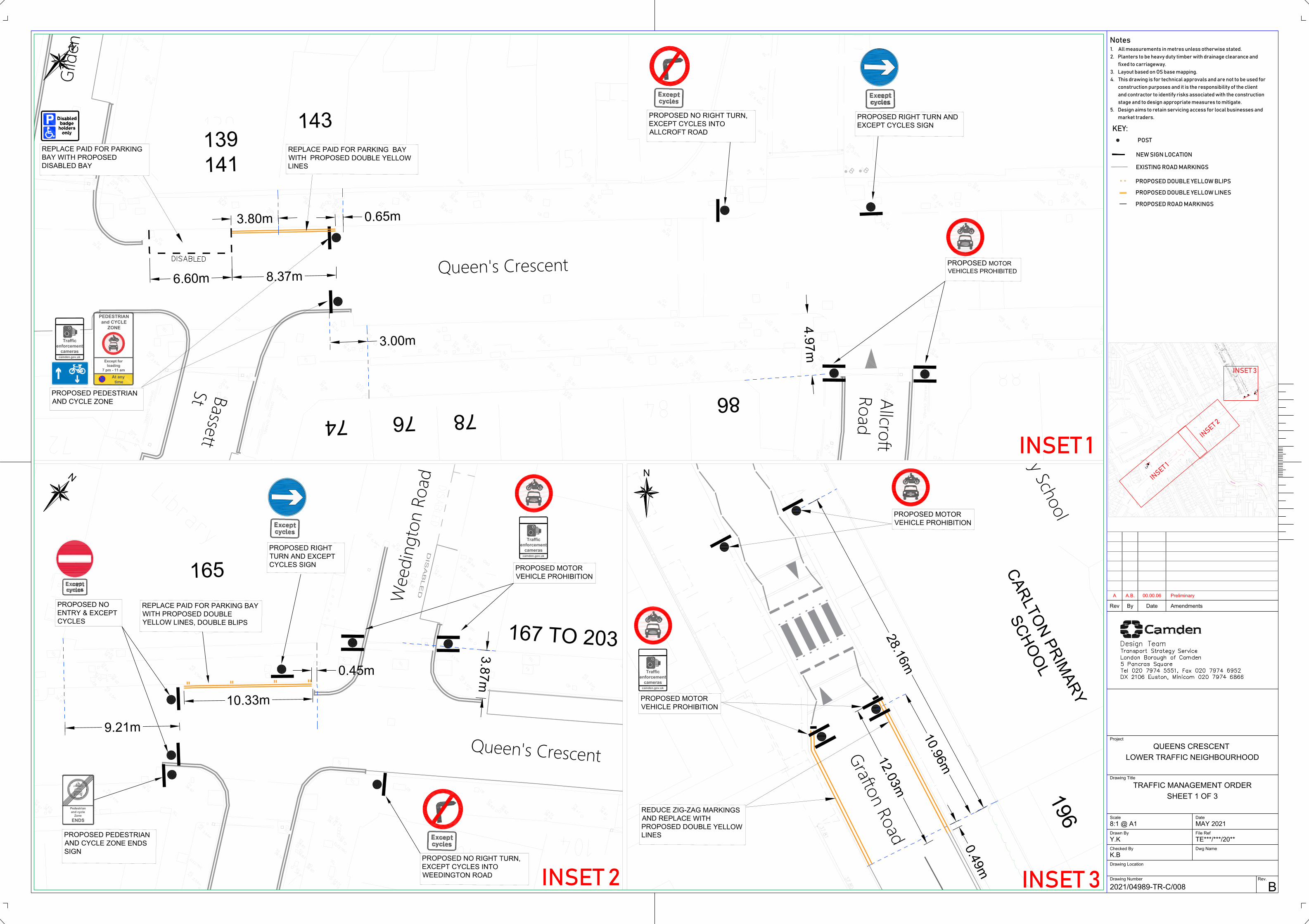
QUEEN’S CRESCENT – Motor vehicles are not permitted to enter the section of Queen’s Crescent which lies between the eastern kerb line of Bassett Street and the western kerb line of the southern arm of Weedington Road. An exemption will apply in respect of vehicles entering the restricted section in order to load / unload goods for the purposes of delivering to or collecting from premises located adjacent to this section of the road between the hours of 7pm and 11am. An exemption also in respect of vehicles requiring access to private parking places designated in Ashdown Crescent, Dial-a-Ride buses and Camden PlusBus vehicles, emergency services and council statutory services such as refuse collection. Any such exempted vehicle must proceed in this section of Queen’s Crescent in a north-eastwards direction only (cyclists are permitted to proceed in either direction). ALLCROFT ROAD – motor vehicles prohibited from entering Allcroft Road at its junction with Queen’s Crescent or to proceed from Allcroft Road into Queen’s Crescent. WEEDINGTON ROAD, northern arm – motor vehicles prohibited from entering the northern arm of Weedington Road at its junction with Queen’s Crescent or to proceed from the northern arm of Weedington Road into Queen’s Crescent. GRAFTON ROAD - motor vehicles prohibited from proceeding in a northerly direction in Grafton Road past a point which lies approximately 11 metres north-west of the north-western flank wall of no. 196 Grafton Road and from proceeding in a southerly direction past a point which lies approximately 28 metres north-west of the same wall, corresponding to points either side of the pedestrian crossing outside Carlton Primary School. Exemptions apply to emergency services, Dial-a-Ride and Camden PlusBus services and council statutory services. PROHIBITIONS ON VEHICULAR ACCESS TO QUEEN’S CRESCENT ON MARKET DAYS (THURSDAYS AND SATURDAYS)
The provisions of the Camden (Prescribed Routes) (No. 2) Traffic Order 2005 will continue to apply except that the hours during which the restriction on vehicular entry to Queen’s Crescent will be modified to apply on both Thursdays and Saturdays between 7am and 6pm (rather than until 5.30pm on Thursdays) and holders of street trading licences will no longer be permitted to access the section of the road which lies between Bassett Street and Weedington Road. CHANGES TO PARKING RESTRICTIONS
QUEEN’S CRESCENT – removal of all “paid-for” parking places situated on the north-west side between the junctions with Gilden Crescent and Weedington Road and designation of a disabled persons’ parking place outside nos. 139/141 Queen’s Crescent. Where not already in force, a 24-hour prohibition on waiting by vehicles is designated in Queen’s Crescent between its junctions with Bassett Street and Weedington Road and, opposite the junction with the south arm of Weedington Road, including for the purposes of loading. ALLCROFT ROAD – removal of the north-westernmost 12.8 metre section of the parking place outside no. 42 and 44 Allcroft Road and at the side of no. 86 Queen’s Crescent and designation of a 24-hour prohibition on waiting along the same length of the road; designation of a 6.6m long disabled persons parking place outside nos. 40 and 42 Allcroft Road; designation of a 12.7m long parking place outside nos. 36, 38 and 40 Allcroft Road for use by “CA-L” permit holders on Mondays to Fridays between 9 and 11am and also Market Traders permit holders on Thursdays and Saturdays between 8.30 and 11am
WEEDINGTON ROAD – conversion of the parking place outside nos. 129 and 129A Weedington Road to permit “paid-for” parking on Mondays, Tuesdays, Wednesdays and Fridays between 9 and 11am. GRAFTON ROAD – designation of a 24-hour prohibition on waiting outside Carlton Primary School. Further information regarding this scheme can be found at camden.gov.uk/CommentQueensCrescent The Council will be considering in due course whether the provisions of the experimental order should continue in force indefinitely. Within a period of six months beginning with the date on which this modification to the experimental order comes into force or, if the order is varied by other orders or modified pursuant to section 10 (2) of the Road Traffic Regulation Act 1984 beginning with the day on which the variation or modification or the latest variation or modification came into force, any person may object to the making of an order for the purpose of such indefinite continuation. Any such objection must be made in writing, stating the grounds on which the objection is being made and sent to [email protected] or by post to FREEPOST LBC Transport Strategy. Copies of the order and other documents relating to the order may be inspected at camden.gov.uk/recently-advertised-proposals or obtained by contacting [email protected] Peter Mardell Head of Parking Operations 20 May 2021
The Camden (Queen’s Crescent) Experimental Traffic Order 2021
STATEMENT OF REASONS
a) The section of Queen’s Crescent between the B517/Malden Road and Grafton Road is approximately 300m in length and has been identified as part of a significant east/west (and vice versa) rat-running route between Malden Road and both Kentish Town Road and Prince of Wales Road.
b) The road experiences high traffic volumes, with approximately 3,500 two-way daily motor vehicle trips per day.
c) Queen’s Crescent caters for a high volume of pedestrians, shoppers and commercial activity. Approximately 32,000 people living with a 15 minute walk (0.7 miles) of Queens Crescent. Between 2014 and 2018, a total of 12 pedestrians or cyclists were injured on Queen’s Crescent and at its junctions. Three of them suffered from serious injuries, and one person on a bike lost their life on Malden Road.
d) The Coronavirus (COVID-19) pandemic has created new road safety challenges in Camden that the Council is taking seriously and responding to rapidly. In line with National Government’s statutory, COVID-19 guidance to local authorities, the London Borough of Camden is currently putting in place measures across the Borough to make it easier and safer for people to walk and cycle locally.
e) The scheme is proposed to be implemented on a trial basis by using an Experimental Traffic Order (ETO) in order to allow the interventions to be monitored and their impact to be recorded during the experimental period. Mode share by car in Camden by Camden residents has decreased from 19% to 13% of all trips between 2011 and 2018/19 (to a point where mode share in the Borough by car is 6% lower than the inner London Borough average), with 85% of all Camden residents trips made on foot, by bike or public transport.
f) The 2011 Census has indicated that in the areas adjoining Queen’s Crescent, access to a car or van is as low as 19%, making road safety for walking and cycling crucial in the area.
g) The Council is also responding to needs in the medium-term (as lockdown eases) to constrain the expected rise in motor vehicles trips.
h) The Camden Transport Strategy (CTS) contains a road user hierarchy, which has pedestrians and cyclists at the top, recognising their vital role in a safer, cleaner, healthier Camden. Policy 1c of the CTS states that “the Council will change how road space is allocated, including reducing kerbside space for parking/loading provision, and reallocating carriageway space to active, sustainable travel modes, if necessary, to enable and encourage people to walk and cycle, to improve road safety and deliver enhancements to the public realm”. It is imperative that our streets are made as safe as possible for these vulnerable road users, both currently and as road traffic levels continue to rise as the lockdown eases. Full details of the rationale for these proposals are set out in the Covid-19 Safer Travel in Camden SMD report referenced earlier.

i) The proposal to implement a traffic free zone between Bassett Street and Weedington Road for a length of approximately 90m, would enable more space for pedestrians and cyclists and reduce traffic dominance. Pedestrians would be able to walk in the carriageway and cross over the street with ease, enabling significant benefits for older people, children and people with disabilities.
j) The proposed restrictions on Grafton Road and Weedington Road, in conjunction with the traffic free environment on Queen’s Crescent, would prevent streets such as Wellesley Road and Vicars Road from being used as an alternative rat-run route for through traffic on local streets.
k) To ensure businesses on Queen’s Crescent are still able to receive deliveries, and exemption for loading would operate within the motor traffic free environment between the hours of 7pm and 11am (Monday-Wednesday, Friday and Sunday). On Thursdays and Saturdays the loading exemption would be between 7pm and 7am. With 7am being in line with the existing market operations. Additional space for loading would also be created just outside the traffic-free area.
l) Exemptions from the restrictions will be provided for emergency service vehicles and certain accessible transport vehicles, such as the Councils Accessible Transport Plusbus door to door service will be provided.
m) In the Motor Traffic-free zone, 55m of pay by phone parking bays (Mon, Tue, Wed & Fri 9 am-11 am) would be removed; enabling the Council to work with local businesses and the community to introduce parklets, trees and seating along Queen’s Crescent. These measures reflect the priorities of the community, as discussed in the community co-design Stage 2 report.
n) The scheme is proposed to be implemented on a trial basis by using an Experimental Traffic Order (ETO) in order to allow the interventions to be monitored and their impact to be recorded during the experimental period. An ETO will enable the Council to understand the impacts of the scheme on parking pressure, traffic volumes on surrounding streets, traffic speeds, pedestrian footfall, road safety, air quality and delivery’s to local businesses. the scheme will be introduced during the present Covid-19 restrictions, and the Government has proposed a staged relaxation of the present social distancing measures, albeit that whether and when the successive relaxations will be introduced is presently uncertain. In light of this, officers consider that it is appropriate to proceed by way of experiment during a period when traffic patterns (including pedestrian footfall) on Queen’s Crescent may go through a number of fluctuations before, as it is not unreasonable to expect, a “new normal” traffic pattern eventually establishes itself.
o) An additional advantage of proceeding by way of ETO is that this allows the Council to invite and consider feedback from stakeholders and local residents and businesses during the experimental period. The experimental scheme thus provides an opportunity to ascertain the views of the community and stakeholders in relation to some key interventions, as well as piloting elements of the wider permanent public realm project to inform a more transformational final design that can be put forward for public consultation after 6 months of the trial.

p) A public consultation on the long-term future of the Queens Crescent and experimental scheme is planned for late November 2021, 6 months after launch of scheme.
q) The Council intends to consider whether to make an indefinite or “permanent” Traffic Management Order having the same effect as the Experimental Traffic Order. A decision will be made as to this by the Council’s Director of Environment and Sustainability in response to recommendations contained in an officer’s report which will consider, among other matters, the results of the public consultation referred to in paragraph (p) above and all other available relevant information including, for example, monitoring information.
B
BB
B
BB
Queen's Crescent
Gild
en C
resc
ent
B
PEDESTRIAN
and CYCLE
ZONE
Except for
loading
7 pm - 11 am
At any
time
Traffic
enforcement
cameras
camden.gov.uk
PROPOSED PEDESTRIAN
AND CYCLE ZONE
PROPOSED MOTOR
VEHICLES PROHIBITED
74
7876
3.00m
139
141
143
4.97m
86
REPLACE PAID FOR PARKING
BAY WITH PROPOSED
DISABLED BAY
REPLACE PAID FOR PARKING BAY
WITH PROPOSED DOUBLE YELLOW
LINES
3.80m
6.60m
0.65m
8.37m
Allcroft
Road
BassettSt
PROPOSED RIGHT TURN AND
EXCEPT CYCLES SIGN
PROPOSED NO RIGHT TURN,
EXCEPT CYCLES INTO
ALLCROFT ROAD
D
I
S
A
B
L
E
D
Traffic
enforcement
cameras
camden.gov.uk
PROPOSED MOTOR
VEHICLE PROHIBITION
PROPOSED NO
ENTRY & EXCEPT
CYCLES
165
9.21m
167 T
O 2
03
3.87m
REPLACE PAID FOR PARKING BAY
WITH PROPOSED DOUBLE
YELLOW LINES, DOUBLE BLIPS
10.33m
0.45m
PROPOSED RIGHT
TURN AND EXCEPT
CYCLES SIGN
Pedestrian
and cycle
Zone
ENDS
PROPOSED PEDESTRIAN
AND CYCLE ZONE ENDS
SIGN
PROPOSED NO RIGHT TURN,
EXCEPT CYCLES INTO
WEEDINGTON ROAD
Grafton Road
Carlton Primary School
Traffic
enforcement
cameras
camden.gov.uk
1
9
6
C
A
R
L
T
O
N
P
R
I
M
A
R
Y
S
C
H
O
O
L
PROPOSED MOTOR
VEHICLE PROHIBITION
PROPOSED MOTOR
VEHICLE PROHIBITION
1
0
.
9
6
m
2
8
.
1
6
m
REDUCE ZIG-ZAG MARKINGS
AND REPLACE WITH
PROPOSED DOUBLE YELLOW
LINES
0
.
4
9
m
1
2
.
0
3
m
B
B
B
B
B
B
Queen
's Cres
cent
Bassett Street
Allcr
oft R
oad
Weedington Road
Weedington Road
Grafton Road
Queen's C
rescen
t
Gild
en C
resc
ent
Mal
den
Road
Que
en's
Cres
cent
B
Queens Cresce
nt
S
P
Queens Crescent
LC
LC
B
B
KLB
KLB
KLB
KLB
Grafton Road
Carlton Primary School
G
R
A
F
T
O
N
R
O
A
D
G
R
A
F
T
O
N
R
O
A
D
Malden Road
I
N
S
E
T
1
I
N
S
E
T
2
INSET 3
1
2
.
2
5
L
P
L
P
AmendmentsRev DateBy
Project
Drawing Title
DateScale
File Ref
Dwg Name
Drawing Location
Checked By
Drawn By
Drawing Number Rev.
QUEENS CRESCENT
LOWER TRAFFIC NEIGHBOURHOOD
TRAFFIC MANAGEMENT ORDER
SHEET 1 OF 3
2021/04989-TR-C/008
B
8:1 @ A1 MAY 2021
TE***/***/20**Y.K
K.B
N
A A.B. 00.00.06 Preliminary
Notes
1. All measurements in metres unless otherwise stated.
2. Planters to be heavy duty timber with drainage clearance and
fixed to carriageway.
3. Layout based on OS base mapping.
4. This drawing is for technical approvals and are not to be used for
construction purposes and it is the responsibility of the client
and contractor to identify risks associated with the construction
stage and to design appropriate measures to mitigate.
5. Design aims to retain servicing access for local businesses and
market traders.
KEY:
N
N
PROPOSED DOUBLE YELLOW BLIPS
PROPOSED DOUBLE YELLOW LINES
PROPOSED ROAD MARKINGS
INSET 1
INSET 2INSET 3
POST
NEW SIGN LOCATION
EXISTING ROAD MARKINGS
Queen's Crescent
Wee
ding
ton
Road

Allc
roft
Road
1
2
.6
8
m
6
.6
0
m
EXISTING TIMED PERMIT HOLDER PARKING BAYS
REPLACED WITH DOUBLE YELLOW LINE
PROPOSED DISABLED PARKING BAY
INSTALLED ON LAMP COLUMN
CONVERT EXISTING
CA-L Mon - Fri 9am -11 am Permit holders only
TO
CA-L Mon - Fri 9 -11 am Permit holders only
AND
MKT Thurs & Sat 8.30 -11.00am Permit holders only
4
4
3
2
3
6
1
2
.7
9
m
2
.9
7
m
4
2
B
B
B
B
B
B
Queen
's Cres
cent
Bassett Street
Allcr
oft R
oad
Weedington Road
Weedington Road
Grafton Road
Queen's C
rescen
t
Gild
en C
resc
ent
Mal
den
Road
Que
en's
Cres
cent
B
Queens Cresce
nt
S
P
Queens Crescent
LC
LC
B
B
KLB
KLB
KLB
KLB
G
R
A
F
T
O
N
R
O
A
D
Malden Road
1
2
.
2
5
L
P
L
P
Weedington Road
CONVERT EXISTING
CA-L Mon, Tues, Wed & Fri 9am -11 am Permit holders only
AND
MKT Thurs & Sat 8.30 -11.00am Permit holders only
TO
Mon, Tues, Wed & Fri 9am-11am Permit Holders or Pay by
Phone 02030032532 quoting location XXXX
Max stay 1 hour
AND
MKT Thurs & Sat 8.30 -11.00am Permit holders only
1
2
9
1
2
9
A
1
.3
6
m
2
0
.3
7
m
AmendmentsRev DateBy
Project
Drawing Title
DateScale
File Ref
Dwg Name
Drawing Location
Checked By
Drawn By
Drawing Number Rev.
QUEENS CRESCENT
LOWER TRAFFIC NEIGHBOURHOOD
TRAFFIC MANAGEMENT ORDER
SHEET 2 OF 3
2021/04989-TR-C/009
B
8:1 @ A1 MAY 2021
Y.K
K.B
N
A A.B. 00.00.06 Preliminary
Notes
1. All measurements in metres unless otherwise stated.
2. Planters to be heavy duty timber with drainage clearance and
fixed to carriageway.
3. Layout based on OS base mapping.
4. This drawing is for technical approvals and are not to be used for
construction purposes and it is the responsibility of the client
and contractor to identify risks associated with the construction
stage and to design appropriate measures to mitigate.
5. Design aims to retain servicing access for local businesses and
market traders.
INSET 4
N
INSET 5
I
N
S
E
T
4
I
N
S
E
T
5
KEY:
PROPOSED DOUBLE YELLOW BLIPS
PROPOSED DOUBLE YELLOW LINES
PROPOSED ROAD MARKINGS
POST
NEW SIGN LOCATION
EXISTING ROAD MARKINGS

B
BB
B
BB
Queen's Crescent
Bassett Street Allc
roft
Road
Weedington Road
Weedington Road
Queen's Crescent
Gild
en C
resc
ent
Mal
den
Road
Queen's Crescent
SP
L
C
B
Malden Road
1
1
0
PEDESTRIAN
ZONE
No Vehicles
Thurs & Sat
7 am - 6 pm
REMOVE EXISTING VEHICLE
PROHIBITION SIGN AND TEXT FROM
EXISTING QUEENS CRESCENT
GANTRY AND REPLACE WITH
PEDESTRIAN ZONE SIGN WITH
PROPOSED TIMES
1
.8
5
m
PEDESTRIAN
ZONE
No Vehicles
Thurs & Sat
7 am - 6 pm
REMOVE EXISTING VEHICLE
PROHIBITION SIGN AND TEXT FROM
EXISTING POST AND REPLACE
WITH PEDESTRIAN ZONE SIGN
WITH PROPOSED TIMES
139
141
0.70m
PEDESTRIAN
ZONE
No Vehicles
Thurs & Sat
7 am - 6 pm
REMOVE EXISTING VEHICLE
PROHIBITION SIGN AND TEXT FROM
EXISTING POST AND REPLACE
WITH PEDESTRIAN ZONE SIGN
WITH PROPOSED TIMES
72
3.76m
PROPOSED PEDESTRIAN
ZONE END SIGNS
143
PEDESTRIAN
ZONE
No Vehicles
Thurs & Sat
7 am - 6 pm
PROPOSED PEDESTRIAN ZONE
SIGN WITH PROPOSED TIMES
4
4
6
.7
8
m
REMOVED EXISTING
VEHICLE PROHIBITION SIGN
PEDESTRIAN
ZONE
No Vehicles
Thurs & Sat
7 am - 6 pm
REMOVE EXISTING VEHICLE
PROHIBITION SIGN AND TEXT FROM
EXISTING POST AND REPLACE
WITH PEDESTRIAN ZONE SIGN
WITH PROPOSED TIMES
0.29m
100
PEDESTRIAN
ZONE
No Vehicles
Thurs & Sat
7 am - 6 pm
REMOVE EXISTING VEHICLE
PROHIBITION SIGN AND TEXT FROM
EXISTING POST AND REPLACE
WITH PEDESTRIAN ZONE SIGN
WITH PROPOSED TIMES
1
0
4
23.84m
B
B
B
B
B
B
Queen
's Cres
cent
Bassett Street
Allcr
oft R
oad
Weedington Road
Weedington Road
Grafton Road
Queen's C
rescen
t
Gild
en C
resc
ent
Mal
den
Road
Que
en's
Cres
cent
B
Queens Cresce
nt
S
P
Queens Crescent
LC
LC
B
B
KLB
KLB
KLB
KLB
Grafton Road
Carlton Primary School
G
R
A
F
T
O
N
R
O
A
D
G
R
A
F
T
O
N
R
O
A
D
Malden Road
1
2
.
2
5
L
P
L
P
AmendmentsRev DateBy
Project
Drawing Title
DateScale
File Ref
Dwg Name
Drawing Location
Checked By
Drawn By
Drawing Number Rev.
QUEENS CRESCENT
LOWER TRAFFIC NEIGHBOURHOOD
TRAFFIC MANAGEMENT ORDER
SHEET 3 OF 3
2021/04989-TR-C/010
B
NTS MAY 2021
TE***/***/20**Y.K
K.B
N
A A.B. 00.00.06 Preliminary
Notes
1. All measurements in metres unless otherwise stated.
2. Planters to be heavy duty timber with drainage clearance and
fixed to carriageway.
3. Layout based on OS base mapping.
4. This drawing is for technical approvals and are not to be used for
construction purposes and it is the responsibility of the client
and contractor to identify risks associated with the construction
stage and to design appropriate measures to mitigate.
5. Design aims to retain servicing access for local businesses and
market traders.
KEY:
PROPOSED DOUBLE YELLOW BLIPS
PROPOSED DOUBLE YELLOW LINES
PROPOSED ROAD MARKINGS
INSET 1
POST
SIGN LOCATION
EXISTING ROAD MARKINGS
I
N
S
E
T
1

The Camden (Queen’s Crescent) Experimental Traffic Order 2021 2021 No. 31
Fees and Charges (2014/
2020 No. 31 - ARTICLES
1
LONDON BOROUGH OF CAMDEN
TRAFFIC MANAGEMENT ORDER
2021 No. 31
The Camden (Queen’s Crescent) Experimental Traffic Order 2021
Made on 17 May 2021 Coming into force on 27 May 2021 ________________________________________________________________________ The Council of the London Borough of Camden, after consulting the Commissioner of Police of the Metropolis, in exercise of the powers conferred by section 9 of Road Traffic Regulation Act 1984 [1984 c. 27], and of all other powers thereunto enabling, hereby make the following order: 1. Citation and commencement 1.1 This order shall come into force on 27 May 2021 and may be cited as the Camden
(Queen’s Crescent) Experimental Traffic Order 2021. 2. Interpretation
2.1 In this order the following terms have the meanings respectively ascribed to them;
"pedal cycle" has the same meaning as ascribed to it by the Traffic Signs Regulations and General Directions 2016 [S. I. 2016 No. 362]; “Dial-a-Ride or PlusBus vehicle” means a vehicle operated by Transport for London’s Dial-a-Ride service or the London Borough of Camden’s PlusBus service and which is solely used to provide one of those services; “electronic communications network” has the same meaning as in the Communications Act 2003 [2003 c.21]; "goods" means goods of any kind whether animate or inanimate and includes postal packets of any description; and "delivering" and "collecting", in relation to any goods, includes checking the goods for the purpose of their delivery or collection;
3. Restrictions on vehicle movements and exemptions to restrictions
3.1 No person shall cause any vehicle to enter that section of Queen’s Crescent which
lies between the north-western kerb line of Bassett Street and the south-western kerb line of the southern arm of Weedington Road.
3.2 Nothing in Article 3.1 shall apply in respect of a pedal cycle.

2020 No. 31 - ARTICLES
2
3.3 Nothing in Article 3.1 shall apply in respect of; 3.3.1 a vehicle being used to deliver goods to or to collect goods from premises adjacent
to that section of Queen’s Crescent on any day before 11am or after 7pm and which is caused to enter that section of the road for the purposes of loading or unloading those goods to or from the vehicle;
3.3.2 a vehicle being used for fire brigade, ambulance or police purposes; 3.3.3 a Dial-a-Ride or PlusBus vehicle; 3.3.4 a vehicle for which a parking space in Ashdown Crescent has been provided and
which is being caused to proceed to or from that parking space, or a vehicle operated by the Queen’s Crescent Community Centre;
3.3.5 a vehicle being used by or on behalf of the council for the collection of refuse or in
the pursuance of statutory powers or duties; 3.3.6 a vehicle being used in connection with the removal of any obstruction to traffic
within that section of Queen’s Crescent; 3.3.7 a vehicle being used in connection with the laying, maintenance or repair of any
mains or apparatus for the supply of gas, electricity, water or electronic communications network provided that, in all the circumstances, the work cannot reasonably be carried out without the vehicle entering that section of Queen’s Crescent.
3.4 Any vehicle, having entered and being caused to proceed in the section of Queen’s
Crescent described in Article 3.1, and which is being used for any of the purposes set out in Article 3.3 shall proceed in a north-easterly direction only.
3.5 No person shall cause any vehicle to enter Allcroft Road at its junction with Queen’s
Crescent. 3.6 No person shall cause any vehicle to enter Queen’s Crescent at its junction with
Allcroft Road. 3.7 No person shall cause any vehicle to enter the northern arm of Weedington Road at
its junction with Queen’s Crescent. 3.8 No person shall cause any vehicle to enter Queen’s Crescent at its junction with the
northern arm of Weedington Road. 3.9 Nothing in Articles 3.5 to 3.8 shall apply in respect of; 3.9.1 a vehicle being used for fire brigade, ambulance or police purposes; 3.9.2 a pedal cycle on Mondays, Tuesdays, Wednesdays, Fridays and Sundays and on
Thursdays and Saturdays before 7am and after 6pm.

2020 No. 31 - ARTICLES
3
3.10 No person shall cause any vehicle to enter the section of Grafton Road which lies between a point 11 metres north-west of the north-western flank wall of no. 196 Grafton Road and a point 28.15 metres north-west of the same flank wall.
3.11 Nothing in Article 3.10 shall apply in respect of; 3.11.1 a pedal cycle; 3.11.2 a vehicle being used for fire brigade, ambulance or police purposes; 3.11.3 a Dial-a-Ride or PlusBus vehicle; 3.11.4 a vehicle being used by or on behalf of the council in the pursuance of statutory
duties; 3.11.5 a vehicle being used in connection with the removal of any obstruction to traffic
within that section of the road; 3.11.6 a vehicle being used in connection with the laying, maintenance or repair of any
mains or apparatus for the supply of gas, electricity, water or electronic communications network provided that, in all the circumstances, the work cannot reasonably be carried out without the vehicle entering that section of the road.
4. Revocation and designation of parking places 4.1 Nothing in this article shall prejudice the validity of anything done or any liability
incurred in respect of any act or omission before the coming into force of this order. 4.2 The Camden (Parking Places) (CA-L) Traffic Order 2012 [L.B.C. 2012 No. 11] shall
have effect as though;
4.2.1 there were omitted from schedule 1 to that order, the items set out in table 1 of the schedule to this order;
4.2.2 there were included in schedule 1 to that order, the items set out in table 2 of the
schedule to this order; 4.2.3 there were omitted from schedule 2 to that order, the items set out in table 3 of the
schedule to this order; 4.2.4 there were included in schedule 3 to that order, the items set out in table 4 of the
schedule to this order; 4.3 The Camden (Parking Places) (Queen’s Crescent Market) Traffic Order 2012
[L.B.C. 2012 No. 78] shall have effect as though; 4.3.1 there were omitted from the schedule to that order, the items set out in table 5 of
the schedule to this order; 4.3.2 there were3 included in the schedule to that order, the items set out in table 6 of the
schedule to this order.

2020 No. 31 - ARTICLES
4
4.4 The Camden (Free Parking Places) (Disabled Persons) Traffic Order 2012 [L.B.C. 2012 No. 22] shall have effect as though there were included in the schedule to that order, the items set out in table 7 of the schedule to this order.
5. Designation of waiting and loading restrictions
5.1 Without prejudice to the validity of anything done or to any liability incurred in respect of any act or omission before the coming into force of this order, the Camden (Waiting and Loading Restrictions) (Civil Enforcement Area) Traffic Order 2012 [L.B.C. 2012 No. 1] shall have effect as though;
5.1.1 there was substituted for items in relation to the similarly named streets set out in
schedule 1 to that order, the items set out in table 8 of the schedule to this order 5.1.2 there was included, or substituted for items set out in relation to similarly named
streets, in schedule 2 to that order, the items set out in table 9 of the schedule to this order;
5.1.3 there was included in schedule 3 to that order, the items set out in table 10 of the
schedule to this order. 6. MODIFICATION TO THE CAMDEN (PRESCRIBED ROUTE) (No. 2) TRAFFIC
ORDER 20025 6.1 The Camden (Prescribed Route) (No. 2) Traffic Order 2005 [L.B.C. 2005 No. 9]
shall have effect as though there were substituted for Articles 4 and 5 of that order, the similarly numbered articles set out below;
4. No person shall cause any vehicle to enter or proceed in those parts of
Queen’s Crescent which lie between the western kerb line of Grafton Road and the eastern kerb line of the southern arm of Weedington Road and between the eastern kerb line of Malden Road and the eastern kerb line of Bassett Street in the London Borough of Camden between the hours of 7am and 6pm on Thursdays and Saturdays.
5. No person shall cause any vehicle to enter those parts of Queen’s Crescent
which lie between the western kerb line of Grafton Road and the eastern kerb line of the southern arm of Weedington Road and between the eastern kerb line of Malden Road and the eastern kerb line of Bassett Street at the junctions with Weedington Road, Bassett Street or Gilden Crescent between the hours of 7am and 6pm on Thursdays and Saturdays.

2020 No. 31 - ARTICLES
5
7. Power to modify or suspend provisions of this order 7.1 Pursuant to Section 10 (2) of the Act of 1984, the Director of Regeneration &
Planning, Supporting Communities Directorate, or any person authorised by him may, if it appears to him or such other authorised person essential in the interest of the expeditious, convenient and safe movement of traffic, or in the provision of suitable and adequate parking, or for preserving or improving the amenities of the area through which any road affected by this order runs, modify or suspend this order or any of the provisions in this order.
Dated this 17 May 2021
Peter Mardell Head of Parking Operations

2021 No. 31 - SCHEDULE 1
TABLE 1 – ITEMS OMITTED FROM SCHEDULE 1 TO THE CAMDEN (PARKING PLACES) (CA-L) TRAFFIC ORDER 2012
ITEM NUMBER
STREET LENGTH OF HIGHWAY CONTROLLED
HOURS
12592 ALLCROFT ROAD west side: from the northern boundary of no. 44 Allcroft Road, southwards for a distance of 26 metres
MONDAY – FRIDAY 9-11AM
4361 ALLCROFT ROAD west side: from a point 20 metres south of the northern boundary wall of no. 44 Allcroft Road, southwards for a distance of 120 metres
MONDAY – FRIDAY 9-11AM
7775 WEEDINGTON
ROAD west side: from a point 24 metres south of the southern kerb line of Queen’s Crescent, southwards for a distance of 20 metres
MONDAY – FRIDAY 9-11AM
TABLE 2 – ITEMS INCLUDED IN SCHEDULE 1 TO THE CAMDEN (PARKING PLACES) (CA-L) TRAFFIC ORDER 2012
ITEM NUMBER
STREET LENGTH OF HIGHWAY CONTROLLED
HOURS
13844 ALLCROFT ROAD south-west side: from the party wall of nos. 34 and 36 Allcroft Road, north-westwards for a distance of 12.7 metres
MONDAY – FRIDAY 9-11AM
13845 ALLCROFT ROAD south-west side: from the party wall of nos. 34 and 36 Allcroft Road, south-eastwards for a distance of 116 metres
MONDAY – FRIDAY 9-11AM
2021 No. 31 - SCHEDULE 2
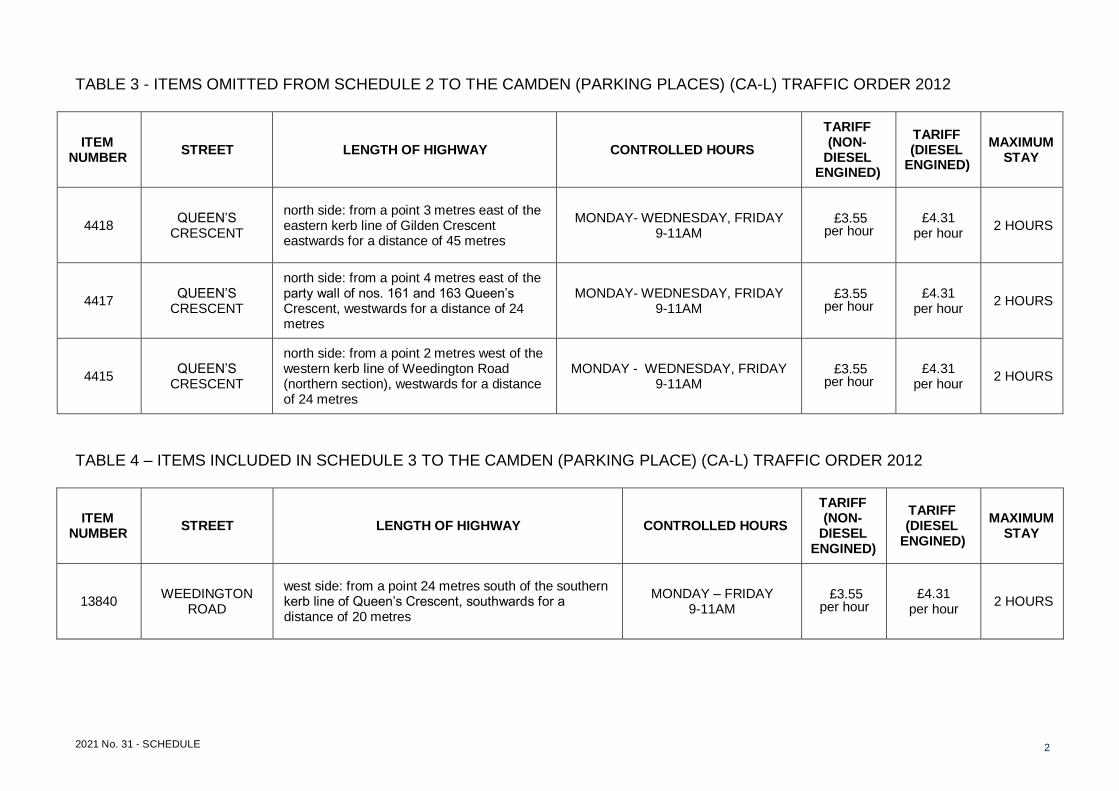
TABLE 3 - ITEMS OMITTED FROM SCHEDULE 2 TO THE CAMDEN (PARKING PLACES) (CA-L) TRAFFIC ORDER 2012
ITEM NUMBER
STREET LENGTH OF HIGHWAY CONTROLLED HOURS
TARIFF (NON-
DIESEL ENGINED)
TARIFF (DIESEL
ENGINED)
MAXIMUM STAY
4418 QUEEN’S
CRESCENT
north side: from a point 3 metres east of the eastern kerb line of Gilden Crescent eastwards for a distance of 45 metres
MONDAY- WEDNESDAY, FRIDAY 9-11AM
£3.55 per hour
£4.31 per hour
2 HOURS
4417 QUEEN’S
CRESCENT
north side: from a point 4 metres east of the party wall of nos. 161 and 163 Queen’s Crescent, westwards for a distance of 24 metres
MONDAY- WEDNESDAY, FRIDAY 9-11AM
£3.55 per hour
£4.31 per hour
2 HOURS
4415 QUEEN’S
CRESCENT
north side: from a point 2 metres west of the western kerb line of Weedington Road (northern section), westwards for a distance of 24 metres
MONDAY - WEDNESDAY, FRIDAY 9-11AM
£3.55 per hour
£4.31 per hour
2 HOURS
TABLE 4 – ITEMS INCLUDED IN SCHEDULE 3 TO THE CAMDEN (PARKING PLACE) (CA-L) TRAFFIC ORDER 2012
ITEM NUMBER
STREET LENGTH OF HIGHWAY CONTROLLED HOURS
TARIFF (NON-
DIESEL ENGINED)
TARIFF (DIESEL
ENGINED)
MAXIMUM STAY
13840 WEEDINGTON
ROAD
west side: from a point 24 metres south of the southern kerb line of Queen’s Crescent, southwards for a distance of 20 metres
MONDAY – FRIDAY 9-11AM
£3.55 per hour
£4.31 per hour
2 HOURS
2021 No. 31 - SCHEDULE 3
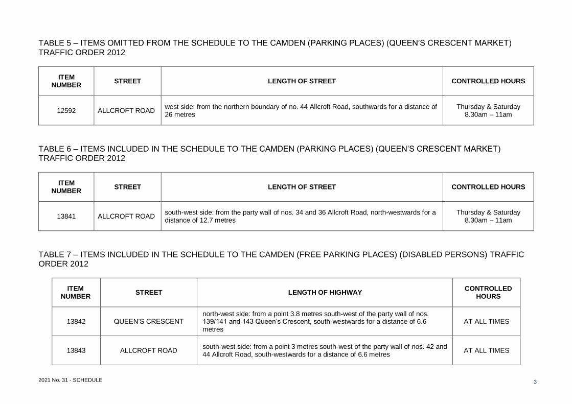
TABLE 5 – ITEMS OMITTED FROM THE SCHEDULE TO THE CAMDEN (PARKING PLACES) (QUEEN’S CRESCENT MARKET) TRAFFIC ORDER 2012
ITEM NUMBER
STREET LENGTH OF STREET CONTROLLED HOURS
12592 ALLCROFT ROAD west side: from the northern boundary of no. 44 Allcroft Road, southwards for a distance of 26 metres
Thursday & Saturday 8.30am – 11am
TABLE 6 – ITEMS INCLUDED IN THE SCHEDULE TO THE CAMDEN (PARKING PLACES) (QUEEN’S CRESCENT MARKET) TRAFFIC ORDER 2012
ITEM NUMBER
STREET LENGTH OF STREET CONTROLLED HOURS
13841 ALLCROFT ROAD south-west side: from the party wall of nos. 34 and 36 Allcroft Road, north-westwards for a distance of 12.7 metres
Thursday & Saturday 8.30am – 11am
TABLE 7 – ITEMS INCLUDED IN THE SCHEDULE TO THE CAMDEN (FREE PARKING PLACES) (DISABLED PERSONS) TRAFFIC ORDER 2012
ITEM NUMBER
STREET LENGTH OF HIGHWAY CONTROLLED
HOURS
13842 QUEEN’S CRESCENT north-west side: from a point 3.8 metres south-west of the party wall of nos. 139/141 and 143 Queen’s Crescent, south-westwards for a distance of 6.6 metres
AT ALL TIMES
13843 ALLCROFT ROAD south-west side: from a point 3 metres south-west of the party wall of nos. 42 and 44 Allcroft Road, south-westwards for a distance of 6.6 metres
AT ALL TIMES

2021 No. 31 - SCHEDULE 4
TABLE 8 – ITEMS SUBSTITUTED FOR ITEMS SET OUT IN RELATION TO SIMILARLY NAMED STREETS IN SCHEDULE 1 TO THE CAMDEN (WAITING AND LOADING RESTRICTIONS) (CIVIL ENFORCEMENT AREA) TRAFFIC ORDER 2012
ITEM NUMBER
STREET, SIDE OF STREET and LENGTH OF HIGHWAY
PRESCRIBED HOURS
(see Schedule 3)
389 GRAFTON ROAD
(a) east side:
(i) between its junction with Prince of Wales Road, and a point 67.0 metres north of that point A
(ii) between a point 67.0 metres north of its junction with Prince of Wales Road and a point 7.5 metres south-east of the south-eastern kerb line of Inkerman Road
B
(iii) between a point 7.5 metres south-east of the south-eastern kerb line of Inkerman Road and a point 26 metres north-west of the north-western kerb line of Inkerman Road
A
(iv) between a point 26 metres north-west of the north-western kerb line of Inkerman Road and a point 20 metres south-east of the south-eastern kerb line of Athlone Street
B
(v) between a point 20 metres south-east of the south-eastern kerb line of Athlone Street and a point 5.7 metres north-west of the north-western kerb line of Athlone Street
A
(vi) between a point 5.7 metres north-west of the north-western kerb line of Athlone Street and a point 19 metres south-east of a point level with the southern kerb line of Warden Road
B
(vii) between a point 19 metres south-east of a point level with the southern kerb line of Warden Road and a point 3 metres south-east of that kerb line
A
(viii) between a point 3 metres south-east of the southern kerb line of Warden Road and a point 9.3 metres south-east of the south-eastern kerb line of Queen’s Crescent
2A
(ix) between a point 9.3 metres south-east of the south-eastern kerb line of Queen’s Crescent and the south-eastern boundary wall of no. 198 Grafton Road
A
(x) between the south-eastern boundary wall of no.198 Grafton Road and a point 8 metres south-east of the south-eastern kerb line of Cressfield Close
2A
(xi) between a point 8 metres south-east of the south-eastern kerb line of Cressfield Close and a point 5 metres north-west of the north-western kerb line of Cressfield Close
A

2021 No. 31 - SCHEDULE 5
(xii) between a point 5 metres north-west of the north-western kerb line of Cressfield Close and a point 3.5 metres south-east of the south-eastern kerb line of Dale Road
2A
(xiii) between a point 3.5 metres south-east of the south-eastern kerb line of Dale Road and a point 67 metres south of the southern kerb line of Lamble Street
A
(xiv) between a point 67 metres south of the southern kerb line of Lamble Street and a point 40 metres south of its junction with Lamble Street
B
(xv) between its junction with Lamble Street, and a point 40 metres south of that junction A
(b) west side:
(i) between its junction with Prince of Wales Road and a point 36 metres north of that point A
(ii) between a point 36.0 metres north of the junction with Prince of Wales Road and a point 75 metres south-east of the south-eastern kerb line of Ryland Road
B
(iii) between a point 75 metres south-east of the south-eastern kerb line of Ryland Road and a point 37 metres south-east of the south-eastern kerb line of Ryland Road
A
(iv) between a point 37 metres south-east of the south-eastern kerb line of Ryland Road and a point 5 metres south of the south-eastern kerb line of Ryland Road
B
(v) between a point 5 metres south of the south-eastern kerb line of Ryland Road and a point 5 metres north of the north-western kerb line of Ryland Road
A
(vi) between a point 5.0 metres north of the north-western kerb line of Ryland Road and a point 5.0 metres south of the south-eastern kerb line of Wilkin Street
B
(vii) between a point 5 metres south the south-eastern kerb line of Wilkin Street and a point 5 metres north-west of the north-western kerb line of Wilkin Street
A
(viii) between a point 5 metres north the north-western kerb line of Wilkin Street and a point 21 metres south-east of the south-eastern kerb line of Athlone Street
B
(ix) between a point 23 metres south-east of the south-eastern kerb line of Athlone Street and a point 15 metres north of northern kerb line of Warden Road
A
(x) between a point 15 metres north of the northern kerb line of Warden Road and a point 55 metres south-east of a point opposite the party wall of nos. 166 and 168 Grafton Road
2A
(xi) ween a point 55 metres south-east of a point opposite the party wall of nos. 166 and 168 Grafton Road, and a point 39 metres south-east of that point
A

2021 No. 31 - SCHEDULE 6
(xii) between a point 39 metres south-east of a point opposite the party wall of nos. 166 and 168 Grafton Road and a point 8.5 metres south-east of the south-eastern kerb line of Queen’s Crescent
2A
(xiii) between a point 8.5 metres south-east of the south-eastern kerb line of Queen’s Crescent and a point 9.2 metres north-west of the north-western kerb line of Queen’s Crescent
A
(xiv) between a point 9.2 metres north-west of the north-western kerb line of Queen’s Crescent and a point opposite the north-western flank wall of no. 196 Grafton Road
2A
(xv) from a point opposite the north-western flank wall of no. 196 Grafton Road to a point opposite the party wall of nos. 202 and 204 Grafton Road
A
(xvi) from a point opposite the party wall of nos. 202 and 204 Grafton Road to a point 3 metres north of a point opposite the party wall of nos. 236 and 238 Grafton Road
2A
(xvii) between a point 3 metres north of a point opposite the party wall of nos. 236 and 238 Grafton Road and a point 72 metres north of the northern kerb line of Vicar’s Road
A
(xviii) between a point 72 metres north of the northern kerb line of Vicar’s Road and a point 20 metres south of its junction with Lamble Street
B
(xix) between its junction with Lamble Street and a point 20 metres south of that junction A
775 QUEEN’S CRESCENT
(a) north-west and north sides:
(i) from the southernmost extremity of Queen’s Crescent to a point 25.4 metres south of the northern flank wall of nos. 17-30 Silverbirch Walk
A
(ii) from a point 25.4 metres south of the northern flank wall of nos. 17-30 Silverbirch Walk to a point 5 metres south of the southern kerb line of Modbury Gardens
B
(iii) from a point 5 metres south of the southern kerb line to a point 5 metres north of the northern kerb line of Modbury Gardens A
(iv) from a point 5 metres north of the northern kerb line of Modbury Gardens northward for a distance of 45 metres B
(v) from a point 5 metres south of the southern kerb line of St. Ann's Gardens to a point 2 metres north of the northern kerb line A
2021 No. 31 - SCHEDULE 7
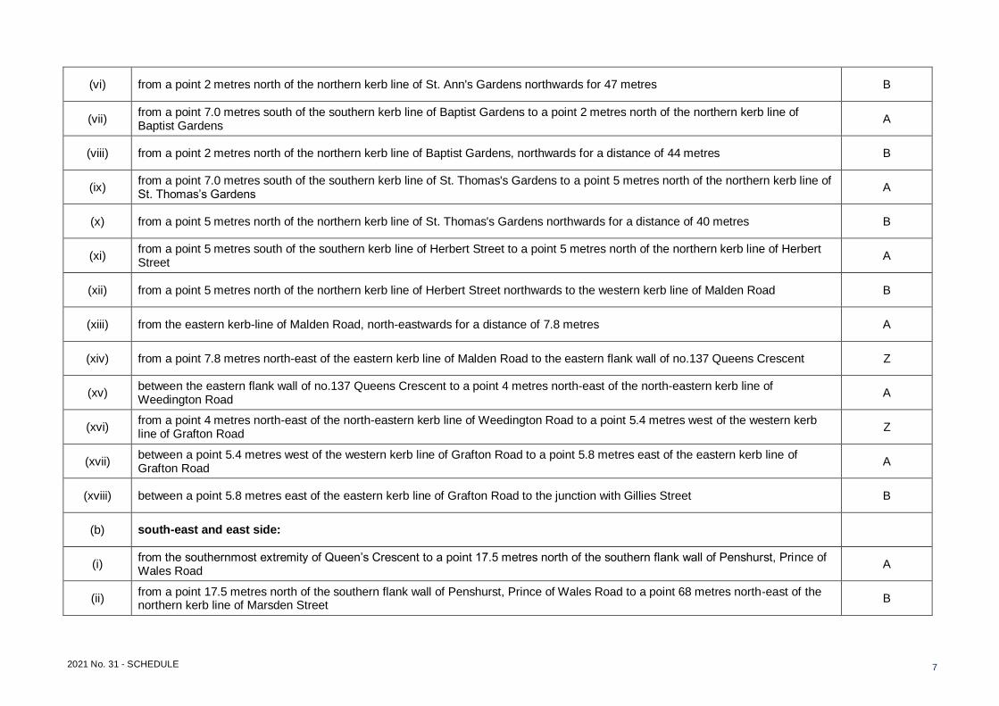
(vi) from a point 2 metres north of the northern kerb line of St. Ann's Gardens northwards for 47 metres B
(vii) from a point 7.0 metres south of the southern kerb line of Baptist Gardens to a point 2 metres north of the northern kerb line of Baptist Gardens
A
(viii) from a point 2 metres north of the northern kerb line of Baptist Gardens, northwards for a distance of 44 metres B
(ix) from a point 7.0 metres south of the southern kerb line of St. Thomas's Gardens to a point 5 metres north of the northern kerb line of St. Thomas’s Gardens
A
(x) from a point 5 metres north of the northern kerb line of St. Thomas's Gardens northwards for a distance of 40 metres B
(xi) from a point 5 metres south of the southern kerb line of Herbert Street to a point 5 metres north of the northern kerb line of Herbert Street
A
(xii) from a point 5 metres north of the northern kerb line of Herbert Street northwards to the western kerb line of Malden Road B
(xiii) from the eastern kerb-line of Malden Road, north-eastwards for a distance of 7.8 metres A
(xiv) from a point 7.8 metres north-east of the eastern kerb line of Malden Road to the eastern flank wall of no.137 Queens Crescent Z
(xv) between the eastern flank wall of no.137 Queens Crescent to a point 4 metres north-east of the north-eastern kerb line of Weedington Road
A
(xvi) from a point 4 metres north-east of the north-eastern kerb line of Weedington Road to a point 5.4 metres west of the western kerb line of Grafton Road
Z
(xvii) between a point 5.4 metres west of the western kerb line of Grafton Road to a point 5.8 metres east of the eastern kerb line of Grafton Road
A
(xviii) between a point 5.8 metres east of the eastern kerb line of Grafton Road to the junction with Gillies Street B
(b) south-east and east side:
(i) from the southernmost extremity of Queen’s Crescent to a point 17.5 metres north of the southern flank wall of Penshurst, Prince of Wales Road
A
(ii) from a point 17.5 metres north of the southern flank wall of Penshurst, Prince of Wales Road to a point 68 metres north-east of the northern kerb line of Marsden Street
B
2021 No. 31 - SCHEDULE 8
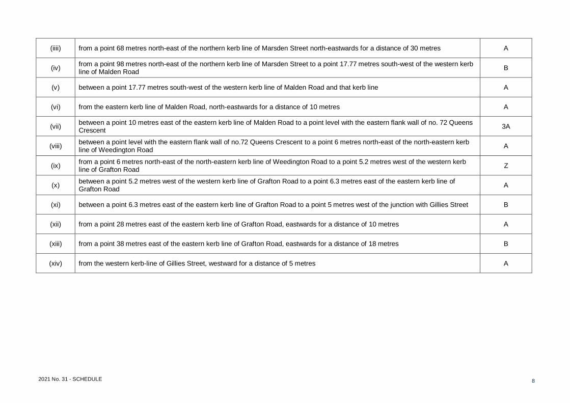
(iiii) from a point 68 metres north-east of the northern kerb line of Marsden Street north-eastwards for a distance of 30 metres A
(iv) from a point 98 metres north-east of the northern kerb line of Marsden Street to a point 17.77 metres south-west of the western kerb line of Malden Road
B
(v) between a point 17.77 metres south-west of the western kerb line of Malden Road and that kerb line A
(vi) from the eastern kerb line of Malden Road, north-eastwards for a distance of 10 metres A
(vii) between a point 10 metres east of the eastern kerb line of Malden Road to a point level with the eastern flank wall of no. 72 Queens Crescent
3A
(viii) between a point level with the eastern flank wall of no.72 Queens Crescent to a point 6 metres north-east of the north-eastern kerb line of Weedington Road
A
(ix) from a point 6 metres north-east of the north-eastern kerb line of Weedington Road to a point 5.2 metres west of the western kerb line of Grafton Road
Z
(x) between a point 5.2 metres west of the western kerb line of Grafton Road to a point 6.3 metres east of the eastern kerb line of Grafton Road
A
(xi) between a point 6.3 metres east of the eastern kerb line of Grafton Road to a point 5 metres west of the junction with Gillies Street B
(xii) from a point 28 metres east of the eastern kerb line of Grafton Road, eastwards for a distance of 10 metres A
(xiii) from a point 38 metres east of the eastern kerb line of Grafton Road, eastwards for a distance of 18 metres B
(xiv) from the western kerb-line of Gillies Street, westward for a distance of 5 metres A

2021 No. 31 - SCHEDULE 9
TABLE 9 – ITEMS INCLUDED, OR SUBSTITUTED FOR ITEMS SET OUT IN RELATION TO SIMILARLY NAMED STREETS, IN SCHEDULE 2 TO THE CAMDEN (WAITING AND LOADING RESTRICTIONS) (CIVIL ENFORCEMENT AREA) TRAFFIC ORDER 2012
ITEM NUMBER
STREET, SIDE OF STREET and LENGTH OF HIGHWAY
PRESCRIBED HOURS
(see Schedule 3)
QUEEN’S CRESCENT
(a) both sides: from the eastern kerb line of Bassett Street to a point 22 metres west of the western kerb line of Weedington Road 80
(b) north side: from the western kerb line of Weedington Road, westwards for a distance of 22 metres 1
TABLE 10 – ITEMS INCLUDED IN SCHEDULE 3 TO THE CAMDEN (WAITING AND LOADING RESTRICTIONS) (CIVIL ENFORCEMENT AREA) TRAFFIC ORDER 2012 Column 1
Prescribed hours
(Schedule 1)
Column 2; Day(s) and time(s) during which restriction applies
Column 3 Restricted
hours (Schedule 2)
4B EACH DAY 7PM – MIDNIGHT; MIDNIGHT – 11AM 80


![The Camden Chronicle (Camden, S.C.). 1902-05-16 [p ]](https://cdn.vdocument.in/doc/165x107/629de903deda946b42048dc1/the-camden-chronicle-camden-sc-1902-05-16-p-.jpg)
