
20 OCTOBER 2006 VOL 314 SCIENCE www.sciencemag.org406
NEWSFOCUS
Indonesia’s major earthquake last year tilted Nias
Island like a seesaw, disrupting villagers’ lives and
pointing to future dangers
NIAS, INDONESIA—Jolted awake late in the
night of 28 March 2005, Ahmad Chatib
staggered outdoors to find fissures in the
ground snaking from the beach up to his
wooden house. He and others in Tagaulei, a
seaside village on Nias Island off Sumatra’s
west coast, didn’t hesitate. “We took our
children and ran,” says Chatib, a former vil-
lage head. Fresh in memory was
the tsunami that 3 months earlier
had claimed more than 160,000
lives in Sumatra’s Aceh Prov-
ince, 500 kilometers to the north.
Of Tagaulei’s couple of hundred
residents, all but four—two
mothers with infants who moved
too slowly—escaped. Within an
hour, most homes had been
swallowed by the sea.
It wasn’t a tsunami that wiped
Tagaulei off the map but subsi-
dence caused by a rupture of the
Sunda megathrust, the subduc-
tion zone that parallels Sumatra’s
west coast, 25 kilometers below
the village. The great 2005 Nias-
Simeulue fault break, which
generated an earthquake with a
magnitude of 8.7, instantly
yanked down Nias’s southeast shore some
30 centimeters. The earthquake’s sustained
shaking then made vast stretches of beach
liquefy and spread, lowering the coast by
another meter or more in places and leading
to the inundation of buildings during high
tide. Erosion since the quake has erased most
vestiges of the once-picturesque village. On
Nias and nearby islands, “places with minor
subsidence are being massively rearranged,”
says Richard Briggs, a geologist at the Cali-
fornia Institute of Technology in Pasadena
and member of a Caltech–Indonesian Insti-
tute of Sciences (LIPI) team that has spent a
decade probing the region’s tectonics.
While the quake lowered southeast Nias,
it lifted parts of the island’s
northwest coast nearly 3 meters,
thrusting coral reefs into the air
and extending the shoreline by
hundreds of meters in places.
Although such upheavals go hand
in hand with a major earthquake of
this kind, the Caltech-LIPI team,
led by paleoseismologist Kerry
Sieh, has used painstaking geo-
detic measurements to put together
one of the finest-grained maps of
seismic deformation. The portrait
of Nias reveals in unprecedented
detail how subsidence and uplift
can utterly remake a landscape.
“The ecological changes are pro-
found,” Briggs says.
The severe warping of Nias
offers an unsettling preview of
what may await central Sumatra’s
Out of their depth. Near Lahewa,
algae clinging to an uplifted reef
mark the extent of high tide.
CR
ED
ITS
(T
OP
TO
BO
TT
OM
): K
ER
RY
SIE
H A
ND
AR
ON
ME
LTZ
NE
R; D
AN
NY
HIL
MA
N N
ATA
WID
JA
JA
The Day the LandTipped Over
Published by AAAS

west coast, including the major city of Padang.
It faces a segment of the Sunda megathrust that
the Caltech-LIPI team says is likely to rupture
within the next few decades (see sidebar,
p. 408). If a massive slip does occur, models
suggest that the coastline around Padang
would subside tens of centimeters, in a reprise
of the devastation in Banda Aceh, which sub-
sided by an average of 50 centimeters during
the 2004 earthquake. Faced with that bleak
outlook, Indonesian authorities must assess
the feasibility of girding coastal structures
against the subsidence and uplift of future
megaquakes, says Danny Hilman Natawidjaja,
a geologist at LIPI’s Research Center for
Geotechnology in Bandung. “It’s important,
absolutely, to do this,” he says.
The social consequences of the 2005 catas-
trophe for islanders whose homes straddle the
Sunda megathrust will take years to over-
come. The region’s economy lies in tatters. On
Nias, patchy reconstruction efforts have left
Chatib’s family and hundreds of others living
in tents and other temporary shelters. In the
nearby Banyak Islands, only a few kilometers
from the quake’s epicenter, primary, or tec-
tonic subsidence during the earthquake
pulled the land down as much as a meter in
some areas. There, to compensate for
regular flooding, villagers have built
elevated wooden walkways, as in Venice,
and retreat to upper floors when the
water creeps in. “I’m not sure that we in
the West would put up with this for
long,” says Briggs.
Vanished mangrovesOn a wet September morning, the
3-hour drive by minivan from
Nias’s main town, Gunung Sitoli,
to the northwestern port of
Lahewa winds across hills ver-
dant with coconut palms, banana
trees, and cocoa trees from which
mottled yellow, tear-shaped pods
hang like Christmas tree orna-
ments. It’s also a trail of tears. The
2005 earthquake, which released
more than a century of pent-up
strain in the subduction zone, leveled many
homes and rearranged aquifers, causing some
wells and rivers to run dry. Problems with
water supply in coastal areas are “wide-
spread,” says Briggs, who has chronicled
deformation of the altered landscape.
Electricity was out for 3 months, accord-
ing to Ahmad Yani, a businessman from
Gunung Sitoli. After power was restored, it
took a couple more months for Nias’s sur-
vivors, wearing surgical masks against the
stench of rotting flesh, to clear the rubble. All
the while, powerful aftershocks terrif ied
many into believing that Nias would just sink
and disappear. “A lot of people fled the
island,” says Yani.
A few kilometers east of Lahewa, the road
bends around a wide, sandy beach. “Before
the earthquake, this was all mangroves,” says
Imam Suprihanto, an independent marine
biologist and divemaster based in Jakarta who
collaborates with the Caltech-LIPI team. Now
the beach is bare; the mangrove forest, which
had helped prevent erosion and shelter wet-
land creatures, was wiped out by an uplift of
roughly 2 meters, and the shore these days
extends several hundred meters farther toward
the sea than it did before the earthquake tilted
the land. Megaquakes in the region have
wreaked similar havoc before. Measurements
show that the Mentawai Islands off the coast
of Padang rose 0.8 meter in 1797 and
2.8 meters in 1833, says Mohamed Chlieh, a
geodynamic modeler at Caltech.
Some residents of Lahewa lost their
livelihoods as well as their homes. The uplift
transformed the harbor and surrounding
beaches into an otherworldly vista of
exposed coral reef colored in somber
shades. “It must have been amazing and star-
tling to see what must be among the rarest
of sights, an entire living reef and most
of its occupants high and dry in sec-
onds,” says Briggs. Sudden sea-floor
uplift generated the massive 2004
tsunami. The 2005 Nias quake
triggered a smaller tsunami,
roughly 2 meters high when it
came ashore on Nias. But the
island’s uplift reduced
inundation along the
northern shoreline, which
contributed to a much
lower death toll in 2005—
approximately 1300—
than that of the 2004
quake, says geophysicist
Mikio Tobita of the
Geographical Survey Institute in
Tsukuba, Japan. His group’s
satellite radar imagery of uplift
and submergence patterns jibed
with Sieh’s team’s laborious
field measurements.
In Lahewa harbor’s former
seabed, coral crackles under-
foot like tinkling glass. Some
microatolls of the coral genus
Porites are taller than a minivan;
the Caltech team zeroed in on
these as records of uplift in 2005
and earlier quakes (Science, 31 March,
p. 1897). Where fishing boats were once
moored, hermit crabs and mudskippers
skitter in their tidal pools. The earthquake
shrugged a concrete jetty off its pillars,
which now jut at odd angles. In the days
after the quake, waves pulverized the
beached fishing boats. Only a few larger
vessels at sea escaped intact.
www.sciencemag.org SCIENCE VOL 314 20 OCTOBER 2006 407
CR
ED
IT (B
OT
TO
M):
R. B
RIG
GS
/CA
LTE
CH
; O
BLIQ
UE
SH
AD
ED
RE
LIE
F: N
AS
A W
OR
LD
WIN
D/B
LU
E M
AR
BLE
; IL
LU
ST
RA
TIO
N: A
. S
TO
NE
BR
AK
ER
/SC
IEN
CE
NEWSFOCUS
Sunken city. Villagers in Haloban, on Tuangku, oneof the Banyak Islands, must cope with daily flooding.
Seismic shift. When a 400-kilometer-long stretch of the Sunda megathrustruptured on 28 March 2005, the slip yanked down eastern Nias while thrustingup the island’s west coast.
Published by AAAS
20 OCTOBER 2006 VOL 314 SCIENCE www.sciencemag.org408
NEWSFOCUS
The destruction of the harbor was a cruel
blow. At a fish market once lapped by the har-
bor’s waters but now several hundred meters
inland, sales have been dismal. Relief agen-
cies donated replacement boats, but most
fishers have taken construction jobs, says
Syaharfani Aceh, a fisher. And those who still
fish “are afraid to go far out to sea,” he says,
because uplifted corals just below the surface,
most yet to be charted, pose a navigation haz-
ard. Before the earthquake, fishers tended to
put to sea at night, when catches are greater.
So pervasive is the fear of another quake,
Aceh says, that now they are afraid to leave
their families alone after dark. And even mov-
ing the diminished stock is hard. “It’s like the
disaster just never stops for the fishermen and
their families,” says Briggs.
An endurance test
The earthquake destroyed the road to
Tagaulei, so the only way to reach it now is by
a half-hour ride in a skiff from Bozihona, a
village up the coast. Several beachfront
homes in Bozihona, which also subsided, are
half-buried in muck and sand. But its easier
access allowed the Association of Medical
Doctors of Asia (AMDA) to quickly erect
30 replacement homes here last July.
Approaching Tagaulei’s new beach, the
boatman cuts his engine, and the skiff drifts
past a few dark, wooden posts poking above
the waves—all that remains of beachfront
homes. As the skiff is hauled ashore, a shirt-
less man in his 30s ambles over. Arman Aceh,
a former fisher, points out to sea at a wall-less
house frame sticking up from the waves—the
only structure still with a roof. “That’s my
home,” says Aceh, teeth stained orange from a
mix of areca nut and chalk, wrapped in betel
leaf, bulging inside his cheek. He says there
were houses even closer to the pre-earthquake
shoreline, about 300 meters out to sea from
the present one; they have vanished.
Joining the conversation on the beach at
Tagaulei is Chatib, a long balatu blade hang-
ing, sheathed, from his belt. He points to
lumber on a white tarp with the logo of the
U.N. High Commissioner for Refugees.
“The wood has been
there more than a
year,” Chatib grum-
bles. “It’s just rot-
Facing a Tsunami With No Place to Run
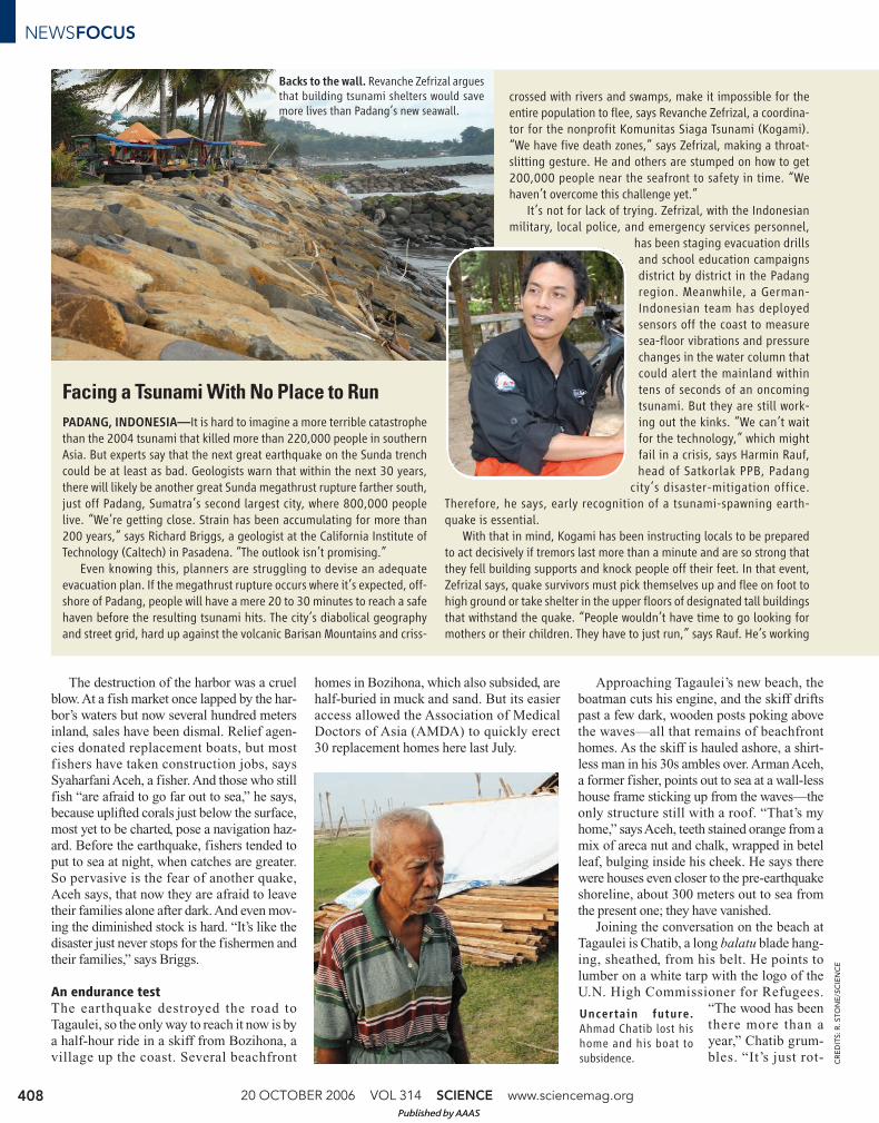
PADANG, INDONESIA—It is hard to imagine a more terrible catastrophethan the 2004 tsunami that killed more than 220,000 people in southernAsia. But experts say that the next great earthquake on the Sunda trenchcould be at least as bad. Geologists warn that within the next 30 years,there will likely be another great Sunda megathrust rupture farther south,just off Padang, Sumatra’s second largest city, where 800,000 peoplelive. “We’re getting close. Strain has been accumulating for more than200 years,” says Richard Briggs, a geologist at the California Institute ofTechnology (Caltech) in Pasadena. “The outlook isn’t promising.”
Even knowing this, planners are struggling to devise an adequateevacuation plan. If the megathrust rupture occurs where it’s expected, off-shore of Padang, people will have a mere 20 to 30 minutes to reach a safehaven before the resulting tsunami hits. The city’s diabolical geographyand street grid, hard up against the volcanic Barisan Mountains and criss-
crossed with rivers and swamps, make it impossible for theentire population to flee, says Revanche Zefrizal, a coordina-tor for the nonprofit Komunitas Siaga Tsunami (Kogami).“We have five death zones,” says Zefrizal, making a throat-slitting gesture. He and others are stumped on how to get200,000 people near the seafront to safety in time. “Wehaven’t overcome this challenge yet.”
It’s not for lack of trying. Zefrizal, with the Indonesianmilitary, local police, and emergency services personnel,
has been staging evacuation drillsand school education campaignsdistrict by district in the Padangregion. Meanwhile, a German-Indonesian team has deployedsensors off the coast to measuresea-floor vibrations and pressurechanges in the water column thatcould alert the mainland withintens of seconds of an oncomingtsunami. But they are still work-ing out the kinks. “We can’t waitfor the technology,” which mightfail in a crisis, says Harmin Rauf,head of Satkorlak PPB, Padang
city’s disaster-mitigation office.Therefore, he says, early recognition of a tsunami-spawning earth-quake is essential.
With that in mind, Kogami has been instructing locals to be preparedto act decisively if tremors last more than a minute and are so strong thatthey fell building supports and knock people off their feet. In that event,Zefrizal says, quake survivors must pick themselves up and flee on foot tohigh ground or take shelter in the upper floors of designated tall buildingsthat withstand the quake. “People wouldn’t have time to go looking formothers or their children. They have to just run,” says Rauf. He’s working
Backs to the wall. Revanche Zefrizal arguesthat building tsunami shelters would savemore lives than Padang’s new seawall.
CR
ED
ITS
: R
. S
TO
NE
/SC
IEN
CE
Uncertain future.
Ahmad Chatib lost hishome and his boat tosubsidence.
Published by AAAS

ting.” During the earthquake, the
survivors ran inland about a kilo-
meter to a settlement also called
Tagaulei. Halfway to the second
Tagaulei, a path through bamboo
rushes passes a small clearing
with plots for three homes,
including one for Aceh’s family.
All that’s been built so far is the
concrete base. “We are waiting
for our wood,” Aceh says.
Before the earthquake, Chatib
was a fisher. Now, sans boat, he
says he has been reduced to selling
fish caught by other men. “We are
very poor,” he says, before adding, bitterly,
“Why are we still living like this? We feel left
out and forgotten.”
AMDA’s senior logistics officer sympa-
thizes with the Tagauleians’ plight. “We feel
very sorry for them. They have been waiting
so long” for help, says Naoto Usami. AMDA
chartered an amphibious craft last year to
deliver the lumber now sitting on the beach;
the nongovernmental organization didn’t
anticipate the difficulty of moving it inland
to homesteads in Tagaulei Two. The delays
have created tensions with the villagers.
“Our staff have been threatened with knives,”
he says. AMDA is planning a second lumber
shipment for next month and aims to com-
plete all homes by the end of January. “Now,”
says Usami, “we’re moving very fast.”
Night has fallen, and Chatib
says goodbye: a melodious
“Ya-ahowu!” “Yahowuuuuu!”
yodels Suprihanto, who does not
speak the local language. Others
chime in with mangled variations
like off-key a cappella singers; it’s
infectious. The skiff sets out for
the return to Bozihona. Lightning
flares on the horizon. But the sea
is glassy calm, and glowing bio-
luminescent plankton stream off
the bow like sparks. The breath-
taking serenity is a sharp contrast
to the horrors that Chatib and his
fellow villagers endured last year.
Over the coming decades, the tilted crust
around Nias will settle gradually—returning
to its approximate position before the 2005
quake—as strain on the fault builds to a
crescendo for the next gargantuan release.
But for Chatib and many other islanders, life
may never regain its prequake equilibrium.
–RICHARD STONE
www.sciencemag.org SCIENCE VOL 314 20 OCTOBER 2006 409
NEWSFOCUS
with the mosques to connect muezzin loudspeakers to a central radio dis-patch for broadcasting warnings and instructions.
About 400,000 of Padang’s residents live on the beach or in a warrenof narrow streets along the coast. Two- and three-story apartment com-plexes, shops, and restaurants are interspersed with striking buildingswith sharply sloping roofs: “bull’s horns” symbolizing the bravery andresilience of the Minang people of west Sumatra. Close to shore, not eventhe imposing Minang architecture could stave off a tsunami. “All thesebuildings would be swept away,” says Imam Suprihanto, a marine biolo-gist who works with the Caltech team. The city has laid down boulders toform a 5-meter-high seawall, “but this will only protect Padang from asmall tsunami,” Rauf says. The towering waves from a great quake wouldwash over them. Only a few main roads lead inland, leaving about half ofthe beachside residents no viable escape route.
City officials plan to widen themain roads, says Rauf. Anotheridea is to build a series of concretetowers along the beach in whichpeople stranded near shore couldride out a tsunami. One promi-nent advocate of this approach isRoger Bilham, a geophysicist atthe University of Colorado, Boul-der, and a top expert on earth-quake risk in Southeast Asia.“Tsunami shelters should be con-structed every 100 meters alongthe coast,” he says. Bilham envi-sions 10-meter-high “indestructi-ble platforms” with numerousentry stairs and stocked with sup-plies. Zefrizal backs the idea,although at present there’s ashowstopper: “There’s no money
in the budget to make the towers,” he says. Kogami plans to go cap inhand to international nonprofits.
The potential for severe subsidence would complicate tower construc-tion and an evacuation. Just as the quake that shook southeastern NiasIsland last year tilted the landscape (see main text), a Padang earthquakewould be accompanied by subsidence along the coast, says Briggs. Mod-eling by Caltech’s Mohamed Chlieh, based on the effects of megathrustruptures off Padang in 1797 and 1833, predicts tectonic subsidence—a tugging down of the western Sumatran coast near Padang—of up to50 centimeters, roughly the same as in Aceh Province, on Sumatra’snorthern tip, in 2004. Slumps and fissures from liquefaction of soft, sandyground could exacerbate local flooding.
Modeling by Jose Borrero of the University of Southern California inLos Angeles has shown that subsidence will abet the killing power of a
tsunami, allowing water to runfarther inland with more energy,threatening about 1 mi l l ionpeople along a 500-kilometerstretch of coast. Thus tsunamishelters would have to be built toride out a stronger wave and
shifting ground.Psychology will also come into
play. “West Sumatrans believe inscience, but as Muslims, we alsobelieve that natural disasters areGod’s will,” says Rauf. “We want toknow how to cope with a tsunamibetter. But we will not be afraid ofit.” Rauf can only hope that therest of the population will be solevelheaded when the day of reck-oning comes, as it surely will.
–R.S.
Flip-flop. Before the 2005 rupture, Nias’s southwest coast was subsiding, asindicated by the stand of dead coconut palms seaward of the beach (top). Therupture lifted the coast here 2.5 meters.
CR
ED
ITS
: K
ER
RY
SIE
H
Published by AAAS


