
THE NEW CLEAN WATER RULE
Facts, Implications & Pitfalls
Carland G. Holstead, PWSNatural/Cultural Resources Services Department Manager
Terracon Consultants, Inc. – Dallas, TexasNovember 17, 2015

What We’ll Cover Basis and Rationale for new Clean Water Rule
New Clean Water Rule implementation timeline
What the new Rule does and doesn’t do
Old and New definitions of Waters of the U.S.
What it means for the Agencies (USACE & EPA)
What it means for you

Section 404 of the Clean Water Act Establishes a program to regulate the discharge of
dredged and/or fill material into Waters of the U.S., including jurisdictional wetlands
Responsibility for administering and enforcing Section 404 is shared between the EPA and the USACE
USACE handles the day-to-day regulatory aspects
EPA has ultimate authority for jurisdictional determinations (JDs)
USACE has authority for wetland and waterbody determinations

Clean Water Act Selected Case History
Protection for many of the nation’s streams and wetlands has been complex and time-consuming since Supreme Court decisions in 2001 and 2006
SWANCC v. USACE (2001)– Court ruled that the use of “isolated” non-navigable intrastate
ponds and wetlands by migratory birds was not by itself a sufficient basis for regulatory authority under the CWA.
Rapanos v. United States (2006)– Waters of the U.S. encompasses some waters that are not
navigable– Justice Kennedy: “Significant Nexus”

Why the New Rule?
EPA and USACE have received many requests for a rulemaking to provide clarity from many stakeholders including:
– Congress– State and Local Governments– Agricultural Community– Conservation Groups– Private Sector– Public

New Clean Water Rule Timeline
September 2013
• EPA Connectivity Study published
April 2014 • Draft Definition of Waters of the U.S. released
January 15, 2015 • EPA Connectivity Study finalized
May 27, 2015 • New Clean Water Rule finalized
August 28, 2015 • New Clean Water Rule effective

New Clean Water Rule Timeline September 2013 - EPA’s “Connectivity of Streams
and Wetlands to Downstream Waters: A Review and Synthesis of the Scientific Evidence”– Based on a review of more than 1,200 peer-reviewed publications
Report provides much of the technical basis for new Clean Water Rule– Connections of waters range from “highly connected” to “highly
isolated”– Tributary streams (perennial, intermittent, and ephemeral) are
chemically, physically, and biologically connected to downstream waters.
– Floodplain waters are connected to downstream waters– Effects on downstream waters by non-floodplain waters is
difficult to assess

New Clean Water Rule Timeline ctd. April 2014: EPA and USACE released a Draft of the
Definition of Waters of the U.S. – Solicited comments via Public Notice for more than 200 days– More than 1,000,000 comments were submitted– More than 3,000 were considered substantive – most in support
May 27, 2015: EPA and USACE finalized Clean Water Rule – would be final 60 days after being published in the Federal Register
The new Clean Water Rule is effective as of….
August 28, 2015

But Wait!A federal judge in North Dakota acted late on August 27th to block the new Clean Water Rule hours before it was due to take effect
Judge Ralph Erickson found that the 13 states suing to block the rule met the conditions necessary for a preliminary injunction
The Obama Administration said it would largely enforce the new Clean Water Rule as planned, arguing that the decision only applied to the 13 states that requested the injunction.
Alaska NebraskaArizona New MexicoArkansas NevadaColorado North DakotaIdaho South DakotaMissouri WyomingMontana

There’s More! October 9, 2015
– U.S. Court of Appeals for the Sixth Circuit issued a stay of the new Rule defining the scope of federal jurisdictional under the Clean Water Act
– As of October 9, 2015, the new Rule is NOT in effect NATIONWIDE– “Far from clear” that the new Rule’s distance limitations were
harmonious with the 2006 Rapanos decision. – The process by which the distance limitations were adopted was
“facially suspect” because the proposed rule did not include distance limitations
– The government had not “persuasively rebutted” the petitioner’s argument that the Rule’s distance limitations were devoidof scientific support
November 4, 2015– Bill to eliminate new Rule passes the Senate– Headed to House of Reps.

What Does the New Rule Do? “Ensures that protected waters under the CWA are more
precisely defined, more predictably determined, and easier for businesses and industry to understand”
Enhance protection for the nation’s aquatic resources Increase CWA program predictability and consistency Allow agencies to make categorical determinations of
jurisdiction, particularly with respect to “other waters” Define “significant nexus,” “neighboring,” “tributary,”
“floodplain,” and “riparian area” Reduce documentation requirements and timeframes to
make Approved Jurisdictional Determinations (AJD) by decreasing the number that require case-specific significant nexus analysis

What Does the New Rule NOT Do? Protect any types of waters that have not historically
been covered by the CWA
Regulate most ditches
Apply to groundwater
Eliminate previous exemptions
Interfere with or change private property rights
Cover erosional features such as gullies, rills, and non-wetland swales

What are Waters of the U.S.?(With the new Rule NOT in effect)
- All waters which are currently used, or were used in the past, or may be susceptible to use in the future in interstate or foreign commerce
- All waters subject to the ebb and flow of the tide
- Other waters which could affect foreign commerce
- Impoundments of Waters of the U.S.
- Tributaries of Waters of the U.S.
- Territorial Seas
- Adjacent Wetlands

What are Waters of the U.S.?(Under the new Rule)
33 CFR 328.3(a)Eight Categories of Jurisdictional Waters
“Mainstay Waters”- (1): All waters which are currently used, or were used in the past, or
may be susceptible to use in the future in interstate or foreign commerce, including all waters which are subject to the ebb and flow of the tide
- Traditional Navigable Waters (TNWs)
- (2): All interstate waters, including interstate wetlands
- (3): Territorial Seas

What are Waters of the U.S.? ctd. 33 CFR 328.3(a)
- (4): Impoundments of Waters of the U.S.
- (5): All tributaries of waters identified in paragraphs (1) through (3) (Mainstay Waters) – more on this later!
- (6): All waters adjacent to waters identified in paragraphs (1) through (5) - more on this later!
Waters in (a)(1) through (6) are jurisdictional by rule – no additional analysis is required. Therefore, a case-specific
significant nexus determination is not necessary. Covered tributaries and covered adjacent waters have a
significant nexus to the Mainstay Waters.
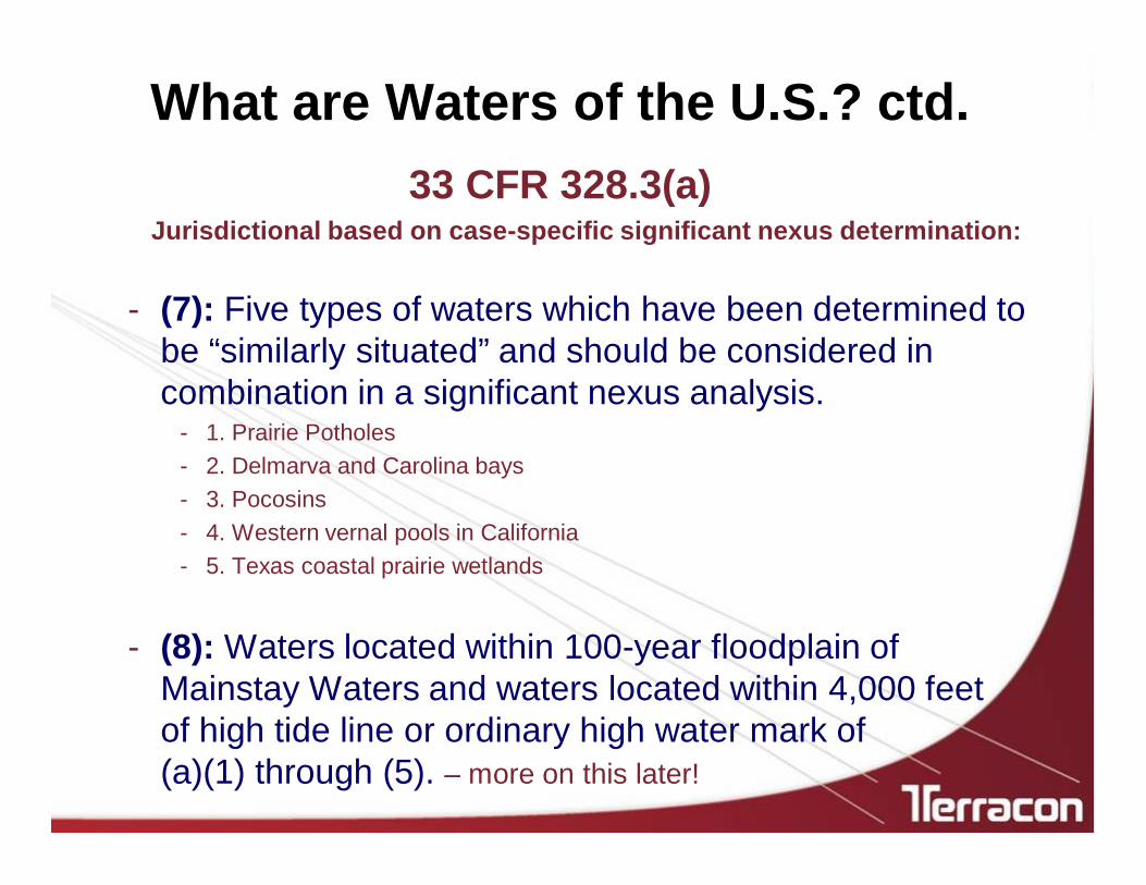
What are Waters of the U.S.? ctd. 33 CFR 328.3(a)
Jurisdictional based on case-specific significant nexus determination:
- (7): Five types of waters which have been determined to be “similarly situated” and should be considered in combination in a significant nexus analysis.
- 1. Prairie Potholes- 2. Delmarva and Carolina bays- 3. Pocosins- 4. Western vernal pools in California- 5. Texas coastal prairie wetlands
- (8): Waters located within 100-year floodplain of Mainstay Waters and waters located within 4,000 feet of high tide line or ordinary high water mark of (a)(1) through (5). – more on this later!

Tributaries– (a)(5) Previous definition of Waters of the U.S.
regulates all tributaries without qualification For the first time, the Agencies have provided a
definition of “Tributaries”
– A water must flow directly or through another water to a Mainstay Water [(a)(1) through (3)]
• Perennial, intermittent, or ephemeral
– Flow must have sufficient volume, frequency, and duration to create physical characteristics
• Bed and Bank• Ordinary High Water Mark

Adjacent Waters – (a)(6) Bordering Contiguous Neighboring – more on this later!
Including waters separated from other Waters of the U.S. by constructed dikes or barriers, natural river berms, beach dunes, and the like
Waters adjacent to (a)(1) through (5) are Waters of the U.S.
Entire water is adjacent if any portion is
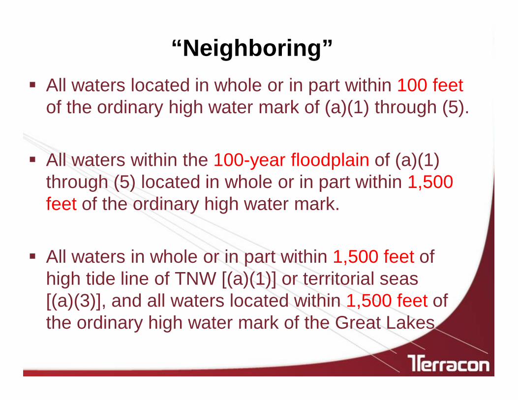
“Neighboring” All waters located in whole or in part within 100 feet
of the ordinary high water mark of (a)(1) through (5).
All waters within the 100-year floodplain of (a)(1) through (5) located in whole or in part within 1,500 feet of the ordinary high water mark.
All waters in whole or in part within 1,500 feet of high tide line of TNW [(a)(1)] or territorial seas [(a)(3)], and all waters located within 1,500 feet of the ordinary high water mark of the Great Lakes

Examples - Neighboring
Pond
100 feet
100-Year FEMA Floodplain
Wetland
1,500 feet
Ordinary High Water Mark
Ordinary High Water Mark

Examples - Neighboring
Pond> 1,500 feet
Wetland
1,500 feet
High Tide Line
High Tide Line
TNW [(a)(1)]

Significant Nexus
A significant nexus exists when a water, including wetlands, either alone or in combination with other similarly situated waters in the region, significantly
affects the chemical, physical, or biological integrity of a water identified in (a)(1) through (3)
For an effect to be significant, it must be “more than speculative or insubstantial.”

Functions Assessed for Significant Nexus
Sediment trapping Nutrient recycling Pollutant trapping, transformation, filtering, and
transport Retention and attenuation of flood waters Runoff storage Contribution of flow Export of organic matter Export of food resources Provision of life cycle dependent aquatic habitat

“Similarly Situated” Waters – (a)(7) Prairie potholes, Carolina and Delmarva bays,
pocosins, western vernal pools in CA, & TX coastal prairie wetlands
Case-specific significant nexus determination required– If not jurisdictional under (a)(1) through (a)(6)
These waters must be assessed in combination with all waters of the same subcategory in the region’s identified “point of entry watershed” aka “the region”– “The drainage basin within whose boundaries all
precipitation ultimately flows to the nearest single (a)(1) through (1)(3)”

100-Year Floodplain & 4,000-Foot Distance – (a)(8)
Waters within 100-year floodplain of Mainstay Waters (but beyond 1,500 feet of ordinary high water mark or high tide line)
Waters within 4,000 feet of high tide line or ordinary high water mark of (a)(1) through (5)
Case-specific significant nexus determination required
Entire water will be evaluated if only a portion is in either location mentioned above

Examples – Significant Nexus Analysis
TNW [(a)(1)]
Pond
100-Year FEMA Floodplain
Wetland
1,500 feet
Ordinary High Water Mark
Ordinary High Water Mark
4,500 feet

Examples – Significant Nexus Analysis
TNW [(a)(1)]
PondWetland
4,000 feet
High Tide Line
High Tide Line
100-Year FEMA Floodplain

NOT Waters of the U.S. Existing exclusions remain (farming, ranching, silviculture) Waste treatment systems, including treatment ponds or lagoons
designed to meet the requirements of CWA Prior converted cropland (EPA has final say for jurisdictional
status) Artificially irrigated areas that would revert back to dry land
should water application cease Artificial, constructed lakes and ponds created in dry land (stock
ponds, irrigation ponds, etc.) Artificial reflecting pools or swimming pools created in dry land Small ornamental waters created in dry land Water-filled depressions created in dry land incidental
to mining or construction activity

NOT Waters of the U.S. ctd.
Erosional features, including gullies, rills, and other ephemeral features that do not meet tributary definition
Non-wetland swales and lawfully constructed grassed waterways
Puddles Groundwater Stormwater control features created in dry land Wastewater recycling structures constructed in dry
land (detention/retention basins, percolation ponds

NOT Waters of the U.S. ctd.
Some Ditches
Ditches with ephemeral flow that are not a relocated tributary or excavated in a tributary
Ditches with intermittent flow that are not a relocated tributary or excavated in a tributary, or drain wetlands
Ditches that do not flow, either directly or through another water, into a Mainstay Water
[(a)(1) through (3)]

What Does This Mean for the Agencies?
What hasn’t changed is that each USACE District operates and behaves differently – different interpretations, different opinions, different Project Managers
Based on direct communication with the USACE, Districts have yet to be provided guidance with respect to new rule implementation
Unclear objectives
How will existing submittals be handled?

What Does This Mean for YOU? Expect regulatory delays, at least up-front during the initial
stages of rule implementation– Don’t expect expeditious responses from USACE Project Managers
Processing/findings/results/determinations will differ geographically (arid/dry vs. humid/wet)
Potential for waters and wetlands which were previously not jurisdictional to be considered jurisdictional and vice versa
Additional documentation and negotiation may be necessary
USACE will not reopen an Approved Jurisdictional Determination (AJD) unless requested by the requester or new information warrants revision

What Does This Mean for YOU? Typically, “Agencies’ actions are governed by the rule in
effect at the time of issuance of a Jurisdictional Determination or permit authorization, not by the date of a permit application or Jurisdictional Determination request.”
The Agencies recognize that there are pending actions
The Agencies expect “only a small portion” of pending actions will require additional information by the requester

Questions ???
Carland G. Holstead, PWSManager I Natural/Cultural Resources Services
Terracon8901 John W. Carpenter Freeway, Suite 100 I Dallas, Texas 75247D (214) 666 6041 I F (214) 630 7070 I M (504) 452 [email protected] I terracon.com


