
1
townsville
Storm Tide Evacuation GuideThis guide is used to inform residents of predicted storm tide inundation associated with a tropical cyclone.
www.townsville.qld.gov.au

2
message from the mayor North Queensland is one of the most cyclone-prone areas in Australia. Like many of our neighbouring coastal communities, natural disasters are a price Townsville residents pay for living in paradise.
Along the coast, storm tides can occur as a result of a cyclone. Cyclone threats in our region could result in an evacuation of particular areas in our city. We will only order an evacuation if a storm tide threatens to inundate developed areas.
This Storm Tide Evacuation Guide is to help you, as a resident, prepare for cyclone events that result in an evacuation. If you are not required to evacuate, your home is often the safest place for you. Before a cyclone event you will need to make sure that you are secure in your home. If you feel you are not secure in your home please make alternative arrangements with friends and family.
If you are told you have to evacuate, you should make your way to family or friends in ‘higher places’ outside the threatened zone. Townsville’s Local Disaster Management Group has shelters available for community members who have no other alternative. Remember that these shelters are intended for use by those identified as being in the storm tide area. Shelters unfortunately do not have the capacity to cater for people with special needs; and there is also no support services such as bedding, food, drink or material aid.
I urge you to read the information provided in this booklet, view the detailed ‘by suburb’ maps on council’s website and understand the evacuation procedures. In the event of a cyclone or storm tide, take immediate action by following the checklists included in this booklet.
Regards,
Cr Jenny Hill
3
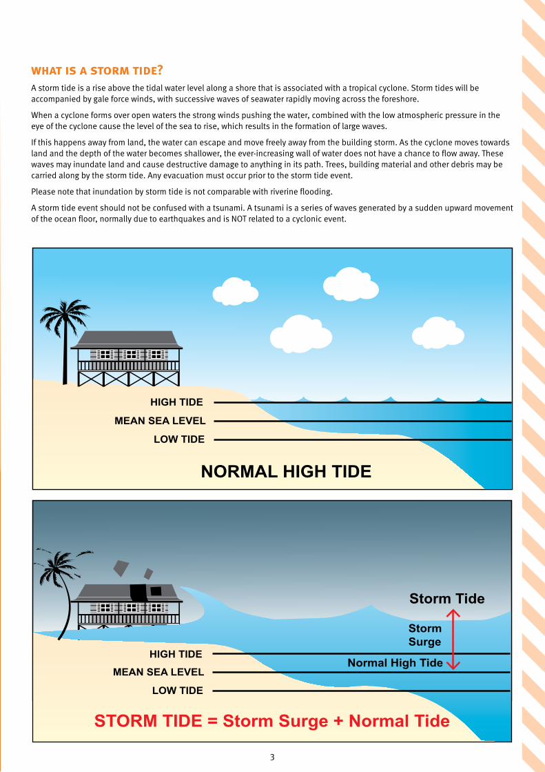
what is a storm tide?A storm tide is a rise above the tidal water level along a shore that is associated with a tropical cyclone. Storm tides will be accompanied by gale force winds, with successive waves of seawater rapidly moving across the foreshore.
When a cyclone forms over open waters the strong winds pushing the water, combined with the low atmospheric pressure in the eye of the cyclone cause the level of the sea to rise, which results in the formation of large waves.
If this happens away from land, the water can escape and move freely away from the building storm. As the cyclone moves towards land and the depth of the water becomes shallower, the ever-increasing wall of water does not have a chance to flow away. These waves may inundate land and cause destructive damage to anything in its path. Trees, building material and other debris may be carried along by the storm tide. Any evacuation must occur prior to the storm tide event.
Please note that inundation by storm tide is not comparable with riverine flooding.
A storm tide event should not be confused with a tsunami. A tsunami is a series of waves generated by a sudden upward movement of the ocean floor, normally due to earthquakes and is NOT related to a cyclonic event.
Storm Tide
MEAN SEA LEVEL
LOW TIDE
STORM TIDE = Storm Surge + Normal Tide
HIGH TIDE
MEAN SEA LEVEL
LOW TIDE
NORMAL HIGH TIDE
Storm Surge
Normal High TideHIGH TIDE
4
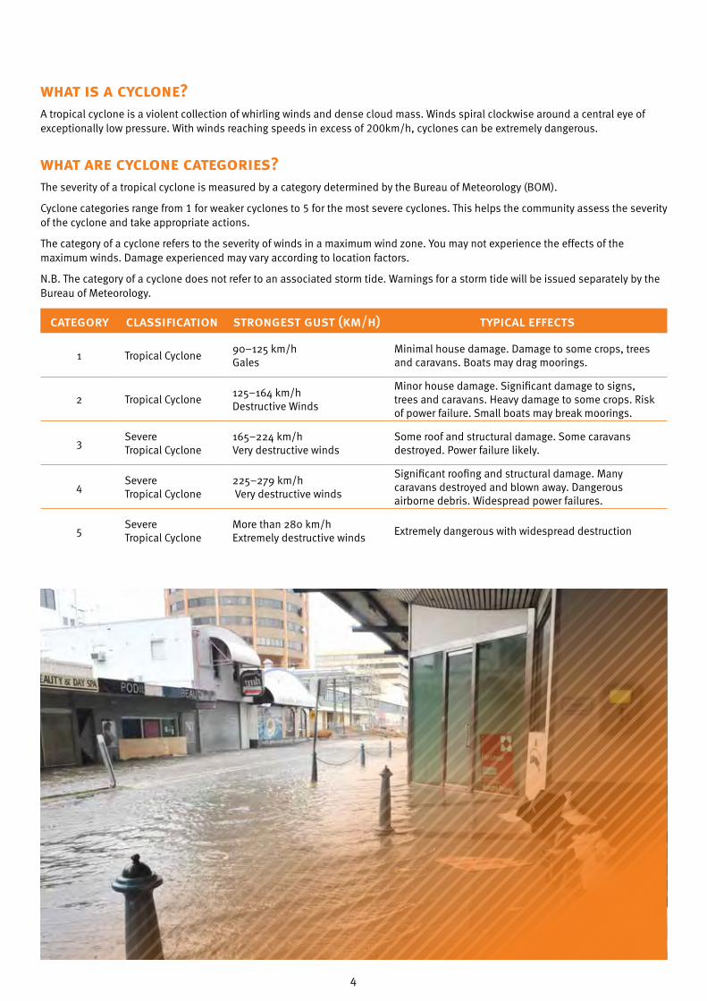
what is a cyclone?A tropical cyclone is a violent collection of whirling winds and dense cloud mass. Winds spiral clockwise around a central eye of exceptionally low pressure. With winds reaching speeds in excess of 200km/h, cyclones can be extremely dangerous.
what are cyclone categories?The severity of a tropical cyclone is measured by a category determined by the Bureau of Meteorology (BOM).
Cyclone categories range from 1 for weaker cyclones to 5 for the most severe cyclones. This helps the community assess the severity of the cyclone and take appropriate actions.
The category of a cyclone refers to the severity of winds in a maximum wind zone. You may not experience the effects of the maximum winds. Damage experienced may vary according to location factors.
N.B. The category of a cyclone does not refer to an associated storm tide. Warnings for a storm tide will be issued separately by the Bureau of Meteorology.
category classification strongest gust (km/h) typical effects
1 Tropical Cyclone90–125 km/h Gales
Minimal house damage. Damage to some crops, trees and caravans. Boats may drag moorings.
2 Tropical Cyclone125–164 km/h Destructive Winds
Minor house damage. Significant damage to signs, trees and caravans. Heavy damage to some crops. Risk of power failure. Small boats may break moorings.
3Severe Tropical Cyclone
165–224 km/h Very destructive winds
Some roof and structural damage. Some caravans destroyed. Power failure likely.
4Severe Tropical Cyclone
225–279 km/h Very destructive winds
Significant roofing and structural damage. Many caravans destroyed and blown away. Dangerous airborne debris. Widespread power failures.
5Severe Tropical Cyclone
More than 280 km/h Extremely destructive winds
Extremely dangerous with widespread destruction

5
cyclone watchA cyclone watch is issued at six (6) hourly intervals if a cyclone or potential cyclone exists, and there is a likelihood gale force winds or stronger will affect coastal or island communities within the next 24 to 48 hours.
Cyclone Warning
A cyclone warning is issued at three (3) hourly intervals if gale force winds or stronger are expected to affect coastal or island communities within the next 24 hours. Warnings are updated every hour when a cyclone is close to landfall. The Standard Emergency Warning Signal (SEWS) may be used with some cyclone warnings.
Severe Weather Warning
A severe weather warning may be issued if the system is no longer a cyclone but communities are still being threatened by damaging winds, flooding rains or pounding seas.
how to use this guideThis Storm Tide Evacuation Guide was developed to assist residents in determining if their properties are at risk of inundation from a storm tide.
As a local resident, council recommends that you:
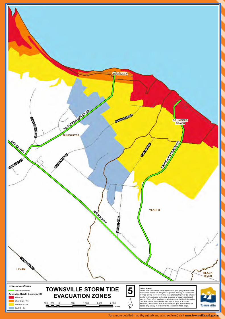
1. Review the evacuation maps in this guide and identify the location of your property. Visit council’s website to view more detailed mapping, with evacuation zones depicted by street and suburb.
2. Consider the tips contained in this guide for preparing a household emergency plan and emergency kit.
3. Familiarise yourself with the local emergency contact details and radio station information.
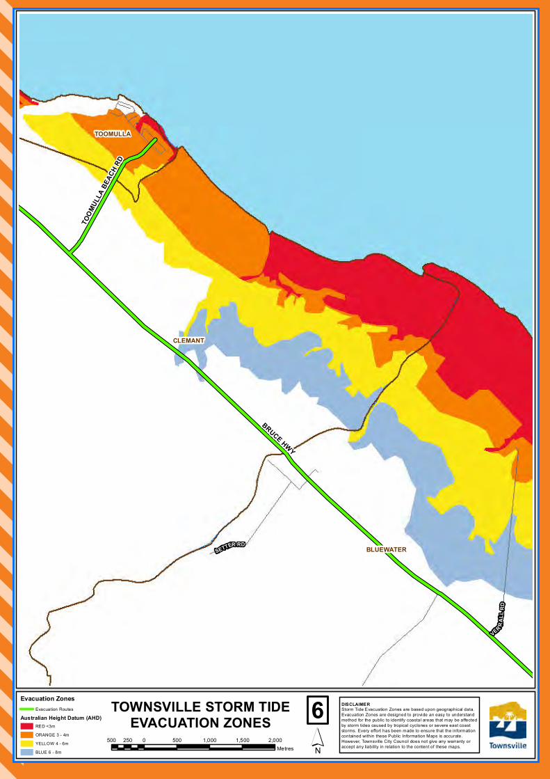
If your residence is located in a coloured evacuation zone, your property may be inundated in a storm tide event. The height of the predicted storm tide during the disaster event will determine which zones will be affected.
N.B. – If you are not located in a coloured evacuation zone, your suburb will not be shown on the detailed maps located on council’s website.
evacuation zones
evacuation zone risk of inundationlevel of inundation
metres above hat metres above ahd
Red Extreme 1.0m Less than 3.0m
Orange High 2.0m 3.0m – 4.0m
Yellow Medium 2.0m – 4.0m 4.0m – 6.0m
Blue Low 4.0m and above 6.0m – 8.0m
what is hat?HAT stands for Highest Astronomical Tide, which is comparable to a king tide. It is the highest level of water, which can be predicted to occur under any combination of astronomical conditions. BOM advices regarding storm tide will refer to a height (in metres) above HAT. Council will use this BOM information to advise which zones may be affected.
what is ahd?AHD stands for Australian Height Datum, which is the altitude measurement for land-based mapping. In 1971, mean sea level was assigned the value of 0.000m elevation based on observations recorded by thirty tide gauges around the coast of Australia for the period 1966–1968. The resulting datum surface, with minor modifications in two (2) metropolitan areas, has been termed the Australian Height Datum (AHD) and was adopted by the National Mapping Council in 1971 as the datum to which all vertical control mapping is to be referred. Elevations quoted using this datum are normally followed with the acronym (AHD).

6
what if i am in an evacuation zone?1. Prepare a documented household emergency plan.
emergency plan activation
Contact all householders Tune into warnings Check on neighbours
Shelter in our strongest room Locate Emergency Kit Make final preparations
evacuation destination
Place to meet: Address:
Phone number: Email address:
out of town emergency contact
Name: Address:
Phone number: Email address:
main service supplies location switch off
Electricity: Yes No
Gas: Yes No
Water: Yes No
vehicle registration our strongest room is
pets
Name: Description:
evacuation checklist
Prior to evacuation:
Ensure vehicle is full of fuel
Ensure you have cash on hand
Know the preferred evacuation routes
Know the location of our evacuation place
When evacuating:
Pack Emergency Kit, and a copy of our Emergency Plan
Contact our out of town emergency contact
Turn off mains supply for power, gas and water
Secure and lock our home and proceed to our predetermined evacuation destination
If flooding or storm surge is imminent:
Sandbag home Store electrical items off the ground

7

8
9
2. Prepare an emergency kit.
Special Items
Baby needs such as nappies and bottles
Medications and scripts
Contact lenses or prescription glasses
Games, books and puzzles for entertainment
Esky and ice
Ensure you have enough cash on hand to last one week
Fuel for car
Pet food and supplies
In a waterproof wallet
Will and insurance policies
Passports and immunisation records
Bank account and credit card numbers
Inventory of household contents
Important phone numbers
Family records such as birth and marriage certificates
USB with the above documents saved electronically
Use this checklist when packing and updating your Emergency Kit.
Water
Water in plastic containers
A three day supply; minimum five litres of water per day per person
Food
Minimum three day supply
Ready to eat canned meats, fruit and vegetables
Canned juices, milk and soups
Staples such as sugar, pepper, salt and high energy foods such as peanut butter, honey, jams and muesli bars
Vitamins
Food for babies, children, elderly persons or any special dietary requirements
Comfort foods such as biscuits, lollies, cereals, coffee and tea
Tools and supplies
Cooking facilities such as gas BBQ/camping stove
Plates, bowls, cups, utensils (paper or plastic plates don’t require washing)
Battery operated radio
Battery operated torches
Spare batteries
Utility knife
Toilet paper
Soap/detergent
Personal hygiene items
Duct and masking tape
Matches in waterproof container
Disinfectant
Mobile phone and charger
Insect repellent and sunscreen
Tools for temporary repairs
Rope and chains for securing outdoor items
Extension cords and power boards
Plastic sheeting or tarps
First Aid Kit
Replace any used contents
Clothing and bedding
At least one complete change of clothing and footwear per person
Long sleeve shirts and trousers
Sturdy shoes
Rain gear
Blankets or sleeping bags
Hats and work gloves
Sunglasses
3. Consider your shelter and evacuation options (including major transportation routes).
Shelter and Evacuation Options
1. Seek shelter outside of Townsville.
2. Seek shelter with family and/or friends located outside the risk area.
3. Seek shelter at an accommodation facility (e.g. motel).
4. Seek shelter at an identified Public Cyclone Shelter or Place of Refuge.
If you are self-evacuating and will not be staying within an identified Shelter, please register your location via the “Register, Find, Reunite” system available on the Australian Red Cross website. (N.B. this will be activated at the time of the pending disaster).
4. Tune into warnings. Authorities will advise which zones need to evacuate.
Emergency Alert System
Townsville City Council utilises the Queensland Government’s “Emergency Alert System”. The “Emergency Alert System” is the national telephone based emergency warning system that sends voice messages to landlines (based on the location of the handset) and text messages to mobile phones (based on the location of the mobile phone).
N.B. Authorities will advise of evacuations by the coloured zones, NOT streets or suburbs.

7
6
5
3
12
98
4
Evac
uatio
n Zo
nes
Aust
ralia
n H
eigh
t Dat
um (A
HD
)R
ED
<3m
OR
AN
GE
3 -
4m
YE
LLO
W 4
- 6
m
BLU
E 6
- 8
m
Eva
cuat
ion
Rou
tes
Det
ail M
aps
Sub
urbs
´0
5,00
010
,000
15,0
0020
,000
2,50
0
Met
res
TOW
NSV
ILLE
STO
RM
TID
EEV
AC
UAT
ION
ZO
NES
DIS
CLA
IME
RS
torm
Tid
e E
vacu
atio
n Zo
nes
are
base
d up
on g
eogr
aphi
cal d
ata.
Eva
cuat
ion
Zone
s ar
e de
sign
ed to
pro
vide
an
easy
to u
nder
stan
dm
etho
d fo
r th
e pu
blic
to id
entif
y co
asta
l are
as th
at m
ay b
e af
fect
ed
by s
torm
tide
s ca
used
by
tropi
cal c
yclo
nes
or s
ever
e ea
st c
oast
stor
ms.
Eve
ry e
ffort
has
been
mad
e to
ens
ure
that
the
info
rmat
ion
cont
aine
d w
ithin
thes
e P
ublic
Info
rmat
ion
Map
s is
acc
urat
e.H
owev
er, T
owns
ville
City
Cou
ncil
does
not
giv
e an
y w
arra
nty
orac
cept
any
liab
ility
in re
latio
n to
the
cont
ent o
f the
se m
aps.
>> V
isit
cou
ncil’
s w
ebsi
te to
vie
w
mor
e de
taile
d m
appi
ng, w
ith
evac
uati
on z
ones
dep
icte
d by
str
eet a
nd s
ubur
b.

7
6
5
3
12
98
4
Evac
uatio
n Zo
nes
Aust
ralia
n H
eigh
t Dat
um (A
HD
)R
ED
<3m
OR
AN
GE
3 -
4m
YE
LLO
W 4
- 6
m
BLU
E 6
- 8
m
Eva
cuat
ion
Rou
tes
Det
ail M
aps
Sub
urbs
´0
5,00
010
,000
15,0
0020
,000
2,50
0
Met
res
TOW
NSV
ILLE
STO
RM
TID
EEV
AC
UAT
ION
ZO
NES
DIS
CLA
IME
RS
torm
Tid
e E
vacu
atio
n Zo
nes
are
base
d up
on g
eogr
aphi
cal d
ata.
Eva
cuat
ion
Zone
s ar
e de
sign
ed to
pro
vide
an
easy
to u
nder
stan
dm
etho
d fo
r th
e pu
blic
to id
entif
y co
asta
l are
as th
at m
ay b
e af
fect
ed
by s
torm
tide
s ca
used
by
tropi
cal c
yclo
nes
or s
ever
e ea
st c
oast
stor
ms.
Eve
ry e
ffort
has
been
mad
e to
ens
ure
that
the
info
rmat
ion
cont
aine
d w
ithin
thes
e P
ublic
Info
rmat
ion
Map
s is
acc
urat
e.H
owev
er, T
owns
ville
City
Cou
ncil
does
not
giv
e an
y w
arra
nty
orac
cept
any
liab
ility
in re
latio
n to
the
cont
ent o
f the
se m
aps.
For a more detailed map (by suburb and at street level) visit www.townsville.qld.gov.au.
BALLS LN
PILK
I NG
TON
S T
ECH
LIN
ST
KIN
GS
RD
QUEENS RD
FULHAM RD
HAROLD ST
STANLEY ST
PALMERSTON ST
ARCHER ST
THE STRAND
MO
ON
EY ST
CA
MBR
IDG
E S T
CHARLES ST
MEE
NA
N ST
KING
ST
HOWITT ST
ACKERS ST
LOVE LN
INGHAM RD
STAGPOLE ST
DEARNESS ST
ROSS ST
JOH N M ELTON
BLACK DR
BOUNDARY ST
GU
LLIV
ER S T
OONOONBA RD
KOKODA ST
YOLANDA DR
TOWNCOMMON
VINCENT
CURRAJONG
DOUGLAS
GULLIVER
AITKENVALE
ANNANDALE
HERMITPARK
ROSSLEA
ROWESBAY
MUNDINGBURRA
OONOONBA
IDALIA
GARBUTT
WULGURUMURRAY
WEST END
TOWNSVILLECITY
CLUDEN
STUART
SOUTHTOWNSVILLE
RAILWAYESTATE
BELGIANGARDENS
CASTLEHILL
NORTHWARD
PIMLICO
HYDEPARK
MYSTERTON
KNAPP ST
DENHAM ST
EYRE ST
HU
GH
ST
SAUNDER
S ST
DEA
N ST
PER
CY
ST
HEATLEYS PDE
RACECOURSE RD
STURT
ST
WARBURTON ST
BRUCE HWY
RA
ILW
AY A
VEDALRYMPLE RD
BOW
EN RD
BUNDOCK ST
CH
AR
TER
S TO
WER
S R
D
STUART DR
ROSS RIVER RD
AB
BO
TT ST
WOOLCOCK ST
UNIVERSITY RD
Evacuation ZonesEvacuation Routes
Australian Height Datum (AHD)RED <3m
ORANGE 3 - 4m
YELLOW 4 - 6m
BLUE 6 - 8m
DISCLAIMERStorm Tide Evacuation Zones are based upon geographical data.Evacuation Zones are designed to provide an easy to understandmethod for the public to identify coastal areas that may be affected by storm tides caused by tropical cyclones or severe east coaststorms. Every effort has been made to ensure that the informationcontained within these Public Information Maps is accurate.However, Townsville City Council does not give any warranty oraccept any liability in relation to the content of these maps.´
1500 0 500 1,000 1,500 2,000250
Metres
TOWNSVILLE STORM TIDEEVACUATION ZONES

FULHAM R
D
BAM
FOR
D LN
BAN
FIEL D
DR
CHAR
LES ST
BAYSWATER RD
MAT
HE R
STINGHAM RD
INGHAM RD
ENTE
RP
RISE ST
TOWNCOMMON
VINCENT
CRANBROOK
MOUNTST JOHN
AITKENVALE
BUSHLANDBEACH
BURDELL
GARBUTT
HEATLEY
BOHLE
COSGROVE
KIRWAN
MOUNTLOUISA
MOUNTLOW
DEERAGUN
BOHLEPLAINS
SHAW
DALRYMPLE RD
ROSS RIVER RD
THE
RI N
G R
D
DU
CK
WO
RTH
ST
THU
RIN
GO
WA
DR
BRUCE HWY
NATH
AN
ST
SH
AW
RD
NO
RTH
SHO
RE
BLVD
WOOLCOCK ST
Evacuation ZonesEvacuation Routes
Australian Height Datum (AHD)RED <3m
ORANGE 3 - 4m
YELLOW 4 - 6m
BLUE 6 - 8m
TOWNCOMMON
SHELLYBEACH
PALLARENDA
ES
PLA
NA
DE
CA
PE
PALLA
REN
DA
RDPALLARENDA INSET
DISCLAIMERStorm Tide Evacuation Zones are based upon geographical data.Evacuation Zones are designed to provide an easy to understandmethod for the public to identify coastal areas that may be affected by storm tides caused by tropical cyclones or severe east coaststorms. Every effort has been made to ensure that the informationcontained within these Public Information Maps is accurate.However, Townsville City Council does not give any warranty oraccept any liability in relation to the content of these maps.´
2500 0 500 1,000 1,500 2,000250
Metres
TOWNSVILLE STORM TIDEEVACUATION ZONES

FULHAM R
D
BAM
FOR
D LN
BAN
FIEL D
DR
CHAR
LES ST
BAYSWATER RD
MAT
HE R
ST
INGHAM RDINGHAM RD
ENTE
RP
RISE ST
TOWNCOMMON
VINCENT
CRANBROOK
MOUNTST JOHN
AITKENVALE
BUSHLANDBEACH
BURDELL
GARBUTT
HEATLEY
BOHLE
COSGROVE
KIRWAN
MOUNTLOUISA
MOUNTLOW
DEERAGUN
BOHLEPLAINS
SHAW
DALRYMPLE RD
ROSS RIVER RD
THE
RI N
G R
D
DU
CK
WO
RTH
ST
THU
RIN
GO
WA
DR
BRUCE HWY
NATH
AN
ST
SH
AW
RD
NO
RTH
SHO
RE
BLVD
WOOLCOCK ST
Evacuation ZonesEvacuation Routes
Australian Height Datum (AHD)RED <3m
ORANGE 3 - 4m
YELLOW 4 - 6m
BLUE 6 - 8m
TOWNCOMMON
SHELLYBEACH
PALLARENDA
ES
PLA
NA
DE
CA
PE
PALLA
REN
DA
RDPALLARENDA INSET
DISCLAIMERStorm Tide Evacuation Zones are based upon geographical data.Evacuation Zones are designed to provide an easy to understandmethod for the public to identify coastal areas that may be affected by storm tides caused by tropical cyclones or severe east coaststorms. Every effort has been made to ensure that the informationcontained within these Public Information Maps is accurate.However, Townsville City Council does not give any warranty oraccept any liability in relation to the content of these maps.´
2500 0 500 1,000 1,500 2,000250
Metres
TOWNSVILLE STORM TIDEEVACUATION ZONES
VEA
LES
RD
GEANEY LN
BOWDEN
RD
BO
WD
EN RD
JENSEN RD
HAY
NES
RD
CHU
RCH
RD
WH
ITE RD
WE N
T R
D
SVE
NS SON
RD
GA
RLA
ND
RD
GA
RLA
ND
RD
BLACKRIVER
BUSHLANDBEACH
BURDELL
BEACHHOLM
MOUNTLOW
YABULU
DEERAGUN
JENSEN
BOHLEPLAINS SHAW
NORTH SHORE BLVDM
OU
NT
LOW
PK
W
BRUCE HWY
Evacuation ZonesEvacuation Routes
Australian Height Datum (AHD)RED <3m
ORANGE 3 - 4m
YELLOW 4 - 6m
BLUE 6 - 8m
DISCLAIMERStorm Tide Evacuation Zones are based upon geographical data.Evacuation Zones are designed to provide an easy to understandmethod for the public to identify coastal areas that may be affected by storm tides caused by tropical cyclones or severe east coaststorms. Every effort has been made to ensure that the informationcontained within these Public Information Maps is accurate.However, Townsville City Council does not give any warranty oraccept any liability in relation to the content of these maps.´
3500 0 500 1,000 1,500 2,000250
Metres
TOWNSVILLE STORM TIDEEVACUATION ZONES
For a more detailed map (by suburb and at street level) visit www.townsville.qld.gov.au.

APJ
OH
N ST
WES
T PT
RD
WEST PT RD
PACI
FIC
DR
PICN
IC ST
PIC
NIC
BAY
FLO
REN
CE
BAY
HO
RSE
SHO
EB
AY
WES
TPO
INT
NEL
LYB
AY
AR
CA
DIA
AR
CA
DIA
RD
ARMAND WY
BIRT
ST
MARINE
PDE
HORSESHOE BAY
RD
SOONING
ST
NELLY BAY RD
MAGNETIC ISLAND RD
Evac
uatio
n Zo
nes
Eva
cuat
ion
Rou
tes
Aust
ralia
n H
eigh
t Dat
um (A
HD
)R
ED
<3m
OR
AN
GE
3 -
4m
YE
LLO
W 4
- 6
m
BLU
E 6
- 8m
DIS
CLA
IME
RS
torm
Tid
e E
vacu
atio
n Zo
nes
are
base
d up
on g
eogr
aphi
cal d
ata.
Eva
cuat
ion
Zone
s ar
e de
sign
ed to
pro
vide
an
easy
to u
nder
stan
dm
etho
d fo
r th
e pu
blic
to id
entif
y co
asta
l are
as th
at m
ay b
e af
fect
ed
by s
torm
tide
s ca
used
by
tropi
cal c
yclo
nes
or s
ever
e ea
st c
oast
stor
ms.
Eve
ry e
ffort
has
been
mad
e to
ens
ure
that
the
info
rmat
ion
cont
aine
d w
ithin
thes
e P
ublic
Info
rmat
ion
Map
s is
acc
urat
e.H
owev
er, T
owns
ville
City
Cou
ncil
does
not
giv
e an
y w
arra
nty
orac
cept
any
liab
ility
in re
latio
n to
the
cont
ent o
f the
se m
aps.
´450
00
500
1,00
01,
500
250
Met
res
TOW
NSV
ILLE
STO
RM
TID
EEV
AC
UAT
ION
ZO
NES
FORESTRY RD
BLUEWATE
R
DR
BLUEWATER DRPU
RO
NO
PKW
PURO
NO PK
W
KATAUGHAL RD
JOHN
BREWER
DR
SAUNDERSBEACH
LYNAM
TOOLAKEA
BLACKRIVER
YABULU
BLUEWATER
BRUCE HWY
TOOLAKEA BEACH RD
SAUN
DERS
BEAC
H RD
BRUCE HW
Y
Evacuation ZonesEvacuation Routes
Australian Height Datum (AHD)RED <3m
ORANGE 3 - 4m
YELLOW 4 - 6m
BLUE 6 - 8m
DISCLAIMERStorm Tide Evacuation Zones are based upon geographical data.Evacuation Zones are designed to provide an easy to understandmethod for the public to identify coastal areas that may be affected by storm tides caused by tropical cyclones or severe east coaststorms. Every effort has been made to ensure that the informationcontained within these Public Information Maps is accurate.However, Townsville City Council does not give any warranty oraccept any liability in relation to the content of these maps.´
5500 0 500 1,000 1,500 2,000250
Metres
TOWNSVILLE STORM TIDEEVACUATION ZONES
For a more detailed map (by suburb and at street level) visit www.townsville.qld.gov.au.
SETTER RD
VER
RA
LL R
D
CLEMANT
TOOMULLA
BLUEWATER
TOO
MUL
LA BE
ACH
RD
BRUCE HW
Y
Evacuation ZonesEvacuation Routes
Australian Height Datum (AHD)RED <3m
ORANGE 3 - 4m
YELLOW 4 - 6m
BLUE 6 - 8m
DISCLAIMERStorm Tide Evacuation Zones are based upon geographical data.Evacuation Zones are designed to provide an easy to understandmethod for the public to identify coastal areas that may be affected by storm tides caused by tropical cyclones or severe east coaststorms. Every effort has been made to ensure that the informationcontained within these Public Information Maps is accurate.However, Townsville City Council does not give any warranty oraccept any liability in relation to the content of these maps.´
6500 0 500 1,000 1,500 2,000250
Metres
TOWNSVILLE STORM TIDEEVACUATION ZONES
PLANTATION RD
PLANTATION RD
HENCAMP CREEK RD
ACHERON DR
MUTARNEE
CRYSTALCREEK
ROLLINGSTONE
BALGALBEACH
CLEMANT
BA
LGA
L B
EA
CH
RDBRUCE
HWY
Evacuation ZonesEvacuation Routes
Australian Height Datum (AHD)RED <3m
ORANGE 3 - 4m
YELLOW 4 - 6m
BLUE 6 - 8m
DISCLAIMERStorm Tide Evacuation Zones are based upon geographical data.Evacuation Zones are designed to provide an easy to understandmethod for the public to identify coastal areas that may be affected by storm tides caused by tropical cyclones or severe east coaststorms. Every effort has been made to ensure that the informationcontained within these Public Information Maps is accurate.However, Townsville City Council does not give any warranty oraccept any liability in relation to the content of these maps.´
7500 0 500 1,000 1,500 2,000250
Metres
TOWNSVILLE STORM TIDEEVACUATION ZONES
For a more detailed map (by suburb and at street level) visit www.townsville.qld.gov.au.

CROCODILE CREEK RD
RILEY
RD
MEEHAN RD
MEEHAN RD
CU
NG
ULL
A
ALL
IGAT
OR
CR
EEK
MO
UN
TEL
LIO
T
CA
PEC
LEVE
LAN
D
NO
ME
CA
RTY
RD
CAPE CLEVELAND RD
BR
UC
E H
WY
GO
OD
SE
L L R
D
Evac
uatio
n Zo
nes
Eva
cuat
ion
Rou
tes
Aust
ralia
n H
eigh
t Dat
um (A
HD
)R
ED
<3m
OR
AN
GE
3 -
4m
YE
LLO
W 4
- 6
m
BLU
E 6
- 8m
DIS
CLA
IME
RS
torm
Tid
e E
vacu
atio
n Zo
nes
are
base
d up
on g
eogr
aphi
cal d
ata.
Eva
cuat
ion
Zone
s ar
e de
sign
ed to
pro
vide
an
easy
to u
nder
stan
dm
etho
d fo
r th
e pu
blic
to id
entif
y co
asta
l are
as th
at m
ay b
e af
fect
ed
by s
torm
tide
s ca
used
by
tropi
cal c
yclo
nes
or s
ever
e ea
st c
oast
stor
ms.
Eve
ry e
ffort
has
been
mad
e to
ens
ure
that
the
info
rmat
ion
cont
aine
d w
ithin
thes
e P
ublic
Info
rmat
ion
Map
s is
acc
urat
e.H
owev
er, T
owns
ville
City
Cou
ncil
does
not
giv
e an
y w
arra
nty
orac
cept
any
liab
ility
in re
latio
n to
the
cont
ent o
f the
se m
aps.
´850
00
500
1,00
01,
500
2,00
025
0M
etre
s
TOW
NSV
ILLE
STO
RM
TID
EEV
AC
UAT
ION
ZO
NES

BENT
LEY
DR
BENT
LEY DR
BARNHAM RD
BARN
HAM
RDW
ILLI
AM
S R
D
PAUL JAMES DR
MA
RRO
N RD
ALLIGATORCREEK
MOUNTELLIOT
STUART
CAPECLEVELAND
JULAGO
NOME
ALLI
GATOR
CREEK
RD
BRUCE HWY
ALLENDALE DR
BRUCE HWY
Evacuation ZonesEvacuation Routes
Australian Height Datum (AHD)RED <3m
ORANGE 3 - 4m
YELLOW 4 - 6m
BLUE 6 - 8m
DISCLAIMERStorm Tide Evacuation Zones are based upon geographical data.Evacuation Zones are designed to provide an easy to understandmethod for the public to identify coastal areas that may be affected by storm tides caused by tropical cyclones or severe east coaststorms. Every effort has been made to ensure that the informationcontained within these Public Information Maps is accurate.However, Townsville City Council does not give any warranty oraccept any liability in relation to the content of these maps.´
9500 0 500 1,000 1,500 2,000250
Metres
TOWNSVILLE STORM TIDEEVACUATION ZONES
For a more detailed map (by suburb and at street level) visit www.townsville.qld.gov.au.

tune into warningsTune into your local radio station for the latest emergency information.
ABC Local Radio 630 am
4TO FM 102.3 fm
Hit 103.1 fm
Power100 100.7 fm
Star 106.3 fm
Triple T 103.9 fm
website www.townsville.qld.gov.au
www.disaster.qld.gov.au
www.bom.gov.au
social media Townsville Disaster Information
@TCC_news
service number
All Emergency Calls 000
Townsville City Council Emergency After Hours, Flooding information, Dengue outbreaks, Sun safety information
1300 878 001
Townsville Local Disaster Management Group Local Disaster Coordination Centre (only during declared emergencies)
1800 738 541
Queensland Fire and Emergency Services 000
Townsville State Emergency Service (SES) Tarping/Branches Down
13 25 00
Queensland Police Service Police Link (Non life-threatening calls)
000 13 14 44
Queensland Ambulance Service (Non life-threatening calls)
13 12 33
Ergon Energy Loss of supply and emergencies
13 22 96 13 16 70
Origin Energy Natural gas and LP gas emergencies - leaks only
1800 808 526
North Regional Gas 07 4774 5111
Telstra 13 22 03
Optus 13 13 44
Townsville Hospital and Health Service 07 4433 1111
Department of Transport and Main Roads (Road Closures)
13 19 40
Translating and Interpreting Service 13 14 50
townsville emergency contacts


