
Upper Arlington Transportation PlanPrepared by Kimley-Horn and Associates, Inc. Appendix B – Traffic Projections
AAppppeennddiixx BB
Traffic Projections
Prepared by MORPC

Traffic Projections for the Upper ArlingtonTransportation Plan Update
To
Kimley-Horn and AssociatesPO Box 33068
Raleigh, North Carolina 27636-3068
For
The City of Upper Arlington
From
Mid-Ohio Regional Planning Commission285 East Main Street
Columbus, Ohio 43215
(614) 228-2663
November 21, 2001

Traffic Projections for the Upper Arlington Transportation Plan Update November 21, 2001Mid-Ohio Regional Planning Commission
Table of Contents
I. Introduction ........................................................................................... 1
II. Land Use and Demographic Assumptions ........................................ 1
III. Transportation Network Assumption ................................................. 3
IV. 2025 Traffic Estimates .......................................................................... 3
Appendix A: MORPC Typical Scope of ServicesAppendix B: Scope of WorkAppendix C: Land Use and Demographic Tables and MapsAppendix D: MORPC FY 2002-2005 TIP Map and Project ListAppendix E: MORPC 2025 Transportation Plan Maps and List for the Upper Arlington
AreaAppendix F: MORPC 1991-2000 Average Daily Traffic Volume Book Pages for the
Upper Arlington area

Traffic Projections for the Upper Arlington Transportation Plan Update November 21, 2001Mid-Ohio Regional Planning Commission 1
I. Introduction
In February 2001 MORPC received several inquires from consultants concerning theannouncement from the city of Upper Arlington Public Services Director to solicit proposals foran update to the city's Transportation Plan. In response, MORPC reviewed the announcementand prepared a description of the typical services MORPC can provide for the Upper ArlingtonTransportation Plan update. This was provided to all consultants preparing proposals whocontacted MORPC and is included in Appendix A..
After being selected by Upper Arlington for the Transportation Plan update, Kimley-Horn andAssociates met with MORPC in June to discuss what MORPC can provide. In July MORPCprovided raw average daily traffic estimate ranges from the travel demand model for facilities inthe Upper Arlington area. In October the Mid Ohio Regional Planning Commission (MORPC)was contracted by Kimley-Horn and Associates for the city of Upper Arlington to prepare futuretraffic estimates to evaluate one new roadway alignment. This complete scope is provided inAppendix B.
This report describes the land use and demographic information and assumptions for the UpperArlington area used in the regional travel demand model to develop the 2025 average dailytraffic estimates. Also, included are the highway network improvement assumptions. Finally,two sets of 2025 average daily traffic estimates are provided. The first are updated 2025 baseestimates and the second is the 2025 estimates with a new roadway connection betweenZollinger Road and Ackerman Road.
II. Land Use and Demographic Assumptions
This is a summary of the land use assumptions that was used in the travel demand model. Thisdata is part of the regional land use data that was prepared for use in the 2025 Long RangeTransportation Plan adopted by MORPC in 2001. The land use was prepared from state andlocal sources, and excerpts of the data were sent to all local governments for comments andreview in the summer of 2000. Comments received at that time were incorporated into the landuse projections.
Overview of the Land Use Forecasting ProcessThe regional land use projections are directed by county level population forecasts generated bythe Ohio Department of Development, Office of Strategic Research. Regional employmenttotals, and a breakdown of the employment into various industrial sectors including industrial,retail, office and public, among others are based on employment projections prepared by theOhio Bureau of Employment, Office of Labor Market Information. Local planning documents areused to guide the geographic distribution of land use in the region.
The Travel Demand Model requires that data be prepared at a particular geography of TrafficAnalysis Zones (TAZ). The TAZ boundaries are determined based on travel opportunities andland use composition. Hard physical boundaries, such as rails, rivers and interstates are usedas boundaries. The TAZ are geographically small in areas of dense development, and large inmore rural areas.
Regional land use is distributed into the TAZ based on historic land use patterns, knowndevelopment activity and local long range land use plans. The forecasts are updated on a 3-5year cycle, and local input is relied upon heavily.

Traffic Projections for the Upper Arlington Transportation Plan Update November 21, 2001Mid-Ohio Regional Planning Commission 2
The land use components for the Travel Demand Model are many. They include population,housing counts, automobile ownership, labor force, employment, floor space (square footage)and acreage for industrial, retail, office and public sectors. The forecasts are based on a historicdata set that MORPC has been maintaining since 1964. Demographic information from the USCensus are incorporated into the data set. Employment, floor space and acreage data arecollected by MORPC from building permits, aerial photography, field studies and county auditoroffices.
The 2025 forecasts were launched from a year 2000 data set baseline. The baseline set wasdeveloped before the release of the 2000 census data. MORPC is currently in the process ofrectifying the base year data and projections against the results of the 2000 decennial census.Consequently, the forecasts described below do not reflect results of the 2000 Census.
Horizon YearThe horizon year for this study is the year 2025.
Study AreaThe study area used for analysis includes the area bound by:North : North side of Bethel RoadSouth: Interstate 70West: Interstate 270East: Olentangy River
The study area is larger than the corporate limits of Upper Arlington to account for a moreregional perspective on land use and traffic affecting the city.
Land Use OverviewThe study area was subdivided into 8 areas to more easily discuss the forecasts. A summary ofthe major land use categories is included in Appendix C as Tables 1 and Table 2. A map of thesub-areas is also included.
ResidentialOverall, the study area is expected to achieve relatively slow growth with a less than 10 percentincrease in population, and slightly higher than 10 percent increase in job growth over the next25 years. Approximately 9,400 new housing units are projected. Approximately one half of theseare expected in the sub areas west of the Scioto River. The 4,600 or so new housing unitsprojected east of the river are distributed among the sub areas, with the greatest shareoccurring along the Bethel Road corridor, outside the city boundaries. There are instanceswhere new housing is expected, but population is expected to decline. This is due to a reductionhousehold sizes.
Retail/OfficeCommercial and industrial growth patterns parallel the housing growth. Most new commercialand industrial growth is expected west of the Scioto River. Growth within the city limits isexpected to remain relatively stable, with the exception of approximately 200,000 square feet ofnew office projected for the Riverside Drive/Henderson Road area. An additional 450,000square feet of new office is projected for the Ohio State area.
Redevelopment at along Olentangy River Road and around the Lennox shopping centeraccount for 130,000 new retail floor space. Kingsdale shopping center is projected to

Traffic Projections for the Upper Arlington Transportation Plan Update November 21, 2001Mid-Ohio Regional Planning Commission 3
experience a significant decline in retail floor space. No alternative land uses are assumed forthis area.
IndustrialIndustrial uses are projected decline in floor space along the Riverside Drive corridor byapproximately 10 percent. Outside of a small amount of new industrial growth at OSU, all newindustrial growth is projected for the Trabue Road corridor.
SummaryTables of the detailed data by TAZ are included in Appendix C, as are graphs and thematicmaps of the projected land use for the area.
III. Transportation Network Assumptions
In addition to the future land use forecasts, the assumptions about the future transportationsystem is important in the development of future traffic estimates. Consistent with theassumptions used in the 2025 estimates provided in July, any projects on the MORPC FY 2002-2005 Transportation Improvement Program (TIP) and in the funded portion of MORPC 2025Transportation Plan were included.
Within Upper Arlington there are no projects on the TIP with the closest significant projectsbeing the Lane Avenue widening from Olentangy River Road to High Street and the addition oframps to and from the south at the Ohio State University Hospital and SR 315. A TIP map andcomplete project listing is included in Appendix D.
There are also few projects in the Upper Arlington area funded in the 2025 Transportation Plan.The ones of note that may have the most impact on the traffic estimates is major widenings ofTrabue Road from US 33 west to Hilliard-Rome Road and Kenny/Godown Road fromHenderson Road to Bethel Road. There are also minor widenings on Kinnear Road east ofKenny Road and on Henderson Road west of Chevy Chase Court. Maps and complete lists oftransportation plan projects in the Upper Arlington area are provided in Appendix E.
Additional information on MORPC's TIP or 2025 Transportation Plan can be obtained from ourweb site at www.morpc.org. Follow the links to Transportation and then the TIP andTransportation Plan respectively.
IV. 2025 Traffic Estimates
Another step in development of future traffic estimates for the Upper Arlington area is to reviewhow well the model is estimating existing traffic. Although the model is validated at the regionallevel, small area forecasts such as this necessitate the need to further examine the results andperhaps make slight adjustments to the highway network. To do this MORPC compiled ourexisting traffic count data for the study area. The map from our 1991-2000 traffic count book isprovided in Appendix F. The counts were adjusted to try to reflect year 2000 conditions. Then,based on year 2000 land use and demographic data, the model was used to prepare year 2000traffic estimates. The counts and the model estimates were then compared and slightadjustments were made to improve the model's ability to estimate average daily traffic estimatesin the Upper Arlington area. These adjustments were then carried forward for the year 2025highway network.

Traffic Projections for the Upper Arlington Transportation Plan Update November 21, 2001Mid-Ohio Regional Planning Commission 4
The figures on the next two pages provide the 2025 average daily traffic estimates. The first isthe base condition and the second is with the new three lane roadway connecting ZollingerRoad to Ackerman Road. The values shown are total two way daily traffic with the exception ofSR 315 which are directional daily values.
For the majority of segments the base case volumes presented here are within the rangesprovided in July. However, on some segments the current values are slightly outside the rangesprovided in July. This is a result of the review of the year 2000 assignments and the slightadjustments used to improve the model estimates of year 2000 conditions. An initialassessment of the segments in which the current estimates are outside the July rangesindicates that they are only slightly outside the ranges and, from a planning level perspective, donot appear very significant.

2025 UPPER ARLINGTONNOV 21, 2001
Viper Software by Citilabs Licensed to Ohio Department of Transportation
22200WN BROADWAY
19600
16800
64800
62300
60800 52900
52100 64900
62800 55500
236
00
665
00
32300 66500
22100
31600 40000BETHEL RD
108
00
11200
27600
31400
19300
8400 21600
23100 22100
8700
22100
8500
10900
39000
89
00
45900
568
00
10600 45500
596
00
54500
87
00
585
00
481
00 2
800
0
477
00
55200
449
00 1
0300
55200
552
00
561
00
108
00
200
00
6600
11400
80
00
44400
66500 64800
665
00
64800
6000
5100
136
00
10900
57
00
14700
13900
12300
15600
13000
113
00
23700
25700
119
00
38300
105
00
29900 12100
39900 31500
113
00 17600
34500
25200
6600
150
00
229
00
22000
251
00
17500
12800
18800U
S 33
15100
HENDERSON RD
21600
7300LANE RD
10600D
UB
LIN R
D 23600
4800McCOY RD
26000
19100
9000
37100
20000
13200 1
0300
13200
15100
11200
20000
9100
19800R
EE
D R
D
9200 10600
2100
14800
12500
21
00
15300
18300 17900
47
00
17000 12200 FISHINGER RD
30300
292
00
81
00
9000
2200<2K
28800
<2K ZOLLINGER RD
26500US 33
14900
LANE AVE
6300
9900
36900
<2K 6300
<2K 6200 7000 5500
27100
TRABUE RD
29600
13200
21800
9000
9100
30100
31900
<2K 3300
<2K <2K
2300
3700
3300
5900
34
00
11200FIFTH AVE
16800
29300
13700M
cKINLEY R
D
10300
28900<
2K
2100
<2K
2500
3900 6800
184
00
15000
<2K
10400
3000<2K
9000
<2K 5500
148
00
9800 6500 9900 73
00
9500 10900
17900 15300
12600
12100
8700
12900 155
00
13700
136
00 7500
125
00
5400 2700
85
00 3300
106
00
9000
9000
4900
4900
22500 39500
9700
107
00
91
00
12600 12400
100
00
14900 21700 63
00
19100
31
00
3300
<2K
4000
<2K
<2K 2200
97
00
<2K
66
00
<2K
79
00
<2K 108
00
2900
78
00
<2K <2K
7200
<2K 41
00
15600
26600 25600
15600
274
00
13200
13100
13600
12100
141
00 1
6100
154
00
24700
KENN
Y RD
164
00 2
6700
261
00
13300 6300
240
00
5400
246
00
KE
NN
Y R
D
24500
235
00
37200
29000
23400
35800
30900
270
00
20100 7300
3300 10600 21300
31700
25700 27400
25400 30300
29900
30300
29700
28500
17800
30000
194
00
29000
8300
182
00
18900
15900 13000
13100 9900 9600
<2K
32900
4100
71
00
5600
77
00
648
00
13400
19300
60
00

2025 UPPER ARLINGTON: WITH ALTERNATIVENOV 21, 2001
Viper Software by Citilabs Licensed to Ohio Department of Transportation
20800
18100
16800
38100
65100
62700
60600 52500
51100 64400
62200 55200
238
00
23300
29500
669
00
66900
23300
31200 39000
110
00
28300
32300
19100
8300 21500
23000 22200
9300
8600
9900
39100
89
00
45800
557
00
11800 44100
601
00
53100
90
00
583
00
478
00
3300
0
480
00
55100
453
00
9800
55000
550
00
559
00
104
00
<2K
210
00
6800
11300
79
00
66900 65100
669
00
65100
6100
5000
134
00 10800
62
00
15100
14100
12400
15500
13000
112
00
23900
24700
64
00 1
1900
37400
106
00
29600 11600
39800 31200
111
00 18400
33400
26300
6800
20900
144
00
230
00
21700
250
00
17300
13200
19400
15800
22100
7600
10500
24100
4700
26400
18900
9000
37000
19800
12900
10300
12900
12300
15300
11600
20600
9600
19600
9100 10400
<2K 14800
11900
<2K 15400
18100 17900
46
00
16800 12500 30400
292
00
87
00
8800
3200<2K
28800
<2K
26500
15000
6000
10000
37100
<2K 6100
<2K 5900 6800 5200
27100
29400
12900
21900
9000
9100
29900
31600
<2K 3200
<2K <2K
2200
3600
3100
5700
33
00
11300 16700
28900
10300
28500<
2K
2000
<2K
2500
10400
2900<2K
9000
<2K 5500
143
00
9400 6300 9600 74
00
9800 11100
18100 15400
12600
12000
8000
12400 152
00
13200
135
00 7000
124
00
4900 2300
88
00 3000
109
00
9200
8300
4800
4700
22500 38500
9100
112
00
85
00
12600 11700
87
00
14300 18500 83
00
15800
56
00
2700
<2K
6800
<2K
<2K 2300
83
00
<2K
66
00
<2K
80
00
<2K 93
00
4900
68
00
6700
5700
8200 11300 27
00
16400
24000 29300
16400
267
00 14700
13900
10600
10800
137
00 1
5400
146
00
24900
268
00 2
6200
12500 6100
250
00
5200
255
00
23800
253
00
37200
29500
23700
35800
30400
269
00
20100 7500
3400 10900 21200
31300
25700 27400
26000 30400
30000
30400
29200
28300
19600
29800
210
00 29600
9100
182
00
18900
16400 12700
12500
10000
33000
4900
64
00
5500
651
00
19600
61
00

Traffic Projections for the Upper Arlington Transportation Plan Update November 21, 2001Mid-Ohio Regional Planning Commission
Appendix A
MORPC Typical Scope of Services

Traffic Projections for the Upper Arlington Transportation Plan Update November 21, 2001Mid-Ohio Regional Planning Commission
TO: Interested Parties
FROM: Robert Lawler
DATE: February 19, 2001
RE: RFQ for the update to the Upper Arlington Transportation Plan
MORPC has reviewed the announcement for proposal released by the city of Upper ArlingtonPublic Services Director with regard to updating the city's Transportation Plan. MORPC hasreceived several inquires from consultants concerning the announcement and who areparticipating in developing a study proposal. In response, MORPC has prepared the followingdescription of typical services MORPC can provide for the Upper Arlington Transportation Planupdate. These should be tailored to meet the specific needs of the study during the proposalstage.
In general, MORPC can develop the necessary land use inventory and projections in a formneeded to generate traffic projections with the regional transportation model. Land use andtransportation network assumptions used in the study will be determined by Upper Arlington andthe selected consultant consistent with the objectives of the study. MORPC would then usethe model to generate traffic projections for the Upper Arlington area. The attached providesdetails on the land use and traffic volume projection procedures MORPC would utilize.
Firms preparing proposals may use the attached information in their proposals. Contact me at233-4160 or email [email protected] with questions or to obtain qualifications of key staff andpersonnel.

Traffic Projections for the Upper Arlington Transportation Plan Update November 21, 2001Mid-Ohio Regional Planning Commission
MORPC Typical Scope of Servicesfor Upper Arlington Transportation Plan Update
Development of Land Use Inventories/Projections
Land use is forecast at a very local level of geography. The region is divided into a set of zonescalled Traffic Analysis Zones (TAZ’s). MORPC has developed a 2000 regional inventory of landuse. This is the most current inventory available for the entire region. This inventory is used asinput to the transportation demand model to produce 2000 average weekday traffic volumes.
MORPC’s basic model includes over 40 TAZ’s in the Upper Arlington area. It may be necessaryto split TAZ’s in the area to provide better traffic volume projections. MORPC will useinformation developed from previous work in this area and input from the consultants and UpperArlington during this process. Both the 2000 inventory and future land use forecasts will bepresented in the refined TAZ structure.
Our current horizon year is 2025. MORPC develops and maintains 2025 projections of land usefor the region. During the development of these projections MORPC makes them available tothe local communities for their review and approval.
Land use scenarios:
1. 2025 Base: MORPC’s most up-to-date regional 2025 land use projections.
2. We can develop additional land use scenarios or modify the 2025 base scenario that reflectdifferent assumptions within the Upper Arlington area.
MORPC will provide the 2000, 2025 and any additional land use scenario data by TAZ in tables.These would be in hard copy and can be provided in electronic (database or spreadsheet) form.Selected summary information can also be graphed and some land use information can bemapped and displayed on the Franklin County Auditor's base mapping.
Trip Table Development
The 2000 land use inventory and 2025 land use scenario(s) will be used to create a 2000 and2025 trip tables. Each land use scenario will require a separate trip table. Development of thetrip tables is the step in the transportation modeling process that estimates how many trips aregenerated by each TAZ and their origins and destinations.
Transportation Demand Model Validation for the Upper Arlington Area
MORPC will use the 2000 land use inventory to develop 2000 traffic volumes with the regionaltransportation demand model. MORPC will review the accuracy of the model with the refinedTAZ structure for the Upper Arlington area based on traffic counts in our files and other existingsources. If necessary, adjustments will be made to enable the model volumes to more closelymatch the traffic counts in the Upper Arlington area.
Transportation Network Alternatives

Traffic Projections for the Upper Arlington Transportation Plan Update November 21, 2001Mid-Ohio Regional Planning Commission
Working with Upper Arlington and the consultants, MORPC will prepare a 2025 Base Network.The base network would include all projects expected to be on the MORPC FY 2002-2005Transportation Improvement Program and other projects in the Upper Arlington area asidentified by the consultant and/or Upper Arlington. In addition alternative networks could alsobe developed reflecting highway test alternatives desired to be examined in the study.
2025 Traffic Volume Projections
Based on the land use scenario(s) and 2025 network(s), one or more 2025 traffic assignmentswill be performed. MORPC will provide the consultant with plots of the 2025 average dailytraffic assignments. If desired, MORPC can also provide the ADT data in electronic form(database, spreadsheet or text file) based on the transportation demand model’s networkstructure. If desired, modeled turning movements can also be provided.
Meetings and Presentations
MORPC staff will be available for working group meetings to discuss land use andtransportation modeling activities.

Traffic Projections for the Upper Arlington Transportation Plan Update November 21, 2001Mid-Ohio Regional Planning Commission
Appendix B
Scope of Work

Traffic Projections for the Upper Arlington Transportation Plan Update November 21, 2001Mid-Ohio Regional Planning Commission
MORPC Scope of Servicesfor Upper Arlington Transportation Plan Update
(1) Development of Land Use Inventories/Projections
Land use is forecast at a very local level of geography. The region is divided into a set of zonescalled Traffic Analysis Zones (TAZ’s). MORPC has developed a 2000 regional inventory of landuse. However, the 2000 inventory has not yet been adjusted to the results of the 2000 census.This is the most current inventory available for the entire region. This inventory is used as inputto the transportation demand model to produce 2000 average weekday traffic volumes.
MORPC’s basic model includes over 40 TAZ’s in the Upper Arlington area. MORPC basic zonestructure will be used. There will not be any TAZ splits in the area to provide better trafficvolume projections. Our current horizon year is 2025. MORPC develops and maintains 2025projections of land use for the region. During the development of these projections MORPCmakes them available to the local communities for their review and approval.
MORPC will provide the 2000 and 2025 land use data by TAZ in tables. These would be inhard copy and can be provided in electronic (database or spreadsheet) form. Selectedsummary information will also be graphed and some land use information may be mapped anddisplayed on the Franklin County Auditor's base mapping. GIS files can be provided in ArcViewformat.
(2) Trip Table Development
The 2000 and 2025 regional trip tables already based on the 2000 land use inventory and 2025land use scenario will be used.
(3) Transportation Demand Model Validation for the Upper Arlington Area
MORPC will use the 2000 trip table to develop 2000 traffic volumes with the regionaltransportation demand model. MORPC will review the accuracy of the model for the UpperArlington area based on traffic counts in our files and other existing sources. If necessary,adjustments will be made to enable the model volumes to more closely match the traffic countsin the Upper Arlington area.
(4) Transportation Network Alternatives
MORPC will provide the network assumptions used for the initial assignment provided on July18, 2001. The network included all projects on the MORPC FY 2002-2005 TransportationImprovement Program. The consultant and/or Upper Arlington will review and concur in these.One alternative network would be the Ackerman Road extension from North Star Road to KennyRoad. Any adjustments made to improve validation of the 2000 assignments will be included inthe future networks.

Traffic Projections for the Upper Arlington Transportation Plan Update November 21, 2001Mid-Ohio Regional Planning Commission
(5) 2025 Traffic Volume Projections
Based on the 2025 regional land use assumptions and resulting trip table, 2025 trafficassignments will be performed on each network. MORPC will provide the consultant with plotsof the 2025 average daily traffic assignments.
(6) Meetings and Presentations
MORPC staff will be available for working group meetings to discuss land use andtransportation modeling activities.
(7) Product Delivery
It is expected that the land use and traffic information would be completed two weeks afterreceipt of signed contract. All work for this contract will be completed by December 31, 2001.
(8) Extended to Client
The total cost to provide these services is $2,500. Kimley-Horn and Associates, Inc. agrees tocompensate MORPC for these costs.
The parties to this agreement approve the study assumptions, methodology, scheduleand costs described in this study request. MORPC is authorized to proceed with thisstudy. MORPC will provide monthly invoices to Kimley-Horn and Associates, Inc. Inaddition, Kimley-Horn and Associates, Inc. agrees to reimburse MORPC within 30 days ofreceipt of invoice for its cost identified on each invoice up to the total contract amountidentified in (8).

Traffic Projections for the Upper Arlington Transportation Plan Update November 21, 2001Mid-Ohio Regional Planning Commission
Appendix C
Land Use and Demographic Tables and Maps

����
����
����
����
����
����
����
����
����
�������
����
����
���
�������
����
����
����
����
����
�������� ����
����
����
����
����
����
����
����
����
���
����
����
����
����
����
����
����
���
���
����
����
����
����
���
���
���
����
����
����
����
����
���
���� ����
���
����
���
����
����
����
����
����
����
�������
����
����
����
����
���
���
����
����
���
����
�������
����
����
����
����
���
����
�������������
���� ��������
�������
����������
�������
��������������������
������������
��������
�����������
���������������������
�����������
���������
�����������
���������
��������
�
���������
���� ��������
����������
������������������
�������
���������
���
�����������������������
������������
�����������
��������
������������
���
������������
�������
����
�������
����������
�����������
��������
����������
������������
������� ������
���
������
�����
�����
���������
����
����
����
���� ����������
���
������
����
������������
���� ������
����
����
���
����������
����
����
������������������
��������
��������
�
����������
������
��������
��������
������������
��������
������������
������������
�
� �
�
�
�
�
�
������������������ �!�����"#�#�$���#
!�����!�%�%�&"�#'&����
�!"�#$%&'()*#&$�+!&,$�&$�*!#+�()-�#+��&(-#."/�%'&(�0)'#&1++&1'�"+�)0)#.)2."�*&�1+�,!#�!�,"�2".#"0"�*&�2"�'".#)2."3$45)'�0#",5-'&6"�*+51--"')'.#$7*&$�+*1/83)-'����&0"(2"'�����
� �3� � �#."+�

Population, Housing, and Employment in Upper ArlingtonTable 1:
Subarea Pop 2000 Pop 2025 DU 2000
DU 2025
Pop Change
% Pop Change
DU Change
% DU Change
Employ2025
EmployChange
%EmployChange
Employ2000
18,633 20,475 10,352 11,670 8,494 8,8731,842 10% 379 4%1,318 13%A15,652 14,379 6,455 6,775 10,286 10,278-1,272 -8% -8 0%320 5%B20,182 20,578 9,670 10,137 5,979 5,498396 2% -481 -8%467 5%C12,856 13,276 6,932 7,562 8,269 7,134420 3% -1,135 -14%630 9%D
1,144 1,528 462 829 10,340 11,637384 34% 1,297 13%367 79%E10,175 10,943 5,062 5,500 15,368 13,726768 8% -1,643 -11%438 9%F14,219 19,968 5,753 8,950 3,506 10,8015,748 40% 7,295 208%3,197 56%G10,777 11,923 4,957 6,190 7,343 10,4371,146 11% 3,094 42%1,233 25%H
103,637 113,069 9,431Area Total 49,643 57,613 9,431 69,585 78,384 8,7999% 16% 13%
Friday, November 16, 2001Page 1 of 1
Prepared by The Mid Ohio Regional Planning Commission285 E Main Street / Columbus Oh 43215/ (614) 228-2663

Figure 1: Population, Housing, and Employment in Upper Arlington
0
5000
10000
15000
20000
25000
30000
35000
40000
A B C D E F G H
Sub-area
Pop 2000Pop 2025DU 2000DU 2025Empl 2000Empl 2025

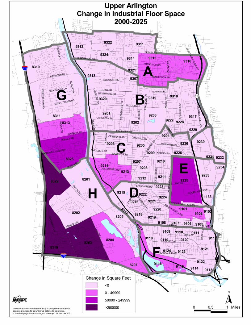
Industrial, Retail Office Space (square feet) in Upper ArlingtonTable 2
Subarea Indust 2000
Indust 2025
Retail 2000
Retail 2025
Indust Change
%Indust Change
Retail Change
%Retail Change
Office 2000
Office 2025
Office Change
%OfficeChange
North Perimeter (Henderson to Bethel)
83,509 122,000 1,573,163 1,515,000 1,103,383 1,347,00038,491 46% 243,617 22%-58,163 -4%A49,300 40,000 280,700 280,000 883,532 974,500-9,300 -19% 90,968 10%-700 0%B
466,600 458,500 1,074,494 1,006,200 465,682 550,394-8,100 -2% 84,712 18%-68,294 -6%C1,562,710 1,409,800 1,281,782 1,513,655 400,696 388,300-152,910 -10% -12,396 -3%231,873 18%D689,302 720,000 250,280 275,605 656,500 1,114,12530,698 4% 457,625 70%25,325 10%E
3,334,680 3,049,600 1,161,034 1,296,800 1,386,093 1,564,043-285,080 -9% 177,950 13%135,766 12%F433,852 515,000 1,078,688 1,610,000 139,291 2,000,00081,148 19% 1,860,709 1336%531,312 49%G
4,079,827 5,630,000 425,424 597,900 619,496 912,5001,550,173 38% 293,004 47%172,476 41%H10,699,780 11,944,900 1,245,120Area Total 7,125,565 8,095,160 969,595 5,654,673 8,850,862 3,196,18912% 14% 57%
Friday, No
Page 1 of 1Prepared by The Mid Ohio Regional Planning Commission285 E Main Street / Columbus Oh 43215/ (614) 228-2663

Figure 2: Industrial, Retail, and Office Space in Upper Arlington
0
1000000
2000000
3000000
4000000
5000000
6000000
A B C D E F G H
Sub-Area
Ind 2000Ind 2025Ret 2000Ret 2025Offc 2000Offc 2025

Subarea TZ Pop 2000 Pop 2025 DU 2000
DU 2025
Pop Change
% Pop Change
DU Change
% DU Change
Employ2025
EmployChange
%EmployChange
Employ2000
Population, Housing, and Employment in Upper ArlingtonTable 3:
A North Perimeter (Henderson to Bethel)9311 4,377 4,263 2,133 2,175 1,588 1,533-114 -3% -55 -3%42 2%
9324 1,870 2,205 1,273 1,500 345 321335 18% -24 -7%227 18%
9314 1,309 1,960 788 800 383 425651 50% 42 11%12 2%
9315 5,854 5,760 3,464 3,600 2,718 2,506-94 -2% -212 -8%136 4%
9316 1,591 1,584 959 960 1,181 1,545-7 0% 364 31%1 0%
9321 0 251 0 205 631 337251 0% -294 -47%205 0%
9322 2,011 2,178 851 1,270 808 800167 8% -8 -1%419 49%
9312 1,621 2,274 884 1,160 840 1,406652 40% 566 67%276 31%
18,633 20,475 1,842Subarea Total 10,352 11,670 1,842 8,494 8,873 37910% 13% 4%
B New UA (North of Fishinger)9201 2,519 2,646 1,084 1,200 106 94127 5% -12 -12%116 11%
9202 1,048 827 370 375 65 66-221 -21% 1 2%5 1%
9313 3,256 2,833 1,255 1,285 1,691 1,564-423 -13% -127 -7%30 2%
9307 0 0 0 0 659 6670 0% 8 1%0 0%
9317 1,467 1,529 638 780 745 1,15762 4% 412 55%142 22%
9319 2,374 1,962 887 890 58 58-412 -17% 0 0%3 0%
9203 0 0 0 0 46 350 0% -11 -24%0 0%
9227 623 588 299 300 54 94-35 -6% 40 74%1 0%
9228 964 823 419 420 59 63-141 -15% 4 7%1 0%
9229 0 0 0 0 6,400 6,2000 0% -200 -3%0 0%
9320 1,944 1,632 727 740 120 50-312 -16% -70 -58%13 2%
Friday, November 16, 2001Page 1 of 5
Prepared by The Mid Ohio Regional Planning Commission285 E Main Street / Columbus Oh 43215/ (614) 228-2663

Subarea TZ Pop 2000 Pop 2025 DU 2000
DU 2025
Pop Change
% Pop Change
DU Change
% DU Change
Employ2025
EmployChange
%EmployChange
Employ2000
Population, Housing, and Employment in Upper ArlingtonTable 3:
9318 1,456 1,539 776 785 283 23183 6% -52 -18%9 1%
15,652 14,379 -1,272Subarea Total 6,455 6,775 -1,272 10,286 10,278 -8-8% 5% 0%
C Mid UA (Between Lane Ave and Fishinger Rd)9204 768 803 381 410 34 2235 5% -12 -37%29 8%
9210 1,267 1,294 607 660 179 18627 2% 7 4%53 9%
9206 4,304 4,145 1,827 1,880 339 326-159 -4% -13 -4%53 3%
9232 341 382 173 195 969 1,45141 12% 482 50%22 13%
9230 3,349 3,753 1,913 1,915 1,782 1,274404 12% -508 -28%2 0%
9205 1,997 2,110 998 1,075 83 66113 6% -17 -21%77 8%
9236 1,345 1,274 641 650 250 327-71 -5% 77 31%9 1%
9209 0 0 0 0 1,177 6850 0% -493 -42%0 0%
9226 433 412 206 210 77 74-21 -5% -3 -3%4 2%
9214 2,505 2,617 1,233 1,335 105 117112 4% 12 11%102 8%
9207 604 507 337 345 0 0-97 -16% 0 0%8 2%
9208 542 576 223 235 117 11234 6% -5 -4%12 5%
9213 0 0 0 0 210 1770 0% -33 -16%0 0%
9211 1,364 1,283 564 582 302 277-81 -6% -25 -8%18 3%
9231 0 0 0 0 312 3720 0% 60 19%0 0%
9212 1,363 1,422 567 645 43 3259 4% -11 -25%78 14%
20,182 20,578 396Subarea Total 9,670 10,137 396 5,979 5,498 -4812% 5% -8%
D Old Arlington (Fifth Ave. to Lane Ave.)9101 2,212 2,646 1,595 1,800 1,843 1,849434 20% 6 0%205 13%
Friday, November 16, 2001Page 2 of 5
Prepared by The Mid Ohio Regional Planning Commission285 E Main Street / Columbus Oh 43215/ (614) 228-2663

Subarea TZ Pop 2000 Pop 2025 DU 2000
DU 2025
Pop Change
% Pop Change
DU Change
% DU Change
Employ2025
EmployChange
%EmployChange
Employ2000
Population, Housing, and Employment in Upper ArlingtonTable 3:
9220 1,212 1,101 471 500 109 77-111 -9% -32 -29%29 6%
9215 113 232 75 105 66 50119 105% -16 -25%30 40%
9222 1,869 1,621 717 735 5 21-248 -13% 16 311%18 3%
9224 1,532 1,455 644 660 130 105-77 -5% -25 -19%16 2%
9223 0 59 0 25 396 50059 0% 104 26%25 0%
9216 487 452 176 205 43 35-35 -7% -8 -20%29 16%
9217 143 192 82 87 282 30649 34% 24 8%5 6%
9102 570 390 265 265 763 425-180 -32% -339 -44%0 0%
9103 0 0 0 0 1,932 1,3670 0% -565 -29%0 0%
9219 623 717 320 325 0 094 15% 0 0%5 2%
9105 386 610 270 415 910 690224 58% -220 -24%145 54%
9108 735 772 503 525 141 13537 5% -6 -4%22 4%
9107 1,275 1,448 941 985 630 621173 14% -9 -1%44 5%
9106 412 412 265 280 266 2290 0% -37 -14%15 6%
9104 0 0 0 0 491 4670 0% -24 -5%0 0%
9218 1,059 918 504 535 105 105-142 -13% 0 0%31 6%
9221 228 253 104 115 157 15325 11% -4 -3%11 11%
12,856 13,276 420Subarea Total 6,932 7,562 420 8,269 7,134 -1,1353% 9% -14%
E Ohio State9225 75 88 40 72 4,459 5,80613 18% 1,347 30%32 80%
9234 61 288 31 147 2,035 1,389227 372% -646 -32%116 374%
9233 929 1,078 349 550 201 373149 16% 172 86%201 58%
Friday, November 16, 2001Page 3 of 5
Prepared by The Mid Ohio Regional Planning Commission285 E Main Street / Columbus Oh 43215/ (614) 228-2663

Subarea TZ Pop 2000 Pop 2025 DU 2000
DU 2025
Pop Change
% Pop Change
DU Change
% DU Change
Employ2025
EmployChange
%EmployChange
Employ2000
Population, Housing, and Employment in Upper ArlingtonTable 3:
9235 79 74 42 60 1,291 1,021-6 -7% -270 -21%18 43%
1133 0 0 0 0 2,354 3,0480 0% 694 29%0 0%
1,144 1,528 384Subarea Total 462 829 384 10,340 11,637 1,29734% 79% 13%
F Grandview, Marble Cliff (South of Fifth)9124 1,143 1,312 496 595 88 75169 15% -13 -15%99 20%
9120 986 904 402 410 49 31-82 -8% -18 -37%8 2%
9117 0 0 0 0 1,007 1,1270 0% 120 12%0 0%
9118 629 684 300 310 157 20455 9% 47 30%10 3%
9119 1,046 1,125 444 510 375 35279 8% -23 -6%66 15%
9109 1,048 1,007 665 685 633 582-41 -4% -51 -8%20 3%
9116 700 1,215 507 620 2,795 2,162515 74% -633 -23%113 22%
9110 467 426 283 290 322 254-41 -9% -68 -21%7 2%
9113 0 0 0 0 1,657 1,5930 0% -65 -4%0 0%
9123 2,631 2,723 1,146 1,235 361 40992 4% 48 13%89 8%
9122 0 0 0 0 848 1,0220 0% 174 20%0 0%
9115 159 176 79 90 642 70717 11% 65 10%11 14%
9114 0 0 0 0 295 2860 0% -9 -3%0 0%
9111 612 588 384 400 2,917 1,775-24 -4% -1,142 -39%16 4%
9121 754 783 356 355 2,823 2,56429 4% -259 -9%-1 0%
9112 0 0 0 0 399 5850 0% 186 47%0 0%
10,175 10,943 768Subarea Total 5,062 5,500 768 15,368 13,726 -1,6438% 9% -11%
G Hilliard Edge (West of the Scioto,north of Dublin Rd)
Friday, November 16, 2001Page 4 of 5
Prepared by The Mid Ohio Regional Planning Commission285 E Main Street / Columbus Oh 43215/ (614) 228-2663

Subarea TZ Pop 2000 Pop 2025 DU 2000
DU 2025
Pop Change
% Pop Change
DU Change
% DU Change
Employ2025
EmployChange
%EmployChange
Employ2000
Population, Housing, and Employment in Upper ArlingtonTable 3:
8313 949 2,058 397 1,050 1,988 4,2321,109 117% 2,244 113%653 164%
8310 4,832 6,615 1,814 3,000 0 1,3431,783 37% 1,343 0%1,186 65%
8311 4,245 6,395 1,669 2,900 649 3,7512,150 51% 3,102 478%1,231 74%
8325 4,194 4,900 1,873 2,000 869 1,475706 17% 606 70%127 7%
14,219 19,968 5,748Subarea Total 5,753 8,950 5,748 3,506 10,801 7,29540% 56% 208%
H Trabue Corridor8203 4,081 4,116 1,928 2,100 205 1,05435 1% 849 414%172 9%
8207 8 0 4 0 284 410-8 -100% 126 44%-4 -100%
8322 2 0 1 0 1,204 2,251-2 -100% 1,047 87%-1 -100%
8201 303 1,262 121 515 82 62959 317% -20 -24%394 326%
8202 2,153 2,021 784 825 835 1,601-132 -6% 765 92%41 5%
8319 1,826 1,666 738 850 2,251 1,976-160 -9% -275 -12%112 15%
8205 921 1,437 694 1,175 1,480 1,431517 56% -49 -3%481 69%
8204 1,484 1,421 687 725 1,001 1,652-63 -4% 651 65%38 6%
10,777 11,923 1,146Subarea Total 4,957 6,190 1,146 7,343 10,437 3,09411% 25% 42%
103,637 113,069 9,431Area Tota 49,643 57,613 9,431 69,585 78,384 8,7999% 16% 13%
Friday, November 16, 2001Page 5 of 5
Prepared by The Mid Ohio Regional Planning Commission285 E Main Street / Columbus Oh 43215/ (614) 228-2663

Subarea Traffic Zone
Indust 2000
Indust 2025
Retail 2000
Retail 2025
Indust Change
%Indust Change
Retail Change
%Retail Change
Office 2000
Office 2025
Office Change
%OfficeChange
Industrial, Retail Office Space (square feet) in Upper ArlingtonTable 4:
A North Perimeter (Henderson to Bethel)9322 0 0 176,390 227,000 12,000 12,0000 0% 0 0%50,610 29%
9321 0 0 184,436 0 77,271 80,0000 0% 2,729 4%-184,436 -100%
9324 1,000 0 92,115 85,000 21,193 20,000-1,000 -100% -1,193 -6%-7,115 -8%
9316 11,692 12,000 428,699 435,000 123,444 120,000308 3% -3,444 -3%6,301 1%
9315 67,960 110,000 335,801 355,000 426,685 425,00042,040 62% -1,685 0%19,199 6%
9314 0 0 0 8,000 113,500 140,0000 0% 26,500 23%8,000 0%
9312 0 0 113,717 175,000 30,500 250,0000 0% 219,500 720%61,283 54%
9311 2,857 0 242,005 230,000 298,790 300,000-2,857 -100% 1,210 0%-12,005 -5%
83,509 122,000 38,491Subarea Total 1,573,163 1,515,000 -58,163 1,103,383 1,347,000 243,61746% -4% 22%
B New UA (North of Fishinger)9201 0 0 18,420 11,000 15,500 15,5000 0% 0 0%-7,420 -40%
9227 0 0 20,000 20,000 8,500 8,5000 0% 0 0%0 0%
9228 0 0 0 0 2,100 2,1000 0% 0 0%0 0%
9229 0 0 0 0 0 00 0% 0 0%0 0%
9202 0 0 0 0 0 00 0% 0 0%0 0%
9317 0 0 0 0 271,282 380,0000 0% 108,718 40%0 0%
9320 0 0 7,200 15,000 0 00 0% 0 0%7,800 108%
9203 0 0 0 0 0 00 0% 0 0%0 0%
9318 49,300 40,000 21,700 22,000 18,400 18,400-9,300 -19% 0 0%300 1%
9307 0 0 203,380 200,000 65,050 50,0000 0% -15,050 -23%-3,380 -2%
9313 0 0 10,000 12,000 502,700 500,0000 0% -2,700 -1%2,000 20%
Friday, No
Page 1 of 5Prepared by The Mid Ohio Regional Planning Commission285 E Main Street / Columbus Oh 43215/ (614) 228-2663

Subarea Traffic Zone
Indust 2000
Indust 2025
Retail 2000
Retail 2025
Indust Change
%Indust Change
Retail Change
%Retail Change
Office 2000
Office 2025
Office Change
%OfficeChange
Industrial, Retail Office Space (square feet) in Upper ArlingtonTable 4:
9319 0 0 0 0 0 00 0% 0 0%0 0%
49,300 40,000 -9,300Subarea Total 280,700 280,000 -700 883,532 974,500 90,968-19% 0% 10%
C Mid UA (Between Lane Ave and Fishinger Rd)9205 0 0 1,500 1,500 21,300 21,3000 0% 0 0%0 0%
9207 0 0 0 0 0 00 0% 0 0%0 0%
9204 0 0 0 0 7,200 7,2000 0% 0 0%0 0%
9214 5,000 8,500 15,800 24,500 8,728 12,0003,500 70% 3,272 37%8,700 55%
9208 0 0 18,000 18,000 4,000 4,0000 0% 0 0%0 0%
9209 0 0 358,846 171,000 60,132 80,0000 0% 19,868 33%-187,846 -52%
9210 0 0 2,400 2,400 11,362 15,0000 0% 3,638 32%0 0%
9211 0 0 21,300 22,800 69,400 74,0000 0% 4,600 7%1,500 7%
9212 0 0 10,000 10,000 4,400 2,1940 0% -2,206 -50%0 0%
9213 0 0 43,820 44,000 17,720 18,0000 0% 280 2%180 0%
9226 0 0 17,000 17,000 10,700 10,7000 0% 0 0%0 0%
9236 0 0 9,000 9,000 91,000 91,0000 0% 0 0%0 0%
9230 450,000 450,000 91,482 93,000 26,700 90,0000 0% 63,300 237%1,518 2%
9232 0 0 306,278 410,000 109,940 90,0000 0% -19,940 -18%103,722 34%
9206 11,600 0 52,300 48,000 23,100 30,000-11,600 -100% 6,900 30%-4,300 -8%
9231 0 0 126,768 135,000 0 5,0000 0% 5,000 0%8,232 6%
466,600 458,500 -8,100Subarea Total 1,074,494 1,006,200 -68,294 465,682 550,394 84,712-2% -6% 18%
D Old Arlington (Fifth Ave. to Lane Ave.)
Friday, No
Page 2 of 5Prepared by The Mid Ohio Regional Planning Commission285 E Main Street / Columbus Oh 43215/ (614) 228-2663

Subarea Traffic Zone
Indust 2000
Indust 2025
Retail 2000
Retail 2025
Indust Change
%Indust Change
Retail Change
%Retail Change
Office 2000
Office 2025
Office Change
%OfficeChange
Industrial, Retail Office Space (square feet) in Upper ArlingtonTable 4:
9104 46,000 46,200 64,132 129,000 13,200 13,200200 0% 0 0%64,868 101%
9103 1,440 0 374,800 450,000 83,200 60,000-1,440 -100% -23,200 -28%75,200 20%
9102 268,600 270,000 300 0 0 01,400 1% 0 0%-300 -100%
9101 829,100 835,000 221,100 260,555 54,513 55,0005,900 1% 487 1%39,455 18%
9219 0 0 0 0 0 00 0% 0 0%0 0%
9105 345,570 195,000 106,221 125,000 38,600 38,600-150,570 -44% 0 0%18,779 18%
9106 2,700 1,500 74,368 75,000 9,000 9,000-1,200 -44% 0 0%632 1%
9107 62,100 62,100 139,731 147,000 56,400 56,0000 0% -400 -1%7,269 5%
9108 0 0 33,804 31,000 17,733 18,0000 0% 267 2%-2,804 -8%
9215 0 0 4,500 4,500 0 00 0% 0 0%0 0%
9218 0 0 8,475 26,700 10,900 12,0000 0% 1,100 10%18,225 215%
9217 7,200 0 32,064 42,000 62,150 65,000-7,200 -100% 2,850 5%9,936 31%
9216 0 0 1,800 1,800 10,000 10,0000 0% 0 0%0 0%
9224 0 0 3,760 2,600 22,800 24,0000 0% 1,200 5%-1,160 -31%
9223 0 0 164,227 163,000 7,500 7,5000 0% 0 0%-1,227 -1%
9222 0 0 1,200 2,500 0 5,0000 0% 5,000 0%1,300 108%
9221 0 0 21,756 23,000 14,700 15,0000 0% 300 2%1,244 6%
9220 0 0 29,544 30,000 0 00 0% 0 0%456 2%
1,562,710 1,409,800 -152,910Subarea Total 1,281,782 1,513,655 231,873 400,696 388,300 -12,396-10% 18% -3%
E Ohio State9235 210,510 120,000 68,180 68,180 100,000 100,000-90,510 -43% 0 0%0 0%
9233 0 0 41,700 58,625 0 00 0% 0 0%16,925 41%
Friday, No
Page 3 of 5Prepared by The Mid Ohio Regional Planning Commission285 E Main Street / Columbus Oh 43215/ (614) 228-2663

Subarea Traffic Zone
Indust 2000
Indust 2025
Retail 2000
Retail 2025
Indust Change
%Indust Change
Retail Change
%Retail Change
Office 2000
Office 2025
Office Change
%OfficeChange
Industrial, Retail Office Space (square feet) in Upper ArlingtonTable 4:
1133 28,800 0 0 0 1,200 18,125-28,800 -100% 16,925 1410%0 0%
9225 449,992 600,000 135,600 144,000 178,500 600,000150,008 33% 421,500 236%8,400 6%
9234 0 0 4,800 4,800 376,800 396,0000 0% 19,200 5%0 0%
689,302 720,000 30,698Subarea Total 250,280 275,605 25,325 656,500 1,114,125 457,6254% 10% 70%
F Grandview, Marble Cliff (South of Fifth)9111 1,007,616 800,000 138,788 140,000 141,121 150,000-207,616 -21% 8,879 6%1,212 1%
9117 164,427 165,000 500 0 320,950 325,000573 0% 4,050 1%-500 -100%
9109 0 0 132,840 153,000 52,278 53,0000 0% 722 1%20,160 15%
9110 0 0 82,731 56,000 32,170 32,0000 0% -170 -1%-26,731 -32%
9122 311,100 310,000 91,400 91,500 71,600 140,000-1,100 0% 68,400 96%100 0%
9115 49,882 50,000 225,935 224,000 14,700 16,000118 0% 1,300 9%-1,935 -1%
9112 9,400 7,000 58,800 143,500 32,300 35,000-2,400 -26% 2,700 8%84,700 144%
9123 81,200 78,500 45,500 75,100 33,900 28,900-2,700 -3% -5,000 -15%29,600 65%
9121 1,063,000 1,000,000 147,800 148,000 255,600 260,000-63,000 -6% 4,400 2%200 0%
9120 2,400 0 3,200 3,200 7,600 7,600-2,400 -100% 0 0%0 0%
9119 6,400 5,000 54,600 57,000 48,800 53,000-1,400 -22% 4,200 9%2,400 4%
9118 10,100 10,100 45,940 49,500 11,484 15,0000 0% 3,516 31%3,560 8%
9116 438,455 440,000 117,000 140,000 314,990 400,0001,545 0% 85,010 27%23,000 20%
9114 0 0 0 0 37,800 37,7430 0% -57 0%0 0%
9113 187,300 184,000 0 0 0 0-3,300 -2% 0 0%0 0%
9124 3,400 0 16,000 16,000 10,800 10,800-3,400 -100% 0 0%0 0%
Friday, No
Page 4 of 5Prepared by The Mid Ohio Regional Planning Commission285 E Main Street / Columbus Oh 43215/ (614) 228-2663

Subarea Traffic Zone
Indust 2000
Indust 2025
Retail 2000
Retail 2025
Indust Change
%Indust Change
Retail Change
%Retail Change
Office 2000
Office 2025
Office Change
%OfficeChange
Industrial, Retail Office Space (square feet) in Upper ArlingtonTable 4:
3,334,680 3,049,600 -285,080Subarea Total 1,161,034 1,296,800 135,766 1,386,093 1,564,043 177,950-9% 12% 13%
G Hilliard Edge (West of the Scioto,north of Dublin Rd)8325 433,852 500,000 227,284 345,000 20,000 066,148 15% -20,000 -100%117,716 52%
8313 0 15,000 851,404 925,000 41,291 600,00015,000 0% 558,709 1353%73,596 9%
8311 0 0 0 260,000 78,000 1,000,0000 0% 922,000 1182%260,000 0%
8310 0 0 0 80,000 0 400,0000 0% 400,000 0%80,000 0%
433,852 515,000 81,148Subarea Total 1,078,688 1,610,000 531,312 139,291 2,000,000 1,860,70919% 49% 1336%
H Trabue Corridor8203 0 800,000 21,624 20,000 20,000 60,000800,000 0% 40,000 200%-1,624 -8%
8201 0 0 0 0 0 00 0% 0 0%0 0%
8202 719,000 700,000 83,100 90,000 61,033 190,000-19,000 -3% 128,967 211%6,900 8%
8204 981,794 1,010,000 161,100 180,000 15,500 20,00028,206 3% 4,500 29%18,900 12%
8205 10,000 0 0 91,000 315,963 380,000-10,000 -100% 64,037 20%91,000 0%
8207 184,600 195,000 13,500 54,400 0 7,50010,400 6% 7,500 0%40,900 303%
8322 1,267,517 1,625,000 141,600 149,500 44,000 58,000357,483 28% 14,000 32%7,900 6%
8319 916,916 1,300,000 4,500 13,000 163,000 197,000383,084 42% 34,000 21%8,500 189%
4,079,827 5,630,000 1,550,173Subarea Total 425,424 597,900 172,476 619,496 912,500 293,00438% 41% 47%
103,637 113,069 9,431Area Tota 49,643 57,613 9,431 69,585 78,384 8,7999% 16% 13%
Friday, No
Page 5 of 5Prepared by The Mid Ohio Regional Planning Commission285 E Main Street / Columbus Oh 43215/ (614) 228-2663

����
����
����
����
����
����
����
����
����
�������
����
����
���
�������
����
����
����
����
����
�������� ����
����
����
����
����
����
����
����
����
���
����
����
����
����
����
����
����
���
���
����
����
����
����
���
���
���
����
����
����
����
����
���
���� ����
���
����
���
����
����
����
����
����
����
�������
����
����
����
����
���
���
����
����
���
����
�������
����
����
����
����
���
����
�������������
���� ��������
�������
����������
�������
�����������
���������
�
�����������
��������
�����������
���������������������
�����������
���������
�����������
���������
��������
�
���������
���� ��������
����������
������������������
�������
���������
���
�����������������������
������������
�����������
��������
������������
���
������������
�������
����
�������
����������
�����������
��������
����������
������������
������� ������
���
������
�����
�����
���������
����
����
����
���� ����������
���
������
����
������������
���� ������
����
����
���
����������
����
����
������������������
��������
��������
�
����������
������
��������
��������
������������
��������
������������
������������
�
� �
�
�
�
�
�
������������������������� ��!������
����"����
�!"�#$%&'()*#&$�+!&,$�&$�*!#+�()-�#+��&(-#."/�%'&(�0)'#&1++&1'�"+�)0)#.)2."�*&�1+�,!#�!�,"�2".#"0"�*&�2"�'".#)2."3$45)'�0#",5-'&6"�*+51--"')'.#$7*&$�+*1/83)-'����&0"(2"'�����
� �3� � �#."+
�
!)$7"�#$��1(2"'�&%� "&-."9���:��;<����:�;<<=���

����
����
����
����
����
����
����
����
����
�������
����
����
���
�������
����
����
����
����
����
�������� ����
����
����
����
����
����
����
����
����
���
����
����
����
����
����
����
����
���
���
����
����
����
����
���
���
���
����
����
����
����
����
���
���� ����
���
����
���
����
����
����
����
����
����
�������
����
����
����
����
���
���
����
����
���
����
�������
����
����
����
����
���
����
�������������
���� ��������
�������
����������
�������
�����������
���������
������������
��������
�����������
���������������������
�����������
���������
�����������
���������
��������
�
���������
���� ��������
����������
������������������
�������
���������
���
�����������������������
������������
�����������
��������
������������
���
������������
�������
����
�������
����������
�����������
��������
����������
������������
������� ������
���
������
�����
�����
���������
����
����
����
���� ����������
���
������
����
������������
���� ������
����
����
���
����������
����
����
������������������
��������
��������
�
����������
������
��������
��������
������������
��������
������������
������������
�
� �
�
�
�
�
�
������������������������� !"#����$���!%��������%
����&����
�!"�#$%&'()*#&$�+!&,$�&$�*!#+�()-�#+��&(-#."/�%'&(�0)'#&1++&1'�"+�)0)#.)2."�*&�1+�,!#�!�,"�2".#"0"�*&�2"�'".#)2."3$45)'�0#",5-'&6"�*+51--"')'.#$7*&$�+*1/83)-'����&0"(2"'�����
� �3� � �#."+
�
!)$7"�#$��&1+#$7��$#*+9���:���;����:��;<=���

����
����
����
����
����
����
����
����
����
�������
����
����
���
�������
����
����
����
����
����
�������� ����
����
����
����
����
����
����
����
����
���
����
����
����
����
����
����
����
���
���
����
����
����
����
���
���
���
����
����
����
����
����
���
���� ����
���
����
���
����
����
����
����
����
����
�������
����
����
����
����
���
���
����
����
���
����
�������
����
����
����
����
���
����
����
���������
���� ��������
�������
����������
�������
�����������
���������
�
�����������
��������
�����������
���������������������
�����������
���������
�����������
���������
��������
�
���������
���� ��������
����������
������������������
�������
���������
���
�����������������������
������������
�����������
��������
������������
���
������������
�������
����
�������
����������
�����������
������������������
������������
������� ������
���
������
�����
�����
���������
����
����
����
���� ����������
���
������
����
������������
���� ������
����
����
���
����������
����
����
������������������
��������
��������
�
����������
������
��������
��������
������������
��������
������������
������������
�
� �
�
�
�
�
�
������������������������� ���! ���
����"����
�!"�#$%&'()*#&$�+!&,$�&$�*!#+�()-�#+��&(-#."/�%'&(�0)'#&1++&1'�"+�)0)#.)2."�*&�1+�,!#�!�,"�2".#"0"�*&�2"�'".#)2."3$45)'�0#",5-'&6"�*+51--"')'.#$7*&$�+*1/83)-'����&0"(2"'����� � �3� � �#."+
�
!)$7"�#$��1(2"'�&%��&2+
9���:��;<����:�;<<=���

����
����
����
����
����
����
����
����
����
�������
����
����
���
�������
����
����
����
����
����
�������� ����
����
����
����
����
����
����
����
����
���
����
����
����
����
����
����
����
���
���
����
����
����
����
���
���
���
����
����
����
����
����
���
���� ����
���
����
���
����
����
����
����
����
����
�������
����
����
����
����
���
���
����
����
���
����
�������
����
����
����
����
���
����
����
���������
���� ��������
�������
����������
�������
�����������
���������
�
�����������
��������
�����������
���������������������
�����������
���������
�����������
���������
��������
�
���������
���� ��������
����������
������������������
�������
���������
���
�����������������������
������������
�����������
��������
������������
���
������������
�������
����
�������
����������
�����������
��������
����������
������������
������� ������
���
������
�����
�����
���������
����
����
����
���� ����������
���
������
����
������������
���� ������
����
����
���
����������
����
����
������������������
��������
��������
�
����������
������
��������
��������
������������
��������
������������
������������
�
� �
�
�
�
�
�
������������������������� !!�"��������#��"�
����$����
�!"�#$%&'()*#&$�+!&,$�&$�*!#+�()-�#+��&(-#."/�%'&(�0)'#&1++&1'�"+�)0)#.)2."�*&�1+�,!#�!�,"�2".#"0"�*&�2"�'".#)2."3$45)'�0#",5-'&6"�*+51--"')'.#$7*&$�+*1/83)-'����&0"(2"'�����
� �3� � �#."+
�
!)$7"�#$�91)'"��""*:���;�<====������;��<====>������

����
����
����
����
����
����
����
����
����
�������
����
����
���
�������
����
����
����
����
����
�������� ����
����
����
����
����
����
����
����
����
���
����
����
����
����
����
����
����
���
���
����
����
����
����
���
���
���
����
����
����
����
����
���
���� ����
���
����
���
����
����
����
����
����
����
�������
����
����
����
����
���
���
����
����
���
����
�������
����
����
����
����
���
����
����
���������
���� ��������
�������
����������
�������
�����������
���������
�
�����������
��������
�����������
���������������������
�����������
���������
�����������
���������
��������
�
���������
���� ��������
����������
������������������
�������
���������
���
�����������������������
������������
�����������
��������
������������
���
������������
�������
����
�������
����������
�����������
������������������
������������
������� ������
���
������
�����
�����
���������
����
����
����
���� ����������
���
������
����
������������
���� ������
����
����
���
����������
����
����
������������������
��������
��������
�
����������
������
��������
��������
������������
��������
������������
������������
�
� �
�
�
�
�
�
�!"�#$%&'()*#&$�+!&,$�&$�*!#+�()-�#+��&(-#."/�%'&(�0)'#&1++&1'�"+�)0)#.)2."�*&�1+�,!#�!�,"�2".#"0"�*&�2"�'".#)2."3$45)'�0#",5-'&6"�*+51--"')'.#$7*&$�+*1/83)-'����&0"(2"'�����
� �3� � �#."+
�
!)$7"�#$�91)'"��""*:���;�<====������;��<====>������
������������������������� ������������!��"�
����#����
����
����
����
����
����
����
����
����
����
�������
����
����
���
�������
����
����
����
����
����
�������� ����
����
����
����
����
����
����
����
����
���
����
����
����
����
����
����
����
���
���
����
����
����
����
���
���
���
����
����
����
����
����
���
���� ����
���
����
���
����
����
����
����
����
����
�������
����
����
����
����
���
���
����
����
���
����
�������
����
����
����
����
���
����
����
���������
���� ��������
�������
����������
�������
�����������
���������
�
�����������
��������
�����������
���������������������
�����������
���������
�����������
���������
��������
�
���������
���� ��������
����������
������������������
�������
���������
���
�����������������������
������������
�����������
��������
������������
���
������������
�������
����
�������
����������
�����������
��������
����������
������������
������� ������
���
������
�����
�����
���������
����
����
����
���� ����������
���
������
����
������������
���� ������
����
����
���
����������
����
����
������������������
��������
��������
�
����������
������
��������
��������
������������
��������
������������
������������
�
� �
�
�
�
�
�
������������������������� �!"#������������$��%�
����&����
�!"�#$%&'()*#&$�+!&,$�&$�*!#+�()-�#+��&(-#."/�%'&(�0)'#&1++&1'�"+�)0)#.)2."�*&�1+�,!#�!�,"�2".#"0"�*&�2"�'".#)2."3$45)'�0#",5-'&6"�*+51--"')'.#$7*&$�+*1/83)-'����&0"(2"'�����
� �3� � �#."+
�
!)$7"�#$�91)'"��""*:���;�<====������;��<====>������

Traffic Projections for the Upper Arlington Transportation Plan Update November 21, 2001Mid-Ohio Regional Planning Commission
Appendix D
MORPC FY 2002-2005 TIP and Project List

$T
$T
$T
$T
$T
$T
#S
#S#S#S
#S
$T
#S
#S#S
$T
$T
#S
#S#S
#S#S
#S
$T#S
#S#S
#S#S
#S
#S
$T
#S
#S#S
#S
#S
#S
#S
#S
#S
#S #S
#S
#S
#S
#S
#S
#S
#S
#S
$T
$T #S
$T
#S
#S
$T
e
e
e
e
e
,270 Pataskala
Dublin
Delaware
HilliardGahanna
GroveCity Groveport
Westerville
NewAlbany
Obetz
Whitehall
Pickerington
Reynoldsburg
Worthington
Powell
Bexley
CanalWinchester
Sunbury
Galena
Ashley
Ostrander
Lithopolis
Johnstown
DELAWARE COUNTY
MORROW COUNTY
DELA
WARE
COU
NTY
KNOX
COU
NTY
MARION COUNTYUN
ION
COUN
TY
FRANKLIN COUNTYDELAWARE COUNTY
LICK
ING
COUN
TY
FAIR
FIEL
D CO
UNTY
FRANKLIN COUNTYPICKAWAY COUNTY
MADISON COUNTY
MADI
SON
COUN
TY
RIVER
ALUM CREEK RESERVOIR
HOOV
ER
RES
ERVO
IR
BIG
WAL
NUT
CREE
K
DELA
WAR
ERE
SERV
OIR
SCIOTO
RIVER
"!161
"!161 "!161
"!605
"!3
"!257
"!745
"!3
(/23
(/33
OLENTANGY
RIVER
WALNUT
CREE
K
BIG
CREEK
OLENTANGY
RIVER
"!203
"!257
"!4"!229
"!37
"!37
"!37
"!656
"!521
"!47
(/23
(/42
(/42
(/36
(/36
(/36
(/62
(/33
(/40(/40
(/62
(/33
(/23
"!104
"!665 "!317
"!317
"!204
"!256
"!3
"!104
"!16
"!310
"!61
"!3
"!750
"!315
(/62
FRAN
KLIN
COU
NTY
1014809
797
816
820
1013
982
415
433
882
,70
,70
,270
,270
,70
71,
71,
71,
894 999996
929
980
888821
991822
573 894 735
528
1012
887984
884
819
772890
543
195
948
942
1002
793
878
815
615
627
154 118
904
1005
199995 377
420
329274
981
752
976
207
10081009
173
693
987
957
989
691 619688
686
988
689
979
986
1761007
1010
732
277
717
409
408
969
969
794
908
776
738885
808636
919
921
777
1017
886970
978632
818
646
781
280
775
993
1004
817
238 241 317
276
421
273
275240
220
177
711
724
936
701
184 937
935
180
1006
949
985
895
795
934
697 725
938
607
824
923893
905
990
924
604
618
736 735
983
774 956
579
578
555
1003
1001
944
883
425
951
998
1023
305303304
997
1031
1032
1030
8921033
,670
1029
810
155
994
889
1034
889
889
889
787
792609
881
726
646
646
734
1039
1038
1040
845
ALUM
CREE
K
RIVER
SCIOTO
DARBY
BIG
SCIO
TO
TRANSPORTATION IMPROVEMENT PROGRAMPROJECT LOCATION MAP
The information shown on this map is compiled from varioussources available to us which we believe to be reliable. n:\arcview\tplan\tip 2001.apr June 8, 2001
N
0 2 4 Miles
D o w
n t o
w n
A r
e a #S
#S#S
#S
#S#S
70,
,71
,670"!3
"!315
(/33
(/33
(/23
(/40
(/23
,71
128127
920922
916
122
113
117
25
118
155 891
Fiscal Years 2002 - 2005July 1, 2001 to June 30, 2004
Adopted by Resolution T-12-01
LEGE
ND
Major WideningNew Roadway Location
New InterchangeMinor Widening/Safety Improvement
Interchange UpgradeIntersection ImprovementResurfacing/Maintenance
BridgeNew Bikeway
Enhancement/Streetscape/Landscaping/StudyLandscaping/Other
Map Location Number
CONSTRUCTION PHASEFY 2002 - 2005
CONSTRUCTION PHASEafter FY 2005
(Construction not part of TIP)
#S #S
#S
$T
#S #S#S$T
#S
#S100
Planning Area100 100 100 100100100 100
Mid-Ohio Regional Planning Commission285 East Main Street
Columbus, Ohio 43215-5272(614) 228-2663
June 2001
Please check www.MORPC.org forupdates to this map and project listing.

**MORPC ID Map Key to Accompany state Fiscal Years 2002 to 2005 TIP
Project NameMORPC ID # County-Route-Section Agency
3 FRA-Rideshare/Vanpool- MORPCRideshare/Vanpool/Workforce/Ozone, Ridesharing
7 ALL-Line Item Project- ODOTPlanning, Planning Activity8 ALL-Line Item Project- ODOTPreperation and Guidance, Planning Activity
9 ALL-Line Item Project- ODOTBridge Inspection, Bridge Inspection
10 ALL-Line Item Project- ODOTConsultant, Environmental Assess
14 FRA-Paving the Way-Program COLUMBUSPaving the Way Program from 2004 to 2005, Program Administration
22 ALL-Recreational Trails- ODNRODNR Trails, Pedestrian Recreational Trails
25 FRA-COTA-MMTT COTACOTA MMTT west of High St at across from Convention Center N of
33 ALL-Line Item Project- ODOTRailroad Highway Crossing, RR Grade Separation
34 ALL-Line Item Project- ODOTRideshare Program, Ridesharing
36 ALL-Line Item Project- ODOTTransportation Enhancement, Enhancement Activity
37 ALL-Line Item Project- ODOTODOT Operations Division, Resurfacing38 ALL-Line Item Project- ODOTOperation and Maintenance, Maintenance Activity
53 ALL-LINE ITEM PROJECT- ODOTPublic Safety Program 402, Safety Program
78 ALL-LINE ITEM PROJECT- ODOTScenic Byway Program, Enhancement Activity
86 FRA-LOCAL Human-Service HUMAN Local Human Service Agency, Purchase
89 FRA-COTA- COTACOTA Operating Revenue, Transit
94 FRA-COTA-Buses COTACOTA Buses, Transit Purchase
102 FRA-SGNL12-0.00 COLUMBUSColumbus Signals Phase 12, Signalization
113 FRA-US0062-01.30 COLUMBUSTown St at Scioto River, Bridge Replacement
117 FRA-US0062-22.708 COLUMBUSUS-62 (Main St) at Scioto River, Bridge Replacement
118 FRA-SSILS1-0.00 ODOT 6SSI Landscaping from I-670 Grandview Ave to E of Neil to SR-315 Broad
122 FRA-IR0071-17.75 ODOT 6I-71 at East Long and Spring Sts, Bridge Rehabilitation
127 FRA-IR0670-01.25 B-1 COLUMBUSSSI I-670 B-1 from Neil Ave to to I-71, New Freeway128 FRA-IR0670-2.610 ODOT 6I-670 B-3 from Chessie RR Track to Neil Ave, New Freeway
151 FRA-SGNL11-0.00 COLUMBUSColumbus Signals Phz 11, Signalization
154 FRA-IR0670-0.000 ODOT 6I-670 from I-70 to Grandview Ave, Resurfacing
155 FRA-IR0670-A1-BKW ODOT 6I-670 Bikeway A-1, Bikeway, Class I Path
173 FRA-CR0003-24.505 HILLIARDHilliard-Rome Road (Hilliard) from Roberts Rd to Cemetery Rd, Major
176 FRA-CR0029-0.27 FRANKLIN Scioto Darby Rd (CR-29) from Amity Rd to Alton Darby Creek Rd, Minor
177 FRA-Avery-Tuttle Blvd Ext DUBLINAvery Rd from Tuttle Blvd Ext to Shier-Rings, Major Widening
180 FRA-SR0029-Leap HILLIARDScioto-Darby Rd (SR-29) from Main St to Leap, Minor Widening
184 FRA-Roberts-Hilliard/Rome COLUMBUSRoberts Rd from Hilliard-Rome Rd to I-270, Major Widening
195 FAI-SR0256-Diley-Col St PICKERINGTONSR-256 from Diley Rd to Columbus St, Minor Widening
199 FRA-SR0745-Dublin Bikeway DUBLINDublin Bikeway (SR-745) from SR-161 to Glick Rd, Bikeway, Class I Path207 FRA-Tuttle Crossing Blvd-Avery DUBLINTuttle Crossing Blvd Ext from Avery Rd to Wilcox Rd, New Roadway
220 FRA-Emerald PKWY-Bright DUBLINEmerald PKWY from SR-257 to Bright Rd, New Roadway
238 FRA-CR0061-2.33 COLUMBUSHard Rd. Phase B from Smoky Row Rd. to Linworth Rd., Major Widening
240 FRA-SR0161-5.77 COLUMBUSSR-161 - Phase B from McVey Blvd to Flora Villa Dr, Major Widening
241 FRA-OLENBK-0.00 COLUMBUSOlentangy Bikeway from Wilson Bridge to Worthington Hills Park,
273 FRA-CR0061-1.10 COLUMBUSHard Rd Phase A from Sawmill to Smokey Row, Major Widening
274 FRA-CR0061-3.65 COLUMBUSHard Rd Phase C from Linworth Rd to Olentangy River Rd, Major Widening
275 FRA-SR0161-5.77 COLUMBUSSR-161- Phase A from Sawmill Rd to McVey Blvd, Major Widening
276 FRA-SR0161-5.77 COLUMBUSSR-161 - Phase C from Flora Villa Dr to Olentangy River Rd, Minor
277 FRA-SR0315-12.800 ODOT 6SR-315 at Clubview Blvd South, Turn Lanes
280 DEL-SR0315-00.86 ODOT 6SR-315 at Bartholomew Run, Bridge Replacement
303 FRA-Lane Avenue-High St COLUMBUSLane Ave from Olentangy River to High St, Major Widening
304 FRA-315-03.48 ODOT 6OSU Ramps from SR-315 to Cannon Drive., New Interchange
305 FRA-CR0059-3.18 FRANKLIN Lane Ave (CR-59) at Olentangy River, Bridge Replacement
317 FRA-Worthington-Galena- WORTHINGTONWorthington-Galena at Huntley, Intersection Upgrade
329 FRA-US0023-Flint COLUMBUSHigh St (US-23) from Flint Rd to Lazelle Rd, Major Widening
377 DEL-County Line Road- WESTERVILLECounty Line Rd (Smothers Rd) from east of SR-3 to Cleveland Ave, New
Page 1 of 5Friday, May 04, 2001

Project NameMORPC ID # County-Route-Section Agency
408 FRA-Dempsey Road-Hempstead WESTERVILLEDempsey Rd from Hempstead Rd to Sunbury Rd, Minor Widening
409 DEL-SR0003-3.420 ODOT 6SR-3 at TR-109 (Big Walnut Rd), Intersection Upgrade
415 FRA-CR0177-B FRANKLIN Stelzer Rd (CR-177) from Fouraker Rd to north of I-670, Major Widening
420 FRA-SR0161-16.12 ODOT 6SR-161 at Sunbury Rd (CDMS 10), Major Widening
421 FRA-IR0270-40.260 ODOT 6I-270 at SR-161(CDMS #11), Interchange Upgrade
425 FRA-US0062X-19.39 ODOT 6US-62 at Alum Creek, Bridge Rehabilitation
433 FRA-International-Gateway COLUMBUS Stelzer Rd at I-670, New Interchange
481 FRA-Livingston Ave-College COLUMBUSLivingston Ave from Nelson Rd to College Ave, Major Widening
528 FRA-CR0222-Chantry Dr FRANKLIN Gender Rd (CR-222) from US-33 to Chantry Dr, Major Widening
543 FAI-Diley Road-SR-256 PICKERINGTONDiley Rd from SR-256 to US-33, Major Widening
555 FAI-US0033-01.20 ODOT 5US-33 at Hill (CR-18) Diley (TR-207) Rd, New Interchange
572 FRA-IR0270/IR0070-00.00 Phz 2 COLUMBUSI-270/I-70 FMS Phase 2, Freeway Surveillance
573 FRA-CR0122-Frebis COLUMBUSAlum Creek Dr from Frebis to Refugee, Major Widening
578 FRA-CR0122-Refugee COLUMBUSAlum Creek from Williams to Refugee, Major Widening
579 FRA-CR0122-2.97 OBETZAlum Creek from I-270 to Williams, Major Widening
604 FRA-IR0071-0.00 ODOT 6I-71 from Pickaway Co Line to SR-665, Reconstruction607 FRA-CR0262-03.700 GROVE CITYHoover Rd (CR-262) from Orders Rd to Milligan Grove Rd, Minor Widening
609 FRA-SR0665-10.09 ODOT 6SR-655 at Linebauch Ditch, Bridge Replacement
615 FRA-Hoover/Orders Rd-I-71 GROVE CITYHoover/Orders Rds at I-71, New Interchange (Study)
617 FRA-Emergency Signal-System GROVE CITY13 Emergency Signals, Signalization
618 FRA-SR0104-01.24 ODOT 6SR-104/665, Intersection Upgrade
619 FRA-US0062-12.985 ODOT 6US-62 from Broadway to I-70, Resurfacing
627 FRA-US0062-01.31 ODOT 6US-62 at RR, Reconstruction Pavement Lower
632 DEL-US0023-12.99 DELAWARE US-23 at Pennsylvania Ave, New Interchange
636 DEL-US0036-09.780 ODOT 6US-36 at Delaware Run, Bridge Replacement
646 DEL-IR0071-13.07/0.00 ODOT 6I-71 in DEL/MRW Cos, Bridge Replacement
686 FRA-CR0026-Sullivant Ave FRANKLIN Georgesville CR-26 from Sullivant Ave to N of Broad St, Minor Widening
688 FRA-Demorest-Briggs COLUMBUS/FRADemorest Rd from Briggs Rd to Sullivant Ave, Minor Widening
689 FRA-CR0143-Georgesville Rd FRANKLIN Sullivant Ave (CR-143) from Georgesville Rd to west of Wilson Rd, Minor
691 FRA-CR0125-3.612 FRANKLIN Clime Rd (CR-125) from Georgesville to Harrisburg Pike (SR-3/US-62),
693 FRA-CR0003-9.82 COLUMBUSNorton Rd (CR-3) from W Broad St to Hall Rd, Major Widening
697 FRA-CR0003-Kropp FRANKLIN Norton Rd (CR-3) from Kropp Rd to Bausch Rd, Minor Widening
701 FRA-CR0003-14.06 COLUMBUSHilliard-Rome Rd (Columbus) from I-70 to Roberts Rd, Major Widening
711 FRA-Cosgray-Scioto Darby HILLIARDCosgray Rd from Scioto Darby Rd to Hayden Run Rd, Major Widening717 DEL-071-07.81 ODOT Polaris Interchange at I-71, Interchange Upgrade
724 FRA-Scioto Darby-Cosgray/Main HILLIARDScioto Darby Rd from Cosgray Rd to Main St, Major Widening
725 FRA-Stringtown Rd-I-71 - SR- GROVE CITYStringtown Rd from I-71 to SR-104, Minor Widening
726 FRA-Alton Darby Creek Rd- HILLIARDAlton Darby Creek Rd from Cosgray to Scioto Darby Rd, New Roadway
729 FRA-COTA-ITS COTACOTA ITS includes real time, signal priority & Park & Ride, Congestion
732 DEL-SR0750-0.00 ODOT 6SR-750 from SR-257/Glick Rd NE to intersect existing SR-750,
734 DEL-US-036-18.98 ODOT 6US-36 at CR-34 (Galena Rd), Signalized Intersect
735 FRA-IR0270-69.911 ODOT 6I-270 from I-70 (east) to Obetz Corp Line, Reconstruction
736 FRA-IR0270-48.470 ODOT 6IR-270 from Obetz Corp Line to Parsons Ave, Resurfacing
738 DEL-US0036-16.76 ODOT 6US-36 at Alum Creek, Study
752 DEL-Murphy Parkway POWELLMurphy Parkway connection south from South Liberty Street to Murphy
757 DEL-DATA-Operating DATADelaware Area Transpo Assoc., Transit
758 DEL-DATA-Capital DATADelaware Area Transpo Assoc., Transit Purchase772 FRA-SR0317-5.20 ODOT 6SR-317 at Rohr Rd, Turn Lanes
774 FRA-SR0317-12.23 ODOT 6SR-317 (Hamilton Rd) at over Conrail RR, Bridge Deck Replace
775 DEL-Home Rd-Scioto River DELAWARE Home Rd at Scioto River, Bridge Replacement
776 DEL-Lewis Center Rd-over DELAWARE Lewis Center Rd at over Alum Creek, Bridge Rehabilitation
777 DEL-Mills Rd-over Mills Creek DELAWARE Mills Rd at over Mills Creek, Bridge Replacement
781 DEL-West Orange Rd- DELAWARE West Orange Rd at Olentangy River, Bridge Replacement
782 FRA-Upper Arlington-Signals UPPER Upper Arlington Signals (38), Signalization
Page 2 of 5Friday, May 04, 2001

Project NameMORPC ID # County-Route-Section Agency
787 FAI-CR0041-0.19 ODOT 5CR-41(Rock Mill Rd) at .19 mi from CR-39, Bridge Replacement
792 FRA-SR0665-I-71 GROVE CITYSR-665 at I-71, Study Interchange
793 FRA-SR0665-US-62 GROVE CITYSR-665 from US-62 to I-71, Study
794 DEL-SR0003-1.29 ODOT 6SR-003 Corridor preservation from 1.29 m north of Fra Co line to .59 m
795 FRA-IR0070-3.31 ODOT 6I-70 from .7 miles east of Jones Rd. to .3 miles west of Wilson Road,
797 FRA-Sunbury Path-Chatham WESTERVILLESunbury Leisure Path from Chatham Ridge Rd to County Line Rd,
806 DEL-Wesley-0.00 DELAWARE Delaware Wesleyan Bikepath/Pathway from Olentangy Ave to William St,
808 DEL-Winter-0.00 DELAWARE East Winter Street from Union St to Lake St, Streetscape
809 FRA-AlumCO-0.00 COLUMBUSAlum Creek Bike Trail from IR-270 to SR-161, Bikeway, Class I Path
810 FRA-Hard Rd-Sidewalks COLUMBUSHard Rd from Linworth Rd to Smoky Row Rd, Streetscape
813 FRA-Morse T-0.00 GAHANNAMorse Rd from Appian Way to Hamilton Rd, Landscaping
815 FRA-Evans-0.00 GROVE CITYBig Splash at Evans Park, Bikeway, Class I Path
816 FRA-AlumWE-0.00 WESTERVILLEAlum Creek Bikeway from Shrock Rd to south of Westerville corp line,
817 DEL-SR0750-0.00 POWELLSR-750 (East Olentangy St) from Olentangy Ridge Place to Beech Ridge
818 DEL-SR0229-0.00 ASHLEYSR-229 (High St) from Westfield Rd to Ashley Rd, Streetscape
819 FRA-GROVPT-0.00 GROVEPORTOhio and Erie Canal ROW from Blacklick Park in Groveport to Rager Rd,
820 FRA-US-062-0.00 NEW ALBANYUS-62/SR-605 at Leisure Paths, Bikeway, Class I Path
821 FRA-256-STS-0.00 REYNOLDSBURSR-256 from Livingston Ave to I-70, Landscaping
822 FRA-040-18.63 WHITEHALLUS-40 (Main St) from west of Maplewood Ave to Hamilton Rd, Streetscape
824 FRA-270-0.60 ODOT 6I-270 from .6 miles west of I-71 (south side) to .47 mile west of US-62,
878 FRA-US0062-0.60 ODOT 6US-62 Evaluation from north of Church St to Zuber Rd in Pleasant Twp,
881 FRA-US0040-Hamilton Road WHITEHALLUS-40/Main Street from Hamilton Road to Big Walnut Creek,
882 FRA-West Bikeway Connector- GAHANNAWest Bikeway Connector from Granville Street to Mill Street,
883 FRA-East Main Street-west BEXLEYEast Main Street at west Bexley Corp Limits, Enhancement Activity
884 FRA-Canal Winchester Bikepath- CANAL Canal Winchester Bikepath from Gender Road to Rager Road, Bikeway,
885 DEL-Olentangy-Belle Ave DELAWARE Olentangy-Belle Ave Bikeway from Olentangy/Henry Ave to Belle
886 DEL-Smith Park Bikeway- DELAWARE Smith Park Bikeway from Parallel to CSX RR to Smith Park, Enhancement
887 FRA-SR0104-The Creek Park COLUMBUSAlum Creek Trail from The Creek Park to Alum Creek, Enhancement
888 FRA-Huber Park Bikeway REYNOLDSBURHuber Park Bikeway Connector from Livingston Ave to Reynoldsburg High
889 FRA-COTA Bus Route COLUMBUSCOTA Bus Route Sidewalks, Enhancement Activity
890 FRA-Canal Winchester Bikepath- CANAL Canal Winchester Bikepath from West Street to Gender Road, Bikeway,
891 FRA-Downtown Bikeway COLUMBUSDowntown Bikeway Connector from Olentangy and Lower Scioto MUT to
892 FRA-SR0161-14.48 ODOT 6SR-161 at SR-3 and RR, Bridge Deck Replace
893 FRA-SR0104-8.18 ODOT 6SR-104 at Scioto River, Bridge Rehabilitation
894 FRA-SR0317-9.26/15.96 ODOT 6SR-317(Hamilton Rd) in Columbus and Gahanna, Resurfacing
895 FRA-IR0270-2.60 ODOT 6I-270 from US-62 to Trabue Rd, Reconstruction900 FRA-CORTRAN- ODOTCORTRAN, Operations Facility
904 FRA-US0033-4.67 ODOT 6US-33 from Riverside Green Rd to Nottingham Rd, Study
905 FRA-US0023-8.32 ODOT 6US-23 at Conrail, Bridge Rehabilitation
906 FRA-EXPO-0.00 ODOT 6Ohio Expo Center, Maintenance Activity
907 DEL-US0023-0.10 ODOT 6US-23 Various, Maintenance Activity
908 DEL-SR0003-1.34/3.48 ODOT 6SR-3 from .14 m south of CR 24 (Old 3 C HWY) to US-36/37, Resurfacing
909 DEL-US0023-0.20 ODOT 6US-23 Various, Maintenance Activity
910 DEL-US0023-0.30 ODOT 6US-23 Various, Maintenance Activity
911 FRA-EXPO-0.00 ODOT 6Ohio Expo Center, Maintenance Activity
912 DEL-IR0071-6.43 ODOT 6IR-71 Various, Signalization
913 DEL-US0023-0.10 ODOT 6US-23 Various, Maintenance Activity
914 DEL-US0023-0.20 ODOT 6US-23 Various, Maintenance Activity915 DEL-US0023-0.30 ODOT 6US-23 Various, Maintenance Activity
916 FRA-US0023-2.82 ODOT 6US-23 at Goodale and Conrail, Bridge Rehabilitation
917 DEL-GRAIL-0.00 ODOT 6Type A Guardrail Various, Guardrail Retrofits
918 FRA-IR0070/71-5.54/16.83 ODOT 6I-70/I-71 Various, Signage
919 DEL-US0042-6.23/6.42 ODOT 6US-42 at C&O RR (1.06m S of US-23), Bridge Rehabilitation
920 FRA-IR0670/VAR-4.60/VAR ODOT 6I-670 from SR-3 to forward approach of I-670, Resurfacing
Page 3 of 5Friday, May 04, 2001

Project NameMORPC ID # County-Route-Section Agency
921 DEL-SR0257-8.75 ODOT 6SR-257 at Mill Creek (.38 m N of US-42/SR-745), Bridge Deck Replace
922 FRA-IR0670-3.80 ODOT 6I-670 B1 Cap at High St, Bridge Rehabilitation
923 FRA-IR0270-4.97 ODOT 6I-270 at Georgesville Rd, Bridge Deck Replace
924 FRA-IR0071-0.40 ODOT 6I-71Under at CR-288 (Harrisburg-London), Bridge Rehabilitation
925 FRA-IR0270-43.45 ODOT 6I-270 Various, Maintenance Activity
927 FRA-Columbus FMS- MORPCColumbus FMS Effectiveness Part 2, Study
928 FRA-COMBAT- COLUMBUSCOMBAT, AVL Technology
929 FRA-SR0016-8.70 COLUMBUSE Broad St from Taylor Station Rd to Taylor Rd in Licking Co, Major
931 FRA-Col Signal-Phase 13 COLUMBUSColumbus Signal System Phase 13, Signalization
932 FRA-Col Signal-Phase 14 COLUMBUSColumbus Signal System Phase 14, Signalization
933 FRA-Fiber Optic-Conversion COLUMBUSSignal System Fiber Optic Conversion, Signalization
934 FRA-Norton-Hall - Alkire COLUMBUSNorton Rd from Hall Rd to Alkire Rd, Major Widening935 FRA-Galloway Rd Ext-West COLUMBUSGalloway Rd Extension from West Broad St to Feder Rd, New Roadway
936 FRA-Roberts-Hilliard Rome Rd COLUMBUSRoberts Rd from Hilliard Rome Rd to Columbus west corp line, Major
937 FRA-Roberts-Wilson Rd COLUMBUSRoberts Rd from Wilson Rd to Dublin, Major Widening
938 FRA-CR0011-10.78 FRANKLIN Alkire Rd (CR-11) under CSX west of Harrisburg Pike, Minor Widening
939 LIC-CR0002-0.00 ODOT 5CR-2 Various,
941 FAI-CR0017-0.00 ODOT 5CR-17 Various, Guardrail Retrofits
942 FAI-CR0022-0.00 ODOT 5CR-22 from Pickerington NCL to SR-204, Resurfacing
944 FAI-Rock Mill Rd-0.1 mile south ODOT 5Rock Mill Rd at 0.1 mile south of Lithopolis Rd, Bridge Rehabilitation
945 FAI-CR0001- ODOT 5CR-1 Various, Guardrail Retrofits
946 FAI-CR0002- ODOT 5CR-2 Various, Maintenance Activity
948 FAI-CR0020-04.74 ODOT 5CR-20 from section 4.74 to section 7.34, Resurfacing
949 FAI-IR0070-0.00 ODOT 5I-70 Various, Maintenance Activity
950 FAI-IR0070-0.00 ODOT 5I-70 Various, Guardrail Retrofits
951 LIC-CR0310-04.960 ODOT 5SR-310 from Main St in Pataskala to Pataskala Corporation limit,
952 FAI-CR-001-0.00 ODOT 5CR-1 Various, Guardrail Retrofits
953 FAI-IR-070-0.00 ODOT 5I-70 at Various routes, Maintenance Activity
954 FAI-CR0001- ODOT 5CR-1 Various, Guardrail Retrofits
955 FAI-IR0070-0.00 ODOT 5I-70 Various, Guardrail Retrofits
956 FAI-IR0070-01.19 ODOT 5I-70 at 1.19 mile east of FAI/FRA Co. line, Bridge Painting
957 FRA-CR0011-Gardner Rd FRANKLIN Alkire Rd (CR-11) from Gardner Rd to Kunz Rd, Reconstruction
958 FRA-COTA Bus Bike Racks- COTACOTA Bus Bike Racks, Transit Purchase
960 COS-US0036-5.75 ODOT 5US-36 District Wide, Maintenance Activity
961 COS-SR-83-12.88 ODOT 5SR-83 at District wide, Maintenance Activity
962 COS-SR-083-12.67 ODOT 5SR-83 at District wide, Maintenance Activity
963 COS-US-036-5.75 ODOT 5US-36 at District wide, Maintenance Activity964 COS-SR-83-12.88 ODOT 5SR-83 at District wide, Maintenance Activity
965 COS-SR0083-12.67 ODOT 5SR-83 at District wide, Maintenance Activity
966 COS-US0036-5.75 ODOT 5US-36 at District wide, Maintenance Activity
967 COS-SR0083-12.88 ODOT 5SR-83 at District wide, Maintenance Activity
968 COS-SR-083-12.67 ODOT 5SR-83 at District wide, Maintenance Activity
969 DEL-US0036-18.390 ODOT 6US-36 Partial/Full depth pavement from 18.390 to Knox Co Line,
970 DEL-SR0037-SR-36 DELAWARE Houk Road (SR 37 Truck Route Connector) middle phase from SR-36 to
971 FRA-Travel Model Improve- MORPCTravel Model Improvement II, Study
972 FRA-CORTRAN Coordinated- MORPCCORTRAN Coordinated Traveler Info, Planning Activity
976 DEL-Houk Road South DELAWARE Houk Road South Extension, New Roadway
978 DEL-US0023/42-Connector DELAWARE New Connector from US-23 Pennsylvania Ave Interchange to US-42, New
979 FRA-CR0026-Broad Street (US- FRANKLIN Georgesville Road/Philippi Road (CR-26) at Broad Street (US-40)
980 FRA-CR0105-Main Street FRANKLIN CR-105 (Rosehill Road) from Main Street to Rosedale Ave, Reconstruction
981 FRA-CR0045-Wilcox Road FRANKLIN Tuttle Crossing Boulevard (CR-45) from Wilcox Road to I-270, Major
982 FRA-CR0103-Clark State Road FRANKLIN Hamilton Road (CR-103) from Clark State Road to Morse Road,
983 FRA-CR0123-Groveport Road FRANKLIN Williams Road (CR-123) from Groveport Road to Alum Creek Drive,
984 FRA-CR0014-(Chatterton Rd) FRANKLIN Chatterton Road (CR-14) from Noe Bixby Road to Reynard Drive, Minor
Page 4 of 5Friday, May 04, 2001

Project NameMORPC ID # County-Route-Section Agency
985 FRA-CR0029-Alton Darby FRANKLIN Scioto Darby Creek Road (CR-29) from Alton Darby Creek Road to
986 FRA-CR0027-Dublin FRANKLIN Trabue Road (CR-27) at Dublin Road/McKinley Ave, Intersection Upgrade
987 FRA-Buckeye Parkway-0.00 GROVE CITYBuckeye Parkway from Stringtown Road to SR-665, New Roadway988 FRA-Haughn Road-Mayfair Road GROVE CITYHaughn Road from Mayfair Road to Orders Road, Minor Widening
989 FRA-Grove City Road-Broadway GROVE CITYGrove City Road from Broadway to Demorest, Reconstruction
990 FRA-Big Run Road-Holt Road GROVE CITYBig Run Road at Holt Road, Intersection Upgrade
991 FRA-US-040-west corp. limit REYNOLDSBURMain Street (Reynoldsburg) from west corp. limit to east corp. limit,
993 DEL-SR0750-west of RR tracks POWELLSR-750 from west of RR tracks to corp. line, Bikeway, Class I Path
994 DEL-North Extension-Liberty POWELLNorth Extension at Liberty Park at Home Road, Bikeway, Class I Pat
995 FRA-County Line Rd (Smothers WESTERVILLECounty Line Rd (Smothers Rd) from Cleveland Avenue to Olde
996 FRA-IR0270-Tech Center Drive GAHANNAI-270/Morrison Road from Tech Center Drive to Tech Center Drive
997 FRA-Morrison Road-Waterbury GAHANNAMorrison Road from Waterbury Ct to Tech Center Drive, Minor Widening
998 LIC-CR0042-1.74 LICKING CR 42-1.74 (Watkins Rd) from US-40 to Refugee Rd, Minor Widening
999 FRA-Hamilton Road-proposed GAHANNAHamilton Road at proposed Tech Center/I-270 Bridge, New Roadway
1000 DEL-GR2002-0.00 ODOT 6Various counties and routes, Guardrail Retrofits
1001 FAI-CR0006-10.16 ODOT 5Lithopolis Winchester Rd (CR-6) from north Lithopolis Winchester Rd Corp
1002 FRA-US0062-Dublin-Granville NEW ALBANYUS-62 at Dublin-Granville Road, Intersection Upgrade
1003 FAI-CR039-1.40 ODOT 5Lithopolis Rd from south Lithopolis Corp Line to west of Rock Mill Rd,
1004 DEL-CR0124 (Home Rd)-CSX DELAWARE Home Road Grade Separation at CSX RR west of Liberty Rd, Grade
1005 FRA-Dublin Rd Bikepath-Hilliard HILLIARDDublin Rd Bikepath from Hilliard Cemetery Rd to Shire Mill Rd, Bikeway,
1006 FRA-Leap Rd-Scioto Darby Rd HILLIARDLeap Rd from Scioto Darby Rd to Midlane Dr, Minor Widening
1007 FRA-Triangle Improvement- HILLIARDTriangle Improvement at Scioto Darby, Cemetery & Main St, Intersection
1008 FRA-Britton Parkway-Cemetery HILLIARDBritton Parkway from Cemetery Rd to Columbus Corp Line, New Roadway
1009 FRA-SOMA-Cemetery Rd HILLIARDSOMA from Cemetery Rd to Davidson Rd, New Roadway
1010 FRA-Cemetery Rd-I-270 HILLIARDCemetery Rd at I-270, Interchange Upgrade
1011 FRA-EXPO-0.00 ODOT 6Ohio Expo Center, Maintenance Activity
1012 FRA-US0033-25.96 Study ODOT 5US-33 from Hamilton Rd (SR-317) to Carroll Southern Road Study, Study
1013 FRA-SR0605-1.658 ODOT 6SR-605 from New Albany Rd to Central Collage, Minor Widening
1014 FRA-SR0003-24.290 ODOT 6SR-3 Evaluate Roadway to improve safety from .02 mil south of Minerva
1015 DEL-IR0071-01.420 ODOT 6Mowing in Delaware, Franklin & Morrow Counties, Maintenance Activity
1016 FRA-IR0270-0.00 ODOT 6I-270 Various, Maintenance Activity
1017 DEL-US0042-01.550 ODOT 6US-42 at SR-745/SR-257, Study1018 DEL-US0023-0.20 ODOT 6US-23 Various, Maintenance Activity
1019 DEL-US-023-0.10 ODOT 6US-23 Various, Maintenance Activity
1020 DEL-US0023-0.30 ODOT 6US-23 Various, Maintenance Activity
1021 DEL-US0023-0.40 ODOT 6US-23 Various, Maintenance Activity
1022 DEL-US0023-0.50 ODOT 6US-23 Various, Maintenance Activity
1023 FRA-SR0003-22.90 ODOT 6SR-3 from Morse Rd to Corporate Dr, Resurfacing
1024 DEL-FY2003 2 LANE- ODOT 6Dummy PID for Urban 2 lane resurfacing, Resurfacing
1025 DEL-VARIOUS-0.00 ODOT 6Delaware Various 04 Pavement, Maintenance Activity
1026 DEL-VARIOUS-0.00 ODOT 6Various Pavement Work, Maintenance Activity
1029 FAI-CR0036-0.98 ODOT-5CR 36 Carroll-Northern at Walnut Creek, Bridge Replacement
1030 FRA-US0062-26.84 GAHANNAUS-62 at Morse Rd, Intersection Upgrade
1031 FRA-Hamilton Rd-Relocation COLUMBUSHamilton Rd relocation from Hamilton Rd north to Central Collage Rd,
1032 FRA-West Campus-Rd COLUMBUSWest Campus Road from New Albany Rd to Central Collage Rd, New
1033 FRA-IR0270-9.49 ODOT 6I-270 from Trabue Rd to US-33, Resurfacing
1034 DEL-Blues Creek West- PRESERVATIONBlues Creek Preserve West Trail Construction Phase III, Pedestrian
1035 FRA-FMS Completion-I-71, I- COLUMBUSFMS Completion (Phase 3) at I-71, I-270, I-670, SR-104, SR-315 and US-
Page 5 of 5Friday, May 04, 2001

Traffic Projections for the Upper Arlington Transportation Plan Update November 21, 2001Mid-Ohio Regional Planning Commission
Appendix E
MORPC 2025 Transportation Plan Maps and ProjectLists for the Upper Arlington Area

e
# #S
#S
#S
#S
#S
#S
#S
#S
#S
#S
#S#S#S
#S
,70
,270
Dublin
Hilliard
MADI
SON
COUN
TY
FRANKLIN COUNTY
DELAWARE COUNTY
UNION COUNTY
"!161
(/33
(/33
AMITY RD
AVERY RD
KENN
Y RD
LANE AVE
SAW
MILL
RD
WALKER RD
FISHER RD
HARD RD
BETHEL RD
FEDER RD
SCIOTO DARBY CREEK RD
HENDERSON RD
REED RD
TRABUE RD
LEAP RD
FISHINGER RD
LINW
ORTH
RD
WEST CASE RD
COSGRAY RD
WILCOX RD
COLE
RD
FRANTZ RD
HAGUE AVE
MC COY RD
DAVIDSON RD
TREM
ONT RD
MORRIS RD
SNOUFFER RD
ROBERTS RD
EMER
ALD
PKY
DAVIS RD
RENNER RD
TUTTLE RD
HUBBARD RD
ZOLLINGER RD
MUIR
FIEL
D DR
HAYDEN RUN RD
BRAND RD
ELLIOTT RD
SAW
MIL
SHIER-RINGS RD
HOUCHARD RD
PATTERSON RD
SMOKEY ROW RD
WILSON RD
JEWETT RD
LEPPERT RD
CEMETERY RD
NORT
H ST
AR R
D
PERIMETER DR
ALTON & DARBY CREEK RD
GODO
WN
RD
DOHERTY
GRAN
DVIE
W A
VE
WOERNER & TEMPLE RD
PHILLIPI RD
CARTER RD
CAMB
RIDG
E BL
VD
WES
TBEL
T DR
DELLINGER RD
SMILEY RD
RING RD
SUMMIT VIEW RD
LANGTON RD
COFF
MAN
RD
SCHIRTZINGER RD
PRESIDENTIAL P
FISHINGER BLVD
SPINDLER RD
WILSON RD
CREEK RDROBERTS RD
COSGRAY RD
MAIN ST
JONE
S RD
HILLIARD-ROME RD
LANE RD
AVERY RD
HAYDEN RUN RD
HARD RD
N&
DARB
Y CR
EEK
RDHILLIARD-ROME RD
ROBERTS RD
COLE RD
RINGS RD
BILLINGSLEY RD
POST RD
DUBLIN RD
AMITY RD
RIVERSIDE DR
RINGS RDRINGS RD
WALCUTT RD
"!745
"!257
"!161 ,270
,67
DUBLIN RD
DUBL
IN R
D
332
352
25 26
38
46
32
39
628
99
335
629
35
121
546
235
336
334
34
357
125
545
548
476451
137
37475
552
362
330
3
525
152
220
43
243
216564
248
233
232
481
139212
133
565
553
240
614
4
615
146
151
585
359
420
480
226
238
142
619
244
581131
227
583
351
499
225
582
145
477
370
5
547
242141
245
541
246251
40
127
140
366
228
549
360
235
323
369
363
551
331
331
243
220
2729
42
47
102
104
108
229
316
329
422
425430
478
#
338
31
#
239
#
358
653
654 655
123
333
"!161
2025 TRANSPORTATION PLAN CANDIDATE PROJECTS MAP
The information shown on this map is compiled from varioussources available to us which we believe to be reliable. n:\arcview\tplan\tplan2001areas combo.apr June 18, 2001
N
0 0.5 1 Miles
AREA 2
7
8
65
3 421
9
#S
New RoadwayConvert to Freeway
Major WideningMinor Widening
#S
300 Project Id #See ProjectListingLE
GEND
TransitIncluded
INCLUDED NOT INCLUDEDNew Interchange
Interchange UpgradeIntersection Improvement #S
#S#S#S

e
e
#
#S
#S
#S #S
#S
#S#S#S
#S
#S
#S#S
#S
#S #S
#S
#S#S
#S
#S
#S
#S
#S#S
,670
Gahanna
Westerville
Whitehall
Worthington
Bexley
5TH AVE
SUNBURY RD
HIGH ST
MORSE RD
KARL
RD
KENN
Y RD
JAME
S RD
LANE AVE
STEL
ZER
RD
MAIN ST
BETHEL RD
CASS
ADY
AVE
3RD AVE
JOYC
E AV
E
KING AVE
17TH AVE
MAXTOWN RD
HENDERSON RD
OLENTANGY RIVER RD
REED RDHA
MILT
ON R
D
RED
BANK
RD
MC KINLEY AVE
WEBER RD
CLEV
ELAN
D AV
E
LINW
ORTH
RD
MAIZ
E RD
NEIL AVE
HAVEN
STYG
LER
RD
SPRI
NG S
T
YEAR
LING
RD
E
TREM
ONT RD
SNOUFFER RD
LAZELLE RD
PARK RD
SCHROCK RD
HUDSON ST
INNIS RD
ULRY
RD
NOE BIXBY RD
CHERRY BOTTOM RD
SANC
US B
LVD
JOHNSTOWN RD
BRYDEN RD
SMOTHERS RD
COOPER RDSI
NCLA
IR R
D
11TH AVE
SMOKEY ROW RD
JEWETT RD
DEMPSEY RD
NORTH BROADWAY RD
WORTHINGTO
N GALENA RD
NORT
H ST
AR R
D
FLIN
T RD
MC CUTCHEON RD
MOCK RD
WILSON BRIDGE RD
GODO
WN
RD
THOMPSO
RD
GOODALE BLVD
HUNT
LEY
RD
GRAN
DVIE
W A
VE
COLE ST
COLLEGE AVE
EASTON WAY
WA
WOO
DLAN
D AV
E
COOKE RD
BREN
TNEL
L AVE
AGLER RD
MORSE CRSG
KINNEAR RD
SCHO
TT R
D
CAMB
RIDG
E BL
VD
WALTHAM RD
OAKLAND PARK AVE
LINCOLN AVE
BROADVIEW RD
CALUMET ST
CUBB
AGE
RD
TAYL
OR A
VE
POLARIS PKY
INDI
ANOL
A AV
E
LEE R
D
HANAWALT RD
CLOT
TS R
D
ACKERMAN RD
RD
MAPL
E CA
NYON
DR
INTERNATIONAL GATEWAY
PROP
RIET
ORS
RD
10TH AVECO
UNTR
Y CL
UB D
R
DODRIDGE ST
FRANKLIN PARK
MARYLAND AVE
INDI
ANOL
A AV
E
COOKE RD
CLEV
ELAN
D AV
E
COUNTY LINE RD
17TH AVE
COOKE RD
HARD RD
MAIN ST
OLD
STAT
E RD
COLLEG
WALNUT ST
AGLER RD
LEE RD
Y RD
"!3
"!3
"!315
"!315
"!750
(/23"!315
MORSE RD
(/23
OLEN
TANG
Y RI
VER
RD
LANE AVE
5TH AVE
(/40
"!16
AGLER RD
SUNB
URY
RD
CLEV
ELAN
D AV
E
(/62
CLARK
"!317
,71
,670
"!161
,71
,270
,270
AFRI
CA R
D
"!710
(/23
640
332
277
345
343
357
342
268
542
267
451
18
8
523
260
3
52
390
49
613
275
243
253
379
278
391
386
254
377
372
331
133
344
620
176
627
393
240 258
276
66
644
359
7
54
339
256
142
626
341
31
266
262
174
340
249
265
558
274
380
388
177
384
270
374
554
141
394
572
165
159
166
246
528
543
568
373
140
121
21
135
247
60355
167259 255
375
66
24
51
5357
59
62
134
161175
179
236 263
269
271329
348
361
382
385
#
383
#
58 261
130
504
378
#
61
#
60#
387
535
#
47
111
328
331
640
57149
663
WES
TERV
ILLE R
D
SUNB
URY
RD
STATE ST
7
8
65
3 421
9
0 0.5 1 Miles
N
The information shown on this map is compiled from varioussources available to us which we believe to be reliable. n:\arcview\tplan\tplan2001areas combo.apr June 18, 2001
AREA 32025 TRANSPORTATION PLAN CANDIDATE PROJECTS MAP
#S
New RoadwayConvert to Freeway
Major WideningMinor Widening
#S
300 Project Id #See ProjectListingLE
GEND
TransitIncluded
INCLUDED NOT INCLUDEDNew Interchange
Interchange UpgradeIntersection Improvement #S
#S#S#S

ID Project Limits, Improvement Description Total Costs (M) Plan StatusArea Name: NW Area (Area 2)
4 Dublin Rd. from Roberts Rd. to Scioto & Darby Creek Rd., Major Widening-Arterial-Add 1 through lane each direction $1.5 Included
5 SR 161 from Eiterman Rd. to US 33, Major Widening-Arterial-Add 1 through lane each direction $0.9 Included
25 Eiterman Rd. ext. from Tuttle Rd. ext. to Shier-Rings Rd., New Roadway-2 lanes each direction $5.8 Included
26 Cosgray Rd.-Avery Rd. connector from Cosgray Rd. n. of Conrail tracks to Avery Rd. at Rings Rd., New Roadway-1 lane each direction $3.3 Included
27 Trabue Rd. at Walcutt Rd., Intersection Improvement-Add turn lanes 2 approaches $0.3 Included
29 Trabue Rd. at Westbelt Dr., Intersection Improvement-Add turn lanes 2 approaches $0.3 Included
31 North Hilliard connector from E. of Cosgray Rd. to Britton Pkwy., New Roadway-2 lanes each direction $10.6 Included
32 Wilcox Rd. extension from Leap Rd. s. of Davidson Rd. to Hayden Run Rd. at Wilcox Rd., New Roadway-1 lane each direction $3.2 Included
34 Alton & Darby Creek Rd.-Cosgray Rd. connector from Alton & Darby Creek Rd. s. of Davis Rd. to Scioto & Darby Creek Rd. at Cosgray Rd., New Roadway-2 lane $1.2 Included
35 Cosgray Rd.-Industrial Pkwy. connector, New Roadway-2 lanes each direction $2.4 Included
37 Tullymore Dr. ext. from Tullymore Dr. to Brand Rd., New Roadway-1 lane each direction $1.5 Included
38 Tuttle Rd. (west) ext. from Rings Rd. near Madison Co. line to Avery Rd., New Roadway-2 lanes each direction $4.9 Included
39 Wyandott Woods Blvd. from Riverside Dr. (SR 257) to Emerald Pkwy., New Roadway-1 lane each direction $2.6 Included
40 Norwich Rd. from Main St. (Hilliard) to Cemetery Rd., Minor Widening/Safety-Widen 2 lane road to standard lane widths with turn lanes $0.8 Included
43 Leppert Rd. from Scioto Darby Rd. to Hayden Run Rd., Minor Widening/Safety-Widen 2 lane road to standard lane widths with turn lanes $1.6 Included
46 Billingsley Rd. from Sawmill Rd. to Smoky Row Rd., Minor Widening/Safety-Widen 2 lane road to standard lane widths with turn lanes $2.1 Included
99 Galloway Rd.-Hilliard Rome Rd. connector from Broad St. to Feder Rd., New Roadway-2 lanes each direction $12.5 Included
102 Roberts Rd. at Amity Rd., Intersection Improvement-Add turn lanes 2 approaches $0.3 Included
104 Roberts Rd. at Walker Rd., Intersection Improvement-Add turn lanes 2 approaches $0.3 Included
108 McKinley Ave. at Fifth Ave., Intersection Improvement-Add turn lanes 2 approaches $0.3 Included
121 Emerald Pkwy. from SR 257 to Bright Rd., New Roadway-2 lanes each direction $6.0 Included
125 Tuttle Rd. (west) ext. from Avery Rd. to Wilcox Rd., New Roadway-2 lanes each direction $5.0 Included
127 Hayden Run Rd. from Shannon Heights Blvd. to Dublin Rd., Minor Widening/Safety-Widen 2 lane road to standard lane widths with turn lanes $1.0 Included
131 Hard Rd. from Sawmill Rd. to Smoky Row Rd., Major Widening-Arterial-Add 1 through lane each direction $6.5 Included
133 SR 161 from Sawmill Rd. to McVey Blvd., Major Widening-Arterial-Add 1 through lane each direction $14.8 Included
137 Emerald Pkwy. from Shier-Rings Rd. to Innovation Dr., New Roadway-2 lanes each direction $1.7 Included
June 14, 2001 MORPC 2025 Transportation Plan Project Listing Page 3 of 25

ID Project Limits, Improvement Description Total Costs (M) Plan StatusArea Name: NW Area (Area 2)
139 Hilliard-Rome Rd. from Roberts Rd. to Cemetery Rd., Major Widening-Arterial-Add 1 through lane each direction $18.6 Included
145 Leap Rd. from Scioto Darby Rd. to Cemetery Rd., Minor Widening/Safety-Widen 2 lane road to standard lane widths with turn lanes $3.6 Included
146 Scioto Darby Rd. from Main St. to Leap Rd., Minor Widening/Safety-Widen 2 lane road to standard lane widths with turn lanes $3.5 Included
151 Avery Rd. from Tuttle Blvd. ext. to Shier-Rings Rd., Major Widening-Arterial-Add 1 through lane each direction $6.5 Included
152 Scioto & Darby Creek Rd. from Amity Rd. to Alton & Darby Creek Rd., Minor Widening/Safety-Widen 2 lane road to standard lane widths with turn lanes $3.2 Included
212 Hilliard-Rome Rd. from I-70 to Roberts Rd., Major Widening-Arterial-Add 1 through lane each direction $9.6 Included
216 Alton & Darby Creek Rd. from Roberts Rd. to Cosgray Rd. connector (s. of Davis Rd.), Major Widening-Arterial-Add 1 through lane each direction $12.0 Included
220 Alton & Darby Creek Rd. from US 40 to Roberts Rd., Major Widening-Arterial-Add 1 through lane each direction $7.3 Included
225 Sawmill Rd. from I270 to Hard Rd, Major Widening-Arterial-Add 1 through lane each direction $1.8 Included
226 Walcutt Rd. from Trabue Rd. to Roberts Rd., Major Widening-Arterial-Add 1 through lane each direction $3.7 Included
227 Trabue Rd./Renner Rd. from Hilliard-Rome Rd. to Conrail overpass, Major Widening-Arterial-Add 1 through lane each direction $8.9 Included
228 Henderson Rd. from US 33 to Sawmill Rd., Minor Widening/Safety-Widen 2 lane road to standard lane widths with turn lanes $0.9 Included
229 I-270 at Roberts Rd., Interchange Upgrade-Complex, with directional ramps $15.9 Included
232 Roberts Rd. from Hilliard-Rome Rd. to I-270, Major Widening-Arterial-Add 1 through lane each direction $11.5 Included
233 Trabue Rd. from Conrail overpass to Hague Ave., Major Widening-Arterial-Add 1 through lane each direction $8.3 Included
234 Shier-Rings Rd. from Avery Rd. to Wilcox Rd., Major Widening-Arterial-Add 1 through lane each direction $1.0 Included
235 Emerald Pkwy. from Bright Rd. to Sawmill Rd., New Roadway-2 lanes each direction $3.6 Included
238 Scioto & Darby Creek Rd. from Leap Rd. to Dublin Rd., Minor Widening/Safety-Widen 2 lane road to standard lane widths with turn lanes $1.6 Included
239 I-270 at US 33/SR 161, Interchange Upgrade-Complex, with directional ramps $16.4 Included
242 Trabue Rd. from Hague Ave. to Scioto River, Major Widening-Arterial-Add 1 through lane each direction $2.5 Included
243 Smoky Row Rd. from Snouffer Rd. to Delaware Co. line, Major Widening-Arterial-Add 1 through lane each direction $11.2 Included
244 Avery Rd. from Hayden Run Rd. to Tuttle Rd. ext., Major Widening-Arterial-Add 1 through lane each direction $3.0 Included
245 Hilliard-Cemetery Rd. from Fishinger Rd. to Dublin Rd., Minor Widening/Safety-Widen 2 lane road to standard lane widths with turn lanes $0.9 Not Included
246 Reed Rd. from Henderson Rd. to Bethel Rd., Minor Widening/Safety-Widen 2 lane road to standard lane widths with turn lanes $0.9 Not Included
248 Hayden Run Rd. from Avery Rd. to Shannon Heights Blvd., Minor Widening/Safety-Widen 2 lane road to standard lane widths with turn lanes $2.5 Included
250 Upper Arlington signal coordination, FMS/Signals/Other-Non transit or lane addition/widening projects $0.5 Included
June 14, 2001 MORPC 2025 Transportation Plan Project Listing Page 4 of 25
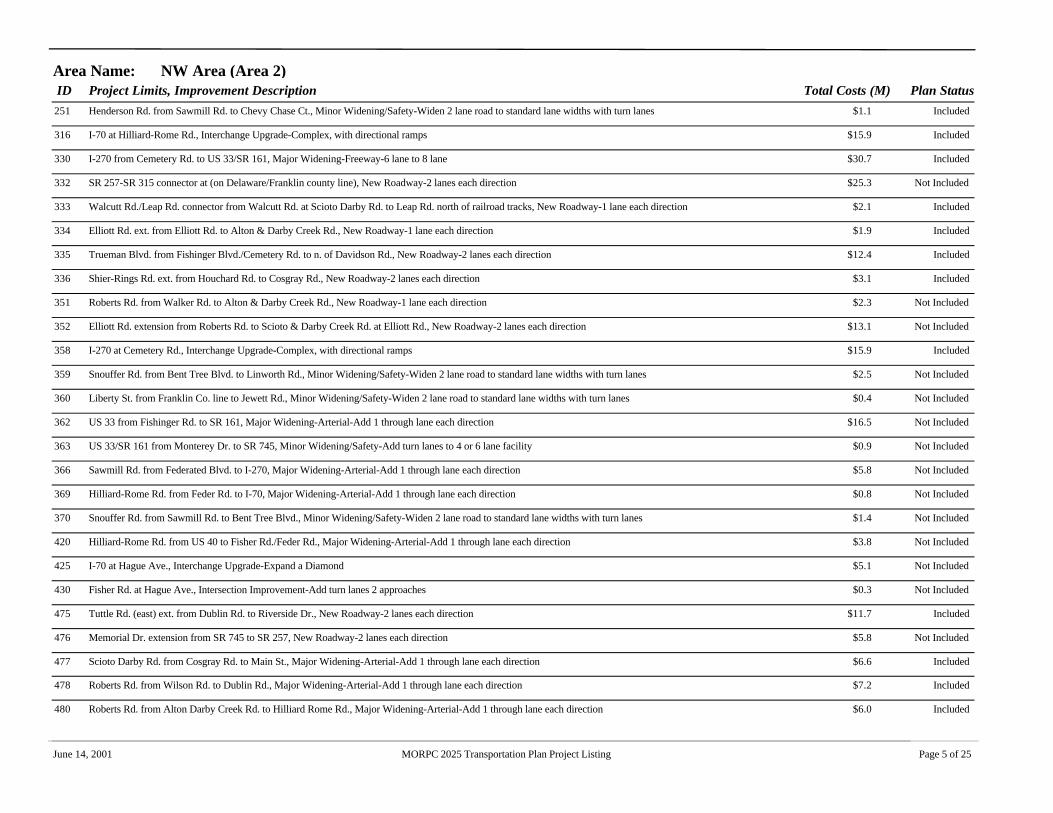
ID Project Limits, Improvement Description Total Costs (M) Plan StatusArea Name: NW Area (Area 2)
251 Henderson Rd. from Sawmill Rd. to Chevy Chase Ct., Minor Widening/Safety-Widen 2 lane road to standard lane widths with turn lanes $1.1 Included
316 I-70 at Hilliard-Rome Rd., Interchange Upgrade-Complex, with directional ramps $15.9 Included
330 I-270 from Cemetery Rd. to US 33/SR 161, Major Widening-Freeway-6 lane to 8 lane $30.7 Included
332 SR 257-SR 315 connector at (on Delaware/Franklin county line), New Roadway-2 lanes each direction $25.3 Not Included
333 Walcutt Rd./Leap Rd. connector from Walcutt Rd. at Scioto Darby Rd. to Leap Rd. north of railroad tracks, New Roadway-1 lane each direction $2.1 Included
334 Elliott Rd. ext. from Elliott Rd. to Alton & Darby Creek Rd., New Roadway-1 lane each direction $1.9 Included
335 Trueman Blvd. from Fishinger Blvd./Cemetery Rd. to n. of Davidson Rd., New Roadway-2 lanes each direction $12.4 Included
336 Shier-Rings Rd. ext. from Houchard Rd. to Cosgray Rd., New Roadway-2 lanes each direction $3.1 Included
351 Roberts Rd. from Walker Rd. to Alton & Darby Creek Rd., New Roadway-1 lane each direction $2.3 Not Included
352 Elliott Rd. extension from Roberts Rd. to Scioto & Darby Creek Rd. at Elliott Rd., New Roadway-2 lanes each direction $13.1 Not Included
358 I-270 at Cemetery Rd., Interchange Upgrade-Complex, with directional ramps $15.9 Included
359 Snouffer Rd. from Bent Tree Blvd. to Linworth Rd., Minor Widening/Safety-Widen 2 lane road to standard lane widths with turn lanes $2.5 Not Included
360 Liberty St. from Franklin Co. line to Jewett Rd., Minor Widening/Safety-Widen 2 lane road to standard lane widths with turn lanes $0.4 Not Included
362 US 33 from Fishinger Rd. to SR 161, Major Widening-Arterial-Add 1 through lane each direction $16.5 Not Included
363 US 33/SR 161 from Monterey Dr. to SR 745, Minor Widening/Safety-Add turn lanes to 4 or 6 lane facility $0.9 Not Included
366 Sawmill Rd. from Federated Blvd. to I-270, Major Widening-Arterial-Add 1 through lane each direction $5.8 Not Included
369 Hilliard-Rome Rd. from Feder Rd. to I-70, Major Widening-Arterial-Add 1 through lane each direction $0.8 Not Included
370 Snouffer Rd. from Sawmill Rd. to Bent Tree Blvd., Minor Widening/Safety-Widen 2 lane road to standard lane widths with turn lanes $1.4 Not Included
420 Hilliard-Rome Rd. from US 40 to Fisher Rd./Feder Rd., Major Widening-Arterial-Add 1 through lane each direction $3.8 Not Included
425 I-70 at Hague Ave., Interchange Upgrade-Expand a Diamond $5.1 Not Included
430 Fisher Rd. at Hague Ave., Intersection Improvement-Add turn lanes 2 approaches $0.3 Not Included
475 Tuttle Rd. (east) ext. from Dublin Rd. to Riverside Dr., New Roadway-2 lanes each direction $11.7 Included
476 Memorial Dr. extension from SR 745 to SR 257, New Roadway-2 lanes each direction $5.8 Not Included
477 Scioto Darby Rd. from Cosgray Rd. to Main St., Major Widening-Arterial-Add 1 through lane each direction $6.6 Included
478 Roberts Rd. from Wilson Rd. to Dublin Rd., Major Widening-Arterial-Add 1 through lane each direction $7.2 Included
480 Roberts Rd. from Alton Darby Creek Rd. to Hilliard Rome Rd., Major Widening-Arterial-Add 1 through lane each direction $6.0 Included
June 14, 2001 MORPC 2025 Transportation Plan Project Listing Page 5 of 25

ID Project Limits, Improvement Description Total Costs (M) Plan StatusArea Name: NW Area (Area 2)
481 Cosgray Rd. from Scioto Darby Rd. to Hayden Run Rd., Major Widening-Arterial-Add 1 through lane each direction $9.2 Included
525 I-270 from I-70W to Cemetery Rd., Major Widening-Freeway-6 lane to 8 lane $27.3 Included
541 Tuttle Crossing Blvd. from Wilcox Rd. to I-270, Major Widening-Arterial-Add 1 through lane each direction $2.5 Included
545 Britton Pkwy. from Cemetery Rd. to Reynolds Dr., New Roadway-2 lanes each direction $4.1 Included
546 Britton Pkwy. from Reynolds Dr. to Davidson Rd., New Roadway-2 lanes each direction $5.5 Not Included
547 Britton Pkwy. from Davidson Rd. to Hayden Run Rd., Major Widening-Arterial-Add 1 through lane each direction $1.6 Not Included
548 Britton Pkwy. from Hayden Run Rd. to north to existing Britton Pkwy., New Roadway-2 lanes each direction $4.6 Not Included
549 Scioto & Darby Creek Rd. from Alton Darby Creek Rd. to Cosgray Rd., Minor Widening/Safety-Widen 2 lane road to standard lane widths with turn lanes $1.5 Included
551 SR 257 from US 33/SR 161 to Home Rd., Major Widening-Arterial-Add 1 through lane each direction $10.8 Not Included
552 SR 745 from US 33/SR 161 to Home Rd., Major Widening-Arterial-Add 1 through lane each direction $11.9 Not Included
564 Cosgray Rd. from Hayden Run Rd. to SR 161, Major Widening-Arterial-Add 1 through lane each direction $8.7 Not Included
565 Wilcox Rd. from Hayden Run Rd. to Woerner & Temple Rd., Minor Widening/Safety-Widen 2 lane road to standard lane widths with turn lanes $2.0 Included
581 Dublin Rd. from Trabue Rd. to Roberts Rd., Major Widening-Arterial-Add 1 through lane each direction $3.9 Not Included
582 Wilson Rd. from Trabue Rd. to Roberts Rd., Major Widening-Arterial-Add 1 through lane each direction $3.7 Not Included
583 Walcutt Rd. from Roberts Rd. to Scioto Darby Creek Rd., Major Widening-Arterial-Add 1 through lane each direction $4.9 Not Included
585 Renner Rd. from Alton Darby Creek Rd. to Hilliard Rome Rd., Major Widening-Arterial-Add 1 through lane each direction $3.9 Not Included
614 Case Rd. from US 33 to Dierker Rd., Minor Widening/Safety-Widen 2 lane road to standard lane widths with turn lanes $2.8 Not Included
615 Hayden Rd./Bethel Rd. from US 33 to Dierker Rd., Major Widening-Arterial-Add 1 through lane each direction $5.7 Not Included
619 US 33/SR 161 from Avery Rd. to I-270, Major Widening-Freeway-4 lane to 6 lane $11.2 Included
628 Cosgray Rd. relocation from n. of Hayden Run Rd. to n. of Conrail tracks, New Roadway-2 lanes each direction $6.5 Not Included
629 Houchard Rd. ext. from Hayden Run Rd. to Rings Rd., New Roadway-1 lane each direction $2.5 Not Included
646 I-70 at west of Hilliard-Rome Rd., New Interchange-Diamond or Partial Clover $9.1 Not Included
653 Scioto & Darby Creek Rd. from Elliott Rd. to Cosgray Rd., Major Widening-Arterial-Add 1 through lane each direction $1.4 Included
654 Alton & Darby Creek Rd. from Cosgray connector to Scioto & Darby Creek Rd., Minor Widening/Safety-Widen 2 lane road to standard lane widths with turn lanes $0.6 Included
655 Cemetery Rd. from Main St. to Norwich St., Major Widening-Arterial-Add 1 through lane each direction $1.3 Included
June 14, 2001 MORPC 2025 Transportation Plan Project Listing Page 6 of 25

ID Project Limits, Improvement Description Total Costs (M) Plan StatusArea Name: N. Franklin Co. Area (Area 3)
7 Dodridge St. from Olentangy River Rd. to Neil Ave., Minor Widening/Safety-Add turn lanes to 4 or 6 lane facility $3.5 Included
8 James Rd./Stelzer Rd. from Mound St. to International Gateway, Minor Widening/Safety-Add turn lanes to 4 or 6 lane facility $7.5 Included
24 Northwest Blvd. at Third Ave., Intersection Improvement-Add turn lanes 2 approaches $0.3 Included
46 Billingsley Rd. from Sawmill Rd. to Smoky Row Rd., Minor Widening/Safety-Widen 2 lane road to standard lane widths with turn lanes $2.1 Included
47 Godown Rd. at West Case Rd., Intersection Improvement-Add turn lanes 2 approaches $0.3 Included
49 Lazelle Rd. from US 23 to Worthington-Galena Rd., Major Widening-Arterial-Add 1 through lane each direction $6.4 Included
51 I-270 at Cleveland Ave., Interchange Upgrade-Complex, with directional ramps $17.7 Included
52 Sunbury Rd. from Agler Rd. to Morse Rd., Major Widening-Arterial-Add 1 through lane each direction $9.7 Included
54 College Ave. from Otterbein Ave. to Spring Rd., Minor Widening/Safety-Widen 2 lane road to standard lane widths with turn lanes $1.4 Included
58 High St. at Hudson St., Intersection Improvement-Add turn lanes 2 approaches $0.3 Included
59 SR 161 at Karl Rd., Intersection Improvement-Add turn lanes all approaches $0.5 Included
60 Blendon Woods Blvd. at Cooper Rd., Intersection Improvement-Add turn lanes 2 approaches $0.3 Included
61 Cooper Rd. at Forest Hills Blvd., Intersection Improvement-Add turn lanes 2 approaches $0.3 Included
62 Cassady Ave. at Agler Rd., Intersection Improvement-Add turn lanes 2 approaches $0.3 Included
130 Hard Rd. from Linworth Rd. to SR 315, Major Widening-Arterial-Add 1 through lane each direction $10.3 Included
131 Hard Rd. from Sawmill Rd. to Smoky Row Rd., Major Widening-Arterial-Add 1 through lane each direction $6.5 Included
133 SR 161 from Sawmill Rd. to McVey Blvd., Major Widening-Arterial-Add 1 through lane each direction $14.8 Included
134 SR 315 at Clubview Blvd., Intersection Improvement-Add turn lanes 2 approaches $0.3 Included
135 SR 161 from Flora Villa Dr. to Olentangy River Rd., Minor Widening/Safety-Widen 2 lane road to standard lane widths with turn lanes $4.0 Included
140 SR 161 from McVey Blvd. to Flora Villa Dr., Major Widening-Arterial-Add 1 through lane each direction $15.0 Included
141 Kenny Rd./Godown Rd. from Henderson Rd. to Bethel Rd., Major Widening-Arterial-Add 1 through lane each direction $3.7 Included
142 Hard Rd. from Smoky Row Rd. to Linworth Rd., Major Widening-Arterial-Add 1 through lane each direction $15.2 Included
159 Lane Ave. from Olentangy River Rd. to High St., Major Widening-Arterial-Add 1 through lane each direction $10.5 Included
161 SR 315 at Cannon Dr. (OSU medical center), New Interchange-Diamond or Partial Clover $7.8 Included
165 Dempsey Rd. from SR 3 to I-270, Minor Widening/Safety-Widen 2 lane road to standard lane widths with turn lanes $1.4 Included
166 Dempsey Rd. from Hempstead Rd. to Sunbury Rd., Minor Widening/Safety-Widen 2 lane road to standard lane widths with turn lanes $2.0 Included
June 14, 2001 MORPC 2025 Transportation Plan Project Listing Page 7 of 25

ID Project Limits, Improvement Description Total Costs (M) Plan StatusArea Name: N. Franklin Co. Area (Area 3)
167 Oakland Park Ave. from Cleveland Ave. to SR 3, Minor Widening/Safety-Widen 2 lane road to standard lane widths with turn lanes $0.4 Included
168 SR 3 at Dempsey Rd., Intersection Improvement-Add turn lanes 2 approaches $0.3 Included
174 SR 3 from SR 161 to south of Dempsey Rd., Major Widening-Arterial-Add 1 through lane each direction $3.4 Included
175 Stelzer Rd. at I-670 connector/International Gateway, New Interchange-Diamond or Partial Clover $38.7 Included
176 Stelzer Rd. from north of I-670 to McCutcheon Rd. (CDMS 8), Major Widening-Arterial-Add 1 through lane each direction $7.7 Included
177 SR 161 from Sunbury Rd. to Little Turtle Way (CDMS 10), Major Widening & Interchange- $45.9 Included
179 I-270 at SR 161 (CDMS 11), Interchange Upgrade-Complex, with directional ramps $60.5 Included
236 I-270 at SR 315, Interchange Upgrade-Complex, with directional ramps $15.9 Not Included
240 Linworth Rd. from Olentangy River Rd. to SR 161, Minor Widening/Safety-Widen 2 lane road to standard lane widths with turn lanes $2.3 Included
243 Smoky Row Rd. from Snouffer Rd. to Delaware Co. line, Major Widening-Arterial-Add 1 through lane each direction $11.2 Included
246 Reed Rd. from Henderson Rd. to Bethel Rd., Minor Widening/Safety-Widen 2 lane road to standard lane widths with turn lanes $0.9 Not Included
247 Kinnear Rd. from Kenny Rd. to Olentangy Riv. Rd., Minor Widening/Safety-Widen 2 lane road to standard lane widths with turn lanes $1.1 Included
249 Olentangy Riv. Rd. from Henderson Rd. to Linworth Rd., Minor Widening/Safety-Add turn lanes to 4 or 6 lane facility $2.5 Included
253 Morse Rd. from I-71 to Cleveland Ave., Minor Widening/Safety-Add turn lanes to 4 or 6 lane facility $4.4 Included
254 Sunbury Rd. from Morse Rd. to SR 161, Major Widening-Arterial-Add 1 through lane each direction $5.2 Included
255 Dempsey Rd. from I-270 to Hempstead Rd., Minor Widening/Safety-Widen 2 lane road to standard lane widths with turn lanes $1.2 Included
256 Hudson St. (E.) from I-71 to Cleveland Ave., Major Widening-Arterial-Add 1 through lane each direction $6.9 Not Included
258 Sinclair Rd. from I-71 ramps to SR 161, Minor Widening/Safety-Widen 2 lane road to standard lane widths with turn lanes $2.6 Included
259 SR 3 from Dempsey Rd. to I-270, Major Widening-Arterial-Add 1 through lane each direction $0.9 Included
260 SR 3 from Cleveland Ave. to SR 161, Major Widening-Arterial-Add 1 through lane each direction $20.9 Included
261 Hudson St. (E.) from High St. to Summit St., Major Widening-Arterial-Add 1 through lane each direction $2.7 Not Included
262 Flint Rd. from US 23 to Lazelle Rd., Minor Widening/Safety-Widen 2 lane road to standard lane widths with turn lanes $2.0 Included
263 I-270N at I-71, Interchange Upgrade-Complex, with directional ramps $29.9 Included
265 Innis Rd. from SR 3 to Sunbury Rd., Major Widening-Arterial-Add 1 through lane each direction $3.8 Included
266 Morse Rd. from High St. to I-71, Minor Widening/Safety-Add turn lanes to 4 or 6 lane facility $4.3 Included
267 Sancus Blvd. from Worthington Woods Blvd. to Park Rd., Major Widening-Arterial-Add 1 through lane each direction $1.6 Included
June 14, 2001 MORPC 2025 Transportation Plan Project Listing Page 8 of 25

ID Project Limits, Improvement Description Total Costs (M) Plan StatusArea Name: N. Franklin Co. Area (Area 3)
268 Sancus Blvd. from Park Rd. to Lazelle Rd., Major Widening-Arterial-Add 1 through lane each direction $2.8 Included
269 I-270N at SR 3, Interchange Upgrade-Complex, with directional ramps $13.6 Not Included
271 I-270N at High St. (US 23N), Interchange Upgrade-Complex, with directional ramps $26.8 Not Included
274 Cassady Ave. from Bexley north corp. limit to I-670, Minor Widening/Safety-Widen 2 lane road to standard lane widths with turn lanes $1.4 Included
278 Sunbury Rd. from Leonard Ave. to Agler Rd., Minor Widening/Safety-Widen 2 lane road to standard lane widths with turn lanes $2.7 Included
329 I-270 at Smoky Row Road, New Interchange-Diamond or Partial Clover $9.1 Not Included
331 Linworth Rd. from SR 161 to Hard Rd., Major Widening-Arterial-Add 1 through lane each direction $9.5 Not Included
332 SR 257-SR 315 connector at (on Delaware/Franklin county line), New Roadway-2 lanes each direction $25.3 Not Included
339 Huntley Rd. from SR 161 to Worthington-Galena Rd., Major Widening-Arterial-Add 1 through lane each direction $5.8 Not Included
340 Worthington Woods Blvd. from Sancus Blvd. to Park Rd., Major Widening-Arterial-Add 1 through lane each direction $6.3 Not Included
341 SR 161 from Cleveland Ave. to SR 3, Major Widening-Arterial-Add 1 through lane each direction $5.9 Not Included
342 Morse Rd.-Bethel Rd. connector from SR 315 to High St., New Roadway-2 lanes each direction $12.9 Not Included
343 Hard Rd. ext. from SR 315 to US 23, New Roadway-2 lanes each direction $13.5 Not Included
344 Cleveland Ave. from SR 161 to Schrock Rd., Major Widening-Arterial-Add 1 through lane each direction $9.8 Not Included
345 Lazelle Rd. ext. from SR 315 to US 23, New Roadway-2 lanes each direction $7.6 Not Included
348 US 62 at Cherry Bottom Rd., Intersection Improvement-Add turn lanes all approaches $0.5 Not Included
357 Godown Rd. ext. from Godown Rd. to SR 161, New Roadway-1 lane each direction $1.9 Included
359 Snouffer Rd. from Bent Tree Blvd. to Linworth Rd., Minor Widening/Safety-Widen 2 lane road to standard lane widths with turn lanes $2.5 Not Included
361 SR 315 at Bethel Rd., Interchange Upgrade-Expand a Diamond $5.1 Not Included
372 North Broadway from Olentangy River Rd. to I-71, Major Widening-Arterial-Add 1 through lane each direction $15.1 Not Included
373 SR 3 from I-270 to Schrock Rd., Major Widening-Arterial-Add 1 through lane each direction $2.5 Not Included
374 SR 161 from Olentangy River Road to Evening St., Major Widening-Arterial-Add 1 through lane each direction $5.9 Not Included
375 Worthington-Galena Rd. from Wilson Bridge Rd./Huntley Rd. to Sancus Blvd., Major Widening-Arterial-Add 1 through lane each direction $0.5 Included
377 I-71 from North Broadway to Morse Rd., Major Widening-Freeway-6 lane to 8 lane $14.7 Not Included
378 Worthington-Galena Rd. from Sancus Blvd. to Lazelle Rd., Major Widening-Arterial-Add 1 through lane each direction $7.8 Not Included
379 Wilson Bridge Rd. from Linworth Rd. to Worthington-Galena Rd., Major Widening-Arterial-Add 1 through lane each direction $7.4 Not Included
June 14, 2001 MORPC 2025 Transportation Plan Project Listing Page 9 of 25

ID Project Limits, Improvement Description Total Costs (M) Plan StatusArea Name: N. Franklin Co. Area (Area 3)
380 US 23 from Wilson Bridge Rd. to Flint Rd., Major Widening-Arterial-Add 1 through lane each direction $5.9 Not Included
382 SR 315 interchange at Lane Ave., Interchange Upgrade-Complex, with directional ramps $15.9 Not Included
383 I-71 at Morse Rd., Interchange Upgrade-Complex, with directional ramps $15.9 Not Included
385 I-71 at SR 161, Interchange Upgrade-Complex, with directional ramps $15.9 Not Included
387 SR 315 interchange at SR 161, Interchange Upgrade-Complex, with directional ramps $15.9 Not Included
388 US 23 from Flint Rd. to Delaware Co. line, Major Widening-Arterial-Add 1 through lane each direction $5.7 Included
394 Stygler Rd. from Ridenour Rd. to Morse Rd., Minor Widening/Safety-Widen 2 lane road to standard lane widths with turn lanes $0.8 Not Included
535 SR 315 from I-270 to Clubview Blvd. South, Minor Widening/Safety-Add turn lanes to 4 or 6 lane facility $0.3 Included
554 SR 315 from Clubview Blvd. South to Delaware Co. line, Minor Widening/Safety-Widen 2 lane road to standard lane widths with turn lanes $1.8 Included
558 Worthington Rd. from Lazelle Rd. to Polaris Pkwy., Major Widening-Arterial-Add 1 through lane each direction $1.3 Not Included
568 Henderson Rd. from SR 315 to High St., Major Widening-Arterial-Add 1 through lane each direction $6.1 Not Included
571 Cherry Bottom Rd. from US 62 to Morse Rd., Major Widening-Arterial-Add 1 through lane each direction $7.4 Not Included
572 Mill St. from Granville St. to Cherry Bottom Rd., Major Widening-Arterial-Add 1 through lane each direction $3.2 Not Included
613 Karl Rd. from Morse Rd. to Schrock Rd., Minor Widening/Safety-Add turn lanes to 4 or 6 lane facility $7.0 Not Included
620 Cooper Rd. from Schrock Rd. to SR 3, Minor Widening/Safety-Widen 2 lane road to standard lane widths with turn lanes $3.6 Not Included
626 Schrock Rd. from Cleveland Ave. to SR 3, Major Widening-Arterial-Add 1 through lane each direction $6.2 Not Included
627 Johnstown Rd. from Stelzer Rd. to Ridenour Rd., Minor Widening/Safety-Widen 2 lane road to standard lane widths with turn lanes $1.3 Not Included
640 COTA North Corridor Light Rail, Transit- $435.0 Included
663 SR 161 from Flora Villa Dr. to Olentangy River Rd., Major Widening-Arterial-Add 1 through lane each direction $1.4 Not Included
June 14, 2001 MORPC 2025 Transportation Plan Project Listing Page 10 of 25

Traffic Projections for the Upper Arlington Transportation Plan Update November 21, 2001Mid-Ohio Regional Planning Commission
Appendix F
MORPC 1991-2000 Average Daily Traffic Volume BookPages for the Upper Arlington area

323635
41
29
18
34
36
21
7 5
4
8
39
10
15 2226
37 38
16
25
2320
42
3027
12
24
21
149
19
40
28
31
17
11
13
33
Upper Arlington (17)
N
Prepared by the Mid-Ohio Regional Planning Commission
o:\arcview\trafvol\countbook00a.apr Sepetember 2000
1991 - 2000Average Daily Traffic
How to Read the Maps
Traffic Counts reported on this map were collectedfrom the following government agencies: ODOT,County Engineers, the City of Columbus andsuburban communities, and their consultants.Counts are from 1991 - 2000 inclusively.
These maps were financed by appropriations fromDelaware, Fairfield, Franklin and Licking counties,municipalities within these counties, and planningfunds from agencies of the United States Departmentof Transportation and the Ohio Department of Transporation.
Data Source
Funding Source
The average daily traffic (ADT, 24-hour, non-directionalseasonal adjusted traffic count) is at the approximatelocation at which the count was taken. The counts arecoded so that the last digit reflects the year of the count.Example: 22,009 reads 22,000 ADT in 1999.
0 2000 4000 6000 Feet
Base Mapping SourceThe base mapping used was provided by ODOT,Franklin Co. Auditor, Delaware Co. Auditor andFairfield Co. Auditor.
23802
99404
4701
427
97404
2980518305 32505
19604
4204
14702
3090229902 446 1806
1606
17704 220043010239
02
5404
1020328704
25305
16505
32005
30051301
23305
27105
29505
31005
16705
25805
1905
27405
5304
704
2404
68051850
5 24605
12062506
436 3145801
2601
5001
2404
54045442204
1504
1304
191
1901 731
2701
13303581
4801 591631
901
2270321203
8406
12306
23006
103604
80405
133
18005
1620114601
2601
804
554 274
1101617
467
226186
4666
902792
4702
4902
10102
4702 58024702 700
2104
02
10302
626 336
7401
19001
14201
14701
15601
1207957
617667
4107
3407
DAVIDSON RD 90904
OLD HENDERSON RD
TREM
ONT RD
NORT
H ST
AR R
D
LANE AV
NORTHAM RD
RIDGEVIEW RD
ZOLLINGER RD
KIOK
A AV
ABINGTON RD
FISHINGER RD
MOUN
TVIE
W R
D
REED RD
LANE RD
McCOY RD
HENDERSON RD
HENDERSON RD
FRANCISCO RD
DUNEDIN RD
E NORTH BROADWAY
HIGH ST
OLENTANGY RIVER RD
KENNY RD
LANE AV
KINNEAR RD
FISHINGER RD
DUBLIN RD
HILLIARD-CEMETERY RD
DUBLIN RD
DUBLIN RD
McKINLEY AV
TRABUE RD
KENN
Y RD SHATTUCK AV
KENNY RD
NORTHWEST BLVD
WYA
NDOT
TE R
D
NEIL AV
(/23
"!315
(/33
RIVERSIDE DR
SMILEY RD REDD
ING
RD
MARBURN DRHIGHLAND DR
GLENMONT AV
WOODY HAYES DR
LANE AV
DODRIDGE ST
FISHINGER RD
ROBERTS RD
NORTH BROADWAY
THOMAS LA
CARMACK RD
2560919209
1004
10109
2510927409 10607 161
8009 8109
9709
22209
17309
23309
30209
82609
1990919909
1108
1000913809
8708
4701
3240723708
16808
17408 23508
1909 3709
36308
16909
1700815702
20508
16709
830912909129098209859
12409
11309
1709
17809 152098209
150985
09
17909
7809 9409
6509
1790913808146088608
9108
5509
1208
2709
5009
126092008
4709
21009
9509
9309
33808
3907
9307
168079907
10707
1007 11107
187051101
188093008 16072408
11608 10
308
118088509 1360
9769
3408
1250812708
4107
32008 3400827508 40108 58
0117708
21608
1108
4505
2510831905
24006
1805
1740515801
15409
1710816508
1409
17909
1708
1440511406
45208 41608240064205
14405
14805
3905
2302
TREMONT RD
TREM
ONT RD
KING AVFIFTH AV
THIRD AV
STANFORD RD
FARLEIGH RD
RIVERSIDE DR
FIFTH AV
KING AV
HIGH ST
FYFF
E RD
CANN
ON D
R
ZOLLINGER RD
EASTCLEFT DR
LYTHAM RD
1110911209
22005
10005
11405
BETHEL RD
DIER
KER
RD
JASONWAY
GODOWN RD
LANGSTON DR
MORSE RD
COOKE RD
.-,270 "!315
16605
29091508
12709
16409


