Wheelway Etiquette
T. Use the right side of the Trail exceptwhen otherwise designated.
R. Pedestrians always have the Rightof way.
A. Always pass on the left.
I. Don’t Inhibit your ability to hearthose around you by listening to loud music.
L. When passing, announce your presence with a bell or by saying “On the Left”.
S. Always maintain proper Speed so that you are always in control.
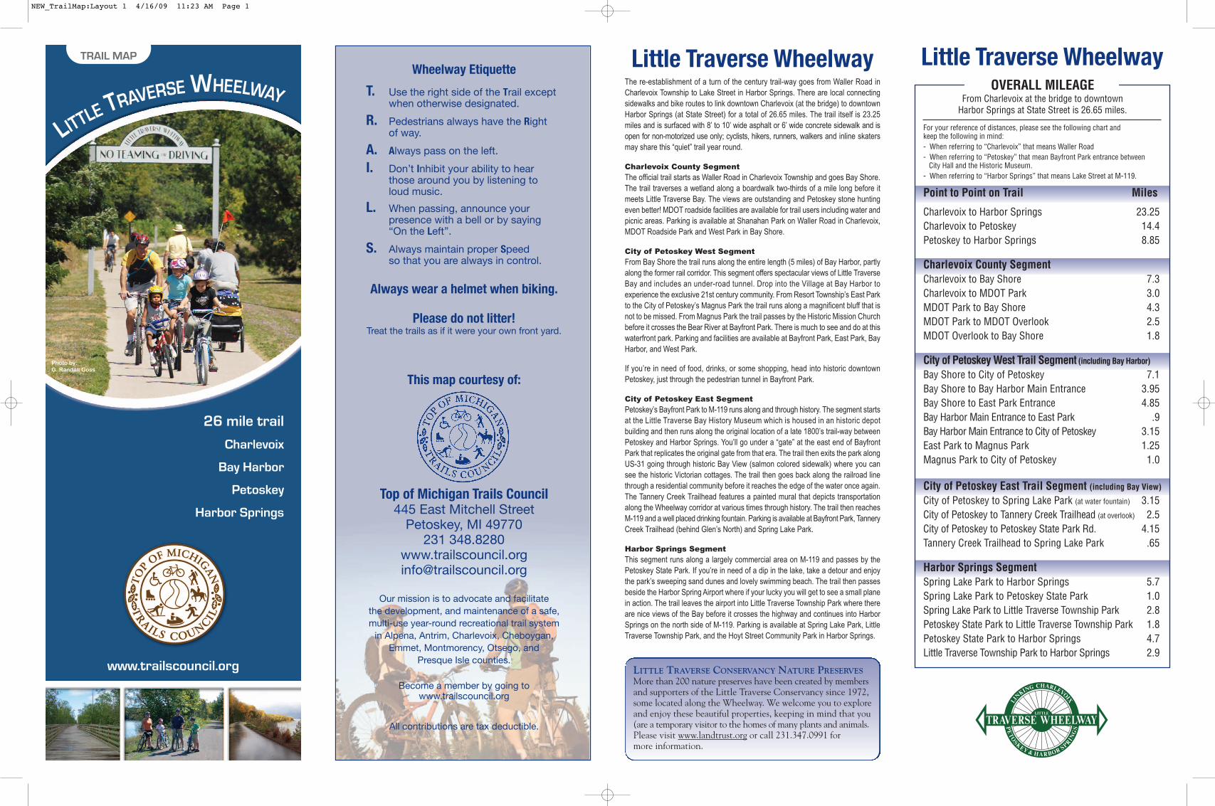
Always wear a helmet when biking.
Please do not litter! Treat the trails as if it were your own front yard.
This map courtesy of:
Top of Michigan Trails Council445 East Mitchell Street
Petoskey, MI 49770231 348.8280
Our mission is to advocate and facilitate the development, and maintenance of a safe,multi-use year-round recreational trail system
in Alpena, Antrim, Charlevoix, Cheboygan,Emmet, Montmorency, Otsego, and
Presque Isle counties.
Become a member by going towww.trailscouncil.org
All contributions are tax deductible.
OVERALL MILEAGEFrom Charlevoix at the bridge to downtown
Harbor Springs at State Street is 26.65 miles.
For your reference of distances, please see the following chart and keep the following in mind:- When referring to “Charlevoix” that means Waller Road- When referring to “Petoskey” that mean Bayfront Park entrance between
City Hall and the Historic Museum. - When referring to “Harbor Springs” that means Lake Street at M-119.
Point to Point on Trail Miles
Charlevoix to Harbor Springs 23.25Charlevoix to Petoskey 14.4Petoskey to Harbor Springs 8.85
Charlevoix County SegmentCharlevoix to Bay Shore 7.3Charlevoix to MDOT Park 3.0MDOT Park to Bay Shore 4.3MDOT Park to MDOT Overlook 2.5MDOT Overlook to Bay Shore 1.8
City of Petoskey West Trail Segment (including Bay Harbor)
Bay Shore to City of Petoskey 7.1Bay Shore to Bay Harbor Main Entrance 3.95Bay Shore to East Park Entrance 4.85Bay Harbor Main Entrance to East Park .9Bay Harbor Main Entrance to City of Petoskey 3.15East Park to Magnus Park 1.25Magnus Park to City of Petoskey 1.0
City of Petoskey East Trail Segment (including Bay View)
City of Petoskey to Spring Lake Park (at water fountain) 3.15City of Petoskey to Tannery Creek Trailhead (at overlook) 2.5City of Petoskey to Petoskey State Park Rd. 4.15Tannery Creek Trailhead to Spring Lake Park .65
Harbor Springs SegmentSpring Lake Park to Harbor Springs 5.7Spring Lake Park to Petoskey State Park 1.0Spring Lake Park to Little Traverse Township Park 2.8Petoskey State Park to Little Traverse Township Park 1.8Petoskey State Park to Harbor Springs 4.7Little Traverse Township Park to Harbor Springs 2.9
Little Traverse WheelwayLittle Traverse WheelwayThe re-establishment of a turn of the century trail-way goes from Waller Road inCharlevoix Township to Lake Street in Harbor Springs. There are local connectingsidewalks and bike routes to link downtown Charlevoix (at the bridge) to downtownHarbor Springs (at State Street) for a total of 26.65 miles. The trail itself is 23.25miles and is surfaced with 8’ to 10’ wide asphalt or 6’ wide concrete sidewalk and isopen for non-motorized use only; cyclists, hikers, runners, walkers and inline skatersmay share this “quiet” trail year round.
Charlevoix County Segment
The official trail starts as Waller Road in Charlevoix Township and goes Bay Shore.The trail traverses a wetland along a boardwalk two-thirds of a mile long before itmeets Little Traverse Bay. The views are outstanding and Petoskey stone huntingeven better! MDOT roadside facilities are available for trail users including water andpicnic areas. Parking is available at Shanahan Park on Waller Road in Charlevoix,MDOT Roadside Park and West Park in Bay Shore.
City of Petoskey West Segment
From Bay Shore the trail runs along the entire length (5 miles) of Bay Harbor, partlyalong the former rail corridor. This segment offers spectacular views of Little TraverseBay and includes an under-road tunnel. Drop into the Village at Bay Harbor to experience the exclusive 21st century community. From Resort Township’s East Parkto the City of Petoskey’s Magnus Park the trail runs along a magnificent bluff that isnot to be missed. From Magnus Park the trail passes by the Historic Mission Churchbefore it crosses the Bear River at Bayfront Park. There is much to see and do at thiswaterfront park. Parking and facilities are available at Bayfront Park, East Park, BayHarbor, and West Park.
If you’re in need of food, drinks, or some shopping, head into historic downtownPetoskey, just through the pedestrian tunnel in Bayfront Park.
City of Petoskey East Segment
Petoskey’s Bayfront Park to M-119 runs along and through history. The segment startsat the Little Traverse Bay History Museum which is housed in an historic depot building and then runs along the original location of a late 1800’s trail-way betweenPetoskey and Harbor Springs. You’ll go under a “gate” at the east end of BayfrontPark that replicates the original gate from that era. The trail then exits the park alongUS-31 going through historic Bay View (salmon colored sidewalk) where you cansee the historic Victorian cottages. The trail then goes back along the railroad linethrough a residential community before it reaches the edge of the water once again.The Tannery Creek Trailhead features a painted mural that depicts transportationalong the Wheelway corridor at various times through history. The trail then reachesM-119 and a well placed drinking fountain. Parking is available at Bayfront Park, TanneryCreek Trailhead (behind Glen’s North) and Spring Lake Park.
Harbor Springs Segment
This segment runs along a largely commercial area on M-119 and passes by thePetoskey State Park. If you’re in need of a dip in the lake, take a detour and enjoythe park’s sweeping sand dunes and lovely swimming beach. The trail then passesbeside the Harbor Spring Airport where if your lucky you will get to see a small planein action. The trail leaves the airport into Little Traverse Township Park where thereare nice views of the Bay before it crosses the highway and continues into HarborSprings on the north side of M-119. Parking is available at Spring Lake Park, LittleTraverse Township Park, and the Hoyt Street Community Park in Harbor Springs.
LITTLE TRAVERSE CONSERVANCY NATURE PRESERVESMore than 200 nature preserves have been created by membersand supporters of the Little Traverse Conservancy since 1972,some located along the Wheelway. We welcome you to exploreand enjoy these beautiful properties, keeping in mind that you(are a temporary visitor to the homes of many plants and animals.Please visit www.landtrust.org or call 231.347.0991 for more information.
LITTLE TRAVERSE WHEELWAY
26 mile trail
Charlevoix
Bay Harbor
Petoskey
Harbor Springs
www.trailscouncil.org
TRAIL MAP
Photo by:G. Randall Goss
NEW_TrailMap:Layout 1 4/16/09 11:23 AM Page 1
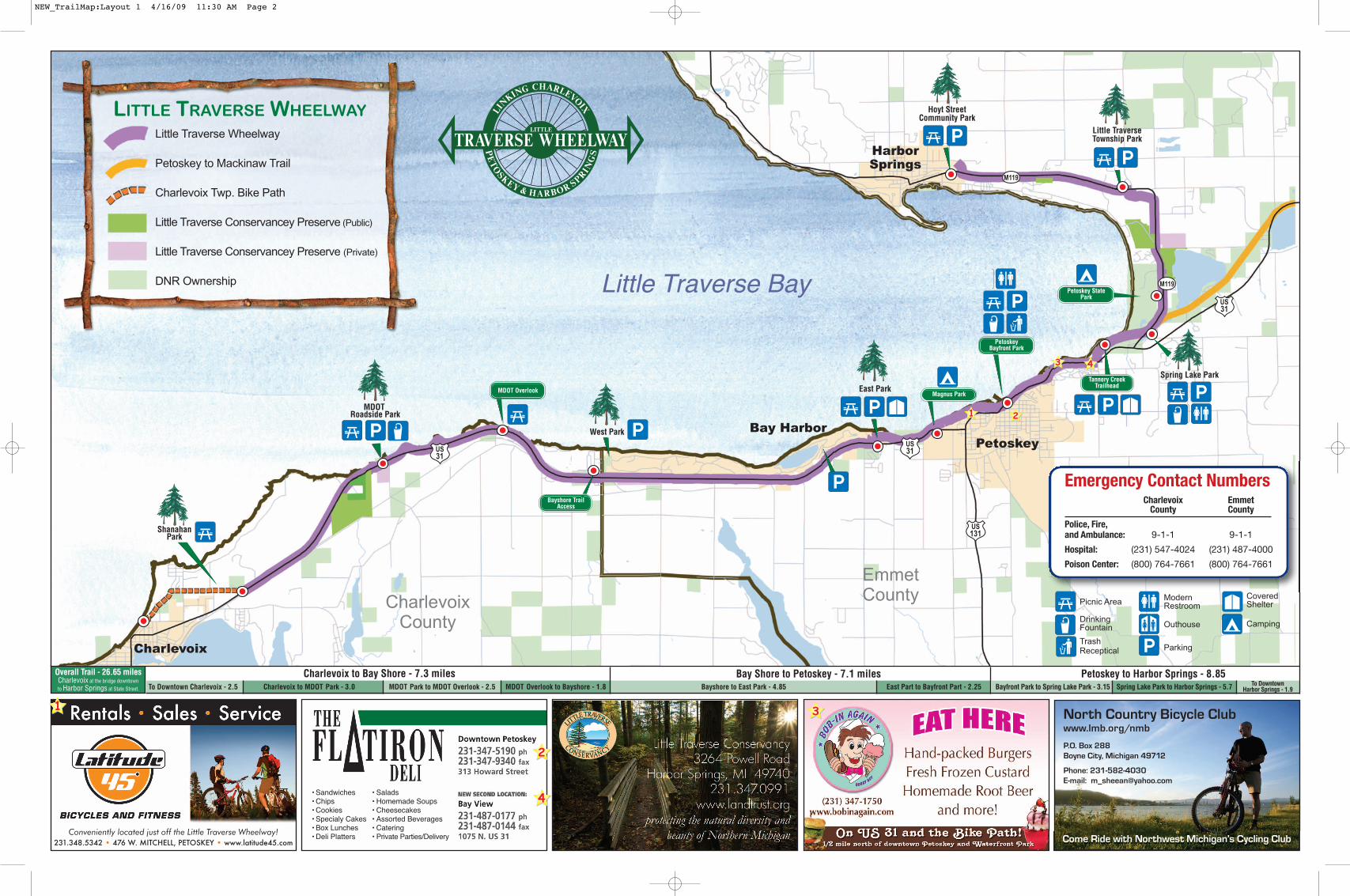
Little Traverse Bay
Emergency Contact NumbersCharlevoix Emmet
County County
Police, Fire,and Ambulance: 9-1-1 9-1-1
Hospital: (231) 547-4024 (231) 487-4000
Poison Center: (800) 764-7661 (800) 764-7661
Conveniently located just off the Little Traverse Wheelway!231.348.5342 • 476 W. MITCHELL, PETOSKEY • www.latitude45.com
• Sandwiches • Salads• Chips • Homemade Soups• Cookies • Cheesecakes• Specialy Cakes • Assorted Beverages• Box Lunches • Catering• Deli Platters • Private Parties/Delivery
North Country Bicycle Clubwww.lmb.org/nmb
P.O. Box 288Boyne City, Michigan 49712
Phone: 231-582-4030E-mail: [email protected]
Come Ride with Northwest Michigan’s Cycling Club
LITTLE TRAVERSE WHEELWAYLittle Traverse Wheelway
Petoskey to Mackinaw Trail
Charlevoix Twp. Bike Path
Little Traverse Conservancey Preserve (Public)
Little Traverse Conservancey Preserve (Private)
DNR OwnershipPetoskey State
Park
Tannery CreekTrailhead
Petoskey
HarborSprings
Bay Harbor
Magnus Park
PetoskeyBayfront Park
Bayshore TrailAccess
MDOT Overlook
ShanahanPark
MDOTRoadside Park
West Park
East Park
Spring Lake Park
Little TraverseTownship Park
Hoyt StreetCommunity Park
CharlevoixCounty
Emmet County
Charlevoix to Bay Shore - 7.3 miles Bay Shore to Petoskey - 7.1 miles Petoskey to Harbor Springs - 8.85Overall Trail - 26.65 milesCharlevoix at the bridge downtownto Harbor Springs at State Street. Charlevoix to MDOT Park - 3.0 MDOT Park to MDOT Overlook - 2.5 MDOT Overlook to Bayshore - 1.8 Bayshore to East Park - 4.85 Bayfront Park to Spring Lake Park - 3.15 Spring Lake Park to Harbor Springs - 5.7
Picnic Area
Drinking Fountain
Trash Receptical
ModernRestroom
Outhouse
Parking
CoveredShelter
Camping
Charlevoix
To Downtown Charlevoix - 2.5 East Part to Bayfront Part - 2.25 To DowntownHarbor Springs - 1.9
NEW_TrailMap:Layout 1 4/16/09 11:30 AM Page 2


