UTLS Asian monsoon anticyclone
• Dynamics and transport in the monsoon anticyclone
• Chemical variability linked to the monsoon
• Instability and eddy shedding; PV diagnostics
• Transport to stratosphere
• Eruption of Mt. Nabro in June 2011
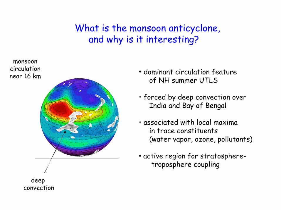
What is the monsoon anticyclone, and why is it interesting?
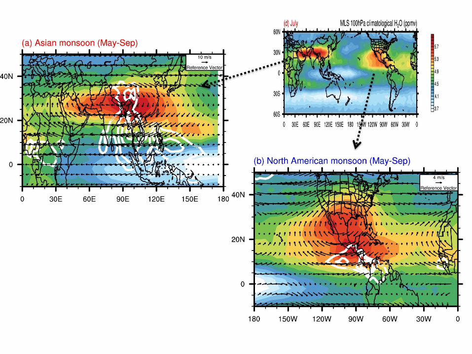
• dominant circulation feature of NH summer UTLS • forced by deep convection over India and Bay of Bengal • associated with local maxima in trace constituents (water vapor, ozone, pollutants) • active region for stratosphere- troposphere coupling
deep convection
monsoon circulation near 16 km
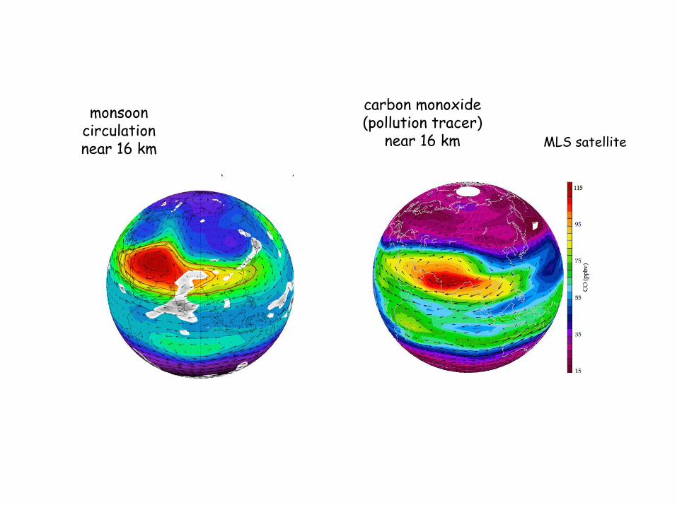
monsoon circulation near 16 km
carbon monoxide (pollution tracer)
near 16 km MLS satellite
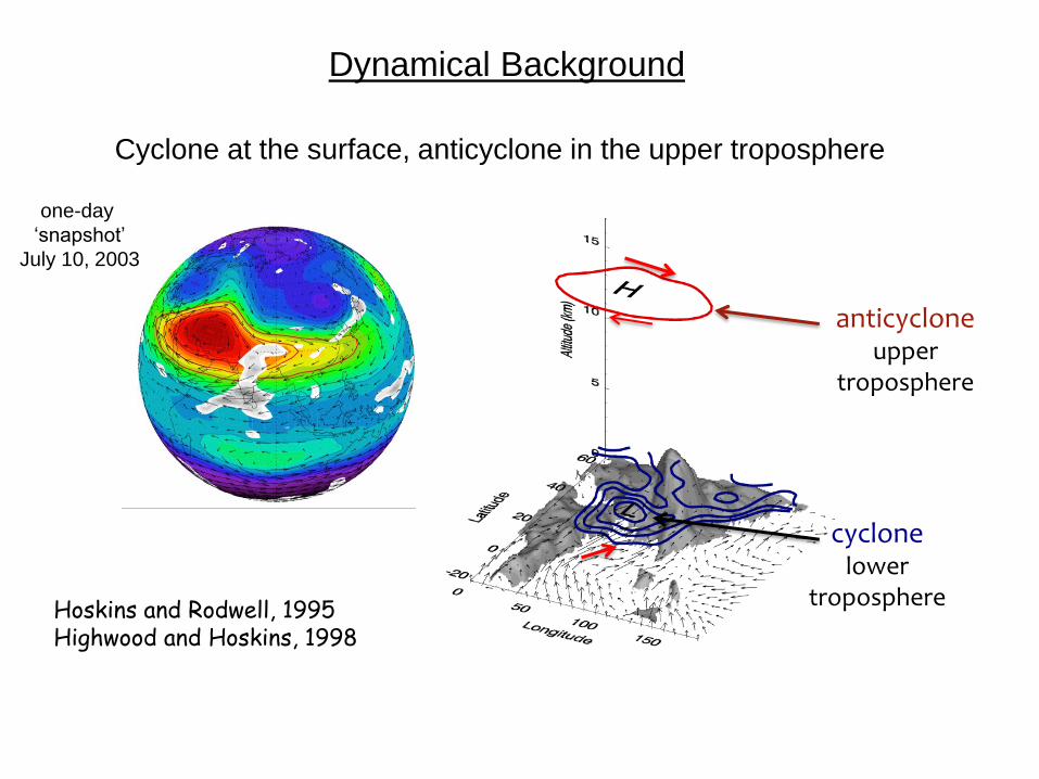
Cyclone at the surface, anticyclone in the upper troposphere
Dynamical Background
Hoskins and Rodwell, 1995 Highwood and Hoskins, 1998
anticyclone upper
troposphere
cyclone lower
troposphere
one-day
‘snapshot’
July 10, 2003
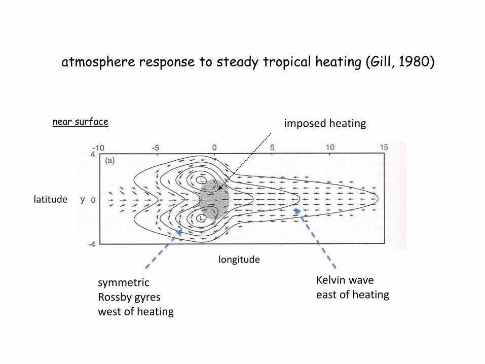
atmosphere response to steady tropical heating (Gill, 1980)
longitude
imposed heating
latitude
symmetric Rossby gyres west of heating
Kelvin wave east of heating
near surface
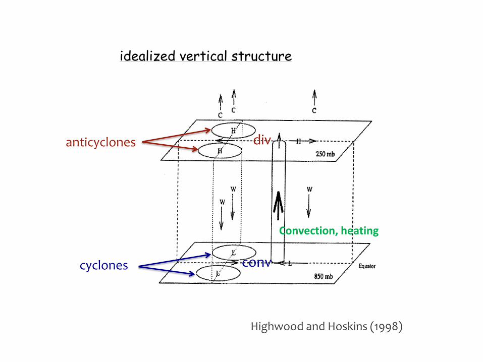
Highwood and Hoskins (1998)
idealized vertical structure
anticyclones
cyclones conv
div
Convection, heating
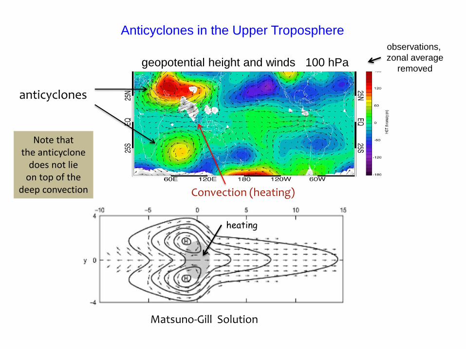
Anticyclones in the Upper Troposphere
anticyclones
Convection (heating)
Matsuno-Gill Solution
Note that the anticyclone
does not lie on top of the
deep convection
geopotential height and winds 100 hPa
heating
observations,
zonal average
removed
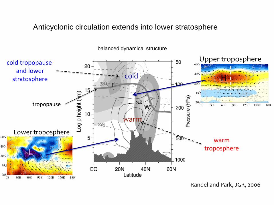
Lower troposphere
Upper troposphere
H
L
cold
warm
Randel and Park, JGR, 2006
Anticyclonic circulation extends into lower stratosphere
tropopause
warm troposphere
cold tropopause and lower
stratosphere
balanced dynamical structure
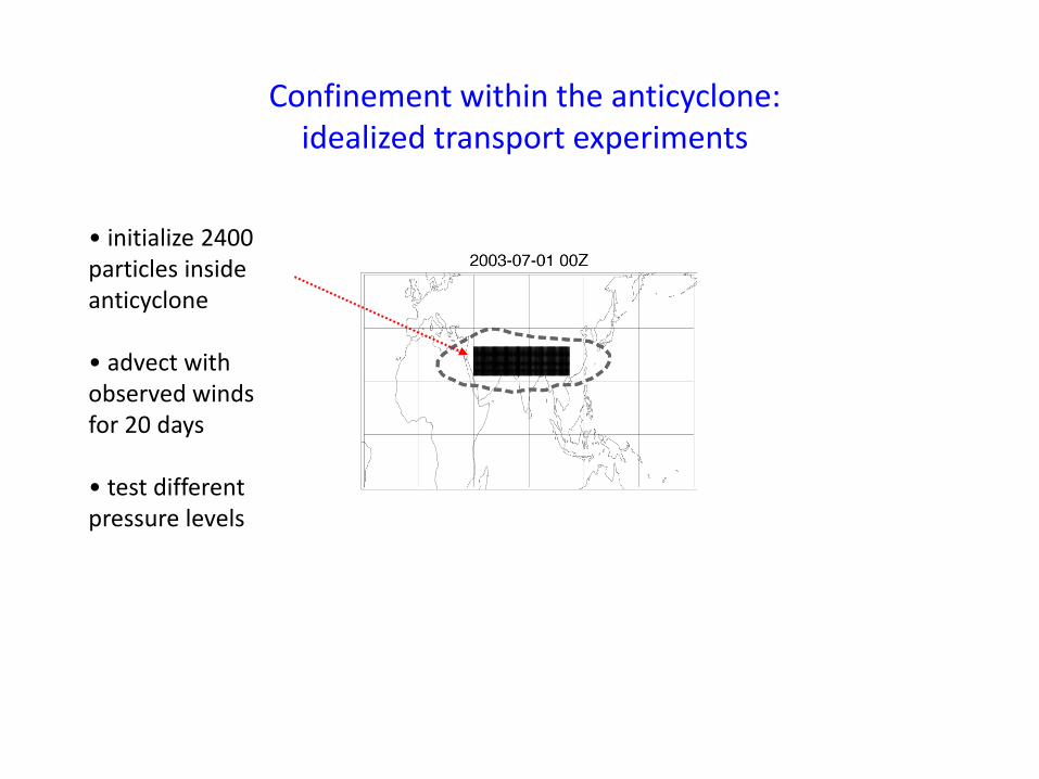
Confinement within the anticyclone: idealized transport experiments
• initialize 2400 particles inside anticyclone • advect with observed winds for 20 days • test different pressure levels
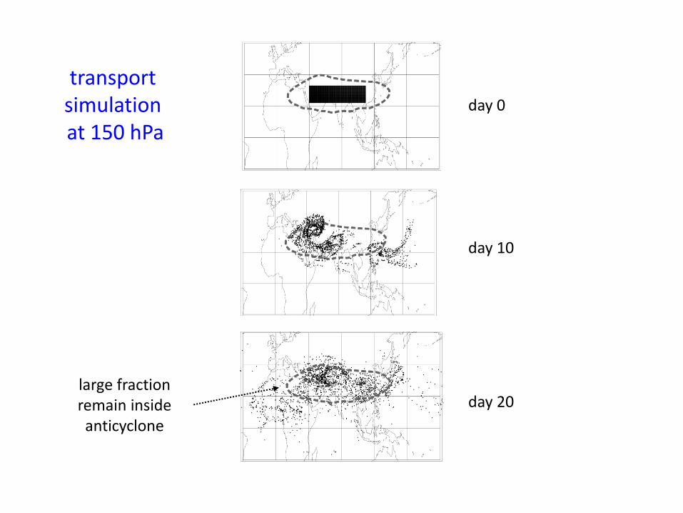
transport simulation at 150 hPa
day 0
day 10
day 20 large fraction remain inside anticyclone
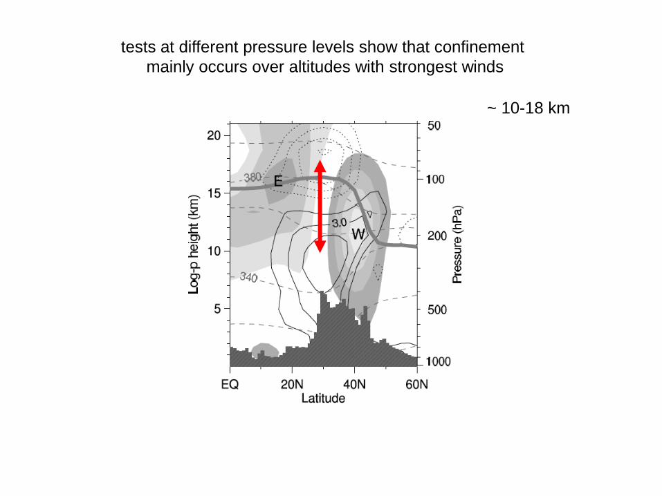
tests at different pressure levels show that confinement
mainly occurs over altitudes with strongest winds
~ 10-18 km
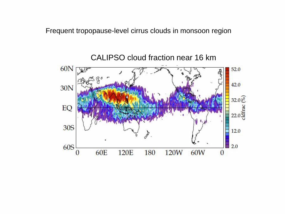
CALIPSO cloud fraction near 16 km
Frequent tropopause-level cirrus clouds in monsoon region
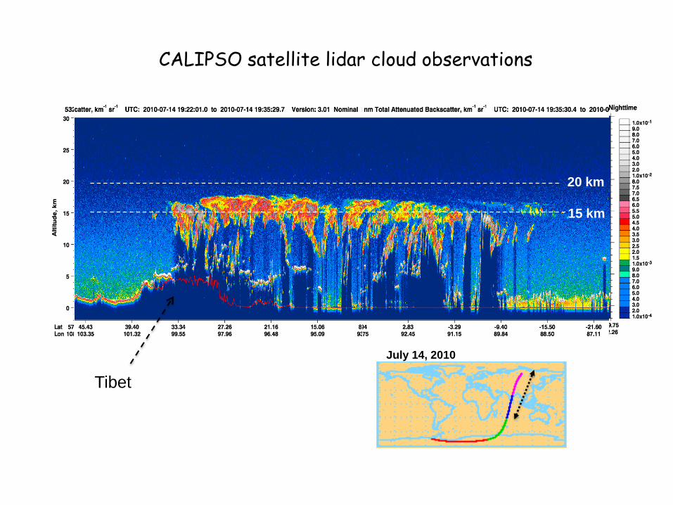
Tibet
CALIPSO satellite lidar cloud observations
20 km
15 km
July 14, 2010
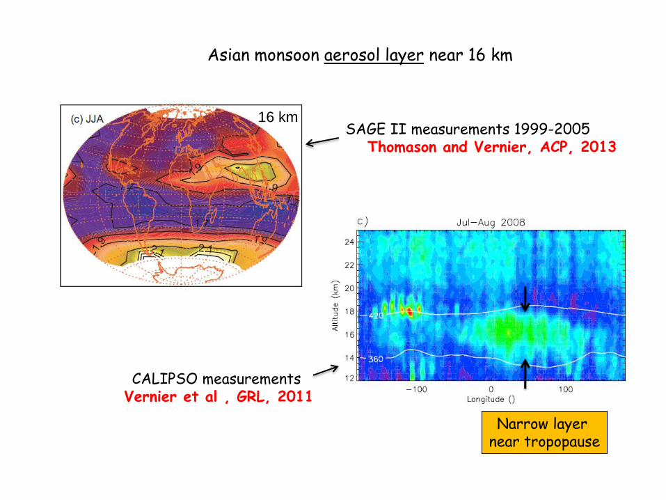
Asian monsoon aerosol layer near 16 km
SAGE II measurements 1999-2005 Thomason and Vernier, ACP, 2013
CALIPSO measurements Vernier et al , GRL, 2011
Narrow layer near tropopause
16 km
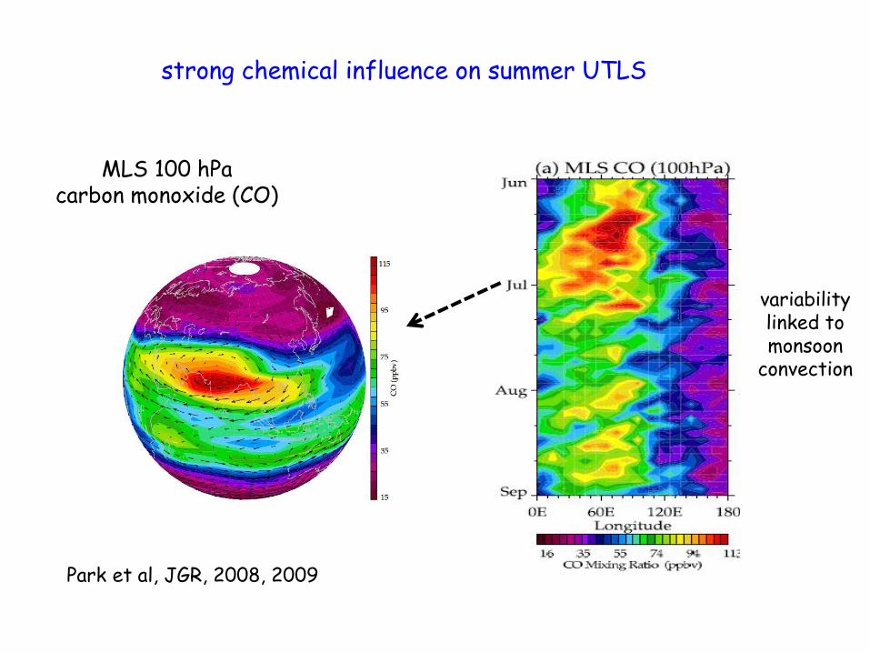
strong chemical influence on summer UTLS
MLS 100 hPa carbon monoxide (CO)
Park et al, JGR, 2008, 2009
variability linked to monsoon
convection
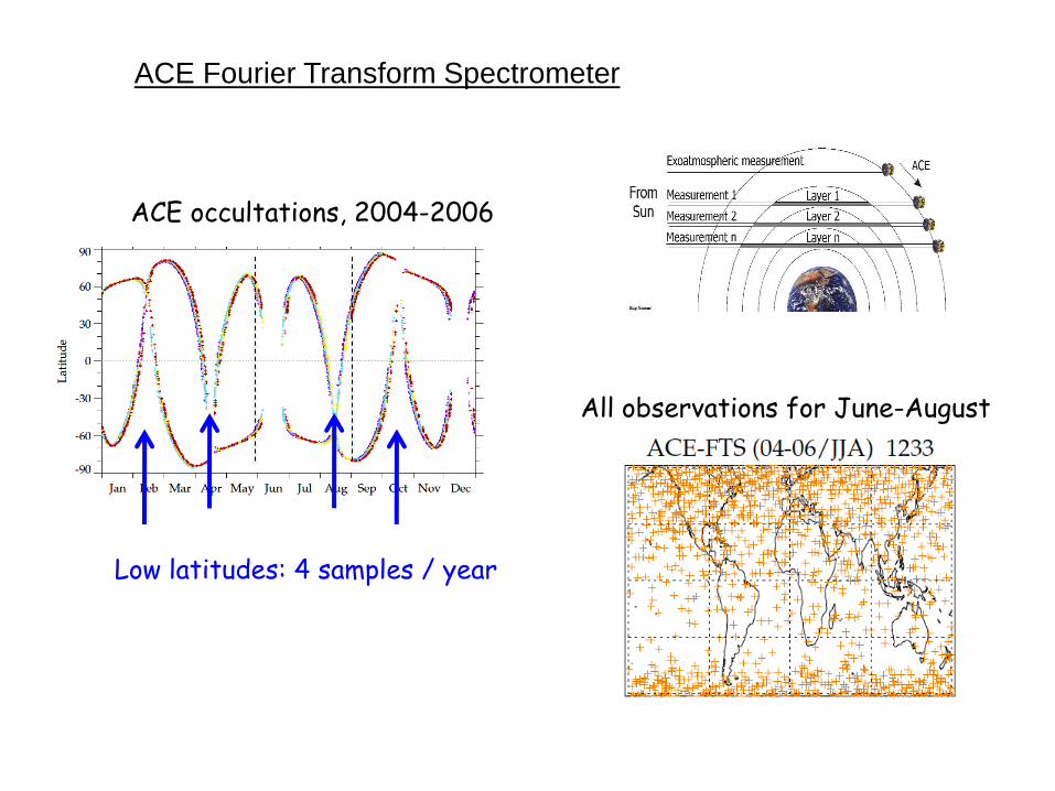
ACE Fourier Transform Spectrometer
ACE occultations, 2004-2006
Low latitudes: 4 samples / year
All observations for June-August
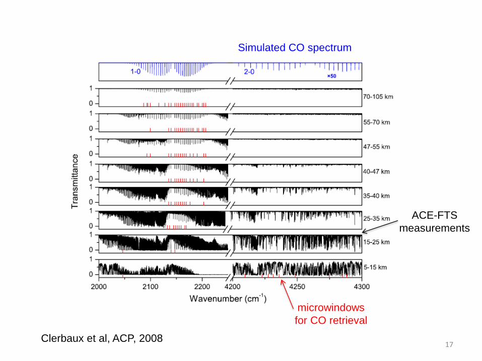
17
microwindows
for CO retrieval
Simulated CO spectrum
Clerbaux et al, ACP, 2008
ACE-FTS
measurements
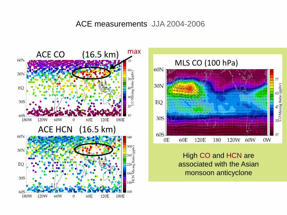
ACE measurements JJA 2004-2006
High CO and HCN are
associated with the Asian
monsoon anticyclone
MLS CO (100 hPa) ACE CO (16.5 km)
ACE HCN (16.5 km)
max
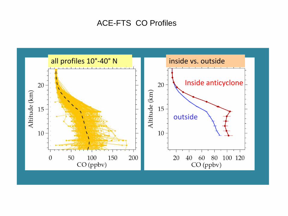
ACE-FTS CO Profiles
inside vs. outside
outside
all profiles 10°-40° N
Inside anticyclone
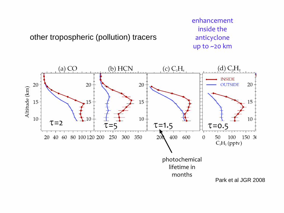
other tropospheric (pollution) tracers
photochemicallifetime in
months
enhancement inside the
anticyclone up to ~20 km
=2 =5 =1.5 =0.5
Park et al JGR 2008
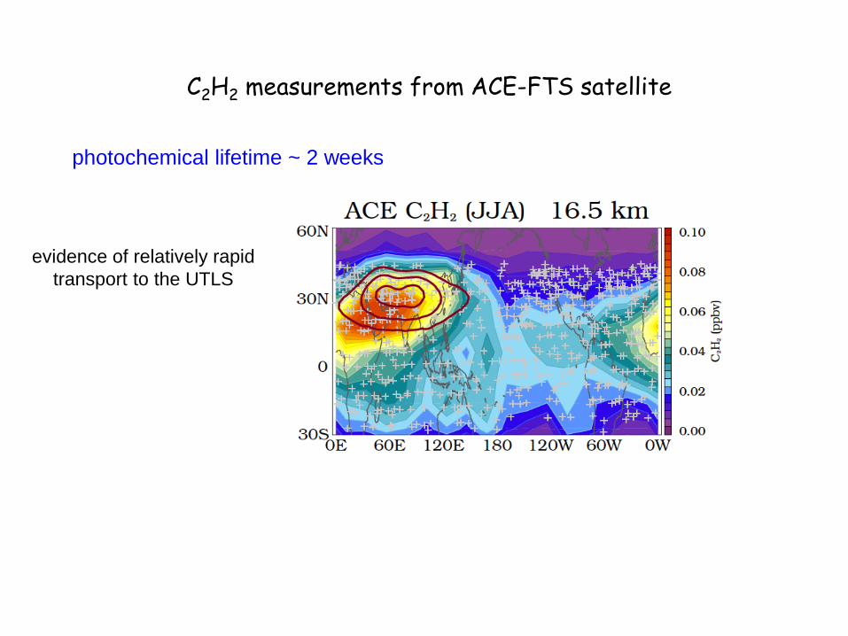
C2H2 measurements from ACE-FTS satellite
photochemical lifetime ~ 2 weeks
evidence of relatively rapid
transport to the UTLS
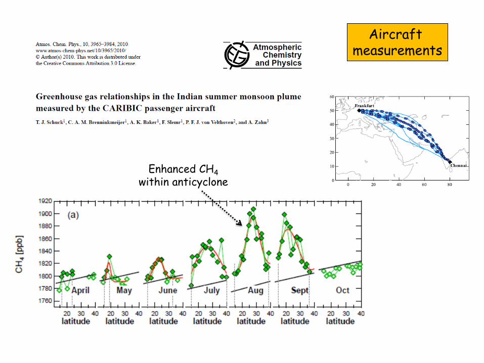
Enhanced CH4
within anticyclone
Aircraft measurements
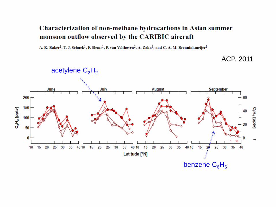
acetylene C2H2
benzene C6H6
ACP, 2011
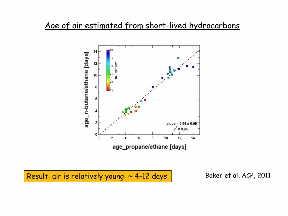
Age of air estimated from short-lived hydrocarbons
Baker et al, ACP, 2011 Result: air is relatively young: ~ 4-12 days
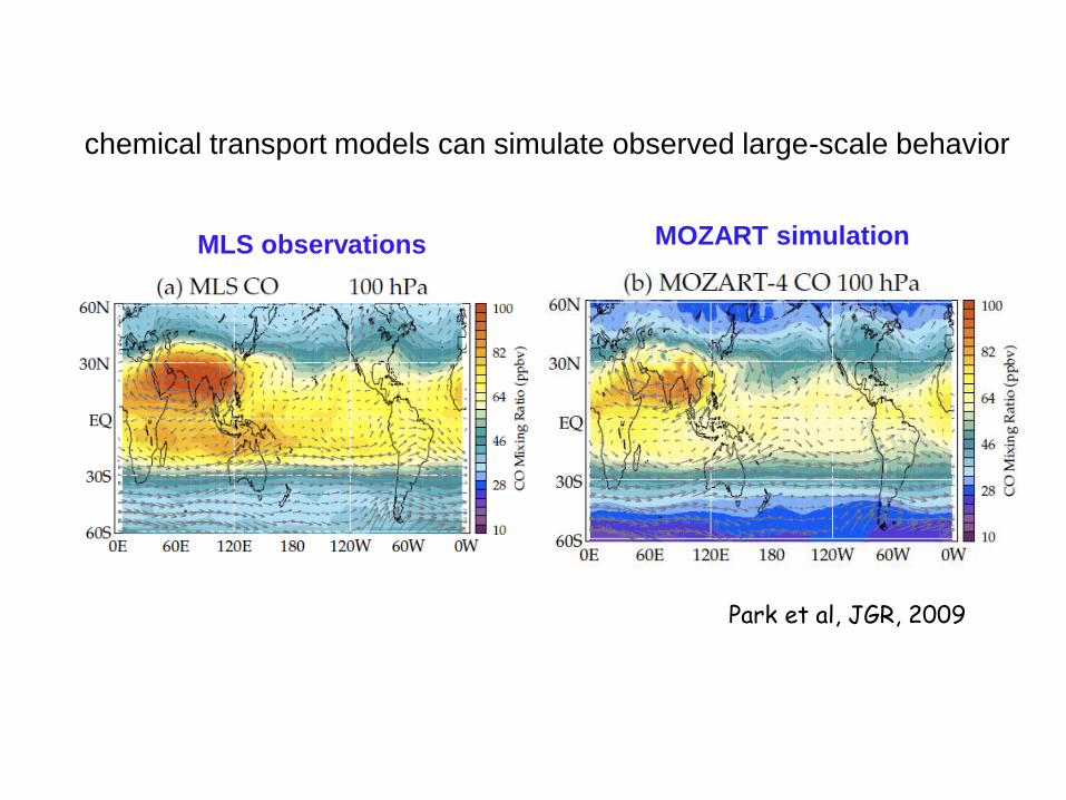
chemical transport models can simulate observed large-scale behavior
MLS observations MOZART simulation
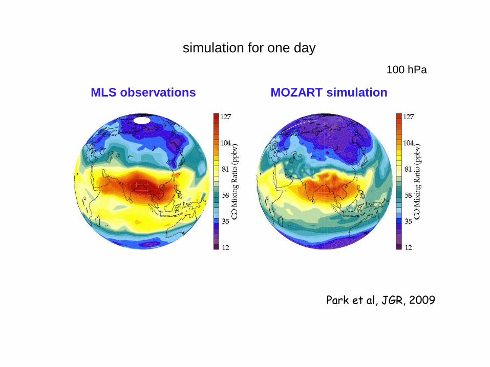
Park et al, JGR, 2009
Park et al, JGR, 2009
MLS observations MOZART simulation
simulation for one day
100 hPa
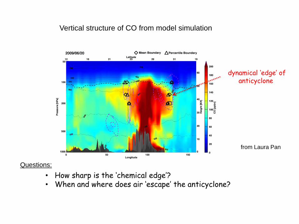
Vertical structure of CO from model simulation
dynamical ‘edge’ of anticyclone
• How sharp is the ‘chemical edge’? • When and where does air ‘escape’ the anticyclone?
Questions:
from Laura Pan
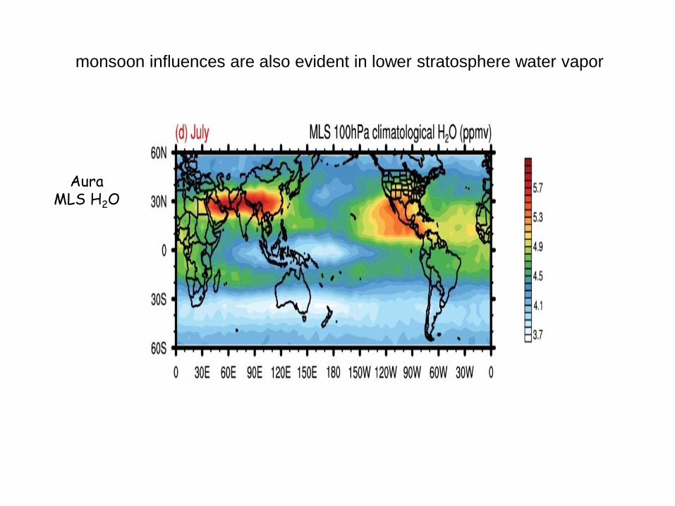
Aura MLS H2O
monsoon influences are also evident in lower stratosphere water vapor
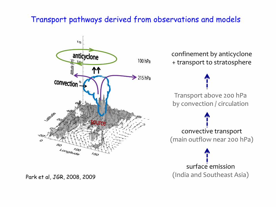
Transport pathways derived from observations and models
surface emission (India and Southeast Asia)
convective transport (main outflow near 200 hPa)
confinement by anticyclone + transport to stratosphere
Transport above 200 hPa by convection / circulation
Park et al, JGR, 2008, 2009
Key points:
• Asian monsoon anticyclone is dynamical response to monsoon convection (heating)
• Climatological feature every year ~June-September
• cold tropopause, frequent clouds, aerosol layer
• Strong chemical anomalies inside anticyclone, due to:
Rapid transport from surface (evidenced by short-lived chemical species)
Circulation traps air inside anticyclone
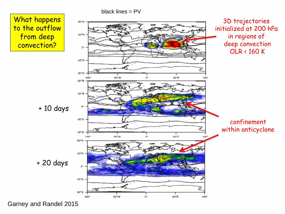
3D trajectories initialized at 200 hPa
in regions of deep convection
OLR < 160 K
+ 10 days
+ 20 days
What happens to the outflow
from deep convection?
confinement within anticyclone
Garney and Randel 2015
black lines = PV
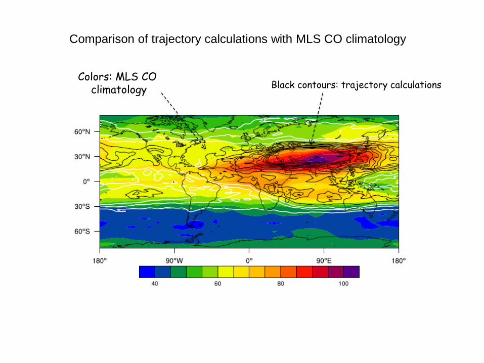
Black contours: trajectory calculations Colors: MLS CO
climatology
Comparison of trajectory calculations with MLS CO climatology
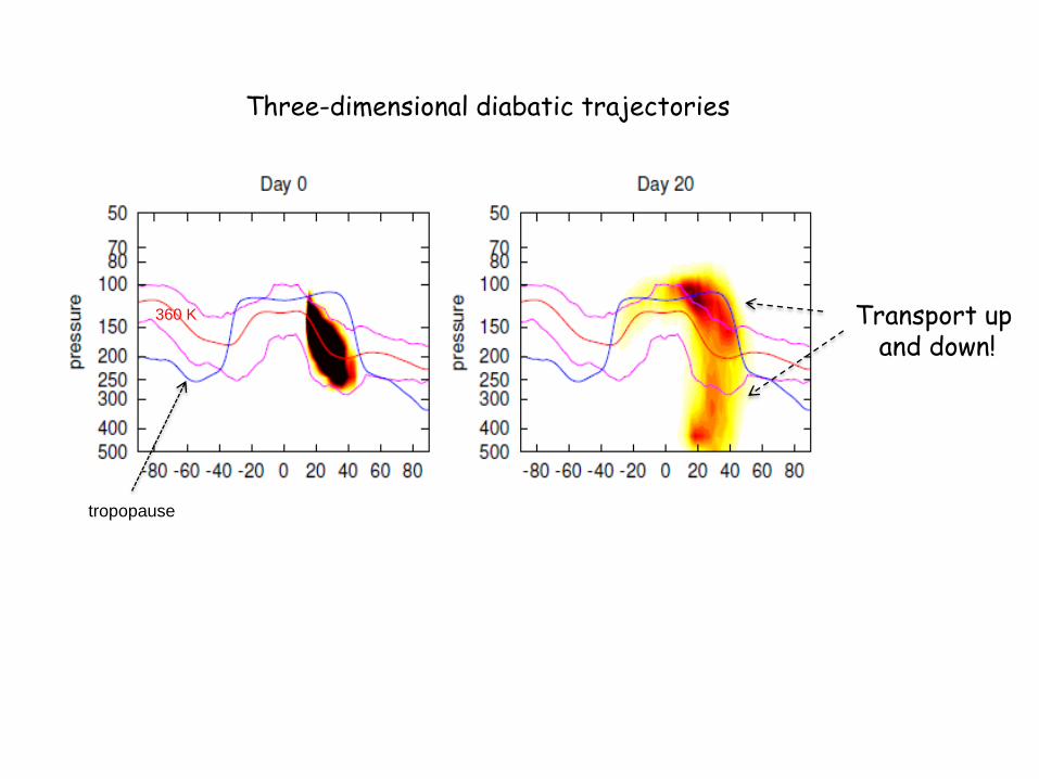
Transport up and down!
Three-dimensional diabatic trajectories
tropopause
360 K
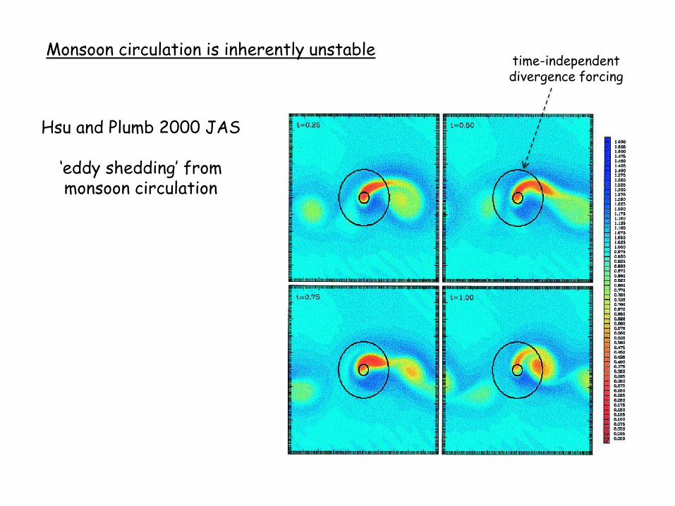
Hsu and Plumb 2000 JAS
‘eddy shedding’ from monsoon circulation
Monsoon circulation is inherently unstable time-independent divergence forcing
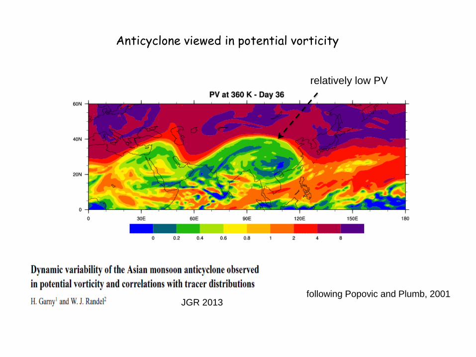
Anticyclone viewed in potential vorticity
JGR 2013
relatively low PV
following Popovic and Plumb, 2001
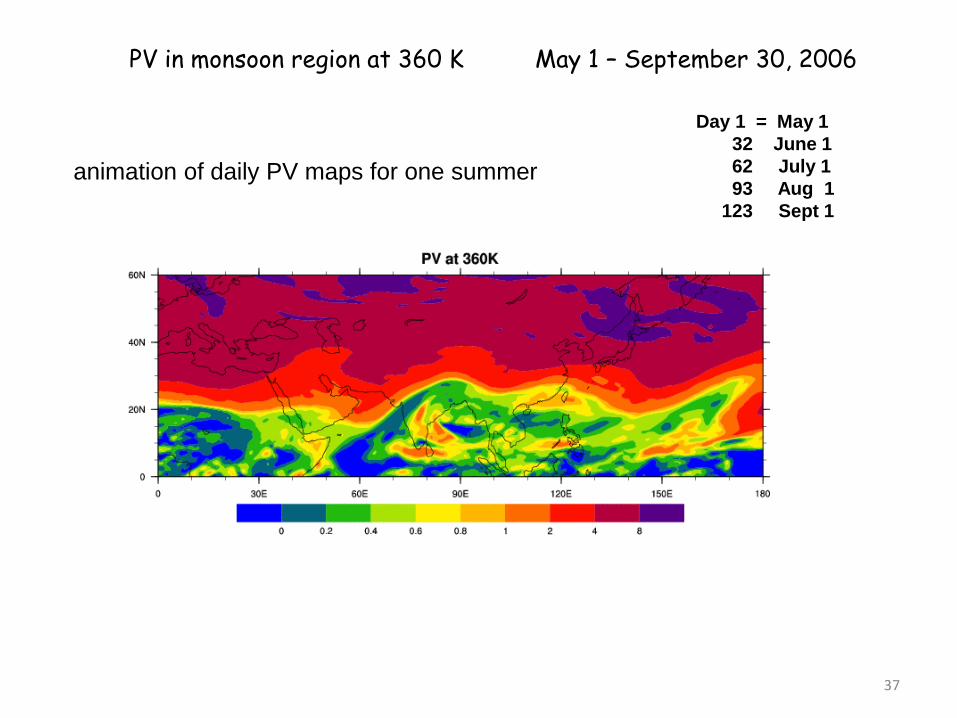
37
PV in monsoon region at 360 K May 1 – September 30, 2006
Day 1 = May 1
32 June 1
62 July 1
93 Aug 1
123 Sept 1
animation of daily PV maps for one summer
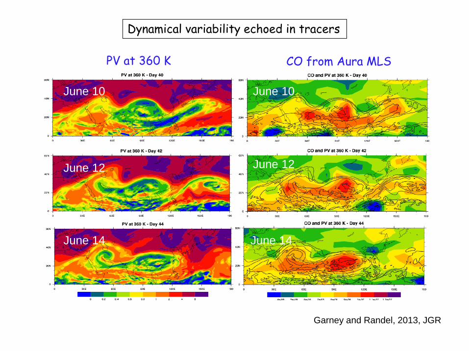
PV at 360 K CO from Aura MLS
June 10
June 14 June 14
June 12 June 12
June 10
Dynamical variability echoed in tracers
Garney and Randel, 2013, JGR
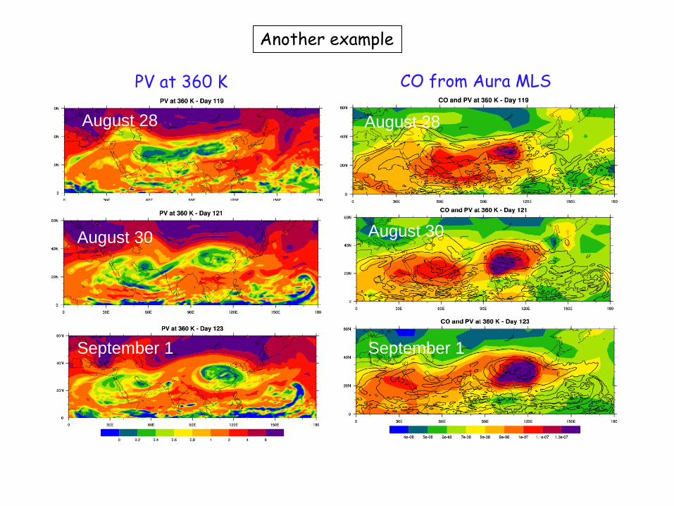
August 28
August 30
September 1
August 28
August 30
September 1
PV at 360 K CO from Aura MLS
Another example
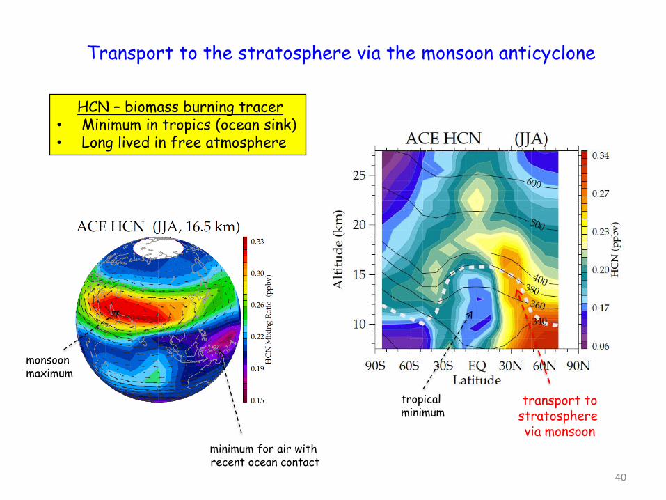
Transport to the stratosphere via the monsoon anticyclone
40
HCN – biomass burning tracer • Minimum in tropics (ocean sink) • Long lived in free atmosphere
monsoon maximum
minimum for air with recent ocean contact
tropical minimum
transport to stratosphere via monsoon
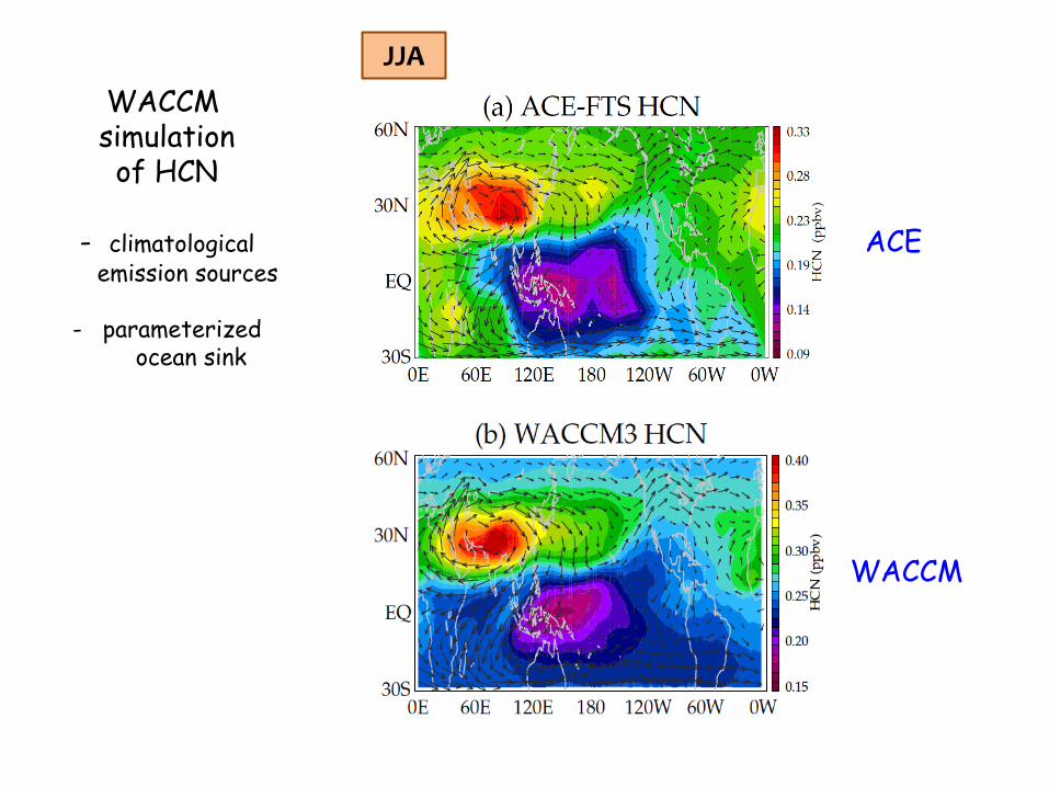
WACCM simulation of HCN
- climatological
emission sources
- parameterized ocean sink
ACE
WACCM
JJA
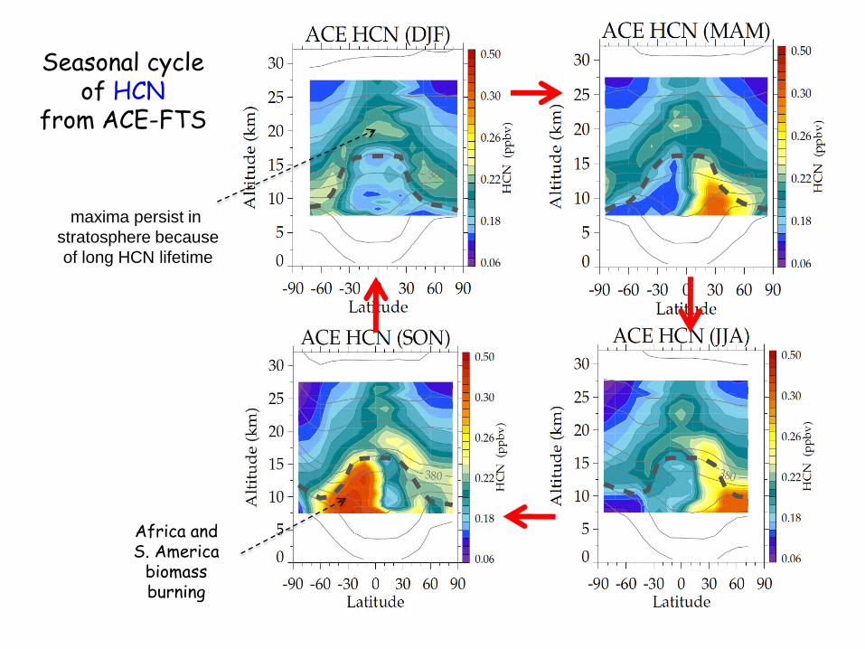
Seasonal cycle of HCN
from ACE-FTS
Africa and S. America
biomass burning
maxima persist in
stratosphere because
of long HCN lifetime
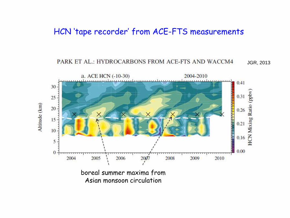
HCN ‘tape recorder’ from ACE-FTS measurements
boreal summer maxima from Asian monsoon circulation
JGR, 2013
Key points: • Trajectory studies show fate of convective outflow (up and down) • Fundamental instability of anticyclone: eddy shedding
• HCN provides evidence for monsoon transport to stratosphere
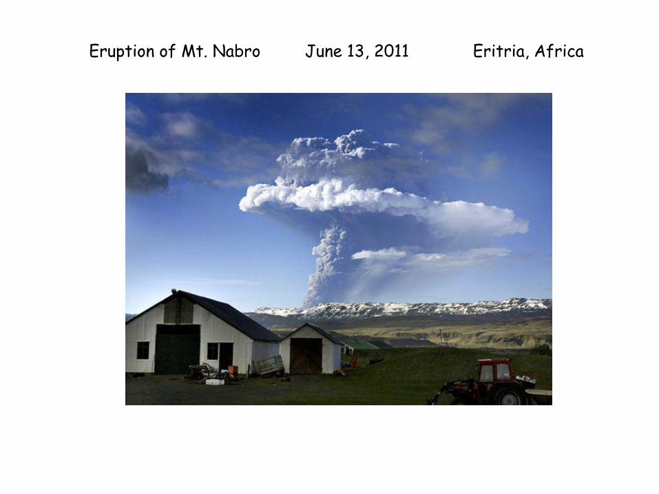
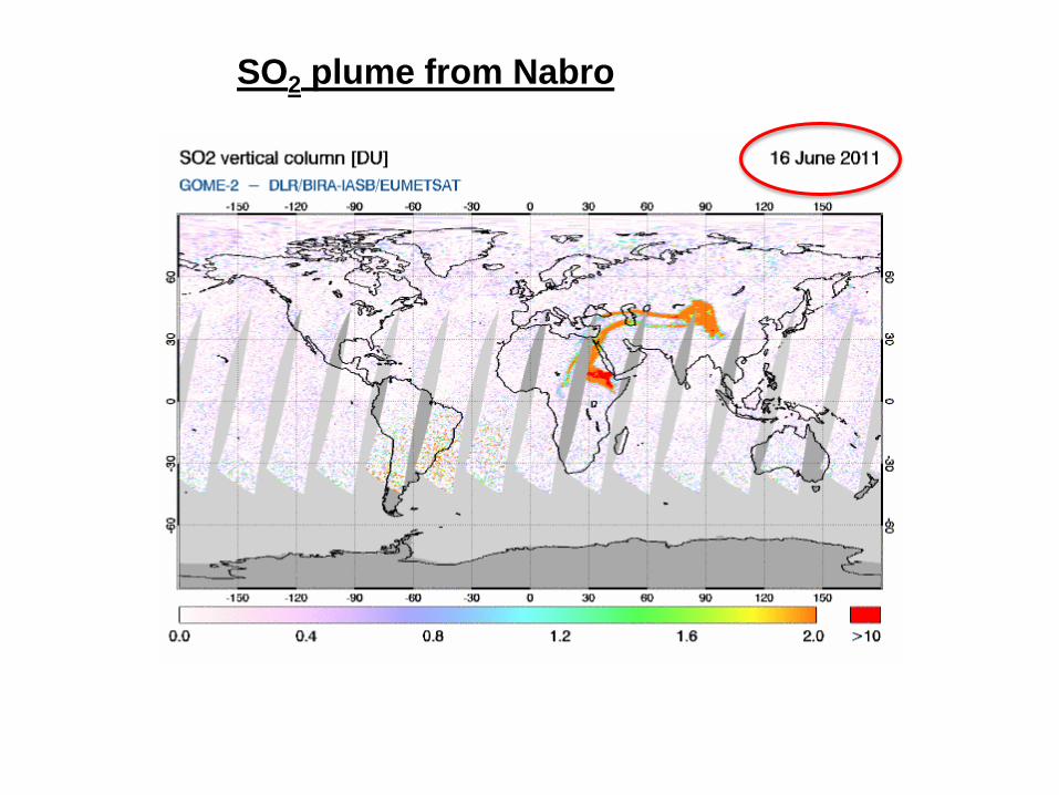
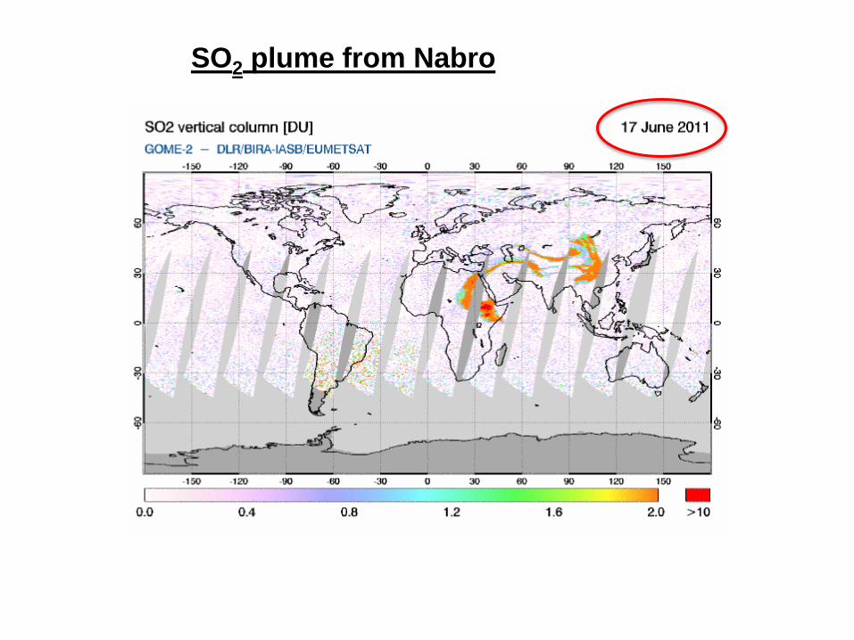
Eruption of Mt. Nabro June 13, 2011 Eritria, Africa
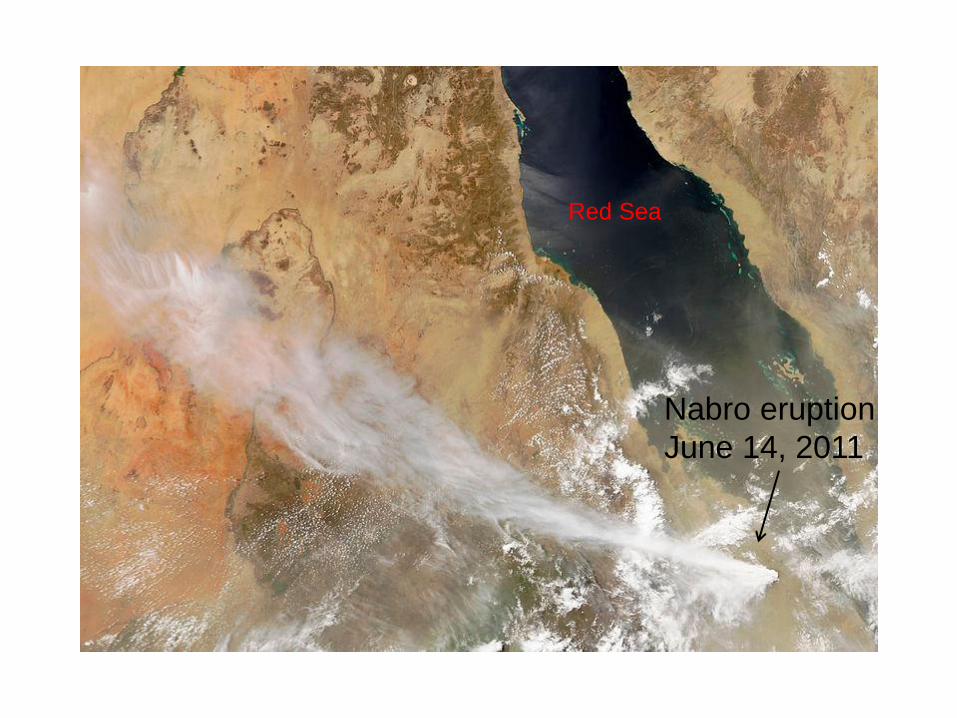
Nabro eruption
June 14, 2011
Red Sea
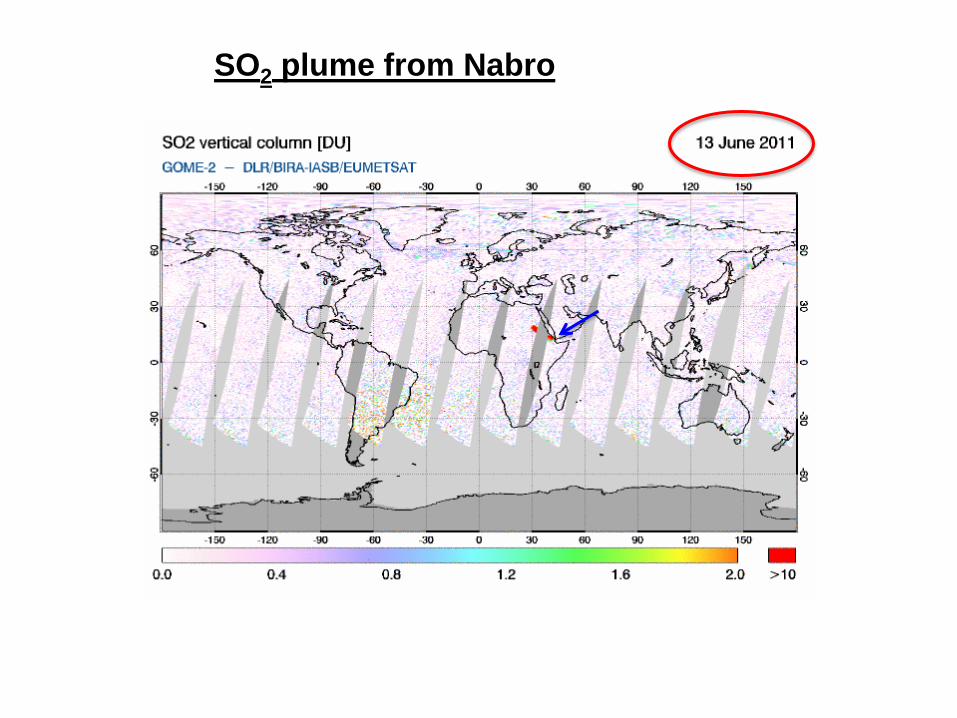
SO2 plume from Nabro
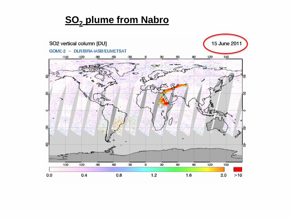
SO2 plume from Nabro
SO2 plume from Nabro
SO2 plume from Nabro
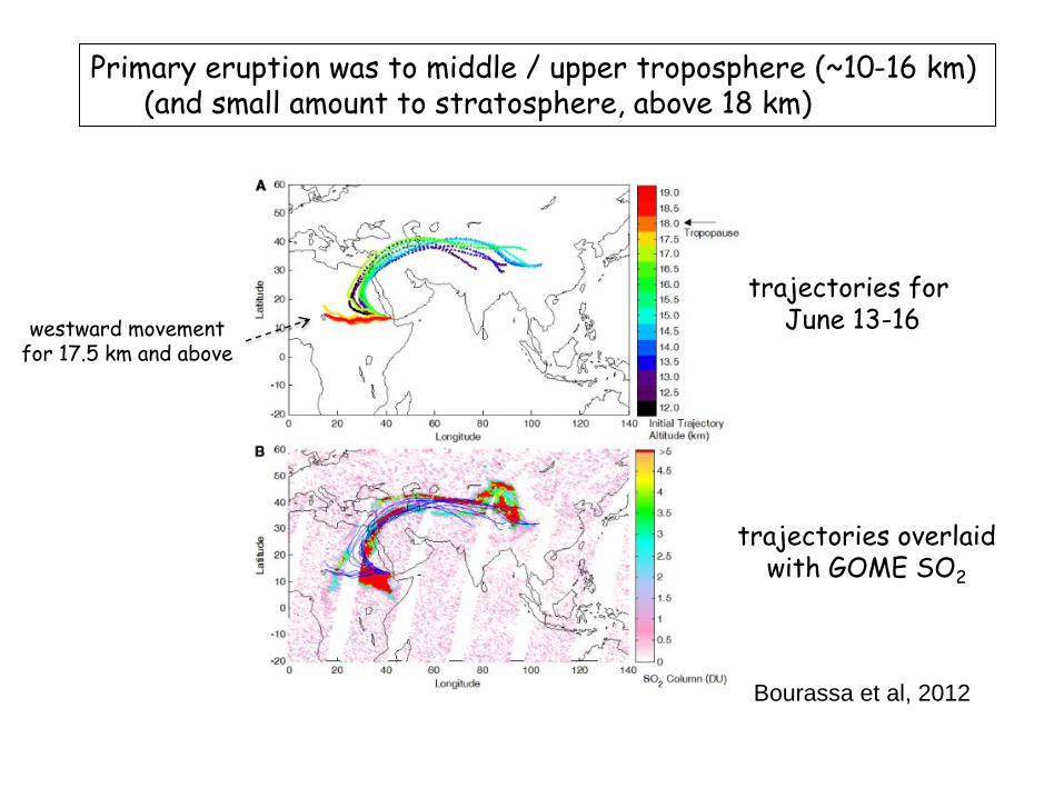
Primary eruption was to middle / upper troposphere (~10-16 km) (and small amount to stratosphere, above 18 km)
trajectories for June 13-16 westward movement
for 17.5 km and above
trajectories overlaid with GOME SO2
Bourassa et al, 2012
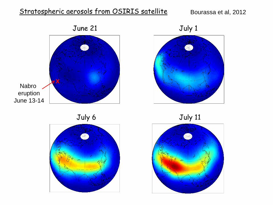
June 21 July 1
July 6 July 11
x Nabro
eruption
June 13-14
Stratospheric aerosols from OSIRIS satellite Bourassa et al, 2012
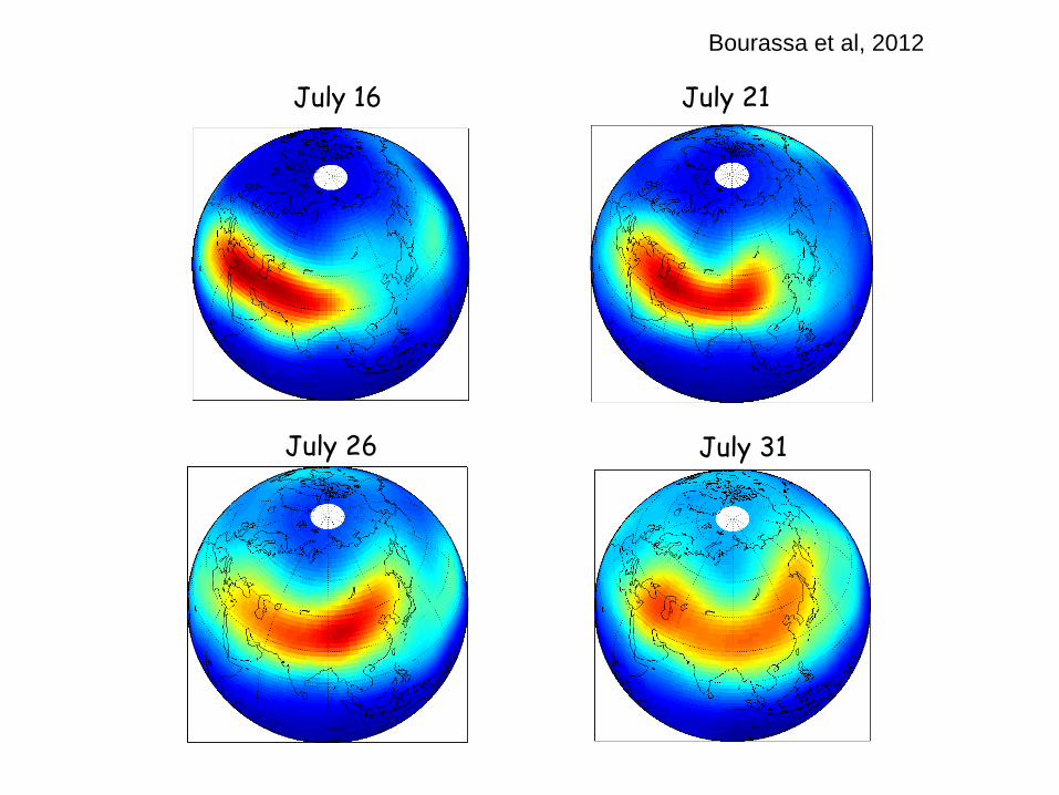
July 16 July 21
July 26 July 31
Bourassa et al, 2012
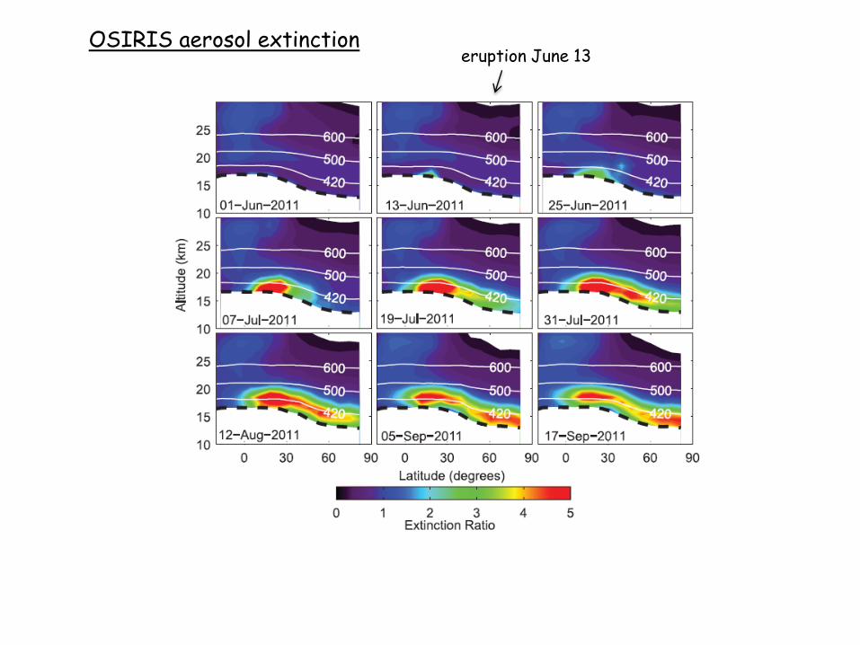
OSIRIS aerosol extinction eruption June 13
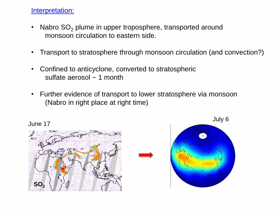
Interpretation:
• Nabro SO2 plume in upper troposphere, transported around
monsoon circulation to eastern side.
• Transport to stratosphere through monsoon circulation (and convection?)
• Confined to anticyclone, converted to stratospheric
sulfate aerosol ~ 1 month
• Further evidence of transport to lower stratosphere via monsoon
(Nabro in right place at right time)
June 17
SO2
July 6
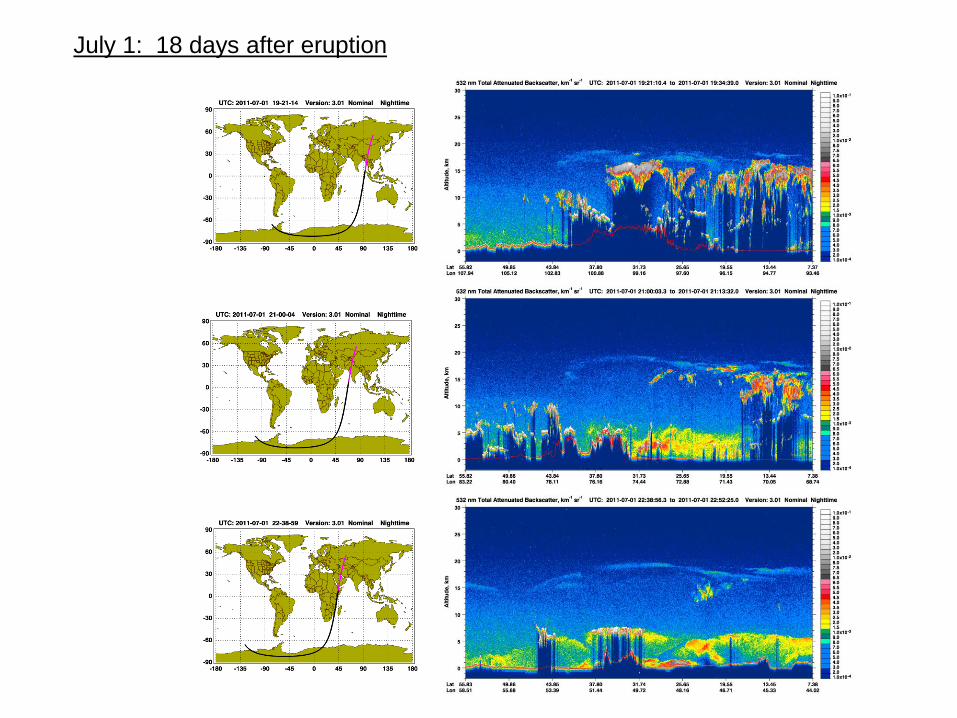
July 1: 18 days after eruption
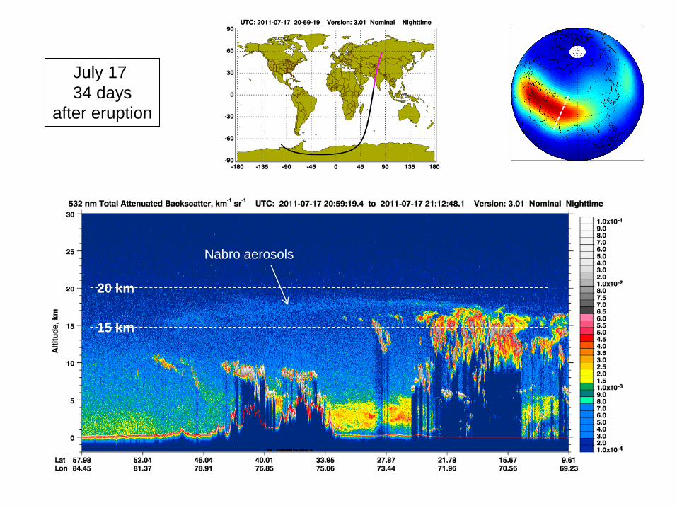
July 17
34 days
after eruption
20 km
15 km
Nabro aerosols
Ongoing research: • What are the contributions of different chemical source regions to the upper troposphere? Is reactive chemistry important? How much reactive nitrogen is in the anticyclone? • When and where does air escape the anticyclone? Are there sharp gradients across edges?
• What is the role of deep convection vs. large-scale upward circulation to the stratosphere? How important are diurnal variations in convection over Tibet?
• What is the nature of the tropopause aerosol layer? Does it influence UTLS clouds?

Thank you
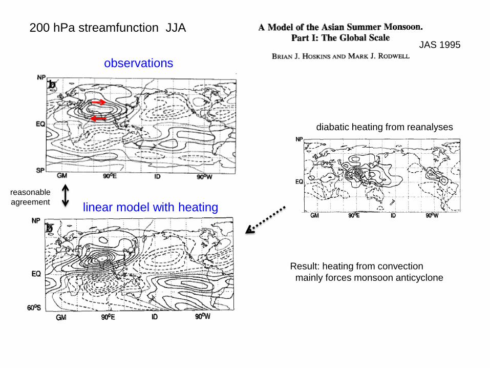
JAS 1995
observations
200 hPa streamfunction JJA
linear model with heating
diabatic heating from reanalyses
reasonable
agreement
Result: heating from convection
mainly forces monsoon anticyclone


