LEGEND
Watercourses
Contours (10m interval)
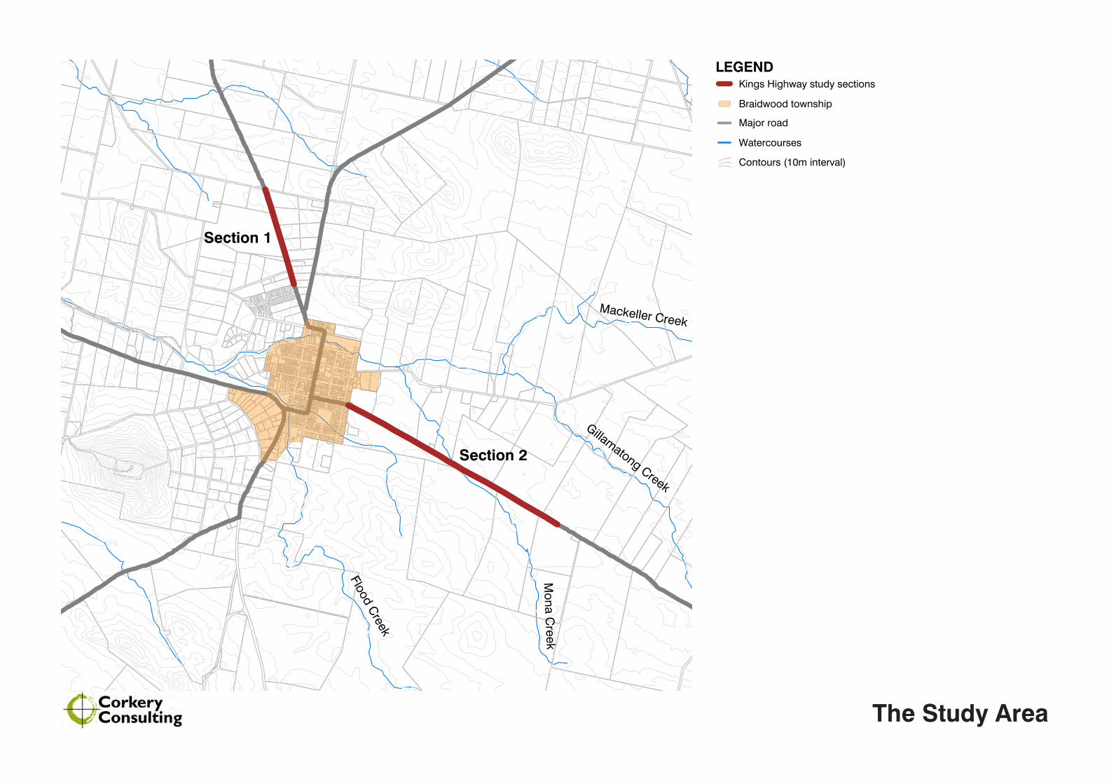
Section 1
Major road
Braidwood township
Section 2
Mona C
reek
Gillamatong Creek
Mackeller Creek
Flood Creek
Kings Highway study sections
LEGEND
Watercourses
Contours (10m interval)
Section 1
Major road
Braidwood township
Section 2
Mona C
reek
Gillamatong Creek
Mackeller Creek
Flood Creek
Kings Highway study sections
The Study Area
LEGEND
Landscape Character Zones (LCZs)
Prominent Hills / Ridgelines
Major Hill Landmark
Watercourses
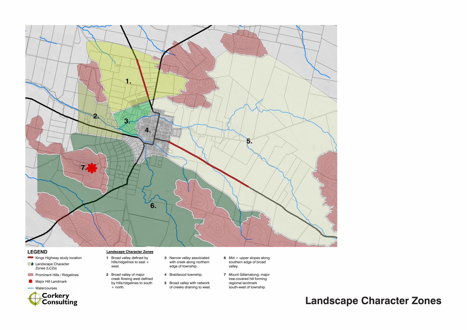
Broad valley defined by hills/ridgelines to east + west.
Broad valley of major creek flowing west defined by hills/ridgelines to south + north.
1
2
Landscape Character Zones
Narrow valley assoiciated with creek along northern edge of township.
Braidwood township.
Broad valley with network of creeks draining to west.
3
4
5
Mid + upper slopes along southern edge of broad valley.
Mount Gillamatong; major tree-covered hill forming regional landmark south-west of township.
6
7
Kings Highway study location
1.
2.
4.3.
5.
6.
7.
Landscape Character Zones

Zone of Visual Influence (ZVI) + Visual Envelope
•Zone of Visual Influence (ZVI) analysis is the process of determining the visibility of objects in the surrounding landscape using computer software and digital elevation datasets.
•ZVI illustrates potential visibility, and does not take into account trees, buildings, etc - the analysis is made on the basis of topography along.
•ZVI results indicate where an object definitely cannot be seen from, whereas actual visibility can only be determined via site survey.
•ZVI results are then used to determine the Visual Envelope. LEGEND
Visual Envelope
Watercourses
Kings Highway study location
Major road
Community buildings / facilities
Residences
Miscellaneous viewpoints
LEGEND
Visual Envelope
Watercourses
Kings Highway study location
Major road
Community buildings / facilities
Residences
Miscellaneous viewpoints
LEGEND
Visual Envelope
Watercourses
Kings Highway study location
Major road
Community buildings / facilities
Residences
Miscellaneous viewpoints
LEGEND
Trees situated on Section 1 of the Kings Highway
Major road
10km Zone of Visial Influence
Whole of tree visible
Top half of tree visible
Top of tree only visible
LEGEND
Trees situated on Section 2 of the Kings Highway
Major road
10km Zone of Visial Influence
Whole of tree visible
Top half of tree visible
Top of tree only visible
Corkery Consulting • Landscape Architecture • Urban Design Kings Highway - Landscape Character + Visual Impact Assessment
19
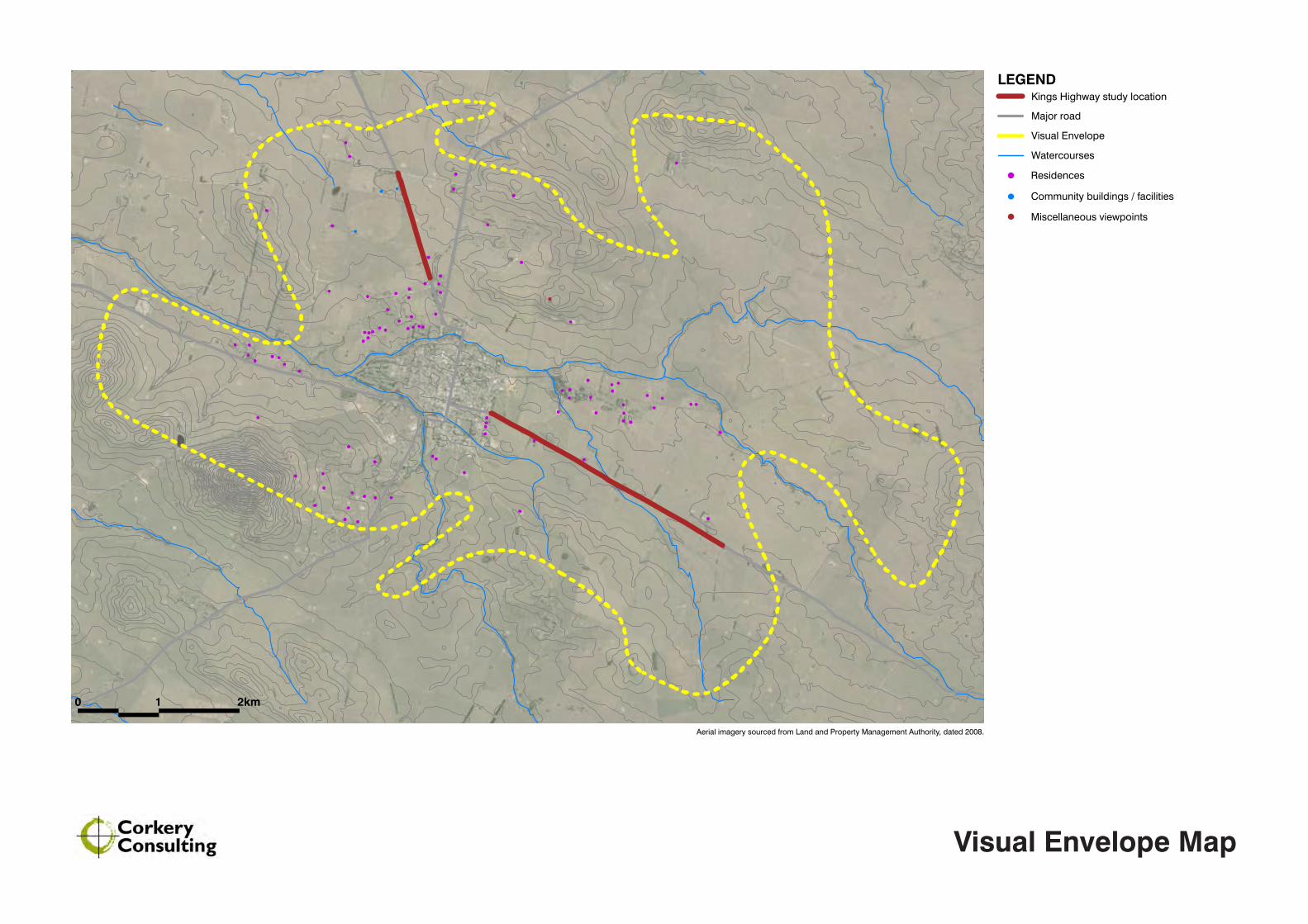
4.3 VISUAL ENVELOPE MAP
The extent to which the roadside trees along the Kings Highway are visible from adjoining areas varies significantly along the Highway’s northern and eastern approaches to Braidwood. Views to the road are influenced by a combination of landform, vegetation, houses and other structures.
The ZVI analysis discussed in the previous section establishes the extent to which the roadside trees can be seen from adjoining areas, based on an analysis of topography alone.
The process of using the ZVI analysis to determine the Visual Envelope is illustrated below in Figure 3.3, while the extent of the Visual Envelope is illustrated in Figure 3.4.
FIGURE 4.4 - VISUAL ENVELOPE MAP + KEY VIEWPOINTSFIGURE 4.3 - PROCESS OF DETERMINING VISUAL ENVELOPE
LEGEND
Trees situated on Section 1 of the Kings Highway
Major road
10km Zone of Visial Influence
Whole of tree visible
Top half of tree visible
Top of tree only visible
+
merge
X - discount areas of visibility beyond a reasonable distance from roadside trees
visual envelope at reasonable distance from roadside trees
ZVI section 1 of Kings Highway ZVI section 2 of Kings Highway
X
XX
X
X
X
combined ZVI
LEGEND
Visual Envelope
Watercourses
Kings Highway study location
Major road
Community buildings / facilities
Residences
Miscellaneous viewpoints
0 1 2km
LEGEND
Visual Envelope
Watercourses
Kings Highway study location
Major road
Community buildings / facilities
Residences
Miscellaneous viewpoints
0 1 2km
Visual Envelope Map
Aerial imagery sourced from Land and Property Management Authority, dated 2008.

WINTER
Lombardy Poplar
Golden Poplar
Pin Oak
--
--
--
SUMMER
Populus nigra var. italica
Populus x canadensis ‘Serotina Aurea’
Quercus palustris
Kings Highway Roadside Trees
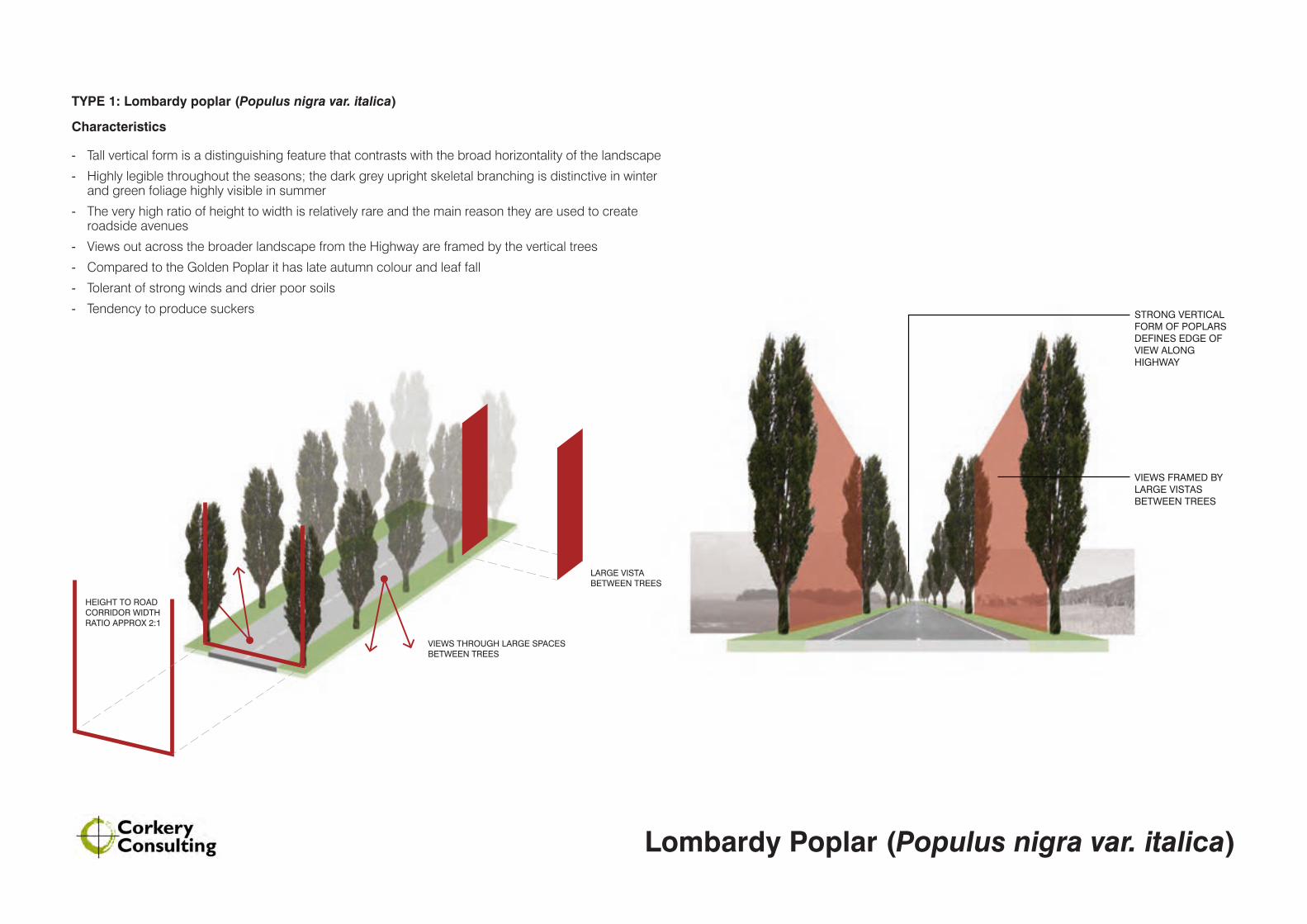
VIEWS FRAMED BY LARGE VISTAS BETWEEN TREES
STRONG VERTICAL FORM OF POPLARS DEFINES EDGE OF VIEW ALONG HIGHWAY
VIEWS THROUGH LARGE SPACES BETWEEN TREES
LARGE VISTA BETWEEN TREES
HEIGHT TO ROAD CORRIDOR WIDTH RATIO APPROX 2:1
TYPE 1: Lombardy poplar (Populus nigra var. italica)
Characteristics
- Tall vertical form is a distinguishing feature that contrasts with the broad horizontality of the landscape
- Highly legible throughout the seasons; the dark grey upright skeletal branching is distinctive in winter and green foliage highly visible in summer
- The very high ratio of height to width is relatively rare and the main reason they are used to create roadside avenues
- Views out across the broader landscape from the Highway are framed by the vertical trees
- Compared to the Golden Poplar it has late autumn colour and leaf fall
- Tolerant of strong winds and drier poor soils
- Tendency to produce suckers
Lombardy Poplar (Populus nigra var. italica)

VIEWS BLOCKED BY LARGE TREE CANOPIES
FILTERED VIEWS THROUGH TREESHEIGHT TO ROAD CORRIDOR WIDTH RATIO APPROX 1:1
SMALL VISTA BETWEEN TREES
TYPE 2: Golden poplar (Populus x canadensis ‘Serotina Aurea’)
Characteristics
- Good proportion and consistent form is desirable characteristic for an avenue tree
- Broader canopy and lower height to width ratio than Lombardy Poplar
- Views between trees reduced as canopy grows wider, reducing space between trees
- Striking and distinct golden yellow autumn foliage
- Foliage colours appear early in autumn contrasting with the still evergreen Lombardy poplar
- Tolerant of strong winds and drier poor soils
Golden Poplar (Populus x canadensis ‘Serotina Aurea’)
VIEWS FILTERED/ BLOCKED BY LARGE TREE CANOPIES
MINIMAL FILTERED VIEWS THROUGH TREES
HEIGHT TO ROAD CORRIDOR WIDTH RATIO LESS THAN 1:1
MINIMAL / NO VISTA BETWEEN TREES
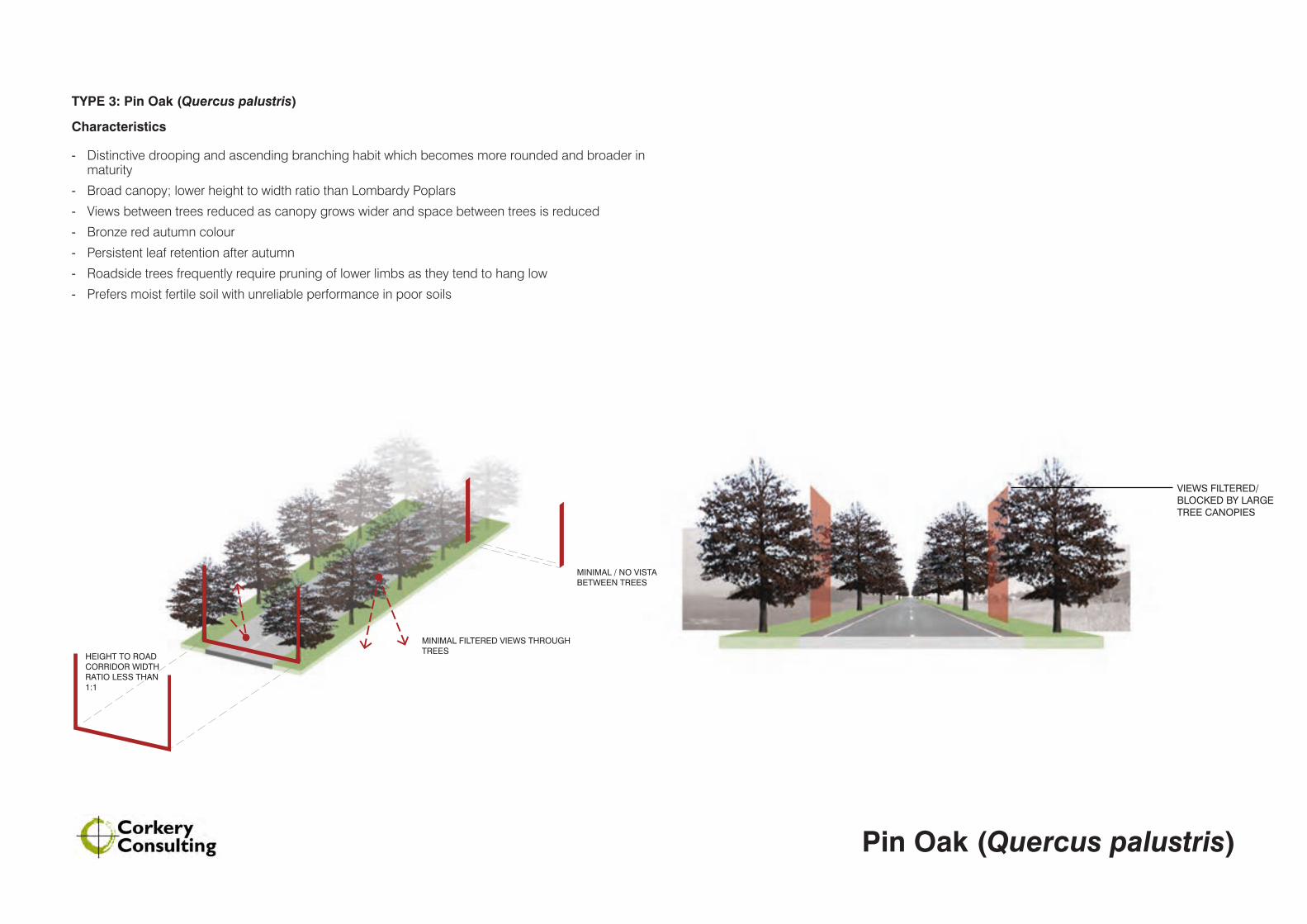
TYPE 3: Pin Oak (Quercus palustris)
Characteristics
- Distinctive drooping and ascending branching habit which becomes more rounded and broader in maturity
- Broad canopy; lower height to width ratio than Lombardy Poplars
- Views between trees reduced as canopy grows wider and space between trees is reduced
- Bronze red autumn colour
- Persistent leaf retention after autumn
- Roadside trees frequently require pruning of lower limbs as they tend to hang low
- Prefers moist fertile soil with unreliable performance in poor soils
Pin Oak (Quercus palustris)
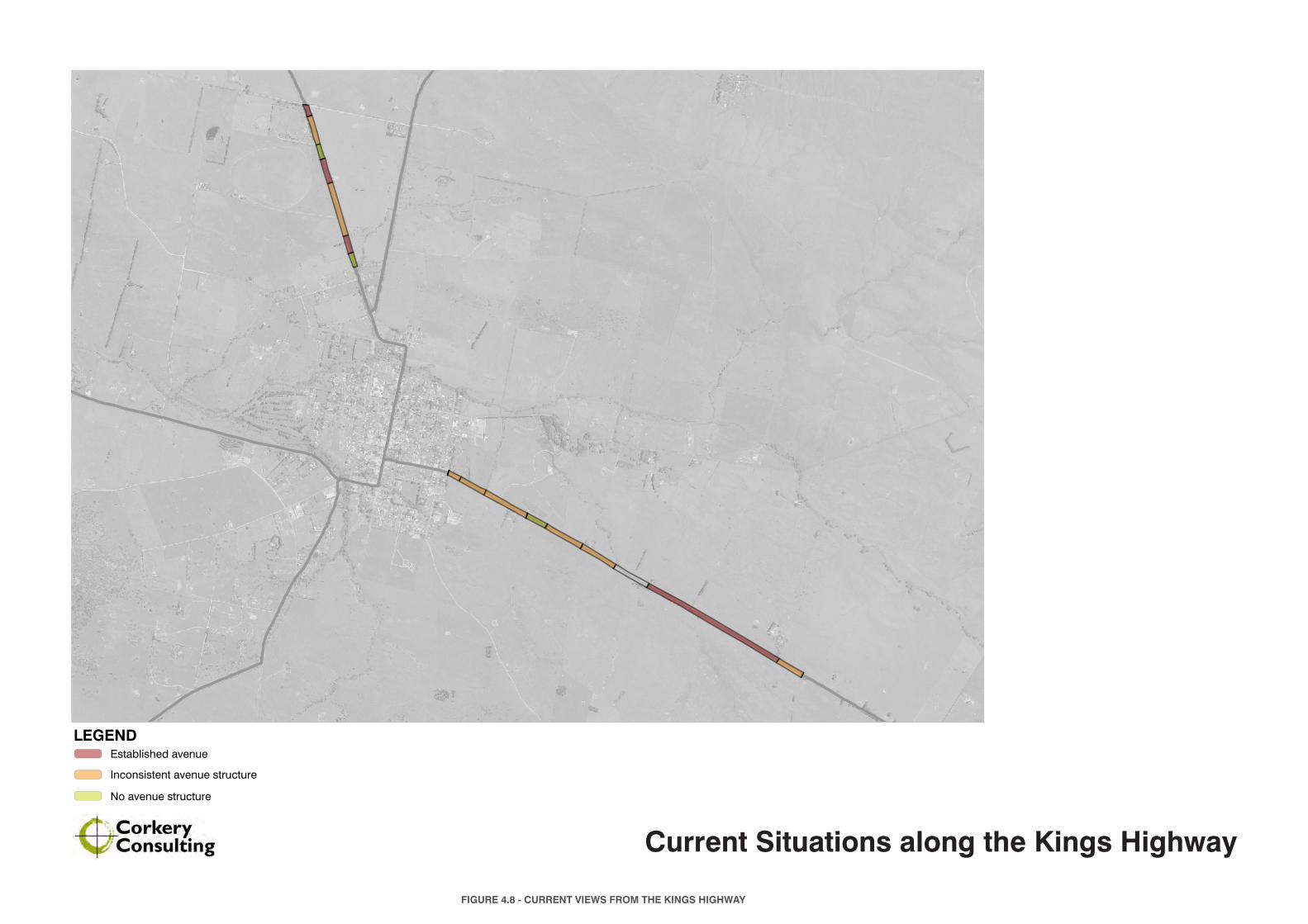
LEGEND
No avenue structure
Established avenue
Inconsistent avenue structure
FIGURE 4.8 - CURRENT VIEWS FROM THE KINGS HIGHWAY
Current Situations along the Kings Highway
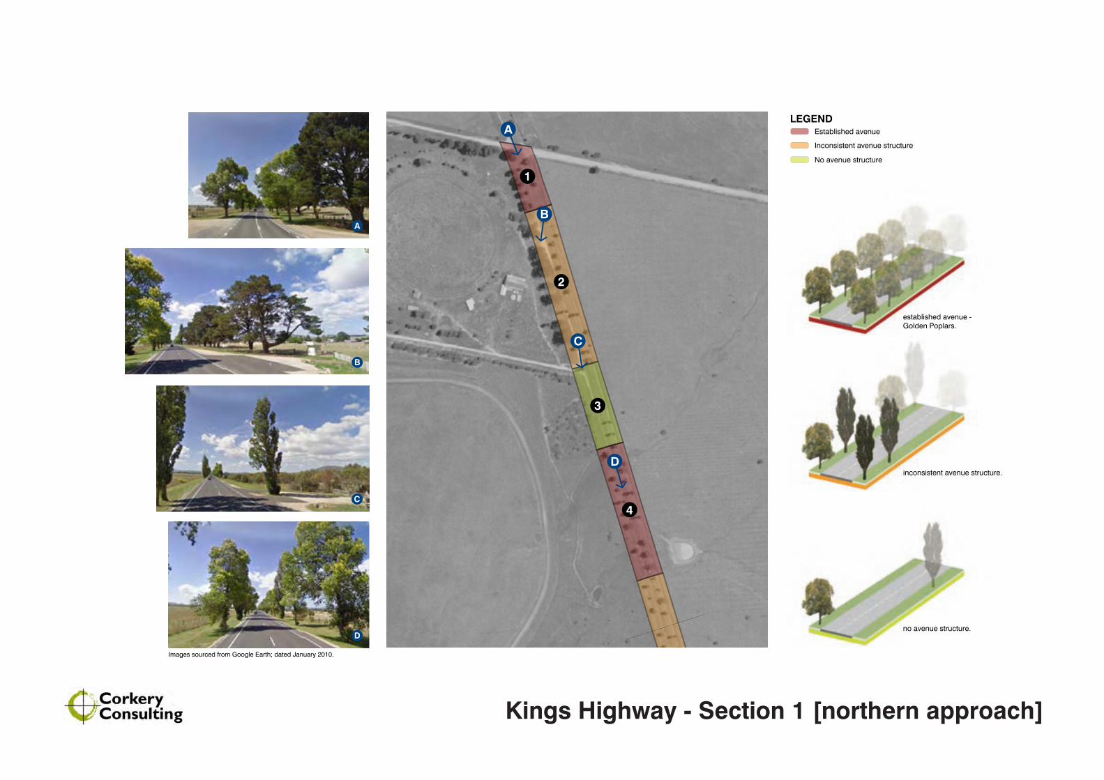
LEGEND
1
2
3
4
A
B
C
E
D
No avenue structure
Established avenue
Inconsistent avenue structure
LEGEND
1
2
3
4
A
B
C
E
D
No avenue structure
Established avenue
Inconsistent avenue structure
no avenue structure.
Images sourced from Google Earth; dated January 2010.
inconsistent avenue structure.
established avenue - Golden Poplars.
B
A
C
D
Kings Highway - Section 1 [northern approach]

No avenue structure
Established avenue
Inconsistent avenue structure
LEGEND
5
6
7
G
F
E
Images sourced from Google Earth; dated January 2010.
No avenue structure
Established avenue
Inconsistent avenue structure
LEGEND
5
6
7
G
F
E
E
F
G
no avenue structure.
established avenue - Pin Oaks.
inconsistent avenue structure.
Kings Highway - Section 1 [northern approach]
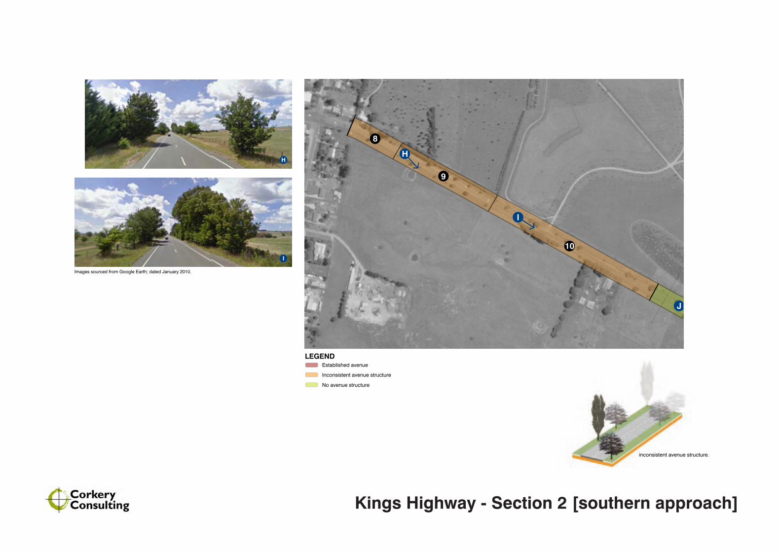
No avenue structure
Established avenue
Inconsistent avenue structure
LEGEND
8
9
10
H
I
J
inconsistent avenue structure.
Images sourced from Google Earth; dated January 2010.
H
I
Kings Highway - Section 2 [southern approach]
No avenue structure
Established avenue
Inconsistent avenue structure
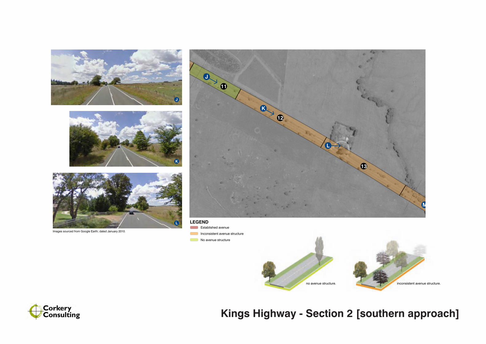
LEGEND
11
12
13
J
K
L
M
no avenue structure. inconsistent avenue structure.
J
K
L
Images sourced from Google Earth; dated January 2010.
Kings Highway - Section 2 [southern approach]
No avenue structure
Established avenue
Inconsistent avenue structure
LEGEND
14
15
M
N
O
established avenue - Lombardy Poplar
inconsistent avenue structure.
M
N
O
Images sourced from Google Earth; dated January 2010.
Kings Highway - Section 2 [southern approach]
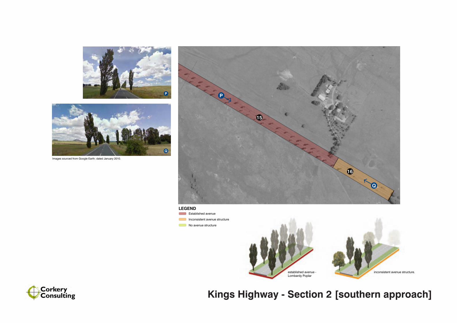
No avenue structure
Established avenue
Inconsistent avenue structure
LEGEND
15
16
Q
P
inconsistent avenue structure.established avenue - Lombardy Poplar
P
Q
Images sourced from Google Earth; dated January 2010.
Kings Highway - Section 2 [southern approach]


