www.rmsi.com
Web 2.0 Trends in Geospatial Information Systems A UserCentric GIS
Faridur Rahman Choudhury Assistant Project Manager 8 th May 2008
Web 2.0 Trends in Geospatial Information Systems
1

www.rmsi .com
We Are…
A professional services company providing geospatial solutions and
application software services to clients worldwide
# 2
A professional services company providing geospatial solutions and
application software services to clients worldwide

www.rmsi .com
§ Global clients including Fortune 100 companies § Over 75% repeat business § Best employer status
– Ranked amongst Indian IT’s Top 20 Best Employers for five years in a row and at fourth position in 2007
– Featured for two years in a row amongst the top five companies in the Great Places to Work study conducted by Great Places to Work Institute and Business World. Ranked 1st in 2006
– Ranked 2nd in the NASSCOM "Exciting Emerging Companies to Work for" survey 2007
§ Quality certifications SEI CMMI Level 5, ISO 27001 and ISO 9001:2000
§ Over 1000 multidisciplinary technical staff § Operations covering North America, UK , Continental
Europe, and Asia
RMSI Today Global clients including Fortune 100 companies
Ranked amongst Indian IT’s Top 20 Best Employers for five years in a row and at fourth position in 2007 Featured for two years in a row amongst the top five companies in the Great Places to Work study conducted by Great Places to Work Institute and Business World. Ranked
Ranked 2nd in the NASSCOM "Exciting Emerging Companies
SEI CMMI Level 5, ISO 27001 and
disciplinary technical staff Operations covering North America, UK , Continental
# 3

www.rmsi.com
Where Am I?
The Key is Location
4

www.rmsi .com
Are you spatially enabled?

www.rmsi .com
How many of you have used maps?
Turn Left, Walk straight for 100 meters
and then break through the wall in
the dead‐end!
How many of you have used maps?

www.rmsi .com
How many of you have stopped to ask for directions? How many of you have stopped to ask for directions?
www.rmsi .com
We are all spatially enabled!
We all know where where we are going!
We are all spatially enabled!
where we are and we are going!

www.rmsi .com
What is a Geospatial/Geographic Information System?
A GIS is a system capable of storing, analyzing
geographically referenced information; that is, data identified according to location
What is a Geospatial/Geographic Information System?
A GIS is a system capable of capturing, analyzing, and displaying
geographically referenced information; that data identified according to location

www.rmsi .com
Heritage of Modern GIS § London Cholera outbreak in 1854
§ Dr. John Snow created this map in an attempt to isolate what was infecting all the people
§ His study of the distribution of cholera led to the source of the disease, a contaminated water pump within the heart of the cholera outbreak
§ In fact, you could consider this map to be the first recorded mashup, taking three distinct sets of data – location of cholera deaths, street map and location of water pumps and combining them into a single view
Heritage of Modern GIS
www.rmsi .com
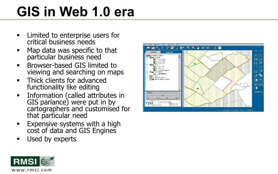
GIS in Web 1.0 era § Limited to enterprise users for
critical business needs § Map data was specific to that
particular business need § Browserbased GIS limited to
viewing and searching on maps § Thick clients for advanced
functionality like editing § Information (called attributes in
GIS parlance) were put in by cartographers and customised for that particular need
§ Expensive systems with a high cost of data and GIS Engines
§ Used by experts
www.rmsi .com
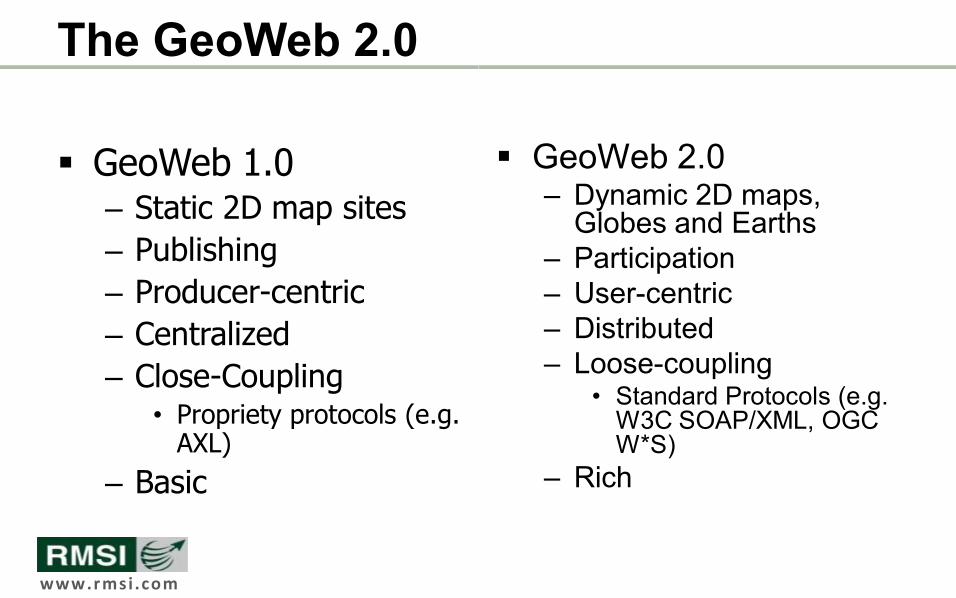
The GeoWeb 2.0
§ GeoWeb 1.0 – Static 2D map sites – Publishing – Producercentric – Centralized – CloseCoupling
• Propriety protocols (e.g. AXL)
– Basic
§ GeoWeb 2.0 – Dynamic 2D maps, Globes and Earths
– Participation – Usercentric – Distributed – Loosecoupling
• Standard Protocols (e.g. W3C SOAP/XML, OGC W*S)
– Rich
www.rmsi.com
Web 2.0 Trends in GIS
The Next Generation GIS
www.rmsi .com
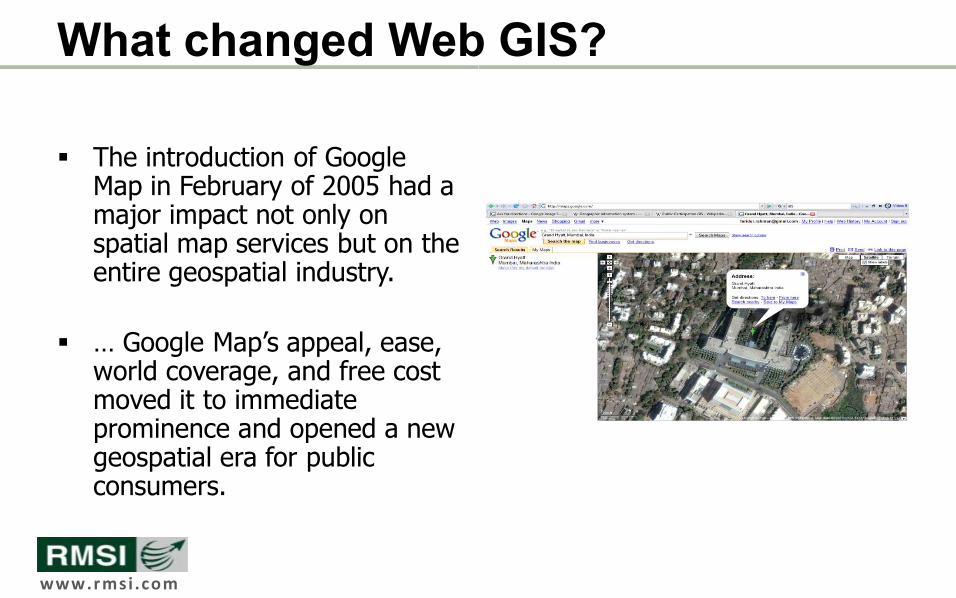
What changed Web GIS?
§ The introduction of Google Map in February of 2005 had a major impact not only on spatial map services but on the entire geospatial industry.
§ … Google Map’s appeal, ease, world coverage, and free cost moved it to immediate prominence and opened a new geospatial era for public consumers.
What changed Web GIS?

www.rmsi .com
What Followed?
§ Google “employed” us to make their database rich
§ We did it for for free § The community started to add data – from the nearest restaurants to where the girlfriend lived
§ Today it is one of the richest GIS Feature database in the world

www.rmsi .com
Crowdsourced Data Collection
§ GeoWiki • Allow anyone to submit updates to the GIS vector
data store • Promotes more uptodate data • A GIS archive maintained using wiki principles • Completely free and open for anyone to use
Crowdsourced Data Collection – “Wikification” of GIS
Allow anyone to submit updates to the GIS vector
A GIS archive maintained using wiki principles Completely free and open for anyone to use
16

www.rmsi .com
Crowdsourced Data Collection
• OpenStreetMap • Collaborative project to create free editable maps • Maps created using
• Data from portable GPS devices • Local knowledge • Public domain sources like TIGER • Satellite and aerial images • Contributed datasets
Crowdsourced Data Collection – “Wikification” of GIS
Collaborative project to create free editable maps
17

www.rmsi .com
Crowdsourced Data Collection
• ShapeWiki • Collaborative shape repository • Tagged repository of shapes anyone can browse, create and import • Follows GIS standards and protocols
Crowdsourced Data Collection – “Wikification” of GIS
Tagged repository of shapes anyone can browse, create and import Follows GIS standards and protocols
18
www.rmsi .com
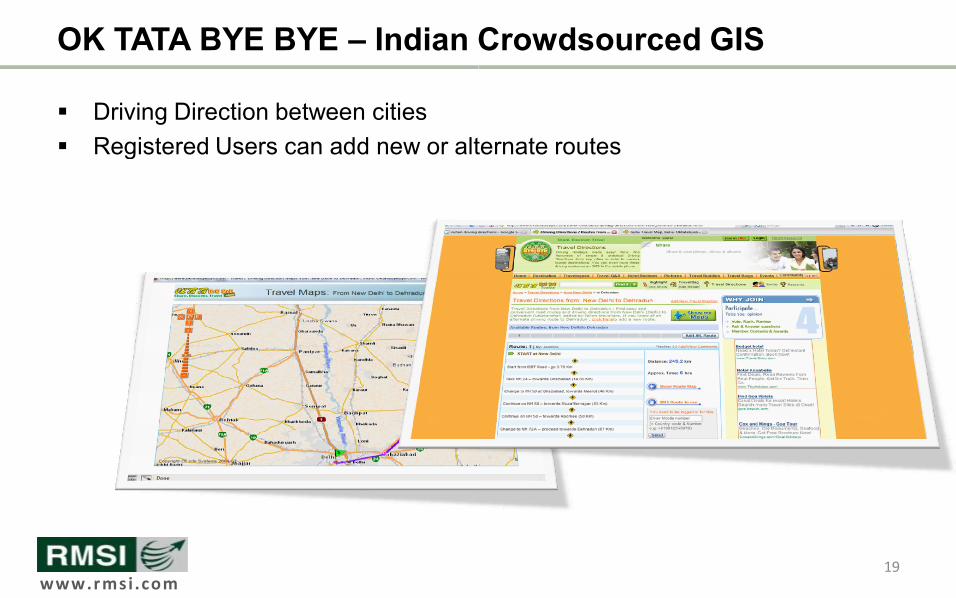
OK TATA BYE BYE – Indian Crowdsourced GIS
§ Driving Direction between cities § Registered Users can add new or alternate routes
Indian Crowdsourced GIS
Registered Users can add new or alternate routes
19

www.rmsi.com
What Makes WebGeo
GIS Data Exchange Standards
WebGeo 2.0 Possible?
20

www.rmsi .com
Standards, Standards and Standards!!
§ The key is standards § Use of Open Geospatial Consortium specified formats and protocols
• GML • KML • GeoRSS • W*S
§ All major GIS Engines understand and speak these languages § All major GIS APIs in Public domain understand and speak these languages
Standards, Standards and Standards!!
Use of Open Geospatial Consortium specified formats and protocols
All major GIS Engines understand and speak these languages All major GIS APIs in Public domain understand and speak these languages
21

www.rmsi .com
Geography Markup Language (GML)
§ XML grammer defined by Open Geospatial Consortium § Serves as a modeling language for geographic systems § Open interchange format for geographic transactions on the Internet
<gml:Polygon> <gml:outerBoundaryIs>
<gml:LinearRing> <gml:coordinates>0,0 100,0 100,100 0,100 0,0</gml:coordinates>
</gml:LinearRing> </gml:outerBoundaryIs>
</gml:Polygon> <gml:Point>
<gml:coordinates>100,200</gml:coordinates> </gml:Point> <gml:LineString>
<gml:coordinates>100,200 150,300</gml:coordinates> </gml:LineString>
Geography Markup Language (GML)
XML grammer defined by Open Geospatial Consortium language for geographic systems
Open interchange format for geographic transactions on the Internet
<gml:coordinates>0,0 100,0 100,100 0,100 0,0</gml:coordinates>
<gml:coordinates>100,200 150,300</gml:coordinates>
22

www.rmsi .com
Keyhole Markup Language
§ An XMLbased language schema for expressing geographic annotation and visualization on existing or future Web threedimensional Earth browsers
§ Developed for use with Google Earth, which was originally named Keyhole Earth Viewer
<?xml version="1.0" encoding="UTF8"?>
<kml xmlns="http://earth.google.com/kml/2.0">
<Placemark>
<description>New York City</description>
<name>New York City</name>
<Point>
<coordinates>
</Point>
</Placemark>
</kml>
KML
based language schema for expressing geographic annotation and visualization on existing or future Webbased, twodimensional maps and
Developed for use with Google Earth, which was originally named Keyhole
<kml xmlns="http://earth.google.com/kml/2.0">
<description>New York City</description>
<name>New York City</name>
74.006393,40.714172,0</coordinates>
23

www.rmsi .com
Open Geospatial Consortium Standards
§ Web Map Service (WMS) § Request and provide a map as a picture or set of features ( § Get and provide information about the content of a map such as the value of a feature at a
location (GetFeatureInfo) § Get and provide information about what types of maps a server can deliver (
§ Web Feature Service (WFS) and WFS § WFS allows querying and retrieval of features § WFST allows allows creation, deletion, and updating of features § “Features” can be said to be the sourcecode behind maps § Data exchanged between server and client via GML
§ Web Coverage Service (WCS) § Coverages are objects (or images) in a geographical area § WCS allows querying and retrieval of coverages
Open Geospatial Consortium Standards – W*S
Request and provide a map as a picture or set of features (GetMap) Get and provide information about the content of a map such as the value of a feature at a
Get and provide information about what types of maps a server can deliver (GetCapabilities)
Web Feature Service (WFS) and WFSTransactional WFS allows querying and retrieval of features
creation, deletion, and updating of features code behind maps
Data exchanged between server and client via GML
are objects (or images) in a geographical area coverages
24
www.rmsi .com
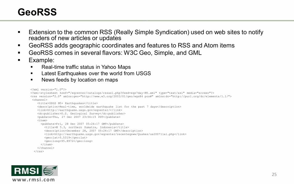
GeoRSS
§ Extension to the common RSS (Really Simple Syndication) used on web sites to notify readers of new articles or updates
§ GeoRSS adds geographic coordinates and features to RSS and Atom items § GeoRSS comes in several flavors: W3C Geo, Simple, and GML § Example:
§ Realtime traffic status in Yahoo Maps § Latest Earthquakes over the world from USGS § News feeds by location on maps <?xml version="1.0"?> <?xmlstylesheet href="/eqcenter/catalogs/rssxsl.php?feed=eqs7dayM5.xml" type="text/ <rss version="2.0" xmlns:geo="http://www.w3.org/2003/01/geo/wgs84_pos#" <channel>
<title>USGS M5+ Earthquakes</title> <description>Realtime, worldwide earthquake list for the past 7 days</description> <link>http://earthquake.usgs.gov/eqcenter/</link> <dc:publisher>U.S. Geological Survey</dc:publisher> <pubDate>Thu, 27 Dec 2007 23:56:15 PST</pubDate> <item>
<pubDate>Fri, 28 Dec 2007 05:24:17 GMT</pubDate> <title>M 5.3, northern Sumatra, Indonesia</title> <description>December 28, 2007 05:24:17 GMT</description> <link>http://earthquake.usgs.gov/eqcenter/recenteqsww/Quakes/us2007llai.php</link> <geo:lat>5.5319</geo:lat> <geo:long>95.8972</geo:long>
</item> </channel>
</rss>
Extension to the common RSS (Really Simple Syndication) used on web sites to notify
adds geographic coordinates and features to RSS and Atom items : W3C Geo, Simple, and GML
Latest Earthquakes over the world from USGS
M5.xml" type="text/xsl" media="screen"?> ="http://www.w3.org/2003/01/geo/wgs84_pos#" xmlns:dc="http://purl.org/dc/elements/1.1/">
time, worldwide earthquake list for the past 7 days</description>
<link>http://earthquake.usgs.gov/eqcenter/recenteqsww/Quakes/us2007llai.php</link>
25
www.rmsi.com
How should WebGeo feel like?
The Presentation Layer
WebGeo 2.0 Applications
26

www.rmsi .com
I want my desktop GIS on the internet! § Desktoplike experience § Full screen bigger maps § No pagerefreshes § Dynamic pan and zoom § Seamless clientside drawing of
Points, Lines and Polygons on map § Dockable/Movable panels § High levels of interaction and
instant feedback § Extensive use of Web 2.0
technologies – AJAX – Adobe AIR / Flash – Microsoft Silverlight
I want my desktop GIS on the internet!
27
www.rmsi.com
TakingWebGeo 2.0 To The Enterprise
GIS Web Services Mashup for an Enterprise Application
2.0 To The Enterprise
GIS Web Services Mashup for an Enterprise Application
28
www.rmsi .com
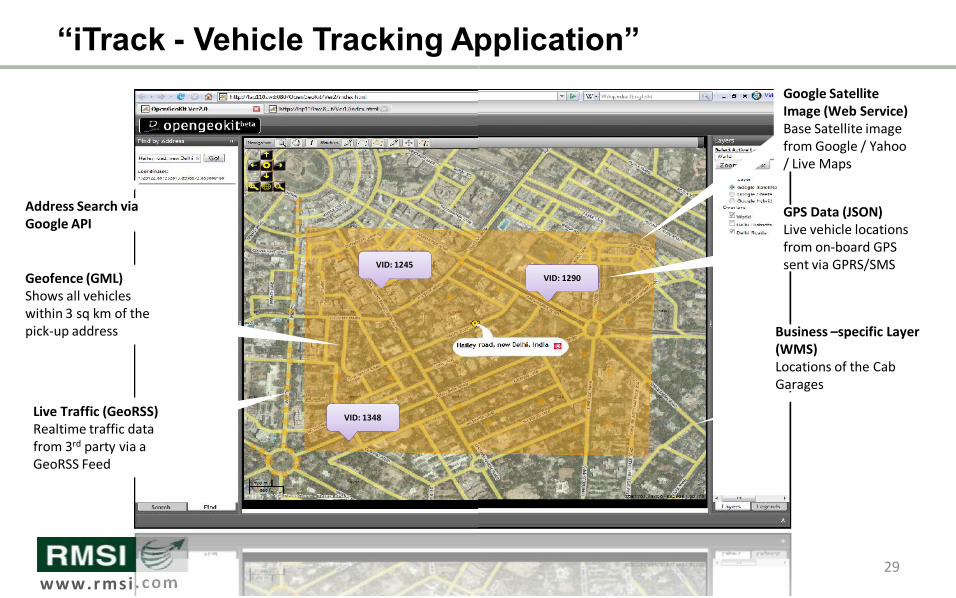
“iTrack Vehicle Tracking Application”
Geofence (GML) Shows all vehicles within 3 sq km of the pick‐up address
Live Traffic (GeoRSS) Realtime traffic data from 3 rd party via a GeoRSS Feed
Address Search via Google API
VID: 1245
VID: 1348
Vehicle Tracking Application”
29
Google Satellite Image (Web Service) Base Satellite image from Google / Yahoo / Live Maps
GPS Data (JSON) Live vehicle locations from on‐board GPS sent via GPRS/SMS
Business –specific Layer (WMS) Locations of the Cab Garages
VID: 1290

www.rmsi .com
A Typical Open Source GeoWeb 2.0 Architecture ¡ Apache Tomcat
OpenSource J2EE Application Server
¡ GeoServer OpenSource OGCcompliant Map server (Using Map and Feature Services)
¡ PostgreSQL with PostGIS OpenSource RDBMS with Spatial Capabilities
¡ OpenLayers OpenSource Web mapping JavaScript library using AJAX and clientside mapping tools
¡ Styled Layer Descriptors Styled Layer Description for map styling
¡ (X)HTML, CSS, XML and Javasacript W3C and ECMA compliant web languages
¡ Hosted Services (Image) like Google, Yahoo and Virtual Earth (Live Maps) and overlaying custom ESRI Shape files on them without sending data to their servers
¡ Hosted Services (Features) like Google, Yahoo and Virtual Earth (Live Maps) for searching features
A Typical Open Source GeoWeb 2.0 Architecture
30
Data Source
PostgreSQL+Post GIS / Oracle/ DB2/ArcSDE (Spatial DB)
Public Map APIs (Google, Yahoo, VirtualEarth etc)
SHP, TAB, GeoTIFF, VPF,
WFS
Web Server (IIS, Tomcat, JBoss, Jetty,JRun)
GeoServer (Spatial Data Server)
Client
HTML Flash / Flex Desktop
WMS
Image
WFS Features
(XML/GML)
WCS
Aerial
OpenLayers (JavaScript GIS API Library)
Prototype+Scriptaculous (AJAX API Library)
Mobile
GeoRSS XML KML

www.rmsi .com
Conclusion
§ GIS is all about layers, and associating attributes to spatial data
§ GIS is a key buzzword in the context of Social Web Technologies • Serves as a backend for for geospatial web applications • Provides content allowing for users to create new “layers” on top of publicly available GIS stores to create mashups
§ The “wikification” of GIS • Allows normal users to update inaccurate data and contribute new data
• Apply best features of Wikis to a GIS data archive
GIS is all about layers, and associating attributes to
GIS is a key buzzword in the context of Social Web
Serves as a backend for for geospatial web applications Provides content allowing for users to create new “layers” on top of publicly available GIS stores to create mashups
Allows normal users to update inaccurate data and contribute
Apply best features of Wikis to a GIS data archive
31


