
22-23 Mars 2006
INS
PIR
E
Projet part-financépar l’Union
Européenne
M O D U L E II: Metadata. Describing GeoSpatial Data
WS2 METADATA: Describing GeoSpatial Data
Susana Fontano

22-23 Mars 2006
INS
PIR
E
Projet part-financépar l’Union
Européenne
M O D U L E II: Metadata. Describing GeoSpatial Data
Planning
�General concepts about metadata�The use of standards�Items about the creation of metadata�Software�How to create metadata�The ISO19115 Standard Metadata�IDENA Profile�Practical exercises (show the results
with style sheets)

22-23 Mars 2006
INS
PIR
E
Projet part-financépar l’Union
Européenne
M O D U L E II: Metadata. Describing GeoSpatial Data
General Concepts
�There is a real need to document thedata for future use.
�Data without context are not as valuable as documented data.
�There are three principal problems:�Poor knowledge of existing data.�Poorly documented information about the
data.
�Data inconsistencies.

22-23 Mars 2006
INS
PIR
E
Projet part-financépar l’Union
Européenne
M O D U L E II: Metadata. Describing GeoSpatial Data
General Concepts
�Metadata is useful for all data users(city planners, graduate students in geography, forest managers…), butthey also benefit from the creator of thedata by maintaining the value of thedata and assuring their continued use over a number of years.

22-23 Mars 2006
INS
PIR
E
Projet part-financépar l’Union
Européenne
M O D U L E II: Metadata. Describing GeoSpatial Data
General Concepts
�Metadata means “data about data”, and is the term used to describe thesummary information or characteristicsof a set of data.
�Metadata are used not only to describe spatial data, but they can also describe medication, printed maps, librarycatalogues.
�Metadata answer the terms: what, who, where, why, when and how of the data.

22-23 Mars 2006
INS
PIR
E
Projet part-financépar l’Union
Européenne
M O D U L E II: Metadata. Describing GeoSpatial Data
General Concepts
�Benefits of metadata:�MD help users to find the data they need
and determine how best to use it.�MD benefit the data producer
organisation. Not duplication of efforts.
�Nowadays, the organizations starts torecognize the value of this informationand they often begin to look atincorporating the metadata collectionwithin the data management process.

22-23 Mars 2006
INS
PIR
E
Projet part-financépar l’Union
Européenne
M O D U L E II: Metadata. Describing GeoSpatial Data
General Concepts
�There are different levels of metadata:�Discovery metadata
�Exploration metadata�Exploitation metadata
�Each of these purposes requiredifferent levels of information.

22-23 Mars 2006
INS
PIR
E
Projet part-financépar l’Union
Européenne
M O D U L E II: Metadata. Describing GeoSpatial Data
General Concepts�Discovery metadata:
� Is the minimum amount of information.�They have to answer the following questions
(broad categories):� What: title and description� Why: abstract detailing reasons for the data collection
and its uses� When: when the data set was created and the update
cycles, if any.� Who: originator, data supplier� Where: the geographical extent (in coordinates,
geographical names or administrative areas)� How: how it was made and how to access the data.

22-23 Mars 2006
INS
PIR
E
Projet part-financépar l’Union
Européenne
M O D U L E II: Metadata. Describing GeoSpatial Data
General Concepts�These broad categories are only a few in
number to reduce the effort of collectingthe information.
�The level of the metadata detail that willbe documented depends on:�the type of data held�the methods that it is accessing and using�the scope of the data being defined

22-23 Mars 2006
INS
PIR
E
Projet part-financépar l’Union
Européenne
M O D U L E II: Metadata. Describing GeoSpatial Data
General Concepts
�Exploration metadata:�After discovery, more detail is needed
about individual data sets.�Provides sufficient information to ascertain
that data fit for a given purpose.
�Reference some point of contact for more information.
�Include those properties required to allowthe prospective end user to know whetherthe data will meet general requirements ora given problem.

22-23 Mars 2006
INS
PIR
E
Projet part-financépar l’Union
Européenne
M O D U L E II: Metadata. Describing GeoSpatial Data
General Concepts
�Exploitation metadata:�Include those properties required to
access, transfer, load, interpret and applythe data in the end application where it isexploited.
�This class of metadata often includes thedetails of a data dictionary, the data organisation, projection and geometriccharacteristics and other parameters thatare useful in the proper use of thegeospatial data.

22-23 Mars 2006
INS
PIR
E
Projet part-financépar l’Union
Européenne
M O D U L E II: Metadata. Describing GeoSpatial Data
The use of standards�Metadata should be referenced to a
standard.�Why? Because whithout standardization,
meanful comparisons are more difficult toderive.
�Standards have been developed through a consultative process (experts).
�Software programs will be developed toimplement the standard.
�Problem: there are a number of standards in use or development.

22-23 Mars 2006
INS
PIR
E
Projet part-financépar l’Union
Européenne
M O D U L E II: Metadata. Describing GeoSpatial Data
The use of standards�The three main standards are:
�FGDC�CEN�ISO 19115
�The Content Standard for Digital Geospatial Metadata
�Adopted in 1994, revised in 1998�FGDC: Federal Geographic Data Committee�U.S., Canada, United Kingdom, Latin
American, Asia...�http://www.fgdc.gov/standards/standards_publ
ications/index_html

22-23 Mars 2006
INS
PIR
E
Projet part-financépar l’Union
Européenne
M O D U L E II: Metadata. Describing GeoSpatial Data
The use of standards
�The CEN Pre-standard�Adopted in 1998�Comité Européen de Normalisation�In 2003 address the development of European
profiles of ISO TC 211 standards.

22-23 Mars 2006
INS
PIR
E
Projet part-financépar l’Union
Européenne
M O D U L E II: Metadata. Describing GeoSpatial Data
The use of standards�The ISO 19115 (International
Standard)�Approved in 2003�ISO TC 211�http://www.iso.ch/iso/en/CatalogueDetailPage.
CatalogueDetail?CSNUMBER=26020&ICS1=35
�ISO 19139 (Draft Technical Specification), standarises the expression of 19115 metadatausing the Extensible Markup Language (XML) and includes the logical model (UML) derivedfrom ISO 19115. Currently underdevelopment.

22-23 Mars 2006
INS
PIR
E
Projet part-financépar l’Union
Européenne
M O D U L E II: Metadata. Describing GeoSpatial Data
The use of standards
�OpenGeospatial Abstract Specification(OGC: OpenGeospatial Consortium) consider metadata too, and has adopted ISO 19115 as the abstractmodel for metadata managementwithin the consortium.

22-23 Mars 2006
INS
PIR
E
Projet part-financépar l’Union
Européenne
M O D U L E II: Metadata. Describing GeoSpatial Data
The use of standards
�Another standard not specific togeospatial information: Dublin Core�This standard is centraliced around a core
element set.
�DC metadata is specifically intended tosupport general-purpose resourcediscovery.

22-23 Mars 2006
INS
PIR
E
Projet part-financépar l’Union
Européenne
M O D U L E II: Metadata. Describing GeoSpatial Data
Items about creation of metadata�Who?
�The creator of metadata needs to know information about the data in order todocument them.
�Two options: �creator of data = creator of metadata�another person... In this case a good
communication there is necessary betweenthe data producer and the metadata producer.

22-23 Mars 2006
INS
PIR
E
Projet part-financépar l’Union
Européenne
M O D U L E II: Metadata. Describing GeoSpatial Data
Items about creation of metadata�Factors related to the maintainance of
metadata:�the size of the data�the size of an organisation�the patterns of data management
�Principal inconvenients:�It is too hard�Insufficient time
�Solutions:�Consider the interest and availability of the
organisation

22-23 Mars 2006
INS
PIR
E
Projet part-financépar l’Union
Européenne
M O D U L E II: Metadata. Describing GeoSpatial Data
Items about creation of metadata
�Advice:�Minimum metadata (choose the correct level)�Specific software to fill in the metadata (less
time and effort)�Do not invent your own standard
� Use metadata tools� Make your own profile� Interoperability (IDE)

22-23 Mars 2006
INS
PIR
E
Projet part-financépar l’Union
Européenne
M O D U L E II: Metadata. Describing GeoSpatial Data
Items about creation of metadata
�Metadata Format (XML):�Is widely accepted for international software
support (free and commercial)�Is the format to exchange metadata�XML + XSL
� Presentation of metadata for users� Allow change tag names, show only certain fields of
information

22-23 Mars 2006
INS
PIR
E
Projet part-financépar l’Union
Européenne
M O D U L E II: Metadata. Describing GeoSpatial Data
Software�There are several tools to create
metadata with, according to differentstandards.
�Esri metadata editor uses differentstandards (FGDC, ISO19115)
�At national level in Spain there is theCatMdedit (used for the IDEE)
�At a regional and thematic level, different organizations have developedtheir own programmes: MetaD or IME.

22-23 Mars 2006
INS
PIR
E
Projet part-financépar l’Union
Européenne
M O D U L E II: Metadata. Describing GeoSpatial Data
Software�The software we use is CatMdedit, but at the
beginning we used ArcCatalog.�Advantages for our company to use
Catmdedit:� Is the tool used by the IDEE (more
interoperability and the same advancement)� Implements the last version of the ISO19115
standard�Has thesaurus implemented�Has the majority of the ISO19115 metadata
elements�Has the IDEE profile (similar to us)
22-23 Mars 2006
INS
PIR
E
Projet part-financépar l’Union
Européenne
M O D U L E II: Metadata. Describing GeoSpatial Data
How to create metadata
�Process:�Define exactly what data is to be
documented.�Assemble information about the data.
�Create a digital file (xml) containing theinformation (with an appropiate software).
�Review the content of the metadata.

22-23 Mars 2006
INS
PIR
E
Projet part-financépar l’Union
Européenne
M O D U L E II: Metadata. Describing GeoSpatial Data
How to create metadata�Some years ago our organization
realized the importance of metadata…We had lots of data, and almost no information about theirs!!!
�The beginning:�Make a list of all data in the GIS
department (SITNA)�Establish methodology�Establish the standards and profile to use�Complete the metadata we know�Invest in the metadata we do not know

22-23 Mars 2006
INS
PIR
E
Projet part-financépar l’Union
Européenne
M O D U L E II: Metadata. Describing GeoSpatial Data
How to create metadata�The dificulties:
�Establish our profile of metadata: it wasnot as easy as we thought.
�Invest in metadata we don´t know: sometimes nobody remembers about theorigin of data, or about their process ofconstruction and, in some cases, we do not know the propieter!

22-23 Mars 2006
INS
PIR
E
Projet part-financépar l’Union
Européenne
M O D U L E II: Metadata. Describing GeoSpatial Data
How to create metadata�The results:
�The beginning was difficult, a lot ofprevious tasks.
�Now we have all our data documented.
�The medatada are maintained regularly.�When new data is introduced in some
systems (SITNA, IDENA, IDEPAMPLONA), we create the medatadainmediatly.
22-23 Mars 2006
INS
PIR
E
Projet part-financépar l’Union
Européenne
M O D U L E II: Metadata. Describing GeoSpatial Data
The ISO19115 Metadata Standard
�Principal metadata standard of Europe.�It consists of 300 metadata elements�ISO Core is the nucleus (most
important metadata)�It is possible to create profiles (to
satisfy the organizational needs).

22-23 Mars 2006
INS
PIR
E
Projet part-financépar l’Union
Européenne
M O D U L E II: Metadata. Describing GeoSpatial Data
IDENA Profile
�This is based in the NEM (Spanishnucleus of metadata).
�To assemble the most importantmetadata for our organization.
�The need to establish profiles (300 elements in ISO19115 standard, 42 in IDENA profile).
�It is used for IDEPamplona too.

22-23 Mars 2006
INS
PIR
E
Projet part-financépar l’Union
Européenne
M O D U L E II: Metadata. Describing GeoSpatial Data
IDENA Profile
�Consists of:�Core ISO (ISO19115)
�Dublin Core�Quality elements
�NEM Additional elements�IDENA Additional elements

22-23 Mars 2006
INS
PIR
E
Projet part-financépar l’Union
Européenne
M O D U L E II: Metadata. Describing GeoSpatial Data
IDENA Profile�Core ISO (22 elements = 7 mandatory
and 15 opcional)� Dataset title (M)� Dataset reference date(M)� Reference system(O) � Dataset responsible party(O) � Lineage(O) � Geographic location of the dataset (by four coordinates or by geographic identifier) (C)� On-line resource (O)� Dataset language (M) � Dataset character set(C) � Dataset topic category (M) � Spatial resolution of the dataset (O) � Abstract describing the dataset (M) � Distribution format (O) � Additional extent information for the dataset (vertical and temporal) (O)� Spatial representation type (O)� Metadata date stamp (M)� Metadata file identifier (O)� Metadata standard name (O)� Metadata standard version(O)� Metadata language (C)� Metadata character set (C)� Metadata point of contact (M)
22-23 Mars 2006
INS
PIR
E
Projet part-financépar l’Union
Européenne
M O D U L E II: Metadata. Describing GeoSpatial Data
IDENA Profile
�Dublin Core elements (4):�Contributor
�Relation�Rights management
�Type
�NEM additional elements (4):�Keywords (theme and place)�Type of presentation
�Use�Purpose

22-23 Mars 2006
INS
PIR
E
Projet part-financépar l’Union
Européenne
M O D U L E II: Metadata. Describing GeoSpatial Data
IDENA Profile
�Quality elements (3-6):�Statement�Hierarchical level�Type of quality control
�IDENA aditional elements:�Alternative title�Father identifier�Frequency of maintenance�State�Suplementary information�Distribution information

22-23 Mars 2006
INS
PIR
E
Projet part-financépar l’Union
Européenne
M O D U L E II: Metadata. Describing GeoSpatial Data
IDENA Profile
22 ISO Core elements
4 Dublin Core elements
6 Quality elements
4 NEM Additional elements
6 IDENA Additional elements
•Alternative title
•Father identifier
•Frequency of maintenance/update
•State
•Suplementary information
•Distribution
NEMNEM

22-23 Mars 2006
INS
PIR
E
Projet part-financépar l’Union
Européenne
M O D U L E II: Metadata. Describing GeoSpatial Data
IDENA Profile
ISO CoreDublin Core
Quality
AdditionalElements
IDENA PROFILE(NEM + Additional Elements)
NEM
ISO19115

22-23 Mars 2006
INS
PIR
E
Projet part-financépar l’Union
Européenne
M O D U L E II: Metadata. Describing GeoSpatial Data
Practical exercise
�ArcCatalog metadata editor
22-23 Mars 2006
INS
PIR
E
Projet part-financépar l’Union
Européenne
M O D U L E II: Metadata. Describing GeoSpatial Data
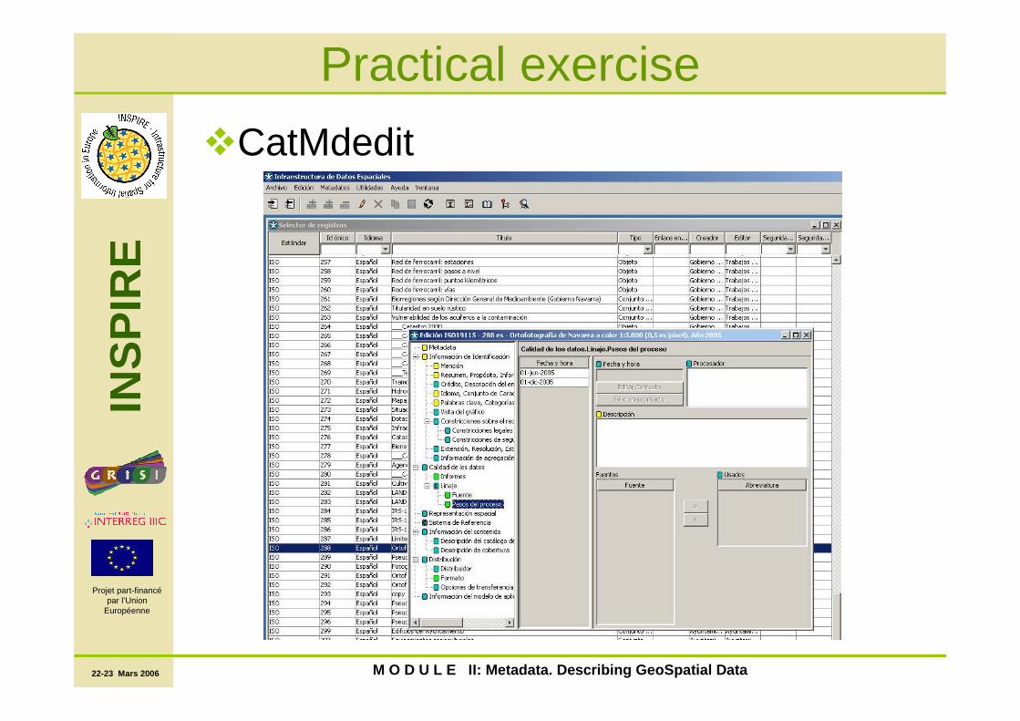
Practical exercise
�CatMdedit

22-23 Mars 2006
INS
PIR
E
Projet part-financépar l’Union
Européenne
M O D U L E II: Metadata. Describing GeoSpatial Data
Practical exercise
�We are going to create three metadatafiles:�Ortophotography of Navarre
�Health zonning�Hydrography network

22-23 Mars 2006
INS
PIR
E
Projet part-financépar l’Union
Européenne
M O D U L E II: Metadata. Describing GeoSpatial Data
Practical exercise
MetadataMetadata
RepositoryRepositoryXMLCatMdEdit
MetadataMetadata AdministratorAdministrator
XSL
ArcCatalog
Conversion
Documents
(HTML)
IDENA profile
O.G.C.
CatalogueCatalogue
MetadataMetadata SearchSearch


