dr. agus wibowo centre of data, information and public ... · disaster risk assessment •valid for...
TRANSCRIPT

Dr. Agus Wibowo
Centre of Data, Information and Public Relations
National Authority of Disaster Management (BNPB)
Email: [email protected]

DISASTER DEFINITION
According to The Law No 24/2007 about Disaster Management, Chapter 1: general requirement, section 1:
“Disaster is an event or a series of events that threaten and disrupt the lives and livelihoods of the people caused by either natural factors
and/or non natural factors or man-made factor causing the loss of lives, environmental
damage, loss of material possession, and psychological impact”.

• Natural Disaster
– (1) earthquake, (2) tsunami, (3) volcanic eruption, (4) flood, (5) drought, (6) hurricane/typhoon, (7) land-slide.
• Non-Natural Disaster
– (8) technological failure, (9) forest/land fire, (10) epidemic, (11) disease outbreak.
• Social Disaster
– (12) community or social conflict, (13) terrorism.
DISASTER TYPES

-
200
400
600
800
1,000
1,200
1,400
1,600
1,800
2,000
2002 2003 2004 2005 2006 2007 2008 2009 2010 2011 2012 2013 2014
Banjir
Puting Beliung
Tanah Longsor
Banjir dan Tanah Longsor
Kekeringan
Kebakaran Hutan danLahanGelombang Pasang /AbrasiLetusan Gunungapi
Gempabumi
Gempabumi dan Tsunami
Tsunami
Kecelakaan Industri
146
404
778
602
745
817
1.074
1.248
1.946
1.634
1.811
1.678
1.227
Trend: Disasters will continue to increase, all the intensity, frequency, magnitude, and its spread. Environmental damage also increases hydro-meteorological disasters.
Disaster Events: 90% is hydro-meteorological disasters (floods, landslides, cyclones, droughts, tidal-waves).
DISASTER DATA 2002-2014
Source: dibi.bnpb.go.id

THE AGENCIES FOR DISASTER MANAGEMENT
National level : B N P BEstablished by Presidential
Regulation No. 8 of 2008.
BNPB
Steering Committee Executive Body
BPBD(Provincial Level)
BPBD (District Level)
Steering Committee Executive Body
Steering Committee Executive Body
Provincial/District level : BPBDEstablished by Regional Regulation.
BNPB & BPBD have 3 functions: Coordination Command Implementation
34 BPBD
428 BPBD

Organization Structure and Mapping Policies
Head of BNPB
Prime SecretaryAuditor
Deputy forPrevention & Preparedness
Deputy forEmergency Respond
Deputy for Rehabilitation & Reconstruction
Deputy for Logistic &
Equipment
Centre of Education & TrainingCentre of Data Information & PR
Risk assessment mapRisk Index Map (IRB)
Pre Disaster MapDisaster Impact Map
Site MapMonitoring RR progress
Logistics & EquipDistribution Map
Basemap, Line ministries map, population, etc.

General Policies
• Adopted One Map Policy
• Join the INA-SDI Network
• Use data produced by line of ministries (base map, hazard map, etc.)
• Use free and open source data i.e. OSM for quick response map.
• Use UAV technology for rapid mapping
• Support public participatory mapping i.e. OSM

DISASTER RISK ASSESSMENT
• Valid for 5 years and update every 2 years
• Level of risk map:– Basic / Province level, scale 250K,
finished at 2011
– Intermediate / District level, scale 50K, finished 33 selected district at 2012, on going for other selected district at 2013
– Advanced / community level, scale 25K ~ 10K
• Risk maps is share to public via Website, WebGIS and WMS.
H
CV


West Sumatera West Papua


UAV Image of Aceh Earthquake
2 July 2013

GEOSPATIAL DATABASE
SPATIAL
DATABASE
ENGINE
Vector
Raster
Basemap (25K, 50K, 250K) Administrative Boundary (Bakosurtanal,
BPS 2010) Road (Bakosurtanal, OSM, Tele Atlas, Navigasi.net), River (Bakosurtanal), Contour Line and Height Point (Bakosurtanal), Landuse and Settlement area (Bakosurtanal, OSM, Navigasi.net )
Thematic Map Hazard and Risk Map for 33 provinces
and selected 33 Districts/Municipalities Daily of Disaster events in Indonesia Statistical Maps of Disaster
• Digital Elevation Model (DEM) SRTM 90 m• Digital Elevation Model (DEM) ASTER 30 m• IKONOS• Quick Bird• Landsat• SPOT

GEOSPATIAL DATA SHARING http://geospatial.bnpb.go.id
Geospatial website:web map services, map for download, etc.
Disaster monitoring watch
Web-GIS Portal

InaSAFE http://inasafe.org
Indonesia Scenario Assessment For Emergencies
• Free and open source: based on Quantum GIS
• Used available geospatial data from line ministries data, OSM, etc.
• Simple and easy to used.
• Automatic real time earthquake impact map
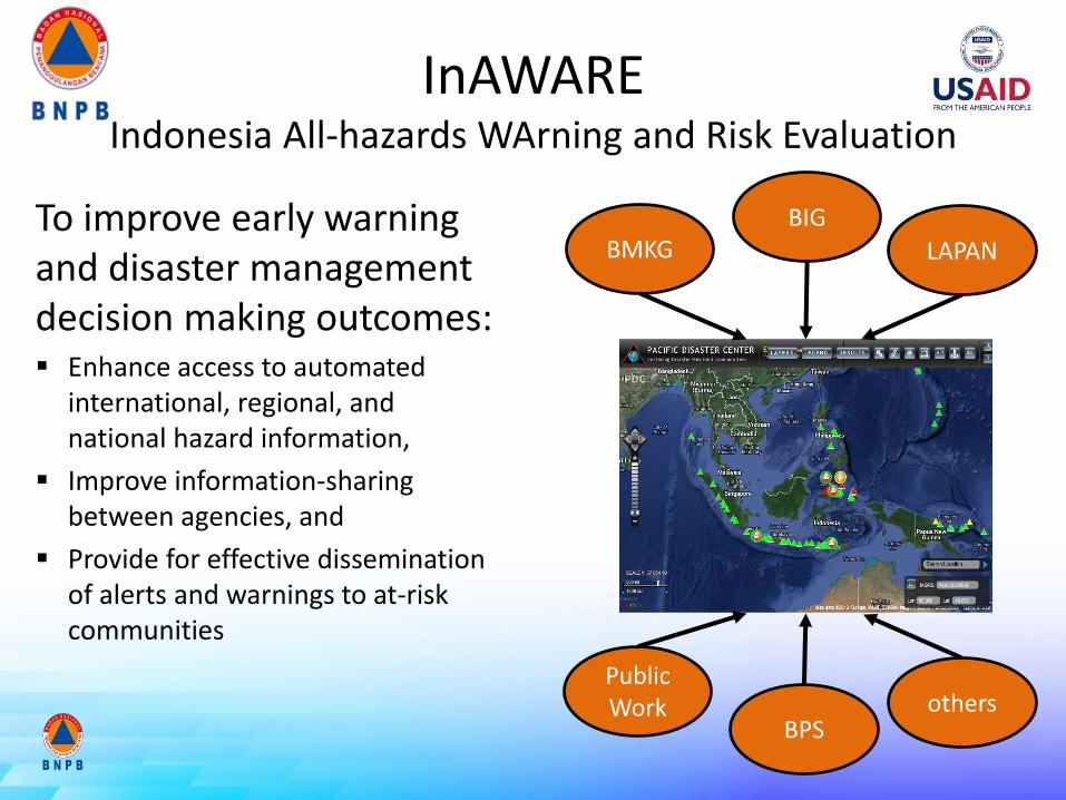
InAWAREIndonesia All-hazards WArning and Risk Evaluation
To improve early warning and disaster management decision making outcomes: Enhance access to automated
international, regional, and national hazard information,
Improve information-sharing between agencies, and
Provide for effective dissemination of alerts and warnings to at-risk communities
Public Work
BIGBMKG
BPS
LAPAN
others

InAWARE: Integrate data for coordination

FLOW CHART OF “OFFICIAL STATEMENT” FOR EARTHQUAKE
First Official Statement issued BNPB within ± 30 minutes after the earthquake.
BNPB EOC (BMKG &
USGS)
BNPB Officer
(via SMS)5W + 1 H
InaSAFE Real-time Earthquake impact map
Gempa
bumi
Field check by local agencies: BPBD, Koramil, Polres, etc.
Preliminary analysis
1st Official Statement
- BBM to 1.800 media- Twitter, Facebook- Website BNPB
5 menit 5-10 menit
2nd Official Statement: further analysis(impact & respond)
REPORT TO PRESIDEN
Further update
10 menit
MEDIAPRESSCON
(JAKARTA & SITE)30 - 60 menit

Tsunami Travel Time Halmahera EQ 7.3 SR 15 Nov 2014

DATA COMMUNICATION FORUM
• Gathering for discussion, training, etc.
• Data exchange, personnel and equipment support
• Formalized with Head of BNPB decree

TERIMA KASIH
THANK YOU