dr. wordsworth odame larbi - fig€¦ · dr. wordsworth odame larbi ghana 1. ... being registered...
TRANSCRIPT

““ IN SEARCH OF A UBIQUITOUS IN SEARCH OF A UBIQUITOUS ––CADASTRE FOR GHANA CADASTRE FOR GHANA –– THE THE
SYSTEMATIC APPROACH UNDER THE SYSTEMATIC APPROACH UNDER THE
LAND ADMINISTRTION PROJECT (LAP)LAND ADMINISTRTION PROJECT (LAP)””
Dr. Wordsworth Odame Larbi
GHANA
1
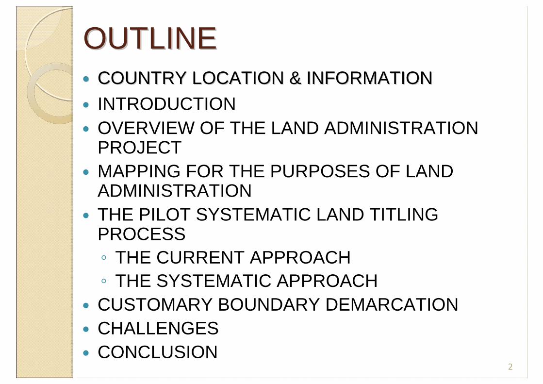
OUTLINEOUTLINE�� COUNTRY LOCATION & INFORMATIONCOUNTRY LOCATION & INFORMATION� INTRODUCTION� OVERVIEW OF THE LAND ADMINISTRATION
PROJECT� MAPPING FOR THE PURPOSES OF LAND
ADMINISTRATION � THE PILOT SYSTEMATIC LAND TITLING
PROCESS◦ THE CURRENT APPROACH◦ THE SYSTEMATIC APPROACH
� CUSTOMARY BOUNDARY DEMARCATION� CHALLENGES� CONCLUSION
2

COUNTRY LOCATION & INFORMATIONCOUNTRY LOCATION & INFORMATION
� Land Area -239,460 km2
� Population- 21.7 million
� Growth rate- 2.7%
� Subsistence agric accounts for 37.3% of GDP and employs 60% of workforce
� Agric accounts for 75% of export earnings and contributes 90% of food needs
� 63.3% of population is rural
� 63 % of total land area is agriculture
� GDP growth rate was 6% in 2006, with service sector having highest of 37.5%

INTRODUCTIONINTRODUCTION� Weak land administration system
◦ Inadequate legislation◦ Fragmented institutional arrangement
� Lack of consultation, coordination and cooperation among public sector land agencies
◦ Poor capacity
� General indiscipline in the land market◦ Land encroachment◦ Multiple sale of land◦ Unapproved development schemes◦ Haphazard development
� Indeterminate boundaries of customary owned lands
� Lack of reliable maps/plans and the use of unapproved inaccurate maps
RESULTS� Inadequate security of tenure� Difficult accessibility to land 4

OVERVIEW OF LAPOVERVIEW OF LAPLONG TERM OBJECTIVES� To reduce poverty and enhance social and
economic growth:◦ Improving security of tenure◦ Simplifying processes of land acquisition◦ Fostering prudent land management practices◦ Developing the land market◦ Establishing an efficient and sustainable system
of land administration, both state and customaryBased on clear, coherent, and consistent polices and laws supported by appropriate institutional structures
5

OBJECTIVE OF PHASE 1OBJECTIVE OF PHASE 1� Phase 1 is from 2003 – 2010
To undertake land policy and institutional reforms and key land administration pilots for laying the
foundation for a sustainable decentralized land administration system that is fair, efficient, cost effective and ensures land tenure
security.
6

THE FOUR COMPONENTSTHE FOUR COMPONENTS
� COMPONENT 1: Harmonizing land policy and regulatory
framework� COMPONENT 2:Institutional Reform and Development� COMPONENT 3:Improving Land titling, Registration, Valuation,
Land Use Planning and Land information system
� COMPONENT 4:Project Management, Human Resource
Development and Monitoring and Evaluation7

MAPPING FOR THE PURPOSES OF MAPPING FOR THE PURPOSES OF LAND ADMINISTRATIONLAND ADMINISTRATION� Topographic Maps
◦ Medium scale (1:50,000)
◦ Large Scale (1:2,500)
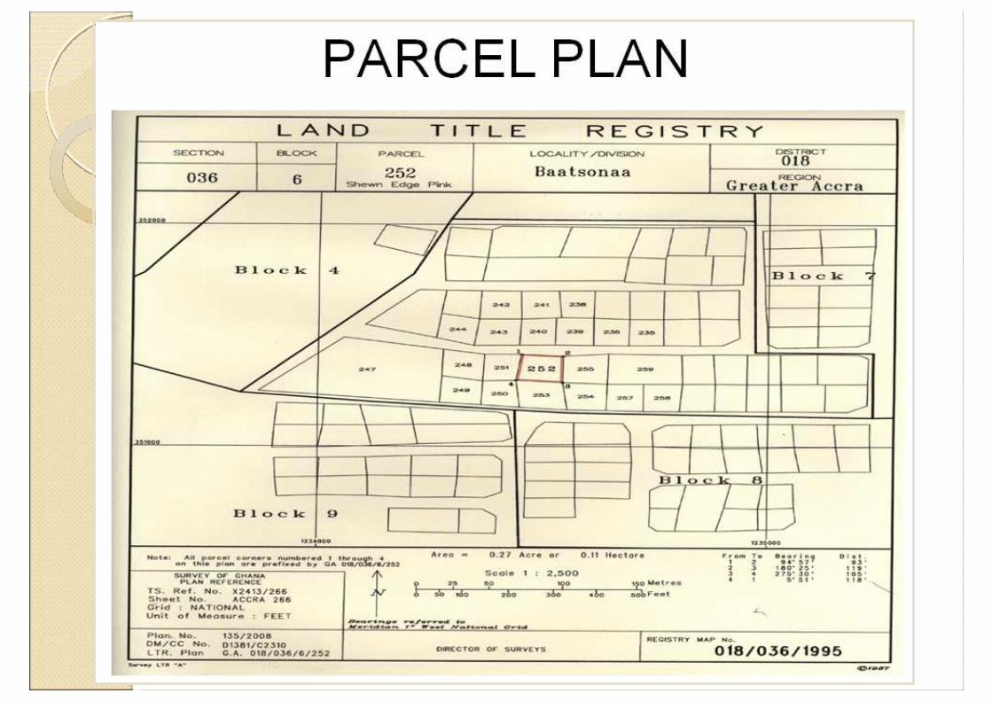
� Orthophotomaps� Sectional Maps� Section 15 (1) of the Land Title Registration Law, 1986
(PNDCL 152) states that’s “where land or interest in land being registered is evidenced by an instrument then that land or an interest therein shall not be registered under the Law unless there is attached thereto a plan of the land which has been approved and duly signed by the Director of Surveys or officer of the Survey Department authorized by him.”
8

THE PILOT SYSTEMATIC LAND THE PILOT SYSTEMATIC LAND TITLING PROCESSTITLING PROCESS
◦ THE CURRENT APPROACH� Stamping of the instrument� Lodgment of the instrument� Request for parcel plan preparation
� Availability of sectional maps� Non availability of sectional maps
� Publication, searches at PVLMD� Issuance of the Land Title Certificate
◦ Challenges� Demand led and slow� Register is not complete� Surveying is part-to-whole


Sporadic TitlingSECTION 77
LAND TITLE REGISTRY MAP
ACCRA DISTRICT 02


THE SYSTEMATIC APPROACHTHE SYSTEMATIC APPROACH� It involves surveying systematically from block to block
and parcel to parcel, measuring, verifying, complementing and correcting existing information, including permanent structures (buildings) to enable
titles to be issued.
� Mapping in the field using DPT� Data is processed in an office erected for the
purpose� The process is out sourced to the private sector
with quality control by the SMD and LRD◦ Both the parcel plan preparation and the collection of
the legal information
� Publication is done in the locality


CUSTOMARY BOUNDARY CUSTOMARY BOUNDARY DEMARCATIONDEMARCATION

WHY BOUNDARY DEMARCATION ?
� 80% of land are owned by the customary sector where there are no determined boundaries
� Most disputes in land are caused byindeterminate boundaries
� Determined boundaries ensure peaceful co-existence of neighbors
� Determined boundaries ensure orderly development
� Determined boundaries are the basis for efficient and effective land registration system
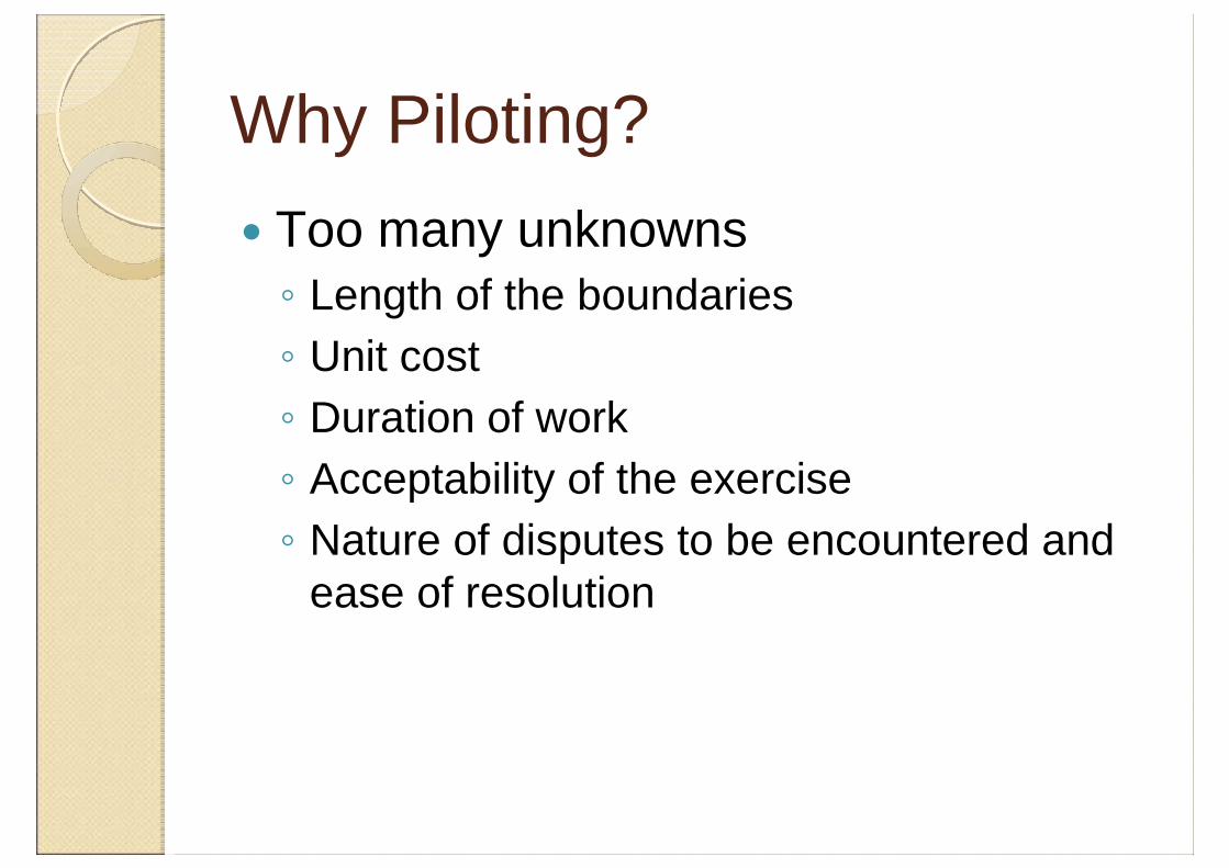
Why Piloting?
� Too many unknowns◦ Length of the boundaries◦ Unit cost ◦ Duration of work◦ Acceptability of the exercise◦ Nature of disputes to be encountered and
ease of resolution

Criteria for selecting a Pilot Area� Fairly stable customary land
ownership pattern� Interest of the community in the
exercise� The presence of an overlord in the
area who will help with settling of disputes
� Relatively small area that is doable within the project time

SGE/BP/A/1/4
R. A kw
asua
FRO
M A
SISI
RIW
A
TO B
OAM
ADUM
ASE
BAMBOO
JUABEN STOOL LANDEJISU STOOL LANDKUNTENASE
PUMP HOUSEWELL
RAIL
KOKROBOA
ADAW
IABENA
BDP4
BDP5
BDP6BDP7
VBA/21/28/1
BDP2
BDP1
L INE
HWE RE
LINE
SUPA
N
ABE
TREN
SUA
B OHY
EN
RAIL
KUMASI STOOL LAND
STOOL LAND
SUPA
N
BENA
ABETRENSUA
KOKROBOA
BURUKRUWA
43
42
41
40
39
3837
36
35
34
33
32
31
30
29
28
27
26
25
24
23
22
21
20
19
16
15
14
1312
11
10
9
8
7
5
4
3
2
6
COCONUT PLANTATION
TEAK PLANTATION
BANKO
TWEMETWEME
HWERE
BANKO
44
45
46
47
49
VBA/21/28/3
50
VBA/21/28/4
51
52
VBA/21/28/5
VBA/21/28/6
53
54
55
56
57
58
60
6162
65
66
67
68
69
71
VBA/21/28/8
YAW AGYEI VILLAGE
KWADWO NIMO'S VILLAGE
NANA DIKO'S VILLAGE
BANKOBANKO
AMOADU
AMOADU
ADANKESUA
BONSUBRI
TO ABENASE
ACHINAKROM
ESSIENINPONG
BEBU
BOA
DW
OA
BONTU
ODA
OD
A
ODA
MANGOASE
ONWE
44A
DIS
PUTE
D A
REA
TO EJISU
EJISU STOOL LAND
59
DONASO
ODAHO
63
DISPUTED AREA
71A
69B
DON
A
KE
NYAMEDUA KE1
PRL1
71
OD A
AKYAWKROM
GYAMASE
BESEASE
EJISUEJISU
KRAPA
ADAKO GYAKYE
DISPUTEAREA
DISPUTE AREA(KRONKOR & EJISU)
DISPUTE AREA
DISPUTEAREA
ASOTWE
ABIRA
EJISU
ASAMAN
ABANKRO/TIKROM
AKY1
AK1
AKY2
R. Boboacam
AST6
AST8
AST9
NT AST1
Mango AST1
NT AST2AST6
AST11
AST12
AST13
AST14
AST5
AST4AST3
AST2
AST1
AST17
AST13
AST18
AST19
AST18A
Big OnyinaNT4A
Big NT4
Big NT8
TK3
TK4
EKR2
EKR3
EKR4 EKR5
AKWB
EKR3
EKR5EKR6EKR7EKR8EKR9
P EK1
P EK2
P EK3
P EK5EK 1P
EK10
NT EK
4EK
2
EK3
NT EK
5
P EK13
P EK15
KUSIAN EK1
RD EK1PC EK1
EK9
PC EK2
EK11
EK14
EK16
AKOTENE EK1
AKOTENE E
K3NYANTS
ERE EK1
NT EK7
EK18
NTE
K9
EK1
9
EK2
0
PEA
R E
K3
OI L
&SAL
T1
PEA
R E
K 1
GCG
A 1
5 34
3
OTIE
KE
KE1
KE2
NTK E1
OIL&SAL
TKE1ONYIN
AKE1
NTKE4MAN
GOEKE2
CASHIER
KE1ONYINA KE2
AST8
KE4
RBS1
AMANDADUA KE1 KEZ2
KEZ3
KEZ EJ5KEZ6
KEZ9
KEZ11RD
EA5
KRONKOL9125
PRL
KE0
KWS
KRONKOFL 91 1
AKBW
BWD ATM
AS1
BAFO1
KEB1
AF1
ODA1
EKR1DAA1
DA2
NTDA3NTDA5
NTDA6NTDA10
NTDA15
RCDA1
DA20
DA21
DA22 DA23
NTDA26 DA28
NTDA30
NTDA31DA33
EKR1
EKR2
EK50
EK51 EK53
EKR3EK54
EK55
EK56
EK57
EK58EK59
EK60
EK61
DAR1
PRL1
42
43
44
45
4748
49
DB1
DB2
DB3
DB4VRA
TAMGPS84
DB5
DB6
EP25
DB7
DB9
AKST1
STP
ABST1
AT1AT2
NTAT2
ABK2
ATAT7
ABANKRO
SGE/BP/A/1/3
4
15
5
3
BF12
BF10
BF9
R. A b
o ab o
BF6
BF2BF1
31
30B
3433
32
PEGAST1
PEGBF7
Ejisu Health Center
The result: Map of Ejisu Customary Area

CHALLENGESCHALLENGES
• Institutional Capacity• Mainstreaming and motivation• Little public education and interest
of property owners• Difficulty in resolving disputes
24

CONCLUSIONCONCLUSION� Useful lessons have been learnt from
these pilots◦ It is possible to estimate cost per km◦ Those with registered deeds are not keen to
participate in the title registration◦ It has provided data for input into the LIS ◦ ADR should be a key component in the boundary
Demarcation instead of the court◦ More permanent boundary marks have been
established
25

THANK YOUTHANK YOU
26