draft history museum of contemporary … history museum of contemporary art site dr rosemary annable...
TRANSCRIPT
Appendix ‐ History
DRAFT HISTORY
MUSEUM OF CONTEMPORARY ART SITE
Dr Rosemary Annable
October 2000 (revised March 2009)
Appendix ‐ History
_________________________________________________________________________________Casey & Lowe MCA AMP History
Contents
1.0 Shaping the settlement: Sydney Cove in 1788 2.0 A maritime settlement 3.0 Maintaining the penal colony 1788-1818 3.1 The first government boats 3.2 Private boat building 4.0 Master Boat Builders and the Dockyard 1795-1818 5.0 Establishing the dockyard 1797-1800 6.0 The dockyard 1800-1818 7.0 Pictorial evidence for the dockyard and its location 8.0 The dockyard workforce and its work 9.0 Supplying the settlement 1788-1818: The Commissariat 10.0 Permanent buildings for the stores 1809-1812 11.0 Problems with the Commissariat 12.0 A period of transition 1819-1831 13.0 A new dockyard 1818-1822 14.0 The dockyard and its workforce 1819-1831 15.0 The Commissariat 1818-1831 16.0 Towards a new Sydney 1831-early 1860s 16.1 Semi-Circular Quay - late 1830s – late 1850s 17.0 The Commissariat and Ordnance stores 1831-late 1850s 18.0 The Commissariat and Ordnance stores 1850s-early 1860s 19.0 The dockyard 1831-1850s 20.0 The Colonial Store 1836-1850s 21.0 Major changes to the site late 1850s – early 1860s 22.0 The stores 1860s-1890s 23.0 The Quay from the 1850s to the 1890s 24.0 The city from 1900-1940 25.0 The site from 1890s-1940 Chronology Authorship: Dr Rosemary Annable
1 Appendix ‐ History
_________________________________________________________________________________Casey & Lowe MCA AMP History
Dockyard and Commissariat and Ordnance stores site Historical Report
1.0 Shaping the settlement: Sydney Cove in 1788 Port Jackson, ‘the finest harbour in the world’ and the great natural feature of the future city of Sydney was an unexpected bonus for the founders of the first European settlement in Australia. Named but unexplored by Cook’s first expedition, which had only glimpsed the entrance from several miles out to sea, Australia’s largest and most beautiful harbour lay, by chance within a short distance of Botany Bay, the intended, but ultimately temporary destination of the First Fleet. Sydney Cove, the eventual site of first settlement was chosen for its maritime advantages, its spring of fresh water and for those natural features which appeared to offer the prospect of successful agricultural enterprise. While the latter was to prove difficult and the apparent fertility of the soil illusory, the sheltered deep water anchorage of Sydney Cove was to be a major factor in the growth and development of both town and colony. For an infant community half a world away from its parent, Sydney Cove was its lifeline, sheltering the ships which were its only means of communication with the outside world. In the years to come, it was also to be the place through which the settlement would build its own future, by trade and commerce around the globe. Within the first few months of the arrival of the First Fleet, a pattern of organisation began to emerge around Sydney Cove which was to dominate the shape of the settlement for its first fifty years and beyond. As soon as the new settlers landed, the civilian and military components of the population were geographically divided. ‘The marines and convicts are to be encamped on the west side, and the Governor and staff, with his guard and a small party of convicts, on the east side of the rivulet’ reported Lieutenant King on 26 January.1 The division was not just a social one. The main determinants of the form of the settlement were topographical. The west side of Sydney Cove was rocky and interspersed with small sandy beaches, which provided convenient landing places. It may have been here that the very first landing was made. To the west the land rose steeply to a high ridgeline and offered little in the way of level cultivable land, although a strip of ground close to the foreshore had sufficient room for building. At the head of the Cove the stream of fresh water and an extensive area of tidal flats effectively cut the settlement in two with communication between the two sides best affected by water. On the east side of the stream and close to the Governor’s residence there appeared to be the prospect of cultivation. In the adjacent cove to the east the first farm was established giving the place its new name. During the governorship of Arthur Phillip from 1788 to 1792 the differentiation between the two sides of Sydney Cove, which had begun on first landing, became fixed, as permanent buildings were erected. On the west were the hospital, prison, store houses, the majority of the convict population and the military, while on the east were the farm and the residences of the civil officers. Each side had its own wharf: on the east, the government wharf begun in December 1789 and on the west, the hospital wharf, begun in November 1790. The plan of Sydney was essentially established. The west side of Sydney Cove was the working part of the town, associated with its maritime activities and ordinary residents. The east side was its administrative heart and the birthplace of its botanical and agricultural endeavours.2
1 Quoted in John Cobley : Sydney Cove in 1788 (1962) p 38 2 M Kelly & R Crocker : Sydney Takes Shape : a collection of contemporary maps from foundation to Federation(1978) ‘Sketch & description of the settlement at Port Jackson’ April 1788, Sketch of Sydney Cove, Port Jackson July 1788’ & ‘A survey of the settlement in New South Wales, New Holland, 1792’
2 Appendix ‐ History
_________________________________________________________________________________Casey & Lowe MCA AMP History
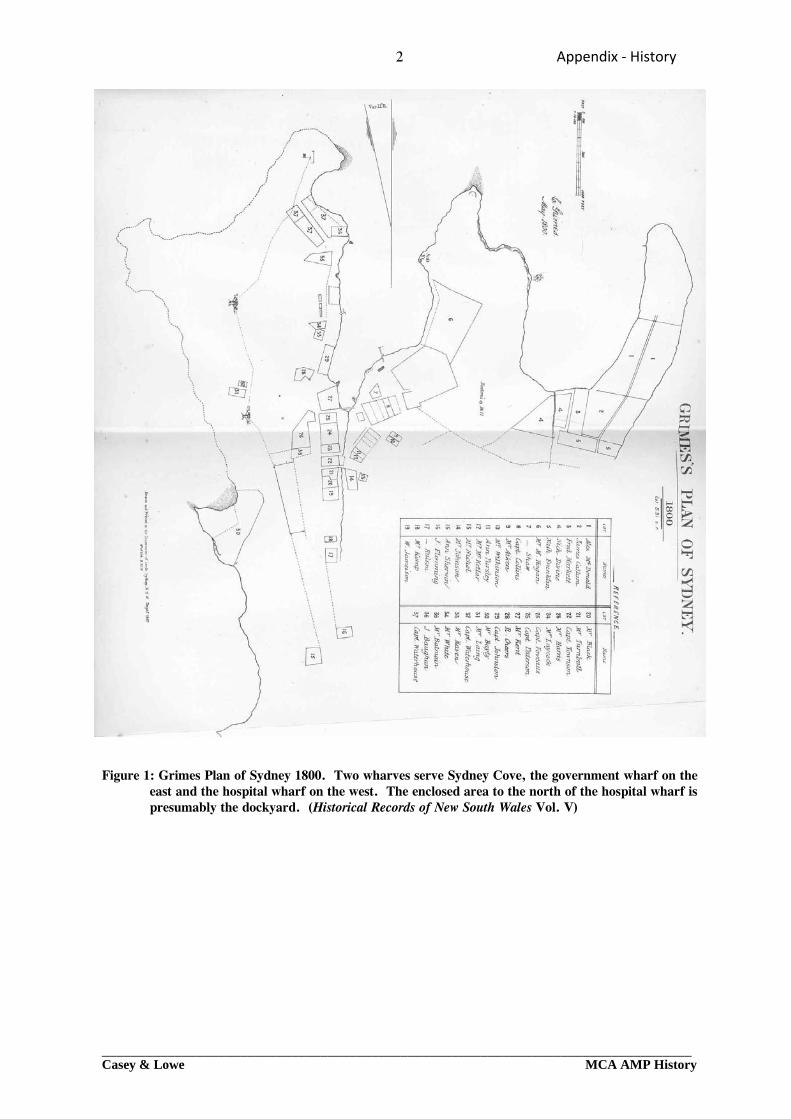
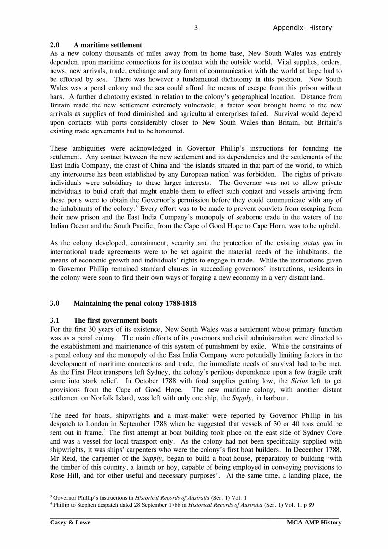
Figure 1: Grimes Plan of Sydney 1800. Two wharves serve Sydney Cove, the government wharf on the
east and the hospital wharf on the west. The enclosed area to the north of the hospital wharf is presumably the dockyard. (Historical Records of New South Wales Vol. V)
3 Appendix ‐ History
_________________________________________________________________________________Casey & Lowe MCA AMP History
2.0 A maritime settlement As a new colony thousands of miles away from its home base, New South Wales was entirely dependent upon maritime connections for its contact with the outside world. Vital supplies, orders, news, new arrivals, trade, exchange and any form of communication with the world at large had to be effected by sea. There was however a fundamental dichotomy in this position. New South Wales was a penal colony and the sea could afford the means of escape from this prison without bars. A further dichotomy existed in relation to the colony’s geographical location. Distance from Britain made the new settlement extremely vulnerable, a factor soon brought home to the new arrivals as supplies of food diminished and agricultural enterprises failed. Survival would depend upon contacts with ports considerably closer to New South Wales than Britain, but Britain’s existing trade agreements had to be honoured. These ambiguities were acknowledged in Governor Phillip’s instructions for founding the settlement. Any contact between the new settlement and its dependencies and the settlements of the East India Company, the coast of China and ‘the islands situated in that part of the world, to which any intercourse has been established by any European nation’ was forbidden. The rights of private individuals were subsidiary to these larger interests. The Governor was not to allow private individuals to build craft that might enable them to effect such contact and vessels arriving from these ports were to obtain the Governor’s permission before they could communicate with any of the inhabitants of the colony.3 Every effort was to be made to prevent convicts from escaping from their new prison and the East India Company’s monopoly of seaborne trade in the waters of the Indian Ocean and the South Pacific, from the Cape of Good Hope to Cape Horn, was to be upheld. As the colony developed, containment, security and the protection of the existing status quo in international trade agreements were to be set against the material needs of the inhabitants, the means of economic growth and individuals’ rights to engage in trade. While the instructions given to Governor Phillip remained standard clauses in succeeding governors’ instructions, residents in the colony were soon to find their own ways of forging a new economy in a very distant land. 3.0 Maintaining the penal colony 1788-1818 3.1 The first government boats For the first 30 years of its existence, New South Wales was a settlement whose primary function was as a penal colony. The main efforts of its governors and civil administration were directed to the establishment and maintenance of this system of punishment by exile. While the constraints of a penal colony and the monopoly of the East India Company were potentially limiting factors in the development of maritime connections and trade, the immediate needs of survival had to be met. As the First Fleet transports left Sydney, the colony’s perilous dependence upon a few fragile craft came into stark relief. In October 1788 with food supplies getting low, the Sirius left to get provisions from the Cape of Good Hope. The new maritime colony, with another distant settlement on Norfolk Island, was left with only one ship, the Supply, in harbour. The need for boats, shipwrights and a mast-maker were reported by Governor Phillip in his despatch to London in September 1788 when he suggested that vessels of 30 or 40 tons could be sent out in frame.4 The first attempt at boat building took place on the east side of Sydney Cove and was a vessel for local transport only. As the colony had not been specifically supplied with shipwrights, it was ships’ carpenters who were the colony’s first boat builders. In December 1788, Mr Reid, the carpenter of the Supply, began to build a boat-house, preparatory to building ‘with the timber of this country, a launch or hoy, capable of being employed in conveying provisions to Rose Hill, and for other useful and necessary purposes’. At the same time, a landing place, the
3 Governor Phillip’s instructions in Historical Records of Australia (Ser. 1) Vol. 1 4 Phillip to Stephen despatch dated 28 September 1788 in Historical Records of Australia (Ser. 1) Vol. 1, p 89
4 Appendix ‐ History
_________________________________________________________________________________Casey & Lowe MCA AMP History
government wharf, was formed from a rocky promontory nearby. Work began on the vessel in May 1789 and was completed in October. The convicts named the boat The Rose Hill Packet but she was later nicknamed The Lump probably because, as David Collins reported, so much wood was used in her construction that she appeared to be a ‘mere bed of timber’.5 The same site also saw the launch of the Francis in August 1793, a sloop of 41 tons which had been sent out in frame, as suggested by Governor Phillip, and put together by the former carpenter’s mate of the Sirius.6 Shipping and water transport were not just the Colony’s only means of communication with the rest of the world, but were also of great importance locally. Boats were the most efficient means of travel and of conveying goods around Sydney Cove, within Port Jackson and, as other settlements were founded, up river. More distant offshoots, the new ‘dependencies’ foreseen in Phillip’s instructions, such as Norfolk Island and later Van Diemen’s Land, were also dependent upon shipping. When British and foreign ships eventually arrived in port, there had to be facilities and materials to supply and repair them. Boat building and shipbuilding skills were essential for survival. 3.2 Private boat building While the ability of government to command sufficient skills for much boat building appears to have been limited, private enterprise was much more successful, as in many other aspects of the development of the new settlement. Private boat builders were already at work in April 1791 when Governor Phillip issued an order limiting the length of boats built by them to ‘fourteen feet from stem to stern’ in order to deter convicts from trying use them for escape. By the end of 1793 a number of emancipists were enjoying the profits from their own passage boats, plying between Sydney and Parramatta. Built by boat builders and shipwrights in their leisure hours and paid for in rum, these vessels could be put together in five or six days. Quite how long they would last was doubtful, as ‘many of them were very badly put together, and threatened destruction to whoever might unfortunately be caught in them with a sail up in blowing weather’.`7 From 1792, when private individuals had the opportunity to lease town allotments in Sydney there were additional opportunities to benefit from investment in boats and shipping. Entrepreneurs, including those engaged in mercantile and maritime pursuits were soon to be found taking advantage of water frontages at Sydney Cove on which to erect their own wharves, stores and places of business. They were also building their own boats. Government orders and regulations continued to reiterate the need for private individuals to obtain the governor’s permission to build boats and for various security measures to prevent convict escaping, such as securing oars, rudders, masts and sails at night. In August 1796 the Governor ordered that boats be numbered and a register kept.8 The very existence of these orders and their constant repetition suggests that private boat building was alive and well in Sydney Cove and taking little account of government orders. In 1798 James Underwood established a shipyard on his property at the head of Sydney Cove. By 1804 there were 22 schooners and sloops in New South Wales belonging to private individuals, of which the majority had been built in Sydney, one at Woolloomooloo at Commissary John Palmer’s home and the rest on the Hawkesbury.9 By comparison with this record, government boat building was much less significant. More importantly for the administration of the colony, the
5 David Collins, An account of the English Colony in New South Wales (First published in 1798, edited by B H Fletcher 1975) Vol. 1, pp 40 & 67 6 J H Watson, ‘Early shipbuilding in Australia’ in Journal of the Royal Australian Historical Society Vol. 9 Pt. 2 (1920) p 99 7 David Collins, An account of the English Colony in New South Wales (First published in 1798, edited by B H Fletcher 1975) Vol. 1, pp 276-277 8 David Collins, An account of the English Colony in New South Wales (First published in 1798, edited by B H Fletcher 1975) Vol. 1, pp 406, Vol.2 p 39 & Sydney Gazette 5 October 1806 p 1a 9 Return of schooners and sloops belonging to individuals dated 28 February 1804 quoted in J H Watson : ‘Early shipbuilding in Australia’ in Journal of the Royal Australian Historical Society Vol. 9 Pt. 2 (1920) p 103
5 Appendix ‐ History
_________________________________________________________________________________Casey & Lowe MCA AMP History
government needed to be able to maintain and repair local craft and to be able to offer this facility to convict and supply ships arriving in Sydney. A dockyard was crucial for official business. 4.0 Master Boat Builders and the Dockyard 1795-1818 The somewhat ad hoc nature of government boat building and repair in the early years of the settlement changed in September 1795 with the arrival of Governor John Hunter, accompanied by the colony’s first official Boat Builder Daniel Paine. At the instigation of the Pitt administration, Hunter had sought a person to fill the position of Boat Builder at Port Jackson. After his first choice had turned down the offer ‘not thinking the encouragement sufficient’ he had found Daniel Paine. ‘Well recommended…for his Theoretical & practical knowledge’ Paine had served a seven year apprenticeship as a shipwright in the Deptford Yard where he continued to work when out of his time.10 ‘Instigated by motives of Curiosity and a desire to see Foreign Climes’ he had then successfully applied to Hunter for the position of ‘Builder at the new Settlement’.11 Paine’s duties included the repair of small boats and larger vessels, building new boats and the identification of timbers suitable for naval purposes. His arrival saw the beginning of government boat building in New South Wales and of timber getting for naval purposes. The boat shed at the government wharf on the east side of Sydney Cove, where the colony’s first two boats had been constructed, was apparently Paine’s official ‘office’.12 There was no official dockyard but the vicinity of the government wharf may have served this purpose. Governor Hunter’s concern about the state of the Colony’s shipping and its importance for internal communication was evident in a despatch to London three months after his arrival:
The Boats of the Settlement by which our principal Communication between this Place and other Districts is to be kept up, having also fallen to Ruin & Decay, it becomes a very essential Concern, to have them rebuilt, or repaired, as without them we cannot convey the necessary Supplies of provisions or other Stores from one Place to the other; no Time must therefore be lost in putting them in such a State, as to render them safe & useful.13
Orders were given to prevent the indiscriminate felling of timber that might be useful for building or naval purposes on Crown land.14 A year after his arrival Paine was well acquainted with the properties of many local timbers and may have drawn on Aboriginal knowledge to identify and locate them.15 Paine apparently performed his duties diligently but his term in office was short. His political beliefs, expressed in open friendship with the Scottish Martyrs and his behaviour at the trial of his servant for murder, which resulted in a charge of contempt of court being laid against him, led to his dismissal by Hunter in August 1796. Paine’s successor as Master Boat Builder was Thomas Moore, who was appointed in September 1796. Moore had first arrived in Sydney in 1792 as ship’s carpenter on the Britannia. After ten months with a party from the Britannia left at Dusky Bay, New Zealand, followed by voyages to the Cape of Good Hope and Calcutta, he returned to Sydney in 1796 and left his ship to become a
10 Quoted in R J B Knight & A Frost (eds), The Journal of Daniel Paine 1794-1797: Together with documents illustrating the beginning of government boat-building and timber-getting in New South Wales, 1795-1805 (1983) pp xviii-xix 11 Quoted in R J B Knight & A Frost (eds), The Journal of Daniel Paine 1794-1795 (1983) p 1 12 Government and General Order 18 July 1796 quoted in R J B Knight & A Frost (eds), The Journal of Daniel Paine 1794-1795 (1983) xxviii Note 35 13 Hunter to Portland 21 December 1795 CHECK Historical Records of Australia 14 Government and General Order 8 December 1795 {CHECK HRA} PRO CO 201/13 f 227 15 R J B Knight & A Frost (eds), The Journal of Daniel Paine 1794-1795 (1983) p xx-xxi
6 Appendix ‐ History
_________________________________________________________________________________Casey & Lowe MCA AMP History
free settler. 16 In the thirteen years during which Moore held the position of Master Boat Builder, the dockyard was to become an established feature of Sydney Cove and its workers an important support for the maritime colony. 5.0 Establishing the dockyard 1797-1800 An exact date when the government dockyard was established is not recorded, but the name ‘dockyard’ and an account of buildings constructed for that purpose first appeared in 1797, suggesting that this was the year in which it began.17 The site chosen was an extensive stretch of water frontage on the west side of Sydney Cove, opposite the hospital and gaol. A rocky foreshore, interspersed with small sandy beaches, the choice of site was probably determined by the location of the hospital wharf and its distance well away from the tidal flats at the mouth of the Tank Stream. Some town leases had already been granted on the foreshore nearby, to the north to John Baughan (later to be Robert Campbell’s) and Captain Waterhouse and to the south to Captain Johnston (Fig. 1).18 The annual ‘Returns of Labour’ document the construction of the dockyard buildings in 1797 and 1798 with work continuing until 1800 on a residence nearby for the master shipwright. In 1797 the dockyard gang built sheds for boats and for the sawyers and a steamer ‘for seasoning of plank’. At the same time, the dockyard was enclosed, ‘pailed in’ and gates hung. Meanwhile, the brick and stone layers gang ‘layed the foundation of a new house for the master-shipwright’.19 A bell ‘for assembling the people to work’ may have been in the dockyard, as seen in later illustrations.20 In 1798 ‘a workshop and storehouse for the joiners, watch-house, and an apartment for the clerk’, together with a smith’s shop were added to the establishment. The master-shipwright’s residence was finally ‘lathed and plaistered’ in 180021 and described as a ‘commodious stone house near the naval yard’.22 The two storey house with mansard roof was set high on a rocky outcrop, in its own allotment of ground to the north of the dockyard and was a dominant feature of the early waterfront. 6.0 The dockyard 1800-1818 By 1800 the basic facilities of the dockyard were apparently complete. Reports on the public buildings in the colony, compiled in 1806 and 1810 for incoming governors, provide some evidence for the dockyard at these dates. The 1806, report, compiled for Governor Bligh as he took up his duties, was drawn up by Thomas Moore and Richard Rouse, suggesting another dimension to Moore’s duties. The buildings in the dockyard were essentially the same as those recorded in 1797-1798, with some deficiencies:
The Dock Yard – wants Sheds for Boats, and to work under for Saw-Pits; the Blacksmith’s Shop and Store Houses and watchman’s Hut want Plaistering, whitewashing, new Doors and Shutters, rep’g Tiles outside of Staircase, Also New Posts and Railing next the Road.
16 D W B Robinson: ‘Thomas Moore and the early life of Sydney’ in Journal of the Royal Australian Historical Society Vol. 56 Pt. 3 (1970) pp 167-172 17 Return of labour at Sydney, Parramatta, and Toongabbe, 1797’ Historical records of New South Wales Vol. 3 p 336 ff 18 Grimes’ Plan of Sydney 1800 Historical Records of New South Wales Vol. 5 & R J Ryan (ed.), Land Grants 1788-1809 (Published 1974, Australian Documents Library edition 1981) pp 222-224. 19 ‘Return of labour at Sydney, Parramatta, and Toongabbe, 1797’ Historical Records of New South Wales Vol. 3 p 337 20 ‘Return of labour at Sydney, Parramatta, and Toongabbe, 1797’ Historical Records of New South Wales Vol. 3 p 336 21 ‘Statement of work executed at the different Settlements during the year 1798’ & ‘Return of Labour during 1800’ Historical Records of New South Wales Vol. 3 pp 521-522 & Vol. 4 pp 280-283 22 ‘Return of public buildings erected in New South Wales since October 1796’ Enclosure No. 2 with despatch from Hunter to King 25 September 1800 Historical Records of Australia (Ser. 1) Vol. 2 p 562
7 Appendix ‐ History
_________________________________________________________________________________Casey & Lowe MCA AMP History
Wharfinger’s Hut – wants New windows and doors, Plaistering, whitewashing, a new Chimney, and Tileing required.23
By October 1807 the dockyard had been ‘all repaired’24 and ‘much improved’ suggesting that some new facilities, perhaps boat sheds and saw pits, may have had been built.25 A similar report was compiled for Governor Macquarie, in April 1810, early in his administration.26 Thomas Moore’s skills were once more called upon (although Moore had retired from government service) to compile a ‘Strict and carefull Survey of the Whole of the Buildings, Vessels, Boats, &c belonging to the Colony’. The dockyard consisted of:
Lime House in Good Order Blacksmiths Shop Intirely New and finished Except 2 Window Shutters 5 by 3 [-] 2 do. 3 by 2 Two Boatsheds useless Shop for Planking good order Storehouse & Watch House Not Worth repairing One pair of New Gates wanting for the Yard Fence Repairing
The majority of the buildings are recognisable from earlier accounts. The unfinished state of the blacksmith’s shop suggests that this was a replacement for the 1798 smith’s shop and the ‘good order’ of the lime house might also indicate that this was comparatively new. The contents of the dockyard were also itemised. There was still a schooner on the stocks, but comparatively little in the way of equipment or stores, which included anchors, tar, two millstones and some ordnance.27 The insubstantial nature of the dockyard buildings and boundary fence may have meant that more valuable supplies and tools were kept elsewhere. Although an important place of work, some of the population would appear to have had a laissez-faire attitude towards the dockyard boundary and its security, at least as far as the pleasures of bathing were concerned as noted in Governor Macquarie’s order in October 1810:
A very indecent and improper Custom having lately prevailed, of Soldiers, Sailors and Inhabitants of the Town bathing themselves at all Hours of the Day at the Government Wharf, and also in the Dock-yard, His Excellency, the Governor, directs and commands, that no Person shall Bathe at either of those Places in future, at any Hour of the Day; and the Sentinels posted at the Government Wharf and in the Dock-yard are to receive strict Orders to apprehend and confine any Person transgressing this Order.28
The tone of the order suggests that the Governor’s objections to this practice had more to do with the promotion of morality (and the protection of his views from Government House) than the protection of maritime interests. Nude bathing in Sydney Cove was to be no more, and moved instead to the far side of the Domain and to Cockle Bay. The more serious issue of preventing the escape of convicts remained. In May 1808, the Harrington had been seized by convicts when lying
23 ‘Statement of Government Buildings in Sydney Augt. 13th 1806’ Enclosure with Despatch No. 1, Bligh to Windham 25 January 1807 1800 Historical Records of Australia (Ser. 1) Vol. 6 pp 98-99 24 ‘Statement of Govt. Buildings in New South Wales’, Enclosure No. 3 with General Letter, Bligh to Windham, dated 31 October 1807 1800 Historical Records of Australia (Ser. 1) Vol. 6 p 144ff 25 James Meehan ‘Plan of the town of Sydney in New South Wales’ 31 October 1807 in M Kelly & R Crocker Sydney Takes Shape : a collection of contemporary maps from foundation to Federation(1978) p 12 26 Macquarie to Castlereagh Despatch No. 3 dated 30 April 1810, Enclosure No. 16, Public Record Office, Colonial Office Series CO201/53 (PRO Reel 26) 27 Macquarie to Castlereagh Despatch No. 3 dated 30 April 1810, Enclosure No. 15, Public Record Office, Colonial Office Series CO201/53 (PRO Reel 26) 28 Government and General Orders Sydney Gazette 6 October 1810 p 2b
8 Appendix ‐ History
_________________________________________________________________________________Casey & Lowe MCA AMP History
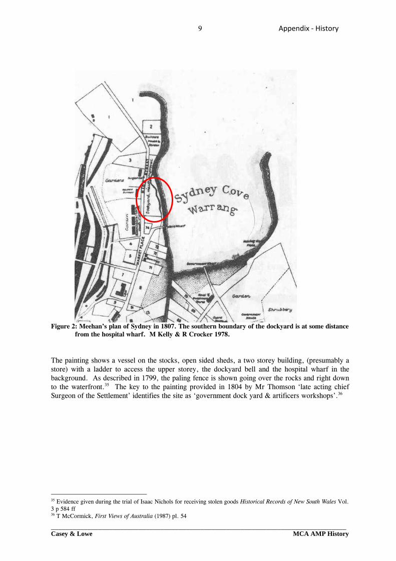
at anchor off Campbell’s wharf. A large long boat, the William Cossar was cut from her moorings close to the King’s Wharf (formerly the hospital wharf) in July 1817.29 As Moore and his committee were compiling their report in 1810, a major change was taking place close to the dockyard. At the southern end of the site and immediately adjacent to the hospital wharf, a large, stone built, four storey store was being erected. Two years later a second large store was completed to the west of the first, with a frontage on George Street. The extent to which the construction of two large stores impinged upon the dockyard is not known. The exact location of the dockyard buildings is difficult to determine with any real accuracy, as these are known only from pictorial sources and are not shown on early maps and plans. The pictorial evidence tends to suggest that the store was built largely upon land to the south of the dockyard boundary and not within it. Both Grimes’ and Meehan’s plans, drawn in 1800 and 1807 respectively, show the southern boundary of the dockyard at some distance to the north of the hospital wharf, leaving space for the new stores between the dockyard and the road down to the wharf (Figs 1, 2).30 Taken in conjunction with the documentary evidence that the dockyard buildings, the ship on the stocks and lower storeys of the Commissariat stores were in existence simultaneously in April 1810, this would seem to suggest that the new stores did not interfere with the working of the dockyard. A group of buildings that had existed close to the wharf, prior to 1809 was however removed for the construction of the Commissariat stores.31 It is probable that some of these were associated with the work of the wharf, such as the wharfinger’s house. 7.0 Pictorial evidence for the dockyard and its location As the picturesque heart of the settlement in New South Wales, Sydney Cove was much illustrated by its early artists. The documentary record of the development of the dockyard can be supplemented by a number of such views. The earliest and by far the best picture of the dockyard shows the west side of Sydney Cove, looking south along the High Street [George Street] from a rocky vantage point in the vicinity of the Master Builder’s house. Redrawn by Edward Dayes ‘from a Picture painted in the Colony’,32 internal evidence and the attribution of the original drawing to Thomas Watling33 (who left Sydney in 1801) suggest that this the original picture dates to c. 1798-1800 when the dockyard was quite new (Fig. 3).34
29 J Selkirk Provis & K A Johnson: Cadman’s Cottage. The life and times of John Cadman in Colonial Sydney – 1798-1848(1972) pp 30 & 52-53 30 ‘Grimes’s Plan of Sydney 1800’ Historical Records of New South Wales Vol. 5 & James Meehan’s ‘Plan of the town of Sydney in New South Wales’ dated October 1807 in M Kelly & R Crocker : Sydney Takes Shape: a collection of contemporary maps from foundation to Federation(1978) 31 T McCormick, First Views of Australia (1987) pp 290-295 Structures around Sydney Cove 32 T McCormick, First Views of Australia (1987) pl.55 33 The attribution of the Dayes version of this painting is to be found in S Evans: Historic Sydney as seen by its early artists (1983) pp 8-10, pls. 4 & 5. Watling left Sydney in 1801 and never returned. See Australian Dictionary of Biography Vol. 2, entry for T Watling. The painting is reproduced in colour on the cover of R J B Knight & A Frost (eds): The Journal of Daniel Paine 1794-1795 (1983) 34 Government House is shown without the extension built by Governor King in 1800-1801.
9 Appendix ‐ History
_________________________________________________________________________________Casey & Lowe MCA AMP History
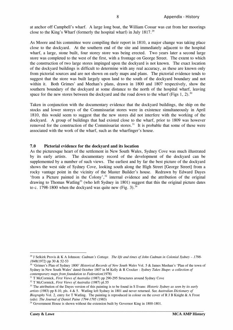
Figure 2: Meehan’s plan of Sydney in 1807. The southern boundary of the dockyard is at some distance
from the hospital wharf. M Kelly & R Crocker 1978. The painting shows a vessel on the stocks, open sided sheds, a two storey building, (presumably a store) with a ladder to access the upper storey, the dockyard bell and the hospital wharf in the background. As described in 1799, the paling fence is shown going over the rocks and right down to the waterfront.35 The key to the painting provided in 1804 by Mr Thomson ‘late acting chief Surgeon of the Settlement’ identifies the site as ‘government dock yard & artificers workshops’.36
35 Evidence given during the trial of Isaac Nichols for receiving stolen goods Historical Records of New South Wales Vol. 3 p 584 ff 36 T McCormick, First Views of Australia (1987) pl. 54
10 Appendix ‐ History
_________________________________________________________________________________Casey & Lowe MCA AMP History
Figure 3: ‘A View of Sydney Cove, New South Wales’. Published in 1804 the hand-coloured aquatint was ‘Drawn by E Dayes from a Picture painted in the Colony’ probably a drawing by Thomas Watling made c.1798-1800 shortly after the dockyard had been established. In the small cove to north of dockyard is the ‘Surgeons Boat & House’. McCormick 1987: pl 55.
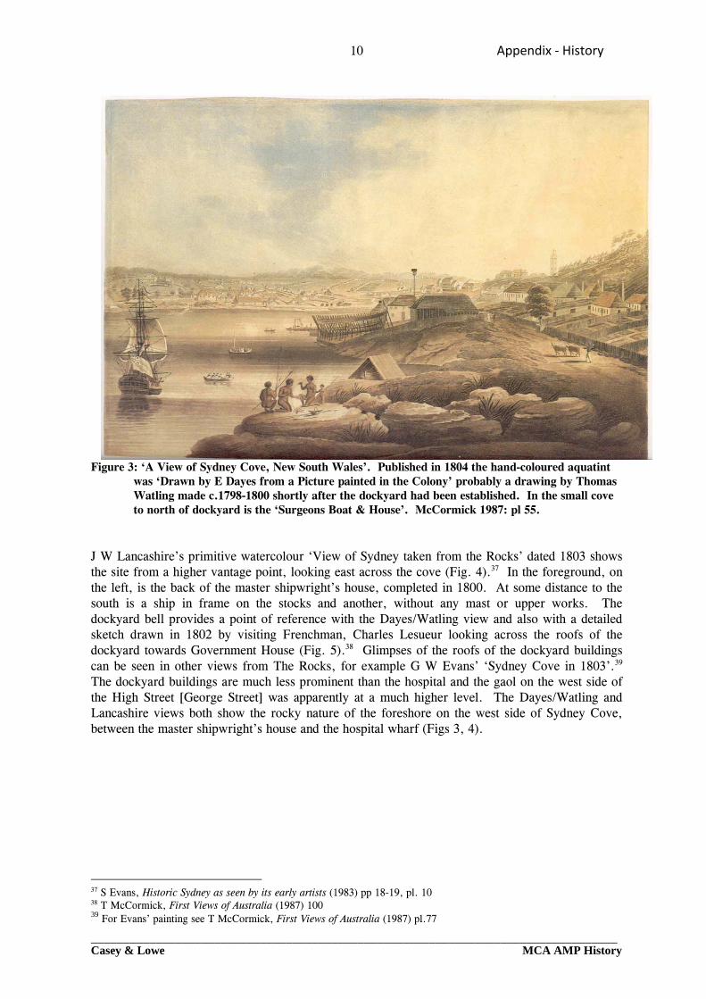
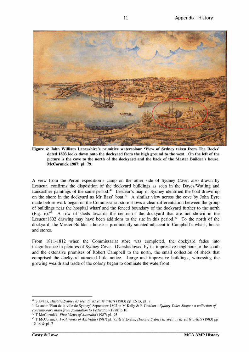
J W Lancashire’s primitive watercolour ‘View of Sydney taken from the Rocks’ dated 1803 shows the site from a higher vantage point, looking east across the cove (Fig. 4).37 In the foreground, on the left, is the back of the master shipwright’s house, completed in 1800. At some distance to the south is a ship in frame on the stocks and another, without any mast or upper works. The dockyard bell provides a point of reference with the Dayes/Watling view and also with a detailed sketch drawn in 1802 by visiting Frenchman, Charles Lesueur looking across the roofs of the dockyard towards Government House (Fig. 5).38 Glimpses of the roofs of the dockyard buildings can be seen in other views from The Rocks, for example G W Evans’ ‘Sydney Cove in 1803’.39 The dockyard buildings are much less prominent than the hospital and the gaol on the west side of the High Street [George Street] was apparently at a much higher level. The Dayes/Watling and Lancashire views both show the rocky nature of the foreshore on the west side of Sydney Cove, between the master shipwright’s house and the hospital wharf (Figs 3, 4).
37 S Evans, Historic Sydney as seen by its early artists (1983) pp 18-19, pl. 10 38 T McCormick, First Views of Australia (1987) 100 39 For Evans’ painting see T McCormick, First Views of Australia (1987) pl.77
11 Appendix ‐ History
_________________________________________________________________________________Casey & Lowe MCA AMP History
Figure 4: John William Lancashire’s primitive watercolour ‘View of Sydney taken from The Rocks’ dated 1803 looks down onto the dockyard from the high ground to the west. On the left of the picture is the cove to the north of the dockyard and the back of the Master Builder’s house. McCormick 1987: pl. 79.
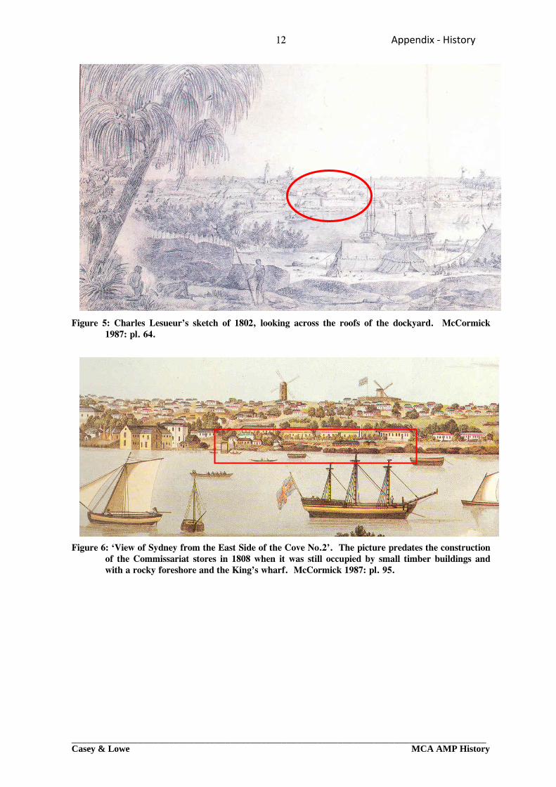
A view from the Peron expedition’s camp on the other side of Sydney Cove, also drawn by Lesueur, confirms the disposition of the dockyard buildings as seen in the Dayes/Watling and Lancashire paintings of the same period.40 Lesueur’s map of Sydney identified the boat drawn up on the shore in the dockyard as Mr Bass’ boat.41 A similar view across the cove by John Eyre made before work began on the Commissariat store shows a clear differentiation between the group of buildings near the hospital wharf and the fenced boundary of the dockyard further to the north (Fig. 6).42 A row of sheds towards the centre of the dockyard that are not shown in the Lesueur1802 drawing may have been additions to the site in this period.43 To the north of the dockyard, the Master Builder’s house is prominently situated adjacent to Campbell’s wharf, house and stores. From 1811-1812 when the Commissariat store was completed, the dockyard fades into insignificance in pictures of Sydney Cove. Overshadowed by its impressive neighbour to the south and the extensive premises of Robert Campbell to the north, the small collection of sheds that comprised the dockyard attracted little notice. Large and impressive buildings, witnessing the growing wealth and trade of the colony began to dominate the waterfront.
40 S Evans, Historic Sydney as seen by its early artists (1983) pp 12-13, pl. 7 41 Lesueur ‘Plan de la ville de Sydney’ September 1802 in M Kelly & R Crocker : Sydney Takes Shape : a collection of contemporary maps from foundation to Federation(1978) p 10 42 T McCormick, First Views of Australia (1987) pl. 95 43 T McCormick, First Views of Australia (1987) pl. 95 & S Evans, Historic Sydney as seen by its early artists (1983) pp 12-14 & pl. 7
12 Appendix ‐ History
_________________________________________________________________________________Casey & Lowe MCA AMP History
Figure 5: Charles Lesueur’s sketch of 1802, looking across the roofs of the dockyard. McCormick
1987: pl. 64.
Figure 6: ‘View of Sydney from the East Side of the Cove No.2’. The picture predates the construction of the Commissariat stores in 1808 when it was still occupied by small timber buildings and with a rocky foreshore and the King’s wharf. McCormick 1987: pl. 95.
13 Appendix ‐ History
_________________________________________________________________________________Casey & Lowe MCA AMP History
8.0 The dockyard workforce and its work When Governor Hunter listed the work performed by government labour in 1797 the men employed at the newly formed dockyard were the only convict work gang to have their own specified workplace. The workforce of sixteen ‘shipwrights, caulkers, boat-builders, labourers, and watch-men’ was comparatively small for the large range of specialised tasks involved in boat building and repairs.44 Numbers increased steadily to about forty in 1805, by which time the workforce also included apprentices, but there were few shipwrights. ‘We have only 2 men that can be called ships carpenters’ King reported in 1804, ‘the rest being rough house carpenters and ‘prentice boys’.45 Sometimes there were no men, or perhaps only one, in specialist trades such as sail making.46 Other gangs also contributed to the work of the dockyard, in particular the blacksmiths, timber getters and sawyers, although the dockyard eventually had its own blacksmith’s shop and saw pits. By the early 1800s its workforce comprised carpenters, shipwrights, caulkers, labourers, blacksmiths, sawyers and ropemakers, together with the establishment’s watchmen and clerk.47 With or without the benefit of many skilled men, the dockyard gang was kept constantly busy, keeping colonial vessels in repair and building boats for the various settlements. In its earliest years, the dockyard carpenters also undertook a variety of other work, but this probably diminished with increasing specialisation and an apprenticeship system. Shortages of supplies could cause havoc with work already completed. In March 1798 David Collins reported:
The Colony was at this time in such want of naval stores of every kind, that the ruin of all the floating craft, so lately in good condition, was nearly effected. The bottoms of the boats were destroyed by worms, for want of pitch, tar, paint and oil: and in order to enable the Colonial schooner to proceed to Norfolk Island…it had been necessary to reduce part of the Supply’s sails, and convert them to her use.48
Much of the dockyard’s time could also be spent in repairing and refitting visiting ships. When the Navy Commissioners quibbled about the cost of additional payments to members of ships’ crews for duties which were not their own, Governor King pointed out to them the problems of work ‘on this Remote service’. Considerable amounts of work were performed on His Majesty’s ships by convict labour, the only cost to the Navy being that of victualling the convicts from the ships while they were at work on them. With few, if any skilled men for certain trades, the dockyard gang had to be supplemented by the ships crews undertaking additional duties. Shortages of materials also meant more work, with canvas from one ship being made to fit another when there was not enough to go round, as Collins also recorded. Between 1800 and 1805, King reported convict labour had been employed on the Porpoise, Buffalo, Lady Nelson, Calcutta, Glatton and the Investigator and the Buffalo had been in Australian waters for almost three years.49 With this constant repair work and few skilled carpenters, there was no time for building new vessels for the use of the Crown. The dockyard also played its part in refitting and equipping voyages of exploration around the Australian coast. The whaleboat built of banksia timber and lined with cedar used by George Bass in 1797-1798, when he established the existence of the strait that bears his name, was built in Sydney, probably by Thomas Moore.50 In September 1802, Bass’ vessel the Venus was in the
44 ‘Return of labour at Sydney, Parramatta, and Toongabbe, 1797’ Historical Records of New South Wales Vol. 3 p 337 45 King to Hobart 1 March 1804 1797, Historical Records of New South Wales Vol. 5 p 338 46 King to Commissioners of the Navy 20 July 1805, 1797, Historical Records of Australia (Ser. 1) Vol. 5 pp 546-547 47 Returns of employment 1800-1806 in Historical Records of Australia (Ser. 1) Vol. 2 – Vol. 5 48 David Collins, An account of the English Colony in New South Wales (First published in 1798, ed. by B H Fletcher 1975) Vol. 2, p 73 49 King to Cooke Despatch dated 20 July 1805, Enclosure Nos. 2 & 3 Historical Records of Australia (Ser. 1) Vol. 5 p 548 50 D W B Robinson, ‘Thomas Moore and the early life of Sydney’ in Journal of the Royal Australian Historical Society Vol. 56 Pt. 3 (1970) pp 178-179
14 Appendix ‐ History
_________________________________________________________________________________Casey & Lowe MCA AMP History
dockyard.51 Flinders’ ship the Investigator, in which he circumnavigated and charted the coast of Australia, was also repaired and refitted in the Sydney dockyard in 1802. Flinders’ experience in the Cumberland, which had been built at Sydney in 1801 was however inauspicious. Leaving Port Jackson in 1803 for England, the schooner proved totally unfit and leaked so much that she required almost constant pumping. Flinders’ decision to stop for water and to seek help in Mauritius caused him to lose his liberty for six and half years, while detained as a prisoner of the French.52 The importance of the Sydney dockyard lay not just in its practical role in refitting and repair, but also in the investigation and trial of timbers suitable for naval purposes, a matter of considerable concern to the Navy Board in England.53 Daniel Paine had surveyed the timbers of New South Wales during his short time as Master Builder and in March 1803 Thomas Moore was appointed Surveyor of Timber for Naval Purposes. Quantities of timber were prepared for export to England, as return cargoes on convict transports.54 When time allowed, attempts were made to build new, larger vessels although progress on these was sometimes long delayed. The Cumberland, a schooner of 28 tons (Matthew Flinders’ ill fated vessel) was completed in 1801. On 13 January the Integrity, which had been begun in 1802, was completed ready for rigging and was launched to ‘three English cheers’ from a dockyard full of spectators. According to the Sydney Gazette she was the first vessel to have been launched in Sydney, the others having been floated off. The sometime Naval Officer, John Harris was reported to have played an active role ‘in inspecting and forwarding the completion of this vessel’.55 Thomas Moore’s role as builder was not however forgotten.56 A much larger vessel, the Portland, a brig of 160 tons, was long delayed in its completion.57 Although laid down in 1798, she was not completed until 1816 when she was launched as the Elizabeth Henrietta, in honour of Mrs Macquarie.58 The dockyard’s labour force was not entirely a convict one. By 1804 there were apprentices, the majority of whom were native born. Apart from their labours in the dockyard, the apprentices also made a contribution to private enterprise shipbuilding. In 1809 The Brothers was built in Cockle Bay for James and William Jenkins. The Sydney Gazette reported that the work been executed by the apprentices employed in His Majesty’s dockyard ‘in a manner that reflects the highest credit to the Gentleman superintending that Department, under whose immediate observation these youths have been brought forward’.59 Thomas Moore, the gentleman in question, ‘requested permission’ to retire in November 1809 as his growing interests in trade and land drew him away from his original calling. His success in later ventures was to make him a wealthy man. His philanthropy and bequests to the church were to see him remembered to the present day, as a major benefactor of the theological college which bears his name and the Anglican Diocese of Sydney in general. As Master Boat Builder he had established the dockyard and was instrumental in the maintenance of the colony’s maritime connections during difficult years.
51 Lesueur ‘Plan de la ville de Sydney’ September 1802 in M Kelly & R Crocker : Sydney Takes Shape: a collection of contemporary maps from foundation to Federation (1978) p 10 52 Australian Dictionary of Biography Vol. 1 Entry for Matthew Flinders 53 R J B Knight & A Frost (eds) : The Journal of Daniel Paine 1794-1795 (1983) pp 73-75 54 D W B Robinson, ‘Thomas Moore and the early life of Sydney’ in Journal of the Royal Australian Historical Society Vol. 56 Pt. 3 (1970) p 182 & R J B Knight & A Frost (eds), The Journal of Daniel Paine 1794-1795 (1983) pp 81-84 55 Sydney Gazette 15 January 1804 p 4a 56 Sydney Gazette 11 December 1803 p 4c 57 Hunter to King Despatch dated 25 September 1800, Enclosure No. 5 Colonial Shipping, Historical Records of Australia (Ser. 1) Vol. 2 p 564 58 J H Watson, ‘Early shipbuilding in Australia’ in Journal of the Royal Australian Historical Society Vol. 9 Pt. 2 (1920) p 102 59 Sydney Gazette 1 January 1809 p 1 b-c
15 Appendix ‐ History
_________________________________________________________________________________Casey & Lowe MCA AMP History
9.0 Supplying the settlement 1788-1818: The Commissariat The penal colony of New South Wales was established in 1788 under military discipline and as such its settlers were provisioned, like British troops, by the Commissariat, the department charged with the supply of food and all supplies for the army. Like other British garrisons, the colony’s Commissary was a civilian, appointed by and directly responsible to the Treasury for his accounting, an independent contractor who derived his income from a percentage of all goods handled.60 While many aspects of the local Commissary’s role could be equated with similar situations for provisioning British troops overseas, the circumstances of the new colony were in many respects unique. The settlement at Sydney Cove had no sister settlements nearby with which to trade, or to rely on for support. Its population consisted not only of military personnel but also of civilians, both bond and free, maintained by the Crown. The settlement was intended to be self-sufficient but its settlers had to learn how to farm in an alien environment and climate. It was situated at a great distance from other ports and was constrained in its potential trading by the monopoly of the East India Company. Last, but by no means least, the colony had been established without money. In these unusual circumstances, the Commissariat, as the sole agent for every type of supply was the first financial institution in the colony. For the first four decades the Commissariat and its officials were an integral part of the colonial economy and an essential adjunct to the development of private enterprise.61 In the first years of settlement the Commissariat provisioned every aspect of life, as everyone was ‘on the stores’. The need to ensure that the new settlers were fed placed great importance not only upon the success of the first farm, but also upon the safe storage of supplies. Food, tools, utensils, clothing and every other need had to be met, in the first instance, from stores brought from overseas. Storehouses featured prominently among the first buildings at Sydney Cove, on the west side near the hospital and marine barracks and officers’ tents and on the east side close to the Governor’s residence. Locations close to the water were of prime importance, to reduce the laborious handling of bulky and heavy goods which had to be off-loaded from ships in stream into small boats. The theft of food was considered so serious as to warrant the death penalty. The first man to be hanged was the convict Thomas Barrett who stole butter, pease and pork from the stores. As famine threatened, the safe storage of what remained became even more crucial. Stores had to be well built and guarded. By 1802 there were five separate storehouses around the cove, each for different types of goods; spirits and salt provisions, dried vegetables and grain, clothing, general stores and public stores.62 As the economy of the penal settlement became more complex, the Commissariat took on the roles of bank and credit agency, far removed from a purely provisioning role. When surpluses of agricultural produce began to be produced in the early 1790s these were sold to the Commissariat which became the ‘market’ through which goods were transferred from the private sector to the government. Those who traded with the Commissariat enjoyed a double benefit. In the first instance, they were guaranteed a stable market and dependable return for their efforts but, more importantly, the store receipts issued in payment for such goods became the currency of the colony. For the larger traders who were able to take advantage of it, these could be consolidated for exchange into British Treasury bills, which were recognised and negotiable in the international market, giving access to another and more extensive world of foreign exchange and trade. As private enterprise developed, the Commissariat played a critical role in ‘primitive accumulation’.63 With government providing the basic food requirements for the convicts, military and much of the
60 M J E Steven, ‘Public Credit and private confidence’ in J Broadbent & J Hughes (eds.), The Age of Macquarie (1992) p 51 61 T G Parsons : ‘Colonial Commissaries’ in R T Appleyard & C B Schedvin (eds) : Australian Financiers : Biographical Essays (1988) p 11 62 Lesueur ‘Plan de la ville de Sydney’ September 1802 in M Kelly & R Crocker : Sydney Takes Shape : a collection of contemporary maps from foundation to Federation (1978) p 10 63 T G Parsons : ‘Colonial Commissaries’ in R T Appleyard & C B Schedvin (eds), Australian Financiers: Biographical Essays (1988) p 19
16 Appendix ‐ History
_________________________________________________________________________________Casey & Lowe MCA AMP History
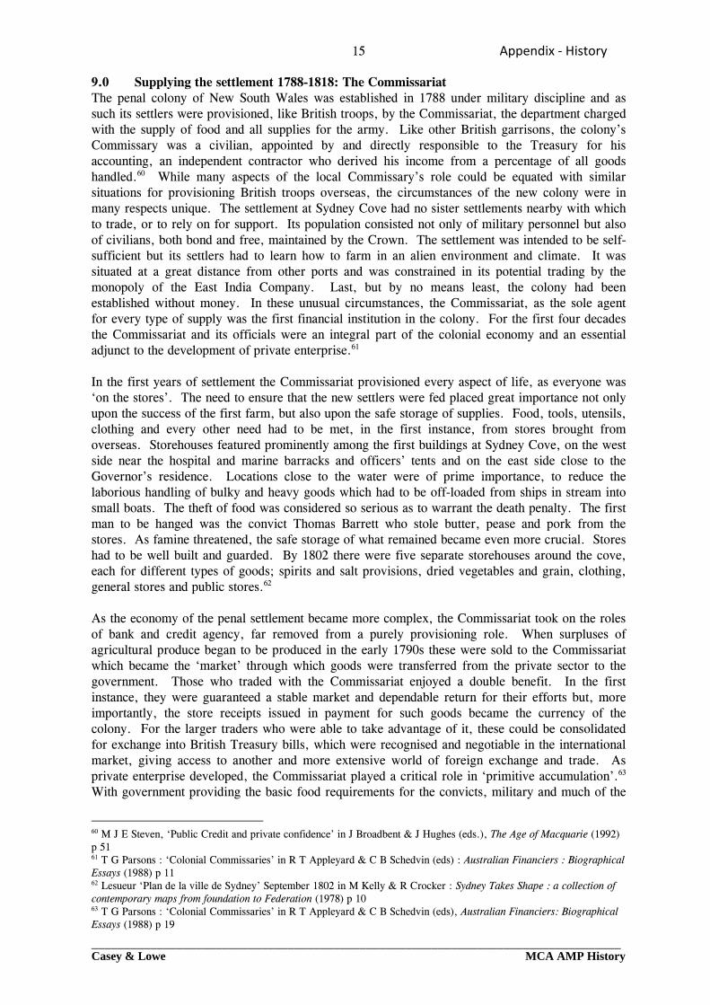
civil population, any surplus earnings could be spent on imported goods which proved a profitable market. As imports began arriving from India, Britain and occasionally from America, and with a developing market in exports from the region, notably sealing and whaling, Sydney became a bustling port. A ‘dynamic private sector’ came into operation.64 10.0 Permanent buildings for the stores 1809-1812 The construction of suitable storehouses was limited, in the first instance, by available materials and skills. In the first decade of the nineteenth century, better built and more commodious storehouses began to be constructed for both government and private use. In July 1808 Lieutenant-Colonel Joseph Foveaux returned to New South Wales, en route to Norfolk Island and unexpectedly found himself in command of the colony. Although his position was temporary, Foveaux continued essential public works. Work on a new granary at Parramatta was continued and by September 1808 Foveaux was about to make ‘immediate arrangements to commence buildings on a similar plan’ at Sydney, close to the water. The distance of the existing stores from the wharf was such that ‘a large number of men are almost constantly employ’d in removing provisions; and when there are ships to discharge of their cargoes, every other necessary work is unavoidably suspended to prevent them coming on demurrage’.65 As one of those who had arrived in Sydney in 1792 during a period of severe famine, the importance of food supplies and adequate stores was no doubt one with which Foveaux was acutely familiar.66 Plans for ‘an extensive range of stone storehouses contiguous to the wharf of Sydney’ were forwarded to London in February 1809 (Fig.7).67 The design comprised a U-shaped building with three separate bays, each with its own entrance, the central bay 82 feet long by 30 feet wide and the two wings each 62 feet long by 30 feet wide. Situated on the waterfront, stores could be raised directly from the yard into the two projecting wings by means of hoists. According to Foveaux, the plan and choice of materials were his own work.68 Work was already in progress in January 1809 when the Sydney Gazette reported:
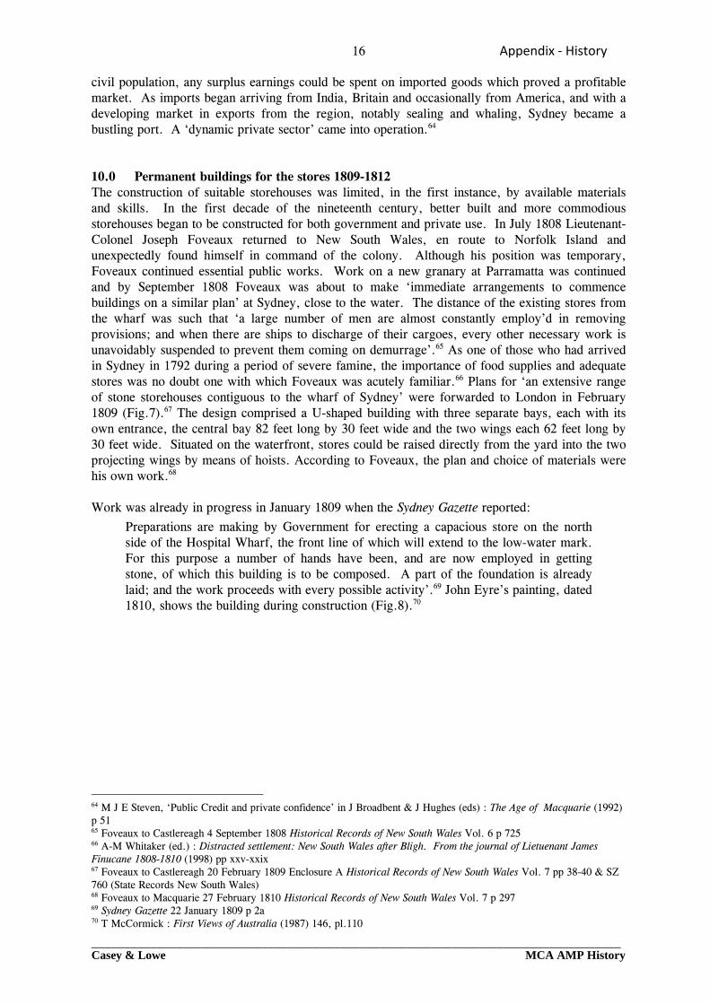
Preparations are making by Government for erecting a capacious store on the north side of the Hospital Wharf, the front line of which will extend to the low-water mark. For this purpose a number of hands have been, and are now employed in getting stone, of which this building is to be composed. A part of the foundation is already laid; and the work proceeds with every possible activity’.69 John Eyre’s painting, dated 1810, shows the building during construction (Fig.8).70
64 M J E Steven, ‘Public Credit and private confidence’ in J Broadbent & J Hughes (eds) : The Age of Macquarie (1992) p 51 65 Foveaux to Castlereagh 4 September 1808 Historical Records of New South Wales Vol. 6 p 725 66 A-M Whitaker (ed.) : Distracted settlement: New South Wales after Bligh. From the journal of Lietuenant James Finucane 1808-1810 (1998) pp xxv-xxix 67 Foveaux to Castlereagh 20 February 1809 Enclosure A Historical Records of New South Wales Vol. 7 pp 38-40 & SZ 760 (State Records New South Wales) 68 Foveaux to Macquarie 27 February 1810 Historical Records of New South Wales Vol. 7 p 297 69 Sydney Gazette 22 January 1809 p 2a 70 T McCormick : First Views of Australia (1987) 146, pl.110
17 Appendix ‐ History
_________________________________________________________________________________Casey & Lowe MCA AMP History
Figure 7: Elevation and plan of intended store at Sydney, designed by Lieutenant-Governor Joseph
Foveaux. State Records New South Wales SZ760.
Figure 8: Detail of John Eyre’s painting of c. 1810. The Commissariat stores are under construction
and the ground floor almost complete. McCormick 1987: pl. 110.
18 Appendix ‐ History
_________________________________________________________________________________Casey & Lowe MCA AMP History
By November the building was being hailed as one of the welcome signs of progress in the colony.
In addition to the innumerable recent improvements in the Colony which every one must esteem really beneficial, no plan of building appears more deserving of remark than that of the public store erecting at the principal wharf. The necessity of such a building had long been evident from the very great advantages which must as evidently result, not only from its ample security to the property of Government, but from the vast proportion of labour which in the course of every twelvemonth will be saved by the landing of stores immediately into their depository, and thereby preventing the necessity of a distant land removal. In the projection of the plan have use and ornament been equally consulted; and indeed, this also may be said of many private buildings which within these few last years have made their appearance, to the astonishment of strangers, who cannot be otherwise than much surprised that a Colony of little more than one-and-twenty years establishment should present so fair a spectacle.71
When Thomas Moore’s committee prepared its report on public buildings for Governor Macquarie in April 1810, the building was incomplete. Some 24,100 feet of stonework, just over 40 per cent of the total, had been completed. The paving of both the ground floor and the ‘platform’, the flooring, doors, window shutters, roofing, timbers and shingling and construction of two cranes all remained to be done.72 Work continued on the building in 1810 using some free labour.73 In October 1811, the prisoners from the Admiral Gambier were mustered for inspection by the Governor ‘on the Terrace of the New Store’.74 The building was completed in 1812.75 A ‘large stone built provision store and granary’, of four storeys, it was generally known, from its usage, as the Commissariat stores.76 Its size and commanding position on the waterfront made it one of the most impressive buildings of the early Macquarie period. At the same time as the Commissariat store was being completed, a ‘Large Stone-Built Provision Store, 2d Granary and Office for Commissariat Department, two Stories high’ was built immediately to the west on George Street. In the keystone above the main entrance were the initials GR and above these a stone plaque with the inscription ‘Erected in the year 1812 L. Macquarie, Esq., Governor’.77 Later photographs show that the building had two storeys on the George Street frontage but also had a basement level, accessible from the east side. Both stores were originally under the control of the Commissariat. Following a change of usage and administration in the 1830s, the George Street building was later known as the Ordnance stores. Associated with these new buildings, changes were made to wharfage arrangements at Sydney Cove. In October 1810, as Governor Macquarie set about re-ordering the form of Sydney, the market-place was moved from its site close to the hospital wharf further south along George Street. A new wharf was constructed in Cockle Bay where boats from Parramatta, Kissing Point and the Hawkesbury were to unload their produce for the new markets.78 All other articles of trade were to be landed at the hospital wharf. If landed elsewhere they would be considered as smuggled, and
71 Sydney Gazette 5 November 1809 p 2a 72 Macquarie to Castlereagh Despatch No. 3 dated 30 April 1810, Enclosure No. 16, Public Record Office, Colonial Office Series CO201/53 (PRO Reel 26) 73 List of free men employed for building new store March 1810, Colonial Secretary’s Papers 1788-1825, 4/1723 pp 202-203, Reel 6042 (State Records New South Wales) 74 Sydney Gazette 12 October 1811 p 3b 75 ‘List of buildings & works undertaken, now in progress or completed in New South Wales and Van Diemen’s Land since 1 February 1810’. NSW Appendix to Commissioner Bigge’s Report 1822, Mr Greenway, Public Buildings. Public Record Office, Colonial Office series CO 201/133 (PRO Reel 120) 76 ‘A list and schedule of public buildings and works erected … at the expence of the Crown from the 1st of January 1810, to the 30th of November 1821, both inclusive’ Macquarie to Bathurst 27 July 1822 Enclosure A 1809 Historical Records of Australia (Ser. 1) Vol. 10 pp 684-685 77 ‘Relics of Old Sydney. Demolition begins.’ Sydney Morning Herald 6 July 1939 p 8g 78 Sydney Gazette 6 October 1810 p 1b
19 Appendix ‐ History
_________________________________________________________________________________Casey & Lowe MCA AMP History
hence subject to confiscation.79 In 1812-1813, the hospital wharf was replaced by a new structure, built under contract by John Manning at a cost of 500 pounds. When completed in March 1813 it was officially named the King’s Wharf.80 11.0 Problems with the Commissariat While the Commissariat was crucial to the well being of the colony, the conduct of some of its representatives left much to be desired. The commissary’s role as a private contractor, deriving his percentage share from a market in which the Commissariat had a virtual monopoly, inevitably led to jealousies and suspicion in the small town of Sydney. The commissaries’ private activities as merchants and farmers further confused the picture. Even the long serving John Palmer, acknowledged as the honest exception amongst others less honourable, was not above suspicion, particularly when his own business interests could not be clearly distinguished from government business. Deficiencies in the Commissariat were however by no means confined to New South Wales. The manifest failures of the department to support British troops in the Peninsular War led to the subsequent reorganisation of the whole of the Commissariat. In New South Wales where the Commissariat had more a civil than a military function, the changes had wider ramifications than they did on the battlefield. Although appointed by and directly responsible to the Treasury, the New South Wales commissaries had, because of the nature of the settlement, been effectively responsible to the governor in day-to-day affairs. From 1813 the position changed. Under new regulations, the newly titled Deputy Commissary General was directly responsible to the Commissary-in-Chief and held his position independent of the governor. The new situation did not meet with the approval of Governor Macquarie. Despite its new organisational structure, distance played its part in determining just how the Commissariat could function in New South Wales. Tensions between Macquarie and the new Commissary, David Allan, on matters of economic policy81 found the governor constantly using his ‘supervising’ authority, which the Deputy Commissary General did not always feel bound to obey.82 In this, as in other areas of policy, the governor’s local power proved greater, in the short term, than the larger authority of the British government exercised from a distance. Despite reforms, the integrity of some Commissariat officials remained doubtful. Both Allan and his successor Drennan left the colony under the cloud of recall, Drennan under arrest.83 Whatever the balance of power between the governor and the colony’s commissary, much larger matters of economic policy and development came to the fore during the administration of Governor Macquarie. The cost of the Colony was under scrutiny by the British government. As a major player in the economic life of the Colony, any change impacted upon the business and role of the Commissariat. In 1814, under instructions from the Colonial Office, a reduction was made in the number of civilians on the stores. Rations issued to new settlers were reduced from a two-year supply to six months and civil servants could no longer draw rations for their families. Convict labour and supplies to civil and military officers were also scaled down. In 1815, the sale of articles from the government stores to private individuals was disallowed. This diminution in the Commissariat’s role in relation to civilians did not see a reduction in its work load. Following
79 HRNSW Vol 2, pp 415, 425 & 428 quoted in J Selkirk Provis & K A Johnson : Cadman’s Cottage. The life and times of John Cadman in Colonial Sydney – 1798-1848 (1972) p 35 80 Indenture of contract for erection of new wharf by John Manning dated 18 June 1812 with annotation of date of final payment 16 March 1813. Colonial Secretary’s papers 1788-1825, 4/1727 pp 233-236, Reel 6043 (State Records New South Wales) 81 B H Fletcher : Landed enterprise and penal society: a history of farming and grazing in New South Wales before 1821 (1976) pp 138-141 82 Commissariat Record Guide. (State Records New South Wales) 83 Commissariat Record Guide. (State Records New South Wales)
20 Appendix ‐ History
_________________________________________________________________________________Casey & Lowe MCA AMP History
the end of the Napoleonic Wars, the number of convicts transported to New South Wales increased dramatically. Between 1815 and 1821, the population rose from 13,000 to almost 30,000, many of whom were the responsibility of government. Much of the convict work force was engaged in the construction of public works and was victualled by the Commissariat. In addition to the demands of a growing population, the colony itself was expanding rapidly. The geographical spread of settlement required the supply of stores to an increasing number of distant settlements with appropriate facilities for their safe custody. In the Macquarie period there were Commissariat stores at Sydney, Parramatta, Windsor, Liverpool, Bathurst, Hobart, Port Dalrymple and Newcastle. While no longer the only market for imported goods, or source of credit and international exchange, the Commissariat remained at the heart of the penal system, still the dominant ‘industry’ in New South Wales. 12.0 A period of transition 1819-1831 In July 1822, after twelve years as Governor of New South Wales, Macquarie wrote a long letter to Earl Bathurst, summing up the achievements of his administration. He had found the Colony ‘barely emerging from infantile imbecility, and suffering from various privations and disabilities; the Country impenetrable beyond 40 miles from Sydney; Agriculture in a yet languishing state; commerce in its early dawn; Revenue unknown; threatened by famine; distracted by faction.’ He had left the Colony ‘reaping incalculable advantages from my extensive and important discoveries in all directions, including the supposed insurmountable barrier called the Blue Mountains, to the westward of which are situated the fertile plains of Bathurst, and, in all respects, enjoying a state of private comfort and public security’.84 Macquarie wrote his resume of progress in the shadow of the impending publication of the Bigge report, conscious that the Commissioner’s inquiry had given ample opportunity for complaint and the venting of private grievances. The instigation of the Commission of Inquiry was however more than just a response to Macquarie’s detractors and the complaints of settlers with powerful friends in Whitehall. Britain’s new colony could no longer be considered as just a prison. Private enterprise was beginning to make a substantial contribution to the economy of New South Wales and new commodities offered the prospect of international trade. The population was increasing and settlement expanding. Free settlers wanted to enjoy the civil liberties and legal rights to which they were entitled under English law, and emancipists wished to have these rights restored to them. The penal colony was becoming a new society and the rules and constraints that had been appropriate at its foundation were now in need of change. The wide ranging scope of J T Bigge’s commission of inquiry bore witness to this. From the late Macquarie period into the early 1830s, New South Wales was in a period of transition. Still a penal colony, private enterprise and free settlement were now growing forces. All aspects of the Colony’s administration would need readjustment to accommodate these changes. Governor Macquarie’s programme of public building and civic improvement did much to provide a new face for the colony, in more permanent form, and built with better skills and materials than had been possible previously. Some elements of civic life were relocated. The markets were moved further south along George Street and were served by their own wharf on Cockle Bay for produce brought to market by water. On the eastern ridge of the town a new enclave of official buildings was created along Macquarie Street as a backdrop to Government House. Many of the important elements of the administration of the convict colony were however still clustered at the north end of the town: the gaol, military barracks, lumber yard, dockyard, the Commissariat stores and granary, the military hospital and guard houses. On the east side of Sydney Cove, the old
84 Macquarie to Bathurst 27 July 1822 Historical Records of Australia (Ser. 1) Vol. 10 pp 671-671
21 Appendix ‐ History
_________________________________________________________________________________Casey & Lowe MCA AMP History
stores were removed and Macquarie Place created to form a suitable approach to Government House. The Domain was enclosed and Gothic buildings and follies enhanced the landscape. The Governor and his Domain were still central to the town of Sydney. The distinction between the two sides of Sydney Cove remained, on the west, the busy King’s Wharf, stores and dockyard and on the east, the pleasure grounds of Government House. Macquarie’s continuing use and further enclosure of the Domain did not make much provision for the Colony’s new entrepreneurs and their commercial ambitions. By the time Commissioner Bigge arrived, little space remained for new commercial buildings at Sydney Cove or for additional public wharfage. Cockle Bay was the obvious area of expansion. By the 1820s, the western foreshores of Sydney were already being used for the developing commercial life of the town. On Miller’s Point settlement was spreading from its original concentration along the west side of Sydney Cove over to the other side of the peninsula. Most of the northern end of the point and around into Cockle Bay was in private ownership by the 1820s, and many of its residents were engaged in maritime activities. Merchants combined their place of residence with business and lived near or close to their wharves.85 By the early 1830s, maritime activities had become well established in Cockle Bay, where private enterprise flourished. Many of Sydney’s streets now had an east-west axis extending down to this new wharfage. Sussex Street was a busy thoroughfare with its flour mills, manufactories and wharves serving the coastal trade. Whalers used Walsh Bay and on the opposite shore an industrial waterfront was developing at Pyrmont serving the timber and coal trade. The successful establishment and growth of Sydney had a detrimental effect upon those natural features which had first encouraged Governor Phillip to choose Sydney Cove as the place of settlement. By the 1820s, the Tank Stream, the settlement’s first source of fresh water, had become an open sewer and Sydney Cove itself, once a fine deep water anchorage, was beginning to silt up. Clearance of native vegetation, cultivation, building activities, poor drainage and no sewerage meant that the Tank Stream now deposited silt, mud and filth into the mouth of the Cove. With little tidal flow, a feature that had once been valued as a protection to shipping, the accumulation of material in the cove reduced the clearance for vessels, and sewage could be both seen and smelt. Allotments which had once had valuable water frontages were now becoming land locked due to deposits of sand and mud. 13.0 A new dockyard 1818-1822 The dockyard did not escape notice in Macquarie’s building programme and from 1818 onwards it was ‘enlarged and greatly improved’. Macquarie reported in 1822 that the work consisted of:
new building and repairing Docks, Wharfs, Quays, Sail Rooms and all the requisite Workshops including Boat Houses, and also offices for the Master Builder and Master Attendant of the Colonial Marine, the whole of the premises being enclosed with a Stone Wall, 12 feet high.86
In his Report, Commissioner Bigge noted that:
Considerable additions have lately been made in the dockyard, by the erection of two blacksmiths and nailers forges, a sail room and boathouse underneath, two saw pits and a high stone wall that now entirely separates the yard from the street and from the commissariat stores.87
85 S Fitzgerald & C Keating : Millers Point : the urban village (1991) pp 18-21 86 ‘A list and schedule of public buildings and works erected … at the expence of the Crown from the 1st of January 1810, to the 30th of November 1821, both inclusive’ Macquarie to Bathurst 27 July 1822 Enclosure A 1809 Historical Records of Australia (Ser. 1) Vol. 10 pp 684-685 87 Bigge Report quoted in J Selkirk Provis & K A Johnson : Cadman’s Cottage. The life and times of John Cadman in Colonial Sydney – 1798-1848 (1972) p 65
22 Appendix ‐ History
_________________________________________________________________________________Casey & Lowe MCA AMP History
Plans and elevations of the Commissariat stores, the government stores and the dockyard were included in the portfolio of drawings put together by Commissioner Bigge for the purposes of his enquiry, but are not known to survive.88 Much, if not all, of the 1790s-1800s dockyard was apparently swept away. Major George Druitt, the Chief Engineer, giving evidence to Commissioner Bigge in October 1819 reported that when he was appointed early in 1818 he found the dockyard enclosed with a battened railing and gates ‘leaving the yard open to depradation’. He had since ‘caused a high wall to surround it’, nine feet high, making it ‘perfectly secure’. Sheds, forges and a house for the master of the yard were then being erected.89 The wall was built by contract, largely by Ambrose Briant [Bryant] with some work also performed by Christopher Jackson. Payments began in the quarter December 1818-February 1819 and the final balance was paid in the period from September to November 1820.90 Francis Greenway, the Civil Architect, estimated the value of work carried out at the dockyard under his supervision at a cost of 3,500 pounds, performed in part by contract (the wall) and the rest by convict labour, but no further details are known of these structures. Work on additional workshops was still in progress in February 182091 and in September Commissioner Bigge wrote to Greenway recommending that the dockyard should be finished ‘with as much expedition as possible’. On completion, the dockyard not only included new workshops ranged around the perimeter of the walled area, but also four docks which had been carved out of the sandstone foreshore. One further addition to the complex, a store, was suggested by the Master Builder James Norris in September 1822 and was probably built soon afterwards.92 This was a long, narrow building extending from the George Street frontage down to the waterfront and can be clearly identified in various illustrations and later photographs. The new store effectively closed off the end of the dockyard, separating it from the other government buildings to the north, between the dockyard and Robert Campbell’s property. These were the house which had been built in 1797-1800 for the Master Builder and a ‘stone built barracks’ constructed c. late 1815 to early 1816, ‘contiguous to the Dock Yard for the Coxswain and crews of the Government boats, enclosed with a high store wall’. It was eventually to be called Cadman’s Cottage after its best known occupant.93
88 NSW Appendix to Commissioner Bigge’s Report 1822, Mr Greenway, Public Buildings. Public Record Office, Colonial Office series CO 201/133 (PRO Reel 120) 89 John Ritchie : The evidence of the Bigge Reports : New South Wales under Governor Macquarie. Vol. 1 The Oral Evidence (1971) pp 4-9 90 ‘General Abstract of Disbursements from the Police Fund on account of Public Works … 13 October 1810 – 30 September 1820’ NSW Appendix to Commissioner Bigge’s Report 1822, Mr Greenway, Public Buildings. Public Record Office, Colonial Office series CO 201/133 (PRO Reel 120) 91 Macquarie to Bathurst despatch No. 12 dated 28 February 1820 Historical Records of Australia (Ser. 1) Vol. X p 281 92 Norris to Nicholson 10 September 1822 & Nicholson to Colonial Secretary 11 September 1822, Colonial Secretary’s Papers, Letters Received 4/1756 pp 147-148, Reel 6053 (State Records New South Wales) 93 J Selkirk Provis & K A Johnson : Cadman’s Cottage. The life and times of John Cadman in Colonial Sydney – 1798-1848 (1972) pp 55-58
23 Appendix ‐ History
_________________________________________________________________________________Casey & Lowe MCA AMP History
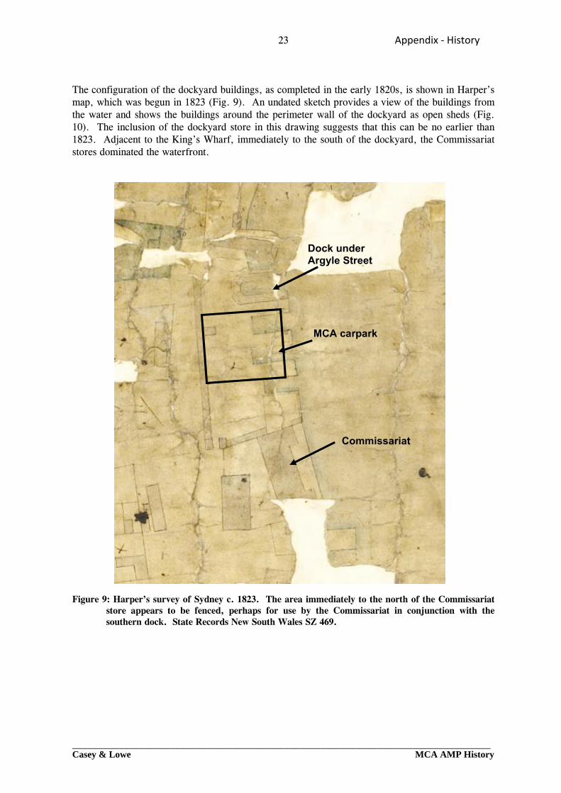
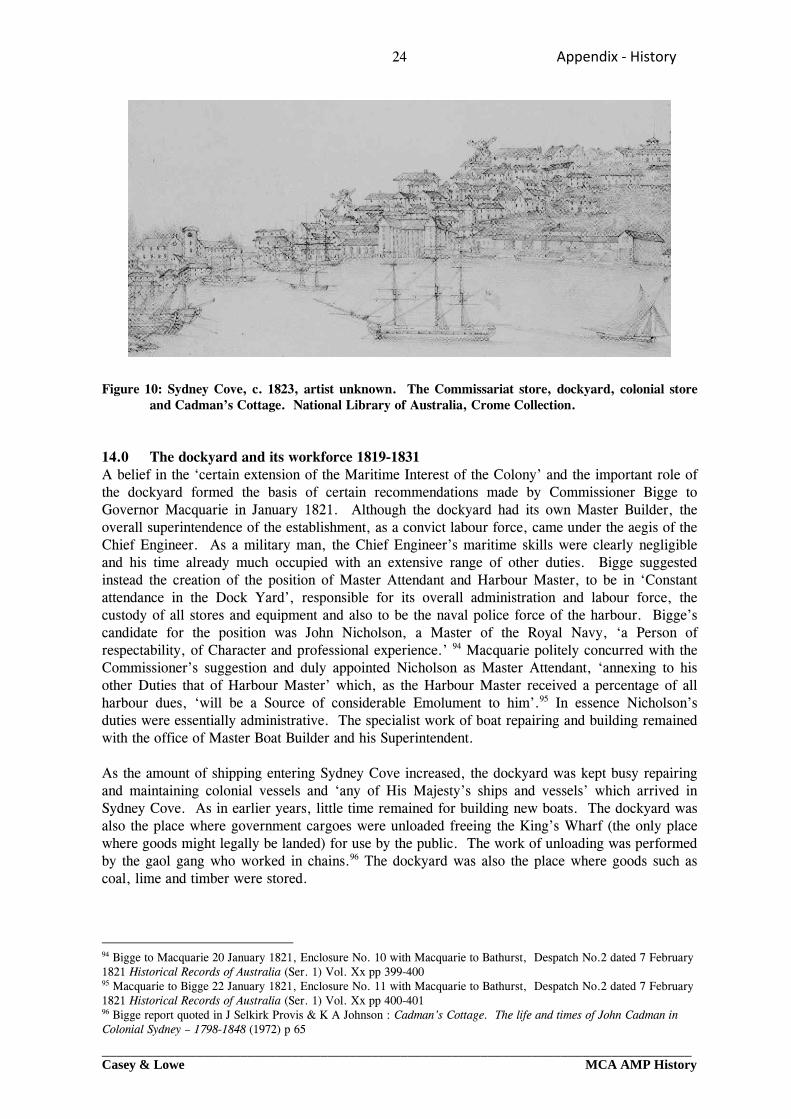
The configuration of the dockyard buildings, as completed in the early 1820s, is shown in Harper’s map, which was begun in 1823 (Fig. 9). An undated sketch provides a view of the buildings from the water and shows the buildings around the perimeter wall of the dockyard as open sheds (Fig. 10). The inclusion of the dockyard store in this drawing suggests that this can be no earlier than 1823. Adjacent to the King’s Wharf, immediately to the south of the dockyard, the Commissariat stores dominated the waterfront. Figure 9: Harper’s survey of Sydney c. 1823. The area immediately to the north of the Commissariat
store appears to be fenced, perhaps for use by the Commissariat in conjunction with the southern dock. State Records New South Wales SZ 469.
Commissariat
MCA carpark
Dock under Argyle Street
24 Appendix ‐ History
_________________________________________________________________________________Casey & Lowe MCA AMP History
Figure 10: Sydney Cove, c. 1823, artist unknown. The Commissariat store, dockyard, colonial store
and Cadman’s Cottage. National Library of Australia, Crome Collection. 14.0 The dockyard and its workforce 1819-1831 A belief in the ‘certain extension of the Maritime Interest of the Colony’ and the important role of the dockyard formed the basis of certain recommendations made by Commissioner Bigge to Governor Macquarie in January 1821. Although the dockyard had its own Master Builder, the overall superintendence of the establishment, as a convict labour force, came under the aegis of the Chief Engineer. As a military man, the Chief Engineer’s maritime skills were clearly negligible and his time already much occupied with an extensive range of other duties. Bigge suggested instead the creation of the position of Master Attendant and Harbour Master, to be in ‘Constant attendance in the Dock Yard’, responsible for its overall administration and labour force, the custody of all stores and equipment and also to be the naval police force of the harbour. Bigge’s candidate for the position was John Nicholson, a Master of the Royal Navy, ‘a Person of respectability, of Character and professional experience.’ 94 Macquarie politely concurred with the Commissioner’s suggestion and duly appointed Nicholson as Master Attendant, ‘annexing to his other Duties that of Harbour Master’ which, as the Harbour Master received a percentage of all harbour dues, ‘will be a Source of considerable Emolument to him’.95 In essence Nicholson’s duties were essentially administrative. The specialist work of boat repairing and building remained with the office of Master Boat Builder and his Superintendent. As the amount of shipping entering Sydney Cove increased, the dockyard was kept busy repairing and maintaining colonial vessels and ‘any of His Majesty’s ships and vessels’ which arrived in Sydney Cove. As in earlier years, little time remained for building new boats. The dockyard was also the place where government cargoes were unloaded freeing the King’s Wharf (the only place where goods might legally be landed) for use by the public. The work of unloading was performed by the gaol gang who worked in chains.96 The dockyard was also the place where goods such as coal, lime and timber were stored.
94 Bigge to Macquarie 20 January 1821, Enclosure No. 10 with Macquarie to Bathurst, Despatch No.2 dated 7 February 1821 Historical Records of Australia (Ser. 1) Vol. Xx pp 399-400 95 Macquarie to Bigge 22 January 1821, Enclosure No. 11 with Macquarie to Bathurst, Despatch No.2 dated 7 February 1821 Historical Records of Australia (Ser. 1) Vol. Xx pp 400-401 96 Bigge report quoted in J Selkirk Provis & K A Johnson : Cadman’s Cottage. The life and times of John Cadman in Colonial Sydney – 1798-1848 (1972) p 65
25 Appendix ‐ History
_________________________________________________________________________________Casey & Lowe MCA AMP History
Various musters and returns of government gangs provide information about the size and skills of the dockyard workforce. This numbered about forty in the early Macquarie period but had risen to seventy-five free men and artificers by the time Commissioner Bigge was gathering his statistics.97 Native born apprentices continued to be part of the establishment, presumably providing a useful source of skilled men for private boat builders when they had completed their time.98 Amongst the convict workforce in 1813 were shipwrights, brass founders, sawyers and charcoal burners.99 Sailmakers, nailers and blacksmiths were listed in the 1822 muster.100 Convicts who were too old or infirm to do other work, picked oakum under shelter in the dockyard.101 In 1825 Major Ovens reported on the work and size of the convict gangs including the dockyard:
‘The Dockyard
There are generally about 70 men as Mechanics and Labourers attached to this Department, besides the Town Gang consisting of about [-] generally, who are made to be useful in loading or discharging Vessels and boats, etc.
The Mechanics are classed as follows, Shipwrights, Blockmakers, Blacksmiths, Nailers, Sailmakers, Rope Do., Painters, Coopers, Sawyers and others, besides Labourers and Watchmen, who generally are employed in the repair or outfit of any of His Majesty’s Ships and Vessels that may be in the Cove and of all Colonial Crafts whatsoever. A Vessel is generally on the stocks, being built in this yard, which serves to occupy many of the people when no other employment can conveniently at the time be found. In this yard are kept, in store, coals, lime, and timber in bags when first landed, and until they are carried away for use, or adapted to the purpose they may be destined for. The labourers are distributed so as to assist and attend upon the Mechanics’.102
By 1828 the workforce had reached its maximum size with some thirty-four mechanics and seventy-two labourers.103 Despite Bigge’s belief in the importance of the Colonial Marine, it was the main thrust of his report in relation to the use of convict labour that was ultimately to see the end of government establishments such as the lumber yard and dockyard. While Macquarie’s use of convict labour on public works enhanced both the appearance of the Colony and its economy, the costs to the government were considerable. Government labourers were on the stores and were maintained entirely at government expense. A more economical solution was to make this source of labour available to settlers engaged in agriculture who would then become responsible for feeding and clothing their workers. Not only would this provide a source of much needed labour, it would also promote the extension of settlement and remove prisoners from the temptations of town life. In the 1820s, in the wake of the Bigge report, public works were much reduced and more convicts assigned to private service. Government expenditure was curtailed and greater control exercised over government equipment and stores. Under a new breed of professional governors the administration of the Colony was overhauled and an organised bureaucracy developed. In the early stages of change, Sydney’s main works depots, the lumber yard and dockyard were retained.
97 Bonwick Transcripts Box 27 (Mitchell Library) 98 C J Baxter (ed.) General Muster of New South Wales 1814 (1987) 99 J Selkirk Provis & K A Johnson : Cadman’s Cottage. The life and times of John Cadman in Colonial Sydney – 1798-1848 (1972) pp 40-42 & C J Baxter (ed.) General Muster and Land and Stock Muster of New South Wales1822 (1988) 100 C J Baxter (ed.) General Muster and Land and Stock Muster of New South Wales 1822 (1988) 101 John Ritchie : The evidence of the Bigge Reports : New South Wales under Governor Macquarie. Vol. 1 The Oral Evidence (1971) pp 4-9 102 Ovens to Secretary Goulburn 16 June 1825, Enclosure No. 2 in Despatch from Brisbane to Horton dated 16 June 1825 Historical Records of Australia (Ser. 1) Vol. 11 p 658 103 Darling to Murray Despatch dated 10 February 1829, Enclosure No. 2 Historical Records of Australia (Ser. 1) Vol. 14 pp 636-637
26 Appendix ‐ History
_________________________________________________________________________________Casey & Lowe MCA AMP History
From the late 1820s the picture changed, as assisted free migration boosted the population. Government work could now be put out to competitive tender in a labour market with sufficient skilled tradesmen. In the dockyard, the first signs of change appeared in 1828. Nicholson’s remuneration as Master Attendant and Harbour Master was altered. Instead of, as previously, receiving a small salary, a house and the fees from harbour dues, which were as Governor Macquarie had noted ‘a Source of considerable Emolument to him’,104 he was to be paid a salary of 500 pounds per annum. Similar changes were made in other departments. A new form of bureaucracy was replacing the earlier tradition of payment by percentage. Civil servants would be paid salaries without emoluments and the Colonial Treasury would receive the fees that had once been paid to individual office holders. The house occupied by Nicholson was put up for sale.105 Early in 1829 the sizes of the convict establishments which were still considered necessary for various government departments were fixed. The dockyard was not to exceed two overseers, thirty-eight mechanics and fifty-six labourers, the third largest establishment in Sydney after public works (269) and the Carters’ Barracks (100).106 By August 1831 the establishment numbered fifty-eight amongst whom there were thirteen free persons, including eight apprentices. But the end of the dockyard as a busy workplace had come. The establishment was reduced to fourteen and was ‘for effecting trifling repairs only’. More extensive work was to be performed by contract. The twelve-ton boat, in frame, on the stocks was to be sold ‘in that state’.107 The Master Attendant was to be careful that the remaining men ‘when not engaged in any immediate repairs, are kept Constantly employed in preparing such articles as may be useful for the Vessels and Boats, so as to prevent delay when they may be demanded’.108 Shipbuilding and repairs were now the province of private enterprise in Sydney. 15.0 The Commissariat 1818-1831 From the 1820s onwards, changes in the administration and responsibilities of the Commissariat were associated with moves to promote greater efficiency in the running of the colony and economies of cost. In 1824 an accounts branch was formed within the Commissariat to counter continuing maladministration and to provide proper custody for, and accurate accounting of, all goods received. Further changes were effected by Governor Darling, as a part of his overhaul of the whole administration. Like Macquarie, Darling rejected the notion that the Commissariat was independent of both civil and military authority and instituted further controls. Greater efficiency was promoted by including the superintendence of civil and military stores under one person in 1826. The following year the different parts of the administration were separated in the accounts, to differentiate supplies required for convicts from those required for the military and other colonial services. In 1831 under Governor Bourke a similar differentiation was made to separate out the costs of maintaining the buildings required for convict and military purposes. These were placed under the control of the Deputy Commissary General, while other colonial buildings were made the responsibility of the Colonial Architect. Previously these costs had all been met by the colonial government. Like other parts of the civil service, the duties and responsibilities of the Commissariat and its staff were subject to closer supervision and control.109
104 Macquarie to Bigge 22 January 1821, , Enclosure No. 11 with Macquarie to Bathurst Despatch No.2 dated 7 February 1821 Historical Records of Australia (Ser. 1) Vol. Xx pp 400-401 105 Darling to Hay, Despatch dated 10 July 1828 Historical Records of Australia (Ser. 1) Vol. 14 p 247 106 Darling to Murray, Despatch No. 17 dated 16 February 1829 Historical Records of Australia (Ser. 1) Vol. 14 pp 646-647 107 Colonial Secretary to Nicholson 9 September 1831, Colonial Secretary Copies of letters to Master Attendant etc. 1830-1832, 4/3779 pp 186-187, Reel 2862 (State Records New South Wales) 108 Minute No. 83 dated 23 August 1831, Enclosure No. 1 with Despatch No. 73, Darling to Goderich Historical Records of Australia (Ser. 1) Vol. 16 pp 352-353 109 Commissariat Records Guide (State Records New South Wales)
27 Appendix ‐ History
_________________________________________________________________________________Casey & Lowe MCA AMP History
Renewal of the Commissariat’s building stock in Sydney had begun under Foveaux and was continued by Governor Macquarie. Henry Kitchen’s usual doom laden comments in January 1821 to Commissioner Bigge about building works of the period included the stores, which were ‘deficient in size and so imperfectly constructed that at this moment, a very large portion of them is in an unsafe condition’. They also lacked a properly constructed ‘treasury’ or strong room for the public chest, which had previously been robbed ‘to a very considerable amount’.110 Quite which of the two stores Kitchen was referring to is not clear, but it may have been the George Street Commissariat stores. In September 1820 Bigge had given Greenway instructions for various repairs which sound not unlike those mentioned by Kitchen: ‘Repair of the Roof of Commissariat Stores at Sydney and Drainage made to carry off the Water, that Lodges around and has affected the foundation of the lower Store. An office for the Commissariat officer in Charge of the Stores. A Wall to be continued from end of present Guard room to the Wall of the Dock-Yard, with a Gate and Egress for Empty Carts after delivering their Grain to the Store. The two rooms in which the Overseer of the Dock-Yard now resides may be converted into Offices for the purpose here required, and communicated with the Store-Yard by a Stair Case’.111 Reference to a stone wall to be continued from the guard room to the wall of the dock yard suggests that this was the George Street building, at the south end of which there was a guard room under a verandah. In 1823, part of the building was properly fitted out as a strong room for the military chest. Windows and fireplaces were blocked up and the room lined with tin for additional security. The architect responsible for the work, S L Harris appeared to share Kitchen’s views, noting that the building was erected in 1812 and ‘is now in a decaying state & shewing Settlement.112 Whatever its defects, the building continued to stand (Fig. 11, 12). In 1831, as the adjacent dockyard establishment was reduced, the Commissariat’s accommodation was greatly increased.
110 John Ritchie : The evidence to the Bigge Reports. New South Wales under Governor Macquarie. Vol. 2 The written evidence. (1971) pp 140-141, Evidence of Henry Kitchen 29 January 1821 111 Bigge to Greenway 24 September 1820, Enclosure No. 1 with Macquarie to Bathurst despatch No. 2 dated 27 February 1821 Historical Records of Australia (Ser. 1) Vol. X pp 381-382 112 S L Harris : ‘Report and Estimate of the Value of the Improvements which have taken place in the Public Buildings of Sydney, Parramatta, Windsor … between the 25th of Decr. 1822 & the 24th of Decr. 1823 inclusive (Mitchell Library C225, pp 42-45 CY Reel 1035)

28 Appendix ‐ History
_________________________________________________________________________________Casey & Lowe MCA AMP History
Figure 11: Plan of the two stores and the wharf in 1824 by S L Harris, The plan shows the original
extent of the George Street (Ordnance) store. Mitchell Library C225, CY 1035. Figure 12: West elevation of the George Street (Ordnance) store in 1824. S L Harris undertook minor
works to provide a secure room in the building for the Military Chest. The Plaque bearing Governor Macquarie’s name and the date 1812 is above the centre door. Mitchell Library C225, CY 1035.
29 Appendix ‐ History
_________________________________________________________________________________Casey & Lowe MCA AMP History
16.0 Towards a new Sydney 1831-early 1860s From the 1830s, as private enterprise flourished and the free population expanded, New South Wales made the final shift from penal colony to civil society. In 1838, the assignment of male prisoners ceased and in 1840, convict transportation to New South Wales was suspended. Associated with these changes was the gradual removal of the convict presence, and eventually also that of the military, from the immediate environs of Sydney and the re-use of government buildings for other purposes. With a huge expansion of population, the once sufficient natural resources of Sydney were under strain. Macquarie’s neat town, with its bucolic vision of Government House as a gentleman’s estate, now needed more space for commercial development, adequate wharfage, a proper water supply, sewerage and drainage. Government House, variously patched up and extended over forty years, could no longer be considered adequate. Replanning Sydney became an important and immediate issue. 16.1 Semi-Circular Quay - late 1830s – late 1850s New uses for government buildings in the 1830s and 1840s, made necessary by the changing composition of the Colony’s population, were mirrored in the works carried out at Sydney Cove. From the end of the Macquarie period it had been apparent that additional public wharfage would need to be provided in order for the commercial life of the Colony to develop. In 1836, separate Committees of the Legislative Council addressed the two questions which were to have a significant impact on the planning of Sydney; the site for a new Government House and the preservation of Sydney Cove for mercantile and shipping purposes. The Committees’ recommendations were the basis of the first major replanning scheme to be implemented in Sydney, affecting the heart of the early settlement, Sydney Cove and the Government Domain. Preservation of a deep water frontage would be achieved by the construction of a new ‘circular’ wharf around the whole of the Cove, with associated infilling and reclamation work. In order to provide access to the new quay, part of the Government House Domain would need to be surrendered, an integral part of Governor Bourke’s solution to fund a new government house. The new house would be built to the east of the existing building, allowing the streets to be extended down to the quay, between Macquarie Place and the northward extension of Macquarie Street. The sale of the new town allotments would fund the cost of building the new government house. The plan would give the Governor a much needed new residence, the town would gain new wharfage and the Tank Stream drain cum sewer would be buried.113 Preparation for the construction of the new Semicircular Quay began in 1838 and the work was completed in 1855, directed first by the Colonial Engineer and later by the Colonial Architect. From 1838 until 1847 its labour force were convicts, and after that date free men. While plans for the quay had been prepared in Sydney by the Colonial Engineer, Colonel George Barney, some necessary special equipment, diving bells and dredging machinery, had to be ordered from England.114 On 1 August 1842 the steam dredge Hercules, with the use of two punts and the assistance of twenty-five prisoners, began cleaning out the front of the existing wharves beginning at the dockyard and extending round to the ‘government jettee’ (Fig. 13). The diving bell was used to clear away debris, including the wreck of the Ann Jamieson which had blown up and sunk by the Queen’s Wharf some years previously.115
113 ‘Report from Committee on the proposed quay at Sydney Cove, with the minutes of evidence’. Votes & Proceedings of the Legislative Council 1836 Session 114 Bourke to Glenelg 12 February 1837, Despatch and Glenelg to Bourke 1 May 1837 Despatch Historical Records of Australia (Ser. 1) Vol. XVIII pp 669-671 & 744-745 115 Colonial Engineer to Colonial Secretary 15 August 1843, Report on works etc. 31 July 1842-31 July 1843, Colonial Secretary Correspondence received from Colonial Engineer 1843, 4/2609.1 (State Records New South Wales)
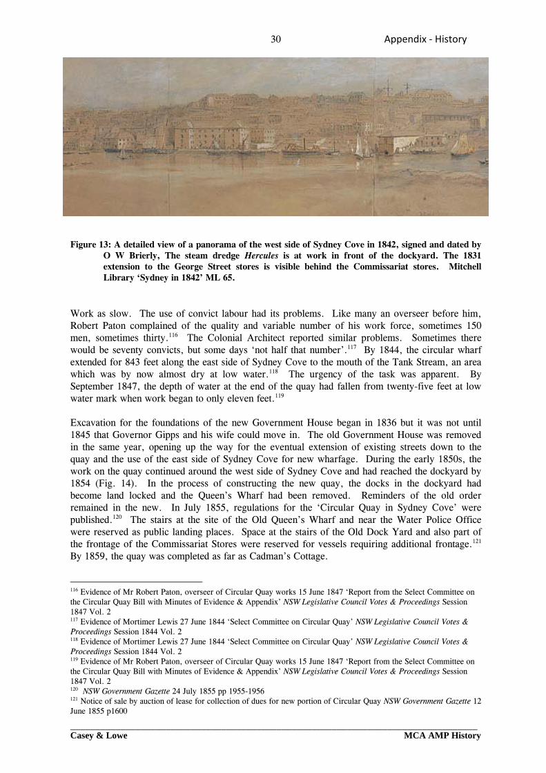
30 Appendix ‐ History
_________________________________________________________________________________Casey & Lowe MCA AMP History
Figure 13: A detailed view of a panorama of the west side of Sydney Cove in 1842, signed and dated by
O W Brierly, The steam dredge Hercules is at work in front of the dockyard. The 1831 extension to the George Street stores is visible behind the Commissariat stores. Mitchell Library ‘Sydney in 1842’ ML 65.
Work as slow. The use of convict labour had its problems. Like many an overseer before him, Robert Paton complained of the quality and variable number of his work force, sometimes 150 men, sometimes thirty.116 The Colonial Architect reported similar problems. Sometimes there would be seventy convicts, but some days ‘not half that number’.117 By 1844, the circular wharf extended for 843 feet along the east side of Sydney Cove to the mouth of the Tank Stream, an area which was by now almost dry at low water.118 The urgency of the task was apparent. By September 1847, the depth of water at the end of the quay had fallen from twenty-five feet at low water mark when work began to only eleven feet.119 Excavation for the foundations of the new Government House began in 1836 but it was not until 1845 that Governor Gipps and his wife could move in. The old Government House was removed in the same year, opening up the way for the eventual extension of existing streets down to the quay and the use of the east side of Sydney Cove for new wharfage. During the early 1850s, the work on the quay continued around the west side of Sydney Cove and had reached the dockyard by 1854 (Fig. 14). In the process of constructing the new quay, the docks in the dockyard had become land locked and the Queen’s Wharf had been removed. Reminders of the old order remained in the new. In July 1855, regulations for the ‘Circular Quay in Sydney Cove’ were published.120 The stairs at the site of the Old Queen’s Wharf and near the Water Police Office were reserved as public landing places. Space at the stairs of the Old Dock Yard and also part of the frontage of the Commissariat Stores were reserved for vessels requiring additional frontage.121 By 1859, the quay was completed as far as Cadman’s Cottage.
116 Evidence of Mr Robert Paton, overseer of Circular Quay works 15 June 1847 ‘Report from the Select Committee on the Circular Quay Bill with Minutes of Evidence & Appendix’ NSW Legislative Council Votes & Proceedings Session 1847 Vol. 2 117 Evidence of Mortimer Lewis 27 June 1844 ‘Select Committee on Circular Quay’ NSW Legislative Council Votes & Proceedings Session 1844 Vol. 2 118 Evidence of Mortimer Lewis 27 June 1844 ‘Select Committee on Circular Quay’ NSW Legislative Council Votes & Proceedings Session 1844 Vol. 2 119 Evidence of Mr Robert Paton, overseer of Circular Quay works 15 June 1847 ‘Report from the Select Committee on the Circular Quay Bill with Minutes of Evidence & Appendix’ NSW Legislative Council Votes & Proceedings Session 1847 Vol. 2 120 NSW Government Gazette 24 July 1855 pp 1955-1956 121 Notice of sale by auction of lease for collection of dues for new portion of Circular Quay NSW Government Gazette 12 June 1855 p1600
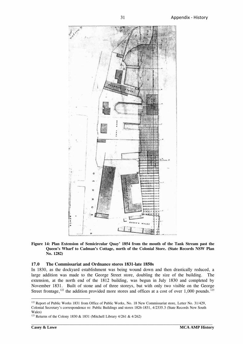
31 Appendix ‐ History
_________________________________________________________________________________Casey & Lowe MCA AMP History
Figure 14: Plan Extension of Semicircular Quay’ 1854 from the mouth of the Tank Stream past the
Queen’s Wharf to Cadman’s Cottage, north of the Colonial Store. (State Records NSW Plan No. 1282)
17.0 The Commissariat and Ordnance stores 1831-late 1850s In 1830, as the dockyard establishment was being wound down and then drastically reduced, a large addition was made to the George Street store, doubling the size of the building. The extension, at the north end of the 1812 building, was begun in July 1830 and completed by November 1831. Built of stone and of three storeys, but with only two visible on the George Street frontage,122 the addition provided more stores and offices at a cost of over 1,000 pounds.123
122 Report of Public Works 1831 from Office of Public Works, No. 18 New Commissariat store, Letter No. 31/429, Colonial Secretary’s correspondence re: Public Buildings and stores 1826-1831, 4/2335.3 (State Records New South Wales) 123 Returns of the Colony 1830 & 1831 (Mitchell Library 4/261 & 4/262)
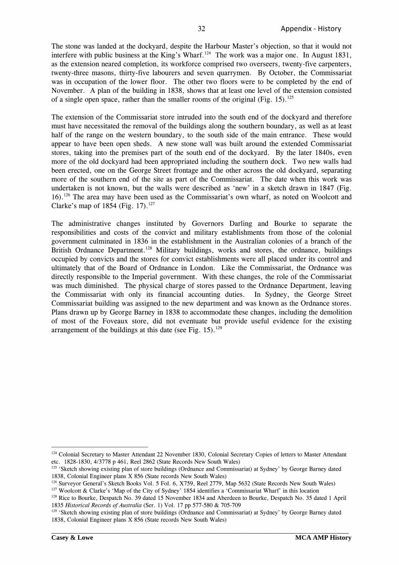
32 Appendix ‐ History
_________________________________________________________________________________Casey & Lowe MCA AMP History
The stone was landed at the dockyard, despite the Harbour Master’s objection, so that it would not interfere with public business at the King’s Wharf.124 The work was a major one. In August 1831, as the extension neared completion, its workforce comprised two overseers, twenty-five carpenters, twenty-three masons, thirty-five labourers and seven quarrymen. By October, the Commissariat was in occupation of the lower floor. The other two floors were to be completed by the end of November. A plan of the building in 1838, shows that at least one level of the extension consisted of a single open space, rather than the smaller rooms of the original (Fig. 15).125 The extension of the Commissariat store intruded into the south end of the dockyard and therefore must have necessitated the removal of the buildings along the southern boundary, as well as at least half of the range on the western boundary, to the south side of the main entrance. These would appear to have been open sheds. A new stone wall was built around the extended Commissariat stores, taking into the premises part of the south end of the dockyard. By the later 1840s, even more of the old dockyard had been appropriated including the southern dock. Two new walls had been erected, one on the George Street frontage and the other across the old dockyard, separating more of the southern end of the site as part of the Commissariat. The date when this work was undertaken is not known, but the walls were described as ‘new’ in a sketch drawn in 1847 (Fig. 16).126 The area may have been used as the Commissariat’s own wharf, as noted on Woolcott and Clarke’s map of 1854 (Fig. 17).127 The administrative changes instituted by Governors Darling and Bourke to separate the responsibilities and costs of the convict and military establishments from those of the colonial government culminated in 1836 in the establishment in the Australian colonies of a branch of the British Ordnance Department.128 Military buildings, works and stores, the ordnance, buildings occupied by convicts and the stores for convict establishments were all placed under its control and ultimately that of the Board of Ordnance in London. Like the Commissariat, the Ordnance was directly responsible to the Imperial government. With these changes, the role of the Commissariat was much diminished. The physical charge of stores passed to the Ordnance Department, leaving the Commissariat with only its financial accounting duties. In Sydney, the George Street Commissariat building was assigned to the new department and was known as the Ordnance stores. Plans drawn up by George Barney in 1838 to accommodate these changes, including the demolition of most of the Foveaux store, did not eventuate but provide useful evidence for the existing arrangement of the buildings at this date (see Fig. 15).129
124 Colonial Secretary to Master Attendant 22 November 1830, Colonial Secretary Copies of letters to Master Attendant etc. 1828-1830, 4/3778 p 461, Reel 2862 (State Records New South Wales) 125 ‘Sketch showing existing plan of store buildings (Ordnance and Commissariat) at Sydney’ by George Barney dated 1838, Colonial Engineer plans X 856 (State records New South Wales) 126 Surveyor General’s Sketch Books Vol. 5 Fol. 6, X759, Reel 2779, Map 5632 (State Records New South Wales) 127 Woolcott & Clarke’s ‘Map of the City of Sydney’ 1854 identifies a ‘Commissariat Wharf’ in this location 128 Rice to Bourke, Despatch No. 39 dated 15 November 1834 and Aberdeen to Bourke, Despatch No. 35 dated 1 April 1835 Historical Records of Australia (Ser. 1) Vol. 17 pp 577-580 & 705-709 129 ‘Sketch showing existing plan of store buildings (Ordnance and Commissariat) at Sydney’ by George Barney dated 1838, Colonial Engineer plans X 856 (State records New South Wales)
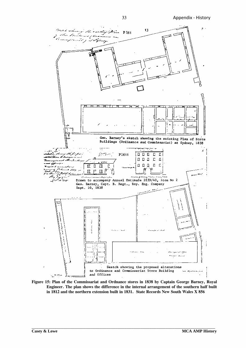
33 Appendix ‐ History
_________________________________________________________________________________Casey & Lowe MCA AMP History
Figure 15: Plan of the Commissariat and Ordnance stores in 1838 by Captain George Barney, Royal Engineer. The plan shows the difference in the internal arrangement of the southern half built in 1812 and the northern extension built in 1831. State Records New South Wales X 856
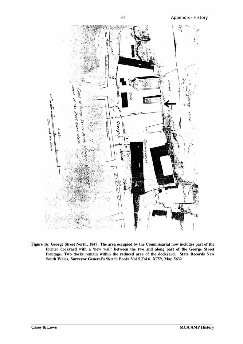
34 Appendix ‐ History
_________________________________________________________________________________Casey & Lowe MCA AMP History
Figure 16: George Street North, 1847. The area occupied by the Commissariat now includes part of the
former dockyard with a ‘new wall’ between the two and along part of the George Street frontage. Two docks remain within the reduced area of the dockyard. State Records New South Wales, Surveyor General’s Sketch Books Vol 5 Fol 6, X759, Map 5632
35 Appendix ‐ History
_________________________________________________________________________________Casey & Lowe MCA AMP History
Figure 17: Woolcott & Clarke’s ‘Map of the City of Sydney’, 1854. The Semicircular Quay has been
completed to the end of the continuation of Pitt Street, where the Bon Accord Bridge crosses the mouth of the Tank Stream. A Commissariat Wharf is identified within the area to the north of the Commissariat stores. Mitchell Library
Barney’s proposed re-arrangement would have made a clear separation between the Ordnance and Commissariat departments and their associated yards, with better provision for offices, as well as stores. Instead, the two departments continued to adjust to various configurations of the available space for the next forty years. The need to service both the remaining convict establishments and the military saw the continuing use of the stores at Sydney Cove. In 1848, at the request of the Secretary of State for the Colonies, accommodation was made available in the Commissariat buildings for supplies for the British Navy.130 It was this function which was to be the major usage for the Commissariat stores until the establishment of a naval base at Garden Island in the 1890s. The role of the Ordnance Department in New South Wales was comparatively short lived. With the suspension of transportation to New South Wales in 1840, an associated decline in the number of convicts on the stores and then a reduction in military establishments, the Ordnance Department was of little importance after about 1850. In that year all barracks, establishments and lands used for defence purposes were transferred to the colonial government. By 1870, the last Imperial military forces were withdrawn from the Australian colonies. Like the building stock that had supported the convict system, many of its buildings remained to be adapted for other purposes.
130 Enclosures to FitzRoy’s Despatch No. 158 of 1848, Colonial Office, NSW Governors’ Despatches 1846-1848, Typed transcripts A 1267 / 23 pp 3654-3656, CY Reel 811 (Mitchell Library) & Colonial Office CO 201/398 (Public Record Office, London)
36 Appendix ‐ History
_________________________________________________________________________________Casey & Lowe MCA AMP History
18.0 The Commissariat and Ordnance stores 1850s-early 1860s During the 1850s, the Commissariat stores continued to be used for naval purposes, with Sydney as a victualling base for ships of the Imperial navy. Salt provisions for Mauritius, New Zealand, Van Diemen’s Land and Western Australia were stored in the Commissariat store, which was often too small for these needs.131 Throughout their history, the dockyard and Commissariat and Ordnance sites in Lower George Street had remained Crown land. In 1856, the buildings occupied by the Commissariat and Ordnance were transferred to the colonial government under the Constitution Act.132 When these arrangements were made, a condition was attached to the transfer of the Commissariat buildings in Lower George Street, that sufficient accommodation would always be provided, at the expense of the Colony ‘for such stores as the Commissariat may require to keep in hand for naval or military service.’ The space not required for this purpose would be available for colonial purposes.133 The officer commanding the Imperial forces agreed that the north wing of the Commissariat stores could be used by the colonial government, which was now very short of space in the small dockyard store.134 When the buildings occupied by the Commissariat and Ordnance were officially handed over to the colonial government in 1859 they comprised the Commissariat store (the Foveaux store), the military store, offices and guard room (the George Street Ordnance store) and the engineer yard.135 The importance of the commitment to the support of British naval interests in the Pacific increased considerably in 1859 when Australia became a separate station, with its own commanding officer, holding the rank of Commodore. It had formerly (since 1821) been under the command of the Flag Officer of the East Indian station. Naval stores were a vital supply link for vessels on a station which included Australia and New Zealand, and extended from north of Australia to the Antarctic Circle and from the 75th to the 170th degree of longitude.136 19.0 The dockyard 1831-1850s From 1831, the dockyard establishment was reduced to a minimum. The business of the dockyard was ‘inconsiderable’ and requests for additional men were rejected.137 As John Nicholson’s position as Master Attendant and Harbour Master was largely an administrative one, his role was now much diminished. The main work on the harbour was carried out by the pilots and by the Superintendent of Government Craft, John Cadman. The Australian and one of its letter writers ‘A Free Thinker’ began to question just what ‘a few of those sinecurists’ in the dockyard were doing to earn their pay. The Superintendent of the Dockyard, Daniel Egan, had ‘only a few cockle shell boats to look after, and a few apprentices to find employment’. The Harbour Master was paid 500 pounds per annum ‘for running backwards and forwards to the barracks and the colonial office as a
131 Commissariat Office to Colonial Secretary 28 August 1854, Colonial Architect papers re: Commissariat Stores 2/640A (State Records New South Wales) 132 ‘Memorandum re: proposed surrender of Ordnance lands and buildings … by John Robertson 17 January 1882 to Colonial Secretary’, Colonial Secretary Special Bundles : Miscellaneous from Commodore and Admiral 1879-1885, 4/857 (State Records New South Wales) 133 Secretary of State for Colonies to Denison Despatch No. 104 dated 2 September 1856, Colonial Secretary Special Bundles : Naval Ordnance Stores 1882-1883, 4/846.2 (State Records New South Wales) 134 Colonial Secretary to Colonial Architect 2 June 1856 Letter No. 56/4906, Colonial Architect papers re: Commissariat Stores 2/640A (State Records New South Wales) 135 ‘Return of land and buildings in charge of the War Dept. at Sydney transferred to the Colonial Govt. pursuant to War Office letter 11 March 1859’, dated 2 September 1859, Colonial Architect papers re: Commissariat Stores 2/640A (State Records New South Wales) 136 G L Macandie (compiler) : The Genesis of the Royal Australian Navy (1949) pp 9-15 & map of Australia Station 1859 137 Colonial Secretary to Master Attendant 20 July 1833, Colonial Secretary Copies of letters to Master Attendant etc. 1832-1834, 4/3780 (State Records New South Wales)
37 Appendix ‐ History
_________________________________________________________________________________Casey & Lowe MCA AMP History
messenger’ and had never been known ‘to moor a ship or place her’, which was done by the harbour pilots.138 There were in the 1830s still some duties associated with the penal system. Convicts were landed and mustered at the dockyard. The Master Attendant arranged the boats for landing and for the transfer of prisoners on to other settlements. He was always instructed that ‘no other persons whose presence is not absolutely necessary to be on the spot at that time’. When the Ladies Committee attended to inspect the female convicts, an office in the dockyard was made available for their accommodation.139 In the 1840s, the duties associated with convicts and the policing of the harbour ended. In 1841, the water police were established. In 1843, when Merion Moriarty became Harbour Master, the boats in the dockyard consisted mainly of small craft used by the various government departments. Three Commissariat boats, the Governor’s barge, the Post Office boat, three Assistant Harbour master’s boats, the Portmaster’s gig, three other gigs, one launch, the Australian, and one small sailing boat comprised the contents of the dockyard.140 On the lighter side, as recreational activities on the harbour became part of Sydney’s social life, the dockyard became a point of embarkation for passengers going out to watch the Anniversary Regattas.141 As the dockyard establishment was reduced, the extension to the George Street store necessitated the removal of at least some of the Macquarie period buildings. A plan of alterations made to the store at the north end of the dockyard in 1836 indicates that other changes may also have been made by this date (Fig. 18). No buildings are shown along the dockyard wall but instead there is a detached building at the west end of the large northern dock. Later surveys in the 1840s and 1850s show two buildings, possibly combined residences and offices, north of the dockyard entrance, between the two northern docks and the George Street wall. A date in the 1830s remains a possibility for their construction. One was being used to house the Superintendent of Boats in 1851.142 Although there was an increasing number of maps of Sydney from the 1830s onwards, these do not assist in dating the dockyard buildings. Most of the commercially produced maps were not based on original surveys, but were compiled and copied from a number of sources. It is apparent that out of date, or much simplified information about individual sites and buildings, continued to be reproduced for many years. The 1831 extension to the George Street store for example, does not appear in any of the Post Office Directory maps of the 1830s. The arrangement of the dockyard buildings, as shown in Harper’s c.1823 survey (see Fig. 9 above), was reproduced in maps of Sydney into the 1840s and 1850s, long after the dockyard had ceased to exist and changes had been made to most its buildings (Fig. 19). By 1847, the Commissariat and Ordnance stores had taken more of the southern end of the former dockyard site. By the early 1850s, the northern end of the dockyard had been fenced off for use with the Colonial Store, leaving only a small central portion as the dockyard. The construction of Semicircular Quay was soon to make further changes.
138 The Australian 16 June 1835 p 2d & 23 June 1835 p 2d-e quoted in J Selkirk Provis & K A Johnson : Cadman’s Cottage. The life and times of John Cadman in Colonial Sydney – 1798-1848 (1972) pp 105-106 139 Colonial Secretary Copies of letters sent to Master Attendant etc. 4/3781 Various letters 1836-1837 (State Records New South Wales) 140 Colonial Secretary correspondence from Harbour Master 1843, Harbour Master’s reports 4/2611.1 (State Records New South Wales) 141 J Selkirk Provis & K A Johnson : Cadman’s Cottage. The life and times of John Cadman in Colonial Sydney – 1798-1848 (1972) pp 105-106 142 Estimate of expenses to repair a house in the dockyard for the use of the Supd. Of Boats, 10 January 1851, Colonial Architect papers re: Sydney Dockyard, 2/642A (State Records New South Wales)
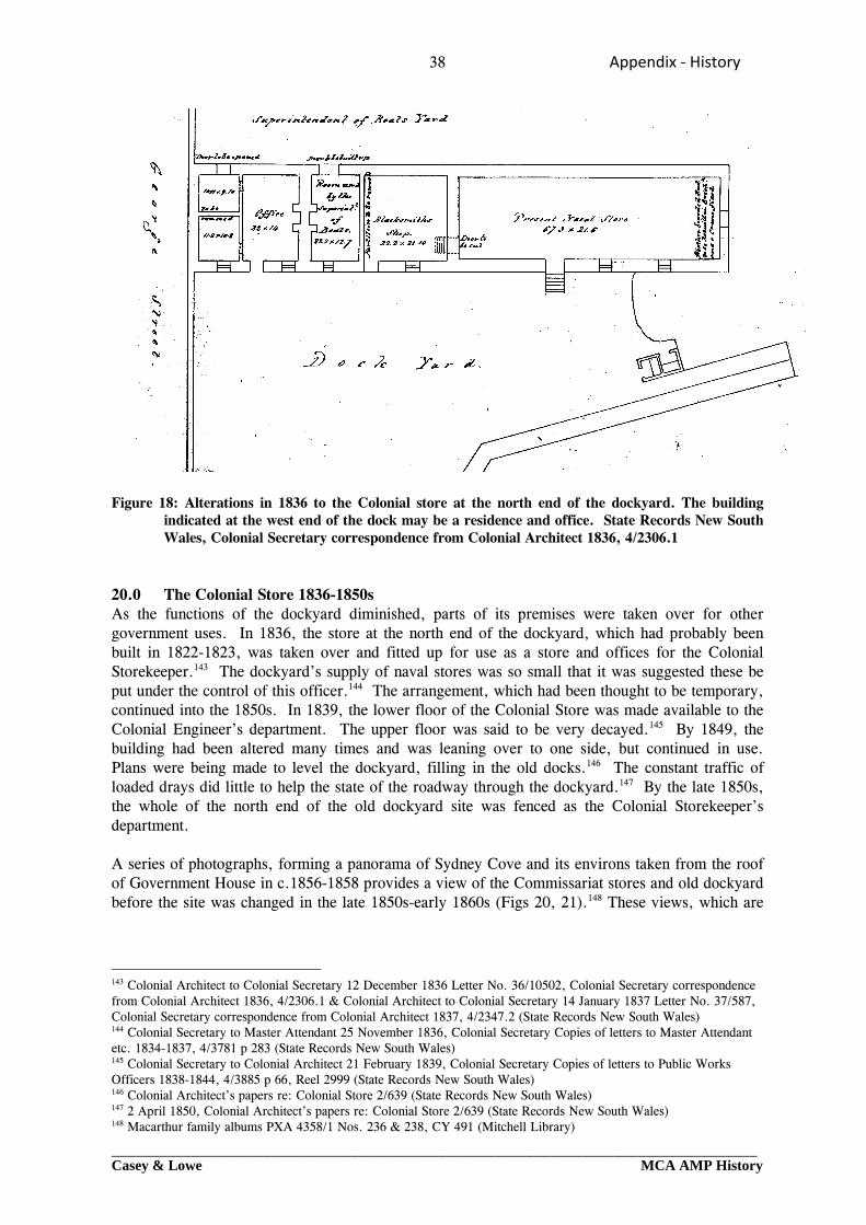
38 Appendix ‐ History
_________________________________________________________________________________Casey & Lowe MCA AMP History
Figure 18: Alterations in 1836 to the Colonial store at the north end of the dockyard. The building
indicated at the west end of the dock may be a residence and office. State Records New South Wales, Colonial Secretary correspondence from Colonial Architect 1836, 4/2306.1
20.0 The Colonial Store 1836-1850s As the functions of the dockyard diminished, parts of its premises were taken over for other government uses. In 1836, the store at the north end of the dockyard, which had probably been built in 1822-1823, was taken over and fitted up for use as a store and offices for the Colonial Storekeeper.143 The dockyard’s supply of naval stores was so small that it was suggested these be put under the control of this officer.144 The arrangement, which had been thought to be temporary, continued into the 1850s. In 1839, the lower floor of the Colonial Store was made available to the Colonial Engineer’s department. The upper floor was said to be very decayed.145 By 1849, the building had been altered many times and was leaning over to one side, but continued in use. Plans were being made to level the dockyard, filling in the old docks.146 The constant traffic of loaded drays did little to help the state of the roadway through the dockyard.147 By the late 1850s, the whole of the north end of the old dockyard site was fenced as the Colonial Storekeeper’s department. A series of photographs, forming a panorama of Sydney Cove and its environs taken from the roof of Government House in c.1856-1858 provides a view of the Commissariat stores and old dockyard before the site was changed in the late 1850s-early 1860s (Figs 20, 21).148 These views, which are
143 Colonial Architect to Colonial Secretary 12 December 1836 Letter No. 36/10502, Colonial Secretary correspondence from Colonial Architect 1836, 4/2306.1 & Colonial Architect to Colonial Secretary 14 January 1837 Letter No. 37/587, Colonial Secretary correspondence from Colonial Architect 1837, 4/2347.2 (State Records New South Wales) 144 Colonial Secretary to Master Attendant 25 November 1836, Colonial Secretary Copies of letters to Master Attendant etc. 1834-1837, 4/3781 p 283 (State Records New South Wales) 145 Colonial Secretary to Colonial Architect 21 February 1839, Colonial Secretary Copies of letters to Public Works Officers 1838-1844, 4/3885 p 66, Reel 2999 (State Records New South Wales) 146 Colonial Architect’s papers re: Colonial Store 2/639 (State Records New South Wales) 147 2 April 1850, Colonial Architect’s papers re: Colonial Store 2/639 (State Records New South Wales) 148 Macarthur family albums PXA 4358/1 Nos. 236 & 238, CY 491 (Mitchell Library)
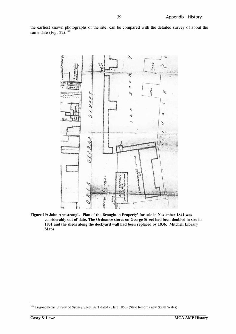
39 Appendix ‐ History
_________________________________________________________________________________Casey & Lowe MCA AMP History
the earliest known photographs of the site, can be compared with the detailed survey of about the same date (Fig. 22).149 Figure 19: John Armstrong’s ‘Plan of the Broughton Property’ for sale in November 1841 was
considerably out of date. The Ordnance stores on George Street had been doubled in size in 1831 and the sheds along the dockyard wall had been replaced by 1836. Mitchell Library Maps
149 Trigonometric Survey of Sydney Sheet B2/1 dated c. late 1850s (State Records new South Wales)
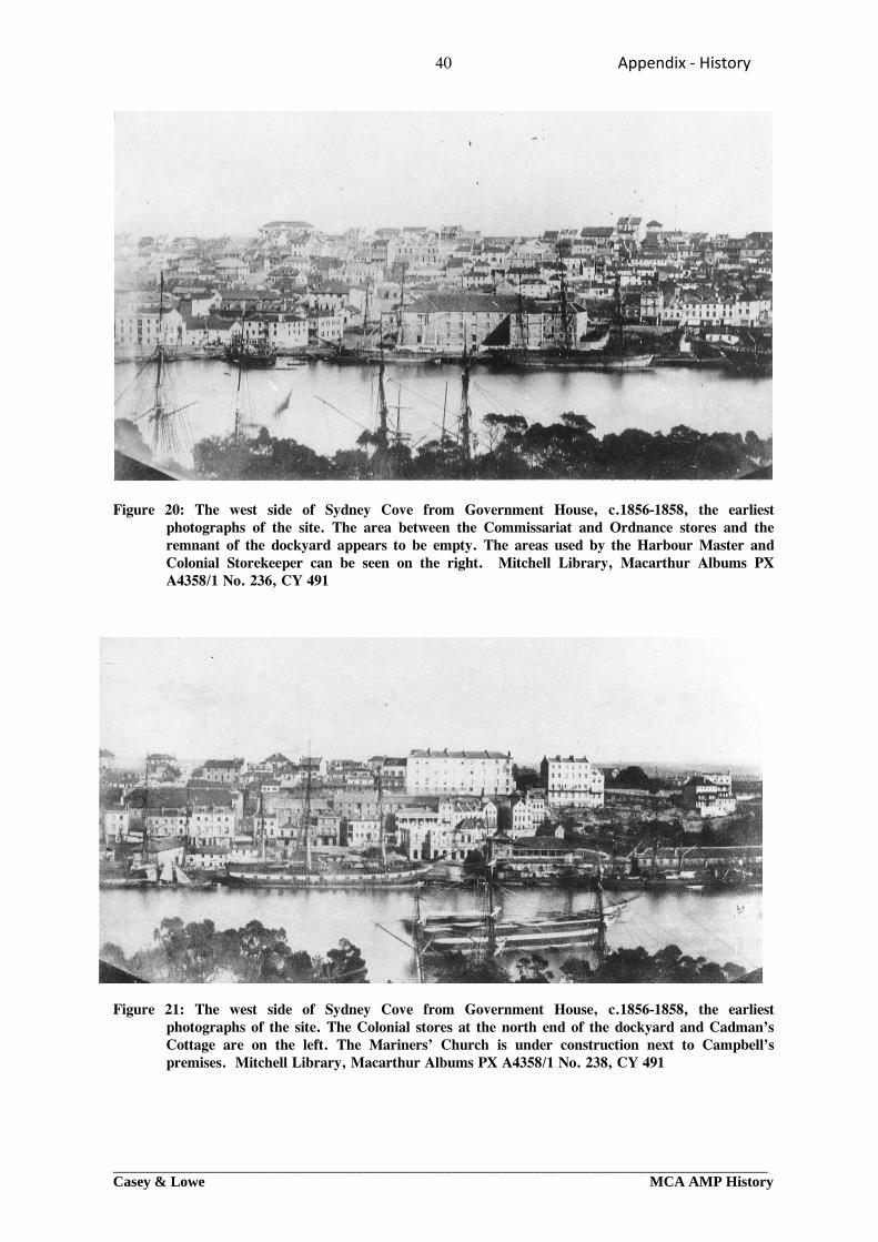
40 Appendix ‐ History
_________________________________________________________________________________Casey & Lowe MCA AMP History
Figure 20: The west side of Sydney Cove from Government House, c.1856-1858, the earliest
photographs of the site. The area between the Commissariat and Ordnance stores and the remnant of the dockyard appears to be empty. The areas used by the Harbour Master and Colonial Storekeeper can be seen on the right. Mitchell Library, Macarthur Albums PX A4358/1 No. 236, CY 491
Figure 21: The west side of Sydney Cove from Government House, c.1856-1858, the earliest photographs of the site. The Colonial stores at the north end of the dockyard and Cadman’s Cottage are on the left. The Mariners’ Church is under construction next to Campbell’s premises. Mitchell Library, Macarthur Albums PX A4358/1 No. 238, CY 491
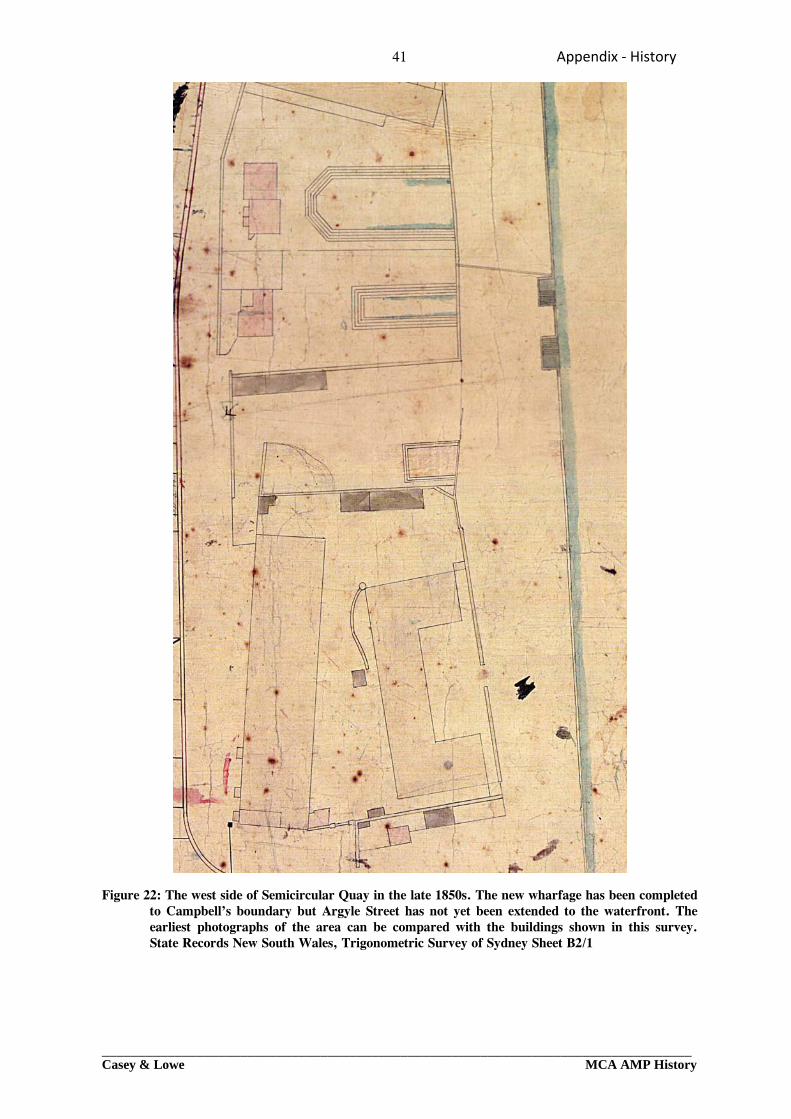
41 Appendix ‐ History
_________________________________________________________________________________Casey & Lowe MCA AMP History
Figure 22: The west side of Semicircular Quay in the late 1850s. The new wharfage has been completed
to Campbell’s boundary but Argyle Street has not yet been extended to the waterfront. The earliest photographs of the area can be compared with the buildings shown in this survey. State Records New South Wales, Trigonometric Survey of Sydney Sheet B2/1
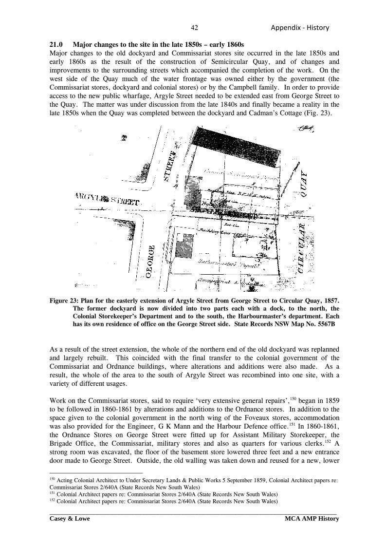
42 Appendix ‐ History
_________________________________________________________________________________Casey & Lowe MCA AMP History
21.0 Major changes to the site in the late 1850s – early 1860s Major changes to the old dockyard and Commissariat stores site occurred in the late 1850s and early 1860s as the result of the construction of Semicircular Quay, and of changes and improvements to the surrounding streets which accompanied the completion of the work. On the west side of the Quay much of the water frontage was owned either by the government (the Commissariat stores, dockyard and colonial stores) or by the Campbell family. In order to provide access to the new public wharfage, Argyle Street needed to be extended east from George Street to the Quay. The matter was under discussion from the late 1840s and finally became a reality in the late 1850s when the Quay was completed between the dockyard and Cadman’s Cottage (Fig. 23). Figure 23: Plan for the easterly extension of Argyle Street from George Street to Circular Quay, 1857.
The former dockyard is now divided into two parts each with a dock, to the north, the Colonial Storekeeper’s Department and to the south, the Harbourmaster’s department. Each has its own residence of office on the George Street side. State Records NSW Map No. 5567B
As a result of the street extension, the whole of the northern end of the old dockyard was replanned and largely rebuilt. This coincided with the final transfer to the colonial government of the Commissariat and Ordnance buildings, where alterations and additions were also made. As a result, the whole of the area to the south of Argyle Street was recombined into one site, with a variety of different usages. Work on the Commissariat stores, said to require ‘very extensive general repairs’,150 began in 1859 to be followed in 1860-1861 by alterations and additions to the Ordnance stores. In addition to the space given to the colonial government in the north wing of the Foveaux stores, accommodation was also provided for the Engineer, G K Mann and the Harbour Defence office.151 In 1860-1861, the Ordnance Stores on George Street were fitted up for Assistant Military Storekeeper, the Brigade Office, the Commissariat, military stores and also as quarters for various clerks.152 A strong room was excavated, the floor of the basement store lowered three feet and a new entrance door made to George Street. Outside, the old walling was taken down and reused for a new, lower
150 Acting Colonial Architect to Under Secretary Lands & Public Works 5 September 1859, Colonial Architect papers re: Commissariat Stores 2/640A (State Records New South Wales) 151 Colonial Architect papers re: Commissariat Stores 2/640A (State Records New South Wales) 152 Colonial Architect papers re: Commissariat Stores 2/640A (State Records New South Wales)
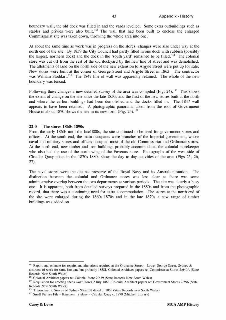
43 Appendix ‐ History
_________________________________________________________________________________Casey & Lowe MCA AMP History
boundary wall, the old dock was filled in and the yards levelled. Some extra outbuildings such as stables and privies were also built.153 The wall that had been built to enclose the enlarged Commissariat site was taken down, throwing the whole area into one. At about the same time as work was in progress on the stores, changes were also under way at the north end of the site. By 1859 the City Council had partly filled in one dock with rubbish (possibly the largest, northern dock) and the dock in the ‘south yard’ remained to be filled.154 The colonial store was cut off from the rest of the old dockyard by the new line of street and was demolished. The allotments of land on the north side of the new extension to Argyle Street were put up for sale. New stores were built at the corner of George Street and Argyle Street in 1863. The contractor was William Stoddart.155 The 1847 line of wall was apparently retained. The whole of the new boundary was fenced. Following these changes a new detailed survey of the area was compiled (Fig. 24).156 This shows the extent of change on the site since the late 1850s and the first of the new stores built at the north end where the earlier buildings had been demolished and the docks filled in. The 1847 wall appears to have been retained. A photographic panorama taken from the roof of Government House in about 1870 shows the site in its new form (Fig. 25).157 22.0 The stores 1860s-1890s From the early 1860s until the late1880s, the site continued to be used for government stores and offices. At the south end, the main occupants were branches of the Imperial government, whose naval and military stores and offices occupied most of the old Commissariat and Ordnance stores. At the north end, new timber and iron buildings probably accommodated the colonial storekeeper who also had the use of the north wing of the Foveaux store. Photographs of the west side of Circular Quay taken in the 1870s-1880s show the day to day activities of the area (Figs 25, 26, 27). The naval stores were the distinct preserve of the Royal Navy and its Australian station. The distinction between the colonial and Ordnance stores was less clear as there was some administrative overlap between the two departments at various periods. The site was clearly a busy one. It is apparent, both from detailed surveys prepared in the 1880s and from the photographic record, that there was a continuing need for extra accommodation. The stores at the north end of the site were enlarged during the 1860s-1870s and in the late 1870s a new range of timber buildings was added on
153 Report and estimate for repairs and alterations required at the Ordnance Stores – Lower George Street, Sydney & abstracts of work for same [no date but probably 1858], Colonial Architect papers re: Commissariat Stores 2/640A (State Records New South Wales) 154 Colonial Architect papers re: Colonial Store 2/639 (State Records New South Wales) 155 Requisition for erecting sheds Govt Stores 2 July 1863, Colonial Architect papers re: Government Stores 2/596 (State Records New South Wales) 156 Trigonometric Survey of Sydney Sheet B2 dated c. 1865 (State Records new South Wales) 157 Small Picture File – Basement. Sydney – Circular Quay c. 1870 (Mitchell Library)
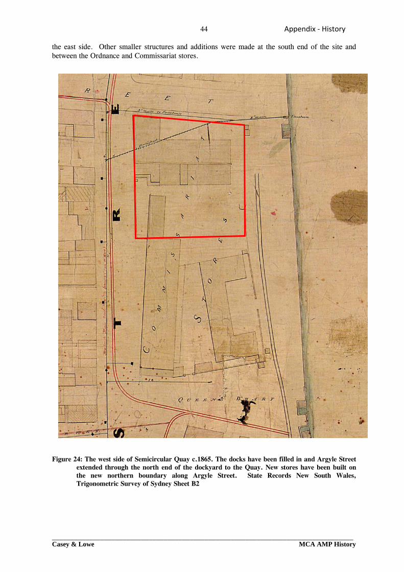
44 Appendix ‐ History
_________________________________________________________________________________Casey & Lowe MCA AMP History
the east side. Other smaller structures and additions were made at the south end of the site and between the Ordnance and Commissariat stores.
Figure 24: The west side of Semicircular Quay c.1865. The docks have been filled in and Argyle Street
extended through the north end of the dockyard to the Quay. New stores have been built on the new northern boundary along Argyle Street. State Records New South Wales, Trigonometric Survey of Sydney Sheet B2
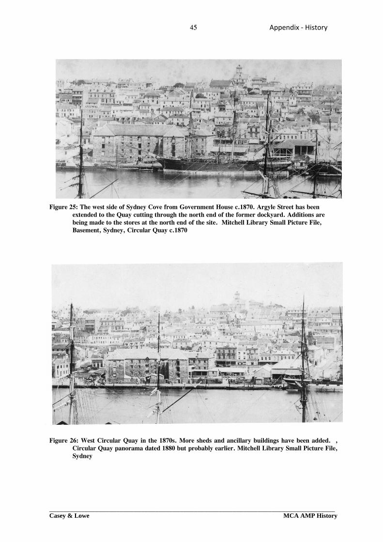
45 Appendix ‐ History
_________________________________________________________________________________Casey & Lowe MCA AMP History
Figure 25: The west side of Sydney Cove from Government House c.1870. Argyle Street has been extended to the Quay cutting through the north end of the former dockyard. Additions are being made to the stores at the north end of the site. Mitchell Library Small Picture File, Basement, Sydney, Circular Quay c.1870
Figure 26: West Circular Quay in the 1870s. More sheds and ancillary buildings have been added. , Circular Quay panorama dated 1880 but probably earlier. Mitchell Library Small Picture File, Sydney
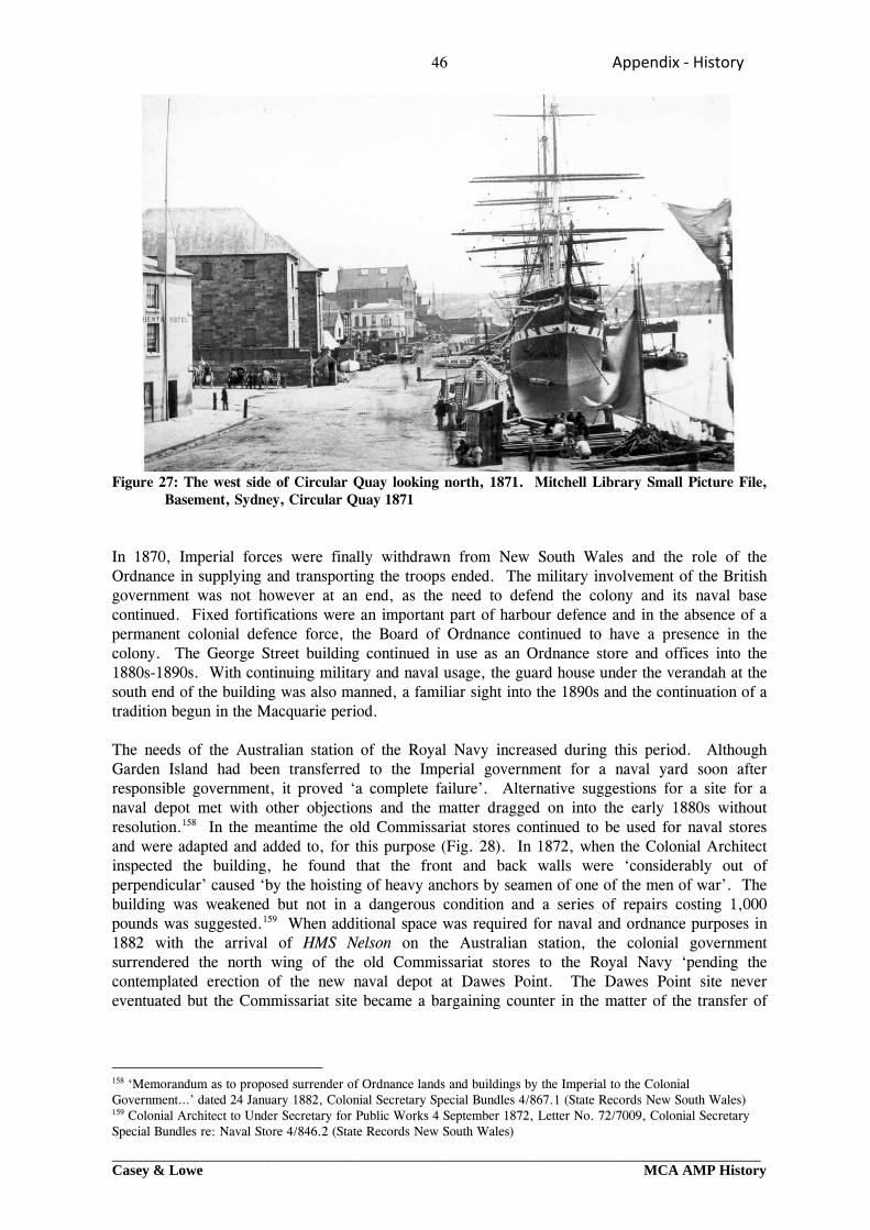
46 Appendix ‐ History
_________________________________________________________________________________Casey & Lowe MCA AMP History
Figure 27: The west side of Circular Quay looking north, 1871. Mitchell Library Small Picture File, Basement, Sydney, Circular Quay 1871
In 1870, Imperial forces were finally withdrawn from New South Wales and the role of the Ordnance in supplying and transporting the troops ended. The military involvement of the British government was not however at an end, as the need to defend the colony and its naval base continued. Fixed fortifications were an important part of harbour defence and in the absence of a permanent colonial defence force, the Board of Ordnance continued to have a presence in the colony. The George Street building continued in use as an Ordnance store and offices into the 1880s-1890s. With continuing military and naval usage, the guard house under the verandah at the south end of the building was also manned, a familiar sight into the 1890s and the continuation of a tradition begun in the Macquarie period. The needs of the Australian station of the Royal Navy increased during this period. Although Garden Island had been transferred to the Imperial government for a naval yard soon after responsible government, it proved ‘a complete failure’. Alternative suggestions for a site for a naval depot met with other objections and the matter dragged on into the early 1880s without resolution.158 In the meantime the old Commissariat stores continued to be used for naval stores and were adapted and added to, for this purpose (Fig. 28). In 1872, when the Colonial Architect inspected the building, he found that the front and back walls were ‘considerably out of perpendicular’ caused ‘by the hoisting of heavy anchors by seamen of one of the men of war’. The building was weakened but not in a dangerous condition and a series of repairs costing 1,000 pounds was suggested.159 When additional space was required for naval and ordnance purposes in 1882 with the arrival of HMS Nelson on the Australian station, the colonial government surrendered the north wing of the old Commissariat stores to the Royal Navy ‘pending the contemplated erection of the new naval depot at Dawes Point. The Dawes Point site never eventuated but the Commissariat site became a bargaining counter in the matter of the transfer of
158 ‘Memorandum as to proposed surrender of Ordnance lands and buildings by the Imperial to the Colonial Government…’ dated 24 January 1882, Colonial Secretary Special Bundles 4/867.1 (State Records New South Wales) 159 Colonial Architect to Under Secretary for Public Works 4 September 1872, Letter No. 72/7009, Colonial Secretary Special Bundles re: Naval Store 4/846.2 (State Records New South Wales)

47 Appendix ‐ History
_________________________________________________________________________________Casey & Lowe MCA AMP History
Ordnance lands to New South Wales by the Imperial government.160 In 1883, the New South Wales parliament finally made a commitment to the proper development of Garden Island as a naval base and construction for that purpose took place over a decade.161 It seems most likely that the Royal Navy vacated the old Commissariat stores and dockyard site in about 1894 when the naval stores on Garden Island were completed. The new naval base was formally handed over in September 1896.162 The move ended the long association of the site at Sydney Cove with maritime and naval activities spanning a century.
Figure 28: Percy Dove’s Complete wharf and street directory of 1880. A number of sheds have been built around and between the former Ordnance and Commissariat stores. Mitchell Library FM 4/10397
23.0 The Quay from the 1850s to the 1890s The construction of Circular Quay combined with the release of allotments of land nearby allowed a new generation of merchants prime waterfront access. Unlike their predecessors whose trading interests had been wide ranging, many of the trading houses now specialised in wool, the Colony’s principal export. Much of the Colony’s economy focused on this link with the world’s trade, funnelling the wealth of its hinterland through Sydney, the Exchange and the wool stores at Circular Quay. From the 1850s onwards, the shipment of wool was the main activity on the east and south sides of Circular Quay. Activity on the west side was much as it had been in the past with mixed general trade. The Ordnance and Commissariat stores and Campbell’s wharf and storehouses still dominated. The new quay provided additional public wharfage but as much of the area on the west was already in government or private ownership and had been built upon by the time it was constructed, there had been no opportunity for merchants to acquire extensive premises in the vicinity. The backdrop to the west side of the quay was The Rocks and Miller’s Point where many of the men who worked on the wharves lived and where the transitory population of ships’ crews lodged, drank and amused themselves. Much of the life of the area was associated with maritime activities in what was still a sailors’ town.
160 Commodore Erskine to Governor 1 February 1882 & Minute for His Excellency M 18491 dated 2 April 1883, Colonial Secretary Special Bundles : Naval Ordnance Stores 1882-1883, 4/846.2 (State Records New South Wales) 161 T R Frame: The Garden Island (1990) pp 148-149 162 Simon Davies : The Islands of Sydney Harbour (1984) pp 40-41
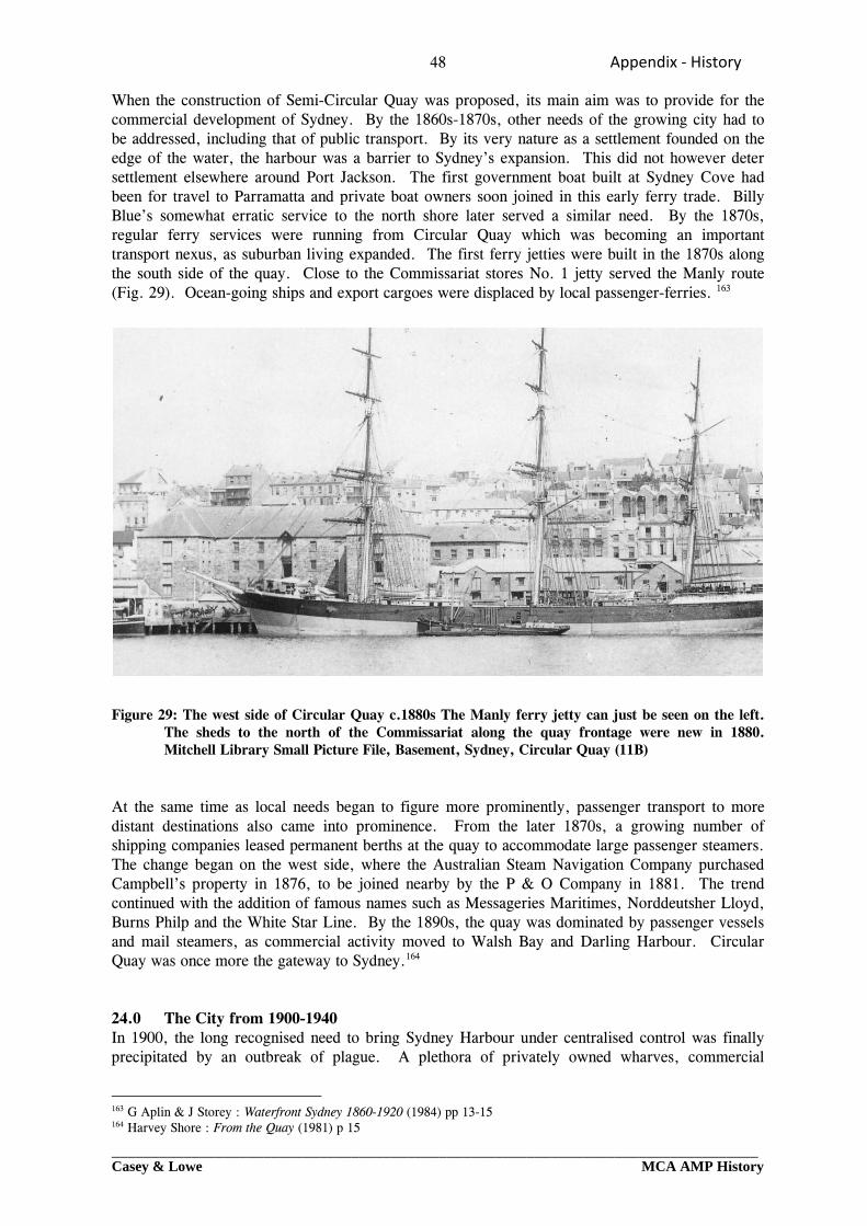
48 Appendix ‐ History
_________________________________________________________________________________Casey & Lowe MCA AMP History
When the construction of Semi-Circular Quay was proposed, its main aim was to provide for the commercial development of Sydney. By the 1860s-1870s, other needs of the growing city had to be addressed, including that of public transport. By its very nature as a settlement founded on the edge of the water, the harbour was a barrier to Sydney’s expansion. This did not however deter settlement elsewhere around Port Jackson. The first government boat built at Sydney Cove had been for travel to Parramatta and private boat owners soon joined in this early ferry trade. Billy Blue’s somewhat erratic service to the north shore later served a similar need. By the 1870s, regular ferry services were running from Circular Quay which was becoming an important transport nexus, as suburban living expanded. The first ferry jetties were built in the 1870s along the south side of the quay. Close to the Commissariat stores No. 1 jetty served the Manly route (Fig. 29). Ocean-going ships and export cargoes were displaced by local passenger-ferries. 163
Figure 29: The west side of Circular Quay c.1880s The Manly ferry jetty can just be seen on the left.
The sheds to the north of the Commissariat along the quay frontage were new in 1880. Mitchell Library Small Picture File, Basement, Sydney, Circular Quay (11B)
At the same time as local needs began to figure more prominently, passenger transport to more distant destinations also came into prominence. From the later 1870s, a growing number of shipping companies leased permanent berths at the quay to accommodate large passenger steamers. The change began on the west side, where the Australian Steam Navigation Company purchased Campbell’s property in 1876, to be joined nearby by the P & O Company in 1881. The trend continued with the addition of famous names such as Messageries Maritimes, Norddeutsher Lloyd, Burns Philp and the White Star Line. By the 1890s, the quay was dominated by passenger vessels and mail steamers, as commercial activity moved to Walsh Bay and Darling Harbour. Circular Quay was once more the gateway to Sydney.164 24.0 The City from 1900-1940 In 1900, the long recognised need to bring Sydney Harbour under centralised control was finally precipitated by an outbreak of plague. A plethora of privately owned wharves, commercial
163 G Aplin & J Storey : Waterfront Sydney 1860-1920 (1984) pp 13-15 164 Harvey Shore : From the Quay (1981) p 15
49 Appendix ‐ History
_________________________________________________________________________________Casey & Lowe MCA AMP History
premises and facilities was resumed by the government, to be administered by the new Sydney Harbour Trust. The government’s own property at West Circular Quay was included in the ambit of the Trust’s responsibilities. Radical reorganisation and rebuilding of harbour facilities in the early years of the 20th century included the removal of cargo facilities to Walsh Bay, where new wharfage was built and the improvement of the ferry wharves at Circular Quay. The improvement of other parts of the city and the question of a proposed harbour crossing and city railway were the subject of two Royal Commissions in 1909. It was not however until 1915 that a report by J J C Bradfield was accepted as the basis for the most extensive programme of public works to affect the city and its transport networks in the 20th century. Bradfield’s scheme proposed the electrification of suburban railway lines, the construction of an underground city railway and a bridge across the harbour for motor vehicles, trains and trams, a unified system of public transport connected to the existing rail system. Although the city railway was to be largely underground, it would be raised above street level at Circular Quay. The scheme involved considerable replanning of the Circular Quay area, including the demolition of various premises which stood in the way of the above ground section of the railway. Amongst these were the head offices of the Sydney Harbour Trust, for which a new site had to be found. The first part of the city railway to St James’ and Museum stations, was completed in 1926, to be followed by the opening of the Sydney Harbour Bridge and the stations at Town Hall and Wynyard in 1932. The effect of the new transport link was immediate, a substantial reduction in the use of ferries. Almost overnight the importance of Circular Quay as a major transport connection was greatly reduced. The long delay in completing the final link of the city railway at Circular Quay compounded the problem. Property values fell and businesses moved away from the quay to be closer to the new railway stations now used by their potential customers. Circular Quay West was still used by passenger ships, but with the loss of its commercial wharfage and ferry traffic, fell into limbo. The government’s use of its own property at Circular Quay West was a clear indication of the area’s loss of status. 25.0 The Site from 1890s-1940 With the removal of the naval stores to Garden Island, the whole of the old Commissariat store and much of the associated area were vacated. From the 1890s onwards, the space was let to private businesses for a variety of uses including stores, workshops, engineering yards, a brass foundry, garages, cordial manufacturers and later a car hire yard.165 These enterprises occupied not only the Commissariat stores but also the various sheds and stores which had been built between and around them from the early 1860s to the 1880s (Fig. 30). The majority of these remained in use until the late 1930s (Fig. 31).
165 Sands Directories (various dates)
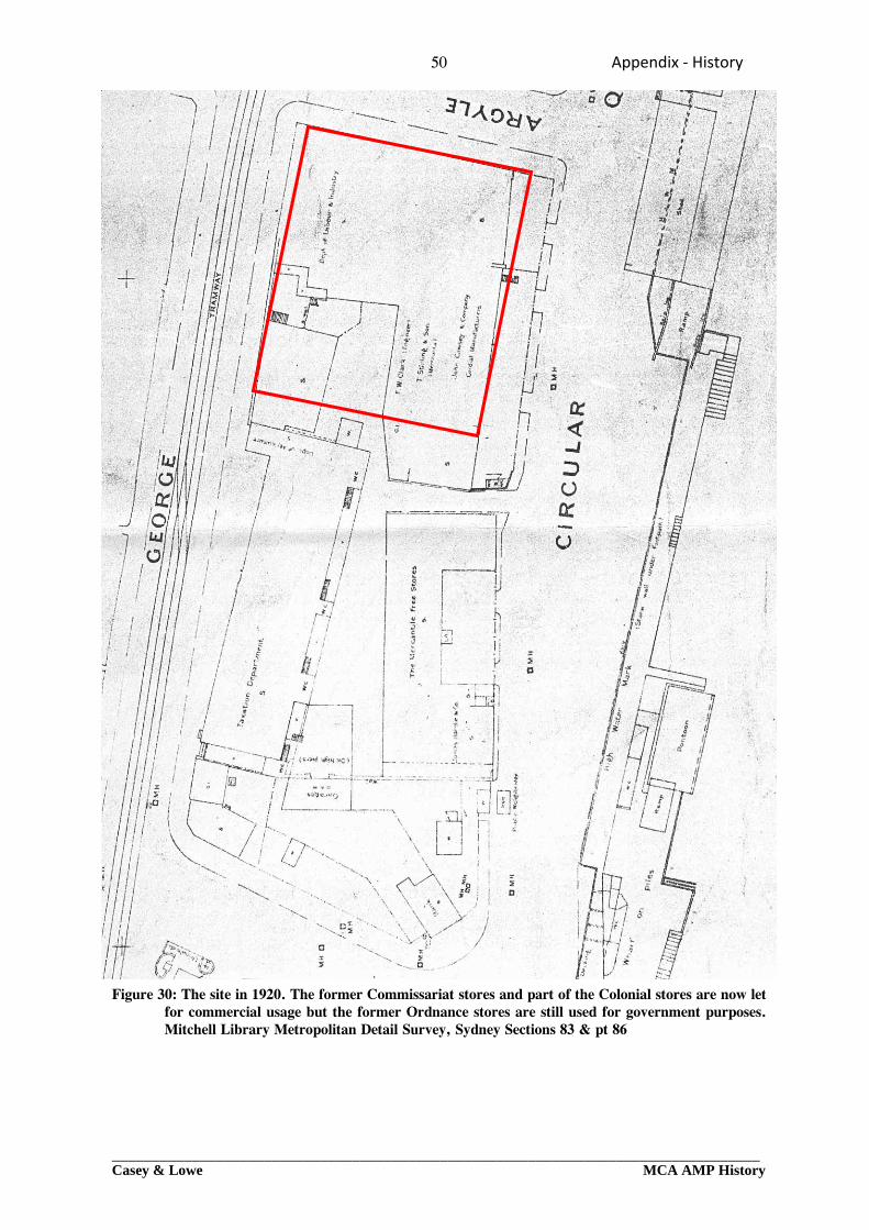
50 Appendix ‐ History
_________________________________________________________________________________Casey & Lowe MCA AMP History
Figure 30: The site in 1920. The former Commissariat stores and part of the Colonial stores are now let for commercial usage but the former Ordnance stores are still used for government purposes. Mitchell Library Metropolitan Detail Survey, Sydney Sections 83 & pt 86
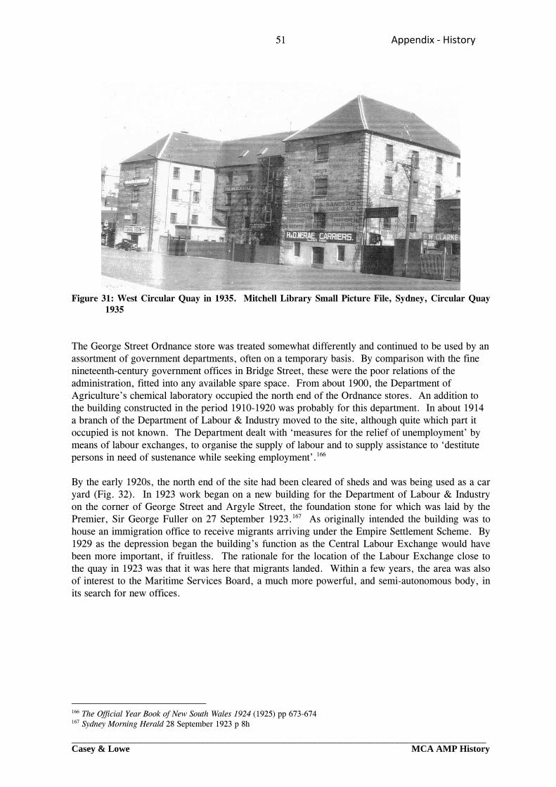
51 Appendix ‐ History
_________________________________________________________________________________Casey & Lowe MCA AMP History
Figure 31: West Circular Quay in 1935. Mitchell Library Small Picture File, Sydney, Circular Quay
1935 The George Street Ordnance store was treated somewhat differently and continued to be used by an assortment of government departments, often on a temporary basis. By comparison with the fine nineteenth-century government offices in Bridge Street, these were the poor relations of the administration, fitted into any available spare space. From about 1900, the Department of Agriculture’s chemical laboratory occupied the north end of the Ordnance stores. An addition to the building constructed in the period 1910-1920 was probably for this department. In about 1914 a branch of the Department of Labour & Industry moved to the site, although quite which part it occupied is not known. The Department dealt with ‘measures for the relief of unemployment’ by means of labour exchanges, to organise the supply of labour and to supply assistance to ‘destitute persons in need of sustenance while seeking employment’.166 By the early 1920s, the north end of the site had been cleared of sheds and was being used as a car yard (Fig. 32). In 1923 work began on a new building for the Department of Labour & Industry on the corner of George Street and Argyle Street, the foundation stone for which was laid by the Premier, Sir George Fuller on 27 September 1923.167 As originally intended the building was to house an immigration office to receive migrants arriving under the Empire Settlement Scheme. By 1929 as the depression began the building’s function as the Central Labour Exchange would have been more important, if fruitless. The rationale for the location of the Labour Exchange close to the quay in 1923 was that it was here that migrants landed. Within a few years, the area was also of interest to the Maritime Services Board, a much more powerful, and semi-autonomous body, in its search for new offices.
166 The Official Year Book of New South Wales 1924 (1925) pp 673-674 167 Sydney Morning Herald 28 September 1923 p 8h
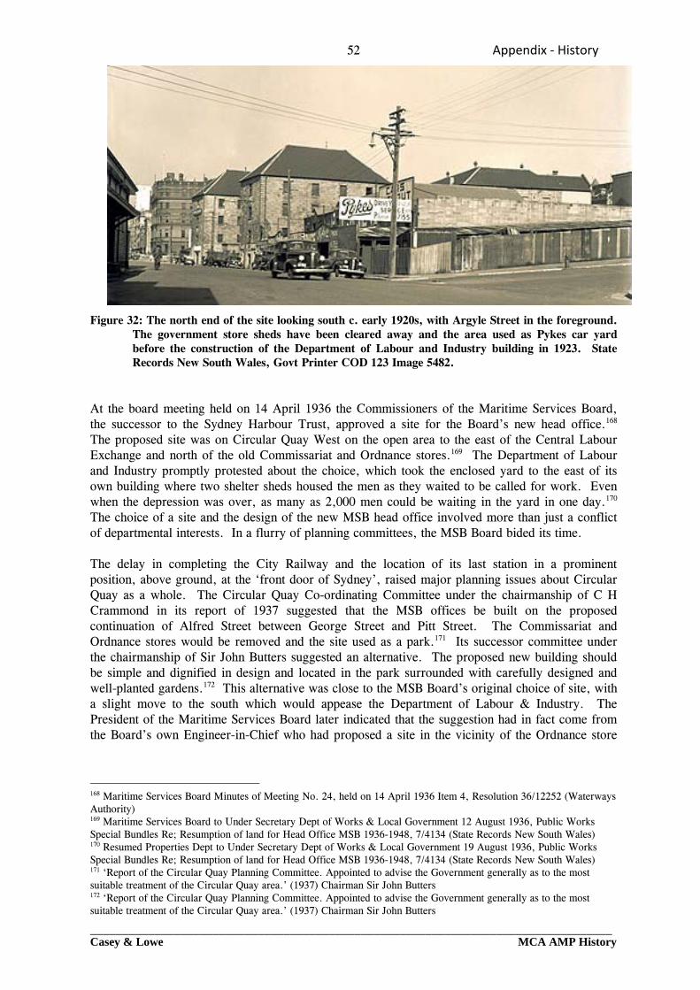
52 Appendix ‐ History
_________________________________________________________________________________Casey & Lowe MCA AMP History
Figure 32: The north end of the site looking south c. early 1920s, with Argyle Street in the foreground. The government store sheds have been cleared away and the area used as Pykes car yard before the construction of the Department of Labour and Industry building in 1923. State Records New South Wales, Govt Printer COD 123 Image 5482.
At the board meeting held on 14 April 1936 the Commissioners of the Maritime Services Board, the successor to the Sydney Harbour Trust, approved a site for the Board’s new head office.168 The proposed site was on Circular Quay West on the open area to the east of the Central Labour Exchange and north of the old Commissariat and Ordnance stores.169 The Department of Labour and Industry promptly protested about the choice, which took the enclosed yard to the east of its own building where two shelter sheds housed the men as they waited to be called for work. Even when the depression was over, as many as 2,000 men could be waiting in the yard in one day.170 The choice of a site and the design of the new MSB head office involved more than just a conflict of departmental interests. In a flurry of planning committees, the MSB Board bided its time. The delay in completing the City Railway and the location of its last station in a prominent position, above ground, at the ‘front door of Sydney’, raised major planning issues about Circular Quay as a whole. The Circular Quay Co-ordinating Committee under the chairmanship of C H Crammond in its report of 1937 suggested that the MSB offices be built on the proposed continuation of Alfred Street between George Street and Pitt Street. The Commissariat and Ordnance stores would be removed and the site used as a park.171 Its successor committee under the chairmanship of Sir John Butters suggested an alternative. The proposed new building should be simple and dignified in design and located in the park surrounded with carefully designed and well-planted gardens.172 This alternative was close to the MSB Board’s original choice of site, with a slight move to the south which would appease the Department of Labour & Industry. The President of the Maritime Services Board later indicated that the suggestion had in fact come from the Board’s own Engineer-in-Chief who had proposed a site in the vicinity of the Ordnance store
168 Maritime Services Board Minutes of Meeting No. 24, held on 14 April 1936 Item 4, Resolution 36/12252 (Waterways Authority) 169 Maritime Services Board to Under Secretary Dept of Works & Local Government 12 August 1936, Public Works Special Bundles Re; Resumption of land for Head Office MSB 1936-1948, 7/4134 (State Records New South Wales) 170 Resumed Properties Dept to Under Secretary Dept of Works & Local Government 19 August 1936, Public Works Special Bundles Re; Resumption of land for Head Office MSB 1936-1948, 7/4134 (State Records New South Wales) 171 ‘Report of the Circular Quay Planning Committee. Appointed to advise the Government generally as to the most suitable treatment of the Circular Quay area.’ (1937) Chairman Sir John Butters 172 ‘Report of the Circular Quay Planning Committee. Appointed to advise the Government generally as to the most suitable treatment of the Circular Quay area.’ (1937) Chairman Sir John Butters
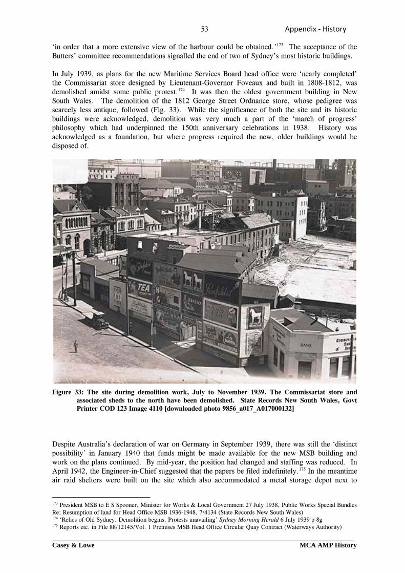
53 Appendix ‐ History
_________________________________________________________________________________Casey & Lowe MCA AMP History
‘in order that a more extensive view of the harbour could be obtained.’173 The acceptance of the Butters’ committee recommendations signalled the end of two of Sydney’s most historic buildings. In July 1939, as plans for the new Maritime Services Board head office were ‘nearly completed’ the Commissariat store designed by Lieutenant-Governor Foveaux and built in 1808-1812, was demolished amidst some public protest.174 It was then the oldest government building in New South Wales. The demolition of the 1812 George Street Ordnance store, whose pedigree was scarcely less antique, followed (Fig. 33). While the significance of both the site and its historic buildings were acknowledged, demolition was very much a part of the ‘march of progress’ philosophy which had underpinned the 150th anniversary celebrations in 1938. History was acknowledged as a foundation, but where progress required the new, older buildings would be disposed of.
Figure 33: The site during demolition work, July to November 1939. The Commissariat store and associated sheds to the north have been demolished. State Records New South Wales, Govt Printer COD 123 Image 4110 [downloaded photo 9856_a017_A017000132]
Despite Australia’s declaration of war on Germany in September 1939, there was still the ‘distinct possibility’ in January 1940 that funds might be made available for the new MSB building and work on the plans continued. By mid-year, the position had changed and staffing was reduced. In April 1942, the Engineer-in-Chief suggested that the papers be filed indefinitely.175 In the meantime air raid shelters were built on the site which also accommodated a metal storage depot next to
173 President MSB to E S Spooner, Minister for Works & Local Government 27 July 1938, Public Works Special Bundles Re; Resumption of land for Head Office MSB 1936-1948, 7/4134 (State Records New South Wales) 174 ‘Relics of Old Sydney. Demolition begins. Protests unavailing’ Sydney Morning Herald 6 July 1939 p 8g 175 Reports etc. in File 88/12145/Vol. 1 Premises MSB Head Office Circular Quay Contract (Waterways Authority)
54 Appendix ‐ History
_________________________________________________________________________________Casey & Lowe MCA AMP History
Department of Labour & Industry building on George Street.176 In September 1946, the work for the new headquarters of the Maritime Services Board finally went out to tender.177 The building was completed in December 1952 after weathering ‘a period of six years, which covered some of the most difficult ever experienced in Australia in respect of labour and material shortage’.178 Above the main entrance, on the eastern side of the building a sculptured frieze by Lyndon Dadswell represented some of the history and commercial importance of the site, showing ships being unloaded in front of the Commissariat store.179 The foundation stone of the Commissariat store was preserved in front of the new building.180
176 Public Works Special Bundles Re; Resumption of land for Head Office MSB 1936-1948, 7/4134 (State Records New South Wales) 177 Maritime Services Board Minutes of Meeting No. 758, held on 5 September 1946, Item 5 Resolution 46/12244 (Waterways Authority) 178 The Maritime Services Board New Head Office Building, Circular Quay, Sydney’ Building, Lighting, Engineering 24 January 1953 p 19 179 M G MacDougall : ‘Some features of the Board’s new Head Office Port of Sydney Journal October 1952 pp 46-49 180 Public Works Department of NSW : ‘The Maritime Services Board Building, Circular Quay, Sydney. Conservation Study’ (1985)