draft initial study
TRANSCRIPT


Draft Initial Study &
Mitigated Negative Declaration for the
Mapes Road Cannabis Cultivation and Distribution Project
Lead Agency: City of Perris
135 North D Street Perris, CA 92570
Prepared by:
VCS Environmental 30900 Rancho Viejo Road, Suite 100
San Juan Capistrano, California 92675 Contact: Dan Bott
April 2020

Page intentionally left blank.

City of Perris Initial Study / Environmental Checklist
Mapes Road Cultivation Project i
TABLE OF CONTENTS SECTION 1.0 INTRODUCTION ............................................................................................................ vi
Purpose ............................................................................................................................................... 1
Statutory Authority and Requirements .............................................................................................. 1
Intended Uses of this Initial Study and Mitigated Negative Declaration ........................................... 1
Tiered Documents and Incorporation by Reference .......................................................................... 1
Technical Studies ................................................................................................................................ 2
SECTION 2 PROPOSED PROJECT ......................................................................................................... 3
Existing Setting .................................................................................................................................... 3
Proposed Project ................................................................................................................................ 3
SECTION 3.0 DETERMINATION ......................................................................................................... 11
SECTION 4.0 ENVIRONMENTAL ANALYSIS......................................................................................... 13
4.1 Aesthetics .................................................................................................................................... 14
4.2 Agricultural Resources ................................................................................................................ 16
4.3 Air Quality ................................................................................................................................... 18
4.4 Biological Resources ................................................................................................................... 32
4.5 Cultural Resources ...................................................................................................................... 36
4.6 Energy ......................................................................................................................................... 41
4.7 Geology/Soils .............................................................................................................................. 43
4.9 Greenhouse Gas Emissions ......................................................................................................... 48
4.10 Hazards/Hazardous Materials .................................................................................................. 52
4.11 Hydrology/Water Quality ......................................................................................................... 58
4.13 Land Use/Planning .................................................................................................................... 70
4.14 Mineral Resources .................................................................................................................... 71
4.15 Noise ......................................................................................................................................... 72
4.16 Population/Housing .................................................................................................................. 77
4.17 Public Services .......................................................................................................................... 78
4.18 Recreation ................................................................................................................................. 80
4.19 Transportation/Traffic .............................................................................................................. 81
4.20 Tribal Cultural Resources .......................................................................................................... 87
4.20 Utilities and Service Systems .................................................................................................... 90
4.21 Wildfire ..................................................................................................................................... 95

City of Perris Initial Study / Environmental Checklist
Mapes Road Cultivation Project ii
4.22 Mandatory Findings of Significance .......................................................................................... 97
SECTION 5.0 SUMMARY OF MITIGATION MEASURES ........................................................................ 99
SECTION 6.0 REFERENCES .............................................................................................................. 101
LIST OF TABLES
Table 1: Building Phasing Plan ................................................................................................. 10
Table 2: SCAQMD Regional Criteria Pollutant Emission Thresholds of Significance ................ 20
Table 3: SCAQMD Local Air Quality Thresholds of Significance ............................................... 21
Table 4: Construction-Related Regional Criteria Pollutant Emissions ....................................... 24
Table 5: Construction-Related Local Criteria Pollutant Emissions ............................................ 25
Table 6: Operational Regional Criteria Pollutant Emissions ...................................................... 25
Table 7: Project’s Contribution to Criteria Pollutants in the South Coast Air Basin .................... 26
Table 8: Operations-Related Local Criteria Pollutant Emissions ............................................... 28
Table 9: Cultural Resources Within One-Half Mile of the Project Site ....................................... 38
Table 10: Studies On and Within One-Half Mile of the Project Site ........................................... 39
Table 11: Expansion Potential .................................................................................................. 46
Table 12: Project Related Greenhouse Gas Annual Emissions ................................................ 50
Table 13: 303 (D) Listed Impaired Water Bodies ...................................................................... 60
Table 14: Beneficial Use Descriptions ...................................................................................... 61
Table 15: Study Area Water Body Beneficial Uses ................................................................... 63
Table 16: Water Quality Objectives .......................................................................................... 63
Table 17: Cannabis Cultivation General Order Technical Reports ............................................ 65
Table 18: City of Perris Exterior Noise Level Standards ........................................................... 73
Table 19: Typical Construction Equipment Inventory Noise Levels ........................................... 74
Table 19: Vibration Source Levels for Construction Equipment ................................................ 75
Table 20 Study Area Intersections ............................................................................................ 82
Table 21: Existing Plus Project Intersection Traffic Conditions ................................................. 83

City of Perris Initial Study / Environmental Checklist
Mapes Road Cultivation Project iii
Table 22: Existing Plus Ambient Growth Plus Project ............................................................... 84
Table 23: Existing Plus Ambient Growth Plus Project Plus Cumulative Projects ....................... 85
Table 24: Water Demands ........................................................................................................ 92
LIST OF FIGURES Figure 1: Regional Location Map
Figure 2: Vicinity Map
Figure 3: Conceptual Site Plan
Figure 4: Elevations
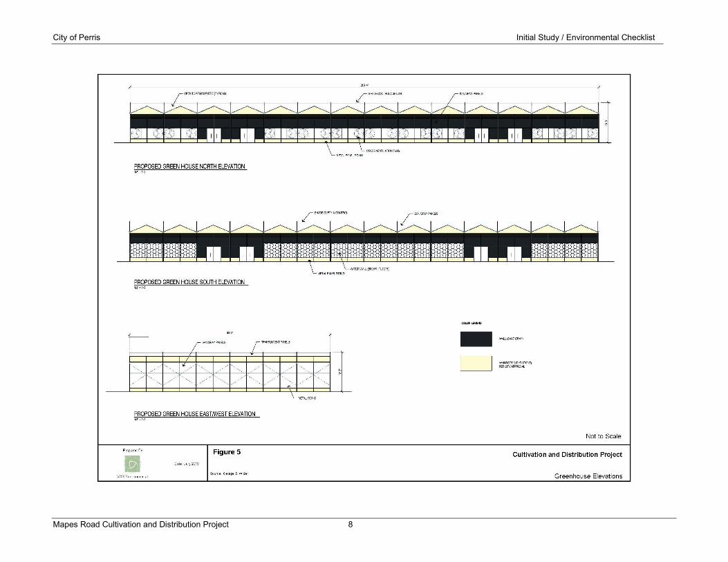
Figure 5: Greenhouse Elevations
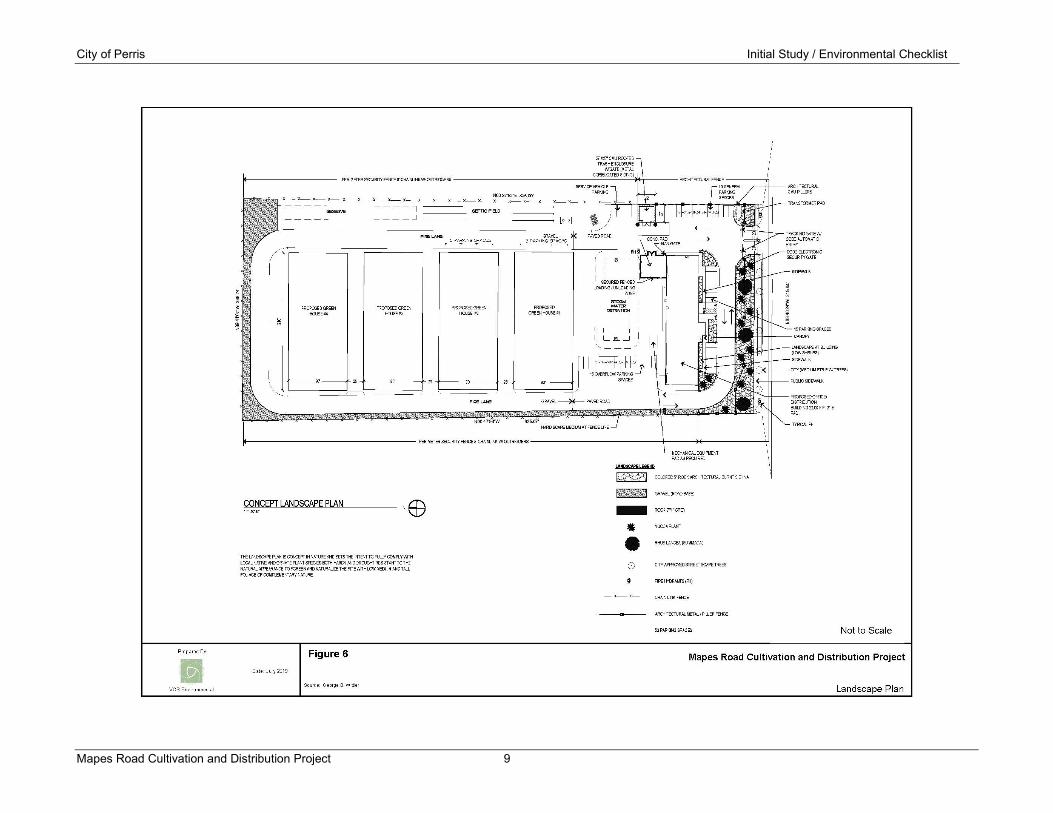
Figure 6: Landscape Plan

City of Perris Initial Study / Environmental Checklist
Mapes Road Cultivation Project iv
LIST OF ACRONYMS
AB Assembly Bill AQMP Air Quality Management Plan BMPs Best Management Practices CAAQS California Ambient Air Quality Standards CalEEMod California Emissions Estimator Model Caltrans California Department of Transportation CAAQS California Ambient Air Quality Standards CARB California Air Resources Board CCAA California Clean Air Act CCR California Code of Regulations CDFW California Department of Fish and Wildlife CEQA California Environmental Quality Act CHRIS Cultural Historical Resources Information System CNDDB California Natural Diversity Database CNEL Community Noise Exposure Level CO Carbon Monoxide DSAC Dam Safety Action Classification DWR California Department of Water Resources dB Decibel EIR Environmental Impact Report EMWD Eastern Municipal Water District EPA United States Environmental Protection Agency ESA Environmental Site Assessment FTA Federal Transit Administration GHG Greenhouse Gas HP Horsepower IS/MND Initial Study/Mitigated Negative Declaration Lb Pound Leq Average Background Noise Level LID Low Impact Development LST Localized Significance Threshold ND Negative Declaration NOI Notice of Intent MATES Multiple Air Toxics Exposure Study MND Mitigated Negative Declaration MLD Most Likely Descendant MSL Mean Sea Level MS4 Municipal Separate Storm Sewer System MT Metric Ton NAAQS National Ambient Air Quality Standards NAHC Native American Heritage Commission NES Natural Environment Study

City of Perris Initial Study / Environmental Checklist
Mapes Road Cultivation Project v
NPDES National Pollutant Discharge Elimination System PM10 Particulates 10 microns or less in diameter PM2.5 Particulates 2.5 microns or less in diameter PRC Public Resources Code REC Recognized Environmental Concern ROG Reactive Organic Gas RWQCB Regional Water Quality Control Board SB Senate Bill SoCAB South Coast Air Basin SCAG Southern California Association of Governments SCAQMD South Coast Air Quality Management District SCE Southern California Edison SIP State Implementation Plan sq ft Square Feet SWPPP Storm Water Pollution Prevention Plan SWRCB State Water Resources Control Board TAC Toxic Air Contaminant TMDL Total Maximum Daily Load USACE United States Army Corps of Engineers USFWS United States Fish and Wildlife Service UWMP Urban Water Management Plan VCS VCS Environmental VMT Vehicle Miles Traveled VOCs Volatile Organic Compounds WQMP Water Quality Management Plan

City of Perris Initial Study / Environmental Checklist
Mapes Road Cultivation Project vi
Page intentionally left blank.

City of Perris Initial Study / Environmental Checklist
Mapes Road Cultivation and Distribution Project 1
SECTION 1.0 INTRODUCTION Purpose
The California Environmental Quality Act (CEQA) requires that all state and local government agencies consider the environmental consequences of projects over which they have discretionary authority before taking action on those projects. This Initial Study has been prepared to disclose and evaluate short-term construction related impacts and long-term operational impacts associated with the implementation of the Mapes Road Cannabis Cultivation and Distribution Project (Proposed Project). Pursuant to Section 15367 of the State CEQA guidelines, the City of Perris is the Lead Agency and has the principal responsibility of approving the Proposed Project. As the Lead Agency, the City of Perris is required to ensure that the Proposed Project complies with CEQA and that the appropriate level of CEQA documentation is prepared. Through preparation of an Initial Study as the Lead Agency, the City of Perris would determine whether to prepare an Environmental Impact Report (EIR), Negative Declaration (ND) or Mitigated Negative Declaration (MND).
If the Lead Agency finds that there is no evidence that a project activity either as proposed or as modified to include mitigation measures identified in the Initial Study prior to its public circulation, would not cause a significant effect on the environment, the Lead Agency may prepare a ND or MND. Based on the conclusions of this Draft Initial Study, the City of Perris has recommended that the appropriate level of environmental documentation for the Proposed Project is a MND. This Initial Study and Mitigated Negative Declaration (IS/MND) addresses the direct, indirect, and cumulative environmental effects associated with the Proposed Project.
Statutory Authority and Requirements
This IS/MND has been prepared in accordance with the CEQA, Public Resources Code Section 21000 et seq. State CEQA Guidelines and City of Pico Rivera Environmental Procedures. Section 15063 of the CEQA Guidelines identifies global disclosure requirements for inclusion in an Initial Study. Pursuant to those requirements, an Initial Study must include: (1) a description of the Project, including the location of the Project; (2) an identification of the environmental setting; (3) an identification of environmental effects by use of a checklist, matrix or other method, provided that entries on a checklist or other form are briefly explained to indicate that there is some evidence to support the entries; (4) a discussion of ways to mitigate significant effects identified, if any; (5) an examination of whether the Project is compatible with existing zoning, plans, and other applicable land use controls; and (6) the name of the person or persons who prepared or participated in the preparation of the IS.
Intended Uses of this Initial Study and Mitigated Negative Declaration
This IS/MND is intended to be an informational document for the City of Perris as Lead Agency, the general public, and for responsible agencies to ensure adequate mitigation measures are identified to reduce potential significant impacts to a less than significant level. The IS/MND would be used as the supporting CEQA environmental documentation for site plan approvals and construction permits.
Tiered Documents and Incorporation by Reference
Information, findings, and conclusions contained in this IS/MND are based on incorporation by reference of tiered documents, and technical studies that have been prepared for the Proposed Project. This document incorporates by reference the City of Perris General Plan and the General

City of Perris Initial Study / Environmental Checklist
Mapes Road Cultivation and Distribution Project 2
Plan EIR, certified in 2014. The General Plan EIR is available for review at City of Perris, 135 D Street Perris, CA 90660.
Technical Studies
The following technical studies and information have been incorporated in the environmental impact evaluation prepared for the Mapes Road Cannabis Cultivation and Distribution Project.
Appendix A: Air Quality and Greenhouse Gas Emission Impact Analysis, Vista Environmental, August 2019
Appendix B: Biological Report and Western Riverside County Multiple Species Habitat Conservation Plan Consistency Analysis, Michael Romich Biological Services, November 2018
Appendix C: Phase 1 Cultural Resources Assessment, VCS Environmental, June 2019
Appendix D: Geotechnical Engineering Investigation, Nor Cal Engineering, August 2018
Appendix E: Phase 1 Environmental Site Assessment Report, USA Environmental, February 2019
Appendix F: Preliminary Drainage Study, Snipes-Dye Associates, December 2018
Appendix F-1: Project Specific Water Quality Management Plan, Snipes-Dye Associates, December 2018
Appendix G: Traffic Impact Analysis, Ganddini Group, August 2019

City of Perris Initial Study / Environmental Checklist
Mapes Road Cultivation and Distribution Project 3
SECTION 2 PROPOSED PROJECT Existing Setting
As depicted in Figure 1 the project is regionally located within south end of the City of Perris within Riverside County. The project site consists of 6.01 acres and is located on the north side of Mapes Road, south of Alpine Drive, between Goetz Road and A Street. As shown in Figure 2, the project site is currently vacant and undeveloped. The site topography is generally flat with a slight southeasterly slope. The site is bounded by a single-family residence and RV storage to the west, manufacturing uses to the north, and undeveloped lands to the east and south. Primary vehicle local access to the site would be provided from Mapes Road. Regional Access would be provided from Interstate 215 and Interstate 15 via Highway 74.
Proposed Project
As shown in Figure 3, the Proposed Project involves the construction and operation of 9,900 square foot (sq. ft.) marijuana processing and light industrial building and four 18,900 sq. ft. greenhouse structures, proving a total of 75,600 sq. ft. of cannabis cultivation area. The site is designated for General Industrial land uses in the City of Perris General Plan and Zoning Ordinance and would be subject the City of Perris Municipal Code Commercial Marijuana Operations Regulatory Program.
Light Industrial Building
The proposed light industrial building would be a pre-engineered metal building that would provide 9,900 0 sq. ft. of light industrial area. The building would be a single-story structure, measuring 198 feet in length, 50 feet in width with a height of 11 feet and 6 inches. The proposed structure would be supported by a conventional slab-on-grade foundation system with perimeter-spread footings and isolated interior footings. The building would have central lobby, four offices, conference room, break room women/men lockers and supporting distribution and warehousing facilities. The entrance to the office building would be from Mapes Road.
An elevation view and rendering of the light industrial building is shown on Figure 4 and Figure 5. The façade of the building would have a combination of smooth and corrugated finishes with articulated architectural features including recessed passageways, window and doorway canopies and an undulating parapet roofline. The building color palette includes a combination of saddle sand, saddle tan and light stone with rustic red accent.
The Landscape Concept Plan for the Proposed Project is shown on Figure 6. A combination of drought tolerant shrubs and trees with colored red rock accenting would be provided. Additionally, City approved street trees would be provided along the frontage of the property.
Greenhouse Structures
The Proposed Project includes four greenhouse buildings that would provide a total of 75,600 sq. ft. of cultivation area. An elevation view of the greenhouse structure is shown on Figure 5. The greenhouse structures would be constructed on concrete slabs. The proposed greenhouse buildings would measure 200 feet in length, 90 feet in width with a height of 11 feet and 6 inches. The greenhouse structures would consist of prefabricated metal materials with a combination of sand gray and light stone colors.

City of Perris Initial Study / Environmental Checklist
Mapes Road Cultivation and Distribution Project 4

City of Perris Initial Study / Environmental Checklist
Mapes Road Cultivation and Distribution Project 5

City of Perris Initial Study / Environmental Checklist
Mapes Road Cultivation and Distribution Project 6

City of Perris Initial Study / Environmental Checklist
Mapes Road Cultivation and Distribution Project 7
City of Perris Initial Study / Environmental Checklist
Mapes Road Cultivation and Distribution Project 8
City of Perris Initial Study / Environmental Checklist
Mapes Road Cultivation and Distribution Project 9

City of Perris Initial Study / Environmental Checklist
Mapes Road Cultivation and Distribution Project 10
Building Site
The improvements to the project the site would introduce 3.45 acres of impervious surfaces. Surface water run-off from the site would be collected in a series of catch basins located along the side of the fire lane and routed to a bio-treatment retention basin located at the northeast corner of the office/manufacturing building. Water service to the site would be provided from an existing 12-inch water line located along Mapes Road. Wastewater service would be provided by an onsite septic system.
A single driveway would provide to access to the site with fire lane circulating along the perimeter of the site. A total of 40 parking spaces would be provided to meet City parking requirements. The site would be entirely enclosed within perimeter security fencing. Two security gates and secured fencing would provide limiting access to the loading and unloading areas. A service security operations plan would be prepared and implemented that would provide an onsite licensed security guard and security cameras.
Construction Phasing
Site Preparation
The initial construction phases of the Proposed Project would involve clearing of the site, rough grading and final grading for preparation of the construction concrete building slabs for the proposed office manufacturing/office building and greenhouse structures. Presently, portions of the site are located within the 100-year floodplain and would require 4 feet of fill material to raise the site elevation above the 100-year floodplain. A combination of existing material on the project site and imported fill material would be used to raise the elevation of the site. Approximately, 39,450 cubic yards of fill material would be required to raise the site above the required flood elevation. Assuming 14 cubic yards of material per truck load, approximately 2,817 truck trips would be required.
Building Construction
The construction of the proposed manufacturing/office building and greenhouse structures would occur in four construction phases. Table 1 shows the building and site improvements and grading activities proposed for each construction phase.
Table 1: Building Phasing Plan
Construction Phase Building/Site Improvement
Phase 1 Office Building, Parking Lot, Bio-Treatment Basin, Septic system, Fire Lane and First Greenhouse structure.
Phase 2 Extension of Fire Lane and Construction of Second Greenhouse Structure.
Phase 3 Extension of Fire Lane and Construction of Third Greenhouse Structure.
Phase 4 Extension of Fire Lane and Construction of Fourth Greenhouse Structure.

City of Perris Initial Study / Environmental Checklist
Mapes Road Cultivation and Distribution Project 11
SECTION 3.0 DETERMINATION The following determination is based on the Initial Study analysis prepared for the Mapes Road Cultivation and Distribution Project. The Environmental Checklist Form used in the analysis is consistent with the Environmental Checklist form provided in Appendix G of the CEQA Guidelines, as updated in January 2019.
Project Title: Mapes Road Cultivation and Distribution Project
Lead Agency Name and Address: City of Perris, 135 North D Street, Perris, CA 992570
Project Contact: Mary Blais, Planner
Location: Northside of Mapes Road, between Goetz Road and A Street
On the basis of this initial evaluation:
I find that the proposed Project COULD NOT have a significant effect on the environment, and a NEGATIVE DECLARATION will be prepared.
I find that although the proposed Project could have a significant effect on the environment, there will not be a significant effect in this case because the mitigation measures described on an attached sheet have been added to the Project. A MITIGATED NEGATIVE DECLARATION will be prepared.
I find that the proposed Project MAY have a significant effect on the environment, and an ENVIRONMENTAL IMPACT REPORT is required.
I find that the proposed Project MAY have a “potentially significant impact” or “potentially significant unless mitigated" on the environment, but at least one effect 1) has been adequately analyzed in an earlier document pursuant to applicable legal standards, and 2) has been addressed by mitigation measures based on the earlier analysis as described on attached sheets, if the effect is a “potentially significant impact” or “potentially significant unless mitigated.” An ENVIRONMENTAL IMPACT REPORT is required, but it must analyze only the effects that remain to be addressed.
I find that although the proposed Project could have a significant effect on the environment, there WILL NOT be a significant effect in this case because all potentially significant effects (a) have been analyzed adequately in an earlier EIR pursuant to applicable standards, and (b) have been avoided or mitigated pursuant to that earlier EIR, including revisions or mitigation measures that are imposed upon the proposed Project, nothing further is required.
Signature: Date:
Printed Name: Title:

City of Perris Initial Study / Environmental Checklist
Mapes Road Cultivation and Distribution Project 12
Page intentionally left blank.

City of Perris Initial Study / Environmental Checklist
Mapes Road Cultivation and Distribution Project 13
SECTION 4.0 ENVIRONMENTAL ANALYSIS The environmental analysis provided below is based on the Initial Study Checklist recommended by in Appendix G of the CEQA Guidelines, as amended, and used by the City of Perris in its environmental review process. For the environmental assessment undertaken as part of this Initial Study’s preparation, a determination that there is a potential for significant effects indicates the need to more fully analyze the development’s impacts and to identify mitigation. For the evaluation of potential impacts, the questions in the Initial Study Checklist are stated and an answer is provided according to the analysis undertaken as part of the Initial Study. The analysis considers the long‐term, direct, indirect, and cumulative impacts of the development. To each question, there are four possible responses:
• No impact. The development would not have any measurable environmental impact on the environment.
• Less than significant impact. The development would have the potential to impact the environment, although this impact would be below established thresholds that are considered to be significant.
• Less than significant with mitigation incorporated. The development would have the potential to generate impacts, which may be considered as a significant effect on the environment, although mitigation measures or changes to the development’s physical or operational characteristics can reduce these impacts to levels that are less than significant.
• Potentially significant impact. The development could have impacts which may be considered significant, and therefore additional analysis is required to identify mitigation measures that could reduce potentially significant impacts to less than significant levels.
The following is a discussion of potential Project impacts as identified in the Initial Study/ Environmental Checklist. Explanations are provided for each issue.

City of Perris Initial Study / Environmental Checklist
Mapes Road Cultivation and Distribution Project 14
4.1 Aesthetics
Would the Project:
Potentially Significant
Impact
Less Than
Significant with
Mitigation
Less Than
Significant Impact
No Impact
a) Have a substantial adverse effect on a scenic vista?
b) Substantially damage scenic resources, including, but not limited to, trees, rock outcroppings, and historic buildings within a state scenic highway?
c) Substantially degrade the existing visual character or quality of public views of the site and its surroundings? If the project is in an urbanized area, would the project conflict with applicable zoning and other regulations governing scenic quality?
d) Create a new source of substantial light or glare which would adversely affect day or nighttime views in the area?
Environmental Analysis:
a) Would the Project have a substantial adverse effect on a scenic vista?
No Impact: For purposes of determining significance under CEQA, a scenic vista is defined as a viewpoint that provides expansive views of a highly valued landscape for the benefit of the general public. In addition, some scenic vistas are officially designated by public agencies, or informally designated by tourist guides. The project site is currently vacant and located in an area that is planned for industrial land uses. According to the City’s General Plan or any other public agency or organization there no designated scenic vistas on the project site or within the project area. Additionally, there are no planned park sites within the vicinity of the project site that could obstruct future public scenic views to or from a planned park site. No mitigation required.
b) Would the Project substantially damage scenic resources, including, but not limited to, trees, rock outcroppings, and historic buildings within a state scenic highway?
No Impact: The State Scenic Highway Program was established to preserve and protect scenic highway corridors from change that would diminish the aesthetic value of lands adjacent to State Highways. Highways may be designated as scenic depending upon how much of the natural landscape can be seen by travelers, the scenic quality of the landscape, and the extent to which development intrudes upon the traveler’s enjoyment of the view. A scenic highway is designated under the State Scenic Highway Program when a local jurisdiction adopts a scenic corridor protection program, applies to the California Department of Transportation (Caltrans) for scenic highway approval and receives notification from Caltrans that the highway has been designated as a Scenic

City of Perris Initial Study / Environmental Checklist
Mapes Road Cultivation and Distribution Project 15
Highway. According to the Caltrans, the closest State Scenic Highway would be Highway 74, which is designated Eligible State Scenic Highway. Highway 74 is located approximately 1.6 miles from the project site and views between the project site and the highway are obstructed by combination of structures and topography. Therefore, no potential adverse impacts to scenic resources within the view shed of a State Scenic Highway would occur. No mitigation required.
c) Would the Project substantially degrade the existing visual character or quality of public views of the site and its surroundings? If the project is in an urbanized area, would the project conflict with applicable zoning and other regulations governing scenic quality?
No Impact. The relevant regulations for the scenic quality of the Proposed Project would be the City of Perris Zoning Code Site and Architecture Design Guidelines and Landscape Design Guidelines for General Industrial land uses. The architectural design guidelines identify specific design elements for entrances, building massing, building elevations, building materials, fenestration, color building materials and roof treatment that should be incorporated into industrial buildings. As shown in Figure 4, the Proposed Project has incorporated many of the required architecture treatments features. The façade of the building would have a combination of smooth and corrugated finishes with articulated architectural features including recessed passageways, window and doorway canopies and an undulating parapet roofline. The building color palette includes a combination of saddle sand, saddle tan and light stone with rustic red accent. As part of the approval of the Proposed Project, the City of Perris would determine if the proposed architecture and site development treatments are consistent with the Site and Architecture Design Guidelines and Landscape Design Guidelines. No mitigation required.
d) Would the Project create a new source of substantial light or glare which would adversely affect day or nighttime views in the area?
Less than Significant Impact: The project site is undeveloped and absent of nighttime lighting. The surrounding area is developed with urbanized land uses that provide various levels of nighttime lighting. Additionally, the existing undeveloped properties near the project site would ultimately be developed with urbanized land uses that have building lighting and supporting improvements such as street lighting which would further increase nighttime lighting in the project. The proposed buildings on the project site would not have exterior surfaces that would be highly reflective that would generate substantial glare in the project area. In accordance with Section 19.440.070 of the City of Perris Zoning Code, all lighting fixtures would be fully shielded with cut-off fixtures so that there is no glare emitted onto adjacent properties or above the lowest part of the fixture. Additionally, Section 19.02.110 of the Zoning Code requires that all parking lot security lighting be directed away from adjoining properties and the public right-of-way. Compliance with Zoning Code outdoor lighting requirement would ensure that new sources of substantial light impacts are not introduced into the project area. No mitigation required.

City of Perris Initial Study / Environmental Checklist
Mapes Road Cultivation and Distribution Project 16
4.2 Agricultural Resources
In determining whether impacts to agricultural resources have significant environmental effects, lead agencies may refer to the California Agricultural Land Evaluation and Site Assessment Model (1997) prepared by the California Department of Conservation as an optional model to use in assessing impacts on agriculture and farmland. In determining whether impacts to forest resources, including timberland, are significant environmental effects, lead agencies may refer to information compiled by the California Department of Forestry and Fire Protection regarding the state’s inventory of forest land, including the Forest and Range Assessment Project and the Forest Legacy Assessment Project; and forest carbon measurement methodology provided in Forest Protocols adopted by the California Air Resources Board.
Would the Project:
Potentially Significant
Impact
Less Than Significant
with Mitigation
Less Than Significant
Impact
No Impact
a) Convert Prime Farmland, Unique Farmland, or Farmland of Statewide Importance (Farmland), as shown on the maps prepared pursuant to the Farmland Mapping and Monitoring Program of the California Resources Agency, to non-agricultural use?
b) Conflict with existing agricultural zoning for agricultural use, or a Williamson Act contract?
c) Conflict with existing zoning for, or cause rezoning of, forest land (as defined in Public Resources Code section 12220(g)), timberland (as defined by Public Resources Code section 4526), or timberland zoned Timberland Production (as defined by Government Code section 51104(g))?
d) Result in the loss of forest land or conversion of forest land to non-forest use?
e) Involve other changes in the existing environment which, due to their location or nature, could result in conversion of Farmland, to non-agricultural use or conversion of forest land to non-forest use?

City of Perris Initial Study / Environmental Checklist
Mapes Road Cultivation and Distribution Project 17
Environmental Analysis:
a) Would the Project convert Prime Farmland, Unique Farmland, or Farmland of Statewide Importance (Farmland), as shown on the maps prepared pursuant to the Farmland Mapping and Monitoring Program of the California Resources Agency, to non-agricultural use?
No Impact: The State of California Farmland Mapping and Monitoring Program indicates that there is no Prime Farmland, Unique Farmland or Farmland of Statewide Importance on the project site. Additionally, the City’s General Plan Land Use Element does not identify any agricultural lands within the City boundaries. Therefore, the construction and operation of the Proposed Project would not result in adverse impacts to Prime Farmland, Unique Farmland or Farmland of Statewide Importance. No mitigation required.
b) Would the Project conflict with existing agriculture zoning for agricultural use, or a Williamson Act contract?
No Impact: The project site is zoned for industrial land uses and would not conflict with any lands zoned for agriculture uses. Additionally, the project site is not under a Williamson Contract. No mitigation measures are required.
c) Would the Project conflict with existing zoning for, or cause rezoning of, forest land (as defined in Public Resources Code Section 12220(g)), timberland (as defined by Public Resources Code Section 4526), or timberland zoned Timberland Production (as defined by Government Code Section 51104(g))?
No Impact: The Proposed Project would be consistent with the project site existing zoning and would not cause a rezone of lands that are zoned for forest land or timberland. No mitigation required.
d) Would the Project result in the loss of forest land or conversion of forest land to non-forest use?
No Impact: The project site does not contain forest land resources. Therefore, implementation of the Proposed Project would not result in the loss of forest land or conversion of forest land to non-forest uses. No mitigation required.
e) Would the Project involve other changes in the existing environment, which due to their location or nature, could result in conversion of Farmland to non-agricultural use or conversion of forest land to non-forest use?
No Impact: The project site and surrounding properties do not contain farmland or timberland. The construction and operation of the Proposed Project would be confined to the project site and would not cause any onsite or offsite conversion of farmland or forest land to non-agriculture uses or non-forest uses. No mitigation required.

City of Perris Initial Study / Environmental Checklist
Mapes Road Cultivation and Distribution Project 18
4.3 Air Quality
Where available, the significance criteria established by the applicable air quality management or air pollution control district may be relied upon to make the following determinations. Would the Project:
Potentially Significant
Impact
Less Than Significant
with Mitigation
Less Than Significant
Impact
No Impact
a) Conflict with or obstruct implementation of the applicable air quality plan?
b) Result in a cumulatively considerable net increase of any criteria pollutant for which the project region in non-attainment under an applicable federal or state ambient air quality standard?
c) Expose sensitive receptors to substantial pollutant concentrations?
d) Result in other emissions such as those leading to odors adversely affecting a substantial number of people?
Environmental Analysis:
The following air quality analysis is based on Air Quality Report prepared by Vista Environmental in August of 2019. The Air Quality Report is presented in Appendix A.
Setting
The study area is located in the South Coast Air Basin (SoCAB). The SoCAB includes Orange County in its entirety and the non-desert portions of Los Angeles, San Bernardino, and Riverside Counties.
Regulatory Framework
Air pollutants are regulated at the national, state and air basin level. Each agency has a different level of regulatory responsibility. The United States Environmental Protection Agency (EPA) regulates at the national level. The California Air Resources Board (CARB) regulates at the state level and the South Coast Air Quality Management District (SCAQMD) regulates at the air basin level.
Federal Regulation
The EPA handles global, international, national and interstate air pollution issues and policies. The EPA sets national vehicle and stationary source emission standards, oversees approval of all State Implementation Plans, conducts research, and provides guidance in air pollution programs and sets National Ambient Air Quality Standards (NAAQS), also known as federal standards. There are six

City of Perris Initial Study / Environmental Checklist
Mapes Road Cultivation and Distribution Project 19
common air pollutants, called criteria air pollutants, which were identified resulting from provisions of the Clean Air Act of 1970. The six criteria pollutants are Ozone, Particulate Matter (PM10 and PM 2.5), Nitrogen Dioxide, Carbon Monoxide, Lead and Sulfur Dioxide. The NAAQS were set to protect public health, including that of sensitive individuals.
State Regulation
A State Implementation Plan (SIP) is a document prepared by each state describing air quality conditions and measures that would be followed to attain and maintain NAAQS. The SIP for the State of California is administered by the CARB, which has overall responsibility for statewide air quality maintenance and air pollution prevention. The CARB also administers California Ambient Air Quality Standards (CAAQS), for the ten air pollutants designated in the California Clean Air Act (CCAA). The ten state air pollutants include the six national criteria pollutants and visibility reducing particulates, hydrogen sulfide, sulfates and vinyl chloride.
South Coast Air Quality Management District
The Project is located within the South Coast Air Basin (Basin), which includes all of Orange County and the non-desert portions of Los Angeles, Riverside, and San Bernardino Counties. Air quality conditions in the Basin are under the jurisdiction of the South Coast Air Quality Management District (SCAQMD). The SCAQMD is required to monitor air pollutant levels to ensure that air quality standards are met and, if they are not met, to develop strategies to meet the standards. Depending on whether the standards are met or exceeded, the local air basin is classified as being in “attainment” or “non-attainment.” The Basin, in which the Project area is located, is a non-attainment area for both the federal and state standards for ozone and PM2.5. The Basin is in attainment for the state and federal standards for PM10, nitrogen dioxide, and carbon monoxide.
SCAQMD is directly responsible for reducing emissions from stationary, mobile, and indirect sources. It has responded to this requirement by preparing a sequence of Air Quality Management Plans (AQMPs). Under state law, the SCAQMD is required to prepare a plan for air quality improvement for pollutants for which the District is in non-compliance. The SCAQMD updates the plan every three years. Each iteration of the SCAQMD’s Air Quality Management Plan is an update of the previous plan and has a 20-year horizon. SCAQMD adopted the 2016 AQMP in March 2017. The 2016 AQMP incorporates new scientific data and notable regulatory actions that have occurred since adoption of the 2012 AQMP. The 2016 AQMP is available to download at http://www.aqmd.gov/home/library/clean-air-plans/air-quality-mgt-plan/final-2016-aqmp.
Local Jurisdictions
Although SCAQMD is responsible for regional air quality planning efforts, it does not have the authority to directly regulate air quality issues associated with plans and new development projects throughout the Air Basin. Instead, this is controlled through local jurisdictions in accordance with the California Environmental Quality Act (CEQA). In order to assist local jurisdictions with air quality compliance issues the CEQA Air Quality Handbook (SCAQMD CEQA Handbook), prepared by SCAQMD, 1993, with the most current updates found at http://www.aqmd.gov/ceqa/hdbk.html, was developed in accordance with the projections and programs detailed in the AQMPs. The purpose of the SCAQMD CEQA Handbook is to assist Lead Agencies, as well as consultants, project proponents, and other interested parties in evaluating a Proposed Project’s potential air quality impacts. Specifically, the Handbook explains the procedures that SCAQMD recommends be followed for the environmental review process required by CEQA. The SCAQMD CEQA Handbook

City of Perris Initial Study / Environmental Checklist
Mapes Road Cultivation and Distribution Project 20
provides direction on how to evaluate potential air quality impacts, how to determine whether these impacts are significant, and how to mitigate these impacts. The SCAQMD intends that by providing this guidance, the air quality impacts of plans and development proposals will be analyzed accurately and consistently throughout the Air Basin, and adverse impacts would be minimized.
Local jurisdictions, such as the City of Perris have the authority and responsibility to reduce air pollution through its police power and decision-making authority. Specifically, the Cities are responsible for the assessment and mitigation of air emissions resulting from its land use decisions. The Cities are also responsible for the implementation of transportation control measures as outlined in the 2016 AQMP. In accordance with the CEQA requirements, the Cities do not, however, have the expertise to develop plans, programs, procedures, and methodologies to ensure that air quality within the Cities and region would meet federal and state standards. Instead, the Cities rely on the expertise of the SCAQMD and utilize the SCAQMD CEQA Handbook as the guidance document for the environmental review of plans and development proposals within its jurisdiction.
Thresholds of Significance
Regional Air Quality
Many air quality impacts that derive from dispersed mobile sources, which are the dominate pollution generators in the Air Basin, often occurs hours later and miles away after photochemical processes have converted primary exhaust pollutants into secondary contaminants such as ozone. The incremental regional air quality impact of an individual project is generally very small and difficult to measure. Therefore, SCAQMD has developed significance thresholds based on the volume of pollution emitted rather than on actual ambient air quality because the direct air quality impact of a project is not quantifiable on a regional scale. The SCAQMD CEQA Handbook states that any project in the Air Basin with daily emissions that exceed any of the identified significance thresholds should be considered as having an individually and cumulatively significant air quality impact. For the purposes to this air quality impact analysis, a regional air quality impact would be considered significant if emissions exceed the SCAQMD significance thresholds identified in Table 2.
Table 2: SCAQMD Regional Criteria Pollutant Emission Thresholds of Significance
Pollutant Emissions (pounds/day) VOC NOx CO SOx PM10 PM2.5 Lead
Construction 75 100 550 150 150 55 3 Operation 55 55 550 150 150 55 3 Source: http://www.aqmd.gov/docs/default-source/ceqa/handbook/scaqmd-air-quality-significance-thresholds.pdf?sfvrsn=2
Local Air Quality
Project-related construction air emissions may have the potential to exceed the State and Federal air quality standards in the project vicinity, even though these pollutant emissions may not be significant enough to create a regional impact to the Air Basin. In order to assess local air quality impacts the SCAQMD has developed Localized Significant Thresholds (LSTs) to assess the project-related air emissions in the project vicinity. SCAQMD has also provided Final Localized Significance Threshold Methodology (LST Methodology), July 2008, which details the methodology to analyze local air emission impacts. The LST Methodology found that the primary emissions of concern are NO2, CO, PM10, and PM2.5.
The LST Methodology provides Look-Up Tables with different thresholds based on the location and size of the project site and distance to the nearest sensitive receptors. The project site is
City of Perris Initial Study / Environmental Checklist
Mapes Road Cultivation and Distribution Project 21
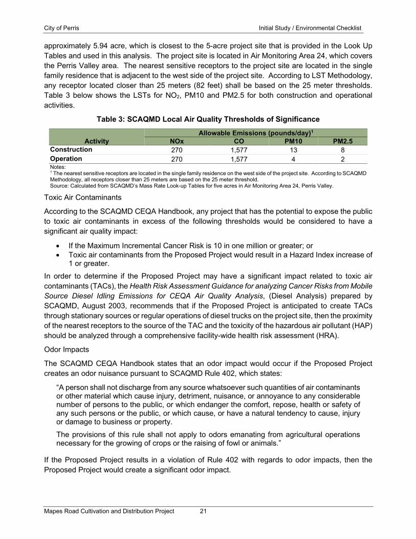
approximately 5.94 acre, which is closest to the 5-acre project site that is provided in the Look Up Tables and used in this analysis. The project site is located in Air Monitoring Area 24, which covers the Perris Valley area. The nearest sensitive receptors to the project site are located in the single family residence that is adjacent to the west side of the project site. According to LST Methodology, any receptor located closer than 25 meters (82 feet) shall be based on the 25 meter thresholds. Table 3 below shows the LSTs for NO2, PM10 and PM2.5 for both construction and operational activities.
Table 3: SCAQMD Local Air Quality Thresholds of Significance
Activity Allowable Emissions (pounds/day)1
NOx CO PM10 PM2.5 Construction 270 1,577 13 8 Operation 270 1,577 4 2 Notes: 1 The nearest sensitive receptors are located in the single family residence on the west side of the project site. According to SCAQMD Methodology, all receptors closer than 25 meters are based on the 25 meter threshold. Source: Calculated from SCAQMD’s Mass Rate Look-up Tables for five acres in Air Monitoring Area 24, Perris Valley.
Toxic Air Contaminants
According to the SCAQMD CEQA Handbook, any project that has the potential to expose the public to toxic air contaminants in excess of the following thresholds would be considered to have a significant air quality impact:
• If the Maximum Incremental Cancer Risk is 10 in one million or greater; or • Toxic air contaminants from the Proposed Project would result in a Hazard Index increase of
1 or greater. In order to determine if the Proposed Project may have a significant impact related to toxic air contaminants (TACs), the Health Risk Assessment Guidance for analyzing Cancer Risks from Mobile Source Diesel Idling Emissions for CEQA Air Quality Analysis, (Diesel Analysis) prepared by SCAQMD, August 2003, recommends that if the Proposed Project is anticipated to create TACs through stationary sources or regular operations of diesel trucks on the project site, then the proximity of the nearest receptors to the source of the TAC and the toxicity of the hazardous air pollutant (HAP) should be analyzed through a comprehensive facility-wide health risk assessment (HRA).
Odor Impacts
The SCAQMD CEQA Handbook states that an odor impact would occur if the Proposed Project creates an odor nuisance pursuant to SCAQMD Rule 402, which states:
“A person shall not discharge from any source whatsoever such quantities of air contaminants or other material which cause injury, detriment, nuisance, or annoyance to any considerable number of persons to the public, or which endanger the comfort, repose, health or safety of any such persons or the public, or which cause, or have a natural tendency to cause, injury or damage to business or property. The provisions of this rule shall not apply to odors emanating from agricultural operations necessary for the growing of crops or the raising of fowl or animals.”
If the Proposed Project results in a violation of Rule 402 with regards to odor impacts, then the Proposed Project would create a significant odor impact.

City of Perris Initial Study / Environmental Checklist
Mapes Road Cultivation and Distribution Project 22
Project Impacts:
a) Would the Project conflict with or obstruct implementation of the applicable air quality plan?
Less Than Significant Impact: The following analysis evaluates construction and operational regional air quality impacts and consistency with the SCAQMD Air Quality Management Plan.
SCAQMD Air Quality Management Plan
The California Environmental Quality Act (CEQA) requires a discussion of any inconsistencies between a Proposed Project and applicable General Plans and regional plans (CEQA Guidelines Section 15125). The regional plan that applies to the Proposed Project includes the SCAQMD AQMP. Therefore, this section discusses any potential inconsistencies of the Proposed Project with the AQMP.
The purpose of this discussion is to set forth the issues regarding consistency with the assumptions and objectives of the AQMP and discuss whether the Proposed Project would interfere with the region’s ability to comply with Federal and State air quality standards. If the decision-makers determine that the Proposed Project is inconsistent, the lead agency may consider project modifications or inclusion of mitigation to eliminate the inconsistency.
The SCAQMD CEQA Handbook states that "New or amended GP Elements (including land use zoning and density amendments), Specific Plans, and significant projects must be analyzed for consistency with the AQMP." Strict consistency with all aspects of the plan is usually not required. A Proposed Project should be considered to be consistent with the AQMP if it furthers one or more policies and does not obstruct other policies. The SCAQMD CEQA Handbook identifies two key indicators of consistency:
(1) Whether the project will result in an increase in the frequency or severity of existing air quality violations or cause or contribute to new violations or delay timely attainment of air quality standards or the interim emission reductions specified in the AQMP.
(2) Whether the project will exceed the assumptions in the AQMP, or increments based on the year of project buildout and phase.
Both of these criteria are evaluated in the following sections.
Criterion 1 - Increase in the Frequency or Severity of Violations?
Based on the air quality modeling analysis contained in this report, short-term regional construction air emissions would not result in significant impacts based on SCAQMD regional thresholds of significance or local thresholds of significance. The ongoing operation of the Proposed Project would generate air pollutant emissions that are inconsequential on a regional basis and would not result in significant impacts based on SCAQMD thresholds of significance. The analysis for long-term local air quality impacts showed that local pollutant concentrations would not be projected to exceed the air quality standards. Therefore, a less than significant long-term impact would occur, and no mitigation would be required.
Therefore, based on the information provided above, the Proposed Project would be consistent with the first criterion.

City of Perris Initial Study / Environmental Checklist
Mapes Road Cultivation and Distribution Project 23
Criterion 2 Exceed Assumptions in the AQMP?
Consistency with the AQMP assumptions is determined by performing an analysis of the Proposed Project with the assumptions in the AQMP. The emphasis of this criterion is to ensure that the analyses conducted for the Proposed Project are based on the same forecasts as the AQMP. The AQMP is developed through use of the planning forecasts provided in the RTP/SCS and FTIP. The RTP/SCS is a major planning document for the regional transportation and land use network within Southern California. The RTP/SCS is a long-range plan that is required by federal and state requirements placed on SCAG and is updated every four years. The FTIP provides long-range planning for future transportation improvement projects that are constructed with state and/or federal funds within Southern California. Local governments are required to use these plans as the basis of their plans for the purpose of consistency with applicable regional plans under CEQA. For this project, the City of Perris General Plan’s Land Use Plan defines the assumptions that are represented in AQMP.
The Proposed Project is currently designated as General Industrial (GI) in the General Plan and is zoned General Industrial (GI). Cultivation and warehousing are allowed uses within the current land use designation and zoning and would not require a General Plan Amendment or zone change. As such, the Proposed Project is not anticipated to exceed the AQMP assumptions for the project site and is found to be consistent with the AQMP for the second criterion.
Based on the above, the Proposed Project will not result in an inconsistency with the SCAQMD AQMP. Therefore, a less than significant impact will occur in relation to implementation of the AQMP.
b) Would the project result in a cumulatively considerable net increase of any criteria pollutant for which the project region in non-attainment under an applicable federal or state ambient air quality standard?
Less than Significant Impact: The Proposed Project would not result in a cumulatively considerable net increase of any criteria pollutant for which the project region is non-attainment under an applicable Federal or State ambient air quality standard. The following section calculates the potential air emissions associated with the construction and operations of the Proposed Project and compares the emissions to the SCAQMD standards.
Construction Emissions
The construction activities for the Proposed Project are anticipated to include site preparation and grading of the 5.94-acre project site, building construction of the 9,900 sq. ft. office and warehousing building and four 18,900 sq. ft. greenhouse cultivation buildings, paving of the onsite roadways and parking lots, and application of architectural coatings. The construction emissions have been analyzed for both regional and local air quality impacts.
Construction-Related Regional Impacts
The California Emissions Estimator Model (CalEEMod) has been utilized to calculate the construction-related regional emissions from the Proposed Project. The worst-case summer or winter daily construction-related criteria pollutant emissions from the Proposed Project for each phase of construction activities are shown below in Table 4. Since it is possible that building construction, paving, and architectural coating activities may occur concurrently, Table 4 shows the combined criteria pollutant emissions from building construction, paving, and architectural coating phases of construction.

City of Perris Initial Study / Environmental Checklist
Mapes Road Cultivation and Distribution Project 24
Table 4: Construction-Related Regional Criteria Pollutant Emissions
Pollutant Emissions (pounds/day)
Activity VOC NOx CO SO2 PM10 PM2.5 Site Preparation1 Onsite2 4.34 45.57 22.06 0.04 10.52 6.67 Offsite3 0.12 0.74 0.93 0.00 0.25 0.07 Total 4.46 46.31 22.99 0.04 10.77 6.74 Grading1 Onsite 2.43 26.39 16.05 0.03 4.22 2.69 Offsite 0.09 0.66 0.72 0.00 0.21 0.06 Total 2.52 27.05 16.77 0.03 4.43 2.75 Combined Building Construction, Paving, and Architectural Coatings Onsite 18.15 34.79 33.32 0.05 1.96 1.83 Offsite 0.53 2.84 4.01 0.01 1.17 0.34 Total 18.68 37.63 37.33 0.06 3.13 2.17 Maximum Daily Construction Emissions 18.68 46.31 37.33 0.06 10.77 6.74
SCQAMD Thresholds 75 100 550 150 150 55 Exceeds Threshold? No No No No No No Notes: 1 Site Preparation and Grading based on adherence to fugitive dust suppression requirements from SCAQMD Rule 403. 2 Onsite emissions from equipment not operated on public roads. 3 Offsite emissions from vehicles operating on public roads. Source: CalEEMod Version 2016.3.2.
Table 4 shows that none of the analyzed criteria pollutants would exceed the regional emissions thresholds during either site preparation, grading or the combined building construction, paving, and architectural coatings phases. Therefore, a less than significant regional air quality impact would occur from construction of the Proposed Project.
Construction-related air emissions may have the potential to exceed the State and Federal air quality standards in the project vicinity, even though these pollutant emissions may not be significant enough to create a regional impact to the Air Basin.
The local air quality emissions from construction were analyzed through utilizing the methodology described in Localized Significance Threshold Methodology (LST Methodology), prepared by SCAQMD, revised October 2009. The LST Methodology found the primary criteria pollutant emissions of concern are NOx, CO, PM10, and PM2.5. In order to determine if any of these pollutants require a detailed analysis of the local air quality impacts, each phase of construction was screened using the SCAQMD’s Mass Rate LST Look-up Tables. The Look-up Tables were developed by the SCAQMD in order to readily determine if the daily onsite emissions of CO, NOx, PM10, and PM2.5 from the Proposed Project could result in a significant impact to the local air quality. Table 5 shows the onsite emissions from the CalEEMod model for the different construction phases. Since it is possible that building construction, paving, and architectural coating activities may occur concurrently, Table 5 also shows the combined local criteria pollutant emissions from building construction, paving and architectural coating phases of construction.

City of Perris Initial Study / Environmental Checklist
Mapes Road Cultivation and Distribution Project 25
Table 5: Construction-Related Local Criteria Pollutant Emissions
Pollutant Emissions (pounds/day)
Phase NOx CO PM10 PM2.5 Site Preparation1 45.57 22.06 10.52 6.67 Grading1 26.39 16.05 4.22 2.69 Combined Building Construction, Paving, and Architectural Coatings 34.79 33.32 1.96 1.83
- Building Construction 19.19 16.85 1.12 1.05 - Paving 14.07 14.65 0.75 0.69 - Architectural Coatings 1.53 1.82 0.09 0.09 Maximum Daily Construction Emissions 45.57 33.32 10.52 6.67 SCAQMD Thresholds for 25 meters (82 feet)2 270 1,577 13 8 Exceeds Threshold? No No No No Notes: 1 Site Preparation and Grading based on adherence to fugitive dust suppression requirements from SCAQMD Rule 403. 2 The nearest sensitive receptors are located in the mobile home park on the west side of the project site. According to SCAQMD Methodology, all receptors closer than 25 meters are based on the 25 meter threshold. Source: Calculated from SCAQMD’s Mass Rate Look-up Tables for five acres in Air Monitoring Area 24, Perris Valley.
The data provided in Table 5 shows that none of the analyzed criteria pollutants would exceed the local emissions thresholds during either the site preparation, grading or the combined building construction, paving, and architectural coatings phases. Therefore, a less than significant local air quality impact would occur from construction of the Proposed Project.
Operational Emissions
The on-going operation of the Proposed Project would result in a long-term increase in air quality emissions. This increase would be due to emissions from the project-generated vehicle trips, emissions from onsite area sources and emissions from energy usage created from the on-going use of the Proposed Project. The following section provides an analysis of potential long-term air quality impacts due to regional air quality and local air quality impacts with the on-going operations of the Proposed Project.
Operations-related Regional Criteria Pollutant Analysis
The operations-related regional criteria air quality impacts created by the Proposed Project have been analyzed through use of the CalEEMod model. The worst-case summer or winter VOC, NOx, CO, SO2, PM10, and PM2.5 daily emissions created from the Proposed Project’s long-term operations have been calculated and are summarized below in Table 6.
Table 6: Operational Regional Criteria Pollutant Emissions
Pollutant Emissions (pounds/day) Activity VOC NOx CO SO2 PM10 PM2.5 Area Sources1 1.94 0.00 0.02 0.00 0.00 0.00 Energy Usage2 0.01 0.05 0.04 0.00 0.00 0.00 Mobile Sources3 1.32 22.65 15.10 0.12 6.22 1.79 Total Emissions 3.27 22.70 15.16 0.12 6.22 1.79 SCAQMD Operational Thresholds 55 55 550 150 150 55 Exceeds Threshold? No No No No No No Notes: 1 Area sources consist of emissions from consumer products, architectural coatings, and landscaping equipment. 2 Energy usage consist of emissions from natural gas usage. 3 Mobile sources consist of emissions from vehicles and road dust. Source: Calculated from CalEEMod Version 2016.3.2.

City of Perris Initial Study / Environmental Checklist
Mapes Road Cultivation and Distribution Project 26
The data provided in Table 7 below shows that none of the analyzed criteria pollutants would exceed the regional emissions thresholds. Therefore, a less than significant regional air quality impact would occur from operation of the Proposed Project.
Pursuant to the Sierra Club v. Friant Ranch Supreme Court Ruling (Case No. S219783, December 24, 2018), which found on page 6 of the ruling that EIRs need to “make a reasonable effort to substantively connect a project’s air quality impacts to likely health consequences.” Also, on page 24 of the ruling it states “The Court of Appeal identified several ways in which the EIR could have framed the analysis so as to adequately inform the public and decision makers of possible adverse health effects. The County could have, for example, identified the Project’s impact on the days of nonattainment per year.”
Table 6 above shows that the primary source of operational air emissions would be created from mobile source emissions that would be generated throughout the Air Basin. As such, any adverse health impacts created from the Proposed Project should be assessed on a basin-wide level. As indicated above in Table 6, the Air Basin has been designated by EPA for the national standards as a non-attainment area for ozone, PM2.5, and partial non-attainment for lead. In addition, PM10 has been designated by the State as non-attainment. It should be noted that VOC and NOx are ozone precursors, as such they have been considered as non-attainment pollutants. According to the 2016 AQMP, in 2016 the total emissions of: VOC was 500 tons per year; NOx was 522 tons per year; SOx was 18 tons per year; and PM2.5 was 66 tons per year. Since the 2016 AQMP did not calculate total PM10 emissions, the total PM10 emissions were obtained from The California Almanac of Emissions and Air Quality 2013 Edition, prepared by California Air Resources Board (CARB), for the year 2020. The project contribution to each criteria pollutant in the South Coast Air Basin is shown in Table 7.
Table 7: Project’s Contribution to Criteria Pollutants in the South Coast Air Basin
Pollutant Emissions (pounds/day) Emissions Source VOC NOx CO SO2 PM10 PM2.5
Project Emissions1 3.27 22.70 15.16 0.12 6.22 1.79
Total Emissions in Air Basin2 1,000,00
0 1,044,00
0 4,246,00
0 36,000 322,000 132,000
Project’s Percent of Air Emissions 0.0003% 0.0022% 0.0004% 0.00033
% 0.0019
% 0.0014
% SCQAMD Operational Thresholds 55 55 550 150 150 55 Exceeds Threshold? No No No No No No Notes: 1 From the project’s total operational emissions shown above in Table 6. 2 VOC, NOx, CO, SO2 and PM2.5 from 2016 AQMP and PM10 from the California Almanac of Emissions and Air Quality 2013 Edition.
As shown in Table 7, the project would increase criteria pollutant emissions by as much as 0.0022 percent for NOx in the South Coast Air Basin. Due to these nominal increases in the Air Basin-wide criteria pollutant emissions, no increases in days of non-attainment are anticipated to occur from operation of the Proposed Project. As such, operation of the project is not anticipated to result in a quantitative increase in premature deaths, asthma in children, days children will miss school, asthma-related emergency room visits, or an increase in acute bronchitis among children due to the criteria pollutants created by the Proposed Project. Therefore, impacts would be less than significant.

City of Perris Initial Study / Environmental Checklist
Mapes Road Cultivation and Distribution Project 27
Operations-Related Local Air Quality Impacts
Project-related air emissions may have the potential to exceed the State and Federal air quality standards in the project vicinity, even though these pollutant emissions may not be significant enough to create a regional impact to the Air Basin. The Proposed Project has been analyzed for the potential local CO emission impacts from the project-generated vehicular trips and from the potential local air quality impacts from on-site operations. The following analyzes the vehicular CO emissions and local impacts from on-site operations.
Local CO Hotspot Impacts from Project-Generated Vehicular Trips
CO is the pollutant of major concern along roadways because the most notable source of CO is motor vehicles. For this reason, CO concentrations are usually indicative of the local air quality generated by a roadway network and are used as an indicator of potential local air quality impacts. Local air quality impacts can be assessed by comparing future without and with project CO levels to the State and Federal CO standards of 20 ppm over one hour or 9 ppm over eight hours.
At the time of the 1993 Handbook, the Air Basin was designated nonattainment under the CAAQS and NAAQS for CO. With the turnover of older vehicles, introduction of cleaner fuels, and implementation of control technology on industrial facilities, CO concentrations in the Air Basin and in the state have steadily declined. In 2007, the Air Basin was designated in attainment for CO under both the CAAQS and NAAQS. SCAQMD conducted a CO hot spot analysis for attainment at the busiest intersections in Los Angeles1 during the peak morning and afternoon periods and did not predict a violation of CO standards. Since the nearby intersections to the Proposed Project are much smaller with less traffic than what was analyzed by the SCAQMD, no local CO Hotspot are anticipated to be created from the Proposed Project and no CO Hotspot modeling was performed. Therefore, a less than significant long-term air quality impact is anticipated to local air quality with the on-going use of the Proposed Project.
Local Criteria Pollutant Impacts from Onsite Operations
Project-related air emissions from onsite sources such as architectural coatings, landscaping equipment, and onsite usage of natural gas appliances may have the potential to create emissions areas that exceed the State and Federal air quality standards in the project vicinity, even though these pollutant emissions may not be significant enough to create a regional impact to the Air Basin.
The local air quality emissions from onsite operations were analyzed using the SCAQMD’s Mass Rate LST Look-up Tables and the methodology described in LST Methodology. The Look-up Tables were developed by the SCAQMD in order to readily determine if the daily emissions of CO, NOx, PM10, and PM2.5 from the Proposed Project could result in a significant impact to the local air quality. Table 8 shows the onsite emissions from the CalEEMod model that includes area sources, energy usage, and vehicles operating in the immediate vicinity of the project site and the calculated emissions thresholds.
1 The four intersections analyzed by the SCAQMD were: Long Beach Boulevard and Imperial Highway; Wilshire Boulevard and Veteran Avenue; Sunset Boulevard and Highland Avenue; and La Cienega Boulevard and Century Boulevard. The busiest intersection evaluated (Wilshire and Veteran) had a daily traffic volume of approximately 100,000 vehicles per day with LOS E in the morning and LOS F in the evening peak hour.

City of Perris Initial Study / Environmental Checklist
Mapes Road Cultivation and Distribution Project 28
Table 8: Operations-Related Local Criteria Pollutant Emissions
Pollutant Emissions (pounds/day) Onsite Emission Source NOx CO PM10 PM2.5
Area Sources 0.00 0.02 0.00 0.00 Energy Usage 0.05 0.04 0.00 0.00 Onsite Vehicle Emissions1 2.27 1.51 0.62 0.18 Total Emissions 2.32 1.57 0.62 0.18 SCAQMD Thresholds for 25 meters (82 feet)2 270 1,577 4 2 Exceeds Threshold? No No No No Notes: 1 Onsite vehicle emissions based on 2.5 percent of the gross vehicular emissions, which is the estimated portion of vehicle emissions occurring within a quarter mile of the project site. 2 The nearest sensitive receptors are located in the mobile home park on the west side of the project site. According to SCAQMD Methodology, all receptors closer than 25 meters are based on the 25 meter threshold. Source: Calculated from SCAQMD’s Mass Rate Look-up Tables for five acres in Air Monitoring Area 24, Perris Valley.
The data provided in Table 8 shows that the on-going operations of the Proposed Project would not exceed the local NOx, CO, PM10 and PM2.5 thresholds of significance. Therefore, the on-going operations of the Proposed Project would create a less than significant operations-related impact to local air quality due to onsite emissions and no mitigation would be required. Therefore, the Proposed Project would not result in a cumulatively considerable net increase of any criteria pollutant.
c) Would the Project expose sensitive receptors to substantial pollutant concentrations?
Less than Significant Impact: The Proposed Project would not expose sensitive receptors to substantial pollutant concentrations. The local concentrations of criteria pollutant emissions produced in the nearby vicinity of the Proposed Project, which may expose sensitive receptors to substantial concentrations have been calculated for both construction and operations, which are discussed separately below. The discussion below also includes an analysis of the potential impacts from toxic air contaminant emissions.
Construction-Related Sensitive Receptor Impacts
Construction activities may expose sensitive receptors to substantial pollutant concentrations of localized criteria pollutant concentrations and from toxic air contaminant emissions created from onsite construction equipment, which are described below.
Local Criteria Pollutant Impacts from Construction
The local air quality impacts from construction of the Proposed Project has been analyzed and found that the construction of the Proposed Project would not exceed the local NOx, CO, PM10 and PM2.5 thresholds of significance. Therefore, construction of the Proposed Project would create a less than significant construction-related impact to local air quality and no mitigation would be required.
Toxic Air Contaminants Impacts from Construction
The greatest potential for toxic air contaminant emissions would be related to diesel particulate matter (DPM) emissions associated with heavy equipment operations during construction of the Proposed Project. According to SCAQMD methodology, health effects from carcinogenic air toxics are usually described in terms of “individual cancer risk”. “Individual Cancer Risk” is the likelihood that a person exposed to concentrations of toxic air contaminants over a 70-year lifetime will contract cancer, based on the use of standard risk-assessment methodology. It should be noted that the most current cancer risk assessment methodology recommends analyzing a 30-year exposure period for the nearby sensitive receptors (OEHHA, 2015).

City of Perris Initial Study / Environmental Checklist
Mapes Road Cultivation and Distribution Project 29
Given the relatively limited number of heavy-duty construction equipment, the varying distances that construction equipment would operate to the nearby sensitive receptors, and the short-term construction schedule, the Proposed Project would not result in a long-term (i.e., 30 or 70 years) substantial source of toxic air contaminant emissions and corresponding individual cancer risk. In addition, California Code of Regulations Title 13, Article 4.8, Chapter 9, Section 2449 regulates emissions from off-road diesel equipment in California. This regulation limits idling of equipment to no more than five minutes, requires equipment operators to label each piece of equipment and provide annual reports to CARB of their fleet’s usage and emissions. This regulation also requires systematic upgrading of the emission Tier level of each fleet, and currently no commercial operator is allowed to purchase Tier 0 or Tier 1 equipment and by January 2023 no commercial operator is allowed to purchase Tier 2 equipment. In addition to the purchase restrictions, equipment operators need to meet fleet average emissions targets that become more stringent each year between years 2014 and 2023. Therefore, no significant short-term toxic air contaminant impacts would occur during construction of the Proposed Project. As such, construction of the Proposed Project would result in a less than significant exposure of sensitive receptors to substantial pollutant concentrations.
Operations-Related Sensitive Receptor Impacts
The on-going operations of the Proposed Project may expose sensitive receptors to substantial pollutant concentrations of local CO emission impacts from the project-generated vehicular trips and from the potential local air quality impacts from onsite operations. The following analyzes the vehicular CO emissions. Local criteria pollutant impacts from onsite operations, and toxic air contaminant impacts.
Local CO Hotspot Impacts from Project-Generated Vehicle Trips
CO is the pollutant of major concern along roadways because the most notable source of CO is motor vehicles. For this reason, CO concentrations are usually indicative of the local air quality generated by a roadway network and are used as an indicator of potential impacts to sensitive receptors. The analysis provided shows that no local CO Hotspots are anticipated to be created at any nearby intersections from the vehicle traffic generated by the Proposed Project. Therefore, operation of the Proposed Project would result in a less than significant exposure of offsite sensitive receptors to substantial pollutant concentrations.
Local Criteria Pollutant impacts from Onsite operations
The local air quality impacts from the operation of the Proposed Project would occur from onsite sources such as architectural coatings, landscaping equipment, and onsite usage of natural gas appliances. The analysis provided found that the operation of the Proposed Project would not exceed the local NOx, CO, PM10 and PM2.5 thresholds of significance. Therefore, the on-going operations of the Proposed Project would create a less than significant operations-related impact to local air quality due to on-site emissions and no mitigation would be required.
Operations-Related Toxic Air Contaminant Impacts
Particulate matter (PM) from diesel exhaust is the predominant TAC in most areas and according to The California Almanac of Emissions and Air Quality 2013 Edition, prepared by CARB, about 80 percent of the outdoor TAC cancer risk is from diesel exhaust. Some chemicals in diesel exhaust, such as benzene and formaldehyde have been listed as carcinogens by State Proposition 65 and the Federal Hazardous Air Pollutants program.

City of Perris Initial Study / Environmental Checklist
Mapes Road Cultivation and Distribution Project 30
Due to the nominal number of diesel truck trips that are anticipated to be generated by the Proposed Project, a less than significant TAC impact would occur during the on-going operations of the Proposed Project and no mitigation would be required. Therefore, operation of the Proposed Project would result in a less than significant exposure of sensitive receptors to substantial pollutant concentrations.
d) Would the Project result in other emissions such as those leading to odors adversely affecting a substantial number of people?
Less than Significant Impact: The Proposed Project would not create objectionable odors affecting a substantial number of people. Individual responses to odors are highly variable and can result in a variety of effects. Generally, the impact of an odor results from a variety of factors such as frequency, duration, offensiveness, location, and sensory perception. The frequency is a measure of how often an individual is exposed to an odor in the ambient environment. The intensity refers to an individual’s or group’s perception of the odor strength or concentration. The duration of an odor refers to the elapsed time over which an odor is experienced. The offensiveness of the odor is the subjective rating of the pleasantness or unpleasantness of an odor. The location accounts for the type of area in which a potentially affected person lives, works, or visits; the type of activity in which he or she is engaged; and the sensitivity of the impacted receptor.
Sensory perception has four major components: detectability, intensity, character, and hedonic tone. The detection (or threshold) of an odor is based on a panel of responses to the odor. There are two types of thresholds: the odor detection threshold and the recognition threshold. The detection threshold is the lowest concentration of an odor that will elicit a response in a percentage of the people that live and work in the immediate vicinity of the project site and is typically presented as the mean (or 50 percent of the population). The recognition threshold is the minimum concentration that is recognized as having a characteristic odor quality, this is typically represented by recognition by 50 percent of the population. The intensity refers to the perceived strength of the odor. The odor character is what the substance smells like. The hedonic tone is a judgment of the pleasantness or unpleasantness of the odor. The hedonic tone varies in subjective experience, frequency, odor character, odor intensity, and duration. Potential odor impacts have been analyzed separately for construction and operations below.
Construction-Related Odor Impacts
Potential sources that may emit odors during construction activities include the application of coatings such as asphalt pavement, paints and solvents and from emissions from diesel equipment. The objectionable odors that may be produced during the construction process would be temporary and would not likely be noticeable for extended periods of time beyond the project site’s boundaries. Due to the transitory nature of construction odors, a less than significant odor impact would occur and no mitigation would be required.
Operations-Related Odor Impacts
The Proposed Project would consist of the development of a 9,900 square foot office and warehousing building and four 18,900 square foot greenhouse cultivation buildings. According to the project applicant the proposed cannabis cultivation area would utilize a climate control system that automates the temperature, humidity, CO2, and intake and exhaust air rates. In addition, the exhaust air will be treated with a carbon filter, prior to being released to the outside air. The

City of Perris Initial Study / Environmental Checklist
Mapes Road Cultivation and Distribution Project 31
combination of this equipment allows for the cultivation facility to operate very efficiently with minimal waste that lowers the odor emissions created from the proposed facility.
It should also be noted that Section 5.58.100(c) of the Municipal Code requires the installation of air treatment systems in all proposed structures utilized for marijuana operations that provide sufficient odor absorbing ventilation and exhaust systems so that any odor generated inside the structures is not detected on the adjacent properties. Therefore, with adherence to Section 5.58.100(c) of the Municipal Code, a less than significant odor impact would occur, and no mitigation would be required.

City of Perris Initial Study / Environmental Checklist
Mapes Road Cultivation and Distribution Project 32
4.4 Biological Resources
Would the Project:
Potentially Significant
Impact
Less Than Significant
with Mitigation
Less Than Significant
Impact
No Impact
a) Have a substantial adverse effect, either directly or through habitat modifications, on any species identified as a candidate, sensitive, or special status species in local or regional plans, policies, or regulations, or by the California Department of Fish and Wildlife or U.S. Fish and Wildlife Service?
b) Have a substantial adverse effect on any riparian habitat or other sensitive natural community identified in local or regional plans, policies, and regulations, or by the California Department of Fish and Wildlife or U.S. Fish and Wildlife Service?
c) Have a substantial adverse effect on state or federally protected wetlands (including, but not limited to, marsh, vernal pool, coastal, etc.) through direct removal, filling, hydrological interruption, or other means?
d) Interfere substantially with the movement of any native resident or migratory fish or wildlife species or with established native resident or migratory wildlife corridors, or impede the use of native wildlife nursery sites?
e) Conflict with any local policies or ordinances protecting biological resources, such as a tree preservation policy or ordinance?
f) Conflict with the provisions of an adopted Habitat Conservation Plan, Natural Community Conservation Plan, or other approved local, regional, or state habitat conservation plan?
Environmental Analysis:
The following analysis is based on Biological Resource Report prepared by Mikael Romich Biological Services in November 2018. The Biological Resources report is presented in its entirety in Appendix B.

City of Perris Initial Study / Environmental Checklist
Mapes Road Cultivation and Distribution Project 33
Project Impacts:
a) Would the Project have a substantial adverse effect, either directly or through habitat modifications, on any species identified as a candidate, sensitive, or special status species in local or regional plans, policies, or regulations, or by the California Department of Fish and Wildlife or the U.S. Fish and Wildlife Service?
No Impact: Special-status biological resources present or potentially present on the site and surrounding areas were identified through a combination of literature searches. The following sources were used during the literature review process.
• U.S. Department of Agriculture (USDA) (2018) web soil survey was queried for soils types.
• U.S. Fish and Wildlife Service (USFWS) Critical Habitat within the project (USFWS 2018).
• California Natural Diversity Database (CDFW 2019) was queried to compile a list of potentially occurring flora and fauna within the City of Perris, Romoland, Lake Elsinore, and Steele Peak USGS quadrangles.
• California Native Plant Society Inventory of Rare, Threatened, and Endangered Plants of California, 8th online edition (CNPS 2019), was searched to compose a list of potentially occurring flora in the Perris, Romoland, Lake Elsinore, and Steele Peak USGS quadrangles.
Plants
As shown in Appendix B of the Biological Resources Report, the literature review conducted for the project site found 21 special-status plant species documented in the region of the site. However, none of these species are expected to occur on the site due to a lack of suitable habitat and soils, and the high level of disturbance. Therefore, no substantial adverse direct or indirect impacts to special status species would occur. No mitigation required.
Wildlife
As shown in Appendix B of the Biological Resources Report, the literature review conducted for the project site found 32 special-status wildlife species documented in the region of the site. However, none of these species are expected to occur on the site due to a lack of suitable habitat and the high level of disturbance. Therefore, no substantial adverse direct or indirect impacts to special status wildlife species would occur. No mitigation measures are required.
b) Would the Project have a substantial adverse effect on any riparian habitat or other sensitive natural community identified in local or regional plans, policies, and regulations, or by the California Department of Fish and Wildlife or the U.S. Fish and Wildlife Service?
No Impact: One vegetation community was documented on the site, annual brome grasslands. This community is dominated by non-native brome grasslands mixed with non-native mustards. As shown in Figure 3 of the Biological Resources Report, the vegetation community only occurs in the far northeastern corner of the site in a small area (0.1 acre) that has not been subject to periodic disking. The remainder of the property consists bare ground or disturbed lands with non-native weeds, including; telegraph weed (Heterotheca grandiflora), common sunflower (Helianthus annuus), annual burweed (Ambrosia acanthicarpa), red-stemmed filaree (Erodium cicutarium), Russian thistle (Salsola tragus), and clustered tarweed (Deinandra fasciculata) cover type. There are no native natural communities on the project site. No mitigation required.

City of Perris Initial Study / Environmental Checklist
Mapes Road Cultivation and Distribution Project 34
c) Would the Project have a substantial adverse effect on state or federally protected wetlands (including, but not limited to, marsh, vernal pool, coastal, etc.) through direct removal, filling, hydrological interruption, or other means?
No Impact: A preliminary assessment of Waters of the U.S. and State and Wetland Waters of the U.S. and State was prepared based of the Corps of Engineers Wetland Delineation Manual Arid Region West. A three-parameter approach was used to identify potential Waters of the U.S. and State. These parameters included the presence of wetland vegetation, presence of drainages and hydrology and the presence of hydric soils. The preliminary wetland assessment showed that the site lacked defined drainages or wetland habitat that contained the required parameters that define Wetland Waters of the U.S./State. Based on the absence of onsite drainages and wetlands, the construction of the Proposed Project would not result in adverse impacts to non- Waters or Wetland Waters of the U.S./State. No mitigation required.
d) Would the Project interfere substantially with the movement of any native resident or migratory fish or wildlife species or with established native resident or migratory wildlife corridors, or impede the use of native wildlife nursery sites?
No impact: The project site is in an industrial area surrounded by nearby developed urbanized land uses and is not connected to any open space corridors that facilitate wildlife movement. The project site does not contain water bodies to support migratory fish or habitat to support migratory birds. No adverse impacts to migratory species would occur. No mitigation required.
e) Would the Project conflict with any local policies or ordinance protecting biological resources, such as a tree preservation policy or ordinance?
No Impact: The project site does not contain trees or other biological resources. Therefore, no conflicts would occur. No mitigation required.
f) Would the Project conflict with the provisions of an adopted Habitat Conservation Plan, Natural Community Conservation Plan, or other approved local, regional, or state habitat conservation plan?
Less than Significant Impact with Mitigation: The project site is included within the Western Riverside County Multiple Species Habitat Conservation Plan (MSHCP). The project site does not overlap or occur adjacent to any area conserved or targeted for conservation by the MSHCP. Therefore, development of the project site would not impact any conservation goals of the MSHCP. The site overlaps an MSHCP required habitat assessment area for the burrowing owl. The sections below address burrowing owl, riparian/riverine areas, vernal pools, fairy shrimp habitat, urban/wildlands interface guidelines, and identifies any identifies any migratory corridors and linkages located on or near the site.
Burrowing Owl
The parcel does not provide suitable nesting or cover sites for burrowing owl due to a lack of suitable burrows. No burrows or other artificial substrates (such as pipe, concrete rubble, or rip-rap) were observed on the project. In addition, no California ground squirrels were observed, which constructs burrows that can be used by burrowing owls. The project site does provide suitable foraging habitat although it was very sparsely vegetated during the habitat assessment. The areas to the west of the project site do not appear suitable for burrowing owls due to high cover of ornamental trees (such as pines, Peruvian pepper, Brazilian pepper, and eucalyptus). The area to the north is not suitable as it

City of Perris Initial Study / Environmental Checklist
Mapes Road Cultivation and Distribution Project 35
is fully developed. The areas to the south and east appear to be in a similar state to the parcel, highly disturbed due to regular disking.
Currently, the project site does not support burrows for burrowing owl and no burrowing owls or sign of burrowing owl was observed. To ensure conditions on the project site do not change prior to implementation of any Proposed Project a burrowing owl survey shall be completed before the start of grading operations.
Riparian/Riverine, Vernal Pool and Fairy Shrimp Habitat
Section 6.1.2 of the Western Riverside County MSHCP describes the process to protect species associated with riparian/riverine areas and vernal pools. As defined in the MSHCP, riparian/riverine areas are lands that contain habitat dominated by trees, shrubs, persistent emergent or emergent mosses and lichens that occur close to or depend on a nearby freshwater source or areas that contain a freshwater flow during all or a portion of the year.
These habitats could support one or more species listed in Section 6.1.2 of the MSHCP. Vernal pools are seasonal wetlands that occur in depressions, typically have wetland indicators that represent all three parameters (soils, vegetation, and hydrology), and are defined based on vernal pool indicator plant species during the wetter portion of the growing season but normally lack wetland indicators associated with vegetation and/or hydrology during the drier portion of the growing season. No riparian/riverine, vernal pools or fairy shrimp habitat occurs in the project site. The soils on the project site are well-drained and not typical to supporting vernal pools and ponded areas. No depressions or swales were observed. A review of aerials from 2005-2018 did not suggest the presence of any ponded areas on the site.
Targeted/Existing Conservation
The MSHCP does not have any existing or targeted conservation lands that overlap the project site. To the south is Criteria Cell 3470 in subunit 4 (San Jacinto River Lower) of the MSHCP. According to the MSHCP, conservation within this Cell will range from 5%-15% in the southeastern portion of the Cell, which is approximately 0.4 mile south of the site.
Urban/Wildlands Interface Guidelines
According to Section 6.1.4 of the MSHCP, the Urban/Wildlands Interface Guidelines are intended to address indirect effects associated with locating development in proximity to the MSHCP Conservation Area. As the site is not located adjacent to the MSHCP Conservation Area, the Urban/Wildlands Interface Guidelines are not applicable to the Proposed Project.
Mitigation Measures
BIO-1: Prior to start of grading operations, a preconstruction burrowing owl survey shall be complete a maximum of 30 days prior to the start of construction. All areas of the project site shall be included, as well as a visual survey of the undeveloped property around the site. The results shall be provided as a letter report. If burrowing owls are observed within the site, additional coordination with the MSHCP and/or CDFW would be required. No burrowing owls may be harmed, and no burrowing owl occupied burrows may be collapsed between February 1 and August 31 to avoid the nesting season.

City of Perris Initial Study / Environmental Checklist
Mapes Road Cultivation and Distribution Project 36
4.5 Cultural Resources
Would the Project:
Potentially Significant
Impact
Less Than Significant
with Mitigation
Less Than Significant
Impact
No Impact
a) Cause a substantial adverse change in the significance of a historical resource pursuant to §15064.5?
b) Cause a substantial adverse change in the significance of an archaeological resource pursuant to §15064.5?
c) Disturb any human remains, including those interred outside of formal cemeteries?
Environmental Analysis:
The following analysis is based on a Cultural Resources Assessment prepared by VCS Environmental in June of 2019.
Background
Cultural resources include prehistoric archaeological sites, historic archaeological sites, historic structures, and artifacts made by people in the past. Prehistoric archaeological sites are places that contain the material remains of activities carried out by the native population of the area (Native Americans) prior to the arrival of Europeans in Southern California. Artifacts found in prehistoric sites include flaked stone tools such as projectile points, knives, scrapers, and drills; ground stone tools such as manos, metates, mortars, and pestles for grinding seeds and nuts; and bone tools. Historic archaeological sites are places that contain the material remains of activities carried out by people during the period when written records were produced after the arrival of Europeans. Historic archaeological material usually consists of refuse, such as bottles, cans and food waste, deposited near structure foundations. Historic structures include houses, commercial structures, industrial facilities, and other structures and facilities more than 50 years old.
Regulatory Setting
CEQA
CEQA requires a lead agency to determine whether a project would have a significant effect on one or more historical resources. A “historical resource” is defined as a resource listed in or determined to be eligible for listing in the California Register of Historical Resources (CRHR) (California Public Resources Code [PRC], Section 21084.1); a resource included in a local register of historical resources (14 California Code of Regulations [CCR], Section 15064.5[a][2]); or any object, building, structure, site, area, place, record, or manuscript that a lead agency determines to be historically significant (14 CCR 15064.5[a][3]).
City of Perris Initial Study / Environmental Checklist
Mapes Road Cultivation and Distribution Project 37
Section 5024.1 of PRC, Section 15064.5 of the State CEQA Guidelines (14 CCR), and Sections 21083.2 and 21084.1 of the CEQA Statutes were used as the basic guidelines for the cultural resources study. PRC 5024.1 requires evaluation of historical resources to determine their eligibility for listing on the CRHR. The purposes of the CRHR are to maintain listings of the State’s historical resources and to indicate which properties are to be protected from substantial adverse change. The criteria for listing resources in the CRHR were expressly developed to be in accordance with criteria developed for listing in the National Register of Historic Places (NRHP) (per the criteria listed in the Code of Federal Regulations [CFR], Title 36, Section 60.4) and include those listed below.
A resource may be listed as an historical resource in the California Register if it meets any of the following National Register of Historic Places criteria:
• Is associated with events that have made a significant contribution to the broad patterns of California’s history and cultural heritage.
• Is associated with the lives of persons important in our past. • Embodies the distinctive characteristics of a type, period, region, or method of construction,
or represents the work of an important creative individual, or possesses high artistic values or
• Has yielded, or may be likely to yield, information important in prehistory or history.
According to Section 15064.5(a)(3) (A–D) of the State CEQA Guidelines (14 CCR), a resource is considered historically significant if it meets the criteria for listing in the NRHP (per the criteria listed at 36 CFR 60.4, previously discussed). Impacts that affect those characteristics of the resource that qualify it for the NRHP or that would adversely alter the significance of a resource listed in or eligible for listing in the CRHR are considered to have a significant effect on the environment. Impacts to cultural resources from a project are thus considered significant if the project (1) physically destroys or damages all or part of a resource; (2) changes the character of the use of the resource or physical feature within the setting of the resource that contributes to its significance; or (3) introduces visual, atmospheric, or audible elements that diminish the integrity of significant features of the resource. The purpose of a cultural resource investigation is to evaluate whether any built environment cultural resources are present in or near the project area or can reasonably be expected to exist in the subsurface. If resources are discovered, management recommendations would be included that require evaluation of the resources for NRHP or CRHR eligibility.
Human Remains
Section 7050.5 of the California Health and Safety Code provides for the disposition of accidentally discovered human remains. Section 7050.5 states that, if human remains are found, no further excavation or disturbance of the site or any nearby area reasonably suspected to overlie adjacent remains shall occur until the County Coroner has determined the appropriate treatment and disposition of the human remains. Section 5097.98 of the PRC states that, if remains are determined by the Coroner to be of Native American origin, the Coroner must notify the Native American Heritage Commission within 24 hours which, in turn, must identify the person or persons it believes to be the most likely descended from the deceased Native American. The descendants shall complete their inspection within 48 hours of being granted access to the site. The designated Native American representative would then determine, in consultation with the property owner, the disposition of the human remains.

City of Perris Initial Study / Environmental Checklist
Mapes Road Cultivation and Distribution Project 38
Records Search
A literature review of documents on file at the Eastern Information Center (EIC) at the University of California, Riverside was completed by EIC staff on April 12, 2019. The review consisted of an examination of the U.S. Geological Survey’s (USGS) Perris 7.5-minute quadrangles to evaluate the project area for any cultural resource sites recorded or cultural resources studies conducted on the parcel and within a one-half mile radius. The EIC is the designated branch of the California Historical Resources Information System (CHRIS) and houses records concerning archaeological and historic resources in Riverside, Inyo, and Mono Counties. The records search provided data on known archaeological and built environment resources as well as previous studies within one-half mile of the Project site. Data sources consulted at the EIC included archaeological records, Archaeological Determinations of Eligibility (DOE), historic maps, and the Historic Property Data File (HPDF) maintained by the California Office of Historic Preservation (OHP). The HPDF contains listings for the CRHR and/or NRHP, California Historical Landmarks (CHL), and California Points of Historical Interest (CPHI).
The EIC search resulted in a finding that one cultural resource was partially on the Project site; however, as a result of inaccurate mapping by VCS, the Project site location sent to the EIC was incorrect and resulted in a faulty result. The EIC actually lists no previously recorded resources on the Project site. There are seven resources within one-half mile of the Project site; all historic structures. Table 9 briefly describes the known cultural resources within one-half mile of the project site.
Table 9: Cultural Resources Within One-Half Mile of the Project Site
Site Number Recorder (Year) Comment
33-007661 Harmon (1982) Historic
33-015379 Goodman, Cogan, and Jones (2006) Historic
33-015384 Rees (2006) Historic. 160 Mapes Road 33-015385 Rees (2006) Historic. 170 Mapes Road 33-015386 Rees (2006) Historic. 150-190 Mapes
Road 33-015387 Rees (2006) Historic. 280 Mapes Road 33-015388 Rees (2006) Historic. 310 Mapes Road
Studies
EIC information notes that seven cultural resources studies and four overviews have been conducted within a one-half mile radius of the Project site. One study—RI-06888—included the southernmost portion of the Project site. Table 10 identifies the previous cultural resources studies within one-half mile of the project site.

City of Perris Initial Study / Environmental Checklist
Mapes Road Cultivation and Distribution Project 39
Table 10: Studies On and Within One-Half Mile of the Project Site
Report Number Author(s) (Year) Type of Study/Comments RI-00002** Rogers (1953) Field Notes RI-00527 Barker (1979) Environmental Impact Evaluation RI-01955** Heller et al (1977) Cultural Resource Investigation RI-03604** Jones (1992) Thesis
RI-04762** Barker et al (1990) Proceedings of the Historic
Mining Conference
RI-06018 Tang et al (2003) Historical/Archaeological Resources Survey Report
RI-06744 Goodwin and Dalton (2006) Cultural Resources Assessment
*RI-06888 Lerch and Gray (2006) Cultural Resources Assessment
RI-07338 Tang and Horgan (2007)
Historical/Archaeological Resources Survey Report
RI-08101 McCormick and Gust (2006)
Archaeological and Paleontological Resources Assessment Report
RI-09791 Smith and Goralogia (2016) Phase I Cultural Resources Survey
*Located on the Project site; **Overviews
In summary, there are 11 recorded cultural resources within one-half mile of the Project site. One of the cultural resources studies is located within the current Project site. RI-06888: This was a Cultural Resources Assessment of the Valley-Ivyglen Transmission Line Project, Riverside County, California. It included a survey of the southernmost portion of the Project site. No resources were observed or recorded.
Field Survey
VCS Archaeologist Patrick Maxon and Daniel Bott completed the pedestrian survey of the project site on May 23, 2019. The site was surveyed on foot utilizing east-west trending survey transects spaced no more than five meters apart. The entire site was surveyed in this manner from west to east. The site’s ground visibility was very good as the site had recently been disked and cleared of all vegetation. Visibility approached 100%. No significant cultural resources were noted during the survey.
Project Impacts:
a) Would the Project cause a substantial adverse change in the significance of a historical resource pursuant to Section 15064.5?
Less than Significant Impact with Mitigation: An examination of the historic aerial photographs revealed that the site area has never been developed. By 1997 the site was essentially in the same state as it is currently – grubbed and cleared with development having occurred to the east and west of the site. In 1978, the next earlier photograph, no improvements have yet occurred at the project site save for dirt roads, which were not present in 1967. No historic structures have ever existed on the project site other than citrus operation. Additionally, no cultural resources have been previously

City of Perris Initial Study / Environmental Checklist
Mapes Road Cultivation and Distribution Project 40
recorded on the Project site. Therefore, implementation of the Proposed Project would not adversely affect any existing know cultural resources. However, because the region area is known to contain historical resources, a construction halt condition is recommended in the event unknown historical resources are encountered. With implementation of Mitigation Measure CR-1 potential impacts to unknown historic resources would be less than significant.
Mitigation Measure
CR-1: In the event unknown cultural resources are encountered during construction activities, all construction activities near the finding will cease, until a qualified archeologist can determine the significance of the finding and the course of action for its recovery.
b) Would the Project cause a substantial adverse change in the significance of an archaeological resource pursuant to Section 15064.5?
Less than Significant Impact with Mitigation. The record search prepared for the project site did not identify any known archeological resources on the project site. Additionally, pedestrian survey conducted on the project site did not show any evidence of archeological resources being present. Therefore, it is unlikely known archaeological resources would be present on the project site. However, because the region area is known to contain archeological resources, a construction halt condition is recommended in the event unknown archaeological resources are encountered.
Mitigation Measures
Mitigation Measure CR-1 is required.
c) Disturb any human remains, including those interred outside of formal cemeteries?
Less than Significant Impact with Mitigation: No human remains or cemeteries are known to exist within or near the project site However, there is always the potential that subsurface construction activities associated with the Proposed Project could potentially damage or destroy previously undiscovered human remains. Accordingly, this is a potentially significant impact. In the event of the accidental discovery or recognition of any human remains, CEQA Guidelines Section 15064.5; Health and Safety Code Section 7050.5; Public Resources Code Section 5097.94 and Section 5097.98 must be followed. With the implementation of Mitigation Measure CR-2 potential impacts to human remains would be less than significant.
Mitigation Measure CR-2: If human remains are encountered during excavation activities, all work shall halt in the vicinity of the remains and the County Coroner shall be notified (California Public Resources Code, Section 5097.98). The Coroner will determine whether the remains are of forensic interest. If the Coroner, with the aid of a qualified Archaeologist, determines that the remains are prehistoric, s/he will contact the Native American Heritage Commission (NAHC). The NAHC will be responsible for designating the most likely descendant (MLD), who will be responsible for the ultimate disposition of the remains, as required by Section 7050.5 of the California Health and Safety Code. The MLD shall make his/her recommendation within 48 hours of being granted access to the site. If feasible, the MLD’s recommendation should be followed and may include scientific removal and non-destructive analysis of the human remains and any items associated with Native American burials (California Health and Safety Code, Section 7050.5). If the landowner rejects the MLD’s recommendations, the landowner shall rebury the remains with appropriate dignity on the property in a location that will not be subject to further subsurface disturbance (California Public Resources Code, Section 5097.98).

City of Perris Initial Study / Environmental Checklist
Mapes Road Cultivation and Distribution Project 41
4.6 Energy
Would the Project:
Potentially Significant
Impact
Less Than Significant
with Mitigation
Less Than Significant
Impact
No Impact
a) Result in potentially significant environmental impact due to wasteful, inefficient, or unnecessary consumption of energy resources, during project construction or operation?
b) Conflict with or obstruct a state or local plan for renewable energy or energy efficiency?
Environmental Analysis: a) Would the Project result in potentially significant environmental impact due to wasteful, inefficient, or unnecessary consumption of energy resources, during project construction or operation?
Less than Significant Impact: Implementation of the Proposed Project would result in the commitment of energy resources. During construction energy supplies would mostly be fuels to operate heavy equipment to construct the Proposed Project. The energy consumption impacts would occur at different levels throughout the construction phase. The Proposed Project would be required to comply with the California Air Resources Board emission requirements for construction equipment, which includes measures to reduce fuel consumption, such as imposing limits on idling and requiring older engines and equipment be repower or replaced.
The primary energy commitment during operation would be electrical consumption. The amount of electrical demand for cannabis cultivation areas varies on energy usage of lighting and operation equipment. Based on estimates provided by Santa Cruz County Planning Department, an acceptable average rate for cannabis cultivation facilities are estimated at 110,000 kilowatt hours per year per 1,000 sq. ft. of area. Based on approximately 75,600 sq. ft. of cultivation, the estimated electrical demands would approximately 8,200,000 kilowatt hours per year. The estimated electrical demands for an approximate 10,000 sq. ft. office building would be 94,248 kilowatt hours per year. The estimated approximate electrical demands for the total project would be 8,454,248 kilowatt hours per year. According to the California Energy Commission the total electrical consumption for Riverside County in 2017 was 8346 million kilowatt hours per year. In comparison to the County as a whole, the electrical demands for the Proposed Project would be minimal. To reduce electrical consumption, the project would include a retractable roof to maximize sun light. Additionally, the Proposed Project under Title 20 and Title 24 of the Building Code would be required to incorporate energy efficient building materials and fixtures. Overall, the construction and operational energy resource impacts would be less than significant. No mitigation required.

City of Perris Initial Study / Environmental Checklist
Mapes Road Cultivation and Distribution Project 42
b) Would the Project conflict with or obstruct a state or local plan for renewable energy efficiency?
Less than Significant Impact: The City of Perris General Plan Conservation Element establishes goals that building designs should also consider building shape and site orientation to take advantage of solar power and natural lighting to boost energy-efficient heating and cooling systems to reduce the consumption of energy. Additionally, The Proposed Project would also be required to comply with Title 24 building energy efficiency standards and Title 20 appliance efficiency regulations, which decrease overall energy use in both residential and nonresidential buildings by encouraging the use of green building design including materials, equipment, lighting, alternative energy sources, and structure maintenance. Before issuing a building permit, the City of Perris Building Department would review and verify that the project plans demonstrate compliance with the Building and Energy Efficiency Standards in the 2013 California Energy Code. The project would also be required adhere to the provisions of the 2013 California Green Building Standards Code, which establishes planning and design standards for sustainable site development, energy efficiency (in excess of the California Energy Code requirements), water conservation, material conservation, and internal air contaminants. Overall, impacts would be less than significant. No mitigation required.

City of Perris Initial Study / Environmental Checklist
Mapes Road Cultivation and Distribution Project 43
4.7 Geology/Soils
Would the Project:
Potentially Significant
Impact
Less Than Significant
with Mitigation
Less Than Significant
Impact
No Impact
a) Directly or indirectly cause potential substantial adverse effects, including the risk of loss, injury or death involving:
i) Rupture of a known earthquake fault, as delineated on the most recent Alquist-Priolo Earthquake Fault Zoning Map issued by the State Geologist for the area or based on other substantial evidence of a Known fault? Refer to Division of Mines and Geology Special Publication 42.
ii) Strong seismic ground shaking?
iii) Seismic-related ground failure, including liquefaction?
iv) Landslides?
b) Result in substantial soil erosion or the loss of topsoil?
c) Be located on a geologic unit or soil that is unstable, or that would become unstable as a result of the Project, and potentially result in on- or off-site landslide, lateral spreading, subsidence, liquefaction or collapse?
d) Be located on expansive soil, as defined in Table 18-1-B of the Uniform Building Code (1994 or most current edition), creating substantial direct or indirect risks to life or property?
e) Have soils incapable of adequately supporting the use of septic tanks or alternative waste water disposal systems where sewers are not available for the disposal of waste water?

City of Perris Initial Study / Environmental Checklist
Mapes Road Cultivation and Distribution Project 44
f) Directly or indirectly destroy a unique paleontological resource or site or unique geologic feature?
Environmental Analysis: The Following analysis is based on Geotechnical Report prepared for the project site by NorCal Engineering in August of 2018. The Geotechnical Report is presented in Appendix D.
a) Would the Project directly or indirectly cause potential substantial adverse effects, including the risk of loss, injury or death involving:
i) Rupture of a known earthquake fault, as delineated on the most recent Alquist-Priolo Earthquake Fault Zoning Map issued by the State Geologist for the area or based on other substantial evidence of a known fault?
No Impact: The Alquist-Priolo Earthquake Fault Zoning Act regulates development near active faults in order to mitigate the hazards of surface fault-rupture. An active fault is one that has experienced earthquake activity in the past 11,000 years. Under the act, the State Geologist is required to delineate special study zones along known active faults. The act also requires that prior to approval of a project, a geologic study be prepared to define and delineate any hazards from surface rupture and that a 50-foot building setback be established from any know trace hazard. According to the California Geologic Survey and the City of Perris General Plan there is no Alquist-Priolo Earthquake Fault Zone on the project site or in the nearby area. Therefore, the Proposed Project would not directly or indirectly be exposed to ground rupture impacts. No mitigation required.
ii) Strong seismic ground shaking?
Less than Significant Impact: The project site is situated within a seismically active region that could be subject to ground shaking impacts from several active faults in the region. Active faults of most concern to the planning area are the San Andreas, San Jacinto, Cucamonga, and Elsinore Faults. None of these faults are located in the City of Perris or its Sphere of influence. These faults would have the potential to produce an earthquake ranging has high from 6.7 to 7.1 on the Richter Scale. In the event an earthquake of this magnitude occurs, the project site could experience periodic shaking, possibly of considerable intensity. The potential seismic shaking risks at the project site would be similar to other areas in southern California. The proposed structures on the project site would be required to be designed to meet seismic design parameters of the California Uniform Building Code to withstand potential seismic shaking impacts caused by an earthquake within an acceptable level of risk. Compliance with the California Uniform Building Code Seismic Safety Standards would reduce potential seismic shaking impacts to less than significant. No mitigation required.
iii) Seismic-related ground failure, including liquefaction?
Less than Significant Impact: Liquefaction is the phenomenon in which loosely deposited soils located below the water table undergo rapid loss of shear strength due to excess pore pressure generation when subject to strong earthquake induced ground shaking. Liquefaction is known generally to occur in saturated or near-saturated cohesion-less soils at depths shallower than 50-feet below the ground surface. According to the Geotechnical Report, groundwater is located in excess of 50 feet in depth and the potential for liquefaction would be low. Additionally, the City of
City of Perris Initial Study / Environmental Checklist
Mapes Road Cultivation and Distribution Project 45
Perris General Plan identifies that the project area would have low potential for liquefaction impacts. The proposed structures on the project site would be required to be designed to meet seismic design parameters of the California Uniform Building Code to withstand potential seismic shaking impacts and associated liquefaction impacts caused by an earthquake within an acceptable level of risk. Compliance with California Uniform Building Code Seismic Safety Standards would reduce potential seismic shaking and associated liquefaction impacts to less than significant. No mitigation required.
iv) Landslides?
No Impact: The project site is flat and not located near any hillside areas. According California Geologic Survey Landslide Hazard Map, the project site is not located within a landslide hazard area. No mitigation measures are required.
b) Would the Project result in substantial soil erosion or the loss of topsoil?
Less than Significant Impact with Mitigation: The construction of the Proposed Project would require grading of the entire 5.94-acre site. The land clearing and grading activities associated with the Proposed Project would uncover soils. The exposed soils could be subject to erosion impacts caused by water and wind. Additionally, construction equipment and vehicles could indirectly transport sediment to offsite locations. Construction projects which disturb one or more acres of soil are required to obtain coverage under a general construction permit issued from the State Water Resources Control Board. The General Construction Permit would require the filing of a Notice of Intent with the State Water Resources Control Board and the preparation of a Storm Water Pollution Prevention Plan (SWPPP). The SWPPP would provide a list of Best Management Practices to minimize potential adverse erosion impacts. With the implementation of Mitigation Measure GEO-1 potential adverse erosion impact would be less than significant.
Mitigation Measures
GEO-1: Prior to the start of grading activities the applicant will obtain coverage under the General Construction Permit issued by the State Water Resources Control Board and in compliance with the permit file a Notice of intent Regional Water Quality Control Board and prepare and implement a Storm Water Pollution Prevention Plan.
c) Would the Project be located on a geologic unit or soil that is unstable, or that would become unstable as a result of the Project, and potentially result in, on or offsite landslide, lateral spreading, subsidence, liquefaction or collapse?
Less than Significant Impact with Mitigation: To determine the feasibility of constructing the Proposed Project, NorCal Engineering collected subsurface samples and conducting laboratory testing and analysis for direct shear and consolidation tests to determine in-place moisture and densities. Based on evaluations conducted in the geotechnical investigation, it was determined that the Proposed Project would be acceptable from a geotechnical engineering standpoint with the incorporation design recommendations identified in the geotechnical report. With the implementation of Mitigation Measure GEO-2 potential geotechnical constraints associated with implementation of the Proposed Project would be less than significant.
Mitigation Measures
GEO-2: Construction activities for the Proposed Project shall incorporate expansion guidelines identified in the geotechnical report, prepared for the project by NorCal Engineering, in August 2018, Project Number 20600.

City of Perris Initial Study / Environmental Checklist
Mapes Road Cultivation and Distribution Project 46
d) Would the Project be located on expansive soil, as defined in Table 18-1-B of the Uniform Building Code (1994), creating substantial direct or indirect risks of life or property?
Less than Significant with Mitigation: Expansive soils are defined as fine grained silts and clays which are subject to swelling and contracting. The amount of swelling and contracting would be subject to the amount of fine-grained clay materials present in the soils and the amount of moisture either introduced or extracted from the soils. As shown in Table 11 expansive soils are divided into five categories.
Table 11: Expansion Potential
Expansion Index Potential Expansion 0-20 Very Low 21-50 Low 51-90 Medium 91-130 High Above 130 Very High
Based on laboratory conduced on subsurface samples taken from the project site, the onsite soils have an Expansion Index of 25, indicating the soils have a low potential for expansion. The geotechnical report prepared by NorCal provides design recommendations to minimize expansion of onsite soils. With the implementation of Mitigation Measure GEO-2 the potential for the expansion soil impacts would be less than significant.
Mitigation Measures
Mitigation Measure GEO-2 required.
e) Would the Project have soils incapable of adequately supporting the use of septic tanks or alternative wastewater disposal systems where sewers are not available for the disposal of wastewater?
Less than Significant impact with Mitigation: The Proposed Project has been designed to operate on a septic waste disposal system. The use of septic disposal systems in Riverside County is regulated by County of Riverside Department of Environmental Health Environmental Protection Oversight Division Land Use and Water Resources Program through the implementation of the Local Agency Management Program for Onsite Wastewater Treatment Systems (LAMP). The LAMP establishes permit system design criteria, and installation and maintenance requirement to regulate the use of septic disposal systems while providing for the protection of water quality and public health. The geotechnical report prepared NorCal evaluated the geotechnical constraints of the project site with the use of a septic disposal system and determined that the septic disposal system was geotechnical feasible with the incorporation of the design requirements for standard onsite wastewater treatment systems provided in the County of Riverside Land Use and Water Resources Program Local Agency Management Program for Onsite Wastewater Treatment Systems. With the implementation of Mitigation Measure GEO-3 potential adverse impacts associated with the use of onsite septic disposal system would be less than significant.

City of Perris Initial Study / Environmental Checklist
Mapes Road Cultivation and Distribution Project 47
Mitigation Measure
GEO-3: Construction and operation of the onsite septic disposal for the Proposed Project shall be permitted, designed and maintained in accordance with County of Riverside Land Use and Water Resources Program Local Agency Management Program for Onsite Wastewater Treatment Systems.
f) Would the Project directly or indirectly destroy a unique paleontological resource or site or unique geologic feature?
Less than Significant Impact with Mitigation. A paleontological resources literature review was completed by Sam McLeod, Director of Vertebrate Paleontology at the Natural History Museum of Los Angeles County (NHMLAC) on March 11, 2019. The review provided information on geological formations, paleontological localities, the project’s potential to adversely affect fossil resources, and mitigation recommendations. The NHMLAC literature revealed that the Museum does not have any vertebrate fossil localities that lie directly within the project site; however, it does have record of vertebrate fossil localities at some distance from deposits similar to those that may occur subsurface on the project site. According to the NHMLAC the surface deposits on the entire project area, consist of older Quaternary Alluvium, derived as alluvial fan deposits from the elevated terrain to the northwest. The closest vertebrate fossil locality from somewhat similar older Quaternary deposits would be LACM 5168, located south-southwest of the project area around Railroad Canyon Reservoir, which produced a fossil specimen of horse, Equus. Slightly further southwest of the Proposed Project area, just northeast and east of the current Lake Elsinore, our older Quaternary localities LACM (CIT) 572 and LACM 6059 produced fossil specimens of horse, Equus, and camel, Camelops hesternus. Northeast of the Proposed Project area, in the eastern San Jacinto Valley from the gravel pits just west of Jack Rabbit Trail on the western side of Mt. Eden, our older Quaternary locality LACM 4540 produced another specimen of fossil horse, Equus. According to NHMLAC, excavations in the older Quaternary deposits found at the surface throughout the project site do have the potential to encounter fossil vertebrates. Any substantial excavations below the uppermost layers, therefore, should be monitored to identify and recover any significant fossil remains. Sediment samples should also be recovered to determine the small-fossil potential of the site. With the implementation of Mitigation Measure PALEO-1 potential impacts to paleontological resources would be less than significant.
Mitigation Measures
PALEO-1: Prior to the issuance of grading permits and/or action that would permit Project site disturbance, the Applicant shall provide written evidence to the City of Perris that the Applicant has retained a qualified Paleontologist to observe grading activities into the paleontologically sensitive older Quaternary Alluvium and to conduct salvage excavation of paleontological resources as necessary. Sediment samples should also be recovered to determine the small-fossil potential of the site. The Paleontologist shall be present at the pre-grading conference; shall establish procedures and a schedule for paleontological resources surveillance; and shall establish, in cooperation with the City, procedures for temporarily halting or redirecting work to permit the sampling, identification, and evaluation of the fossils as appropriate. These actions, as well as final mitigation and disposition of the resources, shall be subject to the approval of the City of Perris.

City of Perris Initial Study / Environmental Checklist
Mapes Road Cultivation and Distribution Project 48
4.9 Greenhouse Gas Emissions
Would the Project:
Potentially Significant
Impact
Less Than Significant
with Mitigation
Less Than Significant
Impact
No Impact
a) Generate greenhouse gas emissions, either directly or indirectly, that may have a significant impact on the environment?
b) Conflict with an applicable plan, policy or regulation adopted for the purpose of reducing the emissions of greenhouse gases?
The following analysis is based on the Air Quality and Greenhouse Gas Emission Report prepared by Vista Environmental in June of 2019. The Air Quality and Greenhouse Gas Emission Report is presented in Appendix A.
Environmental Analysis:
Greenhouse Gas Emissions (GHGs) are comprised of atmospheric gases and clouds within the atmosphere that influence the earth’s temperature by absorbing most of the infrared radiation that rises from the sun-warmed surface and that would otherwise escape into space. This process is commonly known as the “Greenhouse Effect”. GHGs are emitted by natural processes and human activities. GHGs, include carbon dioxide (CO2), methane (CH4), nitrous oxide (N2O), hydrofluorocarbons (HFCs), perfluorocarbons (PFCs), and sulfur hexafluoride (SF6). Other greenhouse gases include water vapor, ozone, and aerosols. Water vapor is an important component of our climate system and is not regulated. Although there could be health effects resulting from changes in the climate and the consequences that can bring about, inhalation of greenhouse gases at levels currently in the atmosphere will not result in adverse health effects, with the exception of ozone and aerosols (particulate matter). The potential health effects of ozone and particulate matter are discussed in air quality criteria pollutant analyses. At very high indoor concentrations (not at levels existing in outside areas), carbon dioxide, methane, sulfur hexafluoride, and some chlorofluorocarbons can cause suffocation as the gases can displace oxygen.
Regulatory Framework
California Air Resources Board (CARB) has proposed interim statewide CEQA thresholds for GHG emissions and released Recommended Approaches for Setting Interim Significance Thresholds for Greenhouse Gases under the California Environmental Quality Act, on October 24, 2008 that has been utilized by the SCAQMD’s GHG Significance Threshold Stakeholder Working Group in their framework for developing SCAQMD’s draft GHG emissions thresholds. The State currently has no regulations that establish ambient air quality standards for GHGs. However, the State has passed laws directing CARB to develop actions to reduce GHG emissions. The following is a listing of relevant State laws to reduce GHG emissions. Detail discussion of each State law is presented in Appendix A.

City of Perris Initial Study / Environmental Checklist
Mapes Road Cultivation and Distribution Project 49
• Executive Order B-30-15, Senate Bill 32 and Assembly Bill 197
• Assembly Bill 1493
• Executive Order S-3-05
• Assembly Bill 32
• Executive Order S-1-07
• Senate Bill 97
• Senate Bill 375
• Assembly Bill 341 and Senate Bills 939 and 1374
• California Code of Regulations Title 24, Part 11
Thresholds of Significance
The Proposed Project is located within the jurisdiction of the SCAQMD. In order to identify significance criteria under CEQA for development projects, SCAQMD initiated a Working Group, which provided detailed methodology for evaluating significance under CEQA. At the September 28, 2010 Working Group meeting, the SCAQMD released its most current version of the draft GHG emissions thresholds, which recommends a tiered approach that provides a quantitative annual threshold of 3,000 MTCO2e for all land use projects. Although the SCAQMD provided substantial evidence supporting the use of the above threshold, as of November 2017, the SCAQMD Board has not yet considered or approved the Working Group’s thresholds.
It should be noted that SCAQMD’s Working Group’s thresholds were prepared prior to the issuance of Executive Order B-30-15 on April 29, 2015 that provided a reduction goal of 40 percent below 1990 levels by 2030. This target was codified into statute through passage of AB 197 and SB 32 in September 2016. However, to date no air district or local agency within California has provided guidance on how to address AB 197 and SB 32 with relation to land use projects. In addition, the California Supreme Court’s ruling on Cleveland National Forest Foundation v. San Diego Association of Governments (Cleveland v. SANDAG), Filed July 13, 2017 stated:
SANDAG did not abuse its discretion in declining to adopt the 2050 goal as a measure of significance in light of the fact that the Executive Order does not specify any plan or implementation measures to achieve its goal. In its response to comments, the EIR said: “It is uncertain what role regional land use and transportation strategies can or should play in achieving the EO’s 2050 emissions reduction target. A recent California Energy Commission report concludes, however, that the primary strategies to achieve this target should be major ‘decarbonization’ of electricity supplies and fuels, and major improvements in energy efficiency [citation].
Although, the above court case was referencing California’s GHG emission targets for the year 2050, at this time it is also unclear what role land use strategies can or should play in achieving the AB 197 and SB 32 reduction goal of 40 percent below 1990 levels by 2030. As such this analysis has relied on the SCAQMD Working Group’s recommended thresholds. Therefore, the Proposed Project would be considered to create a significant cumulative GHG impact if the Proposed Project would exceed the annual threshold of 3,000 MTCO2e.

City of Perris Initial Study / Environmental Checklist
Mapes Road Cultivation and Distribution Project 50
Project Impacts:
a) Would the Project generate greenhouse gas emissions, either directly or indirectly, that may have a significant impact on the environment?
Less Than Significant Impact: The Proposed Project would not generate GHG emissions, either directly or indirectly, that could have a significant impact on the environment. The Proposed Project would consist of the development of a 9,900 square foot office and warehousing building and four 18,900 square foot greenhouse cultivation buildings. The Proposed Project is anticipated to generate GHG emissions from area sources, energy usage, mobile sources, waste disposal, water usage, and construction equipment. The project’s GHG emissions have been calculated with the CalEEMod model based on the construction and operational parameters. A summary of the results is shown below in Table 12.
Table 12: Project Related Greenhouse Gas Annual Emissions
Category Greenhouse Gas Emissions (Metric Tons per Year)
CO2 CH4 N2O CO2e
Area Sources1 0.00 0.00 0.00 0.00
Energy Usage2 96.90 0.00 0.00 97.27
Mobile Sources3 1,941.85 0.06 0.00 1,943.35
Solid Waste4 16.29 0.96 0.00 40.37
Water and Wastewater5 89.75 0.63 0.02 110.14
Construction6 16.42 0.00 0.00 16.50
Total GHG Emissions 2,161.21 1.65 0.02 2,207.63
SCAQMD Draft Threshold of Significance 3,000 Exceed Thresholds? No Notes: 1 Area sources consist of GHG emissions from consumer products, architectural coatings, and landscaping equipment. 2 Energy usage consists of GHG emissions from electricity and natural gas usage. 3 Mobile sources consist of GHG emissions from vehicles. 4 Waste includes the CO2 and CH4 emissions created from the solid waste placed in landfills. 5 Water includes GHG emissions from electricity used for transport of water and processing of wastewater. 6 Construction emissions amortized over 30 years as recommended in the SCAQMD GHG Working Group on November 19, 2009. Source: CalEEMod Version 2016.3.2.
The data provided in Table 12 shows that the Proposed Project would create 2,207.63 MTCO2e per year. According to the SCAQMD draft threshold of significance detailed above in Section 8.5, a cumulative global climate change impact would occur if the GHG emissions created from the on-going operations would exceed 3,000 MTCO2e per year. Therefore, a less than significant generation of greenhouse gas emissions would occur from development of the Proposed Project. Impacts would be less than significant.

City of Perris Initial Study / Environmental Checklist
Mapes Road Cultivation and Distribution Project 51
b) Would the Project conflict with an applicable plan, policy or regulation adopted for the purpose of reducing the emissions of greenhouse gases?
No Impact: The Proposed Project would not conflict with any applicable plan, policy or regulation of an agency adopted for the purpose of reducing GHG emissions. The City of Perris adopted the City of Perris Climate Action Plan (City’s Climate Action Plan), on February 23, 2016, that was prepared in order to meet the requirements of AB 32 and SB 375 and includes a GHG emissions inventory and details actions for the City to take to meet the GHG emissions reduction targets that the City committed to in the Western Riverside Council of Governments Subregional Climate Action Plan, prepared September 2014. In addition, to the City’s Climate Action Plan, the City also prepared a Conservation Element that is part of the City’s General Plan, that provides goals and policies related to sustainability. The GHG reduction measures listed in both the City’s Climate Action Plan and General Plan are limited to actions that the City will take to reduce GHG emissions created by activities within the City. The applicability of these plans to private development within the City is limited to the GHG reduction measures that are adopted in the City’s Development Code. The applicable Section of the Development Code to the Proposed Project is Section 19.69.030, Non-Residential Regulations, which details a number of sustainability measures that must be incorporated into all new non-residential projects in the City and include requiring bicycle parking, providing shade trees in parking lots, and utilization of high-efficiency lighting in parking lots. Through implementation of the sustainability features that are required in Section 19.69.030 of the Municipal Code, the Proposed Project would not conflict with the applicable plans for reducing GHG emissions. Impacts would be less than significant.

City of Perris Initial Study / Environmental Checklist
Mapes Road Cultivation and Distribution Project 52
4.10 Hazards/Hazardous Materials
Would the Project:
Potentially Significant
Impact
Less Than Significant
with Mitigation
Less Than Significant
Impact
No Impact
a) Create a significant hazard to the public or the environment through the routine transport, use, or disposal of hazardous materials?
b) Create a significant hazard to the public or the environment through reasonably foreseeable upset and accident conditions involving the release of hazardous materials into the environment?
c) Emit hazardous emissions or handle hazardous or acutely hazardous materials, substances, or waste within one-quarter mile of an existing or proposed school?
d) Be located on a site, which is included on a list of hazardous materials sites complied pursuant to Government Code Section 65962.5 and, as a result, would it create a significant hazard to the public or the environment?
e) For a Project located within an airport land use plan, or, where such a plan has not been adopted, within two miles of a public airport or public use airport, would the Project result in a safety hazard or excessive noise for people residing or working in the Project area?
f) Impair implementation of or physically interfere with an adopted emergency response plan or emergency evacuation plan?
g) Expose people or structures, either directly or indirectly, to a significant risk of loss, injury or death involving wildland fires?
Environmental Analysis:
The following analysis is based on a Phase 1 Environmental Site Assessment (ESA) prepared by USA Environmental in February 2019 and is presented in Appendix E.

City of Perris Initial Study / Environmental Checklist
Mapes Road Cultivation and Distribution Project 53
a) Would the Project create a significant hazard to the public or the environment through the routine transport, use, or disposal of hazardous materials?
Less Than Significant Impact: Title 22 of the California Code of Regulations, Division 4.5, Chapter 11, Article 3 classifies hazardous materials into the following four categories based on their properties: toxic (causes human health effects), ignitable (has the ability to burn), corrosive (causes severe burns or damage to materials), and reactive (causes explosions or generates toxic gases).
Hazardous materials have been and are commonly used in commercial, agricultural and industrial applications as well as in residential areas to a limited extent. Hazardous wastes are hazardous materials that no longer have practical use, such as substances that have been discarded, discharged, spilled, contaminated, or are being stored prior to proper disposal. The health impacts of hazardous materials exposure are based on the frequency of exposure, the exposure pathway, and individual susceptibility.
Onsite Site Assessment
A site assessment of the property was conducted to determine if there exists any significant surface or subsurface property contamination by hazardous and toxic substances that should be considered during the construction and operation of the Proposed Project. Visual observations of the vegetation and soils on the property were conducted to evaluate if there was discolored soils or sustained damage to the vegetation related to the presence of localized soil of water contamination. Soil stains were not observed and none of the vegetation showed signs of vegetation distress that could be attributed to the presence of contamination. There were no signs that the property was formally contained oils wells, dry wells or leach fields or was used as a waste dump site or other subsurface activities. Additionally, a review of historical aerial photographs of the site showed no signs of environmental concern. No mitigation required.
Construction Operations
The construction operations associated with the Proposed Project would involve the handling of incidental amounts of hazardous substances, such as fuels and oil. To avoid public exposure to hazardous materials, the Proposed Project would be required to comply with local, state and federal laws and regulations regarding the handling and storage of hazardous materials. Additionally, to prevent a threat to the environment during construction, the proper management of potentially hazardous materials would be regulated in part by the Best Management Practices (BMPs) and measures of a required Storm Water Pollution Prevention Plan (SWPPP) for the project. The most pertinent measures pertain to Material Delivery and Storage; Material Use; and Spill Prevention and Control. These measures outline the required physical improvements and procedures for preventing impacts of hazardous materials to workers and the environment during construction. With such standard measures in place, less than significant impacts are anticipated during construction. No mitigation required.
Long-Term Operation
The long-term operation of the Proposed Project is not expected to involve the routine transport, use or disposal of hazardous materials in quantities or conditions that would pose a hazard to public health and safety or the environment. The proposed cultivation activities would involve plant treatment with organic fertilizers, insecticides, fungicides, and other crop protection agents. Materials stored on the project site would be stored and applied according to manufacturer’s instructions to

City of Perris Initial Study / Environmental Checklist
Mapes Road Cultivation and Distribution Project 54
mitigate the potential for incidental release of hazardous materials or explosive reactions. Toxic cleaning compounds, sanitizing agents, solvents, and potentially flammable materials may also be involved within the proposed facilities. Any use of potentially hazardous materials is expected to be in small quantities and would be managed on-site with proper containers and facilities, as required by the industry standards. No mitigation required.
b) Would the Project create a significant hazard to the public or the environment through reasonably foreseeable upset and accident conditions involving the release of hazardous materials into the environment?
Less Than Significant Impact: Consistent with State and local ordinances all proposed cannabis cultivation operations are required to be conducted in the interior of enclosed structures, facilities and buildings. All cultivation operations and all marijuana plants at any stage of growth cannot be visible from the exterior of any structure, facility or building containing the cultivation of medical cannabis. The proposed cultivation activities would occur within greenhouse structures while supporting operations occurring in the office/manufacturing building. The cultivation operations would be subject to product-specific restrictions established by the product manufacturer and by local, state, and federal regulations that would help protect against incidental release of hazardous materials into the environment. The potential impacts associated with the potential threat of the release of hazardous substances into the environment would be less than significant. No mitigation measures are required.
c) Would the Project emit hazardous emissions or handle hazardous or acutely hazardous materials, substances, or waste within one-quarter mile of an existing or proposed school?
Less than Significant Impact: The closest school site to the project site would be Railway Elementary School located .30 miles to the west. As indicated previously, the construction and operation of the Proposed Project would not emit hazardous emissions or handle hazardous materials in way where they would pose a threat to public safety. The operation of the cultivation facility would be required to occur indoor and the project operator would be subject to product-specific restrictions established by the product manufacturer and by local, state, and federal regulations that would help protect against incidental releases. The fact the project site is located more than .25 miles to a school site and the project operator would be subject to product-specific restrictions established by the product manufacturer and by local, state, and federal regulations to protect against incidental release, the potential impact would be less than significant. No mitigation measures are required.
d) Would the Project be located on a site which is included on a list of hazardous materials sites compiled pursuant to Government Code Section 65962.5 and, as a result, would it create a significant hazard to the public or the environment?
No Impact: An Enviro Check search of databases and files from federal, state and local environmental regulatory agencies was conducted to identify the project site was included on a list of hazardous material sites. The results of the database search is presented below.
The Federal records search compiles information from the records of the Environmental Protection Agency (USEPA) that identifies environmental problem sites and activities close in proximity (one-mile radius) to the subject site.
City of Perris Initial Study / Environmental Checklist
Mapes Road Cultivation and Distribution Project 55
National Priorities List (NPL): The NPL is the USEPA's database of uncontrolled or abandoned hazardous waste sites, identified for priority remedial actions, under the Superfund program. A site included on the NPL must either meet, or surpass, a predetermined hazard ranking system score, or be chosen as a state's top-priority site, or meet all the following criteria:
• The U.S. Department of Health and Human Services issues a health advisory, recommending that people be removed from the site to avoid exposure;
• The USEPA determines that the site represents a significant threat;
• The USEPA determines that remedial action is more cost effective than removal action.
No NPL site case is present at the site and around the subject site.
Facilities under RCRA Corrective actions (CORRACTS): One CORRACTS site was present within one-mile radius around the project site. This site does not have an environmental concern for the project site.
Facilities that treatment, storage and dispose of hazardous waste (RCRA/TSD): Appendix F of the Phase 1 ESA contains the RCRA/TSD database, which lists the facility locations within one-mile radius around the subject site. Two RCRA/TSD sites were present within one-mile radius of the subject site. These sites do not have an environmental concern for the project site.
Unused and formerly Used Defense Sites (DEFENSE): No DEFENSE site was present within one-mile radius of the project site.
Brownfields Cleanup and Reuse Sites (Brown): No Brown sites were identified within one-radius of the project site.
Contaminated Sites List (CSL): Seven sites were identified within one-mile radius of the project site. These sites do not have an environmental concern for the project site.
Contaminated Sites List (DEED): Two sites were identified within one-mile radius of the project site. These sites do not have an environmental concern for the project site.
Superfund Database (SUPERFUND): No SUPERFUND sites were identified within one-half mile radius of the project site.
Sites with Leaking Underground Storage Tank (LUST): No records concerning LUST sites were found within a half mile radius of the project site.
Solid Waste Landfills (SWLF): One SWLF site was present within a half-mile radius of the project site. This site does not have an environmental concern for the project site.
Air Emissions Sites (EMISSIONS): No EMISSIONS sites were identified within half-mile radius of the project site.
Hazardous Waste Information System (HAZNET): Seventy-four sites were identified within half mile of the project site. These sites do not have an environmental concern for the project site.
Emergency Response Notification System of Spills (ERNS): No ERNS site was identified with a ¼-mile radius of the project site.
Facilities that generate hazardous waste (RCRA/GEN): Appendix F contains the RCRA/GEN database, which lists the facility locations within a 1/4 of a mile radius around the subject site. Five

City of Perris Initial Study / Environmental Checklist
Mapes Road Cultivation and Distribution Project 56
RCRA/GEN sites were identified within ¼ mile radius of the project site. These sites do not have an environmental concern for the project site.
Underground/Aboveground Storage Tank Reports (UST/AST): Three records concerning UST /AST sites were identified within a ¼ mile radius of the project site. These sites do not have an environmental concern for the project site.
Hazardous Materials Storage and Incident Records (HAZMAT) Eight records concerning HAZMAT sites were identified within ¼- mile radius of the project site. These sites do not have an environmental concern for the project site.
e) For a Project located within an airport land use plan or, where such a plan has not been adopted, within two miles of a public airport or public use airport, would the Project result in a safety hazard or excessive noise for people residing or working in the Project area?
Less than Significant Impact with Mitigation: The project site is located approximately .50 miles from the Perris Valley Airport. Perris Valley Airport is a private airport that is mostly used for departure and arrival of aircraft for skydiving purposes. Additionally, the airport is used for ultralight aircraft operations. Because of its limited size and parking area, the airport is not able to support other private aircraft operations. However, for State airport purposes, the airport would be considered a public-use facility and subject to approvals and regulations from the Riverside County Airport Land Use Commission (ALUC). The ALUC assists local agencies to ensure that there are no direct conflicts with land uses, noise or other issues that would impact the functionality and safety of airport and heliport operations. The relevant ALUCP for the Proposed Project would be the Perris Valley ALUCP.
The California Public Utilities Code Section 21676.5 allows the ALUC to review all projects within the Airport Influence Area when the local jurisdiction’s General Plan is not consistent with the applicable ALUCP. The City of Perris General Plan is not consistent with the ALUCP therefore the Proposed Project would be required to be reviewed by ALUC staff. The ALUCP principal compatibility concerns are: (a) Exposure to aircraft noise; (b) Land use safety with respect both to people on the ground and the occupants of aircraft; (c) Protection of airport airspace; and (d) General concerns related to aircraft overflights.
Exposure to Aircraft Noise
According to the Perris Valley ALUCP the project site is located within the 55 dB to 60 dB CNEL noise contour. The Proposed Project is manufacturing/office building with greenhouse cultivation buildings. According to the Perris Valley ALUCP, the manufacturing and greenhouse components would clearly be acceptable, and the office component would be normally acceptable. Convention building practices incorporated into the proposed office building would adequately sound attenuate aircraft noise impacts. Therefore, potential aircraft noise impacts would be less than significant.
Land Use Safety
The intent of land use safety compatibility criteria is to minimize the risks associated with an off-airport aircraft accident or emergency landing, including risks both to people and property in the vicinity of an airport. According to the Perris Valley ALUCP the project site is located in Compatibility Zone D. Within Compatibility Zone D, non-residential land uses shall be limited to an average of 100 persons per acre and a maximum of 300 people per any individual acre. The Proposed project is anticipated to not have more than 40 onsite employees. Potential land use safety impacts would be less than significant.

City of Perris Initial Study / Environmental Checklist
Mapes Road Cultivation and Distribution Project 57
Protection from Airspace
The runway elevation at Perris Valley Airport is 1,413 feet AMSL. The project site 2,380 feet away from the runway. The FAA threshold is 1,436.8 feet AMSL (1-foot vertical elevation for every 100 feet of horizontal distance). The project site elevation is 1,424 feet AMSL and would construct an 18-foot tall building, which would result in a top point elevation of 1,442 feet AMSL. Based on this elevation, the Proposed Project would exceed the FAA threshold notification for height obstacle obstruction and would require a FAA Obstruction Evaluation Service by the ALUC. The FFA reviewed project and determined on Une 18, 2019, that the project would have no hazard to air navigation.
Mitigation Measure
HAZ-1: Prior to issuance of building permits the project will be reviewed and approved by the Riverside Airport Land Use Commission
f) Would the Project impair implementation of or physically interfere with an adopted emergency response plan or emergency evacuation plan?
Less than Significant Impact: The Riverside County Fire Department, under contract with the City of Perris provides emergency response services. The closest Fire Station to the project site would be Station 1 located approximately 1.88 miles from the project site. The Fire department provides 24-hour fire protection and emergency medical services to the project area. The operation of the Proposed Project would not hinder the ability of the Fire department to respond to emergencies within the project area.
To respond for emergencies the Proposed Project has been designed with fire lane along the perimeter of the project site. The site design would be reviewed by the Riverside County Fire Department for compliance with project-specific emergency access, water pressure and similar requirements as a routine aspect of City’s design review process. With compliance with City of Riverside Fire Department design requirements, potential emergency response impacts would be less than significant. No mitigation required.
g) Would the Project expose people or structures, either directly or indirectly, to a significant risk of loss, injury or death involving wildland fires?
No Impact: According to the City of Perris General Plan, the project site is not within a Wildland Fire Hazard Area. Therefore, the Proposed Project would not expose people or structures to wildland fire risks. No mitigation required.

City of Perris Initial Study / Environmental Checklist
Mapes Road Cultivation and Distribution Project 58
4.11 Hydrology/Water Quality
Would the Project:
Potentially Significant
Impact
Less Than Significant
with Mitigation
Less Than Significant
Impact
No Impact
a) Violate any water quality standards or waste discharge requirements or otherwise substantially degrade surface or ground water quality?
b) Substantially decrease groundwater supplies or interfere substantially with groundwater recharge such that the project may impede sustainable groundwater management of the basin?
c) Substantially alter the existing drainage pattern of the site or area, including through the alteration of the course of a stream or river or through the addition of impervious surfaces, in a manner which would:
(i) result in substantial erosion or siltation on- or off-site;
(ii) substantially increase the rate or amount of surface runoff in a manner which would result in flooding on- or off-site;
(iii) create or contribute runoff water which would exceed the capacity of existing or planned stormwater drainage systems or provide substantial additional sources of polluted runoff; or
(iv) impede or redirect flood flows?
d) In flood hazard, tsunami, or seiche zones, risk release of pollutants due to project inundation?
e) Conflict with or obstruct implementation of a water quality control plan or sustainable groundwater management plan?
Environmental Analysis:
The following analysis is based on a Preliminary Drainage Study (Appendix F) and Project Specific Water Quality Management Plan (Appendix F-1), both prepared by Snipes-Dye Associates in December 2018.

City of Perris Initial Study / Environmental Checklist
Mapes Road Cultivation and Distribution Project 59
The City of Perris is located within the San Jacinto River Watershed, which drains an approximately 540-square-mile area of western Riverside County. The primary receiving surface water bodies/drainage facilities within the study area would include Perris Valley Channel, San Jacinto River, Canyon Lake and Lake Elsinore. The project is underlain by the San Jacinto Perris South Groundwater Basin.
Surface Water Bodies
The San Jacinto River is a 42-mile-long river in Riverside County, California. The river's headwaters are in the San Bernardino National Forest. The river is formed at the west base of the San Jacinto Mountains by the confluence of its North and South forks. The South Fork flows from near the Santa Rosa Summit to Lake Hemet Dam. Downstream of the dam, the South Fork joins the North Fork east of the town of Valle Vista near Highway 74, and the main stem of the San Jacinto River continues northwest until it discharges into Mystic Lake, a couple of miles east of Lake Perris. Overflow from the river then flows southwest, passing under the Ramona Expressway and Interstate 215, and through Canyon Lake. Downstream of Canyon Lake, the river continues flowing roughly west southwest through the canyon through the Temescal Mountains for about 3 miles until it drains into Lake Elsinore.
The project site is located with the sub-watershed segment of the San Jacinto River between Lake Elsinore and Nuevo Road. Within the project area the primary tributary to the San Jacinto River would be the 250-foot wide, earthen Perris Valley Channel, which drains an approximate 38-square mile area that includes the City of Perris, the City of Moreno Valley, and March Air Reserve Base. The channel flows from north to south through southern Moreno Valley and Perris Valley before converging with the San Jacinto River.
South Perris Groundwater Basin
The Santa Ana River Water Quality Control Plan (WQCP) divides the San Jacinto Watershed into 14 groundwater sub-basins. The groundwater basin is managed by Eastern Municipal Water District (EMWD). The City of Perris lies above Perris South I, Perris South II, and Perris South III sub-basins. The Santa Ana Watershed Project Authority’s combines these three sub-basins into two groundwater management zones, referred to as Perris North and Perris South. Groundwater quality in the Perris sub-basin is generally of poor quality due to high concentrations of Total dissolved solids and nutrients resulting from past and present agricultural runoff. Due to high total dissolved solids and nutrient levels, groundwater is no longer used for domestic purposes and only partially used to meet agricultural demand. The EMWD supplements agricultural needs with water imported from the State Water Project.
Regulatory Setting
The following is discussion of Federal, State and local water resource programs that are applicable to the Proposed Project.
Clean Water Act
The objectives of the Clean Water Act are to restore and maintain the chemical, physical, and biological integrity of Waters of the United States. The Clean Water Act establishes basic guidelines for regulating discharges of pollutants into the Waters of the United States and requires states to adopt water quality standards to protect health, enhance the quality of water resources and to

City of Perris Initial Study / Environmental Checklist
Mapes Road Cultivation and Distribution Project 60
develop plans and programs to implement the Act. Below is a discussion of sections of the Clean Water Act that are relevant to the Proposed Project.
Section 303 (d) Water Bodies
Under Section 303 (d) of the Clean Water Act, the State Water Resources Control Board (SWRCB) is required to develop a list of impaired water bodies. Each of the individual Regional Water Quality Control Boards are responsible for establishing priority rankings and developing action plans, referred to as total maximum daily loads (TMDLs) to improve water quality of water bodies included in the 303(d) list. A list of the study area receiving water bodies that have been listed as 303 (d) impaired water bodies is shown in Table 13.
Table 13: 303 (D) Listed Impaired Water Bodies
Water Body Impairment Perris Valley Channel None
San Jacinto River Nutrients, Pathogens
Canyon Lake None
Lake Elsinore PCB’s Organic Compound, Nutrients, Organic Enrichment, Sediment Toxicity, Unknown Toxicity
Section 402
Section 402 of the Clean Water Act established the National Pollution Discharge Elimination System (NPDES) to control water pollution by regulating point sources that discharge pollutants into Waters of the United States. In the State of California, the EPA has authorized State Water Resources Control Board (SWRCB) to be the permitting authority to implement the NPDES program. The SWRCB issues two baseline general permits, one for industrial discharges and one for construction activities (General Construction Permit). Additionally, the NPDES Program includes the long-term regulation of storm water discharges from medium and large cities through the MS4 Permit Program.
Short-Term Storm Water Management
Storm water discharges from construction sites with a disturbed area of one or more acres are required to either obtain individual NPDES permits for storm water discharges or be covered by a General Construction Permit. Coverage under the General Construction Permit requires filing a Notice of Intent with the State Water Resources Control Board and preparation of Storm Water Pollution Prevention Plan (SWPPP). Each applicant under the Construction General Permit must ensure that a SWPPP would be prepared prior to grading and implemented during construction. The primary objectives of the SWPPP is to identify, construct, implement, and maintain BMPs to reduce or eliminate pollutants in storm water discharges and authorized non-storm water discharges from the construction site during construction. BMPs include programs, technologies, processes, practices, and devices that control, prevent, remove, or reduce pollution.
Long-Term Storm Water Management
The Proposed Project would be implemented in the City of Perris. The City of Perris is a co-permittte to the County of Riverside NPDES MS4 Storm Water Permit and would be responsible for the implementation of the permit requirements. Under the NPDES MS4 Storm Water Permit,

City of Perris Initial Study / Environmental Checklist
Mapes Road Cultivation and Distribution Project 61
construction projects are defined as Priority Projects or Non-Priority Projects based on the type of project and/or level of development intensity.
Priority Projects
Projects that are determined to be a Priority Project are required to prepare a Priority Project WQMP based on the County of Riverside Model WQMP. The Priority Project WQMP is required to demonstrate that a project would be able to infiltrate, harvest, evapotranspire or otherwise treat runoff generated from an 85th percentile storm over a 24-hour period. The Model WQMP requires that Low Impact Development (LID) site design principles be incorporated into the project to reduce and retain runoff to the maximum extent practicable. Such LID site design principles include, but are not limited to, minimizing impervious areas, and designing impervious areas to drain to pervious areas.
Non-Priority Projects
Certain projects that do not meet the Priority Project criteria are considered Non-Priority Projects and require preparation of Non-Priority Project Plans. The Non-Priority Project Plan requires documentation of the selection of site design features, source control and any other BMPs included in a project.
State of California Porter Cologne Water Quality Control Act
The Porter Cologne Water Quality Act of 1967 requires the SWRCB and the nine Regional Water Quality Control Board (RWQCB), to adopt water quality criteria for the protection and enhancement of Waters of the State of California for both surface waters and groundwater. The SWRCB sets statewide policy and together with the RWQCB, implements state and federal water quality laws and regulations. Each of the nine regional boards adopts a Water Quality Control Plan or Basin Plan. The study area is included within the Santa Ana Region Basin Plan.
Basin Plan
Beneficial Uses
The Santa Ana Region Basin Plan (Basin Plan) designates beneficial uses for waters for the Santa Ana River Watershed which identifies quantitative and narrative criteria for a range of water quality constituents applicable to certain receiving water bodies in order to protect these beneficial uses. Specific criteria are provided for the larger water bodies within the region as well as general criteria or guidelines for inland surface waters and groundwater basins. The beneficial uses in the Basin Plan are described in Table 14.
Table 14: Beneficial Use Descriptions
Abbreviation Beneficial Use GWR Groundwater Recharge waters are used for natural or artificial recharge of
groundwater for purposes that may include, but are not limited to, future extraction, maintaining water quality or halting saltwater intrusion into freshwater aquifers.
REC 1 Water Contact Recreation waters are used for recreational activities involving body contact with water where ingestion of water is reasonably possible. These uses may include, but are not limited to swimming, wading, water skiing, skin and scuba diving, surfing, whitewater activities, fishing and use of natural hot springs.
REC 2 Non-Contact Water Recreation waters are used for recreational activities involving proximity to water, but not normally body contact with water where ingestion of water would be reasonably possible. These uses may include, but are not limited

City of Perris Initial Study / Environmental Checklist
Mapes Road Cultivation and Distribution Project 62
Abbreviation Beneficial Use to picnicking, sunbathing, hiking, beachcombing, camping, boating, tide pool and marine life study, hunting, sightseeing and aesthetic enjoyment in-conjunction with the above activities.
WARM Warm waters support warm water ecosystems that may include but are not limited to, preservation and enhancement of aquatic habitats, vegetation, fish, and wildlife, including invertebrates.
LWARM Limited Warm Freshwater Habitat waters support warm water ecosystems which are severely limited in diversity and abundance.
COLD Cold Freshwater habitat waters support coldwater ecosystems. BIOL Preservation of Biological Habitats of Special Significance waters support
designated areas of habitats. WILD Wildlife Habitat waters support wildlife habitats that may include, but are not limited
to the preservation and enhancement of vegetation and prey species used by waterfowl and other wildlife.
RARE Rare, Threatened or Endangered Species (RARE) waters support habitats necessary for the survival and successful maintenance of plant or animal species designated under state or federal law as rare, threatened or endangered.
MUN Municipal and Domestic Supply waters are used for community, military, municipal or individual water supply systems. These uses may include, but are not limited to drinking water supply.
AGR Agricultural Supply waters are used for farming, horticulture or ranching. These uses may include, but are not limited to irrigation, stock watering, and support of vegetation for range grazing.
IND Industrial Service Supply waters are used for industrial activities that do not depend primarily on water quality. These uses may include, but are not limited to mining, cooling water supply, hydraulic conveyance, gravel washing, fire protection and oil well depressurization.
PROC Industrial Process Supply waters are used for industrial activities that depend primarily on water quality. These uses may include, but are not limited to, process water supply and all uses of water related to product manufacture or food preparation.
NAV Navigation waters are used for shipping, travel, or other transportation by private, commercial or military vessels.
POW Hydropower Generation waters are used for hydroelectric power generation. COMM Commercial and Sport fishing waters are used for commercial or recreational
collection of fish or other organisms EST Uses of water that support estuarine ecosystems including, but not limited to
preservation or enhancement of estuarine habitats, vegetation, fish, shell fish or wildlife.
WET Uses of water that support wetland ecosystems, including but not limited to preservation or enhancement of wetland habitats, vegetation, fish, shellfish, or wildlife, and other unique wetland functions which enhance water quality, such as providing flood and erosion control, stream bank stabilization, and filtration and purification of naturally occurring contaminants.
MAR Use of water that support marine ecosystems including, but not limited to, preservation or enhancement of marine habitats, vegetation such as kelp, fish, shell fish or wildlife.

City of Perris Initial Study / Environmental Checklist
Mapes Road Cultivation and Distribution Project 63
Abbreviation Beneficial Use MIGR Uses of water that support habitats necessary for migration, acclimatization
between fresh and salt water, or other temporary activities by aquatic organisms, such as anadromous fish.
SPWN Use of water that support high quality aquatic habitats suitable for reproduction and early development of fish.
SHELL Use of water that support habitats suitable for the collection of filter-feeding shellfish for human consumption, commercial or sports purposes.
As shown in Table 15 and Table 16, the Basin Plan identifies beneficial uses for the San Jacinto River, Lake Elsinore, Canyon Lake and Perris South Groundwater Basin.
Table 15: Study Area Water Body Beneficial Uses
Beneficial Use Perris Valley
Channel
San Jacinto River (Lake Elsinore to
Nuevo Road)
Lake Elsinore
Canyon Lake
Perris South Groundwater
Basin Municipal NL I NL X X Groundwater NL I NL X NL Agriculture NL I NL X X Industrial NL NL NL NL Industrial Processes NL NL NL NL NL Recreation 1 NL I X X NL Recreation 2 NL I X X NL Warm Waters NL I X X NL Wild Waters NL I X X NL Rare Waters NL NL NL NL NL Cold Water NL NL X NL NL L- Not Listed, X- Present or Potential Use, I- Intermittent Beneficial Use
Water Quality Objectives
The Basin Plan establishes water quality objectives to ensure the protection of beneficial uses. The water quality objectives for study area water bodies/drainages are shown in Table 16.
Table 16: Water Quality Objectives
Reach TDS HARD Na CI TIN SO4 COD
Perris Valley Channel NA NA NA NA NA NA NA San Jacinto River Lake Elsinore to Canyon Lake
450 260 50 65 3 60 15
San Jacinto River Canyon lake to Nuevo Road to Canyon Lake
820 400 - 250 6 - 15
Lake Elsinore 2000 - - - 1.5 - - Canyon Lake 700 325 100 90 8 200 - Perris South Groundwater Basin 1260 - - 250 6 - 15 NL- Not Listed, (1) Five year moving Average Concentrations in Units of Milligrams Per Liter TDS= Total Dissolved Solids, HARD=Hardness, Na= Sodium, TIN= Total Inorganic Nitrogen, CI=Choride, SO4=Sulfate, COD=Chemical Oxygen Demand

City of Perris Initial Study / Environmental Checklist
Mapes Road Cultivation and Distribution Project 64
State Water Resources Control Board Cannabis Cultivation Policy
On October 17, 2017, the State Water Resources Control Board (State Water Board) adopted the Cannabis Cultivation Policy and Principles and Guideline for Cannabis Cultivation (Cannabis Policy). The Cannabis Policy establishes principles and requirements for cannabis cultivation activities to protect water quality and instream flows. The purpose of the Cannabis Policy is to ensure that the diversion of water and discharge of waste associated with cannabis cultivation does not have a negative impact on water quality, aquatic habitat, riparian habitat, wetlands, and springs.
The Cannabis Policy requirements are primarily implemented through the Water Boards Cannabis Cultivation General Order. The purpose of the Cannabis Cultivation General Order is to ensure, to the greatest extent possible, that discharges to waters of the State do not adversely affect the quality and beneficial uses of state waters. Threats of waste discharge may be from irrigation runoff, over fertilization, pond failure, road construction, grading activities, domestic and cultivation related waste.
The Cannabis Cultivation General Order requires cannabis cultivators to obtain a Waste Discharge Requirement Permit (WDR) to regulate discharges of waste associated with cannabis cultivation both indoor and outdoor. Indoor cultivation is defined as cultivation activities being performed within a structure with a permanent roof and a permanent, relatively impermeable floor (e.g., concrete or asphalt paved). Cultivation activities within temporary structures such as hoop greenhouses are not classified as indoor cultivation and must apply for coverage as an outdoor activity.
The Cannabis Policy provides a statewide tiered approach for permitting and regulating cannabis cultivation by establishing personal use exemption standard and conditional exemptions for low threat to water quality activities, and stricter requirements and reporting procedures for activities that have high threat to water quality. The level of Tiers is defined by the amount of disturbed area. The following criteria below, identifies the level of regulation for cannabis cultivation.
• Personal use exempt dischargers are very small non-commercial cultivators that are exempt from Cannabis Cultivation General Order.
• Indoor commercial cultivation activities are conditionally exempt under the Cannabis Cultivation General Order.
• Outdoor commercial cultivation activities that disturb less than 2,000 square feet may be conditionally Cannabis Cultivation General Order, pending on the site conditions.
• Tier 1 Dischargers are commercial outdoor cannabis cultivators that have a disturbed area equal to or greater than 2,000 square feet and less than 1 acre (43,560 square feet).
• Tier 2 Dischargers are commercial outdoor cannabis cultivators that have a disturbed area equal to or greater than 1 acre.
Tier 1 and Tier 2 Dischargers are further defined as Low Risk, Moderate Risk or High Risk and must comply with riparian setback and slope limits as described below:
• Low Risk: A cannabis cultivation site is classified as low risk if no part of the disturbed area is located on a slope of 30% or greater.
• Moderate Risk: A cannabis cultivation site is classified as moderate risk if any part of the disturbed area is located on a slope greater than 30 percent and less than 50 percent.

City of Perris Initial Study / Environmental Checklist
Mapes Road Cultivation and Distribution Project 65
• High Risk: A cannabis cultivation site is classified as high risk if any part of the disturbed area exists within a riparian setback limit.
Depending on tier and risk level of the operation specific types of technical reports are required as part of obtaining coverage under the Cannabis Cultivation General Order. Table 17 below summarizes report submittal requirements by tier and risk level.
Table 17: Cannabis Cultivation General Order Technical Reports
Tier Risk Level Required Technical Report Conditionally Exempt Nor Applicable Site Closure Report Tier1 All Site Management Plan Tier 1 Moderate Site Erosion and Sediment Control Plan Tier 1 High Disturbed Area Stabilization Plan Tier 1 All Site Closure Report Tier 2 All Site Management Plan Tier 2 Moderate Site Erosion and Sediment Control plan Tier 2 High Disturbed Area Stabilization Plan Tier 2 All Nitrogen Management Plan Tier 2 All Site Closure Report
Project Impacts:
a) Would the project violate Regional Water Quality Control Board Water Quality standards or waste discharge standards?
Cannabis Cultivation Policy
Less than Significant Impact with Mitigation: The proposed cultivation operation would be for commercial use and would occur in temporary greenhouse structures on concreate slabs and would be classified as an indoor activity. Pending on final operational requirements, the Proposed Project could be conditionally exempt subject to preparation of a site closure report. With the implementation of Mitigation Measure HWQ-1 the Proposed Project would not violate water State Water Board Cannabis Cultivation General Order waste discharge standards.
Section 303 (d) Water Bodies
Less than Significant Impact with Mitigation: The San Jacinto River, Lake Elsinore and Canyon Lake have been listed as 303 (d) water bodies. The proposed cannabis cultivation would be required to comply with Cannabis Cultivation General Order which would require preparation of Site Management Plan, Nitrogen Management Plan and a Site Closure Report which would ensure that three water bodies would not be further impaired. With the implementation of Mitigation Measure HWQ-1 the Proposed Project would not further impair 303 (d) listed Water Bodies.
Beneficial Uses
Less than Significant Impact with Mitigation: The Regional Water Quality Control Pan Basin Plan identifies beneficial uses for the Santa Jacinto River, Lake Elsinore and Canyon Lake and the Perris South Groundwater Basin. The Proposed Project would be required to comply with Cannabis Cultivation General Order which would require preparation of Site Management Plan, Nitrogen Management Plan and a Site Closure Repot which would ensure that beneficial uses established for the three surface water bodies and groundwater basin are maintained. With the implementation of

City of Perris Initial Study / Environmental Checklist
Mapes Road Cultivation and Distribution Project 66
Mitigation Measure HWQ-1 the Proposed Project would not violate Water State Water board waste quality standards.
Water Quality Objectives
Less than Significant Impact with Mitigation: The Regional Water Quality Control Pan Basin Plan identifies water quality objectives the Santa Jacinto River, Lake Elsinore and Canyon Lake and the Perris South Groundwater Basin. The Proposed Project would be required to comply with Cannabis Cultivation General Order which would require preparation of Site Management Plan, Nitrogen Management Plan and a Site Closure Report which would ensure that water quality objectives established for the three surface water bodies and groundwater basin are maintained. With the implementation of Mitigation Measure HWQ-1 the Proposed Project would not violate Water State Water board waste quality standards.
Mitigation Measures
HWQ-1: The Proposed Project will obtain a Waste Discharge Requirement Permit from the State Water Resources Department.
b) Would the Project substantially decrease groundwater supplies or interfere substantially with groundwater recharge such that the project may impede sustainable groundwater management of the basin?
Less than Significant Impact: The Perris South Groundwater Basin underlies the project site. The groundwater basin is managed by Easter Municipal Water District West San Jacinto Groundwater Management Plan. The Proposed Project would not involve any activities that would substantially decrease or interfere with recharging of the groundwater basin. The Proposed Project would provide 3.45 acres of impervious surfaces which would minimally interfere with ground water recharging occurring on the project site. The Proposed Project includes the construction of a groundwater infiltration basin that would infiltrate surface water flows generated from the project site to ensure there would be no net loss of ground water recharge. To provide for the water quality protection of the groundwater basin from cannabis cultivation, the Proposed Project would be required to obtain a Waste Discharge Requirement Permit from the State Water Resources Control Board. Additionally, the Proposed Project would be required to obtain a permit from the County of Riverside Land Use and Water Resources Program Local Agency Management Program for Onsite Wastewater Treatment Systems for proposed onsite septic disposal system. With construction of the infiltration basin and compliance with Waste Discharge Requirement Permit and County of Riverside permit requirements for onsite septic disposal system potential impacts to groundwater recharge and groundwater supplies would be less than significant.
c) Would the Project substantially alter the existing drainage pattern of the site or area, including through the alteration of the course of a stream or river or through the addition of impervious surfaces, in a manner which would:
i) Result in substantial erosion or siltation on- or off-site?
Less than Significant Impact with Mitigation: During earthwork activities there would be the potential that uncovered soils on the project site could be exposed to water erosion and/or wind erosion impacts. Additionally, there would be the potential that construction vehicles and construction equipment could transport sediment onto local streets and into local drainage systems. The Proposed Project would disturb more than one acre of area and would be required to obtain a

City of Perris Initial Study / Environmental Checklist
Mapes Road Cultivation and Distribution Project 67
General Construction Permit from the State Water Resources Control Board. The General Construction Permit requires preparation and implementation of a Storm Water Pollution Prevention Plan (SWPPP) and the filing of a Notice of Intent with the State Water Resources Control Board. With the implementation of Mitigation Measure GEO-1 potential erosion impact would be reduced to a less than significant level.
Mitigation Measures
GEO-1: Prior to the start of grading activities the applicant will obtain coverage under the General Construction Permit issued by the State Water Resources Control Board and in compliance with the permit file a Notice of intent Regional Water Quality Control Board and prepare and implement a Storm Water Pollution Prevention Plan.
ii) Substantially increase the rate or amount of surface runoff in a manner which would result in flooding on- or off-site?
Less than Significant Impact: The project site is located within the Hydrologic Soil Group B. A large portion of the site is located within the 100-yer floodplain as shown on the FEMA’s Firm Panel No. 06065C1440H. The project site currently consists of an undeveloped land with no vegetation. The surface runoff from the project site would flow from near the southeasterly corner of the site easterly to Goetz Road and eventually entering the Perris valley Channel. The calculated peak discharge during a 100-year storm for the pre-development site condition would be 6.60 cfs. The calculated peak discharges during the 100-year storm and for the post-development site condition would be 9.50 cfs before mitigated and 6.50 cfs after mitigation. The runoff from the project site would be collected in catch basins located along the fire lane and routed to a bio-treatment basin located at the northeastern corner of the proposed office building. The proposed bio-treatment basin has been designed to retain the volume of water generated from the project site to mitigate the increase discharge to the pre-development condition. Therefore, the Proposed Project would not generate surface water runoff that would flood onsite or offsite properties. No mitigation required.
iii) Create or contribute runoff water which would exceed the capacity of existing or planned stormwater drainage systems or provide substantial additional sources of polluted runoff?
Less than Significant Impact: As indicated previously, the runoff from the Proposed Project would be collected in catch basins and routed to a bio-treatment basin. The proposed bio-treatment basin has been designed to retain the volume of water generated from the project site to mitigate the increase discharge to the pre-development condition and would not exceed the capacity of any existing or planned storm water systems. No mitigation required.
iv) Impede or redirect flood flows?
Less than Significant Impact with Mitigation: The project site is located within the Hydrologic Soil Group B. A large portion of the site is located within the 100-yer floodplain. The grading plan for the Propose Project identifies that the project site would be raised by 4 feet to raise the site elevation above the 100-year floodplain. As part of the approvals, the Proposed Project would have to submit a Letter of Map Revision to FEMA for approval identifying that the project site has been raised to where it is located outside of the 100-year flood plain. With the implementation of Mitigation Measure HWQ-2 potential flood impacts would be less than significant.

City of Perris Initial Study / Environmental Checklist
Mapes Road Cultivation and Distribution Project 68
Mitigation Measures
HWQ-2: Prior to grading permits for the Proposed Project, the applicant shall submit a Letter of Map Revision to FEMA for approval identifying that the project site has been raised to where it located outside of the 100-year flood plain.
d) In flood hazard, tsunami, or seiche zones, risk release of pollutants due to project inundation?
Less than Significant Impact: According to the City of Perris General Plan the project site is susceptible to flooding associated with dam failure, commonly referred to as dam inundation. The City of Perris is within the potential dam inundation plain of three reservoirs, Pigeon Pass Reservoir to the north in the City of Moreno Valley, Lake Perris Reservoir to the immediate northeast, and Little Lake Reservoir to the east in Hemet. Failure of these dams would cause major flooding on the project site as well as good portion of the City of Perris. The Proposed Project would store large quantities of hazardous materials. The construction and operation of the Proposed Project would handle and store small incidental amounts of hazardous that would be regulated by state and federal regulations which would minimize their release into the environment. Additionally, the project site would be raised above the 100-year flood plain which would further help to minimize the release of hazardous materials from project inundation.
e) Would the Project conflict with or obstruct implementation of a water quality control plan or sustainable groundwater management plan?
Less than Significant Impact: The California Sustainable Groundwater Management Act (SGMA) was passed in 2014. The law provides increased authority for local agencies to manage groundwater and requires that most groundwater basins be under sustainable management within 20 years in a manner that would be maintained without causing undesirable results. Undesirable results include, chronic lowering of groundwater levels indicating a significant and unreasonable depletion of supply, reductions in groundwater storage, seawater intrusion, degraded water quality, land subsidence, and surface water depletions that have adverse impacts on beneficial uses.
The project site is located with South Perris Sub-Basin of the San Jacinto Groundwater Basin. The eastside of the San Jacinto Basin is adjudicated. Adjudicated basins are exempt from the requirements to prepare a Sustainable Groundwater Management Plan. The west side of the San Jacinto Basin is currently managed by Eastern Municipal Water District (EMWD) San Jacinto Groundwater Management Plan, as an AB3030 Basin. The existing Groundwater Management Plan meets most, but not all, of the requirements of SGMA. The West San Jacinto Groundwater Management Area (Management Area) is located in the western portion of Riverside County within the San Jacinto River Watershed and includes the cities of Moreno Valley, Menifee, and Perris, as well as the unincorporated areas of Lakeview, Nuevo, and Winchester. EMWD oversees the Monitoring Programs within the Management Area.
Chronic Lowering Groundwater Levels
According the EMWD Urban Water Management Plan (UWMP) water demand projections for EMWD are developed using information about planned development and land use. The Proposed Project is consistent with the City of Perris General Plan. The City’s water demands are met through a combination of imported local supply development and ongoing water conservation. The main source of supply for its retail and wholesale customers is from the Eastern Metropolitan Water District. Based on the information provided in EMWD’s 2015 UWMP, MWD has sufficient supply capabilities to meet

City of Perris Initial Study / Environmental Checklist
Mapes Road Cultivation and Distribution Project 69
the expected demands of its member agencies. Therefore, the Proposed Project would not have to overly rely on groundwater supplies that would chronically lower groundwater levels.
Reductions in Groundwater Storage
The water demands for the Proposed Project are accounted for EMWD Urban Water Management Plan and would not cause additional extractions that would result in a reduction in groundwater storage. The Proposed Project includes a detention basin that would infiltrate surface water to replenish the groundwater basin, ensuring there no net loss of groundwater recharge from the project site.
Seawater Intrusion
The project is not impacted with saltwater intrusion.
Degraded Water Quality
To provide for the water quality protection of the groundwater basin, the Proposed Project would be required to obtain a Waste Discharge Requirement Permit from the State Water Resources Department for cannabis cultivation operations and permit from the County of Riverside Land Use and Water Resources Program Local Agency Management Program for Onsite Wastewater Treatment Systems for the proposed onsite septic disposal system.
Land Subsidence
The Proposed Project would not directly or indirectly extract water that would facilitate land subsidence.
Surface Water Depletions
The project would be supplied with a combination of groundwater and imported water and would not result in the depletion of any surface water body.

City of Perris Initial Study / Environmental Checklist
Mapes Road Cultivation and Distribution Project 70
4.13 Land Use/Planning
Would the Project:
Potentially Significant
Impact
Less Than Significant
with Mitigation
Less Than Significant
Impact
No Impact
a) Physically divide an established community?
b) Cause a significant environmental impact due to a conflict with any land use plan, policy, or regulation adopted for the purpose of avoiding or mitigating an environmental effect?
Environmental Analysis:
a) Would the Project physically divide an established community?
No impact: The project site is currently undeveloped and not within the immediate vicinity of any residential land uses. The construction and operation of the Proposed Project would be confined to the project site and would impact any exiting residential neighborhoods. Additionally, the Proposed Project would not involve construction traffic traversing through residential neighborhoods. No mitigation required.
b) Would the Project cause a significant environmental impact due to a conflict with any land use plan, policy, or regulation adopted for the purpose of avoiding or mitigating an environmental effect?
No Impact: The Proposed Project is consistent with the land use restrictions, site development standards, parking standards, landscape standards and architectural design guidelines provided in the City of Perris General Plan and Zoning Map. The Proposed Project would require the City of Perris to adopt findings to determine the project is consistent with the General Plan and Zoning Code. No mitigation required.

City of Perris Initial Study / Environmental Checklist
Mapes Road Cultivation and Distribution Project 71
4.14 Mineral Resources
Would the Project:
Potentially Significant
Impact
Less Than Significant
with Mitigation
Less Than Significant
Impact
No Impact
a) Result in the loss of availability of a known mineral resource that would be of value to the region and the residents of the state?
b) Result in the loss of availability of a locally-important mineral resource recovery site delineated on a local general plan, specific plan or other land use plan?
Environmental Analysis:
a) Would the project result in the loss of availability of a known mineral resource that would be of value to the region and the residents of the state.
No impact: In order to protect the availability of mineral resources of value, the California Department of Conservation identifies sites to which continuing access is important to satisfying mineral production needs of the region and the State. The relative importance of potential mineral resource sites would be indicated by inclusion in one of four Mineral Resource Zones;
• MRZ 1: No mineral resources;
• MRZ 2: Significant resource area (quality and quantity known;
• MRZ 3: Significant resource area (quality and quantity unknown);
• MRZ 4: No information (applies primarily to high-value ores).
The California Department of Conservation is primarily interested in preservation of access to significant resources areas included in MRZ 2. According to the City of Perris General Plan Environmental Impact Report lands within the City of Perris and its Sphere of Influence are designated MRZ 3 and MRZ 4, which are not defined as significant resource areas. Accordingly, no impact to availability of valuable mineral resources would occur. No mitigation required.
b) Would the project result in the loss of availability of a locally important mineral resource recovery site delineated on a local general plan, specific plan or other land use?
No Impact: No sites have been designated as locally important mineral resource recovery sites on any local plan. Accordingly, no impact to availability of a locally important mineral resource recovery site would occur. No mitigation required.

City of Perris Initial Study / Environmental Checklist
Mapes Road Cultivation and Distribution Project 72
4.15 Noise
Would the Project result in:
Potentially Significant
Impact
Less Than Significant
with Mitigation
Less Than Significant
Impact
No Impact
a) Generation of a substantial temporary or permanent increase in ambient noise levels in the vicinity of the project in excess of standards established in the local general plan or noise ordinance, or applicable standards of other agencies?
b) Generation of excessive ground-borne vibration or ground-borne noise levels?
c) For a project located within the vicinity of a private airstrip or an airport land use plan has not been adopted, within two miles of a public airport or public use airport, would the project expose people residing or working in the project area to excessive noise levels?
Environmental Analysis:
Background
A decibel (dB) is a unit of measurement that indicates the relative intensity of a sound. The zero point on the dB scale is based on the lowest sound level that a healthy, unimpaired human ear can detect. Changes of 3 dB or fewer are only perceptible in laboratory environments. An increase of 10 dB represents a 10-fold increase in acoustic energy, while 20 dB is 100 times more intense, and 30 dB is 1,000 times more intense. Each 10 dB increase in sound level is perceived as approximately a doubling of loudness.
Regulatory Programs
Federal Regulations-Federal Occupational Safety and Health Administration
The most relevant federal agency to the Proposed Project would be the Occupational Safety and Health Administration (OSHA), which limits noise exposure of workers to 90 dB or less over eight hours or 105 dB or less over one hour.
State Office of Noise Control Standards
The California Office of Noise Control has set long term land use compatibility noise standards for different types of land uses and has encouraged local jurisdictions to adopt them. According to the State Land Use/Noise Compatibility Guideline office and manufacturing land uses are compatible in locations with noise levels ranging from 65 dB to 85 db.

City of Perris Initial Study / Environmental Checklist
Mapes Road Cultivation and Distribution Project 73
Local Regulations
Table 18: City of Perris Exterior Noise Level Standards
Land Use 7:00 a.m. to 10:00 p. m 10:00 p.m. to 7:00 a.m.
Exterior 80 dBA 60 dBA
According to the Noise Ordinance it would be unlawful for any person to willfully make, cause or suffer, or permit to be made or caused, any loud excessive or offensive noises or sounds which unreasonably disturb the peace and quiet of any residential neighborhood or which are physically annoying to persons of ordinary sensitivity or which are so harsh, prolonged or unnatural or unusual in their use, time or place as to occasion physical discomfort to the inhabitants of the city, or any section thereof. The standards for dBA noise level above shall apply. To the extent that the noise created causes the noise level at the property line to exceed the ambient noise level by more than 1.0 decibels, it shall be presumed that the noise being created also is in violation.
Exemptions to Noise Ordinance Standards
According to the Noise ordinance it would be is unlawful for any person between the hours of 7:00 p.m. of any day and 7:00 a.m. of the following day, or on a legal holiday, with the exception of Columbus Day and Washington's birthday, or on Sundays to erect, construct, demolish, excavate, alter or repair any building or structure in such a manner as to create disturbing, excessive or offensive noise. Construction activity shall not exceed 80 dBA in residential zones in the city.
Project Impacts:
a) Would the Project result in generation of a substantial temporary or permanent increase in ambient noise levels in the vicinity of the project in excess of standards established in the local general plan or noise ordinance, or applicable standards of other agencies?
Construction Noise Impacts
Less than Significant Impact with Mitigation: The project site is currently vacant. The project site is bounded by a non-conforming single-family home and RV storage to the west, undeveloped land to the east and south and industrial land uses to the north. The project site and surrounding area is designated and planned for industrial land uses. The construction of the Proposed Project would involve the use of heavy construction equipment. The typical noise levels that would be generated from heavy construction equipment that would be used during construction are shown in Table 19. The noise impacts from heavy construction would be a function of the noise generated by type of construction equipment, equipment location, sensitivity of nearby land uses and timing and duration of the construction activities.

City of Perris Initial Study / Environmental Checklist
Mapes Road Cultivation and Distribution Project 74
Table 19: Typical Construction Equipment Inventory Noise Levels
Equipment Actual Measured 50 10 feet (dBA)
Backhoe 82 Concrete Mixer Truck 79 Concrete Pump 81 Crane 81 Dozer 82 Dump Truck 76 Excavator 81 Flat Bed Truck 74 Front End Loader 79 Generator 81 Grader 82
As shown in Table 19 all of the typical construction equipment that could be involved with the Proposed Project would below OSHA noise requirement of 90 dB or less over eight hours or 105 dB or less over one hour. As shown in Table 19 the operation of the backhoe, dozer and grader would have the highest noise levels at 82 db. During the operation of the heavy construction equipment there would be short-term increase in ambient noise levels in the project area. Under the City of Perris Noise Ordinance construction noise would be exempt from the Noise Ordinance between the hours of 7:00 am and 7:00 pm Monday through Saturday. Construction activities for the Proposed Project would occur during the hours of the day when construction noise would be exempt under the City of Perris Noise Ordinance. With the implementation of Mitigation Measures N-1, N-2 and N-3 potential construction noise impacts would be less than significant.
Permanent Noise Impacts
Less than Significant Impact: The project site a vacant parcel of land and the surrounding area is largely undeveloped except for a non-forming residential use and RV Storage Facility to the west. The project site and surrounding area does not represent an existing source of high ambient noise levels. The project area is designated and planned for industrial land uses that would not be considered noise sensitive. Except for periodic truck trips, noise emissions from the Proposed Project should be minimal and would largely be contained in the proposed structures. The long- term operation of the Proposed Project would not be expected to substantially increase existing ambient noise levels.
Mitigation Measure
N-1: All construction activities and maintenance activities will occur during the hours of day when construction noise is exempt under the City of Perris Noise Ordinance.
N-2: No heavy construction equipment will operate before 7:00 a.m., including the warming up of engines.
N-3: All construction equipment will operate with mufflers and intake silencers.

City of Perris Initial Study / Environmental Checklist
Mapes Road Cultivation and Distribution Project 75
b) Generation of excessive ground-borne vibration or ground-borne noise levels?
Less than Significant Impact: Long-term vibration impacts would mostly occur from the operation of equipment. Common sources of vibration impact from construction activities include; blasting, pile-driving and operation of heavy earth-moving equipment. Sensitive receptors for vibration include structures, especially older masonry structures, people and vibration sensitive equipment.
There are several different methods that are used to quantify vibration amplitude such as the maximum instantaneous peak in the vibrations velocity, which is known as the peak particle velocity (PPV).
Presently there is not local threshold that quantifies the level at which excessive groundborne vibration occurs. California Department of Transportation (Caltrans) issued the Transportation- and Construction-Induced Vibration Guidance Manual in 2004. This manual provides practical guidance to Caltrans engineers, planners, and consultants who must address vibration issues associated with the construction, operation, and maintenance of Caltrans projects. This manual is also used as a reference point by many lead agencies and CEQA practitioners throughout California, as it provides numeric thresholds for vibration impacts. Thresholds are established for vibration, which found that the human response becomes distinctly perceptible at 0.25 inch per second PPV. The manual identifies that potential damage could occur at the 1.0 inch per second PPV threshold to residential structures and the 2.0 inch per second PPV threshold for potential damage to industrial and commercial structures.
Construction Equipment Vibration Levels
Construction activity can result in varying degrees of ground vibration, depending on the equipment used on the site. Operation of construction equipment causes ground vibrations that spread through the ground and diminish in strength with distance. Buildings in the vicinity of the construction site respond to these vibrations with varying results ranging from no perceptible effects at the low levels to slight damage at the highest levels. Table 19 gives approximate vibration levels for particular construction activities.
Table 19: Vibration Source Levels for Construction Equipment
Equipment Peak Particle Velocity
(inches/second) at 25 feet
Grader 0.089 Large bulldozer 0.089 Drill Rig 0.089 Loaded trucks 0.076 Jackhammer 0.035 Small bulldozer 0.003 Source: Federal Transit Authority
The City of Perris does not have specific thresholds to determined potentially significant vibration impacts. To estimate potential significant vibration impacts the Federal Transit Administration ground-borne vibration construction threshold of .25 inch per second PPV and operation threshold of .04 inch per second PPV would be used.
A large dozer and grader would be the piece of equipment that would be utilized by the Proposed Project with the highest vibration level, at 0.089 inch per second PPV at 25 feet. The vibration level

City of Perris Initial Study / Environmental Checklist
Mapes Road Cultivation and Distribution Project 76
at the nearest offsite receptor would be below the 0.25 inch per second PPV threshold human perception threshold and well below the threshold for structural damage. Except for periodic truck deliveries, the Proposed Project would not operate any machinery that would generate any long-term ground-borne vibration impacts. Therefore, less than significant ground -borne vibration impact is anticipated to occur from construction and operation of the Proposed Project. No Mitigation required.
c) For a project located within the vicinity of a private airstrip or an airport land use plan has not been adopted, within two miles of a public airport or public use airport, would the project expose people residing or working in the project area to excessive noise levels?
Less than Significant Impact: The project site is located approximately .50 miles from the Perris Valley Airport. According to the Perris Valley ALUCP the project site is located within the 55 dB to 60 dB CNEL noise contour. The Proposed Project is manufacturing office building with greenhouse cultivation buildings. According to the Perris Valley ALUCP, the manufacturing and greenhouse components would be clearing acceptable and the office component would be normally acceptable. Convention building practices incorporated into the proposed office building would adequately sound attenuate aircraft noise impacts. Therefore, potential aircraft noise impacts would be less than significant. No mitigation required.
City of Perris Initial Study / Environmental Checklist
Mapes Road Cultivation and Distribution Project 77
4.16 Population/Housing
Would the Project:
Potentially Significant
Impact
Less Than Significant
with Mitigation
Less Than Significant
Impact
No Impact
a) Induce substantial unplanned population growth in an area, either directly (for example, by proposing new homes and businesses) or indirectly (for example, through extension of roads or other infrastructure)?
b) Displace substantial numbers of existing people or housing, necessitating the construction of replacement housing elsewhere?
Environmental Analysis:
The City of Perris is a city in Riverside County, California, United States, located 71 miles east-southeast of Los Angeles and 80.9 miles north of San Diego, California. The local economy of the city is largely based on agriculture, with services, manufacturing and retail trade all growing in importance. The 2016 Southern Association of Governments Local Community Profile identified that the City of Perris had population of 73,722 persons, 17,037 households and an average income of $49,681.
a) Would the project induce unplanned substantial population growth in an area, either directly or indirectly?
No Impact: The City of Perris General Plan designates the project site for industrial land uses. The Proposed Project is a permitted land use under the industrial land use category. Therefore, the Proposed Project would be considered a planned use. Any population increases associated with the Proposed Project would be accounted for in City population growth projections. No mitigation required.
b) Would the project displace substantial numbers of existing people or housing, necessitating the construction of replacement housing elsewhere?
No Impact: It is anticipated that the Proposed Project would generate a need for about 20 employees. It is anticipated that the employees for the Proposed Project would be from the local area and would not generate a need for new housing construction. No mitigation required.

City of Perris Initial Study / Environmental Checklist
Mapes Road Cultivation and Distribution Project 78
4.17 Public Services
Potentially Significant
Impact
Less Than Significant
with Mitigation
Less Than Significant
Impact
No Impact
a) Would the Project result in substantial adverse physical impacts associated with the provision of new or physically altered governmental facilities, need for new or physically altered governmental facilities, the construction of which could cause significant environmental impacts, in order to maintain acceptable service ratios, response times or other performance objectives for any of the following public services:
Fire protection?
Police protection?
Schools?
Parks?
Other public facilities?
Environmental Analysis:
a) Would the Project result in substantial adverse physical impacts associated with the provision of new or physically altered governmental facilities, need for new or physically altered government facilities, the construction of which could cause significant environmental impacts, in order to maintain acceptable service ratios, response times or other performance objectives for any of the following public services?
Fire Protection
Less than Significant Impact: The Riverside County Fire Department (RCFD) provides fire protection and emergency services under contract with the City of Perris. The closest fire station to the project site is Fire Station 1 at 210 West San Jacinto Avenue, approximately 1.8 miles south of the project site. The Proposed Project would consist of office/manufacturing building and four greenhouse structures with approximately 20 employees. The construction and operation of the Proposed Project would minimally increase the number of fire or emergency services calls to the project area. The incremental increase in fire service demand generated by the Proposed Project would not require the construction of a new fire station or improvements to existing station. Additionally, construction of the Proposed Project would be required to comply with the most current adopted fire, building, and electrical codes and nationally recognized fire and life safety standards. Compliance with these codes and standards would reduce potential fire protection impacts to less than significant. No mitigation required.

City of Perris Initial Study / Environmental Checklist
Mapes Road Cultivation and Distribution Project 79
Police Protection
Less than Significant Impact: The City of Perris contracts with the Riverside County Sheriff’s Department (RCSD) for police services. The Perris Police Station is at 137 North Perris Boulevard, approximately 6.4 miles south of the project site. Typically, impacts on police services are analyzed based on increases in permanent residents from projects involving residential developments. Although the proposed facility does not involve an increase in residential development, the Proposed Project could generate a typical range of police service calls, such as vehicular burglaries or thefts and disturbances. The project site would have perimeter fences/walls and would be secured during closure hours. Additionally, in accordance with Chapter 5.58 of the City’s Municipal Code the Proposed Project would be required to prepare a security plan on how the cannabis cultivation operation would operate including plans for the handling of cash and transporting cannabis and cannabis products and provisions for an onsite licensed security guard during business operations. It is unlikely that that the facility would trigger the need for new or expanded police facilities. Additionally, because the project site is already within the Perris Police Station service area, the project would not require an expansion of RCSD’s service area. With implementation of the security plan potential police impacts would be less than significant. No mitigation required.
Schools
No Impact: The project site is located within the boundaries of the Val Verde Unified School District (VVUSD). The Proposed Project is an office/manufacturing building with four greenhouse structures and would not increase student population in the VVUSD boundary. The project would have no impact on VVUSD services and facilities and would not require construction of new or expanded school facilities. No mitigation required.
Parks
No Impact: park services and maintenance is provided from the City of Perris Community Services Department. The Proposed Project does not propose the development of residential land uses. Therefore, no new residents would be generated that would increase demand for parks or recreational facilities provided by the City of Perris Community Services Department. No mitigation required.
Library Services
No Impact: Library services are provided by the Riverside County Public Library System, specifically at the local Cesar E. Chavez Library at 163 E. San Jacinto Avenue. The Proposed Project does not include residential development and would not directly increase the demand for library or other public services since no new residential uses would be developed. No mitigation required.
Other Public Facilities
No other public facilities would be impacted. No mitigation required.

City of Perris Initial Study / Environmental Checklist
Mapes Road Cultivation and Distribution Project 80
4.18 Recreation
Potentially Significant
Impact
Less Than Significant
with Mitigation
Less Than Significant
Impact
No Impact
a) Would the Project increase the use of existing neighborhood and regional parks or other recreational facilities such that substantial physical deterioration of the facility would occur or be accelerated?
b) Does the Project include recreational facilities or require the construction or expansion of recreational facilities which might have an adverse physical effect on the environment?
Environmental Analysis:
a) Would the project increase the use of existing neighborhood and regional parks or other recreational facilities such that substantial physical deterioration of the facility would occur or be accelerated?
No impact: Impacts on parks and recreational facilities are typically analyzed based on increases in permanent residents from projects involving residential developments. The Proposed Project is an office/manufacturing building with four greenhouse structures and would not increase the use of existing recreation facilities. No mitigation required.
b) Does the project include recreational facilities or require the construction or expansion of recreational facilities which might have an adverse physical effect on the environment.
No Impact: The Proposed Project is an office/manufacturing building with four greenhouse structures. The project would not require the new construction or expansion of existing recreation facilities. No mitigation required.

City of Perris Initial Study / Environmental Checklist
Mapes Road Cultivation and Distribution Project 81
4.19 Transportation/Traffic
Would the Project:
Potentially Significant
Impact
Less Than Significant
with Mitigation
Less Than Significant
Impact
No Impact
a) Conflict with a program, plan, ordinance or policy addressing the circulation system, including transit, roadways, bicycle and pedestrian facilities?
b) Conflict or be inconsistent with CEQA Guidelines section 15064.3, subdivision (b)?
c) Substantially increase hazards due to a geometric design feature (e.g. sharp curves or dangerous intersections) or incompatible uses?
d) Result in adequate emergency access?
Environmental Analysis:
The following analysis is based on a Traffic Impact Analysis prepared by Ganddini Group in August of 2019.
a) Conflict with a program, plan, ordinance or policy addressing the circulation system, including transit, roadways, bicycle, and pedestrian facilities?
Existing Setting
Regional access to the project area is provided by the Interstate 215 Freeway approximately 2 miles north and east of the project site. Key north-south roadways providing local circulation include A Street/River Road and Goetz Road. Key east-west roadways providing local circulation include 11th Street/Case Road, Mapes Road, and Ethanac Road.
• A Street/River Road is a two-lane divided roadway. A Street/River Road is classified as a Major Collector (78-foot right-of-way) in the City of Perris General Plan. On-street parking is generally prohibited. Dedicated Class II (marked/on-street) bicycle lanes are proposed but not yet provided. Sidewalks are provided on the west side of the roadway between Alpine Drive and Mapes Road.
• Goetz Road is a two-lane undivided roadway. Goetz Road is classified as a Primary Arterial (128-foot right-of-way) in the City of Perris General Plan. On-street parking is generally prohibited. Dedicated Class II (marked/on-street) bicycle lanes are proposed but not yet provided. Sidewalks are generally provided on the west side of the roadway.
• 11th Street/Case Road is a two-lane undivided roadway. 11th Street/Case Road is classified as a Primary Arterial (128-foot right-of-way) west of Goetz Road and a Secondary Arterial (94 foot right-of-way) east of Goetz Road in the City of Perris General Plan. On-street parking

City of Perris Initial Study / Environmental Checklist
Mapes Road Cultivation and Distribution Project 82
is generally prohibited. Dedicated Class II (marked/on-street) bicycle lanes are proposed but not yet provided.
• Mapes Road is a two-lane undivided roadway. Mapes Road is classified as a Secondary Arterial (94-foot right-of-way) in the City of Perris General Plan. On-street parking is generally prohibited. Dedicated Class II (marked/on-street) bicycle lanes are proposed but not yet provided.
• Ethanac Road is a four-lane divided roadway west of Goetz Road and a two-lane undivided roadway east of Goetz Road. Ethanac Road is classified as an Expressway (184-foot right-of-way) in the City of Perris General Plan. On-street parking is generally prohibited. Dedicated Class II (marked/on-street) bicycle lanes are proposed but not yet provided. Sidewalks are generally provided on both sides of the roadway west of Goetz Road.
Based on the study intersections identified in the approved scoping agreement the study area consists of the following study intersections within the City of Perris. Under the existing traffic conditions at traffic signal is warranted at Goetz Road and Mapes Road.
Table 20 Study Area Intersections
Study Intersections1 Jurisdiction 1. South A Street/River Road (NS) at Mapes Road (EW) Perris 2. Goetz Road (NS) at Case Road (EW) Perris 3. Goetz Road (NS) at Mapes Road (EW) Perris 4. Goetz Road (NS) at Ethanac Road (EW) Perris 5. Project Driveway (NS) at Mapes Road (EW) Perris
1(NS) = north-south roadway; (EW) = east-west roadway
The following study intersections currently operate at an unacceptable Level of Service (E or F) during the peak hours for Existing traffic conditions.
A Street/River Road at Mapes Road (#1) [LOS E - AM peak hour]
Goetz Road at Mapes Road (#3) [LOS F - AM peak hour, LOS E - PM peak hour]
Thresholds of Significance
For study intersections within the City of Perris jurisdiction, a project traffic impact is considered significant if:
The addition of 50 or more peak hour project generated trips is forecast to cause an intersection to deteriorate from acceptable Level of Service (D or better) to unacceptable Level of Service (E or F); or,
The addition of 50 or more peak hour project generated trips worsens the delay at an intersection operating at an unacceptable Level of Service (E or F) in the baseline condition by 2 seconds or more.

City of Perris Initial Study / Environmental Checklist
Mapes Road Cultivation and Distribution Project 83
A cumulative impact is considered significant when a study intersection is forecast to operate at an unacceptable Level of Service with the addition of cumulative/background traffic and 50 or more peak hour project trips.
If a project is forecast to cause a significant traffic impact, feasible mitigation measures that will reduce the impact to a less than significant level are identified. Mitigation measures can be in many forms, including the addition of lanes, traffic control modification, or demand management measures. If no feasible mitigation measures can be identified for a significantly impacted facility, the impact will remain significant and unavoidable and a statement of overriding considerations is required.
Project Impacts
Project Trips
The Proposed Project is forecast to generate a total of approximately 424 daily vehicle trips, including 60 vehicle trips during the morning peak hour and 54 vehicle trips during the evening peak hour. The Proposed Project is forecast to generate a total of approximately 545 daily trips in passenger car equivalents, including 92 passenger car equivalent trips during the morning peak hour and 71 passenger car equivalent trips during the evening peak.
Intersection Operations
Existing Plus Project Conditions
As shown in Table 21 the following study intersections are forecast to operate at an unacceptable Level of Service (E or F) during the peak hours for Existing Plus Project traffic conditions (See Table 4 of Traffic Report).
A Street/River Road at Mapes Road (#1) [LOS E - AM peak hour]
Goetz Road at Mapes Road (#3) [LOS F - AM peak hour, LOS E - PM peak hour]
Table 21: Existing Plus Project Intersection Traffic Conditions
Study Intersection AM Peak Hour Level of Service
PM Peak Hour Level of Service
A Street/River Road at Mapes Road
-With Improvements
F
C
B
A
Goetz Road at Case Road B B
Goetz Road at Mapes Road
With Improvements
F
B
E
B
Goetz Road at Ethanac Road C C
Project Driveway at Mapes R oad C B

City of Perris Initial Study / Environmental Checklist
Mapes Road Cultivation and Distribution Project 84
The Proposed Project is forecast to result in a significant traffic impact at the intersection of Goetz Road and Mapes Road for Existing Plus Project conditions (50 or more project generated trips at an intersection performing at an LOS of E or F in the baseline condition and an LOS increase of over 2 seconds).
With the implementation of the traffic signal currently warranted under Existing traffic conditions, Goetz Road and Mapes Road is forecast to operate at acceptable Levels of Service during the peak hours for Existing Plus Project traffic conditions.
Existing Plus Ambient Growth Plus Project
As shown in Table 22 the following study intersections are forecast to operate at an unacceptable Level of Service (E or F) during the peak hours for EAP traffic conditions (See Table 5 of Traffic Report).
A Street/River Road at Mapes Road (#1) [LOS F - AM peak hour]
Goetz Road at Mapes Road (#3) [LOS F - AM/PM peak hour]
Table 22: Existing Plus Ambient Growth Plus Project
Study Intersection AM Peak Hour Level of Service
PM Peak Hour Level of Service
A Street/River Road at Mapes Road F B
Goetz Road at Case Road B B
Goetz Road at Mapes Road
-With Improvements
F
B
F
B
Goetz Road at Ethanac Road C C
Project Driveway at Mapes road C B
The Proposed Project is forecast to result in a significant traffic impact at the intersection of Goetz Road and Mapes Road for EAP conditions (50 or more project generated trips at an intersection performing at an LOS of E or F in the baseline condition and an LOS increase of over 2 seconds).
With the implementation of the traffic signal currently warranted under Existing traffic conditions, Goetz Road and Mapes Road is forecast to operate at acceptable Levels of Service during the peak hours for EAP traffic conditions.
Existing Plus Ambient Growth Plus Project Plus Cumulative Projects
The following study intersections are forecast to operate at an unacceptable Level of Service (E or F) during the peak hours for EAPC traffic conditions (see Table 6 of Traffic Report).
A Street/River Road at Mapes Road (#1) [LOS F - AM peak hour]
Goetz Road at Mapes Road (#3) [LOS F - AM/PM peak hour]

City of Perris Initial Study / Environmental Checklist
Mapes Road Cultivation and Distribution Project 85
Table 23: Existing Plus Ambient Growth Plus Project Plus Cumulative Projects
Study Intersection AM Peak Hour Level of Service
PM Peak Hour Level of Service
A Street/River Road at Mapes Road
-With Improvements
F
C
B
A
Goetz Road at Case Road D C
Goetz Road at Mapes Road
-With Improvements
F
B
F
B
Goetz Road at Ethanac Road D C
Project Driveway at Mapes road C B
The Proposed Project is forecast to result in a significant traffic impact at the intersection of Goetz Road and Mapes Road for EAPC conditions (50 or more project generated trips at an intersection performing at an LOS of E or F in the baseline condition and an LOS increase of over 2 seconds).
With the implementation of the traffic signal currently warranted under Existing traffic conditions, Goetz Road and Mapes Road is forecast to operate at acceptable Levels of Service during the peak hours for EAPC traffic conditions
Mitigation Measure
T-1: Under existing traffic conditions (without the project), a traffic signal is warranted at the intersection of Goetz Road/Mapes Road. Prior to issuance of any occupancy permit, the applicant shall install the said traffic signal, at ultimate design, and the applicant will be eligible for Development Impact Fee (DIF) credit. However, at this time, if the City has already awarded the contract for installation of the said traffic signal, the applicant will only be subject to pay the DIF.
Construction Traffic
The Proposed Project would generate contraction traffic. The largest contribution of construction traffic would be the hauling in of fill material to raise the site. Approximately 2,817 truck trips would be required. To avoid construction traffic impacts during the peak traffic period the project would be required to conduct all hauling materials outside of the peak traffic periods. With the implementation of Mitigation Measure T-2 potential construction traffic impacts would be less than significant.
Mitigation Measure
T-2: During construction truck hauling activities will occur during non-peak traffic periods and will occur along designated truck hauling routes.
b) Conflict or be inconsistent with CEQA Guidelines section 15064.3?
Less than Significant Impact: Section 15064.3 of the CEQA Guidelines describes specific considerations for evaluating a Project’s transportation impacts. Generally, vehicle miles traveled (VMT) would be the appropriate measure of transportation impacts. Other relevant considerations could include the effects of a project on transit and non-motorized travel. Transportation projects that reduce or have no impact on VMT are assumed to cause a less than significant impact.

City of Perris Initial Study / Environmental Checklist
Mapes Road Cultivation and Distribution Project 86
Project construction would temporarily generate additional VMT on the local roadway system, resulting from worker vehicle trips and truck hauling trips traveling to and from the site. The amount construction trips would depend on the construction phase with majority of the trips associated with hauling of materials in and out of the Project site. The VMT from the construction activities would be short-term and would not result a in long term increase in vehicle miles traveled. To minimize VMT during peak hours, construction hauling traffic would be required to only occur outside of peak traffic periods. Short-term VMT impacts associated with the Proposed Project would not be in conflict with Section 15064.3 of the CEQA Guidelines and would be less than significant.
The project site is located in a newly developed area. The City of Perris General Plan Circulation Element, Exhibit CE-8 Existing Public Transit Service Center Network, identifies the project site to be within the vicinity of existing bus routes run along Goetz Road. The availability of transit facilities would help to contribute reducing VMT generated within the project area. Long-term operational traffic VMT impacts associated with the Proposed Project would not be in conflict with Section 15064.3 of the CEQA Guidelines and would be less than significant.
c) Substantially increase hazards due to a geometric design feature (e.g. sharp curves or dangerous intersections) or incompatible uses?
Less than Significant Impact with Mitigation. The Proposed Project would not involve the construction of roadway improvements that would cause a traffic hazard to motorist or pedestrians. To ensure the Proposed Project provides safe vehicle access Mitigation Measure T-1 will be implemented.
Mitigation Measure
T-3: The following design recommendations will be implemented to ensure that the project would provide adequate safe and adequate access to the project site.
• All roadway design, traffic signing and striping, and traffic control improvements relating to the Proposed Project should be constructed in accordance with applicable engineering standards and to the satisfaction of the City of Perris Public Works Department.
• Site‐adjacent roadways should be constructed or repaired at their ultimate half‐section width, including landscaping and parkway improvements in conjunction with development, or as otherwise required by the City of Perris Public Works Department.
• On‐site traffic signing and striping plans should be submitted for City of Perris approval in conjunction with detailed construction plans for the project.
• The final grading, landscaping, and street improvement plans should demonstrate that sight distance standards are met in accordance with applicable City of Perris/California Department of Transportation sight distance standards.
d) Result in adequate emergency access?
Less than significant Impact. As part of approvals for the project, the approved site plan will be required to ensure that emergency access in available to the project site. Additionally, the project would be required to incorporate design recommendations from the Fire Department and Sheriff Department. Compliance with City’s emergency access requirements in-conjunction with incorporation design recommendations from the Fire Department and Sheriff Department. Would ensure that potential emergency access impacts would be less than significant. No mitigation measures are required.

City of Perris Initial Study / Environmental Checklist
Mapes Road Cultivation and Distribution Project 87
4.20 Tribal Cultural Resources
Would the Project:
Potentially Significant
Impact
Less Than Significant
with Mitigation
Less Than Significant
Impact
No Impact
a) Cause a substantial adverse change in the significance of a Tribal Cultural Resource, defined in Public Resources Code section 21074 as either a site, feature, place, cultural landscape that is geographically defined in terms of the size and scope of the landscape, sacred place, or object with cultural value to a California Native American Tribe, and that is:
1) Listed or eligible for listing in the California Register of Historical Resources, or in a local register of historical resources as defined in Public Resources Code section 5020.1(k), or
2) A resource determined by the lead agency, in its discretion and supported by substantial evidence, to be significant pursuant to criteria set forth in subdivision (c) of Public Resources Code Section 5024.1. In applying the criteria set forth in subdivision (c) of Public Resource Code Section 5024.1 for the purposes of this paragraph, the lead agency shall consider the significance of the resource to a California Native American tribe.
Environmental Analysis:
a) Would the Project cause a substantial adverse change in the significance of a Tribal Cultural Resource, defined in Public Resources Code section 21074 as either a site, feature, place, cultural landscape that is geographically defined in terms of the size and scope of the landscape, sacred place, or object with cultural value to a California Native American Tribe, and that is:
1) Listed or eligible for listing in the California Register of Historical Resources, or in a local register of historical resources as defined in Public Resources Code section 5020.1(k), or
2) A resource determined by the lead agency, in its discretion and supported by substantial evidence, to be significant pursuant to criteria set forth in subdivision (c) of Public Resources Code Section 5024.1. In applying the criteria set forth in subdivision (c) of Public Resource Code Section 5024.1 for the purposes of this paragraph, the lead agency shall consider the significance of the resource to a California Native American tribe.

City of Perris Initial Study / Environmental Checklist
Mapes Road Cultivation and Distribution Project 88
Less than Significant Impact with Mitigation: The analysis of potential impacts to tribal resources is based on AB 52 Tribal Consultation conducted by the City of Perris.
AB 52 Tribal Consultations
Native American scoping and consultation is required for this Project under Assembly Bill 52 (AB 52) under CEQA. For AB 52, 7 tribes on the City of Perris consultation list were informed of the Project via email on June 7, 2019 and offered an opportunity to consult on the Project.
The following individuals/tribes were sent email letters:
• Agua Caliente Band of Cahuilla Indians
• Desert Cahuilla Indians (Torres-Martinez)
• Luiseno Indians
• Morongo Band of Mission Indians
• Pechanga Band of Mission Indians
• Rincon Band of Mission Indians
• Soboba Band of Luiseno Indians
The Lead Agency reached out to each of the tribal contacts in a combination of letters and e-mails in order to determine if any concerns or issues existed regarding the Native American cultural resources. Potential mitigation measures were discussed and based on the discussions and project description. One Native American Tribe, Pechanga Band of Mission Indians requested consultation, but subsequently cancelled and did not reschedule. Based on that no new additional information was provided through the AB 52 consultation, the Lead Agency determined that with Mitigation Measures TR-1 and TR-2 incorporated into the project potential impacts to tribal resources would be less than significant.
California Native American Heritage Commission Sacred Lands Search
A record search of the Native American Heritage Commission (NAHC) Sacred Lands File (SLF) was completed for the Proposed Project to determine the potential for Native American Sacred Lands to be present within the Project area. The record search identified that there was a known sacred lands site within the vicinity of the project area and that
The Proposed Project would require excavations which could disturb native soils. Because Native American cultural resources are known to occur within the regional area, there could be the potential that unknown native American cultural resources could occur within the Project area and could be encountered and damaged during excavation activities. To avoid potential impacts to unknown native American resources, it is recommended that excavation activities that occur within native sediment be monitored by a qualified archaeologist and the Native American monitor. With the implementation of Mitigation Measure TR-1 and TR-2 potential impacts to tribal resources would be less than significant.
Mitigation Measures

City of Perris Initial Study / Environmental Checklist
Mapes Road Cultivation and Distribution Project 89
TR-1: Prior to the issuance of grading permit and/or action that would permit Project site disturbance, the Applicant shall provide written evidence to the City of Pico Rivera that the Applicant has retained a Native American monitor to observe grading activities in native sediments and to salvage and catalogue Native American cultural resources, as necessary. The qualified archaeologist and the Native American monitor shall be present at the pre-grade conference and shall establish procedures and a schedule for archaeological resource surveillance. If two or more tribes wish to monitor, a rotation schedule will be developed. Tribal representatives selected for the monitoring shall be rotated equally among all tribal groups identified on the City’s AB 52 list, so every tribal group has an equal opportunity to monitor on the site. During subsurface activity on the site, any Native American representatives on the City’s AB 52 list are welcome to be present on the site and monitor, even if they are not the assigned monitor within the rotation for that day.
TR-2: Prior to the issuance of a grading permit, the applicant shall contact the consulting Native American Tribe(s) that have requested monitoring through consultation with the City during the AB 52 process (“Monitoring Tribes”). The applicant shall coordinate with the Tribe(s) to develop individual Tribal Monitoring Agreement(s). A copy of the signed agreement(s) shall be provided to the City of Pico Rivera Planning Department prior to the issuance of a grading permit. The Agreement shall address the treatment of any known tribal cultural resources (TCRs) including the Project’s approved mitigation measures and conditions of approval; the designation, responsibilities, and participation of professional Tribal Monitors during grading, excavation and ground disturbing activities; Project grading and development scheduling; terms of compensation for the monitors; and treatment and final disposition of any cultural resources, sacred sites, and human remains/burial goods discovered on the site per the Tribe(s) customs and traditions and the City’s mitigation measures/conditions of approval. The Tribal Monitor will have the authority to temporarily stop and redirect grading in the immediate area of a find in order to evaluate the find and determine the appropriate next steps, in consultation with the Project archaeologist.

City of Perris Initial Study / Environmental Checklist
Mapes Road Cultivation and Distribution Project 90
4.20 Utilities and Service Systems
Would the Project:
Potentially Significant
Impact
Less Than Significant
with Mitigation
Less Than Significant
Impact
No Impact
a) Require or result in the relocation or construction of new or expanded water, wastewater treatment or storm water drainage, electric power, natural gas, or telecommunications facilities, the construction or relocation of which could cause significant environmental effects?
b) Have sufficient water supplies available to serve the Project and reasonably foreseeable future development during normal, dry and multiple dry years?
c) Result in a determination by the wastewater treatment provider which serves or may serve the Project that it has adequate capacity to serve the Project's Projected demand in addition to the provider's existing commitments?
d) Generate solid waste in excess of State or local standards, or in excess of the capacity of local infrastructure?
e) Negatively impact the provision of solid waste services or impair the attainment of solid waste reduction goals?
f) Comply with federal, state, and local management and reduction statutes and regulations related to solid waste?
Environmental Analysis:
a) Would the Project require or result in the relocation or construction of new or expanded water, wastewater treatment or storm water drainage, electric power, natural gas, or telecommunications facilities, the construction or relocation of which could cause significant environmental effects?
Water Service
Less than Significant Impact: Water service to the project site would be provided by Easter Municipal Water District. The site would be serviced by an existing 10-inch water line that extends along Mapes Road. Lateral pipelines would be extended onto the project site. The proposed lateral

City of Perris Initial Study / Environmental Checklist
Mapes Road Cultivation and Distribution Project 91
water pipelines would be constructed in accordance with California Uniform Building Code and Eastern Municipal Water District Design standards. Compliance with the California Uniform Building Code and Eastern Municipal Water District Design standards design standards would avoid adverse impacts to the environment. No mitigation required.
Wastewater Service
Less than Significant Impact: Wastewater service for the Proposed Project would be provided from an on-site septic disposal system. The Geotechnical Report prepared by NorCal evaluated the geotechnical constraints of the project site with the use of a septic disposal system and determined that the Proposed Project was geotechnical feasible with the incorporation of the design requirements for standard onsite wastewater treatment systems provided in the County of Riverside Land Use and Water Resources Program Local Agency Management Program for Onsite Wastewater Treatment Systems. With the implementation of Mitigation Measure GEO-4 potential adverse impacts associated with the use of onsite septic disposal systems would be less than significant.
Mitigation Measure
Mitigation Measure GEO-4 is required.
Storm Drain
Less than Significant Impact: Surface water run-off from the project site would be collected in a series of catch basins located along the side of the fire lane and routed to a bio-treatment retention basin located at the northeast corner of the office building. The catch basins and bio-treatment basin would be designed in accordance with design standards established in the project geotechnical report and grading permit requirements provided from the City of Perris Engineering Department. Compliance with geotechnical report and implementation of the grading permit requirements would avoid adverse storm drain impacts to the environment. No mitigation measures are required.
Utility Service Systems
Less than Significant Impact: The project site is vacant. The project would require electrical, natural gas and tele-communication utility systems extended onto the project site. Electrical service would be provided by Southern California Edison and natural gas service would be provided by Southern California Gas Company. A variety of companies would be available to provide tele-communication services to the project site. Each utility service provider would be coordinate on the design and installation and would ensure that adverse impacts to the environment are avoided. No mitigation required.
b) Would the Project have sufficient water supplies available to serve the Project and reasonably foreseeable future development during normal, dry and multiple dry year?
Less than Significant Impact with Mitigation: Water service to the project site would be provided by Eastern Municipal Water District (EMWD). EMWD is required to prepare an Urban Water Management Plans (UWMPs) every 5 years to ensure that adequate water supplies are available to meet existing and future water needs under normal, dry and multiple dry years.
The preliminary water demand assessment for the Proposed Project is shown in Table 24. The water demand for the proposed office/manufacturing building was based on EMWD design demand standards. The water demand for cannabis cultivation operations was based on State of Oregon

City of Perris Initial Study / Environmental Checklist
Mapes Road Cultivation and Distribution Project 92
Energy Department which is specific to cannabis cultivation. As shown in Table 24 the office/distribution would have a preliminary annual water demand of 176,000 gallons per year and the cultivation area would have a preliminary growing season water demand of 2,072,520 gallons per year.
Table 24: Water Demands
Land Use Square Feet Factor Gallons Per Day (GPD)
Gallons Per Year
Office/Distribution Building 10,000 * 2,000 GPD/Gross Acre 500 176,000 Cultivation Area 75,600 ** .10 Gallon Per sq. ft.
Cultivation Area 7,676 *** 2,072,520
* Eastern Municipal Water District ** Oregon Department of Energy *** Assume 270 Day Growing Period
Coordination with EMWD indicated that adequate water service would be available for the Proposed Project. However, the Proposed Project could be subject to water conservation contingency measures provided in the UWMP, which could include water rationing. As part of final design, the Proposed Project would be required to coordinate with EMWD through their new development process, which would provide a more detailed demand analysis and identify measures to enhance water conservation. Prior to construction, the Proposed Project would be required to secure a Will Serve Letter from EMWD which would indicate that EMWD would have the ability to provide adequate water service to the Proposed Project. With the implementation of Mitigation Measure U-1 potential adverse water supply impacts would be avoided.
Mitigation Measures
U-1: Prior to construction, the project would be required to secure a Will Serve Letter from EMWD which would indicate that EMWD would have the ability to provide adequate water service to the Proposed Project.
c) Would the Project result in a determination by the wastewater treatment provider which serves or may serve the Project that it has adequate capacity to serve the Project's Projected demand in addition to the provider's existing commitments?
No Impact: The Proposed Project’s wastewater disposal service would be provided by onsite septic disposal system and would not require a determination from wastewater treatment provider. No mitigation required.
d) Would the Project generate solid waste in excess of State or local standards, or in excess of the capacity of local infrastructure, or otherwise impair the attainment of solid waste reduction goals?
Less than Significant impact: Solid waste disposal service would be provided by CR&R Waste Services. In addition to normal trash collection, the County of Riverside also sponsors several hazardous waste collection events throughout the year. Waste is transported to the Perris Transfer Station and Materials Recovery Facility located at 1706 Goetz Road, approximately 6 miles south of the project site. At this facility, recyclable materials are separated from solid wastes. Recyclable materials are sold in bulk and transported for processing and transformation for other uses. Solid

City of Perris Initial Study / Environmental Checklist
Mapes Road Cultivation and Distribution Project 93
waste produced from the Proposed Project would be transported to either (1) the Badlands Landfill on Ironwood Avenue in Moreno Valley, which has a permitted daily capacity of 4,800 tons per day (tpd) or (2) the El Sobrante Landfill on Dawson Canyon Road in Corona, with a permitted daily capacity of 16,054 tpd.
Solid waste generated would consist mostly of typical household trash from workers. Cannabis cultivation operations could generate solid waste from various materials and containers used during cultivation (e.g., 40 soils, fertilizers, pesticides, pots), as well as household trash from workers, discarded irrigation tubing, and other equipment. Additionally, cannabis cultivation would typically generate green waste throughout the cultivation process from trimming of unwanted leaves and plant parts. The solid waste would be disposed in proper facility pending on the type of solid waste. Additionally, the Proposed Project would be required to obtain Waste Discharge Requirement Permit from the State Water Resources Control Board, which would require preparation of a cannabis waste disposal plan, which would require that the waste is disposed of at either a solid waste facility that has a permit to operate from the California Department of Resources Recycling and Recovery a composting materials handling facility that has a permit to operate from California Department of Resources Recycling and Recovery, or a designated composting area identified in a cultivation plan.
Based on availability and remaining capacity of local landfills it would be unlikely that the volume of solid waste generated from the cultivation facility could exceed landfill capacity. The Waste Disposal Plan where feasible would identify Best Management Practices to reduce solid waste disposal such recycling of all plastic bags, containers, and irrigation materials and green waste composting, chipping, and shredding. With implementation of the Waste Disposal Plan and compliance with California Department of Resources Recycling and Recovery disposal requirements potential solid waste disposal impacts would be less than significant. No mitigation required.
e) Would the Project negatively impact the provision of solid waste services or impair the attainment of solid waste reduction goals?
Less than Significant Impact: The City of Perris and the Proposed Project as business in the City would be required to comply with state and local statutes and regulations related to solid waste. Applicable regulations include California’s Integrated Waste Management Act of 1989 (AB 939) which required cities and counties throughout the state to divert 50 percent of all solid waste from landfills through source reduction, recycling, and composting; 2008 modifications of AB 939 to reflect a per-capita requirement rather than tonnage; AB 341 which increased the statewide goal for waste diversion to 75 percent by 2020; and the California Solid Waste Reuse and Recycling Access Act (AB 1327) which requires local agencies to adopt an ordinance to set aside areas for collecting and loading recyclable materials in development projects. Implementation of the Proposed Project would not conflict with the City of Perris ability to comply with these regulations. No mitigation required.
f) Would the Project comply with federal, state, and local management and reduction statutes and regulations related to solid waste?
No Impact. The Project would produce solid waste associated with the demolishing and construction stages of the Project. The closest landfills for solid waste disposal would be Whitter Landfill, Los Angeles Landfill and the Azusa Landfill. Based on availability and remaining capacity of local landfills it would be unlikely that the volume of solid waste generated from the Proposed Project could exceed landfill capacity. In accordance with California Department of Resources Recycling and Recovery disposal requirements, Best Management Practices would be employed to reduce solid waste
City of Perris Initial Study / Environmental Checklist
Mapes Road Cultivation and Distribution Project 94
disposal such recycling of all plastic bags, containers, and green waste composting, chipping, and shredding. With implementation of the Best Management Practices compliance with California Department of Resources Recycling and Recovery disposal requirements potential solid waste disposal impacts would be less than significant. No mitigation required.

City of Perris Initial Study / Environmental Checklist
Mapes Road Cultivation and Distribution Project 95
4.21 Wildfire
If located in or near state responsibility areas or lands classified as very high fire hazard severity zones, would the Project:
Potentially Significant
Impact
Less Than Significant
with Mitigation
Less Than Significant
Impact
No Impact
a) Impair an adopted emergency response plan or emergency evacuation plan?
b) Due to slope, prevailing winds, and other factors, exacerbate wildfire risks, and thereby expose project occupants to, pollutant concentrations from a wildfire or the uncontrolled spread of a wildfire?
c) Require the installation or maintenance of associated infrastructure (such as roads, fuel breaks, emergency water sources, power lines or other utilities) that may exacerbate fire risk or that may result in temporary or ongoing impacts to the environment?
d) Expose people or structures to significant risks, including downslope or downstream flooding or landslides, as a result of runoff, post-fire slope instability, or drainage changes?
Environmental Analysis:
a) If located in or near state responsibility areas or lands classified as very high hazard severity zones, would the Project impair an adopted emergency response plan or emergency evacuation plan?
No Impact: According to the City of Perris General Plan the project site is not within an area classified as a very high severity wildland fire zone. Therefore, the Proposed Project would not impair emergency plan related to fire hazard evacuation, expose people to fire hazard pollutant concentrations, require fighting infrastructure facilities or expose properties from potential flooding or runoff from post-fire slope instability. No mitigation required.
b) If located in or near state responsibility areas or lands classified as very high fire hazard severity zones, would the Project due to slope, prevailing winds, and other factors, exacerbate wildfire risks, and thereby expose project occupants to, pollutant concentrations from a wildfire or the uncontrolled spread of a wildfire?
No Impact: As stated above the project site is not identified as a high fire hazard area or near state a responsibility area. No wildland fire impacts would occur. No mitigation required.

City of Perris Initial Study / Environmental Checklist
Mapes Road Cultivation and Distribution Project 96
c) If located in or near state responsibility areas or lands classified as very high hazard severity zones, would the Project require the installation or maintenance of associated infrastructure (such as roads, fuel breaks, emergency water sources, power lines or other utilities) that may exacerbate fire risk or that may result in temporary or ongoing impacts to the environment?
No Impact: As stated above the project site is not identified as a high fire hazard area or near a state responsibility area. No wildland fire impacts would occur. No mitigation required.
d) If located in or near state responsibility areas or lands classified as very high hazard severity zones, would the Project expose people or structures to significant risks, including downslope or downstream flooding or landslides, as a result of runoff, post-fire slope instability, or drainage changes?
No Impact: As stated above the project site is not identified as a high fire hazard area or near a state responsibility area. No wildland fire impacts would occur. No mitigation required.

City of Perris Initial Study / Environmental Checklist
Mapes Road Cultivation and Distribution Project 97
4.22 Mandatory Findings of Significance
Potentially Significant
Impact
Less Than Significant
with Mitigation
Less Than Significant
Impact
No Impact
a) Does the Project have the potential to substantially degrade the quality of the environment, substantially reduce the habitat of a fish or wildlife species, cause a fish or wildlife population to drop below self-sustaining levels, threaten to eliminate a plant or animal community, substantially reduce the number or restrict the range of a rare or endangered plant or animal or eliminate important examples of the major periods of California history or prehistory?
b) Does the Project have impacts that are individually limited, but cumulatively considerable? ("Cumulatively considerable" means that the incremental effects of a Project are considerable when viewed in connection with the effects of past Projects, the effects of other current Projects, and the effects of probable future Projects.)
c) Does the Project have environmental effects which will cause substantial adverse effects on human beings, either directly or indirectly?
Project Impacts:
a) Does the Project have the potential to substantially degrade the quality of the environment, substantially reduce the habitat of a fish or wildlife species, cause a fish or wildlife population to drop below self-sustaining levels, threaten to eliminate a plant or animal community, substantially reduce the number or restrict the range of a rare or endangered plant or animal or eliminate important examples of the major periods of California history or prehistory?
Less than Significant Impact with Mitigation: Implementation of the Proposed Project would not result in direct impacts to sensitive plans, wildlife or habitat. The Proposed Project would not result in any impacts to any known cultural resources and the potential to encounter unknown cultural resources would be very low. Mitigation Measures have been incorporated into the Proposed Project to avoid significant impacts to unknown cultural resources that might be present.
b) Does the project have impacts that are individually limited but cumulatively considerable?
Less than Significant Impact with Mitigation: The Proposed Project would comply with local and regional planning programs, applicable codes and ordinances, State and Federal laws and regulations and project specific mitigation measures. Compliance with these programs would reduce the Proposed Project’s incremental contributions to cumulative impacts to a less than significant level.

City of Perris Initial Study / Environmental Checklist
Mapes Road Cultivation and Distribution Project 98
c) Does the project have environmental effects which will cause substantial adverse effects on human beings, either directly or indirectly?
Less than Significant Impact with Mitigation: The Proposed Project would comply with local and regional planning programs, applicable codes, and ordinances, State and Federal laws and regulations and project specific mitigation measures to insure that long term operation activities and short term construction activities associated with the Proposed Project would not result in direct, or indirect adverse impacts to human beings.

City of Perris Initial Study / Environmental Checklist
Mapes Road Cultivation and Distribution Project 99
SECTION 5.0 SUMMARY OF MITIGATION MEASURES BIO-1: Prior to start of grading operations, a preconstruction burrowing owl survey shall be complete a maximum of 30 days prior to the start of construction. All areas of the project site shall be included, as well as a visual survey of the undeveloped property around the site. The results shall be provided as a letter report. If burrowing owls are observed within the site, additional coordination with the MSHCP and/or CDFW would be required. No burrowing owls may be harmed, and no burrowing owl occupied burrows may be collapsed between February 1 and August 31 to avoid the nesting season.
CR-1: In the event unknown cultural resources are encountered during construction activities, all construction activities near the finding will cease, until a qualified archeologist can determine the significance of the finding and the course of action for its recovery.
CR-2: If human remains are encountered during excavation activities, all work shall halt in the vicinity of the remains and the County Coroner shall be notified (California Public Resources Code, Section 5097.98). The Coroner will determine whether the remains are of forensic interest. If the Coroner, with the aid of a qualified Archaeologist, determines that the remains are prehistoric, s/he will contact the Native American Heritage Commission (NAHC). The NAHC will be responsible for designating the most likely descendant (MLD), who will be responsible for the ultimate disposition of the remains, as required by Section 7050.5 of the California Health and Safety Code. The MLD shall make his/her recommendation within 48 hours of being granted access to the site. If feasible, the MLD’s recommendation should be followed and may include scientific removal and non-destructive analysis of the human remains and any items associated with Native American burials (California Health and Safety Code, Section 7050.5). If the landowner rejects the MLD’s recommendations, the landowner shall rebury the remains with appropriate dignity on the property in a location that will not be subject to further subsurface disturbance (California Public Resources Code, Section 5097.98).
GEO-1: Prior to the start of grading activities the applicant will obtain coverage under the General Construction Permit issued by the State Water Resources Control Board and in compliance with the permit file a Notice of intent Regional Water Quality Control Board and prepare and implement a Storm Water Pollution Prevention Plan.
GEO-2: Construction activities for the Proposed Project shall incorporate expansion guidelines identified in the geotechnical report, prepared for the project by NorCal Engineering, in August 2018, Project Number 20600.
GEO-3: Construction and operation of the onsite septic disposal for the Proposed Project shall be permitted, designed and maintained in accordance with County of Riverside Land Use and Water Resources Program Local Agency Management Program for Onsite Wastewater Treatment Systems.
PALEO-1: Prior to the issuance of grading permits and/or action that would permit Project site disturbance, the Applicant shall provide written evidence to the City of Perris that the Applicant has retained a qualified Paleontologist to observe grading activities into the paleontologically sensitive older Quaternary Alluvium and to conduct salvage excavation of paleontological resources as necessary. Sediment samples should also be recovered to determine the small-fossil potential of the site. The Paleontologist shall be present at the pre-grading conference; shall establish procedures and a schedule for paleontological resources surveillance; and shall establish, in cooperation with the City, procedures for temporarily halting or redirecting work to permit the sampling, identification,

City of Perris Initial Study / Environmental Checklist
Mapes Road Cultivation and Distribution Project 100
and evaluation of the fossils as appropriate. These actions, as well as final mitigation and disposition of the resources, shall be subject to the approval of the City of Perris.
HAZ-1: Prior to issuance of building permits the project will be reviewed and approved by the Riverside Airport Land Use Commission.
HWQ-1: The Proposed Project will obtain a Waste Discharge Requirement Permit from the State Water Resources Department.
HWQ-2: Prior to grading permits for the Proposed Project, the applicant shall submit a Letter of Map Revision to FEMA for approval identifying that the project site has been raised to where it located outside of the 100-year flood plain.
N-1: All construction activities and maintenance activities will occur during the hours of day when construction noise is exempt under the City of Perris Noise Ordinance.
N-2: No heavy construction equipment will operate before 7:00 a.m., including the warming up of engines.
N-3: All construction equipment will operate with mufflers and intake silencers.
T-1: Under existing traffic conditions (without the project), a traffic signal is warranted at the intersection of Goetz Road/Mapes Road. Prior to issuance of any occupancy permit, the applicant shall install the said traffic signal, at ultimate design, and the applicant will be eligible for Development Impact Fee (DIF) credit. However, at this time, if the City has already awarded the contract for installation of the said traffic signal, the applicant will only be subject to pay the DIF.
T-2: During construction truck hauling activities will occur during non-peak traffic periods and will occur along designated truck hauling routes.
T-3: The following design recommendations will be implemented to ensure that the project would provide adequate safe and adequate access to the project site.
• All roadway design, traffic signing and striping, and traffic control improvements relating to the Proposed Project should be constructed in accordance with applicable engineering standards and to the satisfaction of the City of Perris Public Works Department.
• Site‐adjacent roadways should be constructed or repaired at their ultimate half‐section width, including landscaping and parkway improvements in conjunction with development, or as otherwise required by the City of Perris Public Works Department.
• On‐site traffic signing and striping plans should be submitted for City of Perris approval in conjunction with detailed construction plans for the project.
• The final grading, landscaping, and street improvement plans should demonstrate that sight distance standards are met in accordance with applicable City of Perris/Caltrans sight distance standards.
U-1: Prior to construction, the project would be required to secure a Will Serve Letter from EMWD which would indicate that EMWD would have the ability to provide adequate water service to the Proposed Project.
City of Perris Initial Study / Environmental Checklist
Mapes Road Cultivation and Distribution Project 101
SECTION 6.0 REFERENCES California Department Fish and Wildfire Natural Diversity Database, Accessed 2019
California Department of Transportation Scenic Highways Program Web Site Accessed, 2019
California Environmental Quality Act, State CEQA Guidelines, 2019.
California Farmland Mapping Monitoring Program, Web Site Access, 2019.
California Geologic Survey Seismic Hazard Zone Map, 2019.
California Native Plant Society Inventory of Rare and Endangered Plants Database Accessed 2019.
City Perris General Plan, Site Access 2019.
County of Riverside Model Water Quality Management Plan, 2019.
Federal Transit Agency, Noise Associated with Typical construction Equipment, 1995.
Federal Transit Agency, Transit Noise and Vibration Assessment, 2006
Melville C. Branch and R. Dale Bland, Noise Levels and Human Response, 1970.
Regional Water Quality Control Board Santa Ana River Basin Plan Web Site Accessed, 2019.
U.S. Army Corps of Engineers Regional Supplement to the Corps of Engineers Wetland Delineation Manual Arid Wet Region, September 2008.

City of Perris Initial Study / Environmental Checklist
Mapes Road Cultivation and Distribution Project 102
Page intentionally left blank.