draft island planning strategy · draft island planning strategy development plan published for...
TRANSCRIPT

DRAFT ISLAND PLANNING STRATEGY DEVELOPMENT PLAN
Published for public consultation November 2018


With a clear Corporate Plan and a number of key strategic documents, including an emerging RegenerationStrategy, the Isle of Wight Council is putting in place a suite of documents that allow us to respond tothe challenges we face as an Island and be pro-active in identifying opportunities and solutions. Once ithas been adopted the Island Planning Strategy will play an integral role in contributing to realising thevision the council has for the Island and facilitating growth.
We need to respond to these challenges to ensure that sustainable development benefits as many peopleas possible. We have a growing and increasingly ageing population and whilst the majority of ourcommunities enjoy a high quality of life, deprivation is evident in some areas. Making new housingaffordable is a key challenge, and ensuring people have access to services and jobs, particularly in ourrural areas, remains a priority. Yet, we have a rich, diverse and distinctive landscape, with communitiesof different sizes where people enjoy living and spending their leisure time.
Through the Island Planning Strategy we want to make sure that the right scale and type of developmenttakes place in the right locations at the right time. The policies proposed in this draft strategy will helpmake better places, where people want to live, work and play. It will help facilitate new jobs, new homesto meet the needs of our residents, new infrastructure and protect and enhance our special environments.
Through the process of preparing this draft strategy and the Regeneration Strategy we have strengthenedexisting and developed new relationships with communities as well as businesses and other stakeholders.This has enabled us to produce a document that we think reflects the needs and aspirations of communitiesas well as the priorities of the Isle of Wight Council, and that stands the best chance of being successfulthrough the independent public examination process.
The Island Planning Strategy must be prepared in accordance with national planning policy, but besensitive to locally identified needs and priorities. This draft strategy document builds on the workundertaken by the Planning department since 2012 and the area engagement undertaken by theRegeneration team.
The draft Island Planning Strategy has been published for consultation - and we want to hear your views!The feedback we receive at this stage in the process will shape the strategy as we move forward intothe more formal stages. So please do take this opportunity to let us know your thoughts.
By working together, being innovative and being creative means that we can achieve sustainabledevelopment on the Isle of Wight that respects our historic and natural environment, provides theatmosphere for job creation and meet the needs of our communities.
Councillor Barry Abraham
Portfolio Holder for Planning and Housing, Isle of WightCouncil
1Draft Island Planning Strategy Isle of Wight Council
1 Foreword

7INTRODUCTION1.
8The Local Plan
8Sustainability Appraisal / StrategicEnvironmental Assessment andHabitats Regulation Assessment
9Background documents and otherplans and strategies
10Duty to Cooperate11This Consultation and Next Stages12Using the Island Planning Strategy
13THE ISLAND AND THEISSUES WE FACE
2.
13The Island13Housing15Economy17Transport17People18Environment
20VISION, KEY DIAGRAM,AREA STATEMENTS ANDAREA DIAGRAMS
3.
20Vision20Objectives22Key Diagram23Area Statements and Diagrams
23West Wight Regeneration AreaStatement
25West Medina Regeneration AreaStatement
25Newport Regeneration Area Statement
26East Medina Regeneration AreaStatement
27Ryde Regeneration Area Statement29The Bay Regeneration Area Statement
31
PLANNING FORSUSTAINABLE
4.
DEVELOPMENT ANDGROWTH
Isle of Wight Council Draft Island Planning Strategy
Contents
31Our Approach Towards SustainableDevelopment and Growth
32Presumption in Favour ofSustainable Development
34Priority Locations for Developmentand Growth
36Developer Contributions38Managing Viability
39Ensuring Planning Permissions areDelivered
41DELIVERING THEHOUSING WE NEED
5.
41Delivering the Housing We Need45Sites Allocated for Housing
47Housing Allocations GeneralRequirements
49Planning for New GardenCommunities
52Maximising Infill Opportunities53Delivering Affordable Housing56Rural Exceptions Sites57Ensuring the Right Mix of Housing59Self and Custom Build
62Planning for Gypsy, Traveller andTravelling Showpeople Provision
64SUPPORTING ANDGROWING OURECONOMY
6.
64Supporting and Growing OurEconomy
65Employment Allocation at Pan Lane,Newport
67Employment Allocation at NicholsonRoad, Ryde
68Employment Allocation at SomertonFarm, Cowes
69Employment Allocation at KingstonMarine Park, East Cowes
70Employment Allocation atLowtherville, Ventnor
72Employment Allocation at SandownAirport, Sandown
73Sustainable Economic Development75Upskilling the Island76Supporting the Rural Economy
Draft Island Planning Strategy Isle of Wight Council
Contents

78Maintaining Employment Sites withWater Access
80Future ProofingDigital Infrastructure
81Supporting and ImprovingOur TownCentres
83Supporting the Evening Economy84Supporting High Quality Tourism85The Bay Tourism Opportunity Area86Ryde Tourism Opportunity Zones
88A BETTER CONNECTEDISLAND
7.
88A Better Connected Island92Supporting Sustainable Transport93Cross-Solent Transport94Supporting Our Railway Network95Electric Vehicle Charging Points
96Parking Provision in NewDevelopment
98CREATINGSUSTAINABLE,STRONG AND HEALTHYCOMMUNITIES
8.
98High Quality Design For NewDevelopment
100Improving Our Public Realm101ImprovingOur Health andWellbeing103Health Hub at St Mary's Hospital104Facilitating Independent Living105Providing Annexe Accommodation106Delivering Locality Hubs107Facilitating a Blue Light Hub
108Renewable Energy and Low CarbonTechnologies
110Lowering Carbon and EnergyConsumption in New Development
114Utility Infrastructure Requirementsfor New Development
115MaintainingKey Utility Infrastructure
117Providing Social and CommunityInfrastructure
119Community-led Planning
121HIGH QUALITYENVIRONMENT
9.
Isle of Wight Council Draft Island Planning Strategy
Contents
121Conserving and Enhancing OurHistoric Environment
124Ecological Assets andOpportunitiesfor Enhancement
126Trees, Woodland and Hedgerows
127Protecting and Providing Green andOpen Spaces
129Local Green Spaces
130Protecting Our Landscapes andSeascapes
132Preserving Settlement Identity133Isle of Wight AONB135Dark Skies136Managing Our Water Resources
138Managing Flood Risk in NewDevelopment
140Monkton Mead Catchment Area142Managing our Coast
144Facilitating Relocation fromCoastalChange Management Areas
145Improving Resilience from CoastalFlooding
146Managing Ground Instability in NewDevelopment
148DELIVERING,MONITORING ANDREVIEWING
10.
158APPENDIX 1 LIST OFALLOCATED SITES
1.
164
APPENDIX 2 SITESPECIFIC
2.
REQUIREMENTS FORALLOCATED SITES
206APPENDIX 3 ISLANDPLAN CORE STRATEGYPOLICIES TO BE SAVED
3.
Draft Island Planning Strategy Isle of Wight Council
Contents

210GLOSSARY.
Isle of Wight Council Draft Island Planning Strategy
Contents

THE ISLAND PLANNING STRATEGY IN NUMBERS
68policies
1.3%of the Island proposed for residential andemployment designations
sites identified by local communities designated as local green space
miles of new
cycle track proposed
hectares allocated for employment uses over six sites
Almost
Almost
new garden communities proposed
new Dark Skies Park supported
2
1
9,615new homes planned for
28
30
8½
1.1 The purpose of the planning system is to contribute to the achievement of sustainabledevelopment. There are three dimensions to sustainable development: economic, social andenvironmental. These dimensions give rise to the need for the planning system to perform anumber of roles:
a social role – supporting strong, vibrant and healthy communities, by providing the supplyof housing required to meet the needs of present and future generations; and by creatinga high quality built environment, with accessible local services that reflect the community’sneeds and support its health, social and cultural well-being; andan environmental role – contributing to protecting and enhancing our natural, built andhistoric environment; and, as part of this, helping to improve biodiversity, use naturalresources prudently, minimise waste and pollution, and mitigate and adapt to climate changeincluding moving to a low carbon economy.an economic role – contributing to building a strong, responsive and competitive economy,by ensuring that sufficient land of the right type is available in the right places and at the
7Draft Island Planning Strategy Isle of Wight Council
1 Introduction

right time to support growth and innovation; and by identifying and coordinating developmentrequirements, including the provision of infrastructure;
1.2 On the Isle of Wight balancing these three roles is often challenging due to the unique set ofcircumstances we experience. The Isle of Wight Council is setting a clear vision for the future ofthe Island through its Regeneration Strategy, and the Island Planning Strategy will be the documentthat sets out in land use terms how the council will achieve its vision.
The Local Plan
1.3 To ensure that its planning policies are up-to-date, the council undertook a review of the IslandPlan Core Strategy, which was adopted in 2012. This review, combined with the work undertakenon draft area action plans (for the Medina Valley, Ryde and The Bay), has resulted in thisdocument, the draft Island Planning Strategy, which is being published for public consultation.Once it has been through the formal consultation, examination and adoption process, the draftIsland Planning Strategy will replace the current Island Plan Core Strategy document and formthe main part of the council’s local plan.
1.4 The local plan is the name for the portfolio of planning document that together provide theframework for managing development and addressing key land use issues on the Isle of Wight.Once the individual documents are adopted they will be used to guide investment decisions anddetermine planning applications.
1.5 The local plan for the Isle of Wight will be made up of the following documents:
The Island Planning Strategy – sets the overall strategic direction for the Local Plan andincludes strategic policies, allocations for a range of land uses and development managementpolicies.
Planning for NewGarden Communities – this will set out the council’s criteria for assessingsuitable sites for up to two new garden communities settlement, and then allocate land forsuch uses including specific policies to shape its development.
Gypsy, Traveller and Travelling Showpeople Allocations - in line with national policythis will allocate specific sites to meet the evidenced requirements of the gypsy, travellerand travelling showpeople communities.
The Island Planning Strategy Waste and Minerals – will deal with waste and mineralsissues on the Island. Following the adoption of the Island Planning Strategy, the Island PlanCore Strategy policies relating to Waste and Minerals will be saved until they are replacedby the Island Planning Strategy Waste and Minerals document.
1.6 The local plan (the Island Planning Strategy), along with relevant neighbourhood developmentplans form a collection of plans and policies that are collectively known as the development plan.All planning applications will be determined in accordance with the development plan, unlessmaterial considerations indicate otherwise.
Sustainability Appraisal / Strategic Environmental Assessment and HabitatsRegulation Assessment
1.7 The draft Island Planning Strategy has been informed by a sustainability appraisal (SA), whichincorporates the requirements for a strategic environmental assessment (SEA). The SA/SEA isan effective way to ensure that sustainable development principles are taken into account duringthe plan making process. By assessing plan policies against a broad range of SA objectives, theappraisal process exposes strengths and weaknesses of a policy, which can help to developrecommendations for its improvement. As well as helping to enhance the policy, the appraisalprocess also provides a basis for discussion between stakeholders around a shared set of
Isle of Wight Council Draft Island Planning Strategy8
1 Introduction

objectives.
1.8 A habitats regulation assessment (HRA) has screened whether the draft policies of the IslandPlanning Strategy are likely to have significant effects upon European sites of nature conservationinterest. Several policies were screened as requiring appropriate assessment, primarily due topotential in-combination impacts, and measures to mitigate these were recommended. The HRAis an iterative process and the development of this plan has taken into account the findings ofthe HRA and the recommended mitigation measures.
Background documents and other plans and strategies
1.9 This draft Island Planning Strategy is accompanied by a draft policies map and a number ofbackground evidence base documents. It has been prepared to positively shape developmentand to give a clear policy framework that provides clarity and certainty for residents, developersand planning officers. A number of documents have been prepared to inform and evidence thecontent of the draft Island Planning Strategy.
1.10 The draft Island Planning Strategy has also taken into account a range of other strategies andplans, and will contribute to achieving them, particularly:
Draft Regeneration Strategy (published for consultation July 2018, IWC)A vision to increase Economic & Social Wellbeing of the Isle of Wight (2018, IOW Chamberof Commerce, supported by IWC)Health and Wellbeing StrategyLocal Care PlanDelivering Better Education action planEmerging Housing Strategy (IWC)Island Independent Living Strategy (2017, IWC)Economic Development Action Plan 2015-2018 (2015, IWC)Island Transport Plan (2011-38)
1.11 Following any amendments that are made to the draft Island Planning Strategy as a consequenceof the public consultation, the draft strategy will be subject to an equalities impact assessment.This will evaluate the potential impacts of individual policies and the plan as a whole onsocio-economic and equality issues.
9Draft Island Planning Strategy Isle of Wight Council
1 Introduction

DRAFT ISLAND PLANNING STRATEGY
ISLE OF WIGHT COUNCIL CORPORATE PLAN
EVIDENCE
Planning for sustainable
development and growth
Draft regeneration
strategy
Economic vision
Educationplan
Health and wellbeing strategy
Independent Island living
strategy
Housing strategy
Supporting and growing our economy
Creating sustainable, strong and
healthy communities
Delivering the housing
we need
A better connected
Island
High quality environment
SA/SEAHRA
Duty to Cooperate
1.12 A duty to cooperate was introduced by the Localism Act (2011) and requires the council, whenpreparing its local plan, to cooperate with certain other bodies. This includes neighbouringauthorities where a particular issue, such as the provision of infrastructure or housing, could havea significant effect on the preparation of the local plans for both authorities. It also requires thecouncil to have regard to the work of a number of statutory bodies that have been prescribed bythe Government, such as the Environment Agency, Historic England, Marine ManagementOrganisation (MMO) and the local enterprise partnership.
1.13 The council is part of a number of sub-regional partnerships, which help it discharge this duty.For example, the council is a member of the Partnership for Urban South Hampshire (PUSH)which has prepared a Spatial Position Statement 2016. The evidence work undertaken to informthe statement established that the Isle of Wight operates as a standalone housing market areaand a functional economic market area. It is also an active member of the Solent Local EnterprisePartnership. To discharge its duties as a responsible authority for themanagement of the Europeansites that straddle the Solent, the council is member of the Bird Aware Solent and other
Isle of Wight Council Draft Island Planning Strategy10
1 Introduction

partnerships.
1.14 Being an Island, a key issue under the duty to cooperate is cross-Solent infrastructure, be ittransport or utilities, and providers have been engaged through the preparation of this IslandPlanning Strategy document particularly in relation to the preparation of the Infrastructure DeliveryPlan.
This Consultation and Next Stages
1.15 There is considerable flexibility open to local planning authorities in how they carry out the initialstages of plan production, provided they comply with the specific requirements in regulation 18of the Town and Country Planning (Local Planning) (England) Regulations 2012, (‘the Local PlanRegulations’) on consultation, and with the commitments in their Statement of CommunityInvolvement.
1.16 Because of the work already undertaken on a range of issues since the adoption of the IslandPlan Core Strategy in 2012, the council considers it expedient to prepare a draft plan to fulfil itsregulation 18 consultation requirements.
THE ISLAND PLANNING STRATEGY PROCESS
Gather the evidenceThe Isle of Wight Council gathers evidence of the issues the Island Planning Strategy needs to address, such as new development and infrastructure and utilises work already undertaken.
Consider the optionsThe council considers the different ways in which they can address the issues identified and then determines the most appropriate approach.
Consult on a draft planThe council publishes a draft plan with supporting evidence, requests stakeholder views and a preferred option is established following consideration of the comments received.
Publish for representations
The revised plan and evidence are published, and there is a period for public representation.
Submit for examinationThe plan, evidence and representations received by the council are then submitted to the Government’s Planning Inspectorate, for an independent examination in public against national criteria.
Adopt the planProvided the plan has been prepared in the right way, the council can formally adopt it and use it to determine planning applications.
11Draft Island Planning Strategy Isle of Wight Council
1 Introduction

1.17 This consultation will notify people of the subject of the draft Island Planning Strategy and providesthem with the opportunity to comment on what the council is proposing and what they considerthe draft Island Planning Strategy should contain.
1.18 The public consultation will run from Friday 30 November 2018 untilmiddayMonday 28 January2019. The consultation period will run for eight weeks (longer than the statutory requirement ofsix weeks), to take into account the Christmas period. Representations received after this datemay not be taken into account. In the interests of sustainability andmanaging resources commentsshould be submitted electronically, preferably through the council's online consultation websiteat http://iow-consult.objective.co.uk/portal. Alternatively comments can be submitted via emailto [email protected] or posted to Planning Policy, Planning Services, SeacloseOffice, Fairlee Road, Newport, Isle of Wight, PO30 2QS.
1.19 The next stages and programmed timetable for the production of this strategy are set out in thecouncil's Local Development Scheme, which is available online. There will be further opportunityfor public engagement through a period for representation on the proposed submission IslandPlanning Strategy, prior to the strategy and accompanying representations being considered byan independent Planning Inspector and undergoing an examination in public.
Using the Island Planning Strategy
1.20 When considering any aspect of the Island Planning Strategy it is necessary to consider thewhole document. The policies of the Island Planning Strategy should not be read in isolation.All the policies apply where relevant, regardless of whether a specific cross-reference has beenmade.
1.21 It is anticipated that the Island Planning Strategy will be adopted in 2019/20, and with a 15 yeartime horizon the plan period for the Island Planning Strategy will be 2019/20-2033/34.
1.22 In line with national policy, the council is committed to undertaking a review of the Island PlanningStrategy at least once every five years. The first review will be completed within five years of theadoption of the Island Planning Strategy, and will take into account any changing circumstancesaffecting the area and any changes to national policy. A key issue for any review process will beunderstanding whether the Island's objectively assessed housing needs has changed significantly.If significant changes do occur, this may trigger the need for a review earlier than the end of thefive year period.
Isle of Wight Council Draft Island Planning Strategy12
1 Introduction
The Island
2.1 The Isle of Wight covers an area of 147 square miles, with a coastline that runs for 57 miles. TheIsland is separated from the mainland of England by a stretch of water known as the Solent, butis connected to the ports of Lymington, Southampton and Portsmouth on the mainland bypassenger and vehicle ferries. Although physically separated from the mainland, the Islandinfluences and is influenced by the wider sub-regional, regional, national and international context.
2.2 The Island features a wide variety of natural, rural and urban landscapes. Over 50% of the Islandis designated as an Area of Outstanding Natural Beauty (AONB) and 28 miles of coastline isdesignated as Heritage Coast. In addition, the Island also includes a very high number ofinternationally, nationally and locally important nature conservation sites.
2.3 The Island is also home to a rich variety of important habitats and species, some of which areunique to the Island or are thriving due to the protection given to them by the Solent. The Island'sbiodiversity is very special, with a number of key species, such as red squirrel, dormouse, bats,Glanville Fritillary butterfly, Field Cow Wheat, Early Gentian and Wood Calamint flourishing.
2.4 Even though 84% of the Island is rural, there are a wide range of settlements across the Island,most of which have their own vernacular design and character. Many of the settlements on theIsland have historic cores and there are currently 36 designated Conservation Areas and justover 2,500 listed buildings.
2.5 Whilst the overriding character of the Island is rural, over 60% of the Island's residents live withinthe main towns of Newport, Cowes, East Cowes, Ryde, Sandown and Shanklin. Newport is theCounty Town of the Island and is the main employment centre, with the majority of public sectoremployers based there (IW Council, HM Prison and the Primary Care Trust). Freshwater, Totlandand Yarmouth are the main settlements to the west of the Island and Ventnor is the largest townon the south coast. Outside of these settlements there are around 30 villages and hamlets. Anumber of the larger villages provide services and facilities to surrounding villages and hamlets.
2.6 The Island is also an incredibly creative place for both the arts and the sciences, with a long listof residents and visitors being inspired here. Robert Hooke, Alfred Lord Tennyson, John Nash,Guglielmo Marconi, Sir Christopher Cockerell, Anthony Minghella, Alfred Noyes, Julia MargaretCameron and John Keats, to name but a few. The Island has also seen the development andtesting of Britain's space rockets, the world's first hovercraft and the world's first radio station.
2.7 The Island hosts a range of festivals and events, including the world-renowned Cowes Week,which is the longest running sailing regatta in the world and the Isle of Wight Festival, revivedafter the 'last great event' of 1970, which attract many thousands of people to the Island.
2.8 With a range of stunning landscapes, a large number of environmental and historic designations,a coastline and coastal waters that are protected by international and national designations, awide range of internationally renowned events and an illustrious list of residents and visitors, theIsland really is a unique place.
Housing
2.9 There has been a shortfall in delivery against the identified objectively assessed need figure onthe Island during the life of the Island Plan Core Strategy (adopted March 2012). Monitoringindicates that there seems to be a ceiling when it comes to the delivery of housing, as it hasaveraged around the 400 dwellings per year mark over this period and this might indicate asaturation point for the Island's housing market.
13Draft Island Planning Strategy Isle of Wight Council
2 The Island and the issues we face

196141 112
150
35 34 18
222268 298 246
382
287 342
2011/12 2012/13 2013/14 2014/15 2015/16 2016/17 2017/18
Affordable Market
Figure 2.1 Housing Completions since the adoption of the Island Plan Core Strategy
2.10 There are many issues that have contributed to this situation, and these are identified as being:
Lack of construction skills
Extra cost of importing materials and skills
Lack of confidence due to a period where development was not generally supported
Unrealistic land values
Lower returns on investment
High house price to income ratio
Lack of, or slow delivery of permissions
Limited appropriate land (over half the Island is designated AONB)
A small standalone housing market area that is very sensitive to changes in supply/demand
2.11 To proactively seek to improve delivery, the council are planning a number of interventions. Anambitious Regeneration Strategy has been published for consultation, which recognises thepositive impacts housing delivery and wider growth can bring. The council itself is moving toestablish a housing delivery company that will use public sector assets as pump primers. It isexploring accelerating delivery by using modular construction methods.
2.12 By reviewing its planning policies the council wishes to give the clearest possible direction onwhat is expected of new development and provide an appropriate framework that recognises theimportance of the delivery of housing.
2.13 Despite the range of interventions that are planned and will be implemented, it is difficult to seehow delivery can match the objectively assessed housing requirement identified using the
Isle of Wight Council Draft Island Planning Strategy14
2 The Island and the issues we face

Government's methodology (which increases the figure from 525 to 641 per year) and deliverthe shortfall of delivery of the current Core Strategy.
2.14 The Isle of Wight is recognised as a standalone housing market area by neighbouring authoritiesin the Partnership for Urban South Hampshire. Monitoring of housing completions since theadoption of the Island Plan Core Strategy in 2012 shows that the number of dwellings built hasn'tmet our objectively assessed housing need figure. It is difficult to establish whether this is a causeor an outcome of the challenges within the Island's housing market. This lack of delivery hasexacerbated a number of issues.
2.15 Changes to housing policy, national planning policy, lack of available larger sites with permissionand the building out of commitments have all contributed to the decrease in delivery of affordablehousing. However, in recent years this delivery has reached crisis levels with just 8.4% of therequired number delivered in 2015/16 and 10.6% delivered in 2016/17. At the time of writing,there are 1800 households on the housing register. With 300 to 400 re-lets per year, it is clearthat there is a greater need than is being met within the current housing stock.
2.16 A lack of supply to meet our challenging demographics has affected many groups within the localcommunity and there is an increasing proportion of the local community who find that they areunable to purchase a home for the first time. Property prices, although cheaper than many areasof the South East remain unaffordable for many local households. The ratio of house prices toearnings on the Island in May 2018, according to Zoopla, is 9.59, based on an average houseprice of £249,494 and the average Island salary being £26,000 per year. ONS figures show thatthe national average in 2017 was 7.91, with the south east average being 9.79 for the sameperiod. This makes home ownership difficult for a large proportion of working age Islanders.
2.17 Over the last 15 years, there has been a 70% increase on the Island’s affordability ratio, indicatingthat in longer terms affordability has worsened across the whole market. In contrast bothPortsmouth and Southampton are more affordable in median and lower quartile terms than theIsle of Wight.
2.18 Rents to income ratios are also challenging on the Island, based on the assumption that ahousehold should spend no more than 30% of their income on housing.
2.19 Lack of affordability contributes to overcrowding, and across the Island 3% of households areclassified as overcrowded with the greatest number of such households being located in Ryde.
2.20 There are also issues with ensuring the supply of market housing is delivering what we need tomeet our aspirations. Due to generally lower wages on the Island and lower levels of performancein areas such as education and health provision, it has been difficult to attract professionals suchas doctors and dentists. This is also true for those at management levels. By improving thehousing stock and offering the right types of accommodation in locations that will attract suchprofessionals, we can contribute to improving the situation.
2.21 We need to reverse the situation where professionals and higher income groups are choosingnot to move to the Island. Introducing their professional skills and spending power will supportthe provision of, and improvement to, services and improve the prosperity of the Island. However,in order to encourage residents to move into and stay on the Island we need to improve thesupply of aspirational housing. This will not only involve providing sites for larger and/or higherspecification dwellings, but will also require enhancements to the environmental quality of thearea and the provision of good quality services.
Economy
2.22 The Isle of Wight’s economy has performed reasonably strongly in recent years, including growthin a number of specialist higher value sectors particularly where the Island benefits from thepresence of leading international businesses. However, it faces a number of challenges asproductivity levels are generally below the mainland, with lower wage levels, challenges in terms
15Draft Island Planning Strategy Isle of Wight Council
2 The Island and the issues we face
of educational attainment and skills levels, many employment opportunities are seasonal andthere is an over reliance on the public sector as a key supplier of job opportunities.
2.23 The population of the Isle of Wight has been increasing, mainly amongst older age groups. TheIsland also struggles to retain people in younger age groups and in addition the economicallyactive working age population is marginally smaller, as a proportionately of the total population.Forecasts indicate these population shifts are set to continue leading to a contraction of theworking-age population, a trend which is being observed in most developed countries. Overall,as an Island economy, the labour market is relatively self-contained with most residents workinglocally and limited numbers of inbound and outbound mainland commuters.
2.24 Physical separation of the Island from the UK mainland is reported to have a negative effect onthe Island’s economy in a number of ways, not least through the ‘Island premium’ which representsthe additional cost of conducting business on and with the Isle of Wight. This premium not onlyencapsulates higher transportation costs, but also the limited opportunities for optimal economiesof scale, due to reduced competition and the size of the market.
2.25 In 2016 the largest sectors, by employment, were health & social work (18.4%), wholesale &retail (16.3%), food & accommodation (12.2%), manufacturing (9.2%), education (9.2%) andadministration (7.1%). The local economy remains to be largely characterised by lower valueundertakings, with higher-value sectors such as communication, information technology andfinancial services being less well represented. The Island does also have a number of opportunitieswhich it can look to exploit in improving its overall economy. It is home to some world classbusinesses such as Gurit, MHI Vestas, BAE Systems and GKN which have all contributed to theIsland’s reputation as a centre of excellence for composite technologies and advancedmanufacturing, especially in the marine andmaritime sectors. The opening of Centre of Excellencefor Composites, Advanced Manufacturing and Marine (CECAMM) in September 2017 allowsyoung Islanders to develop the relevant skills and educational qualifications to grow the skillsbase required by these world class organisations.
2.26 While the legacy of maritime engineering is strong, there are a number of other key sectors thatsupport the economic engine of the Island. Tourism and all its associated industries account for20% of the GVA and with an ever-aging population, the care industry is growing rapidly.
2.27 The Island also benefits from an entrepreneurial culture with micro businesses (with five or feweremployees) accounting for 85% of local business. Excellent quality of life, good broadbandconnectivity and easy access to London and the South East means more people are choosingto live on the Island and locate their enterprise here or commute back to the City.
2.28 The overall value of the local economy in 2016 - gross value added (GVA), measured in £ percapita, equalled £2.7Bn, which is between 66% and 72% of the Island’s near neighbours inSouthampton and Portsmouth. Average earnings for individuals working on the Island are lowat a level that is 80% of those across the South East and crossing the Solent is perceived as abarrier to the economic growth and regeneration of the Island.
2.29 The Island’s employment base has grown over recent years, increasing at a similar rate to theSouth East. Employment growth has been driven by a variety of sectors including those that theIsland has traditionally been strong in (e.g. accommodation and food services) and others whichit is less known for (e.g. real estate). Overall workforce productivity is lower in comparison to themainland and could be improved in the future.
2.30 Latest economic forecasts from Oxford Economics indicate that employment on the Isle of Wightis expected to increase by 4,600 jobs between 2015 and 2036, a growth rate of nearly 8% whichis broadly similar to the LEP average. Most growth is anticipated in health and social care, adminand support services, construction and recreation, reflecting both the ageing population trendand tourism sectors. More traditional sectors such as manufacturing and agriculture are expectedto decline in overall terms.
Isle of Wight Council Draft Island Planning Strategy16
2 The Island and the issues we face
2.31 One note of caution needs to be observed with regards to previous economic forecasts. Thelocalised performance of certain higher-value sub-sectors, largely in manufacturing have drivenhigher levels of employment performance particularly in the aerospace and compositessub-sectors. By comparison other sectors most notably construction have not performed well,with performance largely driven by wider macro-economic issues.
Transport
2.32 The Island is unique within the UK in having all of its mainland links provided by private sectorcompanies, with no public service obligation and/or no community-based service level agreement.The Island is linked to the mainland by six cross-Solent routes, three of which carry both vehiclesand foot passengers and three operate only for foot passengers. In 2016, approximately 2.4mpassengers used ferry services to access the Island, generating an estimated £296m contributionto the local economy. 5.5% of Island residents in employment rely on ferries for daily commutingto the mainland to jobs in London, Portsmouth, Southampton and the surrounds. Converselyonly an estimated 3.7% of Island jobs are filled by mainland residents who commute to the Island.
2.33 Another unique issue faced by the Island is that unlike every other English local authority area,we do not share land boundaries with other authorities and therefore the Island is not driventhrough as part of a longer, onward journey. This means that we are not influenced or burdenedby through traffic. Instead, the Island experiences seasonal variations due to tourism-relatedtraffic, especially in the summer months.
2.34 The location of our major settlements - with Cowes to the north, Ryde to the north-east, Sandown/Shanklin/ Ventnor to the south-east and Freshwater to the west – means that our road networkresembles the spokes on a wheel, with Newport at its “hub” joined by spokes to each settlementand each settlement in turn linked to one another by the rim – which in our case is often a coastalroad.
2.35 The layout and location of our road network brings a range of challenges, particularly at Newport– where all roads meet - and on the coast where some sections of road, such as the MilitaryRoad on the south-west coast, are under threat from land instability and increasingly from climatechange and resulting rise in sea level.
People
2.36 Whilst the Island has long been one of the UK’s most popular holiday destinations for people ofall ages, the local residential population is heavily skewed towards those over 65. Those ofworking age are often in seasonal, low paid jobs and there is a brain-drain of young educatedpeople. Due in part to its popularity as a retirement location, the population of the Island showsan ageing demographic profile with significant levels of chronic disease. The average age on theIsle of Wight is 44.5 years. This puts us in the oldest 20% of local authority areas nationally andsignificantly older than the average age in local authority areas within our sub-region. This placesadditional demand and therefore costs on local public services. Demographic characteristicshave a fundamental influence on the social and economic development of an area. The agedistribution of residents has implications for long-term economic activity rates and spending power(with a younger profile) or current and future social care resourcing (with an older or agingpopulation).
2.37 The Isle of Wight’s resident population over the decade between 2005 and 2015 expanded from137,200 to 139,400 people. The increase was driven by an expansion in the number of residentsaged 65 and over (30,500 to 37,000 residents). During the same period the population of residentsaged 0-15 and working age (residents aged 16-64) population decreased. The Island’s currentpopulation (26.5% residents aged 65 and over) is proportionally older than the Solent LEP areaand England average (20.1% and 17.7% residents aged 65 and over respectively).
2.38 The Office of National Statistics (ONS) projects that between 2016 and 2036 this pattern willcontinue. The population aged over 65 is forecast to increase by 44.1% over the time period,
17Draft Island Planning Strategy Isle of Wight Council
2 The Island and the issues we face
equivalent to an additional 16,600 people. This trend is in line with the Solent LEP and England,which are forecast to expand at a faster rate than the Island (47.9% and 48.5% respectively).The working age population on the Island is forecast to continue to decline by a further 4,200residents; while the number of residents aged 0-15 is expected to remain steady at 22,900 peoplein 2036.
2.39 There is a net outflow of age 15 to 29 year olds as young people leave for higher education andothers for employment and career opportunities, and a net inflow at age 30 and above as peoplereturn to raise their families or older people retire here. The increase in migration in the older agegroups (65 to 79 in particular) is becoming more marked over time, with more than three timesas many arriving on the Island in 2016 than in 2012.
2.40 Locally, child poverty levels are in line with national figures with one in five (20.7%) of all childrenon the Isle of Wight classed as being in relative poverty (21.2% of under 16’s). This is higherthan the South East of England figure and is an increase of 585 children on 2013 numbers.
2.41 The Joint Strategic Needs Assessment (JSNA) identifies that just over a quarter, 26.1% of Islandresidents, are aged 65 years old or over. Further research informs us that 1.4% of Island residentsaged 65 years or over, has been diagnosed with dementia. The national average is 0.7%. By2030 4,232 individuals on the Isle of Wight will have dementia. This will equate to just under 9%of the population aged 65 years or over and 45.5% of the population aged 85 years old and over.
2.42 The Isle of Wight Council permanently admitted 21.2% more people aged 65 years or over intoresidential and nursing care compared to comparable authorities; and 11.3% more than thenational average. We believe that the lack of suitable alternative accommodation is one of thereasons behind these statistics.
2.43 Public Health report that 80% of hospital bed days at St Mary’s Hospital are used by patientsover the age of 65; and 50% of bed days are used by patients over 80 years old. Increasing theprovision of Independent Island living, which could include the provision of housing with aroundthe clock care and support will enable people to return to the comfort of their home to convalesce.
Environment
2.44 The Isle of Wight has a distinct environment with a wide variety of natural, rural, built and historiclandscapes and features. The Island has a range of nationally and locally important heritageassets. There are sites of internationally important geology and the Island is home to a rich varietyof important habitats and species, with 70% of the Island protected by UK or Europeandesignations. The Island includes countryside and coastline with significant nature conservationinterest. Our chalk grasslands, maritime cliff slopes and estuaries are particularly important, notonly in a local context, but also on a regional, national and international scale.
2.45 These designations and the quality environment they protect are a positive, but it does limit thelocations that can be considered for new development and therefore shapes settlement patternsand character. It means that proposals for new development need to pay particular attention tothe requirement for protecting the integrity of European designated sites. This is being achievedthrough the Bird Aware Solent project, whereby a developer contribution is sought for relevantscheme. This in turn, does have an impact on development viability.
2.46 The Island is a special place and is valued by those who live and visit here. The quality andattractiveness of its natural and built environment, and the historic nature of these, is a majorfactor when considering why people choose to live here. It is also one of the prime reasons whypeople visit the Island, thereby directly contributing to our local economy and employment.
2.47 The physical setting of the Island, with its constantly evolving coastline and changes beingexperienced as a result of climate change, present a combination of risks that are being addressed,from a land-use planning perspective, through the Island Planning Strategy.
Isle of Wight Council Draft Island Planning Strategy18
2 The Island and the issues we face
2.48 While much of the Island can be considered stable in terms of land movement, there are localisedareas, extensively along the south coast of the Island, that are susceptible to ground movement.This is due to a combination of the Island's geology, coastal processes, rainfall and humaninfluence. Similarly, the majority of the Island is free from flood risk associated with the sea orwatercourses, but again due to a combination of geomorphology, geology and weather events,there are areas at increased risk of flooding from these sources.
2.49 Parts of the Island have a long history of flooding and coastal erosion, pre-dating human influence.Many settlements on the Island have evolved from small-scale beginnings on sites located inareas vulnerable to flooding and erosion, such as by the coast or an estuary. This historicsettlement pattern is now faced with the new challenges of rising sea levels and increased stormand rainfall events.
2.50 The balance between protecting our environment and allowing development that benefits theIsland and its economy is a fundamental issue for the Island, as the two are intrinsically linked.Both the environment and the economy are sensitive to each other and changes in approach toone may have significant implications (both positive and negative) on the other.
19Draft Island Planning Strategy Isle of Wight Council
2 The Island and the issues we face

Vision
3.1 The Isle of Wight Council, through its Corporate Plan 2017 to 2020, has set a clear vision for theIsland. To ensure consistency throughout the council's key plans and strategies this vision isshared with the council's draft Regeneration Strategy and this document, the draft Island PlanningStrategy. This shared vision
“Is for the Isle of Wight to be an inspiring place in which to grow up, work, liveand visit”
3.2 The draft Island Planning Strategy has been prepared as a key document that sets out how, inspatial terms, and through the planning system, the council will use land-use planning to contributeto achieving it’s draft Regeneration Strategy and Corporate Plan.
Objectives
3.3 The council’s Corporate Plan also underpins the vision with the desired outcomes to be achieved,and these are set out in the graphic on the following page.
3.4 The GROW objective of a financially balanced and sustainable council is clearly is important tothe council and Island's residents. Significant work is being undertaken on this issue, and oneelement of this is the draft Regeneration Strategy with it's wider remit is contributing to achievingthis. Due to its importance this issue has been considered through the SA/SEA process but it isnot considered necessary for it to be included within a land-use plan.
3.5 Therefore, and to ensure a clear consistency of narrative between the Corporate Plan and theIsland Planning Strategy, the other eleven outcomes have been identified as relevant to land-useplanning and therefore form the objectives and priorities for this document:
1. The environment and unique island characteristics are celebrated
2. Outstanding digital and transport connectivity
3. The Isle of Wight is a leading UK visitor destination
4. Businesses have the confidence to invest
5. All young people will have the best start in life so that they can fill their potential
6. A well-educated and skilled community
7. Community needs are met by the best public services possible
8. The community feels safe and the Island is resilient
9. People take responsibility for their own health and wellbeing
10. People have a place to call home and can live with independence
11. Vulnerable people are supported and protected
3.6 The vision and these objectives, which constitute strategic priorities for the purpose of thisdocument, provide the framework within which the policies of the draft Island Planning Strategyhave been developed. As a local planning authority and a council, we cannot achieve theseobjectives on our own and will be developing new partnerships and relationships, nurturingexisting ones and when we can’t deliver something, enabling or facilitating others to do so.
Isle of Wight Council Draft Island Planning Strategy20
3 Vision, Key Diagram, Area Statements and Area Diagrams

3.7 To provide clarity on achieving these objectives, and in line with national policy, the council hasidentified which policies of the Island Planning Strategy are strategic. Where the policies areconsidered strategic they are identified as such following the supporting text, and all policies arelinked to the objectives and strategic priorities.
21Draft Island Planning Strategy Isle of Wight Council
3 Vision, Key Diagram, Area Statements and Area Diagrams

Key Diagram
3.8 The key diagram is a simple interpretation of the key approaches set out in the Island PlanningStrategy. It shows areas of development opportunity and restraint, and key pressures and linkagesin the surrounding area.
Ryde
Inte
rcha
nge
Yarm
outh
toLy
min
gton (Car)
Cowe
s to
Sout
ham
pton (Car)
East
Cowe
s to
Sout
ham
pton
(Passenger)
Fish
bour
ne to
Port
smou
th(Car)
Ryde
toPo
rtsm
outh
(Passenger)
Ryde
toSo
uths
ea(Passenger)
Have
nstre
et
Seav
iew
Nett
lest
one
Newc
hurc
h
Chal
e Gre
en
Calb
ourn
e
Wel
low
Gold
en H
ill
Afto
n Ro
ad
Cowe
s Ind
.Es
tate
/So
mer
ton
Farm
King
ston
M
arin
e Par
k
Nich
olso
nRo
ad
Pan
Lane
Colle
ge Cl
ose
Sand
own
Airp
ort
Low
ther
ville
Shal
�eet
Ferr
y lin
kRo
adRa
ilway
Prop
osed
cyc
le tr
acks
Sust
aina
ble
rura
l set
tlem
ent
Empl
oym
ent a
lloca
tions
and
opp
ortu
nity
are
as
Gen
eral
are
as o
f hou
sing
gro
wth
AON
B
Prop
osed
dar
k sk
ies
park
Are
a of
sea
rch
for n
ew g
arde
n co
mm
uniti
es
Mai
n se
ttle
men
ts
Sett
lem
ent s
epar
atio
n ar
ea
Isle of Wight Council Draft Island Planning Strategy22
3 Vision, Key Diagram, Area Statements and Area Diagrams

Area Statements and Diagrams
3.9 Isle of Wight is a diverse island, and it is often challenging to reflect the many differences indocuments such as this. The draft Regeneration Strategy recognises this and identifies five areaswith broadly similar populations and characteristics across the Island, and these are:
West Wight mainly rural but with Yarmouth and Freshwater as hub settlementsWest Medina Cowes, Gurnard and Northwood and settlements in and to the West ofNewportEast Medina East Cowes and settlements in and to the East of NewportRyde and its wider immediate area including villages such as Bembridge, St. Helens,Seaview and BradingThe Bay Sandown, Shanklin and Lake but also the smaller settlement of Ventnor andadjacent villages
3.10 This draft plan also uses these geographies, and this will enable the council to be clearer abouthow it expects each area to grow over the plan period. It also confirms the council’s commitmentto area-based regeneration and the ongoing conversations the council is having with residents.
3.11 The role of Newport as the Island's commercial, business and civic hub and the range ofdevelopment opportunities in and around the county town affords it special attention as a distinctarea overlaying the southern ends of both West and East Medina. Therefore, for the purposesof this document a sixth area is described:
Newport the area broadly following the parish of Newport and Carisbrooke
3.12 The draft IPS contains strategic island-wide policies and approaches but also includes policy-basedapproaches based upon these areas, to ensure consistency and continuity between the twostrategies. Area Statements set out what the council expects each area to look like by 2035 (theend of the plan period), and will be what the planning policies of the council seek to contributeto achieving.
3.13 Further information about each area can be found in the council's draft Regeneration Strategy.
West Wight Regeneration Area Statement
3.14 The Wight We Want surveyresponses told us that in theWestWight people want moretransport links, along withbetter healthcare facilities andbetter protection for thenatural environment.Negatives also included thequality of secondaryeducation, affordable housingand employment opportunities
3.15 Taking this into account, andthinking about the evidencewe have and the developmentplanned for the area, we think the following is an appropriate statement for the West WightRegeneration Area:
“To see the West Wight's environmental assets celebrated and appropriately protected and thehousing and employment needs of residents are met”
3.16 By 2035 the West Wight Regeneration Area will have grown in a sustainable and managed way.
23Draft Island Planning Strategy Isle of Wight Council
3 Vision, Key Diagram, Area Statements and Area Diagrams

New housing that contributes to meeting local requirements will be delivered in a way that respectsthe existing settlement pattern and roles of settlements. This will help to ease the affordabilityissues faced in the area, and contribute to younger people being able to stay in the West Wight.
3.17 The West Wight’s natural environment continues to be a prized asset for residents and tourists,and will continue to be protected by locating development away from the most sensitive places.New development will respect the surrounding environment and will enhance it wherever possible.
3.18 Opportunities to improve the employment offer in the West Wight will have been taken throughthe provision of employment uses in mixed use schemes in Freshwater and the support of ruraldiversification schemes. Tourism that recognises the importance of the natural and historicenvironments will continue to play a key role.
3.19 By 2035 a new sustainably located settlement will have started to provide housing and employmentopportunities for a range of people.
3.20 New development will benefit from the best possible access to digital networks, and thisconnectivity will provide opportunities for home working and the growth of rural businesses.
3.21 Freshwater (along with Totland and Colwell) will continue to be the largest settlement in thearea, with a number of allocations for residential development and support for expandedemployment development. Freshwater's role as the main convenience shopping offer in theWestWight will continue, with support being given to strengthening the high street and retail offer.
3.22 The town of Yarmouth is heavily constrained by flooding issues, so there is no planned for growthover the plan period. Opportunities that arise for the re-development of brownfield sites will betaken when they arise.
3.23 Thorleywill experience small-scale managed growth that reflects the current settlement pattern.
3.24 There will be planned for growth inWellow that will contribute to the sustainability of the settlement,especially by achieving the delivery of affordable housing. Development will be located to createa central point around the Millenium Green, and not extending the linear form of the settlement.The introduction of the West Wight - Newport cycle track will provide leisure, commuter andtourism opportunities to the benefit of the community.
3.25 In Shalfleet existing permissions and a well-integrated allocation will have been delivered, growingthe village to the west, providing a range of market and affordable housing options. Improvementslinking this area to the main road will have been made, enabling easy access to bus services forpedestrians.
3.26 The settlement of Calbourne will experience small-scale managed growth that provides bothmarket and affordable homes. This incremental increase will deliver high quality design and helpsustain the services and community activities the village currently benefits from.
3.27 Brighstone will continue to provide facilities and services for the surrounding area and smallersettlements. Opportunities for development on previously developed land will been taken, andsmall-scale high quality growth in line with the neighbourhood plan will have been delivered.
3.28 Sustainable transport links will be improved through a cycletrack linking theWestWight to Newport,which will provide a high quality, safe and sustainable commuter, leisure and tourism facility.Provision of new employment opportunities in the West Wight will also reduce the need to travel.
3.29 The area around Compton, including the Military Road, will have been managed as a CoastalManagement Zone. Ongoing work will have established whether the strategic road network canbe maintained and if not, alternatives have been explored and impacts understood.
3.30 The council will have worked with the relevant agencies to explore how the risk of coastal floodingwill be reduced, particularly in Yarmouth, with new development contributing improvements
Isle of Wight Council Draft Island Planning Strategy24
3 Vision, Key Diagram, Area Statements and Area Diagrams

wherever possible.
3.31 The cycle track between the West Wight and Newport will have been completed, providing anexcellent commuter and recreational facility that enables people to move sustainably and safelybetween the two towns.
West Medina Regeneration Area Statement
3.32 The Wight We Want surveyresponses told us that in theWest Medina people are lesshappy with the lack ofaffordable property andemployment opportunities.People like the beaches,countryside, local walks andthe waterfront.
3.33 Taking this into account, andthinking about the evidencewe have and the developmentplanned for the area, we thinkthe following is an appropriatestatement for the West Medina Regeneration Area.
"To see the homes delivered in the Medina Valley as close to where they are required as possibleand employment opportunities making the most of the River Medina as a working river"
3.34 By 2035 the West Medina Regeneration Area will continue to have a strong sense of communityand identity within it's settlements, where people are able to make choices about where they livein relation to where they work.
3.35 Cowes, by 2035, will continue to be a prominent gateway to the Island, offering a world-classsailing experience. Residential development will help to support this and, by delivering the righttypes and tenures, affordability issues will be addressed. New employment floorspace has beenprovided, that improves the offer for existing and new businesses looking to find new locations.New links to the Cowes - Newport cycle track will have made it even easier for people to movebetween the settlements on foot and bicycle.
3.36 The village of Northwood will experience planned-for growth that will respect the settlementpattern and maintain it's identity. It will deliver high quality design and a mix of market andaffordable houses. These will help sustain the services and community activities the villagecurrently has and benefits from.
3.37 Within Gurnard the most sensitive parts of the Jordan Valley are protected, with planned forsmall-scale residential development being delivered. Areas subject to coastal changes are beingappropriately managed.
3.38 New childcare places are provided to ensure that increasing demand is met, and that all aregiven the opportunity to start well.
3.39 The River Medina continues to be a working river, and its ecological integrity is preserved.
3.40 The council will have worked with the relevant agencies to explore how the risk of coastal floodingwill be reduced, with new development contributing improvements wherever possible.
Newport Regeneration Area Statement
3.41 TheWightWeWant survey responses told us that in the Newport area people want more transport
25Draft Island Planning Strategy Isle of Wight Council
3 Vision, Key Diagram, Area Statements and Area Diagrams
options and employment opportunities. People are less happy with the lack of availableemployment and affordable property.
3.42 On the positive side, peoplelike the central locations andthe closeness to the town andshops, but with access togreen spaces and thecountryside.
"Newport maintains its role as thefocal point for retail andemployment provision, andopportunities to improve the publicrealm and movement of peoplehave been fully explored and takenand have helped foster a strongsense of identity. Planned forgrowth will positively contribute to its surrounding area, and come forward in a comprehensivemanner "
3.43 By 2035 Newport will be served by an improved highway network, which will improve the journeytime across the town. Improvements will also be made to the sustainable transport network,particularly a new Newport - West Wight cycle track, along with the completion of the link to EastCowes.
3.44 New residential development will have been brought forward, mainly located in the northernNewport Arc - Horsebridge Hill area and land between Staplers and Fairlee, the Gunville areaand by regenerating the Newport Harbour area.
3.45 These developments will have been brought forward in a co-ordinated manner, with the counciland the various landowners/ developers working together to ensure that the required infrastructurehas been properly identified and brought forward in a timely fashion.
3.46 The council will have funded a number of highways improvements in Newport, and developercontributions will have funded further improvements. A bridge over the River Medina will havebeen investigated.
3.47 A locality hub will have been provided and, if required, a location for a blue light hub will havebeen identified and the facility delivered.
East Medina Regeneration Area Statement
The Wight We Want surveyresponses told us that in the EastMedina people are less satisfiedwith employment opportunities,leisure facilities for young peopleand affordable properties. Naturalfeatures such as the beaches, thecountryside, green spaces and theseafront are all popular too.
3.48 Taking this into account, andthinking about the evidencewe have and the developmentplanned for the area, we thinkthe following is an appropriate
Isle of Wight Council Draft Island Planning Strategy26
3 Vision, Key Diagram, Area Statements and Area Diagrams

statement for the East Medina Regeneration Area.
"To see the homes delivered in the Medina Valley as close to where they are required as possibleand employment opportunities making the most of the River Medina as a working river"
3.49 By 2035 improvements in East Cowes have been made to the marshalling yard area, along withlimited mixed-use development, resulting in better traffic management and wider public realmimprovements. Existing permissions have been completed, improving the leisure and tourismoffer. Residential development at Crossways has delivered a logical extension to the town on it'ssouthern edge.
3.50 The settlement at Wootton has grown sustainably to the west and north-west, with a mix ofmarket and affordable homes being delivered to meet local needs and aspirations. These willcontribute to the ongoing vitality and viability of the settlement. Accessibility will be improved withbetter rail and sustainable transport connections.
3.51 InArreton there is no planned development but the existing commitments will have been delivered,and through it's role as a rural service centre further development may have occurred thatcontributed to meeting local needs.
3.52 Rookley will experience phased small-scale growth over the plan period, with improvementsmade to pedestrian legibility and access from Niton Road to Main Road.
3.53 There will have been a small level of planned for development inMerstone that will take advantageof the opportunities presented by previously developed land.
3.54 A new settlement will have been explored across a wide area that includes Medina East and TheBay, and following an allocation will be delivering housing and employment opportunities for awide range of people. Sustainable transport routes will make it well connected and accessible.
3.55 The cycle track between East Cowes and Newport will have been completed, enabling peopleto move sustainably between the two towns.
3.56 The council will have worked with the relevant agencies to explore how the risk of coastal floodingwill be reduced, with new development contributing improvements wherever possible.
3.57 New childcare and primary school places are provided to ensure that increasing demand is met,and that all are given the opportunity to start well.
Ryde Regeneration Area Statement
3.58 The Wight We Want surveyresponses told us that in theRyde area people want to seemore transport options andemployment opportunities.We also know that people areless happy with the quality ofsecondary education in thearea, also the lack ofaffordable housing andemployment opportunities.
3.59 Taking this into account, andthinking about the evidencewe have and the developmentplanned for the area, we think the following is an appropriate statement for the Ryde RegenerationArea.
27Draft Island Planning Strategy Isle of Wight Council
3 Vision, Key Diagram, Area Statements and Area Diagrams

“To see the wider Ryde area as a vibrant gateway to the Island, where the health, well-being andeconomy of Ryde is supported and enhanced to the benefit of residents, local businesses andvisitors and the settlement pattern and identity is respected and preserved”
3.60 By 2035 Ryde will have maintained its role of most populous town on the Island, and it along withthe settlements of Bembridge, Binstead, Brading, Fishbourne, Havenstreet, Nettlestone, Seaviewand St Helens have maintained their character and identity while contributing to the regenerationand growth of the area.
3.61 Housing demand will have been met through the re-use of previously developed land where it isavailable and on new allocations in the most suitable greenfield sites in and around the mainsettlements. By providing the right size and type of properties the affordability issues faced inthe area will have significantly improved. Opportunities to deliver this on brownfield land andthrough conversion of existing empty buildings will have been fully explored and taken whereverpossible.
3.62 In Ryde town expansion will have happened to the east, where a number of sites are beingbrought forward in a co-ordinated fashion and where the accompanying infrastructure is wellplanned and delivered in a timely manner.
3.63 The Nicholson Road industrial estate will have expanded, and will provide increased employmentopportunities and community uses close to residential areas which will reduce the need to traveland broaden the base of the economy by attracting higher value sectors.
3.64 Ryde’s already vibrant town centre will have further improved, and enhancements to public spaceswill have increased the town’s attractiveness as a destination and gateway town to the Island.Local independent retailers continue to have a very strong presence on the high street, which iscomplemented by improvements to the tourism offer in the Esplanade and beach area. A newintegrated public transport interchange and public realm improvements in Ryde have acted as acatalyst for wider improvements to the Esplanade, and has improved the visitor experience.Accessibility and connectivity will have improved as a result of the interchange and strategichighways enhancements, making movement to, from and within Ryde easier.
3.65 The important network of green corridors through Ryde will have been protected and enhanced,to improve the network of green infrastructure and supporting biodiversity.
3.66 The impacts of flooding from new development have been minimised, particularly in relation toMonkton Mead and wherever possible opportunities to improve surface water management andresilience to incidences of flooding will be taken.
3.67 Improvements to the road network at critical areas have been made, which improves the existingsituation and ensures as a minimum it is not made any worse. The council has worked withpartners to ensure the delivery of highways improvements in eastern Ryde, to ensure thatdevelopment can come forward in this area.
3.68 Havenstreet will have experienced small-scale sustainable growth, which will help deliver safetyimprovements to the local road network and the opportunities to improve public transport linkshave been explored and taken if available. This incremental increase will deliver high qualitydesign and help sustain the services and community activities the village currently benefits from.
3.69 The chance to grow the settlements of Seaview and Nettlestone in a sustainable way thatreflects and respects the existing character has been taken and, when they present themselves,opportunities on previously developed land have been realised.
3.70 St Helens will have experienced a level of co-ordinated residential growth, where landownershave worked together to bring sites forward in a coherent and complementary manner. Thesesites will be located in close proximity to the existing heart of a vibrant, community in order toprovide a sustainable extension that is well related to the existing services.
Isle of Wight Council Draft Island Planning Strategy28
3 Vision, Key Diagram, Area Statements and Area Diagrams

3.71 By 2035 Bembridge will have grown at a sustainable rate, recognising the neighbourhooddevelopment plan, with high quality development that meets the needs of the existing communityby delivering both market and affordable housing.
3.72 The settlement of Brading has benefitted from planned growth that recognises and supports theservices and facilities within the town and can utilise the railway connections the town benefitsfrom. They key tourism and educational offer of the Roman villa is thriving, having introducednew access and parking arrangements funded by small-scale development.
3.73 New childcare and primary school places are provided to ensure that increasing demand is met,and that all are given the opportunity to start well.
The Bay Regeneration Area Statement
3.74 TheWight WeWant survey responses told us that in the Bay people want to see the regenerationof Sandown, particularly empty buildings and hotels and improved tourism. People felt they hadgood access to health care, but secondary education is not thought highly of and the lack ofaffordable property and employment opportunities were raised.
3.75 Taking this into account, andthinking about the evidencewe have and the developmentplanned for the area, we thinkthe following is an appropriatestatement for the BayRegeneration Area.
“To provide a modern tourist offer,where existing and newbusinessesare supported and residentialdevelopment is provided to meetthe requirements of the communityand links from the town to thesurrounding countryside are improved”
3.76 By 2035 the settlement of Chale Green will have experience small-scale planned incrementalgrowth, that have provided a mixture of market and affordable properties that has contributed tomeeting local requirements. This has helped to sustain local and surrounding services.
3.77 Niton will have benefitted from managed growth, where developments are well designed andhave been brought forward in a coherent and phased manner. Improvements to pedestrianfootways have been brought forward and local services and facilities are supported in a thrivingcommunity.
3.78 Small-scale high quality residential development in Whitwell has maintained the strong senseof community, and has provided community facilities, which may have incorporated play space.
3.79 InGodshill local green space identified as being important to the community has been designatedand protected. Residential development has been completed in a joined up manner, deliveringhousing to meet needs and aspirations. Improvements have beenmade to pedestrian connectionsthrough the village, particularly around the school.
3.80 Opportunities for redeveloping previously developed sites within Ventnor have been taken.Allocated sites have delivered an appropriate housing mix and improved community facilities,and employment supporting uses have been developed to support the local economy.
3.81 The settlement ofWroxall has seen redundant brownfield sites in the heart of the village broughtback into use. Further residential development has occurred to the north-west of the settlement,
29Draft Island Planning Strategy Isle of Wight Council
3 Vision, Key Diagram, Area Statements and Area Diagrams
helping to meet local housing requirements and sustaining local facilities.
3.82 Apse Heath has benefitted from small-scale growth that will help sustain the settlement.
3.83 Growth to the east ofWinford has delivered a range of market and affordable dwellings, improvingchoice and affordability. The provision of community facilities, and potentially a convenience retailstore, has improved the settlement's sustainability.
3.84 In Newchurch small-scale managed growth has provided a mix of high quality housing that hascontributed to meeting local needs and choices. Improvements have been made to pedestrianfacilities and improvements to public transport have been fully explored and taken whereverpossible.
3.85 Employment and tourism inSandown andShanklin has been supported, and further employmentland has provided new opportunities. Housing, delivering local requirements, has been built andsustainable transport methods are supported.
3.86 A new settlement will have been explored across a wide area that includes Medina East and TheBay, and following an allocation will be delivering housing and employment opportunities for awide range of people based on garden village principles. Sustainable transport routes will makeit well connected and accessible.
3.87 A number of junctions will have been improved, ensuring that the current situation will not generallybe made worse.
3.88 New childcare places are provided to ensure that increasing demand is met, and that all aregiven the opportunity to start well.
3.89 Community healthcare facilities are provided through a well-located locality hub.
Isle of Wight Council Draft Island Planning Strategy30
3 Vision, Key Diagram, Area Statements and Area Diagrams
4.1 Ensuring that all development on the Island is sustainable and delivers what we want, where wewant it, is crucially important to everyone on the Isle of Wight. This 'family' of policies is designedto give clear direction over how the council intends to achieve this. At the strategic level, 'OurApproach Towards Sustainable Development and Growth' is complemented by the nationallyestablished 'Presumption in Favour of Sustainable Development' which gives a clear commitmentto sustainable development. What this means in spatial terms is set out in 'Priority Locations forDevelopment and Growth'. There is also a responsibility to ensuring that development is viableand can delivery what is required by the policies of this plan, and the approach is explainedin 'Developer Contributions' and 'Managing Viability'. If we grant planning permission we want tosee it delivered. Our powers are limited on this front, but 'Ensuring Planning Permissions areDelivered' provides a clear message to the development community over what the councilexpects.
Our Approach Towards Sustainable Development and Growth
PSDG 1
Our Approach Towards Sustainable Development and Growth
To contribute to achieving the council’s vision for the Island, new development will be of the highestpossible design quality that contributes to a strong sense of place. It will be located in the mostsustainable settlements on the Island, and through managed growth a number of settlements willsee their sustainability improve. Once granted, planning permissions will be delivered in a timelyfashion.
The council will seek to meet its objectively assessed housing need over the plan period, which willbe brought forward primarily through allocated sites. The allocations will provide a range of sites ofdiffering scales and delivery rates, with a focus on smaller and medium sized developments. Thesewill be complemented by a large-scale allocation at Camp Hill and proposed new settlements in thesouth-east and west of the Island.
Job creation opportunities will be provided through allocations for employment uses, support forintensification and expansion of existing industrial estates and by facilitating home working. Therole of town centres will be strengthened and the provision of appropriately located retail floorspacewill be supported. By locating development in the most sustainable locations the need to travel willbe reduced.
It is recognised that people will still choose to travel and to help facilitate this improvement to theexisting road network, particularly in Newport are planned and a bridge across the River Medina isbeing investigated. The provision of a multi-user route between the West Wight and Newport andthe completion of the East Cowes to Newport multi-user route will help facilitate more journeys bysustainable modes of transport.
The health and wellbeing needs of Island residents are recognised through the planning system.People are able to live independently for as long as possible, with appropriate access to medicalfacilities and the ability to live a healthy and active lifestyle.
Our high quality environment is an asset that will be protected and celebrated, by locatingdevelopment away from the most sensitive and important features and areas. If it is requiredappropriate mitigation should be provided.
4.2 The policy sets out a clear statement of what the council considers sustainable developmentand growth will look like on the Island at a strategic level over the plan period. It takes its cuefrom national policies and the presumption in favour of sustainable development, and couplesthese with the local issues that have been identified by evidence collecting and through public
31Draft Island Planning Strategy Isle of Wight Council
4 Planning for Sustainable Development and Growth

consultation and engagement.
4.3 The policies of the plan, either individually or as a whole, will contribute to achieving this, andthe spatial elements of the approach set out in the above policy are summarised on the KeyDiagram.
This is a strategic policy and links to the following Island Planning Strategy Objectives andKey Priorities:
The environment and unique island characteristics are celebratedOutstanding digital and transport connectivityThe Isle of Wight is a leading UK visitor destinationBusinesses have the confidence to investAll young people will have the best start in life so that they can fill their potentialA well-educated and skilled communityCommunity needs are met by the best public services possibleThe community feels safe and is the Island is resilientPeople take responsibility for their own health and wellbeingPeople have a place to call home and can live with independenceVulnerable people are supported and protected
Presumption in Favour of Sustainable Development
PSDG 2
Presumption in Favour of Sustainable Development
Planning applications that accord with the policies in the Island Planning Strategy (and, whererelevant, with polices in neighbourhood plans) will be approved without delay, unless materialconsiderations indicate otherwise.
Where there are no relevant development plan policies, or the policies which are most importantfor determining the application are out of date, the council will grant permission unless:
1. the application of policies in the National Planning Policy Framework that protect areas orassets of particular importance provides a clear reason for refusing the development proposed;or
2. any adverse impacts of granting permission would significantly and demonstrably outweighthe benefits, when assessed against the policies in the National Planning Policy Frameworktaken as a whole.
4.4 Planning plays a major role in enabling sustainable development, which is the central pillar ofthe National Planning Policy Framework (NPPF). This is development that meets the needs ofthe present without compromising the ability of future generations to meet their own needs. Thepresumption in favour of sustainable development is a standard policy that all local plans areexpected to have.
4.5 The Government expects the planning system to actively encourage growth, giving local peoplethe opportunity to shape communities whilst providing sufficient housing to meet local need and
Isle of Wight Council Draft Island Planning Strategy32
4 Planning for Sustainable Development and Growth

supporting economic activity. This approach is entirely consistent with the council’s vision andaspirations for the Island. In this context, it is important that the planning system does everythingpossible to support economic growth and sustainable development.
4.6 The policy confirms that the council will take a positive approach that reflects the presumption infavour of sustainable development, as set out in the NPPF. The draft Island Planning Strategy,when read as a whole, includes policies that provide an interpretation of what sustainabledevelopment means for the Isle of Wight. This includes policies that indicate where developmentwould be restricted, for example relating to protected sites, designated heritage assets andlocations at risk of flooding or coastal erosion.
4.7 Where there are no policies in the draft Island Planning Strategy relevant to an application, orrelevant policies are out of date at the time of making the decision, the council will grant permissionunless material considerations indicate otherwise.
4.8 The council seeks to use officer time as efficiently as possible and will work proactively withapplicants to find solutions. However, if it is considered that solutions cannot be achieved throughnegotiation it will refuse applications.
4.9 The council will also engage positively with statutory consultees and infrastructure providers toidentify ways to support the delivery of sustainable development. To support this process,applications should be accompanied by appropriate supporting information to enable a positiveand timely determination. This will be greatly assisted where applicants actively engage inpre-application discussions with the local community, the council and other consultees.
This is a strategic policy and links to the following Island Planning Strategy Objectives andKey Priorities:
The environment and unique island characteristics are celebrated
Outstanding digital and transport connectivity
The Isle of Wight is a leading UK visitor destination
Businesses have the confidence to invest
All young people will have the best start in life so that they can fill their potential
A well-educated and skilled community
Community needs are met by the best public services possible
The community feels safe and the Island is resilient
People take responsibility for their own health and wellbeing
People have a place to call home and can live with independence
Vulnerable people are supported and protected
33Draft Island Planning Strategy Isle of Wight Council
4 Planning for Sustainable Development and Growth
Priority Locations for Development and Growth
PSDG 3
Priority Locations for Development and Growth
Primary Settlements: Cowes, East Cowes, Newport, The Bay (Sandown, Lake and Shanklin) andRyde.
Secondary Settlements: The West Wight (Freshwater and Totland) and Ventnor.
Rural Service Centres: Arreton, Bembridge, Brading, Brighstone, Godshill, Niton, Rookley, St Helens,Wootton, Wroxall and Yarmouth.
Sustainable Rural Settlements: Calbourne, Chale Green, Havenstreet, Nettlestone, Newchurch,Seaview, Shalfleet, Wellow and Whitwell.
Proposals for non-allocated sites will be expected to:
1. Be located within or immediately adjacent the settlement boundaries of the Primary Settlements,Secondary Settlements and Rural Service Centres (as shown on the Policies Map).
2. Clearly contribute to meeting the Island's objectively assessed housing need, economicaspirations or achieving Island-wide regeneration aspirations when they are located outside of, ornot immediately adjacent to the settlement boundaries.
3. Make as much use as possible of previously developed land.
4. Deliver all policy requirements of the Island Planning Strategy.
Outside defined settlement boundaries proposals for infill development will be supported inaccordance with DHWN5 - Maximising Infill Opportunities.
4.10 This approach is about ensuring the right level of development takes place in the right places.The policy seeks to direct new development to settlements that are already considered sustainable(where there are services, facilities, homes and jobs, and where there are the most sustainablemodes of transport), or settlements where planned growth will enable them to become moresustainable.
4.11 The settlements identified as Primary Settlements, Secondary Settlements and Rural ServiceCentres all have settlement boundaries, and development located within or immediately adjacentthese will be prioritised. Amendments have been made to some of the current settlementboundaries, and these can be viewed on the draft Policies Map
4.12 The council considers, for a potential development site to be immediately adjacent to the settlementboundary there must be a part of the red line touching the boundary, unless it is the opposite siteof a highway, where it will still be considered to be immediately adjacent. The council is unlikelyto consider a site as being immediately adjacent to the settlement boundary if the buildings wouldbe distant from the line itself, for example; where intervening land was used for open space oraccess.
4.13 Whether a potential development site is immediately adjacent a settlement boundary is the firsttest in establishing the suitability of a site, in principle, for development. Once this principle isestablished more detailed issues covered by other policies in the Island Planning Strategy suchas design, density and potential impact on the surrounding area are considered. If, on the planningbalance, the development proposal is unacceptable in relation to these detailed issues it will be
Isle of Wight Council Draft Island Planning Strategy34
4 Planning for Sustainable Development and Growth

refused.
4.14 The council has proposed allocating sites for housing, employment and mixed-use schemes.Through this plan-led approach we have identified the sites we know are available. By growingour settlements in such a way we can manage, and these proposed allocations provide certaintyto all. However, the policy approach allows for non-allocated sites to be considered as this willhelp the council meet national planning requirements and ensure that there is a continuous anddeliverable pipeline of developments to meet our housing needs and choices.
4.15 Sustainable Rural Settlements will not have settlement boundaries, as the council wishes toimprove their sustainability through carefully managed growth rather than through speculativedevelopment.
4.16 Proposals for residential development on non-allocated sites should demonstrate how theycontribute to meeting the Island's objectively assessed housing needs. It is important that suchproposals provide the right type, size and tenure of housing to contribute to meeting the identifiedrequirements of the area.
4.17 This can be identified through a variety of sources, particularly the most recent versions of HousingNeeds Assessment and local Housing Needs Surveys. Evidence can also be supplied by theapplicant, which could look at localised issues that wouldn’t be picked up in Housing NeedsAssessment and local Housing Needs Surveys.
4.18 The council recognises that the provision of 'aspirational' housing is important to the future of theIsland, to improve it's ability to attract professional workers and higher income groups. There isno particular type of housing that can be defined as aspirational as it can include all dwellingsizes and costs, but we know that such households are attracted by factors such as the physicalenvironment of the area and the availability of good schools. The council will support in principleproposals that bring forward such a housing offer.
4.19 It is recognised by the local planning authority, particularly in light of appeal decisions, it isreasonable to expect that development proposals providing housing that meets the identifiedhousing requirements that market housing will also be provided.
4.20 The council also wishes to use land effectively and development proposals should make asmuchuse as possible of previously developed land. The council will use the definition of previouslydeveloped land set out in the glossary of this document, unless the definition is updated at anational level.
4.21 Where non-allocated sites are proposed they should deliver all the policy requirements of theplan.
This is a strategic policy and links to the following Island Planning Strategy Objectives andKey Priorities:
The environment and unique island characteristics are celebrated
Outstanding digital and transport connectivity
The Isle of Wight is a leading UK visitor destination
Businesses have the confidence to invest
People have a place to call home and can live with independence
35Draft Island Planning Strategy Isle of Wight Council
4 Planning for Sustainable Development and Growth

Developer Contributions
PSDG 4
Developer Contributions
The council will work in partnership with other public sector providers, utility companies anddevelopers to ensure that development provides high quality infrastructure commensurate with thescale of the development and the needs of different communities across the Island.
The council will support development proposals where the necessary related infrastructure to makethe development acceptable in planning terms, directly related to the development and fairly andreasonably related in scale and kind, has been secured.
In line with the policies of this plan and any relevant supplementary planning documents, the councilwill seek provision of the following infrastructure where necessary:
1. Affordable Housing
2. Highway infrastructure, including the provision of sustainable transport routes/ facilities foralternative forms of transport to the motor car. Where relevant, contributions or provision shallrelate to projects that have been identified through the Council’s Infrastructure Delivery Planand detailed junction design work related to it.
3. Ecological/ environmental mitigation and/ or compensation including, but not restricted to, theSolent Special Protection Area (SPA) Solent Recreation Mitigation Strategy.
4. Provision of educational infrastructure. This requirement currently only applies to housingdevelopments of 10 dwellings or more.
5. Open space, SANGs, cultural, public realm provision, community and sports infrastructure/facilities.
The above infrastructure will be secured through planning conditions, planning obligations or on-sitedelivery.
4.22 The delivery of good quality infrastructure underpins the social, economic and environmentalregeneration that is envisaged by the council over the plan period. It is essential for the Island’spopulation to have confidence in the key infrastructure that we need, such as safe and sustainablemeans of transport, access to housing for all people, high quality areas for recreation andrelaxation, ecological mitigation and the other infrastructure that will be required to supportsustainable development.
4.23 New development can place additional burdens on existing infrastructure or create a requirementfor wholly new infrastructure. Therefore, developments will be expected to provide or contributetowards the provision of the infrastructure needed to support growth on the Island, as requiredby the relevant policies within the draft Island Planning Strategy.
4.24 While the council will expect developers to provide the infrastructure required to deliver sustainabledevelopment, an open book viability assessment of a development should be provided incircumstances where the requirements of the policies within the plan may not be met. Theassessment should outline why each requirement cannot be met in full. The council will publishthis information and expect developers to meet the council’s full costs for evaluating the openbook viability assessment.
Isle of Wight Council Draft Island Planning Strategy36
4 Planning for Sustainable Development and Growth
4.25 The types of contribution (either financial or actual) that may be required for development mayvary, depending on the location of the proposed development.
4.26 It should be noted that in accordance with Bird Aware Solent guidance, housing developmentswithin a 5.6km radius of the Solent and Southampton Waters Special Protection Area shouldprovide the relevant contribution towards mitigating the recreational impact of additional housingon the designated site, unless suitable alternative mitigation is provided in agreement with NaturalEngland.
4.27 The council currently collects developer contributions through planning obligations such as section106 agreements and section 278 highways agreements. The Government are considering theirapproach towards planning obligations and community infrastructure levy (CIL) at the nationallevel, and it is likely that the approach will change. Because of this, and because the council iskeen to explore all mechanisms to ensure the delivery of infrastructure arising from newdevelopment, the council will continually review the most appropriate mechanism for collectingdeveloper contributions and will consider whether CIL should be introduced.
This is a strategic policy and links to the following Island Planning Strategy Objectives andKey Priorities:
The environment and unique island characteristics are celebratedOutstanding digital and transport connectivityThe Isle of Wight is a leading UK visitor destinationBusinesses have the confidence to investAll young people will have the best start in life so that they can fill their potentialA well-educated and skilled communityCommunity needs are met by the best public services possibleThe community feels safe and the Island is resilientPeople take responsibility for their own health and wellbeingPeople have a place to call home and can live with independenceVulnerable people are supported and protected
37Draft Island Planning Strategy Isle of Wight Council
4 Planning for Sustainable Development and Growth

Managing Viability
PSDG 5
Managing Viability
Should an open book viability assessment demonstrate that a proposal cannot provide therequirements of this plan, the council will work with applicants to understand whether any of thefollowing approaches would be appropriate to facilitate the delivery of the site:
1. Securing public subsidy2. Flexibility in the affordable housing tenure, type and size mix3. Increasing the density of the proposal4. Re-phasing the proposal5. Deferment of the delivery of the plan requirements6. Reducing the policy requirements
If none of the above are considered appropriate the council will refuse the application. Where thecouncil requires the input of viability consultants to review the submitted assessment, these costswill be met by the applicant.
Any viability assessments submitted to the council, and the findings of any review of these, will bemade publicly available.
4.28 The price of purchasing land will have a significant impact on development viability. Throughthe policies of this plan the council is clear about what development will be expected to deliver,and it is entirely reasonable to expect that those buying and selling land will take into accountthe requirements of this plan when valuing land. However, it is also recognised that it may notalways be possible to deliver the full requirements of the plan, for a number of reasons.
4.29 The council are fully committed to ensuring the delivery of housing and supports the delivery ofdevelopment proposals that meet the requirements of this plan. Whilst it will consider alternativeapproaches, should a scheme be clearly evidenced as not being viable, and the proposals toovercome this issue dilute the plan requirements to such an extent the proposal is unacceptable,it will be refused.
4.30 It is recognised that the assessment of viability on a site-by-site basis can cause uncertainty anddelay, increasing land prices and undermine the delivery of this plan and the council's objectives.There are inherent difficulties in the assessment of viability at the application stage given inputuncertainty and the sensitivity of viability appraisals to small changes in assumptions. There isalso a risk that site-specific viability testing is used as a device to reduce planning requirementsand enhance commercial returns, even where genuine barriers to delivery do not exist.
4.31 To avoid these issues, it is expected that the testing of viability of a specific scheme should onlybe necessary where there are clear barriers to delivery that would make the delivery of obligationsunviable. This will speed up the planning process and increase certainty for applicants andplanning authorities, whilst supporting the implementation of planning policies and the deliveryof sustainable development.
4.32 The council has undertaken a whole plan viability assessment for the development envisagedover the plan period. The assessment was undertaken in 2018 and therefore, land values anddevelopment costs are based on the rates available at that time. The viability assessment providesa high-level assessment that allows the council to set realistic requirements for developercontributions and expectations for infrastructure. These will form the basis of negotiations withdevelopers and landowners.
Isle of Wight Council Draft Island Planning Strategy38
4 Planning for Sustainable Development and Growth
4.33 If an applicant wishes to make the case that viability should be considered on a site-specificbasis, they should provide clear evidence of the specific issues that would prevent delivery, inline with relevant policies of this plan. Such issues should be raised through the council'spre-application advice service, prior to the submission of an application.
4.34 Where it is accepted that viability of a specific site should be considered as part of an application,the council will determine the weight to be given to a viability assessment alongside other materialconsiderations, in order to ensure that the development remains acceptable in planning terms.
This is a strategic policy and links to the following Island Planning Strategy Objectives andKey Priorities:
The environment and unique island characteristics are celebratedOutstanding digital and transport connectivityThe Isle of Wight is a leading UK visitor destinationBusinesses have the confidence to investAll young people will have the best start in life so that they can fill their potentialA well-educated and skilled communityCommunity needs are met by the best public services possibleThe community feels safe and the Island is resilientPeople take responsibility for their own health and wellbeingPeople have a place to call home and can live with independenceVulnerable people are supported and protected
Ensuring Planning Permissions are Delivered
PSDG 6
Ensuring Planning Permissions are Delivered
The council expects to see development starting as soon as possible, once planning permissionhas been granted.
When dealing with applications where planning permission has previously been granted but hasexpired, or is soon to expire, the council will not approve the application unless sufficient evidenceis provided that the site is deliverable. In most circumstances if a further permission is granted theconsent will only be valid for a further year.
For all major development proposals the council will consider:
1. The track record of the applicant and/or agent of delivering previous similar schemes.
2. Imposing a condition requiring development must begin within a timescale shorter than therelevant default period.
3. How it might work with developers to ensure the delivery of the site.
Where all reasonable efforts have been made to ensure the build-out on stalled sites, the councilwill actively use its compulsory purchase powers to support delivery.
39Draft Island Planning Strategy Isle of Wight Council
4 Planning for Sustainable Development and Growth

4.35 There are over 2,000 homes consented across the Island which are yet to be commenced. Thecouncil's monitoring reports identify an under delivery of housing against it's objectively assessedrequirement. It is therefore considered necessary to have a policy in place to strongly encouragethe implementation of permissions to resist ‘land-banking’. The council wants to discourageproposals where the failure to implement previous permissions suggests that there is no intentionto build, or where there are insurmountable barriers to delivery on the site.
4.36 When considering further applications following the expiry, or impending expiry of planningpermission for housing developments, it will be necessary for evidence to be submitteddemonstrating the reason why the consent has not been implemented within the three years ofthe conditions of the permission.
4.37 Where planning permission is granted, the council expects to see development starting as soonas possible. The NPPF defines that for a site to be considered deliverable, they should be availablenow. If a site has not come forward in a three year period it must be questioned whether it isdeliverable. An exception to this may be if the delay in delivery has been down to a civil matteror consenting regime outside of the applicant’s control, which at the time of the re-submissionhas been resolved.
4.38 A further consent, if granted would have a shorter time period to expedite the development. If itdoes not commenced within this period permission should not be granted further, unlesscircumstance change.
4.39 When considering the track record of the applicant and/or agent the council will look at similarschemes they have submitted and/ or gained consent for particularly in the Island. This is notabout deterring new entrants to the housing market, but about understanding whether an applicantand/ or agent's track record of strong or poor delivery may be relevant.
4.40 To help ensure that proposals for development are implemented in a timely manner, the councilwill consider imposing a planning condition providing that development must begin within atimescale shorter than the relevant default period, where this would expedite the developmentwithout threatening its deliverability or viability.
4.41 The council will look to work with developers in a pro-active and positive manner to facilitate andsupport the delivery of permitted development sites, especially where they are allocated. Thiscould range from help with unlocking infrastructure challenges through to innovative approachessuch as land swap deals, and could be provided by a range of council departments.
4.42 To ensure stalled sites are built out, once all other reasonable avenues for the delivery of siteshave been explored the council will actively use its compulsory purchase powers to intervene tosupport the delivery of the site.
This policy links to the following Island Planning Strategy Objectives and Key Priorities:
Businesses have the confidence to invest
People have a place to call home and can live with independence
Isle of Wight Council Draft Island Planning Strategy40
4 Planning for Sustainable Development and Growth

5.1 The policies in this section are designed to facilitate and support the delivery of the housing thatis needed on the Island. To provide certainty to residents and the development sector land isallocated for housing, and the expectations of each allocated site are clearly set out ('SitesAllocated for Housing', 'Housing Allocations General Requirements'). As well as identifyingsites in existing settlements, two new settlements are proposed and general locations identified('Planning for New Garden Communities'). Significant further work will be undertaken toestablish the precise location and exactly what will be required. Clear direction is now also givenrelating to maximising infill opportunities, moving the debate away from whether there is a needto providing in principle support subject to design considerations ('Maximising InfillOpportunities').
5.2 Ensuring the delivery of housing that is affordable for Island residents is critical, and this taskisn't made any easier by recent changes in Government policy limiting when financial contributionstowards affordable housing can be sought. The council has set out its requirements for suchprovision in policy 'Delivering Affordable Housing', and this approach is further supported byrural exception sites being delivered ('Rural Exceptions Sites').
5.3 The types and tenures of housing are really important on the Island too, so the policy 'Ensuringthe Right Mix of Housing' establishes the requirements, and alternative methods of deliverythrough self and custom build can contribute to achieving this ('Self and Custom Build'). Asrequired, the provision of sites for gypsy, traveller and travelling showpeople is covered through'Planning for Gypsy, Traveller and Travelling Showpeople Provision'.
Delivering the Housing We Need
DHWN 1
Planning for Housing Delivery
The council is planning for a sustainable housing supply of 9,615 net additional dwellings over theplan period (2020-35), which averages 641 dwellings per year. To ensure that the developmentsector can deliver and the housing market can accommodate this level of development, the councilwill plan for a stepped approach over the plan period, based on the following minimum annualrequirements:
540 dwellings per year 2020/21 - 2022/23 (3 years) 1620
600 dwellings per year 2023/24 - 2025/26 (3 years) 1800
675 dwellings per year 2026/27 - 2028/29 (3 years) 2025
690 dwellings per year 2029/30 - 2031/32 (3 years) 2070
700 dwellings per year 2032/33 - 2034/35 (3 years) 2100
To achieve the above the council will therefore:
1. Allocate sites to deliver housing.
2. Bring forward two new garden communities.
3. Support sustainable development proposals that contribute to meeting our objectively assessedhousing requirements.
5.4 This policy seeks to facilitate and provide certainty for housing delivery across the island by
41Draft Island Planning Strategy Isle of Wight Council
5 Delivering the Housing We Need
setting out how it will be undertaken. It sets out the overarching housing delivery approach withmore detailed policies contained elsewhere in the Island Planning Strategy.
5.5 The council has calculated its objectively assessed housing need figure using the nationallyprescribed standard methodology and the 2016 national household projections. This figure wastested through the sustainability appraisal process and reflects the council's ambitions forwell-managed growth.
5.6 A key part of the council's delivery strategy is to 'step' this requirement over the plan period, toenable a range of planning and non-planning interventions to come into effect that will facilitatethis uplift and to ensure that the Island's development sector and housing market can deliver andaccommodate this increase over the historic delivery rates.
5.7 National policy requires local authorities to apply a further buffer on their objectively assessedhousing need figure. The standard buffer is five percent, but if a local authority experiences asignificant under delivery over a period of time this buffer is increased to 20 percent. The levelof buffer to be applied to the overall housing figure set out in this plan will be determined annuallythrough the council's five year supply calculations.
5.8 Because of the stepped approach the 5-year housing land supply will be calculated on the basisof the relevant requirement for the period in accordance with the above. Subject to any reviewof the Island Planning Strategy, any shortfall in delivery from the start of the plan period will beaddressed by applying the 'Liverpool Approach', with the shortfall being delivered over theremaining years of the Plan period. This is necessary to ensure that the Island Planning Strategy’spolicies for a significant uplift in the supply of housing in the 5-year period following adoption, aspart of the council's wider sustainable, long term growth strategy, are not undermined by thesetting of unrealistic housing targets in the short term.
5.9 The housing delivery of the Island Planning Strategy is set out in the trajectory below. Theallocations in the plan have primarily been identified through the council's call for sites thatinformed the strategic housing land availability assessment and Brownfield Land Register. Aspart of this process sites have been scrutinised by a panel consisting of development industryprofessionals and council officers and members.
5.10 All the proposed allocations are considered to be deliverable during the plan period. The trajectoryset out below is not a phasing policy and is not designed to artificially (and unnecessarily) delaythe commencement of sites. It does, however, take into account the potential lead-in times fornew housing sites.
5.11 To ensure that the allocations come forward and are delivered in a timely manner to meet theobjectively assessed housing needs and maintain a five year land supply of deliverable sites,the council will actively work with landowners and developers to establish the likely phasing anddelivery of sites. Whilst allocating sites is not sufficient in itself to guarantee delivery, the councilconsiders that the mix of size and location of the proposed allocations will assist with a smoothand consistent trajectory and that there is a suitable range and depth of appropriate sites.
5.12 In accordance with 'Sites Allocated for Housing', sites proposed for allocation are listedin 1'Appendix 1 List of Allocated Sites'. Policy 'Housing Allocations General Requirements' detailsthe requirements for allocations with no specific site constraint/feature or requirement,and 2'Appendix 2 Site Specific Requirements for Allocated Sites' sets out the specific policyrequirements for other allocated sites.
5.13 'Windfall' sites that are not allocated for housing development can still come forward, and anallowance for such sites has been factored into the council's housing supply. Some of these mayhave been identified as suitable in the council’s strategic housing land availability assessment(SHLAA) but may need further information or further assessment to understand on-site aspectsor delivery. Applicants should seek pre-application advice in these instances.
Isle of Wight Council Draft Island Planning Strategy42
5 Delivering the Housing We Need

Total2029/30-33/34
Years11-15
2024/25-28/29
Years6-10
2023/24
Year 5
2022/23
Year 4
2021/22
Year 3
2020/21
Year 2
2019/20
Year 1
RegenerationArea
5571151929075353015West Wight
9782822631701778600WestMedina
369516501675230785660Newport
454601711154530330EastMedina
1358266432751701854515Ryde
8394032418720968110The Bay
787621723268106775446012530AllocationTotal
300300NewGardenCommunities
1500500500100100100100100WindfallSites
9676297237681167854560225130TOTAL
Table 5.1 Island Planning Strategy Housing Trajectory
5.14 Where a site is not allocated and not identified as suitable in the SHLAA, proposals may still beacceptable subject to the policies within Island Planning Strategy. Pre-application advice shouldbe sought in these instances in particular where sites are for major developmentschemes. Applications should be submitted with all relevant details and having undertaken anyrelevant studies or investigations.
5.15 In regards to the broad areas of search, policy DHWN4 sets out the criteria for two new gardencommunities. The council intends to undertake a separate call for sites for proposed land to beconsidered for a new settlement and will commence work on a separate development plandocument specifically on this aspect. This will require an update to the Local DevelopmentScheme.
5.16 Any application for housing development within a settlement boundary will be consideredacceptable in principal subject to relevant policies within the development plan and any othermaterial considerations.
5.17 The council will be able to monitor the outcomes of the policy through the following two annualreports:
1. The annual monitoring report. This will record permissions granted as well as developmentsunder construction; and
2. The five year land supply report. This will set out what sites are considered to be suitableand deliverable in a five year period.
43Draft Island Planning Strategy Isle of Wight Council
5 Delivering the Housing We Need

5.18 With any planning process it is necessary to include a degree of flexibility to allow for unexpectedevents such as significant increases in demand or delay in sites coming forward. The plan containsseveral forms of flexibility to allow for this. Firstly, there is an allowance for additional windfallconsents, which provides a source of likely additional dwellings should demand exceed thecapacity of the allocations. Secondly, the capacity of the sites has been calculated based on aconservative density estimate.
5.19 The council recognises that the housing target set out in the policy is not a floor or aceiling. Therefore, meeting the annual requirement set out in the policy (or evidence basedocuments) will not in itself be a reason for refusing a planning application. Decisionswill be taken on their merits and taking into account local circumstances, including longerterm housing needs and affordability in an area.
5.20 It is important that the council is able to act to make sure allocated and consented land is available.The allocations as set out in policy 'Sites Allocated for Housing' have been assessed forachievability and suitability and it is anticipated that these sites will come forward in a timelymanner. The council will work with landowners, developers and other relevant stakeholders tomonitor the achievement of these allocations and any associated trajectory and will act to bringsites forward if necessary.
This is a strategic policy and links to the following Island Planning Strategy Objectives andKey Priorities:
The environment and unique island characteristics are celebrated
Outstanding digital and transport connectivity
The Isle of Wight is a leading UK visitor destination
Businesses have the confidence to invest
People have a place to call home and can live with independence
Vulnerable people are supported and protected
Isle of Wight Council Draft Island Planning Strategy44
5 Delivering the Housing We Need
Sites Allocated for Housing
DHWN 2
Sites Allocated for Housing
The sites listed in Appendix 1, and shown on the Policies Map, are allocated for residential orresidential-led mixed use development. Proposals for these sites should demonstrate how they willdeliver an appropriately phased development in accordance with:
1. The generic allocation requirements set out in Policy DHWN3; and
2. The specific allocation requirements set out in Appendix 2, where relevant; and
3. All other relevant policy requirements set out in this plan.
The yield identified in Appendix 1 is for indicative purposes only and the final number of homes orother development provided will be determined through the planning application process.
Proposals will not be permitted where the infrastructure required to serve the development is eithernot readily available, or will not be provided alongside the development.
5.21 To contribute to meeting it's objectively assessed housing need the council has allocated a mixof larger and smaller development sites which are on previously developed land, greenfield landor a mix of both.
5.22 This policy seeks to facilitate delivery of housing across the Island by setting out those sites thatare suitable for residential and other development. The allocation of these sites should providecertainty for developers and other stakeholders to bring development proposals forward acrossthe Plan period thereby increasing the rate of housing delivery.
5.23 Most sites have been submitted and assessed through the strategic housing land availabilityassessment and are assessed as suitable, available and achievable at some point in the planperiod. It is therefore hoped that by allocating a range of sites that they will come forward andbe delivered in a way that helps meet the objectively assessed housing need figure.
5.24 Each allocated site has been considered individually. Only sites with specific and in some casesunique characteristics or specific policy features due to their size or location are subject to moredetailed requirements.
5.25 Where a proposal is for an allocated site, applicants are expected to refer specifically to PoliciesDHWN2, DHWN3 and Appendices 1 and 2, and submit applications taking into account therelevant policy requirements as well as incorporating any other Island Planning Strategyrequirements where applicable.
5.26 No timeline has been provided within the policy for the allocations, but it is expected that deliverywill be phased and take into account any nearby proposals where relevant.
5.27 Sites should be started and completed within the timeframe of any planning permission. Inexceptional circumstances and subject to the consideration of any newly arising material planningconsiderations and valid reasons for sites not coming forward in a timely manner, planningpermission may be granted for those major sites committed to residential development thatcurrently have planning consent.
45Draft Island Planning Strategy Isle of Wight Council
5 Delivering the Housing We Need

This is a strategic policy and links to the following Island Planning Strategy Objectives andKey Priorities:
People have a place to call home and can live with independence
Isle of Wight Council Draft Island Planning Strategy46
5 Delivering the Housing We Need

Housing Allocations General Requirements
DHWN 3
Housing Allocations General Requirements
All sites allocated for residential or housing-led mixed use development will deliver sustainable,high quality design, taking account of the context, setting, character and local vernacular inaccordance with the relevant policies of this plan, and provide:
1. An appropriate mix of dwelling types and sizes.
2. Improvements to the highway infrastructure as required.
3. Improved access to public transport.
4. Biodiversity enhancements, including appropriately sized buffers around rivers or otherwatercourse corridors, these, and appropriately sized buffers should be incorporated into thedesign of the development as green corridors and natural open space.
5. Safe vehicle and pedestrian access, preserving hedgerows wherever possible where theyform roadside boundaries.
6. New or extensions to footpaths or pavements, when relevant these shall be designed to takeaccount of pedestrian safety, pedestrian and vehicular intervisibility and incorporate any naturalfeatures.
7. Appropriate landscape buffers, especially when sites are located on the edge of the area withfields adjacent; and
8. Appropriate incorporation of ancient, veteran or other protected trees or ancient hedgerowsinto the design and layout of the development.
Furthermore, sites allocated for 10 or more dwellings will also be expected to deliver:
9. An affordable housing contribution in line with DHWN6.
10. Onsite play and open space or contribution towards a nearby facility as required.
11. Any Suitable Alternative Natural Greenspace as required.
12. A contribution, if required, towards children's services facilities.
13. Proportionate contributions to improvements to off-site junctions identified in Tables 7.1 and7.2, if required.
Where there are two or more sites in close proximity the council will work with the developer toensure that they are phased so as to not prejudice the delivery or viability of nearby or adjacentsites.
5.28 This policy seeks to ensure those sites that have been allocated in policy 'Sites Allocated forHousing' are delivered as sustainable high quality developments that provide housing and otheraspects to meet the needs across the Island.
47Draft Island Planning Strategy Isle of Wight Council
5 Delivering the Housing We Need

Policy requirements
5.29 The requirements as set out have been developed through consultation with officers and specialistsincluding evidence documents and are considered appropriate. Some requirements have beenclarified below.
5.30 Each allocated site has been considered individually.
5.31 Where a site is subject to ‘Generic Allocated Sites’ requirements, this policy seeks to specificallyfacilitate delivery of generic sites by setting out criteria based approach to what is expectedon-site. Applicants will be expected to submit applications taking into account the above policyrequirements as well as incorporating any other Plan requirements where relevant.
5.32 Where a proposed allocation is subject to site specific requirements they are identifiedin 1'Appendix 1 List of Allocated Sites', with the specific requirements being set out in 2'Appendix2 Site Specific Requirements for Allocated Sites'. Specific policy requirements are identifiedwhere:
1. A site is large and has the potential to develop a number of houses and other aspects;
2. There may be more than one landowner and a more specific approach is required to ensurethe site is delivered in a comprehensive manner;
3. There is a feature, constraint and/or unique characteristics that require a specific policyapproach.
5.33 Any application submitted will be determined against the above policy, the development plan asa whole and any other material considerations. The council's approach towards developercontributions and viability are set out in policies 'Developer Contributions' and 'ManagingViability' respectively.
5.34 Applicants will be expected to undertake appropriate surveys and/or site investigations as requiredtaking account of the site’s specific characteristics. These will be expected to be undertaken inadvance of, and submitted with an application. Appropriate liaison with council officers andspecialists is expected where relevant.
Provision of suitable alternative natural green space (SANGs) for larger sites
5.35 In partnership with Natural England and others it has been determined that development couldhave an in-combination likely significant effect on the nearby protected sites.
5.36 The impacts are highest from developments within 5.6km of the SPA. It is therefore essentialthat mitigation is secured to make such developments permissible. As such larger sites (75 ormore dwellings) will be expected to deliver SANGs in line with the requirement set out inpolicy 'Protecting and Providing Green and Open Spaces' (HQE5).
Phased delivery
5.37 In some cases there will be two or more sites in close proximity. This is unlikely to have a significantimpact on viability of sites in the larger main towns of Newport and Ryde. It may have an impactin the smaller towns or villages if sites were to be developed at the same time. Consequently,where two or more sites are located adjacent or in close proximity, the council will expect thatsites will be phased so as not to prejudice the delivery of the adjacent or nearby sites.
5.38 In the case where sites are ‘close’ together, the policy requires development to be phased toensure sites remain viable and can come forward in a timely manner. ‘Close’ for the purpose ofthis policy and the towns and villages this may affect, is defined as adjacent to, or up to and withinone mile.
Isle of Wight Council Draft Island Planning Strategy48
5 Delivering the Housing We Need

This is a strategic policy and links to the following Island Planning Strategy Objectives andKey Priorities:
The environment and unique island characteristics are celebrated
Outstanding digital and transport connectivity
People have a place to call home and can live with independence
Planning for New Garden Communities
DHWN 4
Planning for New Garden Communities
New garden communities will be vibrant, healthy and sustainable and based on the followingprinciples:
1. Be a holistically planned and liveable community set around green open space that providesa mix of residential, employment and other services.
2. Collectively deliver approximately 2,000 new dwellings with an appropriate mix of tenure, sizesand types.
3. Development that enhances the natural environment, providing a comprehensive greeninfrastructure network and net biodiversity gains, and that uses zero-carbon and energy-positivetechnology to ensure climate resilience.
4. Strong cultural, recreational and shopping facilities at an appropriate scale in a walkable,vibrant, sociable community.
5. Integrated and accessible transport systems, with walking, cycling and public transport designedto be the most attractive forms of local transport.
6. Champion strong high quality design using materials sympathetic to the local vernacular, localskills and labour.
7. Meet the policy requirements of this plan, unless viability and/ or lack of critical massdemonstrate this is not possible.
8. Avoid nationally protected landscapes and biodiversity designations, flood zones 2 and 3 andgrade 1 or 2 agricultural land.
In order to achieve a vibrant, healthy and sustainable new garden community, a comprehensivemaster planning process will be undertaken and underpinned by public and stakeholder consultation.The masterplan will determine how the area should develop over time by setting a vision, frameworkand design guidance explaining how it will be achieved and should provide integrated and deliverablesolutions to any challenges.
5.39 The policy seeks to provide the framework for locating two new garden settlements on the Island.It sets out the general parameters including locational aspects, what principles should be
49Draft Island Planning Strategy Isle of Wight Council
5 Delivering the Housing We Need
considered when identifying or considering land for the new settlement as well as the type andscale of the development.
Planning Framework
5.40 Strategic planning for new large-scale developments can reduce costs, promote efficiency andreduce conflict, while protecting the environment and promoting development in the right places.However, creating new places inevitably involves a wide range of stakeholders, statutory agencies,and partners across the public, private and voluntary sectors who are responsible for the widevariety of necessary infrastructure, utilities and services needed to make places function. Byincorporating a policy for a new settlement in the Island Planning Strategy and setting out theneed for a separate DPD for allocation will, it is hoped give those relevant private and publicbodies and stakeholders some certainty when considering their forward plans.
5.41 It is likely that a new community will be brought forward under a number of landowners, who inturn may, at some point, each have different agreements with developers. Where unified landownership is not with the local authority, alignment of the vision and the timescale for realisingadded value is of the utmost importance and will be addressed at the earliest possible time.Whilst it is recognised that this may introduce particular challenges, especially in circumstanceswhere not all parties may be willing or financially able to commit to working with each other, thereis the importance of collaborating to agree comprehensive solutions. Consequently, the councilwill be advocating formal agreements between relevant landowners.
5.42 The council will explore appropriate long term delivery vehicles to ensure the success of the newcommunity. This may include utilising a dedicated delivery team or development corporation.Success is likely to require a resource commitment from both the local authority and the developerand is often considered the most constructive approach. Both aligned and working towards ashared vision, while respecting and protecting the formal democratic decision-making process.The team must share the common goal of bringing forward the new community in the mostsustainable way.
5.43 The challenge for the new community will be getting the right level of upfront investment. Ifinfrastructure is not delivered on time, numerous opportunities will be missed. Timely infrastructuredelivery is important in influencing the way that people live – for example by ensuring that goodpublic transport is in place. The DPDwill include an Infrastructure Delivery Plan setting out phasedinfrastructure with the build out of new homes.
The vision and associated masterplanning
5.44 The vision is to create vibrant, healthy and sustainable new communities. It will be important toestablish an ambitious vision and set of principles for the new community early on recognisingthat the vision established for the new community should be a shared commitment which hasbeen formed following engagement with the existing local community, other delivery partnersand stakeholders. Design Codes and Quality Charters can be useful tools in expressing thevision.
5.45 Anymasterplan should embed the principles of highest placemaking and environmental standards.Such principles should be based on a holistically planned new settlement which enhances thenatural environment and offers high-quality affordable housing and locally accessible work inbeautiful, healthy and sociable communities. A means for local voices to be heard should beincorporated, and ensure long-term stewardship underpins the process from the outset. The finaloutput should enable the creation of genuinely affordable, inclusive, high quality and climateresilient new community with the highest environmental standards.
5.46 The council will work in partnership with all organisations who share its vision for new communities.This includes, parish councils, national and local voluntary organisations, faith, community groupsand other statutory services including schools, police, fire and rescue and health.
Isle of Wight Council Draft Island Planning Strategy50
5 Delivering the Housing We Need
Viability
5.47 The viability of the principle of a new settlement has been tested through this plan process andit is clear that it is dependent on realistic land values as a starting point. It is appreciated that anylandowner will expect a realistic return from putting their land forward. However, it must also beunderstood that if a new community is to be sustainable and offer realistic infrastructure, facilitiesand be based on Garden City principles that any return of land values must be appropriate andnot beyond what the new community can sustain.
The process
5.48 To ensure an appropriate location is provided for the new settlement, the council will undertakethe following process:
1. A separate and specific call for sites within the next 12 months.
This will purposely be for land for consideration for the new garden community.
Whilst it is always preferred to work with one landowner to ensure timely delivery, wherethere is more than one landowner the council will consider proposals where there are willinglandowners that will work together comprehensively. This could take the form of a formalor land equalisation agreement for example.
All sites put forward must demonstrate how they can comply and deliver the above policyrequirements over a prescribed period and help meet the council’s objectively assessedhousing needs.
2. All submitted sites will be assessed by the council using a standardised methodology,undergo peer review or be assessed independently.
3. A subsequent and specific Development Plan Document (DPD) will be produced in relationto the new settlement. This DPD will be subject to:
An issues and options consultation, where realistic options are put forward for widerconsultation
A preferred options consultation where the preferred site or sites are set out and how theyachieve the policy requirements set out above
The proposed submission document with the site or sites proposed as allocations withspecific policy requirements.
5.49 The DPD will include an infrastructure delivery plan setting out the phased infrastructure requiredto facilitate the build out of new homes.
5.50 The proposed new settlement or settlements will be based on a fully engaged masterplan thatset out how the criteria and or policy requirements set out above can be delivered in a timelymanner with appropriately phased infrastructure. Any proposals will require proportionatecommunity engagement, evidence, studies and investigations as appropriate includingEnvironmental Impact Assessment and Habitat Regulation Assessment. Details on deliverymechanisms may also be required.
51Draft Island Planning Strategy Isle of Wight Council
5 Delivering the Housing We Need

This is a strategic policy and links to the following Island Planning Strategy Objectives andKey Priorities:
The environment and unique island characteristics are celebrated
Outstanding digital and transport connectivity
Businesses have the confidence to invest
A well-educated and skilled community
People have a place to call home and can live with independence
Vulnerable people are supported and protected
Maximising Infill Opportunities
DHWN 5
Maximising Infill Opportunities
Housing outside and not immediately adjacent the settlement boundaries will be supported whereit would be infilling a small gap in a row of houses, or an otherwise built-up frontage.
Development proposals will need to demonstrate that:
1. They would not unduly damage the amenity of neighbouring properties and the prevailing characterof the surrounding area.
2. The layout would respect the density/ size of surrounding plots.
Any proposal which fails to respect the character of the area, or would result in the loss of animportant area of open space will be refused.
5.51 There will be circumstances across the Island where existing settlements and villages couldaccommodate additional housing without having an impact on the character of the area, despitethese locations not having settlement boundaries.
In smaller housing areas it can help support the sustainability of the settlement to allow for small increaseswithin the existing build up area. As such it is considered appropriate to see these areas bought forwardfor housing, providing they do not impact on the spatial characteristic of the area.
The nature of these developments are generally between one to three units and as such can presentgood opportunities for self-build or smaller local builders.
5.52 Infill sites are a small gap in an otherwise substantially built-up frontage Vacant ‘backland’ sitesin established residential areas may be appropriate for development provided it would not harmthe character and quality of the local environment. Such sites should have a proper means ofaccess, adequate parking and not have a detrimental effect on the amenities of adjoiningresidential properties in terms of loss of light, loss of privacy or disturbance.
5.53 Any proposal for infill development, must respect the character of properties in the immediate
Isle of Wight Council Draft Island Planning Strategy52
5 Delivering the Housing We Need

area in terms of height, scale, mass, design, appearance and materials.
This policy links to the following Island Planning Strategy Objectives and Key Priorities:
The environment and unique island characteristics are celebrated
People have a place to call home and can live with independence
Delivering Affordable Housing
DHWN 6
Delivering Affordable Housing
To contribute to meeting the Island's housing needs, the council will support proposals that provideat least 35% affordable housing.
Development proposals for a net gain of 10 or more dwellings will provide this on-site or, inexceptional circumstances, through financial contributions or by a combination of the two.
For development proposals resulting in a net gain of up to 9 dwellings within the AONB, the councilwill collect financial contributions towards affordable housing.
All financial contributions towards affordable housing will be collected in accordance with the relevantadopted supplementary planning document.
An informed tenure split of affordable housing, based on the most up to date Housing NeedsAssessment but should seek to deliver a target mix of 70% of affordable housing for rent and 30%starter homes, discounted market sales or other affordable routes to home ownership.
However affordable housing is provided, it should ensure that it remains affordable in perpetuity,with the exception of the provisions through Right to Buy.
5.54 The council has a key role in facilitating the delivery of affordable housing on the Island, wherethere is a real need for such housing and there have been problems in achieving its delivery.This policy enshrines the requirements for affordable housing within new development, and formspart of a council-wide package of measures designed to improve the delivery of affordable housingespecially where it is needed the most.
5.55 The planning practice guidance describes affordable housing need as being an estimate of “thenumber of households and projected households who lack their own housing or live in unsuitablehousing and who cannot afford to meet their housing needs in the market”. (1) Affordable housingneed within the council’s 2018 Housing Needs Assessment (HNA) falls within two areas: currentneed (those on the Housing Register), newly-arising need; this being split into newly forminghouseholds and existing housing holds failing into need.
5.56 The council recognises that national policy expects affordable housing to be delivered on-site.However, due to the lack of delivery of affordable housing on the Island over a sustained periodof time, the council considers that in exceptional circumstances amore flexible approach towardsthe delivery of affordable housing is required. Such an approach reflects the challenges of viability
1 PPG paragraph 2a-022.
53Draft Island Planning Strategy Isle of Wight Council
5 Delivering the Housing We Need

for development on the Island, the changes towards government subsidy for affordable housingand the needs of Island residents that are not currently being met.
5.57 The council’s Housing Needs Assessment identifies that an annual figure of 242 dwellings perannum should be provided to meet the affordable housing need, based on an overall housingneed of 641 dwellings per year (2). The council’s annual monitoring report 2017/18 identified that18 affordable housing units were delivered. For 2016/17 it was 34 and 35 in the monitoring year2015/16.
5.58 The projections cover the period from 2016 - 2034; 2016 is chosen as it is the latest date forwhich population estimates have been published by the ONS.
5.59 Due to the above identified under delivery of affordable housing the council need to ensure thatschemes that can provide for or contribute to this target do so.
5.60 Having due regard to the above under supply it is considered reasonable to require a contributiontowards the delivery of affordable housing to be provided with AONBs, which fall within thedefinition of rural areas, in accordance with the council's Affordable Housing SupplementaryPlanning Document.
5.61 In rural communities across the Island houses prices are often outside of the financial achievabilityof young people living within them, with family members. As a result people could be forced toleave the villages/ communities they have grown up in to find accommodation that they can afford.This can impact on the community spirit but also the age range of residents. Development ofmore affordable houses within an exception site in these areas can help to sustain the communityand allow people to have greater choice in where they live.
5.62 The HNA has broken down the Island's housing requirements to the sub-Island level, based onthe areas identified by the Regeneration Team (and referred to the Area Statements section).These are set out in the table below:
Objectively assessed need(per annum)
Objectively Assessed Need(2016-2034)
2013,615The Bay
2193,950Medina Valley
771,384Medina Valley East
1432,566Medina Valley West
1522,740Ryde
681,225West Wight
64111,533Total
Table 5.2 Objectively Assessed Housing Need by Regeneration Area
5.63 The HNA identifies that there is a requirement for a range of tenure types within different areasof the Island. This should be used in determining any planning application for residentialdevelopment to ensure the mix of general market housing and affordable housing contributes tomeeting this need.
5.64 The mix in tenure types shall be appropriate for the local area in which the site is located. Themixed should be in line with the most up-to-date information available, include the council’s HNA.
2 Housing Needs Assessment Final Report, Isle of Wight April 2018 (GL Hearn) page 83
Isle of Wight Council Draft Island Planning Strategy54
5 Delivering the Housing We Need
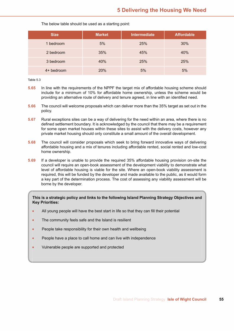
The below table should be used as a starting point:
AffordableIntermediateMarketSize
30%25%5%1 bedroom
40%45%35%2 bedroom
25%25%40%3 bedroom
5%5%20%4+ bedroom
Table 5.3
5.65 In line with the requirements of the NPPF the target mix of affordable housing scheme shouldinclude for a minimum of 10% for affordable home ownership, unless the scheme would beproviding an alternative route of delivery and tenure agreed, in line with an identified need.
5.66 The council will welcome proposals which can deliver more than the 35% target as set out in thepolicy.
5.67 Rural exceptions sites can be a way of delivering for the need within an area, where there is nodefined settlement boundary. It is acknowledged by the council that there may be a requirementfor some open market houses within these sites to assist with the delivery costs, however anyprivate market housing should only constitute a small amount of the overall development.
5.68 The council will consider proposals which seek to bring forward innovative ways of deliveringaffordable housing and a mix of tenures including affordable rented, social rented and low-costhome ownership.
5.69 If a developer is unable to provide the required 35% affordable housing provision on-site thecouncil will require an open-book assessment of the development viability to demonstrate whatlevel of affordable housing is viable for the site. Where an open-book viability assessment isrequired, this will be funded by the developer and made available to the public, as it would forma key part of the determination process. The cost of assessing any viability assessment will beborne by the developer.
This is a strategic policy and links to the following Island Planning Strategy Objectives andKey Priorities:
All young people will have the best start in life so that they can fill their potential
The community feels safe and the Island is resilient
People take responsibility for their own health and wellbeing
People have a place to call home and can live with independence
Vulnerable people are supported and protected
55Draft Island Planning Strategy Isle of Wight Council
5 Delivering the Housing We Need

Rural Exceptions Sites
DHWN 7
Rural Exceptions Sites
To help contribute to meeting the objectively assessed housing need for affordable housing acrossthe Island, the council will support the principle of affordable housing in perpetuity on rural exceptionsites.
The council will consider a small number of market homes on a rural exceptions site, where it canbe demonstrated they will facilitate the delivery of the whole scheme.
5.70 There has been a lack of delivery of affordable housing on the Island in recent years (see thecouncil’s annual monitoring reports and HNA). To help reverse this trend the council needs tothink differently about how it can facilitate opportunities for affordable housing to be delivered.
5.71 Ideally rural exception sites will provide 100% affordable housing. However, it is recognised thatwith reduced public subsidy and the need for affordable homes on the Island there needs to bea pragmatic level of flexibility in order to provide the housing needed on the Island. Therefore,the principle of allowing a small number of market homes on rural exception sites is accepted.
5.72 The council does not wish to be prescriptive and set a maximum percentage for market housingin a rural exceptions policy. Instead it is considered more appropriate that the number of markethomes will be determined by the site specific circumstances, and any proposals will need toprovide justification for the number of market houses proposed. This should take the form of adetailed open book financial appraisal, and the cost of assessing any viability assessment willbe borne by the developer.
5.73 Rural exception sites are defined in national planning policy (see NPPF glossary). Key elementsof this definition are that they are small sites used for affordable housing in perpetuity wheresites would not normally be used for housing.
5.74 For the purposes of this policy the council considers small sites to be sites with a net gain of upto 20 dwellings in total (including market housing). In circumstances where there is a significantlocal need and lack of supply of affordable housing, this figure could be increased. Where thisis proposed the council strongly advocates the use of its pre-application advice service, to ensurethat all parties are clear about the issues at the earliest possible point in the process.
5.75 All affordable housing in rural exception sites will be in perpetuity, and the council will secure thefirst and future occupation of the affordable homes to those whomeet the council’s local connectioncriteria.
5.76 Rural exception sites can be considered on sites that would not normally be used for housing.The council will therefore consider sites that do not comply with the spatial approach of the plan.
5.77 Proposals for rural exception sites will be determined on a case-by-case basis, however thecouncil will not compromise over the design quality of any proposed rural exception site, and thatit should be appropriate in scale, character and appearance.
Isle of Wight Council Draft Island Planning Strategy56
5 Delivering the Housing We Need

This is a strategic policy and links to the following Island Planning Strategy Objectives andKey Priorities:
All young people will have the best start in life so that they can fill their potential
People take responsibility for their own health and wellbeing
People have a place to call home and can live with independence
Vulnerable people are supported and protected
Ensuring the Right Mix of Housing
DHWN 8
Ensuring the Right Mix of Housing
All proposals for residential development should demonstrate how they provide an appropriate mixof housing types, sizes and tenures that contribute to meeting identified needs and market demand.
Development proposals for 10 or more dwellings should deliver the percentage splits for housingtypes, sizes and tenures of the council's Housing Needs Assessment (or most up-to-date equivalent),and demonstrate how any relevant housing needs surveys have been taken into account.
5.78 The policy approach is designed to ensure that the reality of local housing markets are reflectedand the risks of creating imbalanced communities and unviable developments are avoided. Thecouncil wants to provide better access to housing and is particularly aware of the need for twoand three bedroom properties that are affordable to Island residents.
5.79 In providing housing to create and maintain sustainable communities, it is important that a widechoice of housing types and sizes are delivered during the plan period to meet community needs.It will not be possible to match house types exactly to population statistics as individuals andfamilies choose to live in particular types of accommodation. But the aim for the Council is tosupply the right mix of dwellings to meet the general needs of the Island.
5.80 The need for affordable housing of different sizes will vary by area (at a more localised level) andover time. When considering the mix of homes to be provided within specific developmentschemes, applicants should base their approach on the information in the council's HousingNeeds Assessment, together with details of households currently on the Housing Register in thelocal area and the stock and turnover of existing properties.
5.81 In applying the identified housing mix to individual development sites, regard should be had tothe nature of the development site and character of the area, and to up-to-date evidence of needas well as the existing mix and turnover of properties at the local level.
5.82 The 2018 Housing Needs Assessment identifies the following percentage splits:
57Draft Island Planning Strategy Isle of Wight Council
5 Delivering the Housing We Need

4 bed3 bed2 bed1 bed
5%25%40%30%Affordable rented housing
5%25%45%25%Low-cost home ownershiphousing
20%40%35%5%Market housing
Table 5.4
5.83 When looking at affordable rented housing the strategic conclusions of the HNA recognise therole which delivery of larger family homes can play in releasing supply of smaller properties forother households; together with the limited flexibility which one-bed properties offer to changinghousehold circumstances which feed through into higher turnover and management issues andthe issue of single people under 35 years old only being eligible to claim benefits for a room ina shared house.
5.84 The provision of affordable home ownership should be more explicitly focused on deliveringsmaller family housing for younger households.
5.85 In the market sector, a balance of dwellings is suggested that takes account of both the demandfor homes and the changing demographic profile.
5.86 When considering different housing types, the council will use theMinistry of Housing, Communitiesand Local Government definitions of general housing terms.
5.87 In applying the recommended housing mix to individual development sites, regard should be hadto the nature of the development site and character of the area, and to up-to-date evidence ofneed as well as the existing mix and turnover of properties at the local level.
This is a strategic policy and links to the following Island Planning Strategy Objectives andKey Priorities:
All young people will have the best start in life so that they can fill their potential
People have a place to call home and can live with independence
Vulnerable people are supported and protected
Isle of Wight Council Draft Island Planning Strategy58
5 Delivering the Housing We Need

Self and Custom Build
DHWN 9
Self and Custom Build
The council recognises the many benefits to the Island of self and custom built dwellings. In orderto support this method of delivering housing, development proposals that would result in a net gainof 25+ dwellings should include at least 5% of dwelling plots to be available for self and custombuilding.
These plots should be serviced and plot sizes should meet a range of requirements.
In order to provide a coherent and flexible design approach, where 10+ dwellings are being providedas self and custom build, a design code will be agreed between the council and developer.
5.88 The council considers that self and custom build dwellings can have a positive impact on theisland’s housing supply and economy, by diversifying and speeding up the delivery of housingand supporting local development industry and related supply chains. The requirements of thispolicy will also contribute to the council achieving national requirements relating to self and custombuild dwellings.
5.89 The policy requirements will be applied to all proposals that result in a net gain of 25 and abovedwellings.
Services
5.90 The council considers a serviced plot to be a parcel of land with legal access to a public highwayand at least water, foul and surface drainage and electricity supply available at the plot boundary(3).Further to this the council recognises the benefits of plots also being sold with, telecommunicationsservices, and gas (or district heating) where available. It is anticipated that the cost of servicinga plot will be reflected in the plot value.
5.91 To help delivery the council recognises that the servicing of plots may be carried out in phases,with key services required for plot sale and construction (water, electricity and access) beingprovided before services required for occupation (such as sewerage, telecommunications andgas). Notwithstanding this, the council’s preferred approach is for all services to be provided upfront.
5.92 Where plots are not proposed to be serviced for sale, applicants should demonstrate to thecouncil’s satisfaction that legal access and servicing will be possible for potential plot purchasers,before planning permission is granted.
Plot sizes
5.93 The council will seek a range of plot sizes, to take account of the range of demand and affordability.This may include, for example, plots suitable for bungalows for people with limited mobility, smallerplots which provide opportunities for households seeking lower cost market housing, and largerplots suitable for properties of a scale to cater for extended families wishing to build together.Plot providers may also choose to consult with the local community and consider the immediatedemand.
5.94 The council will be able to provide information from its Self and Custom Build Register to informa range of plot sizes. Other sources of information such as the council’s most recent Housing
3 . In accordance with the definition set out in the Housing and Planning Act 2016 (9)(4)
59Draft Island Planning Strategy Isle of Wight Council
5 Delivering the Housing We Need

Needs Assessment, local housing needs surveys and information from specialist self-buildwebsites can be used.
Design
5.95 By their very nature self and custom build housing will provide design variety. Where developmentproposals would result in ten or more self and custom build plots being made available the councilwill require a design code to be agreed. This will enable all parties to be satisfied that developmentwill be of sufficient quality.
5.96 Design codes may cover issues such as:
Plot form – plot size and plot width
Building forms – bulk, massing, height
Building orientation – orientation towards the sun, position on plot, overlooking, naturalsurveillance
Density – site coverage, dwellings per hectare, plot ratios, higher or lower density nodes
Developable footprint – maximum proportion of plot that may be developed; parameters ofdwelling position on plot
Building lines – frontage continuity, roof-line parameters, set backs, boundary treatment
Building types – detached, semi-detached, terraced / town houses, flats
Street network – urban grain – street and building pattern and connectivity
Views and vistas – relationship to heritage assets, topography, corridors and backdrops
Soft landscape – standards, species planted, biodiversity, lawns and verges, planters
Building frontage – active frontage, frequency of building features such as windows andentrances, architectural styles, features, proportions, materials, colours, balconies, porches
Townscape features – eave lines, rooflines, chimneys, corner treatments, focal points,advertising
Street trees – species, numbers, placements
Parking standards – on-street and off-street, on-plot parking, courtyard parking, treatments,overlooking, lighting
Waste facilities – refuse and recycling bin storage, composting
Infrastructure – community energy facilities such as combined heat
5.97 The council uses the definition given in the Housing and Planning Act 2015. This states thatself-build and custom house building are defined as:
5.98 “…the building or completion by – (a) individuals, (b) associations of individuals, or (c) personsworking with or for individuals of houses to be occupied as homes by those individuals. But itdoes not include the building of a house on a plot acquired from a person who builds the housewholly or mainly to plans or specifications decided or offered by that person”.
5.99 This definition is significant as it underlines the importance of the role that the future occupier
Isle of Wight Council Draft Island Planning Strategy60
5 Delivering the Housing We Need
takes. Where a developer delivers speculative units [notwithstanding a purchaser could makevarious choices during the construction phase (e.g. kitchen and bathrooms)] for profit, this isoutside the definition. If the future occupier is involved in the full planning process it is recognisableas within the definition of self or custom build. The council, as the local planning authority, doesnot consider that a dwelling built by developers, or industry professionals, on land that they own(either wholly or in part) with the stated intent of being for rent, a second home or for holiday use,falls within the definition given above.
This policy links to the following Island Planning Strategy Objectives and Key Priorities:
The environment and unique island characteristics are celebratedA well-educated and skilled communityPeople have a place to call home and can live with independence
61Draft Island Planning Strategy Isle of Wight Council
5 Delivering the Housing We Need

Planning for Gypsy, Traveller and Travelling Showpeople Provision
DHWN 10
Planning for Gypsy, Traveller and Travelling Showpeople Provision
The council will allocate sites for transit and permanent pitches for Gypsy or Traveller use or plotsfor Travelling Showpeople in a development plan document, based on assessed needs.
Development proposals for such uses will be supported where they:
1. are sustainably located, preferably within or immediately adjacent settlement boundaries (asshown on the Policies Map);
2. are accessible to shops, schools and health facilities by public transport, on foot or by cycle andis served or capable of being served by essential utility infrastructure;
3. are not subject to physical constraints or other environmental issues that cannot be mitigatedto an acceptable level, or that would impact upon the health, safety or general wellbeing ofresidents on the site;
4. includes adequate levels of privacy and residential amenity for site occupiers;
5. are or can be well integrated using landscaping, boundary treatments and screening materialswhich are sympathetic to the character of the area;
6. do not accommodate non-residential uses that would cause or result in the potential for statutorynuisance, by virtue of smell, noise or vibration, when considering neighbouring business orresidents; and
7. are limited to those meeting the definition of Gypsies and Travellers and Travelling Showpeoplein the relevant national planning policy.
Applications for five or more pitches will be expected to be accompanied by a Site ManagementPlan.
5.100 The council wishes to see homes for the travelling community in sustainable locations that areappropriate for such a use, and accessible to facilities and services in order to help support theeveryday needs of residents on the site. The above policy establishes that the council will preparea development plan document to allocate sites for Gypsy, Traveller and Travelling Showpeoplerequirements, in line with national policy. Prior to the document being adopted, the above policywill be used to assess any applications received.
5.101 The policy is criteria based in order to clearly assess any proposals that may come forward. Theprovision of pitches/plots within settlements is appropriate in principle, as for other forms ofhousing. Outside of settlement boundaries proposals may be appropriate subject to the criteriacontained within this policy and other policies within the Island Planning Strategy.
5.102 Whilst, sites for Gypsies and Travellers pitches generally should follow similar locational criteriato the selection of housing sites for the settled community, there are specific aspects of Gypsiesand Travellers cultural traditions and preferences which need specific consideration, such as thepreference for living in a caravan or working from home and the need to provide space suitablefor both sustained periods of settled living whilst also facilitating a nomadic lifestyle. These factorsneed to be borne in mind when assessing sites.
Isle of Wight Council Draft Island Planning Strategy62
5 Delivering the Housing We Need
5.103 The policy seeks to achieve well landscaped sites that provide residents with the accommodationthey need in areas that can be well served by local facilities including education and health. Inthe first instance, sites will be expected to be located as close as possible to such facilities, wherean alternative site is more suitable, it is expected that these facilities can be accessed using thepublic transport network or on foot. As such, on-site pedestrian access should be separate tovehicular access to ensure that there is no conflict between pedestrians and vehicles. Proposalsshould also provide safe vehicular access and adequate on-site parking.
5.104 It is important that site residents can enjoy good levels of privacy and residential amenity andnew development should be designed to respect these aspects for both existing and newoccupiers. A key issue to be addressed is the service of the site by essential utility infrastructureand this should be demonstrated in any application.
5.105 As with other development proposals for residential use, the impact of a specific proposal onlocal amenity is a key planning consideration. It is important that new development proposalsmake a positive contribution to both their immediate surroundings and the wider environment.Development proposals must not cause harm to the area’s nature conservation interests orheritage assets.
5.106 Where a business use is included evidence should be provided to show that the use will not havea detrimental impact on neighbouring land uses. Applications for five or more pitches will beexpected to submit a site management plan upon application, detailing how the site will bemanaged for the travelling communities.
5.107 It is recognised that there will be a need for private provision as well as public sites. This policyenables this provision. As with other forms of residential development, where planning permissionis granted, the council may use planning conditions or obligations to assist in the delivery of goodquality development.
5.108 Any application submitted will be determined against the above policy, the development plan asa whole and any other material considerations. Evidence to demonstrate that theapplicant/proposed resident of the site/pitch/plot meets the definition of ‘Gypsies and Travellers’for the purposes of the planning system may be sought.
5.109 Conditions will be used to secure any aspects relating to the policy above where these are notclear within the application submitted and subsequently approved. For clarity and transparencya condition restricting occupancy may be included in all permissions as well as compliance witha site management plan.
This policy links to the following Island Planning Strategy Objectives and Key Priorities:
All young people will have the best start in life so that they can fill their potentialPeople have a place to call home and can live with independenceVulnerable people are supported and protected
63Draft Island Planning Strategy Isle of Wight Council
5 Delivering the Housing We Need

6.1 Job creation and economic growth are fundamental to a strong Isle of Wight. The right planningpolicies can contribute to creating the right environment for the market and other agencies to jobcreation and economic growth. 'Supporting and Growing Our Economy' sets out the overalldirection, and this is supported by a series of allocations to give certainty and support to themarket that land is available to support job creation. The wider regeneration conversation is notjust about job creation, it is also about ensuring the Isle of Wight has the right skills to supportdevelopment growth and the right digital infrastructure, and 'Upskilling the Island' and 'FutureProofing Digital Infrastructure' embeds the provision of these elements into the planning process.
6.2 There are a range of other elements that make up a strong and resilient economy. and there ispolicy recognition and support for these. 'Supporting the Rural Economy' and 'MaintainingEmployment Sites with Water Access' provide planning approaches for these specialised areasof our economy. Supporting and Improving Our Town Centres addresses the retail element ofour economy and the function it plays, along with 'Supporting the Evening Economy'. The otherkey component is tourism, and there is a suite of policies dedicated to supporting a high qualitytourism offer; Supporting High Quality Tourism, The Bay Tourism Opportunity Area and 'RydeTourism Opportunity Zones'.
Supporting and Growing Our Economy
SGOE 1
Supporting and Growing Our Economy
The council wishes to create an environment where businesses have the confidence to invest. Itwill therefore support the sustainable growth of the Island's economy and proposals that deliverjobs via a range of sectors while increasing local wages, skills and job opportunities.
To contribute to achieving this, the council allocates the following sites (as shown on the PoliciesMap):
1. 2.8 hectares at Pan Lane, Newport for B1 and B2 uses2. 14.7 hectares at Nicholson Road, Ryde for B1, B2, B8 and community uses3. 1.9 hectares at Somerton Farm, Cowes for B1, B2 and B8 uses4. 6.2 hectares at Kingston Marine Park, East Cowes for B1, B2 and B8 uses5. 0.7 hectares at Lowtherville, Ventnor for B1 and B8 uses6. 2.9 hectares at Sandown Airport, Sandown for B1, B2 and B8 uses
The council will also support the principle of intensification and/ or expansion of existing employmentuses in the following employment opportunity areas (as shown on the Policies Map):
i. Golden Hill Industrial Estate, Freshwaterii. Land at Afton Road, Freshwateriii. Cowes Industrial Estates, Cowesiv. College Close Industrial Estate, Sandown
6.3 The aim of the Island Planning Strategy is to promote a sustainable, diverse economic base thatdelivers skilled jobs to benefit the population. The Island Planning Strategy also aims to providethe certainty to attract investment and new business while promoting the upskilling of the Island’spopulation and a reduction in unemployment. The council will work with partners to ensure thatthe right uses, jobs, infrastructure and investment can take place in the right locations in orderto support the economy.
6.4 To do so, the council proposes to allocate 29.2 hectares of land for employment uses, which will
Isle of Wight Council Draft Island Planning Strategy64
6 Supporting and Growing Our Economy
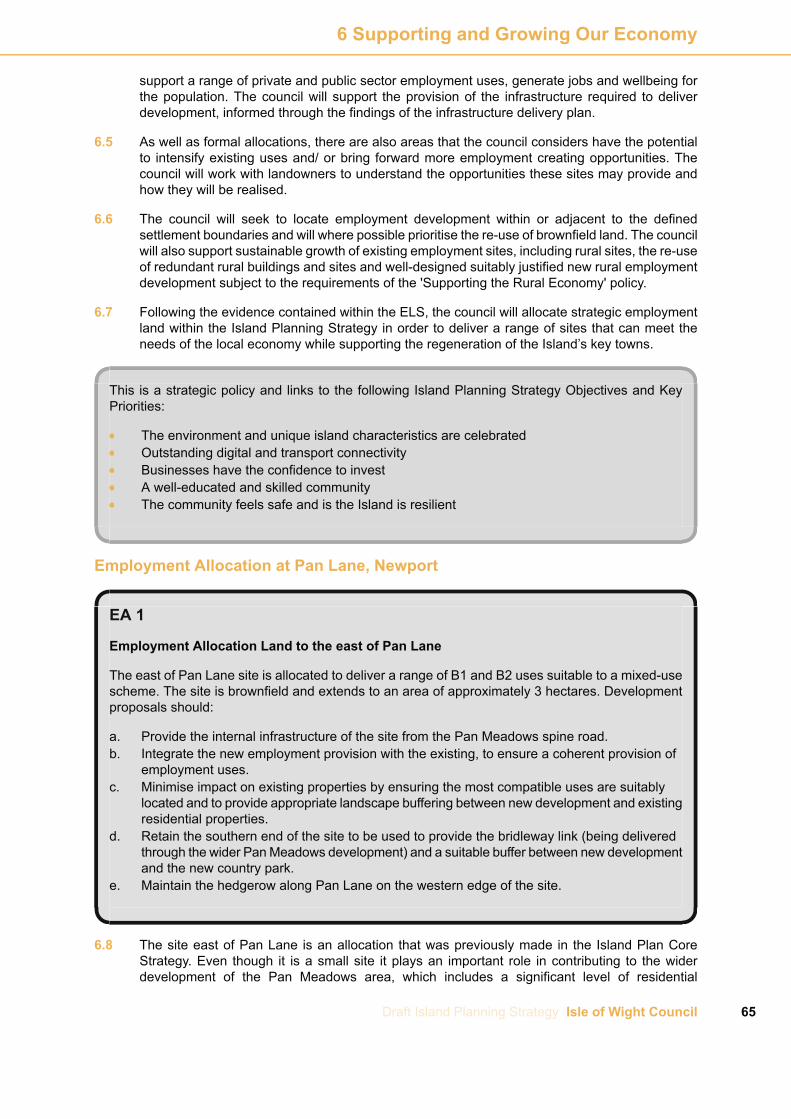
support a range of private and public sector employment uses, generate jobs and wellbeing forthe population. The council will support the provision of the infrastructure required to deliverdevelopment, informed through the findings of the infrastructure delivery plan.
6.5 As well as formal allocations, there are also areas that the council considers have the potentialto intensify existing uses and/ or bring forward more employment creating opportunities. Thecouncil will work with landowners to understand the opportunities these sites may provide andhow they will be realised.
6.6 The council will seek to locate employment development within or adjacent to the definedsettlement boundaries and will where possible prioritise the re-use of brownfield land. The councilwill also support sustainable growth of existing employment sites, including rural sites, the re-useof redundant rural buildings and sites and well-designed suitably justified new rural employmentdevelopment subject to the requirements of the 'Supporting the Rural Economy' policy.
6.7 Following the evidence contained within the ELS, the council will allocate strategic employmentland within the Island Planning Strategy in order to deliver a range of sites that can meet theneeds of the local economy while supporting the regeneration of the Island’s key towns.
This is a strategic policy and links to the following Island Planning Strategy Objectives and KeyPriorities:
The environment and unique island characteristics are celebratedOutstanding digital and transport connectivityBusinesses have the confidence to investA well-educated and skilled communityThe community feels safe and is the Island is resilient
Employment Allocation at Pan Lane, Newport
EA 1
Employment Allocation Land to the east of Pan Lane
The east of Pan Lane site is allocated to deliver a range of B1 and B2 uses suitable to a mixed-usescheme. The site is brownfield and extends to an area of approximately 3 hectares. Developmentproposals should:
a. Provide the internal infrastructure of the site from the Pan Meadows spine road.b. Integrate the new employment provision with the existing, to ensure a coherent provision of
employment uses.c. Minimise impact on existing properties by ensuring the most compatible uses are suitably
located and to provide appropriate landscape buffering between new development and existingresidential properties.
d. Retain the southern end of the site to be used to provide the bridleway link (being deliveredthrough the wider PanMeadows development) and a suitable buffer between new developmentand the new country park.
e. Maintain the hedgerow along Pan Lane on the western edge of the site.
6.8 The site east of Pan Lane is an allocation that was previously made in the Island Plan CoreStrategy. Even though it is a small site it plays an important role in contributing to the widerdevelopment of the Pan Meadows area, which includes a significant level of residential
65Draft Island Planning Strategy Isle of Wight Council
6 Supporting and Growing Our Economy
development. The residential and road infrastructure elements of the scheme are being built outand the allocation of the employment element completes the overall scheme. The majority of theallocated site is council-owned, with the northern part of the site under separate ownership andproviding existing employment uses.
6.9 Whilst the final type and mix of provision will be determined at the planning application stage, itis expected that B1a and B1b will form the majority of the provision. The nature of employmentuses should be compatible with being located in a mixed-use area close to residential units, bothin terms of the built form and scale. In general, it is expected that small units will be appropriate,potentially in the form of either individual units or as some form of managed workspace(s).
6.10 The established employment on the north of the site is a garage. The council will continue towork with the landowner to ensure that the new employment provision on the rest of the site isintegrated to ensure a coherent allocation.
6.11 It is expected that a detailed scheme will be designed to minimise disturbance (both visual andnoise) and impact on amenity to existing properties and that this will be achieved by ensuringthat themost compatible uses are located nearer to the existing residential properties. Furthermore,appropriate landscape buffering between the new development and the existing residentialproperties will be provided.
6.12 At the southern edge of the site is the route of an existing bridleway (N40) that will link with anew footpath that will run along the edge of the Pan Meadows development and the country park.This area will be safeguarded for the retention of the bridleway and to provide an appropriatebuffer between the employment site and the country park.
6.13 The site has a well-established hedgerow on its western edge and the council wishes to see thisretained, particularly as it forms the external boundary of the site that fronts onto a public highway.
This policy links to the following Island Planning Strategy Objectives and Key Priorities:
Businesses have the confidence to investA well-educated and skilled community
Isle of Wight Council Draft Island Planning Strategy66
6 Supporting and Growing Our Economy

Employment Allocation at Nicholson Road, Ryde
EA 2
Employment Allocation at Nicholson Road, Ryde
The site is allocated to deliver a mix of B1, B2 and B8 uses, with a variety of building sizes, alongwith potential supporting uses that would benefit the local population, such as health centres orcreches. The site is greenfield and extends to an area of approximately 14.6 hectares. Developmentproposals should:
1. Provide access to the site from Nicholson Road and examine the suitability of a secondaryaccess point onto the existing road network or through wider infrastructure improvements.
2. Develop the site in a phased approach, to be agreed through the planning application process.3. Minimise impact on existing properties by ensuring the most compatible uses are suitably
located and to provide appropriate landscape buffering between new development and existingresidential properties.
4. Maintain the existing rights of way network on the site and examine the possibility of improvingfootpath R52a, in line with the Rights of Way Improvement Plan.
5. Retain and utilise existing hedgerows and field boundaries wherever possible, especially thosethat form the external boundary of the site.
6. Avoid both direct and indirect adverse effects upon the integrity of protected habitats andspecies and, if necessary, provide appropriate mitigation measures.
6.14 The allocation extends to an area of 14.7 hectares, is under council ownership and directlyadjacent to the existing successful small scale Ryde Business Park, which houses small andmedium-size units. The land was previously allocated as an employment site in the Island Plan.
6.15 The council wishes to build on the success of Ryde Business Park and extend the range ofemployment uses while investigating the potential for community facilities with good links tonearby housing and the highway network. The site is under council ownership and, in light of theidentified social deprivation in the area and need for the provision of further employment land,the council will promote the site via the Regeneration Strategy.
6.16 Access to the site, and the main road within it, will be provided by extending Nicholson Road.Whilst the council does not believe that further improvements to the junction of Nicholson Roadand Great Preston Road are required, further work will be undertaken to ensure that the junctioncomplies with the relevant safety requirements. Proposals for the site should investigate whetherfurther highway capacity could be achieved via alternative accesses to highway network andfuture infrastructure projects.
6.17 The development will be designed to provide the most efficient use of the land, with the majorityof the employment provision located in the upper sections of the site. A phased approach to thedelivery of the site will help to ensure a steady supply of employment land and facilities to meetdemand from a range of employers.
6.18 It is expected that a detailed scheme will be designed to minimise disturbance (both visual andnoise) and impact on amenity to existing properties and that this will be achieved by ensuringthat themost compatible uses are located nearer to the existing residential properties. Furthermore,appropriate landscape buffering between the new development and the existing residentialproperties will be provided.
6.19 A footpath (R55) runs across the site along its northern edge and a bridleway (R54) along thelength of its western edge. R55 provides east/west access from the urban edge of Ryde into thewider rights of way network and the countryside beyond. The council will expect the retention of
67Draft Island Planning Strategy Isle of Wight Council
6 Supporting and Growing Our Economy
the footpath, although an amended route incorporated within the site could be considered. BothR54 and R55 link to R52a, a footpath which crosses the railway line. The Isle of Wight Rights ofWay Improvement Plan has identified opportunities to improve R52a by implementing safetyimprovements to the footpath where it crosses the railway line and the potential to upgrade it toa bridleway to help create improved links into the Swanmore area. Development proposals willbe expected to examine how the development can positively contribute to achieving these aims.
6.20 The site has a number of strong external and internal hedgerows, particularly the western andsouthern external boundaries and the north/ south elements of the internal field network. Theexternal hedgerows should be retained and improved, where possible and appropriate, tocontribute to the buffering outlined in the policy. The stronger internal field boundaries should beretained and should be used to inform the overall layout of the site and the approach to phasing.
This policy links to the following Island Planning Strategy Objectives and Key Priorities:
Businesses have the confidence to investAll young people will have the best start in life so that they can fill their potentialA well-educated and skilled communityCommunity needs are met by the best public services possible
Employment Allocation at Somerton Farm, Cowes
EA 3
Employment Allocation at Somerton Farm, Cowes
The site is allocated to deliver small to medium scale employment uses within the B1, B2 and B8uses. The site is greenfield and extends to an area of approximately 1.9 hectares. Developmentproposals should:
1. Provide a mix of small to medium scale employment uses.2. Provide access to the site from Newport Road, either via the existing Somerton Business Park
or a purpose built site access. Pedestrian connections will also be required.3. Allow space for a multi-use route to allow connection between the Newport to Cowes cycle
route and the employment uses centred around Newport Road.4. Complement the existing employment uses to the north, while having regard to the housing
allocation on land to the south and within the control of Somerton Farm.5. Integrate the mix of uses with existing, to ensure that the site integrates into the wider context
of the area. Employment uses should be compatible with the immediate surroundings and notconflict with town centre uses.
6. Minimise impact on existing and future properties by ensuring the most compatible uses aresuitably located.
7. Retain existing trees and hedgerows to form landscape buffers and complement the characterof the surrounding area.
8. Avoid both direct and indirect adverse effects upon the integrity of designated sites and, ifnecessary, provide appropriate mitigation measures.
6.21 The site at Somerton Farm is in private ownership and extends to an area of 1.9 hectares andlocated immediately south of the existing Somerton Business Park. The land is greenfield andin agricultural use. The land is visible from Newport Road and surrounded by a mix of trees andwell established hedgerows. Land further south is the subject of a housing allocation that has
Isle of Wight Council Draft Island Planning Strategy68
6 Supporting and Growing Our Economy
been assessed through the council’s SHLAA process.
6.22 The site is adjacent to Newport Road and therefore, potential access routes should be carefullyconsidered. There are three potential options which include the formation of a new access to theserve the employment site, a shared access to serve both the employment site and future housingto the south or access via the existing Somerton Business Park. The wider area includes a rangeof employment uses and this site would allow the potential to release land to provide a linkbetween the Newport to Cowes multi-user route and Newport Road. This is a key project for thecouncil, and if achieved would provide sustainable transport choices for the many employmentsites within the area. Therefore, development proposals for this employment site and the linkedhousing site to the south, should be designed to provide the link.
6.23 Development proposals for this site should complement the existing business uses to the northwhile taking account of existing and proposed housing within the area. The site to the northincludes a range of uses and building types and this site should be designed to build uponproviding a variety of uses through buildings that would allow flexibility for new and evolvingbusinesses. Buildings should be designed to provide a transition between employment andhousing uses and to take account of potential impacts to existing and proposed housing.
6.24 The site is not the subject of ecological designations. However, the River Medina is located tothe east and is the subject of a range of international, national and local designations. Given theundeveloped nature of the site, its proximity to designated sites and the trees and hedgerowsthat surround it, development proposals should demonstrate that potential impacts have beenfully considered, along with the need for mitigation. Development proposals should where possibleretain existing trees and hedgerows and where demonstrated to not be possible, providemitigation.
This policy links to the following Island Planning Strategy Objectives and Key Priorities:
Businesses have the confidence to investA well-educated and skilled community
Employment Allocation at Kingston Marine Park, East Cowes
EA 4
Employment Allocation at Kingston, East Cowes
The site at Kingston benefits from planning permission for a marine business park comprising B1,B2 & B8 uses. The site has recently become council owned and extends to an area of 6.2 hectaresDevelopment proposals should:
1. Provide suitable access from Saunders Way.2. Develop the site in a phased approach.3. Provide a range of uses types and building sizes to promote small, medium and large scale
employment uses, allowing flexibility for potential expansion of businesses.4. Minimise impacts on existing uses and surrounding landscape through the use of landscape
buffers and planting and suitably locating compatible uses.5. Retain existing hedgerows that form the boundaries of the site that contribute to screening
the development and protect biodiversity.6. Avoid both direct and indirect adverse effects upon the integrity of designated sites and, if
necessary, provide appropriate mitigation measures.
69Draft Island Planning Strategy Isle of Wight Council
6 Supporting and Growing Our Economy
6.25 The site at Kingston is council owned and extends to a site area of 6.2 hectares of land east ofthe River Medina. The site benefits from planning permission that allows for a mix of office,research and development, light industrial, industrial and storage and distribution uses. The sitewould be suitable for large scale employment buildings, given links to existing industrialemployment uses within East Cowes. While appropriate for large scale buildings, proposalsshould demonstrate a reduction of impacts through high quality design and landscaping.
6.26 Proposals should demonstrate a flexible approach to employment provision through providing arange of building types and sizes, to allow small, medium and large scale employers to occupythe site and potentially forge complementary uses. Buildings should be designed to allow potentialfor expansion. The site is well located for all employment uses, however proposals shoulddemonstrate how impacts on nearby residential developments have been considered and includelocating the most compatible uses within the eastern section of the site. Development proposalsshould also incorporate landscaping and screening in order to reduce the impact of large-scalebuildings while retaining existing hedgerows.
6.27 The site is located adjacent to the Solent and SouthamptonWater Special Protection Area (SPA)/Ramsar site and the Maritime Special Area of Conservation (SAC). It is also adjacent the MedinaEstuary Site of Special Scientific Interest (SSSI). Therefore, proposals should demonstrate thatimpacts on designated site and species have been taken into account, outlining impacts andmitigation.
This policy links to the following Island Planning Strategy Objectives and Key Priorities:
Businesses have the confidence to investA well-educated and skilled community
Employment Allocation at Lowtherville, Ventnor
EA 5
Employment Allocation at Lowtherville, Ventnor
The site at Lowtherville is allocated to deliver a mixed use development to include housing and lowimpact employment uses within the B1, B2 and B8 uses. The site is brownfield and extends to anarea of approximately 0.7 hectares, and redevelopment would require demolition of existing buildings,site clearance and re-profiling of levels. Development proposals should:
1. Provide access to the site from Lowtherville Road with improvements to onsite accessarrangements and may require off-site improvements. Pedestrian connections will also berequired.
2. Integrate the mix of uses with existing, to ensure that the site integrates into the wider contextof the area. Employment uses should be compatible with the immediate surroundings and notconflict with town centre uses.
3. Minimise impact on existing properties by ensuring the most compatible uses are suitablylocated and to provide appropriate landscape buffering between new development and existingresidential properties.
4. Undertake an assessment of previous uses and potential contaminated land and implementa full remediation strategy that is compliant with the relevant non-planning consenting regimes.
5. Avoid indirect adverse effects upon the integrity of designated sites and, if necessary, provideappropriate mitigation measures.
Isle of Wight Council Draft Island Planning Strategy70
6 Supporting and Growing Our Economy
6.28 In the Island Planning Strategy Ventnor is classified as a secondary settlement, and it is thereforeimportant that employment land can be provided in order to local residents with access to jobs.However, the town is located within a geographically constrained area and therefore, the use ofexisting employment sites will be important over the plan period.
6.29 The site at Lowtherville is council owned and extents to a site area of 0.7 hectares. The site isbrownfield and occupied by a range of employment uses around areas of open space andwoodland. Existing buildings are dated and the site is in need of regeneration. The site is adjacentto existing housing and schools.
6.30 Given its current land use, the site lends itself to mixed use development comprising housingand small scale business units. The site slopes from north to south and therefore, proposalsshould take account of changes in land levels.
6.31 Access to the site could be gained via Lowtherville Road to the east and St Margaret’s Glade tothe northwest. However, both roads pass through residential areas and therefore developmentproposals should consider ways of minimising traffic impacts on amenity and road safety. Thejunction of Lowtherville Road and Newport Road lacks visibility and therefore, developmentproposals should consider potential improvements to the junction.
6.32 Because the site is surrounded by existing housing and close to schools, the proposed employmentuses should be carefully located in order to provide suitable buffers, reduce impacts and ensurethat uses with greater impacts are situated away from receptors.
6.33 Due to existing and previous uses, redevelopment proposals should demonstrate that potentialsources of contamination have been considered and if necessary, mitigated.
6.34 The site is elevated and benefits from screening offered by existing trees and tree-lined hedgerows.Development proposals should where possible retain existing trees and hedgerows and wheredemonstrated to not be possible, provide mitigation.
6.35 The site is not the subject of ecology designations; however the down land to the north and eastis designated as a SAC and SSSI. Therefore, development proposals should demonstrate thatpotential indirect impacts on designated sites have been considered. Moreover, due to the existingopen areas of grassland, trees and hedgerows, development proposals should be supported byecological information to investigate potential protected species on site and provide mitigationand biodiversity enhancements where necessary.
This policy links to the following Island Planning Strategy Objectives and Key Priorities:
Businesses have the confidence to investA well-educated and skilled community
71Draft Island Planning Strategy Isle of Wight Council
6 Supporting and Growing Our Economy
Employment Allocation at Sandown Airport, Sandown
EA 6
Employment Allocation at Sandown Airport, Sandown
The site at Sandown Airport benefits from existing links to the current uses at the site, which includegeneral industrial and the airport use. The site would be suitable for B1 and B2 uses, potentiallythrough the use of large scale hanger style buildings. Due to access issues, storage and distributionuses should be avoided. The site is part greenfield and part brownfield and extends to an area of2.99 hectares. Development proposals should:
1. Provide suitable access from the principal highway.2. Provide improved pedestrian connectivity to the east.3. Develop the site in a phased approach.4. Minimise impacts on existing uses and surrounding landscape through the use of landscape
buffers and planting and suitably locating compatible uses.5. Retain existing hedgerows that form the boundaries of the site to screen the development and
protect biodiversity.6. Ensure that the proposed development would not compromise the future use and potential
expansion of the airport.7. Avoid both direct and indirect adverse effects upon the integrity of designated sites and, if
necessary, provide appropriate mitigation measures.
6.36 The site at Sandown Airport extends to a site area of 2.99 hectares. The site is currentlyundeveloped farmland, located between the existing airport, the employment uses that surroundit and Newport Road. The site is surrounded by hedgerows but due to topography, visible fromsurrounding landscape and Newport Road.
6.37 The council is aware that the current vehicle access to the site lacks visibility at its junction withNewport Road, thus constraining operational capacity. Therefore, proposals should include afully compliant means of access to serve the site, investigating the potential for a wholly newmeans of access or improvement of existing routes. In addition, a new pedestrian link to connectwith existing pavements to the east should be provided as part of development proposals.
6.38 Given its proximity to the airport and existing employment uses, the site lends itself to largeemployment units, set within well landscaped grounds. Due to the visibility of the site, appropriatelandscape buffering should be provided and buildings should be set back from the highway. Thesite is surrounding by existing established hedgerows and various trees that contribute tolandscape character and therefore, these should be retained.
6.39 The site area is large and therefore, proposals should set out a phased approach to developmentin order to minimise landscape and visual impacts.
6.40 Proposals should be designed to take account of existing uses in order to minimise potentialimpacts. Moreover, proposals should demonstrate that the development would not compromisethe continued operation or potential for expansion of the airport.
This policy links to the following Island Planning Strategy Objectives and Key Priorities:
Businesses have the confidence to investA well-educated and skilled community
Isle of Wight Council Draft Island Planning Strategy72
6 Supporting and Growing Our Economy
Sustainable Economic Development
SGOE 2
Sustainable Economic Development
Sustainable economic development that will generate, maintain, grow and attract business will bepro-actively supported, especially where it provides jobs in technology, composites, engineering,the marine sectors (including research and development) and horticulture (particularly within theArreton Valley).
Proposals for economic development will be supported where they:
i. Deliver the strategic employment allocations.ii. Allow for the intensification and/ or expansion of existing industrial estates or employment
sites.iii. Result in the re-use of previously developed land and/ or buildings, including agricultural
buildings.
To deliver economic development, support will be given to a range of employment developmenttypes from small and medium enterprises to larger organisations, through the promotion of flexiblestarter units, larger scale developments and mixed use development where the uses are compatibleand would aid the viability of the development.
The loss of employment land and uses will be resisted where the site:
a. is of 0.1 hectares of above, where those sites assist in sustaining the local economy or wherea flexible mix uses would not maintain the viability of the sites;
b. provides water access for employment uses.
The council may support the loss of some employment sites for non-employment or mixed uses,where redevelopment would assist in the regeneration of an area and the loss of employment landwould not compromise the local economy.
6.41 The need to protect existing viable employment sites is an important issue for the Island’seconomy. In recent years, there has a been a loss of traditional employment uses on sitesthroughout the Island as a result of conversion of premises to higher value uses such as retail,trade counters etc. This has led to the loss of employment units, raised land values and placedincreased pressure for speculative development away from employment hubs. Therefore, unlessa suitable justification has been demonstrated, the council will seek to retain existing employmentsites above a site area of 0.1 hectares.
6.42 Prior to accepting the change of use of employment sites, the council will require developers todemonstrate that a site is no longer viable for employment use or that it is unlikely to be used orredeveloped for employment purposes. The council will require a justification to set out why asite is no longer required, including the demonstration of marketing for a period of atleast 12 months, a viability appraisal and why the site could not be promoted for a range of usesthat would retain the majority of the land for employment uses. For the purposes of the justification,rental values and development costs should reflect the local market and be provided by a suitablyqualified surveyor or viability consultant. In line with the development viability policy of the IslandPlanning Strategy, all information will be published in full. The justification should include thefollowing information:
The layout of the site, existing uses and occupancy rates, including length of any periodsof vacancy
73Draft Island Planning Strategy Isle of Wight Council
6 Supporting and Growing Our Economy

The current level of accessibility to the siteThe quality of existing buildings and infrastructure together with details of recent upkeepEfforts to market the site including means of attracting different employment uses
Options for re-use that include refurbishment, sub-division and redevelopmentAn assessment of costs for refurbishment or redevelopment for employment usesThe manner that a non-employment use of the site would impact on the viability of otheruses within the vicinity of the site
6.43 The council will publish this information and expect developers to meet the council’s full costsfor evaluating the open book viability assessment.
6.44 Where justified and in accordance with the other policies within the Island Planning Strategy, thecouncil will support mixed-use development of employment land, through the provision of optionssuch as work/ live units or a mix of employment and non-employment uses. In addition, thereare examples of employment uses located within town centre or residential areas, wheresustainable redevelopment of sites would result in wider regeneration benefits, through releasingland and neighbouring land for additional housing and/ or infrastructure. In such circumstances,the council will support the loss of employment land where it would not outweigh the regenerationbenefits for the site. In such circumstances, proposals should consider whether a mix of lowimpact employment uses could be incorporated with housing in order to provide a sustainableform of development.
6.45 Where the development of employment land is provided as part of a mixed use scheme, the siteswill be phased to ensure that the overall strategy for economic led regeneration will be achievedand where this includes town centre locations this will be promoted where this makes a positivecontribution to the character of the town, and does not reduce the provision of retail floorspace.
6.46 The council will consider proposals for employment land that includes an element of enablingdevelopment. This is in recognition of the history of delivery of economic development on theIsland and is considered an appropriate mechanism to enable employment land to be delivered.The provision of enabling development would not necessarily be required on the site of theemployment and an open-book viability assessment would need to be undertaken by the developerto demonstrate why enabling development is required and to justify the level of enablingdevelopment proposed.
This is a strategic policy and links to the following Island Planning Strategy Objectives andKey Priorities:
Businesses have the confidence to investA well-educated and skilled community
Isle of Wight Council Draft Island Planning Strategy74
6 Supporting and Growing Our Economy

Upskilling the Island
SGOE 3
Upskilling the Island
The council will support development proposals that:
1. Improves workforce skills and employability.2. Promotes and supports skills and employment in existing employment clusters, especially
within the construction, digital, high tech, renewable and marine sectors.
An Employment and Skills Plan will be required for the construction stage where developmentproposals would result in a net gain of 25+ dwellings or 1,000+ m2 of non-residential floor space.
6.47 Enhancing the ability of Island residents to access jobs and training on the Island will promotebetter economic performance, reduce social exclusion, poverty and reliance on benefits, improvehealth and reduce longer distance in-commuting.
6.48 An Employment and Skills Plan (ESP) can provide an opportunity for young people and adultsto up-skill through Apprenticeships, become work ready through Traineeships and provide workexperience opportunities for schools and college age young people through work placementsand site visits.
6.49 ESPs also provide opportunities for contractors to be involved in providing young people andadults with relevant industry careers guidance and help them to consider the wide range ofopportunities in the construction sector. They also carry the wider benefit of driving economicgrowth by providing jobs to local residents in need of more permanent employment. They alsoprovide a platform to up-skill existing members of the construction workforce be they employeesof the contractor or sub contracted employees.
6.50 This planning policy approach will be complemented by similar approaches in other areas, suchas procurement.
6.51 An ESP will be required for the construction phase when development proposals would result ina net gain of 25+ dwellings or 1,000+ m2 of non-residential floor space. The measurement fornon-residential floor space will be based on the gross external area of the development, and willalso incorporate land used for car parking.
6.52 The expectation is that the ESP will relate to the construction phase of the development. However,it is recognised that some developments may have scope for generating employment opportunitiesafter the build is complete include retail, leisure and office developments, and the requirementfor an ESP has been established, and the council will work with applicants to agree the bespokescope of the ESP for each development.
6.53 The council will monitor the number of ESPs being created to understand whether they are comingforward in sufficient numbers. The Island Futures Team will be responsible for facilitating theESPs and importantly monitoring them to ensure all the measures and requirements areimplemented.
6.54 If monitoring indicates that the ESP is not being implemented in accordance with the planningpermission and/or legal agreement, the council will consider appropriate enforcement action.
75Draft Island Planning Strategy Isle of Wight Council
6 Supporting and Growing Our Economy

This policy links to the following Island Planning Strategy Objectives and Key Priorities:
Businesses have the confidence to investAll young people will have the best start in life so that they can fill their potentialA well-educated and skilled community
Supporting the Rural Economy
SGOE 4
Supporting the Rural Economy
To ensure a strong rural economy the council will support proposals for:
1. Farm diversification, where farming remains the principle land use.2. The intensification/ expansion of existing rural industrial estates or employment sites.3. The conversion of existing redundant buildings to employment uses where this expansion/
change of use would not impact on the rural character of the area.4. The reuse of historic redundant farm buildings, which are no longer suitable for modern day
farm practises, for agricultural workers dwellings where evidence is provided to demonstratethat there is a need/ requirement for such a dwelling on site.
Any conversion of existing historic farm buildings to agricultural workers accommodation must beof a size and scale which would remain affordable/ low cost and appropriate for someone workingin agriculture.
The council will resist development on best quality agricultural land, unless it is required for thepurposes of working the land itself and cannot be provided elsewhere.
6.55 The importance of the rural economy to the Island's identity is widely recognised, and throughit's planning policies the council wants to support a prosperous rural economy. By providing moreexplicit support for the growth of rural enterprise it can become more sustainable and viable forrural business to expand and for farm workers to live closer to the areas in which they work.
6.56 Evidence demonstrates that 85.5% (4)of jobs in industry across the Island are classified as microenterprise(5). There is an acknowledgement that with advances in communications technologysmall business operators do not need to travel to existing Island centres to run their businesses.As a result the council considers that in some circumstances it would be more sustainable forpeople to work closer to where they live.
6.57 The council acknowledges that across the Island there are some farms which contain historicstone farm building, which are under used or empty because they are not suitable for modernfarming practises. These buildings can be better utilised by being converted to housing which ismore affordable to agricultural workers or bases for rural business that need to be located in thecountryside. Developments of this nature would also preserve these types of buildings, whichare important to the history of farming and the countryside, but are often lost or poorly maintainedas they do not provide any economic gain in a struggling industry.
6.58 The council wish to support the re-use of existing buildings, or sensitively designed new buildings,
4 Inter Departmental Business Register (ONS)5 Micro is defined as 0 to 9 employees
Isle of Wight Council Draft Island Planning Strategy76
6 Supporting and Growing Our Economy

for employment, providing that proposals are of an appropriate scale and design for the characterof the rural location. Proposals for the conversion of existing building will need to be supportedby ecology studies, which identify that there would be no impact on any protected species suchas bats, which may be roosting in the buildings.
6.59 Consideration should be given to the accessibility of any proposed new employment sites bysustainable modes of transport and therefore where possible development should be locatedadjacent to existing rural industrial estates or employment sites.
6.60 The council acknowledge that in some circumstances the location of a site would be essentialto the nature of the use/operations proposed, which would limit the ability to utilise existing sitesor buildings. In these instances proposals should be supported with evidence to demonstrate afunctional need to be located on a specific site, that they would contribute to the growth of therural economy and are of an appropriate scale for the requirements of the operation. Ownershipin isolation will not been considered as a reasonable justification as to why a site is acceptableor an alternative more sustainable site is not.
6.61 It is also recognised that for many years, farm holdings have been diversifying with uses such asfarm shops, cafes, visitor attractions and tourism accommodation. This has helped to supportmany agricultural businesses. It is essential that for schemes for farm diversification that agricultureremains the primary land use on site and any changes would not impact on the ability of thisfunction.
6.62 It will be expected that proposals which seek to diversify the farming enterprise should wherepossible prioritise the re-use of existing buildings. In instances where new buildings can bejustified they should related well to the existing buildings on the farm, and designed, laid out andof a scale that respects the character of the farm and the surrounding landscape, especially whenlocated within the AONB.
6.63 The council will not support schemes to convert ‘at cost’ barns or more modern structures whichdo not add to the rural or historic character of the area, other than in exceptional circumstanceswhere there would be a significant benefit to the rural economy.
6.64 Applications for dwellings which would be over and above the requirement of an agriculturalworker or extensions which would increase the value of the property over that which would beattainable by an agricultural worker will not be supported.
6.65 If applications for agricultural workers dwellings are supported they will include conditions resistingoccupation of the dwelling for this purpose and remove permitted development rights to extendand alter the building, both to ensure the size of the unit remains appropriate and to protect thecharacter of the building itself and the wider rural area.
This policy links to the following Island Planning Strategy Objectives and Key Priorities:
Outstanding digital and transport connectivityBusinesses have the confidence to investA well-educated and skilled community
77Draft Island Planning Strategy Isle of Wight Council
6 Supporting and Growing Our Economy

Maintaining Employment Sites with Water Access
SGOE 5
Maintaining Employment Sites with Water Access
The council has identified a tidal access cut-off point on the River Medina (as shown on the PoliciesMap). This will be used in the determination of development proposals with waterfront access, asfollows:
To the north of this line
1. Loss of existing employment sites will in principle be resisted and will require evidence tosupport the loss of such a site to other uses. Such evidence should include demonstration ofno net loss of employment use;
2. Proposals for new employment sites requiring waterfront access will in principle be supported.
To the south of this line
3. Proposals that are compatible with the zones identified in the Solent Waterfront Strategy willbe supported in principle.
4. All other proposals will need to demonstrate how they would access the water withoutunacceptable impacts on either the environment or other estuary users.
6.66 There are a number of navigable rivers on the Island that provide some level of marine-relatedemployment. The River Medina is the main river on the Island, and with it's 6.8km long tidallimited navigable channel, provides the main potential to meet any existing and future demandfor waterfront access from employment uses.
6.67 Being an Island, such waterfront sites are critical in terms of both employment provision andtransportation infrastructure, mainly relating to the import/ export of goods and materials. It is animportant issue to the Island’s economic functionality whether there is the need and then theopportunity to retain existing marine and other industry-related employment requiring such sites,to facilitate the potential for growth and the location of new businesses.
6.68 The marine and maritime sector can include, but not be limited to, activities associated withcomponent manufacturing, ports, defence, leisure, ship and boat building and research acrossa product or service cycle. There is a significant level of activity relating to small boat/leisure craftmaintenance and other related services such as brokerage and chandlery.
6.69 The sector is changing rapidly with technological advancements opening up new business linesand markets, as testified by the growth in marine technology and the offshore renewable energysector. There is also growth in the recreational boat (and water-based recreation) sector, whichis of primary importance to the Island.
6.70 The Solent Local Enterprise Report states the provision of suitable land, accommodation andbusiness support systems within locations have long been recognised as a driver of competitiveeconomic advantage. This is seen in the Solent area, which has a high representation of marineand maritime businesses co-locating, some of which are highly specialised and of internationalrenown. Many of these businesses are interlinked through the business supply chain, with smallerfirms providing specific products and services supporting larger ones.
6.71 To ensure that a clear and consistent approach is taken in applying this policy, the council isusing the following definitions.
Isle of Wight Council Draft Island Planning Strategy78
6 Supporting and Growing Our Economy

DefinitionTerm
Uses that provide any kind of employment opportunities (excluding retailEmployment usesuses).
Sites that currently or previously have sustained employment uses andEmployment siteshas not changed its use under the Use Class Order.
Any length of the estuary waterfront that provides an access point for aWater accessspecific use or uses, which requires some form of formal on-goingmanagement and maintenance.
Table 6.1
6.72 The assessment of whether a site has water access in all states of tide (and thus the tidal accesscut off point) has been made through the council’s Employment Sites with Waterfront AccessProject (2013). It has been based on whether the site maintains water access (i.e. there is nointertidal area between the site and the River Medina) rather than any structures that project fromit into the water (such as a pontoon).
6.73 It is important to note that whilst sites have been identified as accessible through the project, theowners/ operators may consider that for the purposes of their operation the site is not accessibleby water at all states of tide.
6.74 Evidence to support the loss of an employment site with water access to an alternative use shouldinclude market testing for the demand for such sites by the marine and maritime sectors and asequential demonstration for the most appropriate site of the proposed use, based upon theWaterfront Sites Register (as set out in the Maritime Future: Solent Waterfront Sites Final Report),updated with relevant information from the commercial property market.
6.75 It developed a vision for the area to guide new investments and development opportunities. Theaim of the document was to attract new investment to provide the opportunities, facilities andattractions that both local people and visitors could enjoy. Investment would enable the growthof local businesses and the attraction of new businesses.
6.76 The strategy also identified five zones associated with the Medina Estuary and went on to describethe zones and highlight their key opportunities. The updated work (2013 employment sites withwaterfront access) carried out by the council verifies the zones identified in this strategy as stillbeing relevant and applicable. Thus where a development proposal is made that is compatiblewith the zones identified in the Cowes waterfront strategy, they will be supported in principle.
6.77 The Medina Valley has a number of interests that will need careful consideration by developmentproposals, where relevant, including potential impacts upon sites designated for natureconservation and the Harbour Authorities and theMarineMaritimeOrganisation where the physicalscope of any proposal crosses into their jurisdiction.
This policy links to the following Island Planning Strategy Objectives and Key Priorities:
The environment and unique island characteristics are celebratedOutstanding digital and transport connectivityThe Isle of Wight is a leading UK visitor destinationBusinesses have the confidence to investA well-educated and skilled community
79Draft Island Planning Strategy Isle of Wight Council
6 Supporting and Growing Our Economy

Future Proofing Digital Infrastructure
SGOE 6
Future Proofing Digital Infrastructure
Enhancing digital connectivity is a key priority for the council, helping to make the Island’s economymore competitive, attracting a greater range of businesses, facilitating modern work practices andreducing the need to travel.
The council will expect development proposals to:
1. Achieve greater digital connectivity than set out in the relevant Building Regulations.2. Ensure that sufficient ducting space for future digital connectivity infrastructure is provided
and, where appropriate, explore infrastructure sharing.3. Demonstrate how digital infrastructure requirements are taken into account when phasing the
development.4. Meet requirements for mobile connectivity within the development and take appropriate
mitigation measures to avoid reducing mobile connectivity in surrounding areas.5. Support the effective use of the public realm (such as street furniture and bins) to accommodate
well-designed and located mobile digital infrastructure.
6.78 The council wishes to see speeds of up to 1GB available across the Island, which is significantlyhigher than the basic standard of 30Mbps being sought by the government. The council recognisesthe benefits of having the best possible digital infrastructure in place. It can positively impact onpeoples’ live/ work behaviours; create the right conditions to facilitate growth and make publicservices more accessible to more people.
6.79 By ensuring that the best possible infrastructure is in place people and businesses will havechoices around technologies and providers. It can also open a wide range of possibilities includingeducation provision, health care, energy management, digital entrepreneurialship and a positiveimpact of the retention and attraction of certain age groups on the Island.
6.80 It is recognised that not all areas currently benefit from the infrastructure to support speeds ofup to 1GB. However a current lack of infrastructure should not prevent the installation oftechnologies, either as part of the provider’s infrastructure roll-out, or from the terminal chamberto the access point on the host property. To achieve the best possible speeds the council willexpect the installation of full fibre networks, rather than copper-based networks.
6.81 The policy requirements will be applied to all development proposals for residential, employmentand retail uses. It is also recognised that due to the potential impacts on the historic fabric ofproviding appropriate access points etc, proposals relating to listed buildings may need to beconsidered on their merits.
6.82 Consideration must be given to the likely timing of infrastructure provision. As such, developmentmay need to be phased either spatially or in time to ensure the provision of infrastructure in atimely manner. Conditions or a planning obligation may be used to secure this phasingarrangement.
6.83 The council will monitor the number of permissions granted where digital infrastructure provisionwill be required. It is expected that the providers monitor digital infrastructure coverage andspeeds and the council may request this information, if required, when considering theeffectiveness of this policy.
Isle of Wight Council Draft Island Planning Strategy80
6 Supporting and Growing Our Economy

This policy links to the following Island Planning Strategy Objectives and Key Priorities:
The environment and unique island characteristics are celebratedOutstanding digital and transport connectivityBusinesses have the confidence to investA well-educated and skilled communityCommunity needs are met by the best public services possiblePeople have a place to call home and can live with independence
Supporting and Improving Our Town Centres
SGOE 7
Supporting and Improving Our Town Centres
The council will support proposals that contribute to the diversity, choice, vitality and viability of towncentres. Proposals for new retail development will be expected to be located within Town CentreBoundaries (as shown on the Policies Map).
For Newport Town Centre, new retail development should firstly be located in the Primary ShoppingArea (as shown on the Policies Map), before Town Centre, edge-of-centre and then out-of-centresites are considered. Any proposal for retail development which falls outside of the identified PrimaryShopping Area or town centre boundaries will be assessed on a sequential basis as outlined innational policy.
Applications for retail development resulting in new retail floor space, or changes of use and variationsof condition to remove or amend restriction on how units operate in practice, outside of the TownCentre Boundaries must be submitted with a retail impact assessment based on the following localfloorspace thresholds:
1. 750m2 gross for Newport;2. 500m2 gross for Ryde and Cowes; and3. 350m2 gross for Sandown, Shanklin, Ventnor, Freshwater and East Cowes.
Applications for out of town retail and commercial developments shall contribute to enhancing linksto the existing centres and improving the quality of the public realm within them, to encourage linkedtrips and ensure that trade is not diverted from these areas.
Applications which result in the loss of A class uses on the ground floor within the Primary ShoppingArea of Newport and the Town Centre Boundaries will be refused, unless it can be demonstratedthat the viability and vitality of the centre will not be adversely affected.
Applications to bring upper storeys of buildings into use, particularly for residential uses, will besupported, provided they would not adversely impact on the viability of the ground floor use.
Any applications which result in the loss of traditional shop fronts or remove display windows willbe resisted, where the feature is important to the character and/ or retail function of the area.
Applications for farm shops or small scale ‘convenience’ stores which assist in making settlementsmore sustainable will not be subject to the sequential approach.
6.84 Town centres are recognised as being at the heart of communities, and the council wants to
81Draft Island Planning Strategy Isle of Wight Council
6 Supporting and Growing Our Economy

promote new retail development in the right locations that do not prejudice the vitality and viabilityof town centres.
6.85 In line with the NPPF, development should be located within the town centre boundaries, beforeedge of centre and out of centres site are considered.
6.86 An edge of centre site is considered to be one which is well connected and up to 300 metres ofthe primary shopping area and town centre boundaries. An out of centre site is considered to beone which is not in or on the edge of a centre, but not necessarily outside the urban area.
6.87 If proposals are submitted for out of centre retail developments the council will expect to receivesupporting information that demonstrates how they will encourage and facilitate linked trips tothe nearest town centre, and potentially provide a contribution towards public realm enhancementsin the town.
6.88 The council has defined a network and hierarchy of centres across the Island, and the main retailtown centres of the Island are considered to be:
CowesRydeNewportMain TownCentres
FreshwaterShanklinSandownLocal Centres
East CowesVentnor
BradingBembridgeArretonVillage Centres
NitonGodshillBrighstone
WoottonSt HelensRookley
YarmouthWroxall
Table 6.2 Main retail town centres of the Island
6.89 These centres play differing roles in the Island retail market and the council wish to build on theexisting individuality of centres and extend the ‘dwell time’ and spend of visitors/ residents visitingthe town and in turn the vitality and viability of the centre. With this in mind it is noted that of the‘main town centres’ Newport contains a higher number of national retailers of general goods/clothes and bulky goods, while Cowes, although containing national retailers is more focusedaround sailing, specialist retail and leisure. Ryde contains more independent retailers andSandown, Shanklin and Ventnor reflect the tourism market.
6.90 By acknowledging the differences between the centres, as outline above, they do not competewith each other and can therefore be successful in their own offer. It is therefore important tounderstand the strengths of a centre to ensure that development complements and enhancesits specific role in the community it serves. The Retail Study includes town centre health checks,which should be given due considered when looking at development within them.
6.91 There is very limited demand for national retail operators seeking a further presence in Newportand Ryde, the policy therefore seeks to encourage smaller scale retailers back into the towncentre, providing wider customer choice.
6.92 Evidence indicates that there is a reasonable level of demand for retailers in Cowes. Based onpublished national retailers requirement data, it appears to currently be the most attractive towncentre for new retailers to locate on the Island.
6.93 The council are not currently proposing to allocate land for the purpose of retail but would supportapplications which demonstrate that they are sequentially preferable and would allow for the
Isle of Wight Council Draft Island Planning Strategy82
6 Supporting and Growing Our Economy

expansion of the retail offer, without impacting on the town centre(s). Consideration will be givento changes of use in existing centres to provide greater diversity and extend the economic activity.
6.94 To enhance the town centre offer the council will support applications for schemes that wouldenhance the appearance of existing buildings within the centre, with consideration being givento an increase in soft landscaping and a removal of large areas of ground level car parking.
6.95 The council will welcome bold proposals, such as the demolition and regeneration of sites suchas the multi-storey car park on South Street, Newport, which would allow for a more legiblepedestrian flow and public realm enhancements.
6.96 Applications for main town centre uses will need to be supported by a sequential assessment (inline with national policy) and impact assessments (in line with the thresholds outline above) ifoutside of Town Centre Boundaries and the Primary Shopping Area.
6.97 If an application would result in a negative/ adverse impact on the viability or vitality of a towncentre it will be refused.
6.98 In considering whether something would have an adverse impact consideration should be givento the Town Centre Health Checks and the trading information contained within the Retail Study.
This is a strategic policy and links to the following Island Planning Strategy Objectives and KeyPriorities:
The environment and unique island characteristics are celebratedThe Isle of Wight is a leading UK visitor destinationBusinesses have the confidence to investThe community feels safe and the Island is resilient
Supporting the Evening Economy
SGOE 8
Supporting the Evening Economy
The council will support development proposals that seek to increase the footfall into the centresin the evenings. All proposals that lead to an increase in the evening economy will need todemonstrate how public safety, disturbance and antisocial behaviour have been taken into account.
6.99 The council wishes to improve the evening offer in the town centres across the Island. This willsupport their ongoing vitality and viability, by diversifying the offer and encouraging people tovisit town centres at different times of day and for different reasons.
6.100 The council has sought to improve the viability and vitality of smaller centres by removing ‘retailonly frontages’ to allow for a mix of uses in town centres, extending the potential activities timesand improving vitality.
6.101 Together with this change the council will support schemes which seek to increase the footfallinto the centres in the evenings (between 17:00 and 20:00), which is noted to be a time of theday which has seen an increase in footfall within town centres nationally, thought to be due toan increase in eating out(6).
6 www.spring-board.info (https://www.spring-board.info/updates/article/Retailer-Trading-Hours-Blog)
83Draft Island Planning Strategy Isle of Wight Council
6 Supporting and Growing Our Economy
6.102 It is recognised that the benefits of a functioning evening economy can only be realised whenthe management of it is coherent across a number of consenting regimes. Critical to the successof this approach will be to ensure that the evening offer is one where people safe, welcomed andmeasures to minimise and manage antisocial behaviours have been implemented. The qualityof the public realm will also play a fundamental role in achieving this.
This policy links to the following Island Planning Strategy Objectives and Key Priorities:
The environment and unique island characteristics are celebratedThe Isle of Wight is a leading UK visitor destinationBusinesses have the confidence to investThe community feels safe and is the Island is resilient
Supporting High Quality Tourism
SGOE 9
Supporting High Quality Tourism
The council will support sustainable growth in viable, high quality tourism, and proposals shoulddemonstrate how they:
1. Utilise the unique characteristics of the historic and natural environments, without compromisingtheir integrity.
2. Develop green and new niche tourism products.3. Increase the quality of existing tourism destinations and accommodation across the Island.4. Maintain a mix of tourism accommodation that offers a range of styles.5. Contribute to creating an all year round tourism offer, which takes full account of seasonal
significant impacts on European protected sites and species.6. Make use of current or former tourism sites, where relevant.
Within the Core Tourist Accommodation Areas, as shown on the Policies Map, the council will resistthe loss of tourist accommodation.
Proposals for the removal of restrictive conditions relating to tourism accommodation will be resisted,and will only be permitted in exceptional circumstances.
6.103 The council wishes to see the Island be a leading UK visitor destination, and to achieve this itwill be important to have the right planning policies in place to support achieving this. By doingso the Island will benefit from improved economic prosperity by increasing the proportion of highend/ high value visitors to the Island over the whole year. This will require an increase in theoverall quality of the tourism offer in terms of accommodation, eating out opportunities, events,attractions and related leisure activities.
6.104 The Island caters for a wide range of different visitor markets and therefore it is important that adiverse range of types and quality of accommodation, attractions and facilities can be providedto satisfy the range of market demands and maintain its place as a popular UK visitor destination.
6.105 Within the Core Tourist Accommodation Areas the council will resist the loss of touristaccommodation as the areas are in prime locations. By clearly setting out this approach thecouncil is seeking to prevent the speculative purchasing of tourist accommodation stock andattempts to redevelop for residential purposes.
Isle of Wight Council Draft Island Planning Strategy84
6 Supporting and Growing Our Economy

6.106 The tourism sector has evolved in recent years. Customer’s expectations for accommodationhave increased and there has been a change towards more flexible tourism accommodationproducts such as ‘air bnb.’ It is therefore accepted that the retention of traditional touristaccommodation and destinations, however desirable, is not always possible. The Island doescomprise examples of poor quality hotel stock and other forms of accommodation and theseproducts can harm the tourism economy through deterring repeat visits and degrading theappearance of the Island. Poorly located tourism accommodation is unlikely to be able to generatesuitable levels of demand to maintain a sustainable business.
This policy links to the following Island Planning Strategy Objectives and Key Priorities:
The environment and unique island characteristics are celebratedOutstanding digital and transport connectivityThe Isle of Wight is a leading UK visitor destinationBusinesses have the confidence to invest
The Bay Tourism Opportunity Area
SGOE 10
Tourism Opportunity Area
The council supports the principle of development that contributes to improving the tourism offerwithin the Bay area, and will give significant weight to proposals within the Tourism OpportunityArea (as identified on the Policies Map).
The council will consider the use of Local Development Orders within the TourismOpportunity Area.
6.107 The Culver Parade area is already a focal point for large scale visitor attractions, such as Isle ofWight Zoo, Dinosaur Isle and Browns Family Golf. The area represents the only seafront locationwithin Sandown that can accommodate tourism development that has the ability to contributesignificantly to the Bay’s regeneration. It is considered that there is significant potential to enhanceand extend the existing tourism offer in the area of land between Fort Street and land at the Isleof Wight Zoo.
6.108 The council does not intend to be prescriptive over the kind of development that could improvethe tourism offer. Specific proposals could come forward individually, or as part of a wider scheme.They could exclusively relate to tourism accommodation and/or destinations, and could includeenabling development where this can be appropriately justified.
6.109 Development proposals to improve the tourism offer do not necessarily need to be large-scalebuilt development. It could be in the form of a series of small-scale interventions and activities,and the refurbishment of existing buildings and attractions. The type of uses envisaged wouldbe largely open in character with minimal built development and would complement and enhancethe character of the site and surrounding area, but creating new reasons to visit Sandown.Opportunities to improve and highlight connectivity between the town centre and the TourismOpportunity Area will be supported.
6.110 Whilst the council and its partner organisations can play a crucial role in creating the rightenvironment for proposals to come forward, it is for the market to determine what will improvethe tourism offer and whether it will be viable. Because of this the council will not be prescriptiveover what uses should come forward within the Tourism Opportunity Area. However, it expects
85Draft Island Planning Strategy Isle of Wight Council
6 Supporting and Growing Our Economy

to see uses that improve and enhance existing tourism facilities and widen their range to includeactivities such as (but not limited to) those that relate to outdoor recreation/attractions, education,heritage, nature conservation and use of the lake. This could include low-impact holidayaccommodation and proposals that create a year-round operation/ destination, subject toappropriate flood risk assessments.
6.111 It is considered that the Culver Parade area could support the wider tourism-led regeneration ofthe Sandown area by generating reasons to visit Sandown and increasing footfall along theseafront. This would benefit existing visitors and would provide business for hotels, restaurantsand existing attractions.
6.112 Local Development Orders (LDO) are a planning mechanism intended to relax planning controlsfor particular areas or categories of development, where the impacts would be acceptable, andin particular where this would promote economic, social or environmental gains for the area, suchas boosting enterprise. Under the Town and Country Planning Act (1990), the local planningauthority, through an LDO grants planning permission for a specific development proposal orclass(es) of development.
This policy links to the following Island Planning Strategy Objectives and Key Priorities:
The environment and unique island characteristics are celebratedThe Isle of Wight is a leading UK visitor destinationBusinesses have the confidence to investPeople take responsibility for their own health and wellbeing
Ryde Tourism Opportunity Zones
SGOE 11
Ryde Tourism Opportunity Zones
The council supports the principle of development where it can be demonstrated that it contributesto achieving the aspirations outlined in the supporting text for each of the zones listed below andshown on the Policies Map:
1. Old Town2. Town Square3. Town Beach4. Waterfront5. Gardens6. Family Beach7. BBQ Zone8. Sports Beach9. Leisure Beach10. Ecology
6.113 The council does not intend to be prescriptive over the kind of development that could improvethe opportunity zones. Specific proposals could come forward individually, or as part of a widerscheme. However, in order to guide any development proposals the general aspirations for eachof the zones are set out below. The different zones identified in the policy are shown on the draftPolicies Map. Whilst the term development is used, it is not necessarily expected that this will be
Isle of Wight Council Draft Island Planning Strategy86
6 Supporting and Growing Our Economy
in the form of large scale buildings but it could be small-scale improvements that are standaloneand self (or community) funded projects.
6.114 Ryde Old Town (area RT1(1)) is an area where there are improvements made to the shoppingand visitor experience. Improvements could be made in a range of different ways, but are likelyto involve enhancing the existing heritage assets of the town and the existing public realm. It isalso likely that the introduction of new public realm would contribute to meeting local aspirations.It is not necessarily expected the proposals and schemes would need to be grandiose or extensivein nature, and could focus on discreet areas or serve to link separate sections of the area.
6.115 RT1(2) is the Town Square, where there is the aspiration for it to become an increasingly importantfocal point for the community. Improvements here could be, or be linked to, improvements infacilities that would benefit residents and visitors. It is considered that the area would also benefitfrom co-ordinated improvements in the public realm, where a clear and distinctive palate ofmaterials could be used drawing on the town’s heritage. A link from this area to Eastern Gardensand the Esplanade beyond, the Pier and Union Street is also an aspiration.
6.116 The Town Beach (RT1(3) on the Policies Map) is an area where the community-led aspirationis for it to be restored to its former use and glory. By doing so it is expected that the beach wouldprovide a ‘short-visit’ facility where visitors benefit from being in close proximity to improved linksto the town’s retail offer.
6.117 RT1(4) is known as the Waterfront, which broadly includes the current harbour area along withcar parking and the ice rink. The aspiration for the area is to see it develop a mix of tourism,leisure and retail offers. Key to the success of such an area will be the maximisation of its visualoutlook, both to and from the area.
6.118 Within the Gardens area (RT1(5)) there is the aspiration to create a vibrant and attractiveenvironment that, through a green corridor, links the Western and Eastern Gardens and beyond,the town to the beach. It is envisaged that achieving this will offer a higher end visitor experience.
6.119 The beach area, which is split into several zones, is a significant asset to the town that could beutilised even more to the benefit of the town. It is the aspirate that each zone of the beach couldbe dedicated to specific uses or users covering a Family Beach (RT1(6)), a BBQ Zone (RT1(7)),a Sports Beach (RT1(8)) and a Leisure Beach (RT1(9). It is not anticipated that all improvementsthat could contribute to achieving this aspiration will need planning permission, and as alreadyoutlined that not all proposals will be ‘big’ schemes requiring significant levels of development.
6.120 The final area is identified as Ecology (RT1(10)), which reflects Ryde Sand’s internationaldesignations and importance for overwintering birds. A key aspiration in this area is to managethe interface between humans and wildlife and to ensure that recreational impacts are avoided,and where requiredmitigated. Part of the approach will be raising the awareness of the significanceof the area and the important role it plays.
This policy links to the following Island Planning Strategy Objectives and Key Priorities:
The environment and unique island characteristics are celebratedThe Isle of Wight is a leading UK visitor destinationBusinesses have the confidence to investThe community feels safe and is the Island is resilientPeople take responsibility for their own health and wellbeing
87Draft Island Planning Strategy Isle of Wight Council
6 Supporting and Growing Our Economy
7.1 As an Island we have a greater choice over our future plans and our transport policy shouldtherefore have a direct and positive influence on the lives of people who both live and work onthe Island, and those who visit here. 'A Better Connected Island' policy provides the strategicover, and identifies the strategic locations for improvements to the Island's transport network. Tosupport travel choice and provide alternate means of travel to the private car, a policy 'SupportingSustainable Transport' is included. The importance of 'Cross-Solent Transport' is recognised,along with the need for 'Supporting Our Railway Network'. Ensuring the right infrastructure forelectric vehicles is set out in 'Electric Vehicle Charging Points', and the council's approachtowards 'Parking Provision in New Development' is also established in policy.
A Better Connected Island
BCI 1
A Better Connected Island
The council will support proposals that increase travel choice, provide alternative means of travelto the car and help reduce the impact on air quality and climate change. It will work with partners,agencies and developers to ensure that the transport network on the Island supports the level ofgrowth planned for and is sufficiently robust.
Key infrastructure improvements are planned, or will be supported, at the following locations andthe council will seek to negotiate financial contributions to these schemes in appropriatecircumstances:
Provision of a new shared path route between Newport and the West Wight
Completion of the shared path between Newport and East Cowes
Improvements to the shared path route between Newport and Sandown
Provision of new sections of shared path between Newport and Ryde
Provision of a Park and Ride Scheme on Fairlee Road, Newport
Key road junctions in Newport, Ryde and The Bay (as set out in Table 7.1)
Contributions towards junctions set out in Table 7.2 may be sought.
Proposals that prejudice the implementation of these schemes will not be permitted.
The feasibility of a road bridge across the River Medina will be investigated, to understand whetherit would contribute to a package of measures to alleviate traffic on Coppins Bridge.
The council recognises the risk of the future loss or truncation of the Military Road. It will work withpartners and landowners to understand the impacts of such an event on the surrounding transportnetwork, settlements and area, and by doing so establish the principles of a preferred approachto be set out in the Local Transport Plan.
Development proposals that contribute to the ongoing use and future viability of the Island's airportswill be supported.
All development proposals should provide safe and suitable access to the site for all people andshould not cause a significantly adverse impact on the local or strategic road network that cannotbe managed or mitigated. The creation of new sustainable transport routes will be supported.
Isle of Wight Council Draft Island Planning Strategy88
7 A Better Connected Island

7.2 The council is charged with promoting sustainable transport and it is recognised that high qualityconnections by road, rail, bus, walking and cycling are all vital to the Island’s future economicprosperity and social inclusiveness. These connections provide access to education, employment,business, retail and leisure opportunities.
7.3 Through its strategic approach set out in Planning for Sustainable Development and Growth, thecouncil is steering development towards locations that are or can be made sustainable.Furthermore, by widening the transport choices available and promoting alternatives to the privatemotor car, the council can actively and positively influence people's travel behaviours.
7.4 The council wishes to see the expansion of the shared path network on the Island, which generallyutilises the former railway network. Key schemes are identified in the policy, and developmentproposals that meet the tests in relation to developer contributions will be expected to provide afinancial contribution to the introduction, improvement and completion of these shared path routesas appropriate. These schemes have been costed and are included in the council's infrastructuredelivery work.
7.5 A planned intervention to have a positive impact on the transport network and air quality is theprovision of a park and ride scheme on Fairlee Road, Newport. This is expected to come forwardas part of a large-scale allocation to the north-east of Newport. The exact location and numberof spaces will be determined in partnership with the developer and the relevant public transportservice providers through the detailed planning application process.
7.6 The council's transport evidence base identifies a number of interventions to the existing roadnetwork that support the delivery of the development planned for in the Island Planning Strategy.These interventions have been identified tomitigate the impact of new development and associatedlevels of traffic and, wherever possible, bring forward improvements to the existing network.
7.7 The council has secured grant investment from the government towards improving infrastructurein Newport, and by making such improvements unlocking development potential. This, along withother sources of investment secured by the council, has been put towards delivering theimprovements identified within and around Newport. By taking such action the council is proactivelydelivering up-front improvements to the strategic infrastructure network, and by doing so reducethe costs to the developers and facilitating them delivering the homes and development we needin a timely fashion.
7.8 The council will continue to seek funding opportunities to support the upfront delivery ofinfrastructure for other locations. Where funding has not been secured for the key schemesidentified in the policy, and development proposals that meet the tests in relation to developercontributions will be expected to provide a financial contribution to improving the strategic roadnetwork. These schemes have been costed and are included in the council's infrastructure deliverywork, and contributions will be taken and spent in line with legislation.
7.9 The specific key road junctions in Newport, Ryde and the Bay are set out in the following table.More information can be found in the background 'explainer' document.
Specific locationArea
St Mary's RoundaboutNewport
Coppins Bridge Gyratory
Hunnyhill/ Hunnycross Way
St Georges Way
Fairlee Road
89Draft Island Planning Strategy Isle of Wight Council
7 A Better Connected Island

Specific locationArea
Medina Way/ Coppins Bridge
Medina Way/ Riverway
Hunnycross Way/ Riverway
Riverway mini roundabout
Hunnycross mini roundabout
Terrace Road/ Trafalgar Road
Queens Road/ West StreetRyde
Argyll Street/ West Street
Quarr Hill/ Newnham Road
Binstead Road/ Pelhurst Road
Marlborough Road/ Great Preston Road
Ashey Road / Carters Road/ Smallbrook Lane Roundabout
Newport Road/ Industrial WayThe Bay
Newport Road/ Sandown Road
Morton Common/ Perowne Way
Lake Hill/ The Fairway
High Street/ Victoria Avenue
Table 7.1 Key road junctions identified for improvement
7.10 These interventions are important to achieving the vision, objectives and requirements of theIsland Planning Strategy. As such any development proposals that prejudice the implementationof these schemes will not be permitted. The council will enter into discussions with developerswhere such situations arise, to understand whether an alternative intervention can be taken thatwould result in better outcome.
7.11 Modelling shows that the package of interventions proposed for Coppins Bridge would have apositive impact, relative to the additional level of traffic likely to be generated by the planned levelof growth. However, the council is keen to understand whether a road bridge across the RiverMedina makes a meaningful difference to traffic impacts in and around Newport. The IslandPlanning Strategy is not making provision for a bridge, but because of the strategic nature of theissue and potential impacts it is identifying it as a piece of infrastructure worthy of furtherinvestigation. Should further evidence demonstrate that there are positive impacts on thesurrounding road network and that there would be no significant adverse impacts on Europeandesignated sites, then a proposal could be supported by the local planning authority.
7.12 There are also a number of further junctions identified in the evidence base, where it is indicatedthat further modelling and assessment would be beneficial and these are set out in the followingtable. The council will take this into consideration when determining applications in the vicinityof these junctions.
Isle of Wight Council Draft Island Planning Strategy90
7 A Better Connected Island

Specific LocationArea
Carisbrooke Road/ Recreation RoadNewport
Newport Road/ Nodes RoadNorthwood
Rowborough Lane/ Beaper Shute/ Carpenters RoadBrading
Yarbridge crossroads (New Road/ Morton Road/ MarshcombeBradingShute/ The Mall)
Table 7.2 Further junctions where contributions may be sought
7.13 The Military Road runs along the south-west coast of the Island and as well as directly linkingthe settlements of Freshwater and Niton, it is a popular tourist route. However, the coastline inthis area has a history of instability and is constantly changing. Parts of the road have alreadybeen stabilised and/ or realigned, and an enquiry into diverting the road inland at Afton Down inthe 1980s concluded that permission should not be granted. Because of the history, the ongoinginstability issues and the aspirations of the National Trust, who own the majority of the land inthis area, it is considered appropriate to investigate this issue once again to be able to providea clear direction.
7.14 The council is committed to work in partnership to identify the short, medium and long term risksto the Military Road including issues and potential benefits from its loss; a feasibility study intothe future of the route in the short, medium and long term; alternative routes and a thoroughunderstanding of the social, economic and environmental context. This approach will also engagewith local communities. Due to the highways implications of any closures or changes to the route,it is considered that the Local Transport Plan will be the appropriate document to cover theseissues.
This is a strategic policy and links to the following Island Planning Strategy Objectives andKey Priorities:
The environment and unique island characteristics are celebrated
The Isle of Wight is a leading UK visitor destination
Businesses have the confidence to invest
The community feels safe and the Island is resilient
91Draft Island Planning Strategy Isle of Wight Council
7 A Better Connected Island
Supporting Sustainable Transport
BCI 2
Supporting Sustainable Transport
The Council will support proposals that increase travel choice and provide alternative means oftravel to the car. Development proposals will be expected to contribute to meeting the aims andobjectives of the Island Transport Plan, the Local Cycling and Walking Infrastructure Plan and theIsle of Wight Rights of Way Improvement Plan.
All relevant proposals should provide and improve accessibility for pedestrian, cycling, equestrianand public transport, and should demonstrate that they:
a. Create sustainable routes between urban and rural areas;b. retain former railway line routes for future sustainable transport use where relevant;c. assist the provision of new cycle routes as part of the national and/or local cycle network, or
contribute to the improvement of the existing network; andd. provide safer routes to schools.
7.15 The policy will help to ensure that there is the widest possible range of sustainable transportchoices available to Island residents. In turn this will have positive impacts on health and wellbeing,safety and minimising the number of journeys undertaken in private motor cars.
7.16 The Island already has an excellent network of footpaths and bridleways but the council is alwayskeen to explore opportunities which improve this provision. Therefore, proposals that createsustainable routes between urban and rural areas that can be adopted as a public footpath orbridleway will be strongly encouraged and supported.
7.17 The Island’s network of former railway lines provides an excellent opportunity for multi-userbridleways, and a number of routes have successfully been used for this purpose. Any proposalsfor land that covers disused former railway lines as a minimum should not prejudice their returnto use and will be expected to commit the land to be available for such a use.
7.18 The council’s approach to development is to locate it in the most sustainable locations. Thisprimarily means within or on the edge of existing settlements. The creation of sustainable routesbetween urban and rural areas is important, as it will enhance the character of development andenable residents to access the countryside for commuting, recreation and leisure.
7.19 Residential development proposals should provide information showing how they relate to schoolsand how the proposal will make it easier for pupils to walk, scooter and cycle to school safely.Such an approach can also have a positive impact of the health and wellbeing of school agechildren.
This policy links to the following Island Planning Strategy Objectives and Key Priorities:
Outstanding digital and transport connectivityThe Isle of Wight is a leading UK visitor destinationBusinesses have the confidence to investPeople take responsibility for their own health and wellbeing
Isle of Wight Council Draft Island Planning Strategy92
7 A Better Connected Island

Cross-Solent Transport
BCI 3
Cross-Solent Transport
The council will support proposals that maintain the current choice of routes and methods of crossingthe Solent to ensure future flexibility and deliverability of service, and improve key interchange areasthat link the Island to the mainland.
Development proposals at existing cross-Solent passenger and vehicular terminals will be expectedto demonstrate how they will:
1. Lead to optimisation and efficient use of the existing terminals, particularly in relation to peaklevel demand.
2. Lead to, or contribute towards, mitigating the traffic impact of any increase in vehiclemovements.
In assessing proposals, the environmental and economic effects of the proposed development willbe considered and, in particular, the scale of proposals will be required to reflect the capacity andsensitivity of the character of the area surrounding the terminal and the wider landscape andbiodiversity of the Island.
Should proposals for any new terminals come forward, they will be expected to demonstrate theirenvironmental and economic benefits to the immediate local area and the wider Island.
7.20 The importance of the Island’s cross-Solent links is recognised, and the policy approach seeksto support the optimal and efficient use of existing cross-Solent passenger and vehicular terminals.
7.21 Over the life of the Island Planning Strategy, there may be proposals to improve these facilitiesthat may involve changes to the current configurations. Whilst the terminal operators alreadyhave a number of permitted development rights to enable them to address issues without requiringplanning permission within their current boundaries, more significant proposals may requirepermission.
7.22 Any proposals that require planning permission will be expected to demonstrate how they optimisethe operators current facility and how the proposal will ensure the most efficient use of what aregenerally confined sites. It should be demonstrated how the proposals have considered alternativeapproaches to increasing the efficiency that would not necessary have to be land-use related.The council will consider proposals for such development in line with the other policies of theIsland Planning Strategy and have regard to environmental health issues that may occur as aresult of the proposals.
7.23 It is recognised that proposals for new terminals may relate to road or rail as well as ferries, andbecause of this may be part of wider proposals for a tunnel or a bridge. Regardless of the transportmode any new terminal may support the council will require clear evidence of their environmentaland economic benefits to the immediate local area and the wider Island.
93Draft Island Planning Strategy Isle of Wight Council
7 A Better Connected Island

This policy links to the following Island Planning Strategy Objectives and Key Priorities:
The environment and unique island characteristics are celebratedOutstanding digital and transport connectivityThe Isle of Wight is a leading UK visitor destinationBusinesses have the confidence to investAll young people will have the best start in life so that they can fill their potentialThe community feels safe and is the Island is resilientVulnerable people are supported and protected
Supporting Our Railway Network
BCI 4
Supporting Our Railway Network
Recognising the importance of the existing railway infrastructure, and the potential benefits furtherimprovements could bring to residents and visitors, the council will support proposals that contributeto:
1. Maintaining and/or improving the timetabled link between Ryde Pier Head and Shanklin.
2. Improving connections with, and access to and from, existing settlements.
3. Providing a safe, convenient service which is accessible to all users including those withmobility issues.
4. Promoting and encouraging the use of the route.
5. Improving real time transport information for users, locally at stations and via other means.
6. Improving the connections and timetable flexibility by providing an appropriately located passingloop or other improvements.
7. Improve connections with the Isle of Wight Steam Railway and maximise the opportunity toachieve steam-hauled access into Ryde.
8. Retain current and former railway routes for future sustainable transport purposes where thiswould allow for the future extension of the line or support the development of other relatedtransport improvements.
7.24 The railway line on the Island plays an important role in connecting people and providing analternative transport option to the private motor car. The council supports the ongoing provisionof the continued network, and is keen to understand whether there are realistic opportunities toexpand the network.
7.25 The council recognises that a number of factors will help secure and improve Island Line andthat not all of these will require planning permission. Whilst it is recognised that some hardinfrastructure measures may require approval, there are a range of other non-land use initiativeswhich could help boost numbers, such as improvements to rolling stock, promotion and advertisingas well as improved travel information and other “hearts and minds” initiatives.
Isle of Wight Council Draft Island Planning Strategy94
7 A Better Connected Island

7.26 The predominately single line configuration and location of the passing loop at Sandown meansthat it is only possible to run trains at 20 and 40 minute intervals, with the result that goodconnections with Wightlink Catamaran at the Pier Head are limited to when the Catamaran runsevery 30 minutes. The council will therefore support moves which will see the creation of a passingloop at Brading. This however would allow trains to pass nearer the middle of the line whichwould allow the operation of “clock face” (30 minute) frequency.
7.27 The council recognises the benefits of working closely with the Isle of Wight Steam Railway and,if possible, physically connecting the two lines at Ryde St Johns Station. Such a connection wouldhelp support efforts to get steam trains back into Ryde, thereby extending this popular touristattraction into the town. It is clear however that a considerable amount of work and expensewould be required to get steam back to Ryde Esplanade, including lowering the track in the tunnel.A more straight forward and possibly cheaper option would be to modify the track layout andstation infrastructure at Ryde St Johns Station; this would negate works to the tunnel and wouldprovide a stop in the town.
7.28 It is considered that the opportunity may exist to extend the line beyond the current alignment inthe future and the council will resist the loss of current and disused railway land where this couldprejudice the best use of or extension to the line.
This policy links to the following Island Planning Strategy Objectives and Key Priorities:
The environment and unique island characteristics are celebrated
Outstanding digital and transport connectivity
The Isle of Wight is a leading UK visitor destination
Businesses have the confidence to invest
The community feels safe and is the Island is resilient
Electric Vehicle Charging Points
BCI 5
Electric Vehicle Charging Points
To support the use of low emission vehicles the council will facilitate the introduction of chargingpoints in appropriate public places, and proposals for the installation of charging points and associatedinfrastructure will be supported.
Proposals for major development should ensure an adequate provision of charging infrastructurein active or passive parking spaces.
7.29 Electric vehicle ownership and use has increased significantly on the Isle of Wight in recentyears, but still only represents a small percentage of the vehicles on the Island’s roads. Byensuring that the right infrastructure is in place, the council can help make electric vehicle usagebecome more widespread and by doing so benefit the environment.
7.30 Where proposals are for the installation of charging points and associated infrastructure particularconsideration will be given to their impact on the streetscene, especially in conservation areas.
95Draft Island Planning Strategy Isle of Wight Council
7 A Better Connected Island
Furthermore, their location should not prevent ease of movement for pedestrians or create ‘streetclutter’.
7.31 The council wishes to see charging infrastructure provided as widely as possible, as it supportsthe use of electric vehicles. Adequate provision is considered to be at least five per cent of theproposed parking spaces, although this should be seen as an absolute minimum. The councilwill welcome deliverable proposals that incorporate the highest possible level of provision.
7.32 Active spaces are fully wired and connected, ready to use, points at parking spaces and this isthe council’s preferred approach. Passive provision requires the necessary underlying infrastructure(e.g. capacity in the connection to the local electricity distribution network and electricity distributionboard, as well as cabling to parking spaces) to enable simple installation and activation of acharge point at a future date.
7.33 In residential developments, developers should ensure that suitable power supplies are availableas near as possible to the parking area, so that any relevant charging equipment can be fittedwithout requiring large amounts of new wiring.
This policy links to the following Island Planning Strategy Objectives and Key Priorities:
The environment and unique island characteristics are celebratedOutstanding digital and transport connectivityThe Isle of Wight is a leading UK visitor destination
Parking Provision in New Development
BCI 6
Parking Provision in New Development
All development proposals will be expected to provide well designed, landscaped and integratedparking for vehicles and bicycles, in accordance with the relevant supplementary planning document.
7.34 The council recognises the importance of parking provision in new development, as it can affectdesign, the amenity of occupiers and users, the amenity of neighbours and the efficient and safeuse of the highway. The amount of parking provided can influence people’s transport choices.The council wishes to avoid an over-provision of car parking, which can lead to unattractive, cardominated environments that are unsafe for non-car users particularly the young, the elderly andthose with restricted mobility, but recognises that an under-provision of car parking can lead tounsuitable or unsafe on-street parking and is argued, may affect the vitality and viability of somecentres.
7.35 A balanced approach to parking provision, when used as part of a package of measures, canpromote sustainable transport choices and provide attractive and safe environments whilstensuring that sufficient parking is provided to meet local needs.
7.36 The council has adopted a supplementary planning document to set out its expectations in relationto parking provision in new development. The supplementary planning document will be the basisfor any negotiations over provision, but gives the council a flexible approach that can be updatedmore easily.
Isle of Wight Council Draft Island Planning Strategy96
7 A Better Connected Island

This policy links to the following Island Planning Strategy Objectives and Key Priorities:
The environment and unique island characteristics are celebratedOutstanding digital and transport connectivityThe Isle of Wight is a leading UK visitor destinationBusinesses have the confidence to invest
97Draft Island Planning Strategy Isle of Wight Council
7 A Better Connected Island

8.1 The council is committed to creating sustainable, strong and healthy communities and this policyfamily is designed to contribute to achieving this. The design of new development is crucial,and 'High Quality Design For NewDevelopment' recognises this, and in the same vein the council'sapproach to 'Improving Our Public Realm' is established. There is a wider commitmentto 'Improving Our Health andWellbeing', which also links to the requirements set out for a 'HealthHub at St Mary's Hospital'.
8.2 In order to enable people to stay as independent as possible for as long as possible, there arepolicies covering 'Facilitating Independent Living' and 'Providing Annexe Accommodation'.Contributing to the provision of public services there is support for 'Delivering LocalityHubs' and 'Facilitating a Blue Light Hub'.
8.3 Setting out the council's commitment to renewable energy and lowering carbon emissions arepolicies 'Renewable Energy and Low Carbon Technologies' and 'Lowering Carbon and EnergyConsumption in New Development'. Infrastructure is critical, both in terms of 'Maintaining KeyUtility Infrastructure' and 'Providing Social and Community Infrastructure'. Finally the contributionnon-formal planning documents can make is recognised through policy 'Community-led Planning'.
High Quality Design For New Development
CSSHC 1
High Quality Design for New Development
Development proposals will be expected to:
1. Provide an attractive, functional, accessible, legible, safe and adaptable built environment,with the incorporation of soft landscaping to provide a sense of place.
2. Optimise the potential of the site but have regards to existing constraints, such as adjacentbuildings, topography, views, water courses, hedgerows, trees, wildlife corridors or otherfeatures which significantly contribute to the character of the area.
3. Respect the character of the area, particularly in Conservation Areas and the AONB.
4. Incorporate appropriate amenity/ living space relative to the nature of accommodation beingproposed.
5. Protect the living conditions of existing and resultant residents, by ensuring appropriate outlookand natural light is maintained/ provided. Basement accommodation where limited naturallight or outlook would be available to habitable rooms will not be supported.
6. Respect the diverse character and appearance of an area through their layout and design,especially in larger scale housing developments.
7. Incorporate areas of green infrastructure within housing developments to encourage healthyand active lifestyles.
8. Preserve the integrity of traditional shop front or building detailing.
9. Ensure advertisement respect the amenity of the area, with appropriate levels of illuminationto avoid unacceptable levels of light pollution, especially in conservation areas.
8.4 There is a requirement for the local planning authority to support sustainable development. Good
Isle of Wight Council Draft Island Planning Strategy98
8 Creating Sustainable, Strong and Healthy Communities
design is considered to be a key element to achieving this. Many of the towns and villages onthe island have an existing strong sense of place and it is important that any new developmentwithin these respects this, working with the existing character and constraints to enhance theidentity of the communities living, working and visiting, for the lifetime of the development.
8.5 The council wishes to move away from larger scale housing development that comprise buildingswhich have a generic external appearance, poor layouts and road networks that do not respectthe varied and organic characteristics of towns and villages across the Island.
8.6 In areas where available, community-led landscape character assessments and characterisationstudies should be used.
8.7 The council will refuse applications for poor design that fail to take the opportunities available forimproving the character and quality of an area.
8.8 In line with national policy the council will support proposals with outstanding or innovative designswhich promote high quality sustainability, so long as they fit in with the overall form and layoutof their surroundings. It is also considered essential that environments are created that areaccessible and legible to all generations.
8.9 The council have not set out specific space standards for residential development in respect ofroom sizes and amenity space, as it is considered that this should relate to and respect thecharacter of the area in which the development is located and the nature of the proposals. Forexample; housing with three bedrooms or above would be considered suitable for families andshould therefore have provision for usable outdoor space for amenity and such things as clothesdrying. Dwellings with a lesser number of bedroomsmay not require the same amount of ‘garden’space.
8.10 It is considered that open space plays a vital role due to its importance to health and wellbeing.Development should therefore provide open space to maximise opportunities for physical activity,visual amenity and biodiversity enhancements. The council will encourage nature conservationand biodiversity enhancements. The Town and Country Planning Association and The WildlifeTrust's Planning for a Healthy Environment - Good Practice Guidance for Green Infrastructureand Biodiversity (2012) has a wide range of best practice design options for biodiversity.
8.11 A habitable room for the purpose of applying this policy is defined as a room used or intendedto be used for living, sleeping, cooking or eating purposes, excluding bathrooms, circulationspaces etc.
8.12 Schemes should consider the features which are prevalent in the area, whether this be windowproportions, detailing, materials or scale or in the case of a householder application; the existingproperty itself and demonstrate how the design of the proposed scheme has taken these intoaccount.
8.13 Buildings should be designed to be adaptable to the needs for future users or residents, to ensurethat the most viable use could be sought for the building with changes circumstances andoccupants can stay in their homes longer, as mobility needs change and allowing for ‘right sizing’.Consideration should be given to documents such as Building for Life(7).
8.14 Hard and soft landscaping is critical to the high quality design of any development. Landscapedesign needs to be an integral part of design development from the outset. Landscaping shouldalso be used, where possible to provide biodiversity enhancements to an area providing a duelfunction. Applications should clearly outline how these areas will be maintained to ensure thatthey provide the same level of amenity in perpetuity.
8.15 A number of the town centres across the Island contain a number of listed buildings or are withinconservation areas. In acknowledgement of this the council wish to preserve the character of
7 Birkbeck D and Kruczkowski S (2015) Building for life 12: The sign of a good place to live
99Draft Island Planning Strategy Isle of Wight Council
8 Creating Sustainable, Strong and Healthy Communities
these areas and historic shop fronts. It is therefore essential that the size, design and illuminationof advertisements respect the form of the shop fronts, the general character of the building andwider street scene. Light spillage can be a significant problem, changing the character of ourtown centres if multiple shops have highly illuminated advertisements. It is therefore considerednecessary for this to be appropriately controlled to ensure the character of areas are protected.
8.16 Any external lighting of advertisements should be down lighting and of a warm white light, toreduce light pollution and protect the visual amenity of town centres and street scenes. WithinConservation Areas the preference will be for projecting signs to be hung from traditional wroughtiron brackets as opposed to projecting straight out from the fascia.
8.17 Early engagement through pre-application discussions is encouraged in order to positively respondto constraints and opportunities sites present. Applications will need to demonstrate that thesubmission has taken into consideration the local vernacular, include key design features, materialsand proportions, where they are important to the character of the area and its sense of place.
8.18 Design and Access Statements are only required for certain types of development. However,they can be a useful tool to assist in explaining the design development of a scheme and how ithas responded to the local context.
This is a strategic policy and links to the following Island Planning Strategy Objectives andKey Priorities:
The environment and unique island characteristics are celebrated
Outstanding digital and transport connectivity
The Isle of Wight is a leading UK visitor destination
Businesses have the confidence to invest
All young people will have the best start in life so that they can fill their potential
The community feels safe and the Island is resilient
Improving Our Public Realm
CSSHC 2
Improving Our Public Realm
All proposals for major development must ensure that the public realm is well integrated into thedesign, with street layouts and public spaces allowing for easy, clear and legible pedestrian andcycle connections, high quality public spaces and green infrastructure or access to it.
Development proposals that enhance the public realm to improve soft landscaping, visual amenityand pedestrian connectivity will be supported.
8.19 Good quality design of the public realm and the provision of green infrastructure is an essentialcomponent to the environmental aspect of sustainable development and ensuring healthy andsafe communities.
Isle of Wight Council Draft Island Planning Strategy100
8 Creating Sustainable, Strong and Healthy Communities

8.20 Towns and villages on the Island have a distinctive character and appearance and whendeveloping these areas it is essential that these are not only protected but enhanced werepossible. Development should be about more than just the buildings within the applicationboundary. Consideration also needs to be given to how these buildings and their surroundingsaddress the existing street scenes and surroundings. It is felt that this has been overlooked inpast development and public realm, both within and out from the site has not been given sufficientconsideration.
8.21 This policy seeks to ensure that development has a legible relationship with its surroundings andprovides space to allow for layouts to breath and free movement, to encourage sustainable routesand alternative means of travel to the private car. Applications will be expected to demonstratethat they have provided sufficient space for the end users wellbeing and the character of thearea. The level of provision will be wholly dependent on the location of the site and the nature ofthe development. The context of the area should be used as a starting point but a key considerationof this policy is enhancement and therefore if the context is dense, this should not set a precedentto repeat this at the expense of resultant residents or users.
This policy links to the following Island Planning Strategy Objectives and Key Priorities:
The environment and unique island characteristics are celebrated
The Isle of Wight is a leading UK visitor destination
Businesses have the confidence to invest
The community feels safe and the Island is resilient
People take responsibility for their own health and wellbeing
Improving Our Health and Wellbeing
CSSHC 3
Improving Our Health and Wellbeing
To contribute to improving the health and wellbeing of Island residents development proposals for25+ dwellings should include a Health Impact Assessment. All development proposals shoulddemonstrate how they:
1. Provide flexible community open spaces that can be adapted to the health needs of thecommunity and encourage social interaction.
2. Maximise the opportunity for physical activity either on site or off site through the use of openspace, indoor and outdoor sports and leisure facilities and providing or enhancing active travelnetworks in appropriate locations.
3. Provide safe and legible age and mobility friendly access between development and thesurrounding area.
Development proposals that contribute to achieving place based initiatives championed by theIsland’s Health and Wellbeing board will be supported in principle.
101Draft Island Planning Strategy Isle of Wight Council
8 Creating Sustainable, Strong and Healthy Communities

8.22 The Isle of Wight’s Health and Wellbeing Board has produced a strategy that takes a life courseapproach of ‘start well, live well, age well’. Its vision for health and wellbeing is for an Islandwhere “People live healthy and independent lives, supported by thriving and connectedcommunities with timely and easy access to high-quality and integrated public services whenthey need them”. The Island Planning Strategy can contribute to achieving this through land usepolicies.
8.23 The provision of open space, sports and recreation facilities in new development should be basedon the most up to date standards provided by the council. Alternative provision would beconsidered when sufficient information is provided by the applicant.
8.24 The built environment can reduce issues associated with ageing and mobility by enabling socialinteraction and connecting people with places and other people. The provision of accessible openspaces and walkable neighbourhoods can also encourage and facilitate increased physical activityamongst the elderly. It is crucial that these spaces and routes are safe and well-maintained.
8.25 Safe, legible, age and mobility friendly environments should ensure that issues such as, but notlimited to, the following are addressed:
Public footpaths are well-lit and evenly surfaced
The transition between changing ground levels are gradual
The provision of railings where steps are unavoidable
Accessible public transport links, such as bus stops within walking distance from people'shomes, are also crucial in maintaining independence
The ability to rest between key places (for example between a bus stop and a library),although this doesn’t necessarily need to be through ‘traditional’ public benches
8.26 Health Impact Assessment (HIA) ensures that the effects of development on both health andhealth inequalities are considered and addressed during the planning process. Land use planningand development can shape a wide range of social, environmental and economic factors thathave an impact on human health and wellbeing. Ensuring these issues are considered at theplanning and design stage can improve both the physical and mental health of the populationand contribute to reducing health inequalities.
8.27 The HIA could be submitted to the council as a stand-alone assessment or as a part of part anexisting supporting document such as an Equality Impact Assessment or Design and AccessStatement. The exact format is not prescribed, providing that it considers the appropriate issues,although a template HIA will be available on the council’s website.
This policy links to the following Island Planning Strategy Objectives and Key Priorities:
All young people will have the best start in life so that they can fill their potential
The community feels safe and the Island is resilient
People take responsibility for their own health and wellbeing
People have a place to call home and can live with independence
Vulnerable people are supported and protected
Isle of Wight Council Draft Island Planning Strategy102
8 Creating Sustainable, Strong and Healthy Communities

Health Hub at St Mary's Hospital
CSSHC 4
Health Hub at St Mary's Hospital
The council supports the effective and efficient provision of NHS services to meet the future needsof the Island's population. It therefore allocates land (as shown on the Policies Map) for developmentproposals that deliver:
1. The alignment of the estate with the future clinical strategy.
2. Health-care and care-related employment.
3. A step-down (or sub-acute) facility, if required.
4. Extra care village incorporating dementia care, assisted living complex, independent livinglodges.
5. A justified level of residential development that includes key worker, affordable and openmarket housing.
The council will work with the relevant partners to develop a masterplan for this part of the hospitalestate and surrounding land under the council's ownership.
8.28 The outcomes of applying this policy will contribute to service provision and commissioning beingdelivered in the most efficient and cost-effective way across the whole system. The council isworking with the Isle of Wight NHS Trust, which is the only integrated acute, community, mentalhealth and ambulance health care provider in England, to improve the health and wellbeing ofthe Island's residents by delivering care at the right time and in the right place, and to ensurethat people receive co-ordinated care that is appropriate to their needs.
8.29 Under the Island Plan Core Strategy this site was allocated for employment uses. The allocateddevelopment has not happened and following consideration of service user and provider needsand changes in market conditions a different approach is required to bring the site forward andcontribute to sustaining health care provision.
8.30 A step-down (or sub-acute) facility provides an intermediate level of care for patients who havebeen discharged from the intensive care unit (or other acute units). Such a facility can play animportant role in patient care through the healthcare system, and can be tailored to meet a rangeof patients and their needs to give better patient outcomes.
8.31 It is recognised that to help bring the development forward an element of residential developmentis likely to be required. There are opportunities to provide a range of types and tenures, particularlykey worker and affordable housing. Market housing could also be provided. Development proposalsshould demonstrate why the level of residential development proposed is necessary.
8.32 There is an opportunity to explore links with surrounding sites allocated for residential developmentto look at whether a comprehensive development package for the area can be brought forward,particularly thinking about how access could be achieved.
103Draft Island Planning Strategy Isle of Wight Council
8 Creating Sustainable, Strong and Healthy Communities

This policy links to the following Island Planning Strategy Objectives and Key Priorities:
All young people will have the best start in life so that they can fill their potential
Community needs are met by the best public services possible
The community feels safe and the Island is resilient
People take responsibility for their own health and wellbeing
People have a place to call home and can live with independence
Vulnerable people are supported and protected
Facilitating Independent Living
CSSHC 5
Facilitating Independent Living
The council will support the delivery of a range of accommodation types and tenures that enablepeople to live as independently as possible. Development proposals will be supported where they:
1. Contribute to the delivery of the Island’s Independent Living Strategy; and/ or
2. Provide buildings that can be adapted over time.
Proposals for major residential development will be expected to provide at least 20% of the totaldwellings as being suitable for older people and/ or those with mobility problems.
8.33 The Island has an ageing population and a high percentage of people with mobility problems,which in turn is placing increased demands on services. Through its policies the council wantsto ensure that future development contributes to creating environments that are accessible to allgenerations (and associated health issues) and by doing so improve residents’ health andwellbeing.
8.34 The council aims to help people to maintain and improve their wellbeing and to live asindependently as possible. We recognise that Independent Island Living, which is the name givento extra care housing by the council, provides an important alternative for those who rely on careand support and would otherwise be placed in residential care if suitable accommodation werenot available.
8.35 There are many ways of providing adaptable buildings, and the council does not wish to beprescriptive or stifle innovation on how to . However, the council recognises the benefits of meetingthe Lifetime Homes Standards and expects developments to ensure that design maximisesutility, independence and quality of life, whilst not compromising other design issues such asaesthetics or cost effectiveness.
8.36 Inclusive design should aim to give the widest range of people, including those with physical and/or sensory impairments, older people and children, convenient and independent access into andaround the built environment (externally and internally) and also equal access to services.
Isle of Wight Council Draft Island Planning Strategy104
8 Creating Sustainable, Strong and Healthy Communities

Particular attention should be given to circulation within the home and external routes to transportinfrastructure. Pathways, hallways, stairways and access to floors above, doorways and spacesto approach and reach essential facilities and controls in the home should be taken intoconsideration.
8.37 Providing adaptable buildings has many benefits, not just for the occupants but also for the counciland other service providers. Being adaptable means that a building can be simply adapted tomeet people’s changing needs over time or to suit the needs of different users. Any subsequentadaptations should be more cost-effective because the original design accommodates their futureprovision from the outset.
8.38 Non-apparent integral design features should be integrated ready to assist adaptation. Forexample, a building could be designed to allow a member of the household, or a visitor, to live,sleep and bath solely on the entrance level for a short period, or to benefit from step-free accessto upper floor facilities. Where a household that has a family member with a temporary orpermanent disability or a progressive condition that is making movement around the home orbetween floors difficult this could make a real difference.
This is a strategic policy and links to the following Island Planning Strategy Objectives andKey Priorities:
The community feels safe and the Island is resilient
People take responsibility for their own health and wellbeing
People have a place to call home and can live with independence
Vulnerable people are supported and protected
Providing Annexe Accommodation
CSSHC 6
Providing Annexe Accommodation
The council will support the provision of a single domestic annexe related to existing dwellinghouseswhether within or outside of the defined settlement boundaries where it would comply with thefollowing criteria:
1. The footprint and scale of the annexe would be subservient to the main dwelling.
2. The annexe would be occupied by dependent relatives of the occupants of the main dwelling,or their carer.
3. At all times, the annexe would be retained within the same ownership as the main dwellingand would not result in the sub-division of the curtilage of the main dwelling.
Where planning permission is granted, the council will impose planning conditions to controloccupancy, ownership and sub-division of curtilage.
8.39 Providing a residential annexe to an existing dwelling can help families to provide the
105Draft Island Planning Strategy Isle of Wight Council
8 Creating Sustainable, Strong and Healthy Communities

independence and support that relatives need. Annexes can allow a more flexible way of livingwhile reducing the need for further dwellings or external healthcare. Annexed accommodationcan also result in increasing the supply of existing housing, by freeing up properties.
8.40 To allow genuine support to be provided, or a suitable level of independence being achieved, itis preferable if a proposed annex is connected to the main dwelling with the ability to be absorbedin to the dwelling if necessary in the future. Thus, annex accommodation and the related maindwelling should be, or have the potential to be connected by an internal link or otherwise havea close relationship with shared facilities and space where possible.
8.41 The council will not support annexes that would be unduly large, given the potential to impact onthe appearance of the surrounding area and to create an economic burden. This could createpressure to sever an annex and main dwelling and result in a new dwelling with poor means ofaccess, a lack of suitable amenity space and a poor relationship with the main dwelling. Therefore,annexes should be subservient to the main dwelling.
This policy links to the following Island Planning Strategy Objectives and Key Priorities:
People take responsibility for their own health and wellbeing
People have a place to call home and can live with independence
Vulnerable people are supported and protected
Delivering Locality Hubs
CSSHC 7
Delivering Locality Hubs
The council supports the creation of locality hubs across the Island and will work with its partnersto deliver. Land is allocated for such uses at the following locations (as shown on the Policies Map):
1. A Bay Locality Hub, which incorporates a range of leisure, public health and wellbeing supportservices.
2. A Central Locality Hub, which incorporates an element of housing.
8.42 The council wishes to see the delivery of integrated locality hubs. A locality hub brings togetherhealth and wellbeing services in fit-for-purpose buildings, bringing services closer to localcommunities. They significantly improve the patient/ customer experience and maintain a goodservice provision both in quality (retaining NHS community services) and capacity (increasingthe size of the GP practice to accommodate the demand and size of the current patients’ list).
8.43 While the principle of the locality hubs are supported, the final proposals for these locations willstill need to demonstrate compliance with the other relevant policies of the Island PlanningStrategy. It is anticipated that providing safe and legible access to both pedestrians and all formsof vehicles will be important to the success of both schemes, and if required information submittedas part of a planning application will need to demonstrate how this is achieved.
Isle of Wight Council Draft Island Planning Strategy106
8 Creating Sustainable, Strong and Healthy Communities

This policy links to the following Island Planning Strategy Objectives and Key Priorities:
All young people will have the best start in life so that they can fill their potential
Community needs are met by the best public services possible
The community feels safe and the Island is resilient
People take responsibility for their own health and wellbeing
Vulnerable people are supported and protected
Facilitating a Blue Light Hub
CSSHC 8
Facilitating a Blue Light Hub
The council supports the delivery of a suitably located shared Blue Light Hub in the Newport area.It will work with partners to establish whether such a facility is required and if so the best locationfor it.
8.44 The council and partners are working together through the One Public Service programme tounderstand whether a 'blue light' hub, shared between the ambulance, fire and police servicesis feasible. This work is complex and has many different elements that are still to be resolved.This policy does not pre-determine the outcomes of this work, but provides a reference point ina land-use plan so that the principle is established. Because of the cycle of plan production andthe timescales involved, the opportunity to embed this policy has been taken in advance of thebackground work being completed.
8.45 The local planning authority will work with the various partners at the earliest possible stage toestablish, from a planning perspective, the suitability of any proposed locations.
This policy links to the following Island Planning Strategy Objectives and Key Priorities:
Community needs are met by the best public services possible
The community feels safe and is the Island is resilient
Vulnerable people are supported and protected
107Draft Island Planning Strategy Isle of Wight Council
8 Creating Sustainable, Strong and Healthy Communities

Renewable Energy and Low Carbon Technologies
CSSHC 9
Supporting Renewable Energy and Low Carbon Technologies
The target of becoming self-sufficient in renewable electricity production is estimated to require aninstalled capacity in the region of 220-300MW to meet current demand. This figure may increaseover time with the electrification of heating and transport.
To support achieving this the council will support proposals for:
1. Domestic and medium scale, localised provision across the Island.
2. Large-scale, grid-connected renewable energy schemes in appropriate locations where thereis appropriate grid capacity and/ or storage.
3. Large-scale heat projects where it can be demonstrated that there is benefit to the Island and/or help to reduce the carbon emissions from existing housing and commercial buildings.
4. The provision of infrastructure for the connection of projects to electricity and heat networks(including, but not limited to sub-stations and heating mains).
5. Smart grid infrastructure.
6. Energy storage systems, such as battery storage and hydrogen production facilities.
7. Energy centres for the provision of heat and/ or power to local communities.
Within areas of protected and sensitive landscapes, development should generally be small scaleor community-based. It is expected that large-scale wind and photovoltaic schemes will be locatedoutside of the AONB and designated areas, and grade 1-3a agricultural land (for photovoltaics).Schemes within the AONB will be considered when there are no alternative sites outside of theAONB and where a considerable community benefit is demonstrated and considered to outweighthe landscape impact.
It is accepted that a range of new technologies, other than those above are likely to emerge andthese will be considered on their own merits against the policies of the Island Planning Strategy.
8.46 This policy provides a framework for appropriate renewable energy and low carbon technologiesto facilitate opportunities to achieve the ambition of becoming self-sufficient in renewable electricityproduction. In short, this means generating enough electricity from renewable sources on theIsland to meet our annual electricity consumption.
8.47 The policy provides flexibility to meet future energy demands and incorporate new generationsystems as advances are made to technologies and new ones are designed. In doing this, thepolicy provides a strategy for increased energy security and resilience; thereby reducing the needfor reinforcement of grid infrastructure, addressing future global energy supply constraints anddeveloping the energy system for future needs. Not only this, it also provides opportunities forinward investment and jobs and for the Island community to benefit from the energy spend byhaving a more localised energy system.
8.48 The policy also seeks to facilitate a continuation in the year on year carbon dioxide emissionsreduction that is required nationally. This acknowledges that there has been a decrease and thatthis is in part due to the switch in the fuel mix for electricity generation from coal and gas to
Isle of Wight Council Draft Island Planning Strategy108
8 Creating Sustainable, Strong and Healthy Communities

renewables.
8.49 The policy also supports associated infrastructure relating to renewable energy and low carbontechnologies and community level schemes. Where schemes require a fuel source, for example,wood fuel and waste, the council expects the source to be from Island resources and able to beprovided on a long-term basis. Where this is not possible, evidence will be required to demonstratewhy and provide information on where the renewable fuel sources originate.
8.50 Proposals intending to use waste as a fuel source will need to comply with other areas of theIsland Planning Strategy and also consider the current and relevant adopted waste policy.Proposals should demonstrate how the proposal supports and does not undermine the wastehierarchy.
8.51 The council has estimated that the target to be self-sufficient in renewable electricity productionacross the Island requires an installed capacity in the region of 220-300MW. This is based onthe Island’s annual consumption of approximately 537 GWh (gigawatt hours) (2016 figures).
8.52 Proposals that contribute to the installed capacity target will be supported where they complywith other policies within the Island Planning Strategy. Proposals should include commentary onthe environmental and economic benefits of the scheme. This supporting information should becommensurate to the scale of the proposal and could for example include reference to communitybenefits, local supply chains, job creation, and the sustainability of Island businesses. Supportinginformation should demonstrate and set out how the energy generated will be distributed tonearby development, the grid or to storage. Applications should also demonstrate the degree towhich the proposal will facilitate other projects especially low carbon projects or be part of a wholesystem approach. For example, a solar farm with battery storage that could feed chargingpoints/heating at a nearby development.
8.53 Planning can provide opportunities for, and encourage energy development which will producewaste heat, to be located close to existing or potential users of the heat. Planning can also helpprovide the new customers for the heat by encouraging development which could make use ofthe heat.
8.54 Where proposals are outside of settlement boundaries consideration will be given to the technologyand associated infrastructure on the visual impact and character of the area as well as localamenity. It is important that new renewable energy and low carbon technologies proposals donot result in unacceptable impacts on the area by virtue of the technology or as a result of theinfrastructure needing to store energy or to connect to the grid. Furthermore, they must not causeunacceptable harm to the area's nature conservation interests or heritage assets.
8.55 Applicants will be expected to undertake appropriate surveys and/ or site investigations as requiredtaking account of site specific characteristics in relation to the technology being applied for. Thesewill be expected to be undertaken in advance of, and submitted with an application. Dependingon the technology being applied for, localised air quality impacts and mitigation aspects mayneed to be considered. Appropriate liaison with council officers and specialists is expected inadvance where relevant.
8.56 Consideration will be given to any cumulative impacts on the landscape and local amenity inrelation to the installation of wind turbines and large scale solar.
109Draft Island Planning Strategy Isle of Wight Council
8 Creating Sustainable, Strong and Healthy Communities

This is a strategic policy and links to the following Island Planning Strategy Objectives andKey Priorities:
The environment and unique island characteristics are celebrated
Businesses have the confidence to invest
The community feels safe and the Island is resilient
Lowering Carbon and Energy Consumption in New Development
CSSHC 10
Lowering Carbon and Energy Consumption in New Development
The council will support proposals that contribute to mitigating and adapting to climate change, aswell as meeting and exceeding the national targets to reduce carbon dioxide emissions. Developmentproposals should include measures to reduce carbon dioxide emissions from energy use, inaccordance with the following energy hierarchy:
1. Minimising energy requirements.
2. Incorporating renewable energy sources.
3. Incorporating low carbon energy sources including heat networks.
4. Consider off-site solutions, retro-fitting and carbon reduction schemes.
Proposals for major residential development will include a simple energy statement that shoulddemonstrate how they will:
a. Implement the highest possible standards of energy efficiency.
b. Utilise, where appropriate, decentralised renewable and low-carbon energy supply systems.
c. Promote the re-use and recycling of materials during construction.
d. Provide for the storage of refuse and recyclable materials.
Proposals for non-residential development should exceed wherever possible the minimum requiredlevel of 'Very Good' standard for BREEAM or equivalent.
Proposals for all major development should incorporate renewable energy systems to provide atleast 10% of the predicted energy requirements.
Proposals for residential development containing in excess of 250 housing units should incorporatecommunity district heating systems that use low carbon heat sources including waste heat. Thecouncil will consider the viability and feasibility of each case on its merits, and will consider evidencedemonstrating why such a system should not be provided.
8.57 The Isle of Wight has extensive opportunities to reduce energy and water demand as well as
Isle of Wight Council Draft Island Planning Strategy110
8 Creating Sustainable, Strong and Healthy Communities

increasing energy generation from low carbon sources. This policy seeks to facilitate this byadopting a proactive approach to new development. The policy encourages more ambitiousprojects and facilitates ‘place shaping’ which, in this context, means a desire to create a lowcarbon community. The policy will also assist in the Island’s ambition of becoming self-sufficientin renewable energy production as well as tackle fuel poverty by reducing future energy costsby promoting a higher standard of building for the end user.
8.58 In general travel is a key emitter of carbon dioxide, the main greenhouse gas. The concentrationof development in mostly larger settlements or where settlements have a number of facilities orconcentration of people helps reduce the need to travel by private vehicle and subsequentlyhelps reduce carbon emissions. This forms a key element in the sustainable development aspectof the Island Planning Strategy which is supported by the provision of improved infrastructure,sustainable transport and employment opportunities in the growth locations.
8.59 New development, however, in these and other areas will play an important role in the overallenergy demand. New developments that positively contribute to the Island’s energy use will meanthat less onshore generation development will be required. New development that provides moreenergy-efficient space, heating and water savings than older properties whilst reusing buildingmaterials will result in a reduction of overall carbon emissions.
8.60 There are also options to reduce energy dependence through design by incorporating districtheating. This is particularly applicable in larger developments, where shared schemes are likelyto be viable. For example district heating schemes based on renewable sources such as biomass,heat pumps, hydrogen or waste heat. Proposals for development containing in excess of 250housing units shall be expected to install community district heating systems that use low carbonheat sources, where feasible and viable. This can be achieved by connecting to existing communityheating systems where they exist.
8.61 It is acknowledged that building regulations legislation has increasing sustainability targets forboth residential and commercial buildings; however, the timelines for these have slipped. Takingthis into account, and with the need to reduce carbon reductions, the falling costs of many lowcarbon technologies, the ambition to become self-sufficient and reduce fuel poverty, it is consideredthat the requirements are appropriate, viable and feasible.
8.62 The council will expect all applications for major development to be accompanied by an energystatement, proportionate to the proposal, to demonstrate the measures taken to meet the policycriteria. This should include a description of the predicted performance of the development, bothbefore the measures are applied and subsequently.
8.63 The energy statement can form part of a larger document e.g. design and access statement orenvironmental statement and should not be overly complex. It could include, for examplediscussion on the following aspects:
How the proposal will provide at least 10% of the predicted energy requirements fromrenewable energy systems or off-site equivalent;
energy efficiency by siting, design, layout and buildings’ orientation to maximise sunlightand daylight, avoidance of overshadowing, passive ventilation;
grouped building forms in order to minimise external wall surface extent and exposure;
landscape or planting design to optimise screening and individual building’sthermal performance;
renewable energy production e.g. external solar collectors, wind turbines or photovoltaicdevices;
sustainable urban drainage systems, including rainwater and waste water collection and
111Draft Island Planning Strategy Isle of Wight Council
8 Creating Sustainable, Strong and Healthy Communities

recycling;
significant use of building materials that are renewable or recycled;
waste reduction and recycling measures; and
carbon neutrality, either on-site or off-site.
8.64 An example of how a proposal could set out how it provides at least 10% of the predicted energyrequirement is shown in the table below.
Energy production ofrenewable energy
system (kWh per year)
Renewable energysystem
Predicted energyconsumption (kWhper
year)
Property Number
2,190Solar PV (rooftop) –16,40012.3kW
2,190Solar PV (rooftop) –16,40022.3kW
2,190Solar PV (rooftop) –16,40032.3kW
2,190Solar PV (rooftop) –16,40042.3kW
2,190Solar PV (rooftop) –16,40052.3kW
2,190Solar PV (rooftop) –16,40062.3kW
2,190Solar PV (rooftop) –16,40072.3kW
2,190Solar PV (rooftop) –16,40082.3kW
0None16,4009
0None16,40010
17,520164,000Total
10.7%Percentage
Isle of Wight Council Draft Island Planning Strategy112
8 Creating Sustainable, Strong and Healthy Communities
Table 8.1 how a proposal could set out how it provides at least 10% of the predicted energy requirement
8.65 This example shows a site with 10 units, all of which are predicted to have the same annualenergy consumption. Rooftop solar PV systems of 2.3 kW will be installed on 8 of the units; PVis considered to be ineffective on the other two units because of, for example, shading ororientation. The total predicted output of the 8 systems is 17,520 kWh per year, which equatesto 10.7% of the total predicted site energy use (164,000 kWh) and therefore complies with thepolicy. Renewable energy systems are defined as those technologies which are specified by theMicrogeneration Certification Scheme (MCS).
8.66 Where there is difficulty meeting the 10% target on-site, the council will consider proposals fornearby off-site solutions, funded by the developer, which generate an equivalent amount ofrenewable energy.
8.67 There may be times where viability or feasibility may impact the delivery of a proposal and inthese instances the energy statement should set these out. It should include what measureshave been taken to ensure the standards can be met. Where they cannot be it should set outthe aspects where a proposal can comply, and what alternative solutions are proposed to achievethe highest possible standards.
8.68 In terms of waste, this aspect deals with systems to reduce waste on the construction site andto encourage waste recycling by the future occupants. Proposals should describe the measuresto reduce, reuse or recycle construction waste. Wasted materials on new build sites can be ashigh as 20%. Much can be done to reduce this, to help the environment and cut costs e.g.:
minimise amount of excavation
waste arising on site is reused or recycled in the construction
on-site facilities for sorting and storing waste for reuse elsewhere
better handling and storage of new materials
not over-ordering materials
8.69 The above should not be seen as an alternative to the policy requirement, it is set out to facilitatethe application process and the type of areas expected to be covered in the energy statement.
8.70 The council is always trying to improve the way in which it treats refuse, consequently sufficientspace for storage of refuse and recyclable materials will need to be included in all relevantdevelopments.
8.71 BREEAM is a methodology for validating the sustainability performance of commercial buildings.It is a tried and tested system which helps to lower running costs of buildings and there is evidencethat it can increase the market value of buildings and attract and retain tenants. As well asimproving resource (energy and water) efficiency in buildings, higher BREEAM standards producehealthy workplaces, improving the quality of life of the workforce.
8.72 BREEAM certification is based on a set of quality and performance standards. The BREEAMrating reflects the performance achieved by the project, as verified by an independent, third partyassessor. Within the framework, developers have considerable flexibility to determine how theywill achieve the required performance and can therefore choose which categories to focus on.
8.73 Evidence (8) suggests that the additional cost of achieving a BREEAM rating at the lower end ofthe scale is modest. The capital cost uplift of achieving a BREEAM ‘Very Good’ rating can be aslittle as 0.25%. Against this should be factored the lifecycle savings from a more sustainable and
8 Delivering Sustainable Buildings:Savings & Payback – J. Prior et al, Currie & Brown / BRE, 2017
113Draft Island Planning Strategy Isle of Wight Council
8 Creating Sustainable, Strong and Healthy Communities

resource-efficient building.
8.74 Decentralised energy broadly refers to energy generation that is produced at the local level andconnected to the distribution network. It can refer to energy from waste plants, combined heatand power, district heating and cooling, as well as geothermal, biomass or solar energy andmicro-renewables. Schemes can serve a single building, new development, a whole communityor town.
8.75 In terms of district heating system requirements these can be deployed at varying scales, froma few hundred metres between homes and flats to several kilometres serving entire communitiesand industrial areas. A district heating network facilitates the distribution of heat from a diversesupply of sources including waste heat captured from industrial processes and power generatingunits such as gas-fired CHP, as well as low carbon options such as heat pumps (air and water)and geothermal sources.
8.76 It is considered that proposals of a certain scale provide the economies of scale not only to beviable but also to provide carbon savings across the site. Applications of a certain size will beexpected to install district heating schemes in line within this policy. If district heating is notproposed, an applicant should provide both viability and feasibility evidence and justification todemonstrate why it has not been included. Details on what other measures are included to reflectthe essence of this policy and the council’s overarching ambition to become energy autonomousshould be included.
This policy links to the following Island Planning Strategy Objectives and Key Priorities:
The environment and unique island characteristics are celebrated
The community feels safe and the Island is resilient
Utility Infrastructure Requirements for New Development
CSSHC 11
Utility Infrastructure Requirements for New Development
The council will support proposals for improvements in the provision of the Island's utilityinfrastructure, to meet identified needs and that would not adversely impact on the ability and/orcapacity of the Island's utility infrastructure to function.
Proposals for new development will need to demonstrate that there is capacity within the relevantutility infrastructure provision to support the proposed development, or capacity can be deliveredin time to serve it.
8.77 Detailed proposals for development will need to ensure that through either their location or design,they do not adversely impact on existing utility infrastructure's ability and/or capacity to function.
8.78 Whilst this policy is applicable to all utility infrastructure provision (electricity, gas,telecommunications, waste water/water), it is particularly applicable to water and wastewaterinfrastructure provision.
8.79 In specific relation to water and wastewater infrastructure, the council will generally conditionplanning permission approvals that no development will occur until the applicant can demonstrate,
Isle of Wight Council Draft Island Planning Strategy114
8 Creating Sustainable, Strong and Healthy Communities

through capacity calculations from Southern Water, that there is the capacity in the system toaccommodate the level of development.
8.80 If the applicant would rather secure permission without such a condition, then a range ofinformation within their application is required, such as capacity calculations (from SouthernWater), a plan indicating intended connection points, connection routes (from the developmentto the proposed connection point) and, if necessary, soakaways, attenuation and overland routesof surface water.
8.81 Developers are strongly encouraged to work with infrastructure providers and consideropportunities to address infrastructure requirements as part of their proposal. On larger sites,infrastructure may need to be phased as different parts of the site are developed. This will enablethe infrastructure needed for the site as a whole to be provided in a coherent and comprehensivemanner.
This is a strategic policy and links to the following Island Planning Strategy Objectives andKey Priorities:
The environment and unique island characteristics are celebrated
Outstanding digital and transport connectivity
Businesses have the confidence to invest
The community feels safe and is the Island is resilient
Maintaining Key Utility Infrastructure
CSSHC 12
Maintaining Key Utility Infrastructure
The council recognises the importance of key pieces of infrastructure to the Island, and will supportthe principle of development that maintains and/or improves the current provision particularly at thefollowing locations (as shown on the Policies Map):
1. Waste Water Treatment Works, off East Yar Road, Sandown
2. Waste Water Treatment Works, Golf Links Road, Sandown
3. Cross-Solent water connection, Gurnard
4. Cross-Solent electricity connection, Thorness Bay
5. Cross-Solent gas connection and regulator station, Gurnard
Development proposals in the surrounding areas should adequately take into account the existingfacilities and should not prejudice their future operation and/ or expansion.
The council will support the provision of storage options for gas, electricity and water that contributeto maintaining supplies and increasing resilience.
115Draft Island Planning Strategy Isle of Wight Council
8 Creating Sustainable, Strong and Healthy Communities
8.82 Being an Island has implications for utility provision and management. It is critical that providershave the confidence to invest in improving the facilities, and the policy gives clear support to suchan approach. There are also issues relating to reliance on the cross Solent utility pipelines andimplications on the Island's resilience when it comes to the provision of utilities.
8.83 Sandown waste water treatment works (WWTW) is the largest WWTW facility on the Island andis an essential infrastructure facility for the Bay, which also serves a large percentage of theIsland’s population. The council is proposing to redraw the settlement boundary in this area, butrecognises the importance of the WWTW and does not want to unduly restrict the ability of theutility provider to improve the existing facility, or if necessary to expand it.
8.84 Approximately 30% of the Isle of Wight’s current water supply is provided by the cross-Solentmain, a fresh water pipeline connection between Gurnard and Lepe on the mainland which hascapacity for 20 million litres per day.
8.85 The Island currently relies upon importing electrical power from the mainland via a series of threehigh voltage undersea interconnectors, which land at Thorness, and all of which are reported tobe operating at maximum capacity. The Island’s demand typically varies between a minimum ofapproximately 40MVA (mega volt amps) and a maximum of approximately 130MVA, whichnormally results in the Isle of Wight importing electrical power from the mainland.
8.86 The high-pressure twin gas pipelines under the Solent connect the mainland in New Forest Districtand the Isle of Wight at Gurnard, where there is a gas pressure regulation station that distributesgas further through an intermediate and medium pressure network.
8.87 There may be the need to undertake development to improve or expand the existing infrastructureto accommodate the level of growth planned on the Island or, where relevant, to take into accountstricter environmental standards (which are covered by a separate consenting regime to planning).
8.88 To prevent unacceptable risks from pollution the council will ensure that new development isappropriate for its location. The effects (including cumulative effects) of pollution on health, thenatural environment or general amenity, and the potential sensitivity of the area or proposeddevelopment to adverse effects from pollution, will be taken into account.
8.89 By ensuring that provision is made on the Island for storage options for gas, electricity and waterwe can maintain supplies and be more resilient. Such an approach will also support newtechnologies and enable renewable energy generated on the Island to be captured and stored.It is recognised that the provision of such facilities are likely to need to be located near theirsource or to the on-Island connection points for cross-Solent infrastructure.
This is a strategic policy and links to the following Island Planning Strategy Objectives andKey Priorities:
The environment and unique island characteristics are celebrated
Outstanding digital and transport connectivity
Businesses have the confidence to invest
The community feels safe and is the Island is resilient
Isle of Wight Council Draft Island Planning Strategy116
8 Creating Sustainable, Strong and Healthy Communities
Providing Social and Community Infrastructure
CSSHC 13
Providing Social and Community Infrastructure
The council will support sustainably located development proposals that provide or improve cultural,educational, leisure and community facilities.
Development proposals will be expected to:
1. Consider the needs and requirements of all people in the community (both immediate andwider) it will serve.
2. Provide opportunities for multi-functional facilities.
3. Ensure that any provision of social and community infrastructure is accessible by cycling andwalking and, wherever possible, public transport.
4. Be delivered to agreed timescales to ensure the needs of the community are met in a timelymanner.
The council will only permit the loss of existing social and community infrastructure facilities, whenit can be demonstrated that:
a. the facility is no longer needed for its original purpose, or viable for any other community use;or
b. a proposed alternative use would provide equal or greater benefits for the local community oreconomy; or
c. if appropriate, an alternative facility will be provided in a location with at least an equal levelof accessibility for the community it is intended to serve.
The council will work positively with Island communities and support proposals to develop, retain,improve or re-use essential facilities, including those identified in Neighbourhood DevelopmentPlans or Orders (including Community Right to Build Orders), along with suitable supportingdevelopment which may make provision economically viable.
8.90 The policy sets out the approach that the council will take in respect of the provision and loss ofsocial and community infrastructure on the Island and gives specific guidance for planningapplications. This policy approach will be applied through the Island Planning Strategy to ensurethat the Island maintains a level of social and community infrastructure to serve the needs of itsresidents.
8.91 For the purpose of this policy, the definition of social and community infrastructure includes (butis not limited to):
Schools and other educations facilities, including libraries and childcare premises
Health care facilities, including healthcare centres, GP surgeries and dentists
Local shops
117Draft Island Planning Strategy Isle of Wight Council
8 Creating Sustainable, Strong and Healthy Communities
Post offices
Pubs
Places of worship
Community buildings including community centres and village halls
Indoor and outdoor recreation and sports facilities including playing fields, indoor sportsfacilities and leisure centres, swimming pools, tennis and netball courts, bowling greens,golf courses/driving ranges, multi-use games areas, grass pitches and water based facilitiese.g. canoeing and other outdoor sports space.
Youth facilities including indoor and outdoor facilities for children and young people.
8.92 Facilities can provide a focus for activities and foster community spirit and, more importantly, canprovide essential services to local communities. In respect of this policy, the term communitymeans the wider community and needs to consider areas outside of defined settlement boundariesand across parish boundaries as to the users of such services and facilities.
8.93 Developers should take into account identified local needs within Neighbourhood DevelopmentPlans or Community led supplementary planning documents where, for example, any deficienciesin services and/or facilities are identified. Developers should also work closely with the communityto consider any further needs that have not been identified within Neighbourhood DevelopmentPlans or Community led supplementary planning documents.
8.94 Planning applications that would result in the loss of social and community infrastructure facilitiesmust show evidence of alternative provision, financial viability, or that the proposed alternativeuse would provide equal or greater benefits for the local community or economy. Applicationsshould evidence that community engagement has taken place and that the proposal will addressany identified deficiency in provision. Developers should also consider the provision of thesetypes of facilities (where sports and leisure facilities are being provided) in conjunction with otherrelevant policies in this document.
8.95 This policy also seeks to support proposals for new essential facilities that would meet identifiedlocal needs. The focus for new social and community infrastructure will be within defined settlementboundaries where the majority of the Island’s growth will be accommodated over the plan period.Development located outside of defined settlement boundaries will only be accepted where thereis evidence that this type of facility is required to be in a rural location due to the type of serviceor facility, or is required to meet a local need and this would result in a more sustainable andaccessible location. Any application for new development outside of, defined settlement boundariesshould be supported by evidence of a local need or through its identification in other plans (suchas neighbourhood development plans).
8.96 In terms of new residential development, the council will expect that, in the first instance,accommodation of social and community infrastructure is on-site where possible. If on-siteprovision is not achievable, any social and community infrastructure needs generated from newdevelopment should be met through the provision of financial contributions. PolicyPSDG4 'Developer Contributions' outlines how the council will secure financial contributions fromdevelopers that will contribute to the delivery and maintenance of social and communityinfrastructure.
8.97 When proposing new social and community infrastructure, developers should design the facilityso that it is capable of being flexible in the way(s) that it is used and to accommodate a varietyof community needs e.g. healthcare centre, clubs, societies etc. The types of uses that theproposal will need to accommodate and its location and design will be informed by the developer’sengagement with the community.
Isle of Wight Council Draft Island Planning Strategy118
8 Creating Sustainable, Strong and Healthy Communities
8.98 In addition to this policy, the council will work proactively with local communities including throughneighbourhood planning and the Community Right to Build, to help communities plan for anddeliver facilities that meet local needs where there is the required level of support from localneighbourhoods.
8.99 Implementation will be through development management and planning application decisions.Neighbourhood planning could also bring forward local facilities and services where there is anidentified need and community support.
This policy links to the following Island Planning Strategy Objectives and Key Priorities:
The environment and unique island characteristics are celebrated
All young people will have the best start in life so that they can fill their potential
A well-educated and skilled community
Community needs are met by the best public services possible
The community feels safe and is the Island is resilient
People take responsibility for their own health and wellbeing
Community-led Planning
CSSHC 14
Community-led Planning
Where town and parish councils have undertaken place plans and/ or masterplanning work thathas been endorsed by the council, development proposals should demonstrate how they contributeto achieving the aims of the community-led plan.
8.100 The council recognises that community engagement often benefits from starting with what peopleand communities are interested in and what their concerns are, not the statutory duties andprogrammes of public authorities.
8.101 There are a number of routes for community-led work to be formalised into planning policy,particularly neighbourhood development plans. The council has also adopted a number ofcommunity-led documents as supplementary planning documents. The processes for adoptingneighbourhood development plans and supplementary planning documents are regulated, whichoften puts communities off engaging in community-led planning.
8.102 Community-led place plans or masterplans can provide a better understanding of local issues tohelp shape future service delivery and a more co-ordinated way of working with the resourcesavailable. The council, through it's regeneration team, has engaged with a number of communitiesto raise public awareness of the regeneration programme and its aims
8.103 The council will work with and/ or support communities undertaking place plans or masterplans.In order to formalise such documents within the planning process the council will need to ensurethat community aspirations are in general conformity with the vision and objectives of this plan,and contribute to the delivery of its vision and objectives. This is not to say that the council will
119Draft Island Planning Strategy Isle of Wight Council
8 Creating Sustainable, Strong and Healthy Communities
be unnecessarily prescriptive in this process, but it will need to be comfortable with the outcomes.
8.104 Community-led place plans or masterplans could be endorsed through a formal council-ledprocess, such as a supplementary planning document.
This policy links to the following Island Planning Strategy Objectives and Key Priorities:
The environment and unique island characteristics are celebrated
Community needs are met by the best public services possible
Isle of Wight Council Draft Island Planning Strategy120
8 Creating Sustainable, Strong and Healthy Communities

9.1 The importance to the Island of its historic and natural environment to the Island cannot beunderstated. The suite of policies in the High Quality Environment family are designed to recognisethis, and to ensure that development proposals deal with environmental issuesappropriately. 'Conserving and Enhancing Our Historic Environment' deals with the historicenvironment, and 'Ecological Assets and Opportunities for Enhancement' provides the strategicpolicy context relating to ecological assets. This is followed with further, specific policies relatingto 'Trees, Woodland and Hedgerows', 'Protecting and Providing Green and OpenSpaces' and 'Protecting Our Landscapes and Seascapes'.
9.2 The importance of settlement identity is recognised in the policy 'Preserving Settlement Identity',along with significance of the Island's Area of Outstanding Natural Beauty in 'Isle of Wight AONB'.Linked to the Area of Outstanding Natural Beauty and tranquillity is 'Dark Skies'.
9.3 The role of water and how it is managed is crucial to the Island. Therefore within the policy family,there are a number of policies targeting the component parts of this issue: 'Managing Our WaterResources', 'Managing Flood Risk in New Development', 'Monkton Mead CatchmentArea', 'Managing our Coast', 'Facilitating Relocation from Coastal Change ManagementAreas', 'Improving Resilience from Coastal Flooding' and 'Managing Ground Instability in NewDevelopment'.
Conserving and Enhancing Our Historic Environment
HQE 1
Conserving and Enhancing our Historic Environment
The council will support proposals that positively conserve and enhance the special character ofthe Island's historic environment and heritage assets. Development proposals will be expected to:
1. Contribute to the delivery of regeneration at either a local or Island-wide level.
2. Relate to the continued use, maintenance, rescue/ refurbishment/ repair and re-use of heritageassets and historic places, especially where they are identified as being at risk or likely tobecome at risk.
3. Consider and balance the relationship between the quality of place, economic, social (includingsafety and antisocial behaviour), cultural and environmental characteristics.
4. Demonstrate how they have been informed by sufficient evidence to reveal impacts upon thesignificance of heritage assets (including any contribution made by their settings).
Substantial harm to, or loss of, a grade II listed building or registered park or gardens will only bepermitted in exceptional circumstances.
Substantial harm to, or loss of scheduled monuments, protected wreck sites, grade I and II* listedbuildings and registered parks and gardens will only be permitted in wholly exceptionalcircumstances.
Development proposals that would result in substantial harm or total loss of significance will berefused, unless it can be demonstrated that:
a. the benefits would outweigh the substantial harm or total loss of significance; or all of thefollowing:
b. the nature of the heritage asset prevents all reasonable uses of the site; and
121Draft Island Planning Strategy Isle of Wight Council
9 High Quality Environment

c. no viable use of the heritage asset itself can be found in the medium term that will enable itsconservation; and
d. conservation through grant-funding or some form of charitable or public ownership is notpossible; and
e. the harm or loss is outweighed by the benefits of bringing the site back into use.
Where a proposal would cause less than substantial harm to the significance of a designated heritageasset (including any contribution made by its setting) a balanced judgement will be required havingregard to the scale of any harm, the significance of the heritage asset and the public benefits of theproposal.
Where a proposal would cause substantial harm or less than substantial harm to the significanceof a Conservation Area or a non-designated heritage asset (including any contribution made bytheir setting), a balanced judgement will be required having regard to the scale of any harm, thesignificance of the heritage asset and its contribution to the special character/local identity of anarea and the public benefits of the proposal.
9.4 The policy is designed to afford an appropriate level of protection to our heritage assets, whilstrecognising that there may be some circumstances where the loss may be considered acceptablewhen balanced against other benefits of a proposal.
9.5 The historic environment encompasses all aspects of the environment resulting from the interactionbetween people and places through time, including all surviving physical remains of past humanactivity, whether visible, buried or submerged, and landscaped and planted or managed flora.These surviving physical remains are referred to as heritage assets.
9.6 Heritage assets are invariably important in their own right, but also form an important contextwhich should be respected when new development is being considered. Designated heritageassets will be afforded the highest protection in line with the relevant legislation, national policyand guidance. Non-designated heritage assets of archaeological interest, which are demonstrablyof equivalent significance to scheduled monuments, should be considered subject to the policiesfor designated heritage assets.
9.7 The Island’s historic environment provides a wealth of these distinctive features, that eitherindividually or collectively help to define their surrounding area. It is these characteristics thatcreate such a strong sense of place, which is valued by the council, communities and visitorsalike. When considering the impact of a proposed development on the significance of a designatedheritage asset, great weight should be given to the assets conservation, irrespective of the degreeof potential harm to its significance. The more important the asset the greater the weight shouldbe.
9.8 The Isle of Wight benefits from:
1956 listed building entries, of which 29 are grade I listed, 68 are grade II* listed and 1859are grade II listed
122 scheduled monuments
9 historic parks and gardens
3 protected wreck sites
36 conservation areas
Isle of Wight Council Draft Island Planning Strategy122
9 High Quality Environment

175 locally listed buildings, structures and parks and gardens
12,872 non-designated sites on the Historic Environment Record
9.9 The location of these can be seen in greater detail on the Policies Map, except for the sites onthe Historic Environment Record and the protected wreck sites. Managing change to a heritageasset in a positive way can take many forms, for example securing the longevity of heritageassets that contribute positively to local character and provide places of interest for visitors tothe Island, or the suitable re-use of heritage assets to provide tourism accommodation orworkspace for employment uses.
9.10 In new development, it is important to retain historic reference points which create a sense oflocal identity and distinctiveness. This includes historic features such as ancient roads, greenlanes and byways and settlement patterns. It is important to remember that it is not only thehistoric buildings and features that are important but also the spaces between and within theseassets. Proposals need to take account of these characteristics to ensure that they respect thecontext within which they sit, be it a historic monument, building, streetscape or landscape. Theinsensitive development of a heritage asset, or land surrounding it, can have negativeconsequences, such as loss of local identity and even, in extreme circumstances, the loss of theasset altogether.
9.11 In order to assess the impact of a proposal upon the significance of a heritage asset (includingits setting) a Heritage Statement may be required. which will need to demonstrate that anassessment of the impact of a proposal upon the significance of a heritage asset has been made.
9.12 As aminimum this should include (but is not limited to) the Council’s Conservation Area Appraisals,the Local List and the Historic Environment Record and by using appropriate expertise wherenecessary. Using this approach should result in proposals which emerge from a robust designprocess that requires an understanding of significance and local context. For designated heritageassets this will also mean the submission of appropriately detailed information to help demonstratethe potential impact upon significance. The level of detail required will depend upon the natureof the asset and the proposal affecting the asset, and will potentially reduce the number ofconditions that could otherwise be required.
9.13 The council welcomes pre-application discussions with applicants which can help identifyopportunities as well as any constraints prior to formal submission of an application. Furthermorethe use of national guidance documents like the Government's Planning Practice Guidance andHistoric England’s ‘Good Practice Advice Notes’ and ‘Historic England Advice Notes’ will assistin the assessment and outcome of development proposals.
9.14 Heritage values are the framework for assessing an asset's importance on many levels and anunderstanding of the fabric, values and significance of the place determines what change isharmful, what can be mitigated and what is beneficial. This value approach goes beyondconsideration of the level of statutory designation, so the fact that a place does not meet certaincriteria for statutory designation does not negate the value that it may hold in its local community.
This is a strategic policy and links to the following Island Planning Strategy Objectives andKey Priorities:
The environment and unique island characteristics are celebrated
The Isle of Wight is a leading UK visitor destination
123Draft Island Planning Strategy Isle of Wight Council
9 High Quality Environment
Ecological Assets and Opportunities for Enhancement
HQE 2
Ecological Assets and Opportunities for Enhancement
Development proposals will be expected to protect the integrity of habitats and species importantto biodiversity and enhance their features of interest wherever possible.
Development should be located away from the most sensitive locations in accordance with thefollowing hierarchy of nature conservation designations (as shown on the Policies Map):
International
National
Local
Development proposals will only be permitted if it can be clearly demonstrated that the integrity ofEuropean sites will not be adversely affected, other than in exceptional circumstances relating tooverriding public interest.
There are a number of habitats and features outside of designated sites that make a significantcontribution to local biodiversity. Development proposals are expected to promote the maintenanceand enhancement of the links between designated sites and to positively contribute to the aims andobjectives of the Biodiversity Action Plans.
Development proposals should demonstrate how they have taken into account the ecological networkon the Island (as shown on the Policies Map).
Applications for development should include adequate and proportionate information to enable aproper assessment of ecological considerations by:
1. Submitting a biodiversity checklist, to demonstrate how biodiversity has been taken into accountand any identified subsequent assessment(s);
2. Setting out any avoidance, mitigation or compensatory measures required.
3. Demonstrating how a net gain for biodiversity will be achieved.
Development proposals located within 5.6km of the Solent SPAs and that meets the relevant criteriashould provide mitigation through either:
a. A financial contribution in accordance with the Bird Aware Solent Strategy; or
b. A developer-led mitigation scheme that achieves the requirements of the Bird Aware SolentStrategy: or
c. A combination of the above.
If appropriate mitigation is not proposed the application will be refused.
9.15 The aim of this policy is conserve designated sites and protected species whilst ensuring a net
Isle of Wight Council Draft Island Planning Strategy124
9 High Quality Environment

gain for biodiversity is achieved. There are three elements to this policy; identifying environmentalassets, the assessment of impacts on these and the measures to mitigate or compensate forany harm.
9.16 All designated sites form some of the Island’s environmental assets and are shown individuallyon the Policies Map. These comprise of SPAs, SACs, Ramsar sites, SSSIs, National NatureReserves, MCZs, LNRs, SINCs and ancient woodland. Development will be steered away fromthese locations to ensure the most environmentally sensitive areas are protected.
9.17 Any plan or development which is considered to have a likely significant effect upon a Europeanand/or Ramsar site will be subject to a Habitats Regulations Assessment and may requiremitigation.
9.18 Relevant development (as set out in the Solent Recreation Mitigation Strategy) within 5.6km ofthe Solent SPAs is considered to contribute towards a cumulative impact on site integrity as aresult of increased recreational disturbance. The council has worked with all the other localauthorities along the Solent coast, Natural England and other organisations, as part of the BirdAware Solent to prepare the mitigation strategy (9).
9.19 A mitigation framework across the Solent, including the Isle of Wight, has been in place since2014. The mitigation scheme is implemented through Bird Aware Solent and allows developmentto take place whilst fulfilling its statutory requirement to prevent a significant effect on the SPAs.Therefore mitigation for this type of development is required either through financial contributionstowards a strategic approach or through bespoke mitigation agreed with Natural England.
9.20 There are a number of habitats and features outside of designated sites that make a significantcontribution to local biodiversity. The Isle of Wight Biodiversity Action Plan (10) is made up of asuite of habitat and species action plans. These include features such as woodlands, lowlandmeadows, coasts, estuaries and other important local habitats. There are also species actionplans for red squirrels and woodland bats. Development is expected to positively contribute tothe aims and objectives of these plans.
9.21 Completion of the biodiversity checklist will show how biodiversity has been taken into accountat the initial stage, and this will indicate which sites require an ecological assessment. An ecologyreport will provide information on the baseline condition and how a demonstrable net gain forbiodiversity is achieved through development. Any impacts should first be avoided, and if notpossible mitigated for. Where this can’t be achieved compensatory measures will need to beagreed with the council.
9.22 Where protected species are identified developments will be expected to conserve and enhancethese. Where it can clearly be demonstrated that there is an overriding need for the developmentthat outweighs the significance of the nature conservation feature(s) the planning authority willimpose conditions on the planning permission or require a planning obligation to:
a. facilitate the survival of individual members of the species;
b. reduce disturbance to a minimum;
c. provide alternative habitats to sustain at least the current levels of population of the species;and
d. take opportunities to enhance their habitat.
9.23 Where harm that cannot be mitigated has been identified, the application will be refused. Theecological network map can be used to help identify concentrations of good quality habitat as
9 http://www.birdaware.org/strategy10 http://www.wildonwight.co.uk/haps.php
125Draft Island Planning Strategy Isle of Wight Council
9 High Quality Environment

well as those which are isolated at a landscape scale. This can then be used to focus effort andtarget resources to restore areas and corridors where conservation will make the most difference.This means that off-site compensatory measures can be secured to provide a contribution to theenhancement of the network where appropriate.
9.24 Planning applications are required to clearly set out any impacts associated with the proposalsand the mitigation or compensation measures that make the development acceptable. This couldbe set out within a separate Biodiversity Mitigation Plan. A natural capital approach will be usedto monitor the levels of protection and enhancement of our environment.
This is a strategic policy and links to the following Island Planning Strategy Objectives andKey Priorities:
The environment and unique island characteristics are celebrated
The Isle of Wight is a leading UK visitor destination
Businesses have the confidence to invest
Trees, Woodland and Hedgerows
HQE 3
Trees, Woodland and Hedgerows
The council recognises the wider benefits of trees, woodlands and hedgerows and thereforedevelopment proposals will be supported where they:
1. Retain trees, woodlands and hedges on site wherever possible, especially where they are ofhigh amenity.
2. Avoid direct and indirect harmful impacts on trees, woodlands and hedges, and where this isnot possible mitigation should be provided.
3. Provide an adequate buffer between new development and ancient woodland (where relevant).
Development proposals that include the loss of ancient woodland and ancient or veteran trees willbe refused, other than in wholly exceptional circumstances and where a suitable compensationstrategy is proposed. Where new or replacement planting is proposed, appropriate species shouldbe used wherever possible that reflect or add to the setting of the surrounding area.
9.25 This policy seeks to protect the landscape character and amenity value afforded by trees,woodlands and hedges on the Island. Trees provide an important green infrastructure functionand contribute significantly to the health of the environment and people.
9.26 In terms of trees, amenity is considered to be the wider benefits that a treed environment maygive to an area. These benefits being the environmental, economic and social aspects a sylvansetting offers. It is not necessary for the public to have access to the trees to benefit from them;the public benefit can also be realised if the trees can be viewed from a public place.
9.27 All trees that may be impacted by a development proposal should be considered and any adverse
Isle of Wight Council Draft Island Planning Strategy126
9 High Quality Environment

impacts ruled out. Development proposals should be supported, when necessary, withdocumentation that identifies the constraints trees might present and how the development willaddress these through design.
9.28 There is no 'one size fits all' with buffer design, each one should be designed to fulfil the specificrequirements of it's location and the type of proposed development. The council will expect thatas a minimum, a buffer of at least 20 metres should be provided between new development andancient woodland. It is also recognised that a larger buffer may be required for particularlysignificant engineering operations, or for after-uses that generate significant disturbance.
9.29 Where the benefit of development is considered to outweigh the benefit of preserving thesefeatures, development will be permitted subject to adequate compensatory provision being made.Where the loss of trees, woodlands and hedges is unavoidable, replacement provision shouldbe of a commensurate value to that which is lost.
9.30 The council will expect applicants to follow the best practice detailed in BS 5837 (2012) “Treesin relation to design, demolition and construction”, or the most up-to-date equivalent.
This policy links to the following Island Planning Strategy Objectives and Key Priorities:
The environment and unique island characteristics are celebrated
The Isle of Wight is a leading UK visitor destination
Protecting and Providing Green and Open Spaces
HQE 4
Protecting and Providing Green and Open Spaces
Development proposals are expected to protect and contribute to green and open space in line withthe standards set out in the Isle of Wight Open Space, Sport and Recreation Audit, or the council'smost up-to-date evidence base. Development proposals will be expected to demonstrate how they:
1. Avoid the loss of identified open space, as shown on the Policies Map.
2. Ensure the deficiencies identified within the councils most up-to-date evidence are beingaddressed.
3. Make provision for public green and open space through on site or off site provision, whererelevant.
Development proposals for residential development that are located within 5.6km of the designatedSolent SPAs and would result in a net gain of 75 dwellings are required to provide onsite suitablealternative natural greenspace (SANGs).
9.31 This policy recognises that open, green and recreational spaces make an important contributionto improving the health and wellbeing of communities. Parks and accessible greenspace provideopportunities for exercise such as walking and cycling. Community spaces can also be used forcultural engagement by providing a valuable resource for learning about local history and nature.Natural green spaces support the environmental capacity to counter effects of pollution and can
127Draft Island Planning Strategy Isle of Wight Council
9 High Quality Environment
improve sites for wildlife.
9.32 All of these spaces are important and as such the policy ensures that new development takesaccount of this and provides and/ or contributes to a variety of open, green, natural and recreationalspaces where relevant.
9.33 The Government has set out policy aims and objectives for the protection and provision of openspace and a strategy is required for the Island. The Isle of Wight Open Space, Sport andRecreation Audit sets local standards based on assessment of local needs, demographics andaudits of existing open spaces. It is the basis for addressing quantitative and qualitativedeficiencies.
9.34 Publicly accessible open spaces have been identified and mapped. The loss of these sites shouldbe avoided and sites of high usage and quality are afforded maximum protection. Proposals tomodify identified spaces (either through loss or type) will need to consider the deficiencies andtypes in the context of the surrounding area. Additional open spaces will need realistic plans forimplementing and resourcing maintenance agreements to provide the required quality. Playingfields should be protected through consultation with Sport England.
9.35 Open space typologies include parks and gardens, natural and semi-natural areas, green corridors,amenity green space, provision for children and young people, outdoor sports facilities, allotments,cemeteries and churchyards and civic spaces. The Audit identified that Island has predominantlyhigh quality open spaces that have a high level of accessibility. However there are some slightdeficiencies in both the urban and rural areas and very few areas have a surplus of provision,particularly when undertaking a local area needs analysis not taking into account the largerIsland-wide provision.
9.36 To ensure new development does not put pressure on existing assets the Audit sets out a m2perperson requirement for various open space types including parks and gardens, local amenityspace, provision for children and young people, outdoor sports facilities and allotments andcommunity gardens. This should be followed for all new development.
Suitable alternative natural greenspace (SANGs) requirements
9.37 In partnership with Natural England and others it has been determined that development couldhave an in-combination likely significant effect on the nearby protected sites from recreationalimpacts. The impacts are highest from developments within 5.6km of the SPA.
9.38 Mitigation for recreational impacts can take the form of access management within the Europeansites, or provision of alternative recreation locations to draw users away from the European sites.Research (11) has shown that alternative natural greenspaces can function as suitable substitutesto reduce visitor pressure on the Solent SPAs.
9.39 Contributions to the Bird Aware initiative provide for strategic and collaborative management ofprotected areas. Contributions are on a per bed basis for any residential development within the5.6km designated SPA site. Primarily management is on the coast including the provision ofrangers, but also includes education and codes of conduct.
9.40 Whilst contributions towards the Solent Mitigation are required, the HRA has found that mitigationat a site specific level is also necessary for alleviating pressure on the European protected sites.This should ideally take the form of suitable alternative natural greenspace (SANGs) whichprovides recreational space. Onsite SANGs, tangible and integrated to the development willmean that residents have access to local provision away from the coast.
9.41 It is considered appropriate for developments of 75 dwellings or more to provide an onsite SANGs.This is due to the degree of pressure related to the number of people likely to be living within thedevelopment that may result in a likely significant effect on the protected European sites.
11 Alver Valley SANG study (Footprint Ecology, June 2015)
Isle of Wight Council Draft Island Planning Strategy128
9 High Quality Environment
9.42 A SANGs needs to serve its intended purpose by providing an alternative accessible area thatis:
CoherentIntegrated within the developmentLinks with existing facilities/ public rights of ways
9.43 The size of the SANGs will be dependent on the above factors. The council is not prescribingthe size of SANGs per person or development preferring to take a site by site basis noting thatsmaller SANGs can still be appropriate providing they are of good quality and where possibleincorporate the above principles.
9.44 Where SANGs cannot be provided onsite, an off-site contribution towards the upgrading ormaintenance of a nearby existing provision may be acceptable. It should be noted that anymitigation will be above the Bird Aware initiative.
This policy links to the following Island Planning Strategy Objectives and Key Priorities:
The environment and unique island characteristics are celebrated
People take responsibility for their own health and wellbeing
Local Green Spaces
HQE 5
Local Green Spaces
In line with national policy, the council will consider requests from communities to designate LocalGreen Spaces. Sites shown as Local Green Space on the Policies Map are designated as suchand development should not take place in these locations, other than in very special circumstances.
9.45 In line with national policy the council supports communities identifying local green spaces thatare demonstrably special to them and holds a particular local significance. By designating suchsites new development is ruled out, other than in very special circumstances.
9.46 The land designated as local green space must be:
a. in reasonably close proximity to the community it serves;
b. demonstrably special to a local community and holds a particular local significance, forexample because of its beauty, historic significance, recreational value (including as aplaying field), tranquillity or richness of its wildlife; and
c. local in character and is not an extensive tract of land.
9.47 Designating land as local green space should be consistent with the local planning of sustainabledevelopment and complement investment in sufficient homes, jobs and other essential services.
9.48 The sites identified on the Policies Map as local green space have either already been designatedthrough neighbourhood development plans, or identified to the council through consultation
129Draft Island Planning Strategy Isle of Wight Council
9 High Quality Environment
responses from the public and representative bodies from other planning and communitysupplementary planning documents
9.49 A local green space designation can be made through the Island Planning Strategy orneighbourhood development plans. The designation gives the same level of protection given innational policy to green belt land and therefore development will only be approved in very specialcircumstances, which are likely only to be where proposals result in a significant Island-wideeconomic benefit.
This policy links to the following Island Planning Strategy Objectives and Key Priorities:
The environment and unique island characteristics are celebrated
Community needs are met by the best public services possible
The community feels safe and is the Island is resilient
People take responsibility for their own health and wellbeing
Protecting Our Landscapes and Seascapes
HQE 6
Protecting Our Seascapes and Landscapes
The council will support proposals that conserve, enhance and promote the seascapes andlandscapes of the Island. Development proposals will be expected to:
1. Ensure new development avoids both direct and indirect adverse effects upon the integrity oflandscapes and seascapes.
2. Protect important vistas and character, from and to the land and sea.
3. Promote the maintenance and enhancement of the links between designated sites, especiallythrough the provision of, and/ or enhancement to, green infrastructure and appropriate localdesignations.
4. Reflect the aims and objectives of the West Wight and East Wight Landscape CharacterAssessments, Historic Landscape Characterisation and any further relevant landscapeassessment.
5. Positively contribute to meeting the aims and objectives of the Isle of Wight’s Local BiodiversityAction Plan and Local Geodiversity Action Plan.
6. Minimise the threats and promote the opportunities arising from climate change on the Island’slandscape, seascape, biodiversity and geology.
9.50 People value their local landscape and seascape. This landscape and seascape is vital not onlyfor its visual beauty, natural and historic character, but also for its contribution to the local economyincluding agriculture and tourism as well as its community value in terms of well-being and leisure.The planning process has an important role in ensuring that landscape quality and local
Isle of Wight Council Draft Island Planning Strategy130
9 High Quality Environment

distinctiveness are maintained and enhanced across the Island.
9.51 The Island is a coastal authority separated from the mainland by the Solent. It is unique in Englandas its entire authority boundary is coastline. This has had a profound influence on the Island,physically shaping it and how it is seen, providing a requirement for the consideration of seascape.
9.52 Seascape as a concept should be thought of as “the coastal landscape and adjoining areas ofopen water, including views from land to sea, from sea to land and along the coastline anddescribes the effect on landscape at the confluence of sea and land. Therefore for the purposeof this policy, seascape is defined as a discrete area within which there is shared inter-visibilitybetween land and sea (a single visual envelope).
9.53 Every seascape therefore has three defined components:
an area of sea (the visible seaward component);
a length of coastline (the visible coastline component, normally defined by prominent physicalfeatures such as headlands or other promontories); and
an area of land (the visible landward component, based on either or a combination of visibilityfrom the above two points).
9.54 By contrast, landscape starts at the coastline, and includes all areas inland, even where thereare no views or direct experience of the sea. In most situations, the landward component of aseascape will play a significant part in seascapes and it is largely the character of the land andcoastline, rather than the sea itself, which defines the basic character of seascapes. Seascapeunits are defined by using visibility analysis in conjunction with character assessment.
9.55 Seascape effects are the changes in the character and quality of the seascape as a result ofdevelopment. Hence, seascape assessment is concerned with direct and indirect effects uponspecific seascape elements and features; more subtle effects on seascape character; and effectsupon acknowledged special interests such as designated landscapes, historic setting, wildnessor tranquillity.
9.56 Frequently the value of a designated site is significantly increased when it is considered as partof a wider green infrastructure. Thus, importance lies in the spatial relationship between thesesites, either as ecological stepping stones, or sites connected by a network of green corridors.Therefore, consideration needs to be given to the spaces in between designated sites, wherethey hold an ecological value, either as a link, or by having interest features of significancethemselves (for example brownfield sites often contain unusual or valuable species).
9.57 Within the West Wight Landscape Character Assessment, the East Wight Landscape CharacterAssessment and the Historic Environment Action Plan areas, a range of landscapes and settlementpatterns are identified. The council will use these assessments to identify how development islikely to impact on the landscape's character and how this may be avoided or mitigated and howdevelopment could bring about improvements to the landscape.
9.58 The Isle of Wight's Local Biodiversity Action Plan and Local Geodiversity Action Plan have aimsand objectives that are reviewed regularly. Relevant development proposals will be expected todemonstrate how these aims and objectives have been considered where appropriate and howthe proposal will make positive contributions towards them.
9.59 The natural environment is one of constant change. However, it is now generally recognised thatthe rate of this change is increasing through the effects of climate change. As we all benefit fromthe environment, it is recognised as the Island's key asset (both in social and economic terms,as well as environmental) and is the receptor of all our activities, we have a responsibility, aswell as a vested interest, in safeguarding this natural asset and allowing natural adjustments tooccur.
131Draft Island Planning Strategy Isle of Wight Council
9 High Quality Environment
This policy links to the following Island Planning Strategy Objectives and Key Priorities:
The environment and unique island characteristics are celebrated
The Isle of Wight is a leading UK visitor destination
Preserving Settlement Identity
HQE 7
Preserving Settlement Identity
In order to maintain the separate identities of settlements and prevent their coalescence, the generallyopen and undeveloped nature of the following gaps, as identified on the Policies Map, will beprotected:
Cowes – NewportCowes – GurnardCowes – NorthwoodEast Cowes – WhippinghamRyde – settlements to the southRyde – Nettlestone – SeaviewNettlestone – St HelensBrading – Sandown – YaverlandSandown – Lake – ShanklinFreshwater – Norton Green – NortonFreshwater – Totland
Development in settlement gaps will be permitted where it would not have a significant adverseimpact on the physical or perceived separation between settlements, either individually or cumulativelywith other existing or proposed development.
9.60 The council wishes to manage development in a way that delivers the growth that meets oursrequirements, but that also maintains the separate identities of communities by avoiding increasingsettlement coalescence to unacceptable levels on the Island.
9.61 Where development proposals are located within the areas identified in the policy, and shownon the policies map, the council will assess whether it would have a significant adverse impactby considering issues such as:
the sense of openness or enclosure;
the pattern and complexity of settlements and the landscape;
the experience derived from a particular settlement and/ or landscape character;
the relationship to existing settlement edges and the cultural pattern;
the visual sensitivities and intervisibility of settlements and/ or the landscape.
Isle of Wight Council Draft Island Planning Strategy132
9 High Quality Environment

9.62 This is not an exhaustive list, and the assessment of such impacts will be made in relation tothe ‘guidelines for maintenance’ of the relevant gap, as set out in the Isle of Wight SettlementCoalescence Study.
9.63 If it is relevant the council will assess the cumulative impacts in conjunction with existing andproposed development. Whilst an individual impact may be considered acceptable, the cumulativeimpacts may be significantly adverse and therefore unacceptable.
9.64 The assessment undertaken by the council will be proportionate to the proposal, although itshould be recognised that the impact is not necessarily directly commensurate to the scale ofthe proposal.
9.65 As the determination of relevant applications will include an assessment of impacts onlydevelopment where there is no significant adverse impact will be permitted, unless materialconsiderations influence the planning judgement.
This policy links to the following Island Planning Strategy Objectives and Key Priorities:
The environment and unique island characteristics are celebrated
Isle of Wight AONB
HQE 8
Isle of Wight AONB
The impact of individual proposals and their cumulative effect on Isle of Wight AONB will be carefullyassessed. Development proposals should demonstrate how they:
1. Conserve and enhance the natural beauty and locally distinctive features of the AONB;
2. Reinforce and responds to, rather than detracts from, the distinctive character and specialqualities of the AONB;
3. Would not, either individually or cumulatively, undermine the integrity or the predominantlyopen and undeveloped, special scenic and rural character of the AONB;
4. Would be appropriate to the economic, social and environmental wellbeing of the area or isdesirable for the understanding and enjoyment of the area (where this is consistent with theprimary purpose of conserving and enhancing natural beauty); and
5. Contribute to the achieving the aims of the Isle of Wight AONB Management Plan.
Should, in exceptional circumstances and for wider planning reasons, planning permission beapproved without the above criteria being met, then compensation for remediation and improvementof damaged designated landscapes will be sought.
Where major development that is considered harmful to the Isle of Wight AONB is permitted forwider planning reasons, the council will seek contributions to deliver mitigation and enhancementto the features that form the special character of the Isle of Wight AONB.
133Draft Island Planning Strategy Isle of Wight Council
9 High Quality Environment

9.66 TheWight AONB covers approximately half of the Island (191 square km). AONBs are nationallydesignated landscapes and afforded the highest status of protection, with great weight given tothe need to conserve and enhance landscape and scenic beauty.
9.67 The Wight AONB is complex and comprises a range of landscape types, as defined by the WestWight and East Wight Landscape Character Assessments and the AONB Management Plan.The AONB includes undeveloped coastlines, chalk downs and hills, harbours and creeks, areasof woodland, dark sky areas and farmland along with a range of villages and other ruraldevelopment. The AONB is a finite landscape resource and new developments of all types havethe potential to detract from the special qualities of the designation.
9.68 The council expects all developments within the AONB to conserve and enhance its landscapeand scenic beauty.
9.69 Therefore, development proposals should be carefully designed to respond positively to thespecial qualities of the AONB landscape and the particular characteristics of the locality in whichdevelopment is proposed. In particular, proposals should demonstrate how developments havebeen designed to take account of locally distinctive features such as building types, materialsand landscape character.
9.70 Where development proposals do not meet the requirement to conserve and enhance the AONB,the council will refuse planning permission.
9.71 The AONB Partnership has produced the Isle of Wight AONB Management Plan and this setsout their objectives for protecting, conserving and enhancing the special qualities and locallydistinctive features of the AONB. The Management Plan is an important resource for alldevelopment proposals and should be used to inform their location, design, layout, scale andlandscaping.
9.72 The council acknowledges that in some situations, development proposals that would fail toconserve and enhance the AONB may be granted planning permission, where there areexceptional circumstances that would outweigh identified harm to the landscape. In such situationsthe council will seek either on-site or off-site mitigation, which may include contributions towardsprojects to deliver improvements to the AONB landscape.
This policy links to the following Island Planning Strategy Objectives and Key Priorities:
The environment and unique island characteristics are celebrated
The Isle of Wight is a leading UK visitor destination
Businesses have the confidence to invest
People have a place to call home and can live with independence
Isle of Wight Council Draft Island Planning Strategy134
9 High Quality Environment
Dark Skies
HQE 9
Dark Skies
The council supports the creation of a Dark Skies Park in the south west of the Island. Developmentproposals will be supported within the proposed Dark Skies Park (as shown on the Policies Map)where they have demonstrated that all reasonable and proportionate opportunities to reduce lightpollution have been explored and incorporated.
Development proposals that include roof glazing and large expanses of glazing will not be supported,unless through appropriate design the impacts can be mitigated.
If external lighting cannot be avoided the colour temperature of lighting should not exceed 2700K.
9.73 The council wishes to see an International Dark Skies Association designation of a Dark SkiesPark on the Island, recognising the high quality of our night-time skies. It is anticipated that sucha designation will also be beneficial to wildlife, provide improved amenity and tranquillity andenhance the Island's tourism offer.
9.74 To achieve the designation it is important to have a clear planning policy approach in place tomanaging lighting in new developments. It is recognised that light itself and minor domestic lightfittings are not subject to planning controls, however through planning policy good lighting practicewill be encouraged and guidance given on how to achieve this. Approaches outside of the planningsystem will be required to encourage good lighting practice.
9.75 It is acknowledged that lighting is part of modern life and can be necessary for safety, securityand farming operations, for example.
9.76 The requirements of this policy will be applied proportionately to all proposals which requireplanning permission within the Dark Skies Park designation, as shown on the Policies Map. Inorder for the council to properly assess the likely impacts of proposals on the dark skies, it willconsider the following questions (12) to establish whether light pollution is likely to occur:
Does a new development proposal, or a major change to an existing one, materially alterlight levels outside the development and/or have the potential to adversely affect the useor enjoyment of nearby buildings or open spaces?
Does an existing lighting installation make the proposed location for a developmentunsuitable? For example, this might be because:
the artificial light has a significant effect on the locality;
users of the proposed development (eg a hospital) may be particularly sensitive tolight intrusion from the existing light source.
Does a proposal have a significant impact on a protected site or species e.g. located on,or adjacent to, a designated European site or where there are designated European protectedspecies that may be affected?
Is the development in or near a protected area of dark sky or an intrinsically dark landscape
12 Based on national planning practice guidance Paragraph: 002 Reference ID: 31-002-20140306
135Draft Island Planning Strategy Isle of Wight Council
9 High Quality Environment
where it may be desirable to minimise new light sources?
Does the proposed development include smooth, reflective building materials, includinglarge horizontal expanses of glass, particularly near water bodies (because it may changenatural light, creating polarised light pollution that can affect wildlife behaviour)?
Are forms of artificial light with a potentially high impact on wildlife (e.g. white or ultravioletlight) being proposed close to sensitive wildlife receptors or areas, including where the lightshines on water?
This policy links to the following Island Planning Strategy Objectives and Key Priorities:
The environment and unique island characteristics are celebrated
The Isle of Wight is a leading UK visitor destination
Managing Our Water Resources
HQE 10
Managing Our Water Resources
All development proposals should be able to demonstrate how they have considered the mostsustainable options for the handling of water. Development proposals will be expected to conserveand manage water resources by:
1. Implementing measures to restrict predicted internal potable water consumption to 100 litresper person per day.
2. Providing on-site recycling measures, where appropriate, to include, but not limited to, rainwaterharvesting, greywater recycling and the use of flood mitigation measures such as attenuationto augment supply.
3. Ensuring no negative impact upon the Island's watercourses and providing environmentalenhancements wherever relevant.
4. Ensuring no negative impact upon the Island’s aquifers, including through the appropriateprovision of sustainable drainage systems.
5. Ensuring no net increase in surface water run-off, compared with the pre-development rateand, where relevant, reduce run-off rates to below the greenfield run-off rates by at least 20%.
6. Ensuring drainage systemsmeet the drainage needs of the development in full over the lifetimeof the development and do not increase flood risk elsewhere.
7. Connecting to the sewer system, where relevant, is made at the nearest point of adequatecapacity, as advised by the relevant statutory provider.
8. Taking into account the existing sewerage infrastructure, to safeguard future access formaintenance and upsizing purposes.
Isle of Wight Council Draft Island Planning Strategy136
9 High Quality Environment

9.77 Water is a precious resource, with the Island reliant on imports from the mainland to supplementsupply. The Island will seek all reasonable measures to move it towards a more self-sufficientstatus in the use of water. Due to the significance of water as an environmental resource on theIsland the council will support applications that manage water resources by the most sustainablemethods possible.
9.78 The Partnership for Urban South Hampshire have produced the South Hampshire IntegratedWater Management Strategy. This provides a framework to guide local plans, although thereremain uncertainties regarding the potential need for further mitigation of the impact of developmentafter 2020 on water quality, water resources and to satisfy the Habitats Regulations. Thereforethe council has built in a further commitment for water efficiency from new development from thispoint in the lifetime of the plan onward.
9.79 Water efficiency standards can also help deliver objectives set out in River Basin ManagementPlans (RBMP). The council has a duty to have regard to RBMP and should ensure that theirdecisions do not compromise those objectives. The relevant South East River Basin ManagementPlan approved by the DEFRA Secretary of State contains an action that requires local authoritiesto ‘seek’ the use of water efficiency standards that exceed building regulations, where localevidence supports that need.
9.80 The need to import water to the Island and the fact that the sources from which this supplyoriginates is restricted due to the potential impacts on European nature conservation designationsassociated with the mainland watercourses is, the council suggests, sufficient evidence for therequirement for more efficient use of water. An increasing population, a warming climate and analready limited resource leave no sensible, responsible option other than to seek better use ofthis resource.
9.81 Efficiency is important not only from a water resource perspective, but also because of the linkwith water quality and disposal of foul water. There are real benefits in keeping down the capitalcost of new water supply and waste water infrastructure, maintaining ecosystems and protectinglandscapes. Reducing the amount of water entering waste water treatment works is also a keyway of helping to mitigate issues around the capacity of the works and the receiving environment.
9.82 Water use in the home also has an impact on greenhouse gas emissions. Domestic water heatingis responsible for 5% of UK CO2 emissions and for 10 – 15% of the household energy bill. Simpledemand management measures, particularly those which reduce the amount of hot water in thehome, have huge potential not only to promote water and energy efficiency, but also to reducethe carbon footprint.
This is a strategic policy and links to the following Island Planning Strategy Objectives andKey Priorities:
The environment and unique island characteristics are celebrated
The community feels safe and the Island is resilient
137Draft Island Planning Strategy Isle of Wight Council
9 High Quality Environment

Managing Flood Risk in New Development
HQE 11
Managing Flood Risk in New Development
The council will expect development proposals to reduce the overall and local risk of flooding onthe Island. Development proposals will be expected to:
1. Meet the aims and objectives of the council's Strategic Flood Risk Assessment and LocalFlood Risk Management Strategy.
2. Apply the sequential test and then, if necessary, the exception test when in flood zones 2 and/or 3.
3. Use opportunities provided by new development to reduce the causes and impacts of floodingand manage residual risk.
4. Provide appropriate on-site sustainable drainage systems for the disposal of surface water,in order to ensure there is no net loss of flood storage capacity or impact on water quality.
5. Undertake a site-specific flood risk assessment and a flood warning and evacuation plan,when identified as being at risk from flooding.
9.83 All new development should be safe and wherever possible reduce the risk of flooding to others.This means that inappropriate development in areas at risk of flooding should be avoided bylocating such vulnerable uses away from areas at highest risk (whether existing or future). Wheredevelopment is necessary in such areas, the development should be made safe for its lifetimewithout increasing flood risk elsewhere.
9.84 Development will only be allowed in areas at risk of flooding where, taking into account therequirements of the policy, it can be demonstrated that:
a. within the site, the most vulnerable development is located in areas of lowest flood risk,applying a site-based sequential approach to the risk;
b. the development is appropriately flood resistant and resilient;
c. it incorporates sustainable drainage systems (unless there is clear evidence that this wouldbe inappropriate);
d. any residual risk can be safely managed; and
e. safe access and escape routes are included where appropriate, as part of the flood warningand evacuation plan.
9.85 The Isle of Wight Local Flood Risk Management Strategy provides a high-level overview of thepotential flood hazard from all sources of flooding (tidal, river, surface water, sewer andgroundwater), and identifies a co-ordinated approach to managing these hazards where thegreatest impacts are likely to occur. The aim of the strategy is to better understand, communicateand manage the risk of flooding on the Island through viable, sustainable and co-ordinatedapproaches for the benefit of local communities, property, land and the environment, both nowand in the future. It should be considered together with any relevant local flood investigation
Isle of Wight Council Draft Island Planning Strategy138
9 High Quality Environment
reports.
9.86 The Isle of Wight Council and Isle of Wight Fire and Rescue Service have produced a guidancedocument to support developers and applicants who are required to produce and submit a FloodWarning and Evacuation Plan as part of an application.
9.87 Where an application comes forward for a site allocated in the Island Planning Strategy, applicantsneed not apply the sequential test. However, where an SFRA Level 2 Factsheet has been preparedby the council, it should be followed to provide the council with an evidenced assessment on howthe site can be safely developed within the requirements of this policy and the NPPF.
9.88 In terms of flood risk the council defines ‘safe’ as dry, with no residual risk and low risk of floodingas per the National Planning Policy Guidance definition of Flood Zone 1. Flood risk means allpotential sources of flooding, including but not limited to tidal, fluvial, surface and groundwater.Mitigation measures (such as resistance and resilience) should not be applied prior to applyingthe Sequential Test.
9.89 When seeking to establish safe floor levels the Environment Agency and it’s Standing Advice onflood risk should be consulted to understand the appropriate freeboard allowance to be applied.This should be done as early in the consideration of the proposal as possible as it may affectoverall building heights, floor area and subsequently viability.
9.90 The assessment of flood risk should take into account the most up-to-date information on floodingavailable from the Environment Agency, together with the information in the council’s currentStrategic Flood Risk Assessment. Whichever source of flood risk information is the furthestpredicted extent should be used for the assessment of risk.
This is a strategic policy and links to the following Island Planning Strategy Objectives andKey Priorities:
The environment and unique island characteristics are celebrated
Businesses have the confidence to invest
The community feels safe and the Island is resilient
People take responsibility for their own health and wellbeing
Vulnerable people are supported and protected
139Draft Island Planning Strategy Isle of Wight Council
9 High Quality Environment

Monkton Mead Catchment Area
HQE 12
Monktonmead Catchment Area
Development proposals within the Monktonmead Catchment Area (as identified on the PoliciesMap) will be expected to demonstrate how:
1. Post development runoff has been reduced by the greatest percentage rates and volumesthat are possible in the context of cost, technical feasibility and viability, in relation to newdwellings, buildings and impermeable surfaces.
2. Large areas traditionally associated with runoff (including car parking and other impermeablesurfaces associated with major applications such as roofs) have been disconnected from directdischarge into the catchment.
3. Watercourses are deculverted when it is practically possible.
4. Watercourses and drainage channels are maintained above ground.
5. The SuDS management train has been applied, with justification for why the approach withinthe SuDS management hierarchy has been taken.
6. The risk of sewer flooding has been reduced.
7. Wherever possible ensure priority habitat creation is integrated as part of the proposal.
8. On sites greater than 1 hectare and in Flood Zones 2 and 3, on-site sustainable drainagesystems will be provided.
New developments that have an impact on flood risk within the catchment boundary may be requiredto make a financial contribution towards flood alleviation projects.
9.91 A Preliminary Flood Risk Assessment (PFRA) of the Island determined there was significantflood risk within the Ryde area, with a history of flooding from ordinary watercourses andoverloaded combined drainage system. By managing development in certain ways within thewhole catchment area, instances of flooding in developed parts of Ryde around MonktonmeadBrook can be minimised. The following are measures identified in the Ryde Surface WaterManagement Plan specific to spatial planning which could offer benefit to flood risk managementin the longer term and are therefore supported by this policy:
restrict runoff from brownfield sites
presumption against culverting
raise awareness and enforcement of paving front gardens
drainage of new developments/SuDS
9.92 Objectives 3 and 4 of the Monktonmead Ryde Flood Risk Management Plan, that this policy isalso seeking to implement are:
Objective 3: To ensure Water Framework Directive outcomes and priority habitat creation
Isle of Wight Council Draft Island Planning Strategy140
9 High Quality Environment
are integrated…; and,
Objective 4: To assist in the reduction of sewer flooding to properties in Ryde.
9.93 Surface water runoff describes flooding from sewers, drains, groundwater, and runoff from land,small water courses and ditches that occurs as a result of heavy rainfall. Development proposalsseeking to comply with this policy should be in line with sustainable drainage principles (SuDS)and follow the SuDS management train (prevention, source control, site control and regionalcontrol) to reduce pressure on the existing drainage regime and aim to improve the existingstandard of protection. Culverting (enclosing) a watercourse is not advised unless there is noalternative. The resulting reduction in storage volume, flow capacity and habitat potential wouldbe unacceptable. Culverted watercourses are also more difficult to maintain due to the limitedaccessibility.
9.94 Planning applications for new development should therefore demonstrate how post developmentrunoff has been reduced and will be managed. This evidence should be set out in a drainageand/ or flood risk statement, where the development is of less than 1 hectare. This statementshould be proportionate in scale and detail to the planning application and should also demonstratethat the development does not have a negative effect on the watercourse, groundwater and/ orsewerage. Planning applications for development of 1 hectare or more and those in Flood Zones2 and 3 should be supported by a flood risk assessment incorporating a drainage strategy, whichshould in addition demonstrate how the sustainable drainage system will operate on-site and willreduce the existing greenfield and brownfield runoff rates and volumes. Further details on theinformation required for an assessment of flood risk is contained in the government publicationcalled Technical Guidance to the National Planning Policy Framework (NPPF).
9.95 There are a range of design manuals to help ensure that designs are suitable and that the SuDSmanagement train principles are applied appropriately (see Evidence and sources of informationbelow). The SuDSManual (CIRIA publication C697) provides a guide through the design processand may be referred to by the council when checking designs and calculations to ensure thatsustainable drainage principles have been applied. Water as a resource on the Island is scarceand SuDS can make a significant contribution to addressing the water demands associated witha development. For example, implementing sustainable supply measures for external potablewater consumption by providing a system to collect rain water for use in external irrigation/watering,will help reduce water demands.
9.96 When designing and delivering SuDS, consideration will need to be demonstrated on their longtermmanagement and maintenance so that no undue burden is placed on future users/occupantsof the development, the council or the statutory wastewater undertaker. Land drainage consentmust be sought from the lead local flood authority prior to starting any works (temporary orpermanent) that affect the flow of water in the watercourse. Such works may include culverting,channel diversion and the installation of trash screens.
This policy links to the following Island Planning Strategy Objectives and Key Priorities:
The environment and unique island characteristics are celebrated
Businesses have the confidence to invest
The community feels safe and the Island is resilient
Vulnerable people are supported and protected
141Draft Island Planning Strategy Isle of Wight Council
9 High Quality Environment

Managing our Coast
HQE 13
Managing our Coast
To enable the council to manage development in coastal areas affected by coastal change,development proposals will be expected to demonstrate how they have taken a sustainable andpracticable approach to coastal erosion and flood risk management.
To avoid inappropriate and/or vulnerable development within the Coastal Change ManagementAreas (CCMAs), as shown on the Policies Map, development proposals will be expected to belimited to:
1. Essential infrastructure, including Ministry of Defence installations.
2. Development directly linked to the coastal strip when within short-term risk areas.
3. Development more widely requiring a coastal location and providing substantial economic andsocial benefits within medium and long-term risk areas.
All development proposals will be expected to undertake an coastal erosion vulnerability assessmentto demonstrate that it will be safe over its planned lifetime and will not have an unacceptable impact.
Permissions granted within CCMAs will usually be time limited.
Proposals for new residential development will not be supported within CCMAs.
9.97 As a first principle, new development should be directed away from areas vulnerable to coastalchange, to avoid putting people at risk. Where there is development close to the coast in areaswhere there is a risk, a sustainable and well-informed approach will be taken.
9.98 For the purpose of this policy, coastal change means physical change to the shoreline througherosion, coastal landslip, permanent inundation and coastal accretion. CCMAs are areas likelyto be affected by coastal change over the next 100 years.
9.99 The CCMA is defined based on the policies and principles of the adopted Isle of Wight ShorelineManagement Plan 2011 and adopted West Wight Coastal Flood and Erosion Risk ManagementStrategy 2016 and the latest coastal Studies into future coastal risks and defence requirements.
9.100 Ministry of Defence installations that require a coastal location can be permitted within a coastalchange management area, provided there are clear plans to manage the impacts of coastalchange. Where the installation will have a material impact on coastal processes, this must bemanaged to minimise adverse impacts on other parts of the coast.
9.101 In relation to point two of the policy, the types of development that would be considered as beingappropriate include (but are not necessarily limited to) beach huts, cafes/tea rooms, car parksand sites used for holiday or short-let caravans and camping. Short-term risk areas are consideredto be a 20 year time horizon from the time of development being permitted. Developers wouldhave to refer to supporting evidence on future erosion rates for different epochs.
9.102 Medium-term is considered to be a 20 to 50-year time horizon and long-term is up to 100-yearfrom the time of the development being permitted. The types of development the council expectsto see in these areas would be time-limited development, and could include uses such as hotels,shops, office or leisure activities requiring a coastal location and providing economic and social
Isle of Wight Council Draft Island Planning Strategy142
9 High Quality Environment
benefits to the community. Other significant development, such as key community infrastructure,is unlikely to be appropriate unless it has to be sited within the coastal change management areato provide the intended benefit to the wider community and there are clear, costed plans tomanage the impact of coastal change on it and the service it provides.
9.103 Proposals within the CCMAmust be accompanied by a coastal erosion vulnerability assessmentthat assesses the degree of risk and the scale, nature and location of the development. Theapplicant will be expected to prepare this in advance in consultation with the Council, theEnvironment Agency and any other relevant stakeholders. The assessment must demonstratethat the development:
Would not impair the ability of communities and the natural environment to adapt sustainablyto the impacts of a changing climate;
will be safe through its planned lifetime, without increasing risk to life or property, or requiringnew or improved coastal defences;
would not affect the natural balance and stability of the coastline or exacerbate the rate ofshoreline change to the extent that changes to the coastline are increased nearby orelsewhere.
demonstrate how water can be discharged without exacerbating erosion and/or having anadverse effect upon the stability of nearby cliffs. This would typically preclude the use ofsoakaways.
consider whether any essential infrastructure which will support the proposed developmentis at risk from being lost to coastal change and demonstrate the proposal is sustainableover its planned lifetime.
consider the management of the development at the end of its planned life, includingproposals for the removal of the development before the site is immediately threatened byshoreline change.
This is a strategic policy and links to the following Island Planning Strategy Objectives andKey Priorities:
The environment and unique island characteristics are celebrated
The Isle of Wight is a leading UK visitor destination
Businesses have the confidence to invest
The community feels safe and the Island is resilient
People take responsibility for their own health and wellbeing
People have a place to call home and can live with independence
Vulnerable people are supported and protected
143Draft Island Planning Strategy Isle of Wight Council
9 High Quality Environment

Facilitating Relocation from Coastal Change Management Areas
HQE 14
Facilitating Relocation from Coastal Change Management Areas
Proposals to relocate existing development and infrastructure away from the Coastal ChangeManagement Areas (CCMAs), where it is forecast to be affected by erosion or permanent inundationwithin twenty years, will be supported subject to it being:
1. The same lawful use being proposed;
2. similar in scale and character to the development it is replacing; and
3. located at an appropriate location inland from the CCMA and, where possible, remains closeto the coastal community from which it was displaced.
All proposals will need to ensure that the site from which the development is relocated is clearedand made safe.
9.104 Where properties within the CCMA are at risk from coastal erosion within the next 20 years, thispolicy allows for the relocation of residential, community and commercial properties to areasinland. This enables property owners to take a pro-active approach to relocate to an alternativelocation well before erosion becomes an imminent threat.
9.105 The policy facilitates the relocation and re-provision of structures at imminent risk of coastalerosion. An appropriate location inland is generally considered to be associated with the nearestcommunity.
9.106 Changes of use from permanent residential to other strictly limited temporary uses (includingchange of use to agricultural or tourism), may be appropriate within the CCMA, where also inaccordance with the short, medium and long term uses outlined in the 'Managing our Coast'policy.
This policy links to the following Island Planning Strategy Objectives and Key Priorities:
The environment and unique island characteristics are celebrated
The Isle of Wight is a leading UK visitor destination
Businesses have the confidence to invest
The community feels safe and the Island is resilient
People take responsibility for their own health and wellbeing
People have a place to call home and can live with independence
Vulnerable people are supported and protected
Isle of Wight Council Draft Island Planning Strategy144
9 High Quality Environment
Improving Resilience from Coastal Flooding
HQE 15
Improving Resilience from Coastal Flooding
Development and redevelopment will play an integral role in delivering sustainable longer term floodand coastal risk management to ensure the continued prosperity of the coastal towns and villageson the Island, including through the provision of new coastal defences which can be incorporatedinto future wider strategic defence schemes.
Development proposals located on waterfronts with a ‘Hold the Line’ policy in the ShorelineManagement Plan should provide and maintain coastal defences or, where appropriate, land raising,to a height consistent with predicted sea level rise over the lifetime of the development.
Developer contributions will be required towards future coastal and flood risk reduction schemes,in areas benefitting directly or indirectly from existing coastal defences and/ or requiring futureimprovements in flood defences. Pre-application discussions should ensure that such requirementsare identified and considered at the earliest stages.
Proposals for new or replacement coastal defence schemes will only be permitted where it can bedemonstrated that the works are consistent with themanagement approach for the frontage presentedin the most up to date Shoreline Management Plan and Coastal Strategy and Studies, and therewill be no material adverse impact on the environment.
9.107 The Isle of Wight Shoreline Management Plan (SMP) covers the coast around the Island andidentifies shoreline management approaches and policies over the next 100 years and providesa strategic approach to the management of the coast.
9.108 The SMP is supported by more detailed Coastal Strategies and Studies (including theWest WightCoastal Flood and Erosion Risk Management Strategy (2016), for the coast from East Cowes toFreshwater) which identify how future coastal defence improvements could be delivered, includingareas where contributions are required to construct new defences, and priority areas.
9.109 Properties and development in areas benefitting from existing coastal defences should be awareof the potential for coastal change to occur in the future, and that any proposals for replacementand or improvement of existing coastal defences are likely to require financial contributions fromthose benefitting from the defences, including private contributions.
9.110 Where new development will benefit either directly or indirectly from existing coastal and floodrisk management infrastructure (e.g. seawalls and flood defences), the developer may be expectedto contribute to the costs of maintaining and improving that infrastructure. Where new coastaldefences are needed to protect new development, developers will be expected to providethem. Pre-application discussions should ensure that such requirements are identified andconsidered at the earliest stages.
145Draft Island Planning Strategy Isle of Wight Council
9 High Quality Environment

This policy links to the following Island Planning Strategy Objectives and Key Priorities:
The environment and unique island characteristics are celebrated
The Isle of Wight is a leading UK visitor destination
Businesses have the confidence to invest
The community feels safe and the Island is resilient
People take responsibility for their own health and wellbeing
People have a place to call home and can live with independence
Vulnerable people are supported and protected
Managing Ground Instability in New Development
HQE 16
Managing Ground Instability in New Development
To prevent unacceptable risks from land instability the council will ensure that new development isappropriate for its location. Where development proposals are located within areas identified asbeing at potential risk from future ground instability (as shown on the Policies Map), they will beexpected to demonstrate that:
1. The site is suitable for its proposed use, taking account of the ground conditions and landinstability, including from natural hazards.
2. The use proposed is suitable for the ground conditions.
3. Measures have been taken to minimise the amount of water entering the ground.
4. Surface water run-off is accommodated within existing, fully functioning piped water disposalsystems.
9.111 The policy seeks to minimise the risks and effects of land instability on property, infrastructureand the public by helping to ensure that various types of development are not located in unstablelocations with various precautions.
9.112 While much of the Island can be considered stable in terms of land movement, there are localisedareas that are susceptible to ground movement including landslides. This is due to a combinationof the Island’s geology, coastal processes, rainfall and human influence. Where a site is affectedby land stability issues, responsibility for securing a safe development rests with the developerand/or landowner, and this policy approach provides clarity over what the council will expect tosee.
9.113 Applications for development will generally need to be accompanied by a ground stability reportprepared by a competent person. The detail required within the report will vary depending uponmany factors, including type/scale of development and location of the development within a
Isle of Wight Council Draft Island Planning Strategy146
9 High Quality Environment

geotechnical context. Where a site is affected by land stability issues, responsibility for securinga safe development rests with the developer and/ or landowner.
9.114 This policy will be applied in the specific areas identified on the Policies Map, which can bedescribed as the Ventnor Undercliff (from Bonchurch to Blackgang), parts of the Cowes to Gurnardcoastal slopes and the cliffs in Totland Bay.
9.115 Installing SuDS is not appropriate in all geological conditions. Within known areas of potentialground instability and coastal landslide risk, use of SuDS is not appropriate because groundwaterhas a significant influence on ground stability. This policy is intended to restrict use of newsoakaway systems accompanying new development within defined zones and thereby contributeto reducing the impact of groundwater on potential ground movement.
9.116 The requirements of the policy are applicable to all development proposals located within areasat potential risk from future ground instability, However it is recognised that the level of informationrequired should be commensurate to the scale and location of the development proposed.
This policy links to the following Island Planning Strategy Objectives and Key Priorities:
The environment and unique island characteristics are celebrated
Businesses have the confidence to invest
The community feels safe and the Island is resilient
People take responsibility for their own health and wellbeing
People have a place to call home and can live with independence
Vulnerable people are supported and protected
147Draft Island Planning Strategy Isle of Wight Council
9 High Quality Environment

10.1 The role of the Island Planning Strategy is to shape places, including facilitating and promotinghigh quality development. It seeks to ensure that the right development takes place in the rightlocations, at the right time. It will help to deliver homes, jobs and better opportunities for thecommunity, whilst protecting and enhancing the environment.
Delivering
10.2 The Island Planning Strategy is based on a strong, robust evidence base which will ensure thatits policies and targets can realistically be implemented. The document is flexible and will allowfor changing circumstances throughout the lifetime of the Plan, ensuring that development is nothindered in difficult times, and achieves the maximum social and environmental benefits, takinginto account the viability of development.
10.3 The Island Planning Strategy will contribute to achieving the council's objectives by determiningplanning applications in accordance with its policies. However, it is important to recognise thatthe Island Planning Strategy, or indeed the council cannot deliver the objectives alone. It will benecessary for a number of internal and external partners to work together to ensure delivery.
Monitoring
10.4 Monitoring is an essential component of effective spatial planning. It helps determine whetherpolicies are achieving their intentions and ultimately whether there is a need to review the policies.It is particularly important for some Island Planning Strategy policies which rely upon monitoringoutcomes as part of their implementation.
10.5 The council will prepare and publish a monitoring report every year to understand whether thepolicies of the Island Planning Strategy are working and contributing the delivery and achievingthe corporate objectives.
Reviewing
10.6 Government policy and legal requirements are clear that plans such as the Island PlanningStrategy should be reviewed to assess whether they need updating at least once every five years,and then should be updated as necessary. The council will ensure that the Island PlanningStrategy remains up-to-date and fit for purpose.
Policy Performance IndicatorsPolicy Reference
PSDG1 Our ApproachTowards SustainableDevelopment and Growth
PSDG2Presumption in Favour Speed of determining applicationsof Sustainable Development
PSDG3 Priority Locations for
Number of dwellings permitted within, or immediately adjacent
Development and Growth
each primary settlement, secondary settlement, rural servicecentres and sustainable rural settlements per year
Number of dwellings permitted on previously developed landper year
Number of dwellings permitted within each regeneration areaper year
PSDG4 Developer Number of legal agreements securing developer contributionsContributions and Ensuring
Isle of Wight Council Draft Island Planning Strategy148
10 Delivering, Monitoring and Reviewing
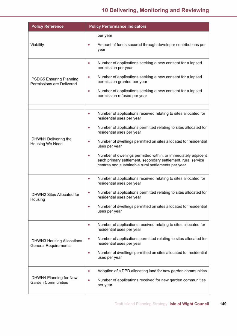
Policy Performance IndicatorsPolicy Reference
Viability
per year
Amount of funds secured through developer contributions peryear
PSDG5 Ensuring Planning
Number of applications seeking a new consent for a lapsed
Permissions are Delivered
permission per year
Number of applications seeking a new consent for a lapsedpermission granted per year
Number of applications seeking a new consent for a lapsedpermission refused per year
DHWN1 Delivering the
Number of applications received relating to sites allocated for
Housing We Need
residential uses per year
Number of applications permitted relating to sites allocated forresidential uses per year
Number of dwellings permitted on sites allocated for residentialuses per year
Number of dwellings permitted within, or immediately adjacenteach primary settlement, secondary settlement, rural servicecentres and sustainable rural settlements per year
DHWN2 Sites Allocated for
Number of applications received relating to sites allocated for
Housing
residential uses per year
Number of applications permitted relating to sites allocated forresidential uses per year
Number of dwellings permitted on sites allocated for residentialuses per year
DHWN3 Housing Allocations
Number of applications received relating to sites allocated for
General Requirements
residential uses per year
Number of applications permitted relating to sites allocated forresidential uses per year
Number of dwellings permitted on sites allocated for residentialuses per year
DHWN4 Planning for New
Adoption of a DPD allocating land for new garden communities
Garden Communities Number of applications received for new garden communitiesper year
149Draft Island Planning Strategy Isle of Wight Council
10 Delivering, Monitoring and Reviewing

Policy Performance IndicatorsPolicy Reference
DHWN5 Maximising Infill
Number of applications received for 'infill' per year
Opportunities
Number of applications permitted for 'infill' per year
Number of applications refused for 'infill' per year
Number of dwellings permitted for 'infill' per year
DHWN6 Delivering Affordable
Number of affordable dwellings permitted per year
Housing
Location of permitted affordable dwellings per year
Number of affordable dwellings completed per year
Location of completed affordable dwellings per year
Number of legal agreements securing developer contributionstowards affordable housing per year
Amount of funds secured through developer contributionstowards affordable housing per year
DHWN7 Rural Exceptions
Number of rural exception sites permitted per year
Sites
Number of rural exception sites refused per year
Location of permitted rural exception sites per year
Number of affordable dwellings permitted per year
Number of affordable dwellings completed per year
DHWN8 Ensuring the Right
Number of 1, 2, 3, 4+ dwellings permitted per year
Mix of Housing
Location of permitted 1, 2, 3, 4+ dwellings per year
Number of 1, 2, 3, 4+ dwelling completed per year
Location of completed 1, 2, 3, 4+ dwellings per year
DHWN9 Self and Custom
Number of self and custom build dwellings permitted per year
Build
Number of self and custom build dwellings permitted per yearby regeneration area
Number of bedrooms for self and custom build dwellingspermitted by regeneration area
Number of self and custom build dwellings completed per year
Number of bedrooms for self and custom build dwellings
Isle of Wight Council Draft Island Planning Strategy150
10 Delivering, Monitoring and Reviewing

Policy Performance IndicatorsPolicy Reference
completed by regeneration area
Number of self and custom build dwellings completed per yearby regeneration area
DHWN10 Planning for Gypsy,
Number of sites/ pitches permitted per year
Traveller and TravellingShowpeople Provision
Location of permitted sites/ pitches
Number of sites/ pitches completed per year
Location of completed sites/ pitches
SGOE1Supporting and
Number of jobs created through planning permissions granted
Growing Our Economy
per year
Number of hectares permitted for employment land per year
Number of hectares of employment land completed per year
EA1 Employment Allocation
Number of jobs created through planning permissions granted
Land at Pan Lane, Newport
per year
Number of hectares permitted for employment land per year
Number of hectares of employment land completed per year
EA2 Employment Allocation at
Number of jobs created through planning permissions granted
Nicholson Road, Ryde
per year
Number of hectares permitted for employment land per year
Number of hectares of employment land completed per year
EA3 Employment Allocation at
Number of jobs created through planning permissions granted
Somerton Farm, Cowes
per year
Number of hectares permitted for employment land per year
Number of hectares of employment land completed per year
EA4 Employment Allocation at
Number of jobs created through planning permissions granted
Kingston Marine Park, East
per year
CowesNumber of hectares permitted for employment land per year
Number of hectares of employment land completed per year
151Draft Island Planning Strategy Isle of Wight Council
10 Delivering, Monitoring and Reviewing

Policy Performance IndicatorsPolicy Reference
EA5 Employment Allocation at
Number of jobs created through planning permissions granted
Lowtherville, Ventnor
per year
Number of hectares permitted for employment land per year
Number of hectares of employment land completed per year
EA6 Employment Allocation at
Number of jobs created through planning permissions granted
Sandown Airport, Sandown
per year
Number of hectares permitted for employment land per year
Number of hectares of employment land completed per year
SGOE2Sustainable Economic
Number of applications for the loss of employment sites of 0.1
Development
hectares or above received per year
Number of employment sites of 0.1 hectares or above lost peryear
Number of applications for the intensification and/ or expansionof existing industrial estates or employment sites per year
Number of applications for the intensification and/ or expansionof existing industrial estates or employment sites permitted peryear
SGOE3 Upskilling the Island
Number of applications received requiring an employment andskills plan per year
Number of applications permitted requiring an employment andskills plan per year
Number of employment opportunities created as a result ofemployment and skills plan per year
SGOE4 Supporting the Rural
Number of applications received for farm diversification receivedper year
Economy
Number of applications permitted for farm diversification peryearNumber of applications for the reuse of historic farm buildingsper yearNumber of applications permitted for the reuse of historic farmbuildings per yearNumber of applications for agricultural workers accommodationunits permitted per yearNumber of applications permitted for agricultural workersaccommodation units permitted per year
SGOE5 Maintaining Number of applications for the loss of employment sites withwater access to the north of the line per yearEmployment Sites with Water
Isle of Wight Council Draft Island Planning Strategy152
10 Delivering, Monitoring and Reviewing

Policy Performance IndicatorsPolicy Reference
Access
Number of applications permitted for the loss of employmentsites with water access to the north of the line per yearNumber of applications for the loss of employment sites withwater access to the south of the line per yearNumber of applications permitted for the loss of employmentsites with water access to the south of the line per year
SGOE6 Future Proofing DigitalNumber of applications proposing greater digital connectivityabove Building Regulations per year
Infrastructure Number of applications permitted proposing greater digitalconnectivity above Building Regulations per year
SGOE7 Supporting and
Number of applications for retail uses within Primary ShoppingArea, Town Centre, Edge-of-Centre and Out of Centre sites peryear
Improving Our Town Centres
Number of applications permitted for retail uses within PrimaryShopping Area, Town Centre, Edge-of-Centre and Out of Centresites per yearNumber of applications requiring a retail impact assessmentper yearNumber of applications permitted requiring a retail impactassessment per year
SGOE8 Supporting theNumber of applications that increase the footfall in centres inthe evening per year
Evening Economy Number of applications permitted that increase the footfall incentres in the evening per year
SGOE9 Supporting High
Number of tourism bed spaces permitted per year
Quality Tourism
Number of tourism bed spaces lost per yearNumber of applications for the loss of tourist accommodationwithin core tourist accommodation areas per yearNumber of applications permitted for the loss of touristaccommodation within core tourist accommodation areas peryear
SGOE10 The Bay TourismNumber of applications for tourism uses within the tourismopportunity area per year
Opportunity Area Number of applications permitted for tourism uses within thetourism opportunity area per year
SGOE11 Ryde TourismNumber of applications for compatible uses within the tourismopportunity zone per year
Opportunity Zones Number of applications permitted for compatible uses withinthe tourism opportunity zone per year
BCI1 A Better Connected
Number of applications that contribute to the delivery of the keyinfrastructure improvements set out in the policy per year
Island Number of applications permitted that contribute to the deliveryof the key infrastructure improvements set out in the policy peryear
153Draft Island Planning Strategy Isle of Wight Council
10 Delivering, Monitoring and Reviewing
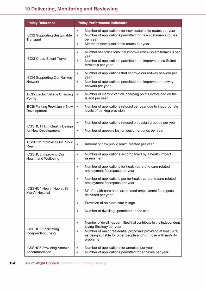
Policy Performance IndicatorsPolicy Reference
BCI2 Supporting SustainableNumber of applications for new sustainable routes per year
TransportNumber of applications permitted for new sustainable routesper yearMetres of new sustainable routes per year
BCI3 Cross-Solent Travel
Number of applications that improve cross-Solent terminals peryearNumber of applications permitted that improve cross-Solentterminals per year
BCI4 Supporting Our RailwayNumber of applications that improve our railway network peryear
Network Number of applications permitted that improve our railwaynetwork per year
BCI5 Electric Vehicle Charging Number of electric vehicle charging points introduced on theIsland per yearPoints
BCI6 Parking Provision in New Number of applications refused per year due to inappropriatelevels of parking provisionDevelopment
CSSHC1 High Quality DesignNumber of applications refused on design grounds per year
for New Development Number of appeals lost on design grounds per year
CSSHC2 ImprovingOur Public Amount of new public realm created per yearRealm
CSSHC3 Improving Our Number of applications accompanied by a health impactassessmentHealth and Wellbeing
CSSHC4 Health Hub at St
Number of applications for health-care and care-related
Mary's Hospital
employment floorspace per year
Number of applications per for health-care and care-relatedemployment floorspace per year
M2 of health-care and care-related employment floorspacedelivered per year
Provision of an extra care village
Number of dwellings permitted on the site
CSSHC5 Facilitating
Number of dwellings permitted that contribute to the IndependentLiving Strategy per year
Independent Living Number of major residential proposals providing at least 20%as being suitable for older people and/ or those with mobilityproblems
CSSHC6 Providing Annexe Number of applications for annexes per yearAccommodation Number of applications permitted for annexes per year
Isle of Wight Council Draft Island Planning Strategy154
10 Delivering, Monitoring and Reviewing
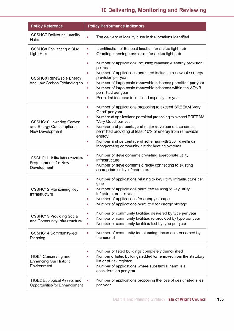
Policy Performance IndicatorsPolicy Reference
CSSHC7 Delivering Locality The delivery of locality hubs in the locations identifiedHubs
CSSHC8 Facilitating a Blue Identification of the best location for a blue light hubLight Hub Granting planning permission for a blue light hub
CSSHC9 Renewable Energy
Number of applications including renewable energy provisionper year
and Low Carbon Technologies
Number of applications permitted including renewable energyprovision per yearNumber of large-scale renewable schemes permitted per yearNumber of large-scale renewable schemes within the AONBpermitted per yearPermitted increase in installed capacity per year
CSSHC10 Lowering Carbon
Number of applications proposing to exceed BREEAM 'VeryGood' per year
and Energy Consumption inNew Development
Number of applications permitted proposing to exceed BREEAM'Very Good' per yearNumber and percentage of major development schemespermitted providing at least 10% of energy from renewableenergyNumber and percentage of schemes with 250+ dwellingsincorporating community district heating systems
CSSHC11 Utility InfrastructureNumber of developments providing appropriate utilityinfrastructure
Requirements for NewDevelopment Number of developments directly connecting to existing
appropriate utility infrastructure
CSSHC12 Maintaining Key
Number of applications relating to key utility infrastructure peryear
InfrastructureNumber of applications permitted relating to key utilityinfrastructure per yearNumber of applications for energy storageNumber of applications permitted for energy storage
CSSHC13 Providing SocialNumber of community facilities delivered by type per year
and Community Infrastructure Number of community facilities re-provided by type per yearNumber of community facilities lost by type per year
CSSHC14 Community-led Number of community-led planning documents endorsed bythe councilPlanning
HQE1 Conserving andNumber of listed buildings completely demolished
Enhancing Our HistoricNumber of listed buildings added to/ removed from the statutorylist or at risk register
Environment Number of applications where substantial harm is aconsideration per year
HQE2 Ecological Assets and Number of applications proposing the loss of designated sitesper yearOpportunities for Enhancement
155Draft Island Planning Strategy Isle of Wight Council
10 Delivering, Monitoring and Reviewing

Policy Performance IndicatorsPolicy Reference
Number of applications permitted proposing the loss ofdesignated sites per yearNumber of applications submitted with a biodiversity checklistper yearAmount of financial contributions agreed in accordance with theBird Aware Solent Strategy per year
HQE3 Trees, Woodland andNumber of applications proposing the loss of ancient woodlandand ancient or veteran trees per year
Hedgerows Number of applications refused proposing the loss of ancientwoodland and ancient or veteran trees per year
HQE4 Providing and
Number of applications received proposing the loss of identifiedopen space per year
Protecting Green Spaces Number of applications permitting the loss of identified openspace per yearAmount of SANGs permitted per year
HQE5 Local Green Spaces
Number of sites proposed by local communities as Local GreenSpaces per yearNumber of applications received within designated Local GreenSpaces per yearNumber of applications permitted within designated Local GreenSpaces per year
HQE6 Protecting OurNumber of applications identified as having a potential impacton seascape per year
Seascapes and Landscapes Number of applications permitted having a potential impact onseascape per year
HQE7 Preserving SettlementNumber of applications received within the settlement gaps peryear
Identity Number of applications permitted within the settlement gapsper year
HQE8 Isle of Wight AONB Number and percentage of applications determined not inaccordance with AONB comments per year
HQE9 Dark Skies
Number of applications received within the proposed Dark SkiesPark including roof glazing and large expanses of glazing peryearNumber of applications permitted within the proposed DarkSkies Park including roof glazing and large expanses of glazingper year
HQE10 Managing Our WaterNumber of dwellings approved where water consumption perhousehold is 100lpppd per year
Resources Number of applications where there is a net increase in surfacewater run-off (compared to the pre-development rate)
Isle of Wight Council Draft Island Planning Strategy156
10 Delivering, Monitoring and Reviewing

Policy Performance IndicatorsPolicy Reference
HQE11 Managing Flood RiskNumber of dwellings permitted in flood risk zones 2, 3a and 3bper year
in New Development Number of planning applications granted contrary toEnvironment Agency on flood risk grounds per year
HQE12 Monktonmead
Number of applications received for development proposals
Catchment Area
located within the Monktonmead catchment area per year
Number of development proposals permitted that provide on-sitesustainable drainage systems per year
HQE13 Managing Our Coast
Number of applications received for development proposalswithin CCMAs per year
Number of permissions granted for development proposalswithin CCMAs per year
Number of completions within CCMAs per year
HQE14 Facilitating Relocation
Number of applications received for relocation from CCMAs per
from Coastal Change
year
Management Areas Number of permissions granted for relation from CCMAs peryear
HQE15 Improving Resilience
Number of applications located on waterfronts with a 'hold the
from Coastal Flooding
line policy' per year
Number of applications proposing provision and/ or maintenanceof coastal defences or land raising per year
HQE16 Managing Ground
Number of applications received located within areas identified
Instability in New Development
as being at potential risk from future ground instability per year
Number of applications permitted within areas identified as beingat potential risk from future ground instability per year
Number of applications refused within areas identified as beingat potential risk from future ground instability per year
157Draft Island Planning Strategy Isle of Wight Council
10 Delivering, Monitoring and Reviewing

West Wight Regeneration Area
IndicativeYield
Specific or GenericPolicy requirement
Housing AllocationReference Number
Settlement
6GenericHA001*Totland
10SpecificHA002Totland
10GenericHA003Totland
60GenericHA004Freshwater
150SpecificHA005Freshwater
90SpecificHA006Freshwater
90SpecificHA007Freshwater
25SpecificHA008Freshwater
10SpecificHA009Freshwater
15SpecificHA010Wellow
7SpecificHA011Wellow
10SpecificHA012Wellow
15GenericHA013Thorley
30GenericHA014Shalfleet
10SpecificHA015Calbourne
10SpecificHA016Calbourne
4SpecificHA017Brighstone
552Total
West Medina Regeneration Area
Indicative YieldSpecific or GenericPolicy requirement
Housing AllocationReference Number
Settlement
20GenericHA018Cowes
535SpecificHA019Cowes
146SpecificHA020Cowes
25SpecificHA021Cowes
80SpecificHA022Cowes
7GenericHA023Cowes
Isle of Wight Council Draft Island Planning Strategy158
1 Appendix 1 List of Allocated Sites
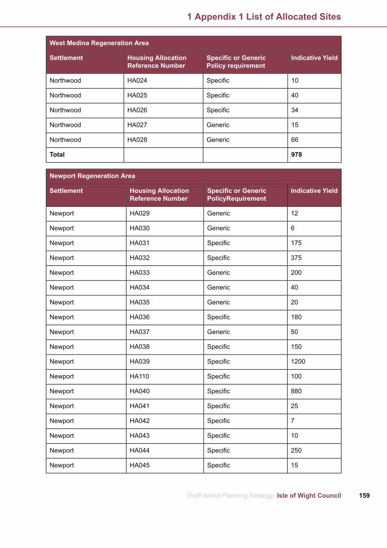
West Medina Regeneration Area
Indicative YieldSpecific or GenericPolicy requirement
Housing AllocationReference Number
Settlement
10SpecificHA024Northwood
40SpecificHA025Northwood
34SpecificHA026Northwood
15GenericHA027Northwood
66GenericHA028Northwood
978Total
Newport Regeneration Area
Indicative YieldSpecific or GenericPolicyRequirement
Housing AllocationReference Number
Settlement
12GenericHA029Newport
6GenericHA030Newport
175SpecificHA031Newport
375SpecificHA032Newport
200GenericHA033Newport
40GenericHA034Newport
20GenericHA035Newport
180SpecificHA036Newport
50GenericHA037Newport
150SpecificHA038Newport
1200SpecificHA039Newport
100SpecificHA110Newport
880SpecificHA040Newport
25SpecificHA041Newport
7SpecificHA042Newport
10SpecificHA043Newport
250SpecificHA044Newport
15SpecificHA045Newport
159Draft Island Planning Strategy Isle of Wight Council
1 Appendix 1 List of Allocated Sites
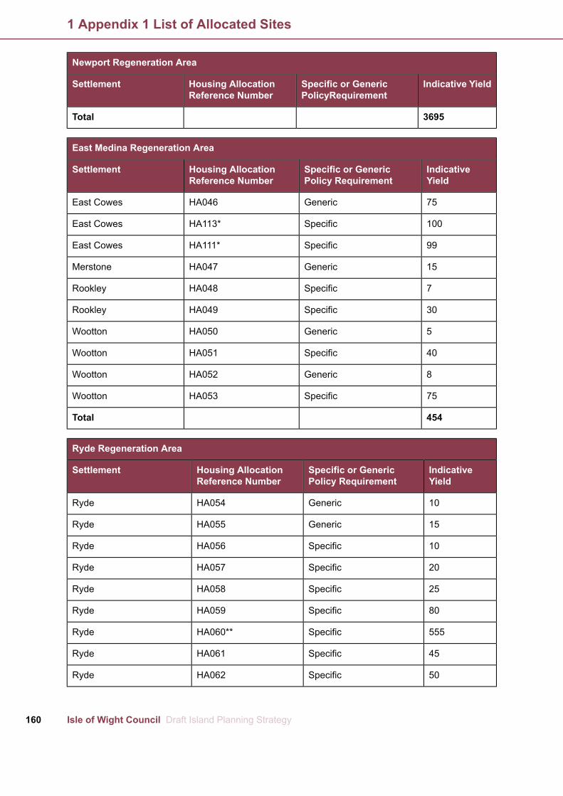
Newport Regeneration Area
Indicative YieldSpecific or GenericPolicyRequirement
Housing AllocationReference Number
Settlement
3695Total
East Medina Regeneration Area
IndicativeYield
Specific or GenericPolicy Requirement
Housing AllocationReference Number
Settlement
75GenericHA046East Cowes
100SpecificHA113*East Cowes
99SpecificHA111*East Cowes
15GenericHA047Merstone
7SpecificHA048Rookley
30SpecificHA049Rookley
5GenericHA050Wootton
40SpecificHA051Wootton
8GenericHA052Wootton
75SpecificHA053Wootton
454Total
Ryde Regeneration Area
IndicativeYield
Specific or GenericPolicy Requirement
Housing AllocationReference Number
Settlement
10GenericHA054Ryde
15GenericHA055Ryde
10SpecificHA056Ryde
20SpecificHA057Ryde
25SpecificHA058Ryde
80SpecificHA059Ryde
555SpecificHA060**Ryde
45SpecificHA061Ryde
50SpecificHA062Ryde
Isle of Wight Council Draft Island Planning Strategy160
1 Appendix 1 List of Allocated Sites
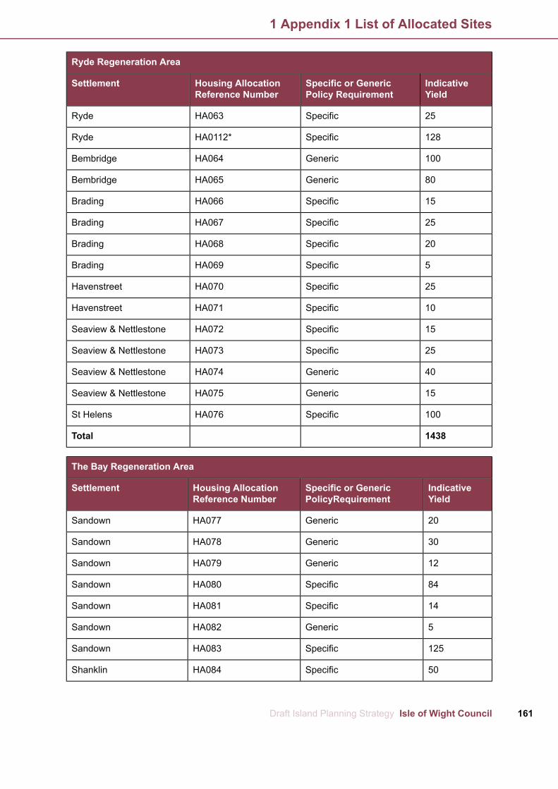
Ryde Regeneration Area
IndicativeYield
Specific or GenericPolicy Requirement
Housing AllocationReference Number
Settlement
25SpecificHA063Ryde
128SpecificHA0112*Ryde
100GenericHA064Bembridge
80GenericHA065Bembridge
15SpecificHA066Brading
25SpecificHA067Brading
20SpecificHA068Brading
5SpecificHA069Brading
25SpecificHA070Havenstreet
10SpecificHA071Havenstreet
15SpecificHA072Seaview & Nettlestone
25SpecificHA073Seaview & Nettlestone
40GenericHA074Seaview & Nettlestone
15GenericHA075Seaview & Nettlestone
100SpecificHA076St Helens
1438Total
The Bay Regeneration Area
IndicativeYield
Specific or GenericPolicyRequirement
Housing AllocationReference Number
Settlement
20GenericHA077Sandown
30GenericHA078Sandown
12GenericHA079Sandown
84SpecificHA080Sandown
14SpecificHA081Sandown
5GenericHA082Sandown
125SpecificHA083Sandown
50SpecificHA084Shanklin
161Draft Island Planning Strategy Isle of Wight Council
1 Appendix 1 List of Allocated Sites

The Bay Regeneration Area
IndicativeYield
Specific or GenericPolicyRequirement
Housing AllocationReference Number
Settlement
14GenericHA085*Shanklin
7GenericHA086Shanklin
3GenericHA087Shanklin
50SpecificHA088Shanklin
10GenericHA089Shanklin
15SpecificHA090Ventnor
15SpecificHA091Ventnor
10GenericHA092Ventnor
16GenericHA093Apse Heath
12GenericHA094Apse Heath
45SpecificHA095Godshill
30SpecificHA096Godshill
50SpecificHA097Godshill
20SpecificHA098Chale Green
5SpecificHA099Chale
15SpecificHA100Newchurch
10SpecificHA101Newchurch
30SpecificHA102Niton
25SpecificHA103Niton
6GenericHA104Niton
20SpecificHA105Whitwell
50SpecificHA106Winford
15SpecificHA107Wroxall
6GenericHA108Wroxall
20GenericHA109Wroxall
839Total
*Has permission for number indicated
Isle of Wight Council Draft Island Planning Strategy162
1 Appendix 1 List of Allocated Sites

**Has permission for 80 dwellings
163Draft Island Planning Strategy Isle of Wight Council
1 Appendix 1 List of Allocated Sites

West WIght Regeneration Area
Policy / RequirementsAddressHousingAllocationRef Number
A mixed brownfield and greenfield site of approximatelyLand and SchoolHA0020.8 hectares is allocated for residential use.buildings at Weston
Primary School, WestonThe site is located on two levels, the lower level with theRoad, Totland Bayexisting school building and the higher level with theoutdoor space and parking area.
The development should provide for at least 10 homesproviding a mix of sizes and an affordable housingcontribution in line with DHWN6.
The level differences of the site should be incorporatedinto the design and layout, using the lower level for theaccommodation and the higher level for parking and openspace.
Given the building is recorded on the HER and contributesto the character of the conservation area, every effortshould be made to incorporate it within the development.
If the school cannot be retained it will need to be recordedprior to development and any new development shouldbe of extremely high quality and design and make apositive contribution to the conservation area.
Early discussions with the council's Planning Servicesand Archaeology & Historic Environment Service isadvised. An alternative community-led approach maybe considered.
A greenfield site of approximately 6 hectares is allocatedLand to the east ofHA005at Camp Road, Freshwater to deliver a sustainable, highFootball Club, Campquality residential development which shall provide:Road, Freshwater
a) At least 150 homes providing a mix of sizes and anaffordable housing contribution in line with DHWN6;
b) road improvements to Camp Road to improve vehicleand pedestrian intervisibility;
c) off site pedestrian pavement/walkway improvements;
d) onsite walking and cycling routes with links to nearbyroutes; and
e) a mix of onsite SANGs, open and recreation space.
Archaeological assessments may need to be undertakenby any potential applicant and early liaison with thecouncil's Archaeology and Historic Environment Service
Isle of Wight Council Draft Island Planning Strategy164
2 Appendix 2 Site Specific Requirements for Allocated Sites
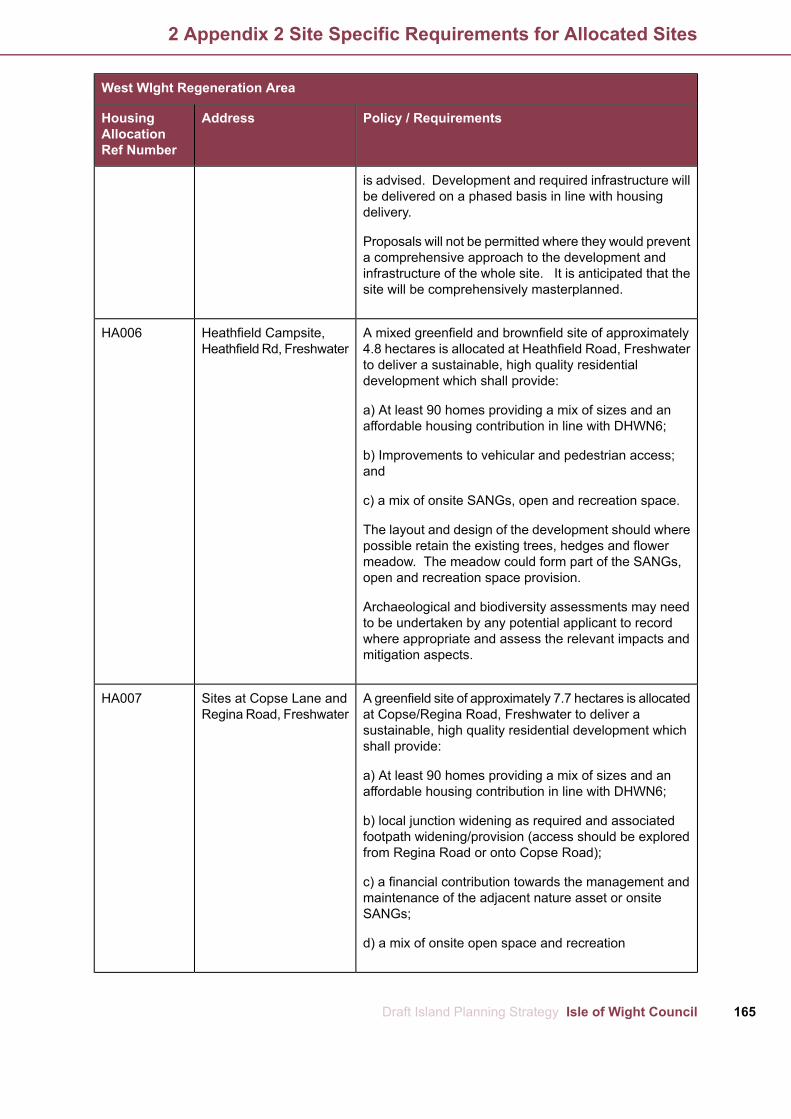
West WIght Regeneration Area
Policy / RequirementsAddressHousingAllocationRef Number
is advised. Development and required infrastructure willbe delivered on a phased basis in line with housingdelivery.
Proposals will not be permitted where they would preventa comprehensive approach to the development andinfrastructure of the whole site. It is anticipated that thesite will be comprehensively masterplanned.
A mixed greenfield and brownfield site of approximatelyHeathfield Campsite,HA0064.8 hectares is allocated at Heathfield Road, FreshwaterHeathfield Rd, Freshwaterto deliver a sustainable, high quality residentialdevelopment which shall provide:
a) At least 90 homes providing a mix of sizes and anaffordable housing contribution in line with DHWN6;
b) Improvements to vehicular and pedestrian access;and
c) a mix of onsite SANGs, open and recreation space.
The layout and design of the development should wherepossible retain the existing trees, hedges and flowermeadow. The meadow could form part of the SANGs,open and recreation space provision.
Archaeological and biodiversity assessments may needto be undertaken by any potential applicant to recordwhere appropriate and assess the relevant impacts andmitigation aspects.
A greenfield site of approximately 7.7 hectares is allocatedSites at Copse Lane andHA007at Copse/Regina Road, Freshwater to deliver aRegina Road, Freshwatersustainable, high quality residential development whichshall provide:
a) At least 90 homes providing a mix of sizes and anaffordable housing contribution in line with DHWN6;
b) local junction widening as required and associatedfootpath widening/provision (access should be exploredfrom Regina Road or onto Copse Road);
c) a financial contribution towards the management andmaintenance of the adjacent nature asset or onsiteSANGs;
d) a mix of onsite open space and recreation
165Draft Island Planning Strategy Isle of Wight Council
2 Appendix 2 Site Specific Requirements for Allocated Sites

West WIght Regeneration Area
Policy / RequirementsAddressHousingAllocationRef Number
e) green footpath links to and from the adjacent natureasset;
f) landscape buffers to the nature asset and to safeguardthe setting of Golden Hill Fort Scheduled AncientMonument; and
g) allotment provision to the south west to retain greenbuffer.
Archaeological assessments may need to be undertakenby any potential applicant and early liaison with thecouncil's Archaeology and Historic Environment Serviceis advised.
A greenfield site of approximately 1.8 hectares is allocatedChurch Field, CopseHA008at Church Field, Copse Lane, Freshwater to deliver highLane, Freshwaterquality residential development which shall provide:
a)At least 25 homes providing a mix of sizes and anaffordable housing contribution in line with DHWN6;
b) vehicular access improvements and/ or consideroptions for access onto Kings Manor Road.
The site is immediately adjacent to Church PlaceConservation Area and the All Saints Church, a GradeII* listed building. The site may also form part of the coreof a medieval settlement, as such any developmentshould be of extremely high quality and take account ofthe adjacent features when considering design andlayout.
Archaeological assessments may need to be undertakenby any potential applicant and early liaison with thecouncil's Archaeology and Historic Environment Serviceis advised.
A greenfield site of approximately 0.5 hectares is allocatedThe Apple Farm, NewportHA009at The Apple Farm, Freshwater to deliver high qualityRoad, Freshwaterresidential development which shall provide:
a) Between 7-10 homes fronting and accessing ManorRoad; and
b) landscape buffers from development towards NewportRoad.
Two sites are allocated in Wellow to provide for a mix ofLand at Main Road &HA010 &
Isle of Wight Council Draft Island Planning Strategy166
2 Appendix 2 Site Specific Requirements for Allocated Sites
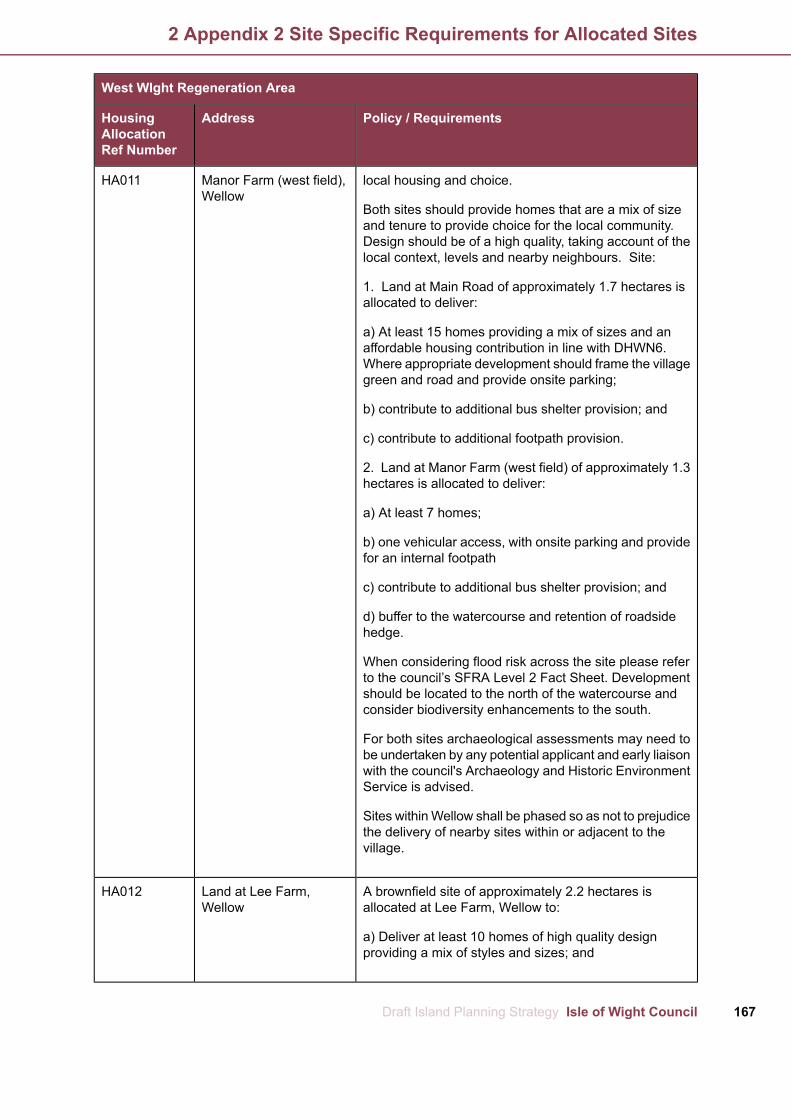
West WIght Regeneration Area
Policy / RequirementsAddressHousingAllocationRef Number
HA011 local housing and choice.Manor Farm (west field),Wellow
Both sites should provide homes that are a mix of sizeand tenure to provide choice for the local community.Design should be of a high quality, taking account of thelocal context, levels and nearby neighbours. Site:
1. Land at Main Road of approximately 1.7 hectares isallocated to deliver:
a) At least 15 homes providing a mix of sizes and anaffordable housing contribution in line with DHWN6.Where appropriate development should frame the villagegreen and road and provide onsite parking;
b) contribute to additional bus shelter provision; and
c) contribute to additional footpath provision.
2. Land at Manor Farm (west field) of approximately 1.3hectares is allocated to deliver:
a) At least 7 homes;
b) one vehicular access, with onsite parking and providefor an internal footpath
c) contribute to additional bus shelter provision; and
d) buffer to the watercourse and retention of roadsidehedge.
When considering flood risk across the site please referto the council’s SFRA Level 2 Fact Sheet. Developmentshould be located to the north of the watercourse andconsider biodiversity enhancements to the south.
For both sites archaeological assessments may need tobe undertaken by any potential applicant and early liaisonwith the council's Archaeology and Historic EnvironmentService is advised.
Sites withinWellow shall be phased so as not to prejudicethe delivery of nearby sites within or adjacent to thevillage.
A brownfield site of approximately 2.2 hectares isLand at Lee Farm,HA012allocated at Lee Farm, Wellow to:Wellow
a) Deliver at least 10 homes of high quality designproviding a mix of styles and sizes; and
167Draft Island Planning Strategy Isle of Wight Council
2 Appendix 2 Site Specific Requirements for Allocated Sites

West WIght Regeneration Area
Policy / RequirementsAddressHousingAllocationRef Number
b) make land available under the wider ownership tofacilitate the delivery of a cycle track between Freshwaterand Newport.
When considering flood risk across the site please referto the council’s SFRA Level 2 Fact Sheet. Archaeologicalassessments may need to be undertaken by any potentialapplicant and early liaison with the council's Archaeologyand Historic Environment Service is advised.
Two sites are allocated at Calbourne to provide a mix ofLand at Elm Lane,HA015 &local housing and choice.(adjacent to TennysonHA016
View) / Merlins Farm, ElmBoth sites should provide homes that are a mix of sizeLane, Calbourneand tenure to provide choice for the local community.Design should be of a high quality, taking account of thelocal context, levels and nearby neighbours. Site:
1. Land at Elm Lane of approximately 0.5 hectares isallocated to deliver:
a) At least 10 affordable homes;
b) a single vehicular access to the north of the site;
c) landscape buffers to the west;
d) an internal footpath to facilitate access along Elm Lane;and
e) retain the ancient roadside hedge as far as possibletaking account of visibility splays and requirements.
2. Land at Merlins Farm, Elm Lane, Calbourne ofapproximately 1 hectare is allocated to deliver:
a) At least 10 homes providing a mix of sizes and anaffordable housing contribution in line with DHWN6; and
b) one new vehicular access to the north of the existingaccess and provide for an internal footpath to facilitateaccessibility.
Archaeological assessments may need to be undertakenby any potential applicant and early liaison with thecouncil's Archaeology and Historic Environment Serviceis advised.
Sites within Calbourne shall be phased so as not toprejudice the delivery of nearby sites within or adjacentto the village.
Isle of Wight Council Draft Island Planning Strategy168
2 Appendix 2 Site Specific Requirements for Allocated Sites

West WIght Regeneration Area
Policy / RequirementsAddressHousingAllocationRef Number
A greenfield site located in the AONB of approximatelyLand at Moor Lane,HA0170.3 hectares is allocated to the north of Moor Lane,BrighstoneBrighstone to deliver high quality residential developmentwhich shall, taking account of topography, local vernacularand distinctiveness, landscape character, and nearbyneighbours provide:
a) Between 3-4 homes in a barn / rustic housing style.
It is anticipated that development would be up to and nomore than a storey and a half in height.
As the site is close to Rock Roman Villa a ScheduleAncient Monument archaeology studies may be required.Early discussions with the council's Archaeology &Historic Environment Service is advised.
West Medina Regeneration Area
Policy / RequirementsAddressHousingAllocationRef Number
A brownfield site of approximately 5.8 hectares isMedina Yard, CowesHA019allocated at the site known as Medina Yard, Cowes todeliver a sustainable, high quality mixed use developmentresilient to climate change which shall provide deliveryof:
a) At least 535 homes providing a mix of sizes and anaffordable housing contribution in line with DHWN6;
b) approximately 18600 sqm of non-residential floorspace which should include an appropriate mix of:
i. Flexible retail, financial and professional services, foodand drink floor space (A1-A4 uses);
ii. flexible office and other work spaces (B1 uses);
iii. including at least 440 sqm of Marine Trainingaccommodation;
iv. approximately 14500 sqm of marine industrial spaceand storage (B2/B8 use);
v. community use and museum floor space (D1 uses);and
vi. other uses as appropriate.
169Draft Island Planning Strategy Isle of Wight Council
2 Appendix 2 Site Specific Requirements for Allocated Sites

West Medina Regeneration Area
Policy / RequirementsAddressHousingAllocationRef Number
c) a mix of onsite SANGs, open and recreation space;
d) new public realm works, including a piazza andaccessible waterfront;
e) hard and soft landscaping across the site withpedestrian routes;
f) reconstruction of the sea wall and new public slip way;
g) on-site car parking and cycle provision;
h) public transport, access and highway improvementsas required as well as opportunities to enhance or createlinks to the existing sustainable transport network; and
i) refurbishment of former J Samuel White offices andHammerhead Crane.
Development and required infrastructure will be deliveredon a phased basis in line with housing delivery. It isanticipated that the site will be comprehensivelymasterplanned.
Proposals should demonstrate that the level of retail andleisure uses will not have an unacceptable impact on thetown centres of Cowes and East Cowes.
A brownfield site of approximately 1.9 hectares isFormer SomertonHA019allocated at the Former Somerton Reservoir, Cowes, toReservoir, Newport Road,deliver a sustainable, high quality residential developmentCoweswhich shall provide delivery of:
a) At least 102 homes providing a mix of sizes and anaffordable housing contribution in line with DHWN6;
b) at least 44 units for assisted living accommodation;
c) onsite soft and hard landscaping;
d) a mix of onsite SANGs, open and recreation space;
e) public transport and highway improvements asrequired; and
f) proportionate contributions to improvements to off-sitejunctions identified in Tables 7.1 and 7.2, if required.
A greenfield site of approximately 1.7 hectares isLand at Baring Road,HA021allocated at Baring Road, Cowes to deliver a sustainable,including 187 Baringhigh quality residential development which shall provide:Road, Gurnard
Isle of Wight Council Draft Island Planning Strategy170
2 Appendix 2 Site Specific Requirements for Allocated Sites

West Medina Regeneration Area
Policy / RequirementsAddressHousingAllocationRef Number
a) At least 25 homes providing a mix of sizes and anaffordable housing contribution in line with DHWN6;
b) a continuous footpath along the road frontage; and
c) landscape buffers should be incorporated to the westto safeguard the setting of Jordan Valley.
As the site is located on the edge of the Jordan Valleybetween Cowes and Gurnard, design should be highquality and take account of the existing context.
Development should look to provide a single row offrontage dwellings, or chalet style to ensure gaps andopportunities to view the valley and slightly set back fromthe road, similar to the existing dwellings to the south.
An appropriate sized gap opposite Crossfield Avenueshould be maintained to provide relief in the massing andmaintain views across the valley.
Archaeological and biodiversity assessments may needto be undertaken by any potential applicant to recordwhere appropriate and assess the relevant impacts andmitigation aspects.
A greenfield site of approximately 9.75 hectares isSomerton Farm, NewportHA022allocated at Somerton Farm, Cowes to deliver aRoad, Cowessustainable, high quality mixed use development whichshall provide:
a) At least 80 homes providing a mix of sizes and anaffordable housing contribution in line with DHWN6;
b) improved road network to allow ease of movement toand through the site;
c) in conjunction with the adjacent employment allocationPolicy EA3, a multi-user route to the nearby Cowes toNewport multi-user network;
d) a mix of onsite SANGs, open and recreation space;
e) landscape buffers to the ancient woodland, SINC andalong with the watercourse corridor; and
f) proportionate contributions to improvements to off-sitejunctions identified in Tables 7.1 and 7.2, if required.
Additional B1 employment uses may be appropriatewithin the farm yard buildings.
171Draft Island Planning Strategy Isle of Wight Council
2 Appendix 2 Site Specific Requirements for Allocated Sites
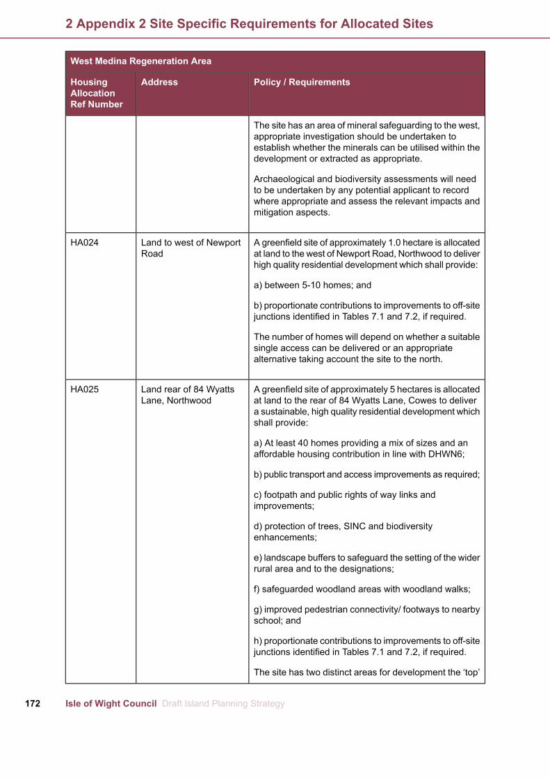
West Medina Regeneration Area
Policy / RequirementsAddressHousingAllocationRef Number
The site has an area of mineral safeguarding to the west,appropriate investigation should be undertaken toestablish whether the minerals can be utilised within thedevelopment or extracted as appropriate.
Archaeological and biodiversity assessments will needto be undertaken by any potential applicant to recordwhere appropriate and assess the relevant impacts andmitigation aspects.
A greenfield site of approximately 1.0 hectare is allocatedLand to west of NewportHA024at land to the west of Newport Road, Northwood to deliverRoadhigh quality residential development which shall provide:
a) between 5-10 homes; and
b) proportionate contributions to improvements to off-sitejunctions identified in Tables 7.1 and 7.2, if required.
The number of homes will depend on whether a suitablesingle access can be delivered or an appropriatealternative taking account the site to the north.
A greenfield site of approximately 5 hectares is allocatedLand rear of 84 WyattsHA025at land to the rear of 84 Wyatts Lane, Cowes to deliverLane, Northwooda sustainable, high quality residential development whichshall provide:
a) At least 40 homes providing a mix of sizes and anaffordable housing contribution in line with DHWN6;
b) public transport and access improvements as required;
c) footpath and public rights of way links andimprovements;
d) protection of trees, SINC and biodiversityenhancements;
e) landscape buffers to safeguard the setting of the widerrural area and to the designations;
f) safeguarded woodland areas with woodland walks;
g) improved pedestrian connectivity/ footways to nearbyschool; and
h) proportionate contributions to improvements to off-sitejunctions identified in Tables 7.1 and 7.2, if required.
The site has two distinct areas for development the ‘top’
Isle of Wight Council Draft Island Planning Strategy172
2 Appendix 2 Site Specific Requirements for Allocated Sites
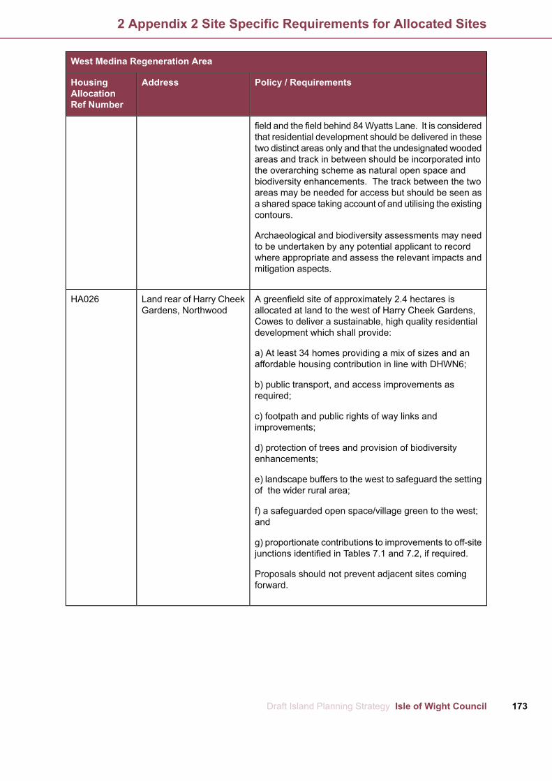
West Medina Regeneration Area
Policy / RequirementsAddressHousingAllocationRef Number
field and the field behind 84Wyatts Lane. It is consideredthat residential development should be delivered in thesetwo distinct areas only and that the undesignated woodedareas and track in between should be incorporated intothe overarching scheme as natural open space andbiodiversity enhancements. The track between the twoareas may be needed for access but should be seen asa shared space taking account of and utilising the existingcontours.
Archaeological and biodiversity assessments may needto be undertaken by any potential applicant to recordwhere appropriate and assess the relevant impacts andmitigation aspects.
A greenfield site of approximately 2.4 hectares isLand rear of Harry CheekHA026allocated at land to the west of Harry Cheek Gardens,Gardens, NorthwoodCowes to deliver a sustainable, high quality residentialdevelopment which shall provide:
a) At least 34 homes providing a mix of sizes and anaffordable housing contribution in line with DHWN6;
b) public transport, and access improvements asrequired;
c) footpath and public rights of way links andimprovements;
d) protection of trees and provision of biodiversityenhancements;
e) landscape buffers to the west to safeguard the settingof the wider rural area;
f) a safeguarded open space/village green to the west;and
g) proportionate contributions to improvements to off-sitejunctions identified in Tables 7.1 and 7.2, if required.
Proposals should not prevent adjacent sites comingforward.
173Draft Island Planning Strategy Isle of Wight Council
2 Appendix 2 Site Specific Requirements for Allocated Sites

Newport Regeneration Area
Policy / RequirementsAddressHousingAllocationRef Number
A greenfield site of approximately 11.8 hectares isLand to east of GunvilleHA031allocated at land to east Gunville, Newport to delivera sustainable, high quality mixed use developmentwhich shall provide:
a) At least 175 homes providing a mix of sizes andan affordable housing contribution in line withDHWN6;
b) approximately 2.0 ha of serviced employmentland for office, general industrial or storage anddistribution uses as appropriate to the site and itswider context, ensuring that there is also a mix ofsize of unit; support will also be given to employmentgenerating uses provided that they are compatiblewith the immediate surroundings and do not conflictwith town centre uses (B uses);
c) community use floor space (D1 uses);
d) improved road network to allow ease ofmovement to and through the site;
e) multi-user links to the wider area;
f) a mix of onsite SANGs, open and recreation spaceas well as biodiversity enhancements;
g) landscaping across the site and buffers toadjacent school; and
h) public transport, pedestrian and public right ofway links and improvements.
Archaeological and biodiversity assessments willneed to be undertaken by any potential applicant torecord where appropriate and assess the relevantimpacts and mitigation aspects.
Development and required infrastructure will bedelivered on a phased basis in line with housingdelivery.
Proposals will not be permitted where they wouldprevent a comprehensive approach to the deliveryof development and infrastructure across the wholesite. It is anticipated that the site will becomprehensively masterplanned.
A greenfield site of approximately 17.8 hectares isLand at Horsebridge HillHA032allocated at Horsebridge Hill, Newport to deliver a
Isle of Wight Council Draft Island Planning Strategy174
2 Appendix 2 Site Specific Requirements for Allocated Sites
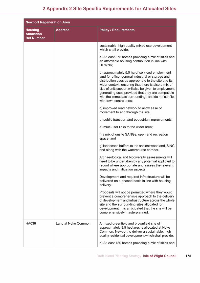
Newport Regeneration Area
Policy / RequirementsAddressHousingAllocationRef Number
sustainable, high quality mixed use developmentwhich shall provide:
a) At least 375 homes providing a mix of sizes andan affordable housing contribution in line withDHWN6;
b) approximately 5.0 ha of serviced employmentland for office, general industrial or storage anddistribution uses as appropriate to the site and itswider context, ensuring that there is also a mix ofsize of unit; support will also be given to employmentgenerating uses provided that they are compatiblewith the immediate surroundings and do not conflictwith town centre uses;
c) improved road network to allow ease ofmovement to and through the site;
d) public transport and pedestrian improvements;
e) multi-user links to the wider area;
f) a mix of onsite SANGs, open and recreationspace; and
g) landscape buffers to the ancient woodland, SINCand along with the watercourse corridor.
Archaeological and biodiversity assessments willneed to be undertaken by any potential applicant torecord where appropriate and assess the relevantimpacts and mitigation aspects.
Development and required infrastructure will bedelivered on a phased basis in line with housingdelivery.
Proposals will not be permitted where they wouldprevent a comprehensive approach to the deliveryof development and infrastructure across the wholesite and the surrounding sites allocated fordevelopment. It is anticipated that the site will becomprehensively masterplanned.
A mixed greenfield and brownfield site ofLand at Noke CommonHA036approximately 8.5 hectares is allocated at NokeCommon, Newport to deliver a sustainable, highquality residential development which shall provide:
a) At least 180 homes providing a mix of sizes and
175Draft Island Planning Strategy Isle of Wight Council
2 Appendix 2 Site Specific Requirements for Allocated Sites

Newport Regeneration Area
Policy / RequirementsAddressHousingAllocationRef Number
an affordable housing contribution in line withDHWN6;
b) public transport, access and proportionate off-sitehighway improvements as required;
c) footpath and public rights of way links andimprovements;
d) a mix of onsite SANGs, open and recreationspace; and
e) landscaping and biodiversity enhancements.
Development and required infrastructure will bedelivered on a phased basis in line with housingdelivery. Proposals will not be permitted where theywould prevent a comprehensive approach to thedelivery of development and infrastructure acrossthe whole site and the surrounding sites allocatedfor development. It is anticipated that the site willbe comprehensively masterplanned.
A greenfield site of approximately 1 hectare isFormer Library HQ, LandHA037allocated at Land Former Library HQ and LandAdjacent St Mary's HospitalAdjacent St Mary's Hospital, Newport to deliver aParkhurst, Newportsustainable, high quality residential developmentwhich shall provide:
a) At least 50 homes providing a mix of sizes andan affordable housing contribution in line withDHWN6;
b) public transport, access and proportionate off-sitehighway improvements as required; and
c) footpath and public rights of way links andimprovements;
It is anticipated that the council will work the NHSto consider how a wider masterplan can offercomprehensive benefits across the site and adjacentNHS land. Therefore, proposals should not preventadjacent sites coming forward.
A greenfield site of approximately 6.4 hectares isLand off Broadwood Lane,HA038allocated at Land off Broadwood Lane, Newport toNewportdeliver a sustainable, high quality residentialdevelopment which shall provide:
Isle of Wight Council Draft Island Planning Strategy176
2 Appendix 2 Site Specific Requirements for Allocated Sites

Newport Regeneration Area
Policy / RequirementsAddressHousingAllocationRef Number
a) At least 150 homes providing a mix of sizes andan affordable housing contribution in line withDHWN6;
b) public transport, access and proportionate off-sitehighway improvements as required;
c) footpath and public rights of way links andimprovements;
d) onsite drainage improvements;
e) a mix of onsite SANGs, open and recreationspace; and
f) landscaping and biodiversity enhancements.
Archaeological and biodiversity assessments mayneed to be undertaken by any potential applicant torecord where appropriate and assess the relevantimpacts and mitigation aspects.
Proposals should not prevent adjacent sites comingforward.
A mixed greenfield and brownfield site ofFormer HMP Camphill,HA039approximately 99 hectares is allocated at Land atNewportformer HMP Camphill, Newport to deliver asustainable, high quality mixed use developmentresilient to climate change and which shall providedelivery of:
a) At least 1,200 homes providing a mix of sizesand an affordable housing contribution in line withDHWN6;
b) approximately 2.0 ha of serviced employmentland for office, general industrial or storage anddistribution uses as appropriate to the site and itswider context, ensuring that there is also a mix ofsize of unit; support will also be given to employmentgenerating uses provided that they are compatiblewith the immediate surroundings and do not conflictwith town centre uses (B uses);
c) community use floor space (D1 uses);
d) an improved road network to allow ease ofmovement to and through the site;
e) public transport improvements;
177Draft Island Planning Strategy Isle of Wight Council
2 Appendix 2 Site Specific Requirements for Allocated Sites
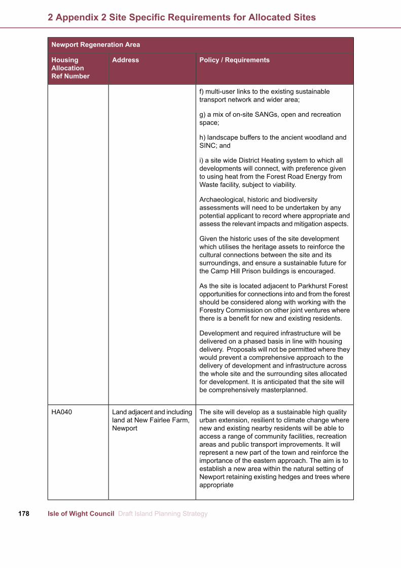
Newport Regeneration Area
Policy / RequirementsAddressHousingAllocationRef Number
f) multi-user links to the existing sustainabletransport network and wider area;
g) a mix of on-site SANGs, open and recreationspace;
h) landscape buffers to the ancient woodland andSINC; and
i) a site wide District Heating system to which alldevelopments will connect, with preference givento using heat from the Forest Road Energy fromWaste facility, subject to viability.
Archaeological, historic and biodiversityassessments will need to be undertaken by anypotential applicant to record where appropriate andassess the relevant impacts andmitigation aspects.
Given the historic uses of the site developmentwhich utilises the heritage assets to reinforce thecultural connections between the site and itssurroundings, and ensure a sustainable future forthe Camp Hill Prison buildings is encouraged.
As the site is located adjacent to Parkhurst Forestopportunities for connections into and from the forestshould be considered along with working with theForestry Commission on other joint ventures wherethere is a benefit for new and existing residents.
Development and required infrastructure will bedelivered on a phased basis in line with housingdelivery. Proposals will not be permitted where theywould prevent a comprehensive approach to thedelivery of development and infrastructure acrossthe whole site and the surrounding sites allocatedfor development. It is anticipated that the site willbe comprehensively masterplanned.
The site will develop as a sustainable high qualityLand adjacent and includingHA040urban extension, resilient to climate change whereland at New Fairlee Farm,new and existing nearby residents will be able toNewportaccess a range of community facilities, recreationareas and public transport improvements. It willrepresent a new part of the town and reinforce theimportance of the eastern approach. The aim is toestablish a new area within the natural setting ofNewport retaining existing hedges and trees whereappropriate
Isle of Wight Council Draft Island Planning Strategy178
2 Appendix 2 Site Specific Requirements for Allocated Sites

Newport Regeneration Area
Policy / RequirementsAddressHousingAllocationRef Number
A site of approximately 44.6 hectares is allocatedto the east of Newport for a mixed use developmentincluding delivery of:
a) At least 880 homes providing a mix of sizes andan affordable housing contribution in line withDHWN6;
b) a mix of onsite SANGs, open and recreationspace;
c) a range of small-scale community facilities whichcould include a multi-purpose community buildingand a small convenience shop. The small-scalelocal/ neighbourhood hub should serve theday-to-day needs of nearby new and existingresidents and act as the focal point for thecommunity being well connected and permeable;
d) public transport improvements;
e) multi-user links to the existing sustainabletransport network and wider area;
f) an improved road network to allow ease ofmovement to and through the site including a parkand ride hub, and connections through to StaplersRoad; and.
g) landscape buffers to the north east.
Development and required infrastructure will bedelivered on a phased basis in line with housingdelivery.
Proposals will not be permitted where they wouldprevent a comprehensive approach to the deliveryof development and infrastructure across the wholesite.
It is anticipated that the site will be comprehensivelymasterplanned.
Relevant surveys will need to be undertaken andearly liaison with the council's Planning Services isadvised.
A brownfield site of approximately 0.7 hectares isBarton School Site, GreenHA041allocated for residential use. The site incorporatesStreeta Victorian School and parking area. Thedevelopment should provide for:
179Draft Island Planning Strategy Isle of Wight Council
2 Appendix 2 Site Specific Requirements for Allocated Sites

Newport Regeneration Area
Policy / RequirementsAddressHousingAllocationRef Number
a) At least 25 homes providing a mix of sizes andan affordable housing contribution in line withDHWN6.
Given the building is recorded on the HER andcontributes to the character of the area, every effortshould be made to incorporate it within thedevelopment. If the school cannot be retained it willneed to be recorded prior to development and anynew development should be of high quality anddesign. Early discussions with the council'sPlanning Services and Archaeology & HistoricEnvironment Service is advised.
A greenfield site of approximately 1.6 hectares isLand east of St. GeorgesHA042allocated at land east of St. GeorgesWay and southWay and south of Asda,of Asda, Newport to deliver a sustainable, highNewportquality residential development which shall provide:
a) Approximately 7-10 homes;
b) a single vehicular access;
c) a pedestrian connection to St Georges Way;
d) retention of the existing roadside hedges;
e) retention of onsite trees; and
f) biodiversity enhancements, open space andlandscape buffering to the higher half of the site.
It is anticipated that development would be lowerdensity given the context of the area and up to astorey and a half in height.
A greenfield site of approximately 0.8 hectares isLand at Landscape Lane,HA043allocated at Landscape Road, Newport to deliver aNewportsustainable, high quality residential developmentwhich shall provide:
a) At least 10 homes providing a mix of sizes andan affordable housing contribution in line withDHWN6;
b) a single vehicular access to the south of the site;and
c) retention of the existing roadside hedge toLandscape Lane.
Isle of Wight Council Draft Island Planning Strategy180
2 Appendix 2 Site Specific Requirements for Allocated Sites

Newport Regeneration Area
Policy / RequirementsAddressHousingAllocationRef Number
It is anticipated that development would compriseof a single row of houses accessed from an internalroad served by one access.
A mixed greenfield and brownfield site ofNewport Harbour, NewportHA044approximately 2.5 hectares is allocated at Land atNewport Harbour, Newport to deliver a sustainable,high quality mixed use development resilient toclimate change and sympathetic to the harbour’scharacter and which shall provide delivery of:
a) At least 250 homes providing a mix of sizes andan affordable housing contribution in line withDHWN6;
b) serviced employment land for office, generalindustrial or storage and distribution uses includingmarine uses provided that they are compatible andappropriate to the site and its wider context,ensuring that there is also a mix of size of unit; (Buses);
c) small-scale flexible retail, financial andprofessional services, food and drink floor space(A1-A4 uses);
d) community/education use floor space (D1 uses);
e) a mix of onsite SANGs, open and recreationspace;
f) an improved road network to allow ease ofmovement to and through the site;
g) multi-user links to the existing sustainabletransport network and wider area;
h) public transport improvements as required;
i) public realm improvements with public access tothe waterfront; and
j) a site wide District Heating system or otherdecentralised energy scheme to which alldevelopments will connect, subject to viability.
When considering flood risk across the site pleaserefer to the council’s SFRA Level 2 Fact Sheet.
Archaeological, historic and biodiversityassessments will need to be undertaken by any
181Draft Island Planning Strategy Isle of Wight Council
2 Appendix 2 Site Specific Requirements for Allocated Sites

Newport Regeneration Area
Policy / RequirementsAddressHousingAllocationRef Number
potential applicant to record where appropriate andassess the relevant impacts andmitigation aspects.
Development and required infrastructure will bedelivered on a phased basis in line with housingdelivery. It is anticipated that the site will becomprehensively masterplanned.
Proposals should demonstrate that the level of retailand leisure uses will not have an unacceptableimpact on the town centre.
A brownfield site of approximately 0.2 hectares isLand at Fairlee Road,HA045allocated at Land at Fairlee Road, Hillside to deliverHillside, Newporta sustainable, high quality residential developmentwhich shall provide:
a) At least 15 homes providing a mix of sizes andan affordable housing contribution in line withDHWN6; and
b) onsite parking.
It is anticipated that the site can be comprehensivelyredeveloped.
A brownfield site of approximately 1.6 hectares isLand at Moreys, TrafalgarHA110allocated at Land at Moreys, Trafalgar Road,RoadNewport to deliver high quality sustainableresidential development which shall provide:
a) At least 100 homes providing a mix of sizes andan affordable housing contribution in line withDHWN6;
b) onsite parking and access improvements asrequired;
c) an access road linking Trafalgar Road andTerrace Road; and
d) a mix of onsite SANGs, green and open space.
Isle of Wight Council Draft Island Planning Strategy182
2 Appendix 2 Site Specific Requirements for Allocated Sites

East Medina Regeneration Area
Policy / RequirementsAddressHousingAllocationRef Number
A greenfield site of approximately 1.25 hectares isHighwood Nursery, MainHA048allocated at Highwood Nursery, Rookley to deliver, highRoad, Rookleyquality residential development which shall provide:
a) Approximately 5-7 homes in a landscape setting toprovide a gateway to the village; and
b) access and highway improvements as required.
Proposals will need to incorporate, where appropriate asense of arrival to the village taking account of the settingand form of the adjacent chapel.
Development should incorporate the onsite trees into thedesign where this will result in an attractive landscapesetting.
Sites within Rookley shall be phased so as not toprejudice the delivery of nearby sites within or adjacentto the village.
A greenfield site of approximately 4.5 hectares isLand to east of atHA049allocated to land east of Rookley Green, Rookley toRookley Green on eastdeliver, high quality sustainable residential developmentside of Niton Road,which shall provide:Rookley
a) At least 30 homes providing a mix of sizes and anaffordable housing contribution in line with DHWN6;
b) improved and safe access to and through the site forboth pedestrians and vehicles;
c) retention or reprovision of existing public rights of way;and
d) landscape buffer and biodiversity enhancements tothe south of the site.
Sites within Rookley shall be phased so as not toprejudice the delivery of nearby sites within or adjacentto the village.
Archaeological assessments may need to be undertakenby any potential applicant and early liaison with thecouncil's Archaeology and Historic Environment Serviceis advised.
A greenfield site of approximately 10 hectares is allocatedPalmers Farm, BrocksHA051to land at Palmers Farm, Wootton Bridge to deliver, highCopse Road, Woottonquality sustainable residential development which shallBridge
183Draft Island Planning Strategy Isle of Wight Council
2 Appendix 2 Site Specific Requirements for Allocated Sites
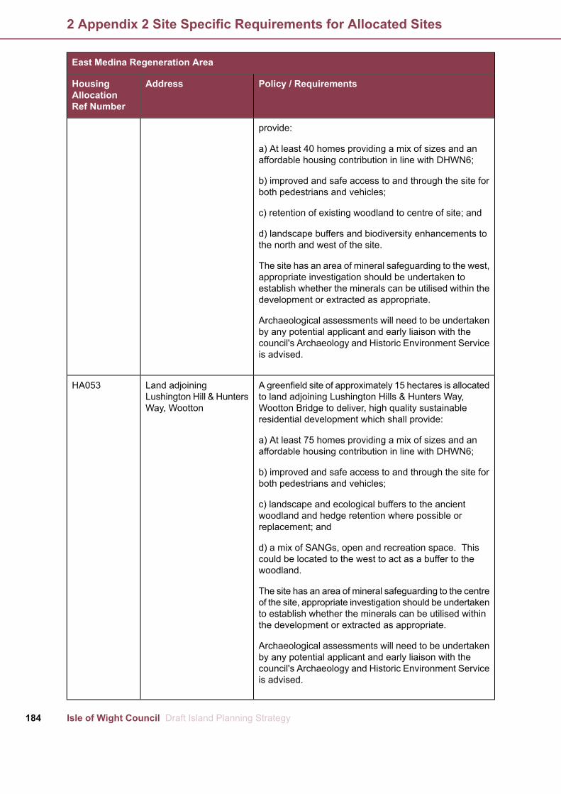
East Medina Regeneration Area
Policy / RequirementsAddressHousingAllocationRef Number
provide:
a) At least 40 homes providing a mix of sizes and anaffordable housing contribution in line with DHWN6;
b) improved and safe access to and through the site forboth pedestrians and vehicles;
c) retention of existing woodland to centre of site; and
d) landscape buffers and biodiversity enhancements tothe north and west of the site.
The site has an area of mineral safeguarding to the west,appropriate investigation should be undertaken toestablish whether the minerals can be utilised within thedevelopment or extracted as appropriate.
Archaeological assessments will need to be undertakenby any potential applicant and early liaison with thecouncil's Archaeology and Historic Environment Serviceis advised.
A greenfield site of approximately 15 hectares is allocatedLand adjoiningHA053to land adjoining Lushington Hills & Hunters Way,Lushington Hill & HuntersWootton Bridge to deliver, high quality sustainableWay, Woottonresidential development which shall provide:
a) At least 75 homes providing a mix of sizes and anaffordable housing contribution in line with DHWN6;
b) improved and safe access to and through the site forboth pedestrians and vehicles;
c) landscape and ecological buffers to the ancientwoodland and hedge retention where possible orreplacement; and
d) a mix of SANGs, open and recreation space. Thiscould be located to the west to act as a buffer to thewoodland.
The site has an area of mineral safeguarding to the centreof the site, appropriate investigation should be undertakento establish whether the minerals can be utilised withinthe development or extracted as appropriate.
Archaeological assessments will need to be undertakenby any potential applicant and early liaison with thecouncil's Archaeology and Historic Environment Serviceis advised.
Isle of Wight Council Draft Island Planning Strategy184
2 Appendix 2 Site Specific Requirements for Allocated Sites

East Medina Regeneration Area
Policy / RequirementsAddressHousingAllocationRef Number
A brownfield site of approximately 14 hectares isLand at Follyworks,HA111allocated at Land at Folly Works, Whippingham to deliverWhippinghama sustainable, high quality mixed use developmentresilient to climate change and sympathetic to thecharacter of the area and which shall provide delivery of:
a) At least 99 homes providing a mix of sizes and anaffordable housing contribution in line with DHWN6;
b) tourist accommodation;
c) approximately 15 business units, small convenienceshop, café and river users facilities;
d) formation of jetty;
e) creation of new access road with junction to BeatriceAvenue and works to Folly Lane;
f) a mix of onsite SANGs, open and recreation space;and
g) biodiversity enhancements and mitigation works asrequired including to the foreshore.
The above provides for enabling development noting thatthe site is constrained and contaminated.
Due to the sensitive nature of the site, a number ofbiodiversity enhancements are expected, these shouldinclude, but are not limited to, creation of riversideterraces, bird island, relocation and ongoing protectionof species as appropriate.
A brownfield site of approximately 2.4 hectares isRed Funnel, East CowesHA113allocated at Land at Red Funnel and surrounds, EastCowes to deliver a sustainable, high quality mixed usedevelopment resilient to climate change and sympatheticto the character of the area and which shall providedelivery of:
a) At least 100 homes providing a mix of sizes and anaffordable housing contribution in line with DHWN6;
b) tourist accommodation;
c) approximately 1850m2 of non-residential floor spaceincluding retail, leisure and commercial premises (useclasses A1-5, B1 and B2);
d) demolition of unused buildings;
185Draft Island Planning Strategy Isle of Wight Council
2 Appendix 2 Site Specific Requirements for Allocated Sites

East Medina Regeneration Area
Policy / RequirementsAddressHousingAllocationRef Number
e) terminal buildings with associatedmarshalling facilities;
f) public transport, access and highway improvementsas required as well as opportunities to enhance or createlinks to the local sustainable transport network;
g) on-site parking and cycle provision;
h) enhanced public realm/ SANGs/ open and recreationspace;
i) pedestrian connectivity improvements;
j) appropriate landscaping and boundary treatment;
k) an appropriate level of public access to the waterfront;
l) an appropriate level of access to the waterfront andmarine-related infrastructure, where it is required forexisting and future marine and maritime-relatedbusinesses;
m) seawall and coastal defence improvements; and
n) any other measures that enhance East Cowes as adestination.
Development and required infrastructure will be deliveredon a phased basis in line with housing delivery.
Proposals should demonstrate that the level of retail andleisure uses will not have an unacceptable impact on thetown centres of East Cowes and Cowes.
Ryde Regeneration Area
Policy / RequirementsAddressHousingAllocationRef Number
A brownfield site of approximately 0.09 hectares is6-8 George Street, RydeHA056allocated at Land at 6-8 George Street, Ryde to delivera sustainable, high quality residential development whichshall provide:
a) At least 10 homes providing a mix of sizes and anaffordable housing contribution in line with DHWN6; and
b) onsite parking and a safe means of access.
It is anticipated that the site can be comprehensively
Isle of Wight Council Draft Island Planning Strategy186
2 Appendix 2 Site Specific Requirements for Allocated Sites

Ryde Regeneration Area
Policy / RequirementsAddressHousingAllocationRef Number
redeveloped and should be of high quality design andshould reflect the character of the conservation area.
When considering flood risk across the site please referto the council’s SFRA Level 2 Fact Sheet.
A brownfield site of approximately 0.45 hectares isSt Thomas Street CarHA057allocated at Land at St Thomas Car Park, Ryde to deliverPark, Rydea sustainable, high quality residential development whichshall provide:
a) At least 20 homes providing a mix of sizes and anaffordable housing contribution in line with DHWN6;
b) onsite parking for new residents;
c) re-provision of any lost public parking that is required;and
d) proportionate contributions to improvements to off-sitejunctions identified in Tables 7.1 and 7.2, if required.
It is anticipated that the site can be comprehensivelyredeveloped and should be of high quality designreflecting the character of the area and respect theproximity of the buildings and uses to the south of thesite.
If at the time of an application the public parking facilityis still required in full or in part, any public parking lost asa result of the proposed development will need to bere-provided elsewhere or within the site as part of thatplanning consent.
A greenfield site of approximately 1.8 hectares isLand Adjoining PuckpoolHA058allocated at Land adjoining Puckpool Hill, Ryde forHill (The Archery Field),residential use to deliver a sustainable, high qualityRyderesidential development which shall provide:
a) At least 25 homes providing a mix of sizes and anaffordable housing contribution in line with DHWN6; and
b) safe access to and through the site for bothpedestrians and vehicles, this may include extensionsimprovements to footpaths/pavements.
The site is currently leased and is used as an archeryfield by the Wight Bowman. It is anticipated thatdevelopment will not occur on the site until the lease hasexpired. Any development proposals will need to include
187Draft Island Planning Strategy Isle of Wight Council
2 Appendix 2 Site Specific Requirements for Allocated Sites

Ryde Regeneration Area
Policy / RequirementsAddressHousingAllocationRef Number
appropriate consultation with the Wight Bowman toestablish where re-provision can be provided.
Archaeological assessments may need to be undertakenby any potential applicant and early liaison with thecouncil's Archaeology and Historic Environment Serviceis advised.
A greenfield site of approximately 3.4 hectares isLand to the west of UptonHA059allocated to the west of Upton Road, Ryde for residentialRoad, Rydeuse to deliver a sustainable, high quality residentialdevelopment which shall provide:
a) At least 80 homes providing a mix of sizes and anaffordable housing contribution in line with DHWN6;
b) a single and safe vehicular access to and through thesite. This should where possible incorporate the existingaccess and improve visibility splays;
c) a network of safe and accessible footpaths within thesite and a footpath link to connect the development tothe north and adjacent housing. This footpath should bedelivered within the site;
d) retain the ancient roadside hedge as far as possibletaking account of visibility splays;
e) a mix of onsite SANGs, open and recreation space;and
f) landscape buffers to the south.
Archaeological assessments may need to be undertakenby any potential applicant and early liaison with thecouncil's Archaeology and Historic Environment Serviceis advised.
A greenfield site of approximately 28 hectares is allocatedWestridge Cross DairyHA060at Westridge Cross Dairy, Ryde to deliver a sustainable,and land to the north ofhigh quality predominately residential developmentBullen Road, Ryderesilient to climate change. The development shallprovide:
a) At least 555 homes providing a mix of sizes and anaffordable housing contribution in line with DHWN6;
b) a mix of onsite SANGs, open and recreation space;
c) community facilities well related and accessible to all,
Isle of Wight Council Draft Island Planning Strategy188
2 Appendix 2 Site Specific Requirements for Allocated Sites

Ryde Regeneration Area
Policy / RequirementsAddressHousingAllocationRef Number
including a small convenience retail provision, ifappropriate;
d) opportunities for sustainable travel and lifestylesincluding a network of safe and convenient green routesand cycling links; and
e) public transport and highway improvements asrequired.
Development and required infrastructure will be deliveredon a phased basis in line with housing delivery.
Proposals will not be permitted where they would preventa comprehensive approach to the delivery of developmentand infrastructure across the whole site. It is anticipatedthat the site will be comprehensively masterplanned.
Relevant biodiversity and archaeological assessmentswill be required and early liaison with council's PlanningServices is advised.
A greenfield site of approximately 3.9 hectares isLand at Binstead, RydeHA061allocated at land at Binstead, Ryde to deliver, high qualitysustainable residential development which shall provide:
a) At least 45 homes providing a mix of sizes and anaffordable housing contribution in line with DHWN6;
b) improved and safe access to and through the site forboth pedestrians and vehicles;
c) retained protected trees, incorporated into the designof the development;
d) improvement, re-provision and/or links to existingpublic rights of way;
e) landscape buffers and biodiversity enhancements tothe south of the site; and
f) proportionate contributions to improvements to off-sitejunctions identified in Tables 7.1 and 7.2, if required.
Archaeological assessments may need to be undertakenby any potential applicant and early liaison with thecouncil's Archaeology and Historic Environment Serviceis advised.
A greenfield site of approximately 1.6 hectares isLand off Quarry Road,HA062allocated at land off Quarry Road, Ryde to deliver, highRyde
189Draft Island Planning Strategy Isle of Wight Council
2 Appendix 2 Site Specific Requirements for Allocated Sites

Ryde Regeneration Area
Policy / RequirementsAddressHousingAllocationRef Number
quality sustainable residential development which shallprovide:
a) At least 50 homes providing a mix of sizes and anaffordable housing contribution in line with DHWN6;
b) improved and safe access to and through the site forboth pedestrians and vehicles;
c) improvement, re-provision and links to existing publicrights of way;
d) a financial contribution to the management andmaintenance of the adjacent nature asset; and
e) landscape buffers and biodiversity enhancements tothe south of the site.
Biodiversity assessments will need to be undertaken byany potential applicant and early liaison with the council'sPlanning Services is advised.
A brownfield site of approximately 11 hectares is allocatedLand at Harcourt Sands,HA112at Land at Harcourt Sands, Ryde to deliver a sustainable,Rydehigh quality mixed use development resilient to climatechange and sympathetic to the character of the area andwhich shall provide delivery of:
a) At least 128 homes providing a mix of sizes and anaffordable housing contribution in line with DHWN6;
b) improvements to the tourism offer;
c) on-site car parking;
d) new vehicular access and works to existing accesses;and
e) a mix of onsite SANGs, open and recreation space aswell as biodiversity enhancements.
A greenfield site of approximately 2.3 hectares isLand Near BradingHA066allocated at land near Brading Roman Villa, Brading asRoman Villa / Land offenabling development to deliver, high quality sustainableMorton Road Bradingresidential development which shall provide:
a) Approximately 15 homes subject to enabling viability;
b) improved and safe access to and through the site forboth pedestrians and vehicles; and
Isle of Wight Council Draft Island Planning Strategy190
2 Appendix 2 Site Specific Requirements for Allocated Sites

Ryde Regeneration Area
Policy / RequirementsAddressHousingAllocationRef Number
c) improved access for local residents and tourists to theScheduled Ancient Monument and tourism facilities atthe feature.
The site is only allocated to ensure the delivery of a newaccess road to the Villa and therefore the number of unitsmust be commensurate to the cost of these worksincluding any required compulsory purchase order.Consequently the council will expect to work with theapplicant to understand the need and quantum of thisdevelopment, this may include an open book approachto viability.
As the site is located in close proximity to a scheduleAncient Monument early engagement with the counciland Historic England is advised.
A greenfield site of approximately 2.8 hectares isLand north of Quay Lane,HA067allocated at land north of Quay Lane, Brading to deliver,Bradinghigh quality sustainable residential development whichshall provide:
a) At least 25 homes providing a mix of sizes and anaffordable housing contribution in line with DHWN6;
b) improved and safe access to and through the site forboth pedestrians and vehicles;
c) improvement, re-provision and links to existing publicrights of way; and
d) landscape buffer and biodiversity enhancements tothe east of the site.
Access options should be explored along Vicarage Laneor within land of the same ownership with Quay Lanebeing secondary due to the narrow nature of the roadand the junction to the main road.
The site is located close to the historic core of Bradingand as such design will need to reflect and take accountof the nearby character and context. Archaeologicalassessments may need to be undertaken by any potentialapplicant and early liaison with the council's Archaeologyand Historic Environment Service is advised.
A greenfield site of approximately 1.2 hectares isWrax Farm, New Road,HA068allocated at Wrax Farm, New Road, Brading to deliver,Bradinghigh quality sustainable residential development whichshall provide:
191Draft Island Planning Strategy Isle of Wight Council
2 Appendix 2 Site Specific Requirements for Allocated Sites

Ryde Regeneration Area
Policy / RequirementsAddressHousingAllocationRef Number
a) At least 20 homes providing a mix of sizes and anaffordable housing contribution in line with DHWN6;
b) improved and safe access to and through the site forboth pedestrians and vehicles;
c) improvement, re-provision and links to existing publicrights of way and the nearby railway station; and
d) landscape buffers and biodiversity enhancements tothe east of the site.
A vehicular access option should be explored through tothe station and accessing Station Road. If this requiresany loss of allotment gardens these will need to bere-provided within the development site. Archaeologicalassessments may need to be undertaken by any potentialapplicant and early liaison with the council's Archaeologyand Historic Environment Service is advised.
A greenfield site of approximately 0.5 hectares isThe Builder's Yard,HA069allocated at The Builder's Yard, Yarbridge, Brading toYarbridge, Bradingdeliver, high quality sustainable residential developmentwhich shall provide:
a) At least 5 homes;
b) improved and safe access to and through the site forboth pedestrians and vehicles;
Given the potential for high ecological value across thesite development should be delivered in a landscapedand treed setting, safeguarding high amenity and maturetrees.
A greenfield site of approximately 2.0 hectares isCoppid Hall Farm, MainHA070allocated at Coppid Hall Farm, Havenstreet to deliver,Road, Havenstreethigh quality sustainable residential development whichshall provide:
a) At least 25 homes providing a mix of sizes and anaffordable housing contribution in line with DHWN6;
b) improved and safe access to and through the site forboth pedestrians and vehicles;
c) a financial or other contribution to facilitatereinstatement of the bus service; and
d) landscape buffer and biodiversity enhancements to
Isle of Wight Council Draft Island Planning Strategy192
2 Appendix 2 Site Specific Requirements for Allocated Sites
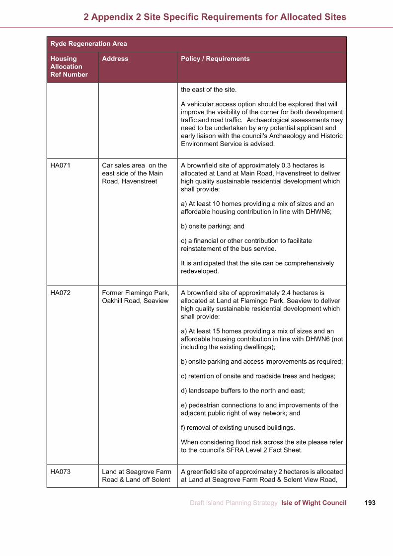
Ryde Regeneration Area
Policy / RequirementsAddressHousingAllocationRef Number
the east of the site.
A vehicular access option should be explored that willimprove the visibility of the corner for both developmenttraffic and road traffic. Archaeological assessments mayneed to be undertaken by any potential applicant andearly liaison with the council's Archaeology and HistoricEnvironment Service is advised.
A brownfield site of approximately 0.3 hectares isCar sales area on theHA071allocated at Land at Main Road, Havenstreet to delivereast side of the Mainhigh quality sustainable residential development whichRoad, Havenstreetshall provide:
a) At least 10 homes providing a mix of sizes and anaffordable housing contribution in line with DHWN6;
b) onsite parking; and
c) a financial or other contribution to facilitatereinstatement of the bus service.
It is anticipated that the site can be comprehensivelyredeveloped.
A brownfield site of approximately 2.4 hectares isFormer Flamingo Park,HA072allocated at Land at Flamingo Park, Seaview to deliverOakhill Road, Seaviewhigh quality sustainable residential development whichshall provide:
a) At least 15 homes providing a mix of sizes and anaffordable housing contribution in line with DHWN6 (notincluding the existing dwellings);
b) onsite parking and access improvements as required;
c) retention of onsite and roadside trees and hedges;
d) landscape buffers to the north and east;
e) pedestrian connections to and improvements of theadjacent public right of way network; and
f) removal of existing unused buildings.
When considering flood risk across the site please referto the council’s SFRA Level 2 Fact Sheet.
A greenfield site of approximately 2 hectares is allocatedLand at Seagrove FarmHA073at Land at Seagrove Farm Road & Solent View Road,Road & Land off Solent
193Draft Island Planning Strategy Isle of Wight Council
2 Appendix 2 Site Specific Requirements for Allocated Sites
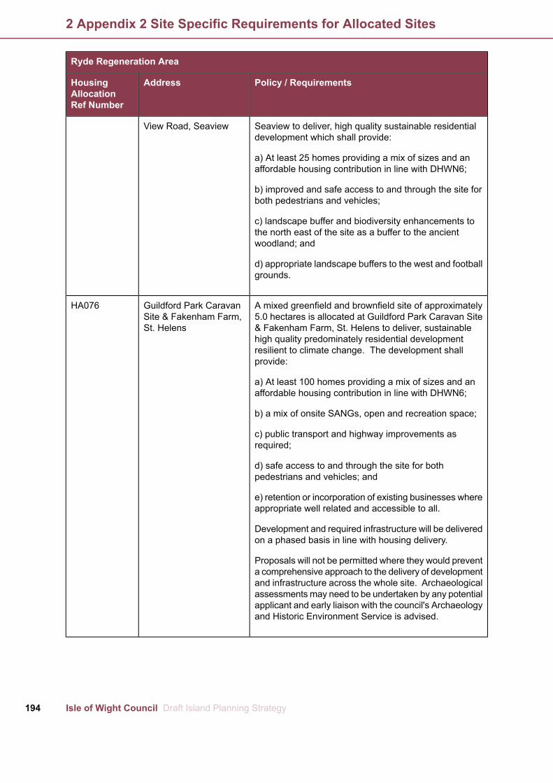
Ryde Regeneration Area
Policy / RequirementsAddressHousingAllocationRef Number
View Road, Seaview Seaview to deliver, high quality sustainable residentialdevelopment which shall provide:
a) At least 25 homes providing a mix of sizes and anaffordable housing contribution in line with DHWN6;
b) improved and safe access to and through the site forboth pedestrians and vehicles;
c) landscape buffer and biodiversity enhancements tothe north east of the site as a buffer to the ancientwoodland; and
d) appropriate landscape buffers to the west and footballgrounds.
A mixed greenfield and brownfield site of approximatelyGuildford Park CaravanHA0765.0 hectares is allocated at Guildford Park Caravan SiteSite & Fakenham Farm,& Fakenham Farm, St. Helens to deliver, sustainableSt. Helenshigh quality predominately residential developmentresilient to climate change. The development shallprovide:
a) At least 100 homes providing a mix of sizes and anaffordable housing contribution in line with DHWN6;
b) a mix of onsite SANGs, open and recreation space;
c) public transport and highway improvements asrequired;
d) safe access to and through the site for bothpedestrians and vehicles; and
e) retention or incorporation of existing businesses whereappropriate well related and accessible to all.
Development and required infrastructure will be deliveredon a phased basis in line with housing delivery.
Proposals will not be permitted where they would preventa comprehensive approach to the delivery of developmentand infrastructure across the whole site. Archaeologicalassessments may need to be undertaken by any potentialapplicant and early liaison with the council's Archaeologyand Historic Environment Service is advised.
Isle of Wight Council Draft Island Planning Strategy194
2 Appendix 2 Site Specific Requirements for Allocated Sites

The Bay Regeneration Area
Policy / RequirementsAddressHousingAllocationRef Number
A mixed brownfield and greenfield site of approximatelyFormer SandhamMiddleHA0804 hectares is allocated at the Former Sandham MiddleSchool Site, SandownSchool, Sandown to deliver a sustainable, high qualitymixed use development based on an independent livingcampus. The site shall provide delivery of:
a) A children’s day-care nursery;
b) extra care services for older people delivering a varietyof sized units;
c) supported housing for vulnerable young people,including care leavers;
d) a small community hub to provide the main receptionand public gateway into the campus. This space shouldinclude facilities and areas for the general public toaccess both leisure and support services. This couldalso include a small library, café and a small-scale retailopportunity to serve local needs;
e) a mix of onsite SANGs, open and recreation space;
f) sustainable drainage scheme; and
g) proportionate contributions to improvements to off-sitejunctions identified in Tables 7.1 and 7.2, if required.
It is considered that as well as Island Independent Living,this site could be suitable for an intergenerational andcross-service delivery approach, incorporating earlyyear’s childcare provision and specialist transitionaccommodation for single teenage parents using acampus configuration.
When considering flood risk across the site please referto the council’s SFRA Level 2 Fact Sheet.
A brownfield site of approximately 0.15 hectares isSandown Town Hall,HA081allocated for residential use at Sandown Town Hall,Grafton Street, SandownSandown to deliver a sustainable, high quality residentialdevelopment which shall provide delivery of:
a) At least 14 homes providing a mix of sizes and anaffordable housing contribution in line with DHWN6.
Given the building is listed building, any developmentand/or conversion must have special regard to thedesirability of preserving the building or its setting or anyfeatures of special architectural or historic interest whichit possesses. Early discussions with the council's Planning
195Draft Island Planning Strategy Isle of Wight Council
2 Appendix 2 Site Specific Requirements for Allocated Sites
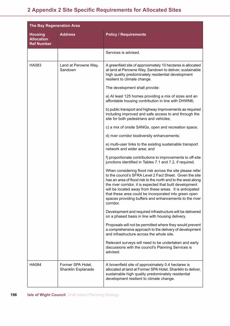
The Bay Regeneration Area
Policy / RequirementsAddressHousingAllocationRef Number
Services is advised.
A greenfield site of approximately 10 hectares is allocatedLand at Perowne Way,HA083at land at PerowneWay, Sandown to deliver, sustainableSandownhigh quality predominately residential developmentresilient to climate change.
The development shall provide:
a) At least 125 homes providing a mix of sizes and anaffordable housing contribution in line with DHWN6;
b) public transport and highway improvements as requiredincluding improved and safe access to and through thesite for both pedestrians and vehicles;
c) a mix of onsite SANGs, open and recreation space;
d) river corridor biodiversity enhancements;
e) multi-user links to the existing sustainable transportnetwork and wider area; and
f) proportionate contributions to improvements to off-sitejunctions identified in Tables 7.1 and 7.2, if required.
When considering flood risk across the site please referto the council’s SFRA Level 2 Fact Sheet. Given the sitehas an area of flood risk to the north and to the west alongthe river corridor, it is expected that built developmentwill be located away from these areas. It is anticipatedthat these area could be incorporated into green openspaces providing buffers and enhancements to the rivercorridor.
Development and required infrastructure will be deliveredon a phased basis in line with housing delivery.
Proposals will not be permitted where they would preventa comprehensive approach to the delivery of developmentand infrastructure across the whole site.
Relevant surveys will need to be undertaken and earlydiscussions with the council's Planning Services isadvised.
A brownfield site of approximately 0.4 hectares isFormer SPA Hotel,HA084allocated at land at Former SPAHotel, Shanklin to deliver,Shanklin Esplanadesustainable high quality predominately residentialdevelopment resilient to climate change.
Isle of Wight Council Draft Island Planning Strategy196
2 Appendix 2 Site Specific Requirements for Allocated Sites

The Bay Regeneration Area
Policy / RequirementsAddressHousingAllocationRef Number
The development shall provide:
a) At least 50 homes providing a mix of sizes and anaffordable housing contribution in line with DHWN6;
b) public transport and highway improvements asrequired;
c) contribution towards improvements to the seawall andcoastal defences; and
d) re-provision of any lost public parking that is required.
The development should be of high quality design andshould reflect the character of the area and respect theproximity of the buildings and uses adjacent to the site.
If at the time of an application the car parking facility isstill needed, any public parking lost and still required willneed to be re-provided within the site as part of thatplanning consent.
Given the site location with the cliff behind, it is anticipatedthat any parking would be to the rear of the site and couldbe stacked. Consideration will need to be given to theground floor frontage area to ensure it is appropriate tothe activity and vitality of the seafront.
Relevant surveys will need to be undertaken and earlydiscussions with the council's Planning Services isadvised.
A brownfield site of approximately 0.2 hectares isShanklin Esplanade CarHA088allocated at land at Shanklin Esplanade Car Park,Park, ShanklinShanklin to deliver, sustainable high quality predominatelyresidential development resilient to climate change.
The development shall provide:
a) At least 50 homes providing a mix of sizes and anaffordable housing contribution in line with DHWN6;
b) public transport and highway improvements asrequired;
c) contribution towards improvements to the seawall andcoastal defences; and
d) re-provision of any lost public parking that is required.
197Draft Island Planning Strategy Isle of Wight Council
2 Appendix 2 Site Specific Requirements for Allocated Sites

The Bay Regeneration Area
Policy / RequirementsAddressHousingAllocationRef Number
The development should be of high quality design andshould reflect the character of the area and respect theproximity of the buildings and uses adjacent to the site.
If at the time of an application the car parking facility isstill needed, any public parking lost and still required willneed to be re-provided within the site as part of thatplanning consent.
Given the site location it is anticipated that any parkingwould be to stacked, this should include parking for bothvisitors and residents of any residential aspects.Consideration will need to be given to the ground floorfrontage area to ensure it is appropriate to the activityand vitality of the seafront.
Relevant surveys will need to be undertaken and earlydiscussions with the council's Planning Services isadvised.
A brownfield site of approximately 0.7 hectares isDepot site at LowthervilleHA090allocated at Land at Lowtherville Road, Ventnor to deliverRoad, Ventnorsustainable high quality mixed use development toprovide:
a) At least 15 affordable homes;
b) serviced employment as set out in Policy EA5; and
c) public transport, highway improvements and pedestrianconnections as required
It is anticipated that the applicant will work with a registerprovider to deliver a mix of affordable homes.
Archaeological assessments may need to be undertakenby any potential applicant and early liaison with thecouncil's Archaeology and Historic Environment Serviceis advised.
A brownfield site of approximately 0.03 hectares isVentnor Youth Club,HA091allocated for residential use at Ventnor Youth Club,Victoria Street VentnorVentnor to deliver sustainable high quality mixed usedevelopment to provide:
a) At least 15 homes providing a mix of sizes and anaffordable housing contribution in line with DHWN6; and
b) a community facility which shall include a library.
Isle of Wight Council Draft Island Planning Strategy198
2 Appendix 2 Site Specific Requirements for Allocated Sites

The Bay Regeneration Area
Policy / RequirementsAddressHousingAllocationRef Number
The building is not listed but is recorded as a historicbuilding. It is therefore anticipated that the existing formernon-conformist chapel will be converted, where this isnot viable, early discussions should be held with thecouncil's Planning Services and Archaeology and HistoricEnvironment Service regarding any applicable recordingof the site.
A greenfield site of approximately 3.8 hectares isLand at Moor Farm,HA095allocated at Moor Farm, Godshill to deliver a sustainable,Godshillhigh quality residential development which shall provide:
a) At least 45 homes providing a mix of sizes and anaffordable housing contribution in line with DHWN6;
b) an improved highway junction/vehicular access;
c) improved pedestrian accessibility to school, villagecentre; and
d) connections to existing public rights of way andmulti-use tracks.
Proposals should explore working with the council toimprove the access and visibility to the main road.
Every endeavour should be made to work with adjacentlandowners to provide better access to the site andadjacent sites and pedestrian access to the school andvillage using existing potentially private routes.
Archaeological assessments may need to be undertakenby any potential applicant and early liaison with thecouncil's Archaeology and Historic Environment Serviceis advised.
Sites within Godshill shall be phased so as not toprejudice the delivery of nearby sites within or adjacentto the village.
A greenfield site of approximately 1.8 hectares isLand adjoining ScotlandHA096allocated at Land adjoining Scotland Farm, Godshill toFarm and Tresslewooddeliver a sustainable, high quality residential developmentCare Village, Scotlandwhich shall provide:Corner, Godshill
a) At least 30 homes providing a mix of sizes and anaffordable housing contribution in line with DHWN6;
b) pedestrian connections to Yarborough Close and alongWest Street.
199Draft Island Planning Strategy Isle of Wight Council
2 Appendix 2 Site Specific Requirements for Allocated Sites

The Bay Regeneration Area
Policy / RequirementsAddressHousingAllocationRef Number
Off-site contributions will be sought to provide apavement/footpath along West Street to provide betterand safer connections to the village centre.
The site has an area of mineral safeguarding to the west,appropriate investigation should be undertaken toestablish whether the minerals can be utilised within thedevelopment or extracted as appropriate.
Sites within Godshill shall be phased so as not toprejudice the delivery of nearby sites within or adjacentto the village.
A greenfield site of approximately 2.7 hectares isLand at DeaconsHA097allocated at land at Deacons Nursery, Godshill to deliver,Nursery, Moor View,high quality sustainable residential development whichGodshillshall provide:
a) At least 50 homes providing a mix of sizes and anaffordable housing contribution in line with DHWN6;
b) improved and safe access to and through the site forboth pedestrians and vehicles;
c) retention or reprovision of existing public rights of way;
d) landscape buffer and biodiversity enhancements tothe watercourse and east of the site.
Any loss of parking as a result of access to thedevelopment should be re-provided within thedevelopment .
Sites within Godshill shall be phased so as not toprejudice the delivery of nearby sites within or adjacentto the village.
Chale Green benefits from some services including aLand at LowerHA098small shop. It is considered that a small amount ofBramstone Farm,development to serve local need may help support andNewport Road, Chaleenhance local services.Green
A Greenfield site of approximately 2.3 hectares isallocated at Land at Lower Bramstone Farm, NewportRoad, Chale Green to deliver sustainable high qualityresidential development to provide:
a) At least 20 homes providing a mix of sizes and anaffordable housing contribution in line with DHWN6;
Isle of Wight Council Draft Island Planning Strategy200
2 Appendix 2 Site Specific Requirements for Allocated Sites

The Bay Regeneration Area
Policy / RequirementsAddressHousingAllocationRef Number
b) improved and safe access to and through the site forboth pedestrians and vehicles; and
c) landscape buffers and biodiversity enhancements tothe east of the site.
The proposal should consider a single row of frontagedevelopment retaining the hedge with a single point ofaccess to the north area and a single point of access tothe south area.
The site should be phased across the plan period startingfrom the north building out to the south.
Archaeological assessments may need to be undertakenby any potential applicant and early liaison with thecouncil's Archaeology and Historic Environment Serviceis advised.
Chale benefits from some services including a garageLand at Tithe Barn Farm,HA099and public house. It is considered that a small amountadjacent Newport Road,of development to serve local need may help supportChaleand enhance local services.
A brownfield site of approximately 0.2 hectares isallocated at Land at Tithe Barn Farm, Chale to deliversustainable high quality residential development toprovide:
a) Approximately 5-7 homes;
b) improved and safe access to and through the site forboth pedestrians and vehicles; and
c) landscape buffer and biodiversity enhancements tothe west of the site
Newchurch benefits from a number of services includingPopes Farm, High Street,HA100 &some employment and the main multi-user connectionNewchurch &HA101between Sandown and Newport. It is considered that aWestmeanth , Land atsmall amount of development to serve local need mayWhite Dymes, Mainhelp support and enhance these services. Two sites areRoad, Newchurchallocated at Newchurch to provide a mix of local housingand choice. Both sites should provide homes that area mix of size and tenure to provide choice for the localcommunity. Design should be of a high quality, takingaccount of the local context, levels and nearbyneighbours.
1. Land at Popes Farm of approximately 1.5 hectares is
201Draft Island Planning Strategy Isle of Wight Council
2 Appendix 2 Site Specific Requirements for Allocated Sites

The Bay Regeneration Area
Policy / RequirementsAddressHousingAllocationRef Number
allocated to deliver:
a) At least 15 homes providing a mix of sizes and anaffordable housing contribution in line with DHWN6; and
b) improvements to onsite and offsite pedestrian accessand footpaths as appropriate.
Archaeological assessments may need to be undertakenby any potential applicant and early liaison with thecouncil's Archaeology and Historic Environment Serviceis advised.
2. Westmeanth, Land at White Dymes of approximately1 hectare is allocated to deliver:
a) At least 10 homes providing a mix of sizes and anaffordable housing contribution in line with DHWN6; and
b) improvements to onsite and offsite pedestrian accessand footpaths as appropriate.
Both allocations shall also make a financial or othercontribution to facilitate the provision of a bus service.
A greenfield site of approximately 2.9 hectares isLand off Chatfeild RoadHA102allocated at Land off Chatfeild Road, Niton to deliver a(East), Nitonsustainable, high quality residential development. Thedevelopment shall provide:
a) At least 30 homes providing a mix of sizes and anaffordable housing contribution in line with DHWN6;
b) public transport and highway improvements asrequired;
c) provision of a pedestrian pavement to Chatfeild Road;and
d) landscape buffers to the east and biodiversityenhancements.
The site should be phased across the plan period startingfrom the south west to the south east. Furthermore,where there are two or more sites close together, thecouncil expects that these shall be phased so as to notprejudice the delivery or viability of nearby or adjacentsites.
Archaeological assessments may need to be undertakenby any potential applicant and early liaison with the
Isle of Wight Council Draft Island Planning Strategy202
2 Appendix 2 Site Specific Requirements for Allocated Sites

The Bay Regeneration Area
Policy / RequirementsAddressHousingAllocationRef Number
council's Archaeology and Historic Environment Serviceis advised.
A greenfield site of approximately 1.7 hectares isLand off Chatfeild Road,HA103allocated at Land off Chatfeild Road, Niton to deliver aNitonsustainable, high quality residential development. Thedevelopment shall provide:
a) At least 25 homes providing a mix of sizes and anaffordable housing contribution in line with DHWN6;
b) public transport and highway improvements asrequired;
c) extension to the pedestrian pavement to be locatedinside the roadside hedge; and
d) landscape buffers to the north and biodiversityenhancements.
Where there are two or more sites close together, thecouncil expects that these shall be phased so as to notprejudice the delivery or viability of nearby or adjacentsites.
Whitwell benefits from some services and facilities andLand rear of High StreetHA105a small amount of development and play space to serveWhitwelllocal needs may help support and enhance the area.
A greenfield site of approximately 1.6 hectares isallocated at land rear of High Street Whitwell to delivera sustainable, high quality predominately residentialdevelopment. The development shall provide:
a) At least 20 homes providing a mix of sizes and anaffordable housing contribution in line with DHWN6;
b) play space to serve local needs;
c) public rights of way links and improvements;
d) public transport and highway improvements asrequired; and
e) landscape buffers and biodiversity enhancement tothe watercourse.
Any proposal should be of high quality design and becentred on a strong community identity focusing on thevillage.
203Draft Island Planning Strategy Isle of Wight Council
2 Appendix 2 Site Specific Requirements for Allocated Sites

The Bay Regeneration Area
Policy / RequirementsAddressHousingAllocationRef Number
Any vehicular access should be from Meadow Closeunless an alternative access is demonstrated to beacceptable with additional pedestrian accesses to theHigh Street.
The site has a small water course across it; anydevelopment should incorporate this into onsitebiodiversity enhancements/natural open space corridor.When considering flood risk across the site please referto the council’s SFRA Level 2 Fact Sheet.
Archaeological assessments may need to be undertakenby any potential applicant and early liaison with thecouncil's Archaeology and Historic Environment Serviceis advised.
Winford has a regular bus service and a number ofLand East of AlverstoneHA106houses but limited facilities. It is considered that a smallRoad, Apse Heath,amount of development and space for a community facilityWinfordand/or small convenience retail provision to serve localneed may help support the area.
A greenfield site of approximately 4.9 hectares isallocated at Land East of Alverstone Road, Apse Heath,Winford to deliver a sustainable, high qualitypredominately residential development. The developmentshall provide:
a) At least 50 homes providing a mix of sizes and anaffordable housing contribution in line with DHWN6;
b) serviced space for a community facility and/ or smallconvenience retail provision to serve local needs;
c) footpath and public rights of way links andimprovements including to the adjacent woodland;
d) public transport and highway improvements asrequired; and
e) landscape buffers to the adjacent woodland.
Any proposal should be of high quality design and becentred on a strong community identity focusing on thevillage. Any non-residential development should be at ascale that is appropriate to and for the immediatesurroundings.
A brownfield site of approximately 0.6 hectares isLand at Castle works andHA107allocated at land Castle Road, Wroxall to deliver aformer bacon Factory,
Isle of Wight Council Draft Island Planning Strategy204
2 Appendix 2 Site Specific Requirements for Allocated Sites

The Bay Regeneration Area
Policy / RequirementsAddressHousingAllocationRef Number
Wroxall sustainable, high quality residential development. Thedevelopment shall provide:
a) At least 15 homes providing a mix of sizes and anaffordable housing contribution in line with DHWN6; and
b) public transport and highway improvements asrequired.
Any proposal should consider proposals forcycle/multi-user links to the west of the site.
205Draft Island Planning Strategy Isle of Wight Council
2 Appendix 2 Site Specific Requirements for Allocated Sites

Updated/ replaced withTo beupdated/replaced
To besaved?
Island Plan Core StrategyPolicy
PSDG1 Our Approach Towards SustainableYesNoSP1 Spatial StrategyDevelopment and Growth
PSDG2 Presumption in Favour of SustainableDevelopment
PSDG3Priority Locations for Development andGrowth
DHWN1 Delivering the Housing We NeedYesNoSP2 Housing
DHWN2 Sites Allocated for Housing
DHWN3 Housing Allocations GeneralRequirements
SGOE1Supporting andGrowingOur EconomyYesNoSP3 Economy
SGOE2 Sustainable Economic Development
SGOE4 Supporting the Rural Economy
DHWN2 Housing Allocations GeneralYesNoSP3(a) – Horsebridge HillRequirements
CSSHC4 Health Hub at St Mary's Hospital
-NoNoSP3(b) – Stag Lane
EA1 Employment Allocation at Pan Lane,YesNoSP3(c) – East of Pan LaneNewport
EA2Employment Allocation at NicholsonRoad,YesNoSP3(d) – South of NicholsonRydeRoad
SGOE9 Supporting High Quality TourismYesNoSP4 Tourism
HQE2 Ecological Assets and Opportunities forYesNoSP5 EnvironmentEnhancement
HQE3 Trees, Woodlands and Hedgerows
HQE4 Providing and Protecting Green andOpen Spaces
CSSHC9 Renewable Energy and Low CarbonYesNoSP6 RenewablesTechnologies
BCI1 A Better Connected IslandYesNoSP7 Travel
Isle of Wight Council Draft Island Planning Strategy206
3 Appendix 3 Island Plan Core Strategy Policies to be Saved
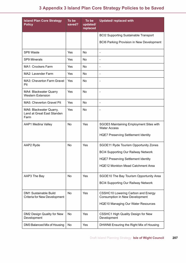
Updated/ replaced withTo beupdated/replaced
To besaved?
Island Plan Core StrategyPolicy
BCI2 Supporting Sustainable Transport
BCI6 Parking Provision in New Development
-NoYesSP8 Waste
-NoYesSP9 Minerals
-NoYesMA1: Crockers Farm
-NoYesMA2: Lavender Farm
-NoYesMA3: Cheverton Farm GravelPit
-NoYesMA4: Blackwater QuarryWestern Extension
-NoYesMA5: Cheverton Gravel Pit
-NoYesMA6: Blackwater Quarry,Land at Great East StandenFarm
SGOE5 Maintaining Employment Sites withYesNoAAP1 Medina ValleyWater Access
HQE7 Preserving Settlement Identity
SGOE11 Ryde Tourism Opportunity ZonesYesNoAAP2 Ryde
BCI4 Supporting Our Railway Network
HQE7 Preserving Settlement Identity
HQE12 Monkton Mead Catchment Area
SGOE10 The Bay Tourism Opportunity Area
BCI4 Supporting Our Railway Network
YesNoAAP3 The Bay
CSSHC10 Lowering Carbon and EnergyYesNoDM1 Sustainable BuildConsumption in New DevelopmentCriteria for New Development
HQE10 Managing Our Water Resources
CSSHC1 High Quality Design for NewYesNoDM2 Design Quality for NewDevelopmentDevelopment
DHWN8 Ensuring the Right Mix of HousingYesNoDM3BalancedMix of Housing
207Draft Island Planning Strategy Isle of Wight Council
3 Appendix 3 Island Plan Core Strategy Policies to be Saved

Updated/ replaced withTo beupdated/replaced
To besaved?
Island Plan Core StrategyPolicy
DHWN6 Delivering Affordable HousingYesNoDM4 Locally AffordableHousing
DHWN7 Rural Exceptions Sites
CSSHC5 Facilitating Independent LivingYesNoDM5 Housing for OlderPeople
CSSHC6 Providing Annexe Accommodation
DHWN10 Planning for Gypsy, Traveller andYesNoDM6 Gypsies, Travellers andTravelling Showpeople ProvisionTravelling Showpeople
CSSHC13 Providing Social and CommunityYesNoDM7 Social and CommunityInfrastructureInfrastructure
SGE1 Supporting and Growing EconomyYesNoDM8 Economic Development
SGE7 Supporting and Improving Our TownYesNoDM9 Town CentresCentres
SGE8 Supporting the Evening Economy
SGE7 Supporting and Improving Our TownYesNoDM10 Rural Service CentresCentresand the Wider Rural Area
SGE8 Supporting the Evening Economy
HQE1 Conserving and Enhancing Our HistoricYesNoDM11 Historic and BuiltEnvironmentEnvironment
HQE6 Protecting Our Landscapes andYesNoDM12 Landscape, Seascape,SeascapesBiodiveristy and Geodiversity
HQE2 Ecological Assets and Opportunities forYesNoDM13 Green InfrastructureEnhancement
HQE4 Providing and Protecting Green andOpen Spaces
HQE5 Local Green Spaces
HQE11 Managing Flood Risk in NewYesNoDM14 Flood RiskDevelopment
HQE12 Monkton Mead Catchment Area
HQE15 Improving Resilience from CoastalFlooding
HQE13 Managing Our CoastYesNoDM15 Coastal Management
Isle of Wight Council Draft Island Planning Strategy208
3 Appendix 3 Island Plan Core Strategy Policies to be Saved

Updated/ replaced withTo beupdated/replaced
To besaved?
Island Plan Core StrategyPolicy
HQE14 Facilitating Relocation from CoastalChange Management Areas
CSSHC9 Renewable Energy and Low CarbonYesNoDM16 RenewablesTechnologies
BCI1 A Better Connected IslandYesNoDM17 Sustainable Travel
BCI6 Parking Provision in New Development
BCI3 Cross-Solent TransportYesNoDM18 Cross-Solent Travel
-NoYesDM19 Waste
-NoYesDM20 Minerals
CSSHC11 Utility Infrastructure RequirementsYesNoDM21 Utility Infrastructurefor New DevelopmentRequirements
PSDG4Developer Contributions and EnsuringYesNoDM22 DeveloperViabilityContributions
209Draft Island Planning Strategy Isle of Wight Council
3 Appendix 3 Island Plan Core Strategy Policies to be Saved

Affordable housing - The council will use the definition of affordable housing, as per the NPPF, whichcurrently is: housing for sale or rent, for those whose needs are not met by the market (including housingthat provides a subsidised route to home ownership and/or is for essential local workers); and whichcomplies with one or more of the following definitions:
a) Affordable housing for rent: meets all of the following conditions: (a) the rent is set in accordance withthe Government’s rent policy for Social Rent or Affordable Rent, or is at least 20% below local marketrents (including service charges where applicable); (b) the landlord is a registered provider, except whereit is included as part of a Build to Rent scheme (in which case the landlord need not be a registeredprovider); and (c) it includes provisions to remain at an affordable price for future eligible households, orfor the subsidy to be recycled for alternative affordable housing provision. For Build to Rent schemesaffordable housing for rent is expected to be the normal form of affordable housing provision (and, in thiscontext, is known as Affordable Private Rent).
b) Starter homes: is as specified in Sections 2 and 3 of the Housing and Planning Act 2016 and anysecondary legislation made under these sections. The definition of a starter home should reflect themeaning set out in statute and any such secondary legislation at the time of plan-preparation ordecision-making. Where secondary legislation has the effect of limiting a household’s eligibility to purchasea starter home to those with a particular maximum level of household income, those restrictions shouldbe used.
c) Discounted market sales housing: is that sold at a discount of at least 20% below local market value.Eligibility is determined with regard to local incomes and local house prices. Provisions should be inplace to ensure housing remains at a discount for future eligible households.
d) Other affordable routes to home ownership: is housing provided for sale that provides a route toownership for those who could not achieve home ownership through the market. It includes sharedownership, relevant equity loans, other low cost homes for sale (at a price equivalent to at least 20%below local market value) and rent to buy (which includes a period of intermediate rent). Where publicgrant funding is provided, there should be provisions for the homes to remain at an affordable price forfuture eligible households, or for any receipts to be recycled for alternative affordable housing provision,or refunded to Government or the relevant authority specified in the funding agreement.
Ancient or veteran tree - A tree which, because of its age, size and condition, is of exceptionalbiodiversity, cultural or heritage value. All ancient trees are veteran trees. Not all veteran trees are oldenough to be ancient, but are old relative to other trees of the same species. Very few trees of any speciesreach the ancient life-stage.
Ancient woodland - An area that has been wooded continuously since at least 1600 AD. It includesancient semi-natural woodland and plantations on ancient woodland sites (PAWS).
Area of Outstanding Natural Beauty (AONB) - Landscape of national importance, designated underthe National Parks and Access to the Countryside Act 1949. The primary purpose of the AONB designationis to conserve and enhance the the natural beauty of the landscape, with secondary aims to haveconsideration for the interests of those who live and work there and support the need for quiet enjoymentof the countryside.
Archaeological interest - There will be archaeological interest in a heritage asset if it holds, or potentiallyholds, evidence of past human activity worthy of expert investigation at some point.
Aspirational housing - Housing that is attractive to “AB” households, i.e. professional workers andhigher income groups. There is no particular type of housing that can be defined as aspirational as it caninclude all dwelling sizes and costs. Research has shown that such households are attracted by factorssuch as the physical environment of the area and the availability of good schools.
BREEAM - The environmental assessment method is a rating system for environmentally friendly design,developed by the government's Building Research Establishment. It includes assessing carbon dioxideemissions from the building once in use.
Isle of Wight Council Draft Island Planning Strategy210
Glossary

Coastal change management area (CCMA) - An area identified in plans as likely to be affected byphysical change to the shoreline through erosion, coastal landslip, permanent inundation or coastalaccretion.
Combined Heat and Power (CHP) - The simultaneous generation of usable heat and power (usuallyelectricity) in a single process, thereby reducing wasted heat and putting to use that would normally bewasted to the atmosphere, rivers or seas. CHP is an efficient form of decentralised energy supply providingheating and electricity at the same time. CHP s overall fuel efficiency can be around 70-90% of the inputfuel, depending on the heat-load; much better than most power stations which are only up to around40-50% efficient.
Community Right to Build Order - An Order made by the local planning authority (under the Town andCountry Planning Act 1990) that grants planning permission for a site-specific development proposal orclasses of development.
Competent person (to prepare site investigation information) - A person with a recognised relevantqualification, sufficient experience in dealing with the type(s) of pollution or land instability, andmembershipof a relevant professional organisation.
Conservation (for heritage policy) - The process of maintaining and managing change to a heritageasset in a way that sustains and, where appropriate, enhances its significance.
Conservation Area - An area designated by the Local Authority due to their special architectural orhistoric interest, the character or appearance of which it is desirable to preserve or enhance.
Deliverable - To be considered deliverable, sites for housing should be available now, offer a suitablelocation for development now, and be achievable with a realistic prospect that housing will be deliveredon the site within five years. Sites that are not major development, and sites with detailed planningpermission, should be considered deliverable until permission expires, unless there is clear evidencethat homes will not be delivered within five years (e.g. they are no longer viable, there is no longer ademand for the type of units or sites have long term phasing plans). Sites with outline planning permission,permission in principle, allocated in the development plan or identified on a brownfield register shouldonly be considered deliverable where there is clear evidence that housing completions will begin on sitewithin five years.
Design code - A set of illustrated design requirements that provide specific, detailed parameters for thephysical development of a site or area. The graphic and written components of the code should buildupon a design vision, such as a masterplan or other design and development framework for a site orarea.
Developable - To be considered developable, sites should be in a suitable location for housingdevelopment with a reasonable prospect that they will be available and could be viably developed at thepoint envisaged.
Designated heritage asset - A World Heritage Site, Scheduled Monument, Listed Building, ProtectedWreck Site, Registered Park and Garden, Registered Battlefield or Conservation Area designated underthe relevant legislation.
Development plan - Is defined in section 38 of the Planning and Compulsory Purchase Act 2004, andincludes adopted local plans, neighbourhood plans that have been made and published spatialdevelopment strategies, together with any regional strategy policies that remain in force. Neighbourhoodplans that have been approved at referendum are also part of the development plan, unless the localplanning authority decides that the neighbourhood plan should not be made.
Edge of centre - For retail purposes, a location that is well connected to, and up to 300 metres from,the primary shopping area. For all other main town centre uses, a location within 300 metres of a towncentre boundary. For office development, this includes locations outside the town centre but within 500metres of a public transport interchange. In determining whether a site falls within the definition of edgeof centre, account should be taken of local circumstances.
211Draft Island Planning Strategy Isle of Wight Council
Glossary

Environmental impact assessment - A procedure to be followed for certain types of project to ensurethat decisions are made in full knowledge of any likely significant effects on the environment.
Geodiversity - The range of rocks, minerals, fossils, soils and landforms.
Green infrastructure - A network of multi-functional green space, urban and rural, which is capable ofdelivering a wide range of environmental and quality of life benefits for local communities.
Habitats site - Any site which would be included within the definition at regulation 8 of the Conservationof Habitats and Species Regulations 2017 for the purpose of those regulations, including candidateSpecial Areas of Conservation, Sites of Community Importance, Special Areas of Conservation, SpecialProtection Areas and any relevant Marine Sites.
Heritage asset - A building, monument, site, place, area or landscape identified as having a degree ofsignificance meriting consideration in planning decisions, because of its heritage interest. It includesdesignated heritage assets and assets identified by the local planning authority (including local listing).
Geodiversity - The range of rocks, minerals, fossils, soils and landforms.
Gigawatt hours (GWh) - A unit of energy representing one billion watt hours and is equivalent to onemillion kilowatt hours. Gigawatt hours are often used as a measure of the output of large electricity powerstations.
Green infrastructure - A network of multi-functional green space, urban and rural, which is capable ofdelivering a wide range of environmental and quality of life benefits for local communities.
Habitats site - Any site which would be included within the definition at regulation 8 of the Conservationof Habitats and Species Regulations 2017 for the purpose of those regulations, including candidateSpecial Areas of Conservation, Sites of Community Importance, Special Areas of Conservation, SpecialProtection Areas and any relevant Marine Sites.
Heritage asset - A building, monument, site, place, area or landscape identified as having a degree ofsignificance meriting consideration in planning decisions, because of its heritage interest. It includesdesignated heritage assets and assets identified by the local planning authority (including local listing).
Heritage coast - Areas of undeveloped coastline which are managed to conserve their natural beautyand, where appropriate, to improve accessibility for visitors.
Historic environment - All aspects of the environment resulting from the interaction between peopleand places through time, including all surviving physical remains of past human activity, whether visible,buried or submerged, and landscaped and planted or managed flora.
Historic environment record - Information services that seek to provide access to comprehensive anddynamic resources relating to the historic environment of a defined geographic area for public benefitand use.
International, national and locally designated sites of importance for biodiversity - All internationalsites (Special Areas of Conservation, Special Protection Areas, and Ramsar sites), national sites (Sitesof Special Scientific Interest) and locally designated sites including Local Wildlife Sites.
Local Development Order - An Order made by a local planning authority (under the Town and CountryPlanning Act 1990) that grants planning permission for a specific development proposal or classes ofdevelopment.
Main town centre uses - Retail development (including warehouse clubs and factory outlet centres);leisure, entertainment and more intensive sport and recreation uses (including cinemas, restaurants,drive-through restaurants, bars and pubs, nightclubs, casinos, health and fitness centres, indoor bowlingcentres and bingo halls); offices; and arts, culture and tourism development (including theatres, museums,galleries and concert halls, hotels and conference facilities).
Isle of Wight Council Draft Island Planning Strategy212
Glossary
Major development - For housing, development where 10 or more homes will be provided, or the sitehas an area of 0.5 hectares or more. For non-residential development it means additional floorspace of1,000m2 or more, or a site of 1 hectare or more, or as otherwise provided in the Town and CountryPlanning (Development Management Procedure) (England) Order 2015.
Mineral Safeguarding Area - An area designated by minerals planning authorities which covers knowndeposits of minerals which are desired to be kept safeguarded from unnecessary sterilisation bynon-mineral development.
Neighbourhood plan - A plan prepared by a parish council or neighbourhood forum for a designatedneighbourhood area. In law this is described as a neighbourhood development plan in the Planning andCompulsory Purchase Act 2004.
Older people - People over or approaching retirement age, including the active, newly-retired throughto the very frail elderly; and whose housing needs can encompass accessible, adaptable general needshousing through to the full range of retirement and specialised housing for those with support or careneeds.
Open space - All open space of public value, including not just land, but also areas of water (such asrivers, canals, lakes and reservoirs) which offer important opportunities for sport and recreation and canact as a visual amenity.
Out of centre - A location which is not in or on the edge of a centre but not necessarily outside the urbanarea.
Out of town - A location out of centre that is outside the existing urban area.
Policies Map - An illustration on a base map, reproduced from or based upon a map base to a registeredscale, of all the policies contained in development plan documents. It must be revised as each newdevelopment plan document is adopted and it should always reflect the up-to-date planning strategy inthe area.
PotableWater - Water that is fit for drinking, being free from contamination and not containing a sufficientquantity of saline material to be regarded as a mineral water.
Previously developed land - Land which is or was occupied by a permanent structure, including thecurtilage of the developed land (although it should not be assumed that the whole of the curtilage shouldbe developed) and any associated fixed surface infrastructure. This excludes: land that is or was lastoccupied by agricultural or forestry buildings; land that has been developed for minerals extraction orwaste disposal by landfill, where provision for restoration has been made through developmentmanagement procedures; land in built-up areas such as residential gardens, parks, recreation groundsand allotments; and land that was previously developed but where the remains of the permanent structureor fixed surface structure have blended into the landscape.
Primary shopping area - Defined area where retail development is concentrated.
Priority habitats and species - Species and Habitats of Principal Importance included in the EnglandBiodiversity List published by the Secretary of State under section 41 of the Natural Environment andRural Communities Act 2006.
Ramsar sites - Wetlands of international importance, designated under the 1971 Ramsar Convention.
Renewable and low carbon energy - Includes energy for heating and cooling as well as generatingelectricity. Renewable energy covers those energy flows that occur naturally and repeatedly in theenvironment – from the wind, the fall of water, the movement of the oceans, from the sun and also frombiomass and deep geothermal heat. Low carbon technologies are those that can help reduce emissions(compared to conventional use of fossil fuels).
Rural exception sites - Small sites used for affordable housing in perpetuity where sites would not
213Draft Island Planning Strategy Isle of Wight Council
Glossary
normally be used for housing. Rural exception sites seek to address the needs of the local communityby accommodating households who are either current residents or have an existing family or employmentconnection. A proportion of market homes may be allowed on the site at the local planning authority’sdiscretion, for example where essential to enable the delivery of affordable units without grant funding.
Self-build and custom-build housing - Housing built by an individual, a group of individuals, or personsworking with or for them, to be occupied by that individual. Such housing can be either market or affordablehousing. A legal definition, for the purpose of applying the Self-build and CustomHousebuilding Act 2015(as amended), is contained in section 1(A1) and (A2) of that Act.
Setting of a heritage asset - The surroundings in which a heritage asset is experienced. Its extent isnot fixed and may change as the asset and its surroundings evolve. Elements of a setting may make apositive or negative contribution to the significance of an asset, may affect the ability to appreciate thatsignificance or may be neutral.
Significance (for heritage policy) - The value of a heritage asset to this and future generations becauseof its heritage interest. The interest may be archaeological, architectural, artistic or historic. Significancederives not only from a heritage asset’s physical presence, but also from its setting. For World HeritageSites, the cultural value described within each site’s Statement of Outstanding Universal Value formspart of its significance.
Special Areas of Conservation (SAC) - Areas defined by regulation 3 of the Conservation of Habitatsand Species Regulations 2017 which have been given special protection as important conservation sites.
Special Protection Areas (SPA) - Areas classified under regulation 15 of the Conservation of Habitatsand Species Regulations 2017 which have been identified as being of international importance for thebreeding, feeding, wintering or the migration of rare and vulnerable species of birds.
Site investigation information - Includes a risk assessment of land potentially affected by contamination,or ground stability and slope stability reports, as appropriate. All investigations of land potentially affectedby contamination should be carried out in accordance with established procedures (such as BS10175Investigation of Potentially Contaminated Sites – Code of Practice).
Site of Importance for Nature Conservation (SINC) - A series of non-statutory sites designated toseek to ensure, in the public interest, the conservation, maintenance and enhancement of species andhabitats of substantive nature conservation value. SINCs should include all areas of substantive value,including both the most important and the most distinctive species, habitats, geological andgeomorphological features within a national, regional and local context.
Site of Special Scientific Interest (SSSI) - Sites designated by Natural England under the Wildlife andCountryside Act 1981.
Stepping stones - Pockets of habitat that, while not necessarily connected, facilitate the movement ofspecies across otherwise inhospitable landscapes.
Strategic environmental assessment - A procedure (set out in the Environmental Assessment of Plansand Programmes Regulations 2004) which requires the formal environmental assessment of certainplans and programmes which are likely to have significant effects on the environment.
Supplementary planning documents -Documents which add further detail to the policies in thedevelopment plan. They can be used to provide further guidance for development on specific sites, oron particular issues, such as design. Supplementary planning documents are capable of being a materialconsideration in planning decisions but are not part of the development plan.
Town centre - Area defined on the local authority’s policies map, including the primary shopping areaand areas predominantly occupied by main town centre uses within or adjacent to the primary shoppingarea. References to town centres or centres apply to city centres, town centres, district centres and localcentres but exclude small parades of shops of purely neighbourhood significance. Unless they areidentified as centres in the development plan, existing out-of-centre developments, comprising or including
Isle of Wight Council Draft Island Planning Strategy214
Glossary

main town centre uses, do not constitute town centres.
Travel plan - A long-termmanagement strategy for an organisation or site that seeks to deliver sustainabletransport objectives and is regularly reviewed.
Wildlife corridor - Areas of habitat connecting wildlife populations.
Windfall sites - Sites not specifically identified in the development plan.
215Draft Island Planning Strategy Isle of Wight Council
Glossary