draft lp 384 planning proposal - city of shoalhaven
TRANSCRIPT

Draft LP 384 Planning Proposal Goodland Road, Woollamia Prepared by Strategic Planning & Infrastructure Group Shoalhaven City Council December 2012

Strategic Planning & Infrastructure Group, Shoalhaven City Council Planning Proposal – Goodland Road, Woollamia
2
Contents
Introduction ....................................................................................................................................................... 3
Subject Land................................................................................................................................................... 3
Background .................................................................................................................................................... 5
Part 1 Statement of objectives or intended outcomes ................................................................................ 6
Part 2 Explanation of provisions .................................................................................................................. 6
Part 3 Justification ........................................................................................................................................ 7
Section A. Need for the Planning Proposal ......................................................................................... 7
Section B. Relationship to strategic planning framework? ................................................................ 9
Part 4 Mapping ........................................................................................................................................... 14
Part 5 Community Consultation ................................................................................................................. 15
Part 6 Project Timeline ............................................................................................................................... 16
Figures
Figure 1: Location of subject land ..................................................................................................................... 3 Figure 2: Boundary of the subject land ............................................................................................................. 4
Attachments
Attachment A: Council resolution to prepare a Planning Proposal Attachment B-Proposed Zoning Map Attachment C-Constraints Map Attachment D-Development Scenario 4 Attachment E- Relevant State Environmental Planning Policies Attachment F - Council Report (See Pdf Attachment) Attachment G - Voluntary Planning Agreement (See Pdf Attachment) Attachment H - Voluntary Planning Agreement Explanatory Statement (See Pdf Attachment) Attachment I- Draft Landowners Agreement (Removed for privacy purposes) Attachment J - Bushfire Assessment (See Pdf Attachment) Attachment K- Environmental Investigation (See Pdf Attachment) Attachment L - Onsite Effluent Disposal Site and Soil Assessment 1 (See Pdf Attachment) Attachment M - Onsite Effluent Disposal Site and Soil Assessment 2 (See Pdf Attachment) Attachment N- Goodland Rd Effluent Calculations (See Pdf Attachment) Attachment O - Threatened Biodiversity Survey and Assessment (See Pdf Attachment) Attachment P- Orchid Survey (See Pdf Attachment) Attachment Q - Further Archaeological Survey (See Pdf Attachment) Attachment R-- Valuation Report (See Pdf Attachment) Attachment S – Archaeological Survey (See Pdf Attachment)
Strategic Planning & Infrastructure Group, Shoalhaven City Council Planning Proposal – Goodland Road, Woollamia
3
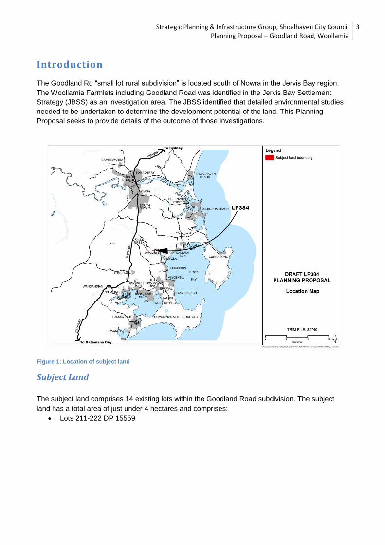
Introduction The Goodland Rd “small lot rural subdivision” is located south of Nowra in the Jervis Bay region.
The Woollamia Farmlets including Goodland Road was identified in the Jervis Bay Settlement
Strategy (JBSS) as an investigation area. The JBSS identified that detailed environmental studies
needed to be undertaken to determine the development potential of the land. This Planning
Proposal seeks to provide details of the outcome of those investigations.
Figure 1: Location of subject land
Subject Land
The subject land comprises 14 existing lots within the Goodland Road subdivision. The subject
land has a total area of just under 4 hectares and comprises:
Lots 211-222 DP 15559

Strategic Planning & Infrastructure Group, Shoalhaven City Council Planning Proposal – Goodland Road, Woollamia
4
Figure 2: Boundary of the subject land
Figure 3- Existing zones

Strategic Planning & Infrastructure Group, Shoalhaven City Council Planning Proposal – Goodland Road, Woollamia
5
Background
The Goodland Road investigation area has a very long and protracted history and the background
is summarised below:
The area was initially subdivided in 1917 as part of the “Woollamia Estate” (DP9289)
The legal paper subdivision of the land created separate land titles. In 1964 the land was
given a “non-urban” zoning under the Interim Development Order No. 1 (IDO No.1) with a
minimum lot size of 40ha being required to erect a dwelling.
In 1995 a draft LEP to allow single dwellings on all of the lots was refused by the then
Minister on the basis of water quality impacts, degradation of SEPP No. 14 Wetlands,
threats to fauna, birdlife and fish habitat, ongoing management of the impacts of
development and precedent for similar land in the area.
This Planning Proposal is a conversion of draft Shoalhaven LP No. 384 Goodland Road,
Woollamia. In 1991 Shoalhaven Council resolved to prepare an LEP (LP.No 191) for the
site. All relevant consultations and studies were undertaken and the plan proceeded to
exhibition stage. However at gazettal, it was determined by the Minister that the LEP was
not suitable for gazettal due to issues with water quality, degradation to a wetland, fauna
and flora and management of development within the area. In 1997 it was determined that
the matter could be included for consideration in the Jervis Bay Settlement Strategy
process. The Strategy was endorsed by Shoalhaven Council and the Department of
Planning and Infrastructure (DP&I) in 2003 and identifies that the subject land is suitable for
investigation.
On 26th July 2005 Council resolved to prepare a draft plan (LP No. 384) for the land.
Council initiated a review of the earlier environmental study and additional reports to
identify development scenarios for the land. Government agency and landholder meetings
were held to refine the scenarios and seek agreement on a preferred option. On 9th
December 2010 Shoalhaven Council requested that DP&I move the draft LEP into the new
plan making system at Section 58 stage.
On 24 December 2010 DP&I advised Council that the former LEP plan-making provisions
cease to apply to draft LP384 and the current provisions of Part 3 of the EP&A Act now
apply. This change required Council to prepare a planning proposal with supporting studies
based on the Local Environmental Study (LES), specifically:
o Provisions of the Jervis Bay Settlement Strategy, Illawarra REP No. 1, Currambene
Creek Catchment Management Plan, Currambene Creek Crown Land Assessment
and SEPP 71 Coastal Protection;
o The urban capability of the land;
o Assessment of flooding risk and its management;
o Potential for acid sulphate soils
o Possible effects on water quality of the adjoining SEPP14 wetlands and
Currambene Creek;
o Flora and fauna values;
o Assessment of bushfire risk and its management;
o Cultural and natural heritage values of the site;
o Wastewater management;
o Provision of public utility services and infrastructure and its costings;
o Provision of community facilities; and
o Social implications of either proceeding/not proceeding with developing the land.
Strategic Planning & Infrastructure Group, Shoalhaven City Council Planning Proposal – Goodland Road, Woollamia
6
Council has since undertaken a number of further studies and engaged with a number of
state agencies. This has resulted in the creation of a development scenario which allows for
some potential development of the land, subject to development assessment whilst still
allowing for protection of the environment.
Part 1 Statement of objectives or intended outcomes
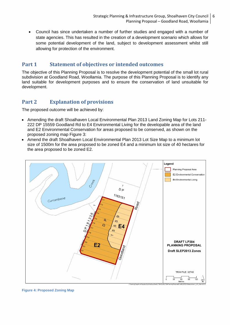
The objective of this Planning Proposal is to resolve the development potential of the small lot rural subdivision at Goodland Road, Woollamia. The purpose of this Planning Proposal is to identify any land suitable for development purposes and to ensure the conservation of land unsuitable for development.
Part 2 Explanation of provisions
The proposed outcome will be achieved by:
Amending the draft Shoalhaven Local Environmental Plan 2013 Land Zoning Map for Lots 211-222 DP 15559 Goodland Rd to E4 Environmental Living for the developable area of the land and E2 Environmental Conservation for areas proposed to be conserved, as shown on the proposed zoning map Figure 3:
Amend the draft Shoalhaven Local Environmental Plan 2013 Lot Size Map to a minimum lot size of 1500m for the area proposed to be zoned E4 and a minimum lot size of 40 hectares for the area proposed to be zoned E2.
Figure 4: Proposed Zoning Map
Strategic Planning & Infrastructure Group, Shoalhaven City Council Planning Proposal – Goodland Road, Woollamia
7
Part 3 Justification
The subject land is currently zoned Rural 1(d) General Rural in Shoalhaven Local Environmental Plan 1985 (LEP 1985) and the proposed zone is RU2 Rural Landscape in draft Shoalhaven Local Environmental Plan 2013 (draft SLEP). The rural zoning of the subject land requires a minimum lot size of 40 hectares to erect a dwelling. The lots range in size from 2630m2 to 3010m2 and currently have no dwelling entitlement. It is considered appropriate to resolve the development potential of this land through amending the zoning and lot size layer for the site to resolve the development potential of the land and to protect environmental constraints. The proposed zone boundaries have been delineated following consultation with NSW Department of Planning & Infrastructure and NSW Office of Environment & Heritage. Council resolved to prepared this planning proposal at its meeting of 29 November 2011 (see Attachment A). The planning proposal is also supported by the following key technical studies:
Valuation Report – Walsh and Monaghan
Effluent Management Report – Eric Hollinger
Review of Onsite Effluent Disposal, Site and Soil Assessment – Whitehead and Associates
Environmental Investigation Report- Spencer J Buchanan and associates pty ltd
Threatened Biodiversity Survey- AHA Ecology
Bushfire Assessment- Bushfire and Environmental Services
Archaeological survey of proposed development area-Navin Officer
Orchid Survey- AHA Ecology
The Planning Proposal is also supported by a Voluntary Planning Agreement and draft
Landowners Agreement.
Section A. Need for the Planning Proposal 1. Is the planning proposal a result of any strategic study or report? The JBSS (2003) identifies areas in its principles plan to be investigated in detail and possibly
rezoned. It specifically addresses the question of the small lot rural subdivisions in the Jervis Bay
Region, in which the Woollamia Farmlets are located. The proposal is consistent with the second
broad option identified in the JBSS (2003) to address small lot rural subdivisions, as follows;
“Investigate rezoning in accordance with the Strategy and where appropriate allow each lot to
have a dwelling built on it.”
The planning proposal is a direct action outcome of the Jervis Bay Settlement Strategy (2003)
(JBSS) which identifies the need to resolve the small lot rural subdivisions and their development
potential in the Woollamia area. The objective for Small Lot Rural Subdivisions in the JBSS is to
ensure that a process is established for resolving the development potential of existing small lot
rural zoned subdivisions in accordance with this Strategy.
Action iv. Woollamia Farmlets was allocated a short term time frame and the direct action details
that:-

Strategic Planning & Infrastructure Group, Shoalhaven City Council Planning Proposal – Goodland Road, Woollamia
8
“The development potential of the Woollamia Farmlets, including Goodlands Road, will be
investigated through a review of lot sizes and configuration in order to accommodate on site
effluent management and meet the guiding principles and policy actions of this Strategy.
Lots larger than 2 hectares may be able to provide for one dwelling to be built on each lot,
provided the guiding principles and policy actions of the Strategy can be achieved.”
The JBSS is a non-statutory plan adopted by Council and endorsed by the State Government. It is
also recognised in the South Coast Regional Strategy (2007) and forms a strategic framework for
conservation and development in the Jervis Bay region.
2. Is the planning proposal the best means of achieving the objectives or intended
outcomes, or is there a better way? To achieve the desired outcome of resolving the development potential of the Goodland Road
subdivision, the following are considered to be the options available to Council:
1. Rezone the land from the current Rural 1(d) General to part E2 Environmental
Conservation and part E4 Environmental Living. Amend the minimum lot size to
1500m for the E4 zoned land to allow for 7 dwelling entitlements, following re-
subdivision of the land. Retain the E2 Environmental Conservation land at 40
hectares. This option was adopted by Council and is considered to be the best means of
protecting the environmental constraints on the land and achieving the desired outcome. To
date, all the investigations, environmental studies and consultation with State agencies and
landowners have been working towards achieving this Development Scenario. A draft
Voluntary Planning Agreement (VPA) and Landowners Agreement has been developed to
seek full commitment from the landowners for this proposal. So far agreement from most
landowners has been reached. The VPA includes the re-imbursement of investigation costs
to Council, land owner funding to finalise the rezoning costs and to implement this
Development Scenario through infrastructure and subdivision costs.
2. Rezone the land to part RU2 Rural Landscape and part E2 Environmental
Conservation and retain the current minimum lot size of 40ha. This option does have
advantages in that it identifies and clarifies that the land could be further considered for
residential purposes in the future (via the RU2 zoning), and also recognises the land which
has high environmental value (via the E2 zoning). This option would not preclude owners
from approaching Council in the future with a rezoning proposal (Change in minimum lot
size) for the E3 Environmental Management land.
3. Do nothing, retain the current zone and minimum lot size. This is not considered a
suitable outcome for Council as it does not acknowledge any of the information that has
been gathered through the rezoning and environmental study process regarding the
environmental attributes of parts of the land and the residential development potential for
other parts of the land.
There is no other strategic approach identified in a strategic study or report to resolve the
development potential and achieve environmental outcomes for the subject land. This is the only
appropriate means to facilitate the development of a residential dwelling on each of the lots
identified, whilst retaining environmentally constrained land.

Strategic Planning & Infrastructure Group, Shoalhaven City Council Planning Proposal – Goodland Road, Woollamia
9
Section B. Relationship to strategic planning framework? 3. Is the planning proposal consistent with the objectives and actions of the applicable
regional or sub-regional strategy?
The South Coast Regional Strategy (SCRS) provides the key regional level guidance applying to
the site. The proposal is consistent with the objectives and actions of the SCRS. The SCRS
provides actions to maintain rural landscapes and rural communities, in particular:
Existing rural residential zones have the capacity to meet the demands for rural lifestyle
housing within the Region. Limited areas for additional rural residential must be located
on cleared land unsuitable for urban or agricultural uses and will only be agreed to by
the Department as part of an endorsed growth management strategy or structure plan.
Local environmental plans will include minimum subdivision standards for rural and
environmental protection zones.
Local environmental plans will include provisions to limit dwellings in rural and
environmental zones.
The JBSS was endorsed by the Director General of the Department of Planning & Infrastructure
and requires that Goodland Road small lot rural subdivision be resolved to determine development
potential. The South Coast Regional Strategy provided the framework and context in preparing
draft Shoalhaven Local Environmental Plan 2013 and will guide future development citywide in
accordance with the outcomes and actions of the South Coast Regional Strategy.
4. Is the planning proposal consistent with a council’s local strategy or other local strategy
plan? At the local level, Council has developed a number of policies and strategies relevant to this proposal. These include:
Jervis Bay Settlement Strategy As discussed in Section A. 1, this planning proposal is consistent with the actions and outcomes identified in the JBSS.
Community Strategy Plan 2020
Council’s Community Strategic Plan, Shoalhaven 2020 provides the long-term direction for
the overall development of the City and is a tool for managing private and public
development in the Shoalhaven. The proposal is consistent with Council's Community
Strategic Plan in that it meets Objective 2.2 - Population and urban settlement growth that
is ecologically sustainable, carefully planned and managed to meet the needs of the
community, and the Strategy 2.2.1 - Develop and implement land use zones and related
strategies for future growth of the City, based on principles of connectivity, ecological
sustainability, flexibility and accessibility.
The proposal is also consistent with Council's Delivery Program which aims to resolve the
future small lot rural subdivisions located in the Jervis Bay region consistent with the Jervis
Bay Settlement Strategy.
Currambene Creek and Moona Moona Creek Flood Studies
Goodland Road is located within close proximity to Currambene Creek. The flood study
identifies that the subject land is within the Currambene Creek catchment and part of the

Strategic Planning & Infrastructure Group, Shoalhaven City Council Planning Proposal – Goodland Road, Woollamia
10
land is flood prone and is affected by the 100 year ARI .The outcomes of the Planning
Proposal are consistent with this flood study in that flood affected land is proposed to be
zoned E3 Environmental Conservation.
5. Is the planning proposal consistent with applicable State Environmental Planning
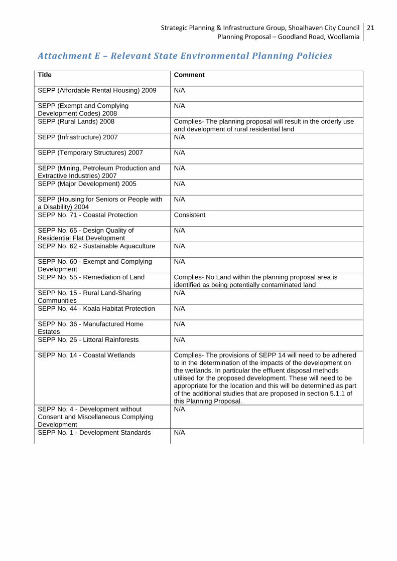
Policies? Relevant State Environmental Planning Policies (SEPPs) considered in the preparation of the Planning Proposal include:
SEPP 14 – Coastal Wetlands
SEPP 71 – Coastal Protection
SEPP 55 – Remediation of Land
Illawarra Regional Environmental Plan No. 1 (deemed SEPP)
Rural Lands SEPP Existing policies identify restrictions on part of the land with respect to development potential and has identified environmental conservation areas. Other areas are identified for development on portions of the land that are clearly not possible due to conservation requirements ( for example SEPP 14 wetlands). These areas require rezoning to enable a balanced form of development consistent with the capacity of the land. The Planning Proposal has been assessed for consistency with the applicable SEPPs as detailed in Attachment E. 6. Is the planning proposal consistent with applicable Ministerial Directions (s. 117
directions)? The planning proposal is consistent with the following s117 Directions:
s117 1.5 Rural Lands - the proposal is consistent with the Rural Planning Principles of the SEPP (Rural Lands) 2008.
s117 2.1 Environment Protection Zones - It is zoning the land to environment protection and thereby ensuring the protection of environmentally sensitive areas.
s117 2.2 Coastal Protection - The proposal ensures the protection of coastal attributes and avoids flood prone land taking into account sea level rise. The Coastal Design Guidelines will be considered through the development assessment process and Councils Principal LEP will include the standard coastal clauses.
s117 2.3 Heritage Conservation - Shoalhaven LEP 1985 and the draft Principal LEP both contain model heritage provisions. The Environmental Study to support the planning proposal will consider archaeological issues.
s117 4.4 Planning for Bushfire Protection - Council is to consult with the NSW Rural Fire Service and take into account its comments prior to proceeding to public exhibition.
s117 5.1 Implementation of Regional Strategies - The planning proposal is consistent with the Jervis Bay Settlement Strategy which is identified in the South Coast Regional Strategy.
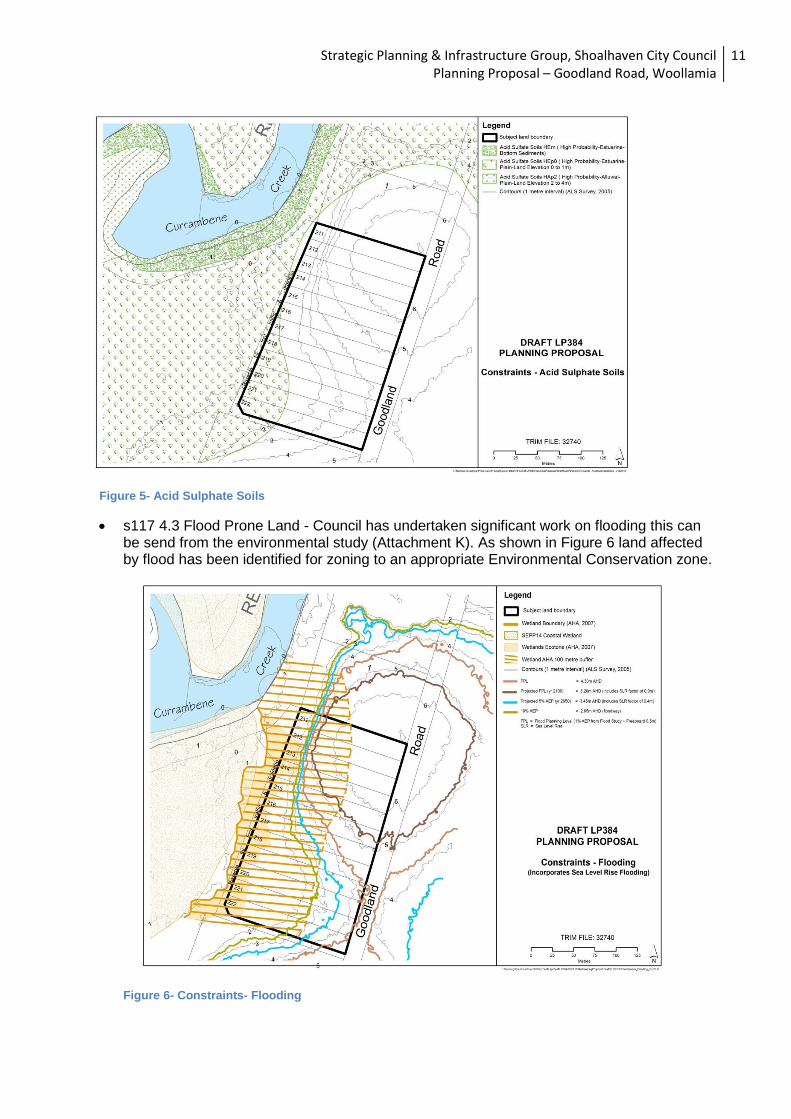
s117 4.1 Acid Sulphate Soils – The investigation area is only partially affected by Acid Sulphate Soils as shown in Figure ... below.
Strategic Planning & Infrastructure Group, Shoalhaven City Council Planning Proposal – Goodland Road, Woollamia
11
Figure 5- Acid Sulphate Soils
s117 4.3 Flood Prone Land - Council has undertaken significant work on flooding this can be send from the environmental study (Attachment K). As shown in Figure 6 land affected by flood has been identified for zoning to an appropriate Environmental Conservation zone.
Figure 6- Constraints- Flooding
Strategic Planning & Infrastructure Group, Shoalhaven City Council Planning Proposal – Goodland Road, Woollamia
12
The planning proposal is inconsistent with the following s117 Directions:
s117 1.2 Rural Zones - the proposal is increasing the residential density of the rural zone, however this increase has been identified in the Jervis Bay Settlement Strategy. This is considered a small inconsistency that is supported by an endorsed Strategy. Council is seeking the Director Generals approval for this variation to the s 117 Direction.
7. Is there any likelihood that critical habitat or threatened species, populations or ecological communities, or their habitats, will be adversely affected as a result of the proposal?
Detailed flora and fauna assessment has been completed for the subject land. Council engaged
Alison Hunt & Associates Pty Ltd (AHA Ecology) to complete the following studies:
Threatened Biodiversity Survey and Assessment – January 2008 (see Attachment O)
A targeted orchid survey for Pterostylis gibbosa (Illawarra Greenhood) – September 2009
(see Attachment P).
The biodiversity assessment identified low, medium and high constraint areas within the
subdivision and the identified constraints were used as a basis for Council’s Development
Constraint mapping and the zoning boundary for the area. The proposed development scenario
and zoning boundaries have been determined in consultation with NSW Office of Environment and
Heritage (OEH) and NSW Department of Planning & Infrastructure (DP&I).
8. Are there any other likely environmental effects as a result of the planning proposal and
how are they proposed to be managed? The subject land has been disturbed to varying degrees. In most cases bushland will need to be
cleared to accommodate residential development, infrastructure and provision of bushfire asset
protection zones. The Goodland Road subdivision is constrained by a number of environmental
effects including:
Flooding
Bushfire hazard
Effulent disposal
SEPP 14 wetlands
Aboriginal Heritage
Threatened Flora and Fauna
These constraints have been considered through a number of studies undertaken as part of the
rezoning investigations. These studies include:
Effluent Management Report – Eric Hollinger
Review of Onsite Effluent Disposal, Site and Soil Assessment – Whitehead and Associates
Environmental Investigation Report- Spencer J Buchanan and Associates Pty Ltd
Threatened Biodiversity Survey and Assessment- AHA Ecology
Orchid Survey- AHA Ecology
Bushfire Assessment- Bushfire and Environmental Services
Valuation Report – Walsh and Monaghan

Strategic Planning & Infrastructure Group, Shoalhaven City Council Planning Proposal – Goodland Road, Woollamia
13
They are provided at Attachment J-S The studies concluded that there is an area within the subject land which requires conservation
and protection. The studies outlined that careful management of this land would be required. It has
also been identified that there is some limited potential for development within the investigation
area and this is identified as the proposed RU2 Rural Landscape land at Figure 3.
There are a number of measures that are proposed to ensure that the effects of any development
resulting from the Planning Proposal are mitigated and these are included within the attached
Voluntary Planning Agreement. Such measures include restriction on the number and size of
houses, requirements for fire trials, bush regeneration practices and process, environmental
management plans, the requirements for Asset Protection zones and requirements relating to
effluent disposal.
Two (2) archaeological surveys have been completed within the Goodlands Road area as detailed
below (Attachment Q and S):
An archaeological survey of proposed development areas – Goodlands Road and
Woollamia Road, Woollamia by Kerry Navin (Navin Officer Archaeological Resource
Management) – April 1992 report to Spencer J. Buchanan & Associates Pty Ltd
Further archaeological investigations Goodland Road, Woollamia by Kerry Navin (Navin
Officer Archaeological Resource Management) – March 1993 report to Shoalhaven City
Council.
The surveys recommended that two (2) areas be protected include a possible Aboriginal sacred
tree and an area where artefacts were recovered from auger hole. These protected area are
identified in the Development Constraints mapping (Attachment C) and are proposed to be zoned
E2 Environmental Conservation.
There are no European heritage items located in the vicinity of the Goodland Road subdivision.
9. Has the planning proposal adequately addressed any social and economic effects? Resolution of the development potential of the small lot rural subdivision will provide social and
economic benefits including but not limited to, the resolution of the status of the land for
landowners to provide them certainty on the value and use of the land in the future. The resolution
will also provide certainty for the broader community about the future use of the land in the
planning proposal area.
The Planning Proposal has considered the economic impacts of any outcomes of the rezoning
through a Valuation Report (Attachment R) and the draft Landowners Agreement (Attachment I) In
determining the development potential of the land Council has tried to ensure that all landowners
benefit from the proposal and that this is achieved in a fair and equitable way.
10. Is there adequate public infrastructure for the planning proposal? Landholders would be required to fund the infrastructure required to develop the lots e.g. on-site effluent management, water supply, road upgrade, provision electricity, bushfire trails.

Strategic Planning & Infrastructure Group, Shoalhaven City Council Planning Proposal – Goodland Road, Woollamia
14
The land is located close to the town of Huskisson. The land can be accessed via Woollamia Road. Huskisson provides a number of essential services including but not limited to a supermarket, primary school, preschool, banks and other shops and services. Sewerage servicing of Woollamia is not planned in the near future and any development on this land will need be to be serviced through onsite effluent disposal systems. An Onsite Effluent Disposal Site & Soil Assessment has been completed for the Goodland Road subdivision by Eric Hollinger in May 2010 (Attachment L). This detailed site and soil assessment was undertaken to determine the feasibility of onsite effluent disposal for development scenario (DS3). The recommendations of this report have been included in the Development Constraints mapping (Attachment C and D) and also recommended that detailed design proposals should be submitted a development application stage.
Additional servicing and infrastructure requirements will be established as the planning proposal progresses. In accordance with Council policy, costs associated with the rezoning and development of land will be borne by the benefitting landowners. The cost recoupment process has been organised through the establishment of a Voluntary Planning Agreement between landowners and Council for rezoning investigations. 11. What are the views of State and Commonwealth public authorities consulted in
accordance with the Gateway determination? To date, detailed communication has occurred with relevant public authorities, particularly NSW Office of Environment and Heritage (OEH) and NSW Department of Planning & Infrastructure (DP&I). The bushfire assessment completed in January 2009 was also prepared in consultation with NSW Rural Fire Service. All parties are agreeable to the proposed development/ rezoning scenario and established conservation outcomes.
Part 4 Mapping
The Planning Proposal is supported by the following maps.
Land subject to the planning proposal
Current land use zone/s applying to the land
Constraints Mapping
Proposed zone changes
Aerial Photographs
These maps appear as part of the body of the Planning Proposal and also as attachments to the document.

Strategic Planning & Infrastructure Group, Shoalhaven City Council Planning Proposal – Goodland Road, Woollamia
15
Part 5 Community Consultation
Council proposes to exhibit the Planning Proposal for a period of 28 days in accordance with the
requirements of section 57 of the Environmental Planning and Assessment Act 1979 (EP&A Act)
and/or any other requirements as determined by the Gateway process. As requested by DP&I in its
letter dated 24 December 2012, Council will seek the Director General’s approval to exhibit under
section 57(2) of the EP&A Act before undertaking any community consultation. Public notification
of the exhibition will include a notice in newspapers circulating in the local area and a notice on
Council’s website and hard copies will be available at Council’s Administrative Building.
Consultation will be made with relevant State or Commonwealth public authorities in accordance
with Section 56 (2)(d) of the Environmental Planning and Assessment Act 1979 (EP&A Act) and/or
any other requirements as determined by the Gateway process.
As requested by DP&I in its letter dated 24 December 2012, additional State Government agency
will be sought prior to community consultation. Council proposes to notify the following government
agencies prior to public exhibition:
Southern Rivers Catchment Management Authority
NSW Office of Environment and Heritage
NSW Department of Primary Industries - Fishing and Aquaculture
NSW Rural Fire Service
Jervis Bay Marine Park
Shoalhaven Water
Below is a brief summary of previous consultation held with government agencies and landowners 2005: Section 62 Consultation undertaken with Government Agencies. 2009: Three (3) development scenarios were referred to DECCW and DP&I for comment. DECCW and DoP were prepared to compromise and support Development Scenario 3 (DS3) subject to additional mitigation measures including community title subdivision with environmental areas being a community lot subject to a Plan of Management. 2010: Impacts of Sea Level Rise and sale of two lots (Lot 102 & 103) result in revised Development Scenario 4 (DS4) which is supported by DECCW and DoP&I. 2010: Consultation session with land owners, Council and State Agencies to discuss DS4. 2010: Survey sent to landowners to establish support or otherwise for DS4 – land owners unable to reach consensus as there is an expectation that all land owners receive a dwelling entitlement through the rezoning and reluctance for land owners to fund process. 2010: Further Council staff and land owner meeting held in December to ascertain land owner commitment to development scenario 4. 2011: Further Council staff and landowner meetings and discussions. Discussions and
submissions to Department of Planning, Local Members, State Members and government departments Discussions with other State Government Departments

Strategic Planning & Infrastructure Group, Shoalhaven City Council Planning Proposal – Goodland Road, Woollamia
16
2012: Drafting of Voluntary Planning Agreement and Landowners Agreement – discussions with landowners
Part 6 Project Timeline
The project plan below sets out the anticipated key steps and dates within the project finalisation timeframe.
Target Date Process
Completed Anticipated commencement date (date of Gateway determination)
Completed Anticipated timeframe for the completion of required studies
Completed Timeframe for government agency consultation (pre and post exhibition as required by Gateway determination)
Feb-Mar 2013 Submission to Department for exhibition approval
March 2013 Exhibition
May 2013 Timeframe for the consideration of a proposal post exhibition
July 2013 Anticipated date RPA will make the plan (if delegated), and
September 2013 Anticipated date RPA will forward to the department for notification (if delegated)
Strategic Planning & Infrastructure Group, Shoalhaven City Council Planning Proposal – Goodland Road, Woollamia
17
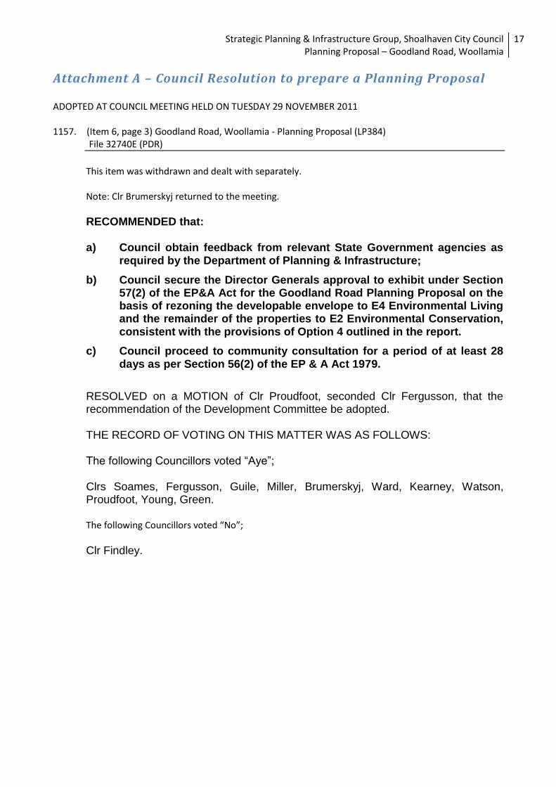
Attachment A – Council Resolution to prepare a Planning Proposal
ADOPTED AT COUNCIL MEETING HELD ON TUESDAY 29 NOVEMBER 2011
1157. (Item 6, page 3) Goodland Road, Woollamia - Planning Proposal (LP384) File 32740E (PDR)
This item was withdrawn and dealt with separately. Note: Clr Brumerskyj returned to the meeting.
RECOMMENDED that: a) Council obtain feedback from relevant State Government agencies as
required by the Department of Planning & Infrastructure;
b) Council secure the Director Generals approval to exhibit under Section 57(2) of the EP&A Act for the Goodland Road Planning Proposal on the basis of rezoning the developable envelope to E4 Environmental Living and the remainder of the properties to E2 Environmental Conservation, consistent with the provisions of Option 4 outlined in the report.
c) Council proceed to community consultation for a period of at least 28 days as per Section 56(2) of the EP & A Act 1979.
RESOLVED on a MOTION of Clr Proudfoot, seconded Clr Fergusson, that the recommendation of the Development Committee be adopted. THE RECORD OF VOTING ON THIS MATTER WAS AS FOLLOWS: The following Councillors voted “Aye”; Clrs Soames, Fergusson, Guile, Miller, Brumerskyj, Ward, Kearney, Watson, Proudfoot, Young, Green. The following Councillors voted “No”;
Clr Findley.

Strategic Planning & Infrastructure Group, Shoalhaven City Council Planning Proposal – Goodland Road, Woollamia
18
Attachment B – Proposed Zoning Map

Strategic Planning & Infrastructure Group, Shoalhaven City Council Planning Proposal – Goodland Road, Woollamia
19
Attachment C - Constraints Maps
Strategic Planning & Infrastructure Group, Shoalhaven City Council Planning Proposal – Goodland Road, Woollamia
20
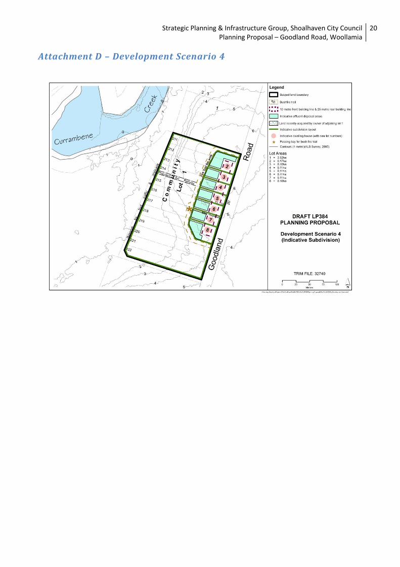
Attachment D – Development Scenario 4
Strategic Planning & Infrastructure Group, Shoalhaven City Council Planning Proposal – Goodland Road, Woollamia
21
Attachment E – Relevant State Environmental Planning Policies
Title Comment
SEPP (Affordable Rental Housing) 2009 N/A
SEPP (Exempt and Complying Development Codes) 2008
N/A
SEPP (Rural Lands) 2008 Complies- The planning proposal will result in the orderly use and development of rural residential land
SEPP (Infrastructure) 2007 N/A
SEPP (Temporary Structures) 2007 N/A
SEPP (Mining, Petroleum Production and Extractive Industries) 2007
N/A
SEPP (Major Development) 2005 N/A
SEPP (Housing for Seniors or People with a Disability) 2004
N/A
SEPP No. 71 - Coastal Protection Consistent
SEPP No. 65 - Design Quality of Residential Flat Development
N/A
SEPP No. 62 - Sustainable Aquaculture N/A
SEPP No. 60 - Exempt and Complying Development
N/A
SEPP No. 55 - Remediation of Land Complies- No Land within the planning proposal area is identified as being potentially contaminated land
SEPP No. 15 - Rural Land-Sharing Communities
N/A
SEPP No. 44 - Koala Habitat Protection N/A
SEPP No. 36 - Manufactured Home Estates
N/A
SEPP No. 26 - Littoral Rainforests N/A
SEPP No. 14 - Coastal Wetlands Complies- The provisions of SEPP 14 will need to be adhered to in the determination of the impacts of the development on the wetlands. In particular the effluent disposal methods utilised for the proposed development. These will need to be appropriate for the location and this will be determined as part of the additional studies that are proposed in section 5.1.1 of this Planning Proposal.
SEPP No. 4 - Development without Consent and Miscellaneous Complying Development
N/A
SEPP No. 1 - Development Standards N/A
Strategic Planning & Infrastructure Group, Shoalhaven City Council Planning Proposal – Goodland Road, Woollamia
22
Attachment F - Council Report (See Pdf Attachment) Attachment G - Voluntary Planning Agreement (See Pdf Attachment) Attachment H - Voluntary Planning Agreement Explanatory Statement (See Pdf Attachment) Attachment I- Draft Landowners Agreement (Removed for Exhibition) Attachment J - Bushfire Assessment (See Pdf Attachment) Attachment K- Environmental Investigation (See Pdf Attachment) Attachment L - Onsite Effluent Disposal Site and Soil Assessment 1 (See Pdf Attachment) Attachment M - Onsite Effluent Disposal Site and Soil Assessment 2 (See Pdf Attachment) Attachment N- Goodland Rd Effluent Calculations (See Pdf Attachment) Attachment O - Threatened Biodiversity Survey and Assessment (See Pdf Attachment) Attachment P- Orchid Survey (See Pdf Attachment) Attachment Q - Further Archaeological Survey (See Pdf Attachment) Attachment R-- Valuation Report (See Pdf Attachment) Attachment S – Archaeological Survey(See Pdf Attachment)