draft north peace fringe area official community plan · 2017-12-30 · north peace fringe area...
TRANSCRIPT

North Peace Fringe Area Official Community Plan
diverse. vast. abundant.
Version 1.0
JANUARY 2018
DRAFT

Peace River Regional District North Peace Fringe Area Official Community Plan
Bylaw No. xxxx, 2017
1
CONTENTS 1 Context .................................................................................................................................... 4
1.1 Purpose of this Plan .......................................................................................................... 4
1.2 Official Community Plan Area and Boundary................................................................... 4
1.3 Community Consultation ................................................................................................. 5
1.4 Our Community Vision ..................................................................................................... 6
2 Growth Management .............................................................................................................. 8
2.1 Growth Projections .......................................................................................................... 8
2.2 Growth Management Goals ........................................................................................... 10
2.3 Growth Management Policies ........................................................................................ 11
3 Our Housing ........................................................................................................................... 16
3.1 Residential Goals ............................................................................................................ 16
3.2 Residential Policies ......................................................................................................... 16
4 Our Environment ................................................................................................................... 18
4.1 Environment Goals ......................................................................................................... 18
4.2 Environment Policies ...................................................................................................... 18
5 Our Economy ......................................................................................................................... 22
5.1 Economic Development Goals ....................................................................................... 22
5.2 Economic Development Policies .................................................................................... 22
5.3 Natural Resources Goals ................................................................................................ 23
5.4 Natural Resources Policies ............................................................................................. 23
5.5 Agriculture ...................................................................................................................... 25
5.6 Agriculture Goals ............................................................................................................ 26
5.7 Agriculture Policies ......................................................................................................... 26
5.8 Commercial Goals .......................................................................................................... 27
5.9 Commercial Policies ....................................................................................................... 27
5.10 Industrial Goals............................................................................................................... 27
5.11 Industrial Policies ........................................................................................................... 27

Peace River Regional District North Peace Fringe Area Official Community Plan
Bylaw No. xxxx, 2017
2
6 Our Parks and Trails ............................................................................................................... 28
6.1 Parks and Trails Goals ..................................................................................................... 28
6.2 Parks and Trails Policies ................................................................................................. 28
7 Our Transportation Network ................................................................................................. 30
7.1 Transportation Goals ...................................................................................................... 30
7.2 Transportation Policies................................................................................................... 31
8 Our Services and Utilities ....................................................................................................... 36
8.1 Existing Conditions ......................................................................................................... 36
8.2 Services and Utilities Goals ............................................................................................ 37
8.3 Services and Utilities Policies ......................................................................................... 37
9 Our Social Well-Being ............................................................................................................ 40
9.1 Social Well-Being Goals .................................................................................................. 40
9.2 Social Well-Being Policies ............................................................................................... 40
10 Land Use Designations ....................................................................................................... 43
10.1 Agriculture (Ag) Land Use............................................................................................... 44
10.2 Medium Density Rural Residential (MDR) Land Use ...................................................... 44
10.3 High Density Rural Residential (HDR) Land Use ............................................................. 45
10.4 Settlement Centre (SC) Land Use ................................................................................... 45
10.5 Local Commercial (LC) Land Use .................................................................................... 46
10.6 Highway Commercial (HC) Land Use .............................................................................. 46
10.7 Industrial – Reserve Land Use ........................................................................................ 46
10.8 Service Industrial (SI) Land Use ...................................................................................... 47
10.9 Light Industrial (LI) Land Use .......................................................................................... 47
10.10 Heavy Industrial (HI) Land Use ....................................................................................... 48
10.11 Civic, Assembly, Institutional (CIVIC) Land Use .............................................................. 48
10.12 Parks, Open Space, and Natural Environment (OS) Land Use ....................................... 48
10.13 South Taylor Management Area .................................................................................... 48
11 Implementing Our Plan ...................................................................................................... 50

Peace River Regional District North Peace Fringe Area Official Community Plan
Bylaw No. xxxx, 2017
3
11.1 Bylaw Consistency .......................................................................................................... 50
11.2 Inter-Agency Cooperation .............................................................................................. 51
11.3 Management of Development ....................................................................................... 52
11.4 Development Permit Areas ............................................................................................ 54

Peace River Regional District North Peace Fringe Area Official Community Plan
Bylaw No. xxxx, 2017
4
1 Context An Official Community Plan is a statement of goals, objectives, and
policies used to guide decisions on planning, land use management, and
community development within a designated area.
The North Peace Fringe Area (NPFA) Official Community Plan (OCP) provides the Peace River
Regional District with a framework for decisions related to development, services, and the future
economic, social, and environmental well-being of the community. The NPFA OCP is also a guide
for residents, businesses, investors, and other levels of government that may be considering
potential land use changes, subdivisions, or new developments.
1.1 Purpose of this Plan
The NPFA OCP provides the Regional Board with a policy framework. It is a starting point for
decisions and actions related to the use and development of land in the Plan area. Once adopted,
the Plan will function as a guide for all residents, landowners, and prospective investors. It will
help to ensure that positive change will occur, and that future development is consistent with
the policies and the direction of the Plan. It is important to recognize that amendments may
occur to reflect new circumstances and situations. Proposed changes or amendments to the Plan
will be subject to a public review process. The NPFA OCP applies to all land and water surfaces
shown on Map 1.
1.2 Official Community Plan Area and Boundary
The NPFA Plan area covers approximately 96,500 ha, which includes all of Electoral Area C, and
small portions of Electoral Areas B, D, and E. This area – the most densely developed rural area
within the Peace River Regional District (PRRD) – has a wide variety of land uses. These include
agricultural operations, natural resource uses, rural residential home sites, commercial and
industrial enterprises, natural areas, institutional uses, recreational uses, and natural areas. The
area falls within Treaty 8 First Nations area.

Peace River Regional District North Peace Fringe Area Official Community Plan
Bylaw No. xxxx, 2017
5
1.3 Community Consultation
Community participation was central to the OCP review process and included workshops, open
houses, and surveys.
1.3.1 Phase 1 – June 2015
The first phase of community consultation included a survey and a series of events held
throughout the Fringe Area in June, 2015. The events consisted of two daytime workshop
sessions, three evening open house sessions, and open meetings with the Community
Advisory Committee (CAC) and the Technical Advisory Committee (TAC).
The process provided the opportunity for residents and stakeholders to participate at a
level in which they felt comfortable. Activities ranged from a “dotmocracy” and visioning
exercise, an in-depth questionnaire, and a hands-on mapping exercise. All sessions were
facilitated to create a greater understanding of the local vision of future growth and
change.
1.3.2 Phase 2 – February 2016
In the second phase of community consultation, several open houses were held in
February, 2016. These sought feedback on emerging vision, key values, and policy
directions. There was also a second online survey.
1.3.3 Phase 3 – January 2018
Occurring in January 2018.

Peace River Regional District North Peace Fringe Area Official Community Plan
Bylaw No. xxxx, 2017
6
1.4 Our Community Vision
The year is 2041 ...
The North Peace Fringe Area is a remarkable place with incredible natural beauty, a thriving
economy, a rich history, and a distinct rural character.
Residents enjoy a high quality of life, with access to stunning open spaces, a variety of housing
choices, employment options, and ample recreational opportunities.
We continue to grow thoughtfully and responsibly by valuing our agricultural and natural
landscapes and by balancing our need to grow with the well-being of our current and future
generations.
1.4.1 Our Values
The consultations during the OCP planning process identified six values of great
importance to NPFA residents.
We value:
1. Our residents’ wants, needs, and input;
2. Our rural character and lifestyle;
3. Our sensitive environmental features and ecological systems;
4. Our health, well-being, and safety;
5. Our productive agricultural lands and resources;
6. Our regional parks and trails;
7. Our opportunities to engage in public consultation;
8. Our communities have a variety of accessible, energy efficient, and comfortable
buildings to live and work; and
9. Our residents use a variety of efficient and healthy transportation choices to live,
work and play in our community.

Peace River Regional District North Peace Fringe Area Official Community Plan
Bylaw No. xxxx, 2017
7
1.4.2 Our Aims and Intentions
The consultations during the OCP planning process identified a number of collectively
shared aims and intentions.
These are to:
1. Retain the rural character and lifestyle, while allowing for carefully managed
growth and development, especially in the interface between residential and
industrial land uses;
2. Preserve sensitive environmental features and ecological systems; maintain
habitat connectivity; water and air quality; and encourage environmental
stewardship;
3. Encourage best practices in preserving, restoring and protecting surface and
groundwater sources;
4. Ensure a sustainable level of resource development, while protecting the well-
being, health, and safety of area residents;
5. Preserve productive agricultural lands to ensure the viability of the industry and
contribute to future food security;
6. Provide housing and lot size options to meet a variety of needs;
7. Ensure the transportation network accommodates roads, transit, recreational
trails, rail, and air travel;
8. Continue to secure a system of regional parks, and support a network of
recreation trails;
9. Continue to explore opportunities to expand and improve the water and sewage
systems;
10. Engage in consultation opportunities when considering the impacts of
development proposals on the communities’ health, social needs, and social well-
being;
11. Work collaboratively with the member municipalities of the City of Fort St. John
and the District of Taylor; and
12. Work collaboratively with First Nations to continue to build more engaged and
open relations.

Peace River Regional District North Peace Fringe Area Official Community Plan
Bylaw No. xxxx, 2017
8
2 Growth Management Growth management is a fundamental component of a well-planned community as it enables a
community to direct growth in a manner that: protects the quality of life for residents, protects
the natural environment, and provides economic opportunities and utilizes infrastructure in an
efficient manner. Within the North Peace Fringe Area, the principles of growth management can
be achieved by:
1) The identification of future lands for residential, commercial, and industrial use;
2) Prioritizing the reduction of rural sprawl and encourage compact development;
3) The protection of agriculture from the pressures of non-agriculture development; and
4) The protection of the health and wellness of the community and its future generations.
Growth projections for population, housing, residential land demand, non-residential land
demand, and employment lands are outlined in this section. Generally, the properties adjacent
to the Alaska Highway will be a favoured location for commercial and industrial activity. The NPFA
is expected to have continued strong demand for residential development.
2.1 Growth Projections
Population projections used for the Plan area are BC Stats Sub-provincial Population Projections
- P.E.O.P.L.E. 2017 (July 2017). These projections represent the medium case scenario. Low and
High projections have been reduced and increased by 0.5% annually, respectively. Population of
the North Peace Fringe Area was determined by combining the 2016 Canada Census population
of Area C with an estimated population for Area B based on the number of dwelling units within
the area and the population per dwelling unit within Area B. Table 1 summarizes projections for
population, housing, and residential land demand.
Table 1: Area Population Counts, 2001-2016
Year 1996 2001 2006 2011 2016
Electoral Area ‘C’ 5,251
5,813
(+9.7%)
6,350
(+8.5%)
6,398
(+0.8%)
6,772
(+5.5%)
NPFA 6,485
7,034
(+7.8%)
7,743
(+9.2% from 2001)
8,187
(+5.4%)
PRRD 56,477
55,080
(-2.5%)
58,264
(+5.5%)
60,082
(+3.0%)
62,942
(+4.5%)
Fort St. John 15,021
16,051
(+6.4%)
17,402
(+7.8%)
18,609
(+6.5%)
20,155
(+7.7%)
Taylor 1,031
1,143
(+9.8%)
1,384
(+17.4%)
1,373
(-0.8%)
1,469
(+6.5%)

Peace River Regional District North Peace Fringe Area Official Community Plan
Bylaw No. xxxx, 2017
9
Table 2: NPFA Population, Housing, and Land Demand Projections, 2017
FRINGE AREA
Baseline
(2016)
Low Med
(BC Stats)
High
Population Projection (2041) 8,187 10,183 11,523 13,031
Housing Projection (additional units) 3,200 713 1,192 1,730
Residential Land Demand
(additional hectares at 1.6 hectares/unit)
—
1,141 1,907 2,768
Residential Land Demand
(additional acres at 4 acres/unit)
—
2,852 4,768 6,920
2.1.1 Population Projections
The total population in the NPFA is projected to increase from the 2016 population of 8,187 to
10,183 by 2041 under the low growth scenario and 13,031 under the high growth scenario. Each
scenario represents strong population growth, ranging from 1.8% per year under the low
scenario to 2.8% per year under the high scenario.
2.1.2 Housing Projections
Housing demand is influenced by population growth, and is estimated based on the Canada
Census average of household size, which is the number persons per dwelling unit. Within
Electoral Area C, the average household size is 2.7, while it is 3.2 within Electoral Area B. These
numbers are expected to remain similar within this Plan, as the main housing forms and densities
are not expected to change drastically.
The total number of housing units in the NPFA is currently approximately 3,200. Based on
population projections and average household size, the Plan area will need to accommodate an
additional 713 to 1,730 dwelling units. Nearly all of these units are expected to remain as single-
family homes or other ground-oriented units (including mobile homes).
2.1.3 Residential Land Demand
Looking at the North Peace Fringe Area, the median lot size is just over 1.6 hectares (4 acres),
which is the minimum size required to accommodate on-site sewage treatment, mainly sewage
lagoons, based on health regulations. Public feedback through community consultation indicated
there continues to be strong demand for residential lots in range of 1.6 – 4 hectares (4 – 10 acres).

Peace River Regional District North Peace Fringe Area Official Community Plan
Bylaw No. xxxx, 2017
10
Residential absorption trends in the NPFA from 2011 to 2014 suggest that the greatest increase
in residential occupancy has occurred among lots in the 1.6 – 1.8 hectare (4 – 5 acre) range.
2.1.4 Employment Growth
Nearly all major industrial employment will continue to be concentrated either within Fort St.
John’s municipal boundaries, or in the immediately surrounding rural area with access to rail and
highway transportation.
Most region-serving office and retail activity will be based in Fort St. John, although there is
potential for smaller-scale retail and service employment at a neighbourhood level in the rural
areas, particularly in population clusters like Charlie Lake and Baldonnel.
Agricultural employment will remain spread across rural farming areas and there is some
potential for additional food-related processing and other activities that are consistent with
Agricultural Land Reserve (ALR) restrictions.
2.1.5 Non-Residential Land Demand Projections
According to BC Assessment, the combined total of industrial and commercial vacant land is
about 1,750 acres in the study area (including Fort St. John and Taylor). However, informal
discussion with both Fort St. John and Taylor suggests that the supply of vacant land designated
for industrial and commercial use is considerably less than reported by BC Assessment.
The current NPFA supply of 560 non-residential acres, or 800+ acres if the Agriculture (Res-LSI)
lands are included, is unlikely to be sufficient, as the NPFA is likely to absorb the majority of future
industrial land demand in the region due to limited supply in Fort St. John.
Future study of non-residential land demand is required based on current industrial development
trends within the NPFA, the City of Fort St. John, and the District of Taylor. This can be achieved
through an update to the Fort St. John and Area Comprehensive Development Plan (CDP), which
has been identified as a Strategic Priority of the Peace River Regional Board. The completion of a
CDP for this area will help identify non-residential land demand, and preferred locations for
future non-residential growth within the Plan area.
2.2 Growth Management Goals
To responsibly accommodate population growth (high growth projection), housing demand, and
associated residential land demand.
To responsibly accommodate employment growth and associated commercial and residential
land demand for the Fringe Area.

Peace River Regional District North Peace Fringe Area Official Community Plan
Bylaw No. xxxx, 2017
11
2.3 Growth Management Policies
1. Encourage development within existing designated areas as shown on Schedule B, before
considering new areas that have not been identified for future growth. This will:
a. Encourage the efficient use of land, infrastructure, and resources;
b. lessen overall environmental and community impact;
c. enable financial sustainability of public infrastructure including services, utilities,
and transit;
d. lessen interference with agricultural operations;
e. protect productive land; and,
f. avoid scattered development patterns.
2. Recognize the Fringe Area lands that interface with the City of Fort St. John as areas for
possible urban expansion, subject to residential land demand, inter-municipal
collaboration and expansion of City services.
3. Be mindful of the potential for the Charlie Lake area to become an incorporated
municipality if and when the interest and initiative of residents is expressed for such an
organizational change.
4. Work collaboratively with member municipalities for the potential benefits and
opportunities that may be shared and expanded upon in areas such as economic
development, tourism, fire protection, recreation services, emergency services, solid
waste, water, and sewer.
5. Maintain ongoing community involvement and consultation, where it is in the public
interest, to foster input and review, respecting Sections 475 and 476 of the Local
Government Act.
6. Acknowledge Treaty Land Entitlement (TLE) negotiations and relevant agreements that
may initiate opportunity for enhanced relations between the PRRD and First Nations.
7. Ensure that the Regional District is recognized by the provincial government as a key
stakeholder in relation to resource development, including but not limited to mining, sand
and gravel extraction, oil and gas production wells, logging operations, transportation,
and the development of BC Hydro’s Site C dam.
8. The PRRD will complete a study to determine the suitability of the land adjacent to the
Alaska Highway north from Highway 29 to approximately Mile 64. Considerations of this
study may include but are not limited to:
a. Agricultural capability;
b. Compatibility with existing and planned uses for the surrounding area;
c. MoTI restrictions; and,
d. Suitability/desirability of the area for industrial uses.

Peace River Regional District North Peace Fringe Area Official Community Plan
Bylaw No. xxxx, 2017
12
2.3.1 Comprehensive Development Planning (CDP) Area Policies
Within the area immediately surrounding the City of Fort St. John, a Comprehensive Planning
Area has been identified based on the study area of the 2005 Fort St. John and Area
Comprehensive Development Plan. The Comprehensive Planning Area is intended to identify
lands immediately surrounding the City of Fort St. John where joint planning between the City
and the Regional District will occur during future Comprehensive Development Planning
activities.
1. In partnership with the City of Fort St. John and with thorough public consultation,
complete a Comprehensive Development Plan to identify future urban expansion areas
and future land use needs.
2. The Comprehensive Development Plan will include an industrial land strategy to forecast
the need for additional industrial land in the study area.
2.3.2 Development Approval Information Areas
The Plan Area is a development approval information area as per Section 485 of the Local
Government Act, and the Regional District may require development approval information for a
Zoning Bylaw Amendment application, Development Permit application, and Temporary Use
Permit application. The objective in designating the Plan Area as a development approval
information area is for the Regional District to obtain information from an applicant for the
Regional District to gain a sound understanding of the anticipated impacts of the proposed
activity or development on the community and to make an informed decision regarding such
applications. Where deemed relevant, an applicant may be required to provide information
regarding:
1. The impacts of the proposed development with surrounding land uses;
2. How the proposed development buffers adjoining farming and rural areas in order to mitigate
potential negative impacts caused by the development proposal;
3. The impact of the proposed development on groundwater quantity and quality, surface water
generated by the proposed development, and the options for collection, storage, and
dispersal of such drainage;
4. The impact of the proposed development on the natural environment, such as adjacent
aquatic areas, vegetation, soils, topographical features, ecosystems and biological diversity,
fish and wildlife habitats, environmentally sensitive features, and rare or endangered plant
or animal species;
5. The ability of the proposed development to provide on-site water and septic disposal or to
connect to community services, if available;

Peace River Regional District North Peace Fringe Area Official Community Plan
Bylaw No. xxxx, 2017
13
6. The impact of the proposed development on public infrastructure, such as roads, water
supply, sewage disposal, fire protection systems, and recycling, as well as community services
such as schools and regional parks;
7. The aesthetic values of the proposed development, such as visual character, integration with
the natural environment, lighting, noise, and odour; and
8. The archaeological impact of a proposed development in areas identified to have high
archaeological potential.
9. Proposals for new development may be considered in the context of a review based on the
following:
a) Potential impact of the proposed development on natural drainage systems;
b) Potential impact of the proposed development on adjacent wildlife areas;
c) Potential instability of soils subject to subsidence;
d) Steep topography, with implications for access and on-site sewage disposal;
e) Susceptibility of the site to periodic or permanent flooding;
f) Potential impact of the development on agricultural activities on the subject property and
nearby properties; and
g) Susceptibility of the site to potentially hazardous industrial operations.
2.3.3 ALR Block Exclusion
1. Pursue a Block Exclusion from the Agricultural Land Reserve for lands within the Charlie
Lake Sewer Area. Future additional block exclusions will be considered for ALR lands
designated for non-agricultural uses within the Plan area.
2.3.4 Work Camps
1. Pursue the creation of an interjurisdictional working group of all authorities involved in
the approval of temporary work camps in order to seek a full understanding of the
cumulative effects of work camps in the region, and to ensure that a complete list of all
work camps in developed for emergency purposes.
2. Develop a business plan that makes a case for the PRRD to assume regulatory control of
work camps and explore this with the provincial government.
3. Consider allowing temporary work camps, subject to temporary use permits and
development permit review if applicable. Temporary work camps are not permitted
within residential zoned areas, and must not be permitted within 1km of existing
residential dwellings.
4. Temporary use permits considered for the operation of a temporary work camp should
not be permitted within 1km of existing residences.

Peace River Regional District North Peace Fringe Area Official Community Plan
Bylaw No. xxxx, 2017
14
5. When considering an application for a work camp, the Regional District will require the
following information from applicants for consideration.
Function Requirement
Water
Use of Local Government water source Notification to local government
Use of river or other natural resource Permitting or agreement in place
Sewer
Use of Local Government sewer
receiving facility
Pre-approval from local government/notification to local
government if pre-approval is not required
Use of on-site treatment Pre-approval from Ministry of Health/Ministry of
Environment
Transportation
Roads
Traffic Impact Study Ministry of Transportation Traffic Impact Study or Traffic
Impact Study completed by a Ministry approved company
Noise and Dust Provide a copy of the Operational Impact Plan that addresses
how noise and dust concerns will be addressed
Travel
Air Transportation, if fly-in, fly-out Notification to Airport Authority of transportation plans
Ground Transportation Explanation on whether it is an open or closed camp and the company’s plan for worker transportation Will employees be bussed to work area Will a shuttle from a municipal centre operate
Housing
Will all employees be housed at the
work camp
Explanation on whether other accommodation will be used
(i.e. hotels, RV camps)
Recreation
Employee recreation activities Confirmation of discussion with municipalities around
recreation if not using on-site recreation
Security
On-site security Confirmation details for site security
Crime Prevention Confirmation of open or dry camp and policies on alcohol,
drugs, hunting, trespassing, off-site behaviour, etc.
Notification to RCMP of camp details
Social
On-site health services Information of level of on-site health service
Reclamation
Demobilization Documentation on site remediation plans

Peace River Regional District North Peace Fringe Area Official Community Plan
Bylaw No. xxxx, 2017
15
Security/Bond Quote for full costs of reclamation works
Posting of bond to Regional District for 100% of cost of
reclamation
Emergency Management
Safety Information on Emergency Management Procedures
including notification process to local and provincial
government agencies
Fire Protection Confirmation of on-site fire protection or service from
external fire protection agency
Communications
Internet/Cell Phone Information on mitigation plans to local communication
infrastructure as a result of additional demand
BC Assessment
Notification Communication of Work Camp to BC Assessment

Peace River Regional District North Peace Fringe Area Official Community Plan
Bylaw No. xxxx, 2017
16
3 Our Housing Estimated projections for the next 20 years indicate a need for 700 – 1,700 new housing units in
the North Peace Fringe Area. Existing residential land use patterns in the Fringe Area reflect the
rural nature of the area and the need to accommodate septic fields or lagoons on the property.
Given that this land use pattern (large lot subdivision) is not sustainable from an environmental,
scale, or land supply perspective, this OCP focuses residential growth within already designated
areas, with higher densities in areas that can be serviced with sanitary sewer. Complementary
measures establish parameters related to the conservation and preservation of agriculture,
natural areas, and open space.
3.1 Residential Goals
To appropriately accommodate projected housing demand to meet the needs of a variety of
household types through a mix of housing options by type, density, and tenures to meet the
diverse needs of current and future community residents.
To encourage cost-effective development, minimize rural sprawl and limit wildfire interface
hazards, and prevent further encroachment into productive agricultural, hazardous, and
environmentally sensitive lands.
3.2 Residential Policies
6. Encourage the development of accessible, adaptable, and visitable housing options to
meet the needs of seniors, persons with mobility issues, and persons with disabilities;
7. Accommodate housing growth throughout the Fringe Area subject to policy found within
the land use designations of this OCP and zoning regulations;
8. Prioritize the concentration of housing within, or within proximity to, established
residential areas to utilize existing infrastructure and proximity to services;
9. Ensure that new residential development respects and enhances the scale and overall
appearance of the existing rural communities;
10. Limit the impact of urban expansion on sensitive environmental features and areas of
viable agricultural land by increasing residential densities and allowing clustered
development patterns;
11. Require a development permit for rural cluster housing and conservation subdivisions as
set out in the Zoning bylaw;
12. Ensure that rural residential development adheres to principles of ‘rural smart’ growth by
developing housing that:
a. Conserves land;

Peace River Regional District North Peace Fringe Area Official Community Plan
Bylaw No. xxxx, 2017
17
b. Encourages the maintenance and enhancement of natural habitats for wildlife;
c. Uses existing infrastructure;
d. Encourages infill or redevelopment;
e. Encourages rural compact development;
f. Encourage residential development that preserves scenic views; and
g. Encourage access to outdoor recreation.
13. Encourage the use of sustainable and green building practices and materials, such as
Passive House design;
14. Permit home-based businesses in all residential areas, subject to specific regulations of
the Zoning bylaw; and

Peace River Regional District North Peace Fringe Area Official Community Plan
Bylaw No. xxxx, 2017
18
4 Our Environment The Fringe Area is home to a number of species of flora and fauna, as well as geological features,
natural landscapes, and water bodies. These natural features hold intrinsic value, sustain life and
ecosystems, and have defined the area for hundreds of years. The natural environment
characterizes a ‘way of life’ that is valued and cherished by the residents of the Fringe Area. The
rolling valleys, the flowing rivers, and the night sky are among the natural attributes that make
the Fringe Area home for so many of its residents. While seeking to develop sustainably, the
Fringe Area places emphasis on preservation and stewardship.
4.1 Environment Goals
To support and work collaboratively with all levels of government, First Nations, community
organizations, public interest groups, and all members of the community to protect the natural
environment and its ecosystems for future generations.
To work toward meeting ‘Carbon Neutral’ targets and actions for reducing Green House Gas
Emissions.
4.2 Environment Policies
1. Ensure future development is managed with consideration for minimizing impacts on the
natural environment;
2. Foster an awareness of the need for environmental protection and the importance of
preserving wildlife and habitat connectivity in this Plan area by directing development
away from such areas;
3. Promote the protection of the Fringe Area ecosystems and biodiversity, while supporting
the rehabilitation of damaged areas that are threatened by invasive alien plants; and
4. Support and encourage community involvement in environmental stewardship and
environmental education.
4.2.1 Energy Reduction Policies
As a signatory to the Climate Action Charter, the Regional District will:
1. Continue to take action to reduce the PRRDs energy consumption and GHG emissions and
encourage residents and local businesses to do likewise in pursuit of ‘carbon neutrality’;
2. Work toward reducing the amount of GHGs by 15% by 2030 (from 2007 levels) and, to
the extent possible, implement the strategies and actions of the Regional District’s
Community Energy Plan and Corporate Energy Plan (2010);

Peace River Regional District North Peace Fringe Area Official Community Plan
Bylaw No. xxxx, 2017
19
3. Broadly support the development and use of alternative energy sources, including wind,
solar and geothermal, subject to regulations of the Zoning bylaw;
4. Encourage building improvements that are resource-efficient, including retrofits to older
structures and green building designs in new structures;
5. Investigate the use of regulatory tools to promote or require efficiency and alternate
energy use in new developments; and Encourage and support environmental stewardship
partnerships focused around achieving the 3 R’s – Reduce, Reuse and Recycle.
4.2.2 Surface and Ground Water Policies
1. Recognize the value of the provincial government’s Northeast Water Strategy (2015) and
work in collaboration with other governments, First Nations, community groups and
industry to achieve the Strategy’s goals of unified water stewardship, healthy aquatic
ecosystems, clean water, and sustainable use of water;
2. Promote the preservation and protection of the quality and quantity of water and
underground aquifers;
3. Discourage development and resource extraction that would adversely affect the quality
of surface and groundwater sources for present and future users;
4. Discourage the clearing of steep slopes or riverbanks because of the detrimental effect
related to soil erosion and the siltation of watercourses;
5. Encourage best practices in preserving, restoring, and protecting natural waterways,
including Charlie Lake, Peace River, Beatton River, and those smaller tributaries within
these watersheds;
6. Recognize that the Peace River is one of 20 rivers in BC proclaimed as a ‘BC Heritage River’
in order to provide greater emphasis on river-related values during land use planning
processes, raise awareness of the importance of a healthy river system, help protect the
special values of the river, and build a stronger public support for and involvement in
stewardship of the river1.
4.2.3 Air Quality Policies
1. Recognize the importance of protecting air quality throughout the Plan area, and work
with industrial, commercial, and community interests to maintain and improve air quality;
2. Work with member municipalities and provincial agencies in identifying issues of air
quality and work collaboratively towards managing development in such a manner to
1 Provincial Proclamation - Ministry of Environment (BC Parks), British Columbia Heritage Rivers Program. Retrieved on Oct. 18, 2016. www.env.gov.bc.ca/bcparks/heritage_rivers_program/bc_rivers.html

Peace River Regional District North Peace Fringe Area Official Community Plan
Bylaw No. xxxx, 2017
20
minimize impacts, specifically within sensitive air sheds such as those located within
valley bottoms.
4.2.4 Environmentally Hazardous Areas Policies
1. Work with the province to identify areas that are subject to natural hazards including
flooding, landslides, and wildfires;
2. Work with the province to reduce the risk of wildfire hazards, including efforts to develop
physical fireguards to protect populated areas from wildfire;
3. Encourage all development to use of wildfire prevention measures such as “Fire Smart”
principles;
4. Direct development and resource activities away from areas that are subject to hazardous
conditions;
5. Prohibit development on lands with a slope of 15% or greater, or on slopes that are
subject to slippage or mass movement;
6. Encourage flood plain and flood-prone areas to be kept in their natural state. Consider
development within these areas, the Regional District may approve development within
these locations as long as mitigation measures identified by the province and in any
supplementary engineering studies are adhered to;
7. Prioritize the acquisition of flood-plain mapping within the NPFA.
8. Discourage development that might result in groundwater contamination in areas where
soils have fast percolation rates and areas where the groundwater is close to the surface;
9. Discourage development in areas characterized by wetlands, swamps, or saturated soils.
Development will also be discouraged in valleys, ravines, or seasonal draws;
10. Areas identified as “Preservation Area” in Schedule C may be subject to natural hazards.
The “Preservation Areas” are approximate. Any application for subdivision or
development within or in close proximity to the Preservation Areas will be required to
provide a report prepared by a Qualified Environmental Profession that confirms the
existence of developable areas on the site and delineates the areas which are at a higher
risk of natural hazards.
11. Lands identified as having a hazard or identified as a ‘Preservation Area’ may, where
possible, be used for park, trails, open space, outdoor recreation, or agricultural purposes;
4.2.5 Lighting Policies
1. Lighting should be designed to support a safe and secure environment, while minimizing
impacts on adjacent properties, environmentally sensitive areas, and the night sky.

Peace River Regional District North Peace Fringe Area Official Community Plan
Bylaw No. xxxx, 2017
21
4.2.6 Invasive Plants Policies
Invasive plants bring harm to our environment by altering habitats and disrupting essential
ecosystem functions. Once established, invasive plants can be costly to manage, if not impossible
to eradicate – prevention is key. Once established, invasive plants can:
• Endanger public health and safety by increasing hay fever allergies and by having toxic
properties harming humans, pets, livestock, and wildlife;
• Out-compete native vegetation and destroy natural habitats;
• Reduce agriculture forage yields and hay quality;
• Increase wildfire hazards and interfere with regeneration of forests;
• Decrease land values and impact recreation areas; and
• Negatively impact water quality by causing soil erosion and stream sedimentation.
1. In recognition of these dangers, the Regional District will be a leader in the prevention
and management of terrestrial invasive plant infestation2 by:
a. Establishing measures to control invasive plants on Regional District property;
b. Developing strategic alliances with other organizations (e.g. BC Hydro) to minimize
the spread of invasive plants to PRRD lands; and
c. Implementing public outreach and education initiatives focused on achieving
prevention through increased awareness.
2 Peace River Regional District. Strategic Plan and Profile Of Invasive Plants and Noxious Weeds. 2015

Peace River Regional District North Peace Fringe Area Official Community Plan
Bylaw No. xxxx, 2017
22
5 Our Economy This section of the OCP provides objectives and policies aimed at ensuring a strong and resilient
local economy in which residents can enjoy a high quality of life. A healthy economy is a
cornerstone of a community – where people can prosper and invest, diversifying the local
economy while balancing the capacity of the natural environment. A healthy community ensures
that enough lands are designated for agricultural, industrial, and commercial uses, so that a wide
range of employment opportunities are available, and that residents and visitors are able to
attain goods and services within the community.
The Peace River region’s most enduring resources are its working landscapes. Natural resource
lands and agricultural lands generate significant employment and add stability to the regional
economy. In order to protect and enhance the rural lifestyle of the Fringe Area, OCP Goals and
Policies were developed to encourage a diverse range of industries, agricultural operations, and
commercial enterprises that contribute to the regional economy.
5.1 Economic Development Goals
To promote an economic climate that supports local businesses and attracts new investments
while providing employment opportunities for residents of the region.
To recognize that educational facilities, recreation centres, resource lands, culture, tourism,
community services, home-based businesses, as well as commercial and industrial businesses are
all essential components of a diverse and strong economy.
5.2 Economic Development Policies
1. Forestry, mining, oil, and gas resources are recognized as important economic drivers for
the region and the OCP encourages wise stewardship and an approach to resource
extraction activities that balances economic opportunities with environmental and social
impacts;
2. Agriculture is recognized as a key sector of the economy and the OCP encourages the
maximization of agricultural opportunities;
3. A range of industrial uses will continue to be allowed within the Plan area to provide the
community with employment opportunities and industrial businesses and services; and
4. A diversity of highway, local commercial, and home-based business uses will be
encouraged in locations where the population can support them.
The Fringe Area economy has historically been supported by agriculture and in recent decades,
forestry, mining, and oil and gas industries have become important economic drivers. In order to

Peace River Regional District North Peace Fringe Area Official Community Plan
Bylaw No. xxxx, 2017
23
benefit the region’s economy, these resources must be protected and extracted efficiently, but
not at the risk of irreparably damaging the working or cultural landscapes of the Fringe Area.
Therefore, it is the intent of the OCP to encourage the utilization of extractive resources in areas
of least detrimental impact and to reclaim the land for other productive uses.
5.3 Natural Resources Goals
To work collaboratively with all levels of government, the public, and industry to reduce conflicts
caused by resource extraction activities and to lessen the cumulative impacts on the land base.
5.4 Natural Resources Policies
1. Encourage a balanced approach to resource extraction activities that recognizes the
importance of industry to the local and regional economy but does not compromise the
health and safety of residents and reduces conflict with adjacent land uses;
2. Support all levels of government in recognized resource management, conservation,
impact mitigation, site rehabilitation, and reclamation techniques to facilitate the future
use of lands after resource extraction has been complete;
3. Acknowledge that federal and provincial governments regulate resource extraction
activities and will ensure that local municipal regulations do not conflict with federal and
provincial legislation and regulation;
4. Request the provincial government give due consideration to the impact of resource
extraction activities on surrounding land uses and to direct such uses away from
residential, commercial, settlement centres, civic and public, and institutional land use
designations, and protected areas;
5. Encourage the provincial government to seek community input and support prior to
resource development on Crown Land by notifying adjacent landowners and by holding
public meetings when extraction activities are located in proximity to residential uses;
6. Support efforts which aim to sustain and enhance the land base in the rural area through
sound management practices, erosion control, identification and protection of
environmentally sensitive areas, and with timely reclamation of lands used for resource
extraction;
7. Encourage water use that does not ultimately diminish the quality and quantity of water;
8. Recognize and continue to support Environmental Assessment Reviews for proposed
resource development projects; and
9. Require extraction, processing, and transportation of primary resources to meet
provincial and federal standards applicable to environmental protection.

Peace River Regional District North Peace Fringe Area Official Community Plan
Bylaw No. xxxx, 2017
24
5.4.1 Forestry Policies
1. Support timber production harvesting, silviculture, and agro-forestry production within
the Plan area; and
2. Recognize that forestry is permitted within ALR lands; however, some ancillary uses
related to this resource activity may be subject to provincial and the zoning bylaw.
5.4.2 Mining Policies
1. Work with all levels of government to identify future sand and gravel sources suitable for
extraction. Recognize the identified locations of sand and gravel deposits suitable for
gravel extraction found on Schedule C.
5.4.3 Oil & Gas Policies
1. Advocate for more proactive management strategies by working with other authorities
to address public concern regarding petroleum activities and facilities that impact the
environment, agriculture, and residents within this Plan area;
2. Work with the provincial government to establish a set of standards when locating oil and
gas production facilities near residents, public developments or community facilities, such
as schools or community halls. The standards will:
a. Be based on best industrial practices and scientific knowledge for the protection
of the environment and public health and safety;
b. Encourage multiple-use and sharing facilities, pipelines, rights-of-way and access
to minimize the cumulative impacts of development, while using land efficiently;
and
c. Evaluate enforcement and updates to the guidelines in a timely fashion, keeping
pace to changes within the industry.
3. Recognize the importance of industry and government commitments to community-
based initiatives and continue to encourage these programs;
4. Recognize that major pipeline rights-of-way traverse the Plan area that may impact
adjacent land use and may alter development plans subject to provincial or federal
regulations, such as referenced on Schedule C;
5. Request that the Ministry of Energy and Mines not provide new tenures or renew existing
tenures for oil and gas exploration without consulting with the Regional District;
6. Investigate the use of Development Permits, pursuant to the Local Government Act, to
address the impacts associated with resource processing and related facilities to the
environment, land, and the community;
7. Develop guidelines to describe the manner by which specific impacts will be mitigated,
which may include, but are not limited to, addressing factors such as:

Peace River Regional District North Peace Fringe Area Official Community Plan
Bylaw No. xxxx, 2017
25
a. Site-specific noise;
b. Protecting aquifers;
c. Minimizing surface disturbance;
d. Establishing setback, siting, and structure location options;
e. Reducing the amount of industrialization and cumulative impacts on the land
surface that precludes all other land uses in the area, including intensive
agriculture;
f. Protecting sensitive riparian areas and wildlife;
g. Maintaining good air quality;
h. Landscaping and buffer requirements to protect viewscape; and
i. Establishing design guidelines to improve visual quality of industrial development.
5.5 Agriculture
In total, the Peace Region makes up 30% of the Agricultural Land Reserve (ALR) in British
Columbia. The Fringe Area encompasses almost 71,000 ha (175,444 acres) of the ALR. Agricultural
areas generate employment and are central to the history, culture, and sense of place of the
Fringe Area’s residents. These lands also serve as attractive visual breaks from more intensive
uses and contribute to the aesthetics of the Fringe Area.
The rolling Fringe Area landscape consists of fertile soils that support an active agricultural
industry. Considered to be a prairie region and the most northerly agricultural area in Canada,
the North Peace region produces almost 90% of the province’s grain. The region is a major food
source to the province, and agriculture is a valuable component of the local and provincial
economy.
Some of the highest quality agricultural lands in the region have already experienced urban
development of some type, particularly in and around Fort St. John and Taylor. Soils around Fort
St. John are primarily Class 2, with moderate limitations that will restrict the range of crops. This
class of soils extends to the south end of Charlie Lake, where Class 3, 4, and 5 soils are also found.
Southeast of Fort St. John there are Class 3 (moderate-severe limitations) and Class 7 (not arable)
lands associated with the natural features, topography, and erodible soils of the Peace River.
Most lands not designated for residential, commercial, industrial, or institutional uses in the
Fringe Area are within the Agricultural Land Reserve. Protection of agricultural lands is a key
priority for the PRRD, communities of the North Peace, and the Government of BC. Careful
management and protection of productive agricultural lands must be prioritized to enhance the
agri-based economy and rural lifestyle of Fringe Area residents.

Peace River Regional District North Peace Fringe Area Official Community Plan
Bylaw No. xxxx, 2017
26
5.6 Agriculture Goals
To support agriculture as a primary industry within the Fringe Area and recognize its value to the
area’s rural character and residents.
To direct subdivisions and non-farm uses that are not complementary to agriculture away from
agricultural areas.
5.7 Agriculture Policies
1. Support the general objectives of the Agricultural Land Commission in preserving the
agricultural land base for future food production and food security.
2. Work with the Agricultural Land Commission to identify Agricultural Reserve Lands that
have limited agricultural capability and may be suitable for non-farm development, such
as industrial, residential or commercial, and can contribute to community development
and economic sustainability.
3. Ensure that bylaws are consistent with the purposes of the Agricultural Land Commission
Act so that land can be used for agricultural and complementary uses as permitted by the
legislation.
4. Encourage water management strategies that increase the availability of water to the
agricultural sector, while striving to ensure management operations are consistent with
provincial and federal objectives for protecting water quality and supply.
5. Support the longevity of the agricultural industry by supporting the family and corporate
farms, encouraging farm diversification initiatives, limiting subdivision opportunities in
agricultural areas, allowing for uses compatible with agriculture, and guiding non-farm
uses away from agriculture areas to minimize the impacts.
6. Explore and support initiatives to increase awareness of the importance of the agricultural
sector to the local economy. These may include initiatives such as local farmers’ markets,
agri-tourism, and education programs.
7. Continue to support the development of a Regional Agricultural Plan3 with the purpose
of providing guiding principles and policies for encouraging and supporting agricultural
activity in the region.
8. Where residential expansion onto Class 2 and 3 land is unavoidable, support strategies to
limit the impact of development by increasing residential densities, incorporating mixed-
3 Reference: Don Cameron Associates, Regional Agricultural Plan Background Report, November 2014

Peace River Regional District North Peace Fringe Area Official Community Plan
Bylaw No. xxxx, 2017
27
use commercial development into new neighbourhoods, and utilizing clustered
development patterns or conservation neighbourhoods.
9. Encourage farming operators to minimize potential conflicts with other land uses through
the use of minimum distance setbacks for intensive agricultural operations, fencing and
landscape buffers, and compliance with the Farm Practices Protection (Right to Farm) Act;
10. Encourage all agricultural operations to comply with the environmental and waste control
regulations and guidelines as administered by the Province.
11. Recognize the importance of local food production, processing, distribution, and sale of
locally grown products, and support efforts to diversify the agri-economy.
12. Support the Province’s Environmental Farm Plan Program and ensure local producers are
aware of Provincial grant programs.
5.8 Commercial Goals
To support a range of commercial facilities and activities that help build a strong economy and
serve the needs of the rural community, tourists, and the traveling public.
5.9 Commercial Policies
1. Promote an orderly sequence of commercial development that is compatible with
neighbouring land uses and agricultural areas; and
2. Work with the Ministry of Transportation and Infrastructure to ensure that commercial
development is compatible with area transportation networks and that access and egress
from industrial developments are designed to the highest standards of safety.
5.10 Industrial Goals
To support a range of industrial facilities and activities that help build a strong local economy.
5.11 Industrial Policies
1. Encourage initiatives taken by industry to avoid or mitigate conflicts with surrounding
land uses such as residential and agricultural, as well as the natural environment;
2. Work with the Ministry of Transportation and Infrastructure to ensure that industrial
development is compatible with area transportation networks and that access and egress
from industrial developments are designed to the highest standards of safety; and
3. Recognize that resource processing industries are often best located in areas close to the
resource.

Peace River Regional District North Peace Fringe Area Official Community Plan
Bylaw No. xxxx, 2017
28
6 Our Parks and Trails The Fringe Area is home to the Montney Centennial Regional Park on the northeast shore of
Charlie Lake and the Charlie Lake, Beatton and Taylor Landing Provincial Parks. There are also
informal trails that are used and maintained by pedestrians and equestrians. In 2013, the
Regional Board adopted the Regional Parks and Trails Master Plan (Master Plan). Its objectives
are:
• Developing regional parks that are enjoyable, exciting, and accessible places;
• Maintaining and encouraging quality outdoor recreational opportunities for residents and
visitors to the PRRD;
• Providing guidelines to encourage a mix of regional parks that are representative of the
varied geographic locations and environments found throughout the PRRD;
• Providing broad recommendations for the improvement, maintenance, and priorities of
the existing regional parks; and
• Supporting user groups and organizations in the development and management of
recreational trails.
6.1 Parks and Trails Goals
To recognize the importance of regional parks and recreational trails for residents in terms of
enhanced quality of life, health and well-being benefits, economic benefits, protection and
conservation of the environment, and preservation of local history and culture.
To manage existing regional parks through the 10-year Parks and Trails Master Plan to ensure
that they are safe, secure, and inviting for residents and visitors.
6.2 Parks and Trails Policies
6.2.1 Regional Parks Policies
During the consultation process associated with the Master Plan, it was determined that park
users would like to see more regional parks as well as upgrades and improvements to existing
regional parks. In response, the Regional District will:
1. Explore opportunities to develop additional camping areas and sites in Montney
Centennial Regional Park;
2. Update and develop policies, procedures, and bylaws to support Montney Centennial
Regional Park; and,
3. Develop guidelines to explore new Regional Park acquisition opportunities.

Peace River Regional District North Peace Fringe Area Official Community Plan
Bylaw No. xxxx, 2017
29
6.2.2 Recreational Trails Policies
A trail for recreational use can either be a stand-alone outdoor recreation feature or be located
within a parkland area. Within the Parks and Trails Master Plan, a “recreational trail” means a
path or route solely or partly used for one or more recreation functions and is regionally
significant within the PRRD but not necessarily owned, managed, or maintained by the Regional
District.
While the Regional District has determined that it does not want to own, manage, or develop
recreational trails, the Regional District will:
1. Consider developing an annual budget for a Recreation Trails Support Grant and program
to provide funding to registered Societies to develop, manage, or maintain recreational
trails;
2. Consider establishing minimum Trail Standards and Procedures as a condition of
successful funding, such as regional connectivity and connectivity to municipal trail
systems.
3. Support the creation of a Regional Map showing the location of all registered trails and
trailheads and their intended recreational use, and identifying roadways with existing
pathways;
4. Explore the creation of a Communications Plan that would provide opportunities for all
recreational trail user groups to collaborate on ways to accommodate a wide variety of
users by sharing information and having open discussions; and
5. Recognize the importance of the existing recreational amenities and ensure that areas
are identified to meet the future needs of the Fringe Area in co-ordination with provincial
agencies.

Peace River Regional District North Peace Fringe Area Official Community Plan
Bylaw No. xxxx, 2017
30
7 Our Transportation Network The Ministry of Transportation and Infrastructure (MoTI) has jurisdiction over most
transportation-related decisions in the Fringe Area, while taking into account local aspirations
and circumstances. All road rights-of-way in the Fringe Area are owned by the Province of BC.
The transportation system includes road, rail, and air traffic. The system also encompasses active
transportation – walking, cycling, and riding. Active modes offer flexible travel most suitable for
short and medium length trips that benefit individuals and the broader community by facilitating
healthy lifestyles, increased recreation/tourism, and reduced environmental impacts. Rural areas
are challenged by longer trip distances and broader areas with increased costs to provide
appropriate infrastructure.
The Fringe Area Transportation Network Plan, prepared in 2015, is the basis of the goals and
policies of this section. The Plan presents the long-term multi-modal transportation network for
the Fringe Area, providing a long-term vision for roads, active transportation facilities, and public
transit. The elements of the Network Plan are coordinated with the long-term development
pattern envisioned for the Fringe Area, and integrated with existing and future multi-modal
networks in Fort St. John and Taylor to provide for coordinated regional travel.
In addition to roads and trails, the BCR / CN Rail line runs north-south in the Fringe Area passing
through Fort St. John and crosses the Peace River immediately west of Taylor. Small spur lines
have been developed in Fort St. John and Taylor to connect to adjacent industrial areas.
The North Peace Regional Airport, located mid-way between Taylor and Fort St. John is a regional
hub, providing services to northern Peace River Region residents, businesses, and resource
industries. Served by three airlines, there are daily services to Edmonton, Calgary, Vancouver,
Fort Nelson, and Prince George. In 2015, the airport set a new record of 257,300 passengers,
35% greater than 2013.
7.1 Transportation Goals
To provide a safe and effective transportation network system that respects the natural
landscape; ensures continuing safety for pedestrians, cyclists and drivers; and increases the
opportunities for efficient active transportation.
To collaborate with the Ministry of Transportation and Infrastructure to improve, upgrade, and
maintain highways and local roads.

Peace River Regional District North Peace Fringe Area Official Community Plan
Bylaw No. xxxx, 2017
31
7.2 Transportation Policies
7.2.1 Road Network Policies
1. Adopt the following road classifications, as shown in Figure 1:
a. Highway (Arterial)
Highways accommodate long distance trips within the region and to destinations
outside the region. The primary role of highways is to move traffic with minimal
interruption and with limitation on property access;
b. Major Road (Collector)
i. Major Roads connect Minor Roads to the Highway system or to major
municipal roads. They may accommodate both short or long distance trips
and balance demand for both vehicular mobility and property access; and
c. Minor Road (Local)
i. Minor Roads provide access to adjacent properties and connect local
vehicles to the Major Road and Highway network. Minor Roads are not
intended for through or long distance trips.
2. Collaborate with the Ministry of Transportation and Infrastructure (MoTI) to improve,
upgrade, and maintain the local area transportation network, which should address
regional priorities such as alternate community routes for potential emergency
evacuations, dangerous goods routes, seasonal weight restrictions, and transit systems
that connect the rural area with the City of Fort St. John and the District of Taylor;
3. Support the implementation of MoTI’s Alaska Highway 97 Corridor Study (2015), which
recommends opportunities to improve the quality of service and safety along the Alaska
Highway;
4. Encourage future connected road networks that minimize travel distances, provide a
choice of route options, maximize access to facilities and services, help distribute traffic
congestion, and aid motorist orientation. The PRRD will promote the following guidelines
for the future transportation network:
a. Roads should respond to existing natural features such as steep topography,
wetlands, and forested areas;
b. The transportation network should encourage active transportation by promoting
walkways, trails, and cycling routes along with road standards that safely
accommodate pedestrians and cyclists;
c. The transportation network should include future inter-community public transit
service within the plan area; and,

Peace River Regional District North Peace Fringe Area Official Community Plan
Bylaw No. xxxx, 2017
32
d. Within settlement centres, consideration should be given to adopting road
standards that include higher-order pedestrian facilities consistent with the
“village” experience envisioned.
5. Review and update the 2015 Transportation Network Plan as needed to address ongoing
upgrades and priority areas identified in the Plan.
6. Consult and pursue approvals from MoTI for alternative road design standards, including
such items as roadside trails, wider shoulders, and potential bus stops;
7. Support the transportation of dangerous goods on routes that would have least impact
on existing and future residential areas;
8. Work with the District of Taylor, City of Fort St. John, and MoTI to identify alternate
emergency routes of access/egress through or around communities;
7.2.2 Trail Network Policies
1. Support and encourage the development of a multi-use pathway from Charlie Lake to
Peace Island Park through Fort St. John and Taylor, thereby enhancing active
transportation and contributing to GHG reductions.
2. Explore the development of a multi-use pathway extending along Fish Creek to the
Beatton River.
3. Support and encourage the development of a multi-use trail south from Fort St. John
towards the Peace River.
4. Trails along Major Roads will include separation between the roadway and a roadside
pathway, whereas Greenways on Minor Roads will consist of a widened, paved shoulder.
5. Pursue partnership opportunities with MoTI and the railway as a way to secure future
trail routes.
7.2.3 Rail and Air Transportation Policies
1. Adhere to the guidelines4 prepared by the Railway Association of Canada and the
Federation of Canadian Municipalities pertaining to building setbacks, noise and vibration
mitigation, safety barriers, security fencing, stormwater management, and drainage.
2. Investigate improvements to air and rail service to alleviate pressure on the highway
system.
3. Recognizing that Federal aviation regulations pertaining to development near airports
supersede regulations of the PRRD, work collaboratively with the North Peace Regional
4 Railway Association of Canada and the Federation of Canadian Municipalities. Guidelines for New Development in Proximity to Railway Operations. 2013

Peace River Regional District North Peace Fringe Area Official Community Plan
Bylaw No. xxxx, 2017
33
Airport to ensure that Federal aviation regulations are adhered to, in order to limit the
potential for aviation hazards on adjacent lands
7.2.4 Governance Policies
1. Explore the merits of reactivating the Regional Transportation Advisory Committee
(RTAC).

Peace River Regional District North Peace Fringe Area Official Community Plan
Bylaw No. xxxx, 2017
34
Figu
re 1
: NP
FA T
ran
spo
rtat
ion
Net
wo
rk P
lan
: Fu
ture
Ro
ad N
etw
ork

Peace River Regional District North Peace Fringe Area Official Community Plan
Bylaw No. xxxx, 2017
35
Figu
re 2
: NP
FA T
ran
spo
rtat
ion
Net
wo
rk P
lan
: Fu
ture
Tra
nsi
t N
etw
ork

Peace River Regional District North Peace Fringe Area Official Community Plan
Bylaw No. xxxx, 2017
36
8 Our Services and Utilities 8.1 Existing Conditions
A baseline Infrastructure Assessment (2015) for the Fringe Area was undertaken by WATT
Consulting Group as background to the OCP Update. This assessment, together with the
statements in the 2010 OCP and the 2015-2018 Strategic Plan, is the basis for the policies relating
to services and utilities.
8.1.1 Water
There is currently no potable water distribution system in the Fringe Area. Water supply is
provided through private wells or from private water haulers. The exceptions are the North Peace
Regional Airport and the Charlie Lake bulk water station, both of which are supplied by the City
of Fort St. John. At one point, a water intake structure operated at Charlie Lake as a drinking
water source for Fort St. John. While it is no longer the City’s primary water source, the pumping
infrastructure at Charlie Lake remains in place. Further study is required to determine the density
threshold where it becomes feasible to provide public water supply in Charlie Lake.
8.1.2 Charlie Lake Fire Department
The Charlie Lake Fire Department (CLFD), operated by the Peace River Regional District, is staffed
by a full time Fire Chief, a full-time Deputy Chief and 30+ enthusiastic volunteer firefighters out
of one fire hall. The department currently responds to 80 to 100 calls for service a year and
protects 125 square kilometres with a population of 3,700.
8.1.3 Liquid Waste
The most common method of sewage disposal in the Fringe Area is individual septic and field
systems. The Regional Airport is tied into Fort St. John’s system for treatment. There is a collective
sewer system operating in Charlie Lake located around the south end of the lake. Completed in
the early 1990s, it was designed to handle domestic sewage, as well as commercial and light
industrial uses. Effluent is collected at a lift station and is pumped out to a sewage lagoon.
Approximate 385 households are currently connected to the system with planned improvements
to accommodate up to 738 households.
8.1.4 Stormwater
There is no collective minor storm system in the Fringe Area; however, as more development
takes place, there may be a need to develop an Integrated Stormwater Management Plan.

Peace River Regional District North Peace Fringe Area Official Community Plan
Bylaw No. xxxx, 2017
37
8.1.5 Solid Waste
Solid waste will continue to be a major issue in the Peace River Region due to the current and
anticipated residential and industrial growth. The Regional District supports Zero Waste as a long-
term, overarching vision.
8.1.6 Shallow Utilities
Shallow utilities refer to natural gas and hydro lines. Natural gas supply in the study area is
provided by Pacific Northern Gas.
8.2 Services and Utilities Goals
To ensure that infrastructure, services, and utilities meet the present and future needs of Fringe
Area residents and businesses.
8.3 Services and Utilities Policies
1. Assist rural residents in determining the feasibility of obtaining, extending, and
maintaining local area infrastructure, inclusive of a range of services and utilities needed
to manage growth as outlined in Section 2.
2. Services and utilities are permitted throughout the Plan area, in any designation. There
will be no minimum parcel size requirement for a use in the Services and Utilities
designation, other than an office building or works yard, which is subject to the zoning
bylaw.
8.3.1 Water and Liquid Waste Services Policies
1. Within its jurisdiction, work toward a supply of clean, safe drinking water available for
human consumption.
2. Review and update all sub-regional rural water agreements by 2018. Assess current status
of all sub-regional agreements and identify measures to address outstanding issues.
3. Facilitate the establishment of new community sewage and water service systems, and
consider expanding existing services on a local service area basis, in order to prevent
sprawl and encourage compact, efficient development.
4. Complete a water service study for the Charlie Lake area, to determine population
thresholds for establishing a community water service or density thresholds for requiring
connection to water services.
5. Work cooperatively with adjoining municipalities and rural area residents to consider the
feasibility of new or extensions to existing sewer or water system services.
6. Investigate priority areas on an annual basis for either new or expanded sewer services
funded on a local servicing area basis, in response to area residents’ requests.

Peace River Regional District North Peace Fringe Area Official Community Plan
Bylaw No. xxxx, 2017
38
8.3.2 Fire Protection, Emergency Call Answer and Fire Dispatch Services Policies
1. Continue to maintain and enhance Fire Protection throughout the Plan area;
2. Enhance the delivery of fire dispatch services in the Plan area;
3. Provide cost effective access to protective and emergency services including 911 call
services, by 2018;
4. Explore the potential of entering into agreements with service providers to provide 911
call answer services and to implement appropriate response protocols for potential
wildfires, flooding, and the handling of oil and gas emergency calls; and
5. Collaborate with provincial agencies, Taylor, and Fort St. John in providing emergency
preparedness for the region and its residents through the Regional Emergency
Management Planning Program.
8.3.3 Waste Management Policies
1. Continue to use and update the Regional Solid Waste Management Plan (2009-2029) to
divert waste from landfills with the intent of reducing the solid waste stream to the
greatest extent possible. Timely reviews and evaluations of the Plan will be carried out to
enhance services to all residents and businesses.
2. Develop a land policy to secure additional sites for transfer stations.
3. Encourage residents and businesses to reduce, re-use and recycle, in order to limit the
volume of solid waste with in the Plan area.
8.3.4 Utilities and Communications Services Policies
1. Work with major utility providers to provide continuous improvement to Fringe Area
customers such as, but not limited to: electricity; radio and television receiving or
broadcasting; telephone exchange; high-speed internet capacity; and natural gas utility
distribution services;
2. Encourage the cooperation and coordination of utility companies in using existing utility
corridors for multiple utilities;
3. Permit public utilities throughout the Plan area with no minimum parcel size requirement,
other than office buildings or works yards, which are subject to the regulations of the
Zoning bylaw; and
4. Facilitate efforts in establishing, enhancing and maintaining telecommunication services
(i.e. wireless, cell phone and internet accessibility) funded on a local service area basis.

Peace River Regional District North Peace Fringe Area Official Community Plan
Bylaw No. xxxx, 2017
39
8.3.5 Energy Services Policies
1. Consider the feasibility of alternative energy approaches, such as a District Energy System
for the Charlie Lake Settlement Centre, to assist in achieving climate action and
sustainability goals.

Peace River Regional District North Peace Fringe Area Official Community Plan
Bylaw No. xxxx, 2017
40
9 Our Social Well-Being While the Regional District does not directly provide any health and social services within the
NPFA, it supports a wide range public and not-for-profit uses, facilities, and services that enhance
the lifestyle opportunities for residents and visitors.
9.1 Social Well-Being Goals
To support the efforts of community groups and public organizations in providing community
facilities and services.
9.2 Social Well-Being Policies
1. As the needs of the community change, work collaboratively with the community, and
appropriate agencies supporting the location of institutional uses such as schools,
community halls, or care facilities in the Fringe Area.
2. Work collaboratively with the School District 60 in relation to residential development
activity and proposals that could impact the need for educational services.
3. Work with School District 60 in addressing future needs of schools that may involve the
acquisition of school sites, as provided for in provincial legislation.
4. Work with School District 60, industry, and the provincial government to address
concerns of health and safety with regards to industrial activities and infrastructure being
located in proximity to rural area schools.
5. Work with local organizations to help articulate local needs and desires. The groups and
facilities help forge a community identity and foster co-operation and volunteerism;
6. Encourage the design of residential neighbourhood to allow freedom of public access with
a connected street network and discourage unconnected street networks; and
7. Publicly-accessed facilities should include universal-design features so that they are age-
friendly and accessible to everyone.
9.2.1 Affordable, Rental and Special Needs Housing Policies
Fort St. John, owing to its access to transit, community amenities, and health and social services,
is the major location for affordable, rental and special needs housing in the North Peace.
Notwithstanding this circumstance, in the Fringe Area, the Regional District will:
1. Allow secondary suites and temporary additional dwellings throughout the Plan area,
subject to Zoning and ALR regulations;
2. Discourage proposals for strata conversion of rental housing stock, including secondary
dwellings, secondary suites and coach houses, subject to zoning;

Peace River Regional District North Peace Fringe Area Official Community Plan
Bylaw No. xxxx, 2017
41
3. Encourage the design of residential neighbourhoods to allow freedom of public access
with a connected street network and discourage disconnected street networks and the
development of gated residential communities intended to restrict public access and
circulation through neighbourhoods by means of security gates, walls and similar barriers.
4. Be receptive to intentional communities5 throughout the plan area;
5. Consider applying incentives, where appropriate, to encourage purpose-built rental
housing and non-market housing in areas located close to amenities and services, such as
waiving development fees, property tax exemptions, and density bonusing.
6. Consider utilizing Housing Agreements to secure affordable rental housing units for a
minimum of 10 years;
7. Collaborate with neighbouring jurisdictions, community-based agencies and partner
agencies to address homelessness and related issues facing vulnerable populations,
including potential migrant workers experiencing homelessness.
9.2.2 Health Care Policies
The recruitment and retention of health professionals in all disciplines is an ongoing challenge
that has a direct link to the quality of life for residents in the Regional District. Although the
following policies and initiatives apply to the whole of the Peace River Region, they merit
referencing in the Fringe Area OCP.
1. Support the creation of a plan to address health care needs in the region;
2. Consider establishing a PRRD scholarship program to enable northerners to be trained as
health care professionals (i.e. doctors, nurses, paramedics, etc.).
3. Explore developing a strategic alliance with Northern Lights Community College to
establish a nurse’s professional development program as part of its suite of educational
opportunities.
4. Collaborate with BC Emergency Health Services and the Northern Health Authority to
explore the establishment of a training center for Primary Care Paramedics.
5. Work with provincial ministries and agencies to:
a. Ensure adequate access to mental health and substance use counseling;
b. Ensure there are quality senior’s care facilities in Fort St. John; and
c. Develop a health professional recruitment strategy.
5 An intentional community is a planned residential community designed from the start to have a high degree of social cohesion and teamwork. The members of an intentional community typically hold a common social, environmental, or religious values (e.g. EcoVillage, Cohousing)

Peace River Regional District North Peace Fringe Area Official Community Plan
Bylaw No. xxxx, 2017
42
9.2.3 Policing Policies
Insufficient police resources exist to deal with the increase in the permanent and population and
incidents go unreported because residents know that response times are an issue. To respond to
this situation, the Regional District will:
1. Collaborate on a region-wide strategy to address insufficient police resources in the
region, which may include:
a. Assessing the 2002 Regional Policing Model to see if there is value is revisiting it.
b. Increasing the Commercial Vehicle Safety & Enforcement (CSVE) complement.
c. Working with the RCMP to develop an effective regional strategy to address crime
prevention.
9.2.4 Emergency Services Policies
In 2004, the Province of British Columbia mandated that regional districts develop and maintain
emergency plans. The PRRD’s Emergency Plan was updated in 2014 and includes an operational
guide and program directive that identified priorities for the emergency program. At certain
times of the year, the wildfire risk in the North Peace is very high. Although much of the Fringe
Area receives fire protection services from municipal and rural fire departments, the BC Wildfire
Management Branch also provides support and respond to interface fires and wildfires. Parts of
the North Peace Fringe Area are also prone to flooding caused by large amounts of rainfall in a
short period of time. Serious floods occurred most recently in 2011 and 2016.
1. Continue to collaborate with provincial agencies, member municipalities, First Nations,
and volunteer organizations to provide emergency management and preparedness for
the region.
9.2.5 Culture and Heritage Policies
1. Identify and protect features and sites of scenic, cultural, historical, paleontological, and
archaeological significance within the Plan Area, with the assistance of residents,
societies, First Nations, member municipalities, provincial ministries and other
organizations;
2. Recognize structures and sites of heritage, historical, and archaeological significance
through inclusion on the Regional District’s Heritage Register; and
3. Recognize the archaeological significance of the Tse’Kwa (Charlie Lake Cave), which
contains evidence of a series of temporary occupations, spanning the last 11,000 years.
4. Recognize the heritage significance of the Old Fort Cemetery by maintaining it on the
Heritage Register.

Peace River Regional District North Peace Fringe Area Official Community Plan
Bylaw No. xxxx, 2017
43
10 Land Use Designations The Land Use Designations, which are a fundamental aspect of the OCP, are shown on Schedule
B and further described in this section. The purpose of a land use designation is to ‘match’ the
lands in the Plan Area to the goals, aims and intentions and policies set out in Sections 1 and 2 of
this Plan. There are 13 designations.
No Community Sewage System With Community Sewage System
Minimum
Parcel Size
Maximum
Residential Density
Minimum
Parcel Size
Maximum
Residential Density
AG – Agricultural 57 hectares
(140 acres)
2 dwellings per
parcel
N.A. N.A.
MDR – Medium Density Rural
Residential
1.6 hectares
(4.0 acres)
N.A. 0.8 hectares
(2.0 acres)
N.A.
HDR – High Density Rural
Residential
14 hectares
(35 acres)
N.A. 0.2 hectares
(0.5 acres)
10 units/hectare
(4 units/acre)
SC – Settlement Centre N.A. N.A. 0.08 hectares
(0.2 acres)
25 units/hectare
(10 units/acre)
LC – Local Commercial 0.8 hectares
(2.0 acres)
N.A 0.4 hectares
(1.0 acre)
N.A.
HC – Highway Commercial 1.6 hectares
(4.0 acres)
N.A
0.81 hectares
(2.0 acres)
N.A.
IRes – Industrial – Reserve 57 hectares
(140 acres)
2 dwellings per
parcel
N.A. N.A.
SI – Service Industrial 1.6 hectares
(4.0 acres)
N.A
0.81 hectares
(2.0 acres)
N.A.
LI – Light Industrial 1.6 hectares
(4.0 acres)
N.A 0.81 hectares
(2.0 acres)
N.A.
HI – Heavy Industry 4.0 hectares
(10 acres)
N.A N.A N.A.
OS – Parks, Open Space, and
Natural Environment
N.A. N.A. N.A. N.A.
CIVIC – Civic, Assembly,
Institutional
0.8 hectares
(2 acres)
N.A 0.2 hectares
(0.5 acres)
N.A.
STMA – South Taylor
Management Area
N.A. N.A. N.A. N.A.

Peace River Regional District North Peace Fringe Area Official Community Plan
Bylaw No. xxxx, 2017
44
10.1 Agriculture (Ag) Land Use
Intent Statement: The purpose of the Agriculture (Ag) designation is to retain this area in its
existing agricultural use.
1. The minimum parcel will not be less than 57 ha (140 acres), with these exceptions:
a. where the land is within the Agricultural Land Reserve, the subdivision is in
compliance with Agricultural Land Commission’s Homesite Severance Policy;
b. where the proposed new parcel is separated from the remainder by a railway,
road right-of-way, or significant topographical constraint;
c. where the parcel to be created has low agricultural capability based on soil rating
in the Canada Land Inventory (Class 5 – excluding Class 5C – Class 6 and Class 7
rated soils) subject to the review under section 4.2.4 (Environmentally Hazardous
Areas) if applicable;
d. where the subdivision is being made for the purpose of providing residence to the
landowner, or a relative of the landowner, the following conditions apply:
i. rezoning is not required;
ii. the subdivision is limited to not more than one lot per parent parcel;
iii. such a subdivision can be approved on a one time only basis per parent
parcel;
iv. the location and configuration of any parcel created should not negatively
impact agriculture operations or increase the potential for conflict with
adjoining parcels; and,
v. where the land is within the ALR, a farm business rationale is presented
which involves a benefit for agriculture.
10.2 Medium Density Rural Residential (MDR) Land Use
Intent Statement: Lands designated as Medium Density Rural Residential (MDR) will contain
ground-oriented housing development, including single detached houses, temporary additional
dwellings, and rural cluster housing/conservation subdivisions. The MDR designation is intended
to provide large lot residential housing options while preserving the rural character of the Fringe
Area.

Peace River Regional District North Peace Fringe Area Official Community Plan
Bylaw No. xxxx, 2017
45
1. New residential developments and subdivisions will be designed in accordance with
Conservation Design principles6, which respect the rural character of the Fringe Area and
preserves open space, which is achieved through innovative site planning.
2. The primary use of land within the Medium Density Rural Residential designation will be
residential and home-based business.
10.3 High Density Rural Residential (HDR) Land Use
Intent Statement: Lands designated as High Density Rural Residential (HDR) will contain ground-
oriented housing development including single detached dwellings, two-unit dwellings,
secondary suites, temporary additional dwellings, and live-work accommodation within a cluster
format. The HDR designation is intended to provide rural cluster housing options while preserving
the rural character of the Fringe Area, and, where appropriate, opportunities for rural live-work
accommodation.
1. High Density Rural Residential uses will be directed to those areas having community
sewer services to maximize existing sewer capacity, or those areas planned to receive
sewer service, encouraging future compact development.
2. New residential developments and subdivisions will be designed in accordance with
Conservation Design principles which respects the rural character of the Fringe Area and
preserves open space, and achieved through innovative site planning.
3. The primary use of land within the High Density Rural Residential designation will be
residential and home-based business.
4. Where feasible, liquid waste should be disposed of through a community sewer system.
10.4 Settlement Centre (SC) Land Use
Intent Statement: Lands designated as Settlement Centre (SC) are intended to recognize and
promote the growth of a settlement centre, such as Charlie Lake, which supports the local area
residents in providing a range of services including but not limited to: schools, community
gathering areas, recreation uses, post office, and convenience commercial outlets.
1. Collaborate with area residents and stakeholders, including the ALC to initiate a
Conceptual Design Plan for the Charlie Lake Settlement Centre that will reflect community
needs.
6 Conservation Design refers to the practice of concentrating new development on one part of the parcel while leaving the remainder largely undisturbed or rehabilitated.

Peace River Regional District North Peace Fringe Area Official Community Plan
Bylaw No. xxxx, 2017
46
2. Within the Settlement Centre the following land uses are permitted, subject to the
policies of those land uses and zoning:
o Agriculture;
o High Density Rural Residential;
o Local Commercial;
o Highway Commercial
o Civic, Assembly, Institutional;
o Parks, Open Space, and Natural Environment.
3. Manufactured home parks and ground-oriented multi-family dwellings are acceptable.
4. Encourage the development of pedestrian and cycling pathways, including highway
crossings that facilitate the safe movement of the public.
10.5 Local Commercial (LC) Land Use
Intent Statement: Lands designated as Local Commercial (LC) will cater to local area residents’
goods and services needs.
1. Local Commercial uses will be encouraged to locate in central areas and near existing
community nodes.
2. Lands designated as Local Commercial will be subject to the relevant guidelines as
described within Commercial Development Permit Area.
10.6 Highway Commercial (HC) Land Use
Intent Statement: Lands designated as Highway Commercial (HC) will generally be all those uses
permitted within Local Commercial, plus uses that cater to residents, tourists, and the traveling
public.
1. Highway Commercial uses may be located within a Settlement Centre, at highway
junctions, or along controlled access highways.
2. Lands designated as Highway Commercial will be subject to the relevant guidelines as
described within Commercial Development Permit Area.
10.7 Industrial – Reserve Land Use
Intent statement: Lands designated as Industrial – Reserve will generally be used for agricultural
uses until such a time as additional industrial land is required.
1. Industrial – Reserve lands have been identified as potential areas for future industrial use.
These lands are to remain zoned for agriculture use until such a time as conditions ‘a’ and
‘b’ below are fulfilled, or until such a time as condition ‘c’ is fulfilled:

Peace River Regional District North Peace Fringe Area Official Community Plan
Bylaw No. xxxx, 2017
47
a. Condition a: The update to the Fort St. John and Area Comprehensive
Development Plan (as identified in Section 2.3.1) has been completed and has
identified a need for additional industrial land;
b. Condition b: The update to the Fort St. John and Area Comprehensive
Development Plan (as identified in Section 2.3.1) is complete and has determined
that the industrial reserve lands are more suitable to accommodate industrial
growth than the proposed alternative;
c. Condition c: 50% of land that has been designated for industrial use has been
absorbed. Remaining land is to be calculated based on area or number of parcels,
whichever is less. At the time of adoption of the NPFA OCP, there was xx vacant
industrial parcel totalling xx hectares.
10.8 Service Industrial (SI) Land Use
Intent Statement: Lands designated as Service Industrial (SI) will generally be used for service-
oriented industrial uses which occur primarily indoors, and serve area resident’s needs.
1. Proposals for new industrial development outside the designated areas are not
encouraged and will only be considered through an amendment to this Plan and zoning
bylaw.
2. Completion of a Comprehensive Development Plan is encouraged in order to determine
future Service Industrial land use needs.
3. Avoid or mitigate potential noise, traffic, visual or emission conflicts among residential,
agricultural and SI uses.
4. All Service Industrial designated lands are subject to the Industrial Development Permit
Area guidelines.
10.9 Light Industrial (LI) Land Use
Intent Statement: Lands designated as Light Industrial (LI) will primarily be used for low and
medium intensity industrial uses, with minimal outdoor use and minor impacts on adjacent uses.
1. Proposals for new industrial development outside the designated areas are not
encouraged and will only be considered through an amendment to this Plan and zoning
bylaw.
2. Completion of a Comprehensive Development Plan is encouraged in order to determine
future Light Industrial land use needs.
3. Avoid or mitigate potential noise, traffic, visual or emission conflicts among residential,
agricultural and LI uses.

Peace River Regional District North Peace Fringe Area Official Community Plan
Bylaw No. xxxx, 2017
48
4. All Light Industrial designated lands are subject to the Industrial Development Permit Area
guidelines.
10.10Heavy Industrial (HI) Land Use
Intent Statement: Lands designated as Heavy Industrial (HI) will primarily be used for those uses
permitted in the Service Industrial and Light Industrial designations, plus heavy or large resource
industrial uses.
1. Consider various measures to mitigate impacts between different land uses to avoid
noise, traffic, visual or emission conflicts;
2. Direct heavy industrial development away from watercourses and any environmental
sensitive areas;
3. All Heavy Industrial designated lands are subject to the Industrial Development Permit
Area guidelines.
10.11 Civic, Assembly, Institutional (CIVIC) Land Use
Intent Statement: Lands designated as Civic, Assembly, Institutional (Civic) will primarily be used
for community facilities, such as educational facilities, religious centres, cemeteries, community
halls, museums, libraries, government offices, health and welfare uses, community care facilities,
medical facilities, public recreation facilities.
10.12 Parks, Open Space, and Natural Environment (OS) Land Use
Intent Statement: Lands designated as Parks, Open Space, and Natural Environment will
primarily be used for active and passive recreation uses and preserved natural spaces, such as
public parks, trails, and outdoor recreational uses such as campgrounds, golf courses, and cultural
and heritage facilities.
1. Public Parks, ecological reserves, fish and wildlife habitat areas are permitted throughout
the Plan area.
10.13 South Taylor Management Area
Intent Statement: The lands in the South Taylor Management Area (STMA) contain some of the
highest quality agricultural lands, including lands in the Peace River Valley. The Regional District
supports agricultural, recreational, and limited commercial activities in this area.
1. Lands located within the Agricultural Land Reserve (ALR) are designated for Agriculture
use.

Peace River Regional District North Peace Fringe Area Official Community Plan
Bylaw No. xxxx, 2017
49
2. Other uses of land outside the ALR will generally be limited to parks, open space, outdoor
recreational uses, limited commercial and residential uses, campgrounds, boat launches
and agriculture.
3. No new permanent dwelling units are to be located on those land parcels identified by BC
Hydro and leased by the District of Taylor, which are generally located below the 410
metre elevation.
4. Best Management Practices will be required for lands located within STMA where lands
may be subject to occasional flooding of the Peace River, associated with BC Hydro power
projects; and other potential hazardous conditions, including unstable soils.
5. When any development is on lands located adjacent to a watercourse, public access to
the water must be maintained or provided.

Peace River Regional District North Peace Fringe Area Official Community Plan
Bylaw No. xxxx, 2017
50
11 Implementing Our Plan The Regional District is the primary authority to implement the goals and policies of the Fringe
Area OCP; however, many of the policies of the Plan will be carried out in collaboration with the
City of Fort St. John, the District of Taylor, provincial ministries and agencies, as well as
community-based organizations. The following are the primary means of carrying out the Plan.
11.1 Bylaw Consistency
11.1.1 Official Community Plan Consistency
All land use applications and changes to regional services will be evaluated by the Regional
District for consistency to this OCP, including its maps and schedules. While every effort has been
made in preparing this Plan to anticipate future development and associated requirements,
occasional amendments may occur in response to new circumstances and situations. Where a
project or proposal necessitates an amendment to the Plan, a public hearing will be held in
accordance with the provisions of the Local Government Act.
An OCP is intended to be reviewed and updated every five to 10 years in response to changing
circumstances and conditions in the area covered by the Plan.
11.1.2 Zoning Bylaw Consistency
The Regional District’s Zoning Bylaw will be amended to be consistent with this Plan. The Zoning
Bylaw regulates the use of the land with specific regulations that control the size, uses, siting and
other details of development on a parcel of land.
A rezoning application submitted to the Regional District by the applicant may be required to
consider factors including, but not limited to the following:
• The physical characteristics of the subject property, including topography and vegetation;
• The agricultural capability of the land, including the Canada Land Inventory soil rating and
history of production;
• The subject property’s access to infrastructure and utilities;
• The projected impact on the transportation network;
• The impacts of the development on neighbouring properties, which may include direct
and indirect impacts;
• The extent to which the proposal would create or contribute to encroaching land uses
that may interfere with agriculture and/or other nearby established land uses;
• Public opinion received through any applicable public consultation process;

Peace River Regional District North Peace Fringe Area Official Community Plan
Bylaw No. xxxx, 2017
51
• The guidelines of Development Permit Areas in the Fringe Area as set out in the Zoning
Bylaw; and
• Other issues that may be relevant to the subject property or specific proposal.
11.1.3 Bylaw Enforcement
The Regional District will work towards resolving any acts in violation of the OCP in accordance
with the established PRRD Bylaw Enforcement Policy.
11.1.4 Other Regional District Bylaws
Other bylaws may influence the shape and development of the rural area, such as the Building
Bylaw or the Manufactured Home Park Bylaw. These bylaws provide detailed specifications that
apply to the use and development of lands consistent with the OCP and are important methods
used for implementation of the Plan. All lands within this Plan area are subject to the BC Building
Code, as well as the Regional District’s Building Bylaw. Building permits are mandatory for all
construction within the NPFA.
11.2 Inter-Agency Cooperation
11.2.1 Agricultural Land Commission
Notwithstanding the provisions of this Plan, lands within the provincial “Agricultural Land
Reserve” remain subject to the provisions of the Agricultural Land Commission Act. Proposals for
non-agricultural use or subdivision within the ALR that are not permitted by the Agricultural Land
Commission Act and require an application to the Commission.
Development proposals affecting property within the ALR may require the approval of the
Agricultural Land Commission. Before the ALC will review an application for subdivision or non-
farm use within the ALR or exclusion from the ALR, the application must be supported by the
Regional District.
11.2.2 Northern Health Authority
The enforcement of the Public Health Act provisions for on-site sewage disposal, by the Northern
Health Authority, is important for the maintenance of public health in the rural area. The
management of sewage system location away from watercourses and ground water is a priority
for the maintenance of healthy environmental conditions of the region’s water resource.
To reduce sprawl and facilitate efficient compact communities in the rural area, the Regional
District will collaborate with Northern Health to:
a. identify opportunities and barriers for compact development, related to rural sewage
disposal challenges in the Peace region; and

Peace River Regional District North Peace Fringe Area Official Community Plan
Bylaw No. xxxx, 2017
52
b. research alternative onsite sewage treatment/disposal options for rural lot development
that will enable approval of Type II and Type III sewage systems on lots less than 1.6 ha (4
acres) in the Peace region.
11.3 Management of Development
11.3.1 Ministry of Transportation and Infrastructure – Subdivision of Land
The Ministry of Transportation and Infrastructure is the Approving Officer for a proposed
subdivision in an unincorporated area. Every subdivision must be approved by an Approving
Officer appointed under the Land Title Act. The Local Government Act gives Regional Districts the
authority to enact subdivision servicing and zoning bylaws. The Land Title Act authorizes the
Approving Officer to refuse a subdivision if it does not conform to these bylaws. A local
government may regulate the provision of works and services in subdivisions by bylaw, including
standards for highways pursuant the Local Government Act.
Where a proposed subdivision or rezoning may be permitted by the Plan, the Regional Board, in
reviewing the subdivision application referred to the Regional District by the Approving Officer
or a rezoning application submitted to the Regional District by the applicant, may consider factors
including but are not limited to the following:
a) The extent of the development and potential impact on the subject property and
neighboring properties;
b) The agriculture capability and CLI soil rating of the area proposed for subdivision;
c) The elevation of the proposed subdivision is greater than 800 metres;
d) The ability of the parcel to be an integral part of an existing farm operation, if applicable;
e) The extent of potential impacts on agriculture on the subject property or in the area;
f) Proposal demonstrates orderly and compact development as a priority to avoid sprawl
and create an efficient development pattern;
g) The severity of topographic features (slope) of the proposed parcel and whether it is
suitable for subdivision or, if applicable, more difficult to farm;
h) Can development accommodate an on-site sewage disposal system or be connected to a
community sewage system as authorized by the agency having jurisdiction;
i) The availability of existing services to the site, including but not limited to, fire protection,
roads, electricity, telephone, natural gas, or the ability to provide the services to the site;
j) Adequate off-street parking can be provided where necessary;
k) Impact on the transportation network;
l) Environmental impact and potential for hazardous conditions;
m) Development demonstrating a reduction of greenhouse gas as a goal, is encouraged;

Peace River Regional District North Peace Fringe Area Official Community Plan
Bylaw No. xxxx, 2017
53
n) Public opinion as received through the public information meetings or hearing
requirements of the Local Government Act;
o) Any other issues that may be relevant to a specific proposal.
11.3.2 Temporary Use Permits
Economic opportunities sometimes arise that are temporary in nature for which permanent
development is not desirable. At times, it is beneficial to test the potential of a use at one
particular location before committing to permanent development. In these circumstances
Temporary Use Permits (TUP) can cover a wide range of activities including weekend events,
worker camps, storage, and many other land uses. In addition to public notification
requirements, a public meeting may be held at the discretion of the Regional Board concerning
an application for a TUP.
• Pursuant to Part 14, Division 8 of the Local Government Act the entire Fringe Area is
designated as an area where temporary use permits will be considered;
• A temporary use permit for a use located adjacent to a Controlled Access Highway or
other major roads may not be approved by the Regional Board where the Ministry of
Transportation and Infrastructure indicates that it has an objection to the proposed use
with reference to traffic safety.
• An approved temporary use may continue in accordance with the provisions specified in
the permit until the date the permit expires, or three years after the permit was issued,
whichever occurs first.
• Temporary use permits may be renewed only once and should be discouraged from re-
application in favour of being considered through a re-zoning amendment process.
• Temporary uses should be oriented as to minimize or eliminate conflicts with agriculture.
Where a temporary use is proposed within the Agricultural Land Reserve, issuance of a
temporary use permit is subject to approval of a non-farm use by the Agricultural Land
Commission.
• Temporary use permits considered for the operation of a temporary work camp must
comply with Section 2.3.4 of this Plan.

Peace River Regional District North Peace Fringe Area Official Community Plan
Bylaw No. xxxx, 2017
54
11.4 Development Permit Areas
In addition to the goals and policies of this Plan, pursuant to Section 488 of the Local Government
Act, certain lands are designated as development permit areas. These areas have been identified
for the following reasons:
• To establish objectives for the form and character of commercial or industrial
development;
• To protect the natural environment, its ecosystem, and biological diversity;
• To protect farming; and
• To protect life and property from hazardous conditions.
The specific purposes, conditions, guidelines, and exemptions for each development permit area
are described in this sub-section of the Plan and shown on Schedule C.
Where a parcel of land is within a development permit area designated in the OCP, the property
owner must obtain a development permit before the land subdivided or the construction of,
addition to, or alterations of a building or other structure on the land is started.
Within the NPFA OCP, the following Development Permit Areas apply:
1. Commercial Development Permit Area
2. Industrial Development Permit Area
3. Charlie Lake Development Permit Area
4. Agriculture Development Permit Area
5. Old Fort Development Permit Area
11.4.1 General Policies
1. Where the land is included within one or more development permit area designations,
one development permit is required; however, the application will be subject to meeting
the guidelines of all applicable development permit areas.
2. Once a permit is issued, the development must be in accordance with the terms of the
permit and the permit will be registered on the title of the land.
3. The Regional Board may require the posting of a bond or letter of credit in order to ensure
compliance with the conditions of the permit.
4. The purpose of the development permit areas is to have the applicant address the
matters raised in the guidelines. The Regional Board has attempted to avoid making the
guidelines appear prescriptive regulations. Various design professionals will be capable of
addressing these guidelines, and the Regional Board encourages applicants to hire them
where appropriate.

Peace River Regional District North Peace Fringe Area Official Community Plan
Bylaw No. xxxx, 2017
55
11.4.2 Commercial Development Permit Area
Category:
1. The Commercial Development Permit Area (DPA) is designated pursuant to Section 488(1)
(f) of the Local Government Act, for the “form and character of commercial
development”.
Area:
2. The Commercial DPA applies to all lands designated Highway Commercial and Local
Commercial on Schedule B of this OCP.
Justification:
3. The Commercial DPA aims to ensure that any commercial development is in keeping with
the community’s expectations and that:
a) The development has a visual quality that enhances the areas general appearance,
including appropriate screening and landscaping to minimize the impacts on
adjacent parcels; and
b) The development offers safe and efficient access to all users.
Guidelines:
4. Within the Commercial DPA, no person shall subdivide land, or construct a building or
structure; prior to the landowner applying for and receiving a development permit from
the Regional District, which shall sufficiently address the following guidelines:
Siting
a. Where feasible, commercial buildings or structures shall be located towards the
front parcel line, with parking and storage areas located to the side or rear of the
parcel.
Appearance
b. Large blank walls visible from the Alaska Highway No. 97(N) and No. 29(N) should
be avoided.
c. Walls facing a Highway or Major Road should feature a variety of surface features
such as glazing, high quality material finishes, identifiable building entrances and
other architectural features.
Landscaping/Buffering
d. Off-street parking, loading, and storage areas should be separated from adjacent
residential or agricultural designated parcels, by landscaped buffers consisting of:

Peace River Regional District North Peace Fringe Area Official Community Plan
Bylaw No. xxxx, 2017
56
i. fencing at the property line;
ii. ground cover consisting of a combination of grass, rocks, mulch, and/or
shrubs; and,
iii. trees at least 6 cm in diameter at breast height at time of planting, spaced
at maximum 10 metre intervals.
Such landscaped buffers should be at least 3 metres in width.
e. Building and structures fronting the Alaska Highway No. 97(N) and Highway No.
29(N) should be separated from the highway by a landscaped area at least 3
metres wide consisting of ground cover consisting of a combination of grass, rocks,
mulch, and/or shrubs, and trees at least 6 cm in diameter at breast height at time
of planting, spaced at maximum 10 metre intervals. Such areas may be broken
only for driveways.
Lighting
a. Buildings should include perimeter lighting, and public spaces should be well lit.
b. Lighting should be designed without glare to the adjoining land parcels or public
rights-of-way.
Exemptions:
2. Where the following conditions apply, a development permit is not required:
a. Construction, addition or alterations of a single detached dwelling and residential
accessory uses;
b. Interior alterations; and
c. Minor exterior addition or alterations with an estimated construction value not
exceeding $2,500.00.
Site Plan Requirements:
3. The applicant for a development permit will supply the following site plan requirements
in written and/or graphic form to the Regional District at the time of application for
development:
a. Existing and proposed parking, loading, storage areas, or solid waste disposal
facilities
b. Existing and proposed outdoor illumination points or areas
c. Landscape buffer plan with details describing buffer area, plants and hardscaping
to be used, spacing and wide of buffer
d. Drawing of building design, including finished surface material, site of building on
lot, and location of building entrance and other architectural features.

Peace River Regional District North Peace Fringe Area Official Community Plan
Bylaw No. xxxx, 2017
57
11.4.3 Industrial Development Permit Area
Category:
1. The Industrial Development Permit Area (DPA) is designated pursuant to Section 488 (1)
(f) of the Local Government Act, for the “form and character of industrial development”.
Area:
2. The Industrial DPA applies to all lands designated Service Industrial, Light Industrial, and
Heavy Industrial on Schedule B of this OCP.
Justification:
3. The Industrial DPA aims to ensure that industrial development is in keeping with the
community’s expectations that:
a. The development has a visual quality that enhances the area’s general
appearance, including appropriate screening and landscaping to minimize the
impacts on adjoining parcels; and
b. The industrial development offers safe and efficient access to all users.
Industrial DPA Guidelines:
4. Within the Industrial DPA, no person shall subdivide land, or construct a building or
structure prior to the landowner applying for and receiving a development permit from
the Regional District, which shall sufficiently address the following guidelines:
Siting
a. Where Service Industrial buildings or structures are sited on parcels adjacent to
Highways and Major Roads they shall be located towards the front parcel line,
with parking and storage areas located to the side or rear of the parcel.
Appearance
b. Large blank walls should be avoided when visible from Highways and Major Roads.
Walls facing a Highway or Major Road should feature a variety of surface features
such as glazing, high quality material finishes, identifiable building entrances and
other architectural features.
c. All outdoor industrial use areas such as off-street parking and loading areas,
storage areas, or solid waste disposal facilities should be located to the rear of
buildings, to be minimally visible from Highways and non-industrial areas.

Peace River Regional District North Peace Fringe Area Official Community Plan
Bylaw No. xxxx, 2017
58
Landscaping/Buffering
e. Off-street parking, loading, and storage areas should be separated from adjacent
non-industrial designated parcels, by landscaped buffers consisting of:
i. fencing at the property line;
ii. ground cover consisting of a combination of grass, rocks, mulch, and/or
shrubs; and,
iii. trees at least 6 cm in diameter at breast height at time of planting, spaced
at maximum 10 metre intervals.
Such landscaped buffers should be at least 6 metres in width.
d. Alternative buffers may be considered which include earth berms that block the
line of sight between industrial and non-industrial areas.
i. Berms should consist of soil, seeded to grass in the same year the berm is
built, with optional vegetative growth such as shrubs planted along the top
of berm.
ii. Berms should be a height of approximately 3 metres above adjacent
grades and have a base of approximately 9 metres.
e. Building and structures fronting the Alaska Highway No. 97(N) and Highway No.
29(N) should be separated from the highway by a landscaped area at least 3
metres wide consisting of ground cover consisting of a combination of grass, rocks,
mulch, and/or shrubs, and trees at least 6 cm in diameter at breast height at time
of planting, spaced at maximum 10 metre intervals. Such areas may be broken
only for driveways.
Lighting
a. Buildings should include perimeter lighting, and public spaces should be well lit.
b. Lighting should be designed without glare to the adjoining land parcels or public
rights-of-way.
Exemptions:
2. Where the following conditions apply, a development permit is not required:
a. Construction, addition or alterations of a single detached dwelling and residential
accessory uses;
b. Interior alterations; and
c. Minor exterior addition or alterations with an estimated construction value not
exceeding $5,000.

Peace River Regional District North Peace Fringe Area Official Community Plan
Bylaw No. xxxx, 2017
59
Site Plan Requirements:
3. The applicant for a development permit will supply the following site plan requirements
in written and/or graphic form to the Regional District at the time of application for
development:
a. Existing and proposed parking, loading, storage areas, or solid waste disposal
facilities
b. Existing and proposed outdoor illumination points or areas
c. Landscape buffer plan with details describing buffer area, plants and hardscaping
to be used, spacing and wide of buffer
d. Drawing of building design, including finished surface material, site of building on
lot, and location of building entrance and other architectural features

Peace River Regional District North Peace Fringe Area Official Community Plan
Bylaw No. xxxx, 2017
60
11.4.4 Charlie Lake Development Permit Area
Category:
1. The Charlie Lake Development Permit Area (DPA) is designated pursuant to Section 488
(1)(a) of the Local Government Act, for the “protection of the natural environment, its
ecosystem, and biological diversity”.
Area:
2. The Charlie Lake DPA applies to all lands bordering Charlie Lake.
Justification:
3. The Charlie Lake DPA aims to ensure that future development along the Charlie Lake
shoreline is in keeping with the community’s expectations that:
a. the water quality of Charlie Lake is improved and preserved;
b. a balance be found between the preservation of ecological resources and the
desire to develop lakeshore lots around Charlie Lake; and,
c. Charlie Lake is ultimately a public resource and should be accessible to all who use
and enjoy it.
Guidelines:
4. Within the Charlie Lake DPA, no person shall subdivide land, alter land, including the
removal of trees or vegetation and removal or deposit of soil, construct a building or
structure prior to the landowner applying for and receiving a development permit from
the Regional District, which shall sufficiently address the following:
a. As a Special Case Lake, no more than 50% of the Charlie Lake shoreline will be
developed, pursuant to criteria for measuring perimeter development set out in
Peace River Regional District Lakeshore Development Guidelines, July 2000;
b. Any new development proposal within the Charlie Lake DPA will provide a Site
Development Plan that must meet the criteria outlined in ‘General Development
and Subdivision Guidelines’ to address such issues as single lot development and
construction, soil erosion control, building setbacks or site layout and clearing;
c. If proposed development or works may potentially affect the natural features of
the lake or impact fish and wildlife habitat or riparian areas, the applicant may be
required to submit, at the applicant’s expense, further documentation, technical
studies, plans and recommendations with respect to the impacts of the proposed
development or works including any of the following:
i. An environmental assessment report prepared by a registered
professional biologist;
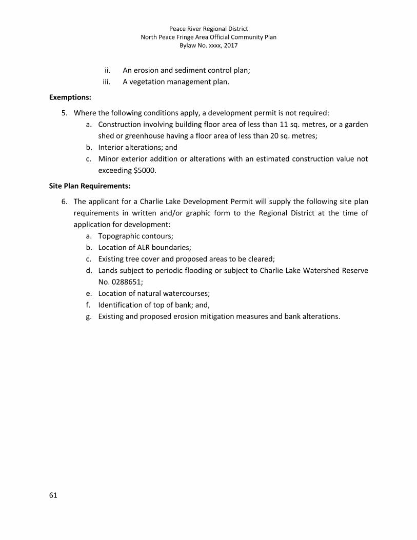
Peace River Regional District North Peace Fringe Area Official Community Plan
Bylaw No. xxxx, 2017
61
ii. An erosion and sediment control plan;
iii. A vegetation management plan.
Exemptions:
5. Where the following conditions apply, a development permit is not required:
a. Construction involving building floor area of less than 11 sq. metres, or a garden
shed or greenhouse having a floor area of less than 20 sq. metres;
b. Interior alterations; and
c. Minor exterior addition or alterations with an estimated construction value not
exceeding $5000.
Site Plan Requirements:
6. The applicant for a Charlie Lake Development Permit will supply the following site plan
requirements in written and/or graphic form to the Regional District at the time of
application for development:
a. Topographic contours;
b. Location of ALR boundaries;
c. Existing tree cover and proposed areas to be cleared;
d. Lands subject to periodic flooding or subject to Charlie Lake Watershed Reserve
No. 0288651;
e. Location of natural watercourses;
f. Identification of top of bank; and,
g. Existing and proposed erosion mitigation measures and bank alterations.

Peace River Regional District North Peace Fringe Area Official Community Plan
Bylaw No. xxxx, 2017
62
11.4.5 Agriculture Development Permit Area
Category:
1. The Agriculture Development Permit Area (DPA) is designated pursuant to Section 488(1)
(c) of the Local Government Act, for the ‘protection of farming’.
Area:
2. The Agriculture DPA applies to lands designated Settlement Centre (SC) or High Density
Rural Residential (HDR) having parcel sizes of less than 0.8 ha (2 acres) that adjoin lands
designated Agriculture (AG).
Justification:
3. Most lands in the Agriculture designation are within the ALR and are subject to the ALC
Act and the Farm Practices Protection Act, and thus this OCP aims at ensuring these lands
are utilized for long term food production. Buffering in accordance with the ALC’s
“Landscape Buffer Specifications”, March 1993, is recommended as a guide to help
protect agriculture and for planning buffers between agricultural and non-agricultural
uses.
Guidelines:
4. Within the Agriculture DPA, no person shall subdivide land or construct a building or
structure prior to the landowner applying for and receiving a development permit from
the Regional District, which shall sufficiently address the following:
a. Principal buildings should be located a minimum of 15 metres (50 feet) from the
boundary of the Agriculture designation. For lots having a site constraint, this
distance may be reduced to the greater of 9 metres (30 feet) or the minimum
setback required by zoning, provided that the principal building is located and
designed to reduce impact from the activities associated with a farm operation
(i.e. Avoiding or reducing the number of doors, windows and other outdoor patios
facing the agricultural land);
b. A continuous landscaped buffer should be provided between any development
and the agricultural land and will occur on the non-agriculture side of adjacent
parcels.
c. Dependent on the circumstance or conflicts expected to be avoided between the
agriculture and non-agriculture use at the edge, the chosen buffer should
illustrate how the visual, noise, or trespass impacts will be mitigated;
d. A majority of the plant material selected for the landscaped buffer should include
low maintenance, indigenous vegetation and should be able to survive with little

Peace River Regional District North Peace Fringe Area Official Community Plan
Bylaw No. xxxx, 2017
63
or no fertilizer. Guidelines contained in the Agricultural Land Commission’s report:
Landscaped Buffer Specifications, March 1993, should be considered;
e. For added effectiveness of the buffer, a low landscaped berm may be provided as
part of the buffer or a continuous fence along the edge of the agricultural area
may be installed and maintained. Guidelines contained in the Agriculture Land
Commission’s report; Landscaped Buffer Specifications, March 1993, should be
considered;
f. Any subdivision of land next to agricultural land should be designed to include the
landscaped buffer or fencing on the non-agricultural side; and
g. Any subdivision of land next to agricultural land should be designed to gradually
reduce densities and the intensity of uses as it nears the boundary of the
Agriculture designation.
Exemptions:
5. Where the following conditions apply, a development permit is not required:
a. Buildings and structures for principal uses located more than 15 metres (50 feet)
from the boundary of the Agriculture Designation;
b. Buildings and structures for accessory uses located more than 15 metres (50 feet)
from the boundary of the Agriculture Designation;
c. Interior alterations;
d. Minor exterior addition or alterations with an estimated construction value not
exceeding $5,000.
Site Plan Requirements:
6. An applicant for a development permit will supply the following site plan requirements in
written and/or graphic form to the Regional District at the time of application for
development:
a. Topographic contours;
b. Location of ALR boundaries;
c. Existing tree cover and proposed areas to be cleared;
d. Lands subject to periodic flooding;
e. Location of natural watercourses;
f. Landscape buffer plan with details describing buffer area, plant to be used, space,
and width of buffer

Peace River Regional District North Peace Fringe Area Official Community Plan
Bylaw No. xxxx, 2017
64
11.4.6 Old Fort Development Permit Area
Category:
1. The Old Fort Development Permit Area (DPA) is designated pursuant to Section 488(1) (b)
of the Local Government Act, for the “protection of development from hazardous
conditions”.
Area:
2. The Old Fort Development Permit Area applies to those parcels of land shown shaded on
Schedule C of this OCP.
Justification:
3. The Old Fort Development Permit covers an area of approximately one quarter section or
63 ha (155 acres), lying on a lower bench of the Peace River, sited on parcels described as
Parts of Sections 17, 18 and 19, Township 83, Range 18, W6M, and District Lot 418, PRD.,
located south of the City of Fort St. John. These properties have steep river banks or
unstable creek banks, which may be vulnerable to flooding, slope instability, erosion, or
landslides.
These identified parcels may also be subject to storm water drainage or lagoon wall failure
or other hazards. There has been a demonstrated need to ensure that all hazards to
persons and property are eliminated through the control of the location and nature of
the development.
Guidelines:
4. Within the Old Fort DPA, no person shall subdivide land, alter land, including the removal
of trees or vegetation and removal or deposit of soil, or construct a building or structure
prior to the landowner applying for and receiving a development permit from the
Regional District, which will sufficiently address the following:
a. For development of land parcels listed below in the Old Fort Development Permit
Area, minimum river bank setbacks and a site specific report certified by a
geotechnical engineer shall be required as set forth in the following table:
Land Parcel Minimum Setback Other Requirements
Blk 2, Plan 14194
Lot 1,2,3,4,5
To be determined based
on consideration of
recommendations of a
geotechnical engineer
Building location subject to
the site specific study by a
geotechnical engineer prior
to construction
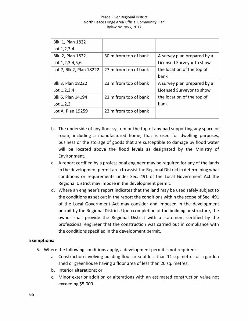
Peace River Regional District North Peace Fringe Area Official Community Plan
Bylaw No. xxxx, 2017
65
Blk. 1, Plan 1822
Lot 1,2,3,4
Blk. 2, Plan 1822
Lot 1,2,3,4,5,6
30 m from top of bank A survey plan prepared by a
Licensed Surveyor to show
the location of the top of
bank
Lot 7, Blk 2, Plan 18222 27 m from top of bank
Blk 3, Plan 18222
Lot 1,2,3,4
23 m from top of bank A survey plan prepared by a
Licensed Surveyor to show
the location of the top of
bank
Blk 6, Plan 14194
Lot 1,2,3
23 m from top of bank
Lot A, Plan 19259 23 m from top of bank
b. The underside of any floor system or the top of any pad supporting any space or
room, including a manufactured home, that is used for dwelling purposes,
business or the storage of goods that are susceptible to damage by flood water
will be located above the flood levels as designated by the Ministry of
Environment.
c. A report certified by a professional engineer may be required for any of the lands
in the development permit area to assist the Regional District in determining what
conditions or requirements under Sec. 491 of the Local Government Act the
Regional District may impose in the development permit.
d. Where an engineer’s report indicates that the land may be used safely subject to
the conditions as set out in the report the conditions within the scope of Sec. 491
of the Local Government Act may consider and imposed in the development
permit by the Regional District. Upon completion of the building or structure, the
owner shall provide the Regional District with a statement certified by the
professional engineer that the construction was carried out in compliance with
the conditions specified in the development permit.
Exemptions:
5. Where the following conditions apply, a development permit is not required:
a. Construction involving building floor area of less than 11 sq. metres or a garden
shed or greenhouse having a floor area of less than 20 sq. metres;
b. Interior alterations; or
c. Minor exterior addition or alterations with an estimated construction value not
exceeding $5,000.
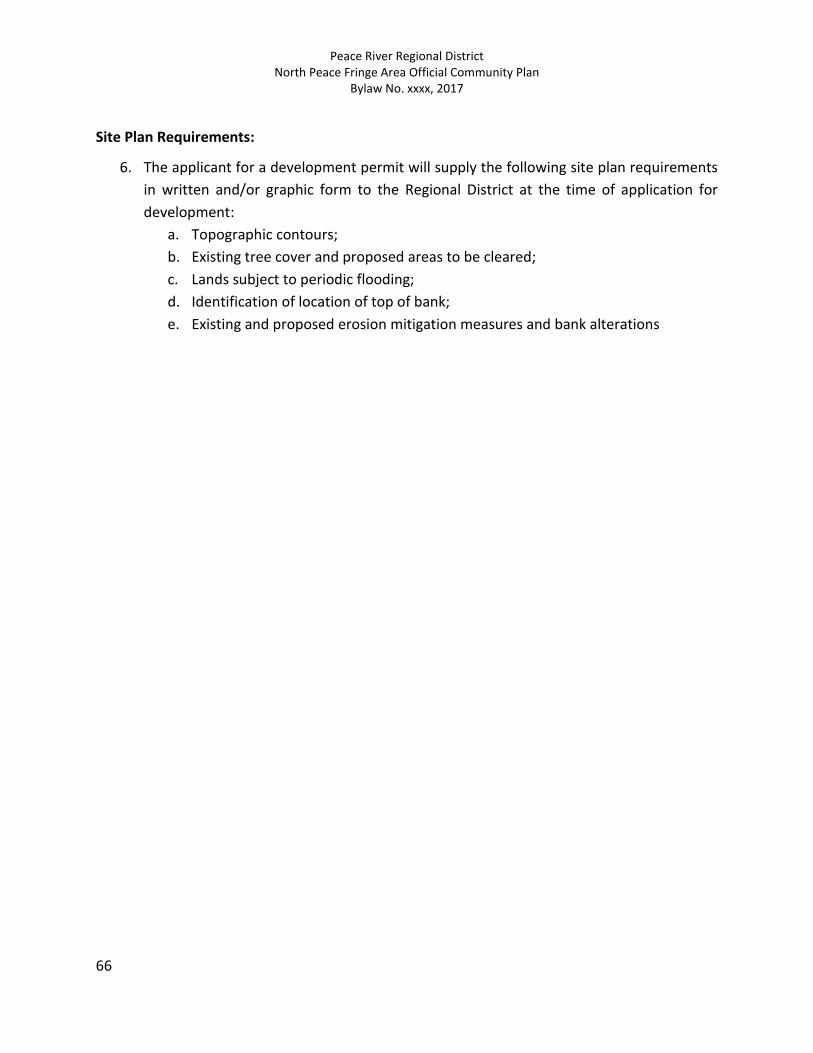
Peace River Regional District North Peace Fringe Area Official Community Plan
Bylaw No. xxxx, 2017
66
Site Plan Requirements:
6. The applicant for a development permit will supply the following site plan requirements
in written and/or graphic form to the Regional District at the time of application for
development:
a. Topographic contours;
b. Existing tree cover and proposed areas to be cleared;
c. Lands subject to periodic flooding;
d. Identification of location of top of bank;
e. Existing and proposed erosion mitigation measures and bank alterations