draft resettlement plan
TRANSCRIPT

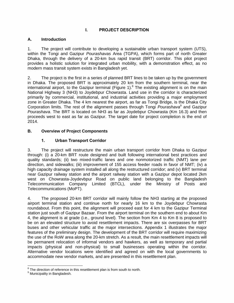
Draft Resettlement Plan February 2012
BAN: Greater Dhaka Sustainable Urban Transport Project Prepared by the Roads Division under the Ministry of Communications, Government of Bangladesh, for the Asian Development Bank.
CURRENCY EQUIVALENTS (as of 29 February 2012)
Currency unit – Taka (Tk)
Tk.1.00 = $0.01223 $1.00 = Tk. 81.750
ABBREVIATIONS
ADB – Asian Development Bank
ADC – assistant deputy commissioner
ARIPO – Acquisition and Requisition of Immovable Property Ordinance
BARI – Bangladesh Agricultural Research Institute
BBA – Bangladesh Bridge Authority
BPL – below poverty line
BRRI – Bangladesh Rice Research Institute
BRT – bus rapid transit
BTCL – Bangladesh Telecommunication Company Limited
CCL – cash compensation under law
CNG – compressed natural gas
DCC – Dhaka City Corporation
DOE – Department of Environment
DYD – Department of Youth Development
EDP – economically displaced person
EMP – environmental management plan EPCM – engineering, procurement, and construction management
ESO – environment safeguard officer
FGD – focus group discussion
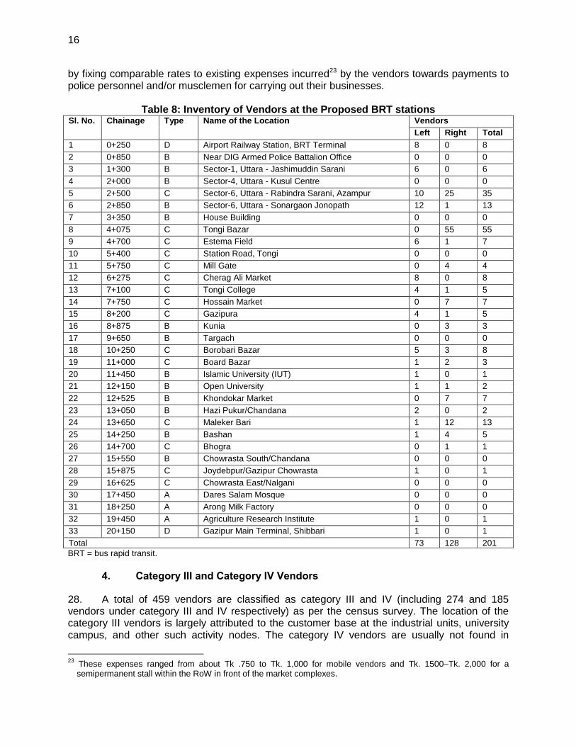
FOB – foot over bridge
GRC – grievance redress committee
GRM – grievance redress mechanism
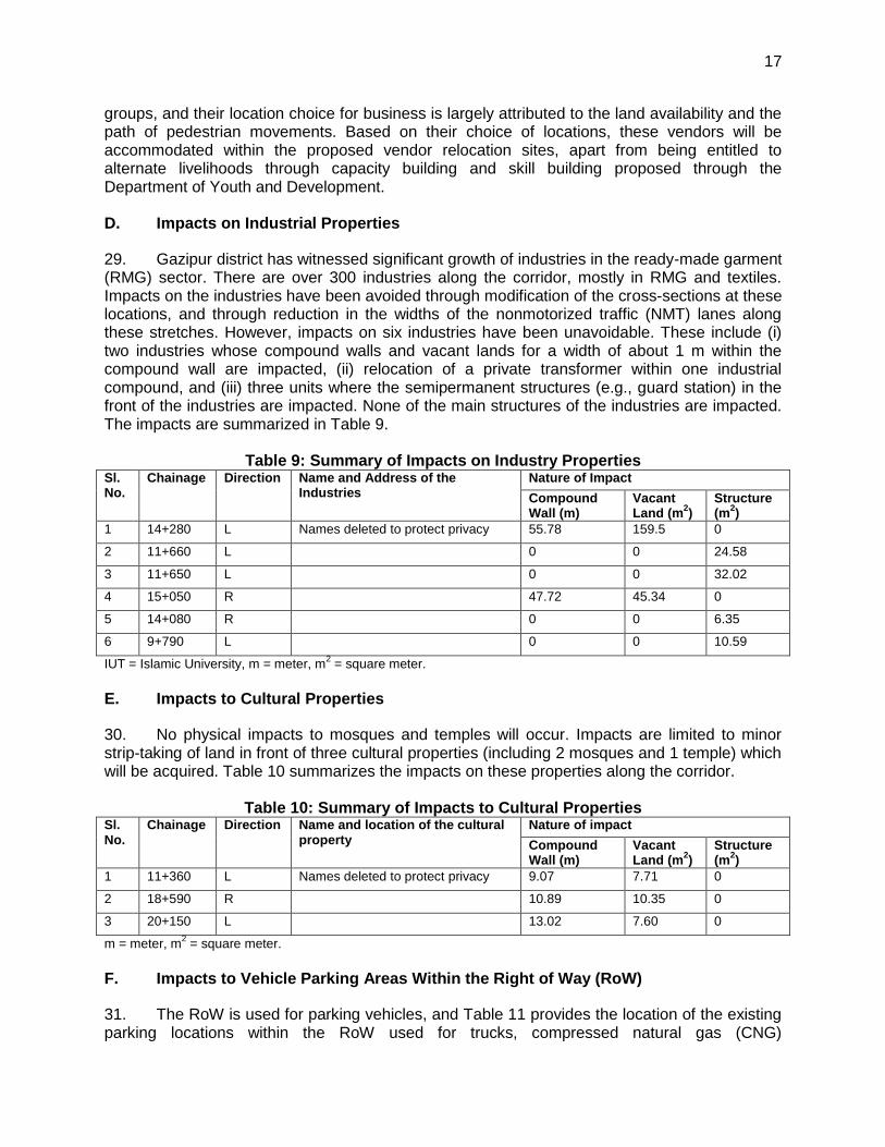
IGS – income-generating schemes
IOL – inventory of losses
LGED – Local Government and Engineering Department
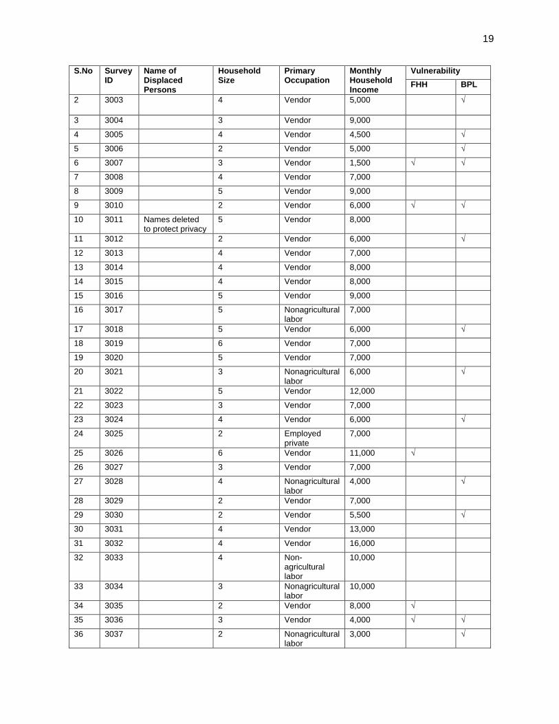
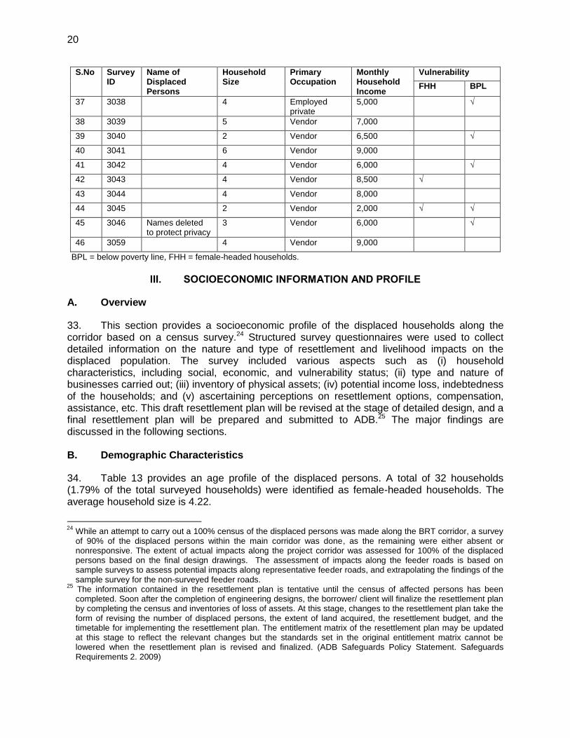
M & E – management and evaluation
MIS – management information system
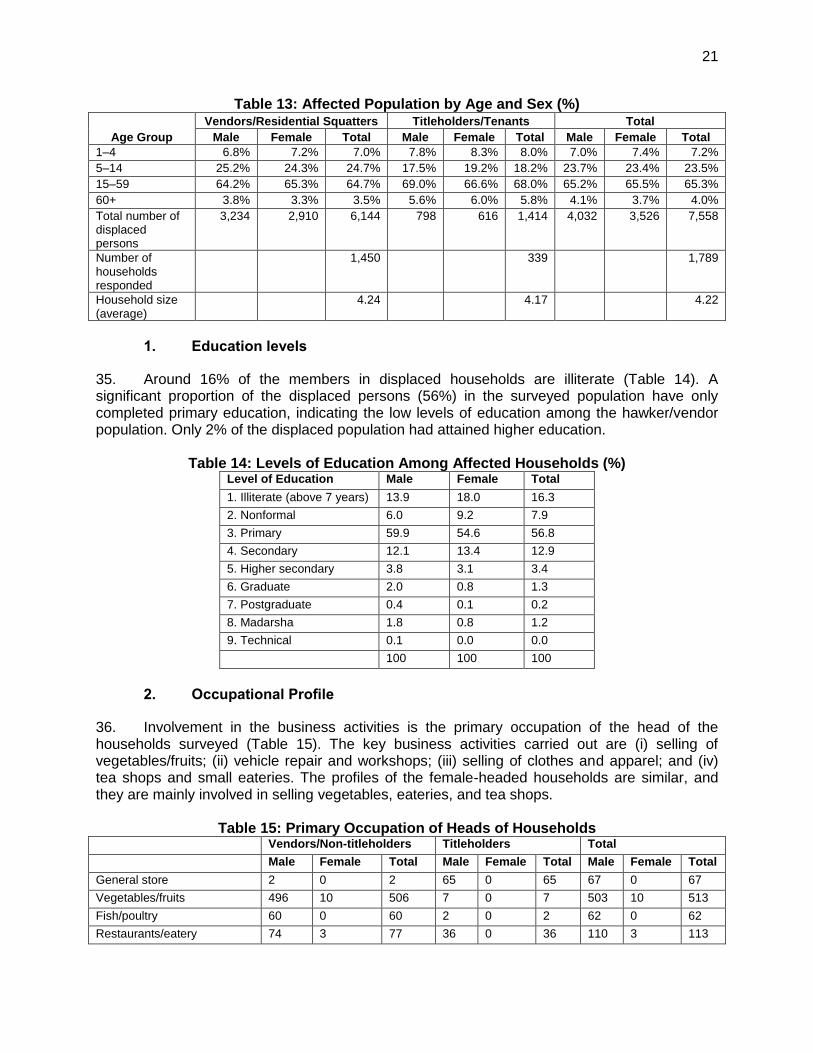
MOL – Ministry of Land
MOPT – Ministry of Posts and Telecommunications
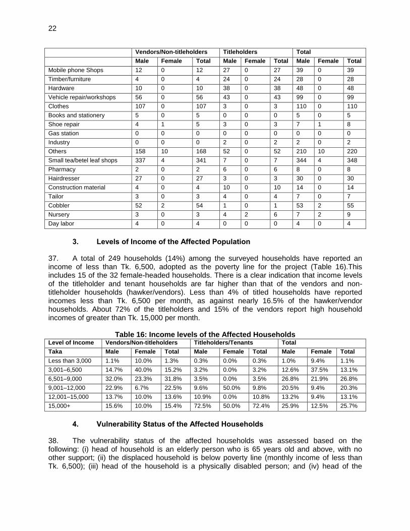
MoU – memorandum of onderstanding
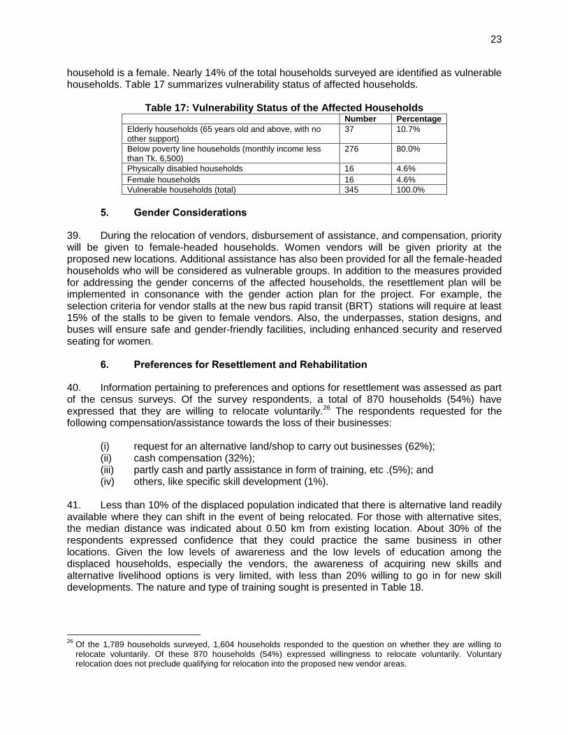
MPR – monthly progress report
NGORP – nongovernment organization for RP Implementation
NMT – nonmotorized traffic
PIU – project implementation unit
PPR – project progress report
PPTA – project preparatory technical assistance
PWD – Public Works Department
RCC – reinforced cement concrete
RHD – Roads and Highways Department
RMG – ready-made garments
RoW – right of way
SPS – Safeguard Policy Statement
SSO – social safeguard officer
UNO – Upazila Nirbahi officer
WEIGHTS AND MEASURES
ha. - hectare km - kilometer km2 - square kilometer m - meter m2 - square meter
NOTE
In this report, "$" refers to US dollars.
This resettlement plan is a document of the borrower. The views expressed herein do not necessarily represent those of ADB's Board of Directors, Management, or staff, and may be preliminary in nature. In preparing any country program or strategy, financing any project, or by making any designation of or reference to a particular territory or geographic area in this document, ADB does not intend to make any judgments as to the legal or other status of any territory or area.
TABLE OF CONTENTS
EXECUTIVE SUMMARY
Page
I. PROJECT DESCRIPTION 1
A. Introduction 11 B. Overview of Project Components 11
II. SCOPE OF LAND ACQUISITION AND RESETTLEMENT 55
A. Overview 55 B. Summary of Land Acquisition and Resettlement 66 C. Impacts to Vendors 1313 D. Impacts to Industrial Properties 1717 E. Impacts to Cultural Properties 1717 F. Impacts to Vehicle Parking Areas within the right of way (ROW) 1717 G. Impacts to Non-Titled Residential Settlers at Tongi Bridge 1818
III. SOCIOECONOMIC INFORMATION AND PROFILE 2020
A. Overview 2020 B. Demographic Characteristics 2020
IV. INFORMATION DISCLOSURE, CONSULTATION, AND PARTICIPATION 2424
A. Public Consultation 2424 B. Information Disclosure 3333 C. Continued Consultation and Participation 3333
V. GRIEVANCE REDRESS MECHANISMS 3535
VI. LEGAL FRAMEWORK 3838
VII. ENTITLEMENTS, ASSISTANCE AND BENEFITS 3838
A. Eligibility 3838 B. Entitlements 3939 C. Benefits 3939 D. Determination of Compensation 48
VIII. RELOCATION OF HOUSING AND SETTLEMENTS 4949
A. Vendor Relocation at Bus Rapid Transit (BRT) Stations 4949 B. Vendor Markets Relocation 51 C. Non-Titled Residential Relocation 51
IX. INCOME RESTORATION AND REHABILITATION 5656
A. Income and Livelihood Restoration Measures 5656
X. RESETTLEMENT BUDGET AND FINANCING PLAN 5858
XI. INSTITUTIONAL ARRANGEMENTS 6262
A. Institutional Arrangements 6262 B. Consultant Support for Resettlement 6363
XII. IMPLEMENTATION SCHEDULE 6464
XIII. MONITORING AND REPORTING 6666
A. Monitoring 6666 B. Verification of Monitoring Information by External Experts
6766 C. Reporting 68
APPENDIXES 1. Illustration of Project Components 69 2. Comparison of Government of Bangladesh and Asian Development Policies 74 3. Stretches Requiring Land Acquisition 77 4. Summary of Consultations at Vendor Markets 82 5. Census Survey Guidelines 83 6. Sample Identity Card (ID) for Entitled Persons 88 7. Official Land Rates – Land Registry Officers 91 8. List of Programs Carried Out by Department of Youth and Development 92 9. Nongovernment Organization for Resettlement Plan Implementation 93 10. Estimated Costs for Civil Works Associated with Impacts to Structures and
Reprovisioning works 96
EXECUTIVE SUMMARY 1. The Greater Dhaka Sustainable Urban Transport Project (the project) will contribute to developing a sustainable urban transport system (UTS) within the Tongi and Gazipur Pourashavas Area (TGPA), which forms part of north Greater Dhaka, through the delivery of a 20-km bus rapid transit (BRT) corridor. This pilot project provides a holistic solution for integrated urban mobility, with a demonstration effect, as no modern mass transit system exists in Bangladesh yet. 2. This draft resettlement plan (RP) focuses on the key activities of the project, which would cause involuntary resettlement impacts as defined by the Asian Development Bank’s (ADB) Safeguards Policy Statement (SPS, 2009).1 It is based on a 90% detailed census survey of the potentially displaced persons2 and will be updated during the detailed design stage. The draft resettlement plan is prepared in accordance with the Government of Bangladesh’s (the government) Acquisition and Requisition of Immovable Property Ordinance, 1982 (ARIPO, 1982), and ADB’s SPS.3 3. Project description. The project will restructure the main urban transport corridor from Dhaka's international airport to Gazipur through: (i) a 20-km BRT route designed and built following international best practices and quality standards; (ii) two mixed-traffic lanes and one non-motorized traffic (NMT) lane per direction, and sidewalks; (iii) improvement of 155 access feeder roads in favor of NMT; (iv) a efficient high capacity drainage system installed all along the restructured corridor; and (v) a BRT terminal and depot in Gazipur. 4. The project will also improve the urban quality of the corridor through (i) procuring and installing 1000 energy-efficient street lighting along the corridor; (ii) improving municipal infrastructures, including 10 local markets, 9 drains and 141 local roads; (iii) procuring and installing equipment for the Traffic Police to improve traffic management, including 70 BRT-priority traffic lights, 150 closed-circuit television (CCTV) cameras at main junctions, and mobile vehicle emission testing devices. 5. The project will also undertake institutional developments to efficiently manage BRT operations with the private sector and ensure efficient operations. 6. Categorization. The project will have significant involuntary resettlement impacts and is classified as category A in accordance with ADB's SPS, as more than 200 persons will experience major impacts, defined as (i) being physically displaced from housing, and (ii) losing 10% or more of their productive assets (income-generating). 7. According to this criteria, an estimated total of 182 households (768 displaced persons or DPs)4 are expected to experience major impacts as follows: (i) 136 commercial
1 According to the SPS, involuntary resettlement safeguards covers physical displacement (relocation, loss of
residential land, or loss of shelter) and economic displacement (loss of land, assets, access to assets, income sources, or means of livelihoods) as a result of (i) involuntary acquisition of land, or (ii) involuntary restrictions on land use or on access to legally designated parks and protected areas. It covers them whether such losses and involuntary restrictions are full or partial, permanent or temporary.
2 A 100% census survey was attempted of all displaced persons; however, some persons were not available during
survey periods. 3 The safeguard requirements apply to all ADB-financed and/or ADB-administered sovereign and non-sovereign
projects and their components, regardless of the source of financing. 4 The estimated numbers of DPs is based on the average household size of 4.22 derived from the census survey.
establishments (574 DPs) will lose more than 10% of their shops;5 and (ii) 46 nontitled residential households (194 DPs) will be physically displaced from their homes. An additional 1,704 non-licensed vendors (i.e., hawkers) will be permanently relocated to alternate locations within the public right-of-way (RoW). 8. Summary of resettlement impacts. Impacts were avoided and/or mitigated to the extent possible during the preliminary design process. An estimated total of 2,482 households (10,474DPs) will be impacted due to the proposed project. These impacts consist primarily of permanent relocation of nonlicensed vendors within the RoW. Only a small portion (2%) of the overall permanent impacts will include physical relocation from housing (i.e., 46 nontitled residential households). The resettlement impacts include the following: (i) relocation of 1,704hawkers conducting businesses within the proposed RoW along the corridor;6 (ii) relocation of 46 nontitled informal residential settlers and their structures along the northern banks of the Turag River; (iii) partial impacts to 498 commercial establishments operating along the corridor, of which 436 will experience partial loss of structures (see footnote 7), and 62 establishments will experience loss of land area used for storage space within the ROW; (iv) partial loss to 225 commercial structures situated on feeder roads near junctions; (v) partial impacts on six industrial establishments along the corridor including (a) two industries whose compound walls and vacant lands for a width of about 1 m within the compound wall are impacted, (b) relocation of a transformer unit within one industrial compound, (c) three units where the semi-permanent structures (i.e., security sheds) in the front of the industries are impacted (note: in none of these six structures is the main building of the industry impacted); and (vi) taking of strips of private land in front of three cultural establishments (including 2 mosques and 1 temple) (note: no physical impacts to the mosque and temple structures will occur). In addition, temporary disruption to income will occur to 966 workers during preconstruction activities. The 0.85 ha of private land acquisition includes strip-taking of land at commercial and industrial properties where the RoW is widened. All landowners are known and identified. The two terminals are proposed on lands belonging to government agencies. The terminal at the airport railway station is proposed on 0.4 ha of lands belonging to the Bangladesh Railways under the Ministry of Communication; the terminal at Gazipur is proposed in front of the Gazipur railway station and will remain within the public ROW; the depot is proposed on 2.0 ha of public land belonging to the Bangladesh Telecommunication Company Limited (BTCL), under the Ministry of Posts and Telecommunications (MoPT).7 . Other government land acquisition includes 0.95 ha of strip-taking of about 2 m on vacant lands within institutional campuses and markets along the corridor. All resettlement impacts are summarized in Table 3 and Appendix 3. 9. Entitlements. The entitlement matrix (Table 21) outlines the types of measures (e.g., compensation at replacement value, assistance, etc.) required to mitigate the resettlement impacts in line with the government and ADB policies. The method for determining unit rates and replacement values for land and assets are also detailed in the resettlement plan. Where land compensation will be through a direct negotiated settlement, the government will engage
5 Of the 498 commercial establishments partially impacted along the corridor, 136 will physically lose more than 10%
of the shops. 6 For this project, a hawker is defined as a person who offers goods or services for sale to the public within a
temporary static structure or mobile stall (or head load) and no permanent built-up structure. Hawkers may be stationary by occupying space on the pavements or other public areas, primarily the RoW owned by RHD. They may be mobile in the sense that they move from place to place carrying their wares on pushcarts or in cycles or baskets, etc.
7 The BTCL land is mostly vacant, open land with grazing and limited farming uses. There are 4 staff households
living on the BTCL who are employees. It was indicated that these staff households would be shifted by BTCL to a nearby location.
an independent external party to document the negotiation and settlement processes to ensure adequate and fair pricing of land and/or other assets. Provisions exist for relocation of vendors through development of alternative vendor markets and provision of commercial spaces in the underpasses at the BRT stations, and development of resettlement sites for the nontitled residential settlers displaced under the project. Compensation eligibility is limited by a cutoff date census survey for nontitled holders and official government notification for titled holders. Identity cards will be distributed to entitled households. Displaced persons who settle in the affected areas after the cutoff date will not be eligible for compensation, but will be given sufficient advance notice (60 days), and requested to vacate premises and dismantle affected structures prior to project implementation. Therefore, all displaced persons who are identified in the project-impacted areas on the cutoff date will be entitled to compensation for their affected assets and income rehabilitation measures (as outlined in the entitlement matrix). The total cost for land acquisition and resettlement for the project is $8.0 million. The government will provide all funds for resettlement in a timely manner. All compensation is to be paid prior to displacement, and ongoing income and livelihood rehabilitation activities will continue after construction begins. 10. Consultations. An extensive consultation program with primary and secondary stakeholders was conducted, including those being directly affected by the project. A total of 25 consultation sessions were undertaken as part of the PPTA, in addition to the project level workshops. These consultations shared project information and identified felt needs of affected communities. A consultation plan to ensure continued consultation and participation with the stakeholders during the RP implementation is included in the RP. The PIUs will arrange consultations with assistance from the nongovernment organization implementing the resettlement plan (NGORP) and the resettlement specialists included as part of the engineering, procurement, construction management and supervision of the construction (EPCM). 11. Information disclosure. The summary resettlement plan was translated and will be disclosed publicly in accessible locations throughout the project corridor shortly after government endorsement of the plan. A resettlement information leaflet will be made available in local language (Bangla), and will be distributed to displaced persons. The project management unit (PMU) and project implementation units (PIUs) will keep the displaced persons informed about the impacts, compensation, and mechanism to receive and resolve grievances. The full resettlement plan will also be made available at the offices of Gazipur and Tongi pourashavas, offices of the union parishads, and at other key accessible locations (such as market places, offices, and libraries) convenient to the displaced persons. A copy of the resettlement plan will be disclosed on the ADB website and project website once established. 12. Grievance redress mechanism. A three-tier project grievance redress mechanism (GRM) will be established within 12 months of loan effectiveness to receive, evaluate, and resolve concerns of affected persons, including the social and environmental performance of the project. The first tier of the GRM is the PIU ,which offers the fastest and most accessible mechanism for resolution of grievances; the second tier of the GRM is the grievance redress committee (GRC), which will consist of local officials and representatives of affected persons. The third tier of the GRM is the union parishad, ward committees, or the appropriate court of law. The GRM will address all grievances in a timebound and transparent manner. 13. Implementation arrangements. The executing agency for the project is the Roads Division (RD) within the Ministry of Communication. A project management unit (PMU) will be established at RD, and will be headed by a full-time project director. An environmental and social safeguard unit (ESSU) will be established in the PMU. The ESSU will consist of an
environmental safeguards officer and a social safeguards officer (SSO) to oversee safeguards implementation. The SSO will submit an updated resettlement plan and semiannual monitoring reports to ADB for review. There will be three Implementing agencies:
(i) Roads and Highway Department (RHD) – will implement the main corridor restructuring, except the elevated section.
(ii) Bangladesh Bridges Authority (BBA) – will implement the 4.5-km elevated section, integrating the new Tongi Bridge and the Abdullahpur intersection flyover.
(iii) Local Government Engineering Department (LGED) – will implement BRT depot and terminal facilities in Gazipur, and municipal infrastructures improvements (local roads, drains, and local markets)..
14. A project implementation unit (PIU) will be established in each of these IAs which will be headed by a full-time project manager. Each of the three PIUs will contain a deputed staff to serve as the resettlement officer to oversee implementation of resettlement planning for their respective works. PIUs will receive support from the engineering, procurement, construction management and supervision of the construction (EPCM) consultants, and will be assisted by a nongovernment organization to implement the resettlement plan (NGORP). Safeguard specialists for environment and resettlement will be part of the EPCM, including an international resettlement specialist (IRS) and a national resettlement specialist (NRS) to update the draft resettlement plan during detailed design. These specialists will also conduct safeguards capacity building activities within the PMU ESSU and PIUs. The NGORP will conduct detailed census survey and oversee resettlement plan implementation, working closely with each PIU. 15. Resettlement plan implementation budget. The total resettlement cost for the project is $8.0 million. The resettlement cost estimates for the project include eligible compensation and resettlement assistance as outlined in the entitlement matrix, and support costs for resettlement plan implementation. The government counterpart financing will provide funds to support resettlement plan implementation in a timely manner. 16. Verification of monitoring information by external experts. An external resettlement monitoring expert will be engaged by the PMU to undertake resettlement monitoring and evaluation during resettlement plan implementation. The key responsibilities of the external expert will include the following: (i) verifying resettlement monitoring information for the project; (ii) monitoring the resettlement safeguard compliance issues in resettlement plan implementation; and (iii) assessing the overall implementation approach, process, and outcome of the resettlement plan, and providing inputs to the PMU for taking corrective actions to resolve any issues.
I. PROJECT DESCRIPTION
A. Introduction
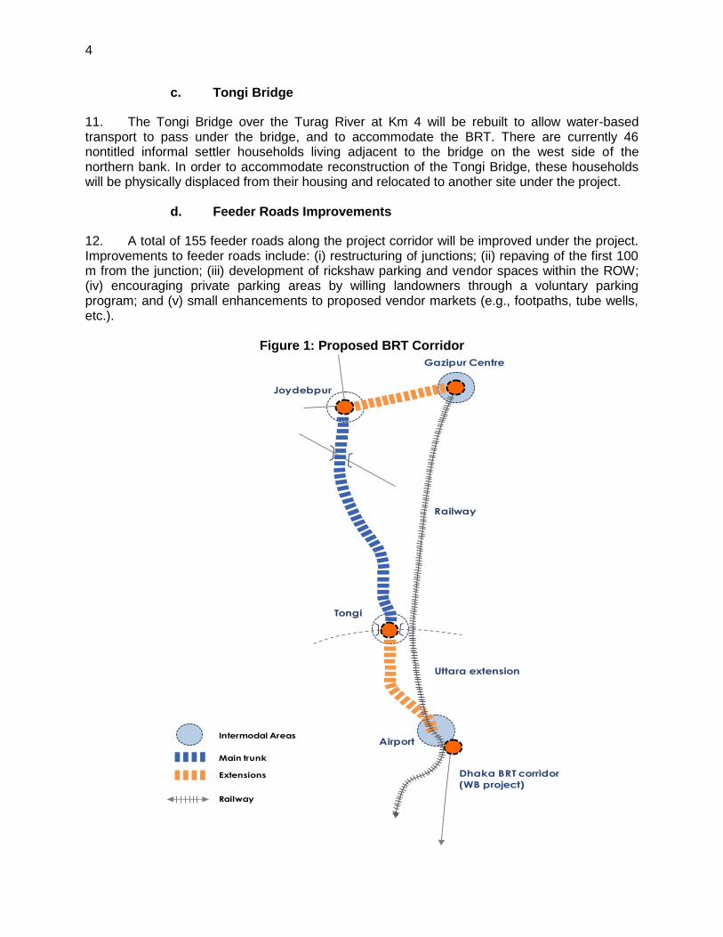
1. The project will contribute to developing a sustainable urban transport system (UTS), within the Tongi and Gazipur Pourashavas Area (TGPA), which forms part of north Greater Dhaka, through the delivery of a 20-km bus rapid transit (BRT) corridor. This pilot project provides a holistic solution for integrated urban mobility, with a demonstration effect, as no modern mass transit system exists in Bangladesh yet. 2. The project is the first in a series of planned BRT lines to be taken up by the government in Dhaka. The proposed BRT is approximately 20 km from the southern terminal, near the international airport, to the Gazipur terminal (Figure 1).8 The existing alignment is on the main National Highway 3 (NH3) to Joydebpur Chowrasta. Land use in the corridor is characterized primarily by commercial, institutional, and industrial activities providing a major employment zone in Greater Dhaka. The 4 km nearest the airport, as far as Tongi Bridge, is the Dhaka City Corporation limits. The rest of the alignment passes through Tongi Pourashava9 and Gazipur Pourashava. The BRT is located on NH3 as far as Joydebpur Chowrasta (Km 16.3) and then proceeds west to east as far as Gazipur. The target date for project completion is the end of 2014. B. Overview of Project Components
1. Urban Transport Corridor
3. The project will restructure the main urban transport corridor from Dhaka to Gazipur through: (i) a 20-km BRT route designed and built following international best practices and quality standards; (ii) two mixed-traffic lanes and one nonmotorized traffic (NMT) lane per direction, and sidewalks; (iii) improvement of 155 access feeder roads in favor of NMT; (iv) a high capacity drainage system installed all along the restructured corridor; and (v) BRT terminal near Gazipur railway station and the airport railway station with a Gazipur depot located 2km west on Chowrasta-Joydevbpur Road on public land belonging to the Bangladesh Telecommunication Company Limited (BTCL), under the Ministry of Posts and Telecommunications (MoPT). 4. The proposed 20-km BRT corridor will mainly follow the NH3 starting at the proposed airport terminal station and continue north for nearly 16 km to the Joydebpur Chowrasta roundabout. From this point, the alignment will proceed east for 4 km to the Gazipur Terminal station just south of Gazipur Bazaar. From the airport terminal on the southern end to about Km 4, the alignment is at grade (i.e., ground level). The section from Km 4 to Km 8 is proposed to be on an elevated structure to avoid resettlement impacts. There are six overpasses for BRT buses and other vehicular traffic at the major intersections. Appendix 1 illustrates the major features of the preliminary design. The development of the BRT corridor will require maximizing the use of the RoW area along the 20-km stretch. As a result, the main resettlement impacts will be permanent relocation of informal vendors and hawkers, as well as temporary and partial impacts (physical and non-physical) to small businesses operating within the corridor. Alternative vendor locations were identified and agreed on with the local governments to accommodate new vendor markets, and are presented in this resettlement plan.
8 The direction of reference in this resettlement plan is from south to north.
9 Municipality in Bangladesh.
2
5. A summary of the main physical works under the urban transport corridor component are as follows:
a. Bus Rapid Transit (BRT) Terminals
6. Two terminals are proposed along the corridor, one located in the southern terminus across from the airport entrance, and the other at the northern terminus in Gazipur just south of Gazipur Bazaar. The land for both terminals is government-owned and contains few encumbrances. A description of both sites is as follows: 7. Airport terminal. The southern terminal is proposed on 0.4 ha of land owned by the Bangladesh Railway under the Ministry of Communication. The land is currently used as a parking lot for the railway station. This location is strategically important and a natural site for a multimodal hub, given its proximity to a railway, international and domestic airport, expressway, and a separate BRT corridor to Sadarghat.10 The terminal would be a multilevel transit facility to be accommodated within the available land area. Railway and conventional bus routes would be located at ground level, BRT services from Gazipur to the airport on first floor, and a BRT from Sadarghat on the second floor. Parking for the railway station would be accommodated. 8. Gazipur terminal. The northern terminal is proposed in front of the Gazipur railway station within the public ROW. This location provides good accessibility for buses and provides connections with other transit systems, including the Gazipur Railway Station. A separate Gazipur depot will be located 2km west on Chowrasta-Joydevbpur Road on public land belonging to the Bangladesh Telecommunication Company Limited (BTCL), under the Ministry of Posts and Telecommunications (MoPT).
b. BRT Stations
9. There are 31 stations planned within the corridor, each within the RoW. Of these, 28 stations are located between the airport and Joydebpur Chowrasta, and three stations located between Joydebpur Chowrasta and the Gazipur Terminal. The stations are designed to avoid or minimize resettlement impacts through either (i) a staggered physical arrangement within the median which also enables overtaking of buses at the BRT stations, or (ii) elevated sections above the roadway (between Tongi Bazaar and Dewra) (Appendix 1). Table 1 summarizes the locations of the proposed BRT stations and type of pedestrian access. Based on the demand and land availability, three types of BRT station footprints are proposed: (i) Type A: 3 m x 25 m; (ii) Type B: 3 m x 60 m; and (iii) Type C: 3 m x 100 m. 10. Pedestrian access to the 28 stations located between the airport and Joydebpur Chowrasta will be through tunneled underpasses connecting the sidewalks to the stations. There will be at-grade access to the three stations between Joydebpur Chowrasta and Gazipur Bazaar. For the terminal stations at the airport and Gazipur, there will be selection of at-grade access and overhead footbridges.
10
The World Bank is financing a similar BRT corridor from the southern terminus of the project corridor at Uttara into the Dhaka city center. The feasibility study commenced in early 2011.

3
Table 1: Locations of Proposed BRT Stations
Sl. No. Chainage Type Location Type of Access
1 0+775 B Near DIG Armed Police Battalion Office Underpass
2 1+300 B Sector-1, Uttara - Jashimuddin Sarani Underpass
3 2+000 B Sector-4, Uttara - Kusul Centre Underpass
4 2+500 C Sector-6, Uttara, Rabindra Sarani, Azampur Underpass
5 2+850 B Sector-6, Uttara, Sonargaon Jonopath Underpass
6 3+350 B House Building Underpass + elevator
7 4+075 C Tongi Bazar Underpass + elevator
8 4+700 C Estema Field Underpass + elevator
9 5+400 C Station Road, Tongi Underpass + elevator
10 5+750 C Mill Gate Underpass + elevator
11 6+275 C Cherag Ali Market Underpass + elevator
12 7+100 C Tongi College Underpass + elevator
13 7+750 C Hossain Market Underpass + elevator
14 8+200 C Gazipura Underpass
15 8+875 B Kunia Underpass
16 9+650 B Targach Underpass
17 10+250 C Borobari Bazar Underpass
18 11+000 C Board Bazar Underpass
19 11+450 B Islamic University (IUT) Underpass
20 12+150 B Open University Underpass
21 12+525 B Khondokar Market Underpass
22 13+050 B Hazi Pukur/ Chandana Underpass
23 13+650 C Maleker Bari Underpass
24 14+250 B Bashan Underpass
25 14+700 C Bhogra Underpass
26 15+550 B Chowrasta South/Chandana Underpass
27 15+875 C Joydebpur/Gazipur Chowrasta Underpass
28 16+625 C Chowrasta East/Nalgani Underpass
29 17+450 A Dares Salam Mosque At grade
30 18+250 A Arong Milk Factory At grade
31 19+450 A Agriculture Research Institute At grade
4
c. Tongi Bridge
11. The Tongi Bridge over the Turag River at Km 4 will be rebuilt to allow water-based transport to pass under the bridge, and to accommodate the BRT. There are currently 46 nontitled informal settler households living adjacent to the bridge on the west side of the northern bank. In order to accommodate reconstruction of the Tongi Bridge, these households will be physically displaced from their housing and relocated to another site under the project.
d. Feeder Roads Improvements
12. A total of 155 feeder roads along the project corridor will be improved under the project. Improvements to feeder roads include: (i) restructuring of junctions; (ii) repaving of the first 100 m from the junction; (iii) development of rickshaw parking and vendor spaces within the ROW; (iv) encouraging private parking areas by willing landowners through a voluntary parking program; and (v) small enhancements to proposed vendor markets (e.g., footpaths, tube wells, etc.).
Figure 1: Proposed BRT Corridor
Gazipur Centre
Joydebpur
Tongi
Airport
Railway
Uttara extension
Dhaka BRT corridor
(WB project)
Intermodal Areas
Main trunk
Extensions
Railway
5
2. Urban Quality Improvements
13. The project will improve the urban quality of the corridor through (i) the revision and enforcement of vehicle emission standards; (ii) the procurement of emission testing equipment for traffic police; (iii) the procurement and installation of 1,000 energy-efficient street lights along the corridor; (iv) small improvements at local markets; and (v) traffic management measures, including (a) a capacity-building program for traffic police; (b) procurement and installation of 70 BRT priority traffic lights and 150 closed-circuit television (CCTV) cameras at main junctions; (c) a hawker and vendor policy at BRT stations; and (d) awareness campaign for traffic and pedestrian safety and behavior. The project will also undertake institutional developments to efficiently manage BRT operations in collaboration with the private sector to ensure efficient operations.
II. SCOPE OF LAND ACQUISITION AND RESETTLEMENT
A. Overview
14. This draft resettlement plan focuses on the key physical activities which would cause involuntary resettlement, as defined by ADB’s Safeguards Policy Statement (SPS). An integral part of the design process was avoiding and minimizing land acquisition and resettlement impacts. This was particularly relevant in drafting and finalizing BRT cross-sections, station designs, and terminal locations. For the BRT corridor, impacts were minimized in two ways, namely: (i) through modifications to cross-sections within the RoW, and (ii) through modifications to geometrics of the alignment to avoid and minimize impacts to private buildings and large complexes. By adopting these two approaches, the need for private land acquisition and impacts on private land and structures were significantly minimized. The available RoW along the corridor is presented in Table 2.
Table 2: RoW Information Along the Project Corridor Chainage
Existing RoW
From To Width (m)
0+000 0+500 45
0+500 0+900 42
0+900 1+100 43
1+100 1+800 60
1+800 2+400 54
2+400 2+600 55
2+600 3+000 58
3+000 4+000 33-39
4+000 16+300 36
16+300 20+200 25
Source: Roads and Highways Department
m = meter, RoW = right of way.
15. Cross-sections. The cross-sections were designed to minimize land acquisition. In a narrow strip of the corridor, namely Km 3.6 at Ashulia Road to Km 7.8 down ramp, an elevated road section is proposed to avoid large-scale resettlement, land acquisition, and impacts to commercial structures. At the BRT stations, land acquisition was minimized through design of the stations in a physically staggered fashion, which also enables provision of an additional lane for overtaking BRT buses.
6
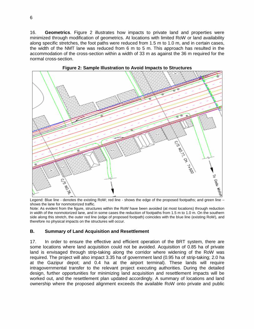
16. Geometrics. Figure 2 illustrates how impacts to private land and properties were minimized through modification of geometrics. At locations with limited RoW or land availability along specific stretches, the foot paths were reduced from 1.5 m to 1.0 m, and in certain cases, the width of the NMT lane was reduced from 6 m to 5 m. This approach has resulted in the accommodation of the cross-section within a width of 33 m as against the 36 m required for the normal cross-section.
Figure 2: Sample Illustration to Avoid Impacts to Structures
Legend: Blue line - denotes the existing RoW; red line - shows the edge of the proposed footpaths; and green line – shows the lane for nonmotorized traffic. Note: As evident from the figure, structures within the RoW have been avoided (at most locations) through reduction in width of the nonmotorized lane, and in some cases the reduction of footpaths from 1.5 m to 1.0 m. On the southern side along this stretch, the outer red line (edge of proposed footpath) coincides with the blue line (existing RoW), and therefore no physical impacts on the structures will occur.
B. Summary of Land Acquisition and Resettlement
17. In order to ensure the effective and efficient operation of the BRT system, there are some locations where land acquisition could not be avoided. Acquisition of 0.85 ha of private land is envisaged through strip-taking along the corridor where widening of the RoW was required. The project will also impact 3.35 ha of government land (0.95 ha of strip-taking; 2.0 ha at the Gazipur depot; and 0.4 ha at the airport terminal). These lands will require intragovernmental transfer to the relevant project executing authorities. During the detailed design, further opportunities for minimizing land acquisition and resettlement impacts will be worked out, and the resettlement plan updated accordingly. A summary of locations and land ownership where the proposed alignment exceeds the available RoW onto private and public
7
lands is provided in Appendix 3. This resettlement plan is based on a detailed census (90% of affected households) carried out along the BRT corridor between February and March 2011.11 18. Permanent impacts. A total of 2,482 households (10,474 DPs12) will be permanently impacted due to the proposed project. Most of these permanent impacts (65%) are to nontitled commercial vendors within the public RoW. Only a small portion of permanent impacts (2%) will include physical relocation from housing (46 nontitled residential settlers). The permanent resettlement impacts are as follows: (i) relocation of 1,704 hawkers conducting businesses within the proposed RoW of the BRT corridor; (ii) relocation of 46 nontitled informal settlers and their residential structures along the northern banks of the Turag River; (iii) partial physical loss to 498 commercial establishments operating along the main BRT corridor, including (a) 436 that will experience partial physical loss of structures,13 and (b) 62 that will experience physical loss of storage space;14 (iv) partial physical loss to 225 commercial structures along the feeder roads near junctions;15 (v) partial physical loss at six industrial properties along the corridor (note: in none of these industries is the main building of the industry impacted), and (iv) strip-taking of private land in front of three religious properties (including 2 mosques and 1 temple) (note: no physical impacts to the mosque and temple structures will occur). The Jagrata Chourangi monument at the Joydebpur intersection will be relocated after project completion. Permanent impacts are summarized in Table 3. An estimated total of 1,591 households (6,714 DPs) are expected to experience major impacts (defined as those losing greater than 10% or more of their productive, income-generating assets). These households include: (i) 1,704 hawkers within the RoW; (ii) 46 nontitled residential households; and (iii) 136 commercial establishments16 partially impacted along the corridor. 19. Private lands. The 0.85 ha of private land acquisition includes strip-taking of land at commercial and industrial properties where the RoW is widened. All landowners are known and identified (Appendix 3). 20. Government land. The two terminals are proposed on government-owned land belonging to two separate agencies. The southern terminal at the airport railway station is proposed on 0.4 ha of land belonging to the Bangladesh Railways, and the northern depot at Gazipur is proposed on 2.0 ha of land belonging to the Bangladesh Telecommunication Company Limited (BTCL), under the Ministry of Posts and Telecommunications (MoPT). The
11
While an attempt to carry out a 100% census of the displaced persons was made along the BRT corridor, a survey of 90% of the displaced persons was done, as the remaining were either absent or nonresponsive. The extent of actual impacts along the project corridor was assessed to be 100% of the displaced persons based on the final design drawings. The assessment of impacts along the feeder roads is based on sample surveys to assess potential impacts along representative feeder roads and extrapolating the findings of the sample survey for the non-surveyed feeder roads.
12 The estimated numbers of DPs is based on the average household size of 4.22 derived from the census survey.
13 The partial losses to 435 structures will include minor loss (depth of 1 m–1.5 m) to frontal facades of single storied commercial establishments to accommodate the proposed BRT alignment.
14 While these commercial establishments are outside the RoW, they are placed onto the RoW for storage purposes, and include shops trading in timber, fabrication, workshop units, furniture, and building materials, apart from vehicle repair units.
15 Sample surveys to assess potential impacts due to the proposed improvements were carried out along feeder roads. Land acquisition impacts will not occur, and the improvements will be carried out within the RoW. On some roads, there are impacts likely on commercial establishments that have encroached onto the RoW, especially at intersections. Based on field observations, some shops are likely to be affected (the front façade for a width of about 1m-1.5 m). Extrapolating the findings of the sample survey, it has been worked out that 45 out of 155 feeder roads will have such impacts on shops, and a total of 225 shops wherein the front portions will be impacted. These will require partial demolition and reconstruction under the project.
16 Of the 498 commercial establishments partially impacted along the corridor, 136 will lose more than 10% of the shops.
8
BTCL land is mostly vacant, open land with grazing and limited farming use.17 . These pieces of land would be transferred to the project relevant authorities. Other government land acquisition includes strip-taking of about 2 m on vacant land within institutional campuses, including the BRRI, Tongi College, Islamic University of Technology, National University, and the Open University, apart from land within the market (bazaars) along the corridor (Appendix 3). 21. Table 3 summarizes the scope of total land acquisition and resettlement under the project. The date of census survey and inventory of losses conducted by the NGO to implement the resettlement plan (NGORP) on completion of the detailed designs will be considered the cutoff date for eligibility for any nontitled persons and hawkers impacted.18 The date of issue of public notification under Section 3 will be the cutoff date for legal titleholders. The exact number of displaced and affected households will be finalized after the official government notification, wherein the project implementation unit (PIU), with support from the engineering, procurement, construction management and supervision of the construction (EPCM) consultants and the NGORP will conduct a detailed measurement survey (DMS) and full census and assets inventory based on the finalized engineering designs and alignments.19 22. Temporary impacts. Temporary income impacts are anticipated for 966 workers in 245 of the 498 commercial structures impacted. Disruption will occur for up to a period of 1 month, when the preconstruction activities will include demolition of the portion of the structure and carry out the repairs/restoration of the façades.20
Table 3: Summary of Land Acquisition and Resettlement Impacts S.No Impact Number Remarks
1 Land 4.44 ha Land acquisition for the BRT alignment will be limited to strip-taking of private and government-owned land. The two terminals are on government-owned land—the southern terminal belongs to Bangladesh Railway, and the northern terminal to the Bangladesh Telecommunication Company Limited. The feeder roads are within the RoW owned by the LGED and pourashavas. A breakdown of government lands is as follows: 0.95 ha (strip-taking in BRT corridor – see Appendix 3 for list of public ownership); 2.0 ha (BTCL); and 0.4 ha (Bangladesh Railways).
1.1 Private land 0.85 ha
1.2 Government land 3.35 ha
2 Structures (DPs in bracket) 2,482 (10,474)
2.1 Commercial (DPs in bracket) 2,427 (10,243) This includes vendors and hawkers along the main corridor, junctions, and feeder roads.
17
There are 4 staff households living on the BTCL who are employees. It was indicated that these staff households would be shifted by BTCL to a nearby location.
18 Information regarding the cutoff date will be disseminated by RHD throughout the project area.
19 A DMS involves staking out of the affected land on the ground based on the engineering design of a project. This exercise forms the basis for carrying out the census and assets inventory of losses of the displaced persons.
20 Disruption of businesses of these shops during the partial demolition and reconstruction/repairs by the contractor is envisaged. The contractor will restore/reconstruct the lost assets to the original designs and specifications under the supervision of the EPCM and NGORP.
9
S.No Impact Number Remarks
(i) Shops along main corridor (DPs in bracket)
498 (2,102) There are 436 shops which will experience partial loss of structures, and 62 establishments which will experience loss of storage space within the RoW. The 498 shops include: 228 tenants on private land, 79 shops on private land, 103 shops on Khaas land, and 88 shops in the existing market complexes developed by pourashavas, union parishad. Of the 436 shops physically impacted, 136 will lose 10% or more of their structures to the project.
(ii) Shops along feeder roads at junctions (DPs in bracket)
225 (950) Partial loss of structures. Based on sample surveys along feeder roads at junctions.
(iii) Hawkers/vendors (non-licensed) along main corridor (DPs in bracket)
1,704 (7,191) All hawkers and vendors operating within the RoW belonging to RHD. None of these vendors are licensed and will be physically relocated. They are entitled to be relocated to pre-identified alternative sites for continuation of their business, or training and income assistance
2.2 Residential
(i) Informal residential settlers (nontitled) on government lands (DPs in bracket)
46 (194) There are 46 informal residential settlers located on the northern banks of the Turag River to the west of the Tongi Bridge. They will be relocated to accommodate the reconstruction of the bridge.
2.3 Industrial 6 Of the industrial compounds impacted, four out of six are tenants. No impacts on the main structures will occur.
2.4 Cultural 3 Strip-taking of land belonging to the following cultural institutions: Tin Sarak Jame Masjid, Schree Shree Indreswar Shib Mandir, and Mohorkhan Wakhfo Jam-e-masjid. No impact to the structures at these properties will occur.
3 Other impacts
(i) Vehicle parking areas within RoW
11 Parking areas impacted include CNG autorickshaw stand, tempo stand, rickshaw stand, pickup van stand, truck stand, and tempo/CNG stand.
4 Livelihoods
(i) Workers 966 A total of 966 workers are employed in 245 commercial structures to be impacted, including 78 women workers.
(ii) Vulnerable households 14% of the affected households
The vulnerable households include: (i) 37 (1.5%) elderly households (65 years old and above); (ii) 276 (11.0%) BPL households
a (monthly income of
less than Tk. 6,500); (iii) 16 (0.64%) physically disabled households; and (iv) 16 (0.64%) female-headed households.
5 Profile of displaced persons
(i) Average family size 4.22 Based on the census surveys of the displaced persons (ii) Median household monthly
income Tk. 10,000
(iii) Median household monthly expenditure
Tk. 9,000
BPL = below poverty line, BRT = bus rapid transit, CNG = compressed natural gas, ha = hectare, LGED = Local Government and Engineering Department, RHD = Roads and Highways Department, RoW = right of way a
The upper poverty line for Dhaka region based on the Bangladesh Bureau of Statistics (BBS) 2005 survey was Tk. 952.67 per capita. Adopting the national inflation rates by BBS based on consumer prices for Bangladesh (7% for 2006-2007, 7.2% for 2007-2008, 9.1% for 2008-2009, 8.9% for 2009-2010, and 5.4% for 2010-2011), the upper poverty line has been updated to current levels at Tk. 1,368.4 per month per capita (i.e., Tk. 6,458.86 per household/month, for an average household size of 4.72 in the Dhaka region as per the BBS). Accordingly, Tk. 6,500 has been adopted as the poverty line for the project.
10
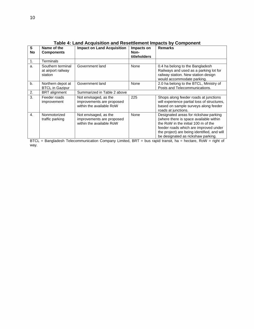
Table 4: Land Acquisition and Resettlement Impacts by Component S No
Name of the Components
Impact on Land Acquisition Impacts on Non-titleholders
Remarks
1. Terminals
a. Southern terminal at airport railway station
Government land None 0.4 ha belong to the Bangladesh Railways and used as a parking lot for railway station. New station design would accommodate parking.
b. Northern depot at BTCL in Gazipur
Government land None 2.0 ha belong to the BTCL, Ministry of Posts and Telecommunications.
2. BRT alignment Summarized in Table 2 above
3. Feeder roads improvement
Not envisaged, as the improvements are proposed within the available RoW
225 Shops along feeder roads at junctions will experience partial loss of structures, based on sample surveys along feeder roads at junctions.
4. Nonmotorized traffic parking
Not envisaged, as the improvements are proposed within the available RoW
None Designated areas for rickshaw parking (where there is space available within the RoW in the initial 100 m of the feeder roads which are improved under the project) are being identified, and will be designated as rickshaw parking.
BTCL = Bangladesh Telecommunication Company Limited, BRT = bus rapid transit, ha = hectare, RoW = right of way.
11
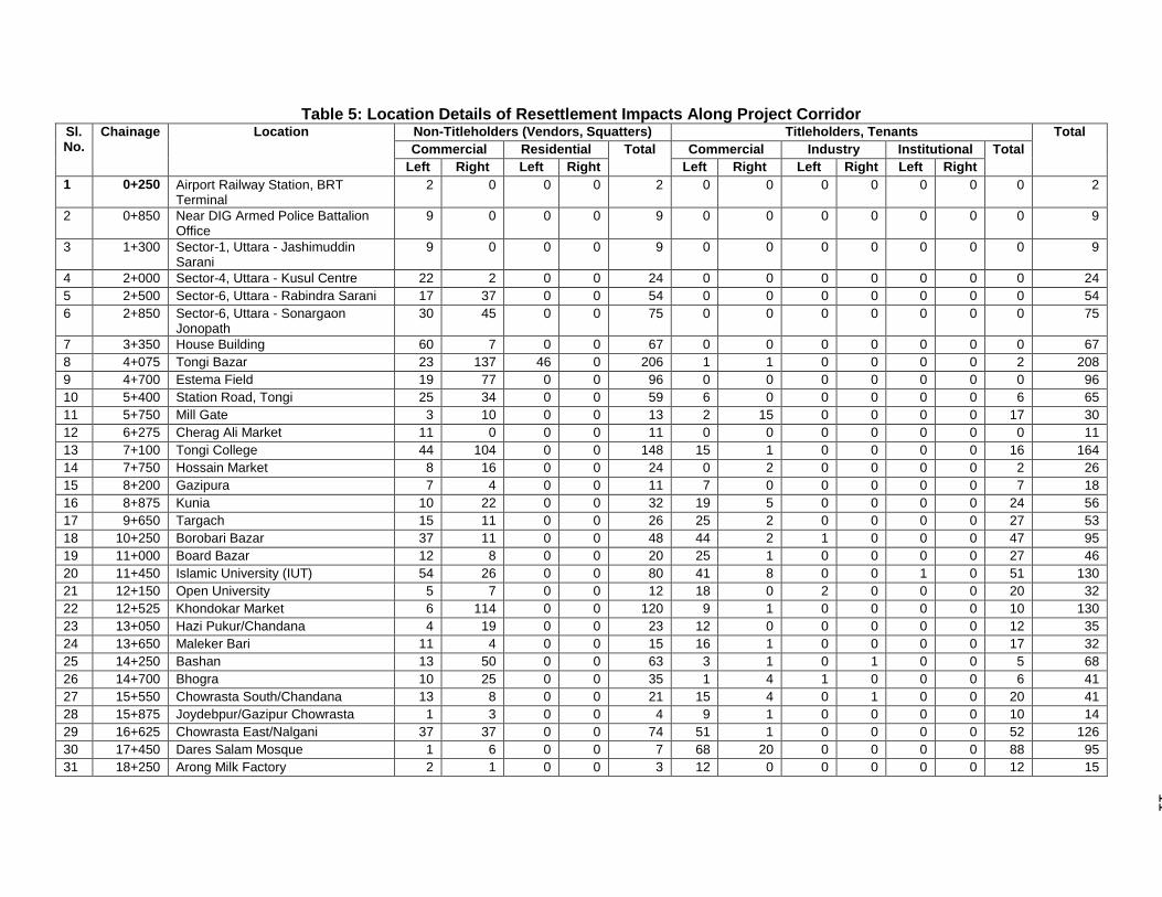
Table 5: Location Details of Resettlement Impacts Along Project Corridor Sl. No.
Chainage Location Non-Titleholders (Vendors, Squatters) Titleholders, Tenants Total
Commercial Residential Total Commercial Industry Institutional Total
Left Right Left Right Left Right Left Right Left Right
1 0+250 Airport Railway Station, BRT Terminal
2 0 0 0 2 0 0 0 0 0 0 0 2
2 0+850 Near DIG Armed Police Battalion Office
9 0 0 0 9 0 0 0 0 0 0 0 9
3 1+300 Sector-1, Uttara - Jashimuddin Sarani
9 0 0 0 9 0 0 0 0 0 0 0 9
4 2+000 Sector-4, Uttara - Kusul Centre 22 2 0 0 24 0 0 0 0 0 0 0 24
5 2+500 Sector-6, Uttara - Rabindra Sarani 17 37 0 0 54 0 0 0 0 0 0 0 54
6 2+850 Sector-6, Uttara - Sonargaon Jonopath
30 45 0 0 75 0 0 0 0 0 0 0 75
7 3+350 House Building 60 7 0 0 67 0 0 0 0 0 0 0 67
8 4+075 Tongi Bazar 23 137 46 0 206 1 1 0 0 0 0 2 208
9 4+700 Estema Field 19 77 0 0 96 0 0 0 0 0 0 0 96
10 5+400 Station Road, Tongi 25 34 0 0 59 6 0 0 0 0 0 6 65
11 5+750 Mill Gate 3 10 0 0 13 2 15 0 0 0 0 17 30
12 6+275 Cherag Ali Market 11 0 0 0 11 0 0 0 0 0 0 0 11
13 7+100 Tongi College 44 104 0 0 148 15 1 0 0 0 0 16 164
14 7+750 Hossain Market 8 16 0 0 24 0 2 0 0 0 0 2 26
15 8+200 Gazipura 7 4 0 0 11 7 0 0 0 0 0 7 18
16 8+875 Kunia 10 22 0 0 32 19 5 0 0 0 0 24 56
17 9+650 Targach 15 11 0 0 26 25 2 0 0 0 0 27 53
18 10+250 Borobari Bazar 37 11 0 0 48 44 2 1 0 0 0 47 95
19 11+000 Board Bazar 12 8 0 0 20 25 1 0 0 0 0 27 46
20 11+450 Islamic University (IUT) 54 26 0 0 80 41 8 0 0 1 0 51 130
21 12+150 Open University 5 7 0 0 12 18 0 2 0 0 0 20 32
22 12+525 Khondokar Market 6 114 0 0 120 9 1 0 0 0 0 10 130
23 13+050 Hazi Pukur/Chandana 4 19 0 0 23 12 0 0 0 0 0 12 35
24 13+650 Maleker Bari 11 4 0 0 15 16 1 0 0 0 0 17 32
25 14+250 Bashan 13 50 0 0 63 3 1 0 1 0 0 5 68
26 14+700 Bhogra 10 25 0 0 35 1 4 1 0 0 0 6 41
27 15+550 Chowrasta South/Chandana 13 8 0 0 21 15 4 0 1 0 0 20 41
28 15+875 Joydebpur/Gazipur Chowrasta 1 3 0 0 4 9 1 0 0 0 0 10 14
29 16+625 Chowrasta East/Nalgani 37 37 0 0 74 51 1 0 0 0 0 52 126
30 17+450 Dares Salam Mosque 1 6 0 0 7 68 20 0 0 0 0 88 95
31 18+250 Arong Milk Factory 2 1 0 0 3 12 0 0 0 0 0 12 15

12
Sl. No.
Chainage Location Non-Titleholders (Vendors, Squatters) Titleholders, Tenants Total
Commercial Residential Total Commercial Industry Institutional Total
Left Right Left Right Left Right Left Right Left Right
32 19+450 Agriculture Research Institute 30 16 0 0 46 16 6 0 0 0 1 23 69
33 20+150 Gazipur Main Terminal, Shibbari21
2 16 0 0 18 4 3 0 0 1 0 8 26
Subtotal 552 857 46 0 1,455 419 79 4 2 2 1 509 1,962
34 Along feeder roads at junctions 0 0 0 0 0 225 0 0 0 0 0 225
Total 2,482
BRT = bus rapid transit.
21
Additional 233 commercial encroachers were found at the Gazipur terminal location, and 62 commercial encroachers at the depot location based on additional survey conducted in January 2012.
13
13
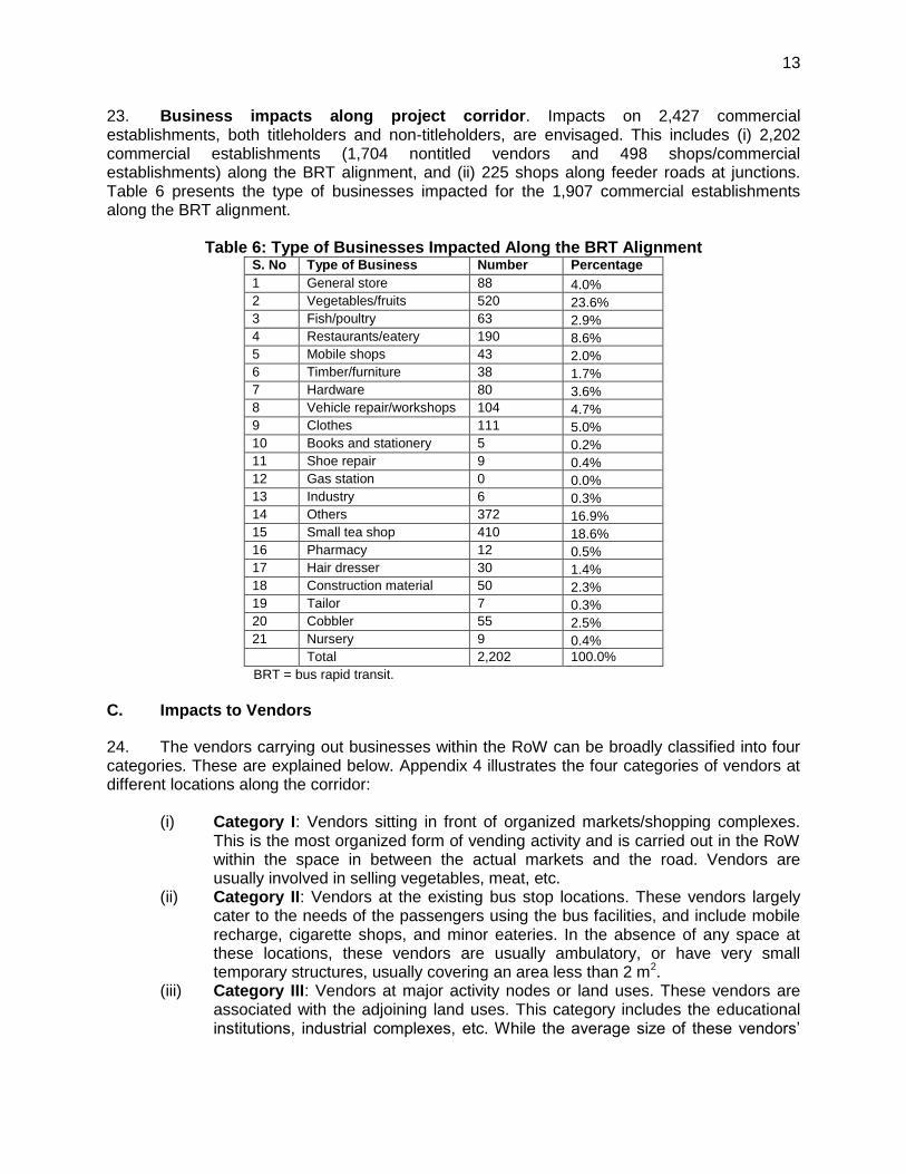
23. Business impacts along project corridor. Impacts on 2,427 commercial establishments, both titleholders and non-titleholders, are envisaged. This includes (i) 2,202 commercial establishments (1,704 nontitled vendors and 498 shops/commercial establishments) along the BRT alignment, and (ii) 225 shops along feeder roads at junctions. Table 6 presents the type of businesses impacted for the 1,907 commercial establishments along the BRT alignment.
Table 6: Type of Businesses Impacted Along the BRT Alignment S. No Type of Business Number Percentage
1 General store 88 4.0%
2 Vegetables/fruits 520 23.6%
3 Fish/poultry 63 2.9%
4 Restaurants/eatery 190 8.6%
5 Mobile shops 43 2.0%
6 Timber/furniture 38 1.7%
7 Hardware 80 3.6%
8 Vehicle repair/workshops 104 4.7%
9 Clothes 111 5.0%
10 Books and stationery 5 0.2%
11 Shoe repair 9 0.4%
12 Gas station 0 0.0%
13 Industry 6 0.3%
14 Others 372 16.9%
15 Small tea shop 410 18.6%
16 Pharmacy 12 0.5%
17 Hair dresser 30 1.4%
18 Construction material 50 2.3%
19 Tailor 7 0.3%
20 Cobbler 55 2.5%
21 Nursery 9 0.4%
Total 2,202 100.0%
BRT = bus rapid transit. C. Impacts to Vendors
24. The vendors carrying out businesses within the RoW can be broadly classified into four categories. These are explained below. Appendix 4 illustrates the four categories of vendors at different locations along the corridor:
(i) Category I: Vendors sitting in front of organized markets/shopping complexes. This is the most organized form of vending activity and is carried out in the RoW within the space in between the actual markets and the road. Vendors are usually involved in selling vegetables, meat, etc.
(ii) Category II: Vendors at the existing bus stop locations. These vendors largely cater to the needs of the passengers using the bus facilities, and include mobile recharge, cigarette shops, and minor eateries. In the absence of any space at these locations, these vendors are usually ambulatory, or have very small temporary structures, usually covering an area less than 2 m2.
(iii) Category III: Vendors at major activity nodes or land uses. These vendors are associated with the adjoining land uses. This category includes the educational institutions, industrial complexes, etc. While the average size of these vendors’
14
14
areas is 2.5 m2, some areas are relatively more permanent and occupy larger spaces, around 5 m2.
(iv) Category IV: Vendors not falling in the above categories. These vendors are usually isolated, and their siting is more attributed to convenience or simply the availability of space near pedestrian traffic.
1. Category I: Vendors Sitting in Front of Organized Markets/Shopping Complexes
25. Vendors sitting in front of 10 open markets who are operating within the RoW in front of these organized markets along the corridor will be impacted. Along these stretches, a total of 749 vendors occupying the RoW will be displaced. An overview of these markets, including the location, nature, and types of businesses, is provided in Table 7. Consultations with the vendors at each of the 10 market locations were undertaken, in addition to the census. Based on these consultations, discussions with the union parishads and pourashavas were undertaken to identify alternative relocation sites for the vendor groups.
Table 7: Summary of Category I Vendor Activity S. No
Union Parishad Chainage
Adjoining Market Name
Ownership of Adjoining Market Complex
Number of Vendors in Front of Market Impacted
Customer Base
Goods Sold
1 Uttara (1.000–2.300) left and right
Uttara footpath market (from airport to housing sector)
On service road and main road side
120 Garment workers, low income groups in local community
Garments, shoes, belts, women’s wear (seasonal) cosmetics, snacks, juice, vegetables, and fruits
2 Tongi (3.700–4.000) right
Tongi Bazar Mosque land 124 Industry workers community and Estema visitors (once yearly)
Vegetables, meat shop, fruits, tea shop, garments, spices, garments wear, cosmetics
3 Tongi (6.500–6.850) right
Chareg Ali bazaar
Private land - 76 family members
110 Public. visitors, industry workers
Vegetables, meat shop fruits, tea shop, dry fish
4 Tongi (7.675–7.775) right
Bamboo market
Land within RoW
10 Building construction, household use, fishing materials
Bamboo
5 Gacha (10.150–10.250) left
Borobari Bazar
Private land family shared
80 Industry workers and community
Vegetables, meat shop, fruits, spices
6 Gacha (11.200–11.325) left
Board Bazar locally called Kalomeshar Bazar (KB Bazar)
Donated Land leased out by the government
52 Industry workers and community
Vegetables, meat shop,
2. fruits

15
15
S. No
Union Parishad Chainage
Adjoining Market Name
Ownership of Adjoining Market Complex
Number of Vendors in Front of Market Impacted
Customer Base
Goods Sold
7 Gacha (12.275–12.600) right
Signboard Bazar
Private property shared by seven owners
135 Industry workers and community
Vegetables, meat shop fruits, dry dish, garments, cosmetics, tea shop
8 Gacha (13.675– 13.725) right
Maleker Bari Khaas land 43 Industry workers and community
Vegetables, Meat shop, fruits, spices, tea shop
9 Gazipur (16.100-16.200) right
Gazipur Chowrasta Bazaar
Private market – Idgah market
63 Community, visitors, industry workers, passengers
Fruits, flowers vegetables, fruits, tailor, newspapers, shoe repair, general stores
10 Gazipur (20.100–20.200) right
Bamboo market
Pourashava land
12 Building construction, household use, fishing materials, fish culture
Bamboo
Total 749
3. Category II: Vendors at the Existing Bus Stop Locations
26. There are 31 bus stations and two terminals proposed along the BRT corridor. The locations for these terminals are proposed at almost the same locations as that of the existing bus stops along the corridor. At every bus stop location, there are a group of vendors, with numbers varying from five to 15 at each of the locations, depending on the size of the bus stop, land availability, etc. The number of vendors at the existing bus stops is presented in Table 8. A total of 201 vendors have been inventoried at the existing bus stop locations. 27. The vendors at the existing bus stops cater largely to the needs of the bus passengers. The possibilities of accommodating the vendors in the underpasses at the proposed BRT stations were discussed. The vendors expressed keen interest in occupying formal spaces at the proposed BRT stations as (i) it would give them a security of tenure, and (ii) businesses would grow due to the increased number of people using the bus systems. The current informal expenses incurred by the vendors at the bus stop locations are about Tk. 800–Tk. 1,000 per month for the police, local collectors (i.e., musclemen), etc. During consultations, it was requested that the rent for the proposed spaces at BRT stations should be fixed within this range to ensure affordability for these vendors.22 The vendors also expressed concern that the allotment process should be transparent to avoid influential people obtaining all the spots. Based on these discussions, it has been agreed upon that all vendors at the existing bus stop locations will be prioritized for commercial spaces in the new stations, through issue of an identity card and assistance by the implementing NGORP, and that rent will be made affordable
22
Affordable rent for vendor spaces which are comparable to existing rents will be addressed in the vendor policy to be formulated under the project. Selection criteria for vendor stalls at BRT stations is included in this RP.
16
16
by fixing comparable rates to existing expenses incurred23 by the vendors towards payments to police personnel and/or musclemen for carrying out their businesses.
Table 8: Inventory of Vendors at the Proposed BRT stations Sl. No. Chainage Type Name of the Location Vendors
Left Right Total
1 0+250 D Airport Railway Station, BRT Terminal 8 0 8
2 0+850 B Near DIG Armed Police Battalion Office 0 0 0
3 1+300 B Sector-1, Uttara - Jashimuddin Sarani 6 0 6
4 2+000 B Sector-4, Uttara - Kusul Centre 0 0 0
5 2+500 C Sector-6, Uttara - Rabindra Sarani, Azampur 10 25 35
6 2+850 B Sector-6, Uttara - Sonargaon Jonopath 12 1 13
7 3+350 B House Building 0 0 0
8 4+075 C Tongi Bazar 0 55 55
9 4+700 C Estema Field 6 1 7
10 5+400 C Station Road, Tongi 0 0 0
11 5+750 C Mill Gate 0 4 4
12 6+275 C Cherag Ali Market 8 0 8
13 7+100 C Tongi College 4 1 5
14 7+750 C Hossain Market 0 7 7
15 8+200 C Gazipura 4 1 5
16 8+875 B Kunia 0 3 3
17 9+650 B Targach 0 0 0
18 10+250 C Borobari Bazar 5 3 8
19 11+000 C Board Bazar 1 2 3
20 11+450 B Islamic University (IUT) 1 0 1
21 12+150 B Open University 1 1 2
22 12+525 B Khondokar Market 0 7 7
23 13+050 B Hazi Pukur/Chandana 2 0 2
24 13+650 C Maleker Bari 1 12 13
25 14+250 B Bashan 1 4 5
26 14+700 C Bhogra 0 1 1
27 15+550 B Chowrasta South/Chandana 0 0 0
28 15+875 C Joydebpur/Gazipur Chowrasta 1 0 1
29 16+625 C Chowrasta East/Nalgani 0 0 0
30 17+450 A Dares Salam Mosque 0 0 0
31 18+250 A Arong Milk Factory 0 0 0
32 19+450 A Agriculture Research Institute 1 0 1
33 20+150 D Gazipur Main Terminal, Shibbari 1 0 1
Total 73 128 201
BRT = bus rapid transit.
4. Category III and Category IV Vendors
28. A total of 459 vendors are classified as category III and IV (including 274 and 185 vendors under category III and IV respectively) as per the census survey. The location of the category III vendors is largely attributed to the customer base at the industrial units, university campus, and other such activity nodes. The category IV vendors are usually not found in
23
These expenses ranged from about Tk .750 to Tk. 1,000 for mobile vendors and Tk. 1500–Tk. 2,000 for a semipermanent stall within the RoW in front of the market complexes.
17
17
groups, and their location choice for business is largely attributed to the land availability and the path of pedestrian movements. Based on their choice of locations, these vendors will be accommodated within the proposed vendor relocation sites, apart from being entitled to alternate livelihoods through capacity building and skill building proposed through the Department of Youth and Development. D. Impacts on Industrial Properties
29. Gazipur district has witnessed significant growth of industries in the ready-made garment (RMG) sector. There are over 300 industries along the corridor, mostly in RMG and textiles. Impacts on the industries have been avoided through modification of the cross-sections at these locations, and through reduction in the widths of the nonmotorized traffic (NMT) lanes along these stretches. However, impacts on six industries have been unavoidable. These include (i) two industries whose compound walls and vacant lands for a width of about 1 m within the compound wall are impacted, (ii) relocation of a private transformer within one industrial compound, and (iii) three units where the semipermanent structures (e.g., guard station) in the front of the industries are impacted. None of the main structures of the industries are impacted. The impacts are summarized in Table 9.
Table 9: Summary of Impacts on Industry Properties Sl. No.
Chainage Direction Name and Address of the Industries
Nature of Impact
Compound Wall (m)
Vacant Land (m
2)
Structure (m
2)
1 14+280 L Names deleted to protect privacy 55.78 159.5 0
2 11+660 L 0 0 24.58
3 11+650 L 0 0 32.02
4 15+050 R 47.72 45.34 0
5 14+080 R 0 0 6.35
6 9+790 L 0 0 10.59
IUT = Islamic University, m = meter, m2 = square meter.
E. Impacts to Cultural Properties
30. No physical impacts to mosques and temples will occur. Impacts are limited to minor strip-taking of land in front of three cultural properties (including 2 mosques and 1 temple) which will be acquired. Table 10 summarizes the impacts on these properties along the corridor.
Table 10: Summary of Impacts to Cultural Properties Sl. No.
Chainage Direction Name and location of the cultural property
Nature of impact
Compound Wall (m)
Vacant Land (m
2)
Structure (m
2)
1 11+360 L Names deleted to protect privacy 9.07 7.71 0
2 18+590 R 10.89 10.35 0
3 20+150 L 13.02 7.60 0
m = meter, m2 = square meter.
F. Impacts to Vehicle Parking Areas Within the Right of Way (RoW)
31. The RoW is used for parking vehicles, and Table 11 provides the location of the existing parking locations within the RoW used for trucks, compressed natural gas (CNG)
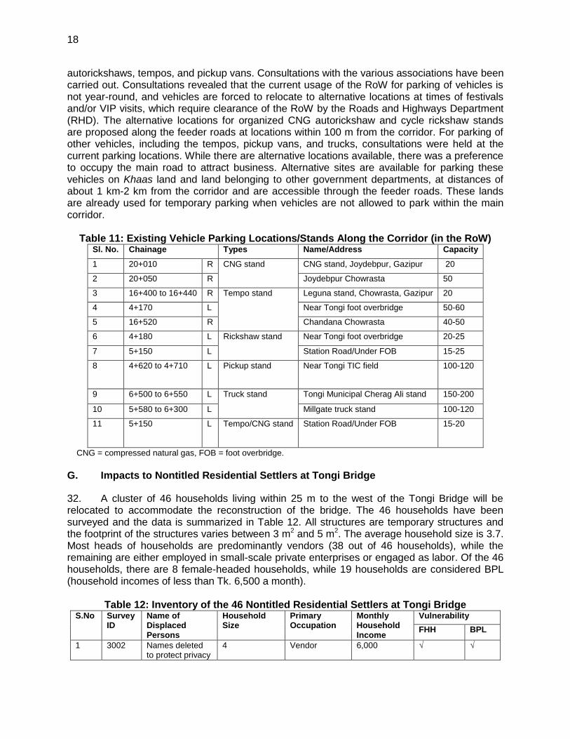
18
18
autorickshaws, tempos, and pickup vans. Consultations with the various associations have been carried out. Consultations revealed that the current usage of the RoW for parking of vehicles is not year-round, and vehicles are forced to relocate to alternative locations at times of festivals and/or VIP visits, which require clearance of the RoW by the Roads and Highways Department (RHD). The alternative locations for organized CNG autorickshaw and cycle rickshaw stands are proposed along the feeder roads at locations within 100 m from the corridor. For parking of other vehicles, including the tempos, pickup vans, and trucks, consultations were held at the current parking locations. While there are alternative locations available, there was a preference to occupy the main road to attract business. Alternative sites are available for parking these vehicles on Khaas land and land belonging to other government departments, at distances of about 1 km-2 km from the corridor and are accessible through the feeder roads. These lands are already used for temporary parking when vehicles are not allowed to park within the main corridor.
Table 11: Existing Vehicle Parking Locations/Stands Along the Corridor (in the RoW) Sl. No. Chainage Types Name/Address Capacity
1 20+010 R CNG stand CNG stand, Joydebpur, Gazipur 20
2 20+050 R Joydebpur Chowrasta 50
3 16+400 to 16+440 R Tempo stand Leguna stand, Chowrasta, Gazipur 20
4 4+170 L Near Tongi foot overbridge 50-60
5 16+520 R Chandana Chowrasta 40-50
6 4+180 L Rickshaw stand Near Tongi foot overbridge 20-25
7 5+150 L Station Road/Under FOB 15-25
8 4+620 to 4+710 L Pickup stand Near Tongi TIC field 100-120
9 6+500 to 6+550 L Truck stand Tongi Municipal Cherag Ali stand 150-200
10 5+580 to 6+300 L Millgate truck stand 100-120
11 5+150 L Tempo/CNG stand Station Road/Under FOB 15-20
CNG = compressed natural gas, FOB = foot overbridge. G. Impacts to Nontitled Residential Settlers at Tongi Bridge
32. A cluster of 46 households living within 25 m to the west of the Tongi Bridge will be relocated to accommodate the reconstruction of the bridge. The 46 households have been surveyed and the data is summarized in Table 12. All structures are temporary structures and the footprint of the structures varies between 3 m2 and 5 m2. The average household size is 3.7. Most heads of households are predominantly vendors (38 out of 46 households), while the remaining are either employed in small-scale private enterprises or engaged as labor. Of the 46 households, there are 8 female-headed households, while 19 households are considered BPL (household incomes of less than Tk. 6,500 a month).
Table 12: Inventory of the 46 Nontitled Residential Settlers at Tongi Bridge S.No Survey
ID Name of Displaced Persons
Household Size
Primary Occupation
Monthly Household Income
Vulnerability
FHH BPL
1 3002 Names deleted to protect privacy
4 Vendor 6,000 √ √
19
19
S.No Survey ID
Name of Displaced Persons
Household Size
Primary Occupation
Monthly Household Income
Vulnerability
FHH BPL
2 3003 4 Vendor 5,000 √
3 3004 3 Vendor 9,000
4 3005 4 Vendor 4,500 √
5 3006 2 Vendor 5,000 √
6 3007 3 Vendor 1,500 √ √
7 3008 4 Vendor 7,000
8 3009 5 Vendor 9,000
9 3010 2 Vendor 6,000 √ √
10 3011 Names deleted to protect privacy
5 Vendor 8,000
11 3012 2 Vendor 6,000 √
12 3013 4 Vendor 7,000
13 3014 4 Vendor 8,000
14 3015 4 Vendor 8,000
15 3016 5 Vendor 9,000
16 3017 5 Nonagricultural labor
7,000
17 3018 5 Vendor 6,000 √
18 3019 6 Vendor 7,000
19 3020 5 Vendor 7,000
20 3021 3 Nonagricultural labor
6,000 √
21 3022 5 Vendor 12,000
22 3023 3 Vendor 7,000
23 3024 4 Vendor 6,000 √
24 3025 2 Employed private
7,000
25 3026 6 Vendor 11,000 √
26 3027 3 Vendor 7,000
27 3028 4 Nonagricultural labor
4,000 √
28 3029 2 Vendor 7,000
29 3030 2 Vendor 5,500 √
30 3031 4 Vendor 13,000
31 3032 4 Vendor 16,000
32 3033 4 Non- agricultural labor
10,000
33 3034 3 Nonagricultural labor
10,000
34 3035 2 Vendor 8,000 √
35 3036 3 Vendor 4,000 √ √
36 3037 2 Nonagricultural labor
3,000 √
20
20
S.No Survey ID
Name of Displaced Persons
Household Size
Primary Occupation
Monthly Household Income
Vulnerability
FHH BPL
37 3038 4 Employed private
5,000 √
38 3039 5 Vendor 7,000
39 3040 2 Vendor 6,500 √
40 3041 6 Vendor 9,000
41 3042 4 Vendor 6,000 √
42 3043 4 Vendor 8,500 √
43 3044 4 Vendor 8,000
44 3045 2 Vendor 2,000 √ √
45 3046 Names deleted to protect privacy
3 Vendor 6,000 √
46 3059 4 Vendor 9,000
BPL = below poverty line, FHH = female-headed households.
III. SOCIOECONOMIC INFORMATION AND PROFILE
A. Overview
33. This section provides a socioeconomic profile of the displaced households along the corridor based on a census survey.24 Structured survey questionnaires were used to collect detailed information on the nature and type of resettlement and livelihood impacts on the displaced population. The survey included various aspects such as (i) household characteristics, including social, economic, and vulnerability status; (ii) type and nature of businesses carried out; (iii) inventory of physical assets; (iv) potential income loss, indebtedness of the households; and (v) ascertaining perceptions on resettlement options, compensation, assistance, etc. This draft resettlement plan will be revised at the stage of detailed design, and a final resettlement plan will be prepared and submitted to ADB.25 The major findings are discussed in the following sections. B. Demographic Characteristics
34. Table 13 provides an age profile of the displaced persons. A total of 32 households (1.79% of the total surveyed households) were identified as female-headed households. The average household size is 4.22.
24
While an attempt to carry out a 100% census of the displaced persons was made along the BRT corridor, a survey of 90% of the displaced persons within the main corridor was done, as the remaining were either absent or nonresponsive. The extent of actual impacts along the project corridor was assessed for 100% of the displaced persons based on the final design drawings. The assessment of impacts along the feeder roads is based on sample surveys to assess potential impacts along representative feeder roads, and extrapolating the findings of the sample survey for the non-surveyed feeder roads.
25 The information contained in the resettlement plan is tentative until the census of affected persons has been completed. Soon after the completion of engineering designs, the borrower/ client will finalize the resettlement plan by completing the census and inventories of loss of assets. At this stage, changes to the resettlement plan take the form of revising the number of displaced persons, the extent of land acquired, the resettlement budget, and the timetable for implementing the resettlement plan. The entitlement matrix of the resettlement plan may be updated at this stage to reflect the relevant changes but the standards set in the original entitlement matrix cannot be lowered when the resettlement plan is revised and finalized. (ADB Safeguards Policy Statement. Safeguards Requirements 2. 2009)
21
21
Table 13: Affected Population by Age and Sex (%)
Age Group
Vendors/Residential Squatters Titleholders/Tenants Total
Male Female Total Male Female Total Male Female Total
1–4 6.8% 7.2% 7.0% 7.8% 8.3% 8.0% 7.0% 7.4% 7.2%
5–14 25.2% 24.3% 24.7% 17.5% 19.2% 18.2% 23.7% 23.4% 23.5%
15–59 64.2% 65.3% 64.7% 69.0% 66.6% 68.0% 65.2% 65.5% 65.3%
60+ 3.8% 3.3% 3.5% 5.6% 6.0% 5.8% 4.1% 3.7% 4.0%
Total number of displaced persons
3,234 2,910 6,144 798 616 1,414 4,032 3,526 7,558
Number of households responded
1,450 339 1,789
Household size (average)
4.24 4.17 4.22
1. Education levels
35. Around 16% of the members in displaced households are illiterate (Table 14). A significant proportion of the displaced persons (56%) in the surveyed population have only completed primary education, indicating the low levels of education among the hawker/vendor population. Only 2% of the displaced population had attained higher education.
Table 14: Levels of Education Among Affected Households (%) Level of Education Male Female Total
1. Illiterate (above 7 years) 13.9 18.0 16.3
2. Nonformal 6.0 9.2 7.9
3. Primary 59.9 54.6 56.8
4. Secondary 12.1 13.4 12.9
5. Higher secondary 3.8 3.1 3.4
6. Graduate 2.0 0.8 1.3
7. Postgraduate 0.4 0.1 0.2
8. Madarsha 1.8 0.8 1.2
9. Technical 0.1 0.0 0.0
100 100 100
2. Occupational Profile
36. Involvement in the business activities is the primary occupation of the head of the households surveyed (Table 15). The key business activities carried out are (i) selling of vegetables/fruits; (ii) vehicle repair and workshops; (iii) selling of clothes and apparel; and (iv) tea shops and small eateries. The profiles of the female-headed households are similar, and they are mainly involved in selling vegetables, eateries, and tea shops.
Table 15: Primary Occupation of Heads of Households Vendors/Non-titleholders Titleholders Total
Male Female Total Male Female Total Male Female Total
General store 2 0 2 65 0 65 67 0 67
Vegetables/fruits 496 10 506 7 0 7 503 10 513
Fish/poultry 60 0 60 2 0 2 62 0 62
Restaurants/eatery 74 3 77 36 0 36 110 3 113
22
22
Vendors/Non-titleholders Titleholders Total
Male Female Total Male Female Total Male Female Total
Mobile phone Shops 12 0 12 27 0 27 39 0 39
Timber/furniture 4 0 4 24 0 24 28 0 28
Hardware 10 0 10 38 0 38 48 0 48
Vehicle repair/workshops 56 0 56 43 0 43 99 0 99
Clothes 107 0 107 3 0 3 110 0 110
Books and stationery 5 0 5 0 0 0 5 0 5
Shoe repair 4 1 5 3 0 3 7 1 8
Gas station 0 0 0 0 0 0 0 0 0
Industry 0 0 0 2 0 2 2 0 2
Others 158 10 168 52 0 52 210 10 220
Small tea/betel leaf shops 337 4 341 7 0 7 344 4 348
Pharmacy 2 0 2 6 0 6 8 0 8
Hairdresser 27 0 27 3 0 3 30 0 30
Construction material 4 0 4 10 0 10 14 0 14
Tailor 3 0 3 4 0 4 7 0 7
Cobbler 52 2 54 1 0 1 53 2 55
Nursery 3 0 3 4 2 6 7 2 9
Day labor 4 0 4 0 0 0 4 0 4
3. Levels of Income of the Affected Population
37. A total of 249 households (14%) among the surveyed households have reported an income of less than Tk. 6,500, adopted as the poverty line for the project (Table 16).This includes 15 of the 32 female-headed households. There is a clear indication that income levels of the titleholder and tenant households are far higher than that of the vendors and non-titleholder households (hawker/vendors). Less than 4% of titled households have reported incomes less than Tk. 6,500 per month, as against nearly 16.5% of the hawker/vendor households. About 72% of the titleholders and 15% of the vendors report high household incomes of greater than Tk. 15,000 per month.
Table 16: Income levels of the Affected Households Level of Income Vendors/Non-titleholders Titleholders/Tenants Total
Taka Male Female Total Male Female Total Male Female Total
Less than 3,000 1.1% 10.0% 1.3% 0.3% 0.0% 0.3% 1.0% 9.4% 1.1%
3,001–6,500 14.7% 40.0% 15.2% 3.2% 0.0% 3.2% 12.6% 37.5% 13.1%
6,501–9,000 32.0% 23.3% 31.8% 3.5% 0.0% 3.5% 26.8% 21.9% 26.8%
9,001–12,000 22.9% 6.7% 22.5% 9.6% 50.0% 9.8% 20.5% 9.4% 20.3%
12,001–15,000 13.7% 10.0% 13.6% 10.9% 0.0% 10.8% 13.2% 9.4% 13.1%
15,000+ 15.6% 10.0% 15.4% 72.5% 50.0% 72.4% 25.9% 12.5% 25.7%
4. Vulnerability Status of the Affected Households
38. The vulnerability status of the affected households was assessed based on the following: (i) head of household is an elderly person who is 65 years old and above, with no other support; (ii) the displaced household is below poverty line (monthly income of less than Tk. 6,500); (iii) head of the household is a physically disabled person; and (iv) head of the
23
23
household is a female. Nearly 14% of the total households surveyed are identified as vulnerable households. Table 17 summarizes vulnerability status of affected households.
Table 17: Vulnerability Status of the Affected Households Number Percentage
Elderly households (65 years old and above, with no other support)
37 10.7%
Below poverty line households (monthly income less than Tk. 6,500)
276 80.0%
Physically disabled households 16 4.6%
Female households 16 4.6%
Vulnerable households (total) 345 100.0%
5. Gender Considerations
39. During the relocation of vendors, disbursement of assistance, and compensation, priority will be given to female-headed households. Women vendors will be given priority at the proposed new locations. Additional assistance has also been provided for all the female-headed households who will be considered as vulnerable groups. In addition to the measures provided for addressing the gender concerns of the affected households, the resettlement plan will be implemented in consonance with the gender action plan for the project. For example, the selection criteria for vendor stalls at the new bus rapid transit (BRT) stations will require at least 15% of the stalls to be given to female vendors. Also, the underpasses, station designs, and buses will ensure safe and gender-friendly facilities, including enhanced security and reserved seating for women.
6. Preferences for Resettlement and Rehabilitation
40. Information pertaining to preferences and options for resettlement was assessed as part of the census surveys. Of the survey respondents, a total of 870 households (54%) have expressed that they are willing to relocate voluntarily.26 The respondents requested for the following compensation/assistance towards the loss of their businesses:
(i) request for an alternative land/shop to carry out businesses (62%); (ii) cash compensation (32%); (iii) partly cash and partly assistance in form of training, etc .(5%); and (iv) others, like specific skill development (1%).
41. Less than 10% of the displaced population indicated that there is alternative land readily available where they can shift in the event of being relocated. For those with alternative sites, the median distance was indicated about 0.50 km from existing location. About 30% of the respondents expressed confidence that they could practice the same business in other locations. Given the low levels of awareness and the low levels of education among the displaced households, especially the vendors, the awareness of acquiring new skills and alternative livelihood options is very limited, with less than 20% willing to go in for new skill developments. The nature and type of training sought is presented in Table 18.
26
Of the 1,789 households surveyed, 1,604 households responded to the question on whether they are willing to relocate voluntarily. Of these 870 households (54%) expressed willingness to relocate voluntarily. Voluntary relocation does not preclude qualifying for relocation into the proposed new vendor areas.
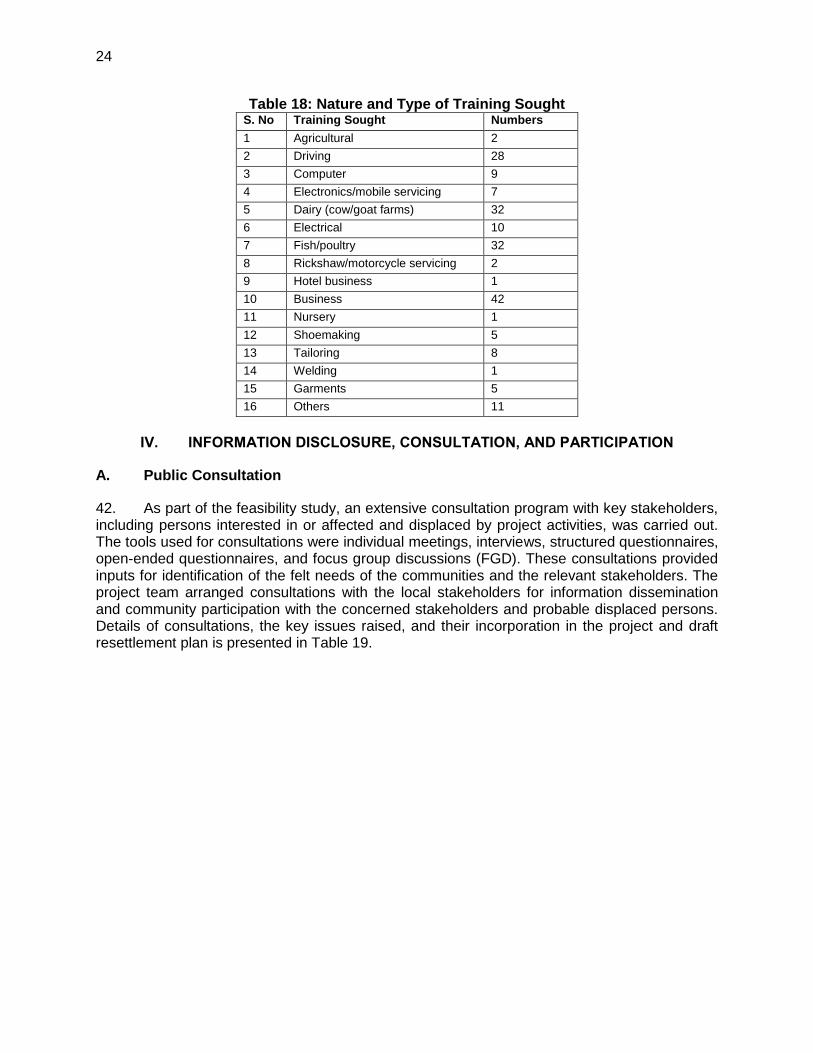
24
24
Table 18: Nature and Type of Training Sought S. No Training Sought Numbers
1 Agricultural 2
2 Driving 28
3 Computer 9
4 Electronics/mobile servicing 7
5 Dairy (cow/goat farms) 32
6 Electrical 10
7 Fish/poultry 32
8 Rickshaw/motorcycle servicing 2
9 Hotel business 1
10 Business 42
11 Nursery 1
12 Shoemaking 5
13 Tailoring 8
14 Welding 1
15 Garments 5
16 Others 11
IV. INFORMATION DISCLOSURE, CONSULTATION, AND PARTICIPATION
A. Public Consultation
42. As part of the feasibility study, an extensive consultation program with key stakeholders, including persons interested in or affected and displaced by project activities, was carried out. The tools used for consultations were individual meetings, interviews, structured questionnaires, open-ended questionnaires, and focus group discussions (FGD). These consultations provided inputs for identification of the felt needs of the communities and the relevant stakeholders. The project team arranged consultations with the local stakeholders for information dissemination and community participation with the concerned stakeholders and probable displaced persons. Details of consultations, the key issues raised, and their incorporation in the project and draft resettlement plan is presented in Table 19.
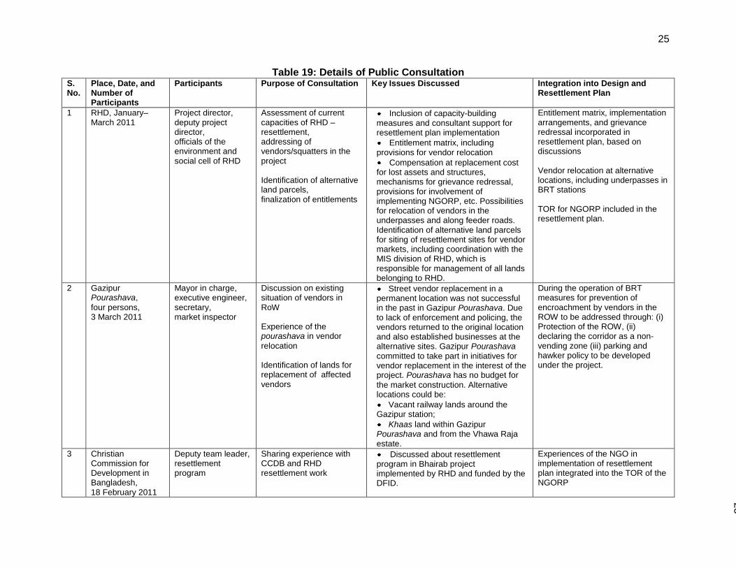
25
25
Table 19: Details of Public Consultation S. No.
Place, Date, and Number of Participants
Participants Purpose of Consultation Key Issues Discussed Integration into Design and Resettlement Plan
1 RHD, January–March 2011
Project director, deputy project director, officials of the environment and social cell of RHD
Assessment of current capacities of RHD – resettlement, addressing of vendors/squatters in the project Identification of alternative land parcels, finalization of entitlements
Inclusion of capacity-building measures and consultant support for resettlement plan implementation
Entitlement matrix, including provisions for vendor relocation
Compensation at replacement cost for lost assets and structures, mechanisms for grievance redressal, provisions for involvement of implementing NGORP, etc. Possibilities for relocation of vendors in the underpasses and along feeder roads. Identification of alternative land parcels for siting of resettlement sites for vendor markets, including coordination with the MIS division of RHD, which is responsible for management of all lands belonging to RHD.
Entitlement matrix, implementation arrangements, and grievance redressal incorporated in resettlement plan, based on discussions Vendor relocation at alternative locations, including underpasses in BRT stations TOR for NGORP included in the resettlement plan.
2 Gazipur Pourashava,
four persons, 3 March 2011
Mayor in charge, executive engineer, secretary, market inspector
Discussion on existing situation of vendors in RoW Experience of the pourashava in vendor
relocation Identification of lands for replacement of affected vendors
Street vendor replacement in a permanent location was not successful in the past in Gazipur Pourashava. Due to lack of enforcement and policing, the vendors returned to the original location and also established businesses at the alternative sites. Gazipur Pourashava committed to take part in initiatives for vendor replacement in the interest of the project. Pourashava has no budget for
the market construction. Alternative locations could be:
Vacant railway lands around the Gazipur station;
Khaas land within Gazipur Pourashava and from the Vhawa Raja estate.
During the operation of BRT measures for prevention of encroachment by vendors in the ROW to be addressed through: (i) Protection of the ROW, (ii) declaring the corridor as a non-vending zone (iii) parking and hawker policy to be developed under the project.
3 Christian Commission for Development in Bangladesh, 18 February 2011
Deputy team leader, resettlement program
Sharing experience with CCDB and RHD resettlement work
Discussed about resettlement program in Bhairab project implemented by RHD and funded by the DFID.
Experiences of the NGO in implementation of resettlement plan integrated into the TOR of the NGORP
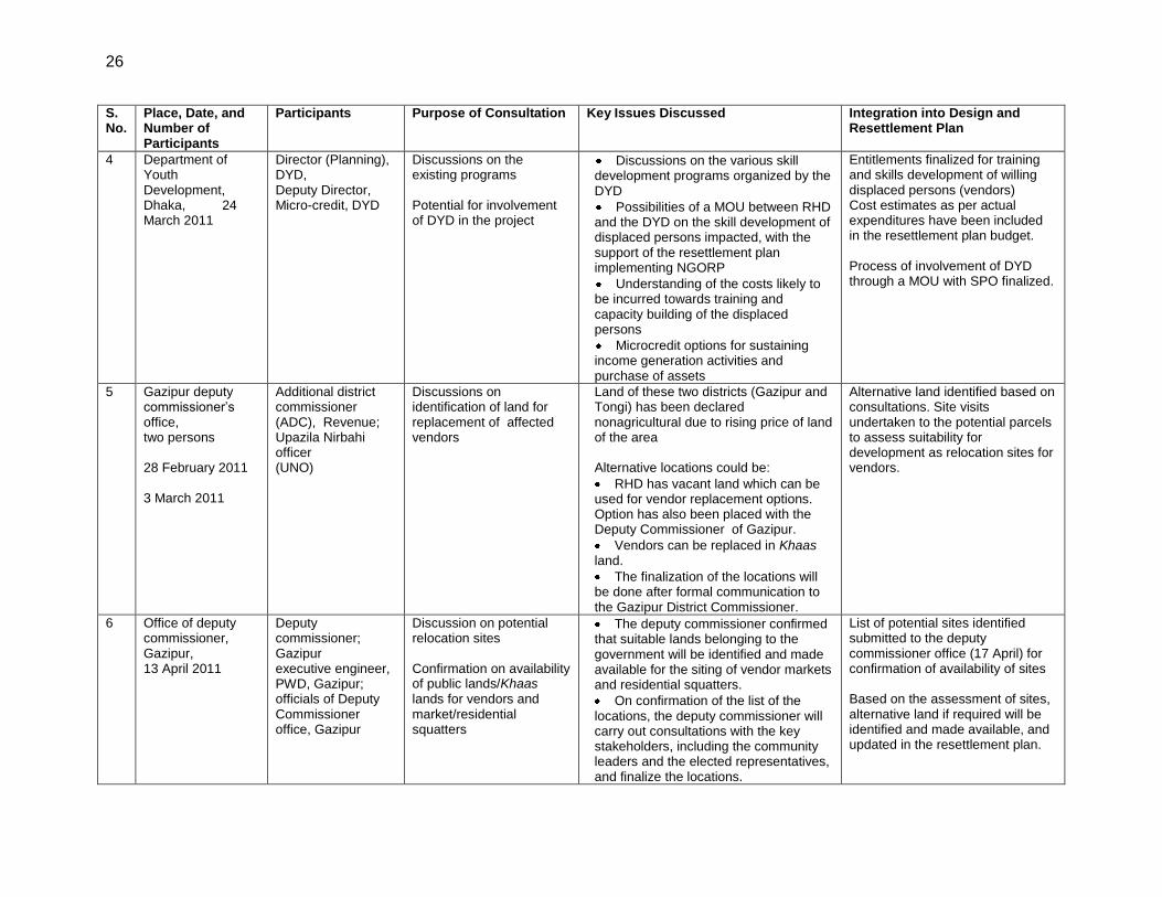
26
S. No.
Place, Date, and Number of Participants
Participants Purpose of Consultation Key Issues Discussed Integration into Design and Resettlement Plan
4 Department of Youth Development, Dhaka, 24 March 2011
Director (Planning), DYD, Deputy Director, Micro-credit, DYD
Discussions on the existing programs Potential for involvement of DYD in the project
Discussions on the various skill development programs organized by the DYD
Possibilities of a MOU between RHD and the DYD on the skill development of displaced persons impacted, with the support of the resettlement plan implementing NGORP
Understanding of the costs likely to be incurred towards training and capacity building of the displaced persons
Microcredit options for sustaining income generation activities and purchase of assets
Entitlements finalized for training and skills development of willing displaced persons (vendors) Cost estimates as per actual expenditures have been included in the resettlement plan budget. Process of involvement of DYD through a MOU with SPO finalized.
5 Gazipur deputy commissioner’s office, two persons 28 February 2011 3 March 2011
Additional district commissioner (ADC), Revenue; Upazila Nirbahi officer (UNO)
Discussions on identification of land for replacement of affected vendors
Land of these two districts (Gazipur and Tongi) has been declared nonagricultural due to rising price of land of the area Alternative locations could be:
RHD has vacant land which can be used for vendor replacement options. Option has also been placed with the Deputy Commissioner of Gazipur.
Vendors can be replaced in Khaas land.
The finalization of the locations will be done after formal communication to the Gazipur District Commissioner.
Alternative land identified based on consultations. Site visits undertaken to the potential parcels to assess suitability for development as relocation sites for vendors.
6 Office of deputy commissioner, Gazipur, 13 April 2011
Deputy commissioner; Gazipur executive engineer, PWD, Gazipur; officials of Deputy Commissioner office, Gazipur
Discussion on potential relocation sites Confirmation on availability of public lands/Khaas lands for vendors and market/residential squatters
The deputy commissioner confirmed that suitable lands belonging to the government will be identified and made available for the siting of vendor markets and residential squatters.
On confirmation of the list of the locations, the deputy commissioner will carry out consultations with the key stakeholders, including the community leaders and the elected representatives, and finalize the locations.
List of potential sites identified submitted to the deputy commissioner office (17 April) for confirmation of availability of sites Based on the assessment of sites, alternative land if required will be identified and made available, and updated in the resettlement plan.
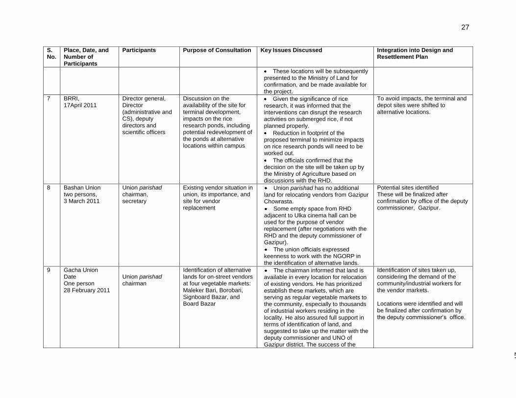
27
27
S. No.
Place, Date, and Number of Participants
Participants Purpose of Consultation Key Issues Discussed Integration into Design and Resettlement Plan
These locations will be subsequently presented to the Ministry of Land for confirmation, and be made available for the project.
7 BRRI, 17April 2011
Director general, Director (administrative and CS), deputy directors and scientific officers
Discussion on the availability of the site for terminal development, impacts on the rice research ponds, including potential redevelopment of the ponds at alternative locations within campus
Given the significance of rice research, it was informed that the interventions can disrupt the research activities on submerged rice, if not planned properly.
Reduction in footprint of the proposed terminal to minimize impacts on rice research ponds will need to be worked out.
The officials confirmed that the decision on the site will be taken up by the Ministry of Agriculture based on discussions with the RHD.
To avoid impacts, the terminal and depot sites were shifted to alternative locations.
8 Bashan Union two persons, 3 March 2011
Union parishad chairman, secretary
Existing vendor situation in union, its importance, and site for vendor replacement
Union parishad has no additional land for relocating vendors from Gazipur Chowrasta.
Some empty space from RHD adjacent to Ulka cinema hall can be used for the purpose of vendor replacement (after negotiations with the RHD and the deputy commissioner of Gazipur).
The union officials expressed keenness to work with the NGORP in the identification of alternative lands.
Potential sites identified These will be finalized after confirmation by office of the deputy commissioner, Gazipur.
9 Gacha Union Date One person 28 February 2011
Union parishad chairman
Identification of alternative lands for on-street vendors at four vegetable markets: Maleker Bari, Borobari, Signboard Bazar, and Board Bazar
The chairman informed that land is available in every location for relocation of existing vendors. He has prioritized establish these markets, which are serving as regular vegetable markets to the community, especially to thousands of industrial workers residing in the locality. He also assured full support in terms of identification of land, and suggested to take up the matter with the deputy commissioner and UNO of Gazipur district. The success of the
Identification of sites taken up, considering the demand of the community/industrial workers for the vendor markets. Locations were identified and will be finalized after confirmation by the deputy commissioner’s office.
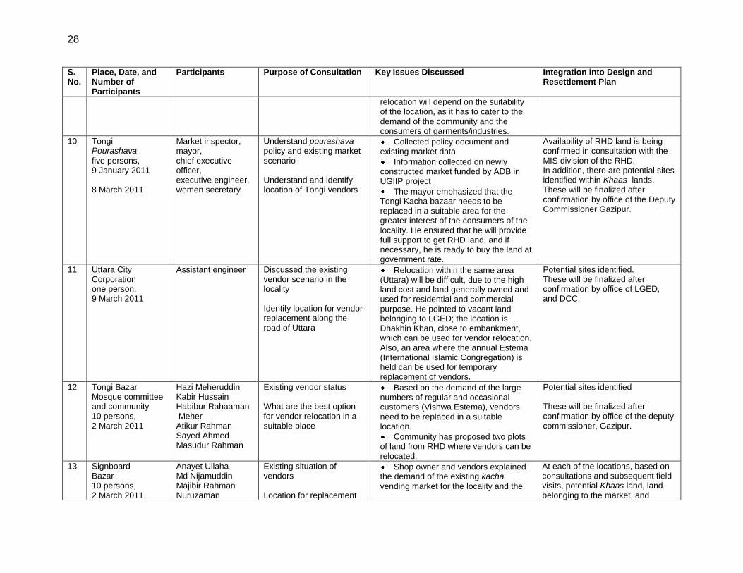
28
S. No.
Place, Date, and Number of Participants
Participants Purpose of Consultation Key Issues Discussed Integration into Design and Resettlement Plan
relocation will depend on the suitability of the location, as it has to cater to the demand of the community and the consumers of garments/industries.
10 Tongi Pourashava
five persons, 9 January 2011 8 March 2011
Market inspector, mayor, chief executive officer, executive engineer, women secretary
Understand pourashava policy and existing market scenario Understand and identify location of Tongi vendors
Collected policy document and existing market data
Information collected on newly constructed market funded by ADB in UGIIP project
The mayor emphasized that the Tongi Kacha bazaar needs to be replaced in a suitable area for the greater interest of the consumers of the locality. He ensured that he will provide full support to get RHD land, and if necessary, he is ready to buy the land at government rate.
Availability of RHD land is being confirmed in consultation with the MIS division of the RHD. In addition, there are potential sites identified within Khaas lands. These will be finalized after confirmation by office of the Deputy Commissioner Gazipur.
11 Uttara City Corporation one person, 9 March 2011
Assistant engineer Discussed the existing vendor scenario in the locality Identify location for vendor replacement along the road of Uttara
Relocation within the same area (Uttara) will be difficult, due to the high land cost and land generally owned and used for residential and commercial purpose. He pointed to vacant land belonging to LGED; the location is Dhakhin Khan, close to embankment, which can be used for vendor relocation. Also, an area where the annual Estema (International Islamic Congregation) is held can be used for temporary replacement of vendors.
Potential sites identified. These will be finalized after confirmation by office of LGED, and DCC.
12 Tongi Bazar Mosque committee and community 10 persons, 2 March 2011
Hazi Meheruddin Kabir Hussain Habibur Rahaaman Meher Atikur Rahman Sayed Ahmed Masudur Rahman
Existing vendor status What are the best option for vendor relocation in a suitable place
Based on the demand of the large numbers of regular and occasional customers (Vishwa Estema), vendors need to be replaced in a suitable location.
Community has proposed two plots of land from RHD where vendors can be relocated.
Potential sites identified These will be finalized after confirmation by office of the deputy commissioner, Gazipur.
13 Signboard Bazar 10 persons, 2 March 2011
Anayet Ullaha Md Nijamuddin Majibir Rahman Nuruzaman
Existing situation of vendors Location for replacement
Shop owner and vendors explained the demand of the existing kacha
vending market for the locality and the
At each of the locations, based on consultations and subsequent field visits, potential Khaas land, land belonging to the market, and
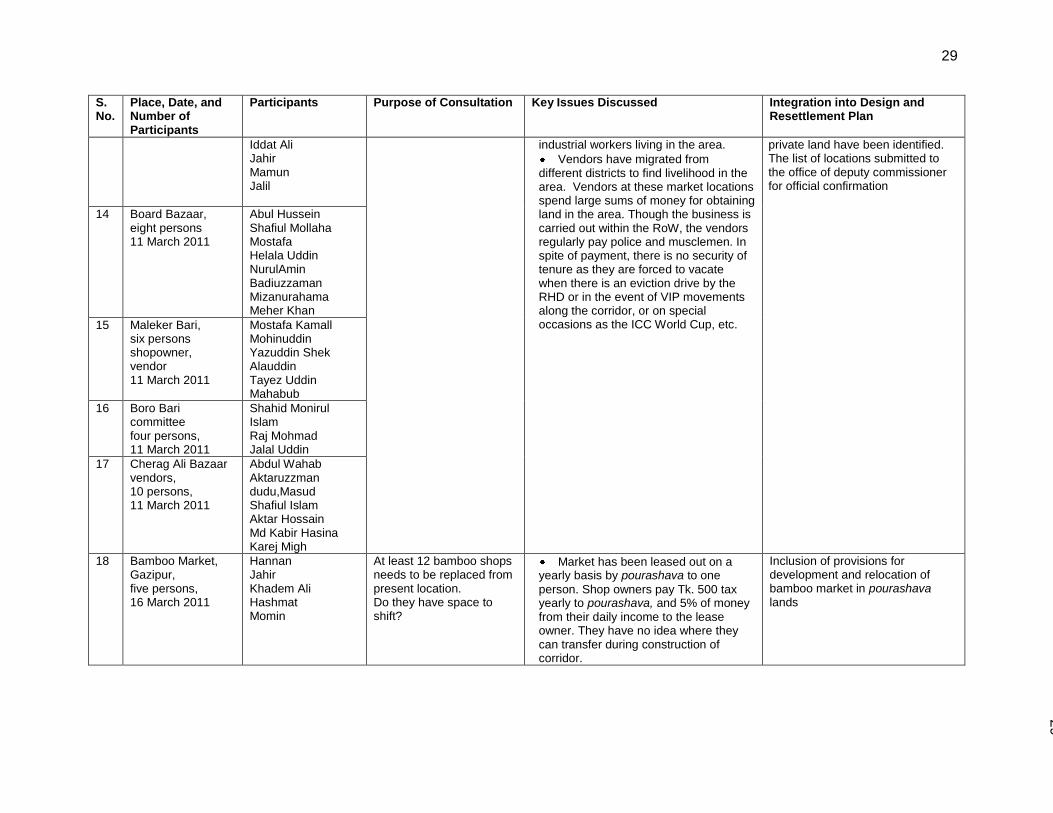
29
29
S. No.
Place, Date, and Number of Participants
Participants Purpose of Consultation Key Issues Discussed Integration into Design and Resettlement Plan
Iddat Ali Jahir Mamun Jalil
industrial workers living in the area.
Vendors have migrated from different districts to find livelihood in the area. Vendors at these market locations spend large sums of money for obtaining land in the area. Though the business is carried out within the RoW, the vendors regularly pay police and musclemen. In spite of payment, there is no security of tenure as they are forced to vacate when there is an eviction drive by the RHD or in the event of VIP movements along the corridor, or on special occasions as the ICC World Cup, etc.
private land have been identified. The list of locations submitted to the office of deputy commissioner for official confirmation
14 Board Bazaar, eight persons 11 March 2011
Abul Hussein Shafiul Mollaha Mostafa Helala Uddin NurulAmin Badiuzzaman Mizanurahama Meher Khan
15 Maleker Bari, six persons shopowner, vendor 11 March 2011
Mostafa Kamall Mohinuddin Yazuddin Shek Alauddin Tayez Uddin Mahabub
16 Boro Bari committee four persons, 11 March 2011
Shahid Monirul Islam Raj Mohmad Jalal Uddin
17 Cherag Ali Bazaar vendors, 10 persons, 11 March 2011
Abdul Wahab Aktaruzzman dudu,Masud Shafiul Islam Aktar Hossain Md Kabir Hasina Karej Migh
18 Bamboo Market, Gazipur, five persons, 16 March 2011
Hannan Jahir Khadem Ali Hashmat Momin
At least 12 bamboo shops needs to be replaced from present location. Do they have space to shift?
Market has been leased out on a yearly basis by pourashava to one
person. Shop owners pay Tk. 500 tax yearly to pourashava, and 5% of money from their daily income to the lease owner. They have no idea where they can transfer during construction of corridor.
Inclusion of provisions for development and relocation of bamboo market in pourashava lands

30
S. No.
Place, Date, and Number of Participants
Participants Purpose of Consultation Key Issues Discussed Integration into Design and Resettlement Plan
19 Gazipur Chowrasta vendors, four persons, 16 March 2011
Suman Jalil Sayed Babu Mobin
Existing situation of vendors Location for replacement
Vendors indicated a private land (2 bigha) in Chandana ward in Bashan
union where they can transfer.
The participants of this session were informed that the relocation sites for their vendor markets will be on government lands, and not the private land in Chandana ward. It was clarified that potential sites have been identified and the site will be finalized after confirmation by the office of the deputy commissioner, Gazipur.
20 Uttara sector 1, six persons, 8 March 2011
Md. Mashin Abdur Rashid Rasel Mohasin (2) Raja Liton
Existing situation of vendor Replacement location
Street vendors’ business is hampered when they fail to pay increasing demands of police. They are not allowed to sit when high-profile people use the road. Currently, due to World Cup Cricket tournament, the vendors are not being allowed at all on the footpath.
Hawkers’ policy to be developed as part of the project, which will provide guidelines for vending along streets and major roads, and also introduce a system of licensing of hawkers, thereby providing increased security of tenure.
21 DCC December 2010- January 2011
Deputy revenue officer; deputy secretary, taxation office general manager; town planner in charge of transport; assistant secretary; administration executive Engineer
Existing market policy and hawkers management Existing market situation and terms of condition and data Hawkers’ market in Dhaka city
Discussed and collected existing market construction and distribution policy. Situation of existing hawker management in Dhaka city. Detailed data on market and vendor management has been collected.
High initial deposits required by the DCC for allotment of spaces within the market complexes are making things difficult for vendors.
The development charges of the resettlement site are borne by the project. No initial deposit to be collected from the vendors, and rent proposed to be made affordable, within the levels of current expenses incurred for equivalent spaces.
22 November, 20 September 2010, Gazipur Shibbari bus stand
Thiti Md Basiruddin Saidur Rahaman Safique
Passengers’ perception of existing bus service, problems What is BRT system? Willingness to pay Create better opportunity for women
Participants informed that community and passengers facing serious problems due to huge traffic. Participants and passengers of the current bus service have appreciated the idea of the BRT system. Passengers wanted to pay more for better service. Must increase number of reserved seats for women in BRT system.
The proposed system will address issues on traffic congestion and safety of road users. Proposed project, as part of the gender action plans, includes special measures for enhancing security of women and includes reserved seats within the buses.
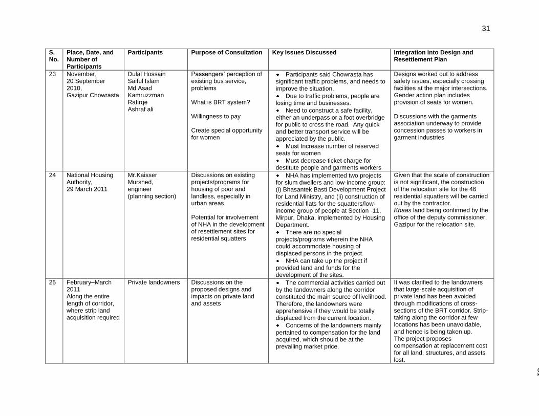
31
31
S. No.
Place, Date, and Number of Participants
Participants Purpose of Consultation Key Issues Discussed Integration into Design and Resettlement Plan
23 November, 20 September 2010, Gazipur Chowrasta
Dulal Hossain Saiful Islam Md Asad Kamruzzman Rafirqe Ashraf ali
Passengers’ perception of existing bus service, problems What is BRT system? Willingness to pay Create special opportunity for women
Participants said Chowrasta has significant traffic problems, and needs to improve the situation.
Due to traffic problems, people are losing time and businesses.
Need to construct a safe facility, either an underpass or a foot overbridge for public to cross the road. Any quick and better transport service will be appreciated by the public.
Must Increase number of reserved seats for women
Must decrease ticket charge for destitute people and garments workers
Designs worked out to address safety issues, especially crossing facilities at the major intersections. Gender action plan includes provision of seats for women. Discussions with the garments association underway to provide concession passes to workers in garment industries
24 National Housing Authority, 29 March 2011
Mr.Kaisser Murshed, engineer (planning section)
Discussions on existing projects/programs for housing of poor and landless, especially in urban areas Potential for involvement of NHA in the development of resettlement sites for residential squatters
NHA has implemented two projects for slum dwellers and low-income group: (i) Bhasantek Basti Development Project for Land Ministry, and (ii) construction of residential flats for the squatters/low- income group of people at Section -11, Mirpur, Dhaka, implemented by Housing Department.
There are no special projects/programs wherein the NHA could accommodate housing of displaced persons in the project.
NHA can take up the project if provided land and funds for the development of the sites.
Given that the scale of construction is not significant, the construction of the relocation site for the 46 residential squatters will be carried out by the contractor. Khaas land being confirmed by the office of the deputy commissioner, Gazipur for the relocation site.
25 February–March 2011 Along the entire length of corridor, where strip land acquisition required
Private landowners Discussions on the proposed designs and impacts on private land and assets
The commercial activities carried out by the landowners along the corridor constituted the main source of livelihood. Therefore, the landowners were apprehensive if they would be totally displaced from the current location.
Concerns of the landowners mainly pertained to compensation for the land acquired, which should be at the prevailing market price.
It was clarified to the landowners that large-scale acquisition of private land has been avoided through modifications of cross-sections of the BRT corridor. Strip-taking along the corridor at few locations has been unavoidable, and hence is being taken up. The project proposes compensation at replacement cost for all land, structures, and assets lost.
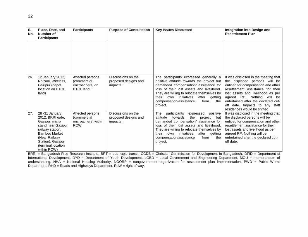
32
S. No.
Place, Date, and Number of Participants
Participants Purpose of Consultation Key Issues Discussed Integration into Design and Resettlement Plan
26. 12 January 2012, Nolzani, Wireless, Gazipur (depot location on BTCL land)
Affected persons (commercial encroachers) on BTCL land
Discussions on the proposed designs and impacts.
The participants expressed generally a positive attitude towards the project but demanded compensation/ assistance for loss of their lost assets and livelihood. They are willing to relocate themselves by their own initiatives after getting compensation/assistance from the project.
It was disclosed in the meeting that the displaced persons will be entitled for compensation and other resettlement assistance for their lost assets and livelihood as per agreed RP. Nothing will be entertained after the declared cut-off date. Impacts to any staff residences would be shifted
27. 28 -31 January 2012, BRRI gate, Gazipur, micro stand near Gazipur railway station, Bamboo Market (Near Railway Station), Gazipur (terminal location within ROW)
Affected persons (commercial encroachers) within ROW
Discussions on the proposed designs and impacts.
The participants expressed positive attitude towards the project but demanded compensation/ assistance for loss of their lost assets and livelihood. They are willing to relocate themselves by their own initiatives after getting compensation/assistance from the project.
It was disclosed in the meeting that the displaced persons will be entitled for compensation and other resettlement assistance for their lost assets and livelihood as per agreed RP. Nothing will be entertained after the declared cut-off date.
BRRI = Bangladesh Rice Research Institute, BRT = bus rapid transit, CCDB = Christian Commission for Development in Bangladesh, DFID = Department of International Development, DYD = Department of Youth Development, LGED = Local Government and Engineering Department, MOU = memorandum of understanding, NHA = National Housing Authority, NGORP = nongovernment organization for resettlement plan implementation, PWD = Public Works Department, RHD = Roads and Highways Department, RoW = right of way.
33
33
B. Information Disclosure
43. To provide for more transparency in planning and for further active involvement of displaced persons and other stakeholders, the project information will be disseminated through disclosure of resettlement planning documents. A summary resettlement plan will be translated and disclosed publicly in accessible locations shortly after government endorsement of the full draft. A resettlement information leaflet will be made available in local language (Bangla), and the same will be distributed to displaced persons.27 The project management unit (PMU) and project implementation units (PIU) will keep the displaced persons informed about the impacts, compensation, and assistances proposed for them and facilitate grievance redressal. The full resettlement plan will also be made available at a convenient place, especially the offices of Gazipur and Tongi Pourashavas, offices of the union parishads, and at other key accessible locations (such as market places) convenient to the displaced persons. A copy of the resettlement plan will be disclosed on the ADB website. C. Continued Consultation and Participation
44. Table 20 provides a consultation plan to be implemented by the NGORP during the implementation of the RP. With assistance from the nongovernment organization implementing the resettlement plan (NGORP) and engineering, procurement, construction management and supervision of the construction (EPCM) resettlement specialists, the PIUs will continue to arrange public consultations, and take the following steps:
(i) organize public meetings and appraise the communities about progress in implementation of resettlement, social, and environmental activities;
(ii) organize public meetings to inform the community about the compensation and assistance to be paid;
(iii) disclose all monitoring and evaluation reports of the resettlement components of the project in the same manner as that of the resettlement plan; and
(iv) make extra efforts to ensure that vulnerable groups understand the process and their entitlements.
27
A resettlement leaflet is a two to three-page document containing information on the cutoff date, compensation, entitlements, information on the grievance redress mechanism, and implementation arrangements for resettlement management for the project.
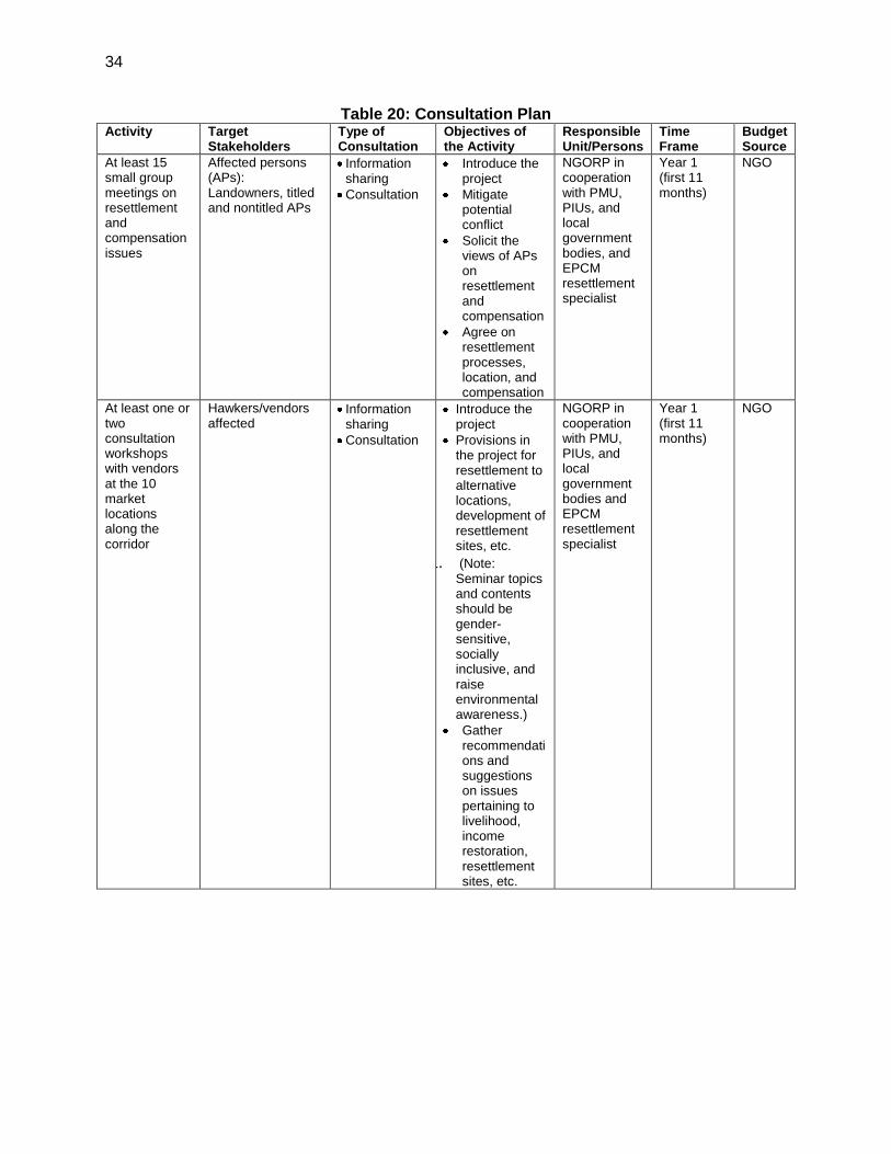
34
Table 20: Consultation Plan Activity Target
Stakeholders Type of Consultation
Objectives of the Activity
Responsible Unit/Persons
Time Frame
Budget Source
At least 15 small group meetings on resettlement and compensation issues
Affected persons (APs): Landowners, titled and nontitled APs
Information sharing
Consultation
Introduce the project
Mitigate potential conflict
Solicit the views of APs on resettlement and compensation
Agree on resettlement processes, location, and compensation
NGORP in cooperation with PMU, PIUs, and local government bodies, and EPCM resettlement specialist
Year 1 (first 11 months)
NGO
At least one or two consultation workshops with vendors at the 10 market locations along the corridor
Hawkers/vendors affected
Information sharing
Consultation
Introduce the project
Provisions in the project for resettlement to alternative locations, development of resettlement sites, etc.
1. (Note: Seminar topics and contents should be gender-sensitive, socially inclusive, and raise environmental awareness.)
Gather recommendations and suggestions on issues pertaining to livelihood, income restoration, resettlement sites, etc.
NGORP in cooperation with PMU, PIUs, and local government bodies and EPCM resettlement specialist
Year 1 (first 11 months)
NGO
35
35
V. GRIEVANCE REDRESS MECHANISMS
45. A project grievance redress mechanism (GRM) will be established to receive, evaluate, and facilitate the resolution of affected people’s concerns, complaints, and grievances about the social and environmental performance of the project. The GRM will aim to provide a timebound and transparent mechanism to voice and resolve social and environmental concerns linked to the project. The grievance redress mechanism and procedure is depicted in Figure 7 below. 46. The PMU and PIUs will make the public aware of the GRM through public awareness campaigns. The contact phone number of the respective PIUs and the PMU will serve as a hotline for complaints, and will be publicized through the media and placed on notice boards outside their offices and at construction sites. The project information leaflet will include information on the GRM, and will be widely disseminated throughout the corridor by the safeguards officers in the PMU and PIUs, with support from the NGORP and communications firm. Grievances can be filed in writing or by phone with any member of the PMU or PIU. 47. First tier of GRM. The PIU is the first tier of GRM, which offers the fastest and most accessible mechanism for resolution of grievances. The resettlement officer and environmental officer in each PIU will be designated as the key officers for grievance redress. Resolution of complaints will be done within 7 working days. At this stage, the resettlement officer and environmental officer will inform the environmental and social safeguards unit (ESSU) in the PMU (PMU ESSU) for additional support and guidance in grievance redress matters. Investigation of grievances will involve site visits and consultations with relevant parties (e.g., affected persons, contractors, traffic police, etc.). Grievances will be documented and personal details (name, address, date of complaint, etc.) will be included, unless anonymity is requested. A tracking number will be assigned to each grievance, including the following elements:
(i) initial grievance sheet (including the description of the grievance) with an acknowledgement of receipt given to the complainant when the complaint is registered;
(ii) grievance monitoring sheet with actions taken (investigation, corrective measures); and
(iii) closure sheet, one copy of which will be handed to the complainant after he/she has agreed to the resolution and signed off.
48. The updated register of grievances and complaints will be available to the public at the PIU office, construction sites, and other key public offices along the project corridor (offices of the pourashavas and union parishads). Should the grievance remain unresolved, it will be elevated to the second tier. 49. Second tier of GRM. The resettlement officer and environmental officer in each PIU will activate the second tier of GRM by referring the unresolved issue (with written documentation) to the PMU ESSU, who will pass unresolved complaints upward to the grievance redress committee (GRC). The GRC will be established by PMU ESSU before commencement of site works. The GRC will consist of the following persons: (i) project director; (ii) representatives of pourashava and union parishad; (iii) representative of the affected persons; (iv) representative of the local deputy commissioners’ office (land); and (v) representative of the Department of Environment (DOE) for environmental related grievances. A hearing will be called with the GRC, if necessary, where the affected person can present his or her concerns/issues. The process
36
will facilitate resolution through mediation. The local GRC will meet as necessary when there are grievances to be addressed. The local GRC will suggest corrective measures at the field level and assign clear responsibilities for implementing its decision within 15 working days. The contractor will have observer status on GRC. If unsatisfied with the decision, the existence of the GRC will not impede the complainant’s access to the government’s judicial or administrative remedies. 50. The functions of the local GRC are as follows: (i) resolve problems quickly and provide support to affected persons arising from various environmental issues, and including dust, noise, utilities, power and water supply, waste disposal, traffic interference, and public safety as well as social and resettlement related issues such as land acquisition (temporary or permanent); asset acquisition; and eligibility for entitlements, compensation, and assistance; (ii) reconfirm grievances of displaced persons, categorize and prioritize them, and aim to provide solutions within a month; and (iii) report to the aggrieved parties about developments regarding their grievances and decisions of the GRC. 51. The PMU ESSU officers will be responsible for processing and placing all papers before the GRC, maintaining a database of complaints, recording decisions, issuing minutes of the meetings, and monitoring to see that formal orders are issued and the decisions carried out.
37
37
Figure 7: Grievance Redress Mechanism
BBA = Bangladesh Bridges Authority, ESSU = environmental and safety specialist, LGED = Local Government Engineering Department, PIU = project implementation unit, RHD = Roads and Highway Department.
52. Third tier of GRM. In the event that a grievance cannot be resolved directly by the PIUs (first tier) or GRC (second tier), the affected person can seek alternative redress through the union parishad or ward committees or in the appropriate court of law. The PIUs or GRC will be kept informed by the district, municipal, or national authority. 53. The monitoring reports of the EMP and resettlement plan implementation will include the following aspects pertaining to progress on grievances: (i) number of cases registered with the GRC, level of jurisdiction (first, second, and third tiers), number of hearings held, decisions made, and the status of pending cases; and (ii) lists of cases in process and already decided
38
upon, which may be prepared with details such as name, ID with unique serial number, date of notice, date of application, date of hearing, decisions, remarks, actions taken to resolve issues, and status of grievance (i.e., open, closed, pending).
VI. LEGAL FRAMEWORK
54. This draft resettlement plan is prepared based on applicable legal and policy frameworks of the government, namely the Acquisition and Requisition of Immovable Property Ordinance 1982 (ARIPO), and ADB's Safeguards Policy Statement, (SPS). A comparison of each policy and gap filling analysis is in Appendix 2. In case of discrepancy between the policies of ADB and the government, the ADB policy will prevail. 55. The government's ARIPO policy does not cover project-displaced persons without titles or ownership record, such as informal settler/squatters, occupiers, and informal tenants and leaseholders (without document), and does not provide for replacement value of the property acquired. The ARIPO has no provision of resettlement assistance for restoration of livelihoods of displaced persons, except for the legal compensation for land and structures. Gaps between national law and ADB’s SPS are identified and bridging measures are included in the entitlement matrix for the project (Appendix 2). ADB’s SPS applies to all ADB-financed and/or ADB-administered sovereign projects and their components, regardless of the source of financing, including investment projects funded by a loan, a grant,or other means. In the event the project is cofinanced by other donors, the draft resettlement plan represents a single, uniform document agreed upon by all parties to ensure compliance with respective rules and policies.
VII. ENTITLEMENTS, ASSISTANCE, AND BENEFITS
56. The entitlement matrix (Table 21) has been designed to (i) cover all affected persons regardless of formal legal rights or recognizable claims to such land; (ii) compensate for lost assets regardless of formal legal rights or recognizable claims to lands; and (iii) restore or enhance the livelihoods of all categories of affected persons, particularly those who are vulnerable. Those affected by the project, in addition to compensation for land and other assets at full replacement cost as per market price, will receive additional measures in the form of assistance to ensure that those affected are not disadvantaged and receive full support during the resettlement process, and can regain (and even improve) their lost income and livelihoods. A. Eligibility
57. Eligibility to receive compensation and resettlement assistance will be limited by the cutoff date. The cutoff date will be as follows:
(i) Titleholders: The cutoff date for compensation under law (Ordinance II of 1982 with amendments) is the date of service of public notice under Section 3 or joint verification by deputy commissioner, Gazipur, whichever is earlier (the legal cutoff date).
(ii) Non-titleholders: The date of detailed census survey and inventory of losses conducted by the implementing NGORP on completion of the detailed designs will be considered the cutoff date for eligibility for any nontitled persons and hawkers impacted.
39
39
58. Any persons moving into the project area after the cutoff dates will not be entitled to compensation or any assistance from the project. However, any displaced persons not covered in the census enumerations can be enlisted with sufficient proof of existence at the said location before the cutoff date. Further, the video filming of the RoW, land, structures, and encroachments within the RoW, conducted by Roads and Highways Department (RHD) immediately after the finalization of the designs and with the support of the implementing NGORP, will provide the basis to control fraudulent claims and opportunistic encroachment onto the RoW. B. Entitlements
59. The entitlement matrix below summarizes the main types of losses and the corresponding entitlements in accordance with the government and ADB’s SPS. According to ADB’s SPS, the executing agency will ensure that no physical or economic displacement will occur until (i) compensation at full replacement cost has been paid to each displaced person for project components or sections that are ready to be constructed; (ii) other entitlements listed in the resettlement plan have been provided to displaced persons; and (iii) a comprehensive income and livelihood rehabilitation program, supported by an adequate budget, is in place to help displaced persons improve, or at least restore, their incomes and livelihoods. C. Benefits
60. The project will offer a number of tangible benefits to the community including (i) permanent and stable alternative vending locations for existing vendors and hawkers working within the RoW; (ii) safer pedestrian environment; (iii) improved accessibility to public transportation; (iv) reduced bus fares for employees of companies participating in the employer-based subsidy program; and (iv) employment opportunities during construction and operation.
40
Table 21: Entitlement Matrix S No
Type of Loss Application Entitled Person Entitlement Implementation Issues Responsible Agency
A. Land
A-1
Loss of land Homestead, commercial or industrial land
Owners with legal title
Cash compensation equivalent to replacement value Provision of stamp duty, land registration fee, capital gains tax, and value added tax incurred for replacement land Option to be compensated if remaining land is not viable Additional allowance equivalent to 2 months’ income at minimum wages for vulnerable households
PVAC will recommend replacement value. Deputy commissioner will pay cash compensation under law (CCL)
a for the land.
If replacement value is higher than CCL, the difference will be paid by RHD with assistance from NGORP. Vulnerable households to be identified during census surveys conducted as part of the updated resettlement plan
ESSU/PIUs/ NGORP/EPCM
A-2
Loss of land Homestead land, commercial or industrial land.
Tenants and leaseholders
60 days’ advance notice Compensation equivalent to 3 months of rental Additional allowance equivalent to 2 months’ income at minimum wages for vulnerable households
Landowners will reimburse tenants and leaseholders land rental deposit or unexpired lease. Vulnerable households to be identified during census surveys conducted as part of the updated resettlement plan
ESSU/PIUs/ NGORP/EPCM
A-3
Loss of land Khaas land, government lands (beyond RoW)
Displaced persons without legal titles (squatters)
60 days’ advance notice to shift from occupied land Option for residential site (for residential squatters) in the resettlement sites free of cost to the landless, vulnerable households Shifting allowance based on actual cost of moving (cost of van hire for a day)
Vulnerable households to be identified during census surveys conducted as part of the updated resettlement plan
ESSU/PIUs/ NGORP/EPCM
A-4
Loss of land Land within RoW used for storage for commercial purposes
Encroachers 60 days’ advance notice for shifting from the RoW One time shifting allowance based on actual cost of moving (cost of van hire for a day) Additional compensation equivalent to 3 months’ rental, at Tk 2,000
b per month for
Vulnerable households to be identified during census surveys conducted as part of the updated resettlement plan
ESSU/PIUs/ NGORP/EPCM
41
S No
Type of Loss Application Entitled Person Entitlement Implementation Issues Responsible Agency
vulnerable households
B. Structures and Assets
B-1
Loss of structure – partially affected, still viable for use
Commercial, industrial structures and other assets (e.g. boundary walls, gates, sheds, etc.)
Owners with legal title
Cash compensation for affected portion of the structure and other fixed assets at replacement cost Reconstruction/repair of the remaining structure by the preconstruction activities contractor Rights to salvage materials from affected structure Shifting allowance based on actual cost of moving (e.g., truck hire, equipment, etc.) Additional allowance equivalent to 2 months’ income at minimum wages for vulnerable households
Replacement costs will be as per the updated schedule of works for civil works, PWD. Vulnerable households to be identified during census surveys conducted as part of the updated resettlement plan Viability of partially identified structures to be determined by PWD in consultation with building owner
ESSU/PIUs/ NGORP/EPCM deputy commissioner
B-2
Loss of structure – fully affected or partially affected structures unviable for continued use
Commercial/industrial structures and other assets (e.g. boundary walls, gates, sheds, etc.)
Owners with legal title
Cash compensation for affected portion of the structure and other fixed assets at replacement cost Option to be compensated for entire structure if remaining structure is no longer viable. Rights to salvage materials from structure Provision of all taxes, registration costs, and other fees incurred for replacement structure. Shifting allowance based on actual cost of moving (e.g., truck hire, equipment, etc.) Additional allowance equivalent to 2 months’ income at minimum wages for vulnerable households
Replacement costs will be as per the updated schedule of works for civil works, PWD Vulnerable households to be identified during census surveys conducted as part of the updated resettlement plan Viability of partially identified structures to be determined in consultation with building owner
ESSU/PIUs/ NGORP/EPCM deputy commissioner
B-3
Loss of structure Commercial/industrial structures and other assets (e.g. shops in markets, boundary walls, gates, sheds, etc.)
Tenants and leaseholders
Cash compensation equivalent to replacement cost of structure (or part of structure) for the portions of the structure constructed by the tenant/leaseholder Reconstruction/repair of the remaining structure by the
Vulnerable households to be identified during census surveys conducted as part of the updated resettlement plan Structure owners will reimburse tenants and leaseholders rental deposit or unexpired lease.
ESSU/PIUs/ NGORP/EPCM
42
S No
Type of Loss Application Entitled Person Entitlement Implementation Issues Responsible Agency
preconstruction activities contractor Rights to salvage materials from structure for the portions of the structure constructed by the tenant/leaseholder Shifting allowance based on actual cost of moving (e.g., truck hire, equipment, etc.). Additional allowance equivalent to 2 months’ income at minimum wages for vulnerable households
B-4
Loss of structure Commercial/residential structures and other assets
Vendors and residential squatters on government Khaas/ private land
Cash compensation equivalent to replacement cost of structure erected by the displaced person Rights to salvage materials from structure Shifting allowance based on actual cost of moving (cost of van hire for a day) Additional allowance equivalent to 2 months’ income at minimum wages for vulnerable households
Vulnerable households to be identified during census surveys conducted as part of the updated resettlement plan
ESSU/PIUs/ NGORP/EPCM
B-5
Loss of structure Commercial structure and other assets (e.g. boundary walls, fences, sheds, etc.)
Encroachers Cash compensation equivalent to replacement cost of structure (or part of structure) constructed by the displaced person Reconstruction/repair of the remaining structure by the preconstruction activities contractor Rights to salvage materials from structure Shifting allowance based on actual cost of moving (e.g., truck hire, equipment, etc.) Additional allowance equivalent to 2 months’ income at minimum wages for vulnerable households
Vulnerable households to be identified during census surveys conducted as part of the updated resettlement plan
ESSU/PIUs/ NGORP/EPCM
C. Livelihood
43
S No
Type of Loss Application Entitled Person Entitlement Implementation Issues Responsible Agency
C-1
Loss of livelihood Permanent loss of livelihood/ source of income
Category I: Vendors in front of organized markets/ shopping complexes
Option I Alternative shop/stall of equivalent size at the vendors market developed, on rental/lease basis Option II One-time assistance for lost income based on 3 months’ lost income at minimum wage rates Enrolment in vocational training courses, based on assessment of skill sets Grant of maximum of Tk. 20,000
c
towards procurement of equipment towards alternative livelihood options on completion of training courses Organizational/logistical support to establish displaced persons in alternative income generation activity In either case: Additional allowance equivalent to 2 months’ income at minimum wages for vulnerable households Consideration for project employment during construction
Development of vendor market at the alternative location to be completed prior to the initiation of civil works, at the particular stretch of the BRT corridor. NGORP, based on assessment of skill sets and interests of the displaced persons, will identify suitable opportunities for training. Training allowance will be paid directly to the training institute. The grant for equipment and tools will be paid based on substantiation of training course completion (e.g., certificate of completion). In the event of disruption to livelihood, pourashava/union parishad will provide alternative
location to carry out business during the period of disruption, through identification of list of stretches/locations where the vendors are allowed to carry out businesses. To ensure affordability to the vendors, the rent for the alternate location will be fixed at less than or equal to the current rent expenditures incurred at the existing location. NGO, in consultation with the displaced persons and pourashavas/union parishads, will arrive at the rent during resettlement plan implementation.
ESSU/PIUs/ NGORP/EPCM
C-2
Loss of livelihood Permanent loss of livelihood/ source of income
Category II: Vendors at the existing bus stop locations
Option I Alternative shop/stall of equivalent size at the underpass location to be developed at the BRT station, on rental/ lease
Pourashava/union parishad to provide alternative location to carry out business during the period of disruption, through identification of list of
ESSU/PIUs/ NGORP/EPCM
44
S No
Type of Loss Application Entitled Person Entitlement Implementation Issues Responsible Agency
basis One-time assistance for lost income based on 3 months’ income at minimum wage rates Option II One time assistance for lost income based on 3 months’ lost income at minimum wage rates Enrollment in vocational training courses, based on assessment of skill sets Grant of maximum of Tk. 20,000 for procurement of equipment towards alternative livelihood options Organizational/logistical support to establish displaced persons in alternative income generation activity In either case: Identification of alternative stretch to carry on business during the period of disruption Additional allowance equivalent to 2 months’ income at minimum wages for vulnerable households Consideration for project employment
stretches/locations where the vendors are allowed to carry on business. Training allowance to be paid directly to the training institute To ensure affordability to the vendors, the rent for the alternate location will be fixed at less than or equal to the current rents/expenditures incurred at the existing location. NGO, in consultation with the displaced persons and pourashavas/union parishads, will arrive at the rent during resettlement plan implementation.
C-3
Loss of livelihood Permanent loss of livelihood/ source of income
Category III: Vendors at major activity nodes or land uses and Category IV: Vendors at isolated locations along the corridor
Option I Alternate location for vendors along the feeder roads, or at the vendors market developed, on rental/lease basis One-time assistance for lost income based on 3 months’ lost income at minimum wage rates (in the event of disruption of livelihood) Option II One-time assistance for lost income based on 3 months’
To ensure affordability to the vendors, the rent for the alternate location will be fixed at less than or equal to the current rents/expenditures incurred at the existing location. NGO, in consultation with the displaced persons and pourashavas/union parishads, will arrive at the rents during resettlement plan implementation. Vulnerable households to be
ESSU/PIUs/ NGORP/EPCM
45
S No
Type of Loss Application Entitled Person Entitlement Implementation Issues Responsible Agency
income at minimum wage rates Enrollment in vocational training courses, based on assessment of skill sets Grant of maximum of Tk. 20,000 for procurement of equipment towards alternative livelihood options Organizational/logistical support to establish displaced persons in alternative income generation activity In either case: Additional allowance equivalent to 2 months’ income at minimum wages for vulnerable households Consideration for project employment
identified during census surveys conducted as part of the updated resettlement plan Training allowance to be paid directly to the training institute
D. Impacts on public infrastructure, common property resources
D-1
Loss of public infrastructure/ common property resources, and government buildings
Infrastructure (electricity, water supply lines, telephone lines, water tanks, etc.), religious sites, government buildings, etc.
Community/ government agencies
60 days’ advance notice to community/relevant government agencies Cash compensation at replacement cost to respective agencies/communities Reconstruction/repair of the affected assets/utilities by the preconstruction activities contractor
Consultation with community and government for alternate site for reconstruction
PIU
E. Temporary impacts
E-1
Temporary loss of land
Land temporarily acquired for the project
Owners with legal title, tenants, leaseholders
60 days’ advance notice Rental assistance for the period for which the land is temporarily required to the owners with legal title Restoration of affected land
Agreement with the landowner will be worked out defining the rental assistance, and will include preoccupation photographs of site, which will form basis to assess extent of restoration to be carried out.
ESSU/PIUs/ NGORP/EPCM
E-2
Temporary loss of access
Temporary loss of access to land, structure, utilities, common property resource
Owners with legal title, tenants, leaseholders,
60 days’ advance notice Provision of temporary access and relocation where possible
Extent of loss of access to be worked out based on a transect walk along the networks and
Contractor to restore access ESSU/PIUs/
46
S No
Type of Loss Application Entitled Person Entitlement Implementation Issues Responsible Agency
encroachers, squatters
Restoration of access to the land, structure, utilities
project locations NGORP/EPCM
E-3
Temporary loss of livelihood
Temporary loss of livelihood/source of income along corridor, feeder roads
Business owners, tenants, leaseholder s, employees, hawkers/ vendors
60 days’ advance notice Provision of alternative sites for continued economic activity, if required One-time assistance for lost income for the actual period of disruption at income/tax statement, minimum wage rates, or based on actual income (whichever is higher), verified through incomes of comparable businesses in the area
Alternative locations for continued economic activities, for hawkers and vendors to be worked out in consultation with the pourashavas and displaced persons Verification of the income data based on the tax payment In the absence of authentic income statements as proof, the unit price will be decided mutually between the displaced person and the PIU during the survey, based on co-relation of income, expenditure., and savings data. Vulnerable households to be identified during census surveys conducted as part of the updated resettlement plan
ESSU/PIUs/ NGORP/EPCM
F. Vulnerable households
F-1
Impacts on vulnerable displaced persons
All impacts Vulnerable displaced persons
Land-for-land option will be a guaranteed option for vulnerable households with title. Additional allowance equivalent to 2 months’ income at minimum wages for vulnerable households
Vulnerable households to be identified during census surveys conducted as part of the updated resettlement plan During the relocation of vendors, disbursement of assistance, and compensation, priority will be given to vulnerable persons. For example, women vendors will be given priority at proposed new locations.
ESSU/PIUs/ NGORP/EPCM
G. Unforeseen losses
G-1
Any other loss not identified
As identified As identified Unanticipated involuntary impacts will be documented and mitigation measures worked out
The entitlements will be approved by the RHD, and compliance to the SPS assessed
ESSU/PIUs/ NGORP/EPCM
47
S No
Type of Loss Application Entitled Person Entitlement Implementation Issues Responsible Agency
in compliance with the government’s and ADB’s SPS (2009).
by ADB prior to finalization.
ADB = Asian Development Bank, BRT = bus rapid transit, CCL = cash compensation under law, EPCM = engineering, procurement, construction management and supervision of the construction, ESSU = environmental and safety specialist, NGO = nongovernment organization, NGORP = nongovernment organization for resettlement plan implementation, PIU = project implementation unit, PVAC = property valuation advisory committee, PWD = Public Works Department, RHD = Roads and Highways Department, RoW = right of way.
a DC will determine the market price of land averaging last 12 months’ sale prices (from the date of service of notice u/s 3) as per registration deeds in affected mouzas
for each type of land obtained from respective subregistrar’s offices. For all private land, the market price will be enhanced by 50% for compensation under law (CCL). b
Tk. 2,000 is the prevailing rent for hiring a space of about 15 m2 in the vicinity of the corridor for storage purposes (based on surveys and consultations).
c Based on consultations with DYD, the costs of procurement of various assets (as the sewing machine, equipment for workshop, and setting up of small home -ased units)
average between Tk. 15,000 and Tk. 27,000. Accordingly, an average of Tk. 20,000 per displaced persons has been considered for the project towards procurement of income generating assets. d
Disruption of businesses and livelihood is envisaged on the partially impacted commercial structures during the demolition, reconstruction, and repair of the structures impacted. The reconstruction of the structure is to be carried out by the preconstruction activities contractor, and the disruption is expected to be for a period of 1 month. Note: The PIU will receive guidance and assistance from the resettlement specialist on the consultant team to ensure all compensation is provided before displacement occurs and that other entitlements are provided in a timely manner. Construction activity can begin on sections where compensation is paid. Vulnerable households may include female-headed households, disable-headed households, and below poverty line (BPL) households.
48
D. Determination of Compensation
61. Negotiated land settlement. A negotiated settlement will offer adequate and fair price for land and/or other assets. The borrower/client will ensure that any negotiations with displaced persons openly address the risks of asymmetry of information and bargaining power of the parties involved in such transactions. For this purpose, the borrower/client will engage an independent external party28 to document the negotiation and settlement processes. If negotiated land settlement is not pursued, the processes described below are other options for determining replacement cost for land and assets. 62. Replacement value of land. All lands proposed to be acquired under this project will be compensated as per government and ADB policies (i.e., replacement cost). The calculation of full replacement cost will be based on the following elements: (i) fair market value; (ii) transaction costs; (iii) interest accrued; (iv) transitional and restoration costs; and (v) other applicable payments. The EPCM consultants will prepare the government required land acquisition plan (LAP)29 for all lands to be acquired in the project. The LAP will be submitted to the Ministry of Land (MOL), which will then process the application through the respective deputy commissioners. The deputy commissioner will generate the sale deed record based on the past 12 months’ transactions. The deputy commissioner will also add a 50% premium to this rate as per the provisions of Acquisition and Requisition of Immovable Property Ordinance (ARIPO). Based on these rates, the deputy commissioner will derive a price which will be the current market rate. Additionally, the cost for tax and stamp duties will be added as derived by the deputy commissioner in consultation with the displaced person, which will finally be considered as the replacement cost. If the displaced person is not satisfied with this rate, he/she can raise the grievance through the project-specific grievance redress mechanism. The NGORP will facilitate this process. 63. Replacement value of structures. The compensation for immovable properties will be determined on the basis of replacement cost as on date without depreciation, based on the most updated Schedule of Rates by the Public Works Department (PWD), Government of Bangladesh. The replacement costs of structures for the resettlement plan budget have been arrived at based on the schedule of rates for civil works (12th edition) by the PWD (effective from 1 June 2008). Updating to current rates has been done through an annual increase of 5% on the 2008 base rates.30 64. The basis for the determination of the structure costs for this draft resettlement plan is provided in Table 21.
28
The independent external monitor is defined as someone who is outside the day-to-day activities of the project, and could include for example a professor at a local university, representative of nongovernment organization (NGO), etc. The independent monitor will document the observations of the negotiation process and submit the same to the borrower/client. The borrower/client, on request from ADB, shall furnish the details of the documentation of the negotiation process.
29 The LAP will include (i) a site plan overlaying the cadastral map to define the area and parcels to be acquired, (ii) a detailed area description specifying the total area of the affected land parcel and the area to be acquired, and (iii) purpose of land acquisition.
30 The unit rates for replacement costs for structures will be updated during the finalization of the resettlement plan based on the recent schedule of rates by the PED, Government of Bangladesh.
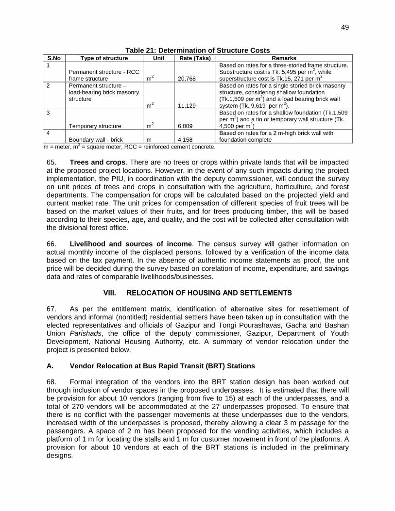
49
49
Table 21: Determination of Structure Costs S.No Type of structure Unit Rate (Taka) Remarks
1 Permanent structure - RCC frame structure m
2 20,768
Based on rates for a three-storied frame structure. Substructure cost is Tk. 5,495 per m
2, while
superstructure cost is Tk.15, 271 per m2
2 Permanent structure – load-bearing brick masonry structure m
2 11,129
Based on rates for a single storied brick masonry structure, considering shallow foundation (Tk.1,509 per m
2) and a load bearing brick wall
system (Tk. 9,619 per m2).
3
Temporary structure m2 6,009
Based on rates for a shallow foundation (Tk.1,509 per m
2) and a tin or temporary wall structure (Tk.
4,500 per m2)
4 Boundary wall - brick m 4,158
Based on rates for a 2 m-high brick wall with foundation complete
m = meter, m2 = square meter, RCC = reinforced cement concrete.
65. Trees and crops. There are no trees or crops within private lands that will be impacted at the proposed project locations. However, in the event of any such impacts during the project implementation, the PIU, in coordination with the deputy commissioner, will conduct the survey on unit prices of trees and crops in consultation with the agriculture, horticulture, and forest departments. The compensation for crops will be calculated based on the projected yield and current market rate. The unit prices for compensation of different species of fruit trees will be based on the market values of their fruits, and for trees producing timber, this will be based according to their species, age, and quality, and the cost will be collected after consultation with the divisional forest office. 66. Livelihood and sources of income. The census survey will gather information on actual monthly income of the displaced persons, followed by a verification of the income data based on the tax payment. In the absence of authentic income statements as proof, the unit price will be decided during the survey based on corelation of income, expenditure, and savings data and rates of comparable livelihoods/businesses.
VIII. RELOCATION OF HOUSING AND SETTLEMENTS
67. As per the entitlement matrix, identification of alternative sites for resettlement of vendors and informal (nontitled) residential settlers have been taken up in consultation with the elected representatives and officials of Gazipur and Tongi Pourashavas, Gacha and Bashan Union Parishads, the office of the deputy commissioner, Gazipur, Department of Youth Development, National Housing Authority, etc. A summary of vendor relocation under the project is presented below. A. Vendor Relocation at Bus Rapid Transit (BRT) Stations
68. Formal integration of the vendors into the BRT station design has been worked out through inclusion of vendor spaces in the proposed underpasses. It is estimated that there will be provision for about 10 vendors (ranging from five to 15) at each of the underpasses, and a total of 270 vendors will be accommodated at the 27 underpasses proposed. To ensure that there is no conflict with the passenger movements at these underpasses due to the vendors, increased width of the underpasses is proposed, thereby allowing a clear 3 m passage for the passengers. A space of 2 m has been proposed for the vending activities, which includes a platform of 1 m for locating the stalls and 1 m for customer movement in front of the platforms. A provision for about 10 vendors at each of the BRT stations is included in the preliminary designs.
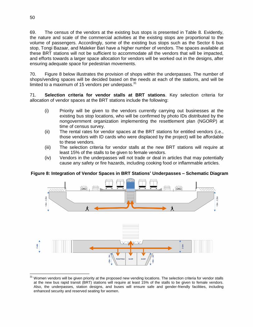
50
69. The census of the vendors at the existing bus stops is presented in Table 8. Evidently, the nature and scale of the commercial activities at the existing stops are proportional to the volume of passengers. Accordingly, some of the existing bus stops such as the Sector 6 bus stop, Tongi Bazaar, and Maleker Bari have a higher number of vendors. The spaces available at these BRT stations will not be sufficient to accommodate all the vendors that will be impacted, and efforts towards a larger space allocation for vendors will be worked out in the designs, after ensuring adequate space for pedestrian movements. 70. Figure 8 below illustrates the provision of shops within the underpasses. The number of shops/vending spaces will be decided based on the needs at each of the stations, and will be limited to a maximum of 15 vendors per underpass.31 71. Selection criteria for vendor stalls at BRT stations. Key selection criteria for allocation of vendor spaces at the BRT stations include the following:
(i) Priority will be given to the vendors currently carrying out businesses at the existing bus stop locations, who will be confirmed by photo IDs distributed by the nongovernment organization implementing the resettlement plan (NGORP) at time of census survey.
(ii) The rental rates for vendor spaces at the BRT stations for entitled vendors (i.e., those vendors with ID cards who were displaced by the project) will be affordable to these vendors.
(iii) The selection criteria for vendor stalls at the new BRT stations will require at least 15% of the stalls to be given to female vendors.
(iv) Vendors in the underpasses will not trade or deal in articles that may potentially cause any safety or fire hazards, including cooking food or inflammable articles.
Figure 8: Integration of Vendor Spaces in BRT Stations’ Underpasses – Schematic Diagram
31
Women vendors will be given priority at the proposed new vending locations. The selection criteria for vendor stalls at the new bus rapid transit (BRT) stations will require at least 15% of the stalls to be given to female vendors. Also, the underpasses, station designs, and buses will ensure safe and gender-friendly facilities, including enhanced security and reserved seating for women.
51
51
B. Vendor Markets Relocation
72. Consultations with vendors at each of the 10 existing market locations (category I vendors) were undertaken, in addition to the census of the vendors. Based on these consultations, discussions with the union parishads and pourashavas identified alternative relocation sites for the vendor groups. A summary of the consultations with the vendors regarding their relocation is presented in Appendix 4. Figure 9 presents the existing locations of vendor markets to be impacted and the proposed alternative sites for relocation of vendors. For all the 10 locations, potential Khaas lands/government lands have been identified for development of relocation sites where alternative markets would be viable, given the access to pedestrian and customer traffic. Consultations with the office of the deputy commissioner Gazipur have been carried out on siting of relocation sites within government lands. The process of confirmation of the identified sites or alternate suitable Khaas lands/government lands is underway. Therefore, private lands acquisition is not envisaged for the relocation sites. However, for costing purposes, one plot of private land of 0.12 ha to accommodate vendors at Borobari Bazaar is included, wherein consultations with the landowner have been carried out and consent for the development of his plot of land for the vendor relocation has been obtained. These sites will be further examined by the office of the deputy commissioner, and suitable land confirmed for relocation in consultation with the local leaders and community representatives. 73. At each of the proposed vendor market relocation sites to be developed, the following improvements will be carried out in addition to the development of the stalls for the vendors: (i) provision of access to the site, including appropriate pathways; (ii) leveling of the site and ensuring adequate drainage; and (iii) water and sanitation facilities, apart from lighting of the vendor market. C. Nontitled Residential Relocation
74. The identification of Khaas lands for the relocation of 46 nontitled residential settlers on the northern bank of the Tongi Bridge requires confirmation by the local government and the deputy commissioner, Gazipur, who supported finding an alternative location for these people. This is an ongoing process, which will be confirmed during project implementation with the assistance of the NGORP and EPCM resettlement specialists.
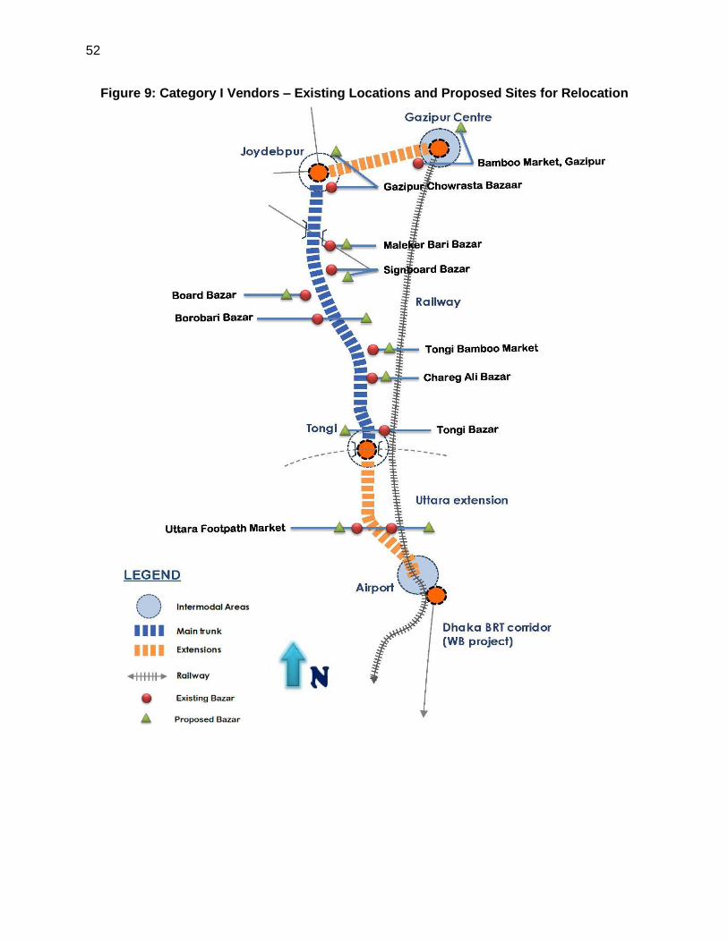
52
Figure 9: Category I Vendors – Existing Locations and Proposed Sites for Relocation

53
Table 22: Identification of Alternative Sites for Vendor Relocation S. No
Market Chainage /Direction
Number of Vendors Impacted
Potential Alternative Location
Space Available, Distance from Present Site
Ownership Potential Number of Vendors to be Accommodated
Remarks
1 Uttara Footpath Market
1.000–2.300 (left)
120 1. Along feeder roads in Uttara, service roads at locations where the RoW is over 50 m, and the open space behind the markets 2. Dakhin Khan near embankment
1. Spaces along the feeder roads and at sides of service road are available, and the vendors usually occupy the vacant spaces when clearing of RoW by police is carried out. 2. More than 4.04 ha of land available
Land within the road RoW LGED land
120 Vendors preferred relocating to feeder roads and the sides of the service road, and would prefer doing business within the Uttara urban area, and do not want to be relocated.
2 Tongi Bazar
3.700–4.000 (right)
124 1. Mayor of pourashava, market committee, and vendors prefer the vacant RHD land beside corridor for relocation.
About 0.20 ha, within 50 m of the corridor
RHD land 100 The confirmation of the land to be done with the MIS division of the RHD. In the event of non-availability, alternative Khaas land to be
identified
3 Chareg Ali Bazaar, Tongi
6.500–6.850 (right)
110 Possible siting of the vendor markets in a small portion of the TIC field belonging to the Department of Telecommunications and the Vishwa Estema ground
0.12 ha, within 50 m from the corridor. The identified land is over 2 ha and is vacant, and about 0.12 ha of these lands can be used for the development of vendor markets.
Government land
100 Confirmation of the availability of these lands for the development of vendor markets is to be obtained from the respective agencies (Telecommunications Ministry and the Tongi Pourashava). In addition to the above sites, the identification of Khaas lands in the vicinity of the market is underway.
4 Bamboo Market, Tongi
7.675–7.775 (right)
10 Vendors expressed that they would prefer to relocate themselves in the empty lowlands behind the existing bamboo
Lands of about 0.12 ha abutting the corridor
Khaas lands 10 Confirmation from the office of the deputy commissioner permitting the bamboo market to shift behind is being obtained.
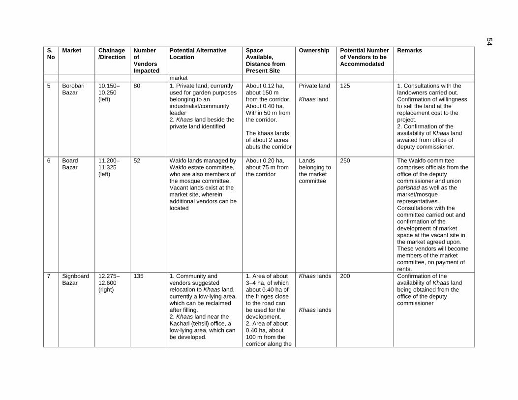
54
S. No
Market Chainage /Direction
Number of Vendors Impacted
Potential Alternative Location
Space Available, Distance from Present Site
Ownership Potential Number of Vendors to be Accommodated
Remarks
market
5 Borobari Bazar
10.150–10.250 (left)
80 1. Private land, currently used for garden purposes belonging to an industrialist/community leader 2. Khaas land beside the private land identified
About 0.12 ha, about 150 m from the corridor. About 0.40 ha. Within 50 m from the corridor. The khaas lands of about 2 acres abuts the corridor
Private land Khaas land
125
1. Consultations with the landowners carried out. Confirmation of willingness to sell the land at the replacement cost to the project. 2. Confirmation of the availability of Khaas land awaited from office of deputy commissioner.
6 Board Bazar
11.200–11.325 (left)
52 Wakfo lands managed by Wakfo estate committee, who are also members of the mosque committee. Vacant lands exist at the market site, wherein additional vendors can be located
About 0.20 ha, about 75 m from the corridor
Lands belonging to the market committee
250 The Wakfo committee comprises officials from the office of the deputy commissioner and union parishad as well as the market/mosque representatives. Consultations with the committee carried out and confirmation of the development of market space at the vacant site in the market agreed upon. These vendors will become members of the market committee, on payment of rents.
7 Signboard Bazar
12.275–12.600 (right)
135 1. Community and vendors suggested relocation to Khaas land, currently a low-lying area, which can be reclaimed after filling. 2. Khaas land near the Kachari (tehsil) office, a low-lying area, which can be developed.
1. Area of about 3–4 ha, of which about 0.40 ha of the fringes close to the road can be used for the development. 2. Area of about 0.40 ha, about 100 m from the corridor along the
Khaas lands
Khaas lands
200
Confirmation of the availability of Khaas land being obtained from the office of the deputy commissioner

55
S. No
Market Chainage /Direction
Number of Vendors Impacted
Potential Alternative Location
Space Available, Distance from Present Site
Ownership Potential Number of Vendors to be Accommodated
Remarks
Malekerbari Road
8 Maleker Bari
13.675 – 13.725 (R)
43 200
9 Gazipur Chowrasta Bazaar
16.100–16.200 (right)
63 1. Identification of Khaas lands in the vicinity of the corridor being carried out 2. RHD lands along the corridor currently used as a nursery
Site of 0.24 ha. Located 200 m north of the Joydebpur Chowrasta, along the Mymensingh Road
RHD lands 100 Confirmation of the availability of the Khaas land being obtained from the office of the deputy commissioner. Confirmation of availability of RHD lands to be obtained from the MIS division of the RHD.
10 Bamboo Market, Gazipur
20.100–20.200 (right)
12 1. Pourashava in the process of identifying government lands 2. Khaas lands between the road and the lands belonging to the railways at Gazipur railway station
Lands of over 2 ha, of which about 0.12 ha will be required.
Khaas lands 12 Confirmation of availability of the khaas lands being
obtained
m = meter, LGED = Local Government and Engineering Department, RHD = Roads and Highways Department, RoW = right of way.
56
IX. INCOME RESTORATION AND REHABILITATION
75. The following impacts to income and livelihood will be experienced:
(i) loss of livelihood sources due to relocation of 1,704 hawkers operating within the right of way (RoW);
(ii) loss of income to 966 wage earners/workers in the commercial structures partially impacted; and,
(iii) loss of business and income due to disruption during the construction period for the 436 commercial structures partially impacted.
76. The entitlement matrix contains provisions for alternative income generating/skill development and other enabling strategies through which displaced persons can either continue their previous occupation, start new ventures, or undertake an alternative occupation. The basic objective behind the income and livelihood restoration activities and schemes is to restore the economic status of the affected persons enjoyed prior to the project, in line with the requirements of ADB’s SPS. As a result, in addition to providing compensation and resettlement benefits, appropriate support measures have been included for income and livelihood restoration of those affected. A. Income and Livelihood Restoration Measures
77. All the persons losing their livelihood or places of income generation as a result of the project will be supported with short-term income and livelihood restoration assistance for subsistence. These short-term income and livelihood restoration measures will be for immediate assistance, and include the following measures:
(i) compensation for land and other lost assets, paid in full prior to relocation; (ii) temporary or short-term employment in construction activities at the resettlement
or project construction sites; and (iii) special assistance, appropriate to vulnerable groups such as women, the elderly,
and the disabled. 78. In addition to the above, the resettlement plan will provide the following short-term assistance for income and livelihood restoration with support from the nongovernment organization implementing the resettlement plan (NGORP).
1. Cash Allowance to Support Lost Income
79. Displaced persons will be eligible for assistance for loss of employment/workdays (for wage earners) owing to dislocation and relocation. Assistance for lost income based on 3 months’ minimum wage rates to displaced vendors will be paid. For temporary disruption to income during the demolition and reconstruction of the partially affected commercial structure, the owners as well as the workers will receive one-time assistance for lost income for the actual period of disruption at income/tax statement, minimum wage rates, or based on actual income (whichever is higher), verified through incomes of comparable businesses in the area.
57
2. Assistance to Reestablish Businesses
80. Commercial spaces will be allotted to vendors in project-sponsored market/vendor relocation sites on rental basis to reestablish affected businesses. The rent for the relocation site will be worked out by the NGORP, and will consider what the vendors can afford.
3. Additional Assistance to Vulnerable Groups
81. The following categories of displaced persons have been identified as vulnerable groups in the project: female-headed, elderly-headed, disabled-headed, and BPL households. A total of 318 households have been identified as vulnerable households based on the census of the displaced persons. In addition to the provisions in the entitlement matrix for compensation of loss of assets and livelihood, additional allowance equivalent to 2 months’ income at minimum wages to each of these vulnerable groups and affected households is included for improvement of their socioeconomic status. Vulnerable persons will be given priority in unskilled labor opportunities under the project. ID cards will verify vulnerability status, and the NGORP will present the list of vulnerable persons to contractors.
4. Employment Benefits during Project Implementation
82. The project implementation unit (PIU) will make provision in the contracts for employment of qualified displaced persons and their dependents in the recruitment of local labor, including affected women. Local people whose livelihood is impacted by the project will get preference in jobs associated with the project construction. The jobs, in the semi-skilled and unskilled category, will be offered to the displaced persons on a preferential basis. Employment in the project construction will act as an added source of income in the income and livelihood restoration processes of displaced persons. 83. The NGORP implementing the resettlement plan will prepare a list of all capable workers, separately including the women workers (from among the affected households) and providing the same to local contractors through the PIU. The supervision consultants will also monitor this through monthly statements of number of individuals employed from the affected people.
5. Capacity Building and Skill Development
84. Consultations with the director (planning) of the Department of Youth Development (DYD) were carried out to discuss possible mechanisms for DYD participation in the project on capacity building/skill development for entitled persons. The project management unit (PMU) will work out a memorandum of understanding (MOU) with the DYD towards vocational/skill development training for the displaced persons in the project. The identification of the skill sets and the selection of training programs appropriate to each of the displaced persons will be done through a needs assessment study carried out by the implementing NGORP at the time of detailed census. The costs for training the displaced persons shall be borne by the project, and are included in the resettlement plan costs. It has been agreed that the age limit for the enrolment in the courses will be expanded to 55, as against the usual beneficiary age group of 18-35 for the programs carried out by the DYD. The training will be imparted at the Youth Training Centre, Department of Youth Development Dairy Farm, Savar, Dhaka. Appendix 8 presents the list of training programs offered of relevance to the displaced persons.
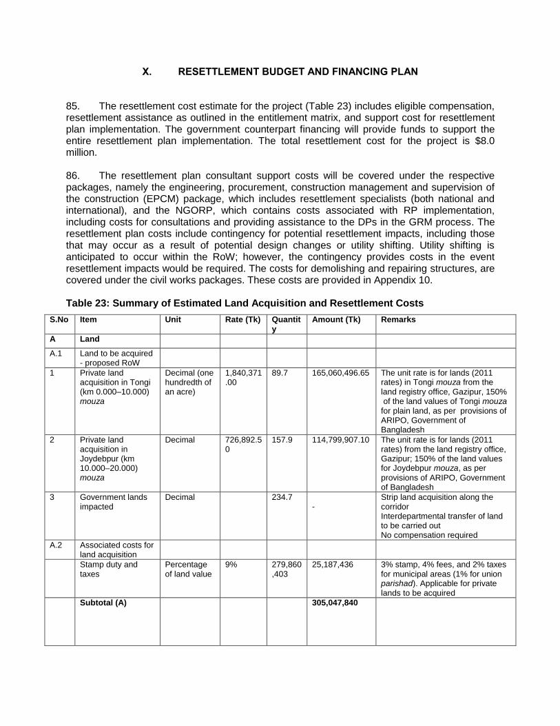
58
X. RESETTLEMENT BUDGET AND FINANCING PLAN
85. The resettlement cost estimate for the project (Table 23) includes eligible compensation, resettlement assistance as outlined in the entitlement matrix, and support cost for resettlement plan implementation. The government counterpart financing will provide funds to support the entire resettlement plan implementation. The total resettlement cost for the project is $8.0 million. 86. The resettlement plan consultant support costs will be covered under the respective packages, namely the engineering, procurement, construction management and supervision of the construction (EPCM) package, which includes resettlement specialists (both national and international), and the NGORP, which contains costs associated with RP implementation, including costs for consultations and providing assistance to the DPs in the GRM process. The resettlement plan costs include contingency for potential resettlement impacts, including those that may occur as a result of potential design changes or utility shifting. Utility shifting is anticipated to occur within the RoW; however, the contingency provides costs in the event resettlement impacts would be required. The costs for demolishing and repairing structures, are covered under the civil works packages. These costs are provided in Appendix 10. Table 23: Summary of Estimated Land Acquisition and Resettlement Costs
S.No Item Unit Rate (Tk) Quantity
Amount (Tk) Remarks
A Land
A.1 Land to be acquired - proposed RoW
1 Private land acquisition in Tongi (km 0.000–10.000) mouza
Decimal (one hundredth of an acre)
1,840,371.00
89.7 165,060,496.65 The unit rate is for lands (2011 rates) in Tongi mouza from the land registry office, Gazipur, 150% of the land values of Tongi mouza for plain land, as per provisions of ARIPO, Government of Bangladesh
2 Private land acquisition in Joydebpur (km 10.000–20.000) mouza
Decimal 726,892.50
157.9 114,799,907.10 The unit rate is for lands (2011 rates) from the land registry office, Gazipur; 150% of the land values for Joydebpur mouza, as per
provisions of ARIPO, Government of Bangladesh
3 Government lands impacted
Decimal 234.7 -
Strip land acquisition along the corridor Interdepartmental transfer of land to be carried out No compensation required
A.2 Associated costs for land acquisition
Stamp duty and taxes
Percentage of land value
9% 279,860,403
25,187,436 3% stamp, 4% fees, and 2% taxes for municipal areas (1% for union parishad). Applicable for private lands to be acquired
Subtotal (A) 305,047,840
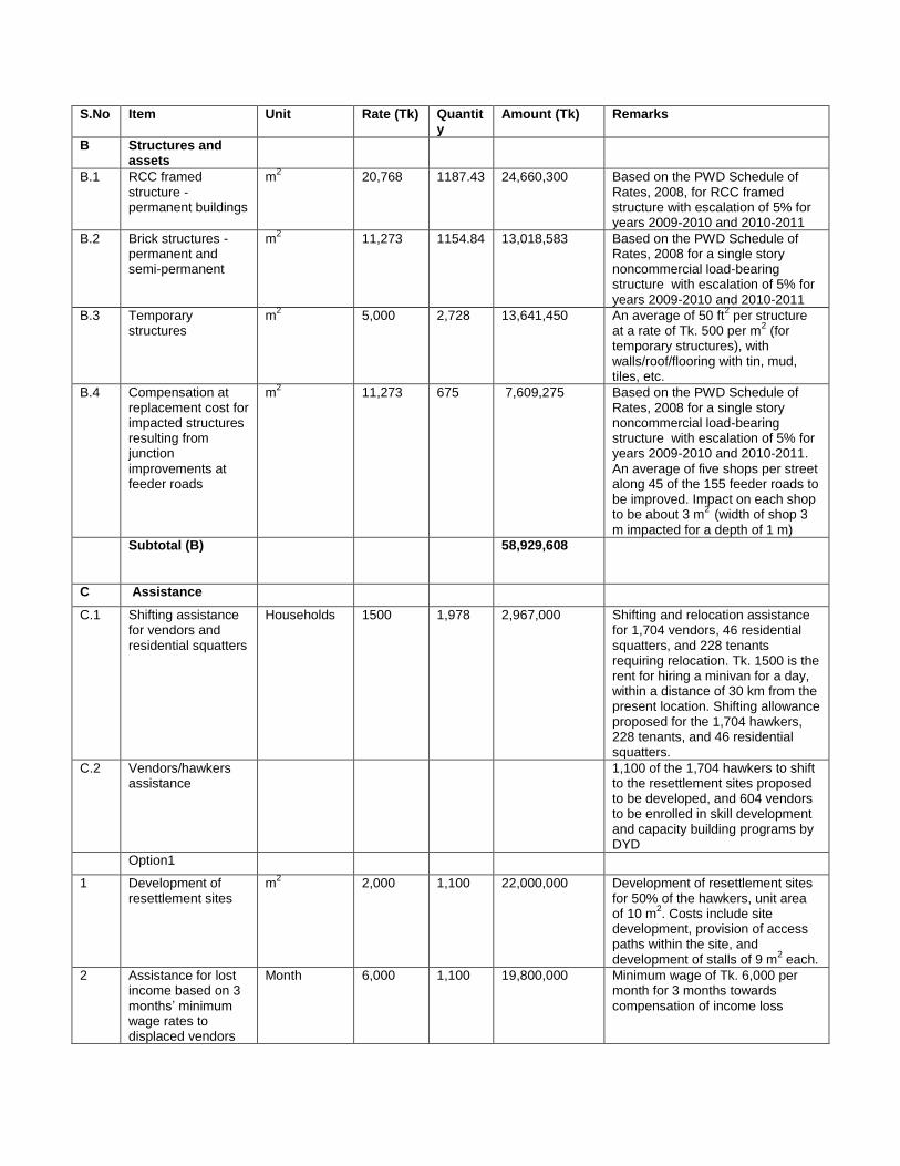
59
S.No Item Unit Rate (Tk) Quantity
Amount (Tk) Remarks
B Structures and assets
B.1 RCC framed structure - permanent buildings
m2 20,768 1187.43 24,660,300 Based on the PWD Schedule of
Rates, 2008, for RCC framed structure with escalation of 5% for years 2009-2010 and 2010-2011
B.2 Brick structures - permanent and semi-permanent
m2 11,273 1154.84 13,018,583 Based on the PWD Schedule of
Rates, 2008 for a single story noncommercial load-bearing structure with escalation of 5% for years 2009-2010 and 2010-2011
B.3 Temporary structures
m2 5,000 2,728 13,641,450 An average of 50 ft
2 per structure
at a rate of Tk. 500 per m2 (for
temporary structures), with walls/roof/flooring with tin, mud, tiles, etc.
B.4 Compensation at replacement cost for impacted structures resulting from junction improvements at feeder roads
m2 11,273 675 7,609,275 Based on the PWD Schedule of
Rates, 2008 for a single story noncommercial load-bearing structure with escalation of 5% for years 2009-2010 and 2010-2011. An average of five shops per street along 45 of the 155 feeder roads to be improved. Impact on each shop to be about 3 m
2 (width of shop 3
m impacted for a depth of 1 m)
Subtotal (B) 58,929,608
C Assistance
C.1 Shifting assistance for vendors and residential squatters
Households 1500 1,978 2,967,000 Shifting and relocation assistance for 1,704 vendors, 46 residential squatters, and 228 tenants requiring relocation. Tk. 1500 is the rent for hiring a minivan for a day, within a distance of 30 km from the present location. Shifting allowance proposed for the 1,704 hawkers, 228 tenants, and 46 residential squatters.
C.2 Vendors/hawkers assistance
1,100 of the 1,704 hawkers to shift to the resettlement sites proposed to be developed, and 604 vendors to be enrolled in skill development and capacity building programs by DYD
Option1
1 Development of resettlement sites
m2 2,000 1,100 22,000,000 Development of resettlement sites
for 50% of the hawkers, unit area of 10 m
2. Costs include site
development, provision of access paths within the site, and development of stalls of 9 m
2 each.
2 Assistance for lost income based on 3 months’ minimum wage rates to displaced vendors
Month 6,000 1,100 19,800,000 Minimum wage of Tk. 6,000 per month for 3 months towards compensation of income loss

60
S.No Item Unit Rate (Tk) Quantity
Amount (Tk) Remarks
Option 2
1 Enrolment in vocational training courses, based on assessment of skill sets
Number 12,000 604
7,248,000
Based on estimates from DYD for the actual costs incurred for the training/skill development programs
2 Assistance for lost income based on 3 months’ lost income at minimum wage rates to displaced vendors
Month 6,000 604
10,872,000
Minimum wage of Tk. 6,000 per month for 3 months towards compensation of income loss
3 Grant of maximum of Tk. 20,000 for procurement of equipment towards alternative livelihood options on completion of training courses
Number 20,000 604
12,080,000
Based on consultations with DYD, the costs of procurement of various assets (as the sewing machine, equipment for workshop, and setting up of small home-based units) average between Tk.15,000 and Tk. 27,000. Accordingly, an average of Tk. 20,000 per displaced persons has been considered for the project towards procurement of income-generating assets.
C.3 Residential squatters
1 Permanent relocation to alternate residential site
Per unit 60,000 46 2,760,000 Cost includes development of resettlement site for 46 residential households at minimum housing standards –Tk. 60,000 per household. The costs include land development of the site, and provision of basic services as water, sanitation, roads, and electricity within the site.
C.4 Workers in commercial establishments
1 Disruption of livelihood to workers
6,000 966 5,796,000 Minimum wages (at Tk. 6,000 per month) for the period of disruption for the 966 workers in the 245 affected commercial units partially impacted. Disruption period estimated at 1 month, during the demolition, reconstruction, and repair of the commercial structure.
C.5 Business owners
1 Disruption of businesses for 1 month
25,000 436 10,900,000 Based on the median monthly income of Tk. 25,000 of the commercial units surveyed for the 435 commercial structures impacted. Disruption period estimated at 1 month, during the demolition, reconstruction, and repair of the commercial structure.
C.6 Tenants
1 Tenants - commercial units
2-month rentals
6,000 228 1,368,000 Considering a median rent of Tk. 3,000 among surveyed households
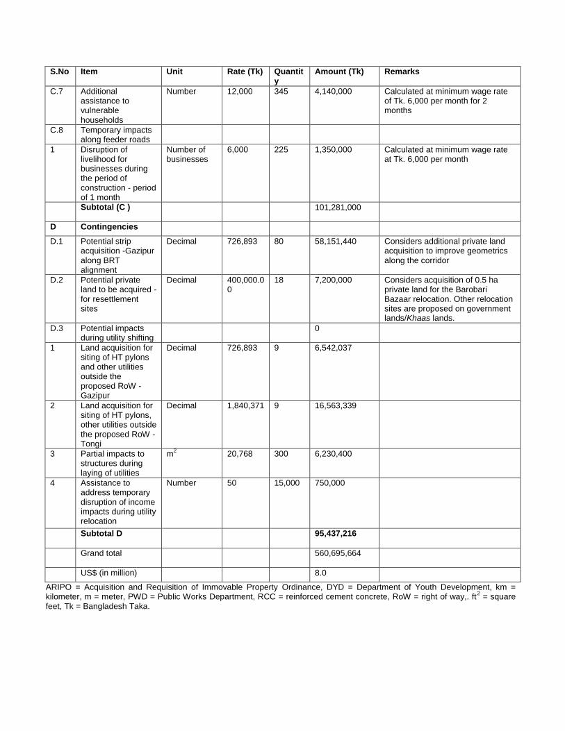
61
S.No Item Unit Rate (Tk) Quantity
Amount (Tk) Remarks
C.7 Additional assistance to vulnerable households
Number 12,000 345 4,140,000 Calculated at minimum wage rate of Tk. 6,000 per month for 2 months
C.8 Temporary impacts along feeder roads
1 Disruption of livelihood for businesses during the period of construction - period of 1 month
Number of businesses
6,000 225 1,350,000 Calculated at minimum wage rate at Tk. 6,000 per month
Subtotal (C ) 101,281,000
D Contingencies
D.1 Potential strip acquisition -Gazipur along BRT alignment
Decimal 726,893 80 58,151,440 Considers additional private land acquisition to improve geometrics along the corridor
D.2 Potential private land to be acquired - for resettlement sites
Decimal 400,000.00
18 7,200,000 Considers acquisition of 0.5 ha private land for the Barobari Bazaar relocation. Other relocation sites are proposed on government lands/Khaas lands.
D.3 Potential impacts during utility shifting
0
1 Land acquisition for siting of HT pylons and other utilities outside the proposed RoW - Gazipur
Decimal 726,893 9 6,542,037
2 Land acquisition for siting of HT pylons, other utilities outside the proposed RoW - Tongi
Decimal 1,840,371 9 16,563,339
3 Partial impacts to structures during laying of utilities
m2 20,768 300 6,230,400
4 Assistance to address temporary disruption of income impacts during utility relocation
Number 50 15,000 750,000
Subtotal D 95,437,216
Grand total 560,695,664
US$ (in million) 8.0
ARIPO = Acquisition and Requisition of Immovable Property Ordinance, DYD = Department of Youth Development, km = kilometer, m = meter, PWD = Public Works Department, RCC = reinforced cement concrete, RoW = right of way,. ft
2 = square
feet, Tk = Bangladesh Taka.
62
XI. INSTITUTIONAL ARRANGEMENTS
A. Institutional Arrangements
87. Interministerial steering committee. Chaired by the Secretary of Roads Division (RD) under the Ministry of Communication (MOC), this was established for the project in January 2011 to provide policy guidance and interagency coordination. The committee will provide guidance on any issues related to safeguards, particularly in delays in the land acquisition and resettlement process. 88. Project management unit. The executing agency (EA) for the project is the RD. A project management unit (PMU) will be established at RD and will be headed by a full-time project director, and supported by RD staff who will be responsible for the management and coordination among the implementing agencies of the project. The PMU will receive support from the project management, coordination, and capacity building (PMCCB) consultants. An environmental and social safeguard unit (ESSU) will be established in the PMU. The ESSU will consist of an environment and safety officer (ESO) and a social safeguards officer (SSO) to oversee safeguards implementation. The SSO will submit an updated resettlement plan and semiannual monitoring reports to ADB for review. 89. Project implementing units. There will be three implementing agencies (IAs), as follows:
(i) Roads and Highways Department (RHD) – will implement the main corridor restructuring, except the elevated section.
(ii) Bangladesh Bridges Authority (BBA) – will implement the 4.5-km elevated section, integrating the new Tongi Bridge and Abdullahpur intersection flyover.
(iii) Local Government Engineering Department (LGED) – will implement BRT depot facilities in Gazipur, and municipal infrastructures improvements (local roads, drains, and local markets)..
90. A project implementation unit (PIU) will be established in each of these IAs, which will be headed by a full-time project manager to take full responsibility for and manage all activities of the PIU. Each PIU will be responsible for the following in relation to their respective works: (i) assisting the IAs in implementing the project; (ii) carrying out procurement and engaging all contractors; (iii) liaising and coordinating with the PSC, PMU, and other PIUs; and (iv) managing the contractors and liaising with other stakeholders on the day-to day implementation of project activities. Each PIU will contain a deputed staff to serve as the resettlement officer to oversee implementation of resettlement planning for their respective works. PIUs will receive support from the engineering, procurement, and construction management (EPCM) consultants, and will be assisted by a nongovernment organization to implement the resettlement plan (NGORP). Safeguard specialists for environment and resettlement will be part of the EPCM, including an international resettlement specialist (IRS) and a national resettlement specialist (NRS) to update the draft resettlement plan during detailed design. These specialists will also conduct safeguards capacity building activities within the PMU ESSU and PIUs. The NGORP will conduct detailed census survey and oversee resettlement plan implementation, working closely with each PIU.
63
63
91. Special purposes organization (SPO).32 This will be set up to manage and coordinate the implementation and operation of the project, and will be placed under and report directly to RD. Its board will be chaired by the Secretary of RD, and the members will include representatives of all main stakeholders of the project. The SPO will receive safeguards capacity support from the IRS and an NRS in the EPCM and Operational Desing and Business Model (ODBM) consulting packages. After the project is completed, the PMU and PIUs will be converted into the SPO to manage, operate, and maintain the BRT.33 92. Safeguards institutional capacity assessment. A capacity assessment of the Roads and Highways Department (RHD) and Local Government and Engineering Department (LGED) on implementation of social safeguards in donor-assisted projects was carried out. Both the RHD and LGED have implemented a number of projects funded by the World Bank, ADB, and other donors. There is an in-house social and environmental cell within the RHD headed by a superintending engineer, supported by two officers with the rank of executive engineers (one each for the environment and the social/resettlement safeguards). For projects with resettlement impacts, an officer with the rank of subdivisional engineer is assigned responsibility for coordination of the social safeguards implementation, with support of NGOs on the implementation of the resettlement plan and the income restoration activities. RHD has previously implemented resettlement plans for various projects in the roads sector. Despite this experience, RHD is still considered to have limited in-house capacity in social safeguards due to high turnover among its staff. This lack of in-house capacity is largely attributed to the fact that staffing of the resettlement positions consists of civil engineers who lack formal training, and a lack of continuity due to the transfer of the officers, either upon project completion or on promotion. LGED has similarly implemented a number of donor-funded projects, yet safeguards capacity needs to be strengthened, given the turnover of staff experienced. 93. The PMU will consist of two deputed staff serving as an environment and safety officer (ESO) and a social safeguards officer (SSO) who together will form the environmental and social safeguard unit (ESSU) in the PMU and oversee all safeguards implementation, including monitoring, reporting, and grievance redressal. The RHD and LGED PIUs will each have a deputed staff serving as a resettlement officer to ensure effective implementation of land acquisition and resettlement impacts outlined in this resettlement plan. All will receive training and capacity support from the EPCM resettlement specialists to ensure learning and development, as well as smooth and effective implementation of the resettlement plan. B. Consultant Support for Resettlement
94. Engineering, procurement, and construction management (EPCM). The EPCM will be engaged to carry out the detailed design, supervision, and management of the project. Resettlement specialists (one international and one national) of the EPCM team will revise the draft resettlement plan based on detailed design, and ensure that sound methodologies and practices are followed in the implementation of resettlement plan. Apart from capacity building and training on the resettlement and social safeguards related issues of the project, the consultants will advise the PMU ESSU and the PIUs on resettlement implementation, participate
32
The government has agreed to create a special purposes organization (SPO) to (i) ensure coordination among all implementing agencies during construction; (ii) design and negotiate the business model of the BRT with the private sector; and (iii) monitor the future BRT operations. The SPO will be established under the 1994 Companies Act, as a 100% government-owned public company, tentatively named ―TransDhaka‖ by project preparatory technical assistance (PPTA) consultants.
33 All three PIUs will be housed in the PMU offices and will be coordinated by the PMU management. All consultants recruited by the project will also be housed in the PMU office.
64
in meetings with the contractor, NGORP, and PIU, and monitor the work of the implementing NGORP in the field. The consultants will also help the PIUs prepare quarterly progress reports to be submitted to the PMU ESSU, who will consolidate and send semiannual progress reports to ADB for review. 95. Nongovernment organization for resettlement plan implementation (NGORP). The role for the NGORP will center around three activities: (i) baseline information collection and survey of displaced persons based on detailed design and final alignments; (iii) implementation of the resettlement plan, including determination of entitlements based on the entitlement matrix, distribution of ID cards to displaced persons, disbursement of entitlements including compensation, and providing other assistance and allowances to eligible persons consistent with the resettlement plan during the preconstruction stage; and (iii) awareness raising, including ongoing consultations with the displaced persons and dissemination of information relating to resettlement planning, such as the impact on the people and corresponding entitlements. The scope of services of the NGORP is included in Appendix 9.
XII. IMPLEMENTATION SCHEDULE
96. A composite implementation schedule for land acquisition and resettlement activities in the project, including various subtasks and timeline matching with civil work schedule, is provided in Table 24 below.
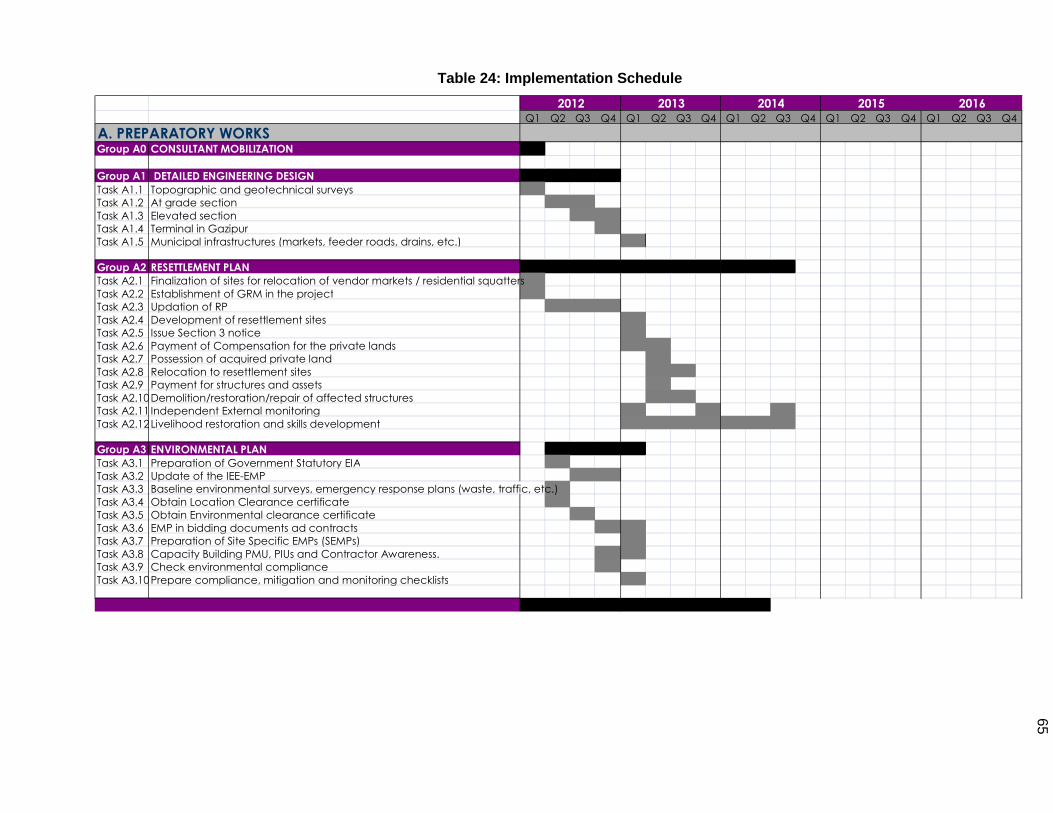
65
Q1 Q2 Q3 Q4 Q1 Q2 Q3 Q4 Q1 Q2 Q3 Q4 Q1 Q2 Q3 Q4 Q1 Q2 Q3 Q4 A. PREPARATORY WORKS Group A0 CONSULTANT MOBILIZATION
Group A1 DETAILED ENGINEERING DESIGN Task A1.1 Topographic and geotechnical surveys Task A1.2 At grade section Task A1.3 Elevated section Task A1.4 Terminal in Gazipur Task A1.5 Municipal infrastructures (markets, feeder roads, drains, etc.)
Group A2 RESETTLEMENT PLAN Task A2.1 Finalization of sites for relocation of vendor markets / residential squatters Task A2.2 Establishment of GRM in the project Task A2.3 Updation of RP Task A2.4 Development of resettlement sites Task A2.5 Issue Section 3 notice Task A2.6 Payment of Compensation for the private lands Task A2.7 Possession of acquired private land Task A2.8 Relocation to resettlement sites Task A2.9 Payment for structures and assets Task A2.10 Demolition/restoration/repair of affected structures Task A2.11 Independent External monitoring Task A2.12 Livelihood restoration and skills development
Group A3 ENVIRONMENTAL PLAN Task A3.1 Preparation of Government Statutory EIA Task A3.2 Update of the IEE-EMP Task A3.3 Baseline environmental surveys, emergency response plans (waste, traffic, etc.) Task A3.4 Obtain Location Clearance certificate Task A3.5 Obtain Environmental clearance certificate Task A3.6 EMP in bidding documents ad contracts Task A3.7 Preparation of Site Specific EMPs (SEMPs) Task A3.8 Capacity Building PMU, PIUs and Contractor Awareness. Task A3.9 Check environmental compliance Task A3.10 Prepare compliance, mitigation and monitoring checklists
2012 2013 2014 2015 2016
Table 24: Implementation Schedule
66
XIII. MONITORING AND REPORTING
A. Monitoring of Resettlement Plan Implementation
97. The project director will carry out monitoring of resettlement plan implementation through the PMU ESSU with the support of the EPCM consultants. The EPCM resettlement specialists (one international and one national) will assist the PMU ESSU in monitoring RP activities. The nongovernment organization implementing the resettlement plan (NGORP) will submit monthly progress reports to PIUs and PMU ESSU to facilitate implementation monitoring. 98. The PMU ESSU will develop a progress and performance monitoring system to collect and organize monitoring output on a regular basis. An information system containing the database on resettlement planning and implementation will be established and updated periodically for monitoring various activities of resettlement plan implementation by the PMU ESSU. The resettlement plan database generated through the census, baseline socioeconomic survey, land market survey and consultation, cash compensation under law (CCL) payment, and resettlement benefit payment database will become essential inputs of the management and information system (MIS). Progress monitoring and evaluation of intended outcomes of resettlement plan implementation will be carried out. 99. The monitoring by PMU ESSU will include: (i) administrative monitoring to ensure that all compensation paid and implementation are on schedule, and problems/grievances are dealt with on a timely basis consistent with the resettlement plan; (ii) socioeconomic monitoring during and after the relocation process to ensure that people are settled and are better off at the new locations; and (iii) monitoring of whether recovery has taken place timely and successfully. 100. Monitoring and evaluation of the resettlement plan implementation will be taken up at all stages of the project. Some of the key indicators at different stages of the resettlement plan are as follows:
1. Preparatory Stage
(i) baseline survey, including the 100% in-depth baseline and needs assessment study of displaced persons;
(ii) establish inventory of losses, including private assets, government land and buildings, and common property resources impacted;
(iii) consultations with displaced persons and stakeholders; (iv) identification of entitlements for displaced persons; (v) collection of gender disaggregated data and preferences of women; (vi) identification of resettlement sites and finalization in consultation with displaced
persons; (vii) identification of locations for temporary relocation, especially for street vendors; (viii) interactions with government agencies, including the deputy commissioner’s
office, union parishads; (ix) preparation/updating of implementation based on changes in project design; (x) memorandum of understanding (MOU) with the Department of Youth
Development (DYD) on the skill development of displaced persons; (xi) information dissemination and disclosure of final implementation, after ADB approval; (xii) institutional capacity assessment and staffing of PIUs; (xiii) implementation schedule and items of expenditure; and (xiv) operationalization of the GRMs in the project.
67
67
2. Resettlement Plan Implementation Stage
(i) payment of compensation; (ii) delivery of entitlement; (iii) grievance redressing; (iv) support in cash compensation under law (CCL) collection process; (v) preparation of resettlement site, including civic amenities (water, sanitation,
drainage, paved streets, electricity supply); (vi) consultations with the displaced persons and facilitating grievance redressal; (vii) relocation of businesses and residential squatters; (viii) payment of resettlement benefits; (ix) income and livelihood restoration assistance, including training and capacity
building; (x) support towards initiation of income generation activities; and (xi) restoration of public utilities and common property resources impacted in the
project
3. Resettlement Plan Evaluation Stage
101. Once displaced persons have settled down at the new sites, the focus of monitoring shifts to issues of economic recovery programs, including whether the displaced persons have benefited from the income-generating schemes, whether they have established their businesses at the new location, impact of the resettlement plan entitlements and schemes on living standards, and the sustainability of the new livelihood patterns.
4. Construction Stage
102. Monitoring during the construction stage will ensure ongoing monitoring of displaced persons and resettlement activities. Other focus will be on labor issues, including child labor, equal opportunities for men and women, and priority of displaced persons in the project construction activities, apart from implementation of all statutory provisions on labor, including workers health, welfare, sanitation, and safe working conditions. B. Verification of Monitoring Information by External Experts
103. ADB requires that the borrower retain qualified and experienced external experts to verify monitoring information of projects with significant impacts and risks.34 An external resettlement monitoring expert will be engaged by the PMU to undertake resettlement monitoring and evaluation during resettlement plan implementation. The key responsibilities of the monitoring external and qualified expert will include the following: (i) verifying resettlement monitoring information for the project; (ii) monitoring the resettlement safeguard compliance issues in resettlement plan implementation; and (iii) assessing the overall implementation approach, process, and outcome of the resettlement plan, and providing inputs to the PMU for taking corrective actions to resolve any issues.
34
External experts mean experts not involved in day-to-day project implementation or supervision (SPS, 2009). An external validation expert will be recruited on an individual basis by the PMU.
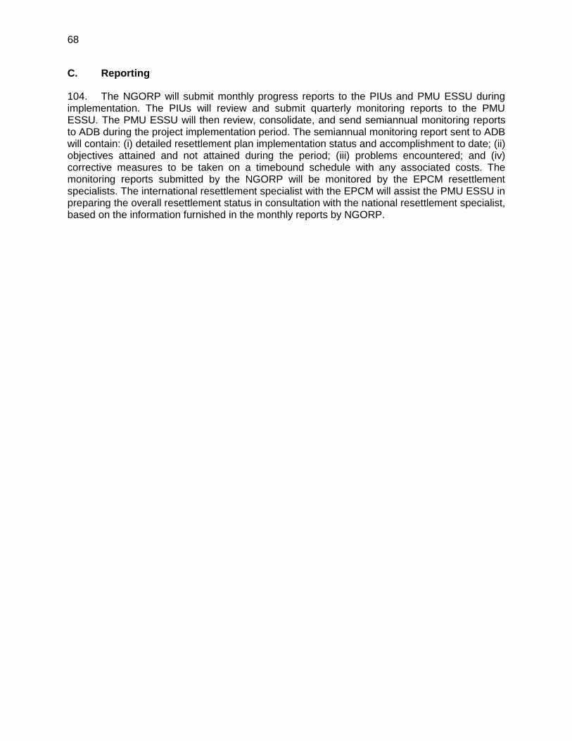
68
C. Reporting
104. The NGORP will submit monthly progress reports to the PIUs and PMU ESSU during implementation. The PIUs will review and submit quarterly monitoring reports to the PMU ESSU. The PMU ESSU will then review, consolidate, and send semiannual monitoring reports to ADB during the project implementation period. The semiannual monitoring report sent to ADB will contain: (i) detailed resettlement plan implementation status and accomplishment to date; (ii) objectives attained and not attained during the period; (iii) problems encountered; and (iv) corrective measures to be taken on a timebound schedule with any associated costs. The monitoring reports submitted by the NGORP will be monitored by the EPCM resettlement specialists. The international resettlement specialist with the EPCM will assist the PMU ESSU in preparing the overall resettlement status in consultation with the national resettlement specialist, based on the information furnished in the monthly reports by NGORP.
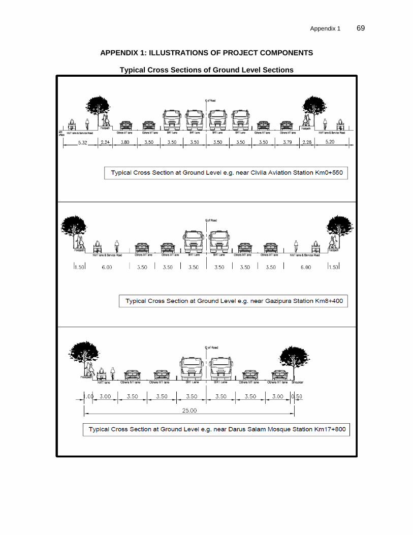
Appendix 1 69
69
APPENDIX 1: ILLUSTRATIONS OF PROJECT COMPONENTS
Typical Cross Sections of Ground Level Sections
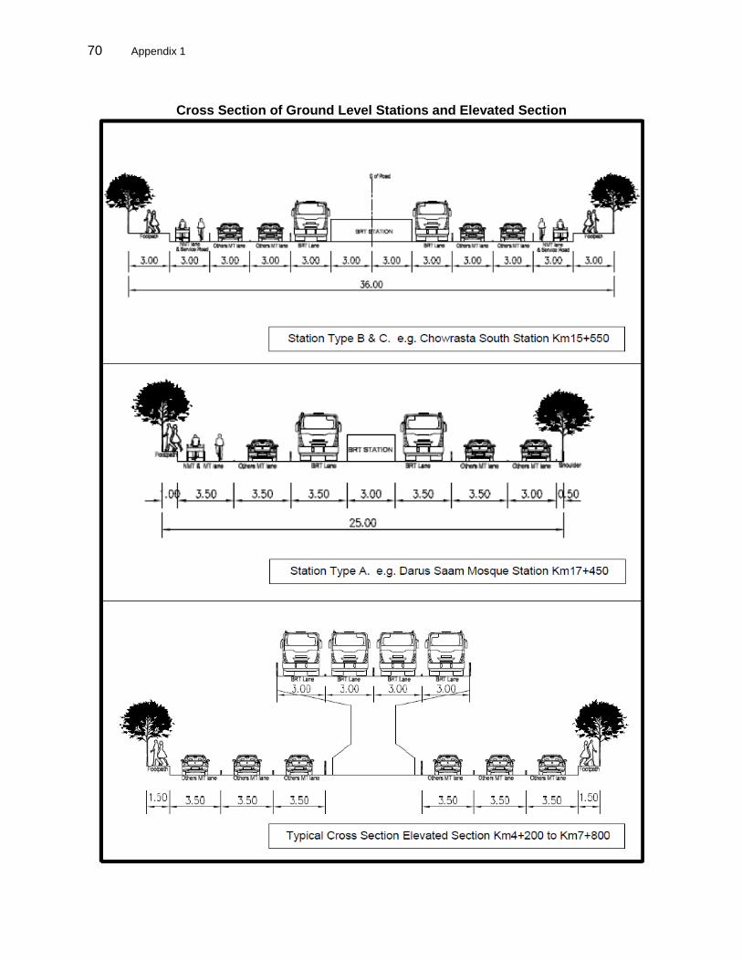
70 Appendix 1
Cross Section of Ground Level Stations and Elevated Section
Appendix 1 71
71
Layout of Flyovers
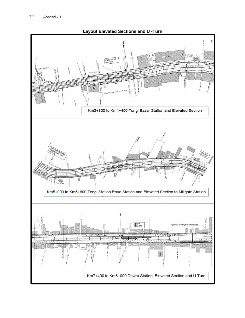
72 Appendix 1
Layout Elevated Sections and U -Turn

Appendix 1 73
73
Access to Stations
74 Appendix 2
APPENDIX 2: COMPARISON BETWEEN THE GOVERNMENT OF BANGLADESH and ASIAN DEVELOPMENT BANK POLICIES
Comparison Between the Government of Bangladesh and ADB Safeguard Policies - Land Acquisition and Resettlement
Sl. No.
ADB’s SPS (2009) Acquisition and Requisition of Immovable Property Ordinance (ARIPO) of 1982
Remarks (Gaps Between ARIPO and ADB’s Policies and Action Taken to Bridge the Gap)
1 Involuntary resettlement should be avoided wherever possible.
Not defined in the ARIPO The ordinance does not deal with the minimization of involuntary resettlement. However, the government uses this approach as standard practice.
2 Minimize involuntary resettlement by exploring project and design alternatives.
Not so clearly defined in the ARIPO. Sections 3 and 18 exempt the acquisition of property used by the public for religious worship, public or educational institutions, graveyards, and cremation grounds.
The ordinance does not deal with these issues and does not comply with ADB’s policies as the ARIPO has no provision for minimizing adverse impacts on private property or common resources, and does not deal with alternate design. The resettlement plan clearly defines the procedures on how to minimize the involuntary resettlement through proper alternate engineering design and adequate consultation with stakeholders.
3 Conducting census of displaced persons and resettlement planning
The ARIPO spells out that upon approval of the request for land by the office of the deputy commissioner, its own staff will conduct the physical inventory of assets and properties found in the land. The inventory form consists the name of person, quantity of land, the list of assets affected, and the materials used in the construction of house. The cutoff date is the date of publication of notice that land is subject to acquisition, and that any alteration or improvement thereon will not be considered for compensation.
The ARIPO does not define the census survey. It only reflects the inventory of losses (IOL), which is more in physical terms and only includes the names of the owners, etc. The ADB policy spells out a detailed census through household surveys of displaced persons in order to assess the vulnerability and other entitlements. This gap has been addressed through incorporating the need for a census survey for the displaced persons.
4 Carry out meaningful consultation with displaced persons and ensure their participation in planning, implementation, and monitoring of resettlement program.
Section 3 of the ordinance provides that whenever it appears to the deputy commissioner that any property is needed or is likely to be needed for any public purpose or in the public interest, he will publish a notice at convenient places on or near the property in the prescribed form and manner stating that the property is proposed for acquisition.
The ARIPO does not directly meet ADB’s requirements. This section of the ordinance establishes an indirect form of public consultation. However, it does not provide for public meetings and project disclosure, so stakeholders are not informed about the purpose of land acquisition, its proposed use, or compensation, entitlements, or special assistance measures. The resettlement plan for the project has been prepared following a consultation process which involves all stakeholders (affected persons, government department/line agencies, local community, NGORP, etc.), and the consultation will be a continuous process at all stages of the project development such as project formulation, feasibility study, design, implementation, and post-implementation, including the monitoring phase.
5 Establish grievance Section 4 allows the occupant of The Section 4 provision is consistent with
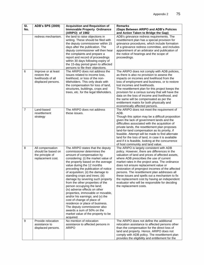
Appendix 2 75
75
Sl. No.
ADB’s SPS (2009) Acquisition and Requisition of Immovable Property Ordinance (ARIPO) of 1982
Remarks (Gaps Between ARIPO and ADB’s Policies and Action Taken to Bridge the Gap)
redress mechanism. the land to raise objections in writing. These should be filed with the deputy commissioner within 15 days after the publication. The deputy commissioner will then hear the complaints and prepare a report and record of proceedings within 30 days following expiry of the 15-day period given to affected persons to file their objections.
ADB's grievance redress requirements. The resettlement plan has a special provision for grievance procedures, which include formation of a grievance redress committee, and includes appointment of an arbitrator and publication of the notice of hearings and the scope of proceedings.
6 Improve or at least restore the livelihoods of all displaced persons.
The ARIPO does not address the issues related to income loss, livelihood, or loss of the non-titleholders. This only deals with the compensation for loss of land, structures, buildings, crops and trees, etc. for the legal titleholders.
The ARIPO does not comply with ADB policies, as there is also no provision to assess the impacts on incomes and livelihood from the loss of employment and business, or to restore lost incomes and livelihoods. The resettlement plan for this project keeps the provision for a census survey that will have the data on the loss of income and livelihood, and the same will be compensated as per the entitlement matrix for both physically and economically affected persons.
7 Land-based resettlement strategy
The ARIPO does not address these issues.
The ARIPO does not meet the requirement of ADB. Though this option may be a difficult proposition given the lack of government lands and the difficulties associated with the acquisition of private lands, the resettlement plan proposes land-for-land compensation as its priority, if feasible. Attempt will be made to find alternate land for the loss of land, in case it is available and if it is feasible, looking at the concurrence of host community and land value.
8 All compensation should be based on the principle of replacement cost.
The ARIPO states that the deputy commissioner determines the amount of compensation by considering: (i) the market value of the property based on the average value during the 12 months preceding the publication of notice of acquisition; (ii) the damage to standing crops and trees; (iii) damage by severing such property from the other properties of the person occupying the land; (iv) adverse effects on other properties, immovable or movable, and/or his earnings; and (v) the cost of change of place of residence or place of business. The deputy commissioner also awards a sum of 50% on the market value of the property to be acquired.
The ARIPO is largely consistent with ADB policy. However, there are differences in the valuation of land and prices of affected assets, where ADB prescribes the use of current market rates in the project area. The ordinance does not ensure replacement value or restoration of preproject incomes of the affected persons. The resettlement plan addresses all these issues and spells out a mechanism to fix the replacement cost by having an independent evaluator who will be responsible for deciding the replacement costs.
9 Provide relocation assistance to displaced persons.
No mention of relocation assistance to affected persons in ARIPO
The ARIPO does not define the additional relocation assistance to affected persons other than the compensation for the direct loss of land and property. Hence, ARIPO does not comply with ADB policy. The resettlement plan provides the eligibility and entitlement for the
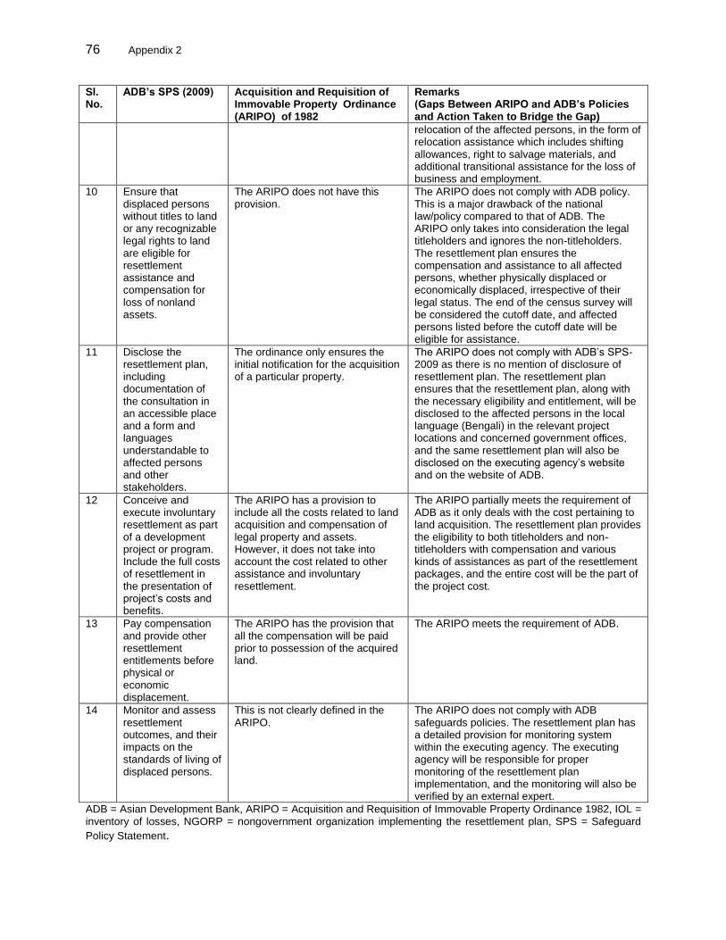
76 Appendix 2
Sl. No.
ADB’s SPS (2009) Acquisition and Requisition of Immovable Property Ordinance (ARIPO) of 1982
Remarks (Gaps Between ARIPO and ADB’s Policies and Action Taken to Bridge the Gap)
relocation of the affected persons, in the form of relocation assistance which includes shifting allowances, right to salvage materials, and additional transitional assistance for the loss of business and employment.
10 Ensure that displaced persons without titles to land or any recognizable legal rights to land are eligible for resettlement assistance and compensation for loss of nonland assets.
The ARIPO does not have this provision.
The ARIPO does not comply with ADB policy. This is a major drawback of the national law/policy compared to that of ADB. The ARIPO only takes into consideration the legal titleholders and ignores the non-titleholders. The resettlement plan ensures the compensation and assistance to all affected persons, whether physically displaced or economically displaced, irrespective of their legal status. The end of the census survey will be considered the cutoff date, and affected persons listed before the cutoff date will be eligible for assistance.
11 Disclose the resettlement plan, including documentation of the consultation in an accessible place and a form and languages understandable to affected persons and other stakeholders.
The ordinance only ensures the initial notification for the acquisition of a particular property.
The ARIPO does not comply with ADB’s SPS-2009 as there is no mention of disclosure of resettlement plan. The resettlement plan ensures that the resettlement plan, along with the necessary eligibility and entitlement, will be disclosed to the affected persons in the local language (Bengali) in the relevant project locations and concerned government offices, and the same resettlement plan will also be disclosed on the executing agency’s website and on the website of ADB.
12 Conceive and execute involuntary resettlement as part of a development project or program. Include the full costs of resettlement in the presentation of project’s costs and benefits.
The ARIPO has a provision to include all the costs related to land acquisition and compensation of legal property and assets. However, it does not take into account the cost related to other assistance and involuntary resettlement.
The ARIPO partially meets the requirement of ADB as it only deals with the cost pertaining to land acquisition. The resettlement plan provides the eligibility to both titleholders and non-titleholders with compensation and various kinds of assistances as part of the resettlement packages, and the entire cost will be the part of the project cost.
13 Pay compensation and provide other resettlement entitlements before physical or economic displacement.
The ARIPO has the provision that all the compensation will be paid prior to possession of the acquired land.
The ARIPO meets the requirement of ADB.
14 Monitor and assess resettlement outcomes, and their impacts on the standards of living of displaced persons.
This is not clearly defined in the ARIPO.
The ARIPO does not comply with ADB safeguards policies. The resettlement plan has a detailed provision for monitoring system within the executing agency. The executing agency will be responsible for proper monitoring of the resettlement plan implementation, and the monitoring will also be verified by an external expert.
ADB = Asian Development Bank, ARIPO = Acquisition and Requisition of Immovable Property Ordinance 1982, IOL = inventory of losses, NGORP = nongovernment organization implementing the resettlement plan, SPS = Safeguard
Policy Statement.
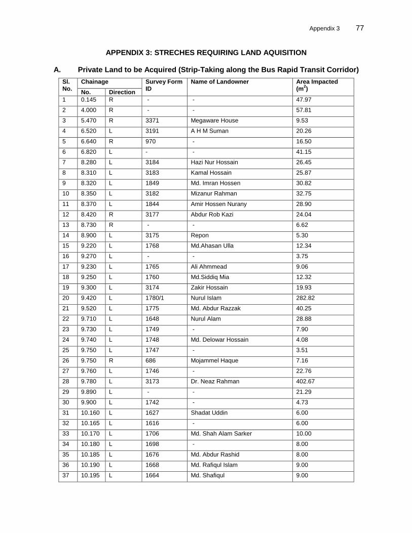
Appendix 3 77
77
APPENDIX 3: STRECHES REQUIRING LAND AQUISITION
A. Private Land to be Acquired (Strip-Taking along the Bus Rapid Transit Corridor)
Sl. No.
Chainage Survey Form ID
Name of Landowner Area Impacted (m
2)
No. Direction
1 0.145 R - - 47.97
2 4.000 R - - 57.81
3 5.470 R 3371 Megaware House 9.53
4 6.520 L 3191 A H M Suman 20.26
5 6.640 R 970 - 16.50
6 6.820 L - - 41.15
7 8.280 L 3184 Hazi Nur Hossain 26.45
8 8.310 L 3183 Kamal Hossain 25.87
9 8.320 L 1849 Md. Imran Hossen 30.82
10 8.350 L 3182 Mizanur Rahman 32.75
11 8.370 L 1844 Amir Hossen Nurany 28.90
12 8.420 R 3177 Abdur Rob Kazi 24.04
13 8.730 R - - 6.62
14 8.900 L 3175 Repon 5.30
15 9.220 L 1768 Md.Ahasan Ulla 12.34
16 9.270 L - - 3.75
17 9.230 L 1765 Ali Ahmmead 9.06
18 9.250 L 1760 Md.Siddiq Mia 12.32
19 9.300 L 3174 Zakir Hossain 19.93
20 9.420 L 1780/1 Nurul Islam 282.82
21 9.520 L 1775 Md. Abdur Razzak 40.25
22 9.710 L 1648 Nurul Alam 28.88
23 9.730 L 1749 - 7.90
24 9.740 L 1748 Md. Delowar Hossain 4.08
25 9.750 L 1747 - 3.51
26 9.750 R 686 Mojammel Haque 7.16
27 9.760 L 1746 - 22.76
28 9.780 L 3173 Dr. Neaz Rahman 402.67
29 9.890 L - - 21.29
30 9.900 L 1742 - 4.73
31 10.160 L 1627 Shadat Uddin 6.00
32 10.165 L 1616 - 6.00
33 10.170 L 1706 Md. Shah Alam Sarker 10.00
34 10.180 L 1698 - 8.00
35 10.185 L 1676 Md. Abdur Rashid 8.00
36 10.190 L 1668 Md. Rafiqul Islam 9.00
37 10.195 L 1664 Md. Shafiqul 9.00
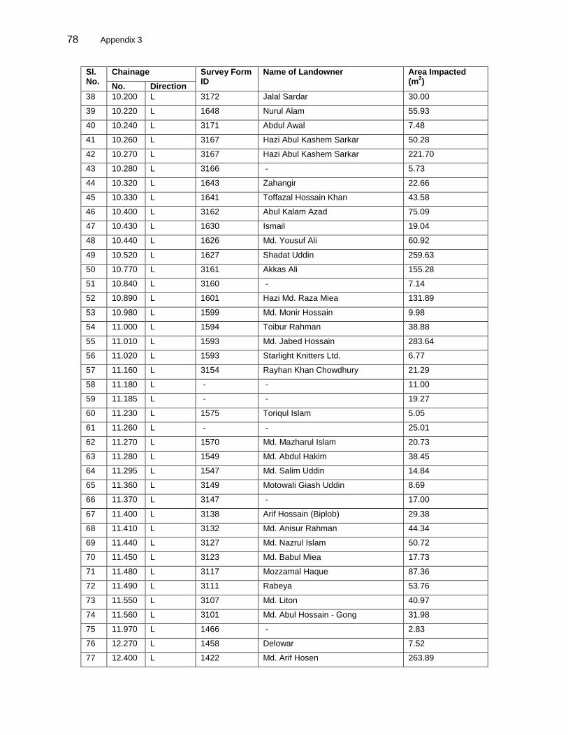
78 Appendix 3
Sl. No.
Chainage Survey Form ID
Name of Landowner Area Impacted (m
2)
No. Direction
38 10.200 L 3172 Jalal Sardar 30.00
39 10.220 L 1648 Nurul Alam 55.93
40 10.240 L 3171 Abdul Awal 7.48
41 10.260 L 3167 Hazi Abul Kashem Sarkar 50.28
42 10.270 L 3167 Hazi Abul Kashem Sarkar 221.70
43 10.280 L 3166 - 5.73
44 10.320 L 1643 Zahangir 22.66
45 10.330 L 1641 Toffazal Hossain Khan 43.58
46 10.400 L 3162 Abul Kalam Azad 75.09
47 10.430 L 1630 Ismail 19.04
48 10.440 L 1626 Md. Yousuf Ali 60.92
49 10.520 L 1627 Shadat Uddin 259.63
50 10.770 L 3161 Akkas Ali 155.28
51 10.840 L 3160 - 7.14
52 10.890 L 1601 Hazi Md. Raza Miea 131.89
53 10.980 L 1599 Md. Monir Hossain 9.98
54 11.000 L 1594 Toibur Rahman 38.88
55 11.010 L 1593 Md. Jabed Hossain 283.64
56 11.020 L 1593 Starlight Knitters Ltd. 6.77
57 11.160 L 3154 Rayhan Khan Chowdhury 21.29
58 11.180 L - - 11.00
59 11.185 L - - 19.27
60 11.230 L 1575 Toriqul Islam 5.05
61 11.260 L - - 25.01
62 11.270 L 1570 Md. Mazharul Islam 20.73
63 11.280 L 1549 Md. Abdul Hakim 38.45
64 11.295 L 1547 Md. Salim Uddin 14.84
65 11.360 L 3149 Motowali Giash Uddin 8.69
66 11.370 L 3147 - 17.00
67 11.400 L 3138 Arif Hossain (Biplob) 29.38
68 11.410 L 3132 Md. Anisur Rahman 44.34
69 11.440 L 3127 Md. Nazrul Islam 50.72
70 11.450 L 3123 Md. Babul Miea 17.73
71 11.480 L 3117 Mozzamal Haque 87.36
72 11.490 L 3111 Rabeya 53.76
73 11.550 L 3107 Md. Liton 40.97
74 11.560 L 3101 Md. Abul Hossain - Gong 31.98
75 11.970 L 1466 - 2.83
76 12.270 L 1458 Delowar 7.52
77 12.400 L 1422 Md. Arif Hosen 263.89
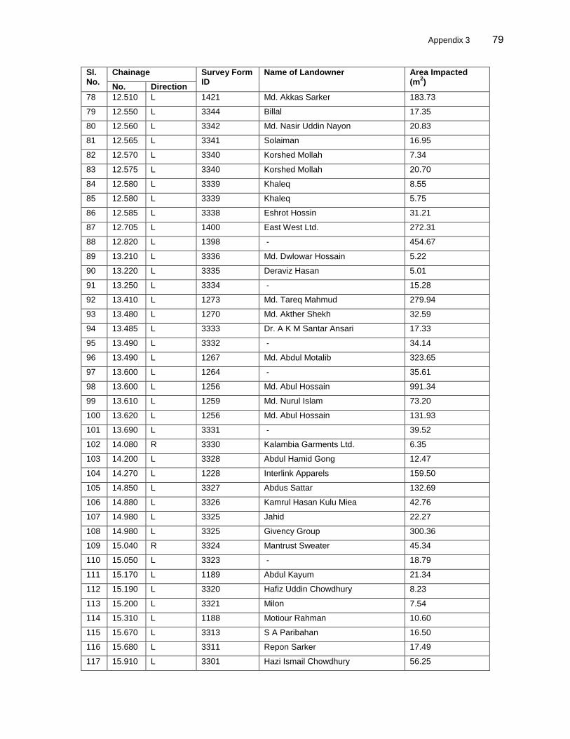
Appendix 3 79
79
Sl. No.
Chainage Survey Form ID
Name of Landowner Area Impacted (m
2)
No. Direction
78 12.510 L 1421 Md. Akkas Sarker 183.73
79 12.550 L 3344 Billal 17.35
80 12.560 L 3342 Md. Nasir Uddin Nayon 20.83
81 12.565 L 3341 Solaiman 16.95
82 12.570 L 3340 Korshed Mollah 7.34
83 12.575 L 3340 Korshed Mollah 20.70
84 12.580 L 3339 Khaleq 8.55
85 12.580 L 3339 Khaleq 5.75
86 12.585 L 3338 Eshrot Hossin 31.21
87 12.705 L 1400 East West Ltd. 272.31
88 12.820 L 1398 - 454.67
89 13.210 L 3336 Md. Dwlowar Hossain 5.22
90 13.220 L 3335 Deraviz Hasan 5.01
91 13.250 L 3334 - 15.28
92 13.410 L 1273 Md. Tareq Mahmud 279.94
93 13.480 L 1270 Md. Akther Shekh 32.59
94 13.485 L 3333 Dr. A K M Santar Ansari 17.33
95 13.490 L 3332 - 34.14
96 13.490 L 1267 Md. Abdul Motalib 323.65
97 13.600 L 1264 - 35.61
98 13.600 L 1256 Md. Abul Hossain 991.34
99 13.610 L 1259 Md. Nurul Islam 73.20
100 13.620 L 1256 Md. Abul Hossain 131.93
101 13.690 L 3331 - 39.52
102 14.080 R 3330 Kalambia Garments Ltd. 6.35
103 14.200 L 3328 Abdul Hamid Gong 12.47
104 14.270 L 1228 Interlink Apparels 159.50
105 14.850 L 3327 Abdus Sattar 132.69
106 14.880 L 3326 Kamrul Hasan Kulu Miea 42.76
107 14.980 L 3325 Jahid 22.27
108 14.980 L 3325 Givency Group 300.36
109 15.040 R 3324 Mantrust Sweater 45.34
110 15.050 L 3323 - 18.79
111 15.170 L 1189 Abdul Kayum 21.34
112 15.190 L 3320 Hafiz Uddin Chowdhury 8.23
113 15.200 L 3321 Milon 7.54
114 15.310 L 1188 Motiour Rahman 10.60
115 15.670 L 3313 S A Paribahan 16.50
116 15.680 L 3311 Repon Sarker 17.49
117 15.910 L 3301 Hazi Ismail Chowdhury 56.25
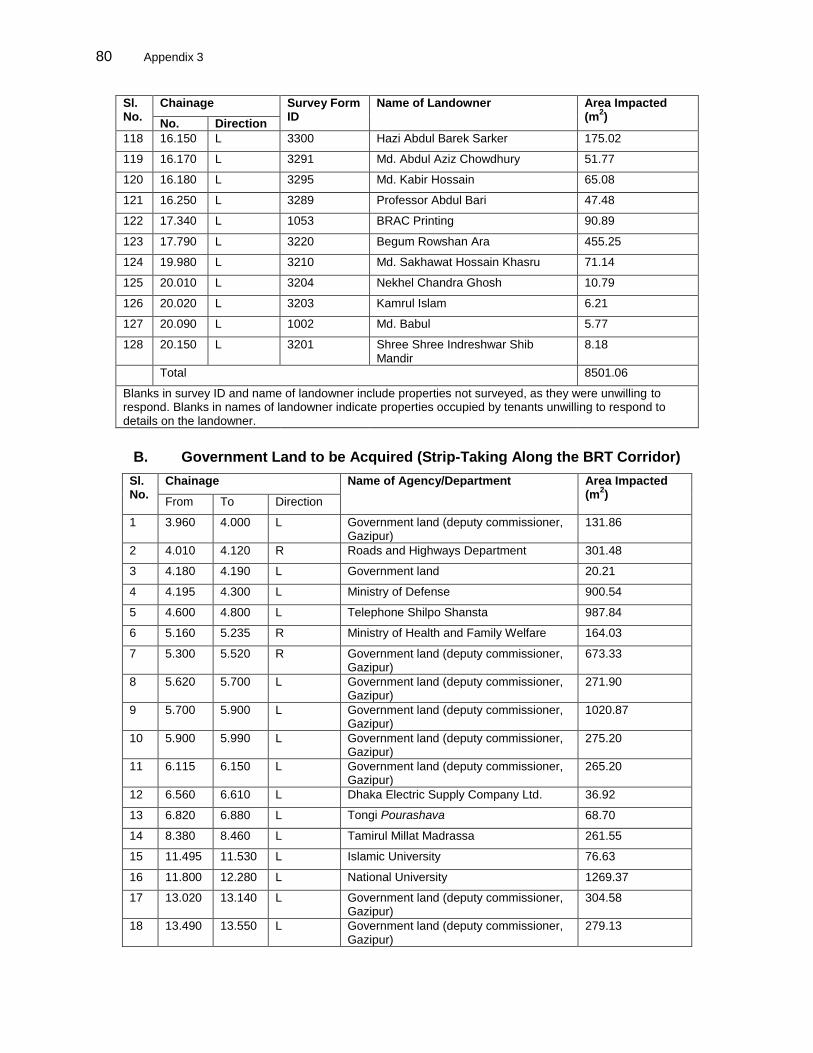
80 Appendix 3
Sl. No.
Chainage Survey Form ID
Name of Landowner Area Impacted (m
2)
No. Direction
118 16.150 L 3300 Hazi Abdul Barek Sarker 175.02
119 16.170 L 3291 Md. Abdul Aziz Chowdhury 51.77
120 16.180 L 3295 Md. Kabir Hossain 65.08
121 16.250 L 3289 Professor Abdul Bari 47.48
122 17.340 L 1053 BRAC Printing 90.89
123 17.790 L 3220 Begum Rowshan Ara 455.25
124 19.980 L 3210 Md. Sakhawat Hossain Khasru 71.14
125 20.010 L 3204 Nekhel Chandra Ghosh 10.79
126 20.020 L 3203 Kamrul Islam 6.21
127 20.090 L 1002 Md. Babul 5.77
128 20.150 L 3201 Shree Shree Indreshwar Shib Mandir
8.18
Total 8501.06
Blanks in survey ID and name of landowner include properties not surveyed, as they were unwilling to respond. Blanks in names of landowner indicate properties occupied by tenants unwilling to respond to details on the landowner.
B. Government Land to be Acquired (Strip-Taking Along the BRT Corridor)
Sl. No.
Chainage Name of Agency/Department Area Impacted (m
2)
From To Direction
1 3.960 4.000 L Government land (deputy commissioner, Gazipur)
131.86
2 4.010 4.120 R Roads and Highways Department 301.48
3 4.180 4.190 L Government land 20.21
4 4.195 4.300 L Ministry of Defense 900.54
5 4.600 4.800 L Telephone Shilpo Shansta 987.84
6 5.160 5.235 R Ministry of Health and Family Welfare 164.03
7 5.300 5.520 R Government land (deputy commissioner, Gazipur)
673.33
8 5.620 5.700 L Government land (deputy commissioner, Gazipur)
271.90
9 5.700 5.900 L Government land (deputy commissioner, Gazipur)
1020.87
10 5.900 5.990 L Government land (deputy commissioner, Gazipur)
275.20
11 6.115 6.150 L Government land (deputy commissioner, Gazipur)
265.20
12 6.560 6.610 L Dhaka Electric Supply Company Ltd. 36.92
13 6.820 6.880 L Tongi Pourashava 68.70
14 8.380 8.460 L Tamirul Millat Madrassa 261.55
15 11.495 11.530 L Islamic University 76.63
16 11.800 12.280 L National University 1269.37
17 13.020 13.140 L Government land (deputy commissioner, Gazipur)
304.58
18 13.490 13.550 L Government land (deputy commissioner, Gazipur)
279.13
Appendix 3 81
81
19 13.630 13.700 L Government land (deputy commissioner, Gazipur)
220.30
20 14.880 14.940 L Government land (deputy commissioner, Gazipur)
157.63
21 14.890 14.920 R Government land (deputy commissioner, Gazipur)
40.81
22 16.905 16.970 L LGED 147.72
23 17.285 17.310 L Government land (deputy commissioner, Gazipur)
29.19
24 17.900 18.085 R Bangladesh Telecommunication Company Limited (BTCL), under the Ministry of Posts and Telecommunications (MoPT).
20,000
Appendix 4 82
APPENDIX 4: SUMMARY OF CONSULTATIONS AT VENDOR MARKETS A. Summary of Consultations with Vendors
1. Bamboo Business in Gazipur Pourashava 1. Bamboo business shop owners are mostly from Gazipur and Sonargaon districts and few are from Mymensingh and Sharper. They collect bamboo from Panchagor Valuka, Bhuapur. The market will also be affected due to project; it needs to be relocated in some suitable place where vendors can continue their business. A total of 12 bamboo shop owners are doing business in pourashava land. Pourashava leases the entire business out to one person who collects rent on a yearly basis. The vendors selling bamboo have been in business for over 10 years at the same location. A summary of information is as follows:
(i) monthly pourashava tax is Tk. 500; (ii) daily payment rate to the lease owner is 5% of daily sales; (iii) payment of money to police and road traffic during loading and unloading of
bamboo; (iv) business is good, and daily they sell at least 30 bamboos, and sometimes 200-
300 ; (v) they shift bamboo into the adjacent drain when high-profile people visit; and (vi) they found the place very suitable for bamboo business, but they do not know
any alternative location. 2 The mayor and the executive engineer of Gazipur confirmed that alternative land will be identified for relocating the vendors displaced. Alternative locations suggested by the mayor include railway lands, which can be taken up for vendor relocation with clearances from the Bangladesh Railways. Gazipur Pourashava had undertaken relocation of 16 vendors in Shibbari Market (in 2005),wherein the vendors were provided shops on a rental basis. However, several of these vendors sold their possession at a premium and were back to the right of way (RoW) for vending purposes.
2. Vendor Markets in Gacha Union Parishad 3. The need for the development of the markets in Gacha union has been attributed to the growth of the ready-made garments (RMG) industries in the area. These markets, though existing earlier, were small, and have expanded to cater to the needs to the RMG workers, who are the main customers in these markets. Consultations also revealed that many vendors shifted from the backyard to the front/roadside due to the competition from new vendors who joined the market to sell vegetables, dry fishes, fruits, etc. 4. Most of the vendors have migrated from different districts, but mostly from Mymensingh, Tangail, and Netrakona. Migrants from surrounding districts who have not secured jobs in the RMG sector have taken up street vending. Also, there are instances where other family members of these vendors work in the RMG industries. 5. Most of the vendors prefer to sell vegetables and goods on the front side of the market or on the main road, where they can attract a higher number of customers, as it is perceived that it is very convenient for the pedestrians to purchase vegetables and other goods on the way. In terms of timing, it was perceived by the vendors that the morning and evening were the
Appendix 5 83
83
best times for business, when the RMG workers are on their way to work and on their way back from work. 6. While the businesses are carried out on the road RoW, most of the vendors are required to pay money to groups such as the market owners, local leaders, and police to ensure smooth operation of their businesses. In case of private markets, the vendors pay money to the market owners/shop owners. In some markets, vendors pay money in advance (Tk. 2,000-Tk. 5,000) for the occupation of space, for which these vendors have obtained loans from formal and informal sources. In terms of money/rents paid by the vendors, there is some variation based on the location of land, nature of goods sold, space occupied, etc., which is summarized below:
(i) rent: Tk. 30-150 daily, and varies from Tk. 30 for a vendor carrying items in a basket to Tk .150 for a vendor with an organized platform for storage of goods and vegetables (space of about 2 m2);
(ii) expenses to police: Tk. 10-50, incurred randomly, and usually about once in a fortnight;
(iii) in case of vendors selling seasonal goods as fruits, the vendors pay for the units sold, e.g., for each jackfruit and watermelon, Tk.2;
(iv) payment for mosque: Tk. 5; (v) payments to the musclemen: Tk. 10 -50 (monthly); (vi) cleaner and night guard: Tk. 5 each monthly; and (vii) in addition to the recurrent expenditure, there has been an initial deposit or
advance payment ranging from Tk .1,000 to Tk. 5,000. 7. In spite of payments of rents and expenditures incurred by the vendors, they are vulnerable to eviction on a periodic basis by the Roads and Highways Department (RHD) and also during times of movement of ministers, etc. in the area, thereby resulting in lack of security of their businesses. 8. Discussions with the pedestrians and the RMG workers revealed that the presence of vendors on the RoW blocked the smooth movement of pedestrians in the footpaths, especially during the peak hours in the morning and evening. Lack of space for pedestrian movements has forced them to walk on the main carriageway, and this has resulted in several accidents in the recent past. 9. The vendors were keen to relocate to an alternate location with a more secure tenure, which would be accessible to the current clientele. The following options were put forth during the consultations:
(i) There will be relocation of the temporary markets to the empty space available in the backyard or side lands of the markets. This will ensure that the footpaths and the space for pedestrians are effectively used.
(ii) A key concern of the vendors, market owners, and committee members was regarding the relocation site for the vendors. The alternative land will be at locations conveniently accessed and along the major routes of movement of people and pedestrians.
(iii) There are certain locations where vacant private land exists in the vicinity of the existing market site. Discussions with the landowners were carried out at these locations. The landowners are agreeable to part with the land parcel, provided that they are compensated at replacement cost for the land acquired.
84 Appendix 4
10. Consultations with the chairman of the Gacha Union Parishad were undertaken to ascertain the willingness of the union parishad in the development of alternative vendor markets and identification of alternative locations for the same. The Gacha Union Parishad confirmed their willingness to develop alternative market locations.
3. Tongi Kacha Bazaar 11. A large number (124 vendors) selling vegetable, fruits, cosmetics, and ready-made garments occupy the footpath and the land within the RHD RoW in front of Tongi Mosque along the corridor. Initially the market was constructed on the water board’s land. In 2007-2008, the water board demolished the market to get their land back. Since then, many of the shopkeepers have been forced to shift to the footpath as vendors. In addition, vendors from other locations have also occupied the RoW for vending. 12. Tongi Bazaar, including the footpath, is a very significant shopping location for the community, especially for the low-income groups. Consultations with the members of the mosque and market committees indicated that the significance of the Tongi market is largely due to the strategic location, which is heavily visited by people from nearby districts for work and business. In addition, the main significance of the market is during the Vishwa Estema, the second largest religious festival in Bangladesh conducted every year and attended by more than a million people. 13. The members of the market committee and the community welcomed the idea of relocating the footpath vendors in a permanent place. Consultations revealed that there have been initiatives towards the same, and in 2010 there were two meetings with the mayor and local influential people, police, and the public. The community raised the issues of a vendor market replacement site and provision of adequate parking space in the market. According to market committee and community, two alternative land parcels belonging to the RHD are available. A consultation with the mayor and the chief executive officer of Tongi Pourashava was undertaken towards obtaining views and perceptions regarding the relocation of the vendor market. During these consultations, the pourashava committed to providing support to identify suitable land, especially Khaas land and land belonging to RHD in the vicinity of the alignment.
4. Uttara Footpath Market 14. This Uttara footpath market extends from channel 1.000 to channel 2.300 along the project corridor. The vendors sell clothes and a variet of goods on tricycle van for the low-income group of the community. Around 120 vendors from different districts of Bangladesh have encroached on the footpath along this stretch, and businesses are carried out on the tricycles. During the night, these tricycles, along with the goods, are covered and tied to each other in a continuous row. Vendors pay a token money to the police in order to continue their business smoothly. The monthly expenditures incurred by these vendors vary between Tk. 1,000 and Tk. 1,550 per month. 15. The footpath market is removed by the RHD during the periodic RoW clearing efforts by the RHD and police. Also, these markets are temporarily removed during (i) visits by VIPs, including ministers, and (ii) during the rainy seasons. Consultations with the vendors reveal that they carry out businesses at alternative locations like nearby feeder roads when they are driven out of the project corridor. Most of the vendors wanted to be rehabilitated to a permanent place with a secure tenure for vending. They expressed willingness to pay any rent and government charges (up to Tk. 1,000 per month) for an alternate location with a secure tenure. The vendors
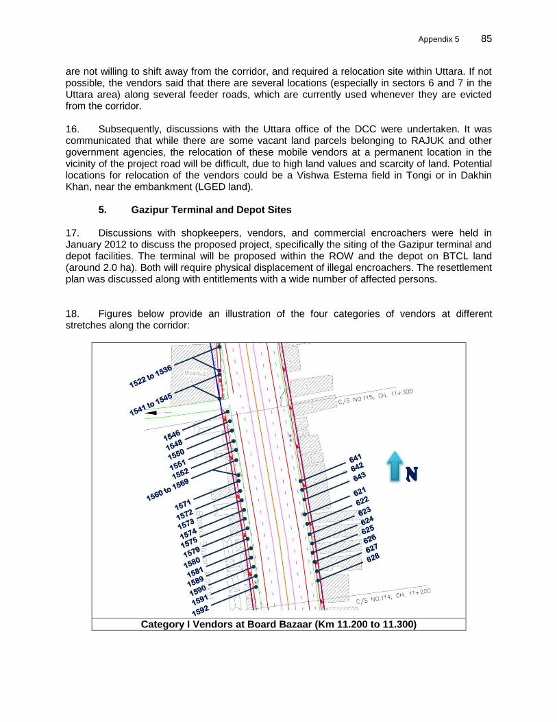
Appendix 5 85
85
are not willing to shift away from the corridor, and required a relocation site within Uttara. If not possible, the vendors said that there are several locations (especially in sectors 6 and 7 in the Uttara area) along several feeder roads, which are currently used whenever they are evicted from the corridor. 16. Subsequently, discussions with the Uttara office of the DCC were undertaken. It was communicated that while there are some vacant land parcels belonging to RAJUK and other government agencies, the relocation of these mobile vendors at a permanent location in the vicinity of the project road will be difficult, due to high land values and scarcity of land. Potential locations for relocation of the vendors could be a Vishwa Estema field in Tongi or in Dakhin Khan, near the embankment (LGED land).
5. Gazipur Terminal and Depot Sites
17. Discussions with shopkeepers, vendors, and commercial encroachers were held in January 2012 to discuss the proposed project, specifically the siting of the Gazipur terminal and depot facilities. The terminal will be proposed within the ROW and the depot on BTCL land (around 2.0 ha). Both will require physical displacement of illegal encroachers. The resettlement plan was discussed along with entitlements with a wide number of affected persons. 18. Figures below provide an illustration of the four categories of vendors at different stretches along the corridor:
Category I Vendors at Board Bazaar (Km 11.200 to 11.300)
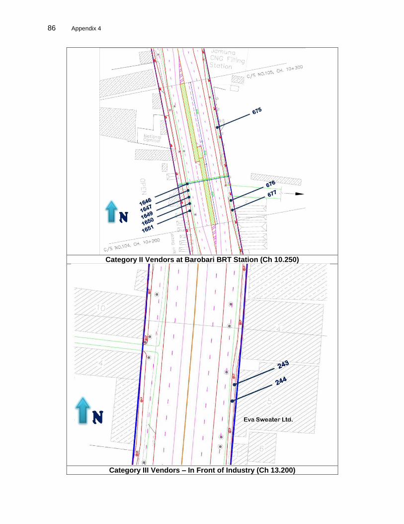
86 Appendix 4
Category II Vendors at Barobari BRT Station (Ch 10.250)
Category III Vendors – In Front of Industry (Ch 13.200)
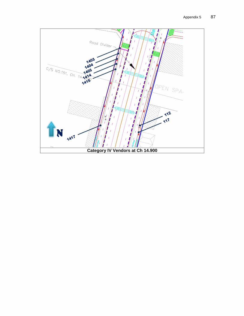
Appendix 5 87
87
Category IV Vendors at Ch 14.900
Appendix 6 88
APPENDIX 5: CENSUS SURVEY GUIDELINES A. Census Requirement and Contents 1. On completion of the detailed engineering designs, an updated resettlement plan shall be prepared based on a census of the displaced persons after a detailed measurement survey (DMS) of the affected properties has been completed. A DMS involves staking out the affected land on the ground based on the engineering design of a project, and forms the basis for carrying out the census and assets inventory of losses of the displaced persons. A census of households and individuals located within the subproject has to be undertaken to register and document the status of potentially affected populations within the subproject impact area. This will provide a demographic overview of the population covered by the resettlement plan, and profiles household assets and main sources of livelihood. It will cover 100% of the potentially affected population within the subproject impact area.
(i) Resource base – the resource base, including land, water, and forest, with an assessment of its development and ecological potential in the preproject conditions. During the conduct of the census, legal boundaries of affected properties and the right of way (RoW) are to be verified. Structures, trees, and other assets are to be recorded.
(ii) Economy base – the economy base of the affected people, including the modes and magnitude of production, consumption pattern, and related economic institutions
(iii) Household census – household census covering immovable property owned by the displaced persons and other resources in their possession or use. These surveys would be carried out in association with local and host communities, as well as with the local representatives.
(iv) Social structures – the social structure, norms, customs, cultural centers, traditions, patterns of leadership, and institutions of the social network
(v) Displaced persons – The census will identify tenants, leaseholders, sharecroppers, encroachers, squatters, and agricultural workers. During such census, those displaced persons dependent on the existing infrastructure link for their livelihood will also be identified and listed along with their identified income. The census will also identify displaced persons from vulnerable groups.
B. Census Procedures 2. The following procedure is to be adopted in carrying out the census:
(i) preliminary screening to provide initial information on social impacts; (ii) verification of legal boundaries of the subproject area, to document existing
structures, land plots, and others physical assets. This involves: (a) all encroachments, private land holdings, and others assets in the subproject
area; (b) assets, structures, land holdings, trees, etc. to be recorded; and (c) all information is to be computerized; photography will be used to document
existing structures. (iii) the baseline socioeconomic survey will cover information on the various
categories of losses and other adverse impacts likely under the subproject; (iv) the census will identify potentially affected populations with special attention to
vulnerable groups; and (v) assessment on the value of various assets will be made.
Appendix 5 89
89
C. Database Management
3. Data sources. As a prerequisite for conducting the primary household surveys, relevant information is to be collected from secondary sources. These include:
(i) revenue records maintained, with regard to land particulars for facilitating
acquisition of properties and resettlement of displaced persons; (ii) census records for demographic information;
(iii) development agencies to get information on various development programs for special sections of the population, like those living below poverty line, scheduled tribes, schedule castes, etc.; and
(iv) local organizations including NGOs in order to involve them and integrate their activities in the economic development programs of the displaced population.
4. Data collection. Household level contacts and interviews will be conducted with each affected family to complete the household socioeconomic profile. Each of the households surveyed and the structure/land likely to be affected by the subproject have to be numbered, documented, and photographed. Public consultation exercises in different subproject areas will be conducted with the involvement of displaced persons. In these exercises, women among the displaced persons are to be involved to elicit their views and opinions on the overall planning of resettlement activities. Discussions with a cross-section of displaced persons will help towards understanding the problems and preference of the displaced persons. 5. Data analysis. The analysis would cover the following: population, population density, age, sex ratio, literacy rates/education, gender issues, tribal issues, religious groups, income, occupation, and poverty line.
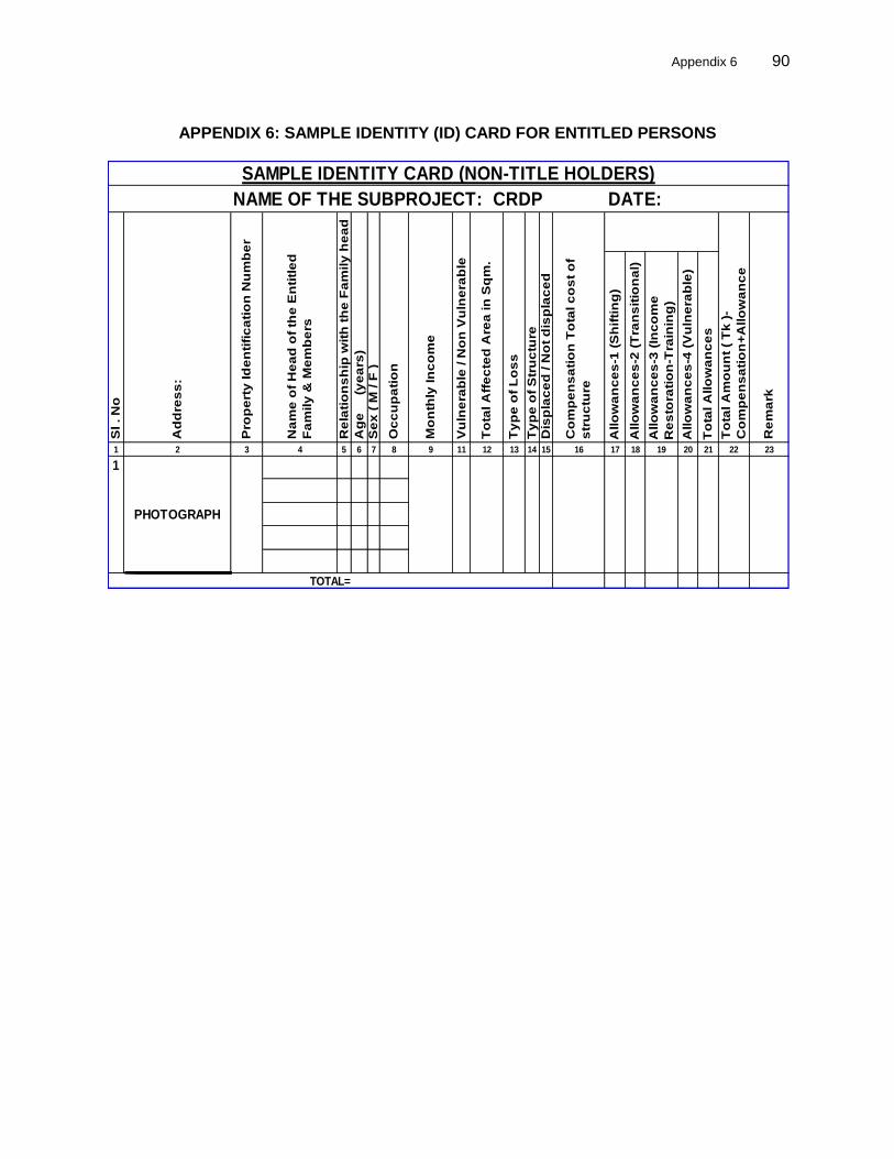
Appendix 6 90
APPENDIX 6: SAMPLE IDENTITY (ID) CARD FOR ENTITLED PERSONS
Allo
wa
nc
es
-1 (
Sh
ifti
ng
)
Allo
wa
nc
es
-2 (
Tra
ns
itio
na
l)
Allo
wa
nc
es
-3 (
Inc
om
e
Re
sto
rati
on
-Tra
inin
g)
Allo
wa
nc
es
-4 (
Vu
lne
rab
le)
To
tal A
llo
wa
nc
es
1 2 3 4 5 6 7 8 9 11 12 13 14 15 16 17 18 19 20 21 22 23
Ty
pe
of
Lo
ss
Ty
pe
of
Str
uc
ture
Dis
pla
ce
d / N
ot
dis
pla
ce
d
Pro
pe
rty
Id
en
tifi
ca
tio
n N
um
be
r
SAMPLE IDENTITY CARD (NON-TITLE HOLDERS)
NAME OF THE SUBPROJECT: CRDP DATE:
Sl . N
o
Ad
dre
ss
:
Na
me
of
He
ad
of
the
En
titl
ed
Fa
mily
& M
em
be
rs
Re
lati
on
sh
ip w
ith
th
e F
am
ily
he
ad
Ag
e (
ye
ars
)
Re
ma
rk
Se
x (
M / F
)
Oc
cu
pa
tio
n
1V
uln
era
ble
/ N
on
Vu
lne
rab
le
To
tal A
ffe
cte
d A
rea
in
Sq
m.
Mo
nth
ly In
co
me
Co
mp
en
sa
tio
n T
ota
l c
os
t o
f
str
uc
ture
To
tal A
mo
un
t (
Tk
)-
Co
mp
en
sa
tio
n+
Allo
wa
nc
e
TOTAL=
PHOTOGRAPH

91 Appendix 7
APPENDIX 7: OFFICIAL LAND RATES – LAND REGISTRY OFFICES
Name of Mouza along with Corridor
Rate 2010 ( Per Decimal in Taka) Rate 2011 ( Per Decimal in Taka)
Gazipur
Vararul 108830 108830
Pakairdeshi 14564 45591
Chaitennapur 17142 17142
Joydebpur 478194 484595
Samantapur 88630 123836
Rahapara 110222 124736
Adaboi 121698 121698
Chottodeoda 183784 206907
Taratpara 44000 44000
Dirasrom 102044 130311
Dakkinkhan 110792 145297
Tongi
Himardighi 1737372 1737372
Tongi 1226914 1226914
Machimpur 1602232 1602232
Gazipura 228228 349182
Auspara 951354 1018343
Registration fees: 3% stamp, 4% fees, and 2% taxes for municipal areas (1% for Union Parishad).
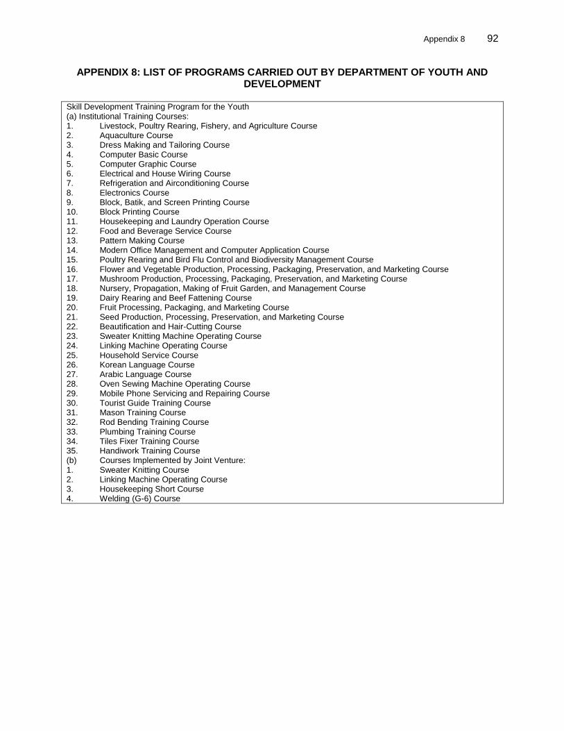
Appendix 8 92
APPENDIX 8: LIST OF PROGRAMS CARRIED OUT BY DEPARTMENT OF YOUTH AND DEVELOPMENT
Skill Development Training Program for the Youth (a) Institutional Training Courses: 1. Livestock, Poultry Rearing, Fishery, and Agriculture Course 2. Aquaculture Course 3. Dress Making and Tailoring Course 4. Computer Basic Course 5. Computer Graphic Course 6. Electrical and House Wiring Course 7. Refrigeration and Airconditioning Course 8. Electronics Course 9. Block, Batik, and Screen Printing Course 10. Block Printing Course 11. Housekeeping and Laundry Operation Course 12. Food and Beverage Service Course 13. Pattern Making Course 14. Modern Office Management and Computer Application Course 15. Poultry Rearing and Bird Flu Control and Biodiversity Management Course 16. Flower and Vegetable Production, Processing, Packaging, Preservation, and Marketing Course 17. Mushroom Production, Processing, Packaging, Preservation, and Marketing Course 18. Nursery, Propagation, Making of Fruit Garden, and Management Course 19. Dairy Rearing and Beef Fattening Course 20. Fruit Processing, Packaging, and Marketing Course 21. Seed Production, Processing, Preservation, and Marketing Course 22. Beautification and Hair-Cutting Course 23. Sweater Knitting Machine Operating Course 24. Linking Machine Operating Course 25. Household Service Course 26. Korean Language Course 27. Arabic Language Course 28. Oven Sewing Machine Operating Course 29. Mobile Phone Servicing and Repairing Course 30. Tourist Guide Training Course 31. Mason Training Course 32. Rod Bending Training Course 33. Plumbing Training Course 34. Tiles Fixer Training Course 35. Handiwork Training Course (b) Courses Implemented by Joint Venture: 1. Sweater Knitting Course 2. Linking Machine Operating Course 3. Housekeeping Short Course 4. Welding (G-6) Course

93 Appendix 9
APPENDIX 9: NONGOVERNMENT ORGANIZATION FOR RESETTLEMENT PLAN IMPLEMENTATION
A. Baseline Information Collection/Survey 1. The detailed census survey will inventory the displaced persons and serve as the basis for entitlements to the displaced persons. Activities include the following:
(i) Based on detailed designs and final alignments, conduct a detailed 100% census survey of all displaced persons. The census survey questionnaire will be finalized after a review of the questionnaire adopted in the previously conducted survey during the feasibility study. Suitable modifications will be carried out and questionnaire finalized.
(ii) Data on land, structures, trees, and other properties lost by the project displaced persons have to be computerized, including development of necessary software to prepare identity/entitlement cards. These files will be used for making payments to the entitled/displaced persons and monitoring progress of resettlement work.
(iii) Conduct videography of the corridor to confirm displaced persons and to verify those persons eligible. The survey and videography will serve as the cutoff date for non-titleholders. (Note: the cutoff date for titled holders is the Section 3 notification.)
B. Resettlement Plan Implementation 2. During this preconstruction stage, the nongovernment organization implementing the resettlement plan (NGORP) will need to work closely with the engineering, procurement, construction management and supervision of the construction (EPCM) resettlement specialists to coordinate design, survey, and finalization and implementation of resettlement plan work. The NGORP will be required to constantly liaise with the EPCM and report progress weekly to the team leader and resettlement specialist of EPCM and the relevant PIU and PMU safeguard officers. The resettlement plan implementation activities will include the following:
(i) Based on the detailed survey, the NGORP is to finalize the list of displaced persons within 6 months and provide the EPCM resettlement specialist with the updated data for revising the resettlement plan, which will include revised impacts, costs, and final entitlements.
(ii) Distribute to all displaced persons an identity card listing entitlements consistent with the resettlement plan entitlement matrix, and educate them regarding their entitlements and obligations. The ID card with entitlements needs to be distributed to each displaced/entitled person within 6 months. ID cards should contain the photograph and actual address of displaced persons. The ID card will be used by all project displaced persons for receiving all types of compensation under the resettlement plan.
(iii) Generate awareness about the alternative economic livelihood and enable displaced persons to make informed choices, and disseminate information to them on available training opportunities, job opportunities, and market opportunities
(iv) For vendors/hawkers or residential squatters (at Tongi Bridge) requiring physical relocation, the NGORP is to assist the displaced persons in relocating and resettling. This includes identifying suitable areas for relocation, wherever
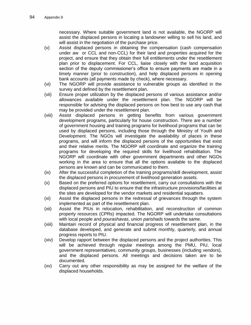
94 Appendix 9
necessary. Where suitable government land is not available, the NGORP will assist the displaced persons in locating a landowner willing to sell his land, and will assist in the negotiation of the purchase price.
(v) Assist displaced persons in obtaining the compensation (cash compensation under aw or CCL and non-CCL) for their land and properties acquired for the project, and ensure that they obtain their full entitlements under the resettlement plan prior to displacement. For CCL, liaise closely with the land acquisition section of the deputy commissioner’s office to ensure payments are made in a timely manner (prior to construction), and help displaced persons in opening bank accounts (all payments made by check), where necessary.
(vi) The NGORP will provide assistance to vulnerable groups as identified in the survey and defined by the resettlement plan.
(vii) Ensure proper utilization by the displaced persons of various assistance and/or allowances available under the resettlement plan. The NGORP will be responsible for advising the displaced persons on how best to use any cash that may be provided under the resettlement plan.
(viii) Assist displaced persons in getting benefits from various government development programs, particularly for house construction. There are a number of government housing and training programs for livelihood programs that can be used by displaced persons, including those through the Ministry of Youth and Development. The NGOs will investigate the availability of places in these programs, and will inform the displaced persons of the opportunities that exist and their relative merits. The NGORP will coordinate and organize the training programs for developing the required skills for livelihood rehabilitation. The NGORP will coordinate with other government departments and other NGOs working in the area to ensure that all the options available to the displaced persons are known and can be communicated to them.
(ix) After the successful completion of the training programs/skill development, assist the displaced persons in procurement of livelihood generation assets.
(x) Based on the preferred options for resettlement, carry out consultations with the displaced persons and PIU to ensure that the infrastructure provisions/facilities at the sites are developed for the vendor markets and residential squatters.
(xi) Assist the displaced persons in the redressal of grievances through the system implemented as part of the resettlement plan.
(xii) Assist the PIUs in relocation, rehabilitation, and reconstruction of common property resources (CPRs) impacted. The NGORP will undertake consultations with local people and pourashavas, union parishads towards the same.
(xiii) Maintain record of physical and financial progress of resettlement plan, in the database developed, and generate and submit monthly, quarterly, and annual progress reports to PIU.
(xiv) Develop rapport between the displaced persons and the project authorities. This will be achieved through regular meetings among the PMU, PIU, local government representatives, community groups, businesses (including vendors), and the displaced persons. All meetings and decisions taken are to be documented.
(xv) Carry out any other responsibility as may be assigned for the welfare of the displaced households.
Appendix 9 95
95
C. Community Awareness and Meaningful Consultation
(i) Identify and prepare, in consultation with PIUs and EPCM’s resettlement specialists, timebound programs for community awareness and meaningful, ongoing consultation related to resettlement plan implementation.
(ii) Disseminate information, including a booklet outlining key points of the resettlement plan, to displaced persons. The booklet is to be circulated within 2 months of engagement. Coordinate closely with the marketing and communication consultants engaged under the project. The booklet, along with other awareness campaigns (through the marketing and communication consultants), must be circulated prior to fieldwork to create a better social environment.
(iii) Carry out awareness building activities related to resettlement planning that will focus on discussions with communities and displaced persons. Consultations will focus on (a) project objectives and its activities; (b) level of disturbance to be expected during construction; (c) entitlements under resettlement plan; (d) training and benefits/opportunities under the project; and (d) assistance in shifting.
(iv) Prepare records of every consultation/discussion, take action or submit to PIU for actions on recommendations arising from each of the consultations, and disseminate action-taken reports in subsequent meetings.
(v) Identify poor and vulnerable households affected by resettlement, and encourage these people to take up the employment opportunities on construction works implemented by the project.
(vi) Pay more attention to and make concerted effort in ensuring that the concerns of women and disadvantaged groups are adequately addressed while planning and implementing the project activities.
D. Other Activities
(i) Provide training to all PIU and contractor’s staff (including laborers) on gender and social issues, including HIV and women and child trafficking issues.
(ii) Prepare monthly progress reports to the PIU, including information and implementation progress on the activities under the CAPP and gender action plan.
(iii) For all other issues that will arise during the implementation of resettlement plan that are not covered in the TOR, the decision may be made by the project director in consultation of the NGORP.
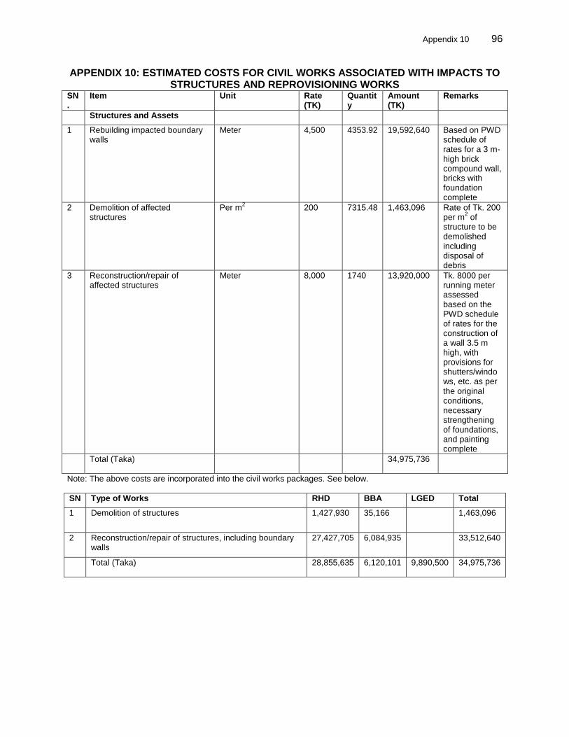
Appendix 10 96
APPENDIX 10: ESTIMATED COSTS FOR CIVIL WORKS ASSOCIATED WITH IMPACTS TO STRUCTURES AND REPROVISIONING WORKS
SN.
Item Unit Rate (TK)
Quantity
Amount (TK)
Remarks
Structures and Assets
1 Rebuilding impacted boundary walls
Meter 4,500 4353.92 19,592,640 Based on PWD schedule of rates for a 3 m-high brick compound wall, bricks with foundation complete
2 Demolition of affected structures
Per m2 200 7315.48 1,463,096 Rate of Tk. 200
per m2 of
structure to be demolished including disposal of debris
3 Reconstruction/repair of affected structures
Meter 8,000 1740 13,920,000 Tk. 8000 per running meter assessed based on the PWD schedule of rates for the construction of a wall 3.5 m high, with provisions for shutters/windows, etc. as per the original conditions, necessary strengthening of foundations, and painting complete
Total (Taka) 34,975,736
Note: The above costs are incorporated into the civil works packages. See below.
SN Type of Works RHD BBA LGED Total
1 Demolition of structures 1,427,930 35,166 1,463,096
2 Reconstruction/repair of structures, including boundary walls
27,427,705 6,084,935 33,512,640
Total (Taka) 28,855,635 6,120,101 9,890,500 34,975,736